
Day: June 17, 2014
EPA: Want to learn more about the Waters of the US proposal? Watch this webcast.
Want to learn more about the Waters of the US proposal? Watch this webcast. http://t.co/4zVDPXEMei
— U.S. EPA Water (@EPAwater) June 18, 2014
Regional stormwater task force hits a snag — The Colorado Springs Gazette
From The Colorado Springs Gazette (Monica Mendoza):
Members of a regional stormwater task force have been hopeful that the towns of Monument, Palmer Lake, Manitou Springs, Green Mountain Falls and Fountain would join El Paso County and Colorado Springs to form a regional stormwater authority that would collect fees and plan for stormwater projects together, but the Town of Monument is not sold on the idea, its mayor said Monday.
“The biggest objection I have is we do not care for adding another layer of bureaucracy on top of everything we do,” said Mayor Rafael Dominguez. “We have a water fund, as part of a mill levy, and some of that money goes to stormwater.”
Monument, north of Colorado Springs, has a population of about 5,700. Dominguez estimates stormwater needs are about $10 million. Those projects could get lost in the hundreds of millions of dollars in projects needed throughout the Fountain Creek Watershed, a 927-square mile area bordered by the Palmer Divide to the north, Pikes Peak to the west and a minor divide 20 miles east of Colorado Springs.
“One of the biggest things that stood out in this plan is that an emergency in another municipality will become an emergency in Monument,” he said. “We don’t want to get bogged down with other problems – Manitou Springs, God bless them, they got issues.”
Palmer Lake also might bow out of a regional stormwater effort, while Fountain and Manitou Springs officials say they still must review the plan and intergovernmental agreements before signing off…
Task force leaders say if voters approve a stormwater fee in November, the estimated $50 million collected annually would be in addition to what cities and the county already spend on stormwater projects. Each entity would get what it put in over a five-year rolling average, organizers have said.
Green Mountain Falls and Palmer Lake mayors could not be reached Monday for comment.
Manitou Springs already has a stormwater enterprise fee and collects about $280,000 a year, said Mayor Marc Snyder. He wants to ensure that if Manitou Springs joins a regional group that his town, where flooding was disastrous last year, would receive at least what it already spends…
Fountain does not collect a stormwater fee, said Mayor Gabriel Ortega. The town had discussed creating a stormwater enterprise fee but first wanted to wait for the regional task force plan…
Munger said a stormwater authority could be formed with fewer than the original seven entities. The intergovernmental agreements would allow any of the neighboring towns to join any time, he said.
More stormwater coverage here.
Happy Birthday to the US Bureau of Reclamation

Click here to read a short history of Reclamation:
Inadequate precipitation in the American West required settlers to use irrigation for agriculture. At first, settlers simply diverted water from streams, but in many areas demand outstripped supply. As demand for water increased, settlers wanted to store “wasted” runoff from rains and snow for later use, thus maximizing use by making more water available in drier seasons. At that time, private and state-sponsored storage and irrigation ventures were pursued but often failed because of lack of money and/or lack of engineering skill.
Pressure mounted for the Federal Government to undertake storage and irrigation projects. Congress had already invested in America’s infrastructure through subsidies to roads, river navigation, harbors, canals, and railroads. Westerners wanted the Federal Government also to invest in irrigation projects in the West. The irrigation movement demonstrated its strength when pro-irrigation planks found their way into both Democratic and Republican platforms in 1900. Eastern and Midwestern opposition in the Congress quieted when Westerners filibustered and killed a bill containing rivers and harbors projects favored by opponents of Western irrigation. Congress passed the Reclamation Act of June17, 1902. The Act required that water users repay construction costs from which they received benefits.
In the jargon of that day, irrigation projects were known as “reclamation”projects. The concept was that irrigation would “reclaim” arid lands for human use. In addition, “homemaking” was a key argument for supporters of reclamation. Irrigation’s supporters believed reclamation programs would encourage Western settlement, making homes for Americans on family farms. President Theodore Roosevelt supported the reclamation movement because of his personal experience in the West, and because he believed in homemaking.
In July of 1902, in accordance with the Reclamation Act, Secretary of the InteriorEthan Allen Hitchcock established the United States Reclamation Service within the U. S.Geological Survey (USGS). The new Reclamation Service studied potential water development projects in each western state with Federal lands — revenue from sale of Federal lands was the initial source of the program’s funding. Because Texas had no Federal lands, it did not become a Reclamation state until 1906 when Congress passed a special Act including it in the provisions of the Reclamation Act.
From 1902 to 1907, Reclamation began about 30 projects in Western states. Then, in 1907, the Secretary of the Interior separated the Reclamation Service from the USGS and created an independent bureau within the Department of the Interior. In the early years, many projects encountered problems: lands/soils included in projects were unsuitable for irrigation; land speculation sometimes resulted in poor settlement patterns; proposed repayment schedules could not be met by irrigators who had high land preparation and facilities construction costs; settlers were inexperienced in irrigation farming; waterlogging of irrigable lands required expensive drainage projects; and projects were built in areas which could only grow low-value crops. In 1923 the agency was renamed the “Bureau of Reclamation.” Then, in the face of increasing settler unrest and financial problems for the reclamation program, in1924 the “Fact Finder’s Report” spotlighted the issues. The Fact Finders Act in late 1924 sought to resolve some of the financial and other problems.
In 1928 Congress authorized the Boulder Canyon (Hoover Dam) Project, and large appropriations began, for the first time, to flow to Reclamation from the general funds of the United States. The authorization came only after a hard fought debate about the pros and cons of public power versus private power.
The heyday of Reclamation construction of water facilities occurred during the Depression and the thirty-five years after World War II. The last major authorization for construction projects occurred in the late 1960s while a parallel evolution and development of the American environmental movement began to result in strong opposition to water development projects. Even the 1976 failure of Teton Dam as it filled for the first time, did not diminish Reclamation’s strong international reputation in water development circles. However, this first and only failure of a major Reclamation dam did shake the bureau which subsequently strengthened its dam safety program to avoid similar problems in the future. However, the failure of Teton Dam, the environmental movement, and the announcement of the President Jimmy Carter’s “hit list” on water projects profoundly affected the direction of Reclamation’s programs and activities in the United States.
Reclamation operates about 180 projects in the 17 Western States. The total Reclamation investment for completed project facilities in September of 1992 was about$11.0 billion. Reclamation projects provide agricultural, household, and industrial water to about one-third of the population of the American West. About 5 percent of the land area of the West is irrigated, and Reclamation provides water to about one-fifth of that acreage (in1992, some 9,120,000 acres). Reclamation is a major American generator of electricity. In1993 Reclamation had 56 power plants on-line and generated 34.7 billion kilowatt hours of electricity.
Between 1988 and 1994, Reclamation underwent major reorganization as construction on projects authorized in the 1960s and earlier drew to an end. Reclamation wrote that “The arid West essentially has been reclaimed. The major rivers have been harnessed and facilities are in place or are being completed to meet the most pressing current water demands and those of the immediate future.” Emphasis in Reclamation programs shifted from construction to operation and maintenance of existing facilities.
Reclamation’s redefined official mission is to “manage, develop, and protect water and related resources in an environmentally and economically sound manner in the interest of the American public.” In redirecting its programs and responsibilities, Reclamation substantially reduced its staff levels and budgets but remains a significant Federal agency in the West.
More Bureau of Reclamation coverage here.
On this day in 1902 the Newlands Reclamation Act that provided federal help for irrigation projects was passed. Read: http://t.co/j2rXDvT9bF
— American Water (@amwater) June 17, 2014
The San Juan Watershed Group launches website #ColoradoRiver

From The Durango Herald (Dale Rodebaugh):
The San Juan Watershed Group, composed of public agencies and community members interested in the health of the San Juan, Animas and La Plata rivers, has launched a website.
The organization educates the public about water-quality goals, finds matching funds for farmers who change practices so as to not pollute the rivers and coordinates research for a basin-wide watershed plan.
Most of the group’s work involves the San Juan River from Navajo Dam through Farmington to the border of the Navajo Nation, the Animas River from Durango to Farmington and the La Plata River downstream of the Colorado border.
The new website is part of the website of the San Juan Soil and Water Conservation District, headquartered in Aztec. It can be found at http://www.sanjuanswcd.com or directly at http://www.sanjuanswcd.com/watershed .
For further information about the organization, send an email to sanjuanwatershedgroup@gmail.com
More San Juan River Basin coverage here. More La Plata River watershed coverage here. More Animas River watershed coverage here.
CU Law: Colorado River Governance Initiative #ColoradoRiver

Click here to read the announcement:
The Getches-Wilkinson Center for Natural Resources, Energy, and the Environment (GWC) is excited to announce the release of two new studies prepared by the GWC’s Colorado River Governance Initiative:
Restoring Sacred Waters: A Guide to Protecting Tribal Non-Consumptive Water Uses in the Colorado River Basin is a detailed review of strategies available to tribes seeking to protect non-consumptive uses of their federal reserved rights. It surveys potential legal and political hurdles that tribes may encounter when applying their rights to instream flows and offers practical strategies derived from case studies the advice of tribal officials on how to surmount these hurdles. Strategies outside of the application of Indian federal reserved rights are also explored, including how federal environmental laws and conservation easements have been used to create additional flows in reservation streams.
Click here for Restoring Sacred Waters
Research Needs in the Colorado River Basin is a synthesis of ideas gained from interviews and reports assessing the state of research post Basin Study, identifying those areas where additional progress is most needed to aid the policy discussions. Embedded in this effort is an assessment of the role that the academic community can play going forward in addressing any shortcomings.
Click here for Research Needs in the Colorado River Basin
All reports of the Colorado River Governance Initiative can be found at the Colorado River Information Portal:
http://www.waterpolicy.info/projects/CRIP/index.htmlFor more information on Restoring Sacred Waters,
Please contact:
Julie Nania at Julie.Nania@Colorado.edu or
Julia Guarino at Julia.Guarino@Colorado.eduFor more information on Research Needs in the Colorado River Basin, please follow up with Doug Kenney at Douglas.Kenney@Colorado.edu.
More Colorado River Basin coverage here.
Climate Central: Check out 6 climate stories we think are worth a click
Check out 6 climate stories we think are worth a click: http://t.co/TtiKsLtFR5 #climate
— ClimateCentral (@ClimateCentral) June 16, 2014
New director of the CIRES-affiliated Western Water Assessment: Lisa Dilling

From CIRES:
Lisa Dilling, assistant professor of Environmental Studies at the University of Colorado Boulder, is the new director of the Western Water Assessment (WWA), an applied research program that addresses societal vulnerabilities related to climate, particularly in the area of water resources.
WWA is part of the Cooperative Institute for Research in Environmental Sciences (CIRES) at CU-Boulder, and is funded primarily by NOAA’s Regional Integrated Sciences and Assessments Program.
Dilling is also a CIRES Fellow and a member of CIRES’ Center for Science and Technology Policy Research at CU-Boulder. Her research focuses on decision making, the use of information and science policies related to climate change, adaptation, geoengineering and carbon management. Her current projects examine drought in urban water systems, water governance and climate change, municipal adaptation to hazards, decision making in public lands management, and knowledge for adaptation in Tanzania. Dilling has authored numerous articles and is a co-editor of the book Creating a Climate for Change: Communicating climate change and facilitating social change from Cambridge University Press.
WWA is based in Boulder but works across the Intermountain West in Colorado, Utah, and Wyoming. Its mission is to identify and characterize regional vulnerabilities to and impacts of climate variability and change, and to develop information, products, and processes to assist decision makers throughout the Intermountain West. For example, WWA staff are producing a Climate Change in Colorado report for the state of Colorado; helped author the National Climate Assessment released this spring; and are conducting work to understand how emergency managers and others use (or do not use) NOAA streamflow forecasts.
Kristen Averyt, WWA’s previous director, will now focus on her position as Associate Director for Science at CIRES, and she will continue to conduct research and lead projects for the WWA.
Runoff/snowpack news
From the Glenwood Springs Post Independent (Hannah Holm):
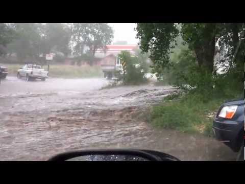
The high water frothing through the Grand Valley this spring is a sharp contrast to conditions in June last year, when there was barely enough water to float a boat on the Colorado River between Palisade and the confluence with the Gunnison.
The high water has brought hazardous floating conditions — be careful out there — and submerged some sections of the Colorado Riverfront Trail, but it has also brought smiles to the faces of kayakers, irrigators, and the folks in charge of efforts to recover four species of endangered fish that reside in these waters. And downstream, Lake Powell is rising at the rate of one foot per day, easing worries that the reservoir could soon drop below the level necessary to generate electricity at Glen Canyon Dam.
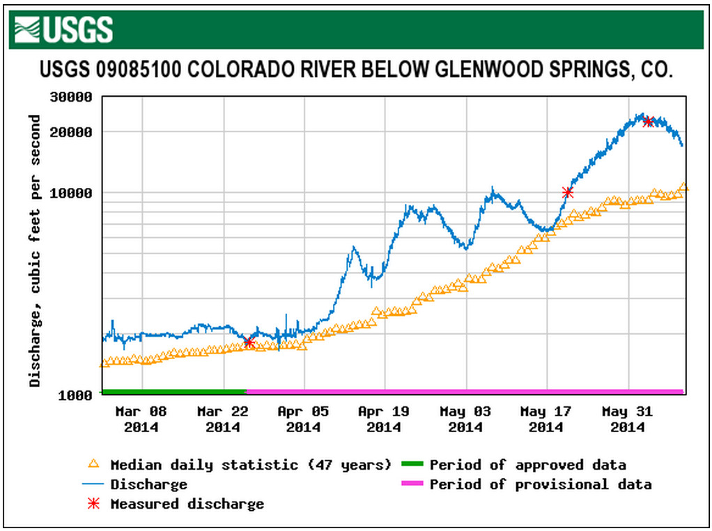
The Colorado River at the gauge near Cameo in DeBeque Canyon crested at over 25,000 cubic feet per second (cfs) on June 2-3, and was still running well above average on June 10 at 16,400 cfs. It’s not advisable to brave these flows and associated floating debris on an air mattress, but with a proper boat, life jacket and an experienced guide, great adventures can be had.
When the Cameo gauge surpasses 20,000 cfs, the “Big Sur” wave forms at the old Orchard Mesa Irrigation District diversion in the canyon, providing a legendary, if temporary, playground for kayakers and surfers. The last time the wave formed was in 2011, and the last time before that was rumored to be in 1997. It’s gone now, but if the warm “El Niño” currents in the Pacific Ocean bring us another wet winter it could be back next year.
The high peak flows were partly a result of an unusually generous snowpack in the upper reaches of the Colorado Basin and partly a result of coordinated reservoir releases to improve habitat for endangered fish. These fish need to have the floodplain inundated periodically to create good spawning habitat.
The Gunnison River at Whitewater, just upstream from Grand Junction, peaked at 12,900 cfs on June 6. The higher than average peak flows were largely due to higher than usual releases out of Blue Mesa and the other two dams in the Aspinall Unit. The Bureau of Reclamation delayed the high releases to avoid the flooding that could occur if both the Colorado and Gunnison rivers crested in Grand Junction at the same time.
During peak releases from the Aspinall unit, all four gates on the Morrow Point dam, the middle dam in the trio, were opened for the first time since the record flood year of 1984. The high releases were made under a 2012 modification to the unit’s operating rules that increases release requirements in wet years to benefit endangered fish habitat.
The peak flow at Whitewater was a bit below the 14,350 cfs target, but the Bureau of Reclamation will still try to attain the related goal of maintaining flows at Whitewater above 8,070 cfs for 40 consecutive days. Flows first hit this target on May 30. Gunnison River flows at Whitewater were still at 10,900 cfs on June 10.
While we play in our rivers and local irrigators enjoy a respite from worries about shortages, the Southwest as a whole remains in a precarious water position. Downstream, almost the entire Colorado River Basin remains in moderate to extreme drought.
From email from Reclamation (Kara Lamb):
I hope everyone had a good weekend. The warm weather and the rain combined for a spike in Big Thompson River runoff flows on Saturday. It looks like the inflow down the Big Thompson River into Lake Estes got up to about 962 cfs early Saturday morning. Outflow through Olympus Dam to the canyon bumped up some on Saturday and Sunday–the average outflow to the canyon on Sunday was 316 cfs. But, today, the river has slowed down.
Outflow through Olympus Dam to the canyon is now about 119 cfs.
If you check the gage, you might notice the small diamond shapes that indicate the 84-year average flow for this time of year. The 316 cfs we hit over the weekend matched that average. We’ve now dropped back down again. I think the reason for the drop is we saw the peak of runoff on the Big Thompson River come a little early this year, over the weekend of May 31-June 1. That weekend, inflows to Lake Estes peaked at 1580 cfs and outflow to the canyon got up to 1000 cfs for an hour or two. We’ve pretty much seen a steady decline since then.
We are still returning about 90 cfs of river water to the Big Thompson River using the concrete chute at the canyon mouth.
We’re anticipating the outflow from Olympus to the canyon to stay in the 120 cfs range and the canyon mouth chute to stay around 90 cfs through most of this week; so, not a lot of change.
What is changing is that as the river drops down, we’ll start bringing more water over from the West Slope via the Alva B. Adams Tunnel. Water imported through the tunnel is Colorado-Big Thompson Project water. It is used to generate hydro-electric power at both Marys and the Estes powerplants in Estes Park, then is recollected at Olympus Dam and sent through Olympus Tunnel to the rest of the project. C-BT water will generate power at Pole Hill and Flatiron powerplants and also be pumped up to Carter Lake.
Carter Lake is filling for the second time this season. It has gained a foot in elevation since Friday and is now 96% full.
Pinewood Reservoir, between Lake Estes and Carter Lake, continues to operate typically for this time of year. It fluctuates with power generation, between 70-85% full.
From email from Reclamation (Kara Lamb):
Just a quick note to let you know where the Fryingpan-Arkansas Project stands.
Ruedi Reservoir is currently releasing about 205 cfs. The Ruedi Dam gage is reading around 237 cfs because another 30 or so cfs is from the Rocky Fork. The reservoir is about 94% full and still rising. We will try to stay near this release rate until the reservoir is full. Ruedi is anticipated to fill before the end of the month, probably a little sooner.
Releases from Sugarloaf Dam at Turquoise Reservoir to Lake Fork Creek were cut back today by 25 cfs. The current release is now about 104 cfs, 80 cfs of that being native runoff flow. Turquoise’s water level elevation has come up considerably in the last two weeks. It is now almost 70% full, not quite, but almost.
Runoff down Lake Creek to Twin Lakes has also decreased. The release from the dam to Lake Creek and the Arkansas River is currently around 663 cfs. Twin is almost 80% full.
Meanwhile, Pueblo Reservoir has maintained a total storage content of about 60% for most of runoff, having hit its highest water level elevation for the season back in May. Please keep in mind that 60% of full at Pueblo is still a decent water level elevation because part of what is not filled in the reservoir is the flood control pool. It’s good for the flood control pool to be empty!
As of today, we’ve moved roughly 70% of the the Fry-Ark’s forecasted imports from the West Slope into Turquoise Reservoir via the Boustead Tunnel.
Weekly Roaring Fork Watershed stream flow report http://t.co/zF2nTDVgHT http://t.co/gAfE9IcgMX
— RoaringFkConservancy (@rfconservancy) June 12, 2014
Climate: Arctic sea ice third-lowest on record for May
FIBArk recap: Andy Corra wins his 10th Downriver Classic
From The Mountain Mail (Nick Jurney):
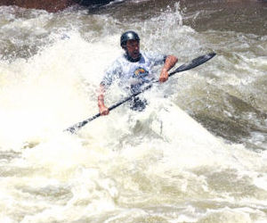
Andy Corra, Durango, captured his milestone 10th FIBArk Downriver Classic Sunday after making the 26-mile run from Salida to Cotopaxi in 2 hours, 9 minutes, 18 seconds.
“It doesn’t get any easier,” Corra said after winning his fourth consecutive FIBArk Downriver Race and 10th overall. His first victory came in 1985, 2 years after his first time participating in the historic competition.
Corra said some of the challenges in this year’s race included an upstream wind and cold water, though the flows near 3,000 cubic feet per second were an advantage to boats.
“It was windy, which was pretty cold and brutal on the hands,” Corra said. “But the water and flow were really good, up on the high side of medium levels.”
Corra’s 10th win came on Father’s Day, and he said he may look to pass the torch on to his 11-year-old son, Wiley, in the coming years.
“He said he was going to try and win as many as he can so I couldn’t catch him,” Wiley said with a smile after the race.
Second place in the downriver was captured by Jeff Parker, Concord, Mass., finishing in 2:16:28. Parker said he won the race in 1998, and his runner-up finish Sunday was his best finish since then.
“This was my 25th race, and I think it will be my last,” Parker said. “I want to go out with a second-place finish.”
Tim Lawson finished third in the downriver with a time of 2:17:03, while multi-sport competitor Natalie Anderson was the first female finisher at 2:30:06.
Team Blaze was the first team of rafters to come across the downriver finish line in Cotopaxi, finishing in 2:58:35.
“We had great water and great rafters,” said team captain Mark Mattson after paddling in his 30th race. “I like the high water; we don’t have to battle the rocks as much.”
Other members of Team Blaze included Matthew Petty, Joshua Mentzer, Tom Rice, Chadd Drott, Logan Myers and Jeff Flora.
The oldest participant in the downriver was Lynn Koester of Woodland Park, who said he is turning 77 today, while the youngest was Andy’s Corra’s son Wiley, who participated in the novice 10-mile downriver.
FIBArk board member Tom Barry said an issue with the spreadsheets used to tally results prevented race officials from getting full results and times put together by press time Sunday.
From The Mountain Mail (J.D. Thomas):
The Business After Hours Kickoff to the 66th FIBArk Whitewater Festival featured crashes of lightning, a scattering of hail and more than $1,000 raised at the event Wednesday at Salida SteamPlant. The annual kickoff, hosted by the Vaqueros of Heart of the Rockies Chamber of Commerce, was moved inside the SteamPlant because of the inclement weather.
“Welcome to the kickoff of the oldest whitewater rafting festival,” Salida Mayor Jim Dickson said to lead off the event.
After Dickson’s introduction, 2014 FIBArk Commodore Greg Felt welcomed people to the event and thanked them on behalf of the city for attending. “Thank you and welcome,” he said. “I hope you all have an unbelievable weekend.”
Following Felt’s speech, FIBArk Board President Christopher Kolomitz began an auction for a painting created for FIBArk by local artist Carl Ortman, depicting the “kayak wall” downtown.
Charlie Forster, CEO of Collegiate Peaks Bank, bought the painting to add to the bank’s art display.
“The painting really represents Salida, and the color and the quality make it a great piece,” he said. “Knowing that it will help out FIBArk is one reason (I bought it); the other is because this year’s commodore is Greg Felt. He’s a great guy.”
The money raised will go into the FIBArk general fund, Kolomitz said. Some of the money in the fund will go to the FIBArk youth paddling program, he said.
Along with local business people and guests, a visitor from South Korea took part in the festivities. Yun Ho Ra from Gunsan was riding his bike from Los Angeles to New York when he stopped in town. He said he would like to stay in Salida for a couple days to enjoy the festivities before he continues his travels.
The food, pulled pork sandwiches and baked beans, was prepared and served by the Vaqueros, and beer was provided by Eddyline Brewing, sponsor for the whitewater festival.
The first pour of Eddyline beer at the festival will be at 4 p.m. today in Riverside Park, said Kolomitz.
More whitewater coverage here.