
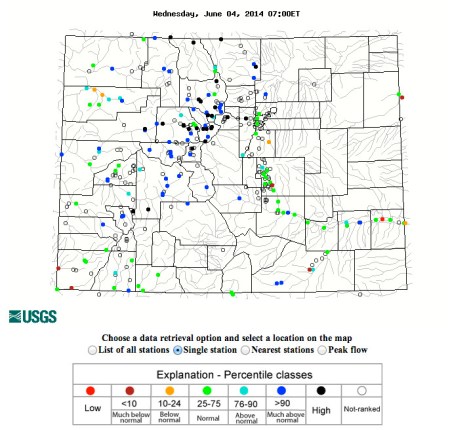
Click on the map above to peruse the USGS’ Water Watch interactive map for Colorado. The dark dots represent higher flows.
From The Pueblo Chieftain (Chris Woodka):
There’s some debate about whether the Arkansas River has seen its peak runoff yet. The river has been running very high after gaining momentum over the weekend and has been dangerous in places. All along the river, from Pueblo to Leadville, flows are twice average for this time of year as spiking temperatures and heavy snowpack have led to a heavy runoff.
Temperatures Tuesday reached 97 degrees, about 3 degrees shy of the record 100 degrees in 2006.
Apparently there is more to come.
“It is kind of surprising for this time of year,” said Steve Witte, Water Division 2 engineer. “I suppose what we’re seeing is the result of a cool May.”
Snowpack above the timberline is still ample, based on observations by Division of Water Resources staff, and more hot weather’s on the way. A fast, early runoff was forecast at the end of April, but more precipitation and cooler weather set the stage for a June peak.
The Arkansas River gauge at Wellsville has been at 4,000-4,200 cubic feet per second for days.
“It’s been flat as a string,” Witte said.
There are advisories for rafters through the Arkansas River canyon on certain stretches of the river.
Levels below Pueblo Dam topped out at 4,800 cfs on Monday, and were falling Tuesday after releases from the dam were cut back slightly.
Meanwhile, about 23,000 acre-feet of Fryingpan-Arkansas Project water has been imported through the Boustead Tunnel into Twin Lakes. More than 60,000 acre-feet is projected this year.
“It’s been about what we would expect at this point,” said Roy Vaughan, Fry-Ark manager for the Bureau of Reclamation.
So far, nothing is at flood stage and the river has been higher on this day in history — June 3, 1921, was the date of the deadliest flood recorded here.
From the Associated Press via the Fort Collins Coloradoan:
Some streets and fields remain flooded in Greeley as the spring runoff continued to push the Poudre River over its banks on Tuesday.
The water reached 9.16 feet, more than a foot above flood stage, around midday. That’s just above the previous crest record for the river set in 2010, the National Weather Service said.
The flooding was making it harder to drive around the city, although some drivers disregarded warnings to stay off closed roads.
Two homes were flooded this week, forcing those residents to evacuate, Greeley street superintendent Jerry Pickett said. Across the flooded street, other residents sat on the porch of a home surrounded by sandbags.
Nearby, Tony Stansbury and Robert Villa waded through waist-deep water with a canoe to recover records from DBE Manufacturing & Supply.
The Greeley Tribune reported Greeley City Councilman Charlie Archibeque caught a 10-pound carp in the driveway of his home, which was surrounded by water.
The water has been high along the Poudre for a week and levels of waterways around the state are expected to remain high for another two weeks or so as the plentiful mountain snowpack melts and fills reservoirs.
“The good news is there’s water to be had, but it could be a nuisance for another few weeks,” National Weather Service forecaster Kyle Fredin said.
The South Platte Basin, which includes the Poudre, was listed as being nearly 300 percent of its average level as of last week.
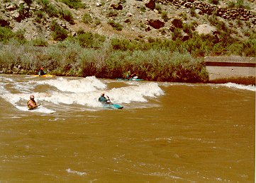
In western Colorado, the spring runoff was creating a wave known as “Big Sur” in the Colorado River, drawing kayakers and paddle boarders to DeBeque Canyon.
The Daily Sentinel reported that the wave develops when water flows over a submerged bridge reach at least 20,000 cubic feet per second. The last time the wave appeared was in 2011.
Things are much drier in the state’s southeastern and southwestern corners, where fire and blowing dust warnings were posted Tuesday.
From the Vail Daily (Raymond A. Bleesz):
John Comer, of McCoy, knows about calamity regarding his beloved water wheel at his Wagon Wheel Ranch. Last month, the high waters of the Colorado River partially destroyed his water wheel for the third time in its 92 years of history.
The Brooks-Dixson water wheel was initially constructed in 1922 by the two entrepreneurial ranchers, Earl Brooks and Wyman Dixson, as they needed water to irrigate their pasture — water, hay and cattle are the focal cornerstone elements for a successful livelihood in ranching. The water wheel was put together with no plans other than using their imagination. The engineering feat, the material and lumber the two ranchers mustered for themselves was a significant feat using approximately 3,570 board feet of lumber. It showed determination and a frontier can-do attitude. The purpose of the wheel was to raise water from the river bottom to the top of the wheel in constructed wooden buckets, as the wheel rotated on its axle to the height of approximately 46 feet and for the water to then flow into a catching wooden flume and into the irrigation ditches of the pasture land. This ingenious device was perhaps the largest one in the state of Colorado and certainly in Eagle County.
From KWGN.com (Sara Morris):
Portions of southeast Greeley remain under water Tuesday night and Greeley’s Emergency Manager believes the flooding isn’t over yet. That concerns many like Erica Nevarez and her family who are trying everything to keep the high water away from their home. So far they have installed four pumps to get the water out of their back yard and horse stalls, funneling it into a nearby ditch. They also had to evacuate all of their animals.
“We had to take all of our horses we put them up here down the street,” said Erica Nevarez.
Building a giant dirt barrier around her property wasn’t enough, so she started making sandbags.
“More than a hundred that’s for sure,” Nevarez said.
And so far their efforts seem to be working because at one point the water was several feet deep.
With two kids and a neice and nephew to watch, Erica said it’s been a stressful couple of days.
“We haven’t slept at all. Just to be watching this water,” said Nevarez.
Unfortunately this may be just the beginning of the flooding in Greeley.
“I think the biggest concern is the longevity of the event. How long will it last and that’s difficult to predict,” said Pete Morgan, the City of Greeley Emergency Manager.
In the meantime voluntary evacuations continue to be in effect in portions of southeast Greeley.
Many including the Nevarez’s are opting to stay because they want to protect their home from future flooding.
From KJCT8.com (Lindsey Pallares):
A water phenomenon of the Grand Valley has made its appearance once again, but it’s not here for long.
Big Sur returns to give rivergoers the adventure of a lifetime.
It’s unlike anything most surfers and kayakers have seen on the river.
“In the ocean, the water moves, or stays the same and the wave stays the same, on the river the wave stays put and the water moves past you,” says Pete Atkinson of Whitewater West.
It’s become one of the most sought after standing waves in the West, emerging from the depths of the Colorado River only when river conditions are just right.
“Big Sur is kind of like a novelty wave, it only comes in upwards at like 20,000 or so CFS is when it starts getting good, which we haven’t had for like three years,” says surfer, Brittany Parker.
If you’ve got good balance and stamina you can ride this wave for hours on a kayak, paddle boat, or surfboard.
Last time the wave came to De Beque in 2011 it was here for nearly three weeks, one of its longest recorded stays in river history.Continued spring runoff determines how long the wave will be around before it subsides.
At this time, experts don’t have a clear of estimate of just how long water enthusiasts will be able to ride the wave.
The wave is rarely here and oftentimes hard to find.
From the Estes Park Trail-Gazette (David Persons):
According to information published by the Colorado Division of Water Resources, the weekend’s top inflow into Lake Estes was at 3 a.m. Saturday when 1,370 cubic feet of water was flowing into Lake Estes. Likewise, the top outflow into the Big Thompson River below Olympus Dam was 1,020 cubic feet per second. An additional 500-550 cfs was also diverted into the Olympus Tunnel.
“That’s right, the peak on the Big Thompson may have been Friday night,” said Kara Lamb, the public information officer for the Bureau of Reclamation’s Eastern Colorado Office in Loveland. The bureau owns both Lake Estes and Olympus Dam.
Lamb pointed out that the water levels have been so high the past week that it’s been necessary to release between 500-550 cfs through Olympus Tunnel. That water generally has been going to Horsetooth Reservoir. However, that reservoir reached capacity at times. When that happened, it was necessary to re-release that water back into the Big Thompson River at the mouth of the canyon.
Lamb said while no one is exactly sure if the spring runoff peak has occurred, it is certain that the Big Thompson River – and others along the Front Range – will run high in the coming weeks as snowpack in the mountains continues to melt.
Despite the fact that the remaining snowpack in the mountains to the west is about 200 percent of average, Lamb said residents shouldn’t be too concerned about that.
“There’s really not a connection between feet of snow on the ground and the amount of snowpack on this day in history,” Lamb said. “But, if it rains up there and the snow melts quickly, then we could have some problems.”
From The Denver Post (Noelle Phillips):
Six roads in Weld County were closed Monday as two rivers reached flood stage.
County officials were keeping a close watch on the Cache la Poudre and South Platte rivers as waters rose from heavy snowmelt and recent rain.
The National Weather Service reported the Poudre was at 9.15 feet Monday afternoon. Flood stage is 8 feet.
The water was expected to recede by Tuesday, the Weather Service reported.
“It’s holding steady right now,” said Joel Hemesath, the county public works director. “They’re not rising, but they’re not receding like we’d like.”
With 59th Avenue, Eighth Avenue and U.S. 85 the only north-south roads coming into Greeley, the city warned motorists to expect congestion and delays.
Two voluntary evacuation notices were issued for Greeley neighborhoods.
Residents in at least one Greeley subdivision were filling sandbags, said Sgt. Sean Standridge of the Weld County Sheriff’s Office. The Spanish Colony neighborhood along 25th Avenue and O Street is along the Poudre River, he said.
A couple of residents in Greeley reported water inside their homes, Hemesath said.
The county’s public works department had employees monitoring bridges across the county. There are concerns about the rising rivers splitting the county in half and cutting the north and south sides off from each other, Standridge said.
Deputies also were watching flooded roads and warning residents not to get too close to rising water, he said. They will issue tickets to anyone trying to cross high water.
“We’ve got a lot of ‘Lookie Lous,’ ” Standridge said. “We are reminding people for their safety to stay out of the water.”
