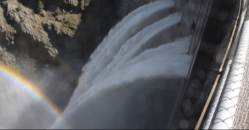
Pretty crazy to see this water release over Morrow Point Dam in CO. Could be another 31 yrs before it happens again http://t.co/O3dWHpXSPJ
— American Rivers (@americanrivers) June 16, 2014

Pretty crazy to see this water release over Morrow Point Dam in CO. Could be another 31 yrs before it happens again http://t.co/O3dWHpXSPJ
— American Rivers (@americanrivers) June 16, 2014
Chris Treese of @ColoradoWater: "SB23 was a fundamental change to #Colorado #Water Law." http://t.co/Nl4u6hfpsE #CoLeg
— H2O Radio (@H2OTracker) June 16, 2014
Here’s the release from the United States Geological Survey:
A recent study conducted by scientists from the U.S. Geological Survey and published in the Journal of Geophysical Research – Biogeosciences found that a combination of climate and human activities (diversion and reservoirs) controls the movement of carbon in two large western river basins, the Colorado and the Missouri Rivers.
Rivers move large amounts of carbon downstream to the oceans. Developing a better understanding of the factors that control the transport of carbon in rivers is an important component of global carbon cycling research.
The study is a product of the USGS John Wesley Powell Center for Analysis and Synthesis and the USGS Land Carbon program.
Different downstream patterns were found between the two river systems. The amount of carbon steadily increased down the Missouri River from headwaters to its confluence with the Mississippi River, but decreased in the lower Colorado River. The differences were attributed to less precipitation, greater evaporation, and the diversion of water for human activities on the Colorado River.
For upstream/headwater sites on both rivers, carbon fluxes varied along with seasonal precipitation and temperature changes. There was also greater variability in the amount of carbon at upstream sites, likely because of seasonal inputs of organic material to the rivers. Reservoirs disrupted the connection between the watershed and the river, causing carbon amounts downstream of dams to be less variable in time and less responsive to seasonal temperature and precipitation changes.
The study presents estimates of changes in the amount of carbon moving down the Colorado and Missouri Rivers and provides new insights into aquatic carbon cycling in arid and semi-arid regions of the central and western U.S, where freshwater carbon cycling studies have been less common. This work is part of an ongoing effort to directly address the importance of freshwater ecosystems in the context of the broader carbon cycle. In the future, changing hydrology and warming temperatures will increase the importance of reservoirs in carbon cycling, and may lead to an increase in Greenhouse Gas Emissions that contribute to global warming, but may also increase the amount of carbon buried in sediments.
More USGS coverage here.
From NOAA (Mike Halpert):
By this point, most of you have heard that it looks like El Niño is coming, and maybe you’re wondering why you should care. After all, why should it matter if the tropical Pacific Ocean becomes warmer than average? That’s thousands of miles away from the continental United States. Well, it turns out that El Niño often results in changes in the patterns of precipitation and temperature across many parts of the globe, including North America (Ropelewski and Halpert 1987, Halpert and Ropelewski 1992).
Many folks probably remember the heavy rainfall, flooding, and landslides that occurred in California in 1982/83 and again in 1997/98. As the region suffers through a devastating drought, it could be something of a relief if we knew for certain that El Niño would bring similar soaking rains. But those two events were the 2 strongest El Niños in the past 60 years, and we’ve seen many other El Niño years where California didn’t experience those types of devastating impacts. So assuming El Niño develops, what can we expect across the United States and when can we expect it?
By examining seasonal climate conditions in previous El Niño years, scientists have identified a set of typical impacts associated with the phenomenon (Figure 1). “Associated with” doesn’t mean that all of these impacts happen during every El Niño episode. However, they happen more often during El Niño than you’d expect by chance, and many of them have occurred during many El Niño events.
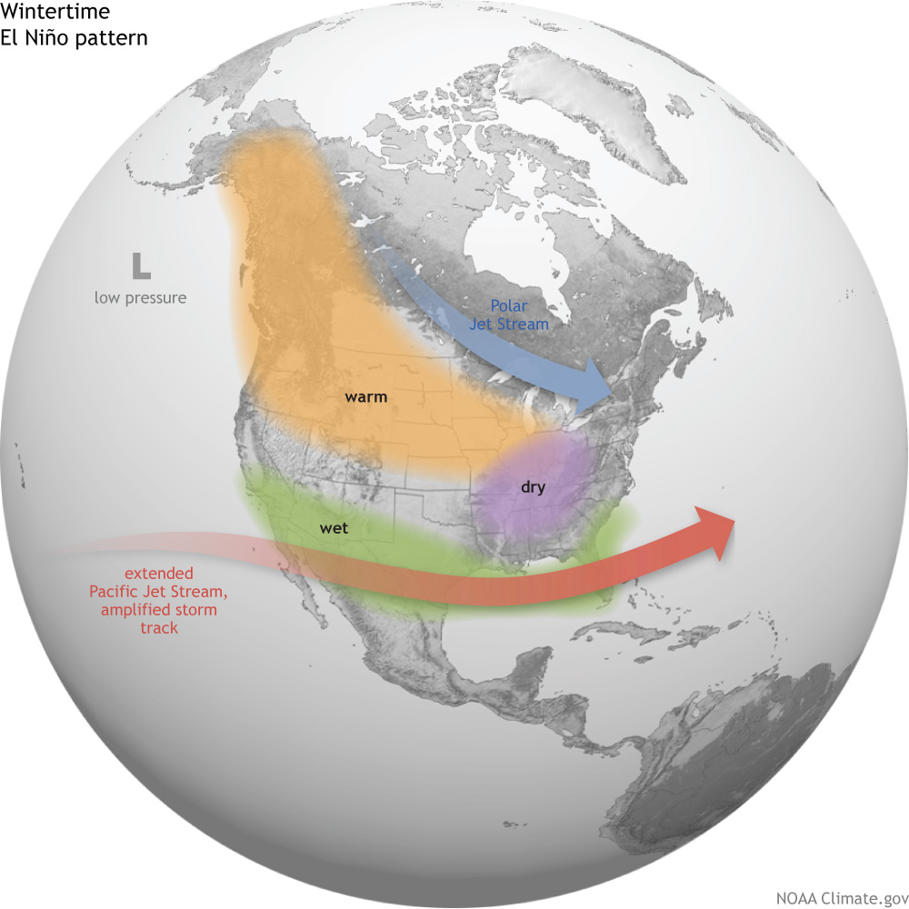
In general, El Niño-related temperature and precipitation impacts across the United States occur during the cold half of the year (October through March). The most reliable of these signals (the one that has been observed most frequently) is wetter-than-average conditions along the Gulf Coast from Texas to Florida during this 6-month period. This relationship has occurred during more than 80% of the El Niño events in the past 100 years.
In Southern California and U.S. Southwest, strength matters
Over California and the Southwest, the relationship between El Niño and above-average precipitation is weaker, and it depends significantly on the strength of the El Niño. The stronger the episode (i.e., the larger the sea surface temperature departures across the central equatorial Pacific are), the more reliable the signal in this region has been.For instance, during the two strongest events in the past 60 years (1982/83 and 1997/98), much-above-median rainfall amounts fell across the entire state of California. Median or above-median precipitation was recorded over the entire state during strong episodes in both 1957/58 and 1972/73 (Figure 2). However, strong events in 1991/92 and 2009/10 only provided small surpluses in the southern part of the state, while precipitation during 1965/66 was generally average to below-average across the state.
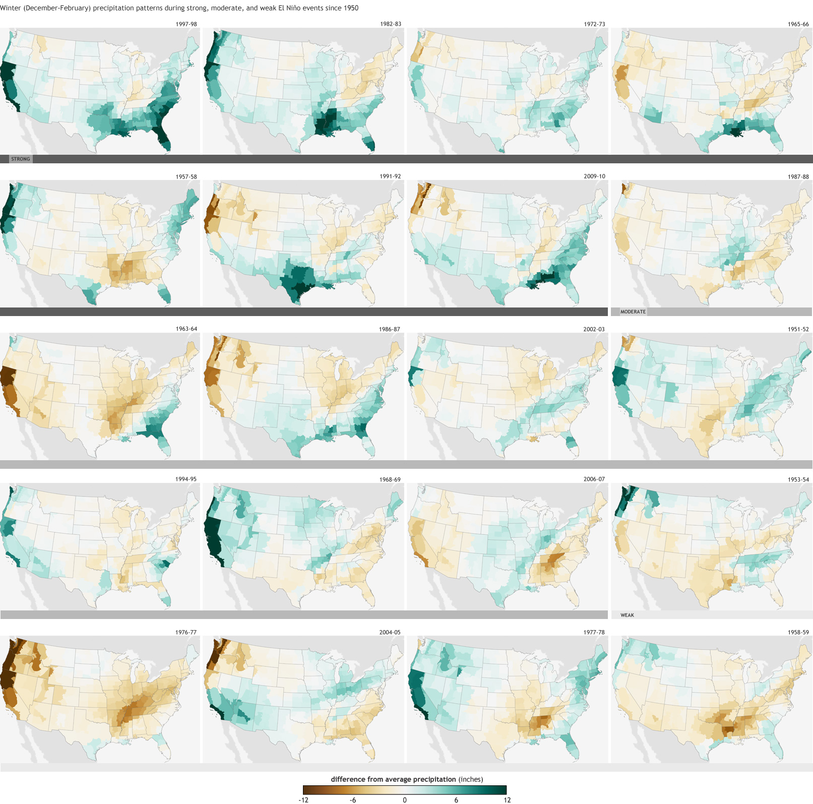
For weak and moderate strength episodes (Figure 2), the relationship is even weaker, with approximately one-third of the events featuring above-average precipitation, one-third near-average precipitation, and one-third below-average precipitation.
Elsewhere over the United States, El Niño impacts are associated with drier conditions in the Ohio Valley, and there is a less-reliable dry signal in the Pacific Northwest and the northern Rockies. Hawaii also often experiences lower-than-average rainfall totals from the late fall through early spring period.
The climate impacts linked to El Niño help forecasters make skillful seasonal outlooks. While not guaranteed, the changes in temperature and precipitation across the United States are fairly reliable and often provide enough lead time for emergency managers, businesses, government officials, and the public to properly prepare and make smart decisions to save lives and protect livelihoods.
Definitions
Weak El Niño: Episode when the peak Oceanic Niño Index (ONI) is greater than or equal to 0.5°C and less than or equal to 0.9°C.
Moderate El Niño: Episode when the peak Oceanic Niño Index (ONI) is greater than or equal to 1.0°C and less than or equal to 1.4°C.
Strong El Niño: Episode when the peak Oceanic Niño Index (ONI) is greater than or equal to 1.5°C.

From the Fowler Tribune (Lacy McCuisiton):
The Arkansas Basin Roundtable, formed in 2005, consists of about 40 active, voting members today. Each county has two representatives, plus conservancy and conservation districts as well as 10 at-large members from the fields of agriculture, recreation and environment, and industry and small municipal water providers. With the purpose or legislative charge of the Rountable to “propose projects and methods to meet the needs of the Arkansas Basin.” By executive order Colorado’s Water Plan draft is due to the governor Dec. 10, 2014, allowing for a final decision to be made by December 2015.
The Roundtable has been working on solutions, ideas and projects to include in the State Water Plan. Some identified include increased storage, imported water (transfer mountain diversions), aquifer storage, recharge ponds, conservation (to reduce municipal demand), lease/fallow, and conservation easements with municipal component. As the Arkansas Basin Roundtable has been working closely with Colorado Parks and Wildlife, they seem to have the same goals in mind. It is Colorado Parks and Wildlife’s goal is to be able to develop relationships and be a partner with other water users as there are things that can be accomplished better together. More importantly, however, is that the Roundtable is asking for “YOUR” suggestions and input.
“Where is the water going to come from if we do build more water storage?” “What plans do we have to stop municipality raids?” were a couple of the concerns brought forth by the citizens of Fowler, as well as that Fowler does have a gap including a water shortage, although not defined in the previous plan. Again, as the Colorado Water Plan is “our” plan, the Arkansas Basin Implementation Plan needs your input. They are asking you to contact your local representatives, visit http://www.coloradowaterplan.com, cowaterplan@state.co.us, http://www.dola.colorado.gov.lgis, and to complete an input form obtained from these websites.
More Colorado Water Plan coverage here.

From the Cortez Journal (Jim Mimiaga):
Montezuma County has bowed out of a complex water dispute on Canyons of the Ancients National Monument, but negotiated stipulations on water use for Yellow Jacket Creek.
In 2009, the monument purchased an inholding – the 4,500-acre Wallace Ranch – for $3.3 million. The property came with a conditional water right of 5.25 cubic feet per second from the intermittent desert stream.
The county, along with Southwest Colorado Landowners Association and Water Rights Montezuma, opposed a routine water-court procedure by the BLM regarding the due diligence on eventual use of the water rights.
“When the BLM acquires conditional water rights, they file for a six-year diligence period, an internal process that gives us time to determine how the water will potentially be used,” said Roy Smith, a BLM water specialist…
The county has been critical of the monument buying private inholdings, fearing it will diminish historic ranching opportunities in that area.
Commissioner Keenan Ertel argued that Article 1, Section 8, of the U.S. Constitution requires the state legislature to approve federal purchase of private property. Permission was not granted by the state, and BLM officials do not believe it is necessary.
The BLM filed a request for summary judgment on the case May 30, which asks the Durango water court judge Greg Lyman to rule in favor of the BLM because the objectors’ legal dispute is presented in the wrong court venue. The decision is pending, and if denied would trigger a trial.
The BLM argues due-diligence procedures have narrow parameters in water court and that those specific facts are not disputed in the case. Special Assistant U.S. Attorney Kristen Guerriero states claims of objectors are irrelevant in water court.
“Specifically, opposers assert Constitutional claims alleging that the United States does not have authority to purchase property own water rights in any state,” writes Kristen Guerrieo, Special Assistant U.S. Attorney. “These are not claims that challenge the validity of BLM’s diligence activities, but rather reflect Opposers’ desire to utilize the Water Court proceeding to advance other objectives.”
Montezuma County officials want water use out of Yellow Jacket creek to be decided on sooner than within the 6-year period requested by the BLM.
“They need to have a plan on what they will do with that water,” said commissioner Ertel.
Montezuma County attorney John Baxter told the commissioners the stipulation agreement drops them as official objectors in the BLM request for the six year diligence period on the Yellow Jacket water rights. But they will still have a say on how the water should be used when the BLM seeks absolute status of those water rights.
“Whether we win or not, they still have to go through us when they perfect the rights,” he said. “The BLM wants to kick the can down the road,” on deciding how to use the water.
The stipulation agreement states that when Yellow Jacket water rights are converted from conditional to absolute they can only be used for public recreation, BLM housing facilities, fire suppression, irrigation use, and livestock use. It further stipulates the water cannot be used to grow crops, that what is not used be available for downstream users, and that the BLM does not file applications to convert the water to instream flow uses or for uses on other properties.
Remaining objectors in the case, Southwest Colorado Landowners Association and Water Rights Montezuma, have until June 24 to respond to the request for summary judgement filed by the BLM.
More water law coverage here.

From The Aspen Times (Scott Condon):
A trial was scheduled to begin Thursday in state water court in Glenwood Springs. “That trial now will not happen,” Ely said.
Pitkin County has worked for about 10 years to establish the ability to use water rights for recreational purposes connected to the special project. The county wants to establish a kayak park on the Roaring Fork River just downstream from Fishermen’s Park, which is a stone’s throw from the Upper Basalt Bypass Bridge on Highway 82.
The county faced opposition from what Ely said he considers “the usual suspects” on water-rights issues. One of the parties opposing the county’s plan was the Twin Lakes Reservoir and Canal Co., which diverts from the headwaters of the Roaring Fork River.
Ely said various parties involved on both sides of the court battle stipulated a settlement rather than proceed with the trial and an uncertain outcome. It was a model of give-and-take, he said.
“Everybody left the table being hungry,” Ely said.
The agreement allows Pitkin County to call for water for the kayak park between April 15 and Labor Day. Differing water levels would be called at different times. The most water would be tapped for the park during spring runoff. The amount would be lower before and after prime runoff…
“It’s been about 10 years since this dialog first started,” Ely said during a ceremony Thursday at Fishermen’s Park attended by about 25 people, including Colorado Gov. John Hickenlooper…
Hickenlooper congratulated Pitkin County and Basalt for their river work. He noted that investments made in river features by towns such as Buena Vista and Salida have paid big dividends.
More water law coverage here.