Snowpack/runoff news: 16,000 cfs in the Shoshone reach

coloradoriverbelowglenwoodsprings05092014

From KUNC (Marci Krinoven):

This time of year the commercial rafting company Whitewater Rafting, LLC takes between 25 to 50 people out on the river each weekday. As the summer progresses, that number increases to up to 300 people in July. Normally, the Glenwood Springs company runs a stretch of the Colorado River through Glenwood Canyon but, because the river’s so swollen, owner Erik Larsson says they’ve changed their route.

“We’re going from as far up as Carbondale all the way down to New Castle for full day trips and that’s quite a bit of mileage and way more than we usually do.”

Because of high water, the company is choosing safer routes that are longer. Still, Larsson says the big water makes some people nervous.

“Some of our rafting guests are little scared about it, for sure. We’ve had a few calls asking whether its safe. And, if anything, right now our trips are a little more mild than they will be in July and August. The river’s bigger, the waves are bigger but it’s not very technical paddling.”

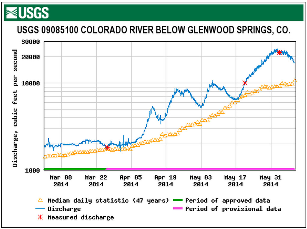
The flows may cause rafter anxiety but overall, they’re a good thing for an industry that typically brings well over $100 million to the state each year. David Costlow is Executive Director of the Colorado River Outfitters Association.

“This year, I think many people anticipate the rafting will be great, and it will be. That’s because of all the snowpack, and we’ve had sufficient rains on the prairie to wet the soils, etc. so less gets absorbed into the ground so less gets absorbed into the ground and more comes down and through rivers,” he says.

He says the heavy spring runoff happening now is earlier than normal, which is good because tourism season hasn’t fully ramped up.

“So, we’d like to take the highs off the river and get down to exciting flows and have those maybe by June 10th, so when the tourism season kicks in, we’re ready to go.”

A slow, steady runoff is preferred by rafters because it ensures good flows late in the summer.

Hermosa bill up in the air — The Durango Herald

Proposed Hermosa Creek watershed protection area via The Durango Herald

Here’s an in-depth look at the resource and proposed legislation for Hermosa Creek and it’s environs from John Peel writing for The Durango Herald. Click through and read the whole thing. Here’s an excerpt:

U.S. Rep. Scott Tipton and U.S. Sen. Michael Bennet are among those with the final say, and the good news is they’re pulling hard for it. Both have introduced the act into their respective chambers of Congress.

But here’s the frustration: Even they haven’t been able to push through a bill that nobody on record has yet opposed…

In 2008 a steering committee formed, and in the next 22 months, it painstakingly, delicately, hammered out a balanced plan. Fishermen, hunters, mountain bikers, equestrians, motorcyclists, wilderness lovers, ranchers and water districts, to name a few, kept at it.

“Everyone was reasonable,” Churchwell says. But then he qualifies that, “Not in the beginning.

“Every one of us gave up something to get something. … It was an incredible experience. It really was.”

In all, it took nearly four years to craft legislation, says Widen, who is the Wilderness Society’s senior public lands representative.

“It was a long and tedious process, but that’s really what brought everyone together,” Widen says. “I think the way the Hermosa Creek group worked is just a stellar example of how it should work.”

Bennet and Tipton took the efforts of the Hermosa Creek Workgroup and created bills. The Senate took the first step last year by holding a subcommittee hearing, and the House did the same this year.

Next is for the bill to go to the Senate Energy and Natural Resources Committee and House Natural Resources Committee for “mark-up” – a process where committee members can make changes. If those committees pass the bill, it goes to the full chambers for votes.

“We are very hopeful it will get out of committee in the next 30 days and possibly a floor vote before August recess,” says Darlene Marcus, Tipton’s Durango-based representative. “It is a priority of the congressman and his staff.”

The House’s Natural Resources chairman is Doc Hastings, R-Wash.; Widen said Natural Resources member Rob Bishop, R-Utah, has indicated he wants to move the bill. In the Senate, it’s unclear how soon new Energy and Natural Resources chair, Mary Landrieu, D-La., will bring it up. It may help that Sen. Mark Udall, D-Colo., is a senior member of that committee and a bill co-sponsor.

Bennet, through his Denver office, said Sunday that the bill “recognizes the diverse set of people who use the space, ranging from ATVers to fisherman to hikers.” He called Hermosa Creek “one of Colorado’s crown jewels.”

“This is one of our most pressing priorities, and we’re hopeful that we can successfully move it through Congress by the end of this session,” Bennet said.

So what does the act do? For starters, it protects wildlife, much of the current trail use and water quality.

Zink, a Durango native, says he actually got involved stemming from his role as secretary of the Animas Consolidated Ditch Co. The hunter, cyclist and horseman dons so many hats “it wears my hair out.”

He likes the plan because it basically keeps land use the way it is now – and that’s what the community’s been asking for during the last half-century of studies and forest plans.

From the air, the 107,886-acre area, which comprises nearly the entire Hermosa watershed, is an uneven green carpet of trees, with a few brown streaks of forest roads north of the East Fork and the snow-capped peaks of Hermosa and Grayrock on the northern border.

The bill would create 37,236 acres of wilderness in the western portion. There would be a 68,289-acre “special management area,” with the northern chunk to be left as is, dirt roads and all. The eastern part (43,000 acres) would be protected as a roadless area but still allow mountain bikes and motorcycles.

Arkansas River Headwaters Recreation Area — a linear recreation area that follows the Arkansas River for 150 miles

Arkansas River Basin -- Graphic via the Colorado Geological Survey
Arkansas River Basin — Graphic via the Colorado Geological Survey

Here’s an in-depth look at the Arkansas River Headwaters Recreation Area from Tracy Harmon writing for The Pueblo Chieftain:

It seems warring is a history that repeats itself in the Upper Arkansas River Valley.

In 1879 railroad companies were going to battle over who would be the first to lay track through the Royal Gorge canyon. It became so heated that shots were exchanged among the opposing camps.

Later, it would be the rafters and the fishermen who would butt heads like bighorn rams vying for dominance. At issue in the early 1990s was the flow of water in the Arkansas River.

Rafters wanted to have extra water for the late-season boating and fishermen felt the higher water flow was a detriment for the fish just when trout needed to catch a break from fighting the summer waves.

Eventually, the feud was settled. Rafters get their extra water until Aug. 15 each year and anglers get water releases in the winter months should the level drop to dangerous lows endangering fish.

At the tenuous center of the boat and hook controversy was an unlikely group of government regulators who dreamed it was possible that someday everyone would get along. After all, rafting can bring a neat $60 million chunk of change to the valley coffers and anglers spend plenty as well.

When the Arkansas Headwaters Recreation Area was officially formed 25 years ago this coming October, work was just beginning. Countless public meetings and lawsuits pushed patience on both sides, yet the recreation area endures as one of the few federal and state partnerships in existence nationwide.

The partners have made the first 150-mile stretch of the Arkansas River corridor not only the most rafted river in the nation, but a gold medal fishing ground.

Besides the breathtaking views and some of Mother Nature’s finest canyon rock wall work, the recreation area has grown to include the kind of amenities that make people want to stop and take it all in.

From Leadville to Lake Pueblo, the recreation area spans four counties. Colorado Parks and Wildlife has teamed up with the U.S. Bureau of Land Management and Forest Service to offer a boatload of improvements from campgrounds and boating ramps to restrooms and picnic grounds.

All totaled there are 42 sites along the corridor, according to Rob White, Arkansas Headwaters manager for CPW.

“One of the greatest accomplishments to date regarding the creation of the Arkansas Headwaters Recreation Area has been the acquisition and development of recreation sites along the Arkansas River corridor that provide invaluable public access for both whitewater boating and angling,” White said. “We try to strike a balance in the development of our recreation sites and with the management of the natural resources, including water, so that whitewater boaters, anglers and all of our visitors can enjoy the recreation area.”

The balance between man and nature is evident. Each recreation site is so well cared for a visitor would be hard pressed to find a gum wrapper littering the ground.

“We continue to work on improvements to the natural resources found throughout the river corridor and the riparian areas are in better condition then they have been in a long time,” said John Nahomenuk, River Manager for the BLM. “We are an integral tie that brings together and helps strengthen the communities in the river valley.”

White and Nahomenuk work together, often identifying potential land acquisitions with willing sellers and then find the money to buy the land.

The Colorado Lottery has been instrumental in making many of the improvements a reality by awarding grants that have helped convert private property parcels into public playgrounds.

Boaters and anglers are not the park’s only users.

Gold panning, riverside picnics and climbing are among the reasons people make it a destination.

Many visitors come to the Bighorn Sheep Canyon between Salida and Canon City in hopes of spotting the state animal. The sheep are so expertly camouflaged it takes movement or a flash of their white rear ends to actually spot them.

White and Nahomenuk often run ideas by the citizen’s task force to get input from a variety of the park’s stewards from boaters and anglers to ranchers and environmentalists.

It’s nice when everyone can agree. Just don’t bring up New York artist Christo’s Over the River artwork planned for a two-week display along the stretch of river between Salida and Canon City or you could see the warring start to brew all over again.

More Arkansas River Basin coverage here.