Dams are a core element of American infrastructure and provide many important services. However, aging infrastructure has led to many dams becoming obsolete, costly, and unsafe, threatening human life if they fail. By 2020, more than 65 percent of dams will be past their designated lifespan. Further, these structures put a strain on American rivers and wildlife by blocking an estimated 600,000 miles of U.S. rivers. Without a comprehensive plan for this failing infrastructure, the problem will continue to grow.
Please join the Center for American Progress for a panel discussion to highlight the progress that has already been made and explore the future of policymaking that aims to modernize the management of dam infrastructure, remove unneeded dams, and restore the health of American rivers.
Introductory remarks:
David Hayes, Senior Fellow, Center for American Progress
Panelists:
Mike Connor, Deputy Secretary of the Interior
Steve Ellis, Vice President, Taxpayers for Common Sense
Rose Marcario, President and CEO, Patagonia Inc.
Rebecca Miles, Executive Director of the Nez Perce Tribe
Moderator:
Annie Snider, Energy Reporter, POLITICO Pro
The “Minute 319 Colorado River Limitrophe and Delta Environmental Flows Monitoring Interim Report,” released by the International Boundary and Water Commission, documents the effects of the environmental flows in the delta from the initial release of a pulse of water from March 23 through May 18, 2014, plus subsequent supplemental deliveries of water through December 2015.
Here’s the release from the University of Arizona (Mari N. Jensen):
Two growing seasons after the engineered spring flood of 2014, the delta’s birds, plants and groundwater continue to benefit, according to a report by a binational, UA-led team.
Two growing seasons after the engineered spring flood of the Colorado River Delta in 2014, the delta’s birds, plants and groundwater continue to benefit, according to the latest monitoring report prepared for the International Boundary and Water Commission by a binational, University of Arizona-led team.
“This short-term event has had lasting consequences. This really demonstrates that a little bit of water does a lot of environmental good,” said Karl W. Flessa, UA professor of geosciences and co-chief scientist of the Minute 319 monitoring team.
“Some of the cottonwoods that germinated during the initial pulse flow are now more than 10 feet tall,” Flessa said.
Martha Gomez-Sapiens, a monitoring team member and postdoctoral research associate in the UA Department of Geosciences, stands on a riverbank next to willows and cottonwoods that germinated as a result of the pulse flow. (Photo: Karl W. Flessa/UA Department of Geosciences)
The “Minute 319 Colorado River Limitrophe and Delta Environmental Flows Monitoring Interim Report,” released by the International Boundary and Water Commission, documents the effects of the environmental flows in the delta from the initial release of a pulse of water from March 23 through May 18, 2014, plus subsequent supplemental deliveries of water through December 2015.
Minute 319 is the 2012 addition to the 1944 U.S.-Mexico Water Treaty that authorized environmental flows of water into the Colorado River Delta from 2013 to 2017.
Birdlife responded to the post-flood burgeoning of vegetation, and bird diversity is still higher than before, the monitoring team reports. Migratory waterbirds, nesting waterbirds and nesting riparian birds all increased in abundance.
Upstream dams and water diversions for farms and cities in both countries have dried up most of the river south of the border. With the exception of a few wet years, the river has not reached the Gulf of California since 1960.
“This is the first time environmental water has ever been delivered across an international boundary.” said Eloise Kendy, a senior freshwater scientist with The Nature Conservancy’s North America Water Program.
“The level of collaboration was really unprecedented — from two national governments to the individual farmers whose irrigation canals were used for some of the water deliveries,” she said. [ed. emphasis mine]
Flessa, Kendy and Karen Schlatter of Sonoran Institute compiled and edited the report on behalf of the binational partnership of many people and federal agencies, universities and non-governmental organizations that monitored the Colorado River Delta under Minute 319.
Some of the water from the pulse flow and subsequent smaller environmental flows recharged the groundwater, which had both ecological and social benefits, Kendy said. The vegetation greened up in areas that received surface water and also in some areas that did not.
“The farmers were happy because it recharged the aquifer they use for groundwater irrigation,” Kendy said. “And plants that were outside the inundation zone got a big drink of water.”
Before 1960, spring floods regularly roared down the Colorado River, scouring the river bottom and overtopping the bank, thereby creating the conditions necessary for cottonwood and willow trees to germinate and establish.
An invasive plant species known as salt cedar or tamarisk is now the dominant plant along the river. Cottonwoods and willows need bare ground and sunlight to germinate, so they cannot establish themselves on tamarisk-covered riverbanks, said Schlatter, a restoration ecologist of the Sonoran Institute’s Colorado River Delta Program.
The March 2014 pulse flow delivered a fraction of the water the pre-1960 spring floods delivered. People from Sonoran Institute and Pronatura Noroeste cleared some areas of non-native vegetation beforehand. The researchers hoped that reducing competition would allow native plants such as willows and cottonwoods to germinate and grow after the pulse flow.
“We mechanically cleared the tamarisk vegetation from the riverbank and old oxbows,” Schlatter said. “We reconnected the meanders to the main river channels so when the pulse flow came there were these nice backwater areas where the conditions were good for the establishment of native trees.”
Now in those restoration areas, cottonwood and willow seeds that germinated after the pulse flow have become trees 3 to 4 meters tall (10 to 13 feet), and bird diversity and abundance has increased, she said.
“Now we have diverse habitat types, including lagoons, cottonwoods-willow forest, mesquite bosque and marshes,” she said. “We are seeing a much higher diversity of riparian bird species in the restoration sites compared to other areas along the river.”
The abundance of 19 bird species of conservation concern, including vermillion flycatchers, hooded orioles and yellow-breasted chats, was 43 percent higher at the restoration sites than at other sites in the floodplain, the monitoring team found.
In addition, the pulse flow reduced soil salinity in some areas that had been targeted for restoration, Schlatter said. “We didn’t expect that — it is a huge bonus.”
Reducing the soil salinity makes conditions more favorable for native plant species.
If there’s another pulse flow, she suggests mechanically clearing tamarisk and other non-native vegetation from the river’s bank.
“We’re not going to get a huge flood on the Colorado River anymore,” Schlatter said. “If the flood isn’t going to provide the same ecological processes floods did in the past, we will have to have active management.”
Other UA members of the monitoring team are Ed Glenn of the UA Department of Soil, Water and Environmental Science and Martha Gomez-Sapiens and Hector Zamora of the UA Department of Geosciences.
The International Boundary and Water Commission in El Paso, Texas, funded the UA portion of the Minute 319 monitoring program.
Carlos de la Parra of the Colegio de la Frontera Norte is co-chief scientist of the Minute 319 monitoring team. Key contributors to the report include Osvel Hinojosa of Pronatura Noroeste, Jorge Ramírez and Jesus Eliana Rodriguez Burgueño of the Universidad Autónoma de Baja California, Francisco Zamora of Sonoran Institute, Jeffrey Kennedy of the U.S. Geological Survey and Dale Turner of The Nature Conservancy.
The Minute 319 monitoring team includes more than 21 scientists from universities, government agencies and nongovernmental organizations from both Mexico and the U.S., including El Colegio de la Frontera Norte, the Ensenada-based Pronatura Noroeste, The Nature Conservancy, the Tucson-based Sonoran Institute, the Universidad Autónoma de Baja California, the University of Arizona, the U.S. Geological Survey and the U.S. Bureau of Reclamation.
Colorado River pulse flow (Minute 319) reaches the Sea of Cortez for the first time since 1998 on May 15, 2014 via the Sonoran Institute
Flash droughts, much like flash floods, are sudden. It happens when dry conditions seemingly coming on without warning. However, a new study from the National Center for Atmospheric Research in Boulder found that there may be a way to better predict this kind of drought.
“In terms of when you look at drought forecast, you also should look towards the ground, in addition to the sky,” PaiMazumder said.
What comes from the sky? Snow — in particular, snowpack. It’s the added ingredient to an equation that could help predict flash droughts months in advance.
“Because in 2012, we had such a lack of snowpack, which influenced our soil moisture,” PaiMazumder said.
Scientists at NCAR found that by looking at the usual drought measurement – soil moisture — and then also analyzing snowpack, they could increase their prediction of a flash drought from one month in advance to four months. That could help water managers in a dry state like Colorado know how much water they have to work with. It’s a lead time could make a big difference in predicting future flash droughts.
The National Science Foundation funded the study, which was just published in the Journal of Geophysical Research, Atmospheres.
Two years ago, a partnership between La Plata County Open Space and Southwest Conversation Corps removed Russian Olive, along with two other invasive species – tamarisk and Siberian elm – from more than 300 acres of the Animas River valley.
However, lands targeted during that project focused only on property owners who had placed their land under a conservation easement. There remained the need to address other landowners in the valley, Mountain Studies Institute’s Amanda M. Kuenzi said.
As a result, MSI applied, and was awarded, a $195,000 grant from the Colorado Water Conservation Board and an additional $52,000 from Colorado Parks and Wildlife for a three-year project to remove invasive plants from Bakers Bridge to the New Mexico line.
This week, crews from Southwest Conservation Corps embarked on the first leg of the project: a three-week effort on about 15 properties in the Animas Valley, including James Ranch and the Zink farm.
This fall’s removal, Kuenzi said, also serves as a pilot project aimed to garner interest from adjacent landowners.
“We really hope to get property owners who haven’t been involved to get aggressive on this,” Kuenzi said.
Kuenzi said because of diligent past efforts from Animas Valley landowners, as well as the city of Durango, among other entities, the presence of Russian olive and other invasive species isn’t nearly as problematic as in neighboring communities.
“If you go to Farmington, the Russian olive is wall to wall,” she said. “But we’ve worked on the problem here for decades, and that’s why our area isn’t overwhelmed. Still, we need to nip this problem in the bud so future generations don’t have to deal with it.”
Indeed, Cathy Metz, parks and recreation manager with the city of Durango, said the city has strategically fought Russian olive and other non-native plants on its property for years.
“We still have an ongoing monitoring situation, but we really don’t have many remaining on city property,” she said. “But certainly, we really advocate for collaborative effort to remove these species just because they are so invasive.”
Megan Graham, spokeswoman for La Plata County, said Russian olive is not on the list of weeds the county targets, but that the issue may be a topic of conversation later this month.
Russian olives are considered a “List B noxious weed,” which requires local governments to manage and limit their spread under Colorado state law.
Regardless, work carried out this week by Southwest Conservation Corp’s eight-person crew aims to cut down the plant. They then drop riparian-safe herbicide on the root so the plant doesn’t grow back.
“The hard part is really trying to spot all of them,” crew leader Alyssa Engdahl said while scouring the Zink property Wednesday. “And, of course, the thorns.”
The project next year will be four months, with the aim of extending into the Florida River watershed, a tributary of the Animas. The effort as a whole, Kuenzi said, largely depends on the community’s response.
“We really need all landowners’ participation to make this program a success and to ensure the health of our watershed for years to come,” she said.
From the La Junta Tribune-Democrat (Bette McFarren):
With Mayor Pro Tem Jeffri Pruyn conducting the meeting, the La Junta City Council on Monday evening formally accepted the loan/grant of $246,000 from the Colorado Water Resources and Power Development Authority to the City of La Junta Wastewater Enterprise of not to exceed $246,000. The loan is to be forgiven at its inception. It is for the purpose of dealing with the problems facing the installation of the new wastewater plant, thus enabling construction to get under way. Construction is unlikely to begin until late winter or next spring, said Director of Water and Wastewater Joe Kelley.
The Fountain Creek Watershed is located along the central front range of Colorado. It is a 927-square mile watershed that drains south into the Arkansas River at Pueblo. The watershed is bordered by the Palmer Divide to the north, Pikes Peak to the west, and a minor divide 20 miles east of Colorado Springs. Map via the Fountain Creek Watershed Flood Control and Greenway District.
The spill, which Air Force officials said they’re investigating, happened as the Air Force increasingly faces scrutiny as a source of groundwater contamination nationwide.
The surge of waste containing elevated perfluorinated chemicals (PFCs) — used at military airfields to douse fuel fires and linked by federal authorities to kidney cancer, testicular cancer, low birth weights and other health problems — flowed through a Colorado Springs Utilities wastewater treatment plant before crews could try to block it. Then it trickled into Fountain Creek.
“Even if we would have been able to head it off at the plant, we’re not equipped. I don’t know of any wastewater plants in the country equipped to remove PFCs,” utilities spokesman Steve Berry said. “We would not have been able to remove that chemical before it was discharged back into the environment from our effluent.”
Fountain Creek flows south toward Pueblo and into the Arkansas River.
Pueblo Board of Water Works spokesman Paul Fanning said Pueblo didn’t hear about the spill until reporters made inquiries Tuesday.
“We don’t use any groundwater or surface water from Fountain Creek. We use water from the Arkansas River taken upstream from where Fountain Creek flows in,” Fanning said. “But it is not a good thing to have those contaminants anywhere in our water. There are some reported health effects. It is in our interest to protect our public.”
[…]
The PFC-laced waste was held in a tank at a firefighter training area on the base, located at the southeastern edge of Colorado Springs. PFCs are a component in the aqueous film-forming foam used to extinguish fuel fires.
Air Force officials said in the statement that they discovered the spill Oct. 12 during an inspection. They notified Colorado Springs Utilities the next day. The tank was part of a system used to recirculate water to a firefighter training area…
In Colorado, government well test data show PFCs have contaminated groundwater throughout the Fountain Creek watershed, nearly as far south as Pueblo, at levels up to 20 times higher than that EPA health advisory limit of 70 parts per trillion.
Public-water authorities in Fountain, Security and Widefield have scrambled to provide enough alternative water. Security has been purchasing millions of gallons of diverted Arkansas River water from Colorado Springs, installing new pipelines and minimizing pumping from contaminated municipal wells. Since Sept. 9, Security has not pumped any water from wells, water and sanitation district manager Roy Heald said. “This spill does not affect us immediately,” Heald said. “Our only concern would be the long-term effect on Fountain Creek and the Widefield Aquifer.”
Some parents south of Colorado Springs began paying for bottled water — to be safe. A contractor delivers emergency bottled water to at least 77 households.
The Air Force has contributed $4.3 million to help communities deal with the contamination.
Colorado Springs utilities crews will work with the military “to keep PFCs out of our system. That is the goal,” Berry said. “How do we protect our customers and our system from this chemical? That is the focus. It goes beyond the Air Force. It is any industrial process that may use that chemical.”
El Paso County Public Health “takes this discharge seriously and will coordinate with the Colorado Department of Public Health and the Environment to collect water samples along Fountain Creek, if warranted,” spokeswoman Danielle Oller said.
CDPHE has been informed, agency spokesman Mark Salley said, adding: “It is under investigation by the Air Force, and the department is waiting for information. … The Air Force has demonstrated its commitment to identifying and addressing PFC contamination at Peterson Air Force Base and facilities nationwide.”
FromThe Colorado Springs Gazette (Tom Roeder and Jakob Rodgers):
The release last week posed no threat to Colorado Springs drinking water.
The base said the release was discovered Oct. 12. The cause hasn’t been determined, but Fred Brooks, Peterson’s environmental chief, said the holding tank was designed to be difficult to discharge.
“It’s not a direct connection,” Brooks said. “This tank would have to have numerous valves switched to actually discharge.”
Was it intentional?
“That’s a possibility,” Brooks said…
An investigation has been opened to determine the cause of the discharge, said Col. Doug Schiess, who commands Peterson’s 21st Space Wing, in the statement.
Colorado Springs Utilities said the chemical-laden water passed through the utility’s Las Vegas Street sewage treatment plant and was released into Fountain Creek. The plant does not have the capacity to remove the chemical.
“There was no risk to the drinking water,” said Steve Berry, a Utilities spokesman. “This did not impact the drinking water, the finished water system, in any way. It went directly into the wastewater system.”
While Peterson notified Colorado Springs, base officials didn’t warn others downstream. Brooks said the base isn’t required to issue a wider notification, noting that the chemical is “unregulated” – a term used for substances that haven’t drawn enforceable drinking water standards…
Peterson had scheduled a public firefighting demonstration on Oct. 12, the day the discharge was discovered. The fire training exercise was canceled, with a spokesman at the base blaming the delay on a “bad valve”
Brooks, the base environmental officer, said two mechanical valves and an electric one must be switched to allow water to flow out of the tank, which held the outflow from fire training exercises dating back as far as 2013.
He said the water wasn’t tested for levels of the firefighting chemical.
A second tank on the base holding fire training residue wasn’t discharged.
The Air Force banned use of the foam outside fire emergencies last year and last month announced a plan to replace the product at all of its bases around the globe. Brooks said the foam at Peterson will be replaced in about two weeks.
The water contamination in Security, Widefield and Fountain has drawn a pair of lawsuits against the manufacturers of the firefighting foam alleging they sold it to the Air Force despite its toxic risks.
Although downstream, no drinking water supplied to Pueblo residents by the Pueblo Board of Water Works comes from Fountain Creek, said Paul Fanning, the agency’s spokesman. The Pueblo Reservoir does not pull from Fountain Creek.
The Widefield Water and Sanitation District is the only water system immediately downstream of the treatment plant now using the Widefield Aquifer, which leaches water from Fountain Creek, where the chemicals flowed.
Widefield officials have previously said they plan to shut off their wells by sometime in October.
Other communities have shut off their wells to the tainted aquifer.
All the water flowing to homes supplied by the Security and Fountain water systems now comes from the Pueblo Reservoir – meaning that last week’s spill should not affect those communities.
“The long-term effects would be concerning,” said Roy Heald, Security water district’s general manager. “But short-term immediate effects – there wouldn’t be any for us.”
The EPA said it wasn’t involved with the spill.
The Colorado Department of Public Health and Environment gave the Air Force a vote of confidence despite the chemical discharge.
“The Air Force has demonstrated its commitment to identifying and addressing (perfluorinated compound) contamination at Peterson Air Force Base and facilities nationwide,” the state agency said.
The release of the Colorado Water Plan ushers in a new era in our water management, where environmental and recreational values are given the same sense of urgency as traditional water development. As communities look for ways to get involved in Water Plan implementation at the local
level, Stream Management Plans (SMPs) are an excellent place to get started.

The concept of the SMPs is still new, with only a few communities having completed or in the process of working on their plans. So, there is plenty for everyone to learn, and the existing plans that are featured in this issue of Colorado Water provide inspiring models for how the plans can
go beyond previous efforts and help to bring communities together.
The Colorado Water Plan highlighted the need for SMPs as a tool to protect watershed health, the environment, and recreation in Colorado. It stated an ambitious goal to “cover 80 percent of the locally prioritized lists of rivers with SMPs by…2030.” SMPs are stakeholder-driven management plans that shepherd environmental and recreational goals and values into actionable projects aimed at “maintaining or improving flow regimes and other physical conditions,” for localized environmental and recreational water uses. Per the Water Plan, SMPs “can provide a framework [to basin roundtables, local stakeholders, and decision makers] for decision making and project implementation.” This special issue of the Colorado Water newsletter is intended to serve as an initial resource guide with topics including an overview of what SMPs are, the steps of the process, available tools, and shared lessons learned from select case studies around the state. The case studies here, alongside others we were unable to include, provide a foundation of water management collaborations that have involved professionals and committed staff who are working on similar issues in every major river basin. Special thanks goes to CSU alumna Claudia Browne from Biohabitats for spearheading.
Two workshops supported by the Colorado Water Conservation Board provided forums for many of the contributors to gather and share these resources in August and October 2016. Workshop presenters included: representatives from the Colorado Water Conservation Board, the Colorado Water Trust, Trout Unlimited, The Nature Conservancy, Open Water Foundation, American Rivers, CSU, the City of Steamboat, and consultants, among others. Bridging the gap between academia and practitioners, CSU students, faculty, alumni, and partners are bringing integrated science, engineering, and social tools to the table. The process should yield better outcomes for Colorado’s streams and rivers as SMPs are implemented.
SMPs are one part of the many approaches outlined in the Colorado Water Plan to secure future water supplies while protecting the environmental, social, and economic values held by Colorado citizens. The academic and research community has an important role in bringing objective science and education to the implementation process for the Water Plan. As the SMP process evolves, there will be room for many more creative minds and voices to help shape the future of wise water management for both humans and the environment.
The figure above shows how the number of days 95° or hotter in the Denver metro area could go from an average of 5 per year late in the last century to 77 per year late in this century. For future periods, the figure shows the range of the middle 80 percent of projections from multiple climate models (the checkered portions of the columns) and the medians (the numerals), for four possible levels of future heat-trapping emissions. Graphic via the Rocky Mountain Climate Organization.
The Rocky Mountain Climate Organization released two parallel reports on projected climate extremes, one covering Boulder County and the other Larimer County, both in Colorado. RMCO also released the results from the first phase of a similar analysis covering the entire Denver metro area.
The analyses show what could be an astonishing transformation of Colorado’s climate. With a continuation of current trends in heat-trapping emissions, by the middle of the century Denver could average 35 days a year 95 degrees or hotter. Boulder could average 38, and Fort Collins 24. By late in the century, Denver could average 77 days that hot, Boulder could average 75, and Fort Collins could average 58.
“This information shows why we need preparedness actions to address the impacts we could face, not only wildfires and possibly more floods but also more heat waves that can threaten people’s health and even lives,” Saunders said. “It also powerfully illustrates how important it is to reduce future emissions to keep the extent of climate change within manageable limits.”
The reports covering Boulder County and Larimer County were funded by the Colorado Department of Local Affairs, to help those counties become more resilient in the face of climate change’s impacts on future disasters including wildfires and floods. The Denver analysis is funded by the City and County of Denver’s Department of Environmental Health.
Here’s the FAQ page from the United States Geological Survey. Here’s an excerpt:
What different types of aerial photographs are available through the USGS?
The aerial photographs date as far back as the 1940’s for the United States and its territories. Availability of specific coverage, film type, and acquisition dates vary from agency to agency.
The Earth Resources Observation and Science Center (EROS) in Sioux Falls, SD has digitized over 6.4 million frames of aerial film creating medium-resolution digital images (400 dpi) and associated browse images for online viewing. Products can be downloaded at no cost through EarthExplorer or GloVis. Several kinds of aerial photos are available.
CIR (color infrared) film, originally referred to as camouflage-detection film, differs from conventional color film because its emulsion layers are sensitive to green, red, and near-infrared radiation (0.5 micrometers to 0.9 micrometers). Used with a yellow filter to absorb the blue light, this film provides sharp images and penetrates haze at high altitudes. Color infrared film also is referred to as false-color film.
Black-and-white panchromatic (B/W) film primarily consists of a black-and-white negative material with a sensitivity range comparable to that of the human eye. It has good contrast and resolution with low graininess and a wide exposure range.
.
Black-and-white infrared (BIR) film, with some exceptions, is sensitive to the spectral region encompassing 0.4 micrometers to 0.9 micrometers. It is sometimes referred to as near-infrared film because it utilizes only a narrow portion of the total infrared spectrum (0.7 micrometers to 0.9 micrometers).
Natural color (also referred to as conventional or normal color) film contains three emulsion layers which are sensitive to blue, green, and red (the three primary colors of the visible spectrum). This film replicates colors as seen by the human eye.
Photographic reproduction of images from the USGS film archives ceased on September 3, 2004. For those who specifically need paper or film products, there is a list of USGS Business Partners who provide aerial photographic research and image printing services.
Here’s the release from the Environmental Protection Agency (Tricia Lynn):
The U.S. Environmental Protection Agency (EPA) is awarding $1.3 million to 22 organizations in 18 states to help protect and restore urban waters and to support community revitalization and other local priorities.
“Often underserved communities in our nation’s cities face disproportionate impacts from pollution, and too often they lack the resources to do something about it,” said Joel Beauvais, EPA Deputy Assistant Administrator for Water. “EPA provides support to empower these communities to improve the quality of their waterways and to help reconnect people and businesses with the water they depend on.”
Many urban waterways have been polluted for years by sewage, runoff from city streets, and contamination from abandoned industrial facilities. Healthy and accessible urban waters can enhance economic, educational, recreational, and social opportunities in surrounding communities.
This year’s Urban Waters grantees will inform and engage residents in stormwater management and pursue community-based plans to address pollution in waterways. To accomplish these goals, many projects will address trash in waterways; test rivers, streams and lakes for pollutants; and prepare the next generation of environmental stewards for careers in the green economy. The 22 organizations receiving EPA grant funding are as follows:
Mystic River Watershed Association, Massachusetts ($60,000) will partner with towns and cities near Boston to create a multimedia education program to increase awareness of stormwater pollution for a regional coalition of municipalities.
Pioneer Valley Planning Commission, Massachusetts ($60,000) will develop a green infrastructure plan for Day Brook in Holyoke to reduce stormwater flow into the brook and resulting combined sewer overflow discharges into the Connecticut River.
NY/NJ Baykeeper, New Jersey ($48,150) will expand its plastic pollution reduction project by identifying, reducing, and preventing plastic transported via stormwater from reaching the lower Passaic River watershed and Newark Bay complex.
Sarah Lawrence College, New York ($60,000) will work with community scientists to investigate the severity and local sources of water pollution while increasing community engagement and stewardship in four underserved urban watersheds in the Lower Hudson River region.
Anacostia Watershed Society Inc., Maryland ($50,000) will educate and train middle-school students from low-income communities in Washington, DC on the problems associated with stormwater runoff and mitigation strategies through a variety of activities.
Virginia Commonwealth University, Virginia ($59,773) will develop a community greening and green infrastructure plan for its two urban campuses and the Richmond Arts District.
The Conservation Fund, Georgia ($60,000) will expand community engagement in planning for two future green infrastructure projects aimed at reducing stormwater runoff located in the headwaters of Proctor Creek in Atlanta.
University of Tennessee, Tennessee ($59,995) will, through a community-driven effort, collect nutrient data across the Baker Creek watershed, which will help the City of Knoxville and Tennessee Department of Environment and Conservation develop a watershed restoration strategy.
Openlands, Illinois ($60,000) will, in partnership with the Healthy Schools Campaign, manage the Space to Grow program which transforms schoolyards into vibrant places that benefit students, communities, and the environment.
The University of Toledo, Ohio ($59,988) will, in collaboration with North Toledo community members, Vistula Management, United North, and the Toledo-Lucas County Sustainability Commission, develop a plan to incorporate green stormwater infrastructure (GSI) at low income, multi-family housing sites in Toledo, Ohio.
Lake Pontchartrain Basin Foundation, Lousiana ($60,000) will partner with several New Orleans-based underserved schools to assess neighborhood stormwater runoff. The data from which will be used to improve local pollution mitigation practices.
Amigos Bravos, New Mexico ($55,508) will work with an underserved community located in Alburquerque’s South Valley to address chronic flooding due to poor stormwater management.
Saint Louis University, Missouri ($58,793) will evaluate whether the use of brine pretreatment as an alternative to chloride used as road salt will help reduce local chloride water pollution.
University of Nebraska-Lincoln, Nebraska ($59,935) will improve stormwater and green infrastructure training and assistance for Omaha’s workforce, students, and residents.
City and County of Denver, Colorado ($60,000) will develop the Heron Pond Regional Open Space Master Plan to consolidate and restore into open space approximately 80 acres of land surrounding Heron Pond, with an ultimate goal of reducing urban runoff pollution, improving wildlife habitat, and creating recreation opportunities for the highly urbanized, industrial, and underserved Globeville neighborhood.
Groundwork Denver Inc., Colorado ($60,000) will work with local high school students from Sheridan, Colorado, an underserved community located at the mouth of Bear Creek, and Metropolitan State University, to determine the sources of E. coli feeding into the creek.
South Dakota School of Mines & Technology, South Dakota ($58,996) will develop and promote a stormwater and green infrastructure educational program for K-12 and college students and the broader community, culminating in a community design charrette for the planning of low-impact development and green infrastructure practices for the proposed Rural America Initiatives development.
Arizona State University, Arizona ($58,227) will work with students and Girl Scouts Troops to monitor water quality in local waterways and recreational fisheries to develop recommendations for community- based solutions.
Constitutional Rights Foundation, California ($59,673) will, in partnership with Los Angeles Waterkeeper and UCLA, expand its teaching curriculum for local undeserved high school students on community stormwater assessments to include enhanced STEM education, and will conduct local civic-minded community environmental projects.
Heal the Bay, California ($59,998) will partner with Los Angeles Trade Technical College and local high schools to monitor bacterial water pollution in the Los Angeles River, which will be used to make recommendations to local government agencies and watershed stakeholders for improving water quality and protecting public health.
Lummi Indian Business Council, Washington ($56,433) will teach third- through fifth-grade students at the Lummi National Schools about how a watershed works, water quality parameters, sources of impairments, and how this impacts the salmon and shellfish that the Lummi Nation depends on for subsistence, economic, and cultural needs.
The Lands Council, Washington ($45,250) will offer green job training and career pathways through the Green Sleeves Program at the Geiger Correctional Center in Spokane and will work with local high school teachers to develop and teach a year-long environmental science curriculum focusing on stormwater pollution and low-impact remediation.
The Urban Waters Small Grants are competed and awarded every two years. Since its inception in 2012, the program has awarded approximately $6.6 million in Urban Waters Small Grants to 114 organizations across the country and Puerto Rico, with individual award amounts of up to $60,000.
Orr Manufacturing Vertical Impact Sprinkler circa 1928 via the Irrigation Museum
Click here to read the newsletter. Here’s an excerpt:
Summer’s heat is off, and so are sprinklers — if you want to prevent costly damage when the first freeze falls. Winterize your irrigation system, hoses and spigots now by clearing them of any water.
Since Colorado winters can also bring periods of tepid temperatures and dry skies, trees and shrubs may still need watering. If you must water, do so the efficient way: by hand, applying water only where it’s needed.
Here are other ways to get your yard ready to weather the winter:
Mow. Late-season mowing helps reduce the risk of mold and other diseases. Try to get in one last cut before the next snow flies.
Mulch. With one easy step, you can both “rake” and bag while benefiting your yard. Just keep the bag off your mower and mulch the leaves into the grass.
Make plans. Start prepping next year’s garden. Consider saving water the tasty, health-conscious way by growing vegetables instead of grass. If you need inspiration, check out this customer’s veggie box haven.
You’ll reap the benefits of your prep work when the next growing season springs. (In the meantime, know that we’re employing some forward thinking on customers’ behalf.)
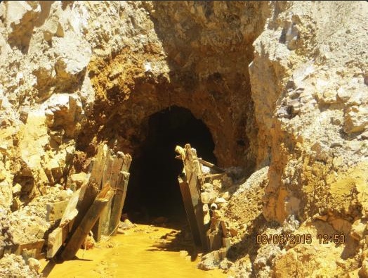
This image was taken during the peak outflow from the Gold King Mine spill at 10:57 a.m. Aug. 5. The waste-rock dump can be seen eroding on the right. Federal investigators placed blame for the blowout squarely on engineering errors made by the Environmental Protection Agency’s-contracted company in a 132-page report released Thursday [October 22, 2015]
The Colorado U.S. Attorney’s Office will not prosecute a U.S. Environmental Protection Agency employee in connection to the Gold King Mine spill.
The decision was reached on Oct. 6 and after the EPA’s Office of Inspector General submitted information about whether the employee may have violated the Clean Water Act and provided false statements, according to an update released this week by the Office of Inspector General.
Jeffery Dorschner, spokesman for the U.S. Attorney’s Office in Colorado, declined to comment about the decision today. The update does not name the employee or provide details about the allegations.
The update states the Office of Inspector General will prepare and submit a Report of Investigation to the EPA’s senior management for review. There is no requirement to submit the report by a certain time, Office of Inspector General spokesman Jeff Lagda said.
EPA officials have taken responsibility for causing the August 2015 mine blowout that released approximately 880,000 pounds of heavy metals into a tributary of the Animas River.
Congressional delegates from New Mexico remain steadfast in holding accountable those responsible for the spill.
Sen. Tom Udall, D-N.M., said he looks forward to reviewing the Office of Inspector General report and will ensure the EPA acts on the findings.
“This decision will not affect my work one bit to ensure the people who are still hurting as a result of the spill are compensated,” Udall said in an emailed statement, adding he continues to push the EPA to reimburse state and local governments for responding to the spill.
Sen. Martin Heinrich, D-N.M., said in an email the EPA’s course of action for cleaning up the mine “fell far short of the standards.” He added communities need reimbursement for response costs and called for reforming outdated policies regarding mine cleanup.
“We shouldn’t wait for more disasters to strike. Western communities deserve full and complete protection of their water, land and livelihoods,” Heinrich said.
Rep. Ben Ray Luján, D-N.M., said he is “deeply concerned” by the EPA’s failures and will “closely” review the report findings.
“In the meantime, I will continue to fight to make the affected communities whole, to ensure robust long-term water quality monitoring, and to prevent a disaster like this from occurring again,” Luján said in an email.
Gold King Mine entrance after blowout August 2015
Navajo Nation President Russell Begaye was among those who visited the mine in the days that followed the spill.
Begaye said EPA administrators and engineers were informed by hydrologists and other experts the mine was unsafe.
“It was the administrators who had these documents that were aware of potential explosions and the pressure that had built up,” he said in an email. “They knew about this and they did nothing. They allowed a single worker to sit in the backhoe and start to clean out the area.”
Begaye added that to place blame on one individual is “unfounded.”
Navajo Nation Council Speaker LoRenzo Bates said the decision by the Colorado U.S. Attorney’s Office has no impact on the lawsuit the tribe filed against the EPA and other entities in August.
“The nation has spoken and is holding the U.S. EPA responsible,” Bates said in a phone interview.
The action by the attorney’s office also prompted response from leaders of two House committees.
Reps. Rob Bishop, R-Utah, Jason Chaffetz, R-Utah, and Cynthia Lummis, R-Wyo., have asked U.S. Attorney General Loretta Lynch to meet with the committees by Oct. 26 to explain the decision.
In their letter to Lynch, they wrote that congressional staff learned about the Colorado U.S. Attorney’s decision on Tuesday during a conference call with the Office of Inspector General.
During the call, the office stated it found evidence of criminal wrongdoing by the EPA, the letter states.
“By not taking up the case, the Department of Justice looks like it is going easy on its colleagues in EPA,” the representatives wrote.
A staff member with the Committee on Natural Resources, which Bishop chairs, said Lynch had not respond to the request as of today.
On April 7, 2016, the Environmental Protection Agency proposed adding the “Bonita Peak Mining District” to the National Priorities List, making it eligible for Superfund. Forty-eight mine portals and tailings piles are “under consideration” to be included. The Gold King Mine will almost certainly be on the final list, as will the nearby American Tunnel. The Mayflower Mill #4 tailings repository, just outside Silverton, is another likely candidate, given that it appears to be leaching large quantities of metals into the Animas River. What Superfund will entail for the area beyond that, and when the actual cleanup will begin, remains unclear. Eric Baker
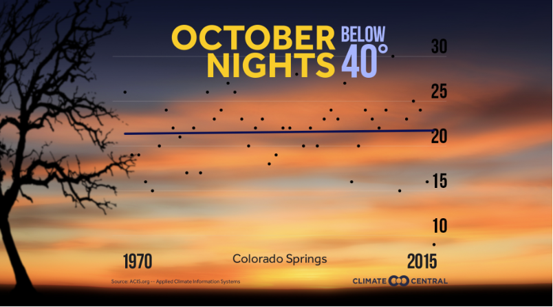
The average duration of the frost-free season is about 15 days longer across the U.S. than it was in the early 20th century. Every year since 1980 has experienced a longer frost free season than the 1895 to 2015 average. While there will continue to be variations in the amount of frost-free days from year to year, climate change is contributing to an overall increase in the number of days without frost.
The West has seen the most dramatic increases in the length of the frost-free season, with Boise and Reno each adding about a month more to their frost-free season since 1970.
The longer the time without a frost, the longer the growing season. While this may seem good — more time should lead to a larger crop yield — it could actually have detrimental effects on the crops we grow. Warmer weather helps pests survive longer which can wreak havoc on crops. Rising temperatures are also expected to contribute to a shift in which areas are most agriculturally productive and what crops grow there.
Methodology: We did not include cities where the average frost season from 1970-2015 was less than 2 months. In addition, outlier temperatures were not removed. An abnormally cold night in July, for example, would result in an unusually short season that year but was included if we were able to verify the temperature.
Selection of the 2015 native heirloom maize harvest of the seed library of The Acequia Institute in Viejo San Acacio, CO Photo by Devon G. Peña
From the Green Fire Times (Miguel Santistevan) via the Taos Acequia Organization:
Acequia irrigation originated in the highlands of Central Asia more than 10,000 years ago and traveled to places such as India and the Middle East. As acequias were established in different areas from the Old World to the New, crops from those areas were incorporated into the diet and practice of acequia culture. By the time the acequia system arrived in the Americas in the 16th century, it carried with it an entourage of crops and animals that represented its origins: apple trees and chickens from Asia, cattle and sorghum from Africa, sheep and many legumes from the Near East, to name a few.
The Old World acequia tradition was matched by incredible agricultural development of indigenous populations in the Americas. Indigenous peoples were practicing many kinds of agricultural production that relied on intensive management of the landscape, including dryland agriculture, floating gardens, agri-forestry, terracing and flood irrigation, among others. The acequia concept came northward with Spanish and Mexican settlers and later included the crops and practices of Puebloan cultures as it took root in what would become New Mexico.
Over time, a unique and integrated food system developed that can only be found in New Mexico. A mixture Old and New World foods, crops and traditions developed into a regional food system that was mostly sustained by acequias. Communities relied on each other to provide staples that could be produced abundantly in their respective environments. What could not be grown in particular areas was obtained through barter with other communities. For example, chile produced in villages of lower elevations could be traded for potatoes that came from higher elevations.
New Mexico eventually experienced significant changes of modernization, many of which interrupted agricultural practices and our relationship to local food and acequias. Some lands shifted to pasture and alfalfa production, feeding our desire for dairy and meat products. Today, acequia use can be measured in the production of bulk commodities and smaller-scale specialties that feed farmers’ markets, as well as the continuation of traditional agriculture and food traditions. Many foods from acequia systems continue to be the cornerstone of local culture and regional cuisine, with specialty foods like chicos (dried horno-roasted corn stew), tamales, posole, and of course, chile, making appearances at least for holidays. Many others regularly consume atole and chaquegüe (blue and white cornmeal porridge), crops that were grown in or originated from an acequia landscape.
As a person looks to reconnect with local food, the best place to start is with what has worked in the past. The acequia tradition offers practicality and sustainability for food production in our environment, which can be characterized by alkaline soils, limited water and potential weather extremes. Over generations of agricultural refinement, acequia culture offers examples for the expansion of our regional food system in terms of community organization, resiliency in practice and its relationship with incidental food production in the landscape.
The term acequia not only refers to the physical irrigation channel but to all the members who belong to it and help manage it. Local knowledge contained within the community and the organizational structure that keeps people connected to the tradition will be important for strengthening our regional food system. Acequia communities manage resources like water and land together for mutual benefits in agricultural production. These relationships result in people coming together to continue the practices necessary to the production of food such as cleaning acequias, picking up bales, or butchering animals (matanzas).
The acequia agricultural tradition can be described by the use of diverse crop and animal types and land-use techniques in the watershed. Production takes on a seasonal character with different activities meeting each season. Root crops and certain grains can be planted in the late fall; certain frost-tolerant legumes, roots and other grains can be planted in the late winter/early spring; and most grains, legumes, fruits and vegetables can be planted in the late spring and early summer. Working with various crops at different times of the year can allow the grower to take advantage of the potential qualities of each season, such as temperatures and moisture, and can create the conditions for more sustainable yields over the long term.
Acequia culture also carries with it the concept of jardín de riso and gathering the landscape, components of a regional food system likely to gain importance as we increasingly feel the effects of a deteriorating industrial food system and climate change. The jardín de riso is the collection of wild plants that serve as food and medicine that happen to self-propagate in the irrigated landscape as “weeds.” Several varieties of wild spinach (quelites) and purslane (verdolagas) flourish among crops in acequia-irrigated fields. The relationship acequias have with the extended landscape provides a connection to additional food resources such as piñón, chimaja (wild parsley) and other food and medicinal plants. In this tradition, gathering from the landscape can strengthen our regional food system by making use of wild plants such as four-wing saltbush and Indian ricegrass. These food sources that thrive in our landscape were an important part of the diet of indigenous people of the region prior to European contact.
It is inevitable that there will be some challenges to our food security in the future. But these challenges can be met by innovations in our relationship to food if they are based on what has worked in the past and developed in a manner that is respectful to the environment and the cultures from which they came. Acequia agriculture has been a cornerstone in the organization of the community and the actualization of food security and can (and should) continue to play a fundamental role into our future. Then our regional food system not only will serve the food needs of our population, but will allow the continuation of longstanding agricultural traditions in New Mexico. The acequia landscape has changed, but every square foot of land connected to the acequia now represents a great part and potential of our regional food system and its ability to feed our communities.
__________________________________________
Miguel Santistevan is dedicated to the conservation of traditional agricultural practices, seeds and acequia systems. He maintains a small acequia-irrigated Permaculture farm in Taos with his wife and two daughters. More information about Santistevan’s various activities can be found at http://solfelizfarm.wordpress.com
Colorado’s corn industry is looking for tools to boost water use efficiency, ranging from sophisticated variable rate irrigation systems to low-cost electronics and hand-made devices that can be put together with materials from the nearest hardware store.
Colorado’s corn industry is looking for tools to boost water use efficiency, ranging from sophisticated variable rate irrigation systems to low-cost electronics and hand-made devices that can be put together with materials from the nearest hardware store.
Farmers and agribusiness professionals got the chance to kick the tires recently on several related research projects during a meeting and tour held at Wray, Colorado. Corn harvest, which started roughly a week and a half ahead of normal in the area, was already under way in surrounding fields.
In addition to discussing progress on drought tolerant hybrids, the group heard from private crop consultant Chad Godsey, of Eckley, who is looking into the amount of potential water savings from variable rate irrigation…
Mark Sponsler, the association’s executive director, praised the project, saying it was right in line with heightened concerns about resource management by farmers, rural communities and the general public.
In fact, Colorado Corn is launching a new farm stewardship award this year, to be presented at the association’s annual meeting and banquet Dec. 7 in Yuma. The honor will include a $10,000 cash award and an expense paid trip to the next annual Commodity Classic, which brings together leading producers of corn, wheat, soybeans and sorghum.
In a field at Rogers Farm south of Wray, Godsey pointed to an irrigation tower outfitted with a variable rate motor. Blue valves mounted at the top of each drop nozzle shut on and off independently as the unit crosses the field. Godsey said he was using a soil texture grid map along with six soil moisture probes and an on-site weather station to set up his irrigation scheduling.
“I’m confident we can save 15 percent on our water use compared to just straight irrigation, and I think our savings in sandy soils could be even better,” he said. “We’ve been pumping less than we historically have, and last year we did not see it affect our yield at all.”
Eventually, he hopes to test his theory in a year when rainfall is more limited.
He is also evaluating the impact of various water and fertilizer rates throughout the growing season and the effect of higher seeding rates on irrigation demand.
One of the challenges to adopting variable rate technology is cost. Jim Williams, the president of J&J Irrigation in Wray, estimated that variable rate technology nearly doubles the cost of a new center-pivot, which starts at around $60,000. In some cases, financial incentives are available through programs like the National Resource Conservation Service’s EQIP or from rural electric cooperatives, which can help defray the costs.
Recognizing the need for cost containment in the current economic environment, a team from USDA’s Ag Research Service in Fort Collins has been working to identify an affordable tool for diagnosing water stress and pinpointing precisely when irrigation applications are needed…
something new has come on the market, the FLIR One thermal imaging device. For around $200, it attaches to an Android or Mac smartphone and effectively turns it into a thermal imaging camera.
To enhance the use of the device, they also showed off two low-cost, easy-to-build accessories. A “selfie stick” for mounting the camera-phone allows them to vary the angle of photos taken from above the canopy. A simple shade-measuring tool, made by applying strips of tape to a plain white plastic pipe, can be laid on the ground under the plants and used to help judge canopy thickness.
“It’s a cheap way of getting true facts about your field,” Willi said.
Sponsler suggested the monitoring technique could be used to complement readings from soil moisture probes, which are expensive to install. He could also see it becoming popular among crop consultants who need quick and easy ways to monitor crop conditions in multiple fields.
He also noted that incorporating it with CSU’s corn hybrid trials might help researchers collect more data about the how plants respond to various growing conditions throughout the season.
At their October 4 meeting, the Winter Park Town Council passed a motion to allow a ceilometer to be installed on the roof of the Winter Park Town Hall. . A ceilometer is a device that uses a laser to determine the height of a cloud base.
The town received a request from the Colorado Water Conservancy Board (CWCB), Denver Water and Winter Park Resort to place the device on the Town Hall building to aid them in their cloud seeding program. It will detect multiple layers of cloud height as well as measure the liquid water available in the clouds. The ceilometer will allow them to provide better forecasting for the cloud seeding program.
In addition to the cloud seeding program, this device will be available to pilots flying into Grand County. The pilots can determine the base elevation of the clouds as they approach the runway at the Granby/ Grand County Airport. The ceilometer is approximately four feet tall and would be attached to an existing concrete pillar.
The ceilometer will need electricity and Internet service. The electricity usage is approximately 5 amps per month (about 55 cents per month). The data usage is approximately a half a megabyte per month. The additional Internet service would not require upgrades as the current system has adequate space.
The Winter Park Town Council, CWCB, Denver Water, and Winter Park resort are now in the process of drafting a Memorandum of Understanding (MOU) for the installation of the ceilometer. The council also determined they will need a lease agreement for the project.
CLOUD SEEDING IN GRAND COUNTY
There are currently two cloud seeding generators in Grand County—one to the north of the Younglife camp at Crooked Creek Ranch, and the other near Churches Park in Fraser. The generators are remotely operated and controlled from Reno, Nev. They have been in place since 2009.
The Desert Research Institute (DRI) runs the cloud seeding program. According to their website, DRI currently has five cloud seeding operations: the San Juans (Mancos) Project, the San Miguel (Telluride) Project, Tahoe and Truckee basins, Walker Basin, and the Winter Park/ Denver Water Project. The purpose of the program is to augment snowfall in mountainous regions that supply water to northern and southern Nevada, and increase the snowpack and resultant runoff from the targeted basins.
According to DRI website, ground-based generators are used to burn a solution of silver iodide, sodium iodide, salt and acetone to release microscopic silver iodide particles which can create additional ice crystals, then snow, in winter clouds. Weather conditions are selected to optimize fallout in targeted basins. Generators are remotely operated by telephone landline, by radio or by other types of wireless communication. A seeding aircraft is frequently used to augment ground seeding operations. The aircraft releases AgI from wing-mounted solution burners. Dry ice is also used occasionally to seed shallow cloud systems, including fog over airports.
According to the website, benefits vary with the seasonal frequency of suitable weather opportunities. Research results have documented precipitation rate increases of a few hundredths to about two millimeters per hour due to ground-based seeding during the proper weather conditions. Based on the rate increases, estimates of augmented snow water from the DRI seeding program have varied from 20,000 to 80,000 acre-feet annually over the past 15 years of operation.
Seasonal percentage increase estimates have varied from two percent to ten percent The cost of augmented water, based on the annual cost of the program, has ranged from $7 to about $18 per acre-foot, according to DRI.
Scientists have found that a warmer Earth is indeed pushing clouds upward and poleward – a response to global warming that climate models have predicted for some time, but we had difficulty detecting until now.
New research published last month in the journal Nature revealed the changes in cloud elevation and coverage after analyzing 30 years of satellite data.
A warmer Earth elevates clouds because the troposphere, the lowest layer of our atmosphere where weather occurs, can extend higher with a hotter surface. Warming also moves clouds poleward because circulation patterns in the tropics are expanding, pushing storms north and south.
But there’s a bigger issue at play here: These perturbed clouds may cause further warming, triggering a vicious cycle of increasingly rising global temperatures. That critical detail was often glossed over as news of the cloud changes spread last month.
As clouds move higher, they trap more heat
While clouds strongly reflect sunlight, as indicated by their bright white color, they also absorb the heat that radiates from Earth’s surface.
Anything that absorbs energy must also re-emit energy. How much is released depends on the temperature of the object.
Heat absorbed and then re-emitted by low clouds that are close to the ground is similar to the heat emitted by the surface because the temperature of the ground and the cloud are similar.
But the higher the cloud is in the sky, the colder it is. So when these high clouds absorb Earth’s heat, they re-emit it at a much lower temperature, forming a blanket that traps heat in the climate system similar to how greenhouse gases trap heat.
If climate change is causing clouds to form at higher elevations, as the science suggests, this phenomenon may thus be causing even more warming of the climate system.
Earth gets more sun as clouds move poleward
While high clouds trap heat, low clouds block sunlight from reaching Earth’s surface, keeping us cool.
The tropics get the most sunlight because of Earth’s orientation. As we move towards the poles, there is less and less sunlight reaching the surface.
Clouds are now moving poleward because of a northward shift in the storm tracks due to the expansion of circulation patterns in the tropics. As a result, these clouds are reflecting less sunlight back out to space than they did at lower latitudes because less sunlight is hitting them when farther north.
There is also more sunlight reaching the mid-latitudes, heating up the surface. This raises temperatures, especially in some arid parts of the world – causing additional warming of the climate system.
There’s only one conclusion we can draw from these alarming findings: We need to curb climate change, and fast.
The Interbasin Compact Committee (IBCC) and Colorado Agriculture Water Alliance (CAWA) will be holding an Agriculture Water Summit in Golden, Colorado. The price is free to attend, we will be sending out an agenda and link to the registration site in the coming weeks.
Date: Tuesday, November 29, 2016
Time: 9:15 a.m. – 5:00p.m.
Location: Jefferson County Fairgrounds, 15200 W. 6th Ave. Frontage Road, Golden, CO.
Room: Exhibit Hall
Flood irrigation in the Arkansas Valley via Greg Hobbs
High Line Canal Regional Context map via the High Line Canal Conservancy
From email from the High Line Canal Conservancy (Suzanna Jones):
The High Line Canal Conservancy, which is dedicated to preserving the recreational and environmental future of the High Line Canal, announced the dates and locations in Aurora, Denver, and Centennial for “Chapter 4: Looking Ahead,” the last of the Vision Plan series of open houses. After a summer of public input, these open houses will bring the public back together for a final time to celebrate the success of the input gathered and begin to outline the next steps and implementation plan for shaping the Canal into a great refuge for the region. Some of the most exciting outcomes include honoring the diverse and distinct communities along the Canal, celebrating the unprecedented scale and historic significance of the Canal’s 71 miles, and looking ahead to the possibility of adapting the Canal for stormwater uses to nourish its natural character.
“We’re thrilled to bring the varied communities back together for our final series of open houses. We will celebrate the inspirational draft vision that thousands of people have helped write that will protect and enhance the future of the High Line Canal,” said Harriet Crittenden LaMair, executive director of the High Line Canal Conservancy. “Folks from communities along the Canal will be able to learn about our draft next steps for the Canal’s future and help us continue to brainstorm new ideas.”
After three successful series of community open houses where families, friends and neighbors from communities along the Canal gathered to share their input and feedback on the future of the Canal, the High Line Canal Conservancy team will forecast next steps and draft implementation strategies for the Canal. The Conservancy will also ask attendees to weigh in on the shared vision for the Canal as a natural refuge for the region, including delving into the guiding principles that the Canal remain natural, varied, connected & continuous, managed, and enhanced.
Let’s get started on the Canal’s future! Please drop in for as long as you are able!
The dates and locations of the interactive open houses are:
Wednesday, October 19, from 4-8 p.m. at Dry Dock Brewing Company North Dock*
2801 Tower Rd., Aurora
*Food trucks and tasting of the High Line Canal Dry Dock beer starting at 5 p.m.
Thursday, October 20, from 2-5 p.m. at Eisenhower Recreation Center
4300 E. Dartmouth Ave., Denver
Thursday, October 20, from 6-8 p.m. at Goodson Recreation Center
6315 S. University Blvd, Centennial
All three sessions will be identical, so guests are invited to attend the event most convenient to them. These events are “open house” format, with no formal presentation, so guests can stop by anytime and stay for as long as they would like.
Here’s how to stay updated on High Line Canal project updates:
Synopsis: La Niña is favored to develop (~70% chance) during the Northern Hemisphere fall 2016 and slightly favored to persist (~55% chance) during winter 2016-17.
ENSO-Neutral conditions were observed during September, with negative sea surface temperatures (SSTs) anomalies expanding across the eastern equatorial Pacific Ocean by early October. All of the Niño regions cooled considerably during late September and early October, with the latest weekly value of Niño-3.4 index at -0.9°C. Subsurface temperature anomalies also decreased toward the end of the month, reflecting the strengthening of below-average temperatures at depth in the east-central equatorial Pacific. Atmospheric anomalies across the equatorial Pacific edged toward La Niña during September, with a stronger tendency toward La Niña late in the month. The traditional Southern Oscillation index and the equatorial Southern Oscillation index were positive. The lower-level winds were near average across most of the basin during the month, but enhanced easterlies were becoming more persistent west of the International Date Line. Upper-level winds were anomalously westerly near and just east of the International Date Line. Convection was weakly suppressed over the central tropical Pacific and was more enhanced over Indonesia compared to last month. Overall, the combined ocean and atmosphere system reflects ENSO-Neutral during September, but are more clearly trending toward La Niña conditions.
The multi-model averages favor borderline Neutral-La Niña conditions (3-month average Niño- 3.4 index less than or equal to -0.5°C) persisting during the Northern Hemisphere fall and continuing into the winter. Because of the recent cooling in the Niño-3.4 region and signs of renewed atmospheric coupling, the forecaster consensus now favors the formation of a weak La Niña in the near term, becoming less confident that La Niña will persist through the winter. In summary, La Niña is favored to develop (~70% chance) during the Northern Hemisphere fall 2016 and slightly favored to persist (~55% chance) during winter 2016-17 (click CPC/IRI consensus forecast for the chance of each outcome for each 3-month period).
Water makes the West as we know it. Congressman Wayne Aspinall put it best: In the West, when you touch water, you touch everything. Never have these words rang more true that today, as we endure a record 16th year of drought in the Colorado River basin — and nearly everyone and everything has been affected.
Demand for water in the river basin now exceeds supply, threatening the drinking water supply for 40 million users of the Colorado River, an indispensable agricultural yield that depends on sufficient water, and the river that powers a $26 billion outdoor recreation economy based on river-related activities. Clearly everything we can do to conserve water and use it more efficiently means a great deal at this point.
Understanding this, President Obama has recently taken several successive measures to bring drought relief and resiliency to Colorado and many of the suffering areas that depend on the Colorado River. In March, coinciding with World Water Day, he issued a directive calling on federal agencies to ramp up the nation’s capabilities to address long-term drought resilience, ordering agencies to collaborate on drought-related activities in key watersheds. It benefits taxpayers and our environment when we ensure that drought resiliency and recovery assistance operates at peak effectiveness.
Subsequently, Agriculture Secretary Tom Vilsack and Bureau of Reclamation Commissioner Estevan López announced in June their intent to boost funding for and better coordinate their respective key water conservation programs: the Environmental Quality Incentive Program and WaterSMART, respectively. This kind of investment and collaboration is essential at a time when drought is the new normal in the West.
That said, our work is far from over. The WaterSMART grant program, championed by Deputy Secretary of the Interior Mike Connor, is a critical component of efforts to restore water supply and demand balance in the West. WaterSMART grants have been a powerful tool for spurring locally-led water conservation projects. These grants come with a match requirement that leverages federal investment dollar for dollar with state and private funding, which means they’re great for taxpayers as much as water users. However, very few projects that have received grants thus far have benefited fish or wildlife habitat, or put water back into our rivers, even though species recovery is one goal of the program.
Just a few small adjustments to WaterSMART grant criteria would make the program even more productive. If we began to reward collaborative, multi-stakeholder efforts to improve watershed health while creating agriculture or municipal water supply benefits, our environment and recreation economy would also stand to benefit. We would create more drought resiliency by keeping water in our rivers and protecting wildlife habitat while improving the reliability of municipal or agricultural water supply. We should also look at how grant recipients can be more transparent about sharing data related to water use and savings. These are small changes to Reclamation’s successful WaterSMART program that would create even more public benefit by supporting local, collaborative, place-based solutions to water scarcity.
Without question, the administration has taken important steps this year to combat drought in the Colorado River and in other key watersheds across the United States. But, there’s always more to do. Coming from “the geography of hope” Westerners are willing. I would urge the Administration to partner with us and adopt these modest but strategic changes to the Interior Department’s water conservation grant program. Water is everything in the West, and we must work together and do everything in our power to protect and sustain a healthy Colorado River — no matter how small the step may seem — so that it may continue to be an environmental, recreational, and economic resource and a vital source of life for us all.
Click here to read the newsletter. Here’s an excerpt:
After years of careful study and a step by step public review and approval process, the Chatfield Storage Reallocation Project is moving forward. Eight water provider entities* formed and are operating the new non-profit Chatfield Reservoir Mitigation Company (CRMC). The Board of Directors moved quickly to select a program management team and signed a Master Services Agreement and Task Order No. One on October 26, 2015. Program Manager CDM Smith and Leonard Rice Engineers immediately began work on the design process to implement the approved and required project components. Sub-consultant teams were selected and approved by the CRMC Board in the following months to develop preliminary designs. The U.S. Army Corps of Engineers is currently reviewing those preliminary designs.
FromThe Grand Junction Daily Sentinel (Dennis Webb):
“This year, I’ve heard scientists or near-scientists speculate (on) anything from an upcoming whopping winter similar to 1983-84 to ‘look out for drought.’” Colorado state climatologist Nolan Doesken told weather- and water-watchers in a recent email.
“… In the next few months, this will all play out before our eyes. This past year’s ‘El Niño’ collapsed as predicted but did not head into ‘La Niña’ land as previously prognosticated.”
[…]
“Right now we’re in kind of a neutral state” between an El Niño and La Niña, said Larry Smith, senior meteorologist with the National Weather Service in Grand Junction.
Neutral conditions aren’t a superb indicator of how winter will shape up, but around Grand Junction they typically lead to kind of a normal water year, but also slightly warmer temperatures that mean the snow line starts at a higher elevation than usual, he said.
A couple of forecasting models show a trend toward a weak La Niña eventually occurring sometime this winter, but the phenomenon can have a time lag in terms of impacts on local weather, which makes predicting its impacts hard, Smith said. He added that the El Niño/La Niña is just one of several factors considered in long-range forecasting.
Colorado’s snowpack fared well last winter during what was a strong El Niño. Meteorologist Cory Gates, who forecasts for http://aspenweather.net, is bullish about this winter’s prospects for the area around the Aspen ski resort town. He has said conditions are similar to those leading into the epic snow year of 1983-84, according to Aspen media reports.
“I would be very careful in making comparisons with that” year, said Klaus Wolter, a research scientist in Boulder with the National Oceanic and Atmospheric Administration and University of Colorado.
“I’m mildly optimistic” about this winter’s snowpack prospects, he said.
But he said there’s a lot of uncertainty because of the lack of clarity about whether there will be a La Niña or not.
Chris Tomer, a meteorologist for Denver television stations who also specializes in mountain forecasting as a private consultant, said he thinks the winter will end up somewhere between neutral conditions “and La Niña Lite.”
He said he expects Colorado’s northern mountains to benefit from a surplus of snow, with a normal winter in the central mountains and slightly below-average snow for the southern part of the state.
Click here to go to the US Drought Monitor website. Here’s an excerpt:
Summary
Hurricane Matthew approached the east coast of Florida as a category 4 hurricane, having many bracing for the impact during this last week. The eye of the storm stayed offshore for the most part, but did bring with it intense rain and associated flooding along with wind damage. Some reports of 14+ inches of rain were noted in South Carolina and North Carolina, but these rains did not impact any of the drought regions of the Southeast. The storm pushed rain up the east coast and into southern New England. Significant rain also fell with a slow-moving storm system that impacted much of southeast Kansas and northeast Oklahoma, but it stalled out as it approached the Ozarks. The Pacific Northwest continues to stay active with multiple storms coming ashore and bringing rain along the coastal areas of Washington and Oregon and into the northern Rocky Mountains. Most of the rest of the United States was dry this week and the significant dryness over the Southeast during the last several months is starting to rapidly deteriorate conditions there with widespread impacts…
High Plains
Temperatures were cooler than normal over most of the region this week with portions of North Dakota 6-9 degrees below normal. Areas of western and eastern Nebraska, along with eastern Kansas, were wetter than normal, with portions of southeast Kansas recording over 5 inches of rain. Drought is not much of an issue in the region and the only change this week was some removal of abnormally dry conditions over western Nebraska…
West
Cooler than normal temperatures were experienced over much of the West this week as departures of 3-6 degrees below normal were common. Most areas were dry outside of the Pacific Northwest and into the northern Rocky Mountains, where several storms impacted the region. Improvements to the abnormally dry conditions were made over western Washington and western Wyoming this week and a full category improvement was made to the drought areas of Montana…
Looking Ahead
Over the next 5-7 days, the storm pattern will continue to impact the Pacific Northwest, with significant rain anticipated along the coastal region from northern California to Washington. These storms will also impact the interior Northwest into central Montana and western Wyoming, bringing widespread precipitation. The Midwest and Great Lakes regions will also see precipitation as well as portions of the southern Plains. The Southeast looks to remain dry into the Mid-Atlantic. Temperatures are anticipated to be warmer than normal over much of the country, with only the areas of the Pacific Northwest being cooler than normal due to the anticipated precipitation. Departures will range from 12-15 degrees above normal for daily high temperatures over the Texas and Oklahoma panhandles to 9-12 degrees below normal over northern California.
The 6-10 day outlooks show that the warm October is anticipated to continue. Almost the entire country (outside of the Great Basin and Central Rocky Mountain regions) has a higher probability of warmer than normal temperatures, with the highest likelihood over the Southeast and Mid-Atlantic. Higher probabilities of above-normal precipitation exist for the Pacific Northwest and interior Northwest, High Plains, Midwest, Northeast and the western side of the Mississippi River Valley. Below-normal precipitation is anticipated over much of the Southeast and into Florida.
This image was taken during the peak outflow from the Gold King Mine spill at 10:57 a.m. Aug. 5. The waste-rock dump can be seen eroding on the right. Federal investigators placed blame for the blowout squarely on engineering errors made by the Environmental Protection Agency’s-contracted company in a 132-page report released Thursday [October 22, 2015]
US prosecutors have declined to pursue criminal charges against an employee of the Environmental Protection Agency over a massive mine wastewater spill that fouled rivers in three states, a federal watchdog agency said. The EPA’s Office of Inspector General disclosed Wednesday that it recently presented evidence to prosecutors that the unnamed employee may have violated the Clean Water Act and given false statements. However, office spokesman Jeffrey Lagda said the US Attorney’s Office in Colorado declined to pursue a case against the employee. In lieu of prosecution, an investigative report will be sent to senior EPA management for review, Lagda said.
EPA spokeswoman Nancy Grantham said agency personnel would review the investigative report, but she offered no further comment. Members of Congress had pressed for a criminal investigation into the EPA’s role in the disaster. A review of the accident completed last year by the US Interior Department determined the cleanup crew could have avoided the spill but rushed the work. Several Republican lawmakers on Wednesday said the lack of a prosecution gives the “appearance of hypocrisy” in light of the Justice Department’s record of pursuit of criminal charges in other cases referred by the EPA.
US Attorney spokesman Jeff Dorschner declined to comment, citing the office’s longstanding practice of not discussing cases where prosecution is declined. The apparent end of the government’s criminal probe comes after the Inspector General’s Office in July said it had suspended a separate examination of the EPA cleanup program pending the outcome of the investigation. That separate examination will now resume, the office said. No timeline for completion was provided.
Colorado abandoned mines
From the Associated Press (Matthew Brown and Sadie Gurman) via The Colorado Springs Gazette:
The apparent end of the government’s criminal probe comes after the Inspector General’s Office in July said it had suspended a separate examination of the EPA cleanup program pending the outcome of the investigation.
That separate examination will now resume, the office said. No timeline for completion was provided.
After a yearlong investigation, the U.S. Attorney’s Office, having been presented the facts of the incident by the Office of Inspector General, decided on Oct. 6 to not prosecute “the EPA employee.”
The release did not name the employee.
The EPA’s temporary on-scene coordinator, Hays Griswold, was in charge Aug. 5, 2015, when a contract crew released an estimated 3 million gallons of mine waste tainted with heavy metals into the Animas and San Juan rivers.
Immediately after the announcement was sent, the Office of Inspector General’s spokesman Jeffrey Lagda posted that the would be out of the office until 2:30 p.m. Thursday. He later said in an email that he “cannot comment on the investigation at this stage.”
The announcement said in lieu of criminal prosecution, “the OIG will prepare a Report of Investigation (ROI) for submission to EPA’s senior management for review. The EPA is required to report to the OIG any administrative action taken as a result of the ROI.”
After the announcement, U.S. House Committee on Natural Resources Chairman Rob Bishop, R-Utah, House Oversight and Government Reform Committee Chairman Jason Chaffetz, R-Utah, and House Oversight and Government Reform Interior Subcommittee Chairwoman Cynthia Lummis, R-Wyoming, demanded the Department of Justice explain its decision to not pursue criminal charges.
In a Wednesday statement, several congressional members said the Office of Inspector General had found evidence of criminal wrongdoing, including providing false statements and violating the Clean Water Act.
“By not taking up the case, the Department of Justice looks like it is going easy on its colleagues in EPA,” the statement said. “Its lack of action on these charges gives the appearance of hypocrisy, and seems to indicate that there is one set of rules for private citizens and another for the federal government. The EPA disaster deserves the same level of accountability to which private citizens are held.”
The committees asked for a briefing on the decision no later than Oct. 26.
Multiple local representatives did not respond to requests for comment late Wednesday.
Republican Congressman Scott Tipton wrote in an emailed response, “This disaster and the EPA’s response or lack of response is bigger than any one employee and was the result of numerous failures at multiple levels at the EPA.
“I will continue to work to make sure responsible parties are held accountable and affected communities are compensated and made whole,” he wrote.
Instead of a criminal prosecution, the EPA’s internal investigators “will submit a report of an investigation to the agency that details the findings of our investigation,” OIG spokesman Jeff Lagda said in response to queries.
“The agency, not the OIG, will then determine what administrative action they may take against the employee based on that report,” Lagda said. “The EPA will have to report to the OIG what administrative action the EPA will undertake.”
The EPA’s quasi-independent OIG launched an investigation into the Gold King disaster more than a year ago. Federal officials later, driven by members of Congress, began a criminal probe.
The OIG is part of the EPA and investigates agency activities.
The OIG investigators “presented facts to the U.S. Attorney’s Office” in Denver “about whether an EPA employee may have violated” the Clean Water Act and the statute prohibiting false statements, according to a statement Lagda issued Wednesday afternoon…
EPA investigators now will return to completing work requested by Congress related to the Gold King Mine spill, Lagda said.
Sens. John McCain of Arizona and John Barrasso of Wyoming, members of the Senate Committee on Indian Affairs, in May sent a letter to Attorney General Loretta Lynch urging a criminal probe.
Other federal agencies also have reviewed EPA conduct linked to the Gold King Mine. An Interior Department report issued last fall deemed the Gold King disaster preventable, the result of errors over many years in handling toxic discharges from inactive mines.
Click here to take a stroll back in time through the Coyote Gulch Animas River category.
On April 7, 2016, the Environmental Protection Agency proposed adding the “Bonita Peak Mining District” to the National Priorities List, making it eligible for Superfund. Forty-eight mine portals and tailings piles are “under consideration” to be included. The Gold King Mine will almost certainly be on the final list, as will the nearby American Tunnel. The Mayflower Mill #4 tailings repository, just outside Silverton, is another likely candidate, given that it appears to be leaching large quantities of metals into the Animas River. What Superfund will entail for the area beyond that, and when the actual cleanup will begin, remains unclear. Eric Baker
Bob Dylan has won the Nobel Prize for Literature “for having created new poetic expressions within the great American song tradition,” the Swedish Academy said on Thursday in awarding the 8 million Swedish crown ($927,740) prize.
Literature was the last of this year’s Nobel prizes to be awarded. The prize is named after dynamite inventor Alfred Nobel and has been awarded since 1901 for achievements in science, literature and peace in accordance with his will.
Click here for all the inside skinny. Here’s an excerpt:
Please join Save The Poudre at the first bike “TOUR de POUDRE!” Come dressed as your favorite river species, or just come dressed! We’ll ride along the Poudre River bike trail from Watson Lake in Bellvue downstream to the Environmental Learning Center, and then rendezvous at Avogadro’s for libations and cheer.
Due to anthropogenic climate change, the average global temperature has increased steadily over the past decade or so. While we’re all familiar with the hockey-stick line chart of rising temperature, the change is even more dramatic on this animated globe showing the local effects of climate change.
The first half of the animation shows the monthly local change compared to historic averages (blue is cooler; red is warmer). The second half of the animation repeats the cycle, but introduces a moving 10-year smoother to reduce the variability in the temperature changes, making the global temperature increase much more apparent in the forecast part of the animation. The overlaid time series shows the global average temperatue deviations from the historical average, in degrees Celcius.
This animation was created by Matt Leonawicz, Lead Statistical Analyst at the Scenarios Network for Alaska and Arctic Planning, using the R language. He created a custom R package called “mapmate” (available on Github).
Dixon Reservoir dam photo via Gauthiere Engineering.
From the Fort Collins Coloradoan (Cassa Niedringhaus):
The 950-foot earthen dam on the north edge of the reservoir is classified as a “significant hazard dam” because of its proximity to homes to the east. The dam is located west of the intersection of Overland Trail and Drake Road in west Fort Collins. It’s prone to “seepage” in which water moves through the dam and erodes it away.
The reservoir’s water level has dropped significantly in recent weeks to allow the dam to dry out so work can begin to repair it. The dam is located in the city-managed Pineridge Natural Area.
The Dixon Canyon Ditch and Reservoir Company, which manages the operation of the reservoir, hired John Gauthiere of Gauthiere Engineering to head the repair project.
“It’s not a major risk, and we were not told we had to do it,” Dixon Reservoir Company president Doug Kokes said. “It’s going to have to be done sometime, so we said, ‘Let’s get it done now before it becomes a hazard.’ ”
Gauthiere submitted preliminary plans to the state March 30. Kokes said Gauthiere will submit finalized plans to the state this week.
He said he plans to spend the next eight weeks finding a contractor to do the construction work, which he said should take between one to two months to complete.
Dixon Dam rehab site map via Gauthiere Engineering.
ASPEN – The Aspen City Council unanimously voted Monday night to tell the state of Colorado this month that it “can and will” build a 155-foot-tall dam on Maroon Creek within view of the Maroon Bells and a 170-foot-tall dam on Castle Creek two miles below Ashcroft.
The council passed a resolution directing staff to file a diligence application in Division 5 water court in Glenwood Springs by Oct. 31 that seeks to maintain the conditional water rights from 1965 that are tied to the potential dams.
“File and pursue an application for finding of reasonable diligence in the development of the Castle and Maroon creek conditional water rights on or before Oct. 31, 2016,” the resolution states.
It also says that “the city is obligated and intends to provide a legal and reliable water supply and to that end can and will develop all necessary water rights, including but not limited to, Maroon Creek Reservoir and Castle Creek Reservoir.”
A map produced by Pitkin County from a map on file with the state of the city of Aspen’s proposed Maroon Creek Reservoir, located just below Maroon Creek Lake, shown to the left as the smaller of the two bodies of water. The map was commissioned by Aspen Journalism and confirmed in 2012 as accurate by city officials.
Not a decision to build
Despite the language in the resolution stating Aspen’s apparent intent to someday build the two dams, Aspen Mayor Steve Skadron stressed that Monday’s decision to file a diligence application in water court was about maintaining water rights, and was not the same as deciding to build the dams.
He said an article in Monday’s Aspen Daily News by Aspen Journalism made it sound “as if the bulldozers are at the roundabout ready for this vote to come and they are going to go up tomorrow.”
“The question is not to build or not to build dams,” Skadron said. “That’s a false premise. The issue is whether to keep water rights alive by the can-and-will due-diligence measures the state has imposed on us, as opposed to letting these water rights become available and appropriated by others. That’s the challenge.
“And so without knowing more about viable alternatives, it simply would not be prudent water management and planning on our part to give these water rights up,” he said.
However, Paul Noto, an experienced Aspen water attorney now representing the national advocacy group American Rivers, told the council Monday night that it was a misperception on their part to think that there was room in Colorado water law to tell the state that the city “can and will” build the dams if the city really just wants to keep its options open to perhaps do so in the future.
“I want to clarify again that in order to keep these rights you have to prove that you actually will build these dams within a reasonable period of time, and that’s typically looked at within a 50-year horizon,” he said. “So this notion that we are going to file to keep our options open doesn’t really jibe with the legal standard that we have to prove in a court of law that we will build these dams within 50 years.”
Noto also said that there was still an apparent misunderstanding of what might happen if the city were to abandon the water rights.
“The rights simply go away,” he said. “No one can take them. No one can buy them. If you didn’t file, the rights simply go away. They no longer exist, and if someone came in and wanted to file for new water rights for that amount of water in that location, it would be under a 2016 or later priority date, not 1965.”
He also said it would be “legally impossible” under the Colorado River Compact of 1922 for some downstream entity, such as Los Angeles or Las Vegas, to somehow come in and control the water in Castle and Maroon creeks.
American Rivers has stated publicly that it intends to oppose Aspen’s efforts in water court to maintain the conditional water rights for another six-year period, as has the U.S. Forest Service.
One of the many wetlands in the area that would be covered by a Castle Creek Reservoir.
At some point?
Since 1971, the city has consistently told the state, through required periodic diligence filings, that it intends, at some point, to build a dam on upper Maroon Creek, just below the confluence of East and West Maroon creeks, to store 4,567 acre-feet of water; and that it intends to build a dam on upper Castle Creek, not far below Fall Creek, that would hold 9,062 acre-feet.
In its most recent diligence filing in 2009 the city told the state “it has steadily applied efforts to complete” the dams and reservoirs “in a reasonably expedient and efficient manner.”
In 1966, an engineer working for the city told a water court judge during a hearing on the proposed rights that at least one of the dams would be needed by 2000 to meet the demands of the then-projected population of 30,000 residents in Aspen. Today, the city’s population is under 7,000.
And a recent study commissioned by the city concluded the municipality had enough water, without the reservoirs, to meet expected water demands for the next 50 years, even in the face of climate change.
The city today also has senior water rights on Castle and Maroon creeks that provide adequate water to the municipal water system.
But most City Council members on Monday said that giving up the water rights tied to the potential dams, despite their locations in pristine alpine valleys, might be doing a disservice to the city in the distant future, which could be much drier.
“I have no more interest in building dams on Castle and Maroon creeks than anybody else in this room or anyone else in this community,” said Art Daily, a council member and a veteran attorney with Holland and Hart. “At the same time, we are facing serious unknowns at the present time regarding our future water supply and storage capacity, and I can’t in good conscience cancel out an eventual water-storage resource.”
Daily added that further study of the city’s long-term storage needs in the face of climate change, including both location and amount, would be a good next step in the process.
“It is simply not in the best interest of our community to give up these conditional rights … until we know with far greater certainty than we have now that they are not going to be essential to our future water needs,” Daily said.
A view of the Maroon Bells, through a zoom lens, from the meadow that would be flooded by a potential 155-foot-tall dam on Maroon Creek. The city of Aspen voted Monday to tell the state this month it still intends to build such a dam – someday – if necessary.
Storage study?
The resolution passed Monday night calls for city staff to “investigate alternative locations and sizing requirements” for the two reservoirs and to report back to the council.
And it says, “if appropriate,” the city could “seek water court approval for modification of one or both conditional decrees.”
Will Roush, the conservation director for Wilderness Workshop, told the council Monday before their vote that his organization wants the city to abandon the rights.
But barring that, he requested the city conduct a comprehensive study as to whether the city actually needs water storage, and if so, where a dam might best be located.
“If you were starting from scratch, I can almost bet that nobody would say ‘Let’s look at the Maroon Bells,’” he said. “So find out if those are the right places, if in fact storage is needed.”
Once the city files its diligence application in water court, parties will have 60 days to file a statement of opposition in the case. Then, typically, a water court referee works with the parties in a case to see if a settlement can be reached before going to trial in front of a water court judge.
Editor’s note: Aspen Journalism and the Aspen Daily News are collaborating on coverage of rivers and water. The Daily News published this story on Tuesday, Oct. 11, 2016.
Western firefighting veterans lamenting a “new normal” amid surging forest fires have received an explanation for the destructiveness they’ve been unable to quell. Rising temperatures are flatly to blame for recent fearsome fire seasons, leading scientists reported Monday.
The number of acres of forest burning yearly in large Western fires ballooned nine-fold from 1984 to 2015, with climate pollution and natural changes in the weather playing roughly equal roles in driving the deadly trend, research published in Proceedings of the National Academy of Sciences concluded.
The study showed that more than a century of fossil fuel burning, deforestation and farming has helped push the American West into an explosive new wildfire regime, and the findings suggest far worse could be ahead.
“The authors clearly demonstrate that a human influence on wildland fire as a consequence of global warming isn’t just a prediction for the future — it’s happening now,” said Kevin Anchukaitis, a University of Arizona scientist who was not involved with the study.
Previous efforts to link Western wildfires with climate change have hinted at a profound relationship but led to unconvincing results, largely because long lists of factors influence ignition and wildfire properties.
Monday’s study focused on forest dryness, identifying the commanding role it has been playing in driving fires. The researchers relied on climate data and modeling to present a sweeping regional view of 30 years of worsening forest fires…
Western wildfires have been devouring forests parched by higher temperatures in recent years, draining federal and local firefighting funds, killing residents unable to flee fast-moving flames and filling skies with sometimes-crippling levels of air pollution.
The new analysis showed temperature increases caused by rising levels of greenhouse gas pollution have had a drying effect on Western forests that caused 10.4 million acres to char in large fires during the three decades.
That suggests 44 percent of the forest area that burned during the three decades analyzed burned because of the effects of global warming. The finding was an estimate, with the researchers concluding global warming likely drove between 6 million acres and 16 million acres of forest fire.
The Colorado River in Cataract Canyon, just above Lake Powell, where water officials are keeping a close eye on water levels. Photo: Brent Gardner-Smith/Aspen Journalism
Drought is turning the nation’s largest reservoir dry — Lake Mead reached its lowest levels this summer since the 1930s — and Lake Powell is limping along, just a little over half full.
That scenario is prompting the Upper Colorado River Commission to offer $1.8 million in funding for pilot projects in which users in the upper basin states of Utah, Colorado, Wyoming and New Mexico voluntarily reduce their demand on the Colorado River.
The idea is to test what works and what won’t work in a drought contingency plan, and what may be the most effective ways to keep water levels at Lake Powell at the elevation necessary to maintain hydropower production.
Robert King, the interstate streams engineer for the Utah Division of Water Resources, said the commission hopes to learn if river system conservation actually sends that water on to Lake Powell.
Because there are more water rights than water that exists in the Colorado River in Utah, King said the concern is even if there are reductions made along the way, there’s no guarantee Lake Powell will see the benefit.
“We hope it works,” he said. “A major part of this is to see how it works with water rights. That is what we are trying to evaluate or if it will actually take something more drastic institutional changes.”
Municipal, industrial and agricultural users are encouraged to submit proposals that, among other things:
• Generate signficant, measurable consumptive water savings.
• Involve multiple participants.
• Involve a ditch company or irrigation district.
• Include opportunities for federal or tribal participation.
• Partners with state in-stream flow programs and downstream water users to move saved water downstream.
Pilot program participants will be selected on factors that include implementation schedule, the identified environmental benefits, the cost per acre-foot saved and the demonstration of water savings.
Creation of a drought contingency plan is just one of the recent steps being embraced by Western states struggling with the dynamics of little precipitation, growing populations and increasing demand on water resources.
On April 7, 2016, the Environmental Protection Agency proposed adding the “Bonita Peak Mining District” to the National Priorities List, making it eligible for Superfund. Forty-eight mine portals and tailings piles are “under consideration” to be included. The Gold King Mine will almost certainly be on the final list, as will the nearby American Tunnel. The Mayflower Mill #4 tailings repository, just outside Silverton, is another likely candidate, given that it appears to be leaching large quantities of metals into the Animas River. What Superfund will entail for the area beyond that, and when the actual cleanup will begin, remains unclear. Eric Baker
“If you have Rebecca, you are extremely lucky,” said Tony Berget, a former Lincoln County Commissioner in Libby, Montana, home to one of the largest and longest running asbestos cleanup sites in the United States.
“At times, the (Superfund process) went really well, and at other times, I’ve been very disappointed. But Rebecca, especially, was really willing to listen. She was one of the bright stars of my experience with the EPA.”
Last month, the EPA formally listed 48-mining sites responsible for degrading water quality in the Animas River Basin as a Superfund site, with Thomas, based in Denver, as project manager for the Bonita Peak Mining District Superfund program.
The announcement came just a year after the Gold King Mine blowout, in which an EPA crew triggered a massive release of mine wastewater, reigniting the longstanding issue of metal loading into the watershed.
Yet the blowout also reversed stubborn resistance from the small, historic mining town of Silverton, home to a fluctuating population of about 600, not so keen on parting ways with its legacy of mining.
It’s a situation Thomas, throughout her career, has stepped into with ease, as evidenced by major projects in Libby, Montana, and Leadville.
Leadville
By the mid-1990s, tensions between the once-thriving community of Leadville and the EPA surrounding the cleanup of 16-square-miles of mining sites had escalated into a vitriolic, hostile environment.
“They came in and said: ‘We are the EPA, and you will do this,’” said resident and environmental consultant Mike Conlin. “One day everyone that lived in the Superfund boundary got a brown paper envelope saying: ‘Congratulations. You’re a potentially responsible party and may be responsible for the cost of cleanup.’”
In Gillian Klucas’s 2004 book detailing the bitter confrontation – Leadville: The Struggle To Revive an American Town – effigies of EPA personnel were dragged through town, cars bore “EPA: GO TO HELL” bumper stickers and one state senator even championed a public hanging.
“My suggestion is to simply hang one (EPA staffer) at each end of town,” state senator Ken Chlouber, a Leadville native, told a national Republican Party in 1994. “In my community, that is the voice of moderation.”
Relationships between the two entities had deteriorated so badly that EPA replaced its fledging personnel with two new project managers: Mike Holmes and Thomas.
“That was very much the turning point,” said Howard Tritz, an ex-miner and county assessor at the time. “They were decent. They explained things to people, and they were not belligerent.”
Indeed, Klucas’s book said local newspapers proclaimed “a new era of cooperation” in 1998 after the arrival of Holmes and Thomas, which eventually led to one of the most complicated but also successful cleanups in the EPA’s history. The Arkansas River, for instance, once referred to as an “industrial sewer,” now boasts a Gold Metal fishery, and is one of the most popular rivers to fish in the state of Colorado.
“They (Holmes and Thomas) were able to direct the energy of the community to the issues rather than personalities,” Conlin added. “They had more of a tendency to say: How can we work together to make something with long-term benefits to the community?’”
[…]
Silverton
Now, Thomas, 53, is entering her 24th year in the EPA’s Superfund program, and is turning her attention to the highly mineralized and complicated network of mines surrounding Silverton.
Early on, town and county officials, as well as residents, demanded a seat at the table in EPA’s decision-making process, even delaying a vote to pursue Superfund designation until that assurance was met.
Already, it seems like EPA is living up to that promise.
“Rebecca is genuinely concerned and has excellent communication with the community,” said Silverton Town Administrator Bill Gardner. “We were promised a seat at the table, and that’s exactly what’s happening.”
Thomas, for her part, said she was taken aback by the amount of investment from groups such as the Animas River Stakeholders Group, which has carried on nearly two decades of remediation projects in the basin.
She said this winter local, state and federal agencies will review a swath of data taken over the past year, and start to formulate a strategy to tackle what is one of the worst metal-loading districts in the American West.
“We need to work with all affected communities and establish what we want this cleanup to do,” Thomas said. “And I think Superfund does bring the resources to a project of this size and complexity that would be hard for a group of individuals to fully address.”
…as the planet warms from the increase in greenhouse gases, the number of October nights with sweater weather is decreasing in most of the U.S.
In this analysis, we examine the number of cool October nights — defined as a temperature below a characteristic threshold for your city. If you feel like the frequency of those cooler October nights is decreasing, it’s probably not your imagination.
The decrease in cool nights is one feature of an overall fall warming trend. Nationwide, fall is warming at a rate of 0.43°F per decade since 1970, with the fastest rates of warming in the Northeast and the West. Similarly, the growing season has lengthened the most in the Northeast and the West. Nationally, the growing season is already about 15 days longer than at the beginning of the 20th century.
The decrease in cool nights can also delay the start of some of the traditional cold season activities, such as snow skiing, in northern states. With the number of nights below freezing decreasing, snow may start showing up later and insects can survive later into the year.
Temperature trends — October nights — Denver via Climate Central.Temperature trends — October nights — Colorado Springs via Climate Central.Temperature trends — October nights — Grand Junction via Climate Central.
Site of Chimney Hollow Reservoir via Northern Water.
From the Loveland Reporter-Herald (Pamela Johnson):
“Chimney Hollow dam will be the tallest one constructed in Colorado in the last 50 years,” said Don Mongomery, the principal engineer who will design the reservoir project, drawing on experience from dams around the globe.
“It will be in the order of 360 feet tall,” he said, with a crest estimated at 3,500 feet long.
Final design of Chimney Hollow will pare down the specific height and construction details for the dam, spillway, pipeline and inlets that will allow Northern Water to store as much as 90,000 acre-feet of Windy Gap Firming Project water.
Northern Water, the agency coordinating the project, recently hired the Broomfield-based MWH Global with an $11.9 million contract for engineering and design. Montgomery, who was raised and went to college in Boulder and Larimer counties, is leading that process.
He said he is excited to use the skills he has honed worldwide, working on projects on the Panama Canal and in Peru among other locations, in his home state to build a reservoir that will provide recreation that he, among many others, enjoys with his family.
“To be able to bring that home is pretty amazing,” said Montgomery. “To be able to help my community is pretty exciting. Once they’re done, they become these great resources to the community.”
Chimney Hollow Reservoir is expected to be completed by 2021 to begin storing water for 13 participants including Loveland, Longmont and the Little Thompson Water District. And it will become a new recreation area managed by the Larimer County Department of Natural Resources.
The reservoir and surrounding park will be located west of Loveland near Carter Lake, Flatiron Reservoir and Pinewood Reservoir, which are all managed by Northern Water for water storage and by Larimer County for recreation.
Specific recreation plans are still in the works, but Larimer County Department of Natural Resources officials are looking at a mix of camping, hiking and non-motorized boating, including paddle boats and sail boats. Campsites reachable only by boat also are in the initial plans.
The design of Chimney Hollow should take about two years and will include determining the best type of structure to be built, whether it will have a clay core made from materials on site, a concrete face or an asphalt core, noted Montgomery. This will be determined by drilling, sampling and studying the area.
The process will fine-tune the construction details and the costs as well as the exact height of the dam at Chimney Hollow. It will, however, be around 360 feet tall, which will make it the tallest in Larimer County,.
Construction of Chimney Hollow will be the biggest reservoir project in Larimer County in about six decades.
Northern Water began applying for permits in 2003, and the federal government approved the project in December 2014. Since then, the water district has been working on the rest of its needed permits. All that is left is a federal wetlands permit, which Werner expects to be approved this year.
“This is the very last piece in the puzzle,” said Werner. “At this point, there’s nothing else. No other permits, no other agreements that we have to do. We’ve done it all.”
Map from Northern Water via the Fort Collins Coloradan.
Click here to read the newsletter. Here’s an excerpt (Nicole Seltzer):
The time I’ve spent at the helm of the Colorado Foundation for Water Education has given me so much more than I would have ever expected. As the organization grew, so did my leadership and management skills, my community of friends and colleagues and my knowledge of Colorado water issues. I have the utmost respect for this organization, its staff and board, and the village of people who support us both intellectually and financially. Being CFWE’s executive director has been the best job I could have asked for, no question, and I am eternally grateful to the board who, 9 years ago, took a chance on me.
And yet, with all that, I still know that it’s time to turn over the reins to someone new. Someone who can take what we’ve built, infuse it with new energy and ideas, and write the next great chapter for Colorado water education. I am excited to see where CFWE goes next, and what possibilities new leadership will unearth.
This is where you, dear supporter, come in. Here is the position announcement for CFWE’s next executive director. Share it widely, consider it yourself, and help us find the best possible person to lead this amazing team. Between all of us, I know we can find the right person.
Here’s the abstract (Scott J. Eilerman, Jeff Peischl, J. Andrew Neuman, Thomas B. Ryerso, Kenneth C. Aikin, Maxwell W. Holloway, Mark A. Zondlo, Levi M. Golston, Da Pan, Cody Floerchinger, and Scott Herndon):
Atmospheric emissions from animal husbandry are important to both air quality and climate, but are hard to characterize and quantify as they differ significantly due to management practices and livestock type, and they can vary substantially throughout diurnal and seasonal cycles. Using a new mobile laboratory, ammonia (NH3), methane (CH4), nitrous oxide (N2O), and other trace gas emissions were measured from four concentrated animal feeding operations (CAFOs) in northeastern Colorado. Two dairies, a beef cattle feedlot, and a sheep feedlot were chosen for repeated diurnal and seasonal measurements. A consistent diurnal pattern in the NH3 to CH4 enhancement ratio is clearly observed, with midday enhancement ratios approximately four times greater than nighttime values. This diurnal pattern is similar, with slight variations in magnitude, at the four CAFOs and across seasons. The average NH3 to CH4 enhancement ratio from all seasons and CAFOs studied is 0.17 (+0.13/–0.08) mol/mol, in agreement with statewide inventory averages and previous literature. Enhancement ratios for NH3 to N2O and N2O to CH4 are also reported. The enhancement ratios can be used as a source signature to distinguish feedlot emissions from other NH3 and CH4 sources, such as fertilizer application and fossil fuel development, and the large diurnal variability is important for refining inventories, models, and emission estimates.
Wyoming has moved one step closer to getting more water for ranching, agriculture and industrial development.
The U.S. House Committee on Natural Resources has advanced a bill that would allow the state to take an additional 125,000 acre-feet of water from the Green River at the Fontenelle Dam…
State officials say expanding the Fontenelle is necessary for farmers and ranchers who need a reliable water supply to keep crops and livestock healthy.
They feel the measure would also be an economic incentive for new businesses to grow and create jobs in southwestern Wyoming…
[Gary Wockner] notes Wyoming isn’t the only state trying to get more water from a shrinking source.
He points to a proposal by Denver Water to expand the Gross Dam that would remove an additional 5 billion gallons annually from the Colorado.
While upper-basin states may technically have rights to the water, Wockner says the challenges of a changing climate and 16 years of drought can’t be ignored.
The dam that forms Gross Reservoir, located in the mountains west of Boulder. Photo: Brent Gardner-Smith/Aspen Journalism


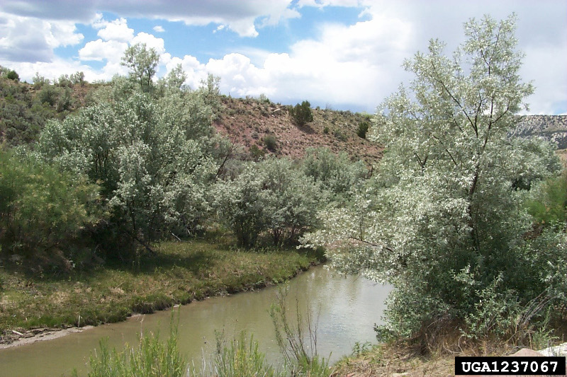


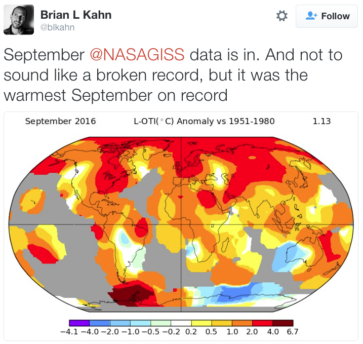
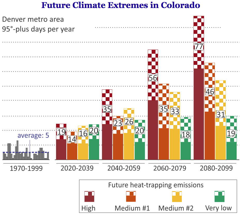


![This image was taken during the peak outflow from the Gold King Mine spill at 10:57 a.m. Aug. 5. The waste-rock dump can be seen eroding on the right. Federal investigators placed blame for the blowout squarely on engineering errors made by the Environmental Protection Agency’s-contracted company in a 132-page report released Thursday [October 22, 2015]](https://coyotegulch.blog/wp-content/uploads/2015/10/goldkingminespill1057am08052015viaepa.png)