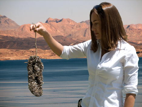
One valve of Dreissena bugensis. Photo credit: Wikimedia
FromThe Grand Junction Daily Sentinel (Charles Ashby):
Colorado has done well keeping aquatic nuisance species out of its lakes and rivers, but that won’t continue to be the case if it doesn’t properly fund a program combating them, sponsors of a bill to raise fees to pay for that program said Monday.
A bipartisan group of lawmakers is proposing establishing a $25 annual fee for a special boat stamp — $50 for out-of-state boaters — that would come on top of the annual boat registration fee the state already assesses on the more than 90,000 boats that use Colorado waters.
The fee is expected to raise about $2.3 million a year, which is about half of what the program costs, said Rep. Jeni Arndt, D-Fort Collins, who’s sponsoring the bill along with Rep. Daneya Esgar, D-Pueblo, and Sens. Kerry Donovan, D-Vail, and Don Coram, R-Montrose.
“It’s better to have a sustainable source of income coming from the people who use the waterways to fund this,” Arndt told the House Agriculture, Livestock & Natural Resources Committee, which approved the measure 10-3…
While some state lawmakers said the bill didn’t properly address the program’s entire funding needs, others said the fee should be higher.
“I’m not a wild fan of fee increases or a large fan of government intervention; however, I can tell you that this fee amount is a compromise,” said Kellen Friedlander, who testified on behalf of the Colorado Marine Dealers Association. “Colorado registrations are still one of the lowest, so we’re not asking for something that’s … totally out of whack with other states. We’re still relatively inexpensive to register boats.”
Rep. Marc Catlin, R-Montrose, said it would be worse for Colorado’s rural economy if the state were forced to close lakes because of such nuisance species as the zebra mussel.
“If we are not successful at this … everybody is going to pay to get those little buggers off the pipes,” Catlin said. “I really think the state of Colorado has a serious problem, and if we don’t get with it we’re going to have one we can never solve.”
The bill also would increase penalties for boaters who fail to get inspected before launching, raising that fine from $150 for a first offense to $500.
The funny thing about the newest book on the Colorado River is that it is not actually new at all.
Yes, it is true that Where the Water Goes has a 2017 copyright, plus a forward-looking author in New Yorker contributor David Owen and a dust jacket decked in praise from contemporary writers including Bill Bryson. But it is also true that the story within the book’s pages is an old one. It is the story of a Colorado River novice setting out to make sense of this great and imperiled Western river by tracing its length from source to sea and pondering, along the way, how its waters are divvied up to serve roughly 40 million people in seven U.S. states and Mexico. Which is to say that it is also the story of Frank Waters (1946), Philip Fradkin (1981), Colin Fletcher (1998), Jonathan Waterman (2010), Pete McBride (2011), William Stauffer-Norris (2011), and others.
Like these previous writers, Owen decides to make his way down the river because he has experienced a hydrologic awakening. Recalling his college days in Colorado Springs, Owen realizes how oblivious he was as a young man to the provenance of the water that came out of his tap — especially the endless gallons he applied to people’s lawns at a summer job. “All I knew was that every time I attached a hose to a spigot and turned it on, I could run it full force until it was time to go home,” he writes.
Decades later, now an established environmental writer, Owen sets out on a journey of self-education designed to decipher, from top to toe, the “vast and intricately interconnected system” that is the Colorado River. He starts in a chartered airplane over the river’s Rocky Mountain headwaters, ends in a borrowed truck in its delta in Mexico, and proceeds in spurts by rental car in between.
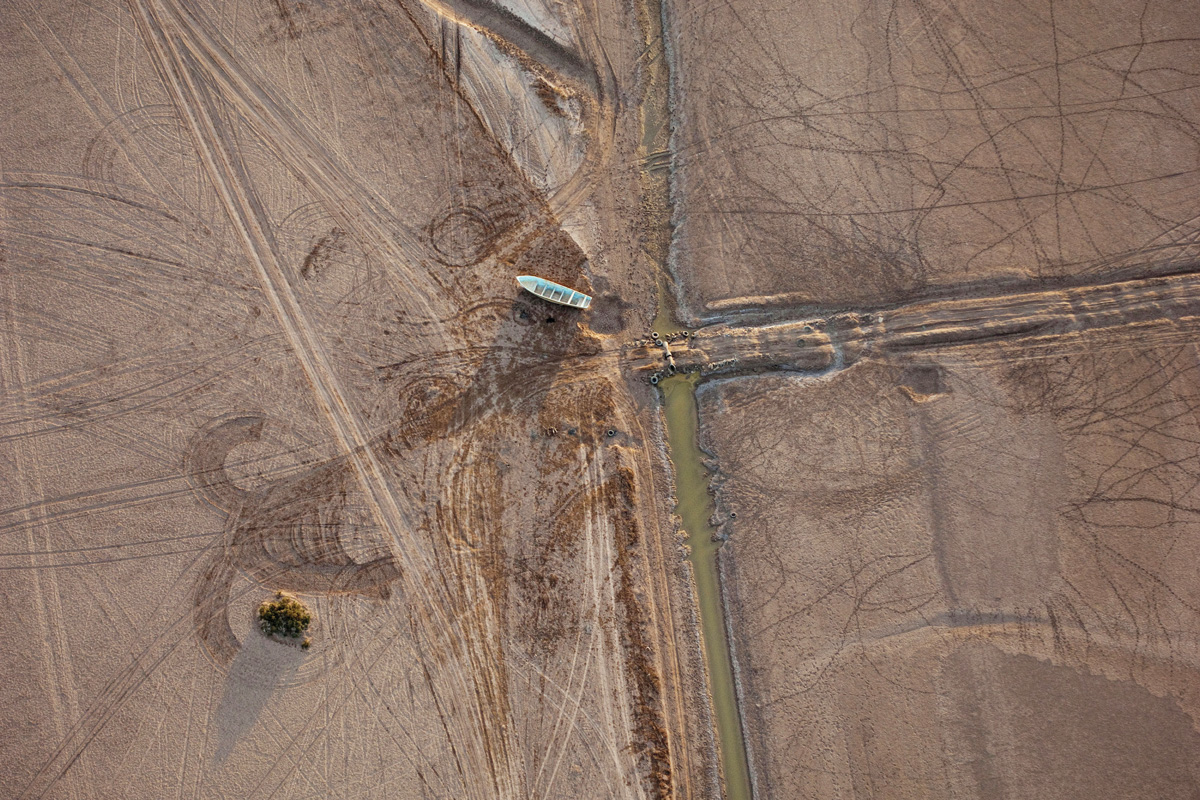
A lone boat sits next to a trickle of the Colorado River, Mexico. National Geographic Creative/Alamy Stock Photo
If Owen knows that his journey echoes those of other source-to-sea storytellers, he does not let on. And that’s too bad, really, because Owen’s telling would gain from acknowledging these kindred spirits and explaining what sets his own work apart from theirs. (For starters, Owen’s account is the most accessible for Western water newbies; he deftly explains oddities that range from “wet” water versus “paper” water to the trade-offs involved in boosting agricultural water efficiency.)
Owen’s method has its strengths. Because his narrative runs geographically rather than chronologically, it jumbles the typical order of a Colorado River tome. Rather than starting in the abstract with famous historical figures, Owen grounds us immediately in the “audacity of the Grand Ditch,” one of the river’s first major diversions, hand-dug in the late 1800s to send water from alpine streams to farms on Colorado’s Front Range. Owen’s road-trip framework also gives him room to ponder topics that don’t always make the pages of Colorado River books, including the hard-to-believe history of the Atomic Energy Commission’s nuclear fracking experiments in the river’s headwaters.
Most importantly, the source-to-sea structure helps the reader see the Colorado River as a whole, and to grasp the complexity of our cumulative impacts upon it. By the time Owen meets an Imperial Valley lettuce farmer, we have already contemplated flood irrigation in a Grand Junction vineyard. By the time Owen digs into Las Vegas’ water challenges, we have already heard about Denver’s. And by the time Owen explains water-quality issues at the U.S.-Mexico border, we have already learned about salinity as far upstream as the Dolores River. That makes it more difficult to blame any individual irrigator, city or tributary for the woes at the river’s terminus, and it shows that solutions to the river’s overuse will not come easily or unilaterally.
It is a bit odd, however, that Owen traces the Colorado River without ever spending much time in a boat. By skipping the depths of the Grand Canyon and other protected stretches, Owen never experiences the river wild. Unlike other source-to-sea chroniclers, he also does not physically struggle through rapids, reservoirs, tamarisk or mudflats to follow its path. Perhaps as a result, Owen expresses no grief when he reaches the spot where the once-mighty Colorado disappears into the sand long before reaching the Gulf of California. Instead, he writes matter-of-factly, “ATV tracks ran back and forth across the streambed, and there were many places where we could step from one side to the other without getting our feet wet.”
Still, by the river’s end, Owen has accomplished what he set out to do. He has figured out, literally, where the water goes. He has also explained it to the rest of us in clear and compelling terms. In a final chapter, he even goes one step further and ponders a handful of potential remedies to the river’s overuse. Along the way, Owen maps out a self-guided field trip that others can follow virtually (as I did, via Google Earth) or in a vehicle. And that’s a path toward a greater hydrologic awakening that we would all benefit from following.
From email from the High Line Canal Conservancy (Connie Brown):
The High Line Canal Conservancy has launched the second phase of significant planning for the High Line Canal, a beloved 71-mile regional trail. This multi-jurisdictional planning initiative follows on the heels of the completion of the Community Vision Plan in early 2017. The nationally recognized planning team includes Denver-based Livable Cities Studio led by Meredith Wenskoski, and Agency Landscape + Planning along with Sasaki Associates out of Boston, led by Gina Ford. The team will focus on developing a Framework Plan, which is anticipated to be complete in the fall of 2018 and result in a multi-year implementation plan. It will include complete plans for signage and wayfinding, as well as landscape guidelines for all 71 miles.
“Cities across the country are grappling with how to deal with 20th century infrastructure. The High Line Canal Framework Plan will advance the community-driven vision into tangible physical ideas that will become a regional treasure and a national model of best practices.” – Gina Ford, Agency Landscape + Planning
The Conservancy’s unprecedented community outreach effort in 2016, which engaged over 3500 people, led to an inspired long-term Community Vision for the High Line Canal that will be used as inspiration to develop the Framework Plan for the entire 71-mile system. The community-driven plan, endorsed by Denver Water and 10 governmental jurisdictions along the 71 miles, outlines a set of guiding principles – that the Canal remain a natural, connected and continuous, varied, managed and enhanced resource for the region.
Guided by these principles, the final Framework Plan will further ensure the Canal reaches its greatest potential as an environmental, recreational, social, historic and economic asset. The plan will focus on:
Additional open space/parks and trailheads with user amenities
Canal branded directional and interpretive signage
Crossing safety and trail gap design solutions;
Environmental guidelines for landscape, tree planning and stormwater
Health and education programs for increased access and use
Long-term permanent protection and maintenance
PUBLIC INPUT: There will be multiple platforms for public input throughout the year, including four public open houses at the end of March and September. Continued support and engagement from the citizens of the region is vital to ensure the future of the Canal is reflective of the public vision.
“Throughout this next phase of planning for the High Line Canal, we have an incredible opportunity to develop creative planning and design solutions that are community-specific, but reflective of the Community Vision Plan for all 71 miles of the Canal. One of the keys to success will be inclusive and authentic engagement among all the jurisdictions.” – Meredith Wenskoski, Livable Cities Studio.
In 2017, the Conservancy kicked off its first ever membership campaign. To date more than 750 members have heeded the call to Be A High Line Hero. In addition to membership, other ways to get involved include:
happenings and opportunities to engage in the planning process.
Follow the High Line Canal’s social media channels (Facebook | Twitter | Instagram).
Visit the High Line Canal Conservancy’s website to learn more: http://highlinecanal.org
ABOUT THE HIGH LINE CANAL CONSERVANCY
The High Line Canal Conservancy is a tax-exempt nonprofit that was formed in 2014 by a passionate coalition of private citizens to provide leadership and harness the region’s commitment to protecting the future of the High Line Canal. With support from each jurisdiction and in partnership with Denver Water, the Conservancy is connecting stakeholders in support of comprehensive planning to ensure that the Canal is protected and enhanced for future generations. For more information, please visit http://www.highlinecanal.org.
The 71-mile High Line Canal has long been a beloved asset across our region, but now its future is uncertain because of changing needs. The High Line Canal Conservancy is working to preserve, protect and enhance this ecological and recreational resource. Don’t take it for granted, the Canal needs your help. Become a High Line Hero today and support what you love!
Summary of Observed Wet & Dry Surface Water Hydrology via SCW
FromThe Glenwood Springs Post Independent (Hannah Holm):
On a bright, early fall day in 2017, members of the Colorado Basin Roundtable stood on the banks of the Colorado River watching water slide smoothly over the Bill and Wendy Riffles near Kremmling. Willows glowed gold on the banks, and new sprouts poked up through the cobble at the water’s edge.
Most riffles don’t have names, but then most riffles aren’t constructed as part of a multi-million dollar plan to remake a damaged river. The Bill and Wendy Riffles, named after the resident ranchers, were designed to raise the level of the river back up to where it used to be so that irrigation pumps, left high and dry by a depleted river, could function. Trout habitat and riparian vegetation have also benefited.
Upstream, plans are afoot to reshape Windy Gap reservoir, which currently blocks the free movement of fish, sediment and water. The construction of a new channel around the reservoir is planned to reconnect those reaches of the river and breathe new life into the ecosystem.
These projects in Grand County are part of a multi-pronged effort to compensate for the impacts of drastic flow reductions resulting from diversions from headwaters streams across the Continental Divide to the Front Range. On average, around 300,000 acre feet of water per year crosses the divide from Grand County, dropping average annual flows at Kremmling by more than 60 percent. These numbers will go up further with the completion of a pair of recently approved projects to increase these diversions.
The prospect of increased diversions, while exacerbating the overall problem of less water in the river, also provided the leverage for Grand County to demand the resources to address problems created by decades of previous trans-mountain diversions, as well as the new ones. This involved both negotiating for more water to be left in streams at certain times and the resources to reshape portions of the river’s channel.
Early on, Grand County commissioned a detailed Stream Management Plan to define environmental flow needs. This study then guided its negotiations and project prioritization. Since the completion of the study, projects to improve flows for both irrigators and the environment, such as the Bill and Wendy Riffle project, have drawn funding from numerous sources. These include the Colorado Basin Roundtable and the Colorado Water Conservation Board (CWCB), as well as the federal Natural Resources Conservation Service. Denver Water and Northern Water have also contributed. Local irrigators have played a leading role in developing and guiding projects, as have conservation organizations such as Trout Unlimited.
The Grand County example has demonstrated that water management does not have to be a zero-sum game, with some interests benefiting only at the expense of others. The approach has inspired related efforts across Colorado, a goal in the Colorado Water Plan, and a statewide grant program to promote stream management planning.
Stream management plans exist or are underway currently for the Poudre River, the Crystal River, the Roaring Fork River, the North Fork of the Gunnison, the Upper Gunnison Basin, and the San Miguel River. New planning efforts have been proposed for the Yampa River, the Eagle River, Ouray County, the Upper San Juan River, and the middle section of the Colorado River.
In addition, the Colorado Basin Roundtable has initiated a framework project to provide tools and guidance for such efforts across the basin. The author of this article is coordinating the framework project.
As these initiatives have spread, it has become clear that environmental and agricultural water needs don’t always align as neatly as they do in Grand County, where all local water interests were affected by reduced flows. Each river basin has its own dynamics, both hydrologically and socially, that affect the approaches taken and prospects for success.
The guidance for the CWCB’s Stream Management Planning grant program focuses on assessing environmental and recreational flow needs, which have historically been less well-understood than needs for agricultural, municipal and industrial uses. However, any plan to address environmental water needs will likely require cooperation from other water users, as well. These water users need a reason to come to the table.
A growing recognition of the importance of addressing the interests of all water users from the beginning of the planning process is reflected in the names of several projects funded through the Stream Management Planning grant program. The Colorado Basin Roundtable chose the term “integrated water management plan” rather than “stream management plan” for its framework project, and the Upper Gunnison project is called a “Watershed Management Planning” project.
Inclusive labeling is not enough to bring and keep diverse stakeholders at the table, however. In order to achieve that, agricultural water users and others that rely on stream diversions need to trust that their interests are genuinely being respected. They also need a sense of common cause with their planning partners. Current planning efforts appear to be attempting to respond to these needs.
Trust levels are influenced by who leads the project as well as the stated project goals. On the middle section of the Colorado River, between Glenwood Canyon and De Beque, local conservation districts have decided to take the lead on gathering information on agricultural water needs, in order to ensure that their constituents are adequately represented. The Middle Colorado Watershed Council, which kicked off the planning effort, has welcomed their involvement.
Cultivating a sense of common cause, the Upper Gunnison Watershed Management Planning Group asserts that its mission is “to help protect existing water uses and watershed health in the Upper Gunnison Basin as we face growing pressure from increased water demands and permanent reductions in overall water supply.”
The Crystal River Plan sought to “identify, prioritize and guide management actions that honor local agricultural production, preserve existing water uses, and enhance the ecological integrity of the river.” The completed plan includes a detailed accounting of agricultural water shortages along with information on the ecological state of the river. The project on the North Fork of the Gunnison River has assessed opportunities for diversion structure upgrades that could benefit irrigators and improve safety for boaters.
These are complicated processes, with many opportunities for conflict and failure. However, the potential payoffs of healthier streams and more water security, as well as enhanced mutual understanding across the whole community of water users, could make these projects well worth the effort.
Hannah Holm coordinates the Hutchins Water Center at Colorado Mesa University, which promotes research, education and dialogue to address the water issues facing the Upper Colorado River Basin. Learn more at http://www.coloradomesa.edu/water-center.
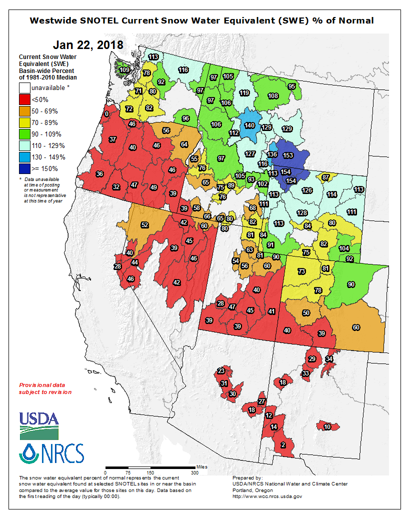
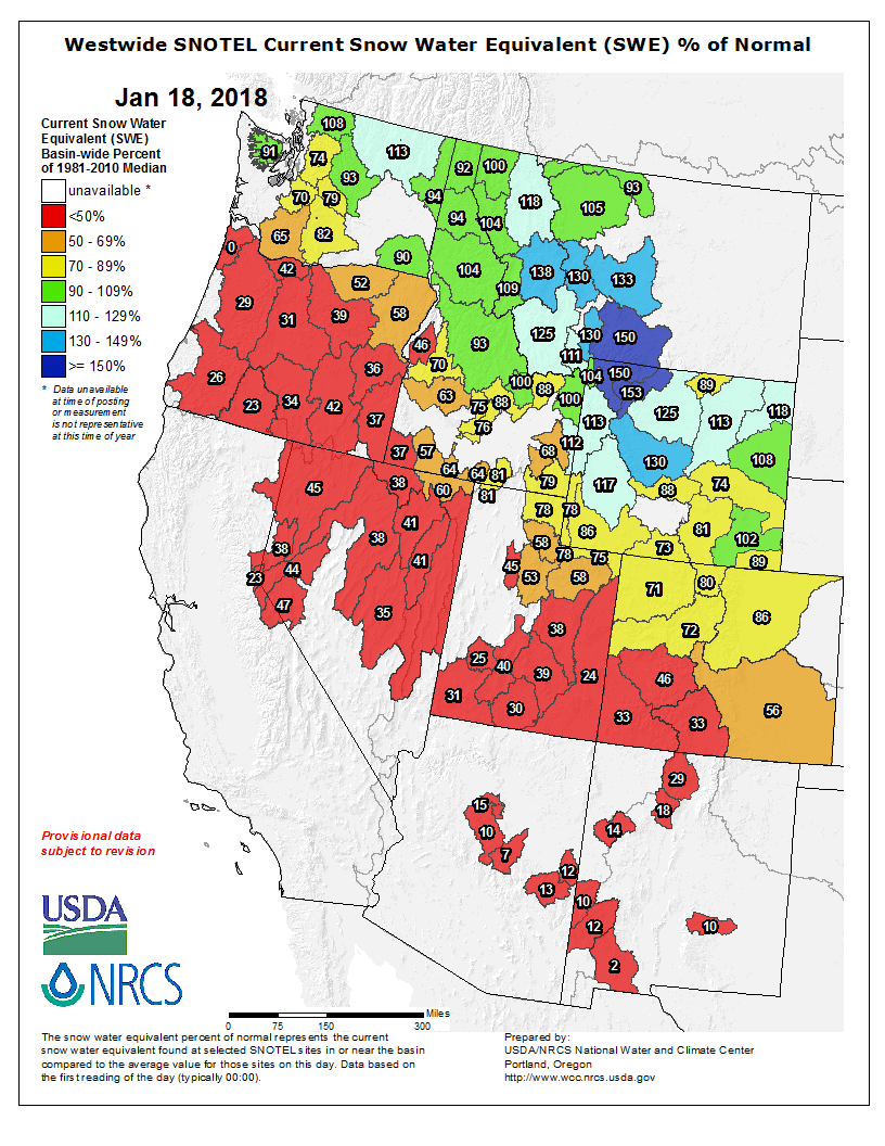
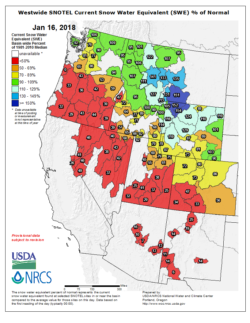
Click on a thumbnail graphic to view a gallery of snowpack data from the NRCS. Note that the Basin High/Low graphs may not reflect all of the snowfall from the weekend storm.
Statewide basin-filled snowpack map January 22, 2018 via the NRCS.
Statewide Basin High/Low graph January 21, 2018 via the NRCS.
Arkansas River Basin High/Low graph January 21, 2018 via the NRCS.
Upper Colorado River Basin High/Low graph January 21, 2018 via the NRCS.
Gunnison River Basin High/Low graph January 21, 2018 via the NRCS.
Laramie and North Platte Basin High/Low graph January 21, 2018 via the NRCS.
Upper Rio Grande River Basin High/Low graph January 21, 2018 via the NRCS.
San Miguel, Dolores, Animas, and San Juan Basin High/Low graph January 21, 2018 via the NRCS.
South Platte River Basin High/Low graph January 21, 2018 via the NRCS.
Yampa and White Basin High/Low graph January 21, 2018 via the NRCS.
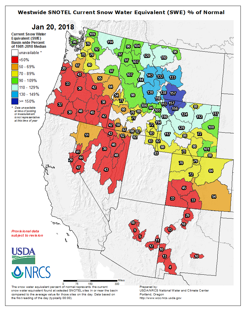
And, here’s the Westwide SNOTEL basin-filled map for January 22, 2018 from the NRCS.
Westside SNOTEL basin-filled map January 22, 2018 via the NRCS.
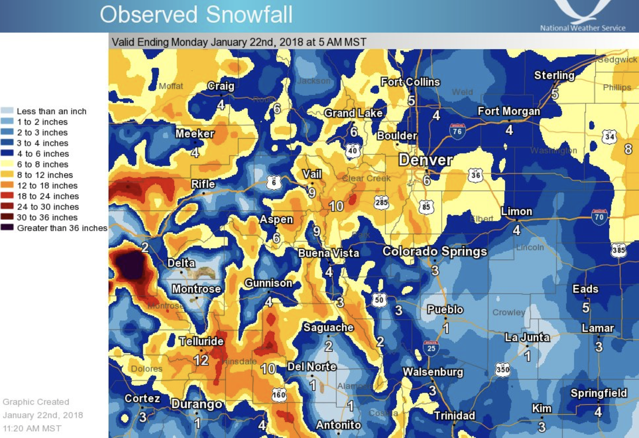
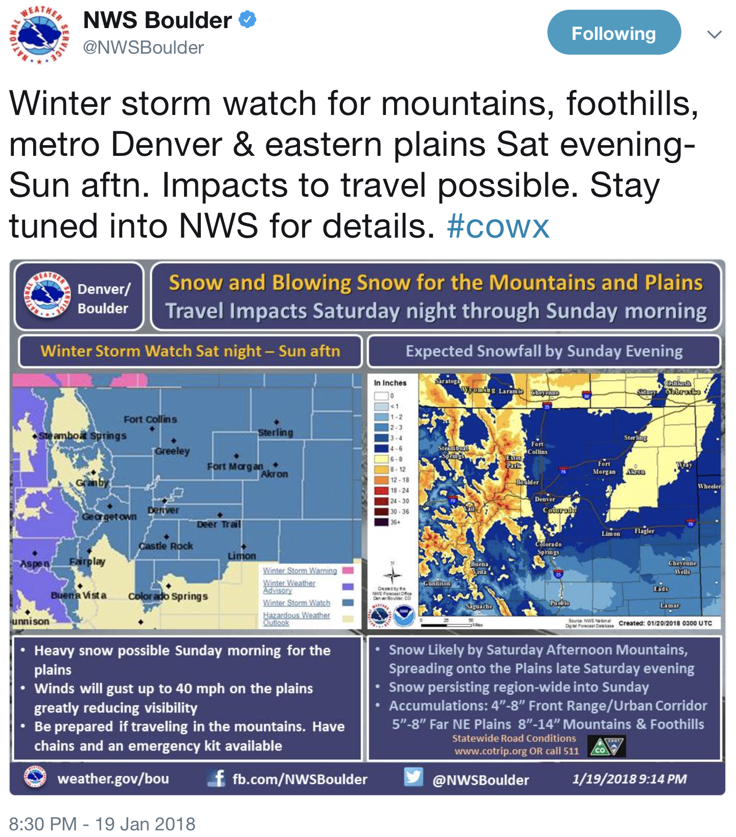
A winter weather advisory remained in effect until 2 p.m. Sunday for the San Juan Mountains, where a winter storm dumped about a foot of snow overnight…
Meteorologist Julie Malingowski of the National Weather Service in Grand Junction said the high country could see an additional 1 to 3 inches of snow Sunday afternoon before the storm moves out of the region.
I can’t give you a precise date, but some time in the past two years the world crossed a threshold and incremental action on climate change was off the menu. To keep temperatures below 2°C, we now need exponential action.
Earth is now 1.1℃ warmer owing to our emissions of greenhouse gases, and the latest scientific assessment, presented in Geophysical Research Letters, suggests that if we would get rid of all life-threatening air pollution, like black carbon, sulphates and nitrates, some of which lower temperatures, we would very likely bump up global temperatures another 0.5–1.1°C. The message is dire. One global bad – global warming – is camouflaged by another global bad – air pollution. This is a reminder that we are really, very late arrivals to the solution space.
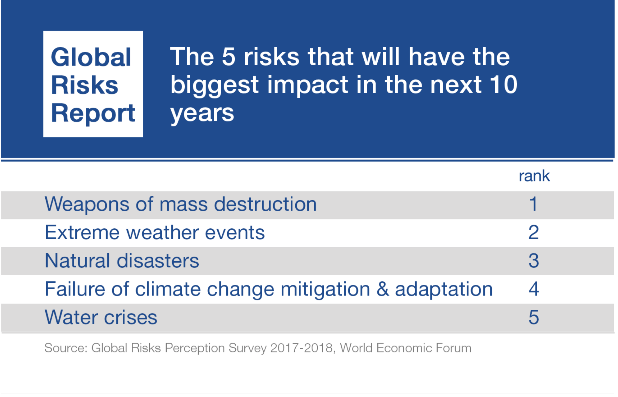
The 2018 World Economic Forum’s Global Risks Report makes this crystal clear. Three global environmental risks now dominate the report both for likelihood and impact: extreme weather, natural disasters and failure to act at the necessary speed to mitigate climate change. This message was reinforced recently by Mark Carney, chair of the G20 Financial Stability Board, who said: “Once climate change becomes a clear and present danger to financial stability it may already be too late to stabilize the atmosphere at two degrees.”
How fast do we need to act? As a general rule of thumb, staying below 2°C above pre-industrial levels means halving emissions of greenhouse gases every decade if we want a high probability of success. We call this exponential pathway the Global Carbon Law, inspired by Moore’s Law in the IT industry – the observation that computers double in speed about every two years.
The Global Carbon Law framing is a useful way to look at the Paris Agreement. It turns a distant goal of reaching carbon neutrality sometime beyond 2050 into a short-term target for the next decade. In this way, it works on timescales relevant to businesses and politicians. It also means that anyone following this pathway, from countries, businesses and organizations, to households and individuals, is automatically “in” the Paris Agreement. This could be useful to cities and states in the US who want to remain “in” if the US president follows through on his decision to exit the agreement.
More importantly, the Global Carbon Law pathway is achievable. In many sectors, businesses can halve their emissions every decade. Indeed, companies like Apple, Google and Intel are cutting emissions much faster and the ICT sector has peaked emissions while driving up value and prosperity. Since we published this Carbon Law roadmap last year, a Swedish network of leading businesses, the Haga Initiative, has shown that even companies outside of ICT can beat the Carbon Law. And now Sweden’s WWF is adopting a similarly ambitious pathway for its science-based targets for businesses.
We now need Carbon Law thinking to go exponential. The solution is on the horizon. Later this year, San Francisco will host the most important event since the Paris Climate Agreement in 2015: the Global Climate Action Summit. Our aim for the summit is to move from incremental action to exponential and harness the power of the most innovative, disruptive part of the global economy – the digital sector.
At this year’s World Economic Forum, former UN climate chief Christiana Figueres and myself will have an open dialogue with leaders of the tech community to drive this level of ambition. Together with the most disruptive industry in the world, we will explore pathways to expedite and amplify a global transformation to a decarbonized future that follows the Global Carbon Law.
The rationale is simple: in the next three decades, the Fourth Industrial Revolution, driven by artificial intelligence, machine learning and the Internet of Things, will transform everyone’s lives. At the moment the compass direction for this transformation is unclear. We need to ensure this transformation is towards a prosperous and resilient zero-carbon future.
Rapid innovation cycles ensure the tech sector stays on its phenomenal and exponential Moore’s Law trajectory. This is what we now need for the Global Carbon Law and, for this, the industry needs a roadmap to coordinate as a sector to deliver on these innovation cycles.
With Davos 2018 as the launchpad, we will bring together a coalition of the leading tech companies to launch a disruptive roadmap in San Francisco to change the course of history. Our goal is to turn 10 million entrepreneurs and engineers and others working in the tech sector into planetary stewards. Whatever these great minds are working on, the stability and resilience of our climate for future generations must be the compass course.
Steve Jobs once said he wanted to put a dent in the universe. He did just that. Right now, we need to put a dent in our world. The world needs nothing less.
On 24 January 2018, Johan Rockström will speak at a breakfast event at the Forum to shape the vision for the Fourth Industrial Revolution with Christiana Figueres, (Mission2020 and former head of UNFCCC), Anne Finucane (Bank of America) and tech leaders.
There’s a term for what’s going on right now in the Sierra Nevada and the mountains that feed the Colorado River. It’s called a “snow drought,” and Nevada climate scientists warn that Westerners had better get used to the phenomenon.
Periods of below-average snowpack have become increasingly common in some Western mountain ranges, and more frequent snow droughts are likely as global temperatures continue to rise, according to Benjamin Hatchett, a postdoctoral fellow in meteorology and climatology at the Desert Research Institute in Reno.
“We’re kind of seeing all these things coming together, and not just in California but all over the West,” he said.
Hatchett and fellow DRI climate researcher Daniel McEvoy are studying trends and changes to mountain snowpack and their impact on regional watersheds and the economies in places where winter recreation fuels tourism. They hope their research will help water managers and others plan for a future that is likely to involve longer dry spells, changes in runoff patterns and an increased risk of flooding.
A drought that’s wet
In a paper published recently in the journal Earth Interactions, they used hourly, daily and monthly data to analyze the progression of eight historic snow droughts that occurred in the northern Sierra Nevada between 1951 and 2017. What they found were two distinct types of snow drought: the familiar “dry” variety caused by low levels of precipitation and a “wet” drought that results when mountain areas usually blanketed with snow get rain instead.
Hatchett said the most recent drought in the Sierra was “pretty similiar” to previous dry spells in terms of precipitation, “but it was this increase in temperature that really exacerbated the severity.”
“As the climate grows warmer and more precipitation falls as rain instead of snow, we are seeing that we can have an average or above-average precipitation year and still have a well-below-average snowpack,” said Hatchett, who has noticed the difference firsthand over a lifetime of backcountry skiing.
In November, he published research outlining a 1,200-foot rise in the average snow level — the elevation at which rain turns to snow — in the Northern Sierra over the past 10 years. Over that same period, the region was experiencing its warmest decade on record, he said.
Snowpack is crucial even in communities that rarely see any snow. The Las Vegas Valley draws 90 percent of its water supply from Lake Mead, and nearly all of that water comes from snowmelt in the mountains that feed the Colorado River.
FromThe Grand Junction Daily Sentinel (Katie Langford):
As the Colorado West Land Trust nears a long-term goal of preserving 1,000 acres of farmland in Palisade, a new 22-acre conservation easement of peach and apricot orchards is moving the needle that much closer.
Rob and Clare Talbott of C&R Farms have previously conserved 59 acres of orchards through the land trust, and Director of Conservation Iliana Moir said she was happy to hear the Talbotts wanted to do it again.
The land trust has conserved approximately 800 acres of Palisade farmland through conservation easements since 2009. Conservation easements are an arrangement in which landowners agree not to subdivide their property and the land trust agrees to hold it in perpetuity. In Palisade, it means those 800 acres will only be used for farming.
“That area is the only area in the Grand Valley that consistently produces good fruit, so it’s really important,” Moir said. “The winds that come through De Beque Canyon in the spring keep the frost from settling on the peach buds, and the area around Palisade has prime, unique soil that’s excellent for growing fruit trees. They have excellent water rights, so they can invest in long-term crops.”
Colorado West Executive Director Rob Bleiberg said preserving Palisade’s agriculture industry is key for the future success of the Grand Valley.
“We have been focused on the fruitlands of Palisade since our founding in 1980, and for the simple reason that the orchards and vineyards are an incredible asset for our community and an economic driver,” Bleiberg said. “They define Palisade.”
The Talbotts started farming in 1979 and have long understood the need to preserve the farmlands of Palisade, said Rob Talbott.
“Our family believes it’s important to preserve farming for future generations,” he said. “There is a lot of pressure on orchards to subdivide their land so homes can be built. Once these homes are built, the small orchard on the property can’t sustain the cost of the home, therefore putting the property out of reach of young farmers to purchase the property as an initial investment or an existing young farmer to expand. We want future generations who want to make farming their livelihood to have the ability to afford to do so.”
A climate science milestone on Colorado’s Continental Divide
On January 16, 1968, in a bracing chill at 11,568 feet above sea level, a Colorado researcher collected an air sample at Niwot Ridge, on the doorstep of the Indian Peaks mountain range. The sample was carried down the mountain and then measured for carbon dioxide at a lab in Boulder, Colorado. The result: 322.4 parts per million.
NOAA was not officially established until 1970, but this air sample produced the first measurement for NOAA’s Global Greenhouse Gas Reference Network. In the 50 years since, more than 274,000 air samples have been collected at over 60 sites around the globe, including more than 9,000 at Niwot Ridge. All have been transported to what is now NOAA’s Global Monitoring Division labs in Boulder for measurements of carbon cycle gases, like carbon dioxide, methane, carbon monoxide and other gases.
From this inauspicious start, NOAA’s Global Greenhouse Gas Reference Network has evolved into one of the international climate science community’s most valuable resources – a long, uninterrupted and highly accurate accounting of Earth’s changing atmosphere.
Air samples are collected on a weekly basis from locations spanning the Canadian Arctic to the South Pole – continental sites ranging from deserts to tropical forests to barren ice caps, on small islands, and on ships crossing the oceans, by scientists and technicians, as well as soldiers, ranchers, mariners, school teachers, lighthouse keepers, a monk, and a host of other volunteers. One dedicated group of volunteers in Mongolia sends a hearty soul on a 12-hour overnight train ride once a month to deliver air samples to a shipping destination.
Over the years measurements were refined and added, and now samples are analyzed for as many as 60 different trace gases, some at a resolution of parts per trillion. Collection and measurement methods have changed over the decades, but extraordinary steps taken to ensure accuracy mean that historical data are valid and continue to be used by researchers around the world to understand the carbon cycle.
Thanks to that 1968 Niwot Ridge sample, NOAA’s Global Greenhouse Gas Reference Network database is the third-longest continuous carbon dioxide record in the world, behind the Scripps Institution of Oceanography’s Mauna Loa, Hawaii, and Antarctic records. NOAA maintains independent sampling stations at Mauna Loa and the South Pole as well.
On January 15, 2018, almost 50 years to to the day since the first sample was collected, a researcher sampled the air at Niwot Ridge. This time, instruments measured 410.24 ppm of carbon dioxide, an increase of 27 percent over that first sample.
For more information on NOAA’s Global Greenhouse Gas Reference Network, contact Theo Stein: theo.stein@noaa.gov.
Xcel Energy’s Greater Sandhill Solar Farm north of Alamosa, Colo. Colorado’s San Luis Valley has some of the nation’s best solar resource. Photo/Allen Best
What’s needed to integrate renewables at scale in the U.S. electrical grids
For all the worries about budget cuts as Donald Trump ascended to the presidency a year ago, the National Renewable Energy Laboratory at Golden, Colo., has remained intact and, in at least one division, is expanding.
That particular division, the Strategic Energy Analysis Center, will add 40 analysts by the end of the year to the existing 150, reported David Mooney, the director.
That division has several major studies to wrap up and others soon to get start, said Mooney in Fort Collins Tuesday evening at an event sponsored by the local chapter of the Colorado Renewable Energy Society.
In March, a study will be released that examines the costs and benefits of breaking down the electrical fences in the United States. The West, the East, and Texas are all on different grids, interconnected but not integrated. Think of three people holding hands, three heartbeats, but not quite with the same timing.
A seamlessly-connected grid would cost trillions of dollars to create but would yield so many benefits that the cost would be reimbursed within 15 years if the work were started in 2024.
Another study, due in October 2019, examines renewable energy integration across North America, not just the United States.
Then there’s the study—expected to be due in 2020, although Mooney said the contract has not been finalized—that will examine what the options would be for the Los Angeles Basin, home to 13 million people, to achieve 100 percent electrification based on renewable energy. “That is real exciting,” he said.
The tone of the evening was a smile. Renewable energy is happening—even more rapidly than many people expected. Mooney related the prices of solar energy when he was a grad student in the 1980s, the most optimistic predictions of the time—and now the reality that is far, far below those most optimistic projections.
Just how low can these prices for renewable go? In Colorado, proposals by independent power developers to Xcel Energy announced in late December were “some crazy good prices,” said Mooney. Wind, as expected, came in at the very lowest, but solar prices, too, were very low.
In fact, Colorado has pretty good solar resources, especially in the San Luis Valley. Mooney related how, after Colorado voters in 2004 ordered Xcel and the state’s other investor-owned utility, Black Hills Energy, to begin investing in renewables, he was at a meeting with representatives of Xcel. He informed them that some of the nation’s best solar capacity was to be found in the San Luis Valley. Three weeks later Xcel was buying land, and the valley now has 26 megawatts of solar generating capacity.
It’s about as good as the Mojave Desert because not only is it nearly as cloudless, but it’s also high, about 8,000 feet, meaning there are no extremely hot days. That results in better electrical production.
But wind is where Colorado really excels, at least in terms of raw generating capacity. It ranks 10th nationally, with about three gigawatts in capacity. Wind now provides about 17 percent of the total electricity consumed by customers of Xcel on an annual basis. Xcel is the state’s largest utility, with more than 60 percent of the state’s customers, including those in Summit County. Xcel is also a wholesale provider for several electrical co-operatives in mountain valleys, including Steamboat Springs and the Yampa Valley and the Vail and Aspen areas.
What stands out is how rapidly this has all come about. Mooney said when he was a grad student in the late 1980s, the world had a total of 50 megawatts of wind, solar and other renewable generation. Now, the United States alone has 1,180 gigawatts and the world has 6,000 gigawatts. One gigawatt has 1,000 megawatts.
If the United States has exploded with renewable generating capacity, and Germany with solar collectors, China has blown past everybody.
Now comes energy storage. Again, it’s not new, but from 2010 to 2017, prices of lithium-ion battery storage have dropped 81 percent.
This plummeting cost of storage is now causing energy analysts like Mooney to begin shifting their thinking. They are no longer asking at what penetration level is storage necessary. Instead, they’re starting to wonder what happens if storage become ubiquitous.
If deep, broad penetration of renewables in the electrical and—more broadly—energy supplies is the goal, then what helps achieve that?
To maximize renewables, he said, the electrical grid needs to be flexible, able to respond rapidly to changes in demand but also changes in supply. Storage, he said, is the ultimate source of flexibility. He also emphasized strengths achieved through the interconnections of effective transmission. The final component is geo-spatial diversity of resources.
“For a robust, well-interconnected transmission system, geo-spatial diversity in assets is really key,” he said.
About Allen Best
Allen Best is a Colorado-based journalist. He publishes a subscription-based e-zine called Mountain Town News, portions of which are published on the website of the same name, and also writes for a variety of newspapers and magazines.
From the Nortglenn-Thornton Sentinel (Scott Taylor):
Westminster looking for spot for Semper successor
City officials will begin looking around Westminster for a good place to put a new water treatment plant with the aim of having it ready for service by 2025.
“This is the first phase of longer program and we’re calling this first phase Water 2025,”said Stephen Grooters said. “That’s designed to give us the quantity, quality and reliability goals we need to meet today’s population.
“And as the city grows and as our other treatment facilities age, the city can gauge the cost and efficacy of adding a second phase plant — when to add it and how big to make it.”
The new plant would provide backup service to the city’s two existing treatment plants, the Northwest plant and the Semper, and give the city time to consider options for replacing Semper some time in 2040.
City Councilors voted Jan. 8 to set aside $609,749 to begin the multi-year Water 2025 process. That would pay for engineering and a city-wide site selection process. The potential sites should be at a lower elevation from Standley Lake but higher than most city storage tanks.
Grooters said he hopes the city can find as many as 12 potential sites for a water treatment facility…
The budget includes $150,000 for a public engagement process to get public opinion about the facility.
Drought impacted corn. Water stress can lead to insufficient water supply for cities, agriculture, and vegetation. Dry vegetation may facilitate the propagation and increase the risk of wildfires.
Precipitation variability — the swing from dry to wet and back again — will continue to increase across the majority of the world’s land area as the climate warms, according to a new study led by scientists at the National Center for Atmospheric Research.
The researchers expect precipitation variability to become greater from day to day, year to year, and even decade to decade. The new research, published in the Nature journal Scientific Reports, provides results from sophisticated computer simulations that predict that there will be both more droughts and more floods within the same areas as the climate warms. The findings are relevant for water managers who need to make long-range plans.
“When it’s dry, it will be drier. When it’s wet, it will be wetter — in the same place,” said NCAR scientist Angeline Pendergrass, lead author of the study. “There will be a broader range of conditions that will become ‘normal.'”
The research was funded by the National Science Foundation, which is NCAR’s sponsor, and by the U.S. Department of Energy.
NEW TOOLS TO STUDY CHANGES IN PRECIPITATION
Historically, changes in precipitation variability have been difficult to pin down because the amount of rain or snow a particular region gets can vary a great deal naturally.
But in recent years, the availability of large ensembles of climate model runs has allowed scientists to begin separating some of the more subtle impacts of climate change from the natural chaos in the climate system. These ensembles may include 30 or 40 runs of a single climate model over the same time period with slightly different, but equally plausible, initial conditions.
Pendergrass and her colleagues, NCAR scientists Flavio Lehner, Clara Deser, and Benjamin Sanderson, along with ETH-Zürich professor Reto Knutti, took a closer look at precipitation variability using large ensembles of runs from the NCAR-based Community Earth System Model (CESM) and from the Geophysical Fluid Dynamics Laboratory (GFDL) climate model. They also looked at a collection of individual runs taken from many different climate models and known as the Climate Model Intercomparison Project Phase 5, or CMIP5.
The team found that precipitation variability will likely increase substantially over two-thirds of the world’s land areas by the end of the century if greenhouse gas emissions continue unabated. They also found that, on average, variability increases 4 to 5 percent over land per degree Celsius of warming and that variability increases across all time scales, from days to decades.
“This increase in variability is arising due to more moisture in the atmosphere and a weakening of global atmospheric circulation,” Pendergrass said. “That’s important because it means that changes in precipitation variability are not just linked to changes in El Niño and La Niña events, as some previous work implied.”
HELPING WATER MANAGERS PLAN FOR THE FUTURE
Pendergrass hopes the study’s findings will be used by water managers in their future planning. Models used today by water managers often assume that the change in precipitation variability in the future will track with the expected increase in average precipitation.
But the new study finds that the increase in precipitation variability will outstrip the increase in average precipitation, which means that water managers may be miscalculating the magnitude of future swings from wet to dry or vice versa.
“Water managers may be underestimating how much heavy events — floods or droughts — will change,” Pendergrass said.
ABOUT THE ARTICLE
Title: Precipitation variability increases in a warmer climate
Authors: Pendergrass, A. G., R. Knutti, F. Lehner, C. Deser, and B. M. Sanderson
Less water in the stream means less comes into large and critical impoundments such as Lake Powell, which Mueller said is already being “equalized” with Lake Mead. The latter is being drawn down by overuse, not just drought.
“They’ve been draining the savings account at Lake Mead for them (users), and, the way it works, they’ve also been draining Lake Powell,” Mueller said. “ … It isn’t the drought draining Lake Powell as much as it is the overuse and the lower supply of water going in.”
Colorado must be aware of that because of its requirements under the Colorado River Compact to deliver a set amount of water right below Glen Canyon Dam.
“There’s accounting that goes on. Every year, we know exactly how much water is delivered. At a point in time … we can see very clearly, we have a significant risk of not being able to deliver that water,” Mueller said. “When we can’t deliver that water, we will get a call, or a curtailment, coming up the river.”
He said it appeared as though most of those present Jan. 19 have pre-compact water, or senior rights, that are not obligated to be called out. Most municipalities have rights junior to the compact — but they also have the right of condemnation through an involuntarily “buy and dry” process.
“Those (municipal) fire hydrants and those faucets, my guess is, are going to get water in the time of curtailment. That’s the municipal preference in our state constitution,” Mueller said.
To-date, the state hasn’t actually had to determine how this consideration would be applied — in fact, mum’s the word at the state level, Mueller added.
“The reality is, many of the Front Range providers would have rights junior to the compact,” Mueller said. These providers divert about 650,000 acre-feet a year to the Front Range out of the Colorado River Basin, including, at times, the Upper Gunnison.
The Front Range is constantly on the lookout for additional supply, but that’s not the only thing to keep in mind, Mueller said. Front Range providers will continue to supply current municipal needs in that populous part of the state.
The question becomes: What happens in the event of a curtailment when municipalities have the right of condemnation?
“They have the right to come over and buy ag rights. They don’t even have to build a pump. They can just run the water down the stream into Lake Powell. They can dry up the agricultural — buy and dry involuntarily,” Mueller said.
Locals under the Uncompahgre Valley Water Users Association are not necessarily safe from condemnation just because the association is under a right held by the federal government, he said.
Although municipalities cannot condemn against federal property, it’s not certain whether the U.S. Secretary of the Interior would ultimately be comfortable with not delivering water to the lower basin, where the greater population provides a congressional delegation many times the size of the Western Slope’s, Mueller explained.
“The question really is, how do we prevent that from happening?” he said.
“We don’t have the answer yet, but we are studying a number of different mechanisms where we can use voluntary efforts by our agricultural producers on the Western Slope, combined with voluntary efforts of ag users who depend on transmountain diversions on the Eastern Slope; industrial providers on the East Slope, and municipal providers on the East and West Slope, to voluntarily curtail their uses ahead of time and bank that water somewhere and then be able to prevent a curtailment from ever occurring.”
These, Mueller explained, are “thoughts,” not absolutes.
Detailed Colorado River Basin map via the U.S. Bureau of Reclamation.
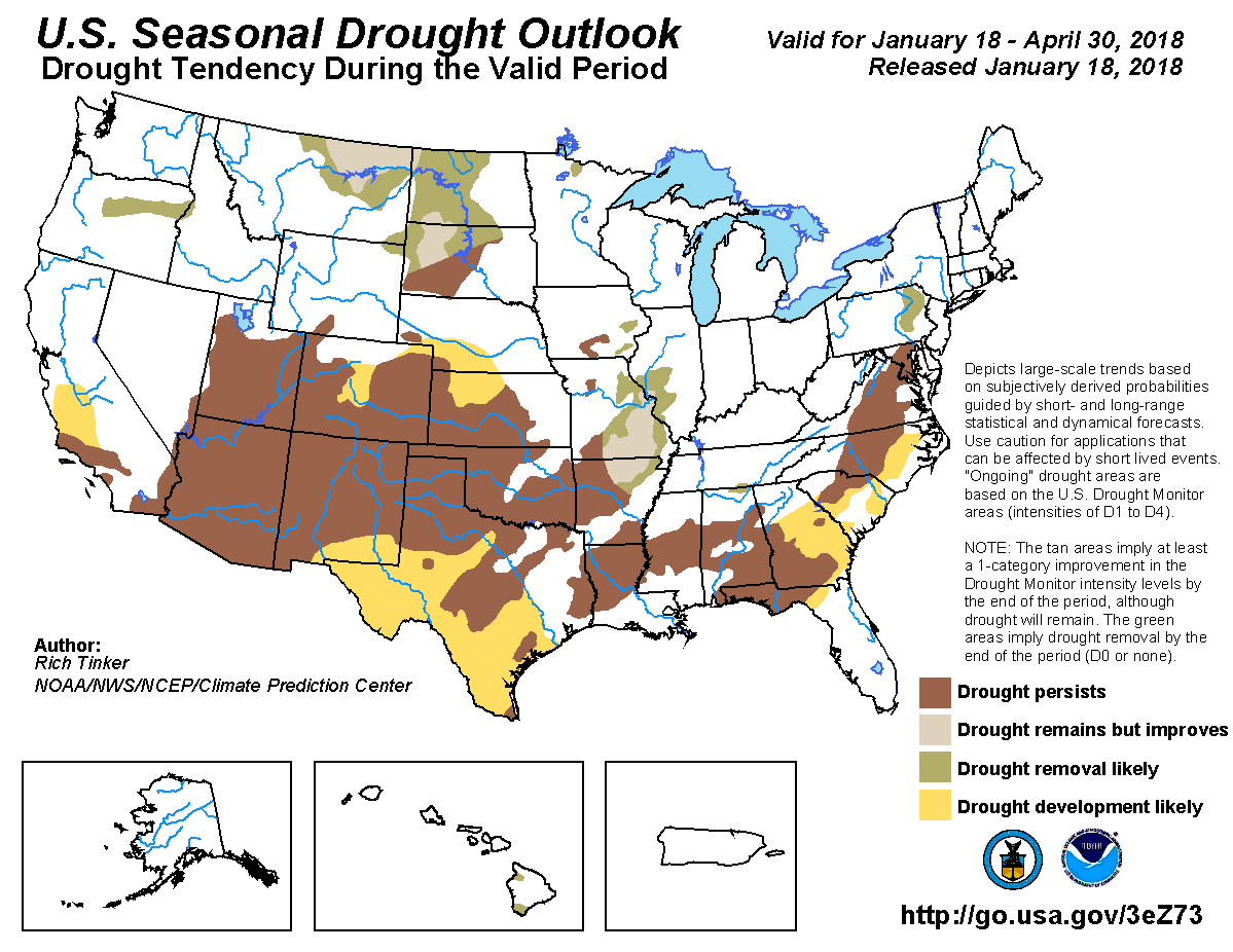
…the drought status does signify the the potential for some major issues if we don’t get needed moisture in the next few months, particularly heading into the drier summer and fall months and fire season.
The mountains are struggling, as any powder-day chaser knows. Colorado’s snowpack is a key source of drinking water, and it also helps deters wildfires come spring and summer.
Statewide, as of Friday, the state’s snowpack sat at 60 percent of average, with the biggest deficits in the southern part of the state. The San Juans have been particularly hard-hit, with the southwest mountains sitting at only about a third of their typical season-to-date snowfall. The northern mountains are also below average, though recent storms have helped them get back to a solid flurry or two away from typical levels for this time of year.
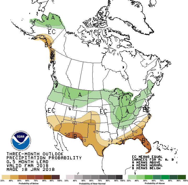
The Climate Prediction Center’s official three-month outlook leaves most of Colorado looking drier than average and continuing the persistently dry pattern across the state, and particularly across the southern parts of the Centennial State.
There’s probably a key buzzword you’re hearing non-stop as to why it’s been so dry and snow-less: La Niña. Okay, that’s technically two words, but it’s a reference to cooler-than-average Pacific Ocean temperatures and a domino effect of global weather impacts.
The West Coast has experienced a fairly typical weather pattern for a La Niña winter: a wet, active spell for the Pacific Northwest and a bone-dry pattern for California and the inter-mountain West. However, storms have trended to push further north than usual, even for a La Niña winter, leading to the huge snowfall deficits. It’s kept Colorado’s northern mountains close to seasonable levels, but it’s left the southern Colorado mountains hungry for snow.
As of this week, snowpack in the Animas, Dolores, San Miguel and San Juan basins was at 33 percent of normal, tied with the Upper Rio Grande basin for the lowest snow totals in Colorado. The state as a whole is at 60 percent of normal.
But water managers are quick to mention one interesting and important stat: about 50 percent of the entire San Juan River basin’s snowpack comes from just 10 percent of the storms to hit the region.
Translation: Southwest Colorado needs only a handful of major storms to drop heavy snow to restore a sense of normalcy to snowpack levels and relieve the region of dreaded water issues that come with drought years.
But as the winter weather has yet to arrive, pressing into late January, these storms have to actually materialize to kick off the about-face.
“Whereas the northern mountains get dustings every other day, we get big events from the Southwest, all at once,” said Susan Behery, a hydraulic engineer with the Bureau of Reclamation, who is based in Durango. “But the longer we go into the season without any snow at all, the less likely that seems.”
Tayrn Finnessey, a climate-change risk management specialist with the Colorado Water Conservation Board, said this winter’s lack of snowfall for Southwest Colorado is a “classic La Niña” year.
“In La Niña years, storms tend to track north,” she said.
There are precedents for this year’s lack of snow.
Take 2002, one of the driest years in Southwest Colorado history, which will forever be tied with the Missionary Ridge Fire that ripped through the San Juan Mountains, burning almost 73,000 acres.
This year’s snowpack is about half of what it was at this time of year in 2002, according to SNOTEL records from the Molas Pass gauging station, about 60 miles north of Durango in the high country.
In 2002, drought conditions didn’t actually hit until later in the season, paving the way for dangerously combustible conditions in the summer.
More comparable snowpack years to this winter would be in 1990 and 2000. But even in those years, snowpack did see a jump by the end of the winter, with peak numbers at about 15 inches and 18 inches, respectively.
“Is there a chance we could come back?” said Brian Domonkos, a snow survey supervisor with the National Resources Conservation Service. “Yes. But our chances are dwindling quickly.”
There is precedent for Colorado basins receiving late winter snow to compensate for a dry start. But given that winter is about half over, it is not likely we will hit those normal averages, Domonkos said.
And, it is notable to mention that past years at least displayed cold temperatures. Not so this year. In January, for instance, the month is on track to be 7.4 degrees warmer than historic averages, according to the National Weather Service.
In his 14 years with the service, Domonkos said this is probably the lowest snowpack he has seen in the majority of Colorado basins. It is statistically abnormal, he said, but not anything weather watchers haven’t seen before.
“We have to keep a real close eye on what’s going on,” he said. “The only way we’ll be able to plan and adjust – and adapt – is by watching these events closely and making smart good decisions.”
Water managers in Southwest Colorado are already watching to see how this year’s snowpack will play out for the many and varied water users of the region.
The Bureau of Reclamation’s Behery said the most-recent forecasts are predicting spring runoffs into Vallecito and Lemon reservoirs will be at about 45 percent of historic averages, and the forecasts will continue to drop with the absence of snow.
As a result, it’s unlikely that either reservoir, of which thousands of irrigators rely on, will hit capacity this year. Both reservoirs are about 50 percent full because of carry over from last year’s strong snow season.
John Simpson, an assistant division engineer with the Department of Water Resources based in Durango, said it’s too early to tell whether strict water restrictions will be enacted on the area’s waterways.
The Department of Water Resources is the state entity that administers all water rights to water users. In years where there is not plentiful water available, that’s when the division must give priority to senior water-right holders, potentially leaving others in the lurch.
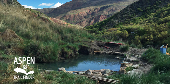
Steve Beckley, owner of the Iron Mountain Hot Springs and Glenwood Caverns Adventure Park with his wife Jeanne, is offering to lease the site from the city of Glenwood Springs for 18 months in order to do the necessary pre-engineering and come up with a development plan.
A concept plan presented by Beckley and land planner Ron Liston to City Council on Thursday envisions designed hot springs facilities and a campground at the site along Garfield County Road 134, just below the city’s landfill.
In addition, Beckley wants to build a campground at the city’s upper South Canyon property where a new mountain biking trail system is about to be constructed.
A lease would allow for water quality testing at the springs and the pool that exists, plus a test well to determine the potential for development and availability of potable water in the area. Beckley and his team also would use the time to design the lower and upper RV park/campgrounds, and obtain any city, county and state permitting that would be necessary.
Two pools exist at the makeshift site that has been a popular hangout over the years for those looking for a free soak.
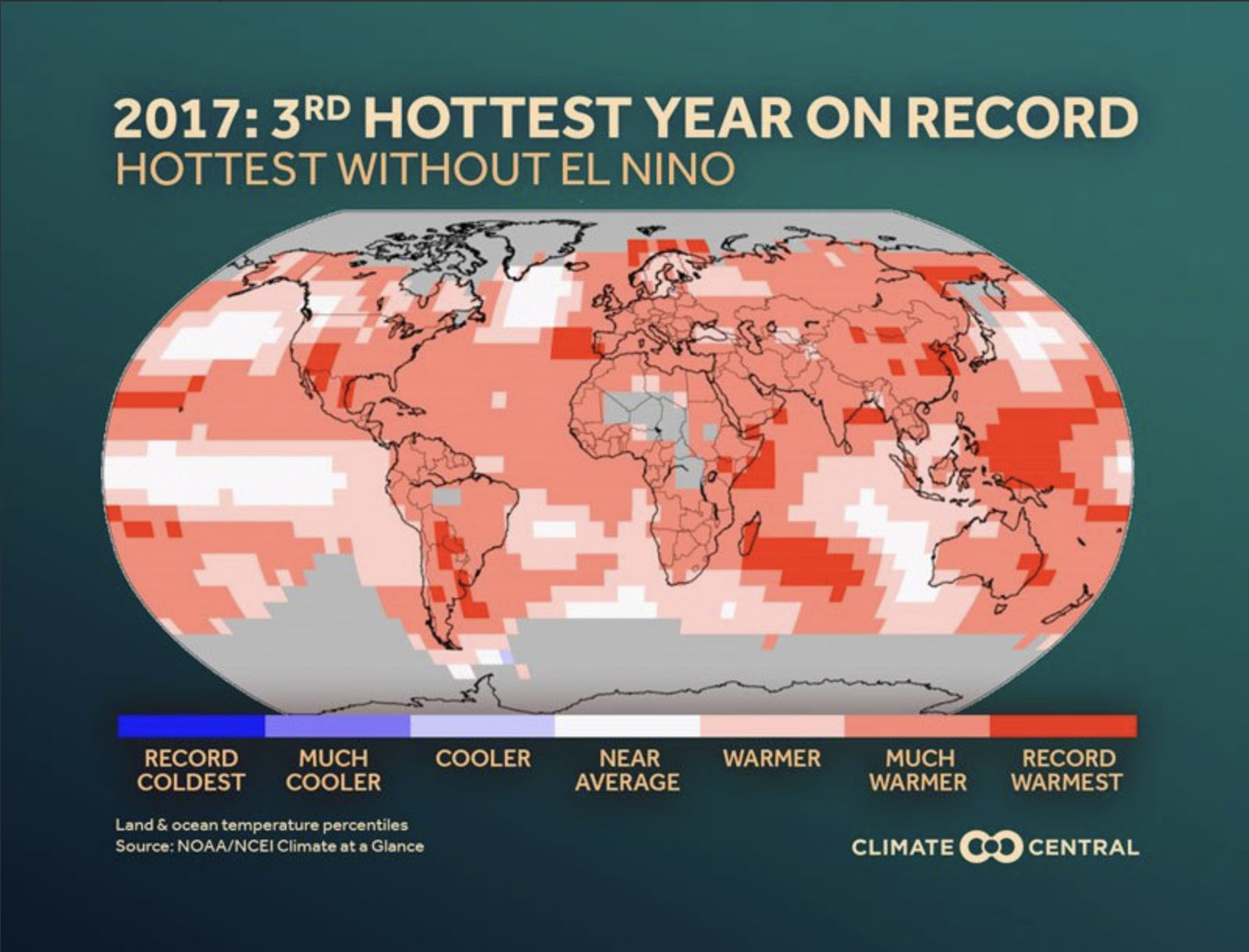
A color-coded map of the globe showing areas of percentiles of cool and warmth — ranging from record warm to record cool — for the calendar year 2017. (NOAA NCEI) FromThe Washington Post Editorial Board:
One warm year is not necessarily cause for concern. The trend, however, is. The past three years were the warmest three ever recorded. The five warmest years in the record all came since 2010. Seventeen of the 18 warmest years in the data came since 2001. This decade is on track to be warmer than the 2000s, which were warmer than the 1990s, and so on. The heating of the Earth is unmistakable.
Some climate doubters insist that while the warming trend is established, humans’ responsibility is not. This assertion is nearly as absurd as denying the warming in the first place. It is not coincidence that breakneck warming occurred just as humans began pumping increasing amounts of heat-trapping gases into the atmosphere. Scientists have spent more time than necessary examining other offered causes — such as solar activity — only to conclude that those supposed causes cannot account for the patterns of warming clear in the data.
Others argue that the country should not get lost in an unsolvable disagreement on the science but rather just talk about solutions. But without a clear sense of the problem, policymakers will waste time and money on the wrong responses. If global warming were a totally natural phenomenon, the task would be simply to build a society more resilient to temperature extremes, crazy weather, droughts, floods and scrambled-up ecosystems. But because humans are warming the planet, the top priority must be to remove the underlying cause by cutting greenhouse gas emissions.
Last year also marked a recent low in the federal government’s response to climate change. President Trump installed a climate-change denier, Scott Pruitt, at the Environmental Protection Agency, signaling the end of landmark climate rules on power companies. Mr. Trump’s energy secretary, Rick Perry, pushed for a pro-coal policy so absurd that the independent Federal Energy Regulatory Commission rejected it out of hand. The president also announced he would pull out of the Paris climate agreement, an accord that the United States spend years fine-tuning to ensure it was a fair deal.
In 50 years, many of the unnecessary distractions that Mr. Trump packed into his presidency will be forgotten. But no one will forget how selfishness and purposeful ignorance reigned in the United States as the world began to cook.
Join Governor John Hickenlooper, Lt. Gov. Donna Lynne and dozens of elected officials and community and business leaders from throughout Colorado to participate in visioning workshops and educational programs related to climate preparedness and clean energy development in Colorado.
The Colorado Communities Symposium will feature a series of plenary sessions, breakout tracks with interactive scenario planning sessions, training events and roundtable discussions, tabletop exhibition, post-conference workshops and meetings, networking events and an awards dinner.
Click here to listen to the show. Here’s an excerpt from the transcript:
The Governor’s Water Availability Task Force met on Thursday, January 18th to discuss snowpack, precipitation, reservoir levels, and weather forecasts. While reservoir levels are currently doing well, the news delivered by a panel of experts overall was not very good.
Dr. Becky Bolinger, a climatologist at Colorado State University set the tone when she started off the meeting by saying, “I am going to apologize ahead of time for my doom and gloom report. It’s not my fault, I’m just the messenger.” She pointed out that November 2017 was the hottest November ever on average in Colorado in 123 years of record-keeping, and December continued that pattern.
In fact, the average temperature from October to December last year was almost 4 degrees higher than previous years. And you may have noticed that the trend seems to be continuing into January this year with Friday’s temperature approaching 70 some places along the Front Range.
As far as precipitation, it was very dry in December—almost 2 inches below average statewide, with the driest areas in the southwest and the southeast. According to recent data from the Colorado Snow Survey Program, the state snowpack is one of the lowest since 1980, with the Gunnison, San Juan, and Rio Grande basins receiving well below average precipitation.
But the most serious warnings about our current situation came from Klaus Wolter, a research scientist with the University of Colorado and NOAA. Dr. Wolter told H2O Radio that it is the first time in five years that we are looking at emerging drought conditions in Colorado. He added that all conditions are for a dry spring, and there may still be near normal precipitation and snow in the mountains for the next month, and maybe, if lucky two months. But, then going forward into the spring he is very concerned about a really dry spring.
He said it was time for a wakeup call that we could not only be looking at low precipitation in the spring, but an increased possibility of wildfires because of higher temperatures combined with the dry conditions. But even more worrisome, he said there are some signs indicating that a drought could be longer than one year, but added that it’s still too early to predict.
The Governor’s Task Force will meet next in February.
Westwide SNOTEL basin-filled map January 20, 2018 via the NRCS.
The city of Aspen told the state [in late December, 2017] it will need 8,500 acre-feet of water storage in order to meet water demands in a hotter and drier world.
The disclosure of how much water storage the city thinks it will need to store in 2065 came as part of a response the city provided Friday to state officials in water court, who were seeking a “substantive” written response by Dec. 29 from the city to issues raised about the potential Maroon Creek and Castle Creek reservoirs.
As part of its response, the city included a Dec. 7 letter from its engineering consultants, Deere and Ault of Longmont, who concluded “the required storage capacity for the city of Aspen is approximately 8,500 acre-feet.”
To help put that into context, Lost Man Reservoir holds 100 acre-feet of water; Grizzly Reservoir on Lincoln Creek holds 590 acre-feet; Wildcat Reservoir, visible from the Snowmass Ski Area, holds 1,100 acre-feet; Harvey Gap Reservoir, north of New Castle, holds 5,060 acre-feet; Paonia Reservoir, west of McClure Pass, holds 20,950 acre-feet; and Ruedi Reservoir on the Fryingpan River holds 102,369 acre-feet.
Engineers at Deere and Ault based their storage estimate on a Nov. 30 study done for the city by Headwaters Corp., titled “Aspen’s Water Future: Estimating the Number and Severity of Possible Future Water Shortages.”
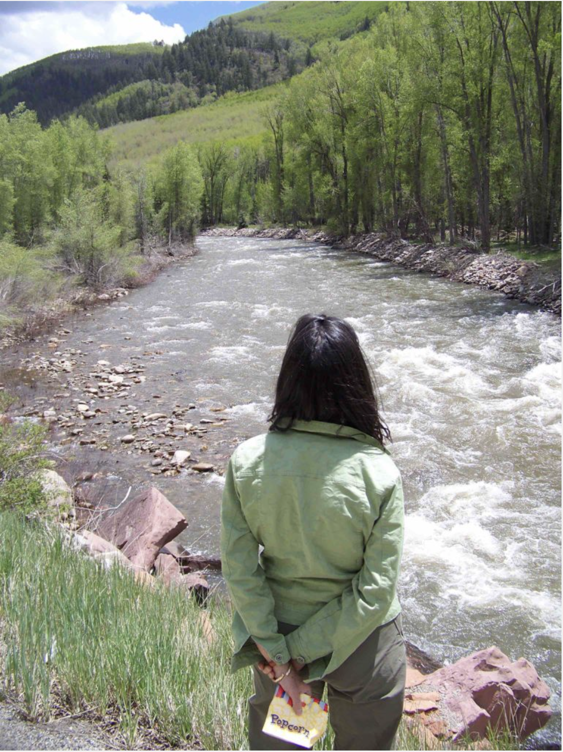
The report, which also was submitted to the court, assumed that a warming climate means less water will be flowing down Castle and Maroon creeks, the city’s two main sources of water, and that the runoff will come earlier.
And, working toward a worst-case scenario, they assumed that the city will not increase water conservation efforts, that large irrigation diversions from Maroon and Castle creeks will not be decreased, and that the city will still try to maintain environmental flow levels on both creeks, which it is not legally obligated to do.
The Headwaters report found that water shortages of over 1,000 acre-feet a year could occur in five out of 100 years, with “shortage” defined to include current irrigation diversions and environmental flows on top of domestic uses.
Deere and Ault then used the Headwaters risk-analysis study to come up with a necessary water storage amount of 8,500 acre-feet to offset the potential water shortages, although its two-page Dec. 7 letter does not describe in detail how it reached its conclusion based on the Headwaters report.
The conclusion from Deere and Ault is different than one made for the city by Wilson Water Group in 2016, which concluded in a report — adopted by the city — that the city would not need new water storage if it took other steps, such as increasing conservation, installing ground wells and using “reuse” water to irrigate its golf course.
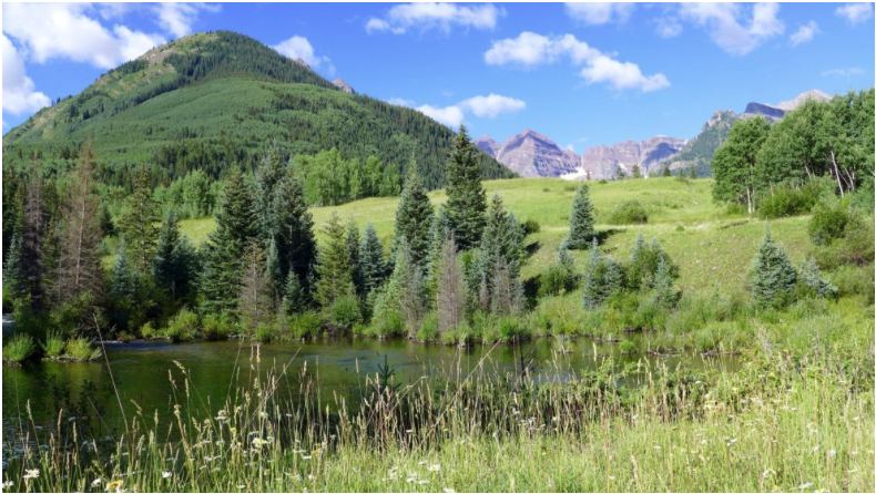
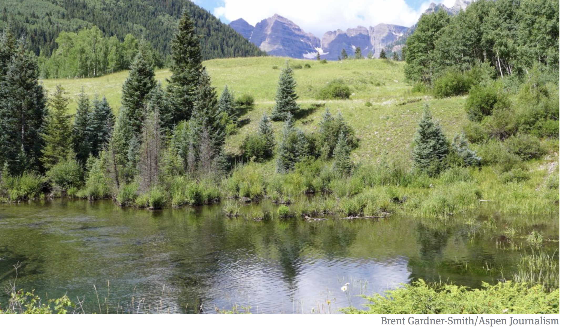
In 1965, an engineer working for the city of Aspen selected this location, just below the confluence of East and West Maroon creeks, as the location for a potential 155-foot-tall dam. The city is still on record with the state as intending to build the dam here, if necessary, to meet its future water needs.
Storage rights
The city has been maintaining conditional water storage rights since 1965 for the two potential reservoirs on Castle and Maroon creeks.
The Maroon Creek Reservoir would hold 4,567 acre-feet of water behind a 155-foot-tall dam across upper Maroon Creek, within view of the Maroon Bells, and the Castle Creek Reservoir would hold, as currently decreed, 9,062 acre-feet behind a 170-foot-tall dam across Castle Creek, 2 miles below Ashcroft.
The conditional storage rights, which hold a 1971 decree, are distinct from the city’s absolute diversion rights on Castle and Maroon, which are senior rights and adequately supply the city’s water system today.
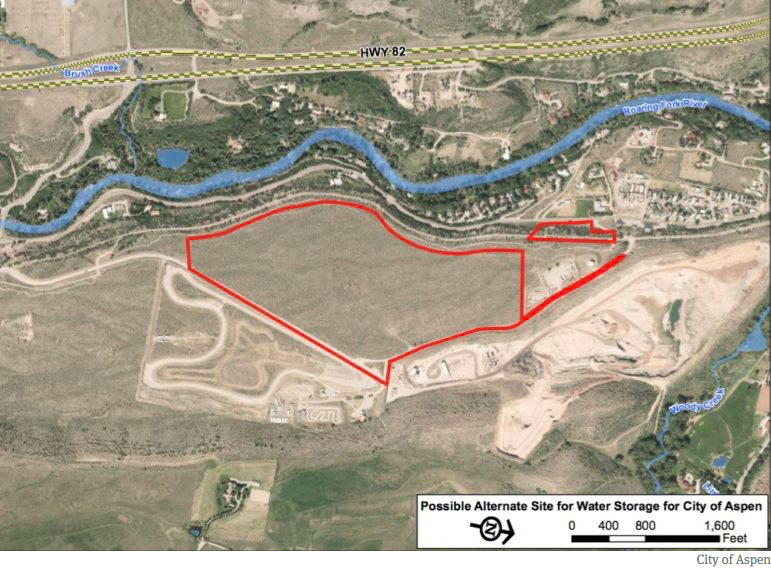
In July, the city announced its intention to try to transfer the conditional storage rights out of the Castle and Maroon creek valleys, and it has put a parcel of land next to the gravel pit in Woody Creek under contract and directed staff to begin developing a reservoir there.
A study done by Deere and Ault in September concluded the city could store up to 8,000 acre-feet of water on the Woody Creek site. The city has said it is also looking at other places to potentially store water, including the city’s golf course and the Cozy Point open space at the intersection of Brush Creek Road and Highway 82.
The city has also put forth a settlement proposal to the 10 parties opposing its efforts to maintain its water rights, and the proposal is predicated upon the city transferring its storage rights out of the Castle and Maroon creek valleys.
But no settlement has yet been reached and the city is still officially on the record with the state of Colorado, through its two applications in water court, saying it fully intends to build both the Castle and Maroon creek reservoirs, someday, when necessary.
A map provided by the city of Aspen showing the two parcels in Woody Creek it has under contract. The city is investigating the possibility of building a reservoir on the site, as well as looking at the possibility of a reservoir in the neighboring Elam gravel pit.
Outstanding questions
After reviewing the two due diligence applications filed by the city in October 2016 seeking to maintain the conditional storage rights, the division engineer and water court referee in Divison 5 in Glenwood Springs raised a set of threshold issues they wanted the city to address.
The officials asked on Jan. 23 for the city to demonstrate it could secure permits and land-use approvals to build the dams and reservoirs, that it could do so in a reasonable time, that it has a specific plan to build them, and that there was sufficient population growth in Aspen’s water service area to justify storing the water.
The city’s water attorney, Cynthia Covell of Alperstein and Covell in Denver, has been reluctant to respond in detail to the court’s request, which came in the form of a summary of consultation.
In her Dec. 29 letter to the court, Covell suggested it was outside of the court’s purview to ask the city to do so at this point in the proceedings.
“Aspen maintains that much of this concern is based on the division engineer’s view of applicable law, and is beyond the proper scope of a consultation report, but nevertheless, responds as follows …” Covell said in her letter.
Covell then reiterated several points that city officials have been making over the past year, including that the city today does not have any “meaningful storage facilities” and that climate change projections “demonstrate the need for storage.”
And while she did not make a detailed case to the court that the city of Aspen could build the Castle Creek Reservoir or the Maroon Creek Reservoir, she did say Aspen could get the necessary permits and arrange financing for reservoirs.
“As a financially stable municipality, Aspen has available to it a number of financing options and therefore will be able to construct a reservoir sufficient to store 8,500 acre-feet,” Covell told the court in her letter in the Castle Creek case. “The decreed location of the Castle Creek Reservoir is primarily on private land. Aspen is able to acquire private land by purchase, lease or eminent domain. Legal procedures and mechanisms exist to obtain land-use approvals and permits on federal land, if necessary, including special-use permit, Congressional authorization and presidential authorization.”
On the other hand, Covell included language that alludes to the city’s stated intent to try to transfer the Castle and Maroon rights out of Castle Creek to another location, such as Woody Creek, and then fill that new reservoir with water from both Castle and Maroon creeks.
“Aspen will develop both the Castle Creek Reservoir storage right (to the extent of 8,500 acre-feet) [and] the companion Maroon Creek Reservoir storage right … in order to provide two sources to meet this storage need,” Covell wrote, without specifically mentioning a reservoir outside of the Castle or Maroon creek valleys. “The total amount of storage will be 8,500 acre-feet from both sources, with no more than 8,500 acre-feet to be diverted annually from Castle Creek. Aspen will relinquish the remaining 562 acre-feet decreed to the Castle Creek Reservoir.”
It’s not clear why the city is willing to relinquish 562 acre-feet from the potential Castle Creek Reservoir right, which is now decreed at 9,062 acre-feet, but it may be a reflection of two earlier agreements with adjoining land owners to reduce the size of the reservoir so as not to flood their properties.
In a separate letter to the court regarding Maroon Creek, Covell took a similar stance, saying the city “will be able to construct a reservoir sufficient to store the 4,567 acre-feet per year to be diverted from Maroon Creek,” but didn’t say where that reservoir might be located.
A status conference in the two water court cases is set for Jan. 4. The parties could agree to keep the case on a quasi-administrative track in front of a water court referee, or the case could be set on a trial track in front of a water court judge.
Editor’s note: Aspen Journalism is collaborating on coverage of rivers and water with The Aspen Times, the Glenwood Springs Post Independent, the Vail Daily, and the Summit Daily News. The Aspen Times published this story in its print edition on Tuesday, Jan. 2, 2017 and the Post Independent published it on Jan. 3.
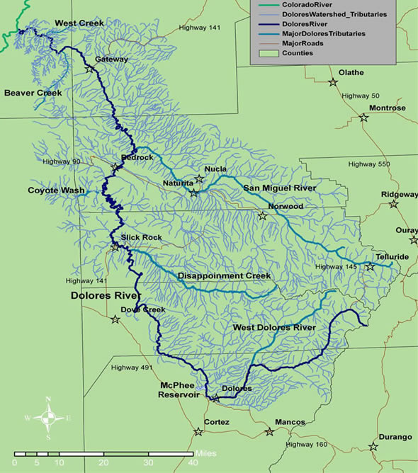
The San Miguel and Dolores rivers are both southwestern Colorado waterways that begin high in the San Juan Mountains.
Both carve through narrow, red sandstone canyons. Eventually, the two rivers become one when the San Miguel merges into the Dolores and the Dolores with the Colorado River in eastern Utah.
But there is one major difference: The Dolores is dammed at McPhee Reservoir near the town of Dolores, while the San Miguel is one of the last free-flowing rivers in the West.
A study of plant traits on these two rivers may provide clues about how riparian habitats will respond to climate change, not just in southwestern Colorado, but across the state and the West.
Measuring traits
Researchers from Colorado State University recently completed a two-year study on the Dolores and San Miguel rivers, the results of which were presented at the Upper Colorado River Basin Forum in Grand Junction in November.
The study compared two sites on the Dolores (Rico and Bedrock) with two sites on the San Miguel (Placerville and Uravan) by documenting different plant traits at each of the four sites. A “trait” is simply a measureable feature of a plant, such as leaf area, root depth, and height. The more diverse these traits are, the higher something called “functional diversity.”
For both of the upstream sites, Placerville and Rico, functional diversity was higher than it was at the downstream sites, which scientists expected because the downstream sites receive less rainfall. But the Bedrock site, downstream from McPhee Reservoir, had a much lower functional diversity than its sister site of Uravan. This is likely due to the changes in the river’s flow as a result of the dam. With lower functional diversity comes a decreased resistance to invasive species or climate change.
“Dams really do have a huge impact on the downstream ecosystem, and it’s not always talked about,” said Erin Cubley, one of the researchers on the project and a Ph.D. candidate in ecology at Colorado State University. “Dams hold sediments and seeds, they change the flow; they change the processes that are essential in maintaining these ecosystems.”
The dam across the Dolores River that forms McPhee Reservoir is downstream from the small town of Dolores. It forms the fifth biggest reservoir in the state and holds back about 381,000 acre-feet of water. McPhee Reservoir supplies the agricultural irrigation needs of farmers and ranchers south of the Dolores River Basin. The resulting decreased flow below the dam has big impacts on the downstream ecology, Cubley said. A smaller river channel cuts deeper, not wider, and this lowers the groundwater that riparian plants depend upon for survival.
“Riparian species have a big taproot and can access water a few feet down, but if they can’t access groundwater, they die,” Cubley said. “That is what we are seeing at Bedrock.”
Spring runoff
By measuring traits and functional diversity instead of specific plant species (which may vary depending on the river and location in the watershed), the study has implications for many of the state’s rivers.
“By using traits, we can look at how similar their traits are and put them into groups and say, ‘OK, we can transfer our findings across rivers that have different species compositions,’” Cubley said.
Another way dams alter the natural flow of the river has to do with spring runoff. Many dams are managed solely with maximum storage capacity in mind, said David M. Merritt, a riparian ecologist with the U.S. Forest Service National Stream and Aquatic Ecology Center. There are easy tweaks water managers can make that will not compromise the power or storage needs of the dam that can also improve the ecological functioning downstream.
For example, one of the most important components of river health is peak flows and flooding with spring runoff. Some species, such as the cottonwood tree, time the release of their seeds to coincide with peak flows. The fluffy white fibers use the river to carry them downstream to hopefully take root in the riverbank. But when dams control the river and don’t allow for this peak flow to happen, it can have a negative effect on cottonwoods, as well as the whole downstream ecosystem.
“If you are a dam operator, it might be easy for you to time a spike that coincides with that historic timing,” Merritt said. “The timing of peak flow is reliant on temperatures with a little variability annually. A dam operator would have tremendous flexibility on when that would occur.”
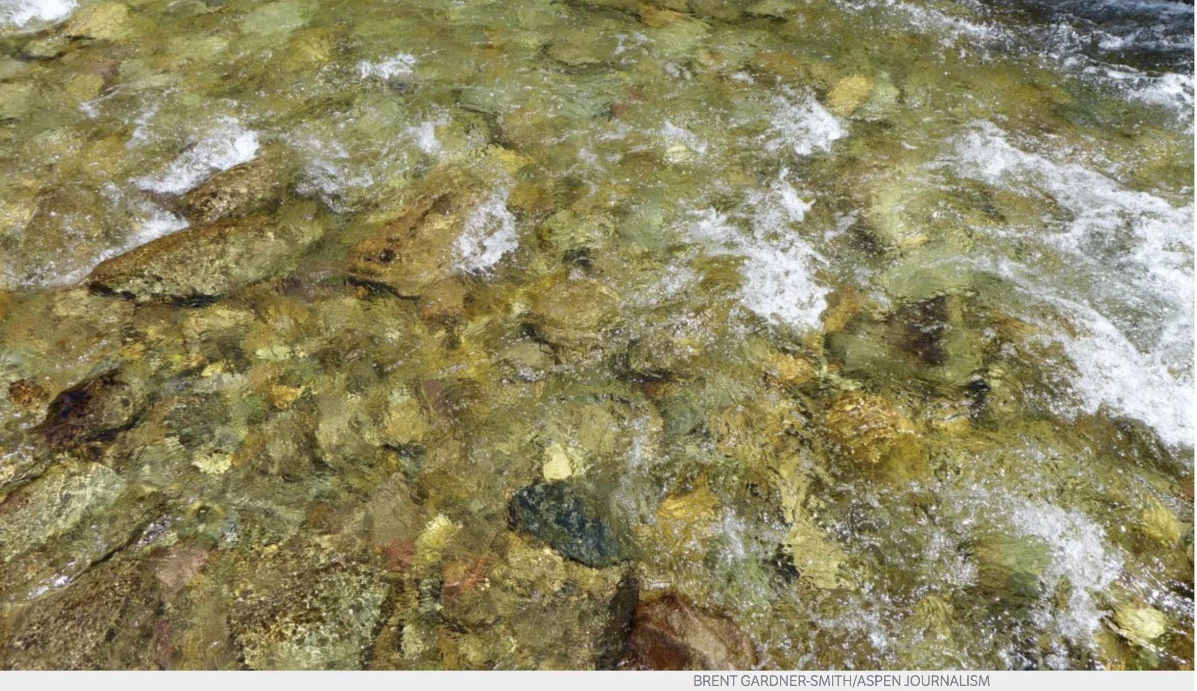
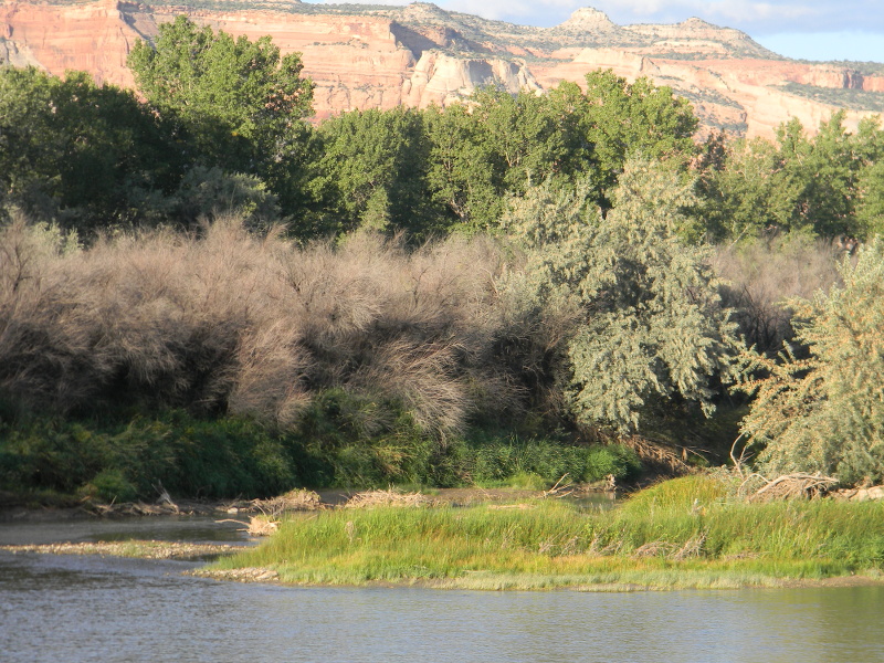
A view of the Dolores River below Slickrock.
Effects of climate change
Assuming that the future of the American West will be warmer and drier than it currently is, the research team can model what a future ecosystem might look like: At what point will more drought-resistant plants move in? If you change the flows of a river, then how will the vegetation respond? What would happen if water managers changed dam operations?
“What if climate change is twice as bad or what if it’s not as bad?” Merritt said. “We are scientists who predict change. … We will be able to show predictions of what the vegetation will look like. It’s a model and a technique that can be used on any river anywhere.”
Editor’s note: Aspen Journalism is collaborating with the Vail Daily, the Summit Daily, The Aspen Times, and the Glenwood Springs Post Independent on coverage of rivers and water. The Vail Daily published this story on Jan. 2, 2017. The Summit Daily published it on Jan. 3.
The city of Aspen has put forward a proposal that would move its conditional water-storage rights, and with it two potential dams and reservoirs, out of the Castle Creek and Maroon Creek valleys and spread a proposed 8,500 acre-feet of water storage among as much as six locations between Aspen and Woody Creek.
That deal was well-received Thursday by opposing parties in two water-court cases tied to the potential Castle and Maroon reservoirs during a brief water court status conference. The city circulated a settlement proposal Dec. 8 to the 10 parties opposing the city’s efforts to maintain a conditional right to store 4,567 acre-feet of water in a potential Maroon Creek Reservoir and 9,062 acre-feet in a potential Castle Creek Reservoir.
In its proposal, according to sources close to the negotiations, the city said it will seek to transfer its conditional storage rights from the two reservoirs to other potential reservoirs on a range of other sites that could hold as much as a combined 8,500 acre-feet of water from Maroon and Castle creeks.
The reservoirs, either surface or underground “in-situ,” would be built on a range of potential locations including the city’s golf course, the Moore, Burlingame, and Cozy Point open space parcels, the gravel pit in Woody Creek operated by Elam Construction, and a parcel of vacant land next to the gravel pit the city now has under contract.
Under the deal, the city would make a firm commitment to move its potential reservoirs out of the Maroon Creek and Castle Creek valleys, and the opposing parties would refrain from fighting the city’s future efforts in water court to transfer its conditional storage rights, and its 1971 decree dates, to the new locations.
“Based on what I’ve heard today it sounds like … there is some consensus that the cases are moving toward settlement,” Division 5 water court referee Susan Ryan said Thursday after each of the attorneys in the two cases stated their view of the ongoing settlement negotiations.
Ryan set another status conference in the two cases for Feb. 15.
The city filed two periodic applications with the court Oct. 31, 2016, to show it’s been diligent in developing its conditional storage rights for the Maroon and Castle creek reservoirs, which it first filed in 1965. The recent applications drew opposition from the U.S. Forest Service, Pitkin County, American Rivers, Colorado Trout Unlimited, Western Resource Advocates, Wilderness Workshop, and four private landowners, two in each valley.
James DuBois, an attorney with the U.S. Justice Department in Denver, told the referee during Thursday’s status conference that “as far as the United States’ objections, I think it’s likely we’ll be able to reach settlement.”
Craig Corona, a water attorney representing the Larsen family, which owns property in Maroon Creek, also was bullish on the city’s proposal to move the water rights out of the valleys.
“Larsen Family LP feels like we’re making substantial progress in negotiating toward a settlement,” Corona told the water court referee. “And we’re happy to stay on the referee’s docket at least for another 45 days to try to finalize the settlement agreement.”
Any party in a water court case has the option at any time to re-refer a case away from a settlement track under the purview of a water court referee and put the case on a trial track in front of a water court judge.
Paul Noto, a water attorney representing American Rivers, Colorado Trout Unlimited, and another Maroon Creek landowner, told the court, “My broad view of the status is that we are making some headway toward settlement and I’d prefer, for one, to avoid trial-track deadlines and focus on settlement issues.”
Rob Harris, a staff attorney at Western Resource Advocates, who also is representing Wilderness Workshop, said, “I agree that we’ve made significant progress toward settlement and I think we’d benefit from at least another couple months or so to pursue settlement.”
Attorneys for Pitkin County and the two property owners in Castle Creek said they did not object to the case staying in front of the referee.
Aspen’s water attorney, Cynthia Covell, told the court that the city has only just recently received a number of written comments to its proposal from the opposing parties, and that the city would like about a month to review them and further discuss its proposal with the parties.
The property next to the Elam gravel pit and the Woody Creek raceway that the City of Aspen has put under contract. The city is investigating the site as a place for potential water storage, either underground or above ground.
Storage options
Aspen officials have been reviewing alternative water storage sites for about a year with the help of Deere and Ault, an engineering firm in Longmont.
A study done in September by Deere and Ault identified a range of in-situ and surface reservoirs that could be built, in differing combinations, on the Woody Creek gravel pit site and the neighboring parcel of land the city intends to buy.
The options include a 320 acre-foot in-situ, or underground, reservoir and five options for surface reservoirs in various configurations that would hold between 700 acre-feet and 8,000 acre-feet of water. The Woody Creek reservoirs range in cost from $48 million to $81 million and would require about 6.5 miles of pipeline to reach the city’s water treatment plant.
Deere and Ault has also found, in a screening study of various sites, that the city could store water in a number of potential in-situ reservoirs on other sites upvalley from Woody Creek.
In-situ reservoirs require deep trenches dug 50 to 100 feet down to bedrock, depending on the site. The trenches form the walls of the storage vessel, or bucket, while the bedrock, and sometimes a geosynthetic liner, forms the bottom of the bucket.
The rocks and dirt on the site are not excavated, but left in place between water-tight slurry walls poured into the surrounding trenches. Water is then poured into the bucket and pumped out for later use.
Deere and Ault found that an in-situ reservoir could be built on the city-owned Moore open space, across Maroon Creek Road from the Aspen Chapel, to hold 550 acre-feet of water, at a cost of $26.9 million. The water could then be pumped nearly a mile via a pipeline to the city’s water treatment plant, which is on a hill behind Aspen Valley Hospital.
The city’s golf course could hold two in-situ reservoirs, one holding 650 acre-feet and another holding 760 acre-feet, for a total of 1400 acre-feet, at a combined cost of $71.3 million.
The Burlingame, or Zoline, open space, which is 1.9 miles from the water treatment plant and owned by the city, could accommodate a 650-acre-foot in-situ reservoir, at an estimated project cost of $34 million.
The Cozy Point open space, also owned by the city, could hold two 100-acre-foot reservoirs for a combined 200 acre-feet of storage. The site is 5.6 miles from the water treatment plant and the estimated project cost for the reservoirs and pipeline system is $15.5 million.
Editor’s note: Aspen Journalism is collaborating with The Aspen Times, the Glenwood Springs Post Independent, the Vail Daily, and the Summit Daily on coverage of rivers and water. The Times published this story on Thursday, Jan. 5, 2017.
The ‘Toilet Bowl” remains open to anglers fishing from shore, but remains closed to water activities, including paddle boarding, free diving, swimming and wading
Here’s the release from Colorado Parks and Wildlife:
Colorado Parks and Wildlife, city of Aspen, Bureau of Reclamation, Eagle County Sheriff’s office and the U.S. Forest Service are confirming anglers will continue having fishing access to the ‘Toilet Bowl from the shore; however, paddle boarding, free diving, swimming, and wading will remain prohibited.
Officials stress the water, located at the base of the Ruedi Dam on the Fryingpan River, is turbulent and subject to sudden changes in depth and flows. In addition, they caution the area has underwater hazards people are unable to see.
The five government agencies met last week to address social media rumors claiming the Toilet Bowl would no longer be accessible to anglers.
“Much of the confusion stems from varied interpretations of the existing signs which were placed to prevent unsafe activities and protect dam infrastructure” said District Wildlife Manager Matt Yamashita of Basalt. “It was made clear during the meeting that the intent is to prohibit in-water recreation in the deep portion of the Toilet Bowl section, for safety and security reasons. Anglers standing on the shore are not the concern.”
Yamashita says the city of Aspen and Bureau of Reclamation will update signs in the area to clarify restrictions.
“Ultimately, for anglers, not much has changed,” he said. “They can continue to fish there, as they always have. Going forward, we ask everyone to follow the rules and regulations as signed, and be sure to respect all current and future signage.”
Officials recently repaired the fence around the hydroelectric plant, replacing a section damaged by a vehicle. Workers also placed posts for a gate they will install this spring. The gate will help keep vehicles away from hydroelectric plant structures.
“The fence and the gate only restrict vehicle access, not foot traffic,” added Yamashita.
The famed fishing hole is popular with anglers, many who travel from around the world to catch the large trout that thrive in the pool.
Parts of the West are currently experiencing one of the driest and warmest winters on record. Snowpack is far below normal levels in southern Colorado, New Mexico, Arizona, Utah and California, leaving some to worry about this year’s water supply.
To get a sense of this year’s snowpack, head to a place like Berthoud Pass, an hour drive into the mountains west of Denver. The pass, which straddles the basins for both the Colorado and the South Platte rivers, is home to a SNOTEL site. SNOTEL — a portmanteau of “snow” and “telemetry” — is the system of hundreds of snow measurement sites throughout the Western U.S. that estimate the amount of water held in mountain snowpack.
The site is a short snowshoe hike up a hill off the highway, in a small clearing in the trees. The Berthoud Pass site was set up in the first generation of SNOTEL sites dating back to the late 1970s.
“This is at the higher range of where we do measure snow,” says Karl Wetlaufer, the assistant snow survey supervisor for the Natural Resources Conservation Service in Denver. “We’re well over 11,000 feet here.”
Each SNOTEL site is a Rube Goldberg setup of meters and tubes designed to measure the weight of the snow. When snow falls it compresses pillows on the ground, filled with a sweet-smelling liquid anti-freeze. The liquid is displaced by the snow’s weight, and from the weight scientists can figure out the most important aspect of mountain snowpack: how much water is in it. The process is mostly automated, but the sites still require maintenance…
“Just driving up through the mountains as we gain elevation there’s definitely noticeably less snowpack than we would expect as we approach the site,” Wetlaufer says. “And intuitively you can just feel that we have a lower snowpack.”
That’s even worse news considering Berthoud Pass — currently at 80 percent of average — is one of the better sites for snowpack in the entire Colorado River watershed, which supplies water for about 40 million people in seven states.
“The hole we’re in now in terms of the snow deficit is going to be really hard to pull out of,” says Jeff Lukas, who studies long-term climate shifts at the Western Water Assessment, based at the University of Colorado-Boulder.
If you add up the numbers at all the SNOTEL sites in the upper Colorado River, snowpack is at 63 percent of average. It’s well below normal, halfway through the snow accumulation season. Essentially, time is running out to make up that deficit, Lukas say…
Forecasts for river flows by the Colorado Basin River Forecast Center are already taking the current diminished snowpack into account. Most streams are projected to be lower this spring, some just slightly, with others extremely below average. Inflow to Lake Powell, the first major reservoir the Colorado River empties into on the Utah-Arizona border, is projected to be 54 percent of average this spring and early summer.
The good news for upstream water managers is that most smaller reservoirs in Colorado, Utah and Wyoming are storing above average amounts of water, boosted by drought-busting wet weather in the winter of 2016-2017.
“We can weather one bad year,” Lukas says. “But in other parts of the West or even downstream in the Colorado River Basin, Lakes Powell and Mead are both sitting well below capacity.”
[…]
All that bad snowpack news means downstream states like Arizona, Nevada and California are anxiously looking toward the Rocky Mountains. The Colorado River — fed by snowmelt — provides roughly 40 percent of the Arizona’s water.
“We closely watch this. We know how important it is,” says Tom Buschatzke, director of the Arizona Department of Water Resources. “It’s a huge piece of Arizona’s water budget, and a life blood for the state.”
Of all the states that rely on the Colorado River’s water, Arizona is in arguably the worst position to handle a dry year. Its reservoirs are currently sitting below average, yet to recover from a long-term drought that’s plagued the southwest for more than a decade.
On a scale of zero to 10 — where zero is not worried at all and 10 is panic mode — Buschatzke says he’s moderately worried about the state’s ability to withstand a dry winter.
“I am probably at about a seven right now,” he says.
Add in the projections for climate change that show a future where the river’s supply is sapped even further, and thinking about the river’s future can be anxiety-inducing…
Back at Berthoud Pass, snow surveyor Karl Wetlaufer writes down measurements, using an aluminum tube to take core samples from the snowpack, and then weighing it. This more old-school method of measurement is still in use by surveyors across the West.
Wetlaufer isn’t panicking yet. There’s still plenty of winter ahead of us. It wouldn’t be unprecedented for some big storms to change everything. But the window for those Hail Mary snow storms is closing, he says.
From powderhounds to Colorado’s water managers, the new year has brought worry. The record-low snowpack in parts of the Rocky Mountains is the culprit. Snowfall at the end of 2017 in Beaver Creek, Vail and Park City, Utah was the lowest in more than 30 years…
Colorado statewide snowpack is at 60 percent of average, which means that this year, snowmaking is a necessity for ski areas. The overall lack of snow has also been hard on the box office. Vail Resorts, Keystone’s owner, reported a 10.8 percent drop in visits across its North American resorts and Canada. Lift ticket revenue was up slightly thanks to pre-ski season Epic Pass sales.
The worry for weather watchers is that Colorado recorded its third warmest year on record in 2017. Last November was the state’s warmest ever for that calendar month.
Even where Colorado saw significant snow, Russ Schumacher, the state climatologist, said, “it’s still remained relatively warm.”
Schumacher and others acknowledge the role climate change and those warmer temperatures will play across the West. The thing that’s more difficult to predict is how winter snowfall might change. Right now, Schumacher said some spots near the Continental Divide have near average snowpack. But move farther south to the Gunnison River basin and there are places setting new records for lack of snow.
Jeff Lukas, with the Western Water Assessment, is watching not just snowpack levels but the water in that snowpack.
“Your senses are triggered,” he said. “But you don’t push the alarm bell yet….”
For him snow is like a bank account for the arid West. Every year water managers capture snow melt in reservoirs. If the snow starts running off early or evaporates in warm weather or there’s not enough of it, then Lukas’ alarm bells will start going off.
From the Colorado State Forest Service via The Sterling Journal-Advocate (Jeff Rice):
Despite a relatively small amount of precipitation falling recently, the most recent U.S. Drought Monitor map indicates that nearly all of Colorado is currently experiencing some level of drought. Trees in urban and community settings throughout this region are dormant now, but still require occasional watering during dry winters to remain in top health.
Keith Wood, urban and community forestry manager for the Colorado State Forest Service, says planted trees in Colorado, especially at lower elevations, often require additional watering in the winter months during extended dry periods (e.g., more than two weeks without lasting snow cover).
“Adequately watering your trees is the best way to ensure optimum health and vigor that will carry through to the growing season,” said Wood. “Overly dry trees become susceptible to root and branch die-back, and subsequent insect and disease problems.”
The CSFS offers the following winter watering tips:
• Water when it’s warm. The best time for winter watering is on days when snow has melted off and the temperature is above 40 degrees.
• Water a wide area. Tree root systems may spread much wider than the height of the tree, with most absorbing roots in the top foot of soil. Apply water to soak the entire area underneath the full span of a tree’s branches.
• Water slowly. To ensure deep penetration, use a drip or soaker hose on low setting, or soft spray wand, to apply water slowly to the full area at the rate of 10 gallons per inch of tree diameter.
• Retain mulch. To retain soil moisture and save water, apply 4 inches of organic mulch onto bare soil within 2 to 3 feet from the base of the trunk, but not directly against the trunk.
• Repeat as necessary. Until abundant spring precipitation arrives, be sure to continue watering every few weeks in the absence of snow and colder temperatures.
For more information about urban tree care, visit the Colorado State Forest Service website at http://www.csfs.colostate.edu.
“Water and climate change are joined at the hip,” said Brad Udall, a researcher at Colorado State University who published a paper earlier this year showing how climate change has reduced flows in the Colorado River. “One of the primary impacts of a warming atmosphere are changes to our water cycle.”
Snowpack is 50 percent lower than the average at this point in the winter at dozens of basins in the region. It’s a major concern in a region with a growing population where water supplies are often pushed to their limits, even in good years. In addition to fueling the West’s winter tourism industry, the snow provides a steady supply of water for the Colorado River, which serves 40 million people spread from Denver to Los Angeles.
The problem is not just a lack of snow, but changes in how it is falling and melting. Think of the snowpack as a natural reservoir. During the winter, it freezes in place. When temperatures rise in the spring, the water within is released gradually, filling reservoirs through the rest of the year. That pattern is fracturing around the world. A study released Wednesday by the University of Potsdam also found less available water from snowpack in High Mountain Asia from 1987 to 2009.
In the western U.S., the snow line is receding to higher elevations—typically above 8,000 feet. Below that line, rain is often falling instead of snow, meaning less precipitation is stored in the snowpack. A big storm might send water to reservoirs, but many pools weren’t built to hold a deluge of rain. As a result, they often have to release the water to avoid flooding.
Without predictable snowpack melts, “it reduces reliability on the supply side,” said Demetri Polyzos, a senior engineer for the Metropolitan Water District, the wholesale water agency for Southern California.
There have been bad starts to the snow season before, and climatologists say it’s too early to rule out the possibility that the Western snowpack will bounce back. But even if it does return to average—or above average—levels, researchers said it is unlikely that critical waterways like the Colorado River would get their normal runoff.
“As it warms, you get less runoff,” said Jonathan Overpeck, a climate scientist at the University of Michigan who co-authored the Colorado River drought paper with Udall.
The short-term effects may be manageable. Because 2017 was a wet year, most reservoirs have enough stored water to satiate municipal and agricultural demand through even a dry, hot summer. But water managers still need to respond to the long-term threat.
Western snowpack could decrease by an average of 60 percent over the next 30 years due to anthropogenic warming and natural climate trends, according to an article published last year in Nature.
Detailed Colorado River Basin map via the U.S. Bureau of Reclamation.
The acting director of the UK Met Office, Prof Peter Stott, told BBC News: “It’s extraordinary that temperatures in 2017 have been so high when there’s no El Niño. In fact, we’ve been going into cooler La Niña conditions.
“Last year was substantially warmer than 1998 which had a very big El Niño.
“It shows clearly that the biggest natural influence on the climate is being dwarfed by human activities – predominantly CO₂ emissions.”
Figures were published on Thursday by the world’s three main agencies monitoring global temperatures: the UK Met Office and the two US organisations – the US space agency (Nasa) and National Oceanic and Atmospheric Administration (Noaa).
Their datasets are compiled from many thousands of temperature measurements taken across the globe, from all continents and all oceans.
Temperatures for 2017 and 2015 are virtually identical.
Nasa rates 2017 the second hottest year, and Noaa and the Met Office judge it to be the third hottest since records began in 1850.
The Met Office HadCRUT4 global temperature series shows that 2017 was 0.99C (±0.1C) above “pre-industrial” levels – that’s taken as the average over the period 1850-1900.
After three consecutive years of record-high temperatures for the globe, Earth was a slightly cooler planet in 2017. But not by much.
Earth’s globally averaged temperature for 2017 made it the third warmest year in NOAA’s 138-year climate record, behind 2016 (warmest) and 2015 (second warmest).
However, unlike the past two years, Earth’s average temperature in 2017 was not influenced by the warming effect of an El Nino, say scientists from NOAA’s National Centers for Environmental Information (NCEI).
A color-coded map of the globe showing areas of percentiles of cool and warmth — ranging from record warm to record cool — for the calendar year 2017. (NOAA NCEI)
The average temperature across the globe in 2017 was 1.51 degrees F above the 20th century average of 57 degrees F. 2017 marks the 41st consecutive year (since 1977) with global land and ocean temperatures at least nominally above the 20th-century average. The six warmest years on record for the planet have all occurred since 2010.
The state of sea ice
Sea ice extent (coverage) at the poles remained low throughout last year. Antarctica had a record-low extent in 2017, while the Arctic had its second-lowest ice coverage on record.
2017, as ranked by other scientific organizations
In a separate analysis of global temperature data released at the same time, NASA scientists ranked 2017 as the second warmest year on record. The minor difference in rankings is due to the different methods used by the two agencies to analyze global temperatures; though over the long term, the agencies’ records remain in strong agreement. Both analyses show that the five warmest years on record all have taken place since 2010.
Analyses from the United Kingdom Met Office and the World Meteorological Organizationoffsite link also ranked 2017 among the top three warmest years on record.
A map of the globe of that indicates noteworthy climate and weather events that occurred around the world in 2017. (NOAA NCEI)
Additional findings from our 2017 report
The month of December: Despite the cooling influence of a weak La Nina in the latter part of the year, December ended up as the fourth warmest December on record for the globe, with an average temperature 1.44 degrees F above the 20th century average.
The globally averaged sea surface temperature was the third highest on record, 1.21 degrees F above average.
The globally averaged land surface temperature was the third highest on record, 2.36 degrees F above average.
Continental warmth: South America had its second warmest year on record; Asia, its third; Africa, its fourth; Europe, its fifth; and North America and Oceania, their sixth.
The average Arctic sea ice extent for the year was 4.01 million square miles, the second smallest annual average since record-keeping began in 1979.
The average Antarctic sea ice extent for the year was 4.11 million square miles, the smallest annual average since record-keeping began in 1979.
Click here to go to the US Drought Monitor website. Here’s an excerpt:
Summary
A significant weather system impacted the lower Mississippi Valley and pushed northeast into the Ohio River Valley and the Northeast. The active pattern over the Pacific Northwest and northern Rocky Mountains continued, bringing much-needed rain and snow to these regions. Cooler than normal temperatures dominated the Plains region and the South, with areas of the northern Plains 15-20 degrees below normal. Warmer than normal conditions dominated the West, with areas of the Great Basin 10-15 degrees warmer than normal…
High Plains
Much of the region did record precipitation in the form of both snow and rain during the last week, but amounts were generally less than half an inch. Some areas of east central Kansas did record close to an inch of precipitation. The most significant changes this week were due to a reanalysis of the data over the short term. From this analysis, the extreme drought over western South Dakota was improved to severe drought status. The impact designation also was changed from a combination of short- and long-term impacts to only long-term impacts. Dryness in southern Kansas and eastern Colorado continued with an expansion of the severe drought conditions to the west, incorporating all of southwestern Kansas and extreme southeastern Colorado. Extreme drought conditions were also pushed more to the west in southern Kansas…
West
The coastal regions of the Pacific Northwest as well as the northern Rocky Mountains again had the most precipitation. Areas of southern Nevada and the desert regions of southern California and western Arizona finally recorded some precipitation. Areas of southern California that had experienced fires late last year were impacted by mudslides from the heavy rains that inundated the region. Even with the precipitation in Oregon, the water year continues to be well below normal for precipitation, which allowed for the expansion of abnormally dry conditions in Oregon, western Idaho, and southern Washington. A new area of moderate drought was introduced from central Oregon to western Idaho. In Utah, the low snow and snow water equivalency values caused an expansion of severe drought in central Utah and moderate drought in northeastern Utah. Abnormally dry conditions were pushed to include all of northern Utah and extreme southwestern Wyoming. In eastern New Mexico, severe drought conditions were expanded over the region…
Looking Ahead
Over the next 5-7 days, the active pattern over the Pacific Northwest is anticipated to continue, with heavy rains along the coastal areas from northern California up to Seattle. Farther inland, precipitation should be widespread from Washington and Oregon into Idaho and western Montana, with the greatest amounts over the panhandle of Idaho. Precipitation from the central Rocky Mountains will pass through the central Plains and into the upper Midwest and Great Lakes. Much of the eastern half of the United States is projected to receive precipitation. During this period, temperatures are anticipated to be 3 to 6 degrees below normal west of the Continental Divide and 6 to 9 degrees above normal to the east. This should help bring the snow levels down over the western United States, allowing for snow accumulation to take place.
The 6-10 day outlooks show that temperatures are anticipated to remain cooler than normal over the western and north central United States, with the greatest probability of below-normal temperatures over Montana and Wyoming. Warmer than normal temperatures are projected over much of the eastern third of the country, with the greatest chances of above-normal temperatures along the eastern seaboard from Florida north into New England. The probability of above-normal precipitation is great over much of the United States outside of the desert Southwest. The highest chances of above-normal precipitation are over the Great Basin and lower Mississippi Valley.
Today (Wednesday, Jan. 17), the U.S. Environmental Protection Agency (EPA) identified the Eagle Mine Superfund site in Eagle County, Colo. as among 31 current and former National Superfund Priorities List (NPL) sites with the greatest expected redevelopment and commercial potential.
“EPA is more than a collaborative partner to remediate the nation’s most contaminated sites, we’re also working to successfully integrate Superfund sites back into communities across the country,” said EPA Administrator Scott Pruitt. “Today’s redevelopment list incorporates Superfund sites ready to become catalysts for economic growth and revitalization.”
EPA’s redevelopment focus list includes a portion of the Eagle Mine Superfund site that has been identified for potential residential development. EPA and the Colorado Department of Public Health and Environment are currently working with a development company, Battle North, LLC, to complete environmental investigation and cleanup actions necessary to allow for future residential use. In 2017, EPA selected a remedy for this area to achieve the additional cleanup of surface soils to levels that would allow for future residential development. These actions will include the excavation, containment and disposal of soils at a solid waste facility, the installation of a soil exposure barrier, and the implementation of institutional controls.
The 235-acre Eagle Mine Superfund site is located one mile from the town of Minturn and 75 miles west of Denver and is bordered by the White River National Forest. The Eagle River runs through the site. Gold, silver, copper and zinc mining and production took place on the site at various times between the 1880s and 1984 leaving high levels of metals in soils, surface water and groundwater. EPA placed the site on the NPL in 1986. To date, cleanup has included the removal of contaminated soils and sediments, containment of mine seepage and runoff, monitoring of surface water, groundwater, pool water and stream water, and land use controls. These actions have achieved significant water quality improvements in the Eagle River, an important recreational asset and a now-thriving trout fishery.
“The Eagle Mine site offers a great example of how EPA is working with local interests to secure the productive reuse of Superfund sites,” said EPA Regional Administrator Doug Benevento. “Over the past decades, cleanup actions taken at the Eagle Mine site have addressed soil, groundwater, and mine waste contamination and significantly improved water quality in the Eagle River. Our recent efforts with the Colorado Department of Public Health and Environment and Battle North build upon that progress with new remedies for soil contamination that will make portions of the Eagle Mine site ready for residential use.”
Superfund redevelopment has helped countless communities reclaim and reuse thousands of acres of formerly contaminated land. Superfund sites on the list have significant redevelopment potential based on previous outside interest, access to transportation corridors, land values, and other critical development drivers.
The Colorado legislature will consider a bill that would provide stable funding for Colorado Parks and Wildlife efforts to keep zebra and quagga mussels out of state waters.
The Mussel-Free Colorado Act (HB 18-1008) was introduced Jan. 10 in the legislature.
If passed, this bill will provide a funding source of $2.4 million for Colorado Parks and Wildlife’s Aquatic Nuisance Species (ANS) Program in 2019 and beyond by requiring motorboats and sailboats to purchase an ANS stamp.
Colorado residents will be charged $25 and non-residents will be charged $50.
The bill also would continue Tier 2 Severance Tax appropriations, when available, to cover the remainder of the $4.5-$5 million annual cost of ANS program implementation, increase fines for violations and allow CPW to charge for labor and costs incurred to store and decontaminate intercepted vessels.
“Zebra and quagga mussels pose a serious threat to our state’s water infrastructure, natural resources and recreation,” said Bob Broscheid, director of Colorado Parks and Wildlife, said in a press release. “As a headwater state with no adult mussel infestations, the only way zebra or quagga mussels can get into Colorado is overland by hitchhiking on watercraft.”
The numbers of motorboats and sailboats found by inspectors each year infested with zebra and quagga mussels continues to rise, according to the release.
In 2017, Colorado inspectors intercepted a record 26 boats infested with adult mussels coming in from out of state. They have intercepted 144 boats infested with adult mussels since the ANS Program began.
Zebra and quagga mussels are not native to the nation’s rivers, lakes and reservoirs. Adult infestations harm aquatic ecosystems and fisheries by disrupting the food web and out-competing native species, according to CPW, as well as problems for water infrastructure used for municipal, agriculture and industrial purposes by attaching to, clogging and impairing water storage, treatment and distribution systems.
“While the problem is getting worse in neighboring states, Colorado’s prevention program is working to keep mussels out of our waters,” Reid DeWalt, assistant director of wildlife and natural resources for Colorado Parks and Wildlife, said.
IIn March 2015, Joe MacLaren, a state oil and gas inspector in Colorado, drove out to the Taylor 3 oil well near the tiny town of Hesperus, in the southwestern corner of the state. He found an entire checklist of violations. Atom Petroleum, a Texas-based company, had bought out more than 50 oil and gas wells after the company that drilled them went bankrupt. Now, Atom was pumping oil from those wells, but Taylor 3 was leaking crude, and it was missing required signage as well as screens on infrastructure to keep birds away from toxic gunk. Worse, the company had not performed safety tests to ensure the well wasn’t leaking fluids underground.
Over the following months, the state slapped Atom with fines, performed follow-up inspections, and demanded a $360,000 bond to cover the cost of shutting down the wells, just in case Atom — hardly proving itself to operate in a trustworthy manner — didn’t clean up its act.
Indeed, the list of violations MacLaren and others discovered kept growing, yet Atom kept on pumping oil and gas, and did not pay fines or put up the $360,000 bond. So in 2016, the state took a rare step: It revoked the company’s drilling permit. Atom’s business, it said, was no longer welcome in Colorado.
Atom didn’t bother to follow through on one last important obligation either. When companies cease production, they are supposed to plug wells with cement to reduce the risk of leaks, and to restore vegetation and wildlife habitat aboveground. They recoup their bonds if they do so, whereas if they don’t, the state cashes them. In this case, Atom flouted its responsibility to plug and reclaim its wells, leaving the state to clean up its mess. Colorado did claim a $60,000 bond Atom posted when it first started operating, but the cleanup could cost taxpayers 10 times that.
The 50 or so wells Atom left behind comprise Colorado’s largest-ever “orphaned well” case, according to the Colorado Oil and Gas Conservation Commission. But it’s not an isolated problem. Companies that go out of business, become bankrupt, or, like Atom, simply ignore the rules, tend to skip out on cleanup and land restoration. And since bond amounts set by states and the federal government rarely if ever cover real-world cleanup costs, it can be cheaper for a company to forfeit a bond than to follow reclamation rules.
Orphaned wells are more likely than properly plugged “abandoned” wells to leak pollutants, including methane gas, which can contaminate groundwater and even trigger explosions. So it’s troubling that the number of such wells in the West has soared. A downturn in energy prices starting back in 2008 has led energy companies to orphan thousands of wells across Colorado, New Mexico and Wyoming. States are struggling even to tally them, let alone remediate them. Officially, Colorado has 244 orphaned wells on its books, but state officials estimate another 400 have yet to be located. And with a new drilling boom tapping deep shale formations along Colorado’s urban Front Range, some worry that the next bust will saddle the public with thousands more.
On state and private land, major energy corporations typically explore and drill for oil and gas across large fields and then sell parcels to smaller operators when production dips. The little guys can still turn profits, just not at the margins big corporations need to satisfy shareholders.
But small companies tend to have shakier financing and are therefore more vulnerable to market swings. When gas prices plunged starting in 2008, it bankrupted many small companies producing marginal amounts of methane from coal seams, and thousands of coalbed methane wells were orphaned.
In Wyoming, the problem reached epidemic proportions. In 2014, under Republican Gov. Matt Mead, the state implemented an aggressive strategy to identify and plug orphan wells. To hedge against future busts, the state also significantly hiked the bonds companies must put up before drilling. It based those increases partly on well depth, since the deeper shale oil and gas wells now being targeted are much more expensive to reclaim than conventional shallow wells. Wyoming has since reclaimed 1,700 sites on state and private lands, using taxes and royalties paid by industry to chip away at the backlog caused by the spike in orphaned wells and insufficient bond funds. But it has also identified nearly 4,600 more orphaned wells — and that’s just on state and private lands.
“Wyoming is more ahead of the game than other states,” says Jill Morrison, director of the Sheridan-based Powder River Basin Resource Council. Even so, the state “can’t keep up,” she says, and the higher bond rates still don’t fully cover reclamation costs when a company orphans its wells. Reclamation on federal lands in Wyoming, where there are thousands of additional orphaned wells, has been even slower.
In Colorado, the state currently uses bonds and revenue from fines to cover cleanup costs for orphans. But that generates less than $850,000 a year, so the state has only plugged and reclaimed 52 orphaned wells since 2013, at an average cost of $82,500 each. According to a recent state analysis, dealing with all 244 of its known orphans will cost an estimated $5.3 million annually over the next five years.
This August, Colorado Gov. John Hickenlooper proposed several tougher rules for monitoring and reclaiming both orphaned and properly plugged wells. The announcement followed a deadly house explosion in a north Denver suburb last April, which elevated concern about abandoned wells of all kinds since it was caused by a severed methane gas flow line from a properly plugged and sealed well. Hickenlooper’s reforms included creating a fund that would be used to eliminate the state’s orphaned-well backlog within a decade. It would be bankrolled by energy companies, possibly through a property-tax increase, and could also pay for services like in-home methane monitors for neighborhoods that are next to or even on top of old wells.
Tracee Bentley, executive director of the Colorado Petroleum Council, acknowledges the need to “get ahead of a potential problem,” but questions whether new taxes are the solution. Instead, she says, the state could direct existing tax revenues to the issue, or create a voluntary program for companies to help plug and reclaim wells. In Oklahoma, for instance, companies can choose to divert 1 cent for every $100 of oil and gas they produce to a program that restores orphaned wells. The state claims that 95 percent of operators participate and the program has restored 16,000 well sites since 1994.
State Rep. Mike Foote, a Boulder County Democrat, says he would like to see higher bond rates in Colorado, but he doesn’t expect much cooperation from state Republicans. In a letter to the Colorado Oil and Gas Conservation Commission, two state GOP leaders expressed concern over Hickenlooper’s proposal for an orphan-well fund and disagreed with his portrayal of the issue as a “vast” problem. But without more money and regulatory muscle, Foote says, the state is not just ducking the current problem; it’s inviting future calamity.
Since the deadly Denver house explosion last spring, watchdogs have documented an alarming number of poorly monitored abandoned wells and flow lines beneath Front Range communities. Some of this potentially perilous infrastructure lies directly beneath neighborhoods. With several small companies, some already cited for violations, currently drilling and applying to drill for oil and gas in Boulder and neighboring counties, Foote and others fear the next price crash could create a hazardous landscape rife with orphaned wells. And dealing with those wells could be even more complicated than before, because industry is now tapping deep shale formations, where wells are much more difficult and expensive to plug, reclaim, and inspect.
According to the Colorado Oil and Gas Conservation Commission, there are currently 63 financially “distressed” operators in the state, who collectively own almost 4,000 wells. These companies have either missed required safety tests or aren’t producing much, signs that they may be running out of money and therefore more likely to abandon their sites. If even a fraction of those companies become deadbeats, the state’s problems will quickly multiply. Without broad action, says Foote, “It’s a disaster waiting to happen.”
Colorado National Monument from the Colorado River Trail near Fruita September 2014
Click here to for the Inside skinny and to register:
Join Tamarisk Coalition and the Water Center at Colorado Mesa University for the 16th annual Riparian Restoration Conference in Grand Junction, Colorado, a premier destination on Colorado’s Western Slope.
Map of the Rio Grande watershed, showing the Rio Chama joining the Rio Grande near Santa Fe. Graphic credit WikiMedia.
From the Colorado Attorney General’s office via the Valley Courier:
[On Monday, January 8, 2018], Colorado Attorney General Cynthia H. Coffman’s office presented arguments in the U.S. Supreme Court in Texas v. New Mexico and Colorado, No. 141, Original, to protect the authority and jurisdiction of the Western States to manage water rights within their own borders and across state lines in cooperation with neighboring state officials.
The case reached the U.S. Supreme Court after Texas sued New Mexico over a dispute regarding water in the Rio Grande Basin. Colorado, Texas and New Mexico are all parties to the Rio Grande Compact, an agreement that since 1938 has regulated the interstate apportionment of the waters of the Rio Grande. Texas did not make any claims against Colorado, but because Colorado is a party to the Compact, Colorado was also included in the case.
While Texas’s claims against New Mexico were pending, the U.S. government attempted to independently sue the State of New Mexico under the Rio Grande Compact. The Supreme Court invited the State of Colorado to present arguments on whether the United States has a right to sue a State under an interstate water compact, despite not being a party to it.
“Arguments over water rights have been going on since the beginning of statehood, but the authority to manage this critically important natural resource has always belonged first and foremost to the States,” said Attorney General Coffman. “We cannot allow the federal government to encroach on our rights and interfere with our ability to manage water resources on equal footing with our Sister States.”
Colorado Solicitor General Fred Yarger argued on behalf of the State, explaining that the federal government does not have a right to sue New Mexico under the Rio Grande Compact. The United States is not a party to the Compact, he explained, and the authority, jurisdiction and responsibility to manage the water of the Rio Grande lies with the States. Solicitor General Yarger argued that allowing the federal government to sue under the Compact to which it is not a party would set a very concerning precedent, harming the ability of States to work together to solve water disputes cooperatively, without federal government intrusion.
Perhaps no other government entity has been more vital to the modernization and development of the western United States than the U.S. Department of the Interior’s Bureau of Reclamation. The dams, canals, and other water infrastructure projects built by Reclamation have allowed water to flow to arid areas in 17 western states, making agriculture and urban development possible. Reclamation projects have also provided vital hydroelectric power and flood protection to many communities. For Reclamation to continue to build on that legacy, it must have effective leadership, and that is what Commissioner Brenda Burman is providing. Commissioner Burman has a long career of working on water and energy issues and is committed to building and maintaining the water infrastructure that will help the West continue to grow. In her first interview since being sworn into office, Commissioner Burman sat down with Irrigation Leader’s editor-in-chief, Kris Polly, to discuss how she became involved in water issues, how Reclamation is striving to become a truly effective partner with western water users, and how she plans to refocus Reclamation on the task of building projects that can deliver the water that western communities depend on for the present and for the future.
Kris Polly: Please tell us about your background and how you became involved in irrigation, power, and water issues.
Commissioner Burman: When I was in school, I decided I wanted to do something related to natural resources, but I thought I wanted to work on maritime, ocean, and shipping issues. That changed when I worked in New Mexico one summer on a trail crew and then at the Grand Canyon. While working in those places, I started reading about the Southwest, the desert, and water issues. I later applied to law school, where I wrote my admittance essay on water law, and I have not looked back. After law school, I worked in Wyoming for the Supreme Court, and the first case I worked on involved the water supply for a small town. From there, I worked for several years in private practice at a water and energy firm, Salmon, Lewis & Weldon, in Phoenix, Arizona, until a job on the Hill came open as a water and energy lawyer for Senator Jon Kyl. I have also had the opportunity to work for state agencies, including the Metropolitan Water District of Southern California and the Salt River Project.
Kris Polly: You are the 21st commissioner of the Bureau of Reclamation, and the first woman to hold that position. What are your thoughts on the historical significance of being commissioner?
Commissioner Burman: Reclamation has an amazing history. We have been in operation for 115 years, since President Teddy Roosevelt signed us into existence, and I think we have come a long way. We have built many projects, from the large, iconic ones like Hoover Dam and Grand Coulee Dam, to smaller projects across all 17 western states. To me, being commissioner is about carrying on that legacy and making sure we are relevant, smart, useful, and able to provide a reliable water supply for the next 100 years.
Kris Polly: What are Reclamation’s top priorities for 2018?
Commissioner Burman: Our top priority is to deliver water reliably, not just for the present, but also for the future. There are a number of things we need to do in order to achieve that goal. First, we need to get back to building things, including projects to expand water storage across the West. The droughts in California, and those in many other places in the West, demonstrate that more storage is needed. Reclamation’s multipurpose water systems rely critically on storage in order to ensure that flows are delivered and hydropower is produced when needed.
Second, we need to work with all our customers and stakeholders to figure out the best way to finance those projects. We understand this is a different world in terms of federal money coming from Congress, so we need to examine creative ideas for bringing in funding, like public-private partnerships and loan guarantees. We are open to any other good ideas and are ready to work with those who can help us move projects forward. We are also not foregoing public-public partnerships that have made the West what it is today. We just need to look broadly for opportunities to fund essential infrastructure needs.
Third, we want to streamline projects, from how they are managed to the way we achieve environmental compliance. It takes much too long to get projects done, and that is not acceptable. Reclamation is looking at how to streamline the process, to actually get shovels in the ground and get things built. That applies to title transfer as well. We at Reclamation need to look at our relationship with our customers, and if we are not helping them, we need to get out of their way. We want our customers to tell us whether we are adding value to what they are doing, and if not, we need to work with them to step aside. Those who are operating the projects onsite are often the best equipped to manage them, and that is how it should be whenever possible.
Another major priority for us will be addressing the drought on the Colorado River, which has been going on for 18 years. A lot has been done by Reclamation, the seven basin states, Mexico, tribes, and nongovernmental organizations to keep that system reliable and stable, but there is still a lot more work to do, particularly in Arizona and California, over the next year to get to a viable drought contingency plan. The probabilities for shortage conditions are real, and we need to act now to implement a plan that minimizes those chances.
Finally, we are going to ensure that we have a culture of safety and respect at Reclamation. We cannot effectively serve our customers if we are not an upstanding organization on the inside. Safety is going to be one of my top priorities going forward. A workplace environment survey was done across the U.S. Department of the Interior last year, and it showed that we have a lot of issues to address. Secretary Zinke has been adamant about having a zero-tolerance policy for any type of harassment in the workplace. We have put together a task force with people across Reclamation, and by the end of January, we will report back to the secretary with ideas on how to make Reclamation a positive workplace for everyone.
Kris Polly: What is Reclamation’s role in western water, and what is the commissioner’s role?
Commissioner Burman: Reclamation is the premier water agency in the West, and we have a very significant role in western water. We have the ability to bring parties together, we have technical expertise that can help projects get done, and we have the ability to construct and complete projects. Reclamation can also harness other federal agencies to help get permitting done more efficiently. As for my role, I have been here 2 weeks and am just now getting to hear from my leadership team, customers, contractors, and stakeholders. I plan to do a lot of listening over the next couple months, and we will then start putting together our list of priorities based on what we hear from everyone.
Kris Polly: What are some of the goals you hope to achieve as commissioner?
Commissioner Burman: My overriding goals as commissioner are to deliver reliable water and power and to build projects. I think we have fallen behind on project development, and we cannot continue to deliver reliable water or power unless we are building new storage and new projects and rebuilding the projects we already have. Much of our infrastructure is over a century old and is aging rapidly, so we have to address that. I plan to be an infrastructure commissioner who gets projects built.
Kris Polly: What should every Reclamation contractor know about you?
Commissioner Burman: They should know that I am accessible and that Reclamation is going to be accessible to them. We are going to make ourselves more customer responsive and are going to look to the contractors and stakeholders to tell us how best to do that. My leadership team and I can provide direction internally, but we need to know what we can be doing better from the people who are on the ground. I am joining a great organization, but that organization needs to focus on our customers and contractors. We also need to focus on our main mission, which is not only to deliver water and generate power, but also to advocate for the delivery of water and power in the West. We want to add value to customers, and we want to know how we can best do that.
Recent geological studies have found water levels in the Ogallala or High Plains Aquifer have been dropping at an increased rate in certain areas of the Midwest, including Colorado, Kansas and Texas.
Groundwater levels in neighboring states have been dropping for decades…
Areas in Colorado are experiencing these declines due to this reason.
“In that part of Colorado, they are looking at about 14-15 inches of rain per year – that’s not very much rain – they are pumping groundwater that largely isn’t going to be replaced. So, to an extent, once it’s gone, it’s pretty much gone,” said University of Nebraska-Lincoln geologist Aaron Young.
The decline in groundwater levels, especially in the mid west are worried for the future of their industry.
Fortunately for Nebraskans, precipitation levels have been higher in recent years, which has led to greater water resources to draw from when the dry season arrives.
Nebraska also has regulations in place that limit the amount of water that can be pumped during the dry parts of the year as well as limits on the installation of new wells.
Something that geologists can not account for is the continued impact of climate change. When recharging the aquifer it is better to experience precipitation levels that accumulate over a longer period of time, rather than flash flooding which can be washed into nearby rivers or streams.
“Water levels or groundwater storage is in pretty good shape, we do have some problem areas, parts of the western part of the state where we are drying up deep ground water that is hard to replace,” said Aaron Young.
In wake of these recent findings, some of the alternatives that are being looked into are better irrigation technology and more efficient land usage.
Northern Colorado ag professionals are searching for strategies to return to profitability in the face of headwinds that include water shortages, over-regulation, labor shortages and increasing costs.
In fact, the difficulty in consistently producing a profit makes selling available water shares increasingly attractive, which makes the ag industry precarious for future generations.
Ag professionals gathered Tuesday morning at Elevations Credit Union in Windsor to participate in BizWest’s CEO Roundtable. The event is sponsored by Elevations, HUB International and EKS&H…
Markham said that about 30 percent of the water originally brought into the region by Northern Colorado Water Conservancy District is used for agriculture and the remainder for municipal uses. As cities grow, there’s more pressure on water-share owners to sell.
Finding a way to mitigate that pressure from urban users of water occupies a lot of time for ag professionals. Mark Sponsler, CEO of Colorado Corn Growers, said a stopgap solution to “slow the bleeding” might be to encourage cities and farmers to work together in a way that reduces the need of farmers to sell their water rights. In a dry year, for example, it might be more advantageous for farmers to lease their water rights to cities instead of fighting drought to produce a crop. The cash payment for water in that year might enable a farmer to make improvements that would make the farm more profitable in future years. City needs could be met in the dry year without permanently drying up neighboring farms.
Sponsler called the approach a “risk-management tool” for use in dry years. He said it isn’t the ultimate answer. “We absolutely need more water storage,” to store water that would otherwise flow out of the state.
Mary Kraft, principal of Kraft Family Farm in Fort Morgan, a large dairy operation, agreed on the need for storage. She noted that Colorado water law is extremely complicated and that conservation doesn’t always produce the result that some think. She said secondary water-right owners downstream depend upon water being used upstream so there are return flows into streams and aquifers. She also said that decisions to lease water to non-agricultural uses can result in a reduction in feed grains that dairies like hers need to produce milk.
Competition for water resources, among other considerations, has resulted in Sakata Farms deciding to forego production of sweet corn and cabbage. Sakata is looking to diversity in the use of its 3,000 acres, Robert Sakata said. “We can’t sell a 4-inch ear of (sweet) corn,” he said, which can happen if there isn’t enough water to produce traditional corn ears.
And water usage is at least partially causing increased interest in hemp crops, which require less water. Morris Beegle, CEO of Colorado Hemp Co., said that Colorado hemp farmers till 9,000 of the total 25,000 acres of hemp produced in the United States. He expects the Colorado hemp acreage to double in the short term because of favorable legislation in Colorado and because some traditional farmers are looking at alternative crops that require less water.
Finding ways to “maximize crop per drop” of water is on the minds of Colorado farmers, Sponsler said. Drip technologies are advancing, but they’re expensive. “It’s like buying the farm all over again,” he said.
Yet such strategies may be necessary for the future of agriculture. Jason Brancel, CEO of Agfinity, a farm co-op, said farmers and suppliers are getting more sophisticated in how they evaluate the costs of crop inputs. “If I have an input need for diesel fuel, when is the best time to make that investment in fuel,” Brancel asked. “Last summer, there was a run-up in the price of corn. How many (farmers) took advantage of that small window of increased price?” he asked.
Bob Yost, CFO of A1 Organics, said that re-use of waste materials as compost and soil enhancements has the potential of increasing yields, saving water and decreasing costs. A1 Organics takes organic waste from farms and food manufacturers and reconditions it for use in products such as MiracleGro.
Tom Haren, CEO of AGPROfessionals, said what he’s seeing in the development of ag operations in several states across the West is that next-generation family farmers are few and far between. “We’re seeing efficient and scaled (large) operations, or specialized operations like hemp farmers” having success, he said.
Farmers also said workforce is a big issue, especially in operations that require hand labor. Kraft said her dairy operates now with about five positions unfilled because it can’t find enough labor. That means that some jobs don’t get done or some staff members work double shifts. Kraft, who said uncertainty in federal immigration law is a factor, is considering technological changes that would reduce the workforce. Yet, while a robot can accurately place a milking machine on a cow, it can’t evaluate whether that cow needs medical attention, she said.
Costs of technology plus the cost of minimum wage increases — 2018 wage increases will cost Kraft about $250,000 — come out of profit with no easy way to make it up.
A comment about potential positive impact from the new federal tax structure drew a muffled laugh from the group. “Farming should benefit (from the new law), but you have to make a profit to benefit,” said Mike Grell of accounting firm EKS&H. He said the increase in the inheritance-tax threshold — from $11 million to $22 million — could positively benefit large farmers seeking to pass their operations to the next generation.
“The catch,” Kraft said, “is that you have to die before the next administration takes office. Whoever comes in could change everything.”
One obstacle that many farmers, particularly small-scale organic farmers, agree exists is the County’s Land Use Code, which they find restrictive, keeping them from buying infrastructure and engaging in activities that would help make their farms financially viable.
So the County, in response to complaints about the Code, reached out to the community a few weeks ago, asking farmers and members of the public to comment on how the Code can be improved. On Jan. 18, the County Land Use Department will hold a public meeting to share the results and hear more concerns.
But there’s been controversy about the process by which the County has engaged farmers and citizens in this attempt to update the Code; it’s fitting, as this is the latest in a series of controversies regarding agriculture on Boulder County unincorporated land.
Mark Guttridge owns Ollin Farms just south of Longmont. He notes that in the first three weeks open to public comment, only one farmer submitted his thoughts. One reason might be, he says, is because current Land Use Code is enforced only when there are complaints, and that many farmers may be operating in violation of code out of necessity, thus incriminating themselves by participating in the survey.
For instance, Guttridge hosted about 80 Boulder Valley School District students recently to teach them about carbon sequestration, cover crops and other regenerative farming techniques. But the event exceeded the six events he’s allowed to host each year on his farm per the County’s Land Use Code. The six-event limit is an arbitrary rule, Guttridge says, developed from one isolated incident and applied to the rest of the farmers in the County. (An additional six events are allowed with a special review process with the County.) He says it prevents farmers from hosting a culturally impactful amount of farm-to-table dinners, educational events, ceremonies and more, which could also provide valuable income.
There are other issues farmers are taking with the Code. Greenhouses, in certain zones, are disallowed because they’re considered part of “intensive agricultural uses,” even though Guttridge says they’re critical to keep his farm financially stable in the winter and keep key organic material such as seedlings alive.
Wyatt Barnes of Red Wagon Farm says the rules regarding farm stands are financially prohibitive (and complex). In his case, he either has to run his farm store off-site or limit the amount he can sell at his on-site store.
“Getting empty land and only using it for a farm stand does not work financially. No one can get a foothold to start a business and grow it to where maybe they could buy an entire property to dedicate to a farm stand,” he says.
The County, of course, must act not only on behalf of the farmers but of the people who live near agricultural operations. Traffic, machinery, blocked views — those are negative impacts. Walt Pounds operates a farm on 60 acres of a conservation easement north of Longmont. He understands the concerns neighbors have, but operating a successful farm simply necessitates certain bits of infrastructure, he says.
“The neighbors definitely prefer to not see any change to the property and … they like looking out across the pasture, so they don’t want to see any active ag development,” Pounds says. “I do think that’s a problem. We have a beautiful county and it’s because we didn’t allow overdevelopment, and I very much appreciate that. [But if] the answer from an ag perspective is not to do any [land improvements], you end up with a perpetual decline in soil fertility and noxious weeds, and it isn’t remedied.”
Amy Oeth, planner at the Boulder County Land Use Department, says that although “agri-tourism can help support an agricultural operation,” there are impacts on the environment, neighbors and other farmers. To what extent the County would expand agri-tourism possibilities for farmers, Oeth says there is not a “set view on the appropriate scale.” The open comment period, ostensibly, is an opportunity to broaden that scope.
But Guttridge says despite the fact that the County is soliciting input on specific regulations, the underlying relationship between farmers and County regulators needs to change.
“We need a cultural shift in the County,” he says. “Most of the farmers I’ve talked to, it’s not the specific code, it’s this culture of hindering instead of helping.”
Barnes says the Code is “intentionally vague,” and agrees that a cultural shift needs to occur in order to support farmers.
“There is no way to read [the Code] and really understand what will happen when you go to do something,” Wyatt says.
Pounds says the application of the Code is as bad, if not worse, than the Code itself. He says he spent a year and thousands of dollars in attorney’s fees to site a small piece of infrastructure on his property.
“[The Code application] is very onerous,” Pounds says. “The practices that we have in Boulder County are far more rigorous and difficult than they would be in other parts of the state by far.”
In response, Oeth wrote in an email that the County “hopes to further understand the community’s viewpoints and where opportunities exist for making changes as identified through this initial outreach.”
Land Use Code amendments may sound like small potatoes to the general public, Guttridge says, but improving the Code is critical to advancing sustainable agriculture — if the public appreciates that, they need to have a say in this process. However, the process is muddied for public involvement, he says. With the deadline for public comment Jan. 12, Guttridge thinks the public hasn’t been engaged well enough.
“It’s kind of hard for someone from the public to access [the public comment form] because there are general categories … that are not providing the background the average citizen needs to engage in this process,” he says.
Oeth says the public meeting on Jan. 18 will feature Land Use staff members able to answer questions.
Ironically, education events at Ollin Farms and other agricultural spots would be one way to get the average citizen up to speed. The Boulder County Farmers’ Markets are often the only interaction citizens have with farmers, but it’s not easy in those situations to convey concepts like regenerative farming and carbon sequestration — and how regulations regarding how many interns can live on your property or which animals can graze affect the ability to execute those groundbreaking environmental concepts.
“In general, there’s a new form of agriculture coming, a new paradigm of agriculture being blossomed,” Guttridge says. “To me, it’s summarized by putting the ecosystem back in the field. We’re seeing farms bringing animals and managing multiple crops. You need greenhouses, new people. In some ways, it’s a little more intense.”
The County recently scrapped its Sustainable Agricultural Research and Innovation Initiative (SARII) program because of a controversial bidding process. SARII would’ve helped large farmers transition off GMOs, which were ordered to be phased out, but Guttridge and Pounds say high-profile cases like that obfuscate a larger point: that farmers in Boulder County are doing cutting edge research in sustainable farming, outside of GMO research, with little help and publicity…
The County did take a small step in the right direction, Guttridge says, with its Colorado State University-led program working with EcoCycle to study agriculture and composting. But given the relatively small scope of that, he and other local sustainable farmers are having to pick up the slack by organizing and hosting research initiatives. Even still, he says, the County, after scrapping SARII, hasn’t effectively managed the GMO transition.
Here’s a guest column from Paul Santi that’s running in The Denver Post. Here’s an excerpt:
The ingredients for deadly debris flows are steep mountain slopes, a loose mantle of soil and rocks covering the hillsides and choking the valleys, and occasional severe rainstorms. These things converge surprisingly often, and most canyons around here have an apron of both ancient and fairly recent debris flow deposits at their mouths, revealing a historic legacy of these events. However, the next ingredient is the kicker: wildfire. Suddenly, the tiny bit of stabilization offered by our patchy arid-climate vegetation is gone. On top of that, rainfall on burned areas runs off faster and in much greater volumes, since any sort of interception by plants or infiltration into the ground is drastically reduced. Oh, and by the way, the changing climate means that wildfires have been more frequent and larger, and intense rainstorms are more likely. More water, more tumbling rock and debris, and more danger.
That was the story in California last week, as the fire-flood-mud sequence played out once again. That has also been the story in Colorado many times in the past. In 2012, the Waldo Canyon Fire burned hillsides above Colorado Springs, and a rainstorm the next summer brought muddy debris down Highway 24 near Manitou Springs, tragically sweeping two people to their deaths. Post wildfire debris flows have destroyed houses and damaged roads and bridges above Boulder, Glenwood Springs, Durango, and many other Colorado cities over the last dozen years.
So what can we do about this? First, you need to know if you are personally in danger. The simple answer is that if you live near a canyon mouth, you live in risk from debris flows. If the forest above you burned, you are at even greater risk for the next few years, until the vegetation comes back. The same goes for highways crossing these areas. A more complex picture can be filled out with tools developed by the U.S. Geological Survey and others that predict that probability of debris flows, how big they will be, how much rain is needed to cause them, and where they will go. The USGS now routinely produces maps showing probability and volume for debris flows in areas where there were significant wildfires (over 80 of these maps were created in 2017 alone, including the Thomas Fire in Santa Barbara County that caused the maelstrom last week).
Second, and this is just as important, if you live near a canyon below a burned forest, evacuate when it rains, as even small storms can cause debris flows in this hair-trigger setting. Natural processes are highly variable and unpredictable, so warnings and evacuation orders have to be conservative — and this means that there will be false alarms. Don’t fall prey to “evacuation saturation” and ignore a warning because the last one didn’t pan out. It is heartbreaking to think of how many lives would have been saved in California last week had those families been somewhere else at the time.
Finally, we need to carefully consider where we are willing to build. Mountain canyons concentrate geologic hazards, and increase the likelihood of accidental fires. Therefore, the encroachment of our communities into steep forested terrain must be accompanied by planning and vigilance to protect ourselves. The scientific tools help, and they are getting better all the time, but our own awareness and caution can be life saving.
The city spent $89,000 [in 2017] on legal work to keep their rights to build reservoirs on Castle and Maroon creeks. The city faces opposition in water court from environmental groups, property owners and other government agencies.
One of the biggest concerns is that reservoirs on those scenic creeks would flood wilderness areas. That legal work will continue into 2018.
Next year, the budget for attorneys fees and other legal issues related to water rights grows to $330,000.
As the city works to keep the rights on Castle and Maroon creeks, staff has also hired consultants to find alternative locations to store water. So far, those studies have cost more than $300,000.