Here’s the release from the Sand County Foundation:
Three finalists have been selected for the prestigious 2020 Colorado Leopold Conservation Award®.
Given in honor of renowned conservationist Aldo Leopold, the award recognizes ranchers, farmers, and foresters who inspire others with their dedication to land, water, and wildlife habitat management on private, working lands.
In Colorado the $10,000 award is presented annually by Sand County Foundation, Colorado Cattlemen’s Association, Colorado Cattlemen’s Agricultural Land Trust, Tri-State Generation and Transmission Association, and USDA Natural Resources Conservation Service.
The finalists are:
Collins Ranch of Kit Carson in Cheyenne County: Toby and Amy Johnson’s family are cattle ranchers who have implemented a grazing system focused on the long-term sustainability and improvement of grass and soil health. By utilizing more, but smaller, pastures their rotational grazing system protects against overgrazing. Cattle are moved to fields of corn stalks during the winter. Water tanks for cattle and wildlife have been moved away from meadows and creeks to reduce erosion.
LK Ranch of Meeker in Rio Blanco County: The innovative grazing management, fencing and watering systems implemented by the Klinglesmith family have made their ranch more ecologically and economically resilient. Conservation easements placed on the ranch ensure that water rights will remain for agricultural and wildlife in perpetuity. New irrigation equipment reduces the amount of water needed to irrigate hay fields, and any late season hay growth is left standing to feed mule deer and elk.
May Ranch of Lamar in Prowers County: From a carbon credit offset program and rangeland health assessments, to how cattle are properly cared for, rancher Dallas May and his family utilize a variety of third-party verifications to measure and manage conservation success. In addition to managing the grasslands his cattle graze, the Mays have installed wildlife-friendly fencing, improved wetlands and streams, restored playas, and planted native trees. They actively work with conservation groups by hosting surveys of bird species, tours and biological inventories on the ranch.
This year’s recipient will be announced in April. The formal award presentation will take place on Monday, June 15 at the Colorado Cattlemen’s Association’s 2020 Annual Convention, which will be held at the Colorado Springs Marriott in Colorado Springs.
This year’s recipient will be announced in April. The formal award presentation will take place on Monday, June 15 at the Colorado Cattlemen’s Association’s 2020 Annual Convention, which will be held at the Colorado Springs Marriott in Colorado Springs.
“Agriculture producers positively benefit the environment, our communities, and our economy while feeding a growing society through sustainable production practices that produce more by using less,” said Steve Wooten, Colorado Cattlemen’s Association President. “This approach is the very backbone of stewardship that the Leopold Conservation Award honors and CCA celebrates the award recipients and applicants, and also all of Colorado’s farmers and ranchers for their conservation contributions.”
“The Colorado Cattlemen’s Agricultural Land Trust is proud to celebrate the voluntary conservation accomplishments of Colorado’s farmers and ranchers,” said Erik Glenn, Colorado Cattlemen’s Agricultural Land Trust Executive Director. “The 2020 Leopold Conservation Award nominees and applicants showcase the diversity of agriculture in Colorado and the dedication that farming and ranching families have to the lands they steward, their communities, and their families.”
The Leopold Conservation Award in Colorado is made possible by generous contributions from the Colorado Cattlemen’s Association, Colorado Cattlemen’s Agricultural Land Trust, Tri-State Generation and Transmission Association, USDA Natural Resources Conservation Service, Sand County Foundation, Gates Family Foundation, Stanko Ranch, American AgCredit, The Bird Conservancy of the Rockies, The Nature Conservancy in Colorado, and McDonald’s.
Sand County Foundation presents the Leopold Conservation Award to private landowners in 20 states for extraordinary achievement in voluntary conservation.
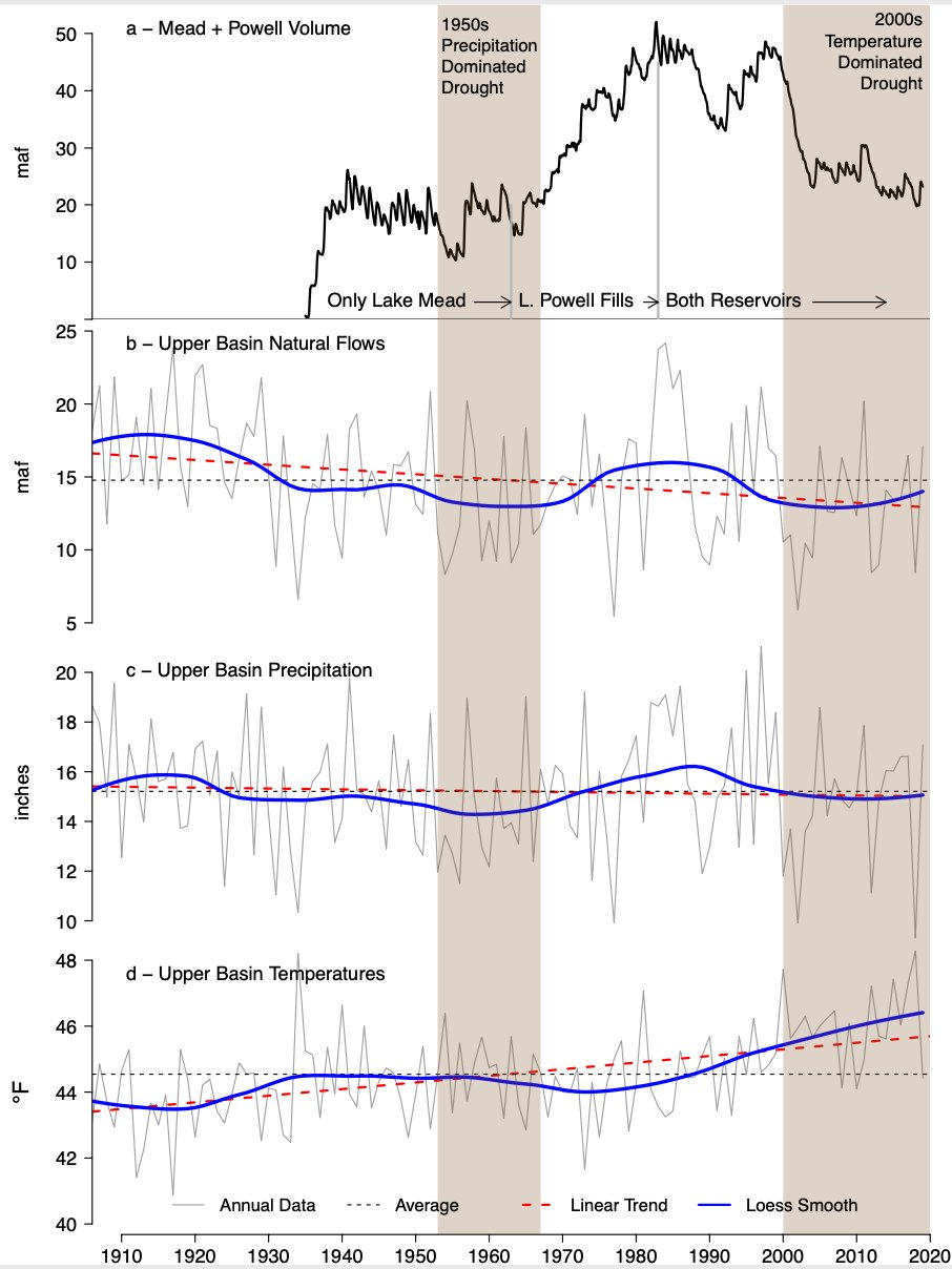
Brad Udall: “…latest version of my 4-Panel plot thru Water Year (Oct-Sep) of 2019 of the #coriver big reservoirs, natural flows, precipitation, and temperature. Data goes back or 1906 (or 1935 for reservoirs.) This updates previous work with @GreatLakesPeck
Here’s the release from the Colorado Water Conservation Board:
Colorado Water Conservation Board Hosts Two-Day Forum
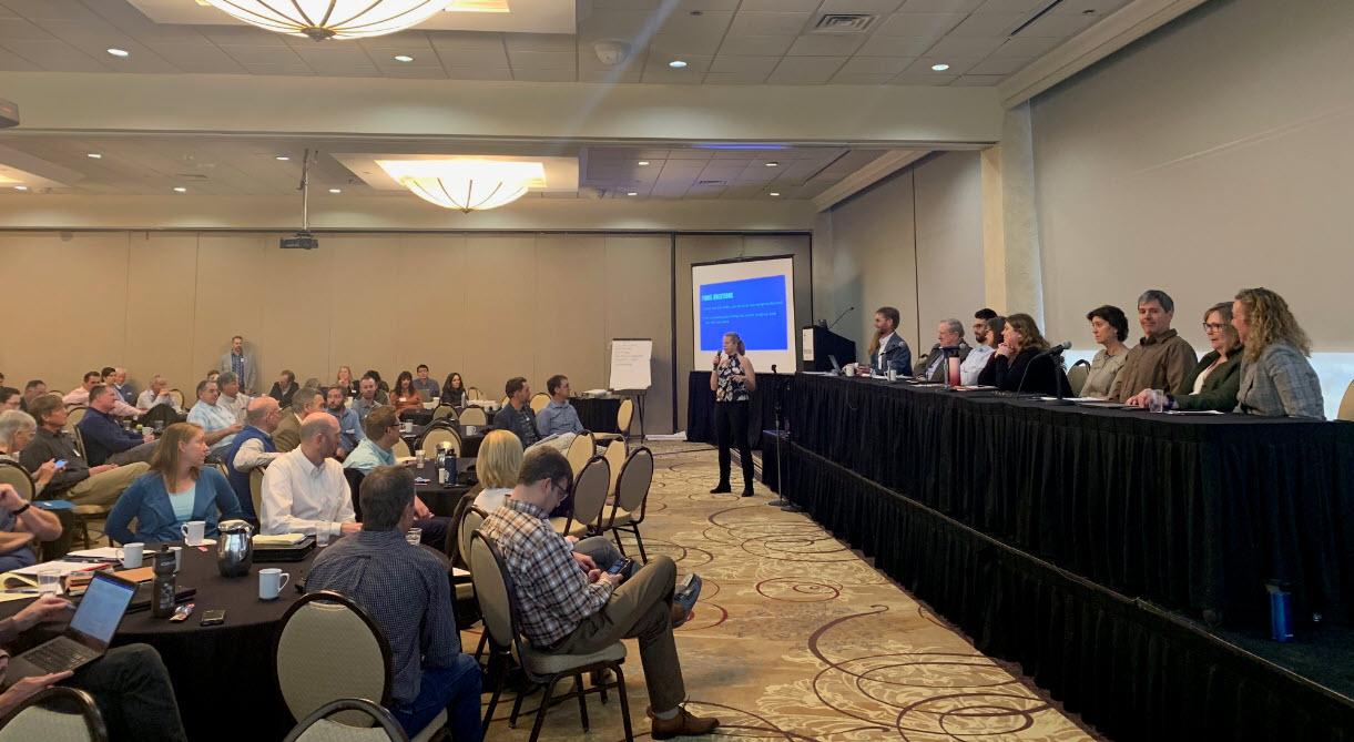
On March 4 – 5, Colorado continued to carve the path forward in its Demand Management Feasibility Investigation during a two-day joint meeting between the Interbasin Compact Committee (IBCC) and eight Demand Management Workgroups.
Hosted by the Colorado Water Conservation Board (CWCB), this was the first workshop convening all eight Workgroups – together representing diverse water-related interests across the state. Workgroups reflected on the past year of discussions and presented on challenges and benefits they foresee in a potential temporary, voluntary, compensated program to address Demand Management.
Demand Management is the concept of temporary, voluntary, and compensated reductions in the consumptive use of water in the Colorado River Basin. Any water saved would only be used to ensure compact compliance and to protect the state’s water users from involuntary curtailment of uses.
“We appreciate the focus, dedication and collaboration of our Workgroup members who gathered this week from across Colorado to move this important conversation forward,” said CWCB Director Rebecca Mitchell. “This workshop was the next step in sharing ideas for Colorado’s water future, and positioning our state as a national leader for cooperative problem solving.”
IBCC Director Russell George said, “We began this process of meeting as individual Workgroups in order to begin exploring concerns and benefits of a potential Demand Management Program. The next step in the process was bringing these Workgroups together in this larger forum, which has fostered the critical conversation needed to ensure we are using a grassroots approach. This approach will help inform our state’s decision-makers as they consider options for a possible Demand Management program.”
Demand Management Workgroups include:
Administration & Accounting
Agricultural Impacts
Economic & Local Government
Education & Outreach
Environmental Considerations
Funding
Law & Policy
Monitoring & Verification
As a headwaters state, Colorado is thoroughly exploring potential tools for managing water in the western United States, and will continue to inform Coloradans throughout the investigation and during the decision-making process.
Demand Management Workgroup Members brainstorm potential program. Photo credit: Colorado Water Conservation Board
Here’s the release from Colorado State University (Jennifer Dimas):
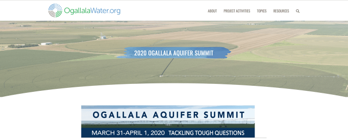
The 2020 Ogallala Aquifer Summit will take place in Amarillo, Texas, from March 31 to April 1, bringing together water management leaders from all eight Ogallala region states: Colorado, Kansas, New Mexico, Nebraska, Oklahoma, Texas, South Dakota and Wyoming. The dynamic, interactive event will focus on encouraging exchange among participants about innovative programs and effective approaches to addressing the region’s significant water-related challenges.
“Tackling Tough Question” is the theme of the event. Workshops and speakers will share and compare responses to questions such as: “What is the value of groundwater to current and future generations?” and “How do locally led actions aimed at addressing water challenges have larger-scale impact?”
“The summit provides a unique opportunity to strengthen collaborations among a diverse range of water-focused stakeholders,” said summit co-chair Meagan Schipanski, an associate professor in the Department of Soil and Crop Sciences at CSU. “Exploring where we have common vision and identifying innovative concepts or practices already being implemented can catalyze additional actions with potential to benefit the aquifer and Ogallala region communities over the short and long term.”
Schipanski co-directs the Ogallala Water Coordinated Agriculture Project (CAP) with Colorado Water Center director and summit co-chair Reagan Waskom, who is also a faculty member in Soil and Crop Sciences. The Ogallala Water CAP, supported by the U.S. Department of Agriculture’s National Institute of Food and Agriculture, has a multi-disciplinary team of 70 people based at 10 institutions in six Ogallala-region states. They are all engaged in collaborative research and outreach for sustaining agriculture and ecosystems in the region.
Some Ogallala Water CAP research and outreach results will be shared at the 2020 Ogallala Summit. The Ogallala Water CAP has led the coordination of the event, in partnership with colleagues at Texas A&M AgriLife, the Kansas Water Office, and the USDA-Agricultural Research Service-funded Ogallala Aquifer Program, with additional support provided by many individuals and organizations from the eight Ogallala states.
The 2020 Summit will highlight several activities and outcomes inspired by or expanded as a result of the 2018 Ogallala Summit. Participants will include producers; irrigation company and commodity group representatives; students and academics; local and state policy makers; groundwater management district leaders; crop consultants; agricultural lenders; state and federal agency staff; and others, including new and returning summit participants.
“Water conservation technologies are helpful, and we need more of them, but human decision-making is the real key to conserving the Ogallala,” said Brent Auvermann, center director at Texas A&M AgriLife Research – Amarillo. “The emergence of voluntary associations among agricultural water users to reduce groundwater use is an encouraging step, and we need to learn from those associations’ experiences with regard to what works, and what doesn’t, and what possibilities exist that don’t require expanding the regulatory state.”
The summit will take place over two half-days, starting at 11 a.m. Central Time (10 a.m. MDT) on Tuesday, March 31 and concluding the next day on Wednesday, April 1 at 2:30 p.m. The event includes a casual evening social on the evening of March 31 that will feature screening of a portion of the film “Rising Water,” by Nebraska filmmaker Becky McMillen, followed by a panel discussion on effective agricultural water-related communications.
Visit the 2020 Ogallala summit webpage to see a detailed agenda, lodging info, and to access online registration. Pre-registration is required, and space is limited. The registration deadline is Saturday, March 21 at midnight Central Time (11 p.m. MDT).
This event is open to credentialed members of the media. Please RSVP to Katie.ingels@kwo.ks.gov or amy.kremen@colostate.edu
The Ogallala aquifer, also referred to as the High Plains aquifer. Source: National Oceanic and Atmospheric Adminstration
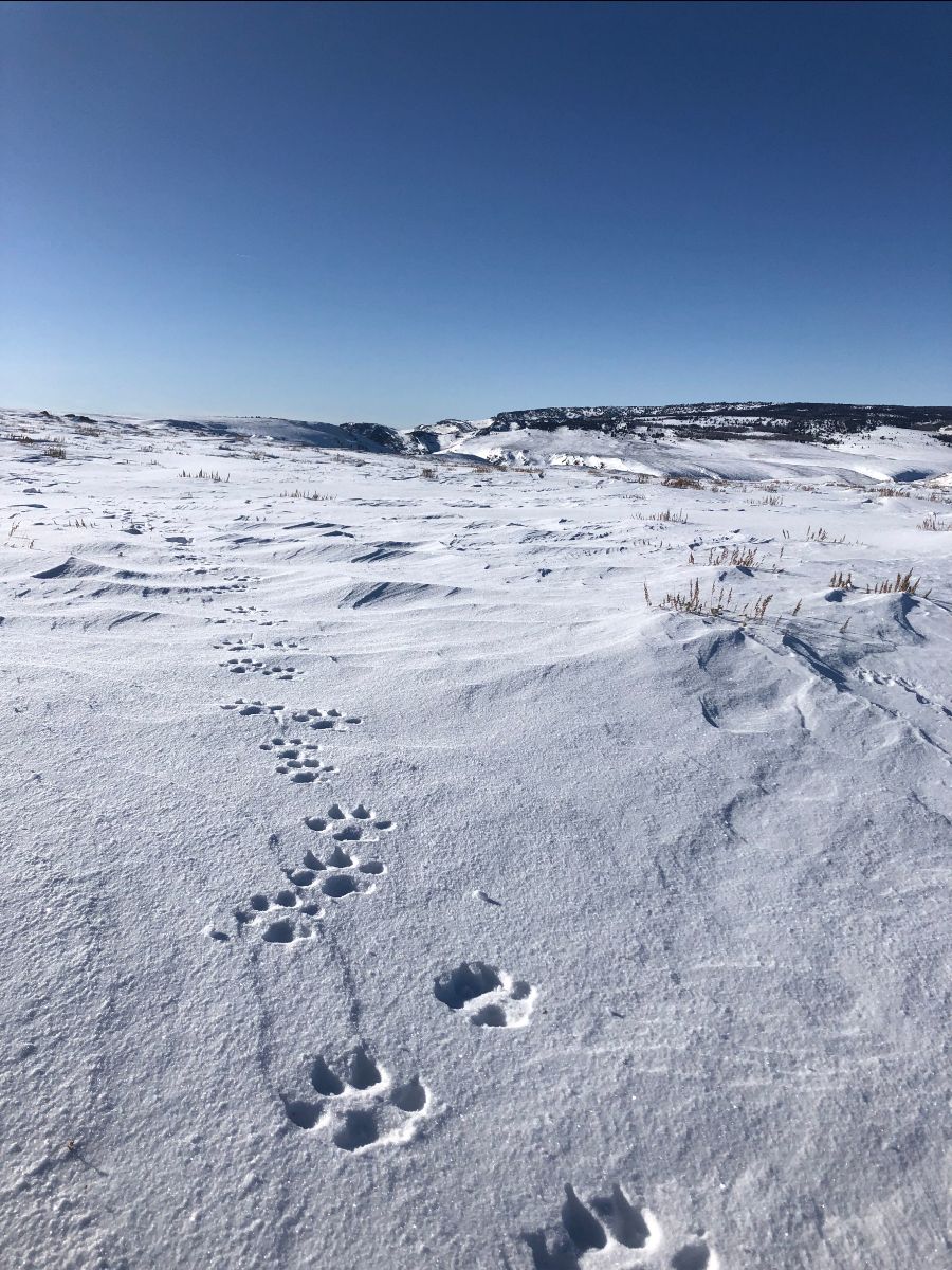
A trail of wolf tracks observed by Colorado Parks and Wildlife officers in Northwest Colorado on January 19, 2020. Photo credit: Colorado Parks & Wildlife
Here’s the release from Colorado Parks and Wildlife (Randy Hampton):
A member of the public spotted the wolves on Tuesday, March 3, providing a credible sighting report of seven wolves. District wildlife managers were able to investigate and visually verify six wolves in the reported area on Wednesday, March 4. The location of this sighting was several miles south of the January sighting location. Over the past few weeks, wildlife managers have heard from area residents about howling, carcasses, and tracks but actual sightings remain rare. Wolves travel over large distances, especially when establishing new home ranges, so the movement and new sightings are not surprising.
As a federally endangered species, wolves in Colorado remain under the authority of the U.S. Fish and Wildlife Service. Colorado Parks and Wildlife works closely with federal partners to monitor wolf presence in Colorado. The wolves migrating into Colorado are likely from larger populations in Wyoming, but could be from populations in Idaho and Montana.
CPW reminds members of the public that killing a wolf in Colorado can result in federal charges, including a $100,000 fine and a year in prison, per offense. Instead, the agency requests that the public give wolves space, and report any sightings to CPW as soon as possible. For more information, visit the CPW website.
After Decade-Long Effort to Secure Full LWCF Funding, Support Builds around Bennet’s Proposal
Today, Colorado U.S. Senator Michael Bennet and a bipartisan group of senators introduced the Great American Outdoors Act, legislation to fully fund the Land and Water Conservation Fund (LWCF) and reduce the $19 billion dollar maintenance backlog on our public lands. Bennet announced the bipartisan legislation at a press conference last week.
“From Rocky Mountain National Park to the Animas River Trail, Colorado’s public lands are central to our identity and vital for our economy. After working on these proposals for years, I’m hopeful that we’ve reached a tipping point with the legislation we’ve introduced today to fully fund LWCF and address the staggering maintenance backlog, which is the result of years of chronic underfunding for our public lands,” said Bennet. “I hope that this is the start of something that our children and grandchildren can look back on and thank us for. I look forward to working with my colleagues to get this bill over the finish line.”
The Great American Outdoors Act would permanently fund LWCF at a level of $900 million and establish a separate restoration fund to address the maintenance backlog at the National Park Service, Forest Service, Fish and Wildlife Service, Bureau of Indian Education, and the Bureau of Land Management using existing revenues from on and offshore energy development.
Bennet has made permanently reauthorizing and fully funding LWCF a top priority since joining the Senate in 2009.
Bennet led the effort to permanently reauthorize the program in Congress with U.S. Senator Richard Burr (R-N.C.), introducing bipartisan legislation in 2015, and in every subsequent Congress. When LWCF expired in September 2015, Bennet spoke on the Senate floor and wrote to Congressional leadership to help secure a three-year authorization in the end-of-year spending bill. When the program was set to expire again in September 2018, Bennet worked with Burr to file an amendment to the Farm Bill. He also introduced a separate bill with U.S. Senator Maria Cantwell (D-Wash.) and Burr to permanently reauthorize and fully fund LWCF. In March 2019, he successfully advocated for the permanent reauthorization of LWCF as part of the John D. Dingell, Jr. Conservation, Management, and Recreation Act. He joined the full funding bill again in April 2019 when it was reintroduced.
Over the years, Bennet has visited several LWCF-funded projects in Colorado, including the Animas River Trail in 2016 and the Yampa River Project in 2018, to learn about and highlight the importance of LWCF in Colorado. LWCF has invested more than $281 million in Colorado projects since its inception.
Bennet has also advocated for robust funding for federal land management agencies for years, sending a letter to former Secretary of the Interior Ryan Zinke in 2017 with proposals to address the national park maintenance backlog in Colorado. Bennet cosponsored the Restore Our Parks Act in 2018, and was an original cosponsor of the legislation when it was reintroduced in 2019.
City officials announced last week it received a $2.9 million grant from the Federal Emergency Management Administration for stabilization work along 9,000 feet of Cottonwood Creek, Biolchini said. The city plans to match the grant with $993,924 from funds intended to improve its stormwater management.
The work will also keep thousands of cubic yards of sediment from washing into Fountain Creek and flowing south to Pueblo, Biolchini said. The project is among 71 Colorado Springs must complete as part of an agreement with Pueblo County to better control the volume and quality of water flowing south in Fountain Creek…
Colorado Springs officials expect to spend $16 million in 2020 on stormwater improvements using fees paid by homeowners and nonresidential property owners, according to the city’s website. Officials must spend $100 million on stormwater projects, operations and maintenance from 2016 through 2020 to comply with the Pueblo agreement. Projects are on track to hit that goal, Biolchini said. The five-year benchmark is part of the requirement to spend $460 million over 20 years on stormwater improvement.
Construction to help prevent erosion of Cottonwood Creek is expected to be designed this year and completed in 2021, he said.
The construction will likely include reshaping the banks so they have gradual slopes and burying hardened structures to keep the creek from changing course, he said.
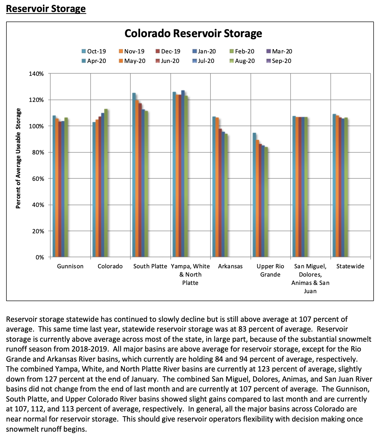
Click on a thumbnail graphic to view a gallery of snowpack data from the NRCS.
Colorado Snowpack March 9, 2020 via the NRCS.
Statewide Basin High/Low graph March 9, 2020 via the NRCS.
Yampa and White Basin High/Low graph March 9, 2020 via the NRCS.
South Platte River Basin High/Low graph March 9, 2020 via the NRCS.
San Miguel, Dolores, Animas, and San Juan Basin High/Low graph March 9, 2020 via the NRCS.
Upper Rio Grande River Basin High/Low graph March 9, 2020 via the NRCS.
Laramie and North Platte Basin High/Low graph March 9, 2020 via the NRCS.
Gunnison River Basin High/Low graph March 9, 2020 via the NRCS.
Upper Colorado River Basin High/Low graph March 9, 2020 via the NRCS.
Arkansas River Basin High/Low graph March 9, 2020 via the NRCS.
FromThe Grand Junction Daily Sentinel (Dennis Webb):
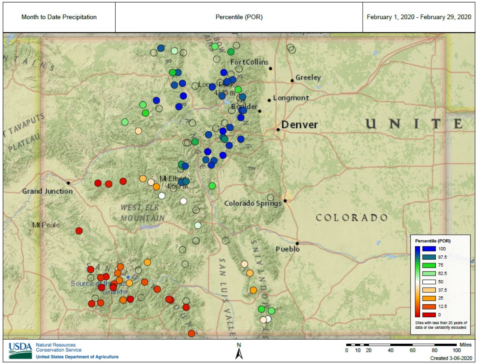
February either gave generously or withheld stingily when it came to snowpack in Colorado, with little in between, and it was all dictated by a fairly sharp north-south dividing line that unfortunately fell north of Grand Mesa.
“Pretty much north of the Grand Mesa, north of Aspen all got well above-normal” precipitation last month, said Karl Wetlaufer, hydrologist and assistant supervisor with the Natural Resources Conservation Service’s Colorado Snow Survey program.
“Below that was well below normal. There’s really not many parts of the state that got in the middle,” he said.
The Mesa Lakes snow telemetry site recorded its lowest February precipitation in the site’s 34-year history, at one inch of water. The two other sites on Grand Mesa — Overland Reservoir and (Trickle) Park Reservoir — recorded their second- and third-lowest precipitation amounts, respectively, for February based on records also dating back decades.
Snowpack at the sites ranged Monday from 65% of median at Mesa Lakes to 73% at Overland.
Statewide snowpack was at 103% of normal as of Monday, down just slightly from the end of January.
Snowpack is at 111% of median in the upper Colorado River Basin, 112% in the Yampa/White basins, 121% in the South Platte basin and 106% in the Arkansas basin. But the Gunnison River Basin is at 90% of median, the Upper Rio Grande, 94%; and the combined San Miguel/Dolores/Animas/San Juan basins, 84%.
Nine snow telemetry sites in northern Colorado had record-high precipitation last month, while six in southern Colorado had record-low amounts.
According to NRCS, the runoff-season streamflows in the combined far-southwest Colorado basins are now predicted to be just 64% of normal, and the forecast for the Gunnison basin is 72% of normal. The Arkansas, Colorado and Yampa/White basins are all predicted to have near-normal runoff volumes.
Reflective of conditions on Grand Mesa, however, the runoff streamflow for Surface Creek at Cedaredge is now expected to be little more than half of average, and the forecast for Plateau Creek is 78% of average.
Andrea Lopez is external affairs manager at the Ute Water Conservancy District, which serves more than 80,000 Mesa County customers. She said the district is concerned not only about snowpack levels on the Grand Mesa but the impact of recent warm temperatures on that snow…
Wetlaufer also is concerned about the recent warm temperatures. Even if they don’t completely melt the snow, they can warm it so when it’s ready to melt it does so faster instead of running off at a more measured pace, he said…
Ute Water’s two Jerry Creek reservoirs, in the Plateau Creek Valley, were 80% full a few weeks ago. Lopez said that fortunately, Ute Water was able to carry over quite a bit of water in them from last year due to the good snowpack last winter. While that will help with water supplies this year even if snowpack remains well below-average on Grand Mesa, two such years in a row could create what Lopez called a “bad situation” when it comes to reliance on those reservoirs.
Denver Water said its reservoirs are all about 5% fuller than they normally are this time of year, and the water in the current snowpack is already up to 96% of peak.
“And that’s just a fancy way of saying, we’re almost to the top amount of water in the snow,” said Todd Hartman, a spokesperson with Denver Water. “We usually don’t see that until come sometime in April. Here we are on March 9th and we are already close to that peak amount of water in the snow. So we do have some reason to feel pretty good, but of course we will still be rooting for a good March and April.”
[…]
This is a stark contrast to last March, when Colorado got record amounts of snow. That lead to an avalanche cycle that was described as ‘historic’ by the Colorado Avalanche Information Center. You may remember some of those snow slides even hit the highways…
Hartman said this season it was February that came through for them with 200% of average snowpack. He said that was very near a record for that month…
The summer monsoon season was not very active in 2019, and that left the Colorado mountains with well below average precipitation from July to October. Hartman said that will impact how some of the runoff reaches our rivers…
He said that despite that issue, the early stream flow forecasts are good for the Denver Water system, ranging between 100-132% of average.
Denver Water said it can’t tell for sure yet if the reservoirs will fill all the way up this summer, until the snowpack does reach that peak. That usually happens by about the second week of April.
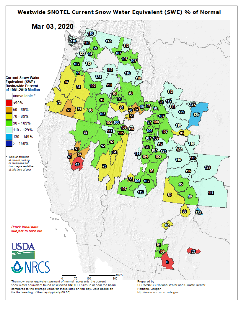
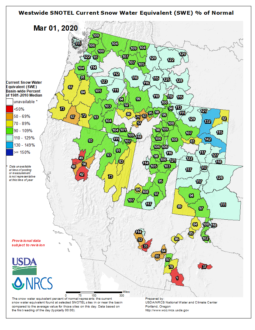
Westwide SNOTEL basin-filled map March 9, 2020 via the NRCS.
Here’s the release from United Water (Lynn Bartels):
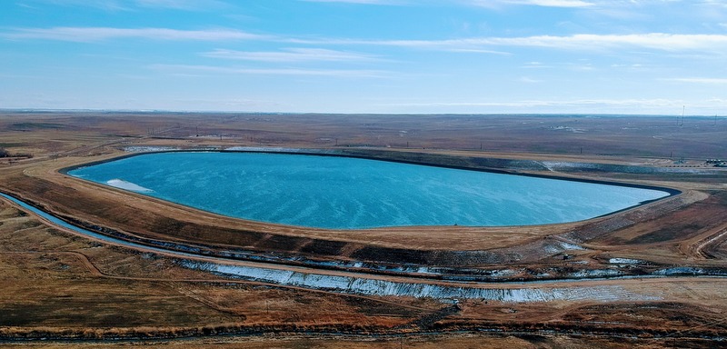
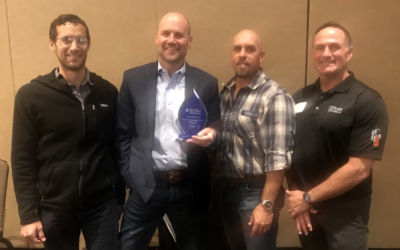
An Adams County company that built an earthen reservoir in Weld County as part of Colorado’s vital water conservation efforts on Friday collected its third major award for the project.
To build the reservoir, Fiore & Sons Inc., a Colorado civil construction company, moved more than 3 million cubic yards of dirt.
The Colorado Contractors Association presented the award to Fiore & Sons its annual H20 Awards banquet, which honors outstanding water projects in the state. Fiore won in the “dam/reservoir” category.
“It was an honor to be part of such a unique project,” said President Butch Fiore, whose grandfather founded the firm in 1959.
The 5,500 acre-foot 70 Ranch Reservoir stores water to support the ranch’s cattle and farming operations, and provides storage for local agricultural and municipal water providers. It’s located near Kersey above the South Platte River, and below the confluence of the St. Vrain and Cache La Poudre rivers.
The reservoir is owned by Weld Adams Water Development Authority and operated by United Water and Sanitation District.
President Bob Lembke said Colorado doesn’t have a water shortage problem but a water storage problem.
“There is plenty of water in Colorado,” he said. “We just have to capture and store it for those times and seasons when we need it.”
The porous soil in that region is susceptible to wind and rain erosion so the reservoir was lined with 7 million square feet of a reinforced synthetic liner. The wave-action protection near the top of the design was unique, and involved a variety of products and employed several techniques on the slope.
Fiore & Sons’ diligence and innovation in building the 70 Ranch Reservoir included the efforts of 30 workers hand pulling weeds around the top of the dam wall because the use of herbicides on a water project would be unacceptable.
In its contest application, Fiore & Sons noted that protecting and preserving water quality was a top priority.
“A state construction dewatering permit required water volume be tracked and samples routinely obtained and tested at Colorado Analytical Labs for water quality,” the firm stated.
Over 115 water tests and 55 site inspections were completed. In addition, Fiore & Sons implemented a detailed erosion and sediment control plan.
“With a project of that size and magnitude, there are some really big lessons that are learned in the process and will really help us when we get the opportunity to build another dam,” Fiore said.
At the groundbreaking ceremony for the 70 Ranch Reservoir in 2019, state Treasurer Dave Young of Greeley and other elected officials praised the “visionary project.”
The project manager for United Water was Drew Damiano, for Fiore & Sons, Jim LaTerra. Fiore & Sons subcontracted with Civil Resources to provide engineering for the project.
Fiore & Sons received two other awards for the construction of the 70 Ranch Reservoir:
The National Utility Contractors Association, which recognizes “challenging, innovative, or unique projects completed with excellent results.” Fiore & Sons won the award in the water category at NUCA’s conference in Arizona last month.
The Associated General Contractors, which recognized Fiore for “Meeting the Challenge of a Difficult Job.” Fiore received the award in Denver last November.
For more information, contact
Lynn Bartels, 303-748-4502 or againlynn@gmail.com
Fiore & Sons Inc., an Adams County firm, picked up its third award for its construction of an enormous earthen reservoir near Kersey that contains 7 million square feet of a reinforced synthetic liner. From left to right, engineer Andy Rodriguez with Civil Resources, project manager Drew Damiano with United Water and Sanitation District, project manager Jim LaTerra of Fiore & Sons and Fiore & Sons president Butch Fiore. Photo credit: United Water
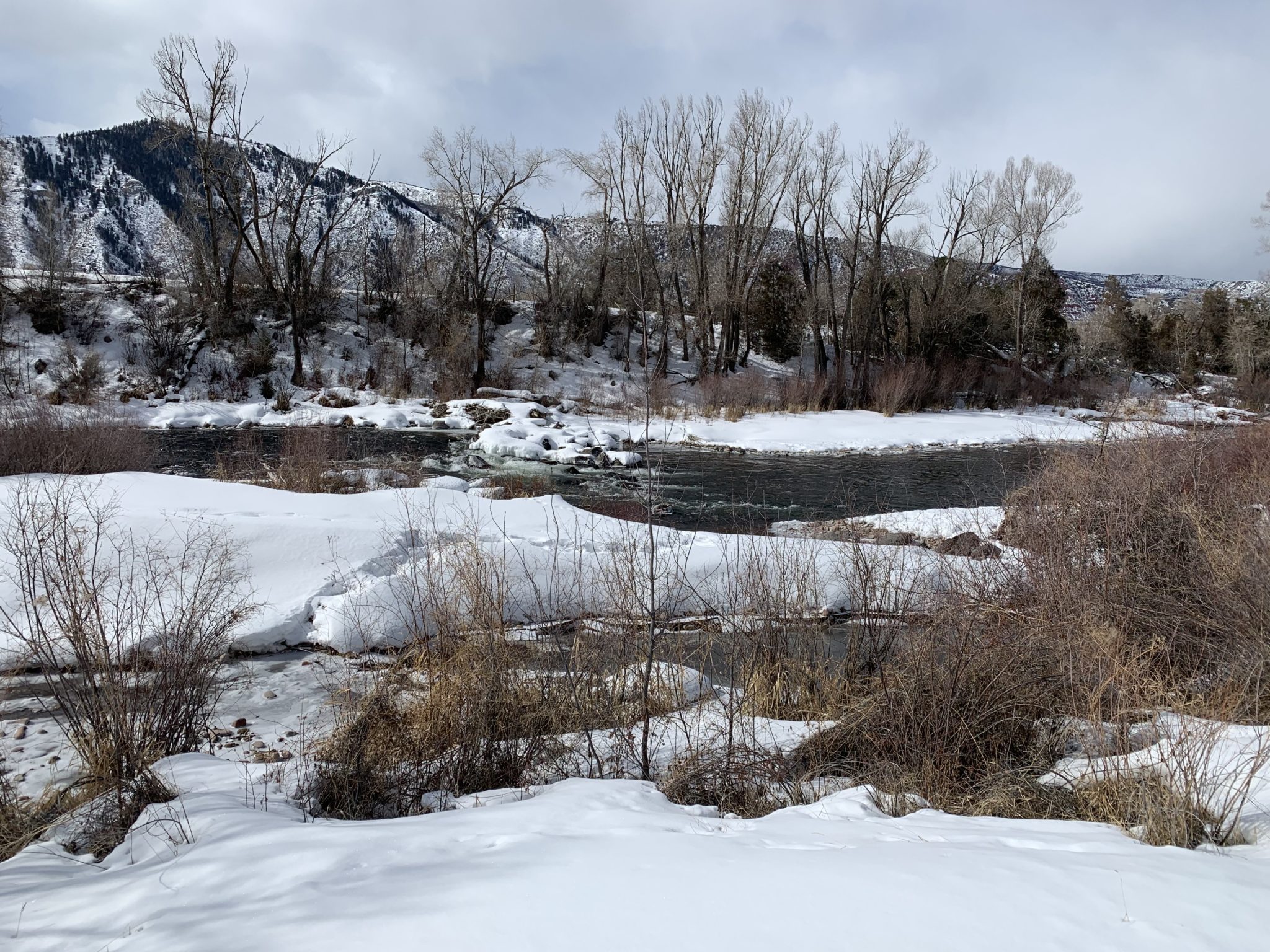
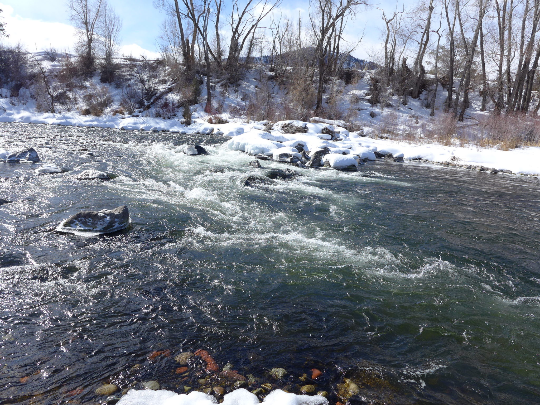
The Robinson Diversion, located just upstream from the boat ramp on Willits Lane has long presented a hazard for boaters on the Roaring Fork River. Pitkin County Healthy Rivers has secured roughly $256,000 in grant money to permanently fix the area. Photo credit: Heather Sackett/Aspen Journalism
Pitkin County’s Healthy Rivers board is moving ahead with a nearly $1 million project to fix a problem spot on the Roaring Fork River between old town Basalt and Willits.
For the past few years, the board has been steadily accumulating grant money to fix the Robinson Diversion, an area known to boaters as Anderson Falls. The diversion is a line of rocks across the river, designed to help water flow into a channel on river right and into the headgate of the Robinson Ditch.
The spot, just upstream of the small boat ramp on Willits Lane near the FedEx outlet, has long presented a tricky obstacle to boaters, especially at low water.
And although repairs last April by the ditch company created a much-improved boat channel, the area remains vulnerable to winter ice flows and spring runoff, which could rearrange the rocks. Pitkin County is hoping to fund a more permanent fix.
The headgate for the Robinson Diversion is located on river right, just upstream from the boat ramp on Willits Lane on the Roaring Fork River. The Pitkin County Healthy Rivers Board is moving forward on a nearly $1 million project to fix the Robinson Diversion structure. Photo credit: Heather Sackett/Aspen Journalism
Option A
Last month, Healthy Rivers board members informally decided to move forward with restoration project “option A” with an estimated cost of $935,000.
The work, by Carbondale-based River Restoration, would include creating two smaller drops in the river, instead of one large drop, which would still allow water to reach the Robinson Ditch’s headgate. The project also would make some improvements to the diversion structure and result in better fish habitat.
River Restoration also presented Healthy Rivers with an “option B,” which would modify the existing rocks and extend the drop downstream to make for a more mellow ride in a raft, ducky or kayak. That option would cost roughly $586,000 but would not include fish-habitat work or improvements to the diversion headgate.
Board members decided to stick with the more complete “option A.”
“We might be wasting money if we don’t go big on this project,” said Healthy Rivers board member Lisa Tasker. “Going big means finding a solution to the Robinson Ditch rearranging the river bed year after year. One of the biggest goals is to have less equipment get into the river.”
Pitkin County commissioners have to approve expenditures from the Healthy Rivers board, which is a recommending body.
Blazing Adventures runs commercial river trips from Snowmass Canyon to just below the Robinson Diversion structure, usually starting in July as spring runoff fades. Owner Vince Nichols said the boat chute last year was a great improvement, but he would welcome a more permanent fix.
“Our main takeaway would be safety and having a boatable passage,” he said.
It’s unclear yet whether the Robinson Ditch Co., which owns and operates the structure and headgate, will contribute monetarily to the project, but manager Bill Reynolds said he is in support of fixing the structure.
“I welcome anything that helps all the boaters, fisherman, all the users on the river,” he said. “And if the ditch company can gain a better structure out there, that will help everybody. It’s a win-win.”
The headgate for the Robinson Diversion is located on river right, just upstream from the boat ramp on Willits Lane on the Roaring Fork River. The Pitkin County Healthy Rivers Board is moving forward on a nearly $1 million project to fix the Robinson Diversion structure. Photo credit: Heather Sackett/Aspen Journalism
These are matching grants, with the county currently committed to contributing at least roughly $246,000 toward the project.
According to Lisa MacDonald, a paralegal in the county attorney’s office, Healthy Rivers has no other grants in the works for the project, but it continues to look for more opportunities and funding. The project is still short of funding by about $430,000, and as time goes on, project costs continue to rise.
The price tag on the project in 2017 was $800,000. By this year, it had increased to $935,000.
“(The project) has a large footprint and we have to move the river during construction,” said Quinn Donnelly of River Restoration. “There are so few contractors that do the work, and it’s involved. There is risk involved.”
To make up the funding gap, MacDonald said the county could seek contributions from Eagle County, the town of Basalt, the ditch company and grants from Great Outdoors Colorado.
“The board does need to talk about exactly where the rest of that funding will come from,” Tasker said. “We are moving forward and will have discussions about how to cover what our grants do not.”
Aspen Journalism collaborates with The Aspen Times and other Swift Communications newspapers on coverage of water and rivers. This story ran in the March 8 edition of The Aspen Times.
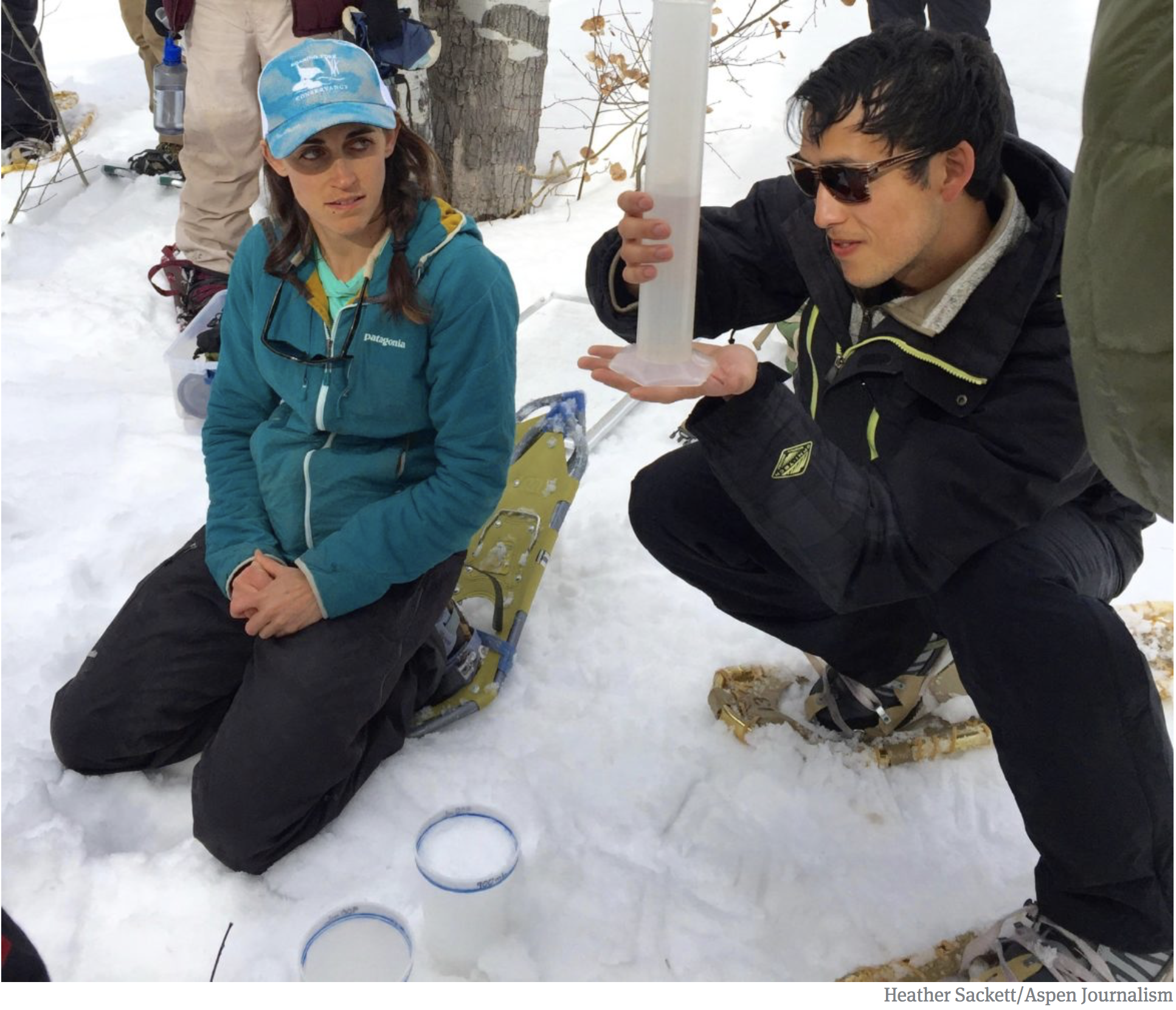
Liza Mitchell, education and outreach coordinator with the Roaring Fork Conservancy, left, and a participant in the Water Education Colorado SNOTEL workshop measure the snow-water equivalent of different layers of the snowpack. The liquid content of snow from this site measured roughly 21 percent. (March 2018)
Colorado’s mountain snow is measuring slightly higher than normal for this time of year, a vulnerable moment for cities and food growers ahead of spring, boosting confidence that water for crops, cattle and a growing population will be adequate.
Federal survey data showed the statewide snowpack at 106% of the norm between 1981 and 2010, but with significant variation between northern and southern mountains — a trend over the past decade.
And forecasters anticipated that dry soil from last year’s warm arid fall likely will reduce water in streams and rivers once snow melts. Much depends on snowfall this month, and March often brings heavy snow.
Southwestern Colorado faced drier conditions with snowpack between 86% and 94 % of the norm, the U.S. Department of Agriculture’s Colorado Snow Survey found. Snow in the South Platte River Basin (124%), Upper Colorado River Basin (114%) and Arkansas River Basin (109%) — the main water sources for Denver, Colorado Springs and northern Front Range cities — promised reasonably sufficient water…
Snow survey supervisor Brian Domonkos said Colorado was in “a good spot” overall, assuming more precipitation in the right places over the next few weeks.
The amount of water in rivers and streams “is going to be better in the northeast, and not as good in the southwest,” Domonkos said…
Denver’s reservoirs were 85% full, higher than the normal 80% at this time of year. Utility officials’ goal: Fill the reservoirs to 100% on July 1 to ensure water availability after snow on mountains melts and evaporates.
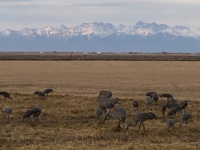
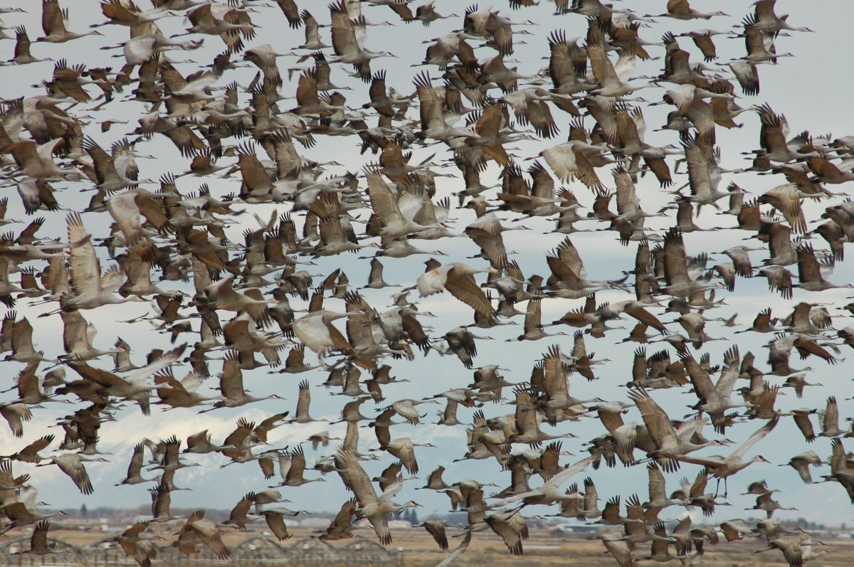
We had a great time hanging out with the Sandhill cranes in the San Luis Valley over the weekend to celebrate the 48th anniversary of my 21st birthday. The folks at the Monte Vista National Wildlife Refuge have created habitat for the the crane migration — shallow water features and barley fields. The idea is to make sure that the cranes get a good feed at the start of their migration so that the “Rocky Mountain population” arrives in their breeding areas (Greater Yellowstone) in good shape.
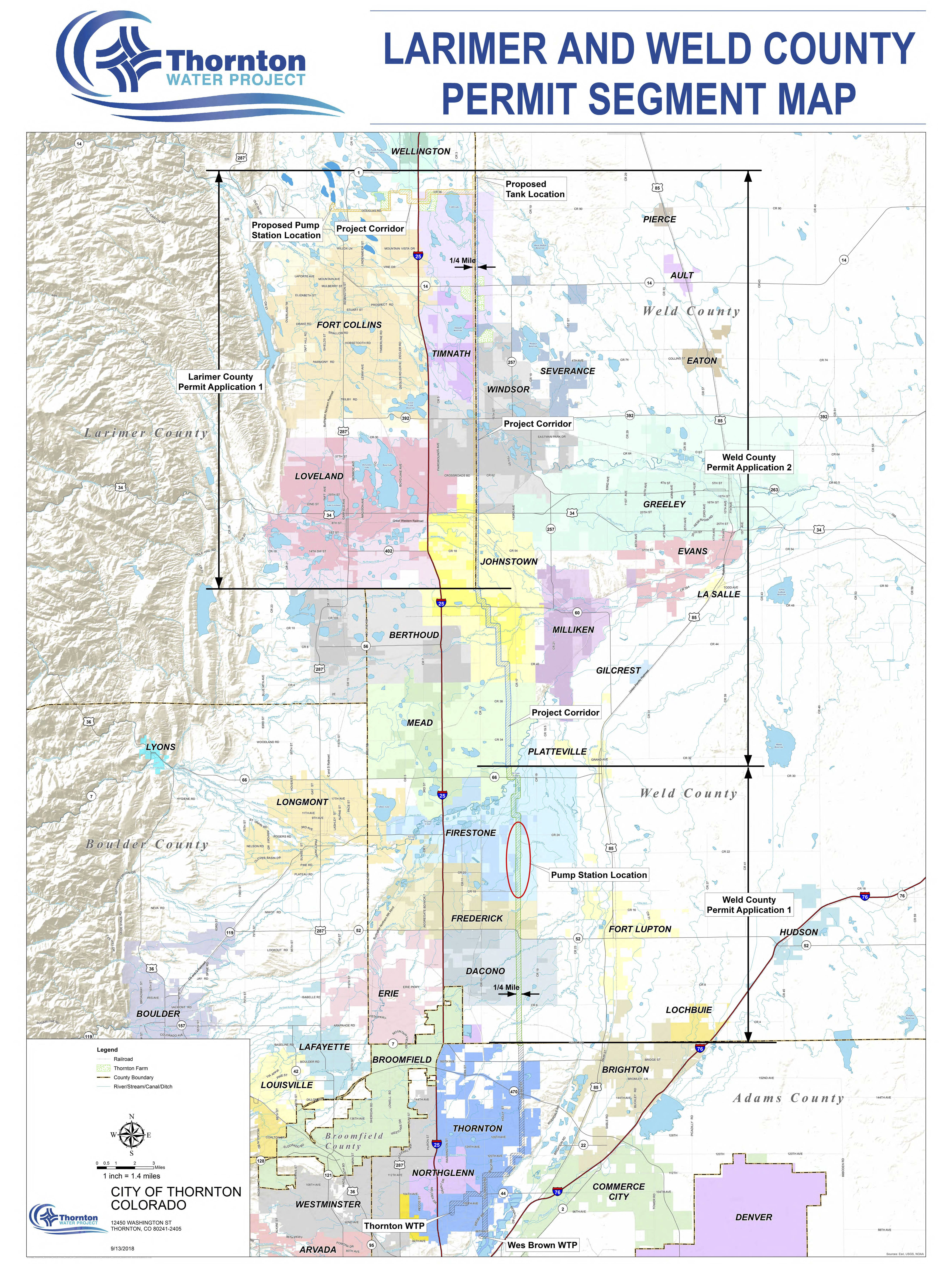
[Ted] Simmons is one of more than a hundred landowners — some who have been there for generations — who received a letter in recent weeks from an agent of the city of Thornton.
The letter offers Simmons and his neighbors a sum of money — Simmons reckoned the city is figuring about $7,500 per acre — for a permanent easement that would allow the city to build a jagged-lined water pipeline, north to south, across Weld County into Thornton.
“The current proposal makes that piece of land almost unusable,” Simmons said. “I can still put up hay, but for the future, if you want to do any plans in the future, it pretty much destroys the whole piece. You can’t build over it.”
The permitting process has been a bit rocky. It involves both Larimer and Weld counties, and the commissioners of each county have thrown various hurdles in the way of the city which resides in neither of their jurisdictions.
Initially, the project proposed to take Weld County Road 13 much of the way south. But there was concern on the part of the Weld commissioners that that was unfair to the landowners along that stretch of highway.
“We said we were not willing to put the pipeline in our right of way,” Weld County commission chairman Mike Freeman said by phone this week. “The reason is, with farming, they farm up to the county road. So it still impacts the landowners as much. The landowners need to be paid for these easements. It’s going to impact them, so they need to be paid.”
About 160 parcels are crossed, Koleber said, as the hypothetical pipeline traverses Weld County. And the commissioners weren’t making things any easier on Thornton, either.
“Weld commissioners said, ‘We want you to acquire all of the easements that you need for the pipeline ahead of time,’ before they even look at the permit,” Koleber said. “That’s reverse of how a project normally goes. Permit-design-right of way-construction. They flipped that and continued our process for a year, from July 2019 to July 2020.”
That said, roadblocks or not, Weld has been substantially more accommodating than Larimer. There, the commissioners rejected the permit application and are on their way to court with the city of Thornton. Freeman said that that’s not the plan in Weld.
“We want to make sure they’re treating people fairly,” Freeman said. “We can’t get in the middle of negotiation, whether they’re paying enough, but we want to make sure they’re getting those easements secured, not coming in and saying, ‘We’ve got 30%.’ We’re not going to approve a pipeline if we don’t know where it’s at … but if they come in with an application demonstrating it’s complete, and it’s a good one, more than likely we’d approve it.”
But the landowners — at least some of them — aren’t thrilled with the idea of giving up a strip of their property to the underground pipeline, even if it can be farmed right over the top of it as Thornton claims.
That’s because, like Simmons, the value is less in agriculture now than it is in development potential. Houses or other municipal space are where the future is.
Simmons and his neighbors, including Ken and Sue Kerchenfaut, would much rather the pipeline go down Weld County Road 13, actually. But if that’s not an option, Simmons has another idea, too. Rather than jutting through the various properties in a zig-zagging line, why not take a straight shot parallel path with an existing Sinclair Energy pipeline that already stripes his and many of his neighbors’ land?
[…]
Like it or not, it seems they’ll probably have to give up the easement one way or another. Thornton feels comfortable its eminent domain powers will be backed up in court, should it get that far.
And they’re probably right.
Thornton is a home rule charter, and such entities are granted quite broad eminent domain power for the sake of a public good by the Colorado constitution. That’s what an expert on the subject, University of Colorado professor Richard Collins, said by phone this week.
“The home rule powers of the constitution explicitly authorize home rule charters to have eminent domain,” Collins said. “So there’s really not much doubt that a home rule city would have broad powers of eminent domain.”
No water will be pumped from the Animas River into Lake Nighthorse this year.
That is because the headgates at the dam southwest of Durango, Colorado, have to be destroyed and replaced, according to Animas-La Plata Project Operations, Maintenance and Repair Association General Manager Russ Howard.
Howard told the San Juan Water Commission on March 4 that the $6.5 million project is needed because the design was not appropriate for the location. This work is being done by the U.S. Bureau of Reclamation.
He said work was also done prior to choosing to replace the gate. Howard said $1.5 million was spent “over the years trying to put a Band-Aid on something that shouldn’t have been there in the first place.”
When asked about the gate, Howard said the design, known as an Obermeyer, gate is not a bad design, but it was not appropriate for the Animas River.
Lake Nighthorse and Durango March 2016 photo via Greg Hobbs.
U.S. Bureau of Reclamation spokeswoman Justyn Liff agreed with Howard that the design was a good design but was not compatible with the Animas River’s conditions. She said on another river it would have worked fine, but the bureau had not realized how muddy the Animas River is.
The amount of mud in the Animas River caused problems and filled the pipes with mud.
In addition to the $6.5 million replacement of the headgates, Liff said the the gate’s original construction, retrofits to keep them operational and engineering studies and design cost about $6.2 million.
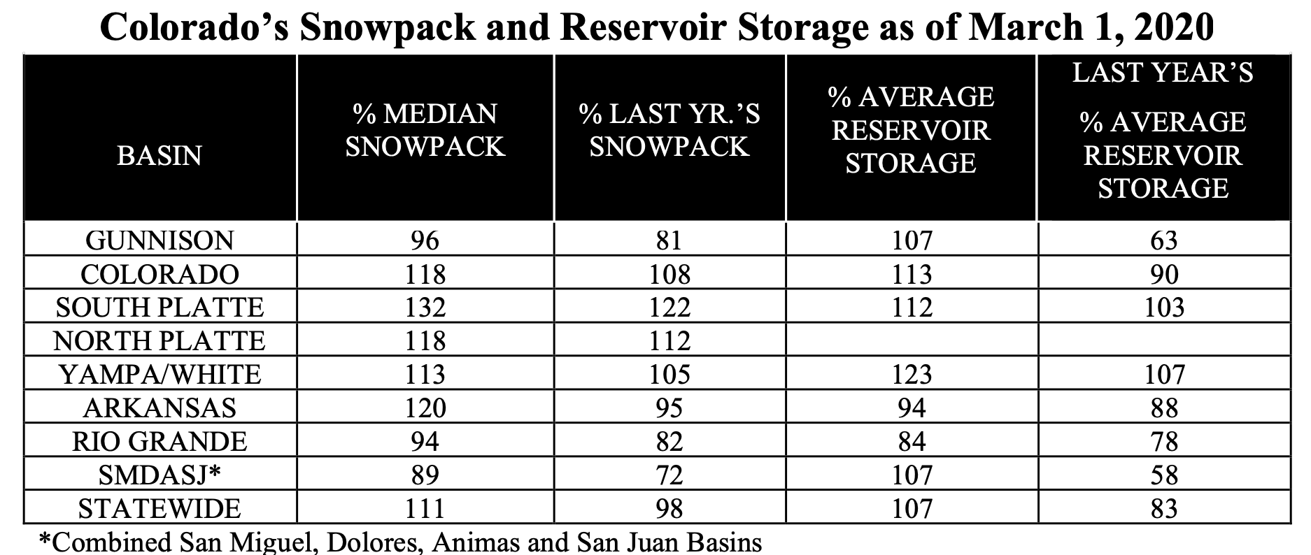
Here’s the release from the NRCS (Brian Domonkos):
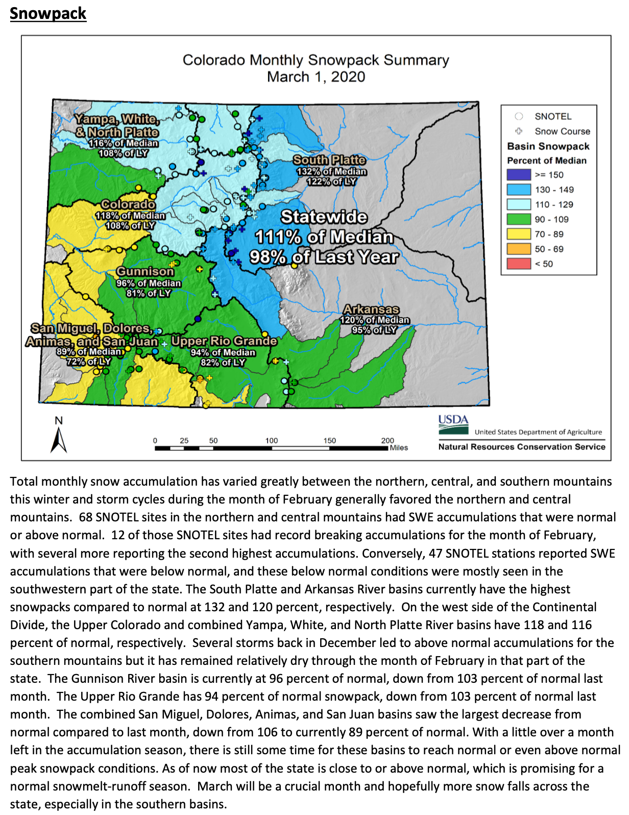
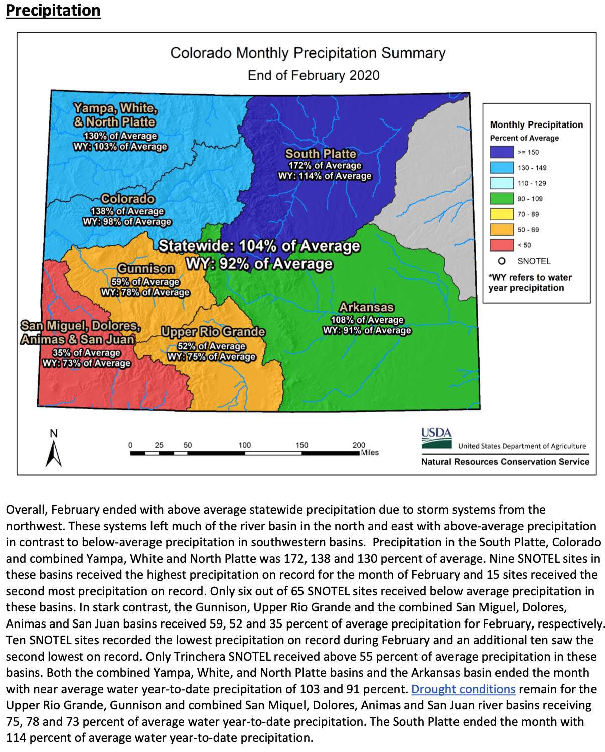
A series of storms hit Colorado throughout February uniquely favoring the northern half of the state, leaving most of Southern Colorado high and dry. NRCS Hydrologist Karl Wetlaufer notes that “This month was particularly interesting because of the feast or famine nature of the snow accumulations in different areas. It was an extremely sharp distinction between Northern Colorado which received well above average precipitation and Southern Colorado that almost uniformly received well below average accumulations.” There were 39 SNOTEL sites across Northern Colorado that received above the 90th percentile of February precipitation on the period of record, with 9 of these being the record high. Conversely, 24 SNOTEL sites in the southern half of the state were in the bottom 10th percentile and six sites observing record low precipitation. These differences resulted in notable changes to snowpack and streamflow forecasts.
The greatest impact was seen in the San Juan Mountains where the percent of normal snowpack dropped an impressive 17 percent from 106 to 89 percent of normal in the combined, San Miguel, Dolores, Animas, and San Juan basins following the very dry month in that area. On the opposite end of the spectrum snowpack in the South Platte increased from 119 to 132 percent of normal.
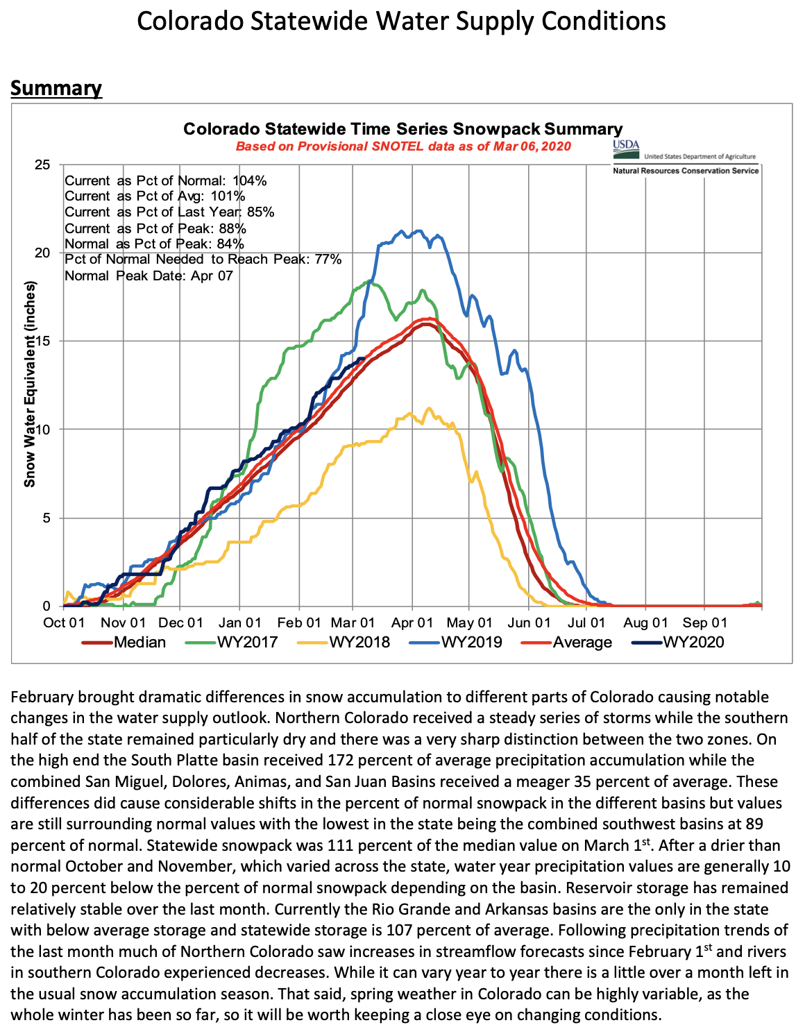
“The last month has caused a stark contrast in regional snowpack and streamflow forecasts compared to what we saw at the beginning of February when conditions were much more uniform across the state. Currently statewide snowpack is 111 percent of normal however it is now more important to be aware of conditions in the individual basins.” Wetlaufer continued.
Following the trends of snowpack and precipitation, streamflow forecasts predict considerably higher values across Northern Colorado than in the southern half of the state, with respect to normal. On the low end the average of forecasts in the combined San Miguel, Dolores, Animas, and San Juan basins is for 64 percent of normal followed closely by the Rio Grande at 68 percent. The Gunnison is doing a little better with all forecast points averaging out to 72 percent of normal. The most plentiful forecasts in the state reside in the South Platte basin with some exceeding 130 percent of average in the main stem headwaters. The Arkansas, Colorado, and combined Yampa and White basins are forecasted to have near normal runoff volumes with the basin-wide average of forecasts ranging from 96 to 106 percent of normal.
Reservoir storage did not see considerable changes over the last month and only the Rio Grande and Arkansas are holding below average storage. A lot can still change over the coming months but as we get nearer to peak snow accumulation Colorado’s water supply situation continues to get more clear.
For more detailed information about January 1 mountain snowpack refer Water Supply Outlook Report. For the most up to date information about supply related information, refer to the Colorado Snow Survey website.
FromThe Douglas County News Press (Elliott Wenzler):
Sterling Ranch and Rocky Mountain PBS came together Feb. 27 to help educate the people of the Front Range on water issues throughout the state as part of Water Week 2020.
At the event, RMPBS screened a portion of their new episode of the “Colorado Experience” on the history of water in Colorado. Similar events took place across the state that night, including in Pueblo, Durango, Grand Junction and Gunnison.
The goal of the event is “to increase the level of civic dialogue happening around an issue that is really vital to all of our sustainability as a state,” CEO of RMPBS Amanda Mountain said.
Water Week was developed one year ago when RMPBS organized a statewide listening tour aimed at understanding which topics are most important to residents…
The event was held at Sterling Ranch, a development in northwest Douglas County that has incorporated water conservation into its master plan.
“Anybody who grew up in Colorado knows the importance of water,” said Harold Smethills, president of the community’s board, during the event. “It’s everything.”
Sterling Ranch prioritized conservation in creating the community. It now uses less than half the water of any other community in Colorado, Smethills said…
RMPBS screened a few minutes of the episode, titled “Western Water — and Power,” which is about an hour long. It begins with a history of water in Colorado, beginning in the days of settlement, when disputes began between the Western Slope and the Front Range over water use. The full episode is available at rmpbs.org/coloradoexperience.
“Conservation means you have something you never should have had in the first place,” Smethills said. “Please don’t use it.”
From cows and plows to horticulture and hemp, Colorado’s agriculture is so diverse it can be difficult to bring everybody together around the same table.
That said, many of Colorado’s agriculture leaders had a chance to interact earlier this week in Denver at the annual Governor’s Forum on Colorado Agriculture, which was preceded by the equally diverse two-day annual conference of the Colorado Fruit and Vegetable Growers Association.
Among those attending both events was Glenda Mostek, who has worked in various capacities in the ag industry and recently took on a new job as executive director of the Colorado Nursery and Greenhouse Association.
Horticulture and nursery plants aren’t the first crop that comes to mind when most people envision agriculture. But in value terms, they actually represent the biggest segment of the specialty crops industry in the state, as defined by the U.S. Department of Agriculture. The industry is also growing rapidly, mostly due to the fast pace of residential development, Mostek said.
At the inaugural Colorado Food Summit in early January, members of Colorado State University’s food systems team emphasized the importance of building linkages across diverse agriculture sectors. Becca Jablonski, a food systems economist who helped organize the food summit and also spoke about marketing opportunities during the CFVGA conference and at the governor’s forum, said the goal is to make sure all voices are represented during discussions about the future of food and agriculture in the state.
It’s also an effort to keep all parts of the industry alerted to emerging markets represented by new outreach efforts, such as the National Western Center and Denver’s Sustainable Food Policy Council, which is working on adopting a pledge that would require institutional buyers to look at more than just price when making food purchasing decisions.
Mostek went into her position with the horticulture and greenhouse association looking for a chance to build bridges between agriculture and the general public.
“Somebody pointed out to me that the most connection a lot of city people will ever have to agriculture is going to a greenhouse to buy plants,” she said. “I’m here to create partnerships. We are all in this together with the same goals and challenges.”
[…]
Dani Traweek runs the Colorado Ag Leadership Program, charged with organizing the Governor’s ag forum each year. This year’s theme, Brand It Agriculture, speaks to the idea that while the industry is broad, dynamic and constantly evolving, it is also united under one big umbrella, she said…
The class experience is enhanced by including professionals who didn’t come out of traditional farm backgrounds, such as chefs, bankers and project organizers, she said.
Three agronomists in the current class work to some degree with the hemp industry, another new dimension of the industry that is providing opportunities to diversify for some and creating competition for land, water and labor for others.
In conversations with the program’s educational sponsors, including CSU and Aims Community College, Traweek has learned there’s a growing need for electricians and technology experts, many of which will probably come from nonfarm backgrounds.
Language and cultural differences are also important, as the industry’s pool of employees and customers becomes increasingly diverse.
During a breakout session at the Colorado Food Summit, Mostek learned about research showing Spanish-speaking customers trust outreach messages more when they’re provided in Spanish as well as English…
“We need to tell our story, and not only tell it, but tell it effectively, and make sure it’s being heard,” she said of ag advocacy efforts. “I think we’re headed in the right direction with groups like Common Ground, where we have women messaging to women.”
On Feb. 20, the University of Utah Center for Colorado River Studies hosted a presentation and panel discussion in Moab on research being conducted on and policies being considered for Lake Powell. Scientists, activists, authors, and historians shared their perspectives on various aspects of the river, the dam, and the reservoir to a full house at Star Hall. The complicated history of river engineering and water allocation sets the stage for an uncertain future of the management of the West’s precious resource.
“We can’t talk about the future of this reservoir and how its managed unless we digest some basic facts,” said Dr. Jack Schmidt, professor of watershed sciences at Utah State University, at the presentation, before he and others gave an overview of the reservoir’s history and parameters.
The presentation was part of an effort by the Center for Colorado River Studies to help the public understand the complexity of the natural systems and political agreements surrounding the Colorado River…
Water levels in Lake Powell and Lake Mead have reflected this decreased flow. In 2005, Lake Powell dropped to its lowest level since it first filled up in 1963, sinking to 3,555 feet above sea level, just barely high enough to keep from exposing the intakes for the hydroelectric generator at the dam and causing damage to the facility.
How much electricity the turbines in the bowels of Glen Canyon Dam can generate depends upon how much water is delivered from the Wind River Range of Wyoming and the high mountains of Colorado into Lake Powell. Photo/Bureau of Reclamation.
“Here’s an important number,” Schmidt told the audience at Star Hall. “If the reservoir elevation gets lower than 3,490 feet above sea level, then water cannot be taken into those penstocks, because then air is entrained, and if air is entrained, you get the phenomenon of cavitation in the turbines, which will destroy the turbines.”
He went on to explain that water managers don’t want to get too close to that absolute limit, and they set a bottom threshold of 3,525 feet above sea level for Lake Powell.
Policymakers must constantly consider how supply and demand are affected by climate and natural systems, new infrastructure and aging infrastructure, population growth and changes in land use, and scientists’ and researchers’ evolving understanding and modeling of how these factors will play out in the future…
To prepare for a renegotiation of interstate agreements, scientists and researchers have been studying the Colorado River basin and all the systems that comprise it. The presentation at Star Hall illustrated just how complex the issue is. Glen Canyon Dam itself has been controversial nation-wide since its inception. Environmentalists, river runners, and archaeologists to this day lament the loss of the natural canyon flooded by the dam, which was filled with Native American artifacts and wild riparian ecosystems. That dam and other infrastructure have changed many properties of the river, from flow rate, to temperature, to fish populations, to evaporation patterns, to the shape of the riverbed. As scientists study the new patterns of the river, they try to create models that can accurately predict future behaviors and conditions of the river. For example, by studying how the river moves and deposits sediment, scientists have variously predicted an operable life span for Lake Powell of 100 to 150 years. These models and data sets can help steer management agreements.
“The current interim guidelines aren’t going to work forever,” said Erich Balken, executive director of the Glen Canyon Institute, a Salt Lake City-based nonprofit devoted to the restoration of Glen Canyon and the Colorado River.
The organization is advocating for a policy they call “Fill Mead First,” which Balken briefly discussed at the Star Hall event. The policy would allow the downstream Lake Mead to be filled to capacity before starting to store water in Lake Powell. The group recommends not decommissioning Glen Canyon Dam, a step that has been taken at other dam sites around the country, but drilling diversion tunnels around it to allow the river to return to its natural flow.
The hydroelectric power plant driven by Lake Powell would be temporarily shut down, and intakes to power the facility would be installed in the diversion tunnels. Glen Canyon would be returned to its natural state until the necessity arose to store more water than Lake Mead could hold.
The idea is politically difficult because Lake Powell serves as a kind of “bank account” of water that helps upper basin states ensure that they meet their water obligations to the lower basin states. Beyond Lake Powell, the water essentially belongs to the lower basin. The dividing line maintains a tension between the regions…
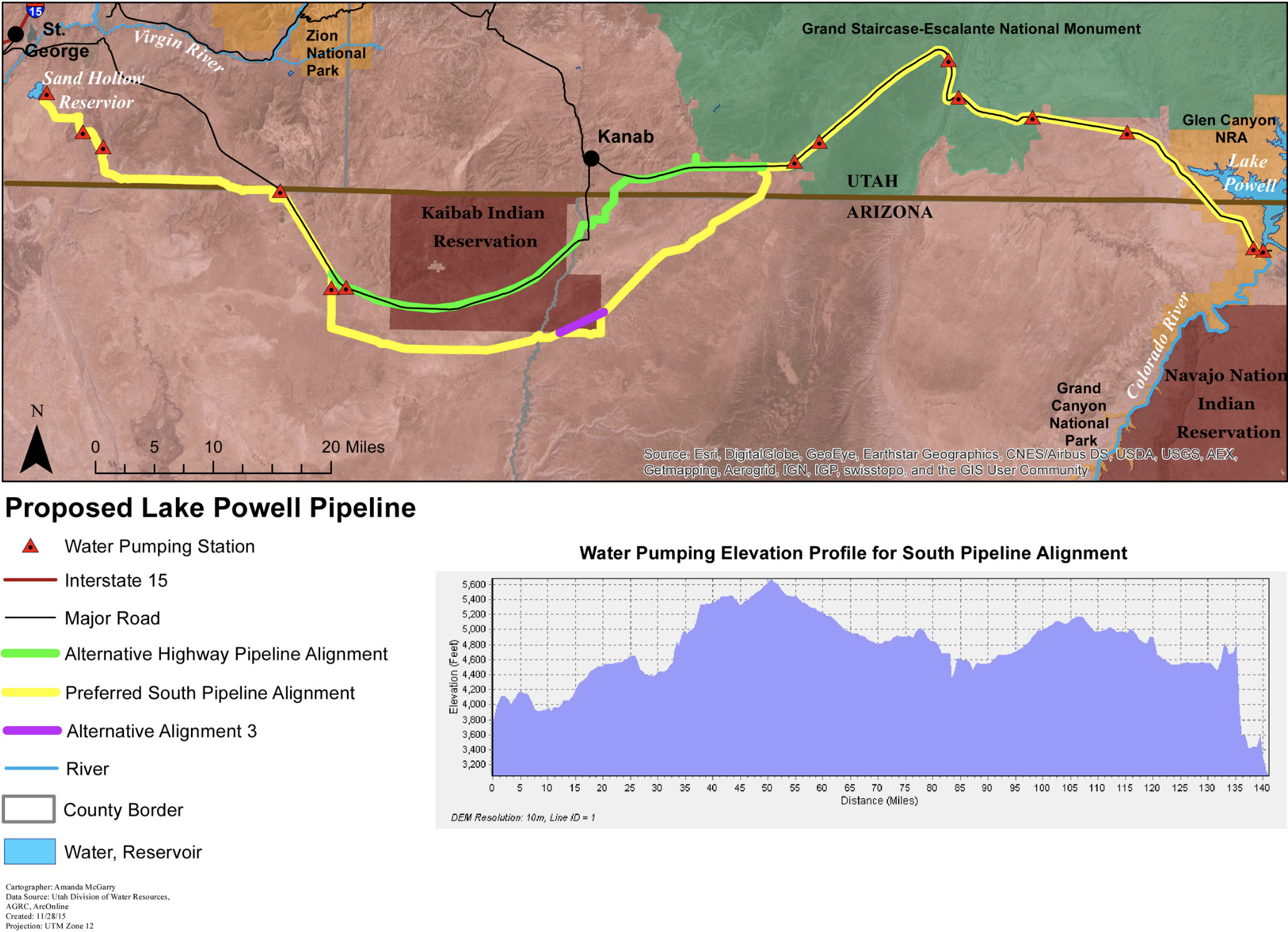
At the same time that Colorado River users are beginning the renegotiation process, the state of Utah continues to pursue water projects that affect the Colorado River and Lake Powell. Local leaders in Washington County are exploring a “Lake Powell Pipeline,” a 140-mile pipe that would pump water from Lake Powell to the St. George area.
Lawmakers in Salt Lake City are considering the possibility of diverting water from the Green River and the Bear River, the former of which is a tributary to the Colorado and eventually feeds Lake Powell, to water users on the Wasatch Front. More water rights have been allocated from the Colorado River than there is actual water to distribute, and historically, the first users of the existing water, and the owners of water infrastructure, retain the rights to continue using the water.
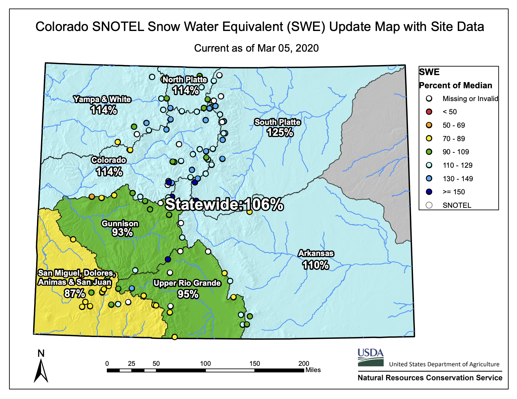
On March 5, the snow water equivalent in Northwest Colorado was at 114% of average, according to data from the Natural Resource Conservation Service Snotel.
[Joel] Gratz said his numbers are closer to 120%.
In the southwestern corner of Routt County, the snow water equivalent is between 88% and 95% of average.
February was a big month for snow, with a snowpack growth of 44% above average, Gratz said…
Ellen Bonnifield, a local weather observer in Yampa for the National Weather Service, said she’d recorded 38.8 inches of snow in February, and 122 inches for the season. The average for the whole season in Yampa is about 118.9 inches, she said.
In the more than 25 years she’s been an observer, Bonnifield said this February was second only to 1996, when she recorded 40.5 inches for the month.
A Snotel telemetry site maintained by the Conservation Service on Rabbit Ears Pass, at an elevation of 9,400 feet, recorded a snow depth of 71 inches as of March 5, and a snow water equivalent of 22.7 inches. Snow depth at the Tower telemetry site, which has a 10,500 feet elevation on Buffalo Pass, was at 110 inches, with 39.4 inches of snow water equivalent…
At the Lynx Pass telemetry site, with an elevation of 8,880 feet, the snow depth was 42 inches with 12.1 inches of snow water equivalent as of March 5. The Bear River site, at 9,080 feet in elevation located south of Yampa in the Flat Tops area, had a recorded snow depth of 41 inches, with 10.6 inches of snow water equivalent.
Peak snowpack is considered at the first or second weekend in April, Pokrandt said.
As the beginning of the runoff season nears in April, Pokrandt said, the forecast for runoff in the Yampa River at Maybell is estimated to be 108% of average.
It is still about a month away from numbers that will tell a more meaningful story about snowpack and runoff, he said. The amount of moisture already in the soil before the first snow falls has an impact on the runoff amounts. First, the snow melts into the ground, then it runs off into the streams and rivers.
In general across the west, Pokrandt said, the soil is on the drier side this year, due to a monsoon season — July and August — that was a “nonsoon” season.
Following record-breaking October and February snowfall, the Blue River basin snowpack is above average. Treste Huse, a senior hydrologist for the National Weather Service in Boulder, said the snow-water equivalent — or how much water is held in the snowpack — is 129% of average while the Colorado River basin’s snow-water equivalent is 116% of average.
The seasonal peak for snowpack is in April, according to Huse, who reported that the Blue River basin is at 95% of the seasonal median, or what you would normally see by the April peak. She cautioned that the data doesn’t necessarily mean the above-average snowpack trend will continue…
When looking at five-year increments of snowpack data, Huse said one or two years are usually above average. Going forward, Huse explained that there are no La Niña or El Niño phenomenons affecting precipitation. She said this “neutral cycle” is predicted to continue through spring and summer…
“The Colorado Basin River Forecast Center is anticipating low cumulative runoff numbers for this spring and summer from the San Juan Basin southward,” the center reported March 3. “This is due not only to low snowpack but also very low soil moisture prior to the start of the cold season.”
Click on a thumbnail graphic to view a gallery of drought data from the US Drought Monitor.
US Drought Monitor March 3, 2020.
West Drought Monitor March 3, 2020.
Colorado Drought Monitor March 3, 2020.
Click here go to the US Drought Monitor website. Here’s an excerpt:
This Week’s Drought Summary
The pattern has been less active over the CONUS over the past 7 days, with high pressure dominating over much of the western CONUS. Storm systems riding up and over the Pacific ridge resulted in some precipitation in the Pacific Northwest, but not enough to alleviate the dryness there, particularly for Oregon. Meanwhile a low-pressure system propagated northeastward along the East Coast and out of the domain early in the period, adding to surpluses in the Tennessee and Ohio Valleys. Drought continued to expand in the West, as dry conditions persisted over much of the region. Parts of Oregon and California saw increases in D0 and D1 coverage, while areas of D0 were expanded slightly in Montana. There was some D1 added to northeastern areas of Colorado (High Plains Region), as the past 60 days have seen drier than normal conditions. Drought intensification and expansion also continues in southern Texas (Southern Region), in association with continued dryness, low humidity, and high winds over the past week. The Midwest and Northeast continue to remain as is for now, as 90-day precipitation surpluses are widespread across many of these areas, with other areas near normal. Some D0 reduction in southern Georgia (Southeast Region) was made due to recent heavy rainfall. However, the Florida Peninsula saw some D0 expansion north and east of Tampa, with year-to-date (YTD) precipitation estimates between 25 and 50 percent of normal…
Some D1 was added over northeast Colorado with YTD precipitation 50 to 65 percent of normal. Stream flows were also running well below normal for this area. Recent ground observations support this addition of D1. SPIs over several time periods also show deterioration. The rest of the High Plains Region has long-term surpluses of precipitation. No D0 development expansion was made elsewhere…
Westward D1 expansion into the San Francisco Bay area and Mendocino County, northward D1 expansion into Trinity and Shasta Counties, and southwestward D1 expansion into San Luis Obispo County in California was warranted in association with the continuance of a much drier-than-normal water year to date (since October 1, 2019; WYTD). Many areas are seeing WYTD precipitation of 25 to 50 percent of normal and YTD precipitation 10 to 25 percent of normal. Some locations near San Francisco saw no precipitation for the month of February. However, reservoir levels are in good shape overall across California, despite the below normal snowpack. In addition, there have been several reports of non-managed creeks and streams running dry and severe lack of vegetation, resulting in producers supplementing feed for livestock. In addition, much of the state has seen above normal temperatures over the past week, further exacerbating the dryness and reducing longevity of existing snowpack. D1 was also expanded in central and southwestern Oregon, as stream flow conditions have continued to deteriorate, precipitation was lacking, and snowpack was below normal. Many unregulated rivers have fallen below the 10th percentile (much below-normal). WYTD precipitation deficits are greater than 12 inches across much of southwestern Oregon, including coastal areas. In contrast, Washington’s March 3 basin average SWC was above normal, and has received above normal precipitation over the past 30 days, mainly concentrated in areas with no drought, but this added to the snowpack and near-normal stream flows in drought areas, leading to status quo this week. The Four Corners Region is also status quo this week as the last 14 days has seen enough precipitation to prevent deterioration, but not enough for improvement. Some D0 expansion in Montana in favor of the 90 day SPI. Some D1 expansion in western Utah into Millard County, which has seen 5 to 10 percent of normal precipitation over the past 90 days…
Drought intensification over southern Texas continued, along with expansion into adjacent coastal areas. Stream flows are below normal for many areas, and recent high winds and low humidity have enhanced surface soil moisture loss. YTD percent of normal precipitation was 25 to 50 percent for much of southern Texas, with less than 10 percent along the Rio Grande Valley. This is on top of receiving essentially no precipitation over the past 30 days, and beyond, for many areas south of the I-10 corridor. D0 remains for portions of the immediate Gulf Coast in Louisiana, Mississippi, and Alabama this week, although dryness has crept northward in these areas with the sharp north-south precipitation gradients in recent weeks…
Looking Ahead
During the next 5 days (March 5-9), heavy rain will be exiting the Southeast early in the period, leaving behind an estimated 1.5 to 3 inches of rainfall. Light to moderate precipitation is forecast along coastal areas of California, the Sierra Nevada, and the Four Corners Region later in the period. This energy is expected to transition to the central Great Plains by day 5, with estimates of greater than 0.5 inches centered just west of the Mississippi River. The 6-10 day (March 10-14) extended range forecast suggests a more transient pattern over the much of the CONUS (indicated by weak height anomalies and zonal flow), favoring above normal precipitation over much of the country. Enhanced probabilities for above normal precipitation are favored during the 6-10 day period over southern California and the Four Corners Region, in association with a potential mean trough propagating eastward underneath a Pacific ridge of high pressure. Meanwhile, an active storm track is favored to remain in place across Alaska, enhancing probabilities for above normal precipitation over much of the state during the extended range.
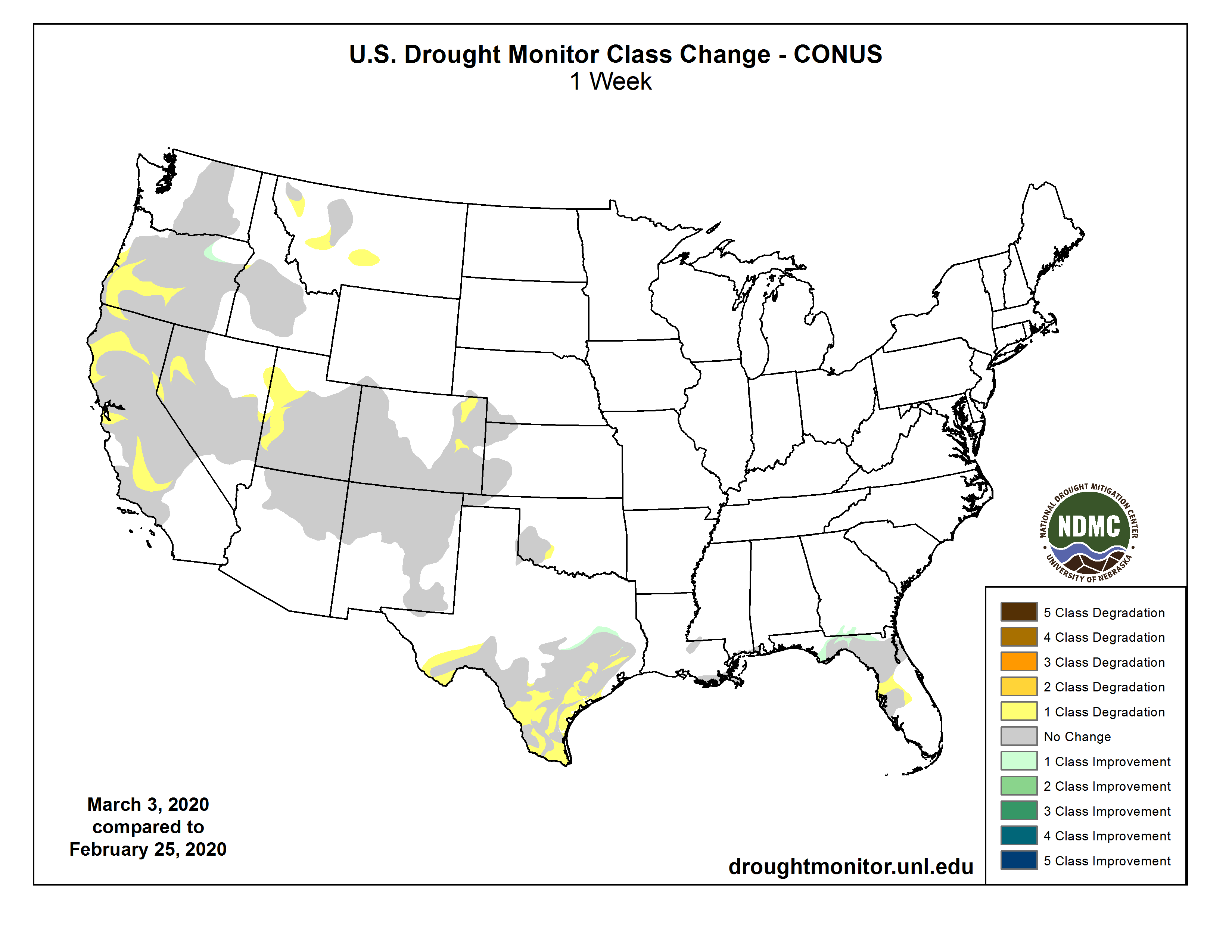
Here’s the one week change map.
US Drought Monitor one week change map ending March 3, 2020.
And, just for grins, here’s a gallery of early March Drought Monitor maps.
Steve Lowe gazed into a gaping pit in the heart of the California desert, careful not to let the blistering wind send him toppling over the edge.
The pit was a bustling iron mine once, churning out ore that was shipped by rail to a nearby Kaiser Steel plant. When steel manufacturing declined, Los Angeles County tried to turn the abandoned mine into a massive landfill. Conservationists hope the area will someday become part of Joshua Tree National Park, which surrounds it on three sides.
Lowe has a radically different vision.
With backing from NextEra Energy — the world’s largest operator of solar and wind farms — he’s working to fill two mining pits with billions of gallons of water, creating a gigantic “pumped storage” plant that he says would help California get more of its power from renewable sources, and less from fossil fuels…
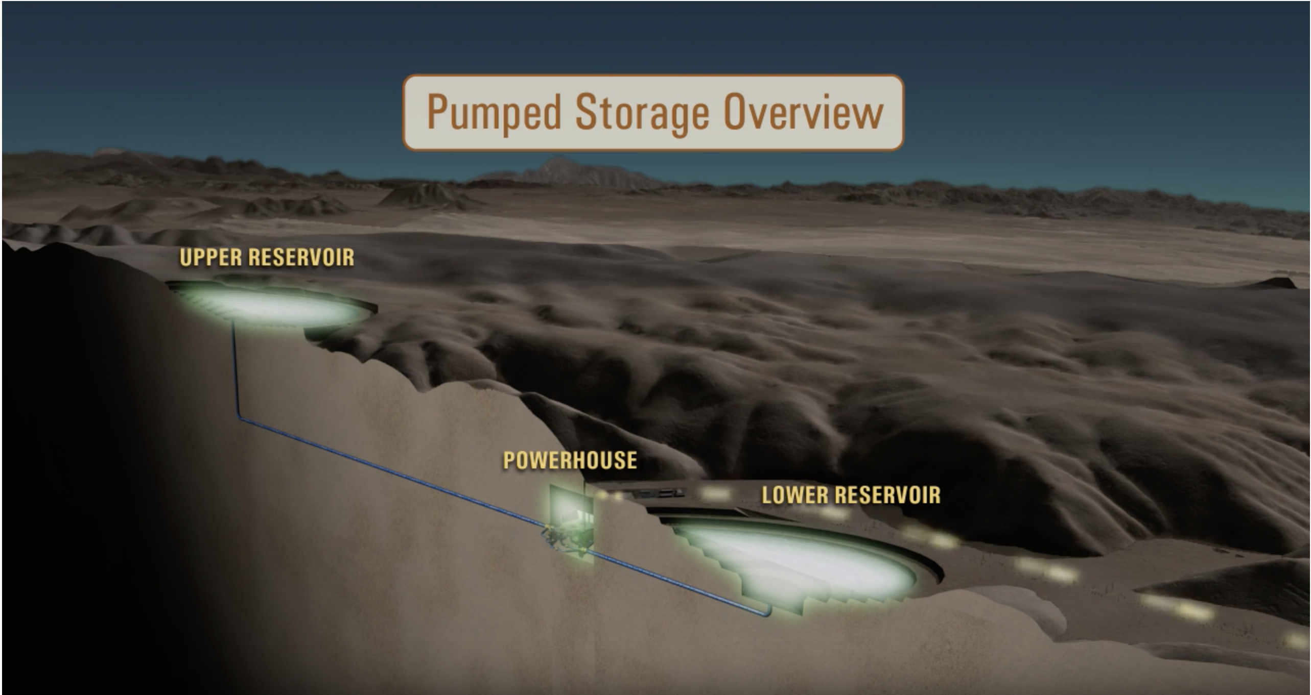
Pumped storage hydro electric.
At Eagle Mountain, one of several abandoned mining pits would be filled with water, pumped from beneath the ground. When nearby solar farms flood the power grid with cheap electricity, Lowe’s company would use that energy — which might otherwise go to waste — to pump water uphill, to a higher pit.
When there’s not enough solar power on the grid — after sundown, or perhaps after several days of cloudy weather — the water would be allowed to flow back down to the lower pit by gravity, passing through an underground powerhouse and generating electricity…
The Eagle Mountain plant wouldn’t interrupt any rivers or destroy a pristine landscape. But environmentalists say the $2.5-billion facility would pull too much water from the ground in one of the driest parts of California, and prolong a history of industrialization just a few miles from one of America’s most visited national parks.
Lowe rejects those arguments, saying his proposal has survived round after round of environmental review and would only drain a tiny fraction of the underground aquifer.
The project’s fate may hinge on a question with no easy answer: How much environmental sacrifice is acceptable — or even necessary — in the fight against climate change?
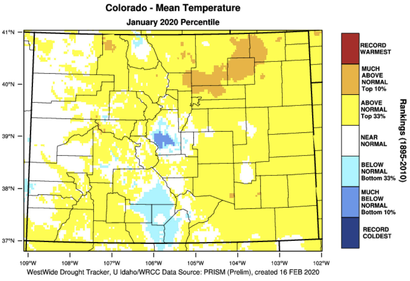
From the Colorado Water Conservation Board (Megan Holcomb/Tracy Kosloff):
2020 is off to an average start. But how? Globally, January was the warmest January on record and 4th warmest month ever on record with respect to global averages. In Colorado, January was warm throughout the entire state except for South Park and the San Luis Valley. After a few early warm days in February, the temperature flipped for Colorado, with most of the state colder than average. Thus far, the Colorado water year (Oct to Feb) shows business as usual, with statewide snowpack at 114% of record median and reservoir storage at 105% of average. The Intermountain West region is similarly experiencing typical winter patterns. This February, Colorado precipitation has been heaviest in the central and north mountain ranges.
● The 90-day Standardized Precipitation Index (SPI) (from Nov 18 – Feb 5) shows geographically distributed average precipitation statewide. The eastern plains are exceptions with SPI values slightly below average.
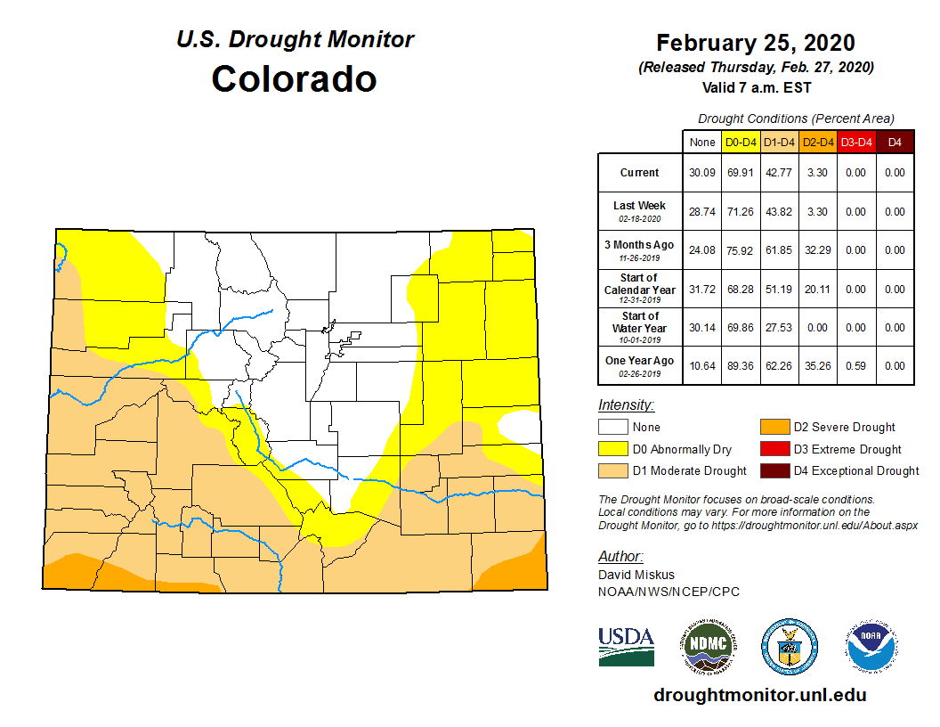
● The U.S. Drought Monitor, released February 18, shows similar drought distributions to last month. D0 (abnormally dry) and D1 (moderate) conditions cover 68% of Colorado. D2 (severe) drought covers 3% of the south east and west state corners and 29% of the state (north-central) remains drought free.
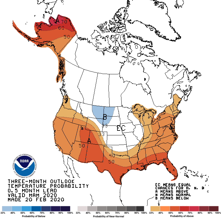
● While equatorial sea surface temperatures were warmer than average over the Pacific the last few months, ENSO forecasts still suggest conditions will revert back to neutral conditions for spring and summer 2020. This could mean reduced odds of SW Colorado spring moisture.
Colorado Drought Monitor February 25, 2020.
● NOAA’s Climate Prediction Center maps continue to show warmer than average temperature outlooks March through May for the SW half of the state, and equal chances of near, above, or below average precipitation outlooks.
● Reservoir storage remains near to above normal: 85% to 127% of average in all major basins and 105% of average statewide.
● SNOTEL Snow Water Equivalent (SWE) sites show statewide snowpack at 114% of record median (as of Feb 14).
● Water providers and water users did not report any unusual impacts or concerns at this time.
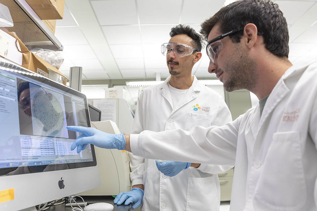
Mutagens, such as disinfection byproducts, in treated wastewater elicit a colorimetric response in this 96-well plate. Photo credit: King Abdullah University of Science and Technology
From King Abdullah University of Science and Technology:
Ultraviolet light could thwart antimicrobial resistance by damaging DNA material in wastewater.
Conventional wastewater disinfection using chlorine could facilitate the spread of antimicrobial resistance in bacteria1. Treating some types of wastewater with ultraviolet (UV) light instead could be part of the solution2, according to a study at KAUST’s Water Desalination and Reuse Center, published in the journal Environmental Science & Technology.
Bacteria are rapidly developing mechanisms to evade the effects of antimicrobial drugs, and this resistance is increasingly threatening public health. Pharmaceutical compounds and resistant bacteria that reach municipal and agricultural wastewater are partially to blame. Interestingly, the antimicrobial resistance of bacteria in wastewater entering water treatment plants is lower than after the wastewater leaves the treatment plant.
This may be because during wastewater disinfection, genetic material breaks out of bacteria into the surrounding water. This extracellular DNA can contain antimicrobial resistance genes. “The big question is are these extracellular resistance genes of concern to public health?” says KAUST postdoctoral fellow, David Mantilla-Calderon. “We don’t have an answer to this question yet, but the first prerequisite these genes must fulfill to be of concern is that they need to be harbored within a viable bacterial cell. This is only possible through a process called natural transformation, which allows extracellular DNA uptake and integration into the bacterial chromosome.”
Mantilla-Calderon and colleagues at KAUST found1 that natural transformation was stimulated in a bacterium commonly found in water and soil, called Acinetobacter baylyi, when it was in the presence of the chlorine byproduct, bromoacetic acid. They found that this disinfection byproduct caused DNA damage in the bacterium, inducing a DNA repair pathway that is known to also increase the integration of foreign DNA into the bacterium’s genome.
Ph.D. student Nicolas Augsburger next investigated2 the effects of sunlight and one component of sunlight, UV light, on natural transformation. “We wanted to see if there was a safer way to disinfect treated wastewater without provoking an increase in natural transformation in environmental bacteria,” he explains.
Interestingly, Augsburger and his colleagues found that, similar to bromoacetic acid, treatment with either the full spectrum of sunlight or only with UV light caused increased natural transformation in Acinetobacter baylyi.
David Mantilla-Calderon (left) and Nicholas Augsburger discuss the results of their UV treatment of the natural transformation they stimulated in a common bacterium when it was in the presence of the chlorine byproduct, bromoacetic acid, casting doubt on commonly used wastewater treatment. Photo credit: King Abdullah University of Science and Technology
“What surprised us was the finding that after treatment with UV light, the bacterium’s genes were damaged to the extent that they were no longer functional,” says Augsburger. “Thus, although treatment with UV light increased the integration of foreign DNA into the bacterium, just like disinfection byproducts and sunlight, it will not be able to express those genes.”
“Our studies question our current reliance on the use of chlorine as the final disinfection step in most wastewater treatment plants,” says microbiologist Peiying Hong, who supervised the studies. “A disinfection strategy using UV light could be considered for disinfecting low turbidity water. This could help in minimizing wastewater contribution to antimicrobial resistance.”
Hong’s lab is now investigating how various stressors might interact to affect uptake and integration rates of extracellular DNA into bacteria.
Attorneys for 21 youth climate activists are filing an appeal after a judge ruled they cannot sue the federal government for failure to act on climate change.
The activists sought a court order to force the government to phase out the use of fossil fuels, but a panel of three judges in January ruled such a decision was beyond the reach of the judicial branch.
Lawyers are now petitioning for a ruling from all 11 judges in the 9th Circuit, arguing that reversing an earlier district court decision fails to ensure the youth activists’ right to a trial.
“In overturning the district court, the majority fundamentally changed the way our branches of our government operate, placing the president and Congress beyond the reach of judicial oversight. If this opinion stands, there will be no more constitutional checks and balances on government conduct,” Philip Gregory, a co-counsel for the youth plaintiffs, argued.
In August, two of the three judges said they did not have the power to push the government to address climate change.
“Reluctantly, we conclude that such relief is beyond our constitutional power,” 9th Circuit Court of Appeals Judge Andrew Hurwitz wrote for the majority. “Rather, the plaintiffs’ impressive case for redress must be presented to the political branches of government.”
But the decision from the court’s majority sparked a powerful dissent from Judge Josephine Staton, who said the climate change issues raised in the suit were within the court’s authority to redress, and warned that “waiting is not an option.”
The youth plaintiffs in Juliana v. United States attended the Ninth Circuit hearing in December. Photo credit: Robin Loznak
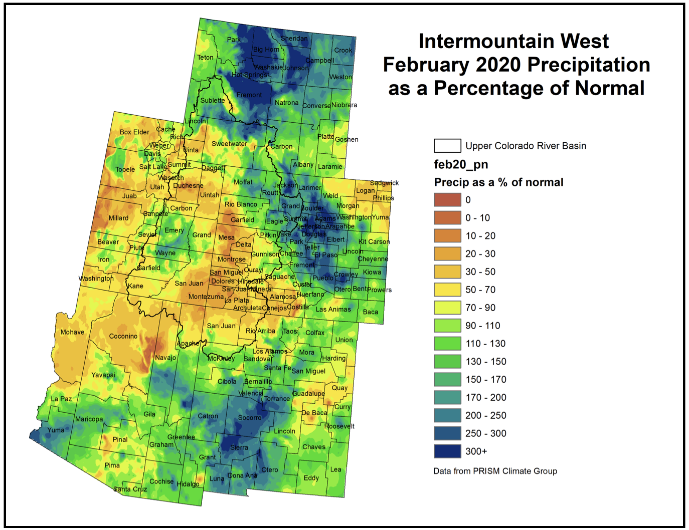
Intermountain West February 2020 precipitation as a percent of normal via the Colorado Climate Center.
Click here to read the current assessment. Click here to go to the NIDIS website hosted by the Colorado Climate Center. Here’s the summary:
Summary: March 3, 2020
Mostly dry, yet cooler than average conditions prevailed across the IMW over the last week. There were two waves of precipitation that impacted the region. A cold front dropping out of the northwest early last week brought up to several tenths of moisture to eastern Wyoming and Colorado. A second system impacted Colorado Sunday into Monday. Neither wave carried large amounts of moisture, and neither gave any more than a glancing blow to areas currently experiencing drought.
The high elevations of the IMW by and large had a drier week than normal for late February/early March. Snowpack is still strong through most of the IMW with a few stations already over 100% of normal peak values. However, recent dryness has led to a regression in snowpack values for the southern portion of the region. The San Juans in Colorado have regressed to 89% of average for this point in the season. Snowpack is also below normal in Arizona and western New Mexico. The Colorado Basin River Forecast Center is anticipating low cumulative runoff numbers for this spring and summer from the San Juan Basin southward. This is due not only to low snowpack, but also very low soil moisture prior to the start of the cold season. Snowpack numbers are above normal east of the Continental Divide.
Surface water supplies are in generally average to above average conditions for small-to-medium reservoirs across the IMW. This is thanks in large part to a high snowpack in 2019. The giant exceptions are Lake Powell, and Lake Mead, which have been consistently lower than normal for years. Powell and Mead would need an anomalous cool, wet period spanning multiple years to return to levels seen in the 1980s and 90s.
Grasslands east of the Continental Divide are seeing mixed surface conditions, but things have been trending drier. According to the NLDAS NOAH model from nationalsoilmoisture.com, northeastern Colorado is seeing widespread dry topsoils and root zone soils. Soil moisture in northeast Wyoming is in better condition.
Dry weather is in the forecast for much of the UCRB and eastern Colorado. The Tetons, Uintahs, and western Colorado Rockies are forecasted to receive 0.50-1.50″ of moisture in the week to come. Stronger than normal elevational gradients are expected with this moisture. Lower elevations are unlikely to see more than 0.10″. Conditions east of the divide will be dry. The 8-14 day outlook will be important to keep an eye on. NOAA’s Climate Prediction Center currently favors increased chance of above normal precipitation over the Four Corners Region over this time period. Given the persisting drought conditions, and deteriorating snowpack, a widespread precipitation event over this area would be valuable.
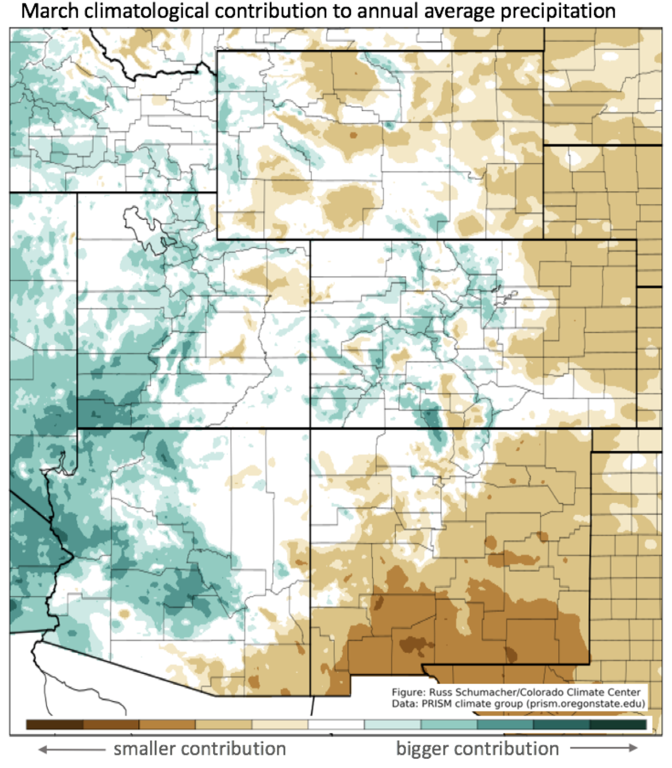
And, here is the March climatological contribution to annual precipitation map from Russ Schumacher.
In October 2020, representatives of the 196 countries that are party to the United Nations Convention on Biological Diversity (CBD) will gather in Kunming, China, to finalize a new Global Biodiversity Framework. Like the 2015 Paris climate accord, this new agreement could mark a turning point in how we manage our relationship to nature.
But biodiversity advocates must learn an important lesson from climate activists. Global climate action gained momentum only after it became clear that the issue was about more than the environment, and would require a transformation of transport, energy, agriculture, infrastructure, and many industries. Likewise, the rapid loss of biodiversity that we are witnessing is about much more than nature. The collapse of ecosystems will threaten the wellbeing and livelihoods of everyone on the planet. Accordingly, the CBD must move beyond traditional notions of “conservation” to engage with all relevant sectors of the economy and civil society.
Since its creation following the 1992 Rio Earth Summit, the CBD has been largely successful in pushing countries to establish new protected areas, such that nearly 15 percent of global land areas are now under some sort of park designation (though the share of protected marine areas is much smaller). But despite this relative success, biodiversity loss has continued, suggesting that the creation of nature refuges is necessary but not sufficient. To slow and halt the rapid decline of species and habitats, we must address how human societies manage land and seascapes and the resources that are being extracted from them.
As matters stand, all of our economic incentives are geared toward encouraging activities that drive biodiversity loss. Agriculture, infrastructure, and urban areas are all rapidly expanding, as are extractive industries like forestry, mining, and fishing. In addition to converting landscapes directly, these practices can disrupt natural habitats and degrade much larger areas, by creating access points for illegal hunting, logging, and other activities. Pollutants, runoff, and industrial and agricultural water usage cause still more damage.
A mere 5 percent of the planet’s land surface remains unaltered by human activities, and that share is likely to shrink further unless we institute changes soon. A recent study by scientists from The Nature Conservancy (TNC) finds that if current trends hold, the construction of roads and energy infrastructure (including renewables), together with mining and agriculture, threatens to double the conversion of remaining intact wild areas in Latin America, and to triple converted lands in Africa by 2050.
Responsibility for protecting the natural world has traditionally fallen to environment ministries, park managers, and conservationists, all of whom will be at the negotiating table next year. But to be truly transformational, the post-2020 Global Biodiversity Framework must also involve finance, planning, transportation, energy, and agriculture officials, particularly those with the clout to effect change across entire economies.
Agriculture ministries, for example, are critical for maintaining natural habitats and protecting biodiversity corridors for pollinators and other wildlife. To slow habitat conversion, governments can make agricultural subsidies conditional on environmental considerations, and require foreign agribusinesses to prove that imports are produced without converting natural habitats.
Similarly, energy generation, transportation, and infrastructure are all major drivers of biodiversity loss, requiring more robust planning and mitigation efforts by ministries far beyond those charged with conservation. Whether by regulation or incentives, governments must do more to minimize the impact of these activities on nature. And when avoidance is impossible, projects should be required to compensate for biodiversity loss by investing in the restoration of degraded or deforested lands. To that end, the new framework should establish guidelines for how specific sectors can improve over time.
Ensuring real accountability and transparency requires a clear agenda. But what, specifically, should countries be accountable for? TNC has proposed a metric based on the “net gain for nature,” which would enable parties to show year-on-year improvements in the condition of natural habitats, and of biodiversity within production landscapes such as agricultural lands.
Admittedly, this kind of indicator is harder to measure than are more standard benchmarks such as protected acreage. But with new low-cost spatial technologies such as geographic positioning systems (GPS), geographic information systems (GIS), and remote sensing, the data needed to measure progress is well within reach. Ideally, we would assess the conditions of every habitat at a global scale, forming a detailed understanding of all ecosystems. And with these data, we could then monitor progress in habitats by country, ecoregion, or biome.
Saving nature is not a task for government alone; it must be a whole-of-society effort. Even with optimal legislation and enforcement, governments probably cannot eliminate all of the main drivers of biodiversity loss. Support from business, local governments, Indigenous communities, civil-society groups, and faith-based organizations will be essential. A sector-based approach that supports “net gains for nature” can be a platform whereby all stakeholders will make voluntary commitments to our broader goals.
The international community has less than one year to negotiate a framework capable of transforming our relationship to nature. If governments want the CBD meeting in Kunming to be a turning point, they will have to engage in the hard work of overhauling how we manage our land and sea resources through all stages of extraction, production, and consumption. That can happen only if negotiators recognize that the Global Biodiversity Framework is not just a matter for environmentalists.
This $2+ billion project would pump 28 billion gallons of water 2,000 feet uphill across 140 miles of desert to provide just 160,000 residents in Southwest Utah with more water. Graphic credit: Utah Rivers Council
…the Utah House of Representatives on Tuesday passed HCR22, which makes clear to neighboring states and policymakers that Utah will someday develop its unused portion of the Colorado River…
Utah has not fully developed its full 23% allocation of the river, with much of that unused water flowing downstream to lower basin states.
Rep. Brad Last, R-Hurricane — who lives in southern Utah where the proposed Lake Powell Pipeline would take the unused allocation — said it is important Utah send a message to its neighbors that the resource will be developed…
The resolution passed on a 57-13 vote because the Lake Powell Pipeline — and development of the Colorado River in light of drought and a changing climate — has stoked opposition by some groups that assert it’s a failed proposal that will drain an already struggling river.
Last’s measure urges development of the water in the most expeditious fashion, and Rep. Joel Briscoe, D-Salt Lake City, questioned what those parameters might be.
“As soon as we can effectively use it,” Last told him.
Briscoe added that conservation practices should have been emphasized more in the resolution and addressed higher in the language of the measure.
But Rep. Lowry Snow, R-Santa Clara — another lawmaker who lives in the Utah region where the pipeline would deliver water — said the resolution is a critical message that merits support.
“It is important as a state that we indicate our intent to preserve our allocation,” Snow said. “I can’t begin to evaluate the monetary value of our water right in the Colorado. It is invaluable and will become more so in the future.”
The resolution is now awaiting action in the Senate.
Brad Udall: “…latest version of my 4-Panel plot thru Water Year (Oct-Sep) of 2019 of the #coriver big reservoirs, natural flows, precipitation, and temperature. Data goes back or 1906 (or 1935 for reservoirs.) This updates previous work with @GreatLakesPeck
The latest figures on the “snow water equivalent” in and near the headwaters of Gore Creek and the Eagle River includes some good news, thanks to a snowy February.
The three main snow measurement sites used by the Eagle River Water & Sanitation District show numbers well above 30-year median figures.
As of March 2, Vail Mountain’s snow measurement site is at 117% percent of that 30-year median. Fremont Pass, the closest measurement site to the headwaters of the Eagle River, is at 124% of the 30-year median. The measurement site at Copper Mountain, the closest to the headwaters of Gore Creek, has the most snow, at 139% of the 30-year median.
In fact, the Copper Mountain measurement site has now accumulated its peak snow water equivalent compared to the 30-year median. That peak generally comes in early May…
That’s good news, for now, but several weeks remain in the area’s “snow year,” with the usually snowiest months of March and April still to come…
In the 2018-19 snow year, a snowy March boosted the snowpack. But a dry April caused the snowpack at Vail to peak in early April, instead of the usual late-April peak.
In fact, the Vail snowpack finished the previous snow year a bit below the 30-year median…
While an even chance of normal precipitation is fine, much of the state remains in some form of drought, according to the Colorado Climate Center at Colorado State University. Those conditions range from “abnormally dry” to “moderate drought.” Only the far southwestern corner of Eagle County is on that map. The rest of the county is drought-free.
And, here’s the Westwide SNOTEL basin-filled map for March 3, 2020 via the NRCS.
In 2012, countless lakes across the central United States went dry, including Teller Lake No.5, in Boulder County, Colorado. Sceintists are exploring the physical processes that can drive flash droughts, the existing capabilities to predict them and what is needed to establish an effective early warning system. Credit: UCAR/Carlye Calvin.
Flash droughts are a type of extreme event distinguished by rapid intensification of drought conditions with severe impacts. They unfold on subseasonal to seasonal timescales (weeks to months), presenting a new challenge for improving predictions of when flash droughts occur.
In new research published in the March 2 edition of Nature Climate Change, a multi-institutional collaboration including Lawrence Livermore National Laboratory (LLNL) climate scientist Celine Bonfils, explored current understanding of the physical processes that can drive flash droughts, the existing capabilities to predict them and what is needed to make progress to establish effective early warning of flash droughts.
“There is a growing awareness that flash droughts can trigger severe agricultural impacts while the mechanisms at their origin need more investigation. This makes flash droughts a compelling frontier for research, monitoring and prediction,” Bonfils said.
Drought is perhaps the most complex and least understood of all weather and climate extremes. Despite an increasing drought risk in a future warmer climate, this risk is often underestimated and continues to remain a “hidden hazard.” Drought can span timescales from a few weeks to decades, and areas from a few kilometers to entire regions. Impacts usually develop slowly, are often indirect and can linger for long after the end of the drought itself.
“A better understanding of the physical processes leading to different types of droughts and how they affect societal and environmental vulnerability is more important than ever,” Bonfils said.
The impact of droughts arise in part from their long duration, such as the Dust Bowl and the 2011-2015 California drought, and have formed strong imagery in the U.S. Megadroughts lasting more than 20 years also have been documented in tree-ring records.
While plenty of research has been done on long-term droughts, not as much has been conducted on the rapid development, in the space of a few weeks, that sometimes occurs.
One flash drought that brought attention to the phenomenon occurred in the Midwest in 2012. The extent of abnormally dry conditions expanded from 30 percent of the continental United States in May 2012 to more than 60 percent by August. This event had significant impacts for agriculture and water-borne transportation in the region. The widespread impacts of the 2012 event caught the attention of the U.S. public and leaders.
But flash drought is not confined to the U.S. Processes that can produce flash droughts are the focus of research in China. In southern Queensland, Australia, a flash drought in early 2018 de-vegetated the landscape and drove livestock numbers to their lowest level in a century, a significant impact for agriculture.
“A drought monitoring and early-warning system is the foundation of effective, proactive drought policy, because it enables notice of potential and impending drought conditions,” said Angeline Pendergrass, a scientist at the National Center for Atmospheric Research and lead author of the paper.
An ideal early warning system would identify climate and water-resource trends and detect the emergence or probability of occurrence of a flash drought, as well as the likely severity of droughts and their impacts.
“Reliable information must be communicated in a timely manner to water and land managers, policy makers and the public through appropriate communication channels, to trigger actions documented in a drought plan, which is particularly critical for flash droughts,” the authors said. “That information, if used effectively, can form the basis for reducing vulnerability and improving mitigation and response capacities of people and systems at risk.”
Graphic credit: The Center For Colorado River Studies
From the Center for Colorado River Studies (Jian Wang and David E. Rosenberg):
Future consumptive water use is difficult to predict because underlying factors that influence consumptive use—future population growth, irrigation technology and practices, climate, agricultural commodity prices and other factors—are individually difficult to forecast. Future consumptive water use cannot be forecast as a point value within a range, nor with probabilities. Instead, future consumptive water use can only be authentically described using a set of scenarios that represent possible future conditions.
Since the 1980s, Bureau of Reclamation and the Upper Colorado River Commission have developed many scenarios of possible future consumptive use for the Upper Colorado River basin (Figure 1, dashed colored lines). Each scenario describes one possible trajectory of future consumptive water use out to the year 2040, 2050, and 2060. When averaged over the long term, each scenario of future consumptive use over-estimated the observed consumptive use reported by Bureau of Reclamation in its regular Colorado River Consumptive Use and Loss Reports (Figure 1, solid black line). Many other water systems also consistently overestimate their demands (Heberger, 2016; Kindler and Russell, 1984). Additionally, the trace of observed use has many more year-to-year variations due to changing precipitation and out-of-basin exports than the forecast scenarios. The disparity between the scenarios of possible future consumptive use and observed use show the inherent difficulties and uncertainties to estimate future demands and develop scenarios that span all possible future conditions. Thus, it is better to develop more scenarios to cover a wider range of future conditions. However, including more scenarios also increases the computational burden of analysis.
The question then is: How should Colorado River stakeholders manage the future Colorado River in the face of these water demand and other uncertainties? For insight, read our white paper “Managing the Colorado River for an Uncertain Future.”
The EPA is involved in multiple PFAS-related criminal investigations, the agency said Wednesday, adding another knot to an already complex legal landscape for “forever chemicals.”
The Environmental Protection Agency acknowledged the probes in a new progress report on its 2019 PFAS Action Plan. The document says the agency “has multiple criminal investigations underway concerning PFAS-related pollution.”
[…]
EPA Administrator Andrew Wheeler told Bloomberg Law the agency is committed to using all its enforcement authorities to address contamination.
“We do use all of our enforcement tools, so if it’s warranted for criminal, we would certainly look to do that,” he said after a National Association of State Department’s of Agriculture event in Arlington, Va.
Wheeler declined to give further detail, saying he couldn’t comment on pending investigations. Federal criminal investigations and related files are confidential.
“Multiple investigations clearly signals EPA is serious about understanding what the manufacturers knew about the chemicals’ toxicity and when they knew it,” said Earth & Water Law Group founder Brent Fewell, an EPA official during the George W. Bush administration. “EPA is likely focused on whether the PFAS manufacturers knowingly failed to disclose to EPA the known risks of the chemical.”
“It’s not at all surprising,” he added, “that EPA has signaled a criminal investigation or even multiple investigations into PFAS given the heightened health concerns and public attention.”
In case you forgot, Colorado State University is a land-grant institution, originally formed as an agricultural college.
To further the University’s initial mission, the College of Agricultural Sciences and the College of Veterinary Medicine and Biomedical Sciences are teaming up to start the Sustainable Livestock Systems Collaborative.
“I think the impetus really is that, you know, CSU is a land-grant university,” said Mark Zabel, CVMBS associate dean for research. “We still have a commitment to agriculture and to educating Coloradans centered around those issues.”
Zabel said that while there will be no physical building or presence, the Sustainable Livestock Systems Collaborative will be a collection of stakeholders — researchers, policy makers and producers in the livestock, agriculture and dairy industries — coming together around the idea of sustainable farming practices.
“The overall goal (is) to specifically engage with livestock production and to help producers at the grassroots (level) address firstly profitability, secondly their environmental footprint, thirdly animal health and lastly human health, particularly via food safety,” said Keith Belk, head of the department of animal sciences and co-chair of the steering committee.
Applications for director of the initiative recently closed, Belk said, and research is anticipated to begin by the fall semester of this year. Belk said they will be opening a couple more faculty positions in the coming months as well.
James Pritchett, interim dean of CAS, said professionals in the agriculture industry have been coming to CSU asking for answers to questions grounded in sustainability. The driving force behind much of the research conducted by the collaborative will be issues posed to CSU by those professionals.
“For example, as the climate changes and we have disrupted weather patterns and we have periods of drought or flood, how does that affect how we can grow crops?” Zabel asked. “We can do things like try to develop heartier strains of grain that can survive droughts or that can survive floods. We can develop better feeding and watering practices for our livestock.”
Belk added that research could be anything related to the environmental impact of farming, ranching and livestock production. Water use, water contamination, soil erosion, land management and production of greenhouse gases are all topics the collaborative wants to explore and find solutions to.
The collaborative will not only provide faculty with more opportunities to conduct research, but will allow for undergraduate and graduate students to participate as well.
“I am very committed to having all of our students — at every education level — coming together as research teams to solve these problems,” Zabel said. “In (the department of microbiology, immunology and pathology), we really emphasize undergraduate research. It’s our goal to be able to train each of our undergraduates in long-term substantive research experience.”
Pritchett said funding for the collaborative comes from repurposing a base budget that funded faculty members who have since retired or moved on, and the Office of the Provost will then match that with funding from student allocations from the general fund.
“We’re going to do some of the very best science to help create sustainable food systems,” Pritchett said. “It’s reaching across not just the college of agriculture or vet med, it’s actually across our entire campus. Where we have students interested in sustainability, we’ve got scientists that are interested in it, and we’re going to be able to do great things by working together.”
Serena Bettis can be reached at news@collegian.com or on Twitter @serenaroseb.
Little Cimarron reach downstream of the McKinley Ditch intake structure. The Little Cimarron River near the McKinley Ditch gets a boost in flows because of the state’s instream flow water loan program, which lets agricultural water users leave water in the river for the benefit of the environment. House Bill 20-1157, which aims to expand the program, is making its way through the state legislature with broad support. Photo credit: Brent Gardner-Smith/Aspen Journalism
A bill aimed at expanding Colorado’s instream-flow loan program is moving through the state legislature and has support from agricultural water users, Front Range water providers and environmental organizations, in contrast to last year when the bill ran into opposition.
House Bill 1157 [Loaned Water For Instream Flows To Improve Environment], which last week passed the House in a unanimous 60-0 vote, would allow water-rights holders to temporarily loan their water to the Colorado Water Conservation Board’s instream-flow program with the goal of improving the natural environment.
The bill expands the number of years from three to five (but for no more than three consecutive years) that a loan may be exercised within a 10-year period. The loan also may be renewed for two additional 10-year periods, meaning that holders of agricultural water rights could theoretically loan their water for the benefit of the environment for 15 of 30 years.
Environmental groups, including The Nature Conservancy, Colorado Sierra Club and Conservation Colorado, support the legislation, and so do water-user organizations, including the Colorado Water Congress, Denver Water, Northern Water, and the Grand Valley Water Users Association.
HB 1157 is sponsored by Sen. Kerry Donovan (D-Vail) and District 26 Rep. Dylan Roberts (D-Avon), both of whom floated a similar bill last year. This year’s iteration gained the sponsorship of District 57 Rep. Perry Will (R-New Castle).
After the bill faltered in last year’s legislative session, Roberts knew he had some work to do before he brought it back to lawmakers, so he spent the summer and fall talking with the many interested parties about how to improve it.
“I represent Eagle and Routt counties, which are home to four major river systems, and I know how vital it is to the Roaring Fork Valley, the Eagle River Valley and the Yampa River Valley to have a really strong flowing river,” he said.
The Eagle, Colorado and Roaring Fork rivers flow through Eagle County, and the Yampa River flows through Routt County.
“Instream-flow loans allow people to loan the water back and help the river, while not losing their water rights,” Roberts said.
n the new bill, lawmakers added more protections for water-rights holders by increasing the window for people to appeal a loan. The legislation quadruples the comment period from 15 to 60 days so that those who feel they could be harmed by a loan of water have sufficient time to raise their concerns with the state engineer
State Sen. Kerry Donovan, middle, speaks at the legislative session at Colorado Water Congress in January. Donovan and Rep. Dylan Roberts, right, along with Rep. Perry Will (not pictured) are sponsors of House Bill 20-1157, which would expand the state’s instream flow water loan program and allow agricultural water users to leave more water in the river to the benefit of the environment. Photo credit: Heather Sackett/Aspen Journalism
Instream flow program
Colorado’s instream-flow program gives the CWCB the ability to hold water rights specifically for preserving the natural environment “to a reasonable degree” by keeping water flowing in the river. Since 1973, the CWCB has appropriated instream-flow rights on nearly 1,700 stream segments, covering more than 9,700 stream miles.
Instream water rights are administered under Colorado’s prior appropriation system. And, given that none of the instream rights were in place before 1973, most of them are junior to senior agricultural water rights. Those rights, which can date to the 1860s in Colorado, have a higher priority under the “first in time, first in right” doctrine.
Senior ag rights divert significant amounts of water from the state’s rivers and streams and can even dry up some reaches in drought years. However, the state’s instream-flow program does allow owners of such senior water rights not to use their rights for irrigation and instead leave their irrigation water in the river, on a temporary basis, to bolster low flows. And the new legislation expands that option.
The temporary loan program — where water-rights owners offer, in exchange for payment, to contribute their water to one of these segments with an existing instream-flow right — has only been used seven times since its creation in 2003. In Division 5, temporary water loans have occurred on Deep Creek, the Fraser River and the Colorado River.
CWCB officials estimate an additional two to four loans under the program over the next few years.
In past deals, irrigators have been paid for the loan of their water by the state, Trout Unlimited or the Colorado Water Trust.
According to CWCB Stream and Lake Protection section chief Linda Bassi, the loan program can help boost streams in late summer when flows are low, temperatures are high and fish are stressed.
“It’s a really helpful tool for instream flows that fall short,” she said. “It’s always good to have more tools to help preserve the environment.”
Stagecoach Reservoir on the Yampa River, was part of a temporary water loan under the CWCB instream flow program. House Bill 20-1157, which aims to expand the program, is making its way through the legislature with broad support via the Applegate Group
River District support
The bill has garnered the support of the Glenwood Springs-based Colorado River Water Conservation District, which helped shape the revamped 2020 bill with its input. The River District board voted unanimously to support the measure, according to Zane Kessler, director of government relations.
“Rep. Roberts went above and beyond to make sure the bill addressed the River District’s needs and provides meaningful protections to our constituents on the West Slope and agricultural water users across the state,” Kessler said.
Also, the legislation requires the CWCB to give preference to loans of water stored in reservoirs, when available, over agricultural and other water rights diverted directly from rivers and streams. This provision was included at the request of the River District.
Kirsten Kurath, attorney for the Grand Valley Water Users Association, said lawmakers worked with the association over the past year to improve the bill from 2019.
“I think, in general, that the bill is much more protective now of other water-rights users on the stream,” Kurath said.
The bill is now under consideration by the state Senate.
Aspen Journalism collaborates with The Aspen Times and other Swift Communications newspapers on coverage of water and rivers. This story ran in the Feb. 29 issue of The Aspen Times.
FromThe High Country News, February 19, 2020 (J. Madeleine Nash):
Like a giant dragonfly, the chopper skims over undulating swaths of tussocky tundra, then touches down at Wolverine Lake, one of a swarm of kettle lakes near the Toolik Field Station on Alaska’s North Slope. Even before the blades stop spinning, Rose Cory, an aquatic geochemist from the University of Michigan in Ann Arbor, gracefully swings to the ground and beelines to the spot where, four years ago, a subterranean block of ice began to melt, causing the steep, sloping bank to slump into the water. The lake throws back a somber reflection of the clouds swirling above, its surface riffled by the wind.
Cory has brought me here because the slump provides a vivid example of the ordinarily inaccessible stuff she studies. Slick with meltwater, the chocolaty goop brims with microscopic bits of once-living things that have not touched sunlight or air or flowing water for centuries, perhaps millennia. Deeper still lie plant and animal remains that could be tens of thousands of years old, dating back to the Pleistocene, when steppe bison and woolly mammoths wandered a treeless region that extended from here across the Bering Land Bridge, all the way to Siberia.
For a moment we just stand there, staring down at the raw gash. Occasionally, Cory lifts her head to scan the shoreline for furry visitors. Despite our proximity to the field station, we are in a wild place, without roads or trails or protective shelter. For years, in fact, the lake was known to researchers only by a number. It earned its moniker in 2013, when a hardy trio of young researchers hauled their instruments nearly five miles cross-country to measure the just-discovered slump and spotted a wolverine circling a wounded caribou.
Cradled by cloudberry, dwarf birch and willow, Wolverine Lake crouches in the shadow of the snow-streaked Brooks Range. A bit over a third of a mile across, it formed during the retreat of a giant lobe of ice that, 60,000 years ago, advanced from its stronghold in those looming mountains to fill the valley of the Sagavanirktok River — commonly called “the Sag” — into which the lake’s outlet stream now drains. The irregular shoreline still traces out the shape of the marooned ice fragment that molded the bowl-like basin. The buried ice that triggered the slump is yet another relict of this long-vanished world, as are the glacier-ground rock and organic debris now streaming into the water.
2014. Toolik Field Station, operated by the University of Alaska Fairbanks’ Institute of Arctic Biology on the east shore of Toolik Lake on the northern foothills of the Brooks Range on the North Slope of Alaska.The station is supported by a cooperative agreement with the National Science Foundation. Credit: Todd Paris/UAF.
To those like Cory who know how to parse it, this slump is a source of wonder. It offers a tantalizing portal into the hidden world of permafrost, the broad band of perpetually frozen soils that undergirds a circumpolar region more than twice the size of the continental U.S. This region is now warming at twice the rate of the global average, with grave implications for the stability of permafrost and all it holds. Both small and large things are poised to emerge from this gelid domain, from common soil-dwelling bacteria, to the nearly intact carcasses of Ice Age megafauna. The most important, however, is the carbon stored in the frozen layers of leaves, stems and roots that lie beneath our feet.
“Think of a cup of tea,” Cory suggests. The carbon-rich organic materials the slump is carrying into the lake are too small to be removed with a filter, but substantial enough to impart a tinge of color and even flavor. The water samples collected from the lakes, streams and rivers here indicate that the brew percolating out of freshly exposed permafrost differs sharply from the steep that comes from shallow layers of soil that thaw and refreeze in accordance with the natural cycle of seasons.
At first, this might seem little more than a bit of esoterica to tuck away for a trivia exchange in the Toolik dining hall. Yet discerning permafrost’s protean signature is one of the keys to understanding what this vast landscape’s transformation might mean — not just for the Arctic, but for the whole planet. The research Cory conducts on a meticulous, molecular scale is just part of a larger body of work aimed at answering an increasingly critical question. Globally, the frigid soils of the Far North store almost double the amount of carbon already circulating in the atmosphere in the form of heat-trapping carbon dioxide — enough to drive the climate system into territory Earth has not experienced for millions of years.
But carbon travels an invisible highway with multiple on- and off-ramps, some of which lead into the atmosphere, some away from it. Figuring out all of this entails an excruciatingly complicated set of calculations. In order to plug in the numbers, scientists like Cory must first understand the biological and chemical processes that control the routes carbon takes through soils and surface waters. As the preserved past thaws and begins to decay, Cory wonders, just how much of that carbon will end up in the atmosphere? And how fast?
Area of the Arctic National Wildlife Refuge coastal plain, looking south toward the Brooks Range. By U.S. Fish and Wildlife Service – images.fws.gov (image description page), Public Domain, https://commons.wikimedia.org/w/index.php?curid=5787251
To peek at permafrost from below, I toured the “permafrost tunnel” bored into a hillside outside Fairbanks, Alaska, by the Cold Regions Research and Engineering Laboratory of the U.S. Army Corps of Engineers. Kept at a chilly 25 degrees Fahrenheit, it exudes a smell reminiscent of garden dirt. There, embedded in a matrix of frozen silt, I could see the bones of mammoths, the horns of bison and the roots and leaves of sedges that grew here more than 30,000 years ago. I could also see rocks and gravels and dark wedges of ice glistening in the artificial light.
This hard, heterogeneous composite has long been a barrier to economic development in both the Arctic and sub-Arctic. The gold miners who flocked to the Alaskan and Canadian Yukon hoping to make their fortune around the turn of the 20th century had to use wood fires, hot water and steam to thaw the gold-bearing gravels. “As resistant to excavation as a mass of reinforced concrete,” the general manager of one mining company complained, though the difficulty didn’t stop it from buying up and working a number of placer claims.
Yet as the slump at Wolverine Lake illustrates, permafrost has a geophysical Achilles’ heel. Once subsurface temperatures creep above freezing, the ice it contains melts and flows away. In the uplands, as around Wolverine Lake, this ice is often a glacial legacy. Elsewhere it comes from rain and snowmelt that have gradually worked their way down through a network of surface cracks and refrozen. Some sections of permafrost contain the merest flecks of ice, barely enough to moisten thawing soils; others are larded with massive wedges that can measure 10 or more feet across.
Until recently, worries about the stability of permafrost focused on the more southerly boreal zone. But geophysicist Vladimir Romanovsky, head of the Permafrost Laboratory at the University of Alaska Fairbanks Geophysical Institute, has grown increasingly concerned about the permafrost on Alaska’s cold North Slope. For four decades now, the lab has tracked permafrost temperatures in a network of deep holes that field crews have drilled across the region. Beginning in 1988, Romanovsky notes, temperatures in the northernmost holes started to rise, echoing the rise in air temperatures. Readings taken near Prudhoe Bay show that the permafrost there has now warmed by more than 5 degrees Fahrenheit at a depth of 65 feet and by 9 degrees Fahrenheit at a depth of 3 feet, where temperatures are now in the 20s. If the trend continues, Romanovsky says, the permafrost close to the surface could reach the thawing point by 2050.
The Permafrost Tunnel provides a look back in time, allowing for research into the frozen ground of interior Alaska. Credit: NASA/Kate Ramsayer
Even today, ice-rich permafrost can grow warm enough to lose its structural integrity. Almost anything that insulates the ground and blocks the flow of cold winter air can do it: a road, a building, a big pile of snow. So can the destruction of vegetation, which shades soils from the summer sun. In 2007, an intense North Slope tundra fire stripped the landscape bare, creating a new landmark, the Valley of Thermokarsts. (“Thermokarst” is the technical term for thaw slumps and related phenomena. Typically, karst topography, riddled with sinkholes and caves, comes from rain and snowmelt that trickles into the ground, dissolving underlying layers of limestone. In the case of thermokarst, water from ice melted by heat provides the erosive force.)
Areas adjacent to sun-warmed bodies of water — coastal bluffs, the banks of rivers and lakes — are prone to thermokarst, especially when undermined by floods or the persistent action of waves. In Alaska, the first recorded sighting of a thermokarst event in progress comes from a 19th century voyage along the Alaskan coast made by Otto von Kotzebue, a lieutenant in the Russian Imperial Navy. At one landing site, he and his party came across “masses of … ice, of the height of a hundred feet, which are under a cover of moss and grass. … The place which, by some accident, had fallen in … melts away, and a good deal of water flows into the sea.”
Thaw slumps can occur in colder times — Kotzebue’s voyage took place towards the end of the centuries-long cold snap known as the Little Ice Age — but they are more likely to occur in balmy interludes. In 2005, a thaw-triggered landslide near Toolik hit another lake known to scientists only as N14. It charged the water with so much glacier-ground rock that the color “went from clear to milky blue,” recalls Feng Sheng Hu, a paleoecologist at the University of Illinois at Urbana-Champaign. The same rock flour showed up as distinct deposits in the 6 feet of cored sediments Hu and his colleagues obtained from the deepest part of the lake. The sediments yielded a thermokarst record that covers the past 6,000 years. Of 10 large slumps that occurred over that time span, seven coincided with climatic intervals marked by warmer summers.
Thermokarst events are the “high-speed trains of permafrost thaw,” observes Cory’s colleague, University of Michigan ecologist George Kling, and there are suggestions they may be increasing. In 2008, an aerial census around Toolik counted nearly three dozen within a 230-square-mile area. Two-thirds did not exist prior to 1980. How many of these might have occurred without the profligate burning of fossil fuels is hard to gauge, but in the future, according to an international team of scientists, an estimated 20 percent of the area underlain by permafrost may become vulnerable to thaw-driven collapse as gears in the climate system continue to shift, ratcheting Arctic temperatures ever higher.
Trace of the Denali Fault after the 7.9 magnitude earthquake of 3 November 2002, Alaska, USA. View south along the Trans-Alaska Pipeline System in the zone where it was engineered to cross the fault (the pipeline rests on sliders rather than rigid pillar supports). The fault trace passes beneath the pipeline between the 2nd and 3rd slider supports at the far end of the zone. A large arc in the pipe can be seen in the pipe on the right, due to shortening of the zigzag-shaped pipeline trace within the fault zone. It was snowing when the photo was taken. Photo credit: USGS
For a sense of how permafrost shapes Alaska’s northern reaches, you might drive to Toolik from Fairbanks, heading out on the Elliott Highway to Livengood, then turning north onto the Dalton Highway. This is the legendary Haul Road, the rough two-lane trucking corridor that parallels the flow of crude oil from the North Slope through the Trans-Alaska Pipeline to the tanker terminal at Port Valdez. The route roller-coasters through some of the state’s most scenic country. It is treacherous, with steep curves, virtually no guardrails, and, in places, a slalom course of thaw-triggered potholes.
For the first part of the journey, the Haul Road slices through the boreal forest of the cold, dry Alaskan interior. Here, the permafrost is disconnected, creating a subtle mosaic in the form of alternating stands of black and white spruce. White spruce mark the warmer, better-drained slopes that are often permafrost free, while black spruce — funny little trees that look like dark green bottle brushes — sink their roots into the cold, soggy soils above an impermeable layer of frozen ground. After you cross the Arctic Circle and head into the Brooks Range, the trees become sparser and scragglier, then disappear.
Beneath the tundra of the North Slope, permafrost forms a continuous underlayment, extending from the Brooks Range to the edge of the Arctic Ocean. At Toolik, this icy substrate is 600 feet thick from top to bottom, compared to 150 feet in the boreal zone. Farther north, beneath the Arctic Coastal Plain, it extends to depths of 2,000 feet.
Map credit: USGS
Throughout this vast realm of frozen soil, thermokarst serves as a source of ecological disturbance and renewal. On steep terrain it causes landslides, bulldozing new clearings and replenishing the nutrients in waterways. (Along with carbon, permafrost also contains nitrogen, phosphorus and calcium.) On the flat, it creates depressions that evolve into ponds, lakes and wetlands. In the boreal zone, along the Tanana River, successive episodes of thermokarst are now converting a birch forest into bogland. Thermokarst is impacting the built landscape as well. In Alaska, one of the most serious impacts of climate change will be the billions of dollars in damage, already extensive, that thermal erosion deals to infrastructure.
But until warmth awakens it, permafrost remains inert. The biological and chemical action takes place in the layer of seasonally thawed soil above it, the “active layer,” as it’s called. This is where the root zone is, where microorganisms live, where rain and snow melt circulate, blocked from following pathways that would lead to deeper drainage. Along with the chilly air, which stymies evaporation, the impermeability of permafrost is the reason the Far North can be so dry — Prudhoe Bay gets less precipitation than Phoenix, Arizona — and yet so water-logged.
A stunning example can be glimpsed from a bush plane flying northwest of Toolik, along the coastal plain. Everywhere, it seems, water puddles on the surface in geometric arrays. It twists and turns in sinuous ribbons. It collects in lakes that look like daubs of sky brushed across the tundra. These are the famous “thaw lakes,” scooped out of the permafrost by thermokarst. Many are too shallow to sustain fish, but nonetheless help support hundreds of thousands of migratory waterfowl and shorebirds, including Brant geese, king eiders and buff-breasted sandpipers.
This is a dynamic landscape, one highly responsive to climate change. Already the loss of ice along the coast is exposing the outer fringe of lakes and wetlands to seawater intrusion. In response, plants adapted to wet tundra are giving way to salt-tolerant species. Eventually, rising temperatures may combine with higher precipitation to cause a more rapid cycle of lake formation and decay. In 2014, one thaw lake swollen with rain and snowmelt breached its permafrost-armored banks and drained in the space of just 36 hours.
The aquatic environments of the Arctic are not just ecologically important; they are climatologically significant as well. Over 40 percent of the carbon dioxide currently entering the atmosphere from the Arctic comes from its surface waters. The reason is simple: In addition to the carbon-rich detritus thrown off by algae and other aquatic organisms, Arctic lakes, rivers and streams also receive generous infusions of soil carbon that seeps into their waters from the active layer above the permafrost. As permafrost thaws, its carbon will also enter the hydrologic system, becoming an increasingly important part of the emissions stream.
But a carbon molecule drifting through water doesn’t magically throw off carbon dioxide (or methane, a less common but even more potent greenhouse gas.) First, it must be broken down, most often by microbes that remain metabolically active year round. One of the curiosities around Toolik is the sudden release of CO2 that occurs each spring when the ice covering its lakes breaks up. This short-lived event is a bit like uncapping a soda bottle, without the audible fizz. It’s due to the fact that, under the ice, microbes have been busy consuming carbon-rich molecules, exhaling carbon dioxide as a byproduct.
The addition of permafrost carbon to soils and surface waters adds a new layer of complexity. Not long ago, much of this carbon — dissolved organic carbon or “dead old carbon,” as Rose Cory calls it — was thought to be structurally so complex that it would take a long time for microbes to process it. Instead, Cory and her colleagues are finding, these tiny organisms lustily respond to fresh infusions of permafrost carbon, attacking tasty morsels with enzymes like nanoscale ninjas hurling dagger-sharp stars.
Rose Cory in front of the thermokarst of Wolverine Lake, near the Toolik Lake Research Natural Area on the North Slope of Alaska. Cory, an aquatic geochemist from the University of Michigan in Ann Arbor, is studying how much carbon will end up in the atmosphere as the permafrost thaws. Photo credit: University of Michigan
The Toolik Field Station, a compact jumble of pre-fab structures, straddles a site that once housed construction crews for the Trans-Alaska Pipeline. Operated by the University of Alaska Fairbanks and funded by the National Science Foundation, along with other government agencies, it has become a magnet for scientists involved in Arctic research. To avoid perturbing the permafrost, many of the buildings here are elevated above ground, as are long sections of the pipeline.
Climbing the steep staircase to Cory’s trailer lab, I find her huddled with her graduate students in front of a computer. She says it feels a bit serendipitous to find herself in a doublewide again. The shape and feel of the workspace evoke warm memories of the trailer in rural Montana that was her childhood home. “I loved it,” she says. “You know the old expression, ‘You can take the girl out of the trailer, but. …’ ” Everyone has just arrived, so the lab is a study in controlled clutter. This is where the team will spend hours doing tedious and painstaking analysis. Still unpacked are boxes of plastic bottles, which, over the summer, will be filled in the field with samples of water aswirl with carbon and brought here for study.
Now 42, Cory first set foot in Toolik 15 years ago when she herself was a student. Ever since, the arc of her career has tracked rising concern about the fate of permafrost and the carbon it contains. Trained in photochemistry, Cory often sees things others do not. Previously, for example, scientists thought mostly about the carbon dioxide released by microbes that, in soils, operate totally in the dark. But from the moment she arrived at Toolik, Cory saw a landscape awash in light. For a few months of the year, 24 hours a day, Arctic waters are quite literally sun-struck, which turns out to be relevant to the release of carbon from permafrost.
Starting in 2010, Cory linked up with Michigan’s George Kling and Byron Crump, a microbiologist from Oregon State University, to explore the biochemical and geochemical impacts of light. One set of experiments involved collecting water samples from seven active thermokarst sites. After removing impurities with a filter, the team put the samples into plastic pouches and left them outside to bask in the sun. This “sun tea” was then presented to bacteria sieved from the same thermokarst-infused water.
This sunlight treatment, the scientists found, substantially boosted the microbes’ ability to convert the dissolved carbon compounds in the samples into carbon dioxide. The mechanism? Light, ultraviolet light in particular, is a breaker of chemical bonds. Like a kitchen knife, it slices and dices organic molecules into smaller, more palatable bits. A second series of experiments focused on the microbial communities cultured from Arctic soils. Most effective at decomposing light-treated organic carbon were those that emerged from thawed chunks of permafrost where they’d remained dormant, or even — as some believe — sluggishly active for centuries.
But microbes are just part of the story. In a study of more than 70 lakes, streams and rivers, including the Sag, Cory and her colleagues have established that exposure to sunlight alone can turn carbon into CO2 without any microbial involvement. The rate at which this happens varies with the cloudiness of the sky, the thickness of the ice cover and the depth and clarity of the water. But on average, they found, this abiotic conversion may account for about a third of all the carbon dioxide currently released by Arctic surface waters. It’s a photochemical pathway that will increase in importance as rising temperatures accelerate the thawing of permafrost and the melting of sunlight-occluding ice.
Climate is only one factor that affects the rate at which carbon is wrested from organic material and released into the atmosphere. Another is molecular structure. Soil samples that Cory and a graduate student cored from the watershed of a major creek contained more than 2,500 different organic compounds. Twenty percent were found only in permafrost; 30 percent, only in the active layer, with the remainder common to both. The masses of these compounds are known, as are the identities of the atoms that compose them, but not the Tinkertoy-like configurations in which the atoms are arranged.
It’s a knowledge gap that bears directly on the question of how much additional carbon will end up in the atmosphere, and Cory and others are racing to fill it. Not all the carbon in permafrost will end up being converted to carbon dioxide. Some of it will be captured by sediments and swept by the Sag and other rivers into the carbon graveyard in the Arctic Ocean. Some of it will prove difficult for microbes and sunlight to break down. “Without knowing the structures of these compounds, it’s impossible to predict how many will get converted to carbon dioxide, and over what time scale,” Cory observes. “Is it five seconds or a thousand years?”
Thaw lakes and patterned ground at the Colville River. National Petroleum Reserve. North Slope, Alaska. Photo credit: Thomas Nash via the High Country News
Leaving Cory’s lab, I head out on the network of boardwalks that lead from the field station to study sites scattered across miles of tundra. In one way or another, most of the scientists who work here are involved in tracking the changes rippling through this region. On either side of the boardwalk, fields of cotton grass prepare to carpet the landscape with silvery seed heads. What will this high-latitude ecosystem look like a century from now? Will cotton grass, Toolik’s signature plant, still grow here in such profusion?
The last time our planet confronted such a consequential upheaval was around 12,000 years ago, when the last Ice Age ended in a rolling thunder of warmth. On a geological time scale, the changes that followed were fast — sea levels rose, weather patterns changed, species migrated pole-ward — but measured against the lifetime of an itinerant hunter-gatherer, they would have been all but imperceptible. This time around, the rate of transformation and its impacts on our densely settled planet are becoming obvious within a generation, especially in the Far North, where air temperatures have been rising at a clip of 1 degree Fahrenheit per decade.
The natural world is now responding in ways that amplify that warming. Dwindling sea ice is changing the color of the Arctic Ocean, uncovering dark blue waters, which absorb solar heat rather than reflect it. The loss of ice is likewise exposing the permafrost-rich coastline, and the remote communities along it, to storms and frenzied waves. In the boreal zone, wildfires stimulated by record heat and drought have burned through millions of acres of trees and released the carbon once locked into wood; they have also turned thick layers of forest duff to ash, ripping away the summer insulation that once protected the permafrost.
The good news, says Northern Arizona University ecologist Ted Schuur, lead investigator for the Permafrost Carbon Network, is that a sudden, catastrophic release of CO2 from permafrost seems unlikely. The bad news is that a steady, incremental leak is plenty problematic on its own. Under the current warming trajectory, Schuur and his colleagues estimate, between 5 and 15 percent of the carbon stored in the Far North’s soils is likely to make it into the atmosphere by the start of the 22nd century.
This might not sound like much, but 15 percent is equal to the jump in atmospheric CO2 — from 280 to more than 400 parts per million (ppm) — that has occurred since the Industrial Revolution. To avoid courting danger, any additional rise in global mean temperature would wisely be kept below 2 degrees Fahrenheit, according to the Intergovernmental Panel on Climate Change (IPCC). That, in turn, means stabilizing carbon dioxide levels at 450 ppm, leaving little time to dawdle. This is why permafrost carbon is such a wild card. Even a modest release will complicate efforts to step back from the brink.
So new is this concern that the global climate models used by the IPCC have not yet factored in permafrost. Likewise, the permafrost models currently under development do not incorporate the potential for rapid, landscape-scale carbon release through thermokarst, which could cause projections to rise. But one thing is clear, says the Permafrost Carbon Network’s Schuur: By easing up on the pressure we’re placing on the climate system, we can reduce the potential for unpleasant surprises. “The more we push the system, the less control we have,” he says.
Researchers get ready to depart Toolik Field Station to travel to their research sites, Dalton Highway, Alaska. By Craig McCaa (BLM)
As I head back down the Haul Road, the questions that arose at Wolverine Lake seem more pressing than ever. Out the side window, I watch the pipeline track along its 800-mile journey. Late last year, in an attempt to keep the pipeline at full capacity, Alaskan Republican Sens. Lisa Murkowski and Dan Sullivan tacked onto the federal tax bill a provision that opens an ecological gem along the coast — the Arctic National Wildlife Refuge — to oil and natural gas exploitation. Signed into law by President Donald Trump, the bill revives a long-simmering controversy that pits economic interests against potentially enormous environmental costs.
Were it not for the pipeline, and the occasional 18-wheeler lumbering by, I would feel as though I were traveling through an exquisitely rendered scroll painting, marveling at timeless vistas of craggy peaks, rolling hills and jewel-like lakes. The sweep of the terrain invites a sense of permanence, as if things have always been this way, as if they will continue to be this way forever. And, yet beneath the surface, a geophysical dragon is stirring. A penumbra of clouds gathers above the pipeline, casting it into shadow.
A large group of North Slope caribou. ADF&G photo
Madeleine Nash is a San Francisco-based science writer who frequently covers climate issues. A former senior correspondent at Time Magazine, she is working on a book about climate change with her physicist-photographer husband, Thomas Nash (nashpix.com).
This coverage is supported by contributors to the High Country News Enterprise Journalism Fund.
At 200% of the normal accumulation, see what last month’s big snowpack means for Denver’s water supply. The post February was snowy, but was it the snowiest? appeared first on News on TAP.
The United States is reclaiming a global top spot in high-performance computing to support weather and climate forecasts. NOAA, part of the Department of Commerce, [February 20, 2020] announced a significant upgrade to computing capacity, storage space, and interconnect speed of its Weather and Climate Operational Supercomputing System. This upgrade keeps the agency’s supercomputing capacity on par with other leading weather forecast centers around the world.
“We are committed to put America back on top of international leadership with the best weather forecasts, powered by the fastest supercomputers and world-class weather models,” said Neil Jacobs, Ph.D., acting NOAA administrator.
Two new Cray computers, an operational primary and backup, will be located in Manassas, Virginia, and Phoenix. The computers — each with a 12 petaflop capacity — will be operational and ready to implement model upgrades by early 2022 after a period of code migration and testing. They will replace the existing Cray and Dell systems, “Luna” and “Mars” in Reston, Virginia, and “Surge” and “Venus” in Orlando, Florida.
Coupled with NOAA’s research and development supercomputers in West Virginia, Tennessee, Mississippi, and Colorado, which have a combined capacity of 16 petaflops, the supercomputing capacity supporting NOAA’s new operational prediction and research will be 40 petaflops.
This increase in high-performance computing will triple the capacity and double the storage and interconnect speed, allowing NOAA to unlock possibilities for better forecast model guidance through higher-resolution and more comprehensive Earth-system models, using larger ensembles, advanced physics, and improved data assimilation.
The new computers will provide operational capacity to implement research and development advancements made under NOAA’s emerging Earth Prediction Innovation Center (EPIC) to make the U.S. Global Forecast System the best model in the world.
“Through EPIC, we have an opportunity to regain our footing as a world leader in global weather prediction. NOAA is excited for the incredible opportunity ahead to partner with university and industry scientists and engineers to advance U.S. numerical weather prediction, and this supercomputer upgrade lays the foundation for that to happen,” added Jacobs.
EPIC is a joint effort across the Weather Enterprise to advance operational modeling skill by making it easier for developers across all sectors to collaborate on improving the nation’s weather and climate models. This approach leverages combined skills and resources, and lowers barriers for interaction and shared ideas through the use of cloud computing and a community modeling approach called the Unified Forecast.
“The National Weather Service ran a competitive acquisition to ensure we have the supercomputing power needed to implement all the great modeling advancements we anticipate over the next several years,” said Louis W. Uccellini, Ph.D., director of the National Weather Service. “This is an exciting time for all of us in the weather research and operations community, with bold changes on the horizon. We are making sure NOAA is ready.”
NOAA conducted a full and open competition to award the contract with CSRA LLC, a General Dynamics Information Technology company. The contract provides for an 8-year base with a 2-year optional renewal. The first task order on the contract covers products and services for the first five years, after which NOAA will work with the contractor to plan the next upgrade phase, ensuring acquisition of the best system money can buy in the marketplace that is tailored to meet the agency’s changing needs. The contract provides a total managed service approach and CSRA owns and will provide all supplies and services, including labor, facilities, and computing components.
Students in Sam Ng’s Field Observation of Severe Weather Class connect what they learn in the classroom with real-world weather events. Photo by Sam Ng via Metropolitan State University of Denver
FromThe New Mexico Political Report (Kendra Chamberlain):
The Ogallala aquifer is rapidly declining.
The large underground reservoir stretches from Wyoming and the Dakotas to New Mexico, with segments crossing key farmland in Texas, Nebraska, Kansas and Oklahoma. It serves as the main water source for what’s known as the breadbasket of America — an area that contributes at least a fifth of the total annual agricultural harvest in the United States.
The U.S. Geological Survey began warning about the aquifer’s depletion in the 1960s, though the severity of the issue seems to have only recently hit the mainstream. Farmers in places like Kansas are now grappling with the reality of dried up wells.
The Ogallala aquifer, also referred to as the High Plains aquifer. Source: National Oceanic and Atmospheric Adminstration
In New Mexico, the situation is more dire. The portions of the aquifer in eastern New Mexico are shallower than in other agricultural zones, and the water supply is running low.
In 2016, the New Mexico Bureau of Geology and Mineral Resources sent a team to Curry and Roosevelt counties to evaluate the lifespan of the aquifer. The news was not good. Researchers determined some areas of aquifer had just three to five years left before it would run dry given the current usage levels, potentially leaving thousands of residents and farmers without any local water source.
The news left local decision-makers in the region weighing options to balance farmland demand for irrigation and community needs for drinking water while a more permanent solution is put into place.
“There’s no policy in place to provide for that scenario,” David Landsford, who is currently mayor of Clovis and chairman of the Eastern New Mexico Water Utility Authority told NM Political Report.
Climate researchers and hydrogeologists agree these types of water scarcity issues will likely become more commonplace in the southwest and beyond as the climate further warms.
“Climate change, especially in the west and southwest, is already impacting us,” said Stacy Timmons, associate director of hydrogeology programs at the Bureau of Geology and Mineral Resources, at a National Ground Water Association conference in Albuquerque.
“There’s some places where we’re seeing some pretty remarkable declines in water availability that are, in some ways, reflecting climate change,” Timmons said. “You can see, just over the last twenty years, there’s been some pretty significant drought impacts to New Mexico, specifically.”
Timmons has assembled a team to head up a new initiative to help the state better track water use, quality and scarcity. The program revolves around data: aggregating all the water data that’s collected across different sectors, government agencies and research organizations in the state. The idea is that by collecting that data in one central location and making it available to everyone, policy makers will have a better understanding not only of current water resources, but also how to shape water management policies moving forward to reflect that reality.
“There’s a huge shift globally and nationally in how we’re looking at water,” Timmons said. “Here in New Mexico, we are really on the cutting edge of actually accessing some of this technology, and we’re starting to modernize how we manage our water and our water data.”
Water Data Act
New Mexico became only the second state in the country to prioritize water data management in statute when the Legislature passed the Water Data Act in 2019. The legislation garnered support from ranchers, farmers, environmentalists and, ultimately, state lawmakers. It passed both the House and Senate unanimously.
The Water Data Act aims to develop a modern, integrated approach to collecting, sharing and using water data. The act also established a fund to accept both state funds and grants and donations to support improvements to water data collection state-wide.
“It’s a tool in the tool box that’s going to help New Mexico as a whole manage our water,” said Rep. Gail Armstrong, R-Magdalena, one of the bill’s sponsors. “If it’s all kept in one place and is readily available, that becomes a tool for management.”
The program is just now getting off the ground, Timmons said. Part of the work has been to secure additional funding to run the program effectively, after much of the budget appropriation for the initiative was stripped from the legislation in committee.
“We have $110,000 to launch this effort — which is not enough, I will say,” Timmons said, but added that her team was able to leverage that money to receive additional grants and philanthropic funds.
The program will only be as effective as its data is descriptive — and getting all the data into the same place, in the same format, is a challenge. While government agencies and departments, including the USGS, the Interstate Stream Commission, the Office of the State Engineer and the New Mexico Environment Department, all collect and manage water data, they do so in different ways.
“There’s four or five or ten different agencies that have data about one location, but right now we don’t have one unifying way to coordinate all of those data sets,” Timmons said. “Everyone has their own way of managing it.”
And the team is also identifying where there are gaps in water data collection that can be addressed in the future.
“A lot of our rural parts of the state, there’s not a whole lot of data on them,” Timmons said. “There’s huge swaths of land where there are some water resources, there are some people on private domestic wells, and we just don’t have a great deal of information to evaluate what the water resources might be in those areas, or where there’s water quality concerns.”
“There’s very little useful information in the realm of metering of how much groundwater use is happening around the state,” she added.
Her team is working to locate, extract and codify the water data sets from those groups and aggregate that data into one central online database. The team has already set up an initial web portal where anyone can browse the data that’s already been uploaded.
Informing water policy
So how will that data help decision makers?
Timmons said that by better understanding how much water is left in our aquifers, and how that water is being used, communities will be better positioned to make decisions about how to craft water policy as the resource becomes more and more scarce.
“By sharing our data, it’s going to be more easily put towards operational decisions and broader state-wide decision making,” Timmons said. “We’re working over the next several years to bring in additional data providers and start pilot studies to utilize that data.”
Back in eastern New Mexico, communities in and around Clovis, Portales, Cannon Air Force Base and Texico are now tackling how to manage what’s left of Ogallala aquifer while securing a new water source.
The Eastern New Mexico Water Utility Authority broke ground on a project that officials believe will sustain the region and its agricultural demand for water. The plan is to build a pipeline to transport water from the Ute Reservoir north of the area to the water-scarce communities in Curry and Roosevelt counties. The project includes new wells being drilled in segments of the aquifer where there’s more groundwater to help support those communities while the rest of the pipeline is built.
Ute Reservoir Pipeline map via the Eastern New Mexico Water Utility Authority
The $527 million project will take years to complete, but Landsford said he expects portions of the pipeline to be operational and delivering water to customers in the next five to six years.
“It’s a step plan,” Landsford said. “Connect the communities, reserve some water, and then once you have additional groundwater secured in the interim, you can supply groundwater to the customers and spend the rest of the time getting to the reservoir, where the renewable supply is located. That’s the general blueprint for where we’re going.”
That type of thinking is emblematic of what Timmons’ described as a shift towards resiliency among communities and policymakers in the face of climate change and water scarcity.
“I’m beginning to see that there’s a paradigm shift happening, and there’s reason to be optimistic about the future, despite some of the doom and gloom data that we have,” Timmons said at the conference. “There’s really a new shift happening in how we think about water, especially here in the southwest. We acknowledge that, in many places where we’re using groundwater, we’re mining the aquifer. We need to be thinking about how we can increase the flexibility of that, and increase the redundancy in where we have water resources.”
“The term ‘sustainability’ has been used — especially when thinking about groundwater — it’s really out the window now,” she said. “We’re starting to think about it more in terms of resilience.”
What’s your relationship with Colorado’s rivers? For most of us, Colorado’s snowpack thaws, flows downhill to wetlands and small streams, connects to rivers, and then flows right into your home. Colorado’s rivers influence how we live our lives every single day. They are the lifeblood of our state’s economy.
Our snowpack is largely our water supply. As of February 20th, Colorado’s statewide average snowpack is 111 percent of normal. That might sound encouraging, but water is a very local issue. According to the United States Drought Monitor, approximately 71 percent of Colorado is abnormally dry or experiencing drought. More than 504,500 Coloradans are living in drought-affected areas right now.
Although Colorado snowpack is slightly higher than normal, it is expected to replenish soil moisture before entering streams and rivers. This will have impacts on the high flows needed to support healthy rivers and riparian ecosystems across the state.
Healthy flowing rivers support critical habitat for birds and other wildlife. In Colorado, an estimated 90 percent of our state’s 800 species of birds, fish and wildlife depend upon riparian habitat, even though these areas comprise less than 2% of the state. Specifically for birds – more than 90 percent of Colorado’s bird species critically rely on riparian habitats throughout some portion of their lifecycle.
Healthy, flowing rivers are essential for our birds, other wildlife, quality of life, and economies in Colorado. Colorado’s rivers contribute billions of dollars every year to the state’s economy. However, our rivers are at risk from the impacts of climate change and our growing population.
The Colorado Water Plan is a roadmap with measurable outcomes and goals to ensure that Colorado and its environment have a more secure water future. Now is the time to dedicate additional funding toward implementing this plan.
We invite you to join us for a collaborative webinar about the importance of Colorado’s Water Plan. In this webinar you will learn about a new study commissioned by Business for Water Stewardship (BWS) that looks at the full economic impact of the state’s rivers. Molly Mugglestone with BWS will go through the study’s findings and provide updated economic data on river related recreation in all nine of Colorado’s river basins (Arkansas, Colorado, Gunnison, Metro, North Platte, Rio Grande, South Platte, Southwest and Yampa/White). In 2011 BWS commissioned a similar study which showed that $9 billion are generated every year from people recreating on or near Colorado’s rivers. This new data is expected to be higher with an even greater economic impact.
This webinar will be useful to river advocates, local leaders, and municipalities looking to make the argument that healthy rivers are critical to healthy communities, thriving economies, and that we must find ways to implement and fund the Water Plan.
This webinar is hosted by Audubon Rockies, American Rivers, Conservation Colorado, Theodore Roosevelt Conservation Partnership, Water Now Alliance with support from Business for Water Stewardship and River Network.
Colorado House Bill 1095 says if a local government’s comprehensive plan includes a water-supply element, it must also include conservation policies. While there might be disagreement on how to conserve, some planners are already incorporating water into their land-use decisions…
In the Southwest basin, water demand is projected to increase between 17,000 and 27,000 acre feet by 2050, according to the Basin Implementation Plan. That’s with some conservation by users…
According to scientific models, the Southwest is also more vulnerable to drought as the climate warms, said Gigi Richard, director of the Four Corners Water Center at Fort Lewis College.
“One, we know our population is growing. Two, we know our climate is warming,” Richard said. “Those two things are going to put stresses on the quantity of water available.”
Durango and Bayfield have already included some water conservation measures into their community planning. Ignacio lacks any specific water conservation measures.
The town does not have a comprehensive plan, an advisory document that outlines long-term goals for community development required by state statute…
Vallecito Reservoir during Missionary Ridge Fire via George Weber Environmental.
In Durango, the comprehensive plan references a 2015 sustainable action plan and a 2011 water efficiency management plan. The last time the city implemented water restrictions was in 2002, the year of the Missionary Ridge Fire.
“If that bill passed, I feel confident that we’ve integrated enough … that we would meet those requirements,” Biggs said. “We could always do more and do better.” In Bayfield, the town’s 2005 comprehensive plan does not include some of the town’s updated policies. For example, the 2018 Water Master Plan includes water supply requirements, and those would be incorporated when the comprehensive plan is updated. The town started looking at its emergency water measures during the drought in 2018.
“Every time we have a project in Bayfield, ‘Hey, is there adequate water?’” said Bayfield Mayor Matt Salka. “The answer is yes, but for the town of Bayfield, we always have water in mind.”
Water conservation and efficiency can be a charged topic among users.
Durango water users’ opinions on conservation methods are a “mixed bag,” Biggs said. Some people are actively trying to conserve, while others value a healthy lawn.
In Bayfield, most people seem to support the idea of water conservation, Salka said. “I don’t think it’s a big topic here from a development perspective,” Garcia said of Ignacio. “Some folks are looking at water conservation for reducing their own use and bill.”
The dome greenhouse gleams in the Sun at the center of the park. To the right is a new restroom and on the far left is the Community Garden. Along the walk way is a small paved amphitheater like space for presentations and entertainment. Photo credit The Pagosa Springs Journal.
From The Pagosa Sun:
The La Plata Electric Asso- ciation (LPEA) Board of Directors voted at its meeting last week to award the Geothermal Greenhouse Partnership (GGP) $13,000 from its Renewable Generation Funds Grant program to support a solar installation to generate electricity for the GGP site in Centennial Park.
Projects were selected based on visibility to the local community, level of innovation, and the potential to blend renewable technologies with educational elements and community engagement.
Grant monies are sourced from LPEA’s Local Renewable Generation Fund — an opt-in fund to which LPEA members can contribute to support the development of renewable energy generation projects in the service territory.
For more information on the program, LPEA members should call 382-3505.
This week, snow water equivalency (SWE) is 80.5 percent of median, down from last week’s total of 85.5 percent of median, according to a press release from Pagosa Area Water and Sanitation District Manager Justin Ramsey. SWE is currently at 20.2 inches. Last week, it was 19.5 inches…
Precipitation data has also seen an increase, going from 20.1 inches last week to 20.8 inches this week.
This week, local basins have seen a 4 percent decrease in snowpack levels, according to the Natural Resources Conservation Service.
The San Miguel, Dolores, Animas and San Juan River basins are currently 92 percent of median. Last week, they were 96 percent of median.
The Upper San Juan site went from 83 percent of median to 78 percent of median this week.
The Wolf Creek summit saw a 1 percent increase from last week, going from 89 percent of median to 90 percent of median…
The Upper Rio Grande Basin has dropped 3 percent since last week. This week, it is 99 percent of median; last week, it was 102 percent of median.
Another 3 percent decrease was listed for the Arkansas River Basin. Snowpack totals this week are 113 percent of median. Last week, they were 116 percent of median.
At the Yampa and White River basins, a 3 percent decrease was reported. This week, snowpack totals are 118 percent of median. Last week, they were 121 percent of median.
This week, the Laramie and North Platte River basins are 118 percent of median. Last week, they were 120 percent of median.
Last week, the South Platte River Basin was 131 percent of median. This week, it is 129 percent of median.
The Upper Colorado River Basin is 118 percent of median this week. Last week, it was 121 percent of median.
A 3 percent decrease was record- ed for the Gunnison River Basin as snowpack totals dropped from 98 percent of median to 95 percent of median this week.
Each spring, Water Education Colorado invites friends and colleagues to our President’s Reception — an evening of celebration, networking and awards as we honor water leadership and raise money for our work at one of the best water events of the year.
Diane Hoppe at CFWE President’s Award Reception 2012
Join us for the President’s Reception on May 8, 2020 at Balistreri Vineyards.
Did you know that Colorado has a long history of fruit production? The people who first started growing fruit in Colorado were a hardy, determined lot who had to learn through trial and error. We owe a great deal of thanks for fruit production in Colorado to these early pioneers.
It was once a very common saying that “you can’t grow fruit in Colorado”. Fortunately, the unwavering groundbreakers didn’t listen to the naysayers. Their persistence and determination during the costly experimental stages of fruit production rewarded them. They overcame the challenge of learning what varieties would grow in Colorado’s climate and how to grow fruit by means of irrigation and methods of treatments. According to the Boulder Apple Tree Project, Colorado was one of the top apple-growing states in the United States. Once, there were thousands of acres of orchards in the Denver area and along the Front Range. A CSU bulletin titled Fruit Interests of the State tells us that by the 1890’s apples were the primary fruit crops, but plums, pears, peaches and cherries were also grown across the state. It’s exciting that a number of these historic orchards that were started in 1868 still stand!
In September of 1895 the first fruit festival was held in the Grand Valley. It’s estimated that 10,000 people came to taste Mesa County peaches. William Jennings Bryan was the guest speaker for the crowd of visitors. This was such a success that in 1909 another celebration, called Peach Days, was held in Grand Junction. This time President Taft was the guest of the city and the fruit growers and spoke on the wonderful fruit grown in Mesa County.
On the Western Slope of Colorado, the Grand Valley apple boom occurred about 1895 when promoters planted thousands of acres, in five, ten, twenty, and forty-acre plots. Western Slope fruit won prizes throughout all parts of the U.S. for the fruit’s beauty, color, and taste. In 1908 fourteen varieties of Grand Valley apples won sweepstakes at Cornell University. When thirteen carloads of fruit from Colorado and other Western states were exhibited at the National Apple Exposition held in Denver in January 1910, Grand Junction won the sweepstakes for the best carload of apples along with a $1,000 award. Fruita came in second place with $500. In 1913, Grand Valley apples took first prize in Cleveland, OH. It’s said that Grand Valley fruit won blue ribbons in all the major cities where it was exhibited.
During the apple boom of 1895, a large number of the newly planted orchards were sold to eastern buyers, mostly professional people. Unfortunately, these people knew very little, if anything, about growing fruit, especially in irrigated orchards. As a result, over irrigating and poor soil drainage led to a buildup of salts and over-watered, stressed trees. This of course led to unhealthy trees and lowered production. Codling moth (worms in apples & pears) soon became an overwhelming problem with neglected orchards of apples and pears everywhere. The trees were so infested with pests that in many areas there was no hope for any solution. Before they knew it, the fruit industry was almost ruined. Fortunately, many of the orchards were eventually converted to more tolerant crops.
In the Montrose area, during the early 1900s, John Ashenfelter owned probably one of the largest orchards in the state. Edward Silva, and later George Phillips, kept the farm “as neat and clean as a new pin”. In 1908 the entire shipment from this 360 acre farm included 26,408 boxes of apples, 2,485 boxes of peaches, and 54,045 pounds of dried prunes. Fruit from the orchard was awarded at least 49 premiums at the Colorado State Fair. Other prominent fruit growers in the Montrose area included the Bell brothers, Heath, Upton, Kyle, Wilson, Getz, Anderson, Keller, Price, Doland and Tobin.
Since 2010, the state has fined Suncor, the oil refinery in Commerce City, $3.7 million for violating the state’s air quality laws more than 100 times, according to the state Air Pollution Control Division. Despite the hefty penalties, on Dec. 11, an equipment malfunction spewed yellow ash that settled over parts of the city. Two days later, the state sent the company a 56-page letter listing potential air quality violations from an earlier inspection, including failing to burn off cancer-causing benzene emissions and repeatedly exceeding emissions caps for the toxic gases hydrogen sulfide and sulfur dioxide.
In the minds of some Democratic lawmakers, the current fines are not doing enough.
“A state like ours should have some of the highest air and water quality violation fines in the country,” said Rep. Serena Gonzales-Gutierrez, a Democrat from north Denver, during a news conference this month. “Anyone who disrespects our air and water should have to pay the price.”
Gonzales-Gutierrez is sponsoring a bill that would raise the maximum penalties that air polluters like Suncor could pay three-fold from the current $15,000 per violation to the federal maximum of $47,357. It also would increase the water quality violations cap of $10,000 to the same federal maximum. The hope, lawmakers say, is that steeper fines will deter companies from violating environmental laws.
The bill is not the only effort to make polluters pay more. Another bill, sponsored by Senate Majority Leader Steve Fenberg, a Democrat from Boulder, would eliminate the legal limit on fees air quality regulators can charge for oil and gas and other industrial air pollution permits, potentially generating $3 million for air monitoring and health studies next fiscal year. Fenberg’s bill is yet to be introduced. The Polis administration also wants to eliminate a cap that limits fees the state can charge a company for each ton of pollution it emits. This would only affect large polluters, such as Tri-State and Xcel, both of which are electric utilities that own and operate coal-fired power plants. Eliminating the cap would raise about $116,000, according to the Colorado Department of Public Health and Environment.
But as lawmakers seek to hold polluters accountable through larger fees and fines they are running into a roadblock with the state’s complicated fiscal policy. That’s forcing them to work around constitutional limits on the size of the state budget.
Under the Taxpayer Bill of Rights, or TABOR, which voters passed in 1992, any revenue that the state collects from fines and fees counts toward the so-called TABOR cap, which places a limit on how much revenue the state can keep before sending some of it back to taxpayers in the form of TABOR refunds. Because revenue will exceed the cap this year, every additional dollar the state collects from fees and fines, an equal amount needs to be scraped off the top of the $30-plus-billion state budget in the form of cuts to programs or reductions in discretionary spending in order to pay for those refunds.
Drilling rig and production pad near Erie school via WaterDefense.org
The move to increase maximum fines comes as the Front Range grapples with ground-level ozone pollution, predominantly stemming from emissions from people driving automobiles and drilling for oil and gas. Meanwhile, the north Denver neighborhoods of Elyria-Swansea and Globeville have the most polluted zip code in the nation, 80216, sandwiched between traffic and construction on I-70 to the south and the Suncor oil refinery and the Xcel’s Cherokee Generating Station gas-fired power plant to the north. The city of Fountain is also working to clean up toxic PFAS chemicals in its water. These neighborhoods are among the more affordable and ethnically diverse in the Front Range, drawing concerns about environmental injustices.
For Gonzales-Gutierrez’s bill, in both a strategic and semantic maneuver, sponsors have proposed dubbing the fines collected as “damages.” Doing so has the effect of avoiding additional TABOR refunds.
For Fenberg’s bill, backers want to set up an enterprise fund to hold the extra money that comes in through fees on air pollution permits. This is different than calling the fees damages but would have a similar effect of avoiding TABOR refund requirements. Enterprise funds are like bank accounts not subject to TABOR.
Even so, TABOR places some restrictions on this kind of budgeting, limiting the amount of other state money, such as general fund revenue from sales and income taxes, that can be used to pay for programs that rely on money in an enterprise fund.
Scott Wasserman, president of the Bell Policy Center in Denver, a left-leaning think-tank, said TABOR makes it harder for lawmakers to use economic incentives or disincentives to address climate change or environmental pollution.
“Any additional revenue that comes in displaces other programs,” Wasserman said. “This is one more example that we can’t act like other states.”
The dilemma this year comes after voters rejected Proposition CC last November. The ballot measure, which failed by 10 points, would have allowed lawmakers to keep the money that exceeded the TABOR revenue cap.
As a result, conservatives suspected Democrats, who control the state legislature and the governor’s office, would try to skirt around TABOR by putting revenue into enterprise funds, said Michael Fields, the executive director for Colorado Rising Action, a conservative political advocacy group. Fields, whose nonprofit doesn’t disclose its donors, donated more than $12,000 to fight Proposition CC.
And on Friday, he filed a ballot measure with the Secretary of State that would require lawmakers to get voter approval for the creation of fee-based enterprises. TABOR already requires that voters approve a tax increase, and since 1992, only three out of 15 proposed tax increases have been approved.
“A lot of people are going to have complaints about those fees,” said Fields, referencing the air pollution permit fees as well as an effort to raise the gas tax by calling it a fee.
The ballot measure wouldn’t affect the bills under consideration this year. And it would change the law, not the Colorado constitution, which means lawmakers could repeal it if they wanted to. But, if the measure passed, it would make it harder politically for lawmakers to rely on enterprises in the future. “I think more than anything we would hope the legislature would listen to the will of the people,” Fields said.
Despite the legislative push to increase maximum fines, the Colorado Department of Public Health and Environment, which enforces the state and federal air quality laws, rarely imposes the existing maximum fines, according to state records. The official view is that high fines can invite costly legal fights, said John Putnam, the agency’s environmental programs manager.
Even so, Putnam said, the department sees the proposed legislation as a signal that the agency should fine companies a bit more. According to a fiscal note from nonpartisan Legislative Council, the state is expected to collect an additional $2.8 million in the fiscal year 2022-23 by raising the fine limits.
The pollution fines bill, sponsored by Gonzales-Gutierrez, would set up a seven-member board to decide how to spend that money. Four of the members would be appointed by the minority and majority parties in the legislature and three members would be appointed by CDPHE’s executive director, one of whom must be a resident from a neighborhood affected by pollution. The goal of this board is to give local communities affected by pollution a voice in how it’s spent.
“Because of my lived experience, I know how it feels to feel as though you’re not being heard and to not feel as though you’re empowered,” said Rep. Dominique Jackson of Aurora, a lead bill sponsor on the bill.
Sen. Faith Winter of Westminster, also backing the pollution fines bill, said the money could be spent on cleaning up pollution, staffing a health clinic or creating more open space for recreation.
“A lot of these communities that have more pollution also tend to have less parks, openspace and bike paths,” Winter said. “And that’s another form of environmental injustice.”
…there’s a risk that [Robin Andrews] and other people with illnesses linked to the chemicals could end up with no compensation for their health problems. That’s because a major manufacturer, DuPont, recently unloaded its PFAS obligations to smaller companies that do not have the money to pay for them.
For decades, DuPont manufactured PFAS-type chemicals in a plant close to Andrews’ home in this tiny South Jersey town on marshy land near the Delaware River. Her grandfather and father both worked at the sprawling plant, known as the Chambers Works, which covers 1,400 acres of riverbank in the shadow of the bridge to Delaware.
In 2017, after she developed unexplained high liver enzymes, her well water tested positive for PFAS; she now runs it through a large filtration system in her basement and has it monitored every three months.
DuPont “could have been a great company and a very good thing for this area had they chosen to take care of people and to be responsible with the way they disposed of these toxins,” Andrews told NBC News. “But they weren’t. I believe it was an economic decision to put people at risk.”
Jeff Tittel, senior chapter director of the New Jersey Sierra Club, has watched DuPont’s moves with concern. “They are setting up other companies to take the fall on liabilities that won’t have enough money, so even if people win lawsuits, they will get nothing or very little,” he said.
PFAS are not regulated by the Environmental Protection Agency under the Safe Drinking Water Act and their side effects are still being understood by scientists and the public. In February, the EPA put out a proposal to regulate two of the most common PFAS chemicals found in drinking water and is asking for comment on how to monitor them.
On Wednesday, the EPA disclosed it “has multiple criminal investigations underway concerning PFAS-related pollution.” The agency did not identify the entities being investigated and it could not be determined if DuPont is one of them.
Daniel Turner, reputation and media relations manager for DuPont, said the company had not received an information request from the EPA related to a criminal investigation…
In 2015, as problems associated with PFAS were becoming clearer, DuPont began a series of complex transactions that transformed the company’s structure. As a result of the transactions, responsibility for environmental obligations associated with the chemicals shifted onto other entities.
The first shift by DuPont occurred in 2015, when it assigned the great majority of liabilities associated with PFAS to The Chemours Company, a new entity containing DuPont’s chemicals business that was spun off to its shareholders…
In a statement provided to NBC News, DuPont spokesman Turner denied that the Chemours spin-off was an attempt to evade environmental and legal liabilities associated with PFAS. “The reason for the spin-off,” Turner said, was that DuPont “was seeking to transform itself into a higher growth, higher value company” and “saw more growth opportunities in its other businesses.”
A second spin-off was Corteva Inc., in 2019, an agriculture science company that holds other legacy DuPont operations and some PFAS liabilities.
The third transaction occurred last June when so-called new DuPont was created. Formerly known as DowDupont, its businesses include electronics, transportation and construction. Because of the two other spin-offs, new DuPont is two steps removed from PFAS obligations…
Chemours, with primary responsibility for the estimated tens of billions of dollars in PFAS obligations, does not have anywhere near the money or assets to cover them. Chemours’ net worth — its assets minus liabilities — stood at just $695 million as of Dec. 31, 2019.
If Chemours becomes insolvent, Corteva Inc. will be responsible, corporate filings show. Corteva does not have the funds to cover tens of billions in estimated PFAS costs either. Turner declined to say whether PFAS responsibilities would ultimately revert to DuPont if Chemours and Corteva are unable to pay them. A lawyer for Chemours declined to comment.
Corporate spin-offs like DuPont’s that transfer liabilities associated with problematic businesses are becoming more common, analysts say, especially in the energy and chemical fields.
“You’re seeing it again and again,” said Clark Williams-Derry, an analyst with the Institute for Energy Economics and Financial Analysis. “Spinning off your legacy liabilities into a separate corporation and to some other responsible party appears to be part of the standard playbook in these industries.”
[…]
DuPont is not the only PFAS manufacturer under scrutiny. Another is 3M, headquartered in Minneapolis. Both companies stopped making PFAS over a decade ago. 3M is fighting the suits and says it is cooperating with government investigators.
DuPont and 3M both face lawsuits over problems allegedly linked to PFAS. But DuPont’s shift of its PFAS liabilities to Chemours has drawn its own raft of litigation. In a complaint filed last year against DuPont by Chemours, it contended that the 2015 deal was fraudulent. DuPont knew and intentionally hid the scope of the liabilities when it dumped them into Chemours, the company alleged.
In response, DuPont says Chemours executives were well aware of the PFAS problems at the time of the spin-off and could not have been duped. Next up is the judge’s ruling on oral arguments in the case…
Legal filings allege DuPont knew for decades that PFAS posed a threat to humans…
In early PFAS cases, lawyers for plaintiffs found internal, undisclosed DuPont documents showing toxicity in PFAS. While the company has acknowledged the findings in court filings, it argued that they were either inconclusive or applicable only to employees working with the chemicals, not to people drinking tap water near DuPont facilities.
The New Jersey lawsuit alleges that DuPont began to recognize toxicity in the most common PFAS chemical in the 1960s but did not tell the state or local communities about the problem.
DuPont has not answered the New Jersey complaint but in previous lawsuits, DuPont has denied that it hid PFAS risks. DuPont spokesman Turner declined to say how long DuPont knew about the toxicity of PFAS, but said the company has provided extensive information over the years to the EPA about potential harm related to the chemicals.
The New Jersey suit also says DuPont hid the results of a 1981 blood sampling study of pregnant employees who worked with the chemicals that found one-quarter had children with birth defects…
The potential that shareholders will take on undervalued liabilities is greater in spin-offs, merger experts say. That’s because the kind of in-depth due diligence that a third-party buyer would do to to determine possible liabilities is not typically done by new owners in a spin-off. Those owners are essentially trusting the parent company to be forthcoming about the obligations.
Had DuPont instead sold its legacy chemicals businesses to another company, the buyer would have dug into the obligations associated with its PFAS production prior to the purchase. Any resulting deal would take those potential liabilities into account, resulting in either a lower sale price, an insurance policy or a right by the buyer to recover costs from DuPont later.
Because DuPont’s existing shareholders took on the liabilities in the Chemours and Corteva spin-offs, that detailed assessment was not done. The Chemours lawsuit alleges that DuPont pursued the spin-off so it “could control the transaction structure and economics” after concluding that “no rational buyer” would accept the liabilities associated with PFAS.
DuPont spokesman Turner disputed this, saying that multiple firms submitted proposals to acquire Chemours before the spin-off. He declined to provide specifics about those companies, however, or their bids.
Back in 2015, when DuPont was preparing to spin off Chemours, the parent company made insufficient disclosures about the environmental liabilities to be shouldered by the new shareholders, the Securities and Exchange Commission found. The company had to provide more details, regulatory filings show.
PFAS contamination in the U.S. via ewg.org. [Click the map to go to the website.]