Hick on Western Slope water: ‘Don’t divert … unless it’s absolutely necessary’ — Real Vail #ColoradoRiver #COriver #aridification

These wetlands in the Homestake Creek valley are near the site of the proposed Whitney Reservoir. The Forest Service is considering whether to issue a permit for drilling and a geotechnical study to test whether the site would support a dam. Photo credit: Heather Sackett/Aspen Journalism

From Real Vail (David O. Williams):

RealVail.com also checked in with Hickenlooper — a Democrat who’s leading incumbent Republican U.S. Sen. Cory Gardner in most polls in the Nov. 3 election – on the topic of transmountain diversions of water from the Western Slope drainages of the dwindling Colorado River Basin to the Front Range cities where most of the state’s people live.

The former Denver mayor, brew pub owner and oil and gas geologist said that, as much as possible, Western Slope water should stay on the Western Slope.

“When we created the Colorado Water Plan, one of the real focuses there was to make sure that we don’t divert water from one basin to another unless it’s absolutely necessary,” Hickenlooper said. “One of the things we set up in the water plan is the process by which we debate that and when people get crosswise over water, you don’t just go to a fight.”

The context of the question was a proposal by Homestake Partners, comprised of the Front Range cities of Aurora and Colorado Springs, to conduct test drilling in the Homestake Creek drainage near Red Cliff to determine the best site for a new dam for the proposed Whitney Reservoir, which would provide the cities up to 20,000 acre-feet in average annual yield.

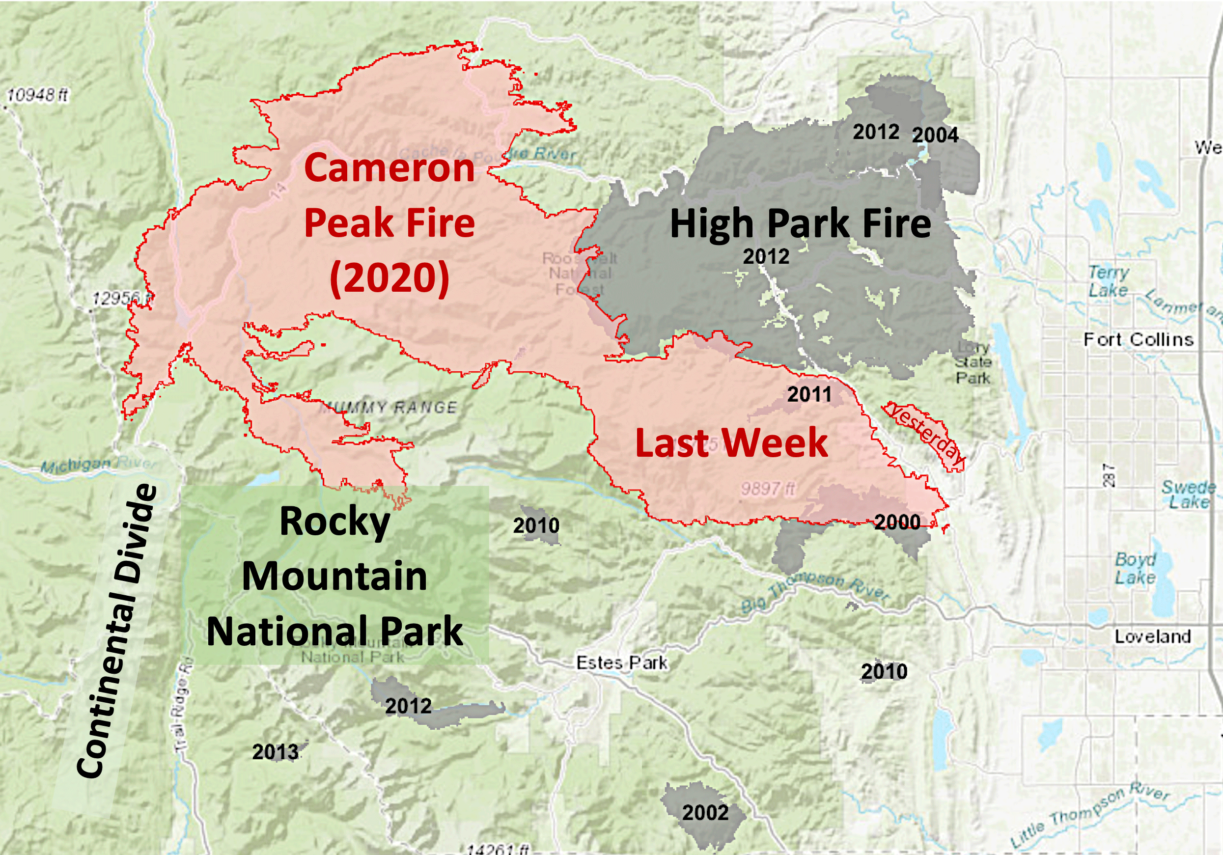
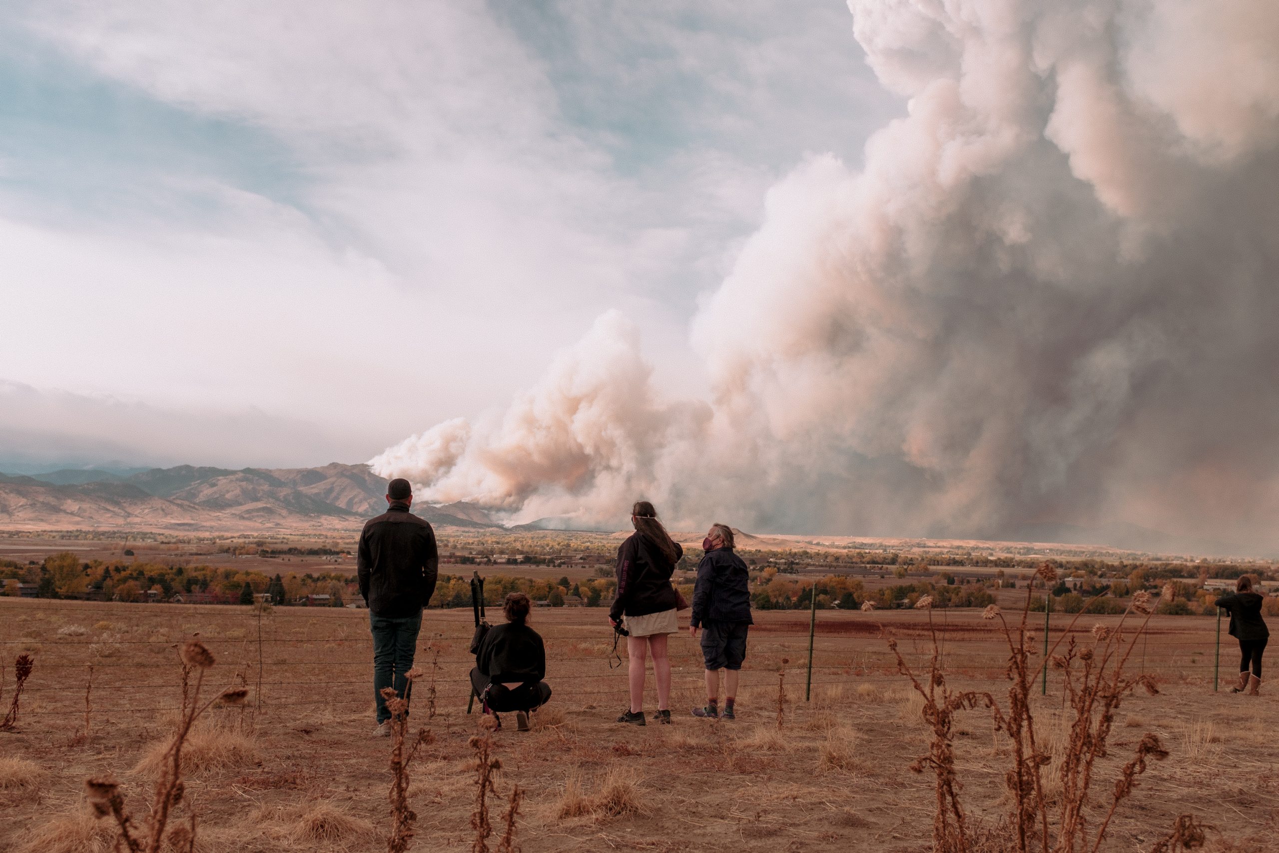
Local towns, politicians and statewide conservation groups oppose even the test drilling, which was delayed in the U.S. Forest Service permitting process by the record wildfire season…

Climate Change Amplifies Colorado’s Water Diversion Debate

Nearly 5 million people live on the eastern side of the Rocky Mountains, along what’s known as Colorado’s “Front Range,” where communities established on semi-arid prairie land need more water to keep expanding.

Now a water battle is brewing over whether the booming population centers of Aurora and Colorado Springs, with nearly 900,000 residents combined, can claim water from a remote valley on the other side of the Rockies, collect it in a new reservoir and pump it across the Continental Divide.

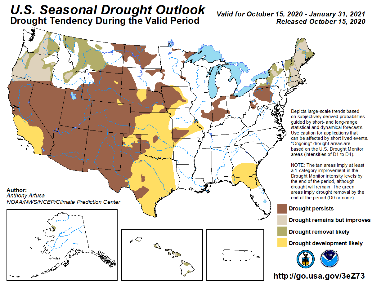
For many residents of bucolic Eagle County on the “Western Slope,” where Homestake Creek meanders through mountain meadows, lush wetlands and ancient fens on its way to the endangered Colorado River, it’s time to end transmountain diversions once and for all as the climate warms and drought intensifies.

But officials in Aurora, a Denver suburb, and Colorado Springs, argue they can collect the water in a new reservoir and make use of it without drastically disturbing the surrounding wilderness. More to the point: they’ve owned the rights to 20,000 acre-feet of average annual yield since 1952 and say it’s time to start exploring if they can use it—for drinking water and on suburban lawns.

“Because water is the lifeblood and it’s so important, we have been doing a relatively good job of having collaborative conversations that are getting us to a point, but the issue is growth and climate change are both happening now so fast and historically these collaborative conversations take a really long time,” said Eagle County Commissioner Matt Scherr.

“Are we going to be able to address that at the scale and speed that the problem is moving?” Scherr added. “So, you hate to see this end up being essentially a war for water, but if we don’t figure out how to do it in a holistic way, that could be our future.”

A #climate scientist’s up-close personal encounter with a nearby record-setting #Colorado wildfire — Yale Climate Connections

Wildfire smoke over Fort Collins. Photo credit: Yale Climate Connections

From Yale Climate Connections (Scott Denning):

Trees just can’t climb uphill to outpace fast-moving forest fires. Instead, they ‘just burn down.’

Where I live there’s a spectacular gradient of climate and vegetation extending from the semi-arid grassland around cities (5,000 ft / 1.5 km) where five-million people live to the tundra and snowfields along the Continental Divide (13,000 ft / 4 km) above sea level.

In the past decade, wildfire has burned up the whole damned thing!

In the sweltering summer of 2012, we were besieged by the High Park fire. My mother died of chronic obstructive pulmonary disorder that summer, her lungs ruined by a lifetime of cigarettes and weeks of wildfire smoke.

Now, in the upper reaches of the currently raging Cameron Peak fire scar, the stinging spindrift of the coming winter has begun swirling among the lichen-covered boulders. Tundra and krumholtz have frozen, and the landscape is shutting down for imminent burial in wind-driven snow. In the foothills outside the city, firefighters sweat through soot to clear brush, protect subdivisions, and hose down the dry summer grass.

Never before in my lifetime has the entire tundra-to-prairie burned like this. Compare the sizes of the recent fire scars to the ones on this map from earlier years.

Cameron Peak and High Park fire scars October 2020. Credit: National Interagency Fire Center

There are three necessary conditions for wildfire: fuel, ignition, and dry soil. Over the past 50-plus years in this region, fuel and sources of ignition – for instance lightning and campfires – have not been lacking. What’s changed is the weather.

Nearly all the soil moisture in our mountain forests comes from the melting of the winter snowpack, especially above about 8,500 feet. Rain provides precious little of the water.

Every single day from “mud season” until the snows start piling up again in October, the forest extracts water from what was stored during spring snowmelt. On hot days it extracts more, and on cold days less. The forest thrives only on the acres where tree roots stay damp until the weather turns cold.

The hotter the days, and the longer the warm season between snows, the more days there are at the end of the season when all that abundant fuel is susceptible to a lightning strike or a campfire gone wrong.

At the end of the last Ice Age, 18,000 years ago, the world warmed about 5 degrees Celsius (10 F) over 10,000 years. That’s a rate of 0.1 degree per century.

That 10 F of warming over 100 centuries caused the plant zones in our mountains to slowly creep about 5,000 feet uphill. The spruces and firs displaced the tundra. The Lodgepole displaced the spruces and firs. The Ponderosa displaced the Lodgepole and the grasses, and yucca displaced the Ponderosa.

Unlike the Ents in Lord of the Rings, our trees didn’t just get up and walk up the mountains. Rather, the poorly adapted ones slowly died out and were replaced by the seedlings of their better-adapted neighbors as the warming slowly crept up the slopes over many millennia. The cone doesn’t fall far from the tree.

By the time today’s toddlers in their 70s, our climate could very easily heat up just as much as it did in 100 centuries during the last great warming. That’s 100 times faster than the last warming. It’s less than the lifetime of a single tree, and way too fast for seedlings to displace their ancestors.

When the climate moves out from under the forest so quickly, the trees don’t just get up and walk uphill.

Instead they just burn down.

AUTHOR
Scott Denning for more than two decades taught as part of the atmospheric sciences faculty at Colorado State University. A frequent speaker and popular informal science educator, Denning says he “takes special delight in engaging hostile audiences” on climate change.

#Drought in western U.S. is biggest in years and predicted to worsen during winter months — The Washington Post #ActOnClimate

From The Washington Post (Matthew Cappucci, Andrew Freedman, and Jason Samenow):

The drought is exacerbating wildfires and taxing water resources

West Drought Monitor October 13, 2020.

The drought has already been a major contributor to record wildfire activity in California and Colorado. Its continuation could also deplete rivers, stifle crops and eventually drain water supplies in some Western states.

Nationwide, drought has expanded to its greatest areal coverage since 2013; 72.5 million people are in areas affected by drought. More than one-third of the West is in “extreme” or “exceptional” drought, the two most severe categories, according to the federal government’s U.S. Drought Monitor.
In its winter outlook issued last week, the National Oceanic and Atmospheric Administration (NOAA) cautioned drought conditions are expected to persist or worsen over large parts of the West during the December through February period, and expand farther east into the central United States.

Scenes of the CalWood Oct. 17, 2020 (Jivan West/CU Independent)

In recent months, drought has surged to extreme levels along parts of the West Coast, including Northern California, much of Oregon and the Cascades in Washington…

In Colorado, wildfires continue to rage along the Front Range, with evacuations west of Fort Collins and northwest of Boulder. The Cameron Peak Fire, which has torched more than 200,000 acres, is now the largest wildfire in Colorado history, and the CalWood Fire became Boulder County’s largest fire on record when it exploded in size over the weekend. That fire has burned at least 26 homes, though the toll is expected to increase.

There is no precedent for wildfires this severe igniting so late in the season in the Centennial State. It’s no coincidence that the entirety of Colorado is experiencing a drought for the first time since 2013. Fifty-nine percent of the state is enduring an extreme drought or worse.

2020 has been a particularly bad year for wildfires, obliterating records in California with more than 4.1 million acres scorched. This is more than twice the acreage burned during the previous record wildfire season.

An environment already parched from a lackluster monsoon

The Four Corners region is perhaps the one hit hardest, where prolonged, intense dryness has led to “exceptional drought.”

In New Mexico, an area one and a half times the size of the state of Connecticut is listed by the U.S. Drought Monitor as being in extreme drought. This includes Los Alamos and Santa Fe. Officials have noticed a dramatic decline in river flow rate feeding many aquifers, though there are no immediate drinking water supply concerns. The Drought Monitor includes the observation that “vegetation and native trees are dying” in parts of the state.

An exceptionally weak monsoon has been a major contributor to the ongoing drought in the Southwest…

In August, for example, Santa Fe picked up just one one-hundredth of an inch of rain. It averages 2.6 inches for the month. Since the start of the year, the city has had 5.44 inches of precipitation, less than half the 11.5 inches it would typically have by now.

It’s the second dud monsoon season in a row…

A large percentage of New Mexico’s rainfall — in some places more than half — comes from the monsoon…

Fontenon said that the rangeland in eastern New Mexico is suffering heavily, bringing shades of a drought early in the decade that plagued area farmers between 2011 and 2013.

Nearby in Arizona, Tucson hasn’t seen a drop of rain since August. Since the start of May, less than two inches has fallen. The year as a whole is 60 percent below average on rainfall.

Even farther north, the deficit has hit the Rockies and Intermountain West particularly hard. Grand Junction, Colo., has only seen 4.09 inches of rain this year; by now it should be in the double digits. Salt Lake City is at 7.86 inches. That’s five inches below average…

Extreme drought has also snaked its way into Wyoming, while moderate drought blankets most of Idaho and Montana…

The drought will only worsen

Forecasters at NOAA say that with a developing La Niña event in the Pacific Ocean, drought is likely to prevail and potentially worsen through the winter over large areas of the West…

Little relief in sight for most

But looking ahead, little to no wet weather whatsoever is expected in the Southwest, southern California, or the Four Corners region. And the drought will probably continue, if not intensify…

Climate change’s role

Human-caused climate change is increasing the likelihood of precipitation extremes on both ends of the scale, including droughts as well as heavy rainfall events and resulting floods. Studies consistently show that as the Southwest warms, the odds of drought are increasing.

According to the Federal National Climate Assessment in 2018, climate change intensified the severe drought in California and is worsening drought in the Colorado River Basin. Part of the reasons for this is that climate change makes such droughts hotter than they might’ve been just a few decades ago, which draws more moisture out of soils and vegetation, thereby worsening the drought in a positive feedback loop…

A recent study published in the journal Science found that the Southwest may already be in the midst of the first human-caused megadrought in at least 1,200 years, which began in the year 2000.

Navajo Dam operations update: Turning down to 650 CFS October 20, 2020 #ColoradoRiver #COriver #aridification #SanJuanRiver

From email from Reclamation (Susan Novak Behery):

In response to increasing tributary flows, the Bureau of Reclamation has scheduled a decrease in the release from Navajo Dam from 700 cubic feet per second (cfs) to 650 cfs on Tuesday, October 20th, starting at 4:00 AM. Releases are made for the authorized purposes of the Navajo Unit, and to attempt to maintain a target base flow through the endangered fish critical habitat reach of the San Juan River (Farmington to Lake Powell).

The San Juan River Basin Recovery Implementation Program recommends a target base flow of between 500 cfs and 1,000 cfs through the critical habitat area. The target base flow is calculated as the weekly average of gaged flows throughout the critical habitat area from Farmington to Lake Powell.

This scheduled release change is subject to changes in river flows and weather conditions. If you have any questions, please contact Susan Behery (sbehery@usbr.gov or 970-385-6560), or visit Reclamation’s Navajo Dam website at https://www.usbr.gov/uc/water/crsp/cs/nvd.html.

The Navajo Dam on the San Juan River.Photo credit Mike Robinson via the University of Washington.