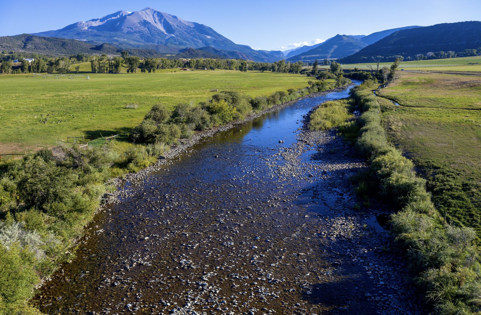
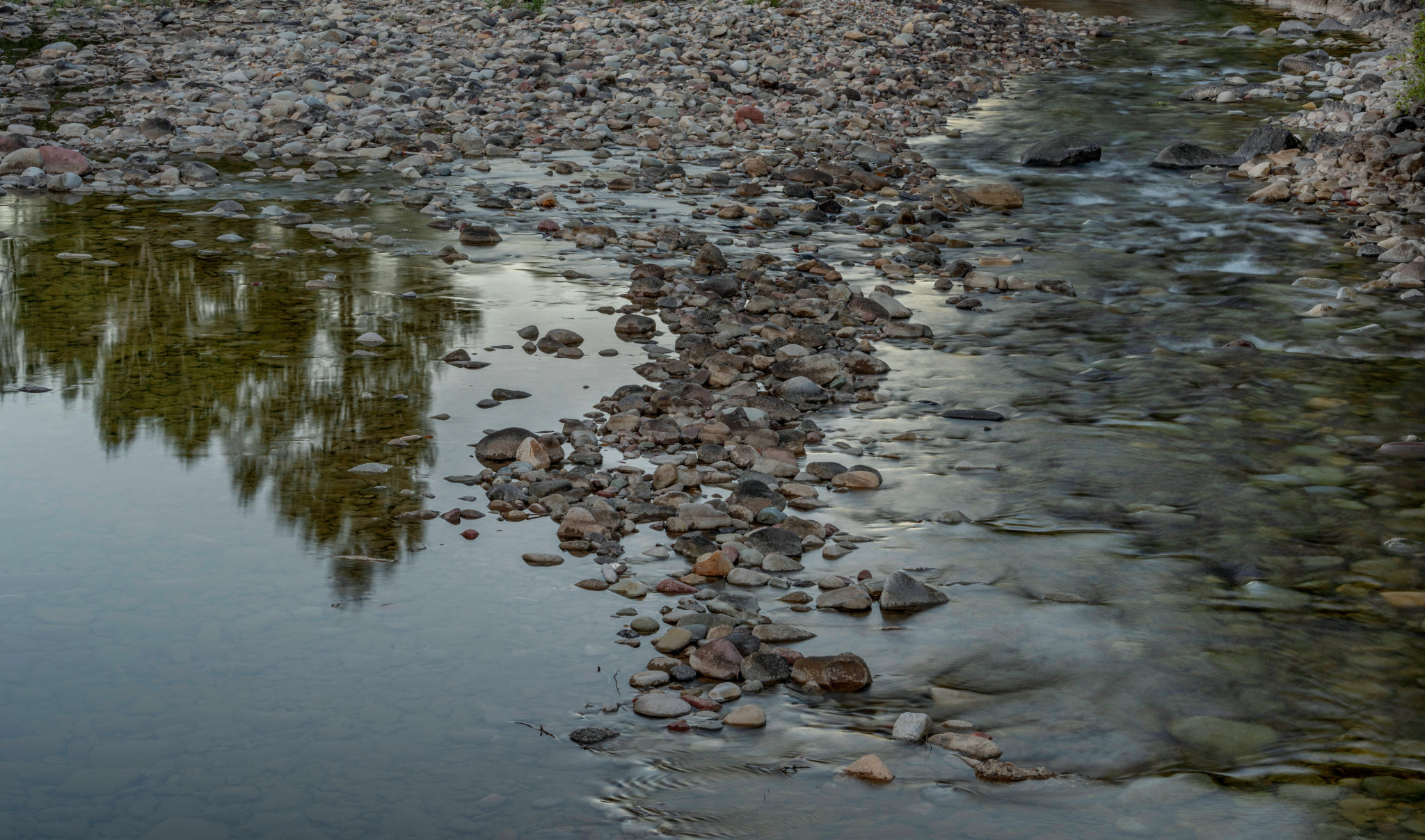
The Crystal River runs low outside of Carbondale on September 1, 2020. With average temperatures warming in summer months by as much as 3.5 degrees since the 1950s in Garfield County, streamflows are trending down as peak runoff comes earlier and more water is sucked up by evaporation and dry soils, stressing available water supplies in late summer and fall. Photo credit: Dan Bayer/Aspen Journalism
In November 2018, Marble Town Manager Ron Leach received a letter that he said was a wake-up call.
The letter was a notice from the Colorado Division of Water Resources that the town’s water rights had been “out of priority” for four weeks the previous August and September because of a call placed by a senior water-rights holder downstream on the Crystal River.
During drought years — and 2018 was an extreme one, with the Crystal running at less than 5% of average after peaking in May, several weeks earlier than usual — junior water-rights holders may have to curtail their water usage until the senior call is satisfied.
“Drought and water supply have been on people’s minds for a long time around here, but we’ve never gotten a letter like that,” Leach said.
The letter urged the Marble Water Company — the private nonprofit entity that delivers water to the town’s approximately 150 residents and a handful of businesses — to create a plan of augmentation, which is an alternate source of water such as a storage pond. Without augmentation, the letter warned, a call could subject Marble to a cease-and-desist order on its municipal water wells.
Several other neighborhoods that get their water from the Crystal also narrowly dodged a bullet that August. The same call put more than 40 homes in Carbondale at risk of not having water, according to Town Manger Jay Harrington.
“Firefighting capability was an issue, too,” Harrington said. “That’s where we had to scramble.”
Carbondale officials were able to make an emergency arrangement with another senior water-rights holder on the Crystal to temporarily borrow water to supply the homes. And they quickly set in motion plans to avoid the situation in the future. In essence, the town is shifting the supply for some of its water needs from the heavily irrigated Crystal to the more reliable Roaring Fork, as the town has three wells that draw from the Roaring Fork aquifer, and has the option to develop more wells. The town also owns 500 acre-feet of water in Ruedi Reservoir it can use to offset its well depletions from the Roaring Fork aquifer.
Up in Marble, Leach doesn’t have multiple, redundant water supplies to serve his constituents. Noting that Marble’s water supply barely exceeds peak summer demand, an engineering firm’s preliminary recommendation was for an 11-acre-foot reservoir, which would require 3 to 4 acres of flat ground.
“The town of Marble doesn’t have cash to do anything like that,” said Leach, who added that space in the constrained mountain valley might also be a hurdle. “There’s no easy solution.”
Still, Leach is confident something will get figured out — a state-funded water study of the Crystal was recently approved, he said — but a very dry 2020 has underscored that the water issue is not going away anytime soon. During what’s now widely accepted as a two-decade-long drought in the Colorado River basin, temperatures have risen, summer rains can’t be relied on and streamflows have dropped, with earlier peak flows sometimes leaving little water in streams by late summer. The state’s letter to Marble noted that “it is reasonable to assume that this administration scenario could happen more frequently in the future.”
To those who deal with water day to day, there’s no question climate change is here and its impacts are being increasingly felt in the summer.
“It all starts with climate change — that’s the big picture,” said Leach. “What’s happening in Marble, this is the micro-example.”
Other Roaring Fork municipalities are also grappling with climate-caused water supply issues. The city of Aspen, which provides municipal water from free-flowing Maroon and Castle creeks and has seen Stage 2 water restrictions enacted two of the past three summers, is creating a 50-year water plan — driven in part by climate-change impacts — that may include expanded water storage. In Basalt, the 2018 Lake Christine Fire came close to cutting power supplies, which could have caused the failure of pump stations that deliver water to users. And after one of Glenwood Springs’ water sources was temporarily shut down during this summer’s Grizzly Creek Fire, debris, ash, mudslides and fire retardant pose lingering hazards.
“We need to continually work on our water systems as we continue to adapt to climate change,” said Harrington. “We are going to have to figure out how to slow it down, but in the meantime, we need to take climate change into our planning.”
“We need to continually work on our water systems as we continue to adapt to climate change,” said Harrington. “We are going to have to figure out how to slow it down, but in the meantime, we need to take climate change into our planning.”
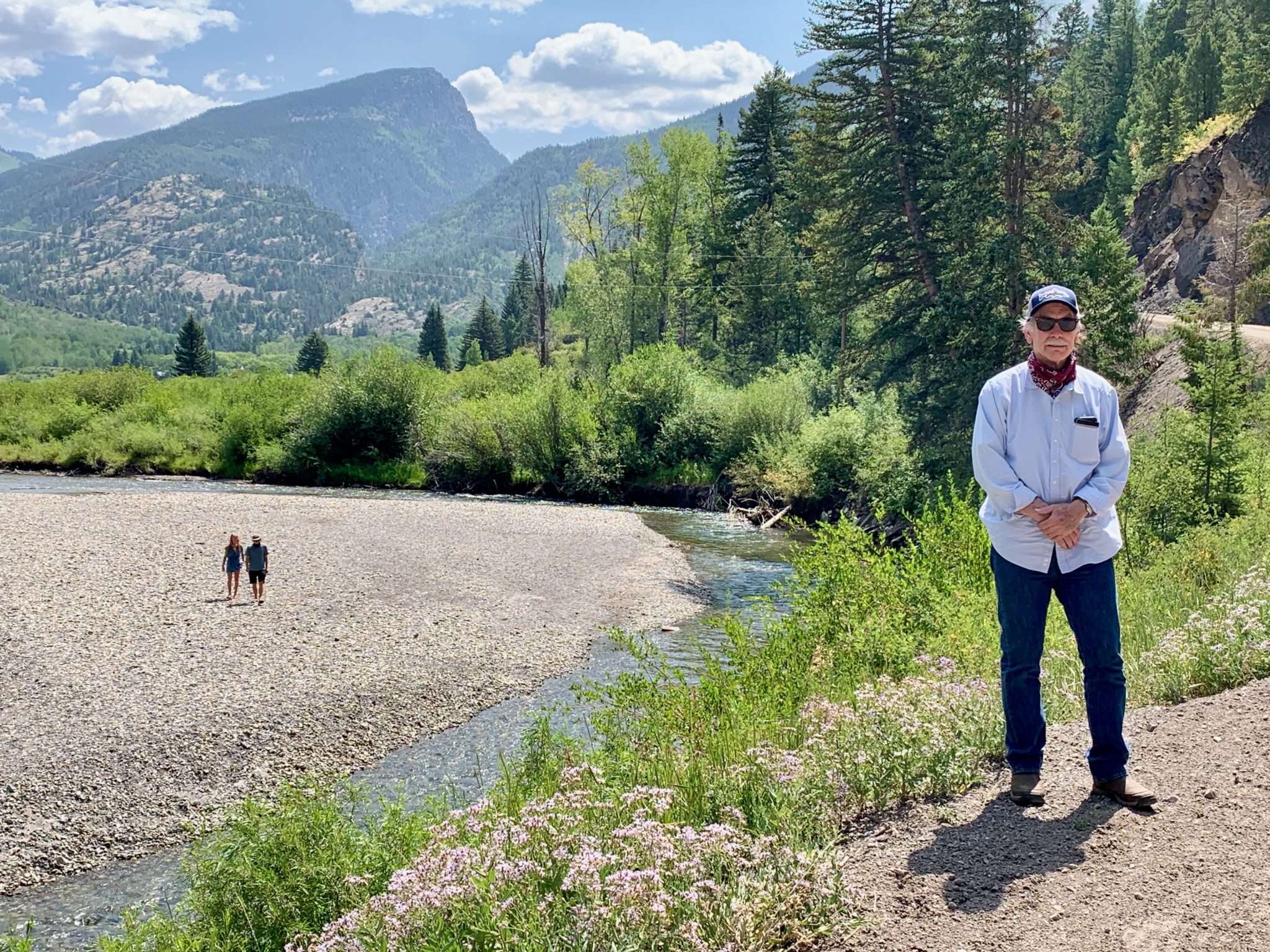
Marble Town Manager Ron Leach is looking for ways to augment the town’s water supply, which comes from the Crystal River aquifer. In 2018, that supply was threatened when the river was running too low to satisfy all water-rights holders. Photo credit: Catharine Lutz/Aspen Journalism
The heat is on
Warming temperatures, linked to increased global greenhouse-gas emissions, are the catalyst that impacts other key conditions in the mountains, including lower snowpacks and streamflows; earlier snowmelt and runoff peaks; more precipitation in the form of rain than snow; more frost-free days; and lower soil moisture.
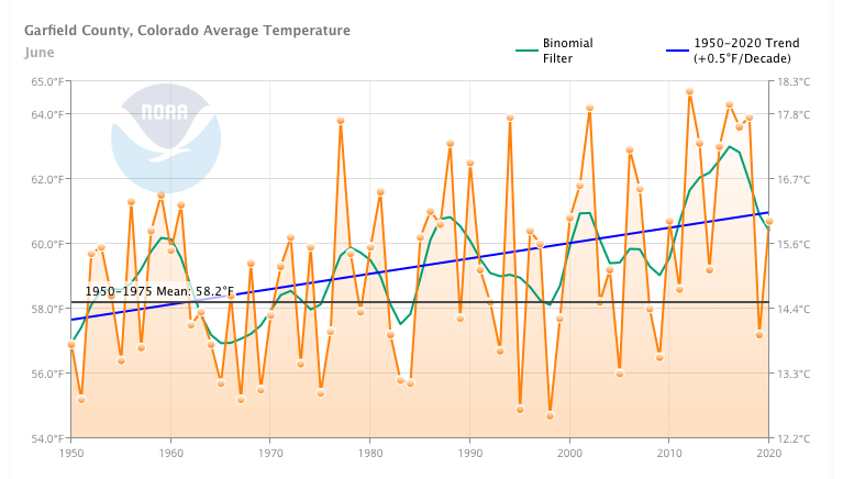
As average temperatures rise in all seasons, heat waves like the one that gripped Colorado during the summer of 2020 are becoming more common. According to the National Oceanic and Atmospheric Administration, average temperatures from May to October in Pitkin and Garfield counties have risen more than 2 degrees Fahrenheit since the 1950s. Some months are warming faster than others. In Pitkin County, June, July and September have warmed by nearly 3 degrees since 1950, while in Garfield County, June and September are 3.5 degrees warmer.
Marble Town Manager Ron Leach is looking for ways to augment the town’s water supply, which comes from the Crystal River aquifer. In 2018, that supply was threatened when the river was running too low to satisfy all water-rights holders. Credit: NOAA via Aspen Journalism
Noting that 12 of the hottest 14 years in western Colorado have occurred in the past 18 years, Colorado River Water Conservation District general manager Andy Mueller said at a recent conference that “the biggest change in temperatures has been occurring within our district and eastern Utah, which is a real problem when you look at the fact that we’re the area that produces the most-significant amount of water in the entire rivershed.”
Scientists are in broad agreement that as long as greenhouse-gas emissions continue to rise — or even level off — temperatures will follow suit.
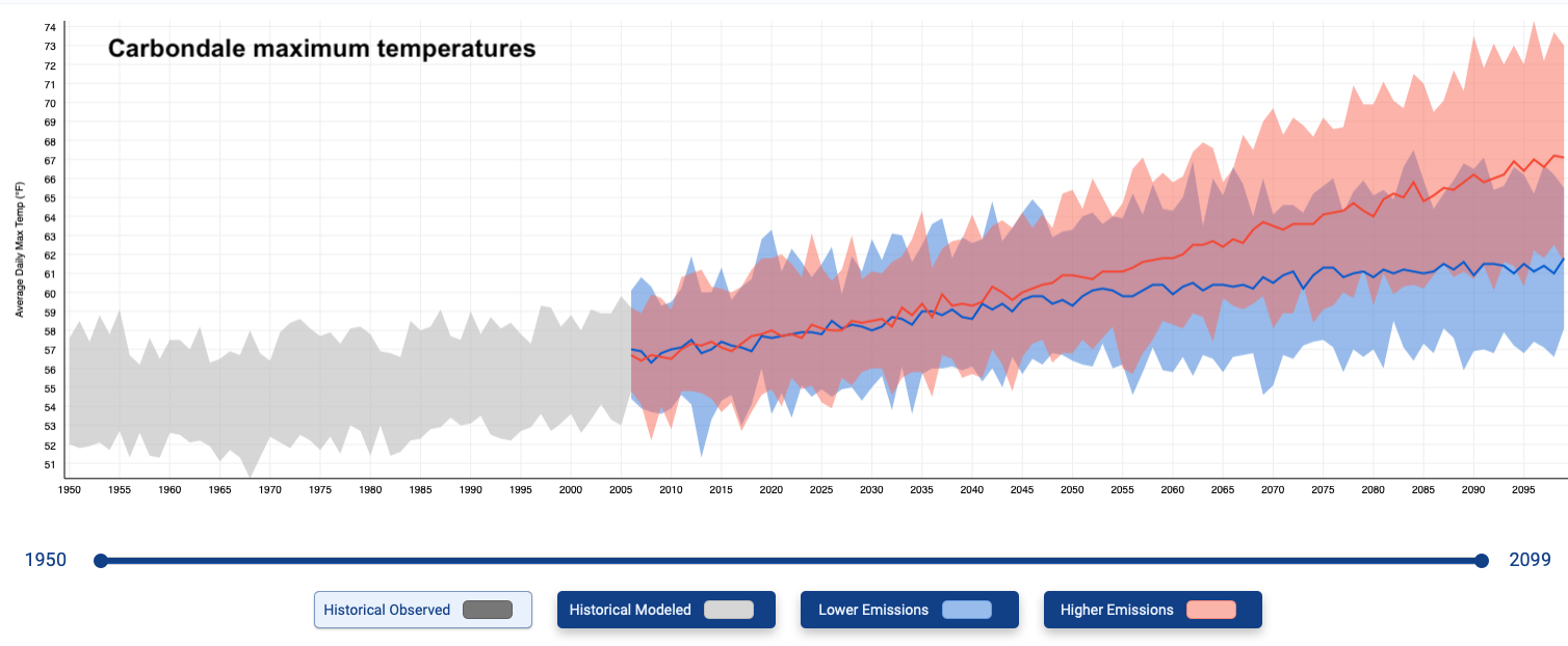
Projections for the region range depending on emissions scenarios, but nearly all of them forecast at least another rise of average temperatures of 3 degrees Fahrenheit by mid-century and a rise of approximately another 10 degrees by the end of the 21st century. To put this into perspective, a warming Aspen could have the climate of Carbondale or Glenwood Springs, while Glenwood would look and feel like Grand Junction in a few decades.
This graph shows the range of average maximum temperature increases projected for Carbondale under both and high and low emissions scenario. Credit: NOAA via Aspen Journalism
The atmosphere taketh away
Local summer precipitation trends are less clear. Monsoon rains — or the lack thereof — drive great swings year to year in summer precipitation, which is usually dwarfed, in terms of volume, by winter precipitation in the form of snow. Historical data shows no clear trends. A report prepared for the town of Carbondale says that average precipitation in the 20th century and since 2000 are about the same.
Still, the summer of 2020 capped a decade of multiple dry summers. Colorado this year saw its third-driest April-July period, according to the National Weather Service, and the 2.5 inches of precipitation Aspen had from June through August was nearly 2 inches below normal. It was the fourth summer in a row with below-average precipitation and the driest in that stretch — even the summer of 2018 saw more rain.
Precipitation projections are also not very clear — although some experts suggest that precipitation could decrease in the summer and increase in the winter. But whether there’s a little more or a little less rain and snow in the future — and the latest models show a long-term decline in the Colorado River Basin — scientists say it doesn’t matter.
Brad Udall: Here’s the latest version of my 4-Panel plot thru Water Year (Oct-Sep) of 2019 of the #coriver big reservoirs, natural flows, precipitation, and temperature. Data goes back or 1906 (or 1935 for reservoirs.) This updates previous work with @GreatLakesPeck
“There’s more uncertainty in how much precipitation is going to change and less uncertainty about how much temperature is going to change,” said hydrology expert Julie Vano, who is research director at Aspen Global Change Institute. “And the effect of just having warmer temperatures means more water is leaving the system.”
Jeff Lukas, a researcher on NOAA’s Western Water Assessment team, put it this way: “A warming atmosphere is a thirstier atmosphere.” In the Roaring Fork Valley, he said, only about a third of all precipitation makes it into streams and rivers; the other two-thirds is reclaimed by evapotranspiration, which is the combination of evaporation from surfaces and what plants absorb then release. Since evapotranspiration is driven in large part by temperature, as temperatures rise, the amount of water in rivers declines.
“The atmosphere giveth and the atmosphere taketh most of it away,” said Lukas. “Warming is the factor — across all seasons and all water-cycle processes — that draws moisture away from the land surface before becoming runoff.”
A table showing hydroclimate trends from Western Water Assessment’s “Colorado River Basin Climate and Hydrology State of the Science” report.
The flow is low
After more than a century of diversions, dams, storage projects and other stream manipulations, it’s complicated to calculate trends in natural streamflow, the term for the amount of water in a river. But streamflow, also called runoff, has perhaps the most direct effect on water availability. And trends are not looking good.
Since 2000, according to a recent report, the average annual volume of water in the upper Colorado River basin, from its headwaters to Lees Ferry (just below Lake Powell in Arizona), has dropped 15% below the long-term average from 1906 to 2019. Published last April, the Western Water Assessment’s “Colorado River Basin Climate and Hydrology State of the Science” report synthesizes all of the recent studies and data on this massive topic. The report’s authors compiled ever-increasing evidence about how rising temperatures are contributing to less water in the Colorado River, which supplies the needs of 40 million people. Although precipitation is still an important factor, some research shows that warming accounts for up to half of the water loss. One study calculated that every 1 degree Fahrenheit of warming decreases runoff by 7.5%.
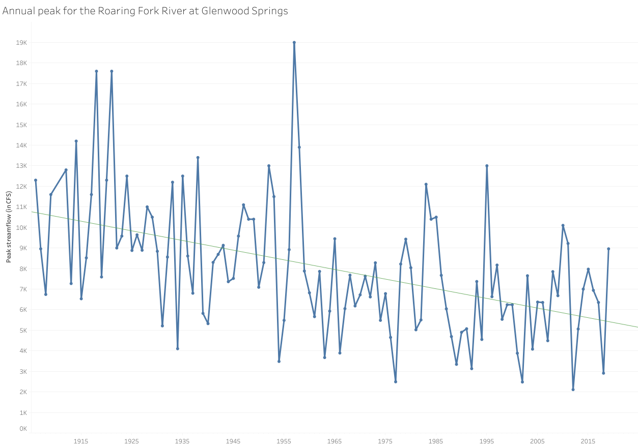
Jeff Lukas, a researcher on NOAA’s Western Water Assessment team, has calculated that between 2000 and 2018, the Roaring Fork River at Glenwood Springs had 13% less water than the 20th century average, which in large part is attributable to declining peak flows, shown here in this graph. Credit: Lauren Lassalle/Aspen Journalism
Declining streamflows are also found up the Colorado’s tributaries. Taking into account water that would’ve been in the stream if it weren’t for diversions and ditches, Lukas calculated that between 2000 and 2018, the Roaring Fork River at Glenwood Springs had 13% less water than the 20th-century average. Analyzing data on the Crystal River near Redstone, he calculated a 5% drop in annual mean streamflow since 2000, compared with the latter half of the 20th century, but a 10% decline during drier years.
In that same analysis of the Crystal, Lukas found that the date of peak streamflow had shifted one week earlier since 2000: from reliably arriving in June to sometimes coming in May. Multiple studies across the Colorado basin have similarly calculated a one- to four-week earlier runoff — which means that high-country snowpacks are melting earlier, so that the highest volume of snowmelt rushing down those streams is coming earlier in the spring.
But an above-average snowpack doesn’t mean an equivalent runoff, as this past year has shown. After a good winter followed by a warm, dry spring and summer, just 55% of the upper Colorado’s runoff made it into Lake Powell.
“The expectation that this amount of snow leads to this amount of runoff — we’re just not seeing as much as we did in the past,” said Vano, the hydrology expert.
Projections on how runoff will change in the coming decades from Western Water Assessment’s “Colorado River Basin Climate and Hydrology State of the Science” report.
Earlier peak runoff and lower flows mean less water (especially in drought years) in late summer and early fall, a critical time for irrigation, recreation and natural systems. From late July through October, the Crystal River upstream from Carbondale has been flowing below half of average, lower than the instream flow water right held by the state for that stretch of river — but since irrigation rights are senior to the conservation right, there’s often no recourse. For example, that is what happened in August on another tributary of the Roaring Fork, when the Colorado Water Conservation Board, which holds 1,700 instream-flow rights throughout the state, requested administration of its instream rights on Hunter Creek, acknowledging that it would likely be “a futile call.”
“A river is not a river without water in it,” said Heather Tattersall Lewin, science and policy director for the Roaring Fork Conservancy.
As with higher temperatures, declining streamflows and earlier runoff are certain into the future, but how much will depend on emissions. A 2006 report by the Aspen Global Change Institute calculated that by 2030, peak runoff for the Roaring Fork River at Woody Creek will occur in May rather than June. And by 2100, the lingering snowpack we see on the high peaks in June will no longer exist, which means less water in the stream all summer. Add in increased demand from growth and diversions, and future Roaring Fork River flows through Aspen could go below required instream-flow levels for nine months of the year.
Downstream in Glenwood Springs, the Roaring Fork’s late summer flows could decline by 30% to 50% by 2070, according to a 2018 analysis by Lukas.
“Changes to water will touch nearly everything,” he said. “All the risk is on the dry side.”
The Crystal River showing a fraction of its normal summer volume in September. Water supply challenges related to climate change have been evident along the waterway as warmer summer temperatures stress streamflows. Photo credit: Dan Bayer/Aspen Journalism
The underlying factor
Another important factor to consider is one we don’t really see: soil moisture.
One of the metrics used to calculate drought severity, soil moisture has been studied locally by the Aspen Global Change Institute since 2013. This short period of record may preclude discerning any trends about whether local soils are getting drier, but the data does show how moisture levels can have a domino effect season to season.
Elise Osenga, community science manager for the institute, likens the soil to a sponge. A dry sponge, like dry soil, absorbs more water than when it’s wet, while a wet sponge, like saturated soil, lets the excess run off. The water that the soil doesn’t absorb goes into streams.
“Climate change is more likely to dry soils in the spring,” said Osenga, who explained that peak snowmelt and peak soil saturation happen around the same time in the mountains. “When that happens, we’ll see soils dry earlier in the summer and become more dependent on summer rain — which is problematic when we don’t get those rains.”
The Aspen Global Change Institute has been tracking local soil moisture since 2013. In each of the past three years, soil moisture has dipped well under the 2013-2017 average for most of the summer.
Each of the past three years, soil moisture in Pitkin County has dipped well under the 2013-2017 average for most of the summer. The drought year of 2018 saw an early snowmelt and soil drying, but fall rains helped soils recover, auguring well for the next year. Most remember the record snows of late winter and spring of 2019, but the lack of rain that summer dried things up. And 2020 largely mirrored 2018, although 2020 saw slightly better soil moisture until late summer.
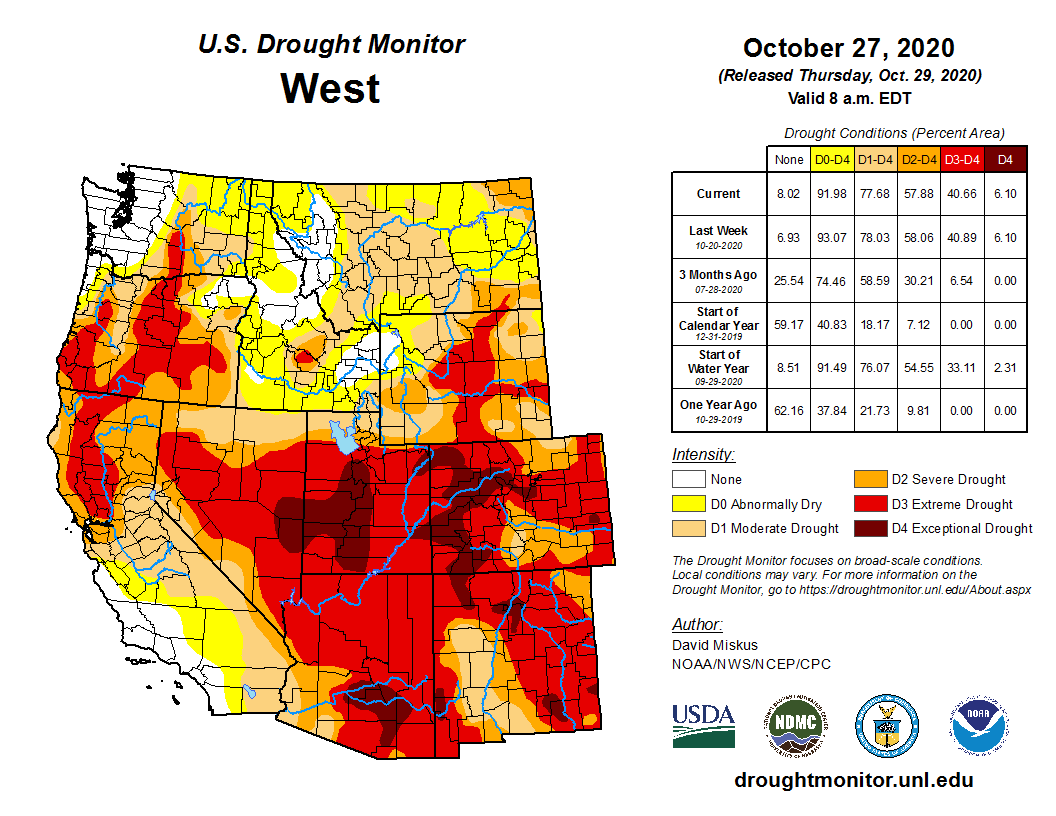
This year, things may have cooled off since August, but drought conditions have worsened, with all of Colorado, as of Oct. 22, in some form of drought and 78% of the state in extreme or exceptional drought. This doesn’t bode well for spring.
With soil moisture, said Osenga, “what happens in September and October is actually really interesting, because it plays a big role in determining whether we start the next spring already at risk of a drought versus in better shape.”
With multiple dry years over the past two decades, some scientists are wondering if we’re entering a period of megadrought, which hasn’t been seen in several hundred years.
“It might be a combination of natural variability plus climate change — a double whammy,” said Vano.
No single drought is evidence of climate change, Lukas said, but “what we’re seeing since 2000 is that climate change is stacking the deck. We’re more prone to the deep droughts, the ones that sneak out of left field like in 2020.”
And even with good planning, that’s sure to make water managers in Marble and Carbondale and throughout the Colorado River basin nervous.
“We do see changing conditions, whether attributable to increased demand/development by water users, drought or long-term climate change,” wrote Colorado water commissioner Jake DeWolfe in an email. “Any of them leads to the same problem: a shortage of water. We are involved in planning for the future likelihood that we will need to limit, if not curtail, uses in Colorado to meet the needs of downstream states.”
An abridged version of this story ran in The Aspen Times on Oct. 30.
Following the United States Fish and Wildlife Service’s announcement to remove endangered species protections for gray wolves in all lower 48 states, world-renown animal behavior expert and conservationist, Dr. Jane Goodall, founder of the Jane Goodall Institute & UN Messenger of Peace, decried the decision citing the important roles that wolves play in their ecosystems and the fact that the move lacks both the support of the scientific community, as well as the public.
Gray wolves occupy only a tiny area compared to their historic home range. Wolves are essential predators in their ecosystems. It is important to understand that where wolves have been restored, the ecosystem comes back into balance. Today’s decision further challenges existing vulnerable populations of wolves with hunting and trapping. Removing these protections fundamentally threatens their survival and the balance of ecosystems across the U.S.
As we approach Election day next Tuesday, November 3rd, American citizens must vote to affirmatively elect leaders who respect nature and protect endangered species, believe in science, who act on climate change, and who will advance sustainable green economies. We have the power to turn things around, but we have a small window of time. Your votes can protect endangered species like gray wolves, their habitats, fight climate change, and safeguard human health and livelihoods.
Gray wolves were extirpated from Colorado in the 1930s, but a pack was recently spotted in the northwest corner of the state. In November, voters in the state will decide on a measure to reintroduce gray wolves. JOHN AND KAREN HOLLINGSWORTH, USFWS
Image from Grand County on June 6, 2020 provided courtesy of Jessica Freeman via Colorado Parks and Wildlife.
Image from Grand County on June 6, 2020 provided courtesy of Jessica Freeman via Colorado Parks and Wildlife.
CPW Image – A wolf eats on an elk carcass in northwest Colorado
A trail of wolf tracks observed by Colorado Parks and Wildlife officers in Northwest Colorado on January 19, 2020. Photo credit: Colorado Parks & Wildlife
Gray wolves are currently protected under the Endangered Species Act, but the Trump administration has petitioned to delist them. That decision, expected this spring, will impact the management and possible reintroduction of wolves in Colorado. Photo credit: Tracy Brooks, U.S. Fish and Wildlife Service via Aspen Journalism
The law enforcement community is among those who have failed to understand the true nature and danger of far-right extremists. Over several decades, the FBI and other federal authorities have only intermittently paid attention to far-right extremists. In recent years, they have again acknowledged the extent of the threat. But it’s not clear how long their attention will last.
In this Jan. 18, 1986, photo, a KKK group marches in Tennessee to protest the first national observance of Martin Luther King Jr.‘s birthday. AP Photo/Mark Humphrey
1. Some have white supremacist views, but others don’t
When asked to condemn white supremacists and extremists at the first presidential debate, President Donald Trump floundered, then said, “Give me a name.” His Democratic challenger Joe Biden offered, “The Proud Boys.”
Not all far-right extremists are militant white supremacists.
White supremacy, the belief in white racial superiority and dominance, is a major theme of many far-right believers. Some, like the Ku Klux Klan and neo-Nazis, are extremely hardcore hate groups.
Others, who at times identify themselves with the term “alt-right,” often mix racism, anti-Semitism and claims of white victimization in a less militant way. In addition, there are what some experts have called the “alt-lite,” like the Proud Boys, who are less violent and disavow overt white supremacy even as they promote white power by glorifying white civilization and demonizing nonwhite people including Muslims and many immigrants.
There is another major category of far-right extremists who focus more on opposing the government than they do on racial differences. This so-called “patriot movement” includes tax protesters and militias, many heavily armed and a portion from military and law enforcement backgrounds. Some, like the Hawaiian-shirt-wearing Boogaloos, seek civil war to overthrow what they regard as a corrupt political order.
2. They live in cities and towns across the nation and even the globe
Far-right extremists are in communities all across America.
The KKK, often thought of as centered in the South, has chapters from coast to coast. The same is true of other far-right extremist groups, as illustrated by the Southern Poverty Law Center’s Hate Map.
The ‘collective delusion’ known as QAnon will be around for many years. AP Photo/Ted S. Warren
3. Many are well-organized, educated and social-media savvy
Far-right extremists include people who write books, wear sport coats and have advanced degrees. For instance, in 1978 a physics professor turned neo-Nazi wrote a book that has been called the “bible of the racist right.” Other leaders of the movement have attended elite universities.
Far-right extremists were early users of the internet and now thrive on social media platforms, which they use to agitate, recruit and organize. The 2017 “Unite the Right” rally in Charlottesville revealed how effectively they could reach large groups and mobilize them into action.
But far-right extremists were here long before Trump.
The history of white power extremism dates back to slave patrols and the post-Civil War rise of the KKK. In the 1920s, the KKK had millions of members. The following decade saw the rise of Nazi sympathizers, including 15,000 uniformed “Silver Shirts” and a 20,000 person pro-Nazi rally at Madison Square Garden in New York City in 1939.
While adapting to the times, far-right extremism has continued into the present. It’s not dependent on Trump, and will remain a threat regardless of his public prominence.
Members of the Boogaloo movement, seen here at a New Hampshire demonstration, seek a civil war in the U.S. AP Photo/Michael Dwyer
5. They pose a widespread and dire threat, with some seeking civil war
Thinking of these extremists as loners risks missing the complexity of their networks, which brought as many as 13 alleged plotters together in the planning to kidnap Michigan’s governor.
Together, these misconceptions about far-right extremist individuals and groups can lead Americans to underestimate the dire threat they pose to the public. Understanding them, by contrast, can help people and experts alike address the danger, as the election – and its aftermath – unfolds.
Click on a thumbnail graphic to view a gallery of snowpack data from the NRCS. The statewide basin-filled map looks great but it’s way early in the water year to relax. What a difference one storm can make this time of year.
Statewide snowpack map October 30, 2020 via the NRCS.
Statewide Basin High/Low graph October 30, 2020 via the NRCS.
Arkansas River Basin High/Low graph October 30, 2020 via the NRCS.
Upper Colorado River Basin High/Low graph October 30, 2020 via the NRCS.
Gunnison River Basin High/Low graph October 30, 2020 via the NRCS.
Laramie and North Platte Basin High/Low graph October 30, 2020 via the NRCS.
Upper Rio Grande River Basin High/Low graph October 30, 2020 via the NRCS.
San Miguel, Dolores, Animas, and San Juan Basin High/Low graph October 30, 2020 via the NRCS.
South Platte River Basin High/Low graph October 30, 2020 via the NRCS.
Yampa and White Basin High/Low graph October 30, 2020 via the NRCS.
The Sunday punch “storm” laid about 8 to 10 inches of snow in the Montrose area while dropping an equal amount or more in the high country. Or, so you would think.
I took a look through the SNOTEL reports for Monday and the snowpack on the peaks with measuring stations did not report great accumulations. Columbine Pass, on the Uncompahgre Plateau southwest of Montrose, has 3 inches on the ground. The Idarado station, near U.S. 550, reports 5 inches, Red Mountain has 4. Lizard Head, to the south, has only an inch.
These three SNOTEL stations are all in the San Juan Mountains and above 10,000 feet. By looking at the surrounding mountains, there appears to more white stuff on the major peaks. It is a start anyway.
A couple of observations. We normally have some kind of early snow event in October, which sort of gets us excited about the coming snow season. If you saw the year’s precipitation as a graph, you would see September and October as pretty much a flatline, with a littler (snow) bump somewhere along the third quarter baseline. Often, what snow we get in September or October runs off and becomes part of the instream flow after the irrigation system ends.
The second thought is a question about the accuracy of the readings and the possibility that the recorded snowpack numbers maybe be misleading.
This might be true for two reasons. One, is the fact that LIDAR, a newer laser/radar method of measuring snow depth, has proven that SNOTEL falls well short when it comes to accuracy that can be relied on as a water use forecasting tool. This is critical given the extreme importance of having a better picture of the snow resources that we have to work with in a given year.
If proposal “7A” passes next Tuesday, perhaps one of the uses for the income to the river district might be to make more use of LIDAR in monitoring the actual snowpack in our high country.
A combination of conditions have made it “a different year” for agriculture, according to Brush-area producer Dan Kendrick.
Kendrick has plenty of experience to make that assessment. A Morgan County native, he grew up in ag and, after what he calls a “hiatus” from the industry after college, when he spend 14 years in the lending industry, he’s been a producer for the past 20 years. His operation includes growing hay and corn, some custom farming, and raising sheep and cattle. He also works in risk management for AgWest Commodities.
Kendrick said hot, dry and windy conditions in June impacted his crops, and there wasn’t enough water in the river to go around. It wasn’t the first drought the veteran farmer has experienced – he recalled 2012 was the last really dry spell — but “it’s never fun,” he said.
Drought conditions have been felt by farmers across the state.
According to a Denver Post article in August, this year’s wheat harvest was one of the smallest the state has seen in the past decade. The lack of water, and its impact on rangeland, was forcing ranchers in the state to consider cutting their herd sizes.
Fred Midcap, a Wiggins-area farmer, told The Denver Post he thought the northeastern plains had received about 14 inches of snow over the past winter, a steep decline from the 40 inches it usually gets. Yearly average rainfall is around 13 inches; Nick Midcap, Fred’s son and a partner in the family farm, estimated the area had seen just 6 to 7 inches of total precipitation.
The Post reported that wheat yield was also down, with the USDA putting Colorado at 30 bushels of wheat per acre this year, compared to 49 bushels per acre last year…
In northeast Colorado, most of the area is experiencing severe drought, with extreme drought in portions of Washington and Yuma counties. Northwest Logan County is under moderate drought.
Kendrick said that in addition to drought, another weather-related phenomenon impacted his hay production this year, albeit in a much less significant way. Smoke from Colorado wildfires have obscured the sky off and on over the summer and into the fall. It was especially hazy the week he did his mid-summer cutting, and the hay took longer to dry and “bleached out” during the process.
His experience was in line with what Dr. Joe Bummer, a forage specialist with the Colorado State University Extension, surmised could happen. He said unless smoke is extremely dense, it’s unlikely to affect the plant’s photosynthesis – the process plants use to absorb sunlight and convert carbon dioxide and water into nutrients — but he could see it slowing the drying process a bit.
“The delayed drying would decrease the quality to some degree as there is still some respiration in the cut plants until they reach 40% or less water content,” he said.
The result, he thought, could be a slight decrease in quality, although he said the only way to be sure would be to test the hay and see how it compares to previous years.
Here’s the release from the City of Boulder (Phillip Yates):
Recent city wildlife monitoring in South Boulder Creek has discovered New Zealand mudsnails – an invasive aquatic species that can disrupt aquatic ecosystems, harm fish populations and displace native insects.
With the discovery of mudsnails in a creek area near the East Boulder Community Center, the City of Boulder requests community assistance in preventing their spread to additional stretches of the creek and other water bodies. It also advises open space visitors the best way to prevent the spread of this invasive snail is to stay out of the creek.
Adult mudsnails are about the size of a grain of rice and can rapidly reproduce through cloning – a single mudsnail can produce a colony of 40 million snails in just one year. Because they are so small, they can hitch a ride from one water body to another on everything from a dog’s paw to fishing equipment, including boots and waders. Mudsnails can also easily adapt to a wide range of aquatic ecosystems and once established in a creek, there are no practical means of removing them all.
The city reminds residents – particularly anglers and dog guardians – to practice these responsible recreation practices:
Visitors should not access streams or creek areas where mudsnails have been found. If individuals fish in an affected area, they should use a wire brush to remove mud and vegetation from their boots and gear immediately after stepping back onto dry ground.
If dogs enter South Boulder Creek, guardians should carefully brush their paws and bellies on dry land.
Visitors, and especially anglers, should take precautionary steps detailed by Colorado Parks and Wildlife when they are back home or before they go to another body of water. Those measures include freezing boots and gear overnight, soaking equipment in hot water, submerging waders and other equipment in solution specified by CPW, or drying boots and gear – preferably in direct sunlight – for at least 48 hours.
Community members should not flush water used to clean boots or rinse equipment down storm drains.
OSMP has temporarily closed South Boulder Creek access south of South Boulder Road to Marshall Road to help stem further human-caused spread of mudsnails along the creek. OSMP also will install educational advisory signs along the creek encouraging visitors to stay out of the creek in areas that aren’t included in the temporary closure.
During this temporary closure and community-outreach period, OSMP will assess its current management of South Boulder Creek – one of the city’s most diverse creek areas and home to federally protected wildlife and plant species – and may implement additional measures and creek access restrictions. The city currently has year-round New Zealand mudsnail closures in portions of Dry Creek and Boulder Creek.
The discovery of New Zealand mudsnails in South Boulder Creek also has led OSMP to postpone implementation of its Gebhard Integrated Site Project – a habitat protection and recreational access project planned for an area near where OSMP discovered mudsnails. The department anticipates sharing updates about this project with community members in early 2021.


