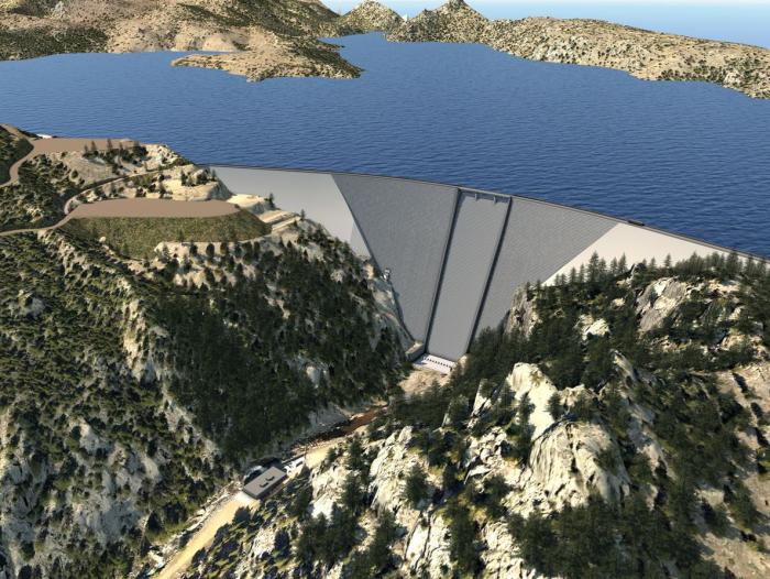
Expanding the reservoir requires raising the dam 131 feet by placing new concrete on the existing structure. Image credit: Denver Water.
Click the link to read the article from Denver Water (Todd Hartman):
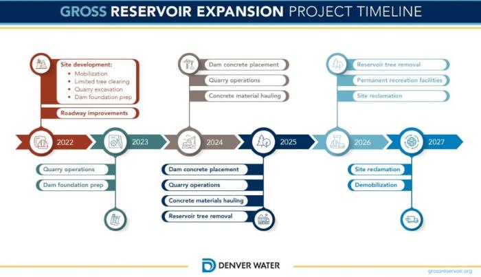
After nearly two decades of planning and permitting, Denver Water’s work to expand Gross Reservoir northwest of Denver is set to kick off.
Over the coming weeks, residents living near the reservoir may notice early signs of construction activity, including limited tree removal, more heavy equipment on roadways and shifts in recreation access to the reservoir.
“We want residents and visitors to the area to be aware and informed; we are taking the initial steps on the project, including mobilization of equipment, in the weeks to come,” said Jeff Martin, the program manager for the expansion project.
“We want to be transparent about the work underway and we want to share information proactively while continuing to address questions and respond to concerns our neighbors have shared. Most importantly, we want to ensure everyone’s safety on the roadways.”
A consistent place to get up-to-date information on the expansion project will be through the project website http://grossreservoir.org as well as via a Google My Map.
The public also can contact Denver Water through email, a phone hotline and virtual office hours, as well as by signing up for email updates and following the utility’s social media channels. Those contact details also are available on the project website and at http://denverwater.org.
Denver Water also held public outreach sessions in February for residents living in the vicinity of the project. About 80 neighbors attended to learn more about what to expect as construction ramps up.
Raising the existing Gross Dam and expanding the reservoir will improve water reliability for more than 1.5 million people. Image credit: Denver Water.
Here are some key things to expect in the coming weeks and months. In many cases, specific start dates for work are still being developed. Those will be shared at http://grossreservoir.org as details are finalized.
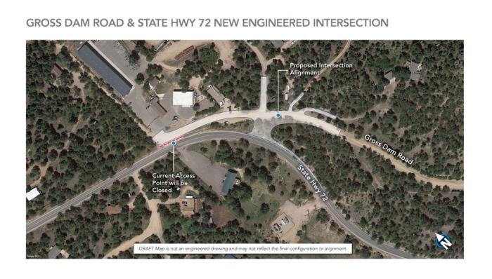
Improvements to Gross Dam Road. To protect the safety of all drivers, Denver Water is widening the road in various sections to address tight curves as well as improving the intersection at State Highway 72 and Gross Dam Road. Signage and traffic control will be in place to help drivers safely navigate the affected areas.
Improving the intersection of State Highway 72 and Gross Dam Road will improve safety for all drivers. Image credit: Denver Water.
Limited tree removal. Some trees will be removed in areas planned for site development on the south side of the dam, at the future quarry location, in areas along Gross Dam Road and other areas where various construction activities are planned.
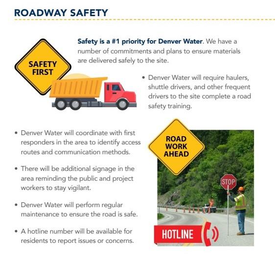
Equipment mobilization. Trucks and other heavy equipment will be spotted more frequently on Highway 72 and nearby roads as contractors position materials for upcoming work on roads and near the base of the dam.
Denver Water is committed to ensuring materials are delivered safely to the project site. Image credit: Denver Water.
Recreation changes. Access to recreation areas on the south side of the dam, including Windy Point, Osprey Point and Miramonte Picnic Area, will be closed in mid-March. Public boat launch access will be relocated from Osprey Point to the North Shore peninsula. This Google My Map is a good place to check for up-to-date information on recreation and access.
Access to the North Shore of the reservoir will also be limited temporarily this spring for construction of a temporary parking lot to help accommodate recreation shifts during the expansion project.
Recreation access will change during the expansion project, this Google My Map is a good place to check for up-to-date information. Image credit: Denver Water.
Construction activities will increase as the weather warms.
By this summer, truck trips in the canyon are expected to increase to nearly 20 trips per day and the workforce will grow to roughly 300 people, though a ridesharing program will help reduce traffic impacts. That intensity will drop off again as the weather cools.
“We recognize this project will have disruptions to the community near the project and within Coal Creek Canyon,” Martin said. “We are committed to clear, two-way communication with the public and keeping people fully informed as we move forward on this critical project.”
Ranking and time evolution of summer (June–August) drought severity as indicated by negative 0–200 cm soil moisture anomalies. Maps show how gridded summer drought severity in each year from 2000–2021 ranked among all years 1901–2021, where low (brown) means low soil moisture and therefore high drought severity. Yellow boxes bound the southwestern North America (SWNA) study region. Time series shows standardized anomalies (σ) of the SWNA regionally averaged soil moisture record relative to a 1950–1999 baseline. Black time series shows annual values and the red time series shows the 22-year running mean, with values displayed on the final year of each 22-year window. Geographic boundaries in maps were accessed through Matlab 2020a.
In the midst of an historic megadrought, states in the American West are embracing cloud seeding to increase snow and rainfall. Recent research suggests that the decades-old approach can be effective, though questions remain about how much water it can wring from the sky.
Not since Charlemagne was crowned Holy Roman Emperor in 800 A.D. has the American West been so dry. A recent study in Nature Climate Change found the period 2000 to 2021 was the driest 22 years in more than a millennium, attributing a fifth of that anomaly to human-caused climate change. The megadrought has meant more fires, reduced agricultural productivity, and reduced hydropower generation. Last summer, the United States’ two largest reservoirs — Lake Mead and Lake Powell — reached their lowest levels ever, triggering unprecedented cuts in water allocations to Arizona, Nevada, and Mexico.
Desperate for water, several Western states have expanded decades-old programs to increase precipitation through cloud seeding, a method of weather modification that entails releasing silver iodide particles or other aerosols into clouds to spur rain or snowfall. Within the past two years, Idaho, Utah, Colorado, Wyoming, and California have expanded cloud seeding operations, with seeding a key plank in the Colorado River Basin Drought Contingency Plan.
Cloud-seeding graphic via Science Matters
Cloud seeding operations have also expanded in water-stressed regions outside the U.S. The United Arab Emirates, which currently gets more than 40 percent of its water through desalination plants, has built a weather enhancement factory that can churn out 250 cloud seeding flares a week. China has long had a far more substantial weather modification infrastructure, with millions of dollars spent each year seeding clouds in the semi-arid north and west, often with anti-aircraft guns launching silver iodide flares into the sky. In 2020, the central government announced that the weather modification program would expand to include more than half of the country, with a grand vision of a “sky river” carrying water from the humid south to the drier north.
Some of the renewed attention on cloud seeding is driven by fresh evidence that it actually works — at least when seeding for snow. In 2020, a group led by researchers at the University of Colorado and the National Center for Atmospheric Research reported the results of a study conducted at a cloud seeding operation in Idaho. Called SNOWIE, the study used sophisticated radar and meteorological methods to demonstrate unambiguously that cloud seeding can increase snowfall.
Cloud Seeding targets North America. Map credit: North American Weather Modification Council
“Cloud seeding works,” says Katja Friedrich, an atmospheric scientist at the University of Colorado and lead author of the SNOWIE study. “We know that. We know that from experiments in the lab. We also have enough evidence that it works in nature. Really the question is: We still don’t have a very great understanding of how much water we can produce.”
Governments and users aren’t waiting for more certainty to pursue projects. In the U.S. West, the need for water is so acute and cloud seeding so cheap that even a very slight increase in precipitation is worth it, says Friedrich. “Cloud seeding is something people consider in areas where they’re desperate for water,” she says.
But cloud seeding should not be thought of as a response to drought, experts agree. For one, in a drought there are likely to be fewer seed-able storms. And when there are storms, even the estimates from cloud seeding companies themselves show the practice increases precipitation by only around 10 percent in a given area. That might be worth the effort when every acre-foot counts, but it’s not going to end a drought across an entire region.
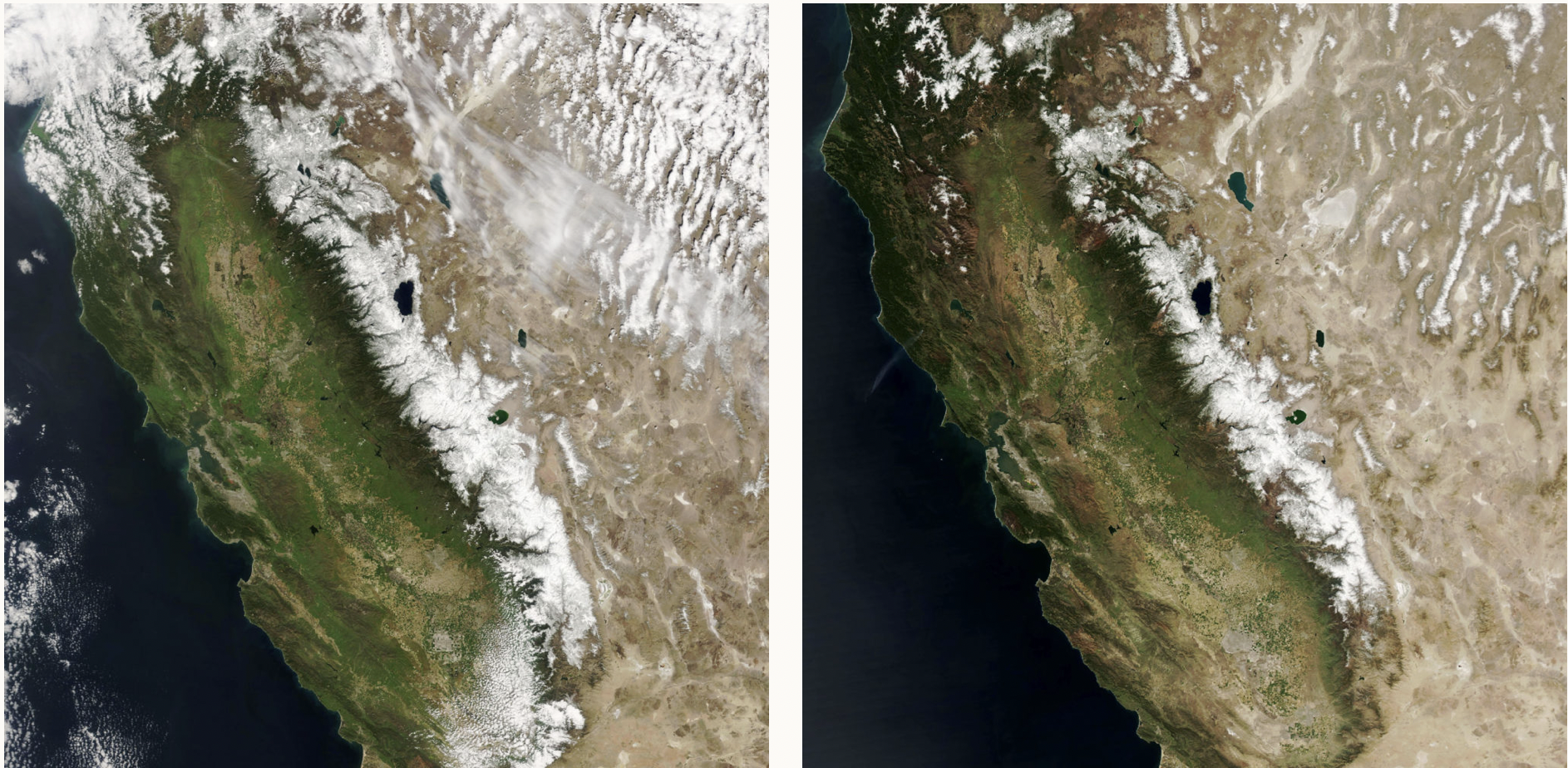
California’s Sierra Nevada mountains in March 2010 (left), a typical year for snowpack, and in March 2021 (right), a drought year. NASA
Cloud seeding, if it’s done at all, is most effective when practiced continually, seeding in wet years and dry years alike to try to keep reservoirs full and soil moist. Along with conserving and using water more efficiently, “it’s just another tool in the toolbox for water supply,” says Mike Eytel, a senior water resource specialist for the Colorado River District. “It’s not the panacea that some people think it is.”
Cloud seeding got its start because of a problem with planes. When pilots began to fly through clouds, ice sometimes accreted on the wings, impacting their ability to fly. During World War II, this was a major issue for American planes flying from India over the Himalayas to supply Chinese forces, a treacherous trip known as “The Hump.” Many planes turned back after icing up. After the war, General Electric began studying how supercooled water in clouds — water that is below freezing temperature but still liquid — became ice. “They were creating the supercooled water clouds in this freezer, and they threw some dry ice in there,” says Frank McDonough, a meteorologist at the Desert Research Institute. The dry ice caused the supercooled water to form ice crystals — snow.
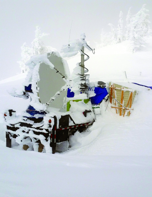
Scenes from the Seeded and Natural Orographic Wintertime Clouds: The Idaho Experiment (SNOWIE) project, which was undertaken in Idaho’s Payette Basin in winter 2017. Credit: Joshua Aikins via Aspen Journalism
Soon, General Electric scientists were running experiments in real clouds, first with dry ice, then with silver iodide, crystals of which resemble ice. When silver iodide particles are released into a cloud, droplets of supercooled water form crystals around them, which fall to the ground as snow. Clouds can be seeded from rockets, planes, or from the ground by burning silver iodide in acetone, so the particles rise in smoke. Warm weather seeding for rain works somewhat differently. Instead of silver iodide, “giant aerosols” such as salt are released into clouds by planes, causing larger droplets to form among the trillions of supercooled droplets too small to fall, which can spark a chain reaction leading to rain.
The finding that weather modification was possible generated a lot of interest, but attempts to demonstrate that seeding reliably caused more precipitation were inconclusive. Stymied by a limited understanding of cloud physics and the difficultly of running well-controlled experiments in nature, researchers were unable to distinguish the effects of cloud seeding from natural variability. The ambiguous evidence, combined with some overzealous promises, gave weather modification a reputation for charlatanism, and research dwindled.
In 2003, recognizing that a number of states had continued cloud seeding programs despite the limitations of prior research, the National Research Council revisited the literature on weather modification. “The Committee concludes that there still is no convincing scientific proof of the efficacy of intentional weather modification efforts,” the report found. “In some instances there are strong indications of induced changes, but this evidence has not been subjected to tests of significance and reproducibility.”
The 2020 study from SNOWIE, which demonstrated that seeding for snow can work in the right meteorological contexts, changes that picture. “In terms of research, this is a really exciting time for cloud seeding,” says Sarah Tessendorf, a researcher at the National Center for Atmospheric Research and another author of the SNOWIE study, though she is careful to qualify the results.
For one, the SNOWIE findings don’t apply to warm weather seeding for rain, which exploits a different mechanism within different types of clouds. And what worked in Idaho doesn’t necessarily apply elsewhere, Friedrich says; even within the SNOWIE study itself, increased snowfall was not observed after every seeding run. Further, the sophisticated radar methods used in the study are not available to analyze every operation, and many questions remain about when, where, and with what methods cloud seeding is most effective, with robust data in short supply.
Cloud seeding operators submit annual reports to states estimating additional precipitation caused by their efforts, often claiming hundreds of thousands of additional acre-feet, but “it’s kind of crude,” says Eric Hjermstad, who runs Western Weather Consultants, a cloud seeding company that manages several seeding operations in Colorado. For instance, company reports make comparisons between seeded areas and unseeded areas at different altitudes or with different levels of humidity, or they make assumptions about the amount of snow that actually ends up in river systems. “I don’t think they are really off in what they are saying,” says Friedrich. “But sometimes we need to question these [reports].”
To address this, Friedrich, Tessendorf, and others aim to use the SNOWIE data to develop more accurate cloud seeding models, which could improve predictions of how much additional precipitation is caused by given operations and determine where and when cloud seeding is most effective — not that cloud seeding operations are waiting around for better models.
Cloud seeding projects are often funded through cost-sharing agreements between state and local governments, and private parties, such as ranchers or ski resorts, willing to accept some risk that their money is for naught, says McDonough. And many are convinced that cloud seeding is having an effect, despite considerable uncertainty in the annual reports. “They know their local water supplies and snowpack well enough that I think they feel like they’re seeing the results,” he says. “These people don’t have that much money. I think that if they had doubts, they probably would have stopped a long time ago.”
Scientists used the Doppler on Wheels radar to measure snowfall in the Idaho mountains that was generated by cloud seeding during the SNOWIE field project. Photo by Joshua Aikins via NCAR
Since 2000, more than 800 reports from more than 50 weather modification projects have been submitted to the National Oceanic and Atmospheric Administration, with most focused on increasing precipitation. State weather modification budgets typically range in the hundreds of thousands of dollars. Utah, which has one of the most extensive seeding programs in the U.S., spends a little more than $700,000 a year on seeding, with contributions split between the state, municipalities, and other states in the Lower Colorado River Basin.
The recent efforts to expand long-standing cloud seeding programs have largely not met opposition, though some projects have been controversial. In New Mexico, which has no active cloud seeding operations, a proposal to begin seeding in the north of the state was abandoned in January after facing public backlash over concerns about environmental impacts, as well as the lack of consultation with tribal governments. Another proposal to seed clouds in the east of the state is under review.
Cloud seeding costs money, but the cost is relatively low compared to the value of water, even if the reports overstate increased precipitation, proponents say. And there do not appear to be environmental downsides to seeding. People are often concerned about contamination from silver iodide because silver can be toxic in high concentrations, Tessendorf says, but studies have found levels of silver iodide in cloud seeded areas are comparable to levels in unseeded areas and are unlikely to accumulate to toxic levels. Because seeding affects such a small portion of the total moisture in a given cloud, there also aren’t likely to be significant downstream effects where “you’re robbing Peter to pay Paul,” she says. In other words, seeding clouds over Colorado doesn’t deprive Utah of snow.
In New Mexico, some commenters opposed to cloud seeding expressed concern that it represents a kind of hubris, that humans shouldn’t “play God” or mess around with nature. Such arguments have been made since seeding became possible. It’s worth pointing out, says McDonough, that seeding or not, “clouds aren’t pristine things.” In many cases, car exhaust and other industrial pollution has reduced the efficiency with which clouds precipitate by shrinking the size of cloud droplets. “Cloud seeding may be putting the clouds back to a more efficient state where they may have been prior to humans,” he says. Or at least prior to Charlemagne.
Eric Hjermstad, field operations director, Western Weather Consultants, lights a cloud seeding generator north of Silverthorne, Colorado. Photo credit: Denver Water
Click the link to read the article on the CNN website (Rachel Ramirez):
For the first time since it was filled more than 50 years ago, Lake Powell, the second-largest reservoir in the country, is projected to dip past a critical threshold, threatening water supplies and putting a key source of hydropower generation at heightened risk of being forced offline, as climate change-fueled drought continues to grip the Western US.
The US Bureau of Reclamation told CNN it is currently anticipating water levels in Lake Powell to reach a significant elevation of 3,525 feet above sea level sometime between March 10 and 16.
Drought contingency plans define the 3,525-foot mark as a significant “target elevation” for the reservoir, under which the situation becomes dire. As of Thursday, Lake Powell had fallen to just over 3,526 feet in elevation, which is just over 24% of capacity and less than two feet away from the critical level.
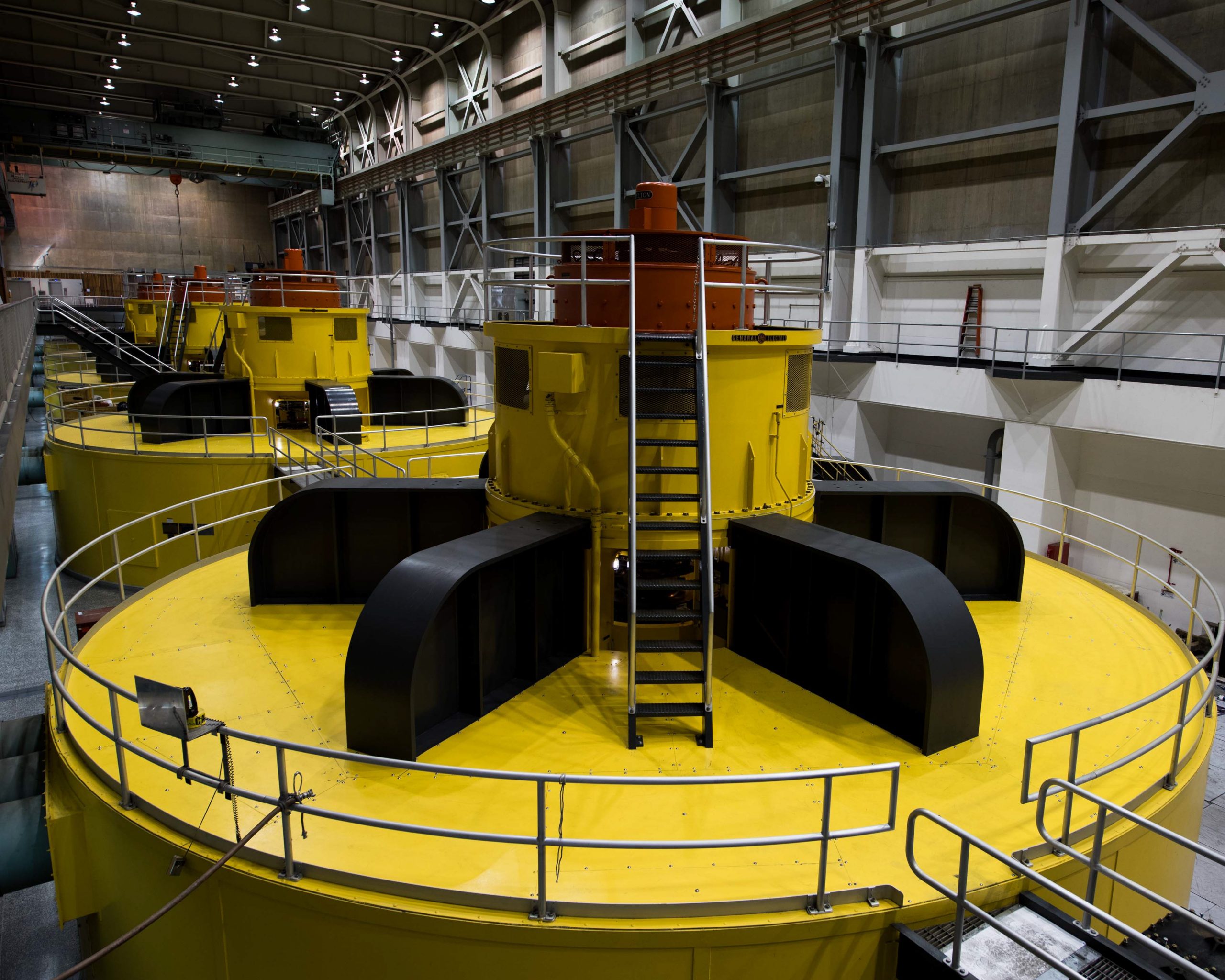
These turbines at Lake Powell’s Glen Canyon Dam are at risk of becoming inoperable should levels at Powell fall below what’s known as minimum power pool due to declining flows in the Colorado River. Photo courtesy U.S. Bureau of Reclamation.
The 3,525-foot target is crucial because it allows a 35-foot buffer for emergency response to prevent Lake Powell from dropping below the minimum pool elevation of 3,490 feet above sea level, the lowest at which Glen Canyon Dam is able to generate hydropower…
Once Lake Powell drops below 3,525 feet, the Bureau of Reclamation would have to release more water from the smaller reservoirs once the spring snow melt dwindles toward the end of the summer, as part of the 2019 Colorado River Drought-Contingency Plan to keep it afloat…
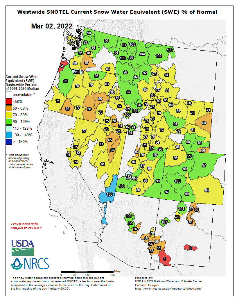
Westwide SNOTEL basin-filled map March 2, 2022 via the NRCS.
If future projections show the monthly releases are not enough to protect Lake Powell, the Bureau of Reclamation will need to consider other avenues. At the moment, the agency and the Upper Basin states are continuing to work on a Drought Response Operations Plan, which they expect to complete this April.
But given the rate at which the planet is rapidly warming, Mankin worries about the potential aftermath recovery process: “Then what? Do we go back to kind of normal operations?” he said. “I feel a bit nervous about the fact that the climate is changing, but our management of water is not.”
Climate change’s impacts on water in the West may just be a preview of what’s to come.
Click the link to read the release on the USDA website:
President Joe Biden and Agriculture Secretary Tom Vilsack announced that the U.S. Department of Agriculture (USDA) is investing more than $166.5 million in 108 infrastructure projects as part of implementing the Bipartisan Infrastructure Law, also known as the Infrastructure Investment and Jobs Act (IIJA). USDA’s Natural Resources Conservation Service (NRCS) is working with local communities in 23 states to invest in new dam and flood prevention projects and in repairs on existing watershed infrastructure, which are all part of USDA’s broader national infrastructure investment.
Through this first round of projects the Bipartisan Infrastructure Law is funding, NRCS prioritized projects in communities heavily impacted by drought and other natural disasters as well as historically underserved and limited resource communities.
“The Biden-Harris Administration is committed to building back better, and this starts with our infrastructure,” Vilsack said. “Protecting our watersheds and saving lives is paramount. These investments in our watershed programs will provide much needed support for communities to build resilience in the face of climate change. We can extend financial assistance to underserved communities that live in constant fear of flooding, help with the effects of severe weather events, and put systems in place that will ensure a climate resilient future to help communities thrive in the years to come.”
Bipartisan Infrastructure Law, signed in November by President Biden, provided $918 million for NRCS watershed programs, which includes the Watershed and Flood Prevention Operations (WFPO) Program, Watershed Rehabilitation Program (REHAB) and Emergency Watershed Protection (EWP) Program. Through NRCS watershed programs, NRCS works with local, eligible sponsors, including state government entities, local municipalities, conservation districts and federally recognized tribal organizations.
REHAB focuses on repairing existing infrastructure, and examples include:
Athens, Ohio: This investment includes two rehabilitation projects for two dams on Margaret Creek near Athens, Ohio. Funds will enable the Margaret Creek Conservation District to raise the embankment of the Meeks Lake Dam, armor its spillway, and extend its lifespan by at least another 50 years. Meanwhile, for the second project, the Margaret Creek Conservation District will bring the Fox Lake Dam into compliance with Ohio’s safety regulations and restore the original flood protection benefits of the structure to last another 50 years or more.
Añasco, Puerto Rico: This investment focuses on two dams in the the Añasco River Watershed, Site 3 (Daguëy Dam) and Site 2A (Ajies Dam), which help prevent flooding. These structures were able to perform their intent and prevented major flooding to the Añasco valley communities and industries during Hurricane Maria in 2017, but both dams suffered damages. With the funds, the Department of Natural and Environmental Resources (DNER) bring both structures to compliance with current safety criteria and performance standards, extend their lifespan and in turn reduce flood risk to life and property.
Meanwhile, WFPO projects focus on new infrastructure, and examples include:
Alakanuk, Alaska: Funds will support planning, design, construction, and the removal of damaged property from the floodplain. This work will assist the Alakanuk community with flood damage reduction and mitigation measures.
Duchesne County, Utah: Funds will support projects that address water use, improve agricultural operations and reduce flood damage throughout the watershed. Specifically, the project will address drought concerns by improving irrigation canals that serve approximately 38,000 acres of cropland and increased flood protection in four communities within the watershed.
Glacier County, Montana: Funds will be used to help implement a new ag-water management strategy for the St. Mary Canal and address areas of deterioration that need to be repaired. Modernization will help the surrounding agricultural community build towards climate resiliency.
IIJA also provided EWP funds and those funds are available for communities to respond to natural disasters. NRCS will continue to assist communities as it receives disaster requests.