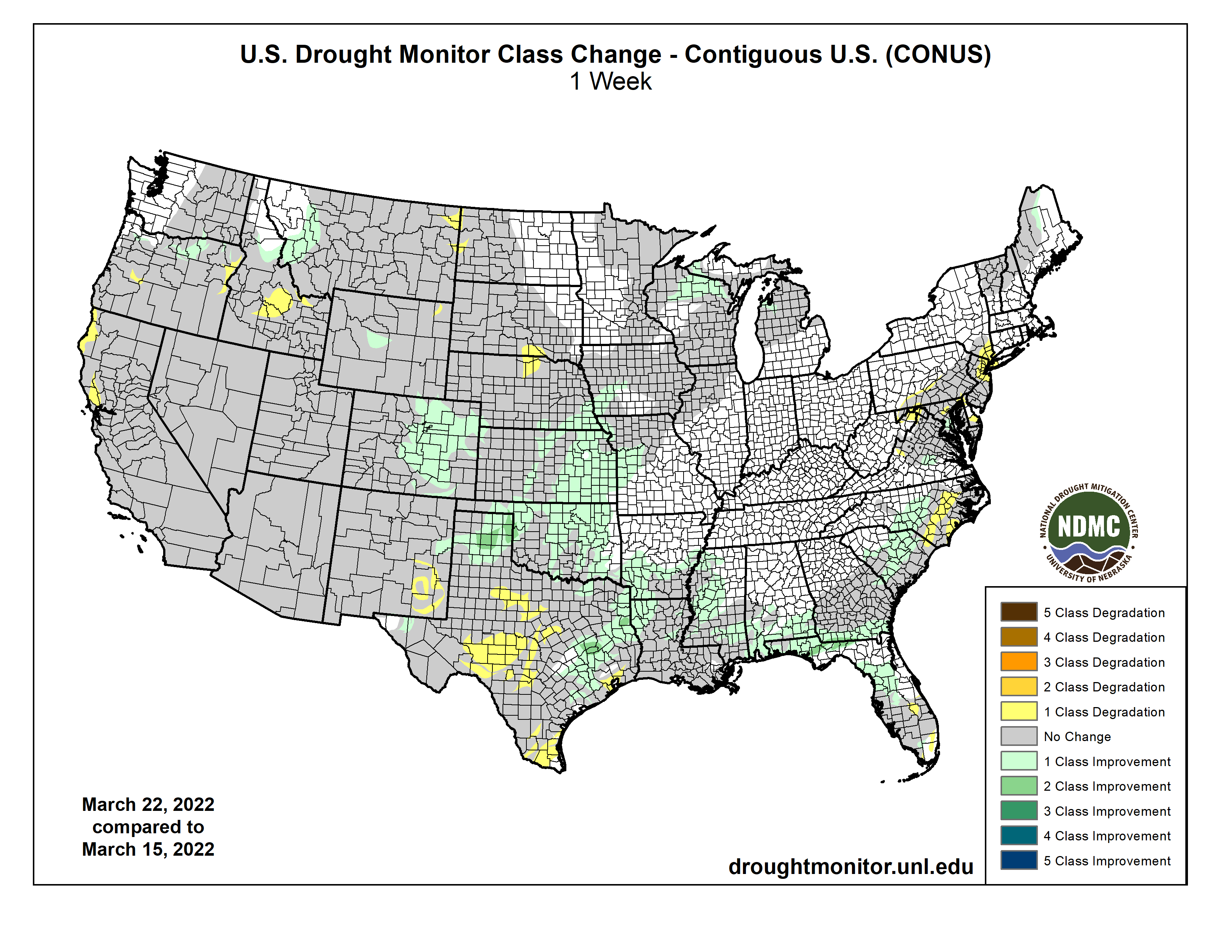
A series of storm systems moved across the lower 48 states this past week. Heavy rain fell across parts of the Great Plains and Southeast, with lighter amounts observed across parts of the Pacific Northwest and Intermountain West. The Central and Southern Plains, Lower Mississippi Valley, and Southeast mostly saw improvements to drought conditions, with several locations receiving more than 2 inches of rainfall (more than 5 inches, locally) during the 7 days leading up to March 22. Throughout much of the U.S., where antecedent dryness coincided with below-normal precipitation, drought either continued or worsened in intensity. The only areas where this was not true was across parts of the Upper Midwest, which experienced some removal of long-term drought due to improvements from melting snow cover…
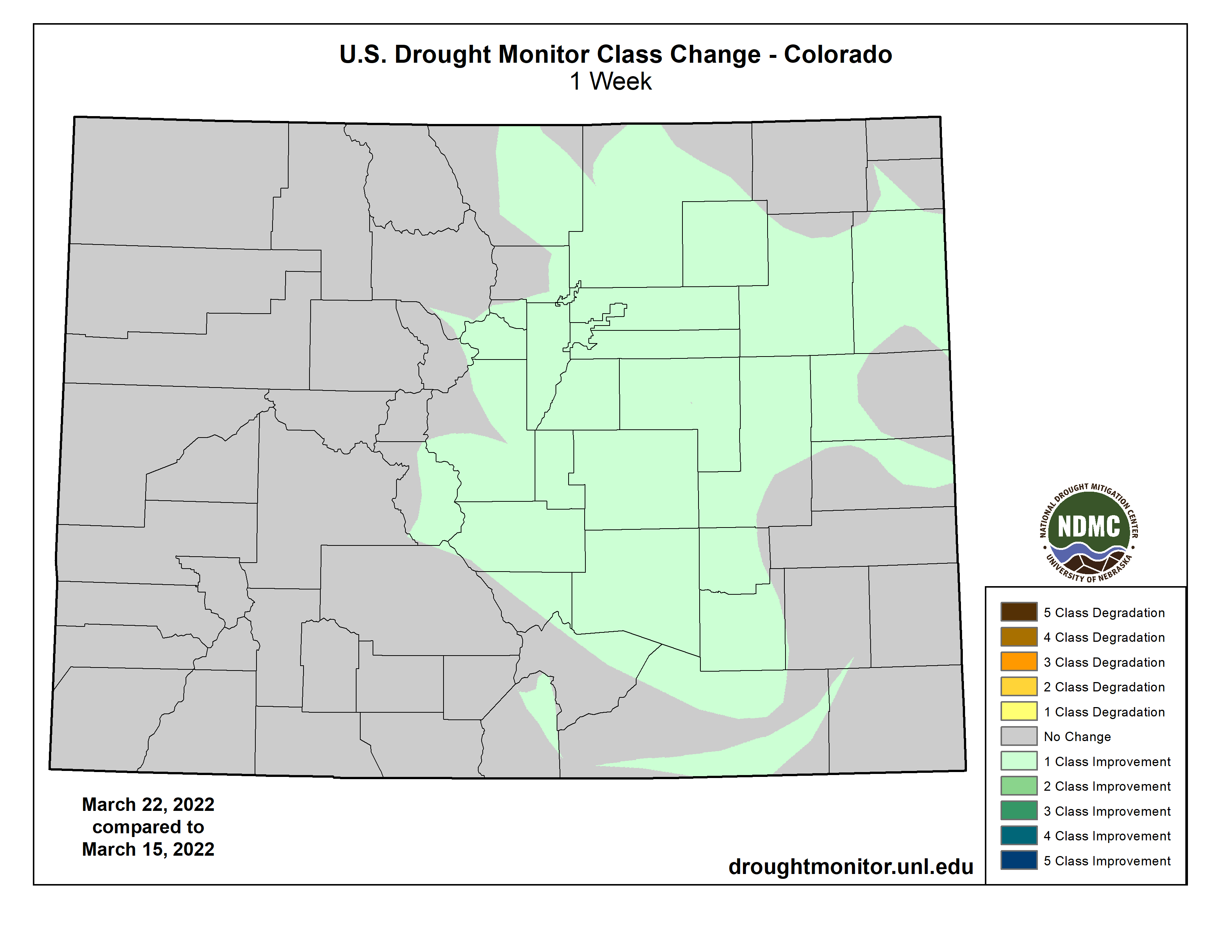
Associated with a storm system intensifying and moving slowly northeastward from the Central Plains March 21-22, heavy rainfall was observed across much of central and eastern Kansas, southeastern Nebraska, and eastern Colorado. Rainfall in excess of 1.5 inches resulted in 1-category improvements across many of these areas. However, improvements were less widespread for some locations in central Kansas and southeastern Nebraska, as longer-term deficits remain intact. Additionally, soil moisture still remains D2-equivalent (indicating severe drought conditions) or worse across many areas, region-wide stream flows are running near and below normal, and standardized precipitation indices (SPIs) are D2-equivalent or worse for all periods between 60 and 120 days. Farther north across western North Dakota and southern South Dakota, the lack of seasonal snow cover, above-normal temperatures this past week (10 °F to 15°F above-normal), and high winds resulted in the expansion of extreme (D3) and severe (D2) drought, respectively. Reports from western North Dakota indicate rangeland conditions are worse than this time last year. Groundwater and root zone soil moisture is very low and watering holes are dried up, supported by NASA GRACE groundwater and NASA SPoRT 0-100 cm soil moisture indicators. In southern North Dakota, shallower soil depths (0-40 cm) have dried out further this past week due to above-normal temperatures and high winds. Additionally, SPIs are at D2-equivalent or worse for all periods going back 120 days. Locals continue to be concerned about the antecedent dryness leading up to the spring. Water availability, forage for feed, and livestock are all at risk if the rains do not come during the spring and summer months, as the Northern Plains begins transitioning into a climatologically wetter time of year in April…
Colorado Drought Monitor one week change map ending March 22, 2022.
Following a very wet December 2021 across parts of the West, a very dry pattern has persisted during much of 2022 so far, mainly from southern Oregon southward. Average basin snow water equivalent (SWE) values have continued to decline across the West and are now below-normal since the start of the water year (October 1, 2021). Despite the drying trend leading up to this week across many areas of the region, a stormy pattern brought above-normal precipitation to the windward (west-facing) slopes of Washington, with some additions to the snowpack. Snowpack gains were also evident across parts of the Northern Rockies. Given the smalls gains made over the past couple of weeks, targeted improvements were made across northern Oregon, northern Idaho, and western Montana. Additionally, sub-basin average SWE values are near and slightly above-normal for the water year, USGS average stream flows are running near and above-normal, and standardized precipitation evapotranspiration indices (SPEIs) are D0 to D1 equivalent (indicating abnormally dry to moderate drought conditions) for all periods going back 6 months. However, longer-term drought remains entrenched across much of the West, supported by NASA GRACE shallow groundwater remaining below the 5th percentile for many areas. Deterioration of drought was also observed in northwestern California, where 7-day precipitation was below-normal again this week. Widespread along the coastal ranges of northern California, USGS 28-day average stream flows are below the 5th percentile of the climatological distribution, with more having fallen into the bottom 1 percent of their respective distributions for the same period. Groundwater, soil moisture, and SWE are all below-normal and nearby reservoir levels are, on average, 50 percent of their historical averages as we begin transitioning into a drier time of year. Elsewhere in the Western Region, a low pressure system tracking eastward in the days leading up to March 22 produced enough precipitation and high elevation snowfall to stave off any further degradation this week. Some basins across the Four Corners region are even reporting near and above-normal seasonal snowpack following the event. However, more will be needed to curb long-term drought across these areas…
Two storm systems brought heavy rainfall across much of the Southern Region this past week. The first system dropped heavy rain across parts of central Louisiana and much of Mississippi before moving eastward very early in the period (March 15-16). The second storm system intensified over the Southern and Central Plains in the final day leading up to March 22, dropping heavy rain across central and eastern Oklahoma and northern and eastern Texas, extending eastward to the Mississippi River. Rainfall totals across many of these areas exceeded 2 inches, leading to large swaths of 1-category improvements in the drought depiction. 2-category improvements were also warranted in isolated locations receiving, in some cases, more than 5 inches of rain. Given the short-term nature of the drought, soil moisture indicators and stream flows responded quickly, leading to more aggressive improvements in eastern Oklahoma, eastern Texas, and the Ark-La-Tex. Farther west and south in Texas, many locations missed out entirely, receiving little to no precipitation this past week. This increased rainfall deficits that go back several months, resulting in the continued deterioration of drought across these areas…
Looking Ahead
A storm system that brought heavy rainfall to eastern parts of the lower 48 states March 22-23 will continue to move northeastward and into the Great Lakes by Thursday, March 24. This storm will continue to bring the potential for rainfall across parts of the Southeast and Mid-Atlantic and mixed precipitation types across the Northeast and Great Lakes through Friday, March 25. By March 26, another fast-moving low pressure system is expected to sweep in behind the Great Lakes system to help push it out to sea by the weekend. Following the passage of these storm systems, colder air is likely across northeastern and north-central parts of the U.S., starting on March 26, with maximum temperature anomalies expected to be anywhere from 10°F to 20°F below-normal across parts of the Midwest. These cold temperatures will shift eastward toward the Northeast and Mid-Atlantic through March 29. Across the western U.S. high pressure is expected to dominate, favoring below-normal precipitation and above-normal temperatures through Monday, March 28. Maximum temperatures are predicted to be on the order of 15°F to 20°F above-normal, and greater, with the warmer temperatures shifting from the West Coast to the Great Plains and into the Southeast March 24-29, before beginning to moderate. On March 29, another storm system is predicted to move into the West Coast bringing an opportunity for much needed precipitation across portions of California.
The Climate Prediction Center’s 6-10 day outlook (valid March 29 to April 2, 2022) favors near to above-normal temperatures across much of the western and eastern contiguous U.S. (CONUS) and the Gulf Coast. Below-normal temperatures are favored for the north-central and northeastern CONUS, behind strong low pressure exiting the East Coast near the start of the period. Above-normal precipitation is favored for much of the eastern two-thirds of the CONUS, as a storm system is expected to intensify and move eastward across U.S. during the period. Behind this storm system and farther to its south, below-normal precipitation is likely across parts of the western CONUS and southern Texas, respectively.
US Drought Monitor one week change map ending March 22, 2022.
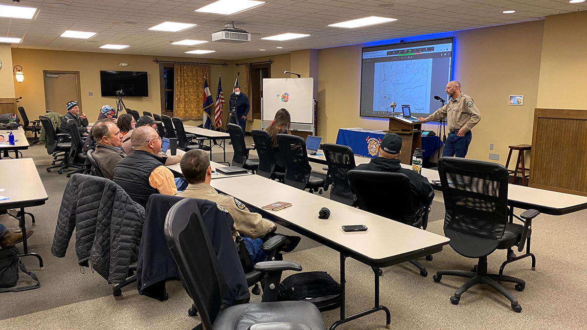
About 20 people attended an in-person meeting to discuss the Colorado River Connectivity Channel last month in Granby. Another 30 attended via Zoom, with the group learning about the benefits of the Connectivity Channel and other impacts associated with the project. Water Resources Project Engineer and CRCC Project Manager Kevin Lock was joined by Director of Engineering Jeff Drager, Collections Systems Department Manager Craig Friar and Public Information Officer Jeff Stahla at the in-person meeting.
The meeting took place as part of a public comment period on the Draft Watershed Plan and Environmental Assessment (Plan-EA) for the Colorado River Headwaters Connectivity Project. The U.S. Department of Agriculture, Natural Resources Conservation Service (NRCS) and project sponsors (Grand County, Trout Unlimited and Northern Water) recently announced the availability of that draft plan.
The Connectivity Channel is one of the key elements of the Chimney Hollow Reservoir Project’s $90 million mitigation and enhancement package. Once complete, it will reconnect the Colorado River around Windy Gap Reservoir.
Members of the public took part in an in-person meeting on Feb. 22 in Granby to discuss the Colorado River Connectivity Channel.
U.S. Secretary of Interior Deb Haaland issued an order in November declaring “squaw” a derogatory term and established a task force to rename more than 600 geographical sites across the country that have the word in their names.
“Squaw” — a racist and sexist term for Native American women — is just the latest target for renaming as the United States continues to reconcile historical names and events to modern sensibilities. Haaland also called for the creation of a complementary Advisory Committee on Reconciliation in Place Names to solicit, review and recommend changes to other derogatory geographic and federal place names.
“Place names are very powerful,” said Sara Jackson Shumate, Ph.D., a human geographer and the director of Metropolitan State University of Denver’s Center for Individualized Learning. “It’s important to rethink our landscapes and what we are valuing through these geographical names.”
The federal Derogatory Geographic Names Task Force convened by Haaland, a member of Laguna Pueblo in New Mexico and the first Native American to lead a Cabinet agency, has recommended 28 sites in Colorado for renaming. All of those sites incorporate the word “squaw.”
The task force works closely with the U.S. Board of Geographic Names, which gives final determinations for standardizing the names of geographic and natural features. The board is a federal body created in 1890 that was established to maintain uniform geographic name usage throughout the federal government.
As you begin to descend towards Echo Lake on the Squaw Pass road, Mt Evans and its barely visible road come into focus. Photo credit: Colorado Bike Maps
“You can’t erase history,” said Adriana Nieto, Ph.D., associate professor chair of Chicana/o Studies at MSU Denver. “Changing geological names doesn’t change our history; it reframes it. Reframing history is important because it points out the holes. Naming important places should be a way to remember or learn about important people and events. It changes what we talk about.”
Nieto said she’s hopeful the conversation is now happening at the national level. “It means it won’t go away easily like it has at a local level,” Nieto said. “A lot of credit goes to Secretary Haaland, who has created an opening for a conversation and brought the significance of names to the public eye.”
Local efforts
Jared Polis established the Colorado Geographic Naming Advisory Board last year to evaluate proposals concerning name changes, new names and name controversies of geographic features and public places in Colorado.
In September, the board made its first recommendation: to change the name of Squaw Mountain in Clear Creek County to Mestaa’ėhehe Mountain. Pronounced mess-taw-HAY, the name honors an influential Cheyenne translator known as Owl Woman.
Other discussions at the state level include renaming Negro Creek and Negro Mesa in Delta County to Clay Creek and Clay Mesa, respectively; changing the name of Redskin Mountain in Jefferson County to Mount Jerome; and renaming Mount Evans as Mount Blue Sky, the name the Arapaho people call themselves.
Mount Evans was named for Territorial Gov. John Evans, who oversaw the Sand Creek Massacre in 1864, in which volunteer soldiers attacked a Cheyenne and Arapaho village, killing approximately 750 people.
Jackson Shumate is hopeful that renaming such a well-known site might spur conversations about past and current values.
“People vacation at these sites. If we start renaming places like Denali (from Mount McKinley) and Mount Evans, it creates an inflection point to begin a critical conversation about our past and what we value as Americans and Coloradans,” Jackson Shumate said. “Do we want the [a] peak in Colorado to be named for a territorial governor who was forced to resign because of his part in the infamous Sand Creek Massacre and its subsequent coverup or something we can all be proud of?”
Mount Evans’ name change may soon be a reality. On Tuesday, the Clear Creek County commissioners recommended changing its name to Mount Blue Sky. The recommendation will go to the state Geographic Naming Advisory Board and Polis before a final decision.
Last June, Colorado legislators passed Senate Bill 116, which prohibits the use of American Indian symbols and names by Colorado public schools beginning this June. Schools that do not come into compliance by June 1 face a $25,000 monthly fine.
“These efforts are steps, albeit baby ones, in the right direction,” Jackson Shumate said. “This is scratching the surface of what really needs to change, which is how we think about and relate to one another, but it gets us moving in the right direction.”