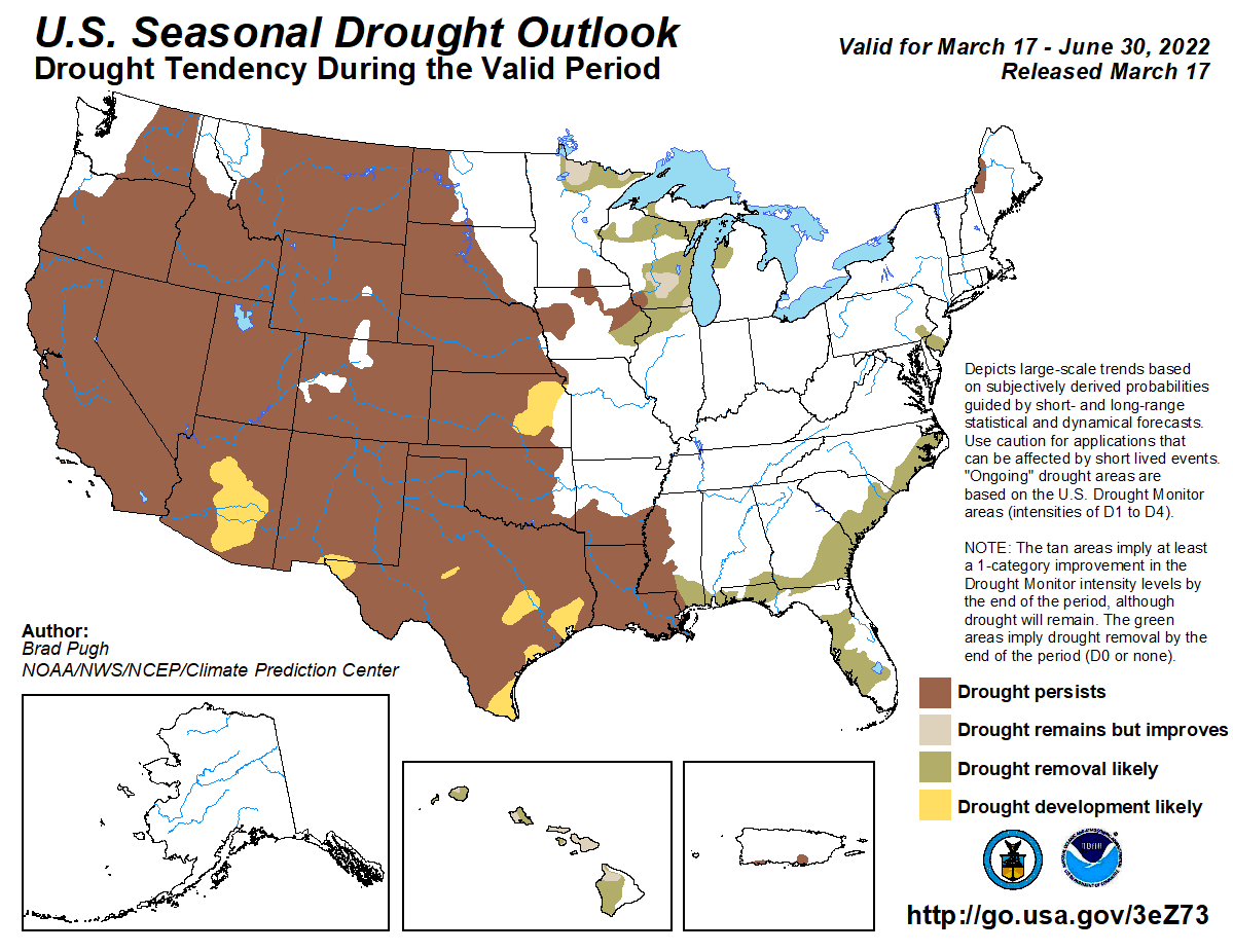
High pressure dominated across much of the central U.S. this week, bringing much below-normal temperatures (more than 10°F below-normal) to the Eastern Rockies, Great Plains, and parts of the Mississippi Valley. Much of the north-central U.S. remained below freezing last week. However, where daytime high temperatures did average above the freezing mark, below-normal precipitation and high winds resulted in some drought degradation across parts of the Great Plains. A series of low pressure systems moving across the southern and eastern U.S throughout this week brought heavy rainfall to parts of the Gulf Coast states and Eastern Seaboard, leading to drought improvements. Northern Florida received the greatest rainfall amounts, with several areas picking up anywhere from 5 to 10 inches of rain through Saturday. The strongest of these storm systems also brought snowfall to the Appalachians and interior areas of the Mid-Atlantic and Northeast Friday into Saturday. In the Pacific Northwest, a series of storms brought some drought improvements to parts of the central Cascades and interior northern Rockies. Farther south across California, drought intensified this week due to mounting deficits since the beginning of the year…
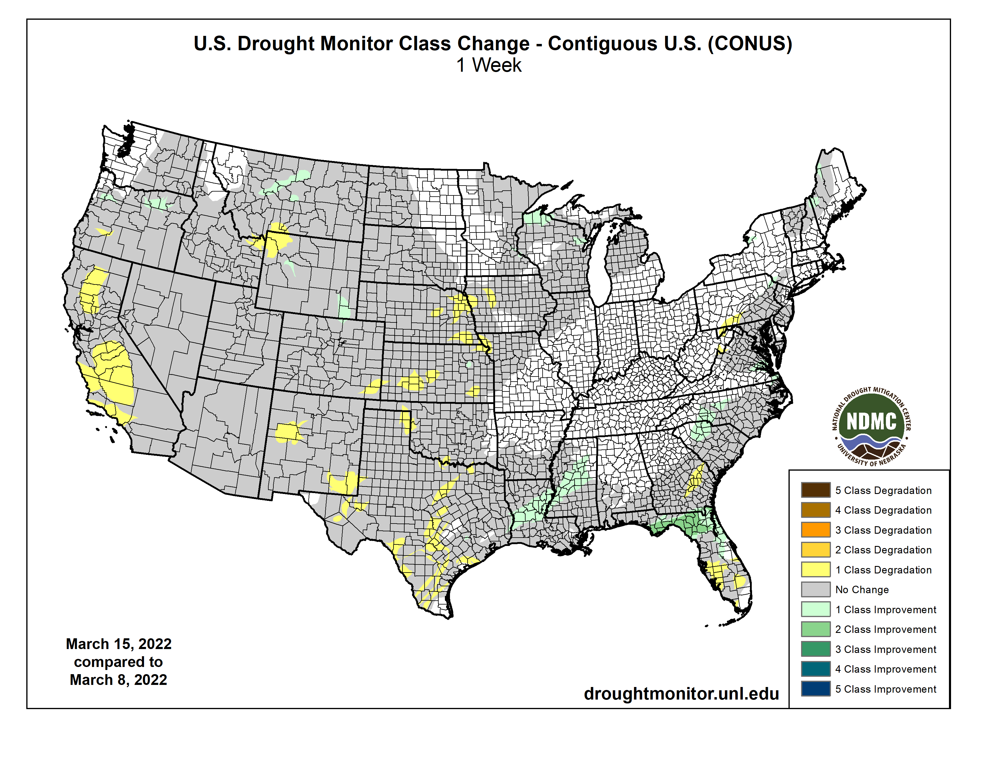
Although the High Plains region experienced widespread much below-normal temperatures this week (10°F to 15°F below-normal; even exceeding 15°F below-normal in the High Plains and Eastern Rockies), several areas saw continued deterioration of drought conditions. This was particularly true across parts eastern Nebraska and central Kansas, where high winds and below-normal 7-day precipitation only exacerbated ongoing short-term dryness brought about by a very dry winter season. Several of these areas have received only 5 to 20 percent of normal precipitation over the past 120 days and the fire risk has rapidly increased as a result. Shallow soil moisture is ranking below the 5th percentile of the climatological distribution, according to NASA SPoRT, and average stream flows are continuing to decline. Parts of southeastern Colorado, which is experiencing short to long-term drought, also experienced degradation this week from severe (D2) to extreme (D3) drought, supported by Keetch-Byram Drought Indices and short-term precipitation deficits (25 to 50 percent of normal precipitation over the past 90 days). Parts of northwestern Wyoming also experienced deteriorating drought conditions, due to depleted groundwater and year-to-date precipitation deficits that are now on the order of 5 to 10 inches. Conversely, there were targeted improvements across central Wyoming and northern Colorado, based on where positive weekly precipitation anomalies were observed, precipitation amounts are above-normal for the water year (since October 1, 2021), and NASA SPoRT soil moisture and USGS 7-day average stream flows are near and above-normal locally…
Colorado Drought Monitor one week change map ending March 15, 2022.
Following a very wet December 2021 (in some cases a record wet December) for many areas in the West, a very dry pattern has persisted since the start of 2022, mainly from southern Oregon southward. Average snow water equivalent (SWE) values have continued to decline across many basins in the West and are now below-normal since the start of the water year (October 1, 2021). Despite, the drying trend leading up to this week across many areas, a stormy pattern brought above-normal precipitation to parts of the Pacific Northwest and Northern Rockies this week, leading to targeted improvements in the central Cascades, northeastern Oregon, and central Montana, where short-term SPEIs and average stream flows are improving, basin SWE values are near 100% of normal, and precipitation is above-normal for the water year. Conversely, farther south in California, widespread deterioration was warranted across parts of the San Joaquin and Sacramento Valleys and the Central Coast. Many of these areas have experienced record dryness since the start of 2022, which has driven some reservoirs to record low levels and resulted in widespread stream flows and soil moisture ranking below the 2nd percentile. Water availability is a real concern as allocation from the Central Valley Project is likely to be either much reduced or non-existent for many farmers in California’s Central Valley, according to the U.S. Bureau of Reclamation…
A series of low pressure systems, tracking across the Gulf Coast states throughout this week, resulted in heavy rainfall across parts of eastern Texas and the Lower Mississippi Valley, leading to broad 1-category improvements where the heaviest rains fell. Some parts of central Louisiana and west-central Mississippi received more than 5 inches of rainfall. Despite year-to-date rainfall deficits being reduced to near zero for several locations and USGS average stream flow running near-normal, soil moisture still ranks between the 5th and 10th percentile of the climatological distribution. This indicates that drought is still firmly entrenched across the Lower Mississippi Valley and that more rainfall will be needed to continue to see meaningful improvements. Farther west across central Texas and parts of Oklahoma, drought continued to intensify. Conversely, high winds and below-normal precipitation prevailed across central Texas and western Oklahoma this week, leading to continued drought degradation. Fire risk remains a concern across many of these areas…
Looking Ahead
A storm system will exit the Rockies Thursday, bringing the potential for snowfall to the Eastern Rockies and Front Range. This system is forecast to intensify and move eastward across the lower 48, bringing an increased potential for precipitation of various types to many areas across the eastern U.S. before exiting the Eastern Seaboard by late Sunday into early Monday. As this system exits the eastern U.S., another low pressure system is forecast to track across the western U.S. and intensify over the Great Plains leading up to Tuesday. In the West, much of the heavier precipitation is forecast across parts of the Pacific Northwest, associated with the storm system later in the week. There are also increased chances of precipitation and high elevation snowfall across much of the West as this system tracks across the Rockies. The heaviest 7-day precipitation amounts are likely to be focused across parts of the Central and Southern Plains eastward to the Middle and Lower Mississippi Valley, with amounts accumulating from both storm systems.
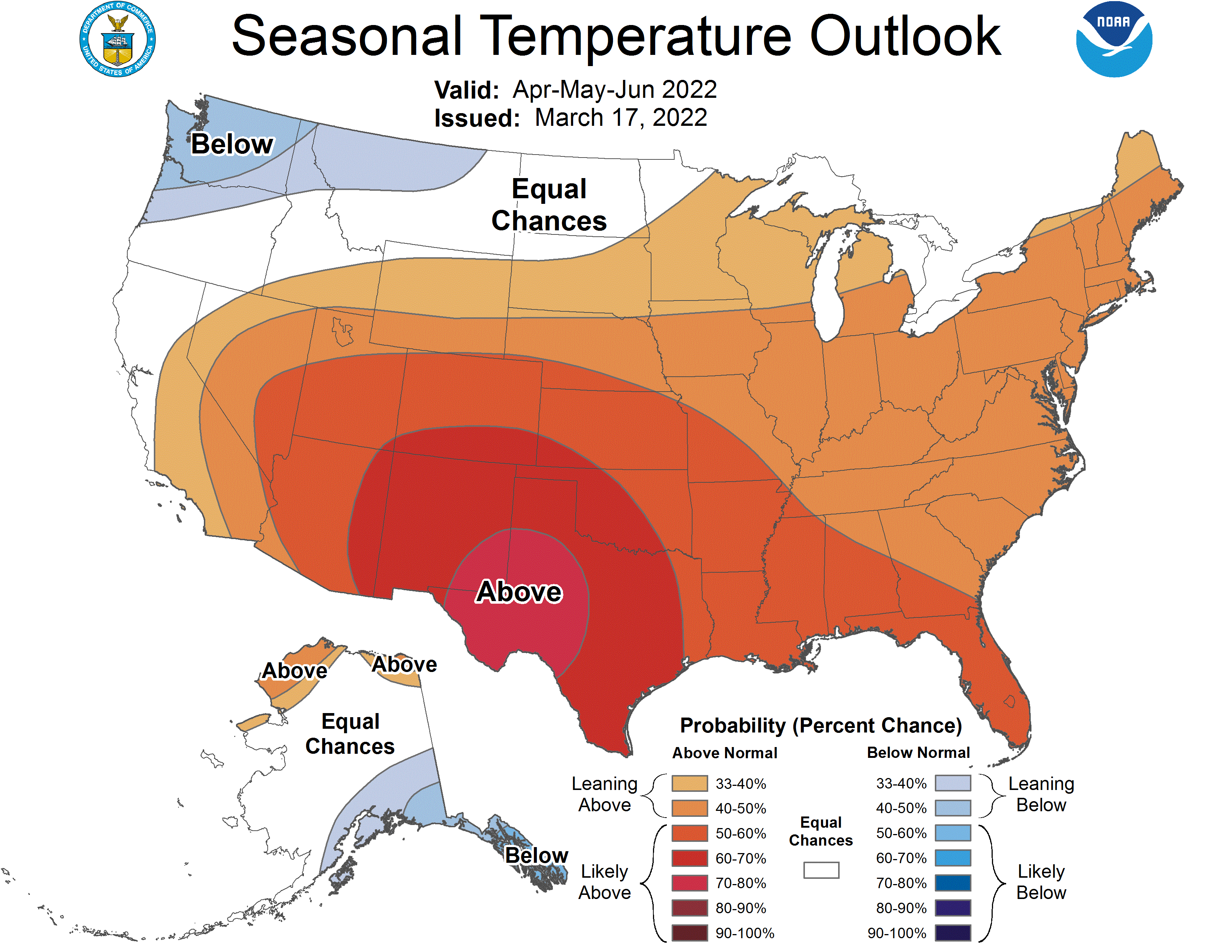
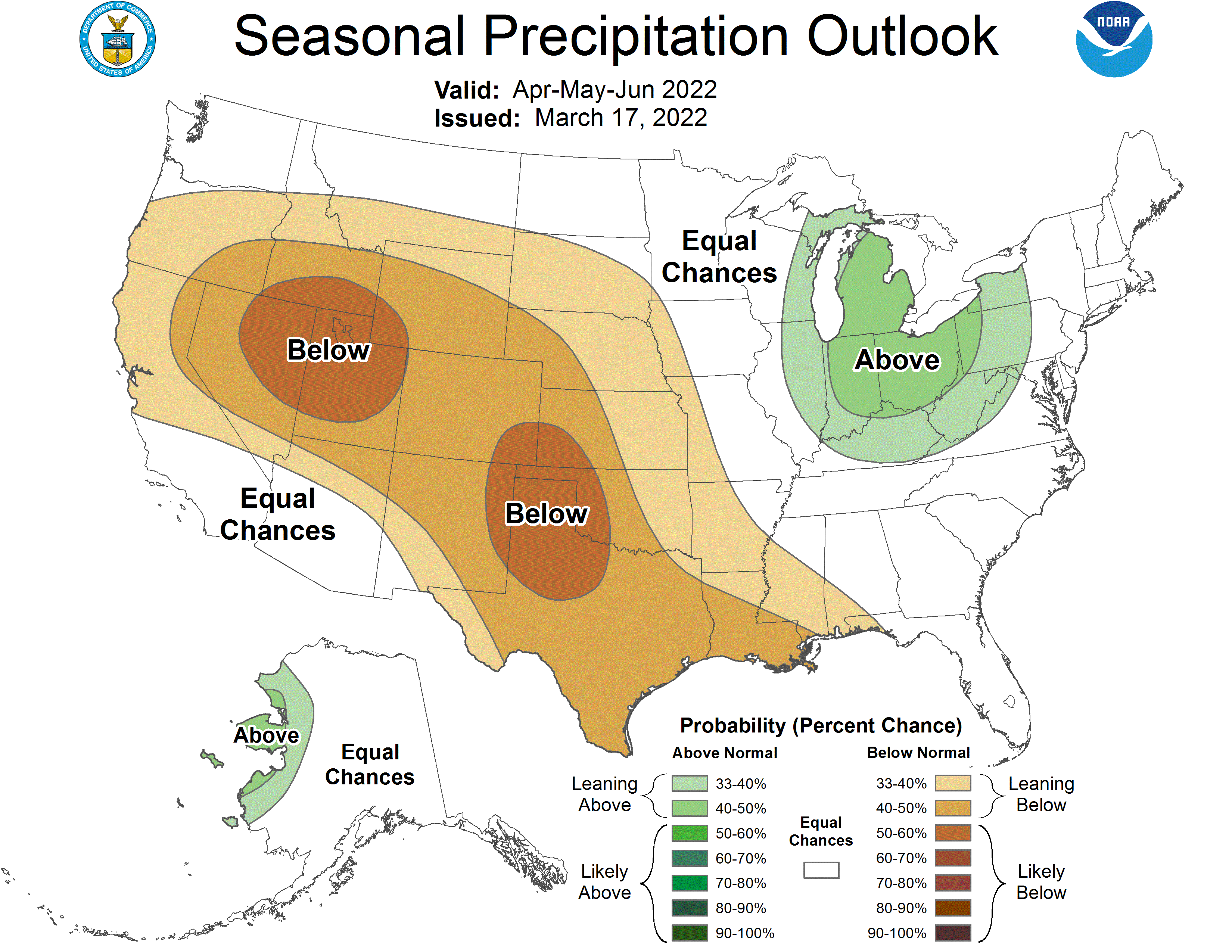
The Climate Prediction Center’s 6-10 day outlook (valid March 22-26, 2022) favors above-normal temperatures across much of the western and eastern contiguous U.S. (CONUS) and the Northern Plains. In the central CONUS, near and below-normal temperatures are forecast for many locations, associated with a mean trough of low pressure. Below-normal precipitation is favored for much of the western third of the CONUS, underneath a mean ridge of high pressure. Conversely, above-normal precipitation is favored for the eastern two-thirds of the CONUS, associated with mean southerly flow from the Gulf of Mexico enhancing precipitation chances, particularly across the Southeast.
US Drought Monitor one week change map ending March 15, 2022.
Seven Western states and their leaders — all depending on water from the Colorado River — remain divided.
September 21, 1923, 9:00 a.m. — Colorado River at Lees Ferry. From right bank on line with Klohr’s house and gage house. Old “Dugway” or inclined gage shows to left of gage house. Gage height 11.05′, discharge 27,000 cfs. Lens 16, time =1/25, camera supported. Photo by G.C. Stevens of the USGS. Source: 1921-1937 Surface Water Records File, Colorado R. @ Lees Ferry, Laguna Niguel Federal Records Center, Accession No. 57-78-0006, Box 2 of 2 , Location No. MB053635.
Split into basins by an imaginary border at Lees Ferry, Arizona, each state can share blame for the rapid depletion of reservoirs that once held over four years’ flow of the Colorado River. But now, Lake Powell and Lake Mead edge closer to empty. With water savings gone, the Lower Basin has been trying to cope, though the Upper Basin carries on business as usual. Meanwhile, 40 millions Americans depend on flows from this over-diverted river.
So far, leaders in the Upper Basin states of Colorado, New Mexico, Utah and Wyoming appear to be hoping that their counterparts will agree to use less water. This is hardly a useful strategy and seems a lot like a dangerous game of chicken.
The brunt of low flows has been borne by the Lower Basin states of Arizona, Nevada and California. Thanks to a series of agreements between 2007 and 2021, by the end of this year the three states will curtail their river use by more than 1 million acre-feet — 325 billion gallons. But it’s likely these cuts won’t change much.
Federal data released last month predict that Lake Mead, the largest reservoir in the nation and the Lower Basin’s water savings account, will continue to lose water for years to come. Lake Powell, the Upper Basin’s savings account, is also vulnerable. But that raises the obvious question: What are Colorado, Wyoming, Utah and New Mexico doing to limit their water use and conserve? The answer is not much.
In the Upper Basin’s four states there are no self-imposed curtailments of Colorado River allocations — no blockbuster, big-city conservation initiatives, no real signs that leaders are convinced that climate change is not only happening but also a major threat to the region.
More discouraging is that in 2016, the interstate collective of Upper Basin officials, known as the Upper Colorado River Commission, officially decided to take more water out of the river. That decision stands today.
Lake Powell Pipeline map via the Washington County Water Conservancy District, October 25, 2020.
Some of the largest projects on the Upper Basin’s wish list include the Lake Powell Pipeline, Green River Block Exchange, Wolf Creek Reservoir, and the Fontenelle Dam expansion…
Does anyone think that extra water exists?
The Bureau of Reclamation, which manages the Colorado River’s infrastructure, released a report in mid-February that predicts Lake Mead will drop another 30 feet by the end of 2023 –– leaving the reservoir 160 feet lower than in the year 2000. It also predicts more cuts for Nevada’s and Arizona’s shares of the river, as well as for California.
In the Upper Basin, where the Colorado River begins, no cuts are proposed. And according to a new report from the Utah River’s Council, a nonprofit fiscal and water watchdog, most of the Upper Basin states continue to use more than their share of the river, even though drought and aridity have reduced river flows.
While the three Lower Basin states use more water than the drought-stricken Colorado can deliver annually, leaders in Arizona, Nevada and California share a spirit of sacrifice when it comes to limiting water use. From my experience running a nonprofit river-protection group, I know that collaboration toward these efforts represents a resolve to act.
The Lower Basin states, for example, are working to fund a water-recycling facility near Los Angeles. The plant would reduce California’s reliance on the Colorado River and give Nevada and Arizona some of that river water in return for their joint funding. Collaborations like this need to start happening in the Upper Basin, but where are the examples?
Water managers in both basins tell folks they are doing their best to deal with the river’s decline, but only the Lower Basin’s actions can be quantified. It’s time for the Upper Basin to blink in this game of chicken and ensure equitable and prudent uses of the river. The lines dividing the states are invisible, but bathtub rings on Lake Powell and Lake Mead are all too visible.
Kyle Roerink via Writers on the range.
Kyle Roerink is a contributor to Writers on the Range, http://writersontherange.org, a nonprofit dedicated to spurring lively conversation about the West. He is the executive director of the Great Basin Water Network, a nonprofit that defends water supplies from undue political and corporate influence in the nation’s two driest states, Nevada and Utah.
Click the link to read the article on the 9News.com website (Wilson Beese). Here’s an excerpt:
The town said its water treatment facilities have been restored, and the system has been flushed through the distribution network after suffering damage during the wildfire…
Reservoir ash removal
The fire deposited ash on the town’s raw water storage at Terminal Reservoir. A firm has been contracted to remove ash from the banks of the reservoir, which will prevent deposited ash from going into the reservoir. The process should be completed in early April.
Chlorine dioxide
Superior installed chlorine dioxide within water treatment plant operations to assist with the oxidation and breakdown of compounds causing the taste and odor issues. Complaints from residents continued after the system was installed, and its use was discontinued.
Granular Activated Carbon (GAC)
The town ordered a GAC system to remove compounds causing the taste and odor issues. It will take four to six weeks for delivery and an additional two weeks for installation.
“This is a significant process revision and will require extensive modifications to the plant,” the town said in a release. “Our team is diligently working, including collaborating with other utilities, on procuring all the equipment required to bring this system online as fast as possible.”
Reservoir draining
Superior will soon begin releasing water from the reservoir into the parks irrigation system, which might help replenish the reservoir with water free of compounds causing the taste and odor issues.
Home filtration systems
The town said that home water filtration systems, especially those that use activated carbon, “may effectively remove” the compounds responsible for the taste and odor issues.
Aerial image of entrenched meanders of the San Juan River within Goosenecks State Park. Located in San Juan County, southeastern Utah (U.S.). Credits Constructed from county topographic map DRG mosaic for San Juan County from USDA/NRCS – National Cartography & Geospatial Center using Global Mapper 12.0 and Adobe Illustrator. Latitude 33° 31′ 49.52″ N., Longitude 111° 37′ 48.02″ W. USDA/FSA, Public domain, via Wikimedia Commons
From email from Reclamation (Susan Novak Behery):
In response to increasing flows in the critical habitat reach, the Bureau of Reclamation has scheduled a decrease in the release from Navajo Dam from 400 cubic feet per second (cfs) to 350 cfs for Thursday, March 17th, at 4:00 AM.
Releases are made for the authorized purposes of the Navajo Unit, and to attempt to maintain a target base flow through the endangered fish critical habitat reach of the San Juan River (Farmington to Lake Powell). This release change is calculated as the minimum required to maintain the target baseflow.
The San Juan River Basin Recovery Implementation Program recommends a target base flow of between 500 cfs and 1,000 cfs through the critical habitat area. The target base flow is calculated as the weekly average of gaged flows throughout the critical habitat area from Farmington to Lake Powell.
Lake Powell just north of Glen Canyon Dam. January 2022. Jonathan P. Thompson photo.
Click the link to read the article on the Land Desk website (Jonathan Thompson):
Lake Powell surface level dropped below the critical 3,525-foot mark sometime on the Ides of March. You’ve probably already read that somewhere, since the national media can’t seem to get enough of the slow motion desiccation of one of the nation’s largest reservoirs. And what’s so critical about 3,525 feet?
Nothing, really.
The real critical number is 3,490 feet, otherwise known as the “minimum power pool.” When Lake Powell sinks below that elevation, Glen Canyon Dam can no longer produce hydropower. That’s a big deal because Lake Powell really only serves two purposes these days: recreation and hydropower generation (the water storage component becomes somewhat irrelevant when Lake Mead is as low as it is now). Not only are the dam’s turbines a significant source of power for the Western Grid, but they also provide resilience for the grid in a way that other generators cannot.
Lake Powell has officially dipped just below 3,525 feet in elevation, reflecting the Colorado River Basin’s dry winter season. The elevation is expected to climb back above 3,525 feet over the course of spring runoff. More info: https://t.co/IobOBURhqH#drought#coloradoriver
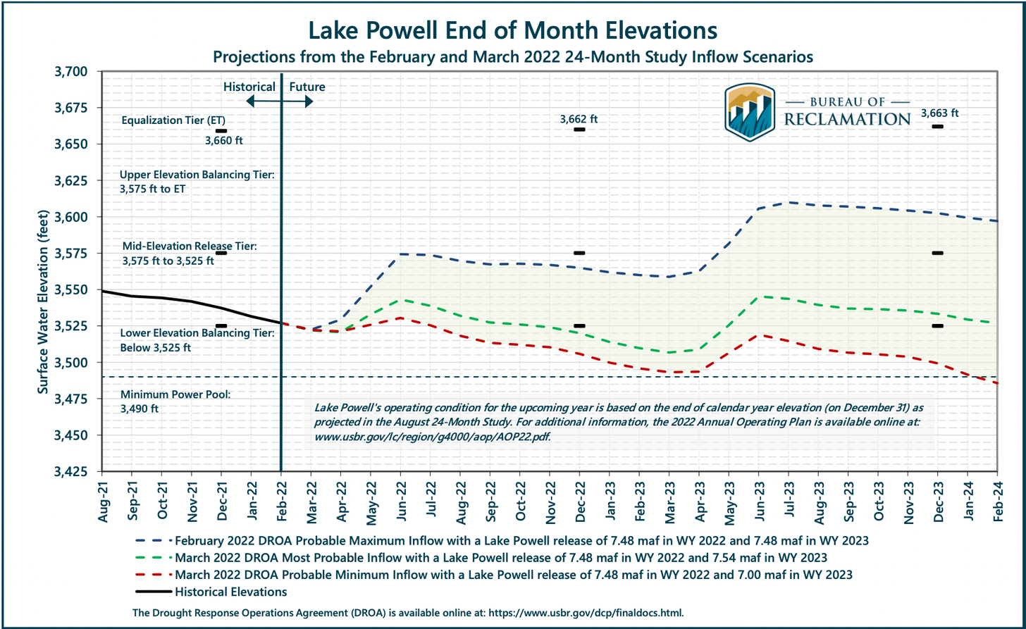
Water managers had hoped to keep the level at least 35 feet above minimum power pool, i.e. above 3,525 feet, so they’d have a bit of a buffer to work with. Now the level is inside the buffer zone, which is reason for concern but not immediate alarm. While the rate of decline has prompted officials to issue a more pessimistic outlook for the reservoir, they don’t expect a loss of hydropower anytime soon. Snowpack levels in the watersheds that feed Lake Powell are slightly below average for this time of year, but are tracking about 7 percent ahead of last year’s levels. Spring runoff will soon begin, inflows will increase, and the lake should begin rising again, staving off the turbine shutdown—for now.
Let’s get to the data:
3,569 feet above sea level: Lake Powell’s surface level on March 9, 2021.
3,524.9 feet: Level on March 15, 2021.
-44 feet: Twelve-month change.
3,490 feet: Level at which Glen Canyon Dam stops producing hydropower.
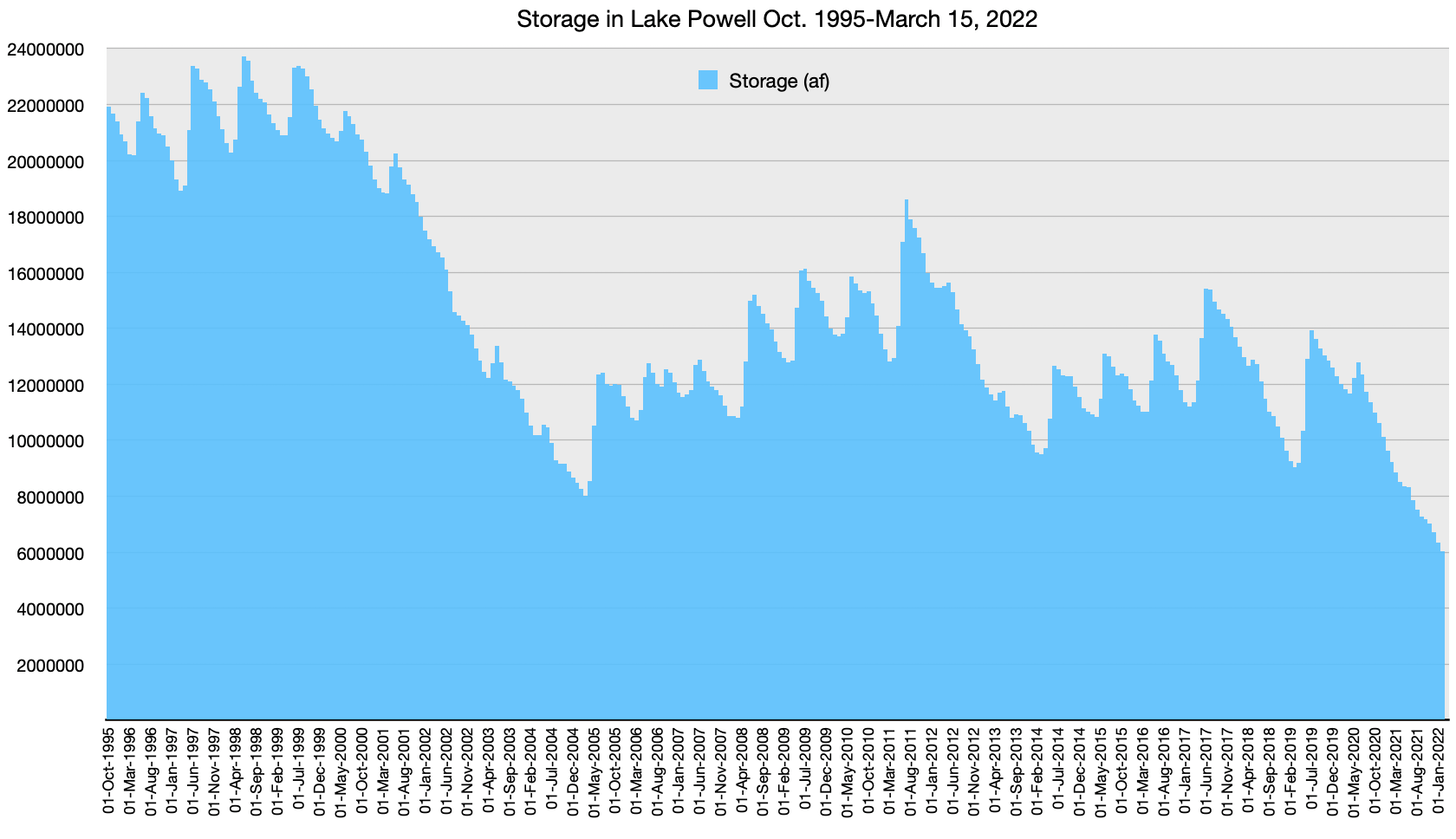
384 billion gallons: Amount by which Lake Powell’s storage has declined since November 2021.
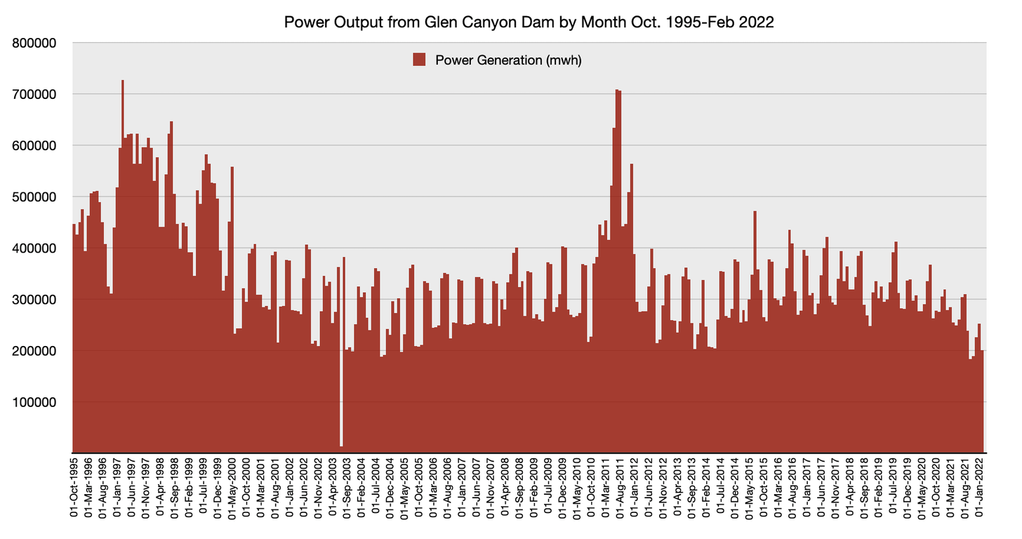
855,656 megawatt hours: August 2021 output of Four Corners Power Plant.
309,640 megawatt hours: August 2021 output of Glen Canyon Dam
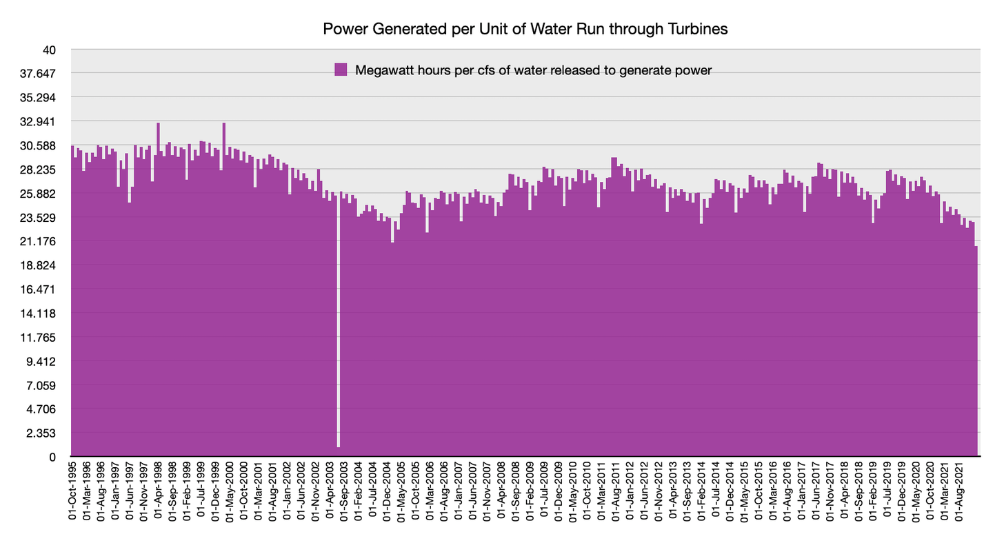
Lake Powell storage in acre-feet. 1 acre-foot = 325,851 gallons. USBR.Glen Canyon Dam’s power output roughly correlates with storage levels, but also varies month to month according to demand. USBR.As water levels drop there is less pressure to turn the dam’s turbines, so less power is generated per unit of water released.
Glen Canyon Dam, January 2022. Jonathan P. Thompson photo.
Click the link to read the article “Lake Powell hits historic low, raising hydropower concerns” on the Associated Press website (Sam Metz and Felicia Fonseca). Here’s an excerpt:
Lake Powell’s fall to below 3,525 feet (1,075 meters) puts it at its lowest level since the lake filled after the federal government dammed the Colorado River at Glen Canyon more than a half century ago — a record marking yet another sobering realization of the impacts of climate change and megadrought. It comes as hotter temperatures and less precipitation leave a smaller amount flowing through the over-tapped Colorado River. Though water scarcity is hardly new in the region, hydropower concerns at Glen Canyon Dam in Arizona reflect that a future western states assumed was years away is approaching — and fast.
“We clearly weren’t sufficiently prepared for the need to move this quickly,” said John Fleck, director of the University of New Mexico’s Water Resources Program.
Federal officials are confident water levels will rise in the coming months once snow melts in the Rockies. But they warn that more may need to be done to ensure Glen Canyon Dam can keep producing hydropower in the years ahead…About 5 million customers in seven states — Arizona, Colorado, Nebraska, Nevada, New Mexico, Utah and Wyoming — buy power generated at Glen Canyon Dam. The government provides it at a cheaper rate than energy sold on the wholesale market, which can be wind, solar, coal or natural gas. For the cities, rural electric cooperatives and tribes that rely on its hydropower, less water flowing through Glen Canyon Dam can therefore increase total energy costs. Customers bear the brunt…
Nick Williams, the bureau’s Upper Colorado Basin power manager, said many variables, including precipitation and heat, will determine the extent to which Lake Powell rebounds in the coming months. Regardless, hydrology modeling suggests there’s roughly a 1 in 4 chance it won’t be able to produce power by 2024.
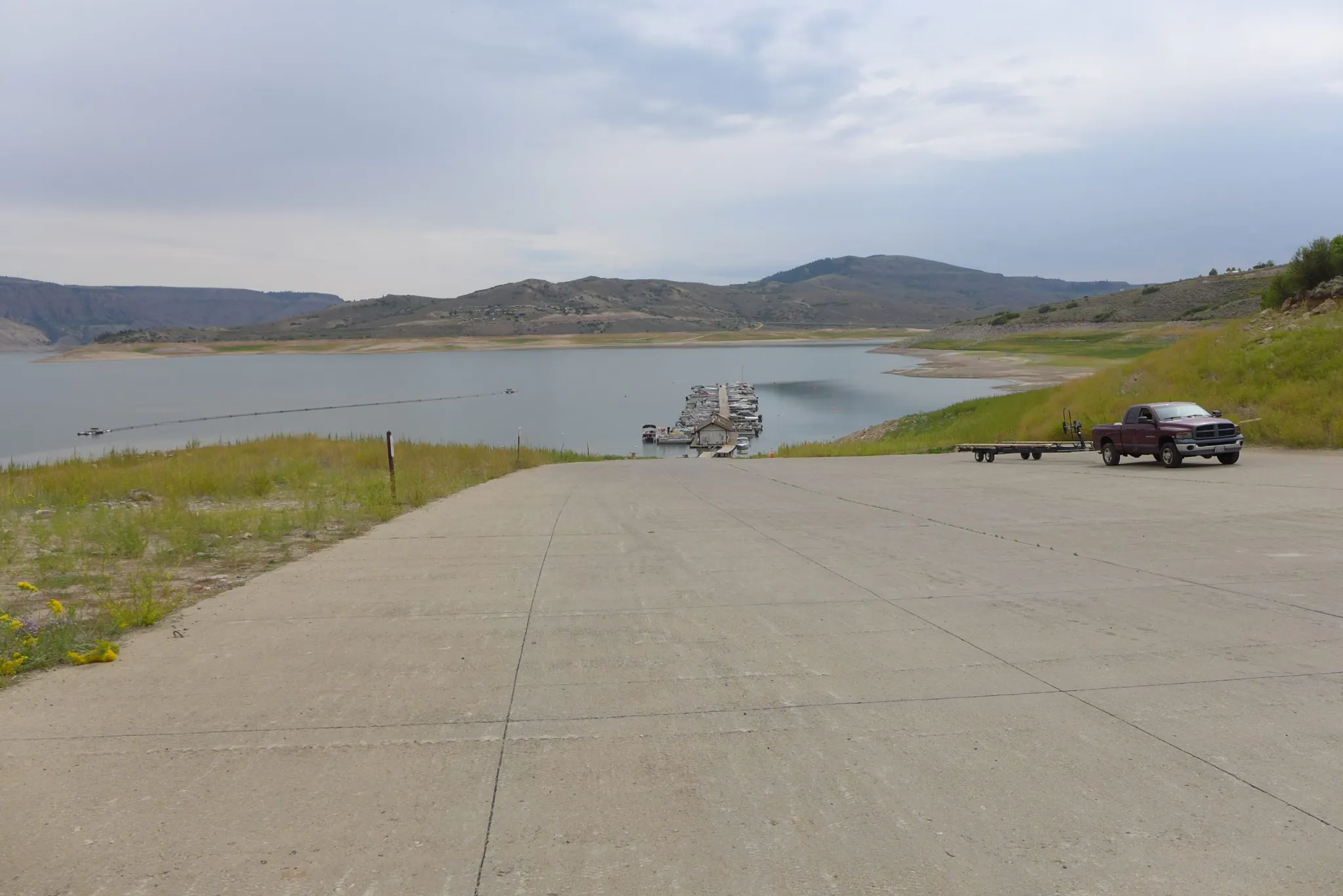
The boat ramp at the Lake Fork Marina closed for the season on Sept. 2 due to declining reservoir levels. The Bureau of Reclamation is making emergency releases out of Blue Mesa Reservoir to prop up levels in Lake Powell and preserve the ability to make hydropower. CREDIT: HEATHER SACKETT/ASPEN JOURNALISM
Click the link to read “Lake Powell drops below critical threshold for the first time despite attempts to avoid it” on the Colorado Public Radio website (Michael Elizabeth Sakas). Here’s an excerpt:
The reservoir is the second-largest in the U.S., and it’s a key piece of the Colorado River storage and supply system. Powell is fed mostly by snowmelt that collects in Colorado’s Rocky Mountains. A 20-year megadrought and a hotter climate, fueled primarily by greenhouse gas emissions from fossil fuels, has contributed to Powell’s levels dropping to all-time lows…
Colorado and the other states that share the Colorado River agreed to work together to keep Powell above this critical threshold with the Congressionally approved 2019 Drought Contingency Plan. That agreement creates a 35-foot buffer of water before the reservoir hits “dead pool,” when reservoir levels are so low, the hydroelectric generators can no longer produce energy. Water levels in Powell quickly started to drop after years of back-to-back drought. In response, the federal government in 2021 took emergency action and sent water from reservoirs in Colorado and other states to prop up supplies in Powell. Blue Mesa Reservoir outside of Gunnison lost eight feet of water as a result. Ultimately, those releases did not prevent water levels from dropping below the critical threshold. But U.S. Bureau of Reclamation hydraulic engineer Heather Patno said the additional release did add about six feet of water to Powell, and any extra buffer helps protect Powell’s ability to produce energy. Patno said the drop should be temporary as the snow in the mountains starts to melt and recharge the river and reservoirs. She said 2021 was the second-driest year on record for the Colorado River basin, and a very dry first few months of 2022 eroded the snowpack collecting in the mountains…
New research suggests there might be even less Colorado River water in the future than what’s forecasted.
A recent report from the Center for Colorado River Studies found that the U.S. Bureau of Reclamation’s projections can be too optimistic, partly because it’s based on the average water inflow into Powell from 1991-2020, a period that includes an abnormal decade in the 90s that was much wetter than the last 20 years. Patno said those findings are important, and it and other studies should be considered when federal and state governments decide how to adapt their water operations to drought. She said Powell projections did improve when the bureau recently switched to using the last 30-year average, but that Powell forecasts rely on models that have a level of risk and uncertainty.
Powell’s worst-case projections show its level could drop below 3,525 feet again as early as August of this year. Patno said emergency water releases from Blue Mesa and other reservoirs might be needed again as one of the tools to keep Powell propped up, especially as the current snowpack continues to decline. Inflow forecasts into Powell expect about 69 percent of average. The ongoing drought also means dry soil will soak up a lot of that water before it reaches rivers and lakes, Patno said.
Commissioner Mitchell (CWCB) Statement on Lake Powell Elevation 3525′:
As of March 15, Lake Powell, a major reservoir that feeds water to the Lower Colorado River Basin, fell below elevation 3525 feet. This is the target elevation identified within the Drought Contingency Plan that provides a buffer to hydropower.
The decline in Lake Powell was caused by over 20 years of low inflows in the Colorado River System, coupled with depletions that exceeded supplies. The imbalance between depletions and available River flows has historically been compensated by taking water from storage in Lake Powell and Lake Mead to provide for downstream depletions, thus causing declines in reservoir elevations.
Below is a statement from Colorado River Commissioner Becky Mitchell:
“Lake Powell hit elevation 3525 feet this week, which is a direct result of depletions from our major reservoirs over the last 20 years coupled with low flows into Lake Powell. As Lake Powell and Lake Mead have declined, water users in the Upper Colorado River Basin have been living on the front lines of climate change. The Upper Basin states of Colorado, New Mexico, Utah, and Wyoming have been taking water cuts for 20 years due to prolonged drought, while continuing to meet our Compact obligations. On top of this, water has been provided from Flaming Gorge and Blue Mesa Reservoirs in an effort to protect Lake Powell. Going forward, all who rely on the Colorado River System must learn to live with what the River provides and adapt to variability of water supply.”
For more information and updates, visit the Commissioner’s Corner on the Colorado Water Conservation Board website.