Click the link to read the article on the News on Tap website (Steve Snyder):
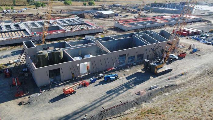
The construction of Denver Water’s new Northwater Treatment Plant is on budget and on track to open in 2024, having overcome challenges during 2021 stemming from the COVID-19 pandemic that affected everything from staffing to the supply chain.
This aerial photo from late 2021 shows construction progress on several buildings at the Northwater Treatment Plant. Photo credit: Denver Water.
The Northwater plant, on Highway 93 north of Golden, will be the fourth drinking water treatment plant in Denver Water’s system.
When finished, the new plant will be capable of producing up to 75 million gallons of clean drinking water per day using state-of-the-art technology. The new plant, part of Denver Water’s North System Renewal work, supplements the utility’s aging Moffat Treatment Plant on West 20th Avenue in Lakewood, which was built in the 1930s.
The new plant is being built on 100 acres of Denver Water land next to the utility’s Ralston Reservoir. The site will include seven primary buildings and multiple auxiliary facilities including tanks, clearwells, pump stations and vaults.
Here are some of the highlights from the work done during 2021:
Passed 50% construction completion.
Passed 1 million hours worked.
Completed all the remaining excavation needed to build the structures that will be part of the plant.
Placed concrete base slabs for the two underground storage tanks. Called “clearwells,” these 10-million-gallon storage tanks will hold clean, treated drinking water from the plant until it is released into Denver Water’s distribution system.
The concrete base of a large, treated water storage tank, or “clearwell,” was placed during one night in June 2021, marking a major milestone for the project. Photo credit: Denver Water.
Dried in” the first building on-site, meaning the work was done to make the exterior surfaces of the Clearwell Influent Valve Vault building impermeable to rain and weather.
Installed the roof and windows and applied a stone veneer on the plant’s Operations Building and started installation of mechanical, electrical and plumbing works.
Completed most of the necessary connections with the Moffat Treatment Plant to enable Moffat to eventually store treated water piped from the Northwater Treatment Plant once the new facility is operational.
Earned the Envision Gold Award from the Institute for Sustainable Infrastructure. Envision Awards recognize leadership in building sustainable infrastructure around the world and encourage those involved to consider sustainable choices throughout the life of the project.
An artist’s rendering of what the site of the Northwater Treatment Plant will look like when completed in 2024, along with locations of the buildings on-site. Photo credit: Denver Water.
Click the link to read the article on the Reclamation website (Camille Collett and Becki Bryant):
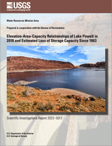
A new report released today and compiled by the U.S. Geological Survey (USGS) in cooperation with the Bureau of Reclamation provides updated information on Lake Powell’s storage capacity. The report confirms Lake Powell has lost 4% of its potential storage capacity since 1986, when the last survey was completed, and 6.79% since 1963, when the diversion tunnels of Glen Canyon Dam closed and the reservoir began to fill. The loss is largely due to sediments continuously transported by the Colorado and San Juan rivers settling on the reservoir bottom.
“It is vitally important we have the best-available scientific information like this report to provide a clear understanding of water availability in Lake Powell as we plan for the future,” said Assistant Secretary for Water and Science Tanya Trujillo. “The Colorado River system faces multiple challenges, including the effects of a 22-year-long drought and the increased impacts of climate change.”
Lake Powell is the reservoir behind Glen Canyon Dam. It extends from just south of the Utah-Arizona border northeast along the southern edge of Grand Staircase Escalante National Monument and is a key water storage unit in the Colorado River system, which provides water to approximately 40 million people, irrigates 5.5 million acres of agricultural land, and has the capacity to generate more than 4,200 megawatts of hydropower electricity.
Lake Powell’s storage capacity has been calculated twice before this study: pre-Glen Canyon Dam elevation-area-capacity tables were calculated from contour maps in 1963, and a reservoir-wide, range-line bathymetric survey was conducted in 1986. This most recent survey, conducted by the USGS in 2017 and 2018, indicates: 1) the total storage capacity is 25,160,000 acre-feet, 2) a decrease of 1,833,000 acre-feet or 6.79% of storage capacity from 1963 to 2018, and 3) 1,048,000 acre-feet or 4% decrease from 1986 to 2018. The average annual loss in storage capacity was approximately 33,270 acre-feet per year between 1963 and 2018.
“Conducting repeat surveys with the most up-to-date technology is critical to understanding water storage capacity in Lake Powell,” said Dan Jones, USGS scientist and co-author of the study. “The new surveys show that the rate of reservoir storage capacity loss observed between the three surveys has remained consistent.”
Topobathymetric elevation model of Lake Powell, photo by USGS
During the most recent survey of Lake Powell, USGS scientists used high-resolution multibeam bathymetry and lidar to create the equivalent of an underwater topographic map of the reservoir. The data were then combined to create a topobathymetric digital elevation model (TBDEM), a continuous representation of submerged bathymetry and subaerial topography.
Reclamation converted the TBDEM data into a format that is useful for the management of Lake Powell and operations at Glen Canyon Dam. Those data will be incorporated into the reservoir’s databases and models for planning and operations.
The USGS Scientific Investigations Report is titled “Elevation-Area-Capacity Relationships of Lake Powell in 2018 and Estimated Loss of Storage Capacity Since 1963” and can be found on the USGS Publications Warehouse.
USGS and Reclamation will host a joint webinar on Wednesday, March 23, 2022, at 10 a.m. (MDT) to discuss the report. A brief question and answer period will be held at the conclusion of the presentation. Click here to join the webinar.
Kyle Roerink’s recent “Writers on the Range” opinion (“A dangerous game of chicken on the Colorado River”) reminds one of Sen. Daniel Patrick Moynihan’s 1983 caution in a Washington Post op-ed: “Everyone is entitled to his own opinion, but not his own facts.”
Roerink, who heads the Great Basin Water Network, claims that the Upper Colorado River Basin states are shirking their responsibilities while the Lower Basin states valiantly work to grapple with the ongoing basin-wide drought. “With (reservoir) water savings gone,” he says, “the Lower Basin has been trying to cope, though the Upper Basin carries on business as usual.”
Brad Udall: Here’s the latest version of my 4-Panel plot thru Water Year (Oct-Sep) of 2021 of the Colorado River big reservoirs, natural flows, precipitation, and temperature. Data (PRISM) goes back or 1906 (or 1935 for reservoirs.) This updates previous work with @GreatLakesPeck.
“Business as usual” in the Upper Basin has always been dealing with the realities of an erratic river, the annual flows of which can go from 5.8 million acre-feet in 1977 to 24.8 million acre-feet in 1984. The Upper Basin lives with that reality, dry years and wet. [ed. emphasis mine]
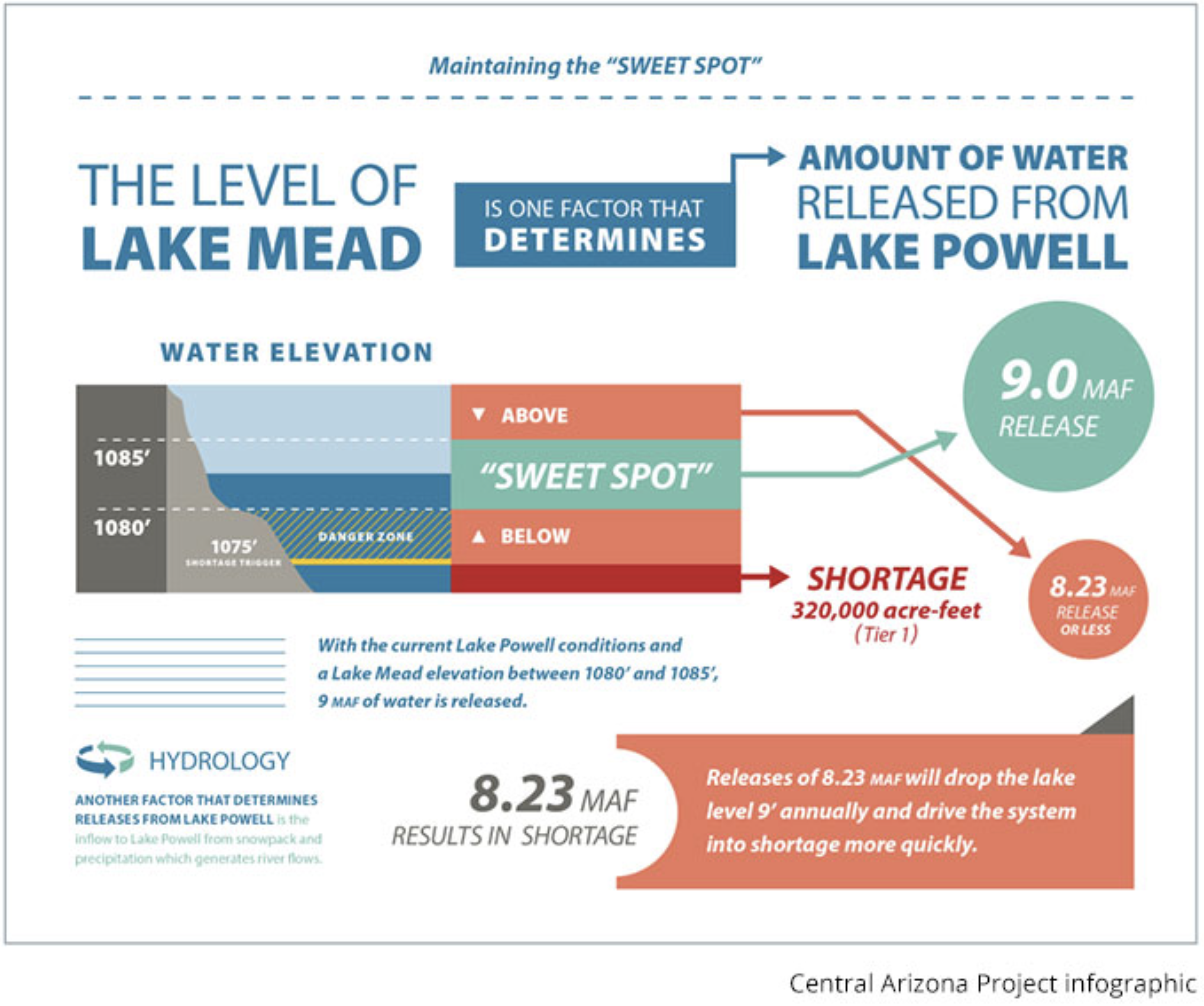
But the Bureau of Reclamation has regularly and faithfully released to the Lower Basin, from Powell Reservoir, the Colorado River Compact and Mexican Treaty allotments –- 8.23 million acre-feet only dropping a little below those allotments half a dozen times since Powell began to fill in the 1960s. Dry year or wet, the Lower Basin always gets its full allotment.
Usually, more than that designated quantity is sent to the Lower Basin (as much as 12 million acre-feet above in 1984). The Compact and Mexican Treaty require that the Upper Basin send downriver 82.5 million acre-feet over a 10-year period; as of 2020, the 10-year running total was 92.5 million acre-feet.
So the Lower Basin never bears the brunt of low flows, as Roerink claims; it has always received its Compact and Treaty allocations since Powell Reservoir filled, usually with some extra, regardless of what was happening in the “real river” the Upper Basin states live with.
It is true that the Lower Basin states are currently “’trying to cope” with river shortages by making some difficult cutbacks in their uses. But what they are trying to cope with is their own excessive use of the water stored in Mead Reservoir.
For decades the three downstream states –- primarily California –- have been using considerably more than their Compact allotment of 7.5 million acre-feet; they have also not been subtracting from their allotment the significant losses to evaporation in desert storage and transit (automatically figured into Upper Basin use through the Powell releases).
The structural deficit refers to the consumption by Lower Basin states of more water than enters Lake Mead each year. The deficit, which includes losses from evaporation, is estimated at 1.2 million acre-feet a year. (Image: Central Arizona Project)
This has resulted in what is euphemistically called a “structural deficit,” but is just the Lower Basin using more water than its entitlement. That was more or less okay before the Upper Basin use was fully developed, and before the Central Arizona Project came online; the Bureau’s extra releases, above Compact requirements, covered the overuse. No more.
So now the Lower Basin states, which have been drawing an annual average of 1.2 million acre-feet more out of Mead Reservoir than has flowed into it, are trying to bring their usage down to the actual Compact allotment. Drought might exacerbate that challenge, but it doesn’t cause it, nor does Upper Basin lollygagging.
The Upper Basin has not even used its full Compact allocation because it became obvious that the river could not supply that on a dependable basis. The Upper Colorado River Compact divides the Upper Basin states’ permissible consumptive uses by percentages rather than a set amount like the Lower Basin gets, but exactly what that allows each state is obviously ambiguous, depending on what “average flow” is used.
Are the Upper Basin states doing their part to ensure prudent uses of the river? They are developing “demand management” programs to pay farmers and ranchers to fallow some of their land to increase flows to Powell Reservoir. Last summer, Blue Mesa Reservoir’s recreation season was cut short to send most of the Reservoir’s water down to bolster Powell.
Denver Water is also working hard to re-plumb its city for reuse, as well as running an ongoing conservation program that has reduced their deliveries to a 1970 level with half a million more people.
Could the Upper Basin states be doing more? Probably, and they probably will be. But they are less to blame for the Lower Basin state’s dilemmas than are the Lower Basin states themselves.
George Sibley
George Sibley is a contributor to Writers on the Range, writersontherange.org, a nonprofit dedicated to spurring lively discussion about Western issues. He has written extensively about the Colorado River.
Ranking and time evolution of summer (June–August) drought severity as indicated by negative 0–200 cm soil moisture anomalies. Maps show how gridded summer drought severity in each year from 2000–2021 ranked among all years 1901–2021, where low (brown) means low soil moisture and therefore high drought severity. Yellow boxes bound the southwestern North America (SWNA) study region. Time series shows standardized anomalies (σ) of the SWNA regionally averaged soil moisture record relative to a 1950–1999 baseline. Black time series shows annual values and the red time series shows the 22-year running mean, with values displayed on the final year of each 22-year window. Geographic boundaries in maps were accessed through Matlab 2020a.
A majority of Coloradans believe the state will face significant water shortages within the next century, a poll released Monday found.
Conducted earlier this month by Morning Consult on behalf of the Walton Family Foundation, the poll surveyed about 300 registered voters in Colorado, among 2,000 respondents nationally. It found that Coloradans are more concerned on average about the threat of climate change than voters nationwide, with 57% agreeing that rising global temperatures are “having a massive impact on my community,” and 55% worrying that the state won’t “have enough water to meet its needs in 100 years.”
“It’s shocking that more than half of the residents in Colorado don’t think there will be enough water in their home state for their grandchildren to live out their lives,” Moira Mcdonald, environment program director for the Walton Family Foundation, said in a statement. “The Colorado River Basin is living through a historic drought fueled by climate change, and this poll shows there is urgency and unity among all voters to meet these challenges head-on. This is a time for bold leadership.”
GET THE MORNING HEADLINES DELIVERED TO YOUR INBOX
The poll’s release comes a week after the U.S. Bureau of Reclamation announced that Lake Powell, a key Colorado River reservoir along the Utah-Arizona border, dropped to its lowest level since it was filled in 1980. Years of declining flows have led to a complex series of negotiations over usage rights and management strategies between the seven states that rely on the Colorado River, collectively supplying water to over 40 million people.
A study released earlier this year concluded that the “megadrought” that has gripped the basin since 2000 is the worst dry spell the region has experienced in at least 1,200 years, and nearly half of the drought’s severity is due to higher temperatures driven by human-caused climate change. Rising atmospheric concentrations of greenhouse gases have caused parts of Colorado — especially areas on the Western Slope — to warm by an annual average of 4 degrees Fahrenheit or more above pre-1900 levels, temperature data from the National Oceanic and Atmospheric Administration show.
The Walton Family Foundation’s poll found that 65% of Colorado voters believe that governments “need stricter regulations in place to limit the impacts of climate change,” a position shared by 67% of voters nationwide. Plans for significant climate legislation by Democrats in Congress, however, remain stalled amid opposition from Sen. Joe Manchin of West Virginia.
The poll was released ahead of World Water Day, a U.N. event observed annually on March 22. The Walton Family Foundation, launched by heirs of Walmart founder Sam Walton, has donated tens of millions of dollars to nonprofits promoting water conservation in the Colorado River Basin in recent years.
SUPPORT NEWS YOU TRUST.
Colorado Newsline is part of States Newsroom, a network of news bureaus supported by grants and a coalition of donors as a 501c(3) public charity. Colorado Newsline maintains editorial independence. Contact Editor Quentin Young for questions: info@coloradonewsline.com. Follow Colorado Newsline on Facebook and Twitter.