San Luis Valley farmers form Sustainable Water Augmentation Group — The #Center Post Dispatch #RioGrande

San Luis Valley Groundwater

Click the link to read the article on the Center Post Dispatch website (Mechel Meek). Here’s an excerpt:

A group of Valley farmers announced in a press release that they have come together to create the Sustainable Water Augmentation Group (SWAG), an alternative to Rio Grande Water Conservation District, Subdistrict 1.

“It is no secret that we are at a critical moment for the future of the San Luis Valley, as drought deepens, climate change intensifies, and the unconfined aquifer’s water level continues to drop at a dangerous rate. Decisive action is required now before the aquifer runs dry and the way of life for the 46,000 residents of the San Luis Valley, where agriculture is the driving economic force is threatened,” the release stated.

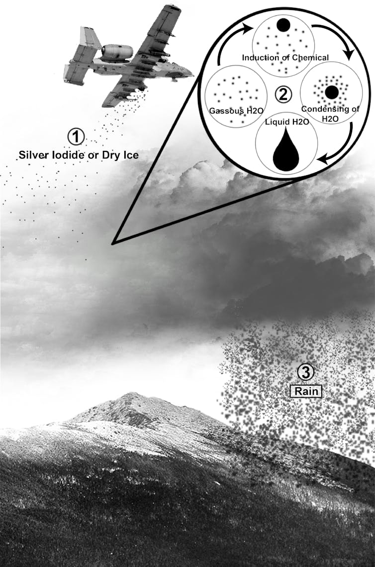
The San Luis Valley has a mostly unconfined aquifer and is subject to many variables including drought. A confined aquifer is surrounded by rock and clay pieces which confine it to an area and make it less at risk for loss, but an unconfined aquifer is exposed and can be impacted more severely by outside factors. A confined aquifer is found deep beneath the ground, while an unconfined aquifer is just below the ground level…

The Rio Grande Water Conservation District, Subdistrict 1 covers much of the San Luis Valley area. According to the Subdistrict 1 Plan of Water Management, “The goals of the Subdistrict are to cause groundwater levels in the Unconfined Aquifer of the Closed Basin to recover, and then to maintain a sustainable irrigation water supply in the Unconfined Aquifer with due regard for the daily, seasonal and longer-term demands on the aquifer and to protect senior surface water rights and avoid interference with Colorado’s obligations under the Rio Grande Compact. To achieve these goals, reducing and managing overall groundwater consumption is essential.” The group of farmers behind SWAG disputes the effectiveness of the plans in place and proposed by Subdistrict 1.

“Despite making little progress towards sustainability with the fee-based model, Subdistrict No. 1’s Board of Managers is now poised to vote on raising the over-pumping fee from $150 to $500 per acre-foot. That’s a 233% increase on top of a 386% increase over the past decade. While this plan may work for some producers, it is not a viable option for the members of SWAG who have paid these ever-increasing fees only to see reduced yields and declining water levels in the aquifer. It is clear the status quo is unsustainable for the farmers of the Valley, nor the aquifer that we rely on for our water. We simply do not have the time to double down on a one-size-fits-all fee-based approach,” SWAG stated in the release.

The SWAG press release included an answer to the ongoing water crisis in the Valley.

“SWAG has entered into an agreement to purchase and retire approximately 4,500 acres, irrigated by wells, that have historically consumed an average of 5,678 acre-feet per year from the unconfined aquifer at a cost of over $35 million. If real progress towards sustainability is not made, the sad truth is that SWAG members’ wells are subject to the very real threat of forced curtailment; whether by the State of Colorado if the subdistrict cannot prove its plan for sustainability will work; or by the Subdistrict itself through ever-increasing fees for pumping which would punish those water users who rely on their decreed water rights for their wells, or the absence of water at their wellheads due to the overuse of the unconfined aquifer. The only way to solve this threat and ensure the future vitality of the Valley is to work together to find solutions which work for everyone. We need more options to promote conservation, not less. SWAG’s augmentation plan is one of those options, and we hope that other members of the community make your voices heard before it is too late,” SWAG concluded.

Town of #Empire at “critically” low levels of drinking #water as demand outpaces supply: Low water source, suspected leak compounding problems — TheDenverChannel.com #ClearCreek

Empire as seen from Douglas Mountain. By Xnatedawgx – Own work, CC BY-SA 3.0, https://commons.wikimedia.org/w/index.php?curid=25798349

Click the link to read the article on TheDenverChannel.com website (Robert Garrison). Here’s an excerpt:

The town of Empire is warning residents of possible interruptions to their water service as its treatment plant struggles to meet demand. In a press release Saturday, town officials warned residents that they should prepare for intermittent loss of water and low pressure, with residents at higher elevations expected to see a greater loss of water pressure.

The Clear Creek County town’s water treatment facility is not able to produce enough clean water to meet demand and is at critically low levels, the release said. Officials said the facility’s water supply, Madd Creek, is too low because of freezing conditions and an ongoing suspected water leak, which crews are attempting to locate, is compounding problems. The town is working to increase the water intake at the source and supplement water into the plant.

Some residents and businesses Sunday morning were reporting no running water, which has forced businesses like Guenella Pass Brewery to close indefinitely.

#Snowpack news: #Colorado basins all in the average range except #GunnisonRiver Basin = 112% of normal

Colorado snowpack basin-filled map March 20, 2022 via the NRCS.

Click the link to read a snowpack article on the Summit Daily website (Eliza Noe). Here’s an excerpt:

Last week’s snowfall has finally pushed local river basins to over the average median, a level that water experts have been following for months into this water year, which runs from October through September.

According to data from the National Resource Conservation Service, the Blue River Basin was steadily on par with its median over the last 10 days. Last week, the basin had been almost exactly along the median before dipping very slightly by Sunday, March 20.

Sunday’s most recent data shows that current levels have a snow-water equivalent of 13.7 inches, whereas the 30-year median is 13.9 inches. This puts the Blue River Basin at 99% of the median at this point in the year and 83% of the median’s peak. The median’s peak is set to crest on April 27, so it is possible that future snowfalls in coming weeks could keep the basin’s trajectory on track.

Westwide SNOTEL basin-filled map March 20, 2022 via the NRCS.

Click the link to read “Colorado snowpack 100% of median Friday ahead of next week’s storm” on TheDenverChannel.com website (Blair Miller). Here’s an excerpt:

Colorado’s snowpack sat at 100% of median Friday after this week’s snowstorm and ahead of another storm that will bring snow to the state on Monday, though forecast models are still showing wide variations in how much snow will fall. The snowpack has increased fairly steadily over the past two weeks after a dry period at the end of January and beginning of March. The foothills west of Denver and Boulder saw the most snow in this week’s storm, but other areas of the state saw a few inches as well…

All eight of the state’s river basins were above 90% median snowpack levels as of Friday. The Gunnison basin (112% of median) had the most robust snowpack, followed by the San Miguel, Dolores, Animas and San Juan (104% of median), the Upper Colorado Headwaters (104% of median), Upper Rio Grande (101% of median), and South Platte (101% of median) basins. The Laramie and North Platte (99% of median), Arkansas (96% of median), and Yampa and White (91% of median) basins were all slightly below median levels…

Colorado Drought Monitor map March 15, 2022.

While the snowpack is at 100%, Colorado’s drought remains relatively unchanged again this week. Ninety-two percent of Colorado is experiencing moderate or worse drought. Fifty-seven percent of the state, mostly along the eastern plains, is experiencing severe drought or worse. And about 8% of the state – mostly along the southern border with New Mexico – is experiencing extreme or exceptional drought conditions, according to the U.S. Drought Monitor.

Conference Talk Summaries: ‘The #ColoradoRiver Compact – Navigating the Future’ (@CUBoulderGWC) — @WaterWired #COriver #aridification

Colorado River “Beginnings”. Photo: Brent Gardner-Smith/Aspen Journalism

Click the link to read the report on the Water Wired website (Michael Campana):

Last week on 17 – 18 March 2022 a two-day conference on ‘The Colorado River Compact – Navigating the Future’ was held at the University of Utah’s S.J. Quinney College of Law in Salt Lake City…

This year marks 100 years since the Compact was signed in November 1922.

The Colorado River Compact divided the basin into an upper and lower half, with each having the right to develop and use 7.5 million acre-feet of river water annually. (Source: U.S. Geological Survey via The Water Education Foundation)

Day 1 – 17 March 2022

From the 2018 Tribal Water Study, this graphic shows the location of the 29 federally-recognized tribes in the Colorado River Basin. Map credit: USBR

Speaker 1: Jason Robinson, University of Wyoming College of Law
An introduction relating how all of us are sitting here in this room 100 years after the Colorado River Compact was written. Look at how ideas have changed There are 30 indigenous tribes within the Colorado River Basin, many with water rights unrecognized. The first ever shortage officially declared on the Colorado river was in summer of 2021, but there has been a supply and demand imbalance since the very beginning. Jason finished his short speech with the comment “For culture is the soil which law and policy grow.”

Signing ceremony for the Colorado River upper and lower basin Drought Contingency Plans. Back Row Left to Right: James Eklund (CO), John D’Antonio (NM), Pat Tyrell (WY), Eric Melis (UT), Tom Buschatzke (AZ), Peter Nelson (CA), John Entsminger (NV), Front Row: Brenda Burman (US), and from DOI – Assistant Secretary of Water and Science Tim Petty. Photo credit: Colorado River Water Users Association

Speaker 2: Tanya Trujillo, Assistant Secretary for Water and Science, U.S. Department of Interior.
Progress made regarding the Colorado River is slow, but it progresses, nonetheless. The Department of Interior is trying to work quickly to rebuild and protect the system of the Colorado River. Part of the 2022 drought response operations is protecting the Lake Powell elevation at 3525 feet. This is the chosen elevation to protect due to hydropower generation and the location of downstream bypass tubes. In the past the “law of hydrology” has been ignored, but this time around the science of hydrology is being considered. Mexico and indigenous populations are being included within the conversation.

September 21, 1923, 9:00 a.m. — Colorado River at Lees Ferry. From right bank on line with Klohr’s house and gage house. Old “Dugway” or inclined gage shows to left of gage house. Gage height 11.05′, discharge 27,000 cfs. Lens 16, time =1/25, camera supported. Photo by G.C. Stevens of the USGS.
Source: 1921-1937 Surface Water Records File, Colorado R. @ Lees Ferry, Laguna Niguel Federal Records Center, Accession No. 57-78-0006, Box 2 of 2 , Location No. MB053635.

Speaker 3: Larry MacDonnell, University of Colorado Law School
In 1922 when the Colorado River was divvied up there was 17.3 MAF annually flow out of Yuma to Mexico. It was decided that with storage there could be 13.93 MAF/yr of water used for irrigation within the basin. The storage of this water uses dams to control flooding, store water, and create hydropower. Four critical elements decided on by Delph E. Carpenter about the Colorado River Compact are: 1) Dividing the basin into two parts, the upper and lower; 2) “Equal” division of all systems as measured in Yuma; 3) Flow guarantee at Lee’s Ferry over a 10 consecutive year period; and 4) Mexico’s needs for the water must also be considered.

Minute 323 environmental section signing. Photo credit: Colorado River Water Users Association

Speaker 4: Anne Castle, University of Colorado Law School
Anne shared a history over time of the Colorado River Compact and the changes that have been made to it since 1922. In 1928 there was the addition of the Boulder Canyon Project where the lower basin states entered an interstate agreement for allocation. In 1944 Mexico was added to the treaty receiving 1.5 MAF annually. In 1948 the upper basin states created allocation by percentages, not fixed volumes and established the Upper Colorado River Commission naming a commissioner from every state. This also included the penalty box provision where a framework was created to curtail states for using more water than they were allocated. 1952 contained a conflict between Arizona and California about who gets the extra 1 MAF, what beneficial use is, and how we account for evaporation. SCOTUS made a decision in 1963 but only reinterpreted the Boulder Canyon Project Act which only accounts for water in the mainstem of the river and not the tributaries. In 1968 the Colorado River Basin Project Act set long range operation criteria for reservoirs. The 21st century contained the worst megadrought this area has experienced in the last 1200 years which affects the whole system. In 2007 Interim guidelines were set for the sharing of shortage/surplus of water as well as water banks and lake contents. These guidelines are set to expire in 2025 and contained reductions to Arizona and Nevada’s delivery. In 2012 the historic binational agreement Minute 319 was with Mexico to create more environmental efforts and allow Mexico to store water in US reservoirs. In 2017 Minute 323 was passed as a renewal of Minute 319 but included a drought contingency plan that expires in 2026. Current efforts are focused on the 500+ Plan which is a commitment to conserve 500,000 acre-feet/year. Demand management is being investigated on a state-by-state basis.

North American Indian regional losses 1850 thru 1890.

Speaker 5: Margaret Vick, Colorado River Indian Tribes
Margaret shared a timeline of what was happening in indigenous communities pre and post Colorado River Compact as well as what obligations the U.S. has to Tribal communities. The Homestead Act of opening “public lands” to settlement coincided with the removal of tribes from their native lands. During the 1900s lands not allotted as “reservations” were divided and sold, the reservation land went from 138 million acres in 1887 to 48 million in 1934. In 1934 the Indian Reorganization Act which “recognized” tribes if they adopted constitutions that were respected by the federal government. The time of assimilation also occurred during this time which included the removal of children and the banning of native language and culture. During this termination era more than 100 tribes lost their land and benefits. Tribes formed the NCAI and other organizations to oppose termination, but it ended with the enactment of Civil Rights 1968. Currently there are 16 tribes with existing federal irrigation projects, but the US “owns” 25-30% of water in the basin on behalf of tribes.

The difference between the terms equality equity and liberation illustrated. Credit: Shrehan Lynch https://www.researchgate.net/publication/340777978_The_A-Z_of_Social_Justice_Physical_Education_Part_1

Speaker 6: Bidtah Becker (Navajo Nation), California EPA, Environmental Justice, and Border Affairs
California has created a truth and reconciliation council for the impacts the United States has had on Tribal communities. The federal government must be a leader in helping tribes determine on what they should focus their energies on. She ended her remarks with a quote that “We live in an equity moment and could be an equity historical period.”

All American Canal Construction circa. 1938 via the Imperial Irrigation District

Speaker 7: Carlos de la Parra, Restauremos el Colorado
The Colorado River Basin includes Mexico, but they were not added onto the Colorado Compact until a later time, Mexico got 10% of water from the Colorado River because World War II and good neighbor policy as well as the fact that Mexico has oil that the US wanted. Also in Mexico water is a property of the nation. The All-American Canal is still an unresolved dispute with Mexico because it stopped seepage into the wetlands at the base of the Colorado River, this caused Mexico the environmental impact of this canal. We are currently in a “hot drought” which decouples surface temperatures and precipitation. This creates variation in water quality and delivery. The Advocacy Coalition was created to bridge the gap between environmental advocacy and citizen diplomacy.

Eugene Clyde LaRue measuring the flow in Nankoweap Creek, 1923. Photo credit: USGS via Environment360

Panel: Science and Governance: Overallocation à Climate Change and Megadrought
C. LaRue was a USGS scientist during the time the Colorado River Compact was written, he shared that the approximation regarding flow rates were made during a very wet period. He testified before congress, but no one really wanted to hear about it because it would make the situation “inconvenient.” The changes in temperature are changing water usage in agriculture through changing evapotranspiration, but these continual changing processes are always being added to the models.

The Whanganui is a major river on the North Island of New Zealand. The Whanganui River is a major river in the North Island of New Zealand. It is the country’s third-longest river, and has special status owing to its importance to the region’s Māori people. In March 2017 it became the world’s second natural resource (after Te Urewera) to be given its own legal identity, with the rights, duties and liabilities of a legal person. The Whanganui Treaty settlement brought the longest-running litigation in New Zealand history to an end. Dana Zartner, CC BY-ND via The Conversation

Speaker 8: Bob Adler, University of Utah S.J. Quinney College of Law is supposed to represent societal values and change with those values. Roscoe Pound said that “The law must be stable, but it must not stand still.” In 1922 “beneficial use” was described as human use, this is just one part of the compact being written with an anthropogenic mindset. The idea of the environment was not added to the compact until the 1956 where the idea of natural resources was included, but only on public lands where dams were built. All environmental regulations put in place for conservation purposes lay below the Colorado River. There are constraints politically for moving forward with environmental regulations, through the multiple layers of government. Alder suggested the “Rights of Nature Theory” as a solution to the issues within the basin.

Day 2: 18 March 2022

Wheat fields along the Colorado River at the Colorado River Indian Tribes Reservation. Wheat, alfalfa and melons are among the most important crops here. By Maunus at English Wikipedia, CC BY-SA 3.0, https://commons.wikimedia.org/w/index.php?curid=47854613

Panel 1: Future Management
Many management plans are expiring in the years 2025-26, if another plan is not made before then we will fall back to the Department of Interior plan from 1976. Equitable solutions have conflicting objectives of honoring the law that is already in place, but also trying to please all parties. Management decisions going forward must work with legal and political constraints, public involvement and consensus building, and the sound technical knowledge of science. There are different management decisions between the Upper Basin, Lower Basin, Mexico, and the 30 Tribes. It is interesting to talk about these management decisions going forward when there is not even clean water access for everyone within the basin. The lack of the bureaucracy isn’t something the basin is suffering from, but there must be a balance of creating a completely new system while using the system we have as a framework.

Brad Udall: Here’s the latest version of my 4-Panel plot thru Water Year (Oct-Sep) of 2021 of the Colorado River big reservoirs, natural flows, precipitation, and temperature. Data (PRISM) goes back or 1906 (or 1935 for reservoirs.) This updates previous work with
@GreatLakesPeck.

Panel 2: Climate Change and Next Management Framework:
Brad Udall, a senior water and climate researcher at Colorado State University, reported some climate statistics and warned that we must be open to the possibility of really low flows. As the population grows and we add uses to the river we must also realize that this puts a stress on the river, but these short-term problems do bring light to long term problems for all. Amy Haas of the Colorado River Authority of Utah spoke about how the river has been ravaged and only hard choices are left. These climatic changes are happening so fast that management can’t keep up. She spoke how perfection is no longer attainable and how there must be equity conversations and support between the two basins. Tom Buschatzke is the head of the Arizona Department of Water Resources and he shared statistics about the water usage in Arizona as well as the 30-40% of land in central Arizona that will become fallowed due to the current struggles with water. Arizona has seen a 600% growth in population since 1957 but has seen a 3% decrease in water usage. Finally, Tina Shields of the Imperial Irrigation District shared how 1/6 of jobs in her region are related to agriculture as well as the importance of food safety and security and how the Southwest feeds this country and the world. She finished with a call of need to give farmers more tools so there can be an increase in production and a decrease in water use.

A slide presented by Andy Mueller, general manager of the Colorado River District, on Sept. 14, 2018 at the district’s seminar called ‘Risky business on the Colorado River.’ The slide shows how water from the Colorado River system, within the state of Colorado, is used.

Panel 3: Strategies to Equitably Share Water
Equity is an emotional issue; it is how we relate to each other. Jack Schmidt, Utah State University, stated how we have created a novel ecosystem of native and non-native species and have completely changed the ecosystem through the addition of dams. There must be a decision made to what part of the river we care about, and what is really going to matter in times of changing temperature. Some parts of the Colorado River have NO water, we must be mindful of this when we create a clear vision of what we want for the future. Jay Weiner, Rosette, LLP, Attorneys at Law who represent some of the native tribes in the basin stated that “what is fair is not necessarily equitable.” Water is flowing upstream to money but there are reservations where there is no access to water rights, yet under prior appropriation the Tribes were “first in time.” Andy Mueller from the Colorado River Conservation District spoke on how agriculture is being painted in a bad light, because majority of ag is working on providing food for the growing populations.

NOTE: Ms. Isabella M. Ayala was a student in my GEOG 440/540 class, Conflict, Cooperation and Control of Water in the USA during the winter 2022 term at Oregon State University, Corvallis, OR. We studied the Colorado River Basin quite a bit. She asked if she could write a summary of talks at the conference and I agreed. I did not attend the meeting and all I contributed to her summary was some minor corrections. – Michael E. Campana, Professor of Hydrogeology and Water Resources Management, College of Earth, Ocean and Atmospheric Sciences, OSU.

Study: Estimating widespread #beaver dam loss: Habitat decline and surface storage loss at a regional scale — EcoSphere

A beaver dam on the Gunnison River. Photo: Brent Gardner-Smith/Aspen Journalism

Click the link to access the study on the Ecosphere website (Julianne E. Scamardo, Sarah Marshall, Ellen Wohl). Here’s the abstract:

The loss of beaver populations has commonly been accompanied by the failure of beaver dams, leading to stream incision, water table lowering, and the eventual transition from a beaver meadow to a drier riparian corridor. Widespread decline in NorthAmerican beaver populations (Castorcanadensis) has been documented from pre-European settlement to the current day, representing an estimated 80% to 98% loss of historicalpopulations. While individual case studies have investigated the ecosystem impacts of local beaver population loss, few studies have quantified large-scale changes associated with widespread population decline. Here, we use the Beaver Restoration Assessment Tool to model landscape-scale habitat suitability and beaver dam capacity in Colorado, USA, in order to deter-mine whether a widespread loss in beaver population corresponds to a similar scale decline in the capacity to sustain beaver on the landscape and declines in physical benefits associated with beaver, such as surface water and sediment storage. Currently, the statewide stream network (298,119 stream kilometers) can support approximately 1.36 million beaver dams, compared with 2.39 million dams historically. All regions of Colorado have seen a decline in beaver dam capacity from historical conditions, likely due to agriculture, urbanization, and loss of vegetation necessary to beaver. Beaver dam capacity loss is accompanied by an approximate 40% decline in beaver-mediated surface water and sediment storage potential across the state. Regions with high percent loss in storage potentials also had a highpercentage of drainage network that had experienced beaver dam capacity losses of 15 or more dams per kilometer, which highlights the disproportionate impacts of losing high dam density reaches (i.e., beaver meadows).Extreme dam density declines were rare, and instead, most reaches have undergone a shift from high to moderate capacity. Statewide shifts in beaver dam capacity highlight the opportunity for using beaver-related restoration in Colorado and across the American West.

Cloud seeding might not be as promising as #drought-troubled states hope — The Conversation


Cloud seeding equipment near Winter Park in Colorado.
Denver Water

William R. Cotton, Colorado State University

Forecasters at the National Oceanic and Atmospheric Administration issued their U.S. spring outlook on March 17, 2022, and their top concern was worsening drought in the West and southern Plains. Several western states have experimented with cloud seeding to try to increase precipitation, but how well does that actually work? Atmospheric scientist William Cotton explains.

On mountain peaks scattered across Colorado, machines are set up to fire chemicals into the clouds in attempts to generate snow. The process is called cloud seeding, and as global temperatures rise, more countries and drought-troubled states are using it in sometimes desperate efforts to modify the weather.

But cloud seeding isn’t as simple as it sounds, and it might not be as promising as people wish.

As an atmospheric scientist, I have studied and written about weather modification for 50 years. Cloud seeding experiments that produce snow or rain require the right kind of clouds with enough moisture, and the right temperature and wind conditions. The percentage increases in precipitation are small, and it’s difficult to tell when snow or rain fell naturally and when it was triggered by seeding.

How modern cloud seeding began

The modern age of weather modification began in the 1940s in Schenectady, New York.

Vince Schaefer, a scientist working for General Electric, discovered that adding small pellets of dry ice to a freezer containing “supercooled” water droplets triggered a proliferation of ice crystals.

Other scientists had theorized that the right mix of supercooled water drops and ice crystals could cause precipitation. Snow forms when ice crystals in clouds stick together. If ice-forming particles could be added to clouds, the scientists reasoned, moisture that would otherwise evaporate might have a greater chance of falling. Schaefer proved it could work.

On Nov. 13, 1946, Schaefer dropped crushed dry ice from a plane into supercooled stratus clouds. “I looked toward the rear and was thrilled to see long streamers of snow falling from the base of the cloud through which we had just passed,” he wrote in his journal. A few days later, he wrote that trying the same technique appeared to have improved visibility in fog.

A man looks into a freezer looking amazed at what he sees.
Vincent Schaefer, in foreground, examines snow created in a modified GE freezer in 1947, with Irving Langmuir, at left, and Bernard Vonnegut.
General Electric Company/Museum of Science and Innovation

A colleague at GE, Bernie Vonnegut, searched through chemical tables for materials with a crystallographic structure similar to ice and discovered that a smoke of silver iodide particles could have the same effect at temperatures below -20 C (-4 F) as dry ice.

Their research led to Project Cirrus, a joint civilian-military program that explored seeding a variety of clouds, including supercooled stratus clouds, cumulus clouds and even hurricanes. Within a few years, communities and companies that rely on water were spending US$3 million to $5 million a year on cloud-seeding projects, particularly in the drought-troubled western U.S., according to congressional testimony in the early 1950s.

But does cloud seeding actually work?

The results of about 70 years of research into the effectiveness of cloud seeding are mixed.

Most scientific studies aimed at evaluating the effects of seeding cumulus clouds have shown little to no effect. However, the results of seeding wintertime orographic clouds – clouds that form as air rises over a mountain – have shown increases in precipitation.

There are two basic approaches to cloud seeding. One is to seed supercooled clouds with silver iodide or dry ice, causing ice crystals to grow, consume moisture from the cloud and fall as snow or rain. It might be shot into the clouds in rockets or sprayed from an airplane or mountaintop. The second involves warm clouds and hygroscopic materials like salt particles. These particles take on water vapor, becoming larger to fall faster.

A drawing of a plane flying
An illustration of cloud-seeding processes.
Naomi E. Tesla/Wikipedia, CC BY

The amount of snow or rain tied to cloud seeding has varied, with up to 14% reported in experiments in Australia. In the U.S., studies have found a few percentage points of increase in precipitation. In a 2020 study, scientists used radar to watch as 20 minutes of cloud seeding caused moisture inside clouds to thicken and fall. In all, about one-tenth of a millimeter of snow accumulated on the ground below in a little over an hour.

Another study, in 2015, used climate data and a six-year cloud-seeding experiment in the mountains of Wyoming to estimate that conditions there were right for cloud seeding about a quarter of the time from November to April. But the results likely would increase the snowpack by no more than about 1.5% for the season.

While encouraging, these experiments have by no means reached the level of significance that Schaefer and his colleagues had anticipated.

Weather modification is gaining interest again

Scientists today are continuing to carry out randomized seeding experiments to determine when cloud seeding enhances precipitation and by how much.

People have raised a few concerns about negative effects from cloud seeding, but those effects appear to be minor. Silver ion is a toxic heavy metal, but the amount of silver iodide in seeded snowpack is so small that extremely sensitive instrumentation must be used to detect its presence.

A man attaches a row of canisters to an airplane wing.
Several companies attempt cloud seeding from airplanes.
AP Photo/Dave Kolpack

Meanwhile, extreme weather and droughts are increasing interest in weather modification.

The World Meteorological Organization reported in 2017 that weather modification programs, including suppressing crop-damaging hail and increasing rain and snowfall, were underway in more than 50 countries. My home state of Colorado has supported cloud-seeding operations for years. Regardless of the mixed evidence, many communities are counting on it to work.

[Get The Conversation’s best science and health coverage.]

This article was updated March 17, 2022, with NOAA’s U.S. spring climate and weather outlook.The Conversation

William R. Cotton, Professor Emeritus of Meteorology, Colorado State University

This article is republished from The Conversation under a Creative Commons license. Read the original article.

Aspinall Unit forecast for operations March 20, 2022 — Reclamation

Click the graphic for a larger view.

Opinion: #Putin and #ClimateChange: two maladies, one treatment —

Denver School Strike for Climate, September 20, 2019.

Click the link to read the opinion piece on the Pueblo Chieftain website (Stephen Greenleaf):

The term “polycrisis” describes the current state of the world. It denotes the fact that we find ourselves in the midst of more than one crisis at a time. Most recently, we faced the COVID-19 pandemic and the economic dislocation caused by the pandemic. Now, we face the return of war to Europe with the brutal invasion of Ukraine by the Putin regime. And we still have the continuing (and increasing) reality of climate change with which we must deal, which we haven’t yet done on the scale required.

In the face of these multiple challenges, we can deploy a response that would effectively address two huge concerns with one stroke: We immediately and aggressively reduce our consumption of fossil fuels.

As to the immediate threat of Putin’s aggression, a reduction of our consumption of fossil fuels aids the current sanctions regime that seeks to starve the beast. More than one commentator has described Russia as “a gas station with nukes.” We can shut down (or at least cripple) the gas station by not buying the gas.

To be clear, at present, the U.S. is a net petroleum exporter. We purchase relatively little petroleum from Russia, and a complete cut-off will not limit U.S. supplies of oil or gas. The restrictions on imports from Russia won’t have much direct impact on U.S. energy prices, although worldwide we can expect higher prices.

This is because the market for petroleum is worldwide, with multiple global players, like Saudi Arabia. The Saudis and other petroleum exporters will affect oil and gas prices by deciding how much petroleum to produce. Also, the volatility in oil and gas prices, with sharp increases and drops, is a continuing characteristic of that global fossil fuels market. Increasing America’s oil and gas development and drilling, which some propose as a response to Putin’s aggression, would not have any significant impact on the high prices we are seeing at the pump now.

As long as we are dependent on fossil fuels, we’ll continue to be subject to manipulation of supplies and prices by the Gulf States and other large producers, like Russia. A clean energy economy would be our surest path towards stable and lower energy prices, and true energy independence from foreign producers.

Over the longer term, decreased use and dependence on fossil fuels will mean fewer dollars for Putin. Of course, reduced demand would result in fewer dollars paid to all fossil fuel providers, including oil and gas companies in the U.S. But they know (and have known for a long time) that the world must eventually drastically reduce our consumption of fossil fuels.

Indeed, those European nations who oppose Putin’s aggression now have — and will increasingly have — access to cheaper alternative systems of energy, including renewables and other forms of clean energy. Accelerating the shift to renewable energy appears to be part of their short- and long-term strategies for opposing Russian aggression.

In addition to the moral and strategic imperatives to reduce fossil fuel consumption to counter Putin’s menace, accelerating our shift to renewable energy will reduce the pollution that fuels increasing global climate change. We have procrastinated in making the necessary transition to cleaner energy for over 30 years. Now the opportunity for gaining a strategic advantage over a hostile adversary should spur us to take the necessary actions that we have so long delayed. More foot-dragging only aids Putin and costs us more.

And remember, greater domestic production of fossil fuels in response to Putin’s aggression would put us further behind in facing up to climate reality. This merely threatens to pull the pin on a slow-motion grenade that will hurt us all. In short, the more petroleum that remains in the ground, the safer we all become. For the well-being—and even survival—of our children and grandchildren, we need to walk away from the fossil fuels that finance Russian aggression and that poison our Earth.