#Drought news February 8, 2024: Central #Arizona, the Four Corners region, and #Colorado saw improvements

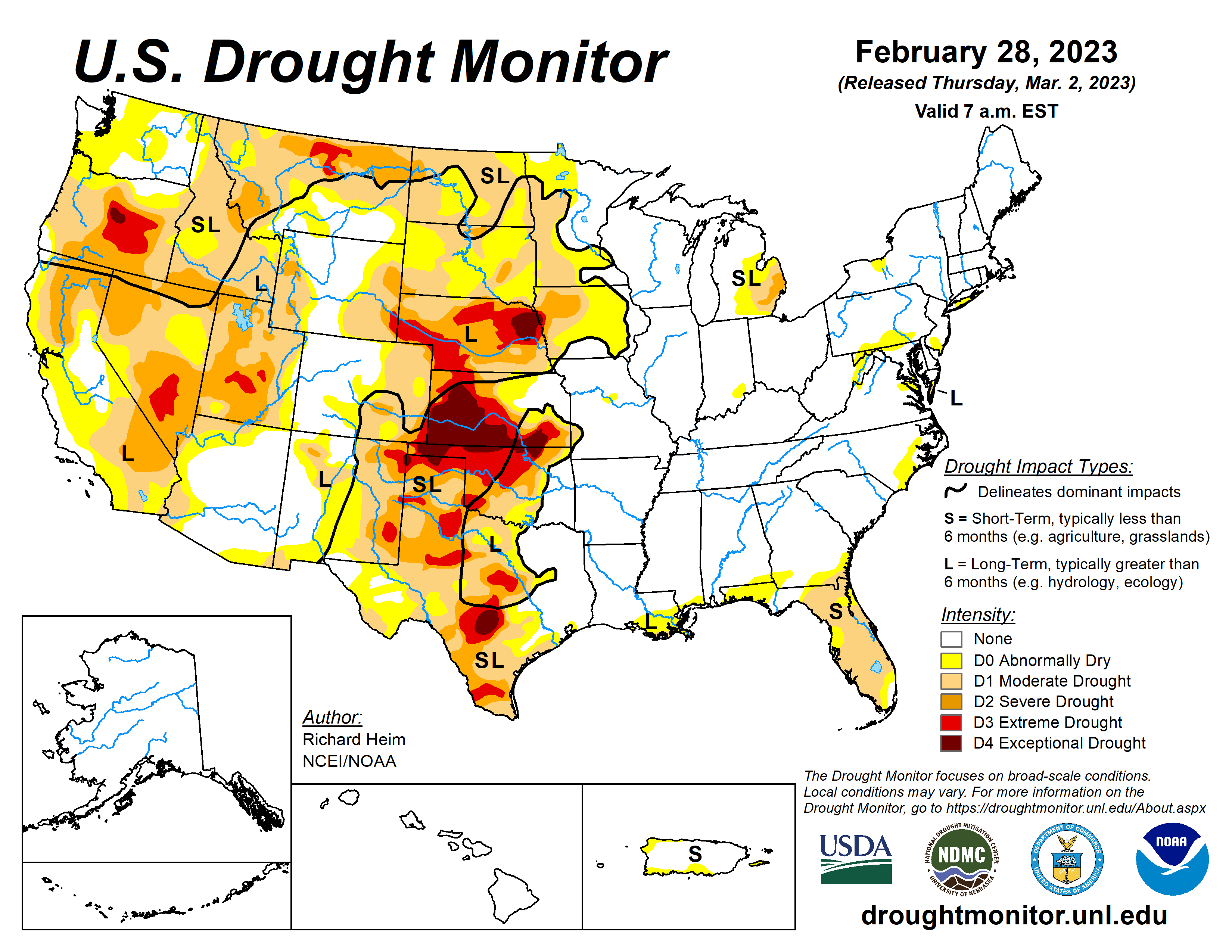
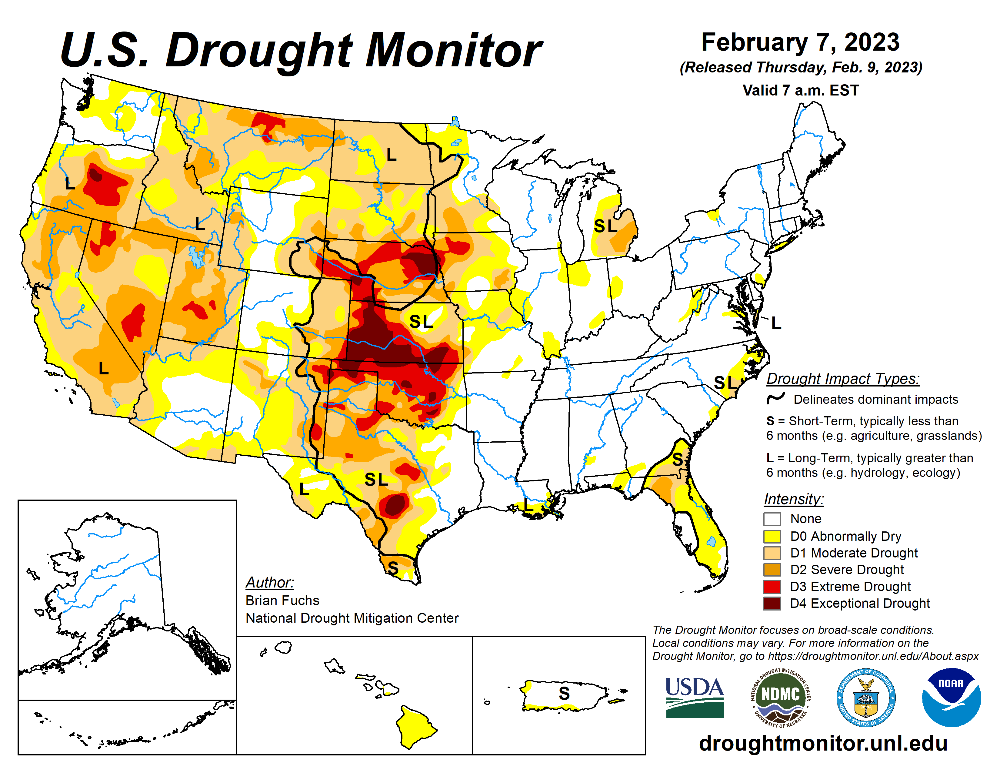
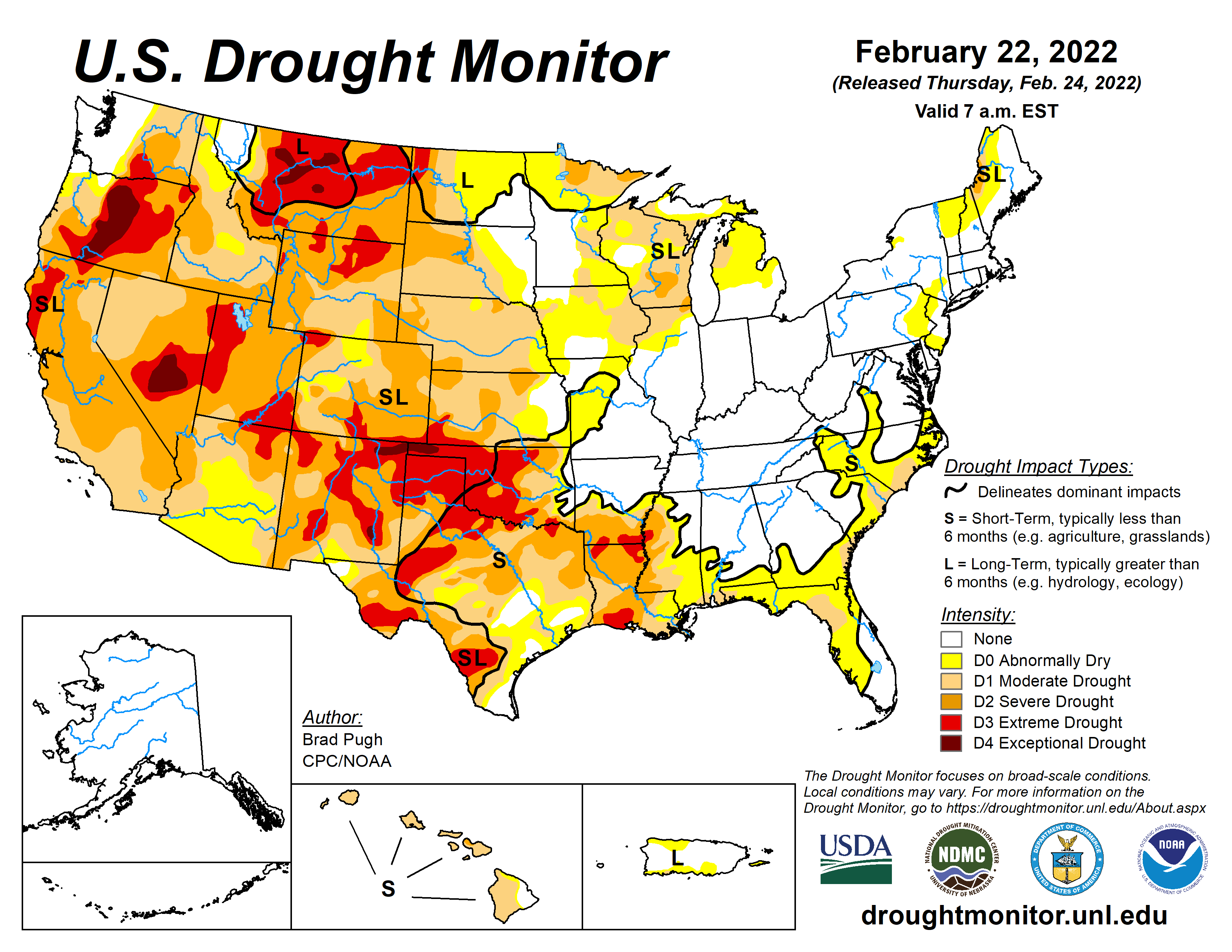
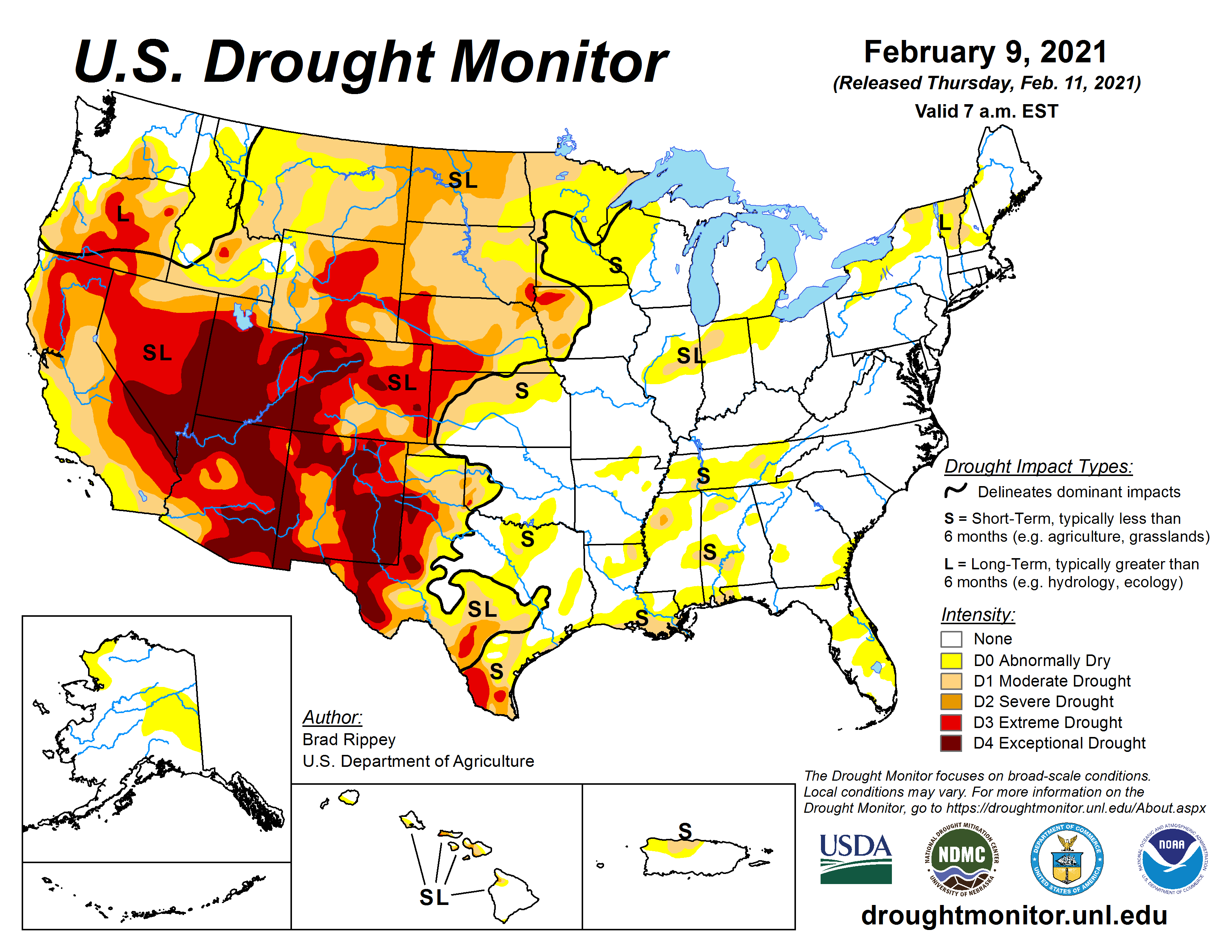
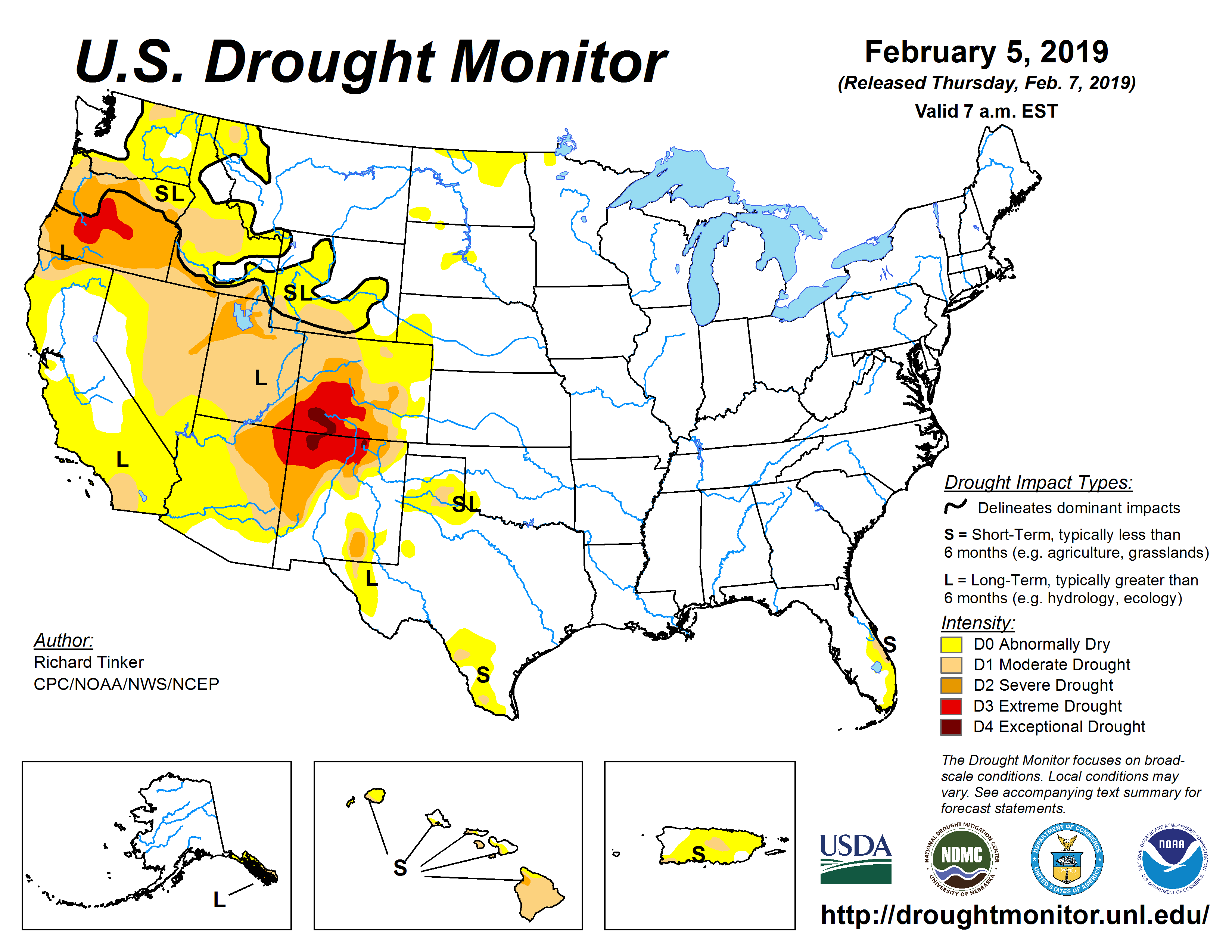
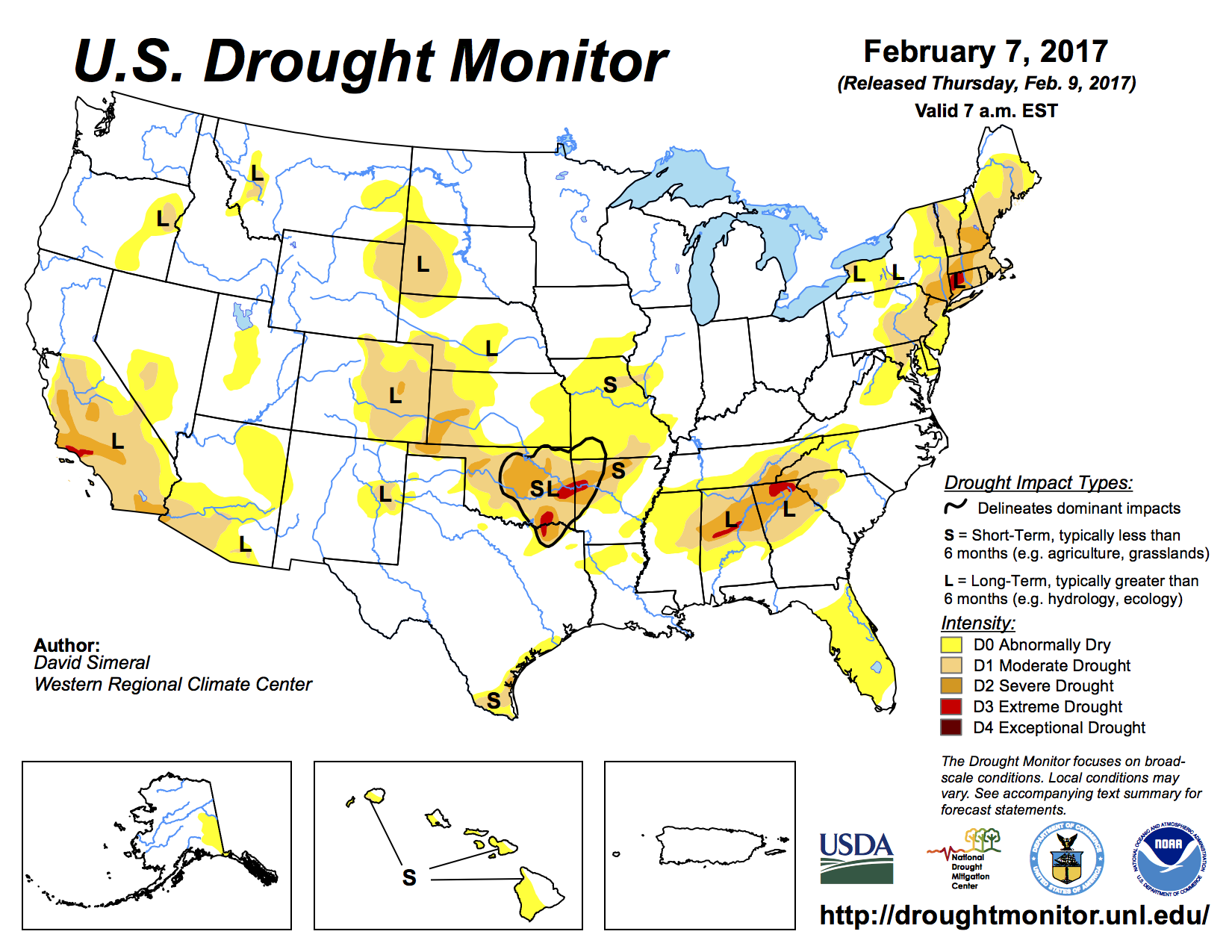
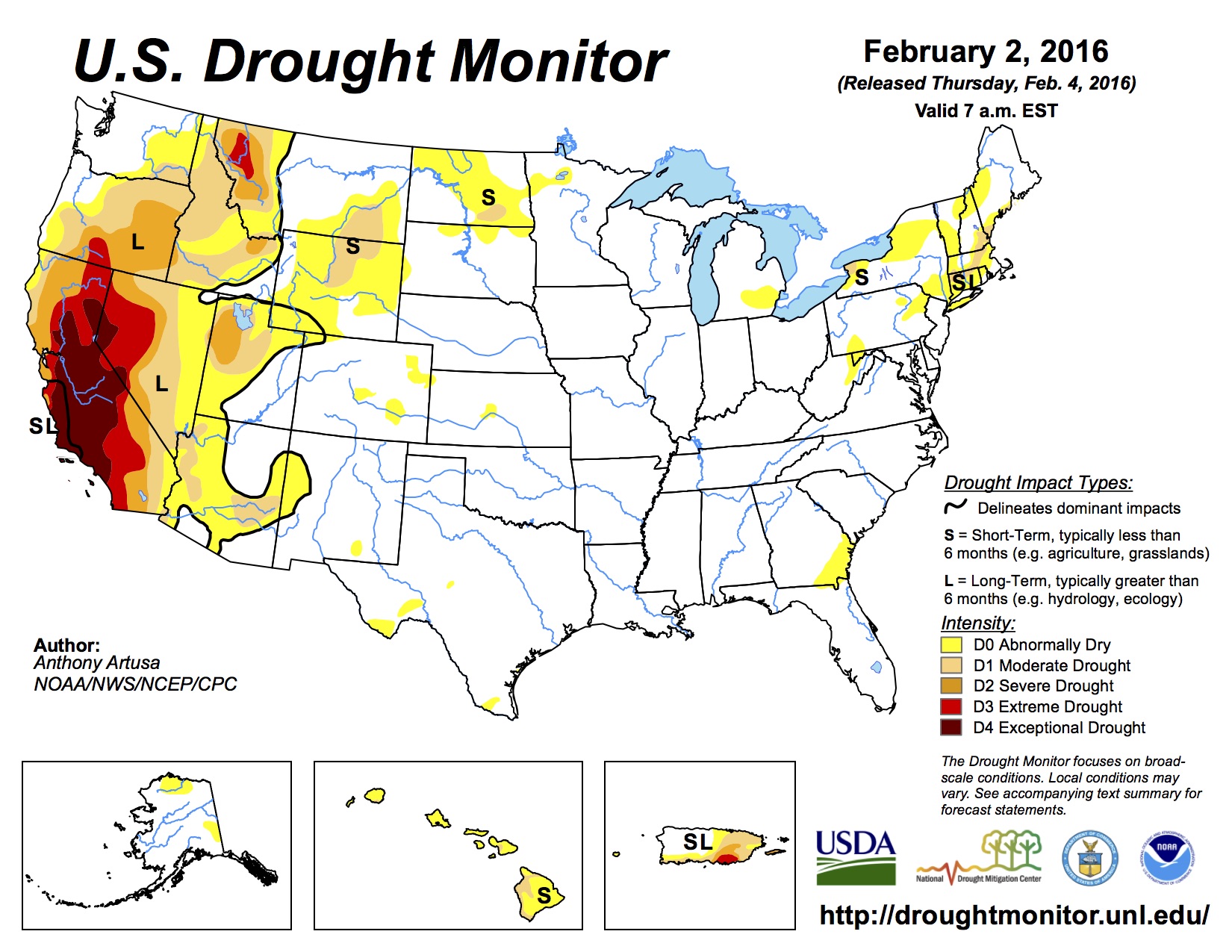
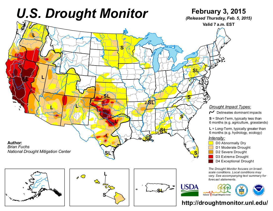
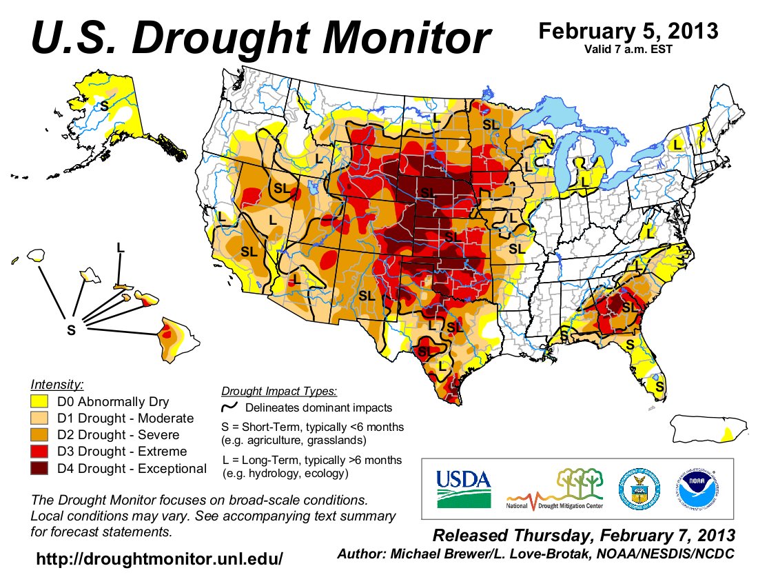
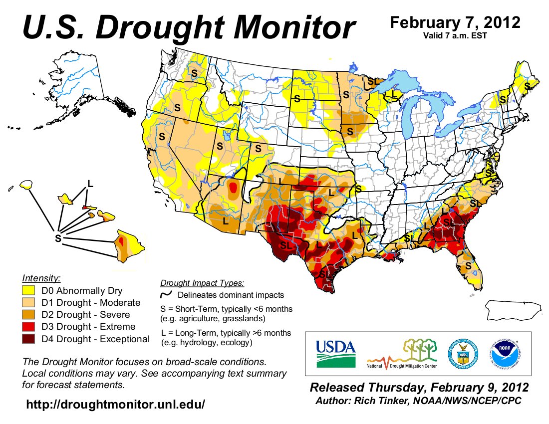
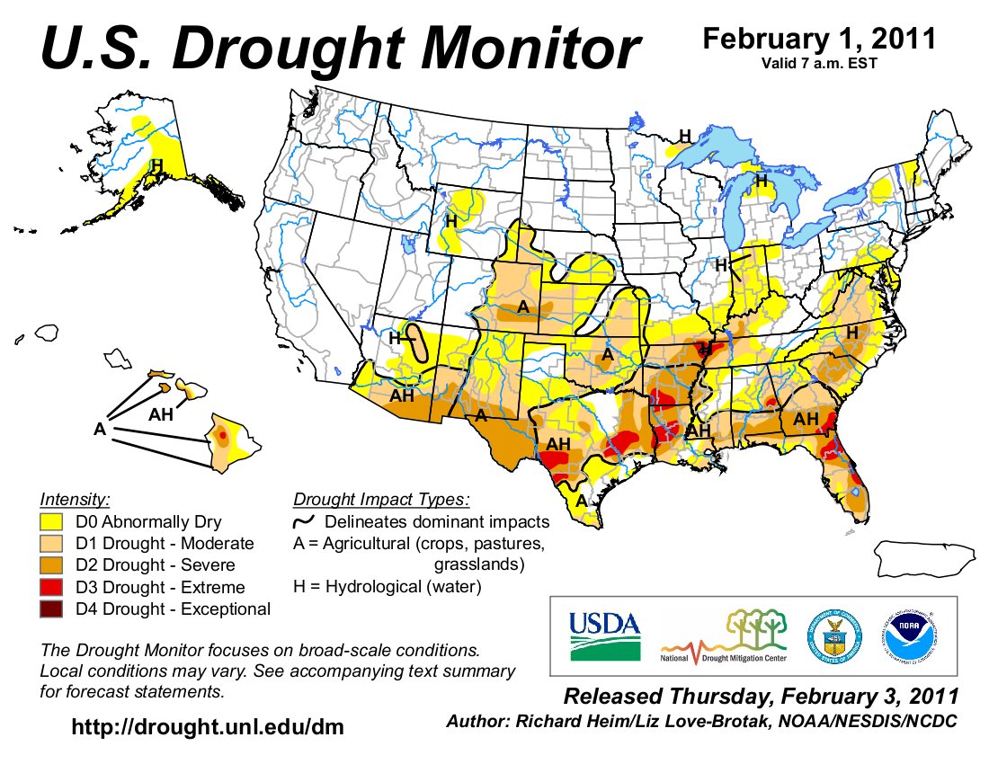
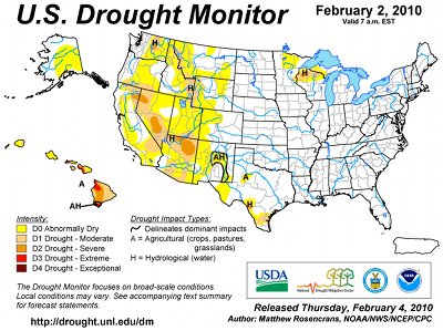
Click on a thumbnail graphic to view a gallery of drought data from the US Drought Monitor website.

Click the link to go to the US Drought Monitor website. Here’s an excerpt:

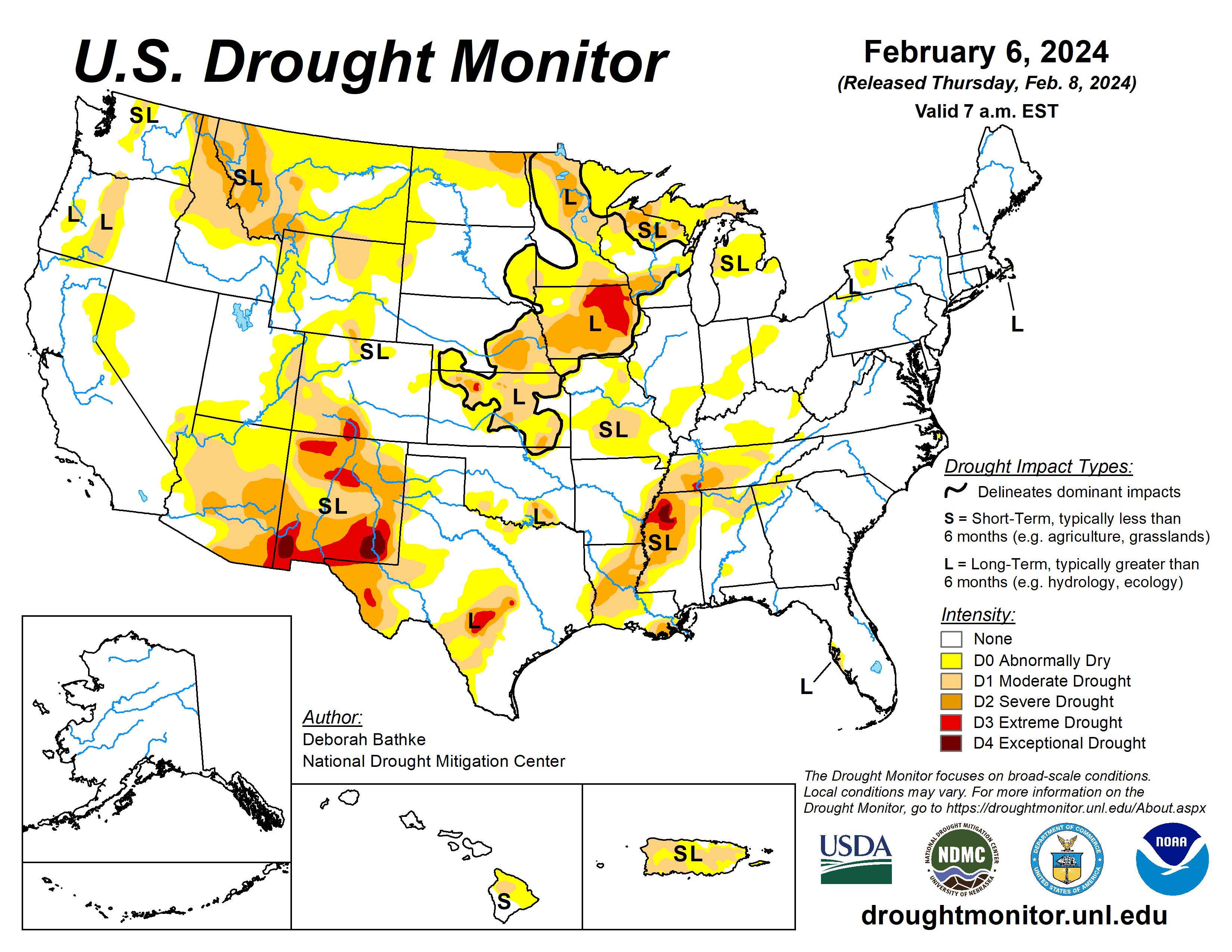
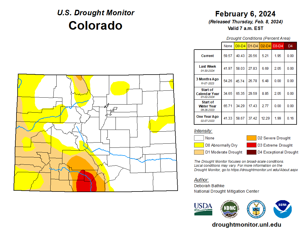
This Week’s Drought Summary

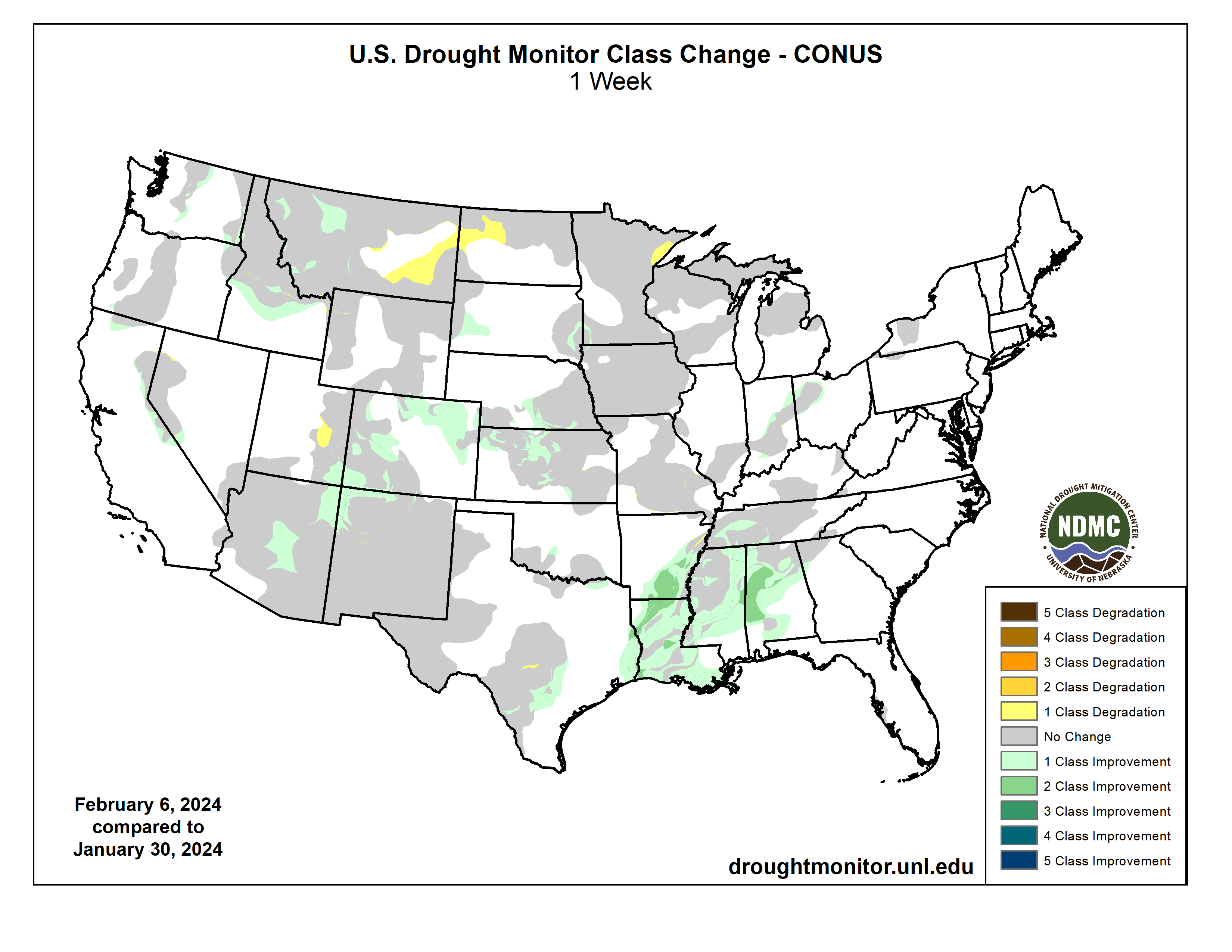
Last week, a strong Pacific storm system brought flooding rains to California and heavy snow to the mountain ranges of Northern California and the Sierra Nevada. Parts of the state saw nearly a foot of rain from this storm, breaking long-standing records. Moisture from this system also brought rain and snow to the Pacific Northwest and inland regions of the West. Most states in the region saw pockets of improvement despite the heaviest precipitation missing many of the West’s persistent drought areas. Another round of showers and thunderstorms passed through the South and Southeast. In the last two weeks, rainfall totals of more than 10 inches fell in parts of East Texas, Louisiana, and Mississippi. The excess rain brought one and two category improvements to drought. The Northern Plains, Upper Midwest, and Northeast stayed relatively dry, with well above normal temperatures last week. Concerns continue to grow over the lack of snow this season…
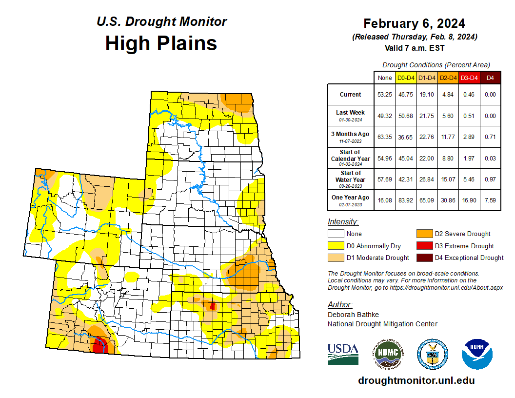
Colorado Drought Monitor one week change map ending February 6, 2024.

High Plains

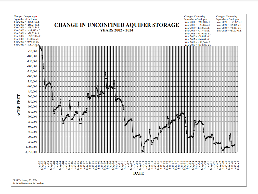
High temperatures averaged about 8 to more than 20 degrees above normal. Precipitation of less than 0.25 inches fell across much of the Dakotas, eastern Nebraska, and southwest Kansas. The rest of the region recorded totals ranging from about 0.25 inches to just over 1 inch. Moderate drought (D1) improved in eastern South Dakota in response to above normal precipitation during the month of January. South-central Nebraska and northern and central Kansas also saw 1-category improvements to long-term drought areas. While short-term moisture deficits have largely been eliminated, a dry signal remains at timescales longer than about 6 months. Precipitation deficits of nearly 10 inches over the last year remain in drought areas in these states and impacts to deeper soil moisture levels and groundwater continue to linger…
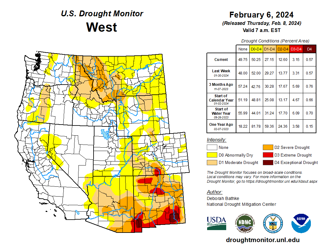
West

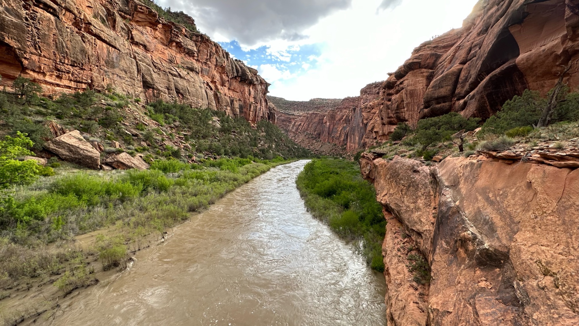
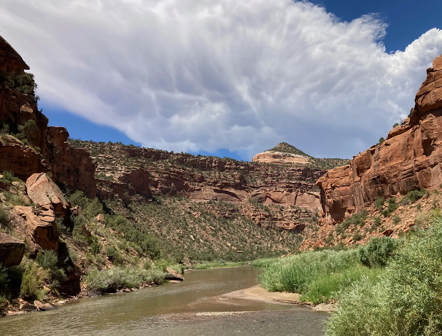
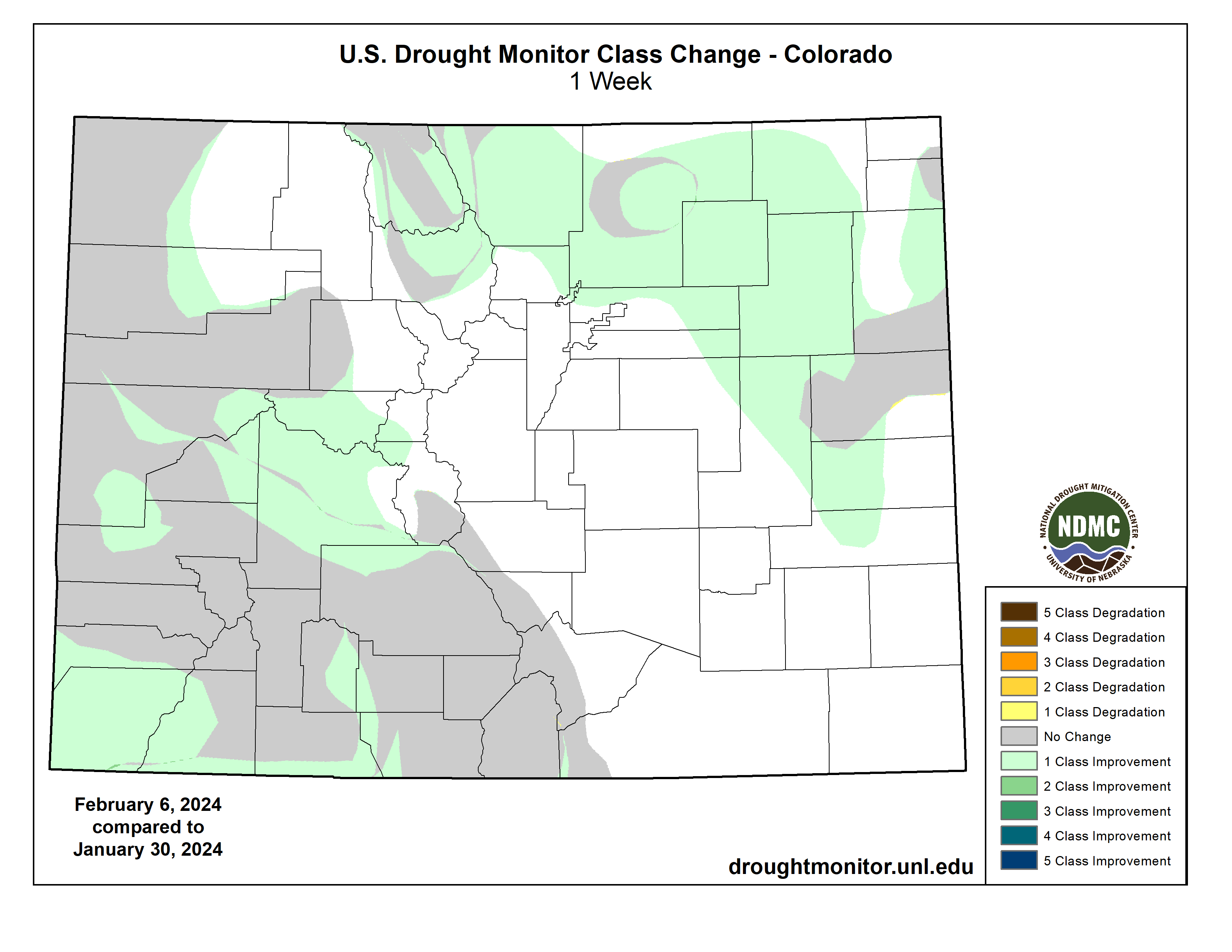
A strong storm system brought flooding rains to California and heavy snow to the mountain ranges of Northern California. Parts of the state recorded totals of 10 to 15 inches during the week, more than 600% of normal (for the same 7-day period). Moisture from this system also brought rain and snow to the Pacific Northwest and inland regions of the West. Outside of California, precipitation mostly totaled less than 3 inches. Pockets of improvements occurred in Idaho and western Montana, where recent precipitation has helped reduce drought signals in the short and longer terms. Central Arizona, the Four Corners region, and Colorado also saw improvements. A lack of snow in eastern Montana and western North Dakota led to the expansion of abnormal dryness (D0)…

South

Another round of wet weather brought more than 3 inches of rain to parts of Texas, Louisiana, and Mississippi. Totals less than 0.25 inches fell in parts of Tennessee and Texas. The continued wet weather left parts of Alabama with 200 to more than 400% of normal rainfall for the last two weeks. Much of the state saw 1- and 2-category improvements to drought conditions. While the drought developed rapidly over the summer, improvements are slower to happen. Rainfall deficits of more than 10 inches over the last six months remain over parts of Louisiana and Mississippi. Streamflow, groundwater levels, and deeper soil moisture also remain historically low for this time of year. The fact that drought signals are still present shows how dry it was during earlier months…

Looking Ahead

The National Weather Service Weather Prediction Center forecast (valid February 7 – 10, 2024) calls for another round of rainfall to sweep across California and into the Desert Southwest. High elevation snow is expected over mountains in the West with a wintry mix (freezing rain, sleet, and snow) over the northern Plains and upper Midwest. Heading into the weekend, the extended forecast (valid February 10 – 14, 2024) calls for a band of heavy rain across the South and Southeast. High temperatures are expected remain above average across central and eastern parts of the country. The Climate Prediction Center’s 6-to-10-day outlook (valid February 13 – 17, 2024) calls for an increased probability that observed temperatures, averaged over this 7-day period, will be above normal across the Upper Midwest, the west Coast, and Alaska. Temperatures across the remaining parts of the country are expected to be near to below normal. The pattern of increased precipitation across California and the southern tier of the continental U.S. (CONUS) is expected to continue, while much of the remaining CONUS, eastern Alaska, and the Big Island of Hawaii are expected to have below or near-normal precipitation.

US Drought Monitor one week change map ending February 6, 2024.

Just for grins here’s a gallery of US Drought Monitor maps for the last few years.

What and where is the #DoloresRiver and why is it important?: #Colorado’s Dolores river is critically important for both wildlife and people — Environment America

Dolores River Canyon. David Joswick | Used by permission

Click the link to read the article on the Environment America website (Karli Eheart and Ellen Montgomery):

December 22, 2023

Where is the Dolores River?

The Dolores River flows more than 241 miles from south to north through Colorado and then into Utah where it joins the Colorado River, carving one of the country’s most stunning canyons. 

In 1765, a Spanish explorer came across what he named “El Río De Nuestra Señora de Dolores,” or “The River of Our Lady of Sorrows.” Today, the Dolores River brings pleasure rather than sorrow, as a vibrant habitat for wildlife and a popular recreation destination.

Dolores River watershed

Why is the Dolores River important?

The water in the Colorado River is used for multiple purposes across many western states; including agriculture and drinking water. The river provides water to the cities of Cortez and Dove Creek as well as the Ute Mountain Ute Tribe and the Montezuma Valley through large, man-made canals. Importantly, the Dolores River flows into the Colorado River, which provides critical downstream benefits to some 40 million Americans. 

Mcphee Reservoir

The Dolores River was dammed just southwest of the city of Dolores, Colorado, creating the McPhee Reservoir, which allocates all of its stored water for agriculture. Even though it is the second largest reservoir in Colorado, the McPhee does not have the capacity to support agriculture and to release enough water into the river to help recreation and wildlife thrive.

This watershed is an ideal habitat for large mammals, such as desert bighorn sheep, mule deer, and beavers as well as many migratory birds. The river is also home to three native fish; flannelmouth sucker, bluehead sucker, and roundtail chub. 

The jaw-dropping scenic views make it a popular tourist destination year after year. Rafting, camping, hiking, fishing, hunting, bird watching and other activities are abundant. Visitors also come for the rich cultural history. The Dolores Canyon was home to ancient Ute peoples, Ancestral Puebloans, and Fremont peoples for thousands of years

Dolores River Canyon. David Joswick | Used by permission

Threats to the Dolores River

The Dolores river is dependent on water released by snowpack, the snow that builds up in the colder months. Due to climate change, snowpack has been decreasing since the 1950’s as snow melts earlier and there is less precipitation

Because of the more intense drought conditions caused by climate change, there is often not enough water in the McPhee Dam left to release into the river after water has been allocated to agriculture. The river’s flow has decreased by 50% over the last 10 years. Not having enough water flowing can lead to dramatic increases in both water temperature and sediment and silt, leading to reduced water quality

Nathan Fey, seen here paddling the Lower Dolores River. The lower Dolores River depends on a deep snowpack for boating releases from McPhee Reservoir. (Photo courtesy Nathan Fey)

The importance of snowpack to the river was demonstrated in 2016. Thanks to a healthy snowpack which released more water than past years, the river flowed at a “floatable” level for the first time in half a decade. The fully flowing river led to increased water recreation, such as rafting the technical rapids, exploring back hidden canyons, fly fishing for rainbow trout and spotting wildlife such as beavers. Camping even resumed, despite many campsites being overgrown and untended for years. 

In addition to low water levels, the river is exposed to pollution from uranium tailings and runoff from historic mines at its headwaters. With the possibility of mining resuming, the Dolores could be exposed to even more pollution, threatening native fish species, potentially leading to population declines. Additionally, it decreases the quality and the safetyof drinking water across the country, potentially leading to public health risks.

Prickly Pear Dolores River Canyon. David Joswick | Used by permission

We must protect the Dolores River

We must ensure the water in the Dolores River is safe for drinking, wildlife, recreation, and agriculture. Designating the land surrounding the Dolores River in Mesa and Montrose counties as a national monument would help to protect endangered species, encourage sustainable and responsible recreation and protect the water that does flow in the river from future toxic pollution. A national monument will not address all of the challenges with water shortages in this area but it will give wildlife a better chance. This will allow people to continue to enjoy the unique beauty of this area without running the risk of overuse, and preserve it for future generations.

Cost to water crops could nearly quadruple as #SanLuisValley fends off #ClimateChange, fights with #Texas and #NewMexico — Fresh Water News #RioGrande

Sunrise March 16, 2022 San Luis Valley with Mount Blanca in the distance. Photo credit: Chris Lopez/Alamosa Citizen

Click the link to read the article on the Water Education Colorado website (Jerd Smith):

Hundreds of growers in Colorado’s San Luis Valley could see their water costs nearly quadruple under a new plan designed to slash agricultural water use in the drought-strapped region and deflect a potential legal crisis on the Rio Grande.

A new rule approved by the area’s largest irrigation district, known as Subdistrict 1, and the Alamosa-based Rio Grande Water Conservation District, sets fees charged to pump water from a severely depleted underground aquifer at $500 an acre-foot, up from $150 an acre-foot. The new program could begin as early as 2026 if the fees survive a court challenge.

“It’s draconian and it hurts,” said Sen. Cleave Simpson, a Republican from Alamosa who is also general manager of the Rio Grande water district.

The region, home to one of the nation’s largest potato economies, has relied for more than 70 years on water from an aquifer that is intimately tied to the Rio Grande. The river begins high in the San Juan mountains above the valley floor.

Both the river and the aquifer are supplied by melting mountain snows, but a relentless multi-year drought has shrunk annual snowpacks so much that neither the river nor the aquifer have been able to recover their once bountiful supplies.

And that’s a problem. Under the Rio Grande Compact of 1938, Colorado is required to deliver enough water downstream to satisfy New Mexico and Texas. If the aquifer falls too low, it will endanger the river’s supplies and push Colorado out of compliance. Such a situation could trigger lawsuits and cost the state tens of millions of dollars in legal fees.

Subdistrict 1 has set state-approved goals to comply with the compact. Within seven years, it must find a way to restore hundreds of thousands of acre-feet of water to the aquifer, a difficult task.

Rio Grande River, CO | Photo By Sinjin Eberle

An acre-foot equals nearly 326,000 gallons of water, or enough to cover an acre of land with water a foot deep.

The specter of an interstate water fight is creating enormous pressure to reorganize the valley’s farming communities in a way that will allow them to use less water, grow fewer potatoes, and still have a healthy economy.

For more than a decade, valley water users have been working to reduce water use and stabilize the aquifer. Many have already started experimenting with ways to grow potatoes with less water by improving soil health, and to find new crops, such as quinoa, that may also prove to be profitable.

They have taxed themselves and raised pumping fees, using that revenue to purchase and then retire hundreds of wells. In fact, the district is pumping 30% less water now than it was 10 years ago, according to Simpson.

But the pumping plans, considered innovative by water experts, haven’t been enough to stop the decline in aquifer levels. The Rio Grande Basin is consistently one of the driest in the state, generating too little water to make up for drought conditions and restore the aquifer after decades of over pumping.

With the new fees, the region will likely have some of the highest agricultural water costs in the state, said Craig Cotten, who oversees the Rio Grande River Basin for Colorado’s Division of Water Resources.

Perhaps not as high as water in the Colorado-Big Thompson Project on the northern Front Range, where cities and developers and some growers pay thousands of dollars to buy an acre-foot of water.

Still it is much higher than San Luis Valley growers and others have paid historically. Fees at one time were just $75 an acre-foot, eventually reaching $150 an acre-foot. The prospect of the fee skyrocketing to $500 is shocking.

“That is high,” said Brett Bovee, president of WestWater Research, a consulting firm specializing in water economics and valuations. Typically such fees across the state have been in the $50 to $100 range, he said.

But Bovee said the water district is taking constructive action while giving growers opportunities to find their own solutions to the water shortage. “It’s putting the decision-making power into the hands of growers and landowners, rather than saying ‘everybody take one-third of your land out of production.’”

Third hay cutting 2021 in Subdistrict 1 area of San Luis Valley. Photo credit: Chris Lopez

Subdistrict 1 is the oldest and largest of a group of irrigation districts in the valley, according to Cotten. Its $500 fee has triggered a lawsuit by some growers, who believe the district is applying the new fees unfairly.

“The responsibility for achieving a sustainable water supply is to be borne proportionately based on (growers’) past, present and future usage,” Brad Grasmick, a water attorney representing San Luis Valley growers in the Sustainable Water Augmentation Group and the Northeast Water Users Association, said, referring to state water laws. “But we believe the responsibility is being disproportionately applied to our wells.”

Those growers are now trying to create their own irrigation district and they are suing to stop the new fee.

“I think that more land retirement and more reduction in well pumping is needed and that is what my group is trying to do,” Grasmick said. “No one wants to see the aquifer diminish and continue to shrink. If everybody can do their part to cut back and make that happen, that is the way forward. My guys just want to see the proportionality adhered to.”

To date, tens of millions of dollars have been raised and spent to retire wells in the San Luis Valley, with Subdistrict 1 raising $70 million in the last decade, according to Simpson. And in 2022 state lawmakers approved another $30 million to retire more wells.

But it’s not enough. With each dry year, the water levels in the aquifer continue to drop.

Republican River Basin by District

Similar issues loom for Eastern Plains irrigators

The San Luis Valley is not the only region faced with finding ways to reduce agricultural water use or face interstate compact fights. Colorado lawmakers have also approved $30 million to help growers in the Republican River Basin on the Eastern Plains reduce water use to comply with the Republican River Compact of 1943, which includes Kansas, Nebraska and Colorado.

Lawmakers are closely monitoring these efforts to reduce water use while protecting growers.

Sen. Byron Pelton, a Republican from Sterling, said the combined money that is going to the Rio Grande and Republican basins is critical. But the potential for legal battles, he said, is concerning.

“Agriculture is key in our communities,” Pelton said. “But the biggest thing is that we have to stay within our compacts. Sometimes you’re backed into a corner and that is just the way it has to be. I hate it, but we have to stay in compliance.”

How much irrigated land will be lost as wells are retired isn’t clear yet. Simpson said growers who have access to surface supplies in the Rio Grande will still be able to irrigate even without as many wells or as much water, but the land will likely produce less and farms may become less profitable.

And it will take more than sky-high pumping fees to solve the problem, officials said. The Division of Water Resources has also created another water-saving rule in Subdistrict 1 that will force growers to replace one-for-one the water they take out of the aquifer, instead of allowing them to simply pay more to pump more.

Cotten said the hope is that the higher fees combined with the new one-for-one rule will reduce pumping enough to save the aquifer and the ag economy.

Valley growers are already shifting production and changing crops, said James Ehrlich, executive director of the Colorado Potato Administrative Committee in Monte Vista, an agency involved in overseeing and marketing the region’s potato crops.

Still the new fees could jeopardize the entire potato economy, Ehrlich said.

“There are a lot of creative things going on down here,” Ehrlich said. “But we have to farm less and learn to survive as a community together. And Mother Nature has not helped us out. We’ve stabilized but we can’t gain back what (state and local water officials) want us to gain back. It is just not going to happen.”

More by Jerd SmithJerd Smith is editor of Fresh Water News. She can be reached at 720-398-6474, via email at jerd@wateredco.org or @jerd_smith.

San Luis Valley Groundwater