Click the link to read the article on The Land Desk website (Jonathan P. Thompson):
+ UT nixes Bears Ears swap; Mining Law reform … NOT!
Though it sits just 10 miles from the Grand Canyon’s south rim, the controversial Pinyon Plain (née Canyon) uranium mine goes unnoticed by the millions of people who drive past it on their way to the national park. It’s tucked in among the trees about two miles off the highway, and its total above-ground footprint is a mere 17 acres — smaller than an upscale shopping center in Flagstaff.
Officials at Energy Fuels, Pinyon Plains’ operator, highlight the facility’s inconspicuousness when responding to opposition to plans to rev up the mine. Curtis Moore, Energy Fuels’ VP of marketing, told the Navajo-Hopi Observer in 2022 that the mine “is about as small and low-impact as commercial mining gets.” There’s no gaping open pit like those at the copper mines further south in Arizona nor hulking piles of waste rock and toxic tailings and, Moore insisted, the Pinyon Plain is the most heavily regulated conventional mine in the nation, which should prevent it from contaminating groundwater or the air.
Moore’s assurances don’t ease the concerns of many Havasupai people, however, who are affected by the mine in ways that transcend regulations and the scope of conventional Western science. “We have a belief system that they don’t understand,” Havasupai elder Carletta Tilousi told The Guardian in 2022. “In our stories, that area where the mine is located is Mother Earth’s lungs. So when they dug the mine shaft, they punctured her lungs.”
This is the sort of potential harm that almost never makes it into environmental impact statements or regulators’ considerations of proposed projects. That may be changing. The United States Geological Survey has published a new report on uranium mining near the Grand Canyon, one that incorporates Indigenous knowledge to identify exposure pathways that standard risk analyses might miss. The report, by Carletta Tilousi (Havasupai Tribe) and Jo Ellen Hinck (USGS), is an eye-opening read.
In the Grand Canyon-area, high-grade uranium ore often occurs in geologic features known as breccia pipes, prompting prospectors to stake hundreds of claims there from the 1940s to the 1980s, when the domestic uranium mining industry collapsed. Interest was revived in 2007, when prices shot up again, and more claims were staked. The Pinyon Plain Mine — which was developed years ago but never produced ore — sits a few miles from Red Butte, a landform held sacred by several tribal nations, and in Mat Taav Juudva, or “sacred meeting corridor” for the Havasupai. It is now within the boundaries of Baaj Nwaavjo I’tah Kukveni – Ancestral Footprints of the Grand Canyon National Monument. New mining claims can’t be staked here, but since Pinyon Plain was an existing, valid claim when President Biden established the monument last year, it is grandfathered in.
The Havasupai Tribe has pushed back against uranium mining for decades, saying it endangers their health, land, and culture. The Pinyon Plain Mine sits above the Redwall-Muav aquifer, and mining could contaminate this precious store of groundwater. Indeed, when the mine shaft was sunk in 2016, it encountered a perched aquifer, which drained into the shaft. This not only threatens the tribe’s drinking water, but also its very existence. The report quotes Havasupai Vice-Chairman Edmond Tilousi thusly: “If the R-Aquifer becomes contaminated, and we must abandon our ancestral home of Supai Village, we will leave the blue-green waters of Havasu Creek behind and consequently will cease to be the Havasuw Baja. While we may still breathe air, we, the People of the Blue Green Water, will have become extinct.”
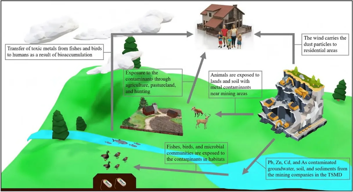
The aquifers are just one exposure pathway. Others will appear in standard risk assessments of mines, like this one:
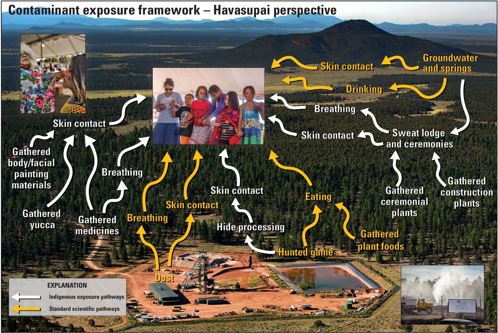
And yet others are typically overlooked. This updated contaminant exposure framework shows both the pathways revealed by standard analyses, and those identified through Indigenous knowledge and the Havasupai perspective:
This new report, “Expanded Conceptual Risk Framework for Uranium Mining in Grand Canyon Watershed—Inclusion of the Havasupai Tribe Perspective,” gives a far more holistic view of mining and its impacts than standard analyses. As such, it gives a much more complete vision of what is actually at stake. Hopefully other researchers and federal agencies will take note and follow the authors’ lead.
I will admit that I was pretty psyched to hear that Congress was finally taking up mining law reform. After all, the General Mining Law of 1872 hasn’t been significantly altered since then President Ulysses S. Grant signed it into law. Isn’t it about time to tighten things up a bit and end the 152 years of public land giveaways? Apparently not.
Yes, Congress is considering the Mining Regulatory Clarity Act. But no, it is not reforming the law in a good way.
See, the law currently says that for a mining claim to be valid, the claimant has to prove it contains a valuable mineral deposit. And if it’s not valid, then a mining company can’t use or occupy the claim. For decades, this requirement was more or less ignored when it came to mining companies using invalid claims on public lands to store waste rock or mill tailings. But in recent years, judges have handed down some significant rulings — most notably the Rosemont decision — blocking mines from storing waste on invalid, unproven claims.
The “Clarity Act” pushed by Rep. Mark Amodei, a Nevada Republican, would essentially validate invalid claims by removing the “valuable mineral” requirement. The language from the bill reads: “A claimant shall have the right to use, occupy, and conduct operations on public land, with or without the discovery of a valuable mineral deposit,” if the claimant pays their location fee and annual maintenance fees.
In other words, it further loosens an already lax and antiquated law.
🤯 Annals of Inanity 🤡
It really seems as if the Republican-led Utah legislature is looking to one up Congress in the dysfunction department. Nearly every day we hear some news of boneheadedness coming out of Capitol Hill, and nearly every time it’s follow up by something even more head-scratching out of Salt Lake City.
This week’s moronic moment comes to you courtesy of Gov. Spencer Cox and his comrades in the legislature, who put the kibosh on a land exchangethat would have swapped out state parcels in Bears Ears National Monument for federal land outside the monument. You might be thinking that Utah felt like they were getting the short end of the stick here, and merely wanted to renegotiate. But in fact, as Utah’s School and Institutional Trust Lands Administration officials and Utah’s congressional delegation will tell you, the swap is a really good deal for the state and for the schools and institutions revenues from the lands support.
The exchange would allow SITLA (Utah’s School and Institutional Trust Lands Administration) to dispose of discrete parcels within the monument with minimal revenue-generating potential. In return, they’d receive consolidated blocks of Bureau of Land Management land in areas targeted for lithium, potash, uranium, helium, oil and gas, and/or residential development. Meanwhile the BLM would rid itself of the headache of dealing with all of these little inholdings within the monument. SITLA officials estimated the swap would net the state hundreds of millions of dollars in additional revenue over the long term, which was good enough for Utah’s entire congressional delegation to sign onto federal legislation that would have ratified the deal (it stalled out, however, which opened the door to this week’s withdrawal).
So what’s changed that would spur the withdrawal? Nothing. Cox and his Republican colleagues claim they made this imbecilic move because: the BLM “has signaled that it will adopt an exceptionally restrictive and unreasonable land management plan {for Bears Ears NM} that would negatively impact the communities surrounding the Monument and the state’s public school children…”
Yes, Utah’s elected leaders are throwing away hundreds of millions of dollars for public schools because they perceived “signals” about something they didn’t like. The draft management plan for Bears Ears NM hasn’t even been released, and even if it is restrictive as all get out, canceling the exchange will do nothing to change it. Nothing! All this little political circus act will do is, yes: Take money away from public school children.
In other words, this whole thing is merely an exercise in ideology-driven stupidity. Echoing their GOP brethren in Washington, D.C., Utah’s Republicans are acting against their constituents’ best interest in order to make a political point. Only not even they know what that point might be.