In response to falling flows in the critical habitat reach, the Bureau of Reclamation has scheduled an increase in the release from Navajo Dam from 350 cubic feet per second (cfs) to 400 cfs for tomorrow, February 10th, at 4:00 AM.
Releases are made for the authorized purposes of the Navajo Unit, and to attempt to maintain a target base flow through the endangered fish critical habitat reach of the San Juan River (Farmington to Lake Powell). The San Juan River Basin Recovery Implementation Program recommends a target base flow of between 500 cfs and 1,000 cfs through the critical habitat area. The target base flow is calculated as the weekly average of gaged flows throughout the critical habitat area from Farmington to Lake Powell.
State climatologist Russ Schumacher appeared on the latest episode of the Outdoor Citizen podcast to talk to us about Colorado’s snow and climate. Schumacher, who took over as Colorado’s state climatologist in 2017, is also professor of atmospheric science at Colorado State University. In a time of climate change and increasingly unpredictable events, Schumacher and people like him are here to help us all make sense of it.
“There’s always something new happening,” and that’s what fascinates him most about his work and the weather. In Colorado, especially, he said. “We have such fascinating weather. The weather and the climate can vary hugely over short distances.”
It’s both fascinating and challenging, he said.
The San Luis Valley is a great example of the variability of weather, he noted. “For one thing, I think it’s not as well understood as other parts of the state.”
Everybody loves to study the weather in the northern part of the state, he said, but “I think some of what happens there in the Valley is so fascinating, and a lot of times it flies under the radar either literally or figuratively.”
New radar installed near the Alamosa airport helps track local weather, he said.
Schumacher and his colleagues at the climate center just released the third edition of the Climate Change in Colorado report. The last time that report was updated was in 2014. A lot has happened since then, he said, and they realized a new update was needed.
You can read the report here. Schumacher broke down some of the key takeaways from that report.
LIke most of the planet, Colorado has been warming. Colorado has warmed by 3 degrees fahrenheit on average since the late 1880s. Precipitation is much harder to pin down, but the past two decades have been very dry.
As the planet continues to warm, Colorado will see the effects.
Climate models are all over the place, he said, when it comes to precipitation. There is a lot of variation. When it comes to snow and water, he said, even if the precipitation doesn’t change and the amount of liquid coming out of the sky doesn’t change “the fact that it’s warmer is going to put more stress on those water resources.”
In the summer, when the air is hotter it means quicker evaporation. In the winter, there is a shift in timing when runoff occurs in the spring and that changes when there are peak flows in the river.
“Warming is going to have impacts on our snow in the winter and our water supply in the summer,” he said.
We’re haven’t yet seen much of the effects for this El Niño year. Schumacher says there is still more time for that. Yet, we’re still below average in many of the nations’ southern river basins.
The current atmospheric river conditions on the west coast and in California are likely to head our way in the coming days and weeks. “It’ll be on the warm side when it hits Southern Colorado, as well.”
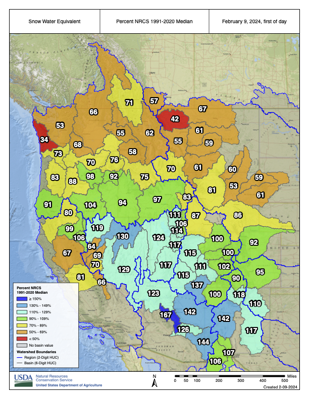
Westwide SNOTEL basin-filled map February 9, 2024 via the NRCS.
“Nowhere in the state is looking great at this point,” but we are much better than we were at the end of 2023. This last bout of snowstorms this month is helping. But it’s not a “boom year” that is typical with El Niño years.
There’s still hope to be had, he said.
The storms coming from the southwest are typically warmer than winter weather. He said that Saturday, Feb. 4, was the wettest day Fort Collins has seen. The city received 1.66 inches of precipitation in just that one day, which he said is not typical for early February.
The current snow drought will have long-term effects. It’s been “most acute” in Southern Colorado. There have been more years with low snowpack rather than a higher snowpack.
Since Colorado is a headwaters state, that doesn’t just impact us but the states surrounding us. Their water levels are reliant on Colorado’s snowpack.
The larger reservoirs in the Colorado River system require more consistently good years. One good year won’t necessarily create good levels. That system is in better shape than it was a year ago, but overall is in a bad state.
In the Rio Grande basin, he said, as the river flows down to New Mexico, there are increasing water supply issues further south. “Even if you have a good snowpack year, if the summer monsoon doesn’t come through and it’s really hot, that air is really thirsty for that water. It’s gonna try and pull that water out of the soils and out of the crops back into the air which means if you’re growing crops you’ve got to irrigate more, which means you’re using more water. That all is really a vicious cycle that puts stress on the system all around.”
Listen to the podcast here, or wherever you get your podcasts to hear more about what Schumacher is seeing.
ENSO Alert System Status: El Niño Advisory / La Niña Watch
Synopsis: A transition from El Niño to ENSO-neutral is likely by April-June 2024 (79%chance), with increasing odds of La Niña developing in June-August 2024 (55% chance).
During January 2024, above-average sea surface temperatures (SST) continued across most of the equatorial Pacific Ocean. SST anomalies weakened slightly in the eastern and east-central Pacific, as indicated by the weekly Niño index values. However, changes were more pronounced below the surface of the equatorial Pacific Ocean, with area-averaged subsurface temperature anomalies returning to near zero. Although above- average temperatures persisted in the upper 100 meters of the equatorial Pacific, below-average temperatures were widespread at greater depths. Atmospheric anomalies across the tropical Pacific also weakened during January. Low-level winds were near average over the equatorial Pacific, while upper-level wind anomalies were easterly over the east-central Pacific. Convection remained slightly enhanced near the Date Line and was close to average around Indonesia. Collectively, the coupled ocean-atmosphere system reflected a weakening El Niño.
The most recent IRI plume indicates a transition to ENSO-neutral during spring 2024, with La Niña potentially developing during summer 2024. Even though forecasts made through the spring season tend to be less reliable, there is a historical tendency for La Niña to follow strong El Niño events. The forecast team is in agreement with the latest model guidance, with some uncertainty around the timing of transitions to ENSO-neutral and, following that, La Niña. Even as the current El Niño weakens, impacts on the United States could persist through April 2024 (see CPC seasonal outlooks for probabilities of temperature and precipitation). In summary, a transition from El Niño to ENSO-neutral is likely by April-June 2024 (79% chance), with increasing odds of La Niña developing in June-August 2024 (55% chance).
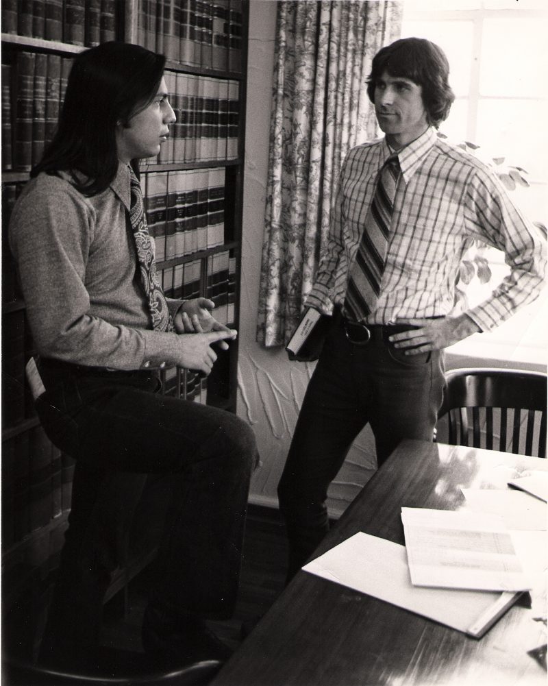
John Echohawk and David Getches discuss strategy in NARF’s early years. Photo credit: Native American Rights Fund
Click the link to read the article on The Denver Post website (Elise Schmelzer). Here’s an excerpt:
February 7, 2024
When David Gover became an attorney with the Native American Rights Fund, he inherited a water rights legal case about as old as he was.
The case revolving around water rights in Oregon held by the Klamath Tribes started in 1975 and it’s emblematic of many tribal water cases — they’re long, complex and require specific legal knowledge. There are not enough Native water attorneys to handle the difficult cases, which are critical for tribes to access the water they are entitled to. That’s one of the challenges Gover hopes the new, Colorado-based Tribal Water Institute will help solve. The institute will help train new attorneys in tribal water law and provide other resources to help tribes access and develop their water rights. Tribes hold some of the oldest and most senior water rights in the West, but many do not have the money or infrastructure to use their water or sufficient legal staff to protect it.
“There’s still so much need out there and capacity is an ongoing issue for us all,” Gover said…
The institute will train young water attorneys to advocate for tribes in state and federal policy and serve as a central resource for tribes on water issues. It will be part of the Boulder-based Native American Rights Fund, a nonprofit that has worked on myriad legal issues for tribal nations since 1970. Too often, tribes are stuck in a reactive position on water policy and litigation because they don’t have enough resources to work proactively, Gover said. The Native American Rights Fund has represented tribes in nine of the 35 tribal water rights settlements approved by Congress since 1978, but there is more work than attorneys available…
The Walton Family Foundation — which has spent millions on water issues in the West — donated $1.4 million to launch the institute. Native American Rights Fund staff continues to fundraise for the $4.2 million they estimate will be needed to fund the institute for three years. Tribal nations are under-represented in federal and state policy discussions, said Moira Mcdonald, environment program director of the Walton Family Foundation.
“That is unjust and unwise,” she said. “We need to listen to their voices. More inclusive decision-making will lead to greater benefits for the environment and society as a whole.”
Native America in the Colorado River Basin. Credit: USBR
Fair representation for tribes is especially important in the Colorado River basin. Combined, the 30 tribes in the basin hold rights to approximately 25% of the water. But many have not been able to use their full allotment and the tribes have been repeatedly left out of negotiations over how the river should be used and divided.
John Echohawk. Photo credit: Allen Best/Big Pivots
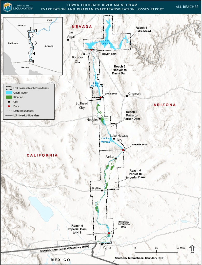
The Bureau of Reclamation today published an overview of historical natural losses along the lower Colorado River. The Mainstream Evaporation and Riparian Evapotranspiration report looks at water surface evaporation, soil moisture evaporation, and plant transpiration. It will be used by Reclamation as a source of data as it manages regional water operations and to improve the agency’s modeling efforts.
“Reclamation’s approach to water management in the Colorado River Basin and across all Reclamation states is based on best available science, transparency, and inclusivity.” said Reclamation Commissioner Camille Calimlim Touton. “The release of the Mainstream Evaporation and Riparian Evapotranspiration study today evidences this commitment by informing our partners and the public about river and reservoir evaporation and transpiration in the Colorado River Basin.”
The report provides an overview of average mainstream losses from both river and reservoir evaporation, as well as the evaporation and transpiration associated with vegetation and habitats along the river. The report states that approximately 1.3-million-acre feet of losses occur annually along the lower Colorado River mainstream. Based on data from 2017 to 2021, approximately 860,000 acre-feet of Colorado River water is lost to evaporation occurring annually from Lake Mead to the border with Mexico. A further 445,000 acre-feet is lost to evaporation and transpiration from natural vegetation and habitats.
A second atmospheric river of moisture in a matter of days is further bolstering Colorado snowpack levels that have continued to lag a bit behind normal…An initial atmospheric river storm system that wound down over the weekend dumped as much as three feet of snow in parts of the mountains, with the Colorado Avalanche Information Center saying the Ruby and Ragged ranges west of Crested Butte and south of Marble were particularly hard-hit. The Mesa Lakes area on Grand Mesa got about 15 inches of snow in that storm and Park Reservoir saw about a foot of snow fall, while another measuring site on Grand Mesa got only about 4 inches, said Dennis Phillips, a meteorologist for the National Weather Service in Grand Junction. The second atmospheric river that arrived this week is expected to be a stronger system, he said…
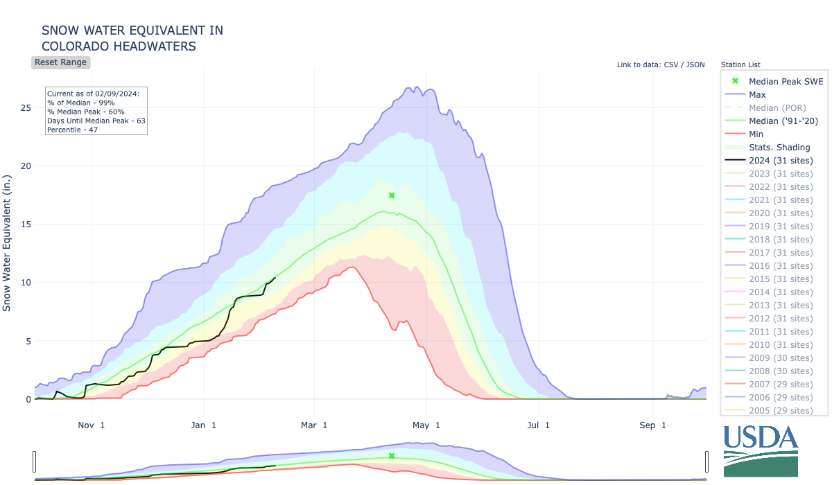
The federal Natural Resources Conservation Service on Tuesday said that statewide snowpack in Colorado stood at 93% of normal for Feb. 6. It has seen little growth since the middle of last month or so, after increasingly sharply from below 70% of normal at the start of January.
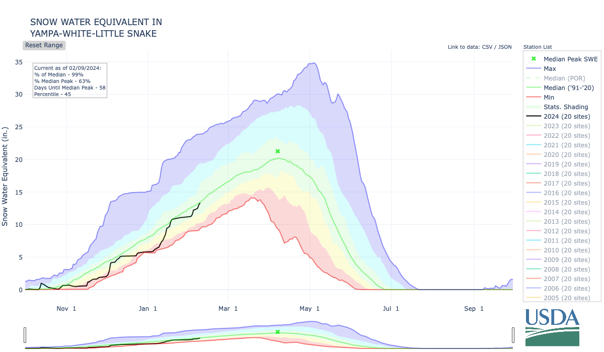
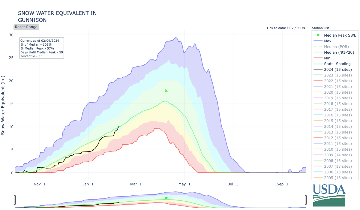
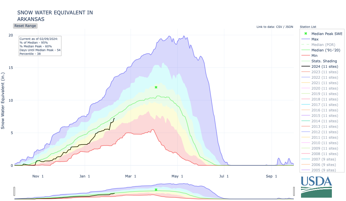
Snowpack in the Colorado headwaters basin on Tuesday stood at 96% of normal for Feb. 6. The Yampa-White-Little Snake basins were at 95% of normal, as was the Gunnison River Basin, and the Arkansas River Basin was at 91%.
Southwest Colorado is drier, with the combined San Miguel-Dolores-Animas-San Juan basins at 84% of normal and Upper Rio Grande River Basin at 80%. On Grand Mesa, snowpack levels at NRCS sites Tuesday ranged from 93% at Mesa Lakes to 74% at Overland Reservoir. Mountain snowpack is relied upon to bolster streamflows, reservoirs and agricultural and municipal supplies when that snow melts and runs off.
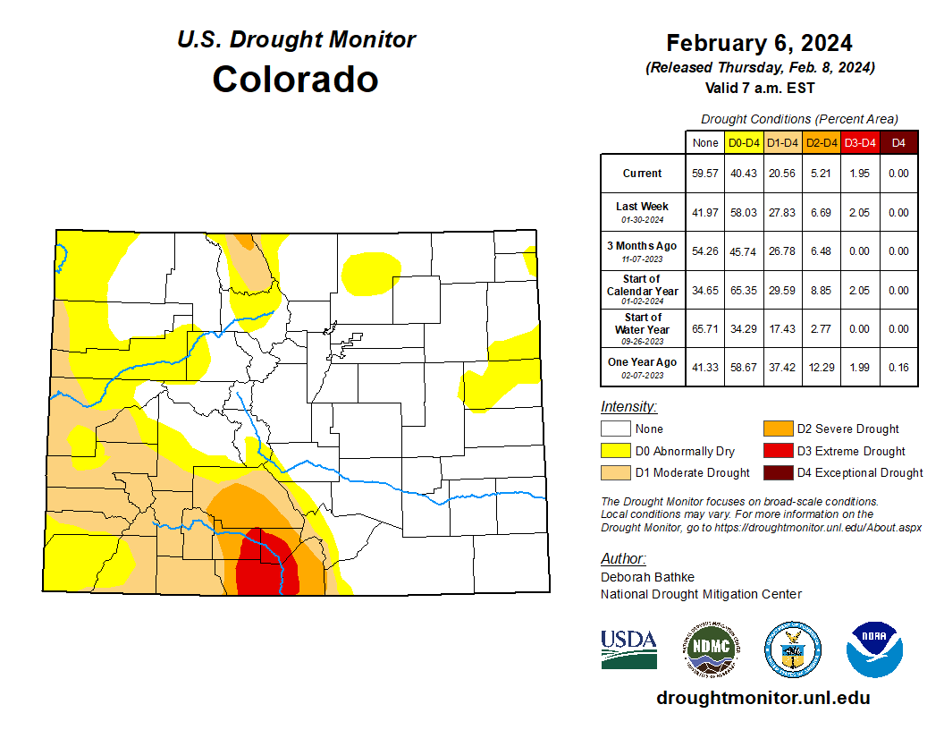
Colorado Drought Monitor map February 6, 2024.
Most of Southwest Colorado is in varying levels of drought, with moderate drought stretching into western and southern Mesa County, according to the U.S. Drought Monitor.