

Click the link to read “Dust, snow, and diminishing albedo: Spring dust storms further shrink the snow ‘reservoir’ that feeds the Colorado River” on The Land Desk website (Jonathan P. Thompson):
May 7, 2021
“Most of us are poor now, like I am. Many of them blame John Collier, who made us reduce our flocks and herds because there was not enough grass for all. But I think the true reason is a change in the climate. When I was a young man this whole country was covered with tall grass. We had rains enough in summer to keep it alive and growing. Now the rains do not come and the grass dies. There are fewer sheep and horses now than when our family claimed this valley, yet all you can see is sand. The grass is gone. All we need to be rich again is rain.” — Navajo elder Hoskannini-Begay, who lived on Naatsis’áán, or Navajo Mountain, near the confluence of the San Juan and Colorado Rivers, to Charles Kelly in 1945

It’s springtime in the Southwest, which means that on four days out of five a dry wind blows incessantly, tossing hats and untethered tents high into the air. The Mistral of southern France is said to drive people—and even horses—insane. The Four Corners Country’s April and May gusts are every bit as maddening, sending humans into paroxysms of mental distress.
And if the wind doesn’t drive you to the brink, then the dust carried by that wind will—dust that blots out desert views, coats your dinner with teeth-grinding grit, and somehow manages to get into every nook and cranny imaginable. Worse, that stuff will eventually fall on what remains of the snow in the mountains, coating the surface with a reddish-brown tinge that kills the snow’s albedo (not libido, silly, albedo). That speeds up snowmelt, which has ripple effects across the ecosystem and water supplies in the lowlands, which, in turn, dries out and frees up more dust for the wind’s taking.
During some years the “dust events” manifest as just that, distinct events during which the wind kicks up, followed by a growing volume of dust in the air, followed by a thick layer of dust on the surface of the snow. Dust storm feels too dramatic a phrase to describe the phenomenon. The incidents in the Four Corners country usually don’t involve a wall of airborne sand, thousands of feet tall, rushing across the desert and gobbling up everything in its path, as sometimes happens further south in the Phoenix area. Dust event, on the other hand, feels too clinical. I prefer aeolian—or windborne—dust cloud, since its root is the Ancient Greek god of wind, Aeolus.
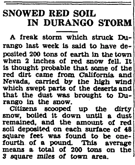
These episodes are not uncommon in these parts, happening several times a year, most often in late winter and early spring. “Our party experienced a violent windstorm when we were several miles above the mouth of Piute Creek,” wrote Hugh D. Miser in a 1924 report on a trip down the San Juan River in Utah on 16-foot boats. “It blew in gusts and picked up sand and fine yellow dust, which were carried up into the air for hundreds if not thousands of feet.” Eight years later, during the severe drought of the early 1930s, newspapers reported that a good two inches of red, dust-infused snow fell on Durango. In that case, the dust even may have “seeded” the clouds, giving something around which the snowflakes could form.
All that dust on (or in) the snow brings about subtle but significant changes by throwing the snowpack’s albedo out of whack. “Albedo is a non-dimensional, unitless quantity that indicates how well a surface reflects solar energy,” notes the National Snow and Ice Data Center. “Albedo varies between 0 and 1. Albedo commonly refers to the ‘whiteness’ of a surface, with 0 meaning black and 1 meaning white.” If a surface’s albedo is zero, or black, then it absorbs all of the solar energy. If it is one, or totally white, it absorbs none of the solar energy, or reflects all of it. When dark-colored dust (or ash, or carbon, or what have you) coats the snow, it reduces the albedo, causing the snow surface to absorb more solar energy, thereby melting the snow more quickly.

In 2003 a group of snow-focused scientists founded the Center for Snow and Avalanche Studies to study the dust-on-snow phenomenon in the San Juan Mountains and to better understand its long-term effects. The San Juan Mountain snowpack is considered to be a giant, natural reservoir that stores up vast amounts of water in the form of snow during the winter months, slowly releasing it to flow down to the arid, surrounding lands in the spring. Most of the snowmelt ends up in the Colorado River watershed, but the San Juan Mountains also contain headwaters for the Rio Grande.
Those who use the water, whether they are irrigators or river rafters or fish, want an abundant but slow-melting snowpack. Dust on snow speeds up the snowmelt, disrupting alpine flora phenology,1 or the natural calendar that tells plants when to bloom and so forth, and pushing the spring runoff earlier into the year. Reduced albedo enhances evapotranspiration and snow sublimation2, thereby reducing the amount of water that goes into the streams and rivers. Aeolian dust on the snow, alone, has pushed the peak of spring runoff of the Colorado River watershed up by three weeks, when compared to the period prior to the 1850s, and it has also reduced the total runoff volume.
These aeolian dust events are natural and have probably been taking place every spring since the end of the Pleistocene era and the retreat, some 12,000 years ago, of the glaciers that carved many of the region’s valleys. Maybe the dust events occurred during the last ice age and contributed to the melting of the glaciers, which was mainly caused by global warming resulting from a buildup of carbon dioxide in the atmosphere. That, too, was natural. But just as human activity is again causing an increase in carbon and a warming climate, so, too, has human activity exacerbated the aeolian dust cloud phenomenon.

By examining the sediment that had built up over nearly six millennia at the bottom of alpine lakes in the San Juan Mountains, researchers in 20083 concluded that most, if not all, of the dust deposited on the San Juan Mountain snows is from the Colorado Plateau, not Asia or other distant lands, as has been hypothesized in the past. And they found that dust events have been occurring for thousands of years but picked up significantly beginning about a century and a half ago, coinciding with the white settler-colonist influx of the mid-1800s and peaking in the first few decades of the twentieth century, when volumes of dust were five times higher than they were prior to colonization. The timing leaves little doubt regarding the cause of the uptick in dust: a combination of the newcomers’ land-disturbing ways, which include mining, development, tilling for farming, logging, and, perhaps most dust-raising of all, cattle grazing, which has drastically altered the landscape of the Colorado Plateau.
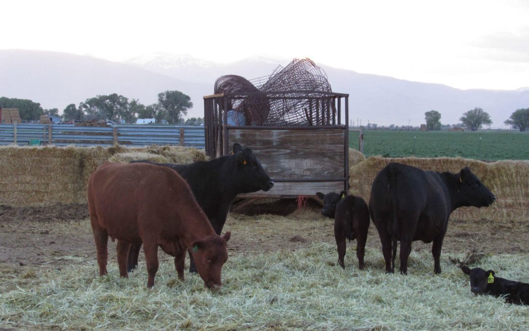
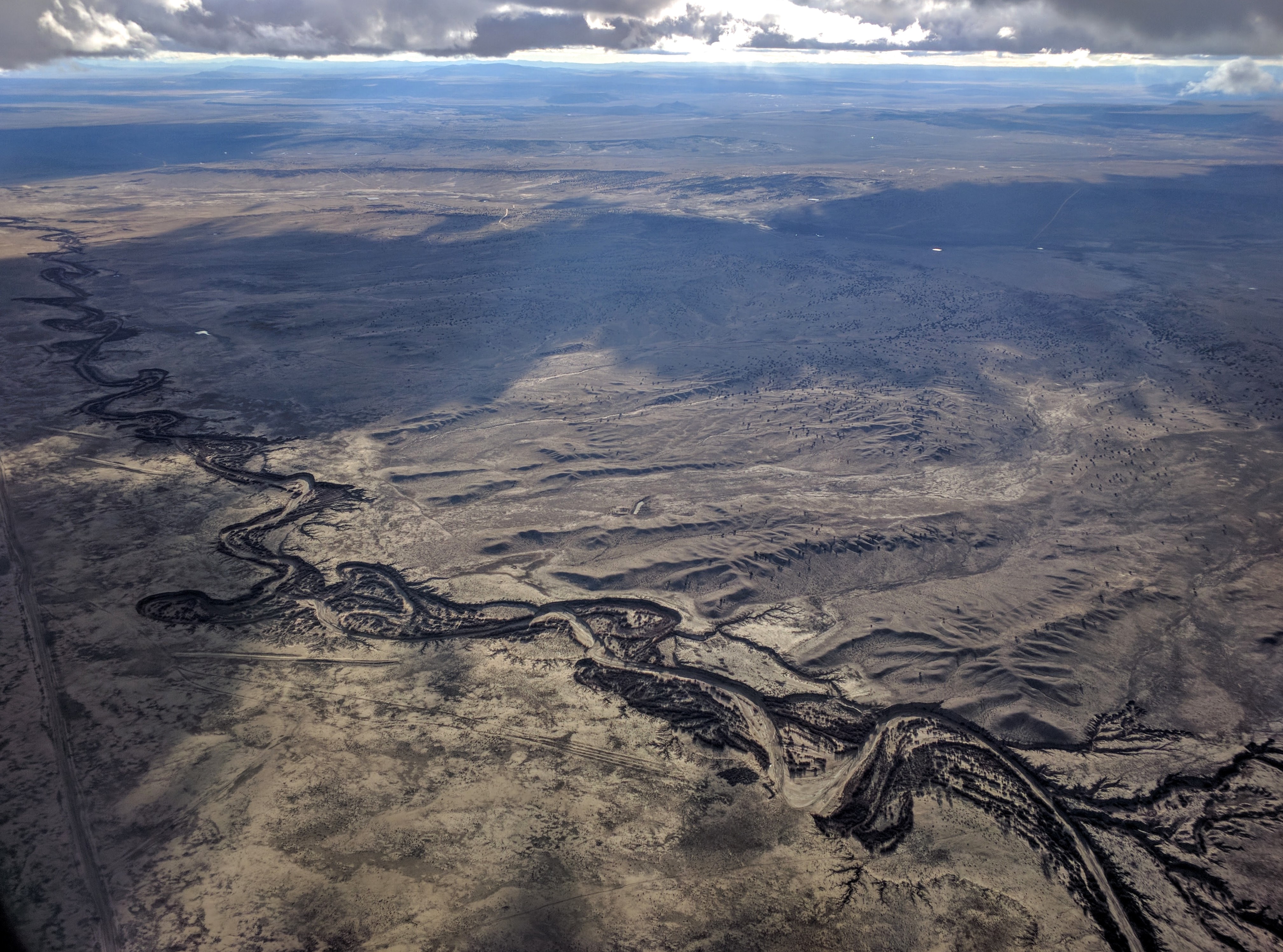
The cattle and sheep ate the native grasses and trampled the fragile soil, making way for non-native grasses to invade and preclude the return of the native vegetation, while also encouraging gulley-forming erosion. Where once ran braided, intermittent streams along wide, flat, sandy beds, now there are deep channels. Streambeds are choked with cheatgrass and other invasive species. These gullied arroyos are so common in the West—the Rio Puerco in northern New Mexico offers one of the most striking examples—that many observers assume that it is the “natural” state, and that they’ve always looked that way. Call it normalized degradation.
Cattle hooves will also wreck the fragile cryptobiotic crust that is critical to the desert ecosystem, and which, as renowned cryptobiotic crust researcher Jayne Belnap put it, holds “the place in place.” Cryptobiotic crust, sometimes known as cryptogamic soil, is ubiquitous, or once was, in most of southeastern Utah. At first glance it looks just like, well, dirt, only with a dark-brown-to-black hue that resembles desert varnish. Bend down and look more closely, however, and you’ll see a miniature, living world—a symbiotic mingling of cyanobacteria, lichen, and mosses—which is particularly noticeable when the crust is wet. The cyanobacteria are made up of filaments wrapped in sheaths. Writes Belnap: “This sheath material sticks to surfaces such as rock or soil particles, forming an intricate webbing of fibers in the soil. In this way, loose soil particles are joined together, and otherwise unstable and highly erosion-prone surfaces become resistant to both wind and water erosion.” And when the crust is destroyed, it leaves those same soils vulnerable to erosion and to the types of winds that scrape across the region every spring.
And the damage is, indeed, irreparable. Once wrecked, cryptobiotic crust may take decades, even centuries, to fully recover. In 2005 Belnap published a paper4 on the impacts of decades of grazing on soils in southeastern Utah. She and her co-researcher ventured into the Needles District of Canyonlands National Park and compared an area that had been grazed from the 1880s until 1974 with Virginia Park, an area where an impassible cliff kept cattle at bay, and which is now a “relict area” shut off to people entirely, save for researchers with a light touch. Belnap’s findings are disturbing. Even 30 years after the cattle had been removed from the historically grazed site, the land had not recovered. The cyanobacteria were distributed spottily, the lichen and moss were only beginning to come back, nutrients and organic material were more sparse than in the ungrazed area, and the soil remains far less stable, which means it more easily can get picked up by the wind and carried to the snow in the San Juan Mountains. Also troubling is the difficulty the researchers had in finding plots of land that had never seen grazing at all, even in a national park. Somehow the cowboys of yore were able to squeeze the cows and their attendant effects into just about every corner of the region.

Back in 1965, James Rodney Hastings and Raymond M. Turner compared historic photographs of a section of Sonoran Desert with modern ones and determined that cattle grazing in the late nineteenth century had caused a “shift in the regional vegetation of an order so striking that it might be better associated with the oscillations of Pleistocene time than with the ‘stable’ present.”5 If we are currently living in the Anthropocene, then an appropriate subset might be the Bovineiferous period or, more appropriate still, the Beefocene.
Clearly cattle are not the only culprit. ATVs, mountain bikes, cars, and bulldozers can wreck cryptobiotic crust and mobilize dust. Chaining huge swaths of juniper forest to make way for forage or even sagebrush is hugely destructive and dusty. Before each of the tens of thousands of oil and gas wells were drilled across the San Juan Basin, more than an acre of land was scraped clean of all vegetation, top soil, cacti, sagebrush, and even centuries-old juniper trees. Every new house or hotel built on Moab’s, Durango’s, or Farmington’s fringe stirs up dust. Springtime tilling of corn, bean, sunflower, and alfalfa fields kick up huge amounts of dust. Even a single human backpacker trodding through the P-J forest in hiking boots can crush and break up the living soil, liberating the dust underneath for the wind’s taking.
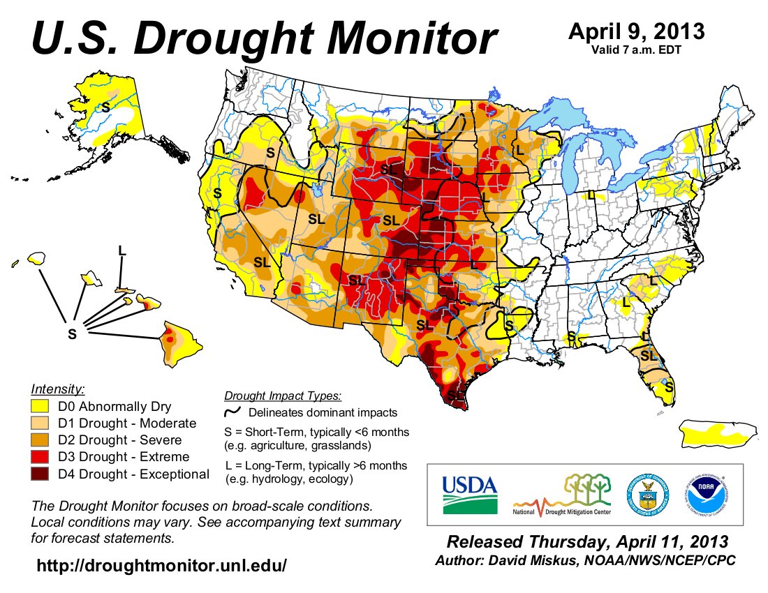
And just as dust on snow can exacerbate aridity, so too can aridity exacerbate the dust problem. The winter of 2013 was one of the skimpiest snow years on record in the Four Corners Country, parching the Colorado Plateau and turning what should have been moist soils and muddy lands into dust patches. The March winds lifted the earth up into the air and carried it across the mesas and canyons, leading to a number of severe dust events. In Durango the dust was so thick that it fell with rain as a gritty red slime, coating cars and buildings and just about everything else; the Durango Herald ran a woe-filled article about a window washer whose work was destroyed by the storm, forcing him to start all over again. Another dust event a week later would whip up a nasty wildfire near Farmington and contribute to a fatal car crash. The dust ended up on top of what snow was left in the San Juans, reducing rivers and streams to a trickle that summer.
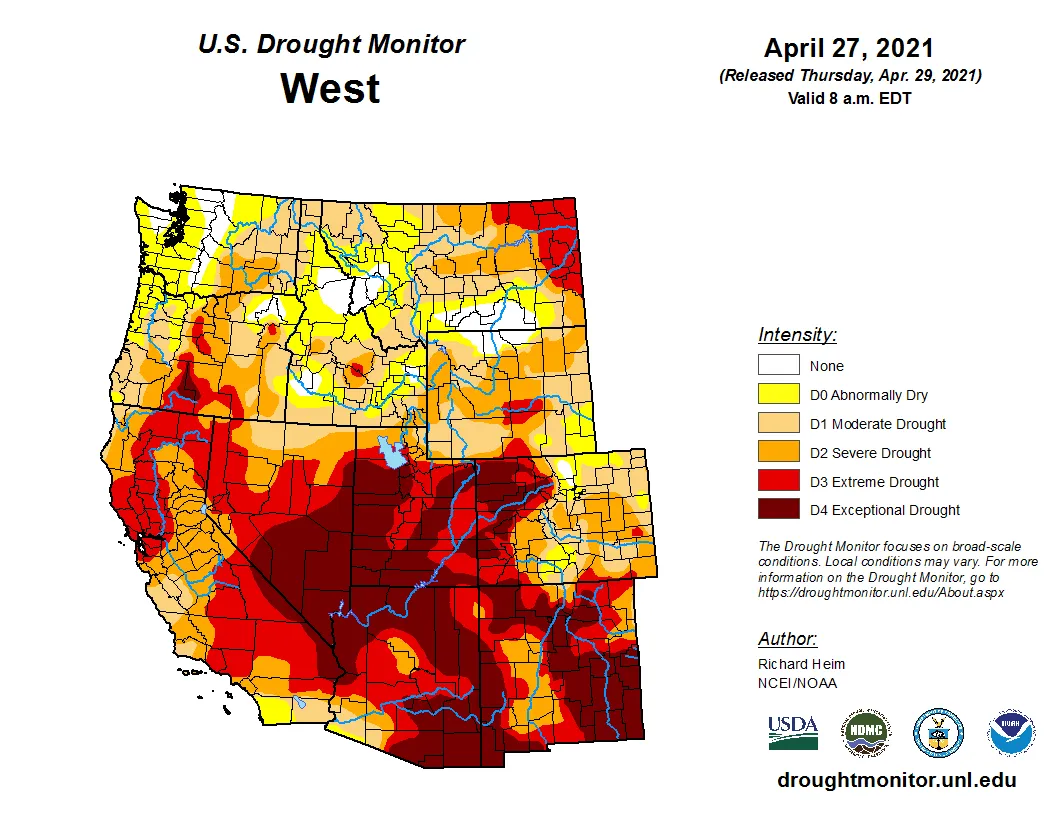
This water year [2021]—taken in isolation—hasn’t been quite as meagre, moisture-wise, as 2013 was, meaning a little more of the place seems to be staying in place, despite the maddening winds. But the effects of 20-plus years of aridification and warm temperatures has left the region unusually dry, and the relentless wind has filled the air with a constant, mid-level dust-haze, which thickens during especially gusty times.
A few weeks ago I unwittingly followed the aeolian dust cloud from northern Arizona into southeastern Utah, where I watched Ute Mountain and the Abajos slowly vanish behind a sepia-toned gauze that seemed to hang from the otherwise clear sky. A few days later I drove over Red Mountain Pass and pulled over to inspect the snowpack. A dusting of new snow had fallen atop the dust layer, partially covering it up for a brief moment. But it was springtime in the San Juans, another dry year in the unrelenting string of dry years, which meant that another dust cloud would arrive before long.
It felt strange but also revelatory to be in the thick of this big cycle of soil disturbance, aeolian dust events, reduced albedo, faster-melting snow, diminished river flows; to be experiencing the interconnectedness of the region, the intimate link between desert and mountains, in real time.
Parts of this essay are excerpted from Sagebrush Empire: How a Remote Utah County Became the Battlefront of American Public Lands, by Jonathan P. Thompson, to be published by Torrey House Press in August 2021. Become a Land Desk Founding Member ($100 or more) and get a free signed copy, along with other swag, to be delivered this August.
