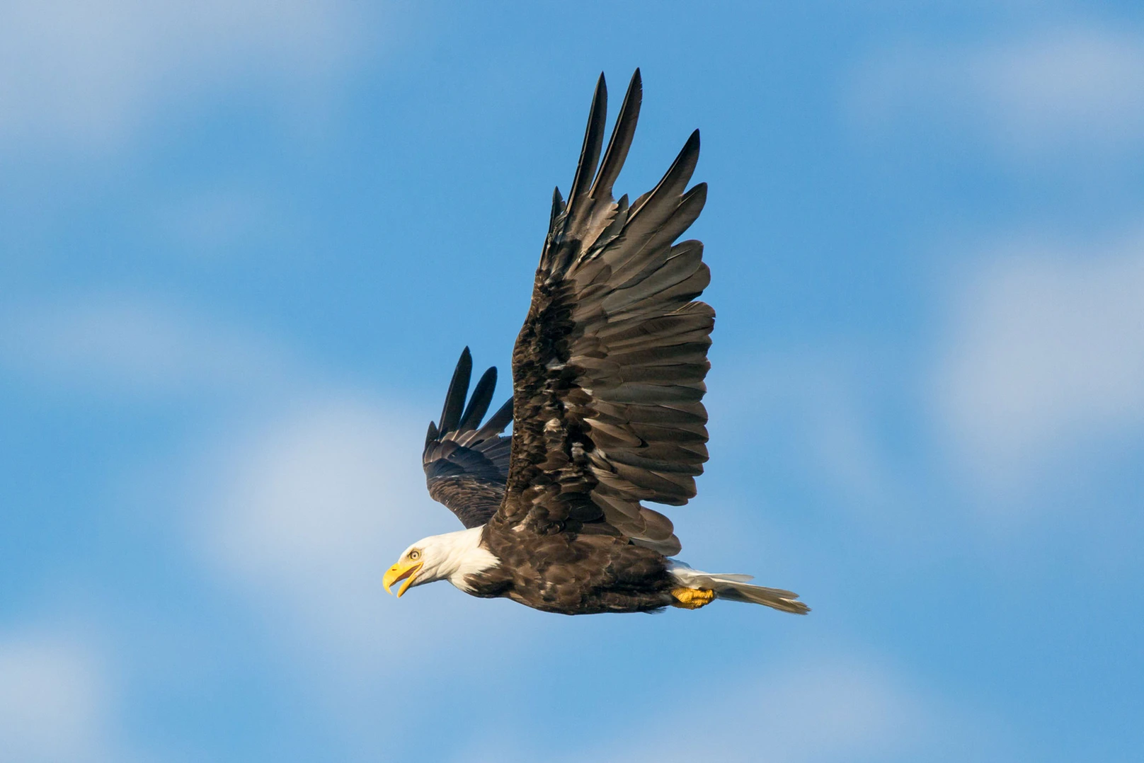
Today the U.S. Fish and Wildlife Service (FWS) announced revisions to their incidental take permitting program under the Bald and Golden Eagle Protection Act. The final rule includes a general permit for wind energy projects that exhibit a demonstrably low risk to eagles. Audubon and partners submitted recommendations to make permitting more efficient in ways that support the buildout of wind energy while benefitting Bald and Golden Eagle conservation.
“Bald Eagles and Golden Eagles are deeply important to our nation, and this rule sets a new precedent for how the U.S. Fish and Wildlife Service will work with clean energy developers to avoid and minimize impacts to these iconic birds at wind energy sites as well as transmission,” said Marshall Johnson, chief conservation officer of the National Audubon Society. “We congratulate the Service and the Migratory Bird Program for their hard work in creating a pathway to a more efficient permit program where wind energy companies commit to conservation measures, monitor and share data on eagles at their project sites, and help manage Bald and Golden Eagle populations across the country.”
This funding will prevent approximately 11,661 tons of salt each year from entering the Colorado River. Quantified economic damages due to salinity in Colorado River water is currently about $332 million per year in the United States. It is estimated that damages would increase to $631 million per year without the Colorado River Basin Salinity Control Program.
“These awards will make improvements to off-farm irrigation systems like ditches and laterals in the Upper Basin States and prevent economic damages to downstream users by improving Colorado River water quality,” said Clarence Fullard, program manager for Reclamation’s Colorado River Basin Salinity Control Program. “When the projects are complete, they will benefit crop production and decrease water treatment costs and damage to water supply infrastructure in Lower Basin States.”
These projects were selected through a competitive process, open to the public. Reclamation solicits, selects and awards grants through Notice of Funding Opportunity announcements to projects sponsored by non-federal entities that control salt loading in the Upper Colorado River Basin. One of the primary selection criteria is the lowest cost per ton of salt controlled. Reclamation will distribute the $17.5 million over the next 4 years to the state of Colorado and $3.4 million to the state of Utah.
You watched the news this morning, and the meteorologist told you snow is coming this weekend. Conversations at the coffee shop and the break room at work center around the amount of snow we might get. But now you actually want to know, “how much am I going to get at my house?” What if you’re driving somewhere else? Might be helpful to know how much other places are going to get too. Look no further. You’re going to want to bookmark one of these links below!
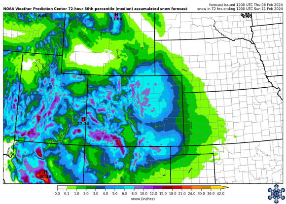
72-hour snowfall accumulation forecast for February 8-11 over the Intermountain West. NOT CURRENT Credit: NOAA Weather Prediction Center
Pull up your weather app, and it’s likely to tell you “chance of snow, high of 29°F, 2-3″ of new accumulations,” or something similar. But that accumulation is just for the morning. Or afternoon. Or one brief time-period that is only one part of a total storm that has passed through. It’s hard to figure out the forecast total for the entire event from your weather app! Bookmark the links below for easy access to forecast snow accumulations.
Intermountain West Ski Dashboard – not only does our ski dashboard provide a 7-day precipitation outlook, you can find 72-hour forecast snow accumulations like the one above (not current, from last week!). The 10th percentile map gives you an idea of a “low end” amount, the 50th percentile represents the most likely amount, and the 90th percentile map gives you the “high end” amount.
National Weather Service Probabilistic Snow Forecast – The Boulder Weather Forecast Office has a wonderful winter page that shows snow forecasts for the entire state of Colorado. Included are the official snow total forecasts, with low end and high end amounts included. There are also probabilistic maps, so you can see the likelihood that your location will receive 2 inches, 6 inches, 10 inches (and other totals) for the next storm passing through.
Snowfall Forecast Maps for Many Locations – the following link takes you to the snowfall forecast for the Contiguous United States (CONUS). Change “CONUS” in the URL to any Weather Forecast Office 3-letter identifier and you’ll zoom into that area. Or change “CONUS” to a state, such as “WY_state_Snow.png” to see any state’s snowfall forecast map. Thanks to Mark Ellinwood, and his informational post on X for this great resource!
It snowed! Woohoo! You’ve taken pictures of your patio furniture and lawns. You’ve captured slo-mo videos of pretty snowflakes falling from the sky. You can go out into your own yard and measure the depth with a ruler. But… it is kinda cold. Also, you want to see the snowfall totals from other locations than just your backyard. Where do we find that information??
Snowfall Accumulation Maps AFTER the Event
The storm ended and you’re watching the news for totals. They tell you the official amount in Denver (which actually comes from Denver International Airport… or practically Kansas!). They share a short-list of other locations around the state – Boulder, Vail, Greeley. But they missed your town! Okay, make sure you have one of these bookmarked to get at that extra info you’re craving!
Intermountain West Ski Dashboard – Back to the top of our ski dashboard page and you’ll find 24-hour, 48-hour, and 72-hour snowfall maps for the Intermountain West. These maps are generated by NOHRSC (pronounced know-risk), using observation data combined with models to estimate total snowfall at every point.
NOHRSC Interactive Snow Information – Going directly to the NOHRSC page, you can set up your own preferences. Zoom into the area you want, pick the product that you want, add county lines or highways. Once done, scroll to the bottom, and on the left, you’ll see options to link to the image directly (“Link to latest image”) or to the page with the latest updates (“Link to latest page”).
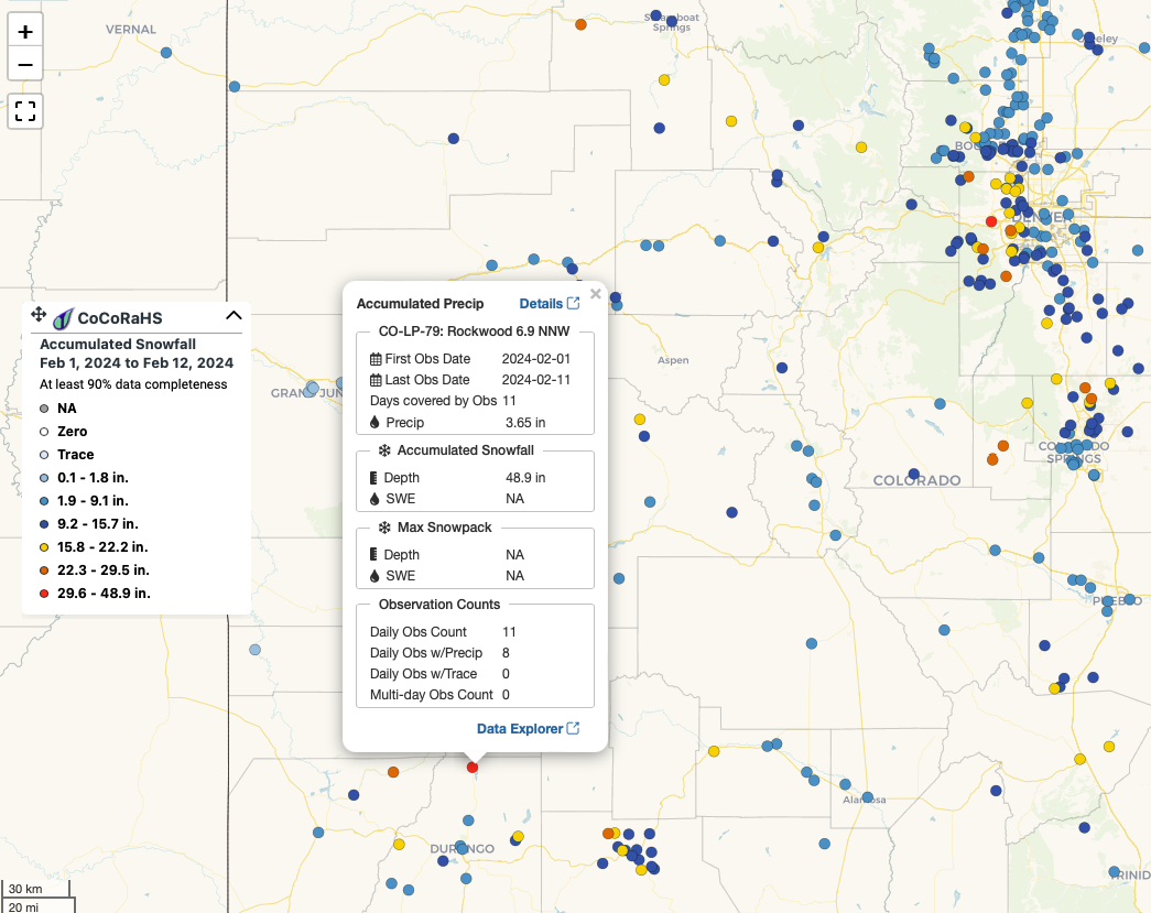
CoCoRaHS New Snow Maps – gridded maps are cool, but station maps are cooler. Find the snowfall totals from thousands of CoCoRaHS volunteer observers. On this page, you can zoom into an area, pick the time period you want, make sure to select snowfall, and see the totals. Click on a station for more details!
Month-to-date snowfall accumulations from CoCoRaHS volunteers. Check out that 48.9″ accumulation in southwest Colorado. That’s a lot of snow in 11 days! Credit: CoCoRaHS
Hopefully you’ve found one of these links helpful. Or maybe you’ve used links to other resources. Share where you get your information to further add to this database of helpful snowfall forecasts and totals!
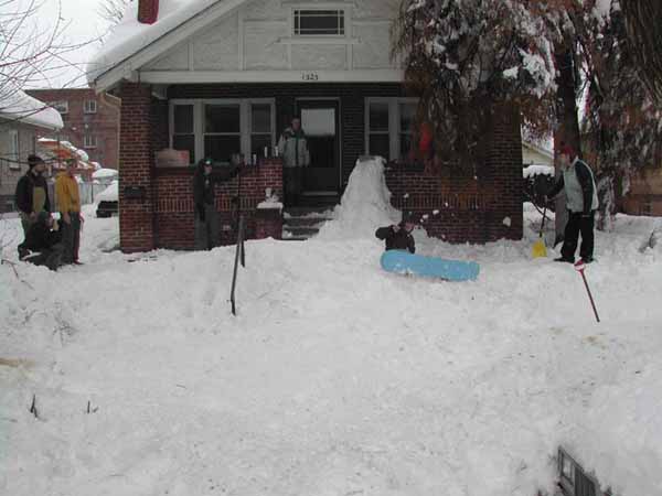
My kids and their friends built a small terrain park in front of their house near Sloans Lake after the March 2003 St. Patrick’s Day blizzard.
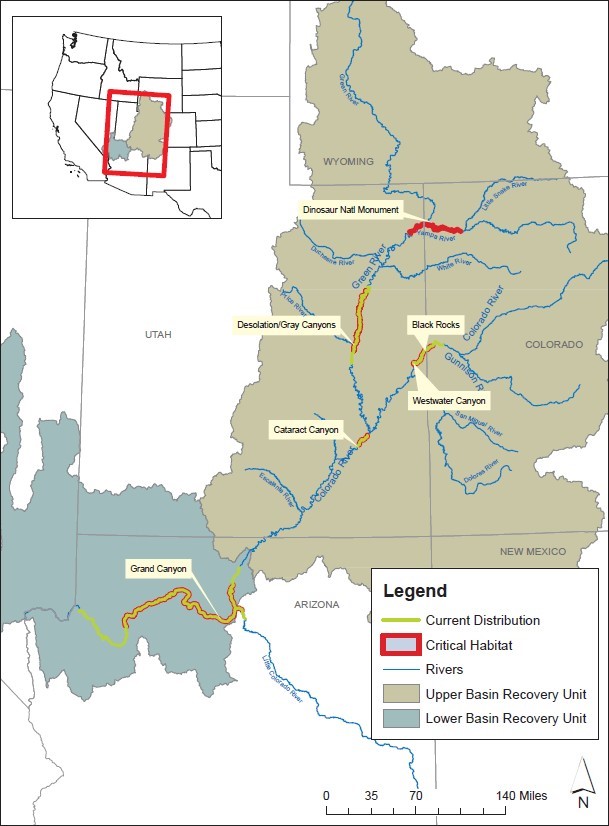
Humpback chub occupied range and critical habitat.
Credit: Julie Stahli/USFWS
Click the link to read the article on the KUNC website (Alex Hager). Here’s an excerpt:
February 10, 2024
Federal water managers proposed a new plan to protect native fish species in the Grand Canyon, but conservation groups say it doesn’t go far enough. Water levels in Lake Powell, the nation’s second-largest reservoir, have been dropping to historic lows as the region struggles to rein in demand in response to dry conditions fueled by climate change. Those low water levels have allowed non-native fish to pass through the Glen Canyon Dam, which holds back Lake Powell, and eat native fish that live on the other side, in the portion of the Colorado River that runs through the Grand Canyon. The native species at issue is the humpback chub, which is found nowhere on earth besides the Colorado River and its tributaries. It was previously considered “endangered,” but was downlisted to “threatened” in 2021. The fish still receives protections under the Endangered Species Act.
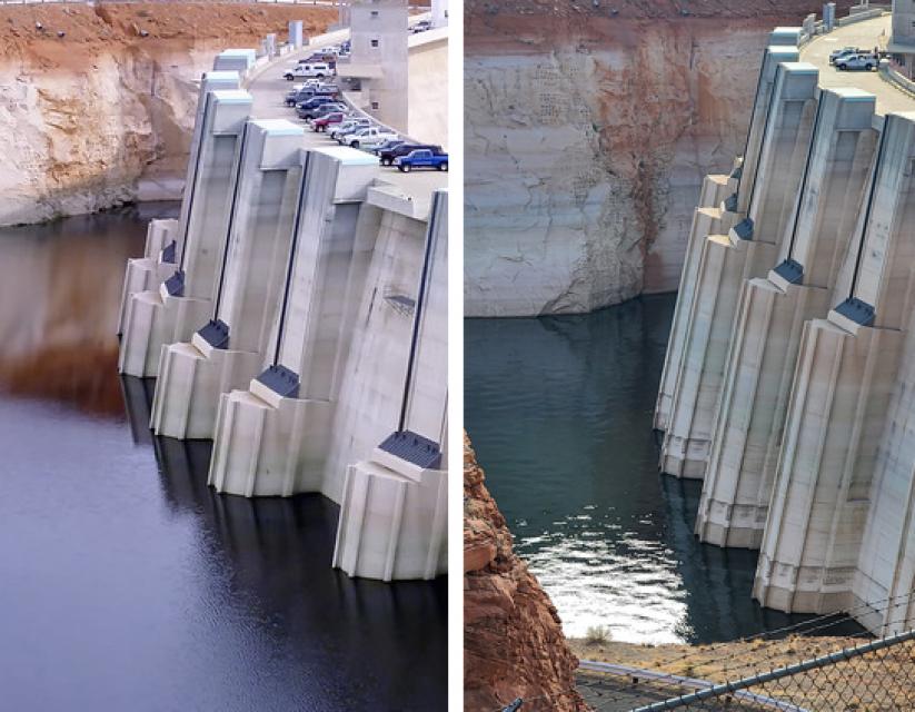
Lake Powell’s decline is seen in these photos of Glen Canyon Dam taken a decade apart. On the left, the water level in 2010; on the right, the water level in 2021. (Source: Bureau of Reclamation)
Lake Powell, which began filling in the 1960s, was stocked with non-native fish such as smallmouth bass for recreational fishing in 1982. Smallmouth bass prefer warm water near the reservoir’s surface. Now that the surface of the reservoir is dropping, the fish are able to move low enough to enter the tubes inside Glen Canyon Dam that allow water to pass from one side to the other. The Bureau of Reclamation, the federal agency which manages the West’s dams and reservoirs, released a draft plan for water releases from the dam in northern Arizona. It proposed five new ways to manage releases from the dam in an effort to keep native fish thriving in the Colorado River below Lake Powell — four of which involve attempts to make the water cooler and disrupt the spawning patterns of non-native fish…
This 2023 diagram shows the tubes through which Lake Powell’s fish can pass through to the section of the Colorado River that flows through the Grand Canyon. Credit: USGS and Reclamation 2023
Taylor McKinnon, Southwest director for the Center for Biological Diversity, takes issue with two components of the draft plan. The first, he said, is a tangible change. McKinnon encouraged federal water managers to consider making physical changes to the dam intakes themselves — like adding screens — to prevent fish from passing through…The second issue McKinnon described is more of an ideological one. He said federal water managers are not doing enough to look at the long-term viability of the reservoir in the face of a drying climate.
“Federal agencies need to become proactive,” he said. “They need to look at the science. They need to look at the forecasts for future Colorado River flows in one decade, two decades. All that information indicates that Glen Canyon Dam is facing climate-inevitable deadpool and climate-inevitable obsolescence.”
The back of Glen Canyon Dam circa 1964, not long after the reservoir had begun filling up. Here the water level is above dead pool, meaning water can be released via the river outlets, but it is below minimum power pool, so water cannot yet enter the penstocks to generate electricity. Bureau of Reclamation photo.
Shoshone Falls hydroelectric generation station via USGenWeb
Click the link to read the article on the KUNC website (Alex Hager). here’s an excerpt:
February 9, 2024
The purchase [of the Shoshone Power Plant non-consumptive use hydropower rights] represents the culmination of a decades-long effort to keep Shoshone’s water on the west side of Colorado’s mountains, settling the region’s long-held anxieties over competition with the water needs of the Front Range, where fast-growing cities and suburbs around Denver need more water to keep pace with development. Even though the Shoshone water rights carry an eight-figure price tag, the new owners will leave the river virtually unchanged. The river district will buy access to Shoshone’s water from the plant operator, Xcel Energy, and lease it back as long as Xcel wants to keep producing hydropower. The water right is considered “non-consumptive,” meaning every drop that enters the power plant is returned to the river. The river district wants to keep it that way as long as they can and ensure the water that flows into the hydroelectric plant also flows downstream to farmers, fish and homes.
The river district is rallying the $98.5 million sum from local, state and federal agencies. The district has secured $40 million already, with deals in the works for the remainder. It’s rare for a big-money water deal to find this kind of broad approval from a diverse group of water users. But the acquisition is seen as pivotal for a wide swath of Colorado, and has been co-signed by farmers, environmental groups and local governments…Shoshone’s water right is one of the oldest and biggest in the state, giving it preemptive power over many other rights in Colorado. Even in dry times, when cities and farms in other parts of the state feel the sting of water shortages, the Shoshone Hydroelectric Plant can send water through its turbines. And when that water exits the turbines and re-enters the Colorado River, it keeps flowing for myriad users downstream…
The hydro plant itself produces relatively little energy. Its 15 megawatt capacity is only a small fraction of Xcel Energy’s total Colorado output of 13,100 megawatts. Shoshone’s capacity is enough to serve about 15,000 customers, which is less than a quarter of the population of Garfield County, where the plant is located. But the power plant has held legal access to water from the Colorado River since 1902, and can claim seniority over the vast majority of other water owners in the state. That kind of seniority means power and certainty for whoever owns it. And that has raised the hackles of Western Colorado water users, who worry that water users in other parts of Colorado might be interested in buying Shoshone’s water right…The Colorado River District’s plans to buy Shoshone’s water have rallied widespread support, largely because of the transfer’s widespread benefits. Perhaps no constituency will benefit from the move as much as the one that lives in the river itself…Standing on the banks of the Colorado River in Grand Junction, [Dale] Ryden looked out over a murky, meandering stretch of water. It’s part of the “15 mile reach,” a critical section of the river about 80 miles west of the Shoshone plant. The reach is filled partly by water exiting Shoshone’s turbines. Ryden explained that this section of river is home to a variety of species, some of which are endangered, and some which are found nowhere else on earth besides the upper portions of the Colorado River. Those species – with funky names like the flannelmouth sucker and the humpback chub – rely on this stretch of river for virtually every aspect of life.
This map shows the 15-mile reach of the Colorado River near Grand Junction, home to four species of endangered fish. Map credit: CWCB
“New plot using the nClimGrid data, which is a better source than PRISM for long-term trends. Of course, the combined reservoir contents increase from last year, but the increase is less than 2011 and looks puny compared to the ‘hole’ in the reservoirs. The blue Loess lines subtly change. Last year those lines ended pointing downwards. This year they end flat-ish. 2023 temps were still above the 20th century average, although close. Another interesting aspect is that the 20C Mean and 21C Mean lines on the individual plots really don’t change much. Finally, the 2023 Natural Flows are almost exactly equal to 2019. (17.678 maf vs 17.672 maf). For all the hoopla about how this was record-setting year, the fact is that this year was significantly less than 2011 (20.159 maf) and no different than 2019” — Brad Udall
Will seven Western states be able to rapidly craft a voluntary plan to keep the Colorado River afloat for decades to come? It’s increasingly unclear, as negotiations have foundered between two sides, according to key players. There are sharp differences between northern and southern states’ proposals, with representatives of the mountainous Upper Basin states of Colorado and New Mexico unwilling, to date, to shoulder large future cuts, both because of historic underuse of their share of the river and because of heavily populated California and Arizona’s historic overuse. The southwestern states have for years taken twice as much as their northern neighbors.
Total losses (evaporation and riparian ET) from Reach 1 through Reach 5. Credit: USBR
Upper Basin officials, including Colorado’s plainspoken river commissioner, Becky Mitchell, said they have been informed of a proposal under discussion by California, Arizona and Nevada, collectively known as the Lower Basin, where the Lower Basin and Mexico would agree to take 1.5 million acre-feet of water less from the shrinking river each year. Mitchell said far more details are needed. That amount would be enough to both to make up for evaporation and leakage from delivery canals snaking across the hot desert, and to help stabilize the nation’s largest reservoirs, based on a report released Thursday by the U.S. Bureau of Reclamation that showed average annual losses to evaporation and river banks of 1.3 million acre-feet in the Lower Basin.
Lower Basin officials, including California’s Colorado River commissioner JB Hamby, who is leading the state’s negotiating team, declined to confirm numbers while they hash out specifics, but pointedly said major reductions need to be contributed by every state. One California official did confirm the numbers. Tom Buschatzke, Arizona’s top representative on the river talks, also wouldn’t confirm the 1.5 million acre-feet number, but emphasized the structural magnitude of what the Lower Basin is offering to do, noting his state and California, with help from Nevada and Mexico, would address evaporation and leakage for decades to come, and contribute more atop that to help stabilize the system. But, he said, more needs to be done, by everyone.
“It’s hugely important for folks to know that the Lower Basin is going to step up, and that we see a desire and a need for the rest of the problem to be solved collectively,” he said. “We can’t do it all. It is not physically possible.”
[…]
“There’s been a couple times when I’ve tried to be quieter or politer to make myself heard, and it hasn’t worked,” Mitchell said. “What we’re fighting for is too important to make myself small to make myself feel comfortable.” via @ShannonMullanehttps://t.co/tNWw8yOgsX
For now, negotiations between the two sides have ground to a halt, even as a deadline looms to produce a draft agreement by next month. The last time representatives from all seven states met face to face was in early January, when they convened at the Woolley’s Classic Suites, at Denver Airport. Since then, at the urging of U.S. Reclamation Commissioner Camille Calimlim Touton, there have been two Zoom calls with all the states that highlighted the fundamental differences, one participant said. The northern states recently invited their southern counterparts to Salt Lake City to resume full talks, but none chose to attend.
“We’ll keep inviting them,” Mitchell said. “I do not think we are at an impasse, and I do not believe we need to be at an impasse.”