Click the link to read the article on the Pagosa Springs Sun website (Derek Kutzer and Josh Pike). Here’s an excerpt:
On March 21, the board of the Pagosa Springs Sanitation General Improvement District (PSSGID), which also sits as the Pagosa Springs Town Council, voted to approve a new memorandum of understanding (MOU) with the Pagosa Area Water and Sanitation District (PAWSD)…The PAWSD board approved the MOU at its March 14 meeting…
The new MOU establishes a framework for a potential merger of the two entities, exploring the idea of a new regional wastewater treatment plant at the southern end of Yamaguchi Park, which would eliminate PSSGID’s reliance on pumping its wastewater 7 miles uphill to the PAWSD-run Vista Wastewater Treatment Plant.
The agreement explains that the PSSGID has faced significant challenges maintaining its uphill wastewater conveyance system, including more than $1 million in pump replacement costs. Additionally, there remains serious concern about the long-term viability of this system, which has significant problems with root intrusions, pipe deterioration and clogging that result in significant inflow and infiltration (I and I) of water into the system, the MOU states.
The new agreement comes on the heels of a town-commissioned 2023 study by Roaring Fork Engineering that examined the town’s options, including consolidation with PAWSD. The study concludes that, if a merger occurred, the community might be better served by a single wastewater treatment plant, which would likely be located in the southern portion of Yamaguchi Park, than by the current pumping arrangement, the MOU states.
Negotiations over future allocations of water from the Colorado River (southwestern US) are contentious, and intensifying. A new study providing comprehensive accounting for all uses of the river’s water can aid design of strategies for bringing use back into balance with available supplies.
The Colorado River in the southwestern US is getting a lot of media attention lately, for good reason. Since 2000, more water has been consumed from the river basin and its reservoirs than melting snows and summer monsoons have been able to replenish. As a result, Lakes Mead and Powell — the two largest reservoirs in the US — are now three-quarters empty, the river no longer reaches the Gulf of California in Mexico, and persistent water shortages threaten the security of cities, farms, electricity generation, recreation, and ecological health.
As I’ve long advised my university students and fellow water professionals, any efforts to resolve a water crisis must be founded on accurate and complete data characterizing available water supplies and uses. Detailed knowledge of how and where a river’s water is being used can aid design of strategies and plans for bringing water use back into balance with available supplies, while ensuring that sufficient water remains in freshwater ecosystems to sustain their health. Yet despite the Colorado River’s importance to more than 40 million people and more than two million hectares (>5 million acres) of cropland, a full sectoral and crop-specific accounting of where all of the river’s water goes en route to its delta has never been attempted, until now.
The seven ‘accounting units’ used in this study are displayed here. Credit: Sustainable Waters
We have just published a complete water budget for the Colorado River in Communications Earth & Environment. Ironically, our motivation for compiling this water budget emerged from our frustrations over the manner in which our previously published research was being regularly miscommunicated in the media! In 2020, we published a paper in Nature Sustainabilitythat included a partial water budget for the Colorado River. That study did not attempt to account for the 12% of the river’s water that is exported outside of the basin’s physical boundary, nor did it account for the substantial volume of water (30%) that either evaporates from reservoirs or is evapotranspired from riparian and wetland vegetation. However, many media reporters overlooked the fact that our water budget did not account for all water consumed from the river basin, and media statements based on our research began suggesting that “Nearly 80% of the Colorado River’s water goes to irrigated agriculture,” which is not accurate, and is misleading. As our new study reports, when accounting for ALL water consumed from the river, the proportion of river water going to farms amounts to just over 50%. [ed. emphasis mine]
Water consumption by sector in the Colorado River Basin and sub-basins (including exports), based on 2000-2019 averages. Credit: Sustainable Waters
These differences in water accounting matter greatly in a river basin with so much at stake. The region has been experiencing a ‘megadrought’ since 2000 that has reduced river flows by 20%. Climate scientists assert that this is a bellwether of long-term, climate-driven aridification in the region. It is of critical importance that the state and federal negotiators presently debating future water allocations are being informed with an accurate tabulation of where all of the river’s water goes presently. Such accounting is essential in designing strategies for rebalancing water consumption with available supplies.
Our water budget details how and where the water is being consumed, including estimates of the volume of water being consumed by individual crops in different areas of the river basin. This level of detail can help water managers understand how much water might be saved by shifting to alternative crops, or by repurposing some portion of farmlands for habitat restoration or renewable energy generation. It is also important to understand trends in water use; our data indicate that during 2000-2019, combined urban and agricultural water use in the Upper Basin increased by 5% while these uses decreased in the Lower Basin by 24%.
An accurate tabulation of a water budget can also be useful to media reporters in formulating comparisons among water-use categories that can capture reader attention, educating them in the process. For instance, our study found that water consumed in irrigated agriculture is three times greater than the volume used in cities, and in fact, the irrigation of just two crops — alfalfa and grass hay fed to cows for beef and dairy production — consumes as much water as all of the cities using Colorado River water.
Another important achievement of our study was our estimation of the volume of water being consumed by riparian and wetland vegetation through evapotranspiration. Over recent decades, this volume has been reduced considerably because of the drying of the river’s delta in Mexico, which wiped out a vast and highly productive wetland along with the native tribe of Cucupa that depended on the delta’s natural bounty. If human uses of the river’s water are not substantially reduced, and climate warming continues to reduce the river’s natural flow, more losses of riparian and wetland vegetation — and greater imperilment of native species — can be expected.
Summary of the Colorado River Basin’s water supplies (left side) and all water consumed in each sub-basin, in each water use sector, and by individual crops. All estimates based on 2000-2019 averages. MCI = municipal, industrial, and Industrial uses. Credit: Sustainable Waters
With the climate warming, leaves and blooms are popping out ahead of schedule. A wide-ranging new study shows why this trend is troubling for a variety of bird species.
For migrating birds, timing is key. Their journeys require massive amounts of energy, so they need plenty of fuel on their way, and after they get to their breeding grounds, they’ll have hungry chicks to feed, too. “Every day during migration, they’re just on this trade-off between starving to death and being able to continue forward,” says Morgan Tingley, an ornithologist at UCLA. “When they’re not flying, they’re mostly voraciously eating.”
These travelers rely on the newly-available resources brought by spring, such as leaves, flowers, and the insects that come out to munch on them. But that abundance of resources dies down later in the season—and if birds arrive at a stopover or breeding site after this peak period of “spring green-up,” they might miss out on the feeding frenzy.
Climate change is raising the risk of this kind of timing mismatch. As temperature and precipitation patterns shift, and spring’s “green-up” arrives earlier and earlier, a major question for scientists has been: Can birds keep up by changing their migrations? According to a sweeping study published this week in the journal PNAS, a wide range of species may already be falling behind.
“We’re used to thinking about warming with climate change,” says study author Scott Loss, an ecologist at Oklahoma State University. “But we’re changing the seasons, the seasonality, all across Earth.” Just this year, following a mild winter and record-warm February, leaves and blooms are already popping out, in some cases weeks ahead of their usual schedules; parts of the West Coast are seeing some of their earliest spring leaf-outs on record.
The new study shows this isn’t an anomaly. Loss and his team analyzed the migratory routes of 150 bird species, from hawks to hummingbirds, that breed in North America. They found that spring green-up was indeed moving earlier across birds’ flight paths, according to satellite observations between 2002 and 2021.
They then stacked those spring shifts against birders’ observations compiled from eBird, and found that migrators generally weren’t keeping pace: “Most of these species were more in sync with past long-term averages of green-up than with current green-up,” says author Ellen Robertson, who worked on the study as a postdoctoral researcher at Oklahoma State University. It’s a concerning mismatch, she says, since it suggests certain birds may not be flexible enough to adapt to a rapidly changing climate. Rather than deciding when to travel based on current conditions, some species may have migratory behavior that is hard-wired into their genes or learned from other birds—factors that could take generations to shift.
These findings add to a growing body of evidence suggesting spring migration is falling out of sync with food sources, says Stephen Mayor, an ecologist at the Ontario Forest Research Institute who was not involved with the study. “This paper expands on previous work to show that the phenomenon is not unique to songbirds, but is common across bird groups,” Mayor says in an email. The analysis covered everything from ducks and geese to kites and woodpeckers.
While the pattern of mismatch showed up across the board, longer-distance migrants—such as vireos and warblers that winter in Central or South America—seemed to have extra trouble adjusting to year-to-year changes. Their schedules appeared to be more tied to the calendar, possibly relying on cues like changing daylight to tell them when to set off, Loss says.
Tingley, who was not involved with this new study, has seen similar patterns in his research: “Most birds can’t keep up well, but there’s a real range,” he says. Short-distance migrants like Eastern Phoebes can more closely track conditions on the ground, which could help them adapt when those conditions change. But “if you’re a bird that’s wintering in South America, you have no understanding, no ability to know whether or not it’s an early spring or late spring here in North America,” Tingley says. “Those are the birds that are really falling behind.”
If migrants can’t find enough sources of food, they may not be able to survive their journeys, or could produce fewer offspring when they arrive, Loss says. And these earlier springs are part of a broader set of challenges for birds and other migratory animals, Robertson points out, ranging from sea turtles to wildebeest. A recent United Nations report found that one out of every five migratory species they tracked was at risk of extinction, battered by threats like habitat loss and overhunting, as well as other risks brought by climate change.
Still, more research is needed to understand exactly how shifting seasonal schedules are affecting bird survival. “The consequences for bird populations are potentially catastrophic, but also not yet entirely clear,” Mayor adds.
There is hope, for example, that even if they can’t shift their migrations, birds can adapt in other ways, like by shortening the window of preparation before they lay eggs—which some species are already doing, Tingley points out.Chicks in particular need to eat lots of insects, so it’s important that their hatches line up with periods of bug abundance. “They’re advancing their breeding, even when they cannot advance their migration,” he says, but it’s not known to what extent these kinds of changes can make up for lost time.
“It could be that even by trying in all these different ways to adapt to climate change, it’s still not enough,” Tingley says. “And at what point that becomes really, really bad for populations is a really big remaining question.”
Map showing the global routes of migratory birds. Credit: John Lodewijk van Genderen via Reseachgate.net
The budget, which is not yet finalized, includes funding for non-lethal wolf deterrence, water litigation and wildlife management. The six-member Joint Budget Committee, which writes the state budget, settled on a $40.6 billion budget that would take effect July 1…
Water
The proposed budget also includes about $300,000 for two additional full-time employees in the Department of Law to help secure the state’s water interests…Colorado is part of nine interstate water compacts, one international treaty, two U.S. Supreme Court decrees and one interstate agreement.
“As climate change and population growth continue to impact Colorado’s water obligations, the DOL’s defense of Colorado’s water rights is more critical than ever,” according to the document.
One of the new employees, a policy analyst, will monitor government regulations and neighboring states’ activities on water policy. The other position will “bolster the representation and litigation support of the DOL across the various river basins,” support the state’s efforts to negotiate Colorado’s water and compact positions and communicate with the state’s significant water interests.
This map shows the snowpack depth of Castle and Maroon valleys in spring 2019. The map was created with information from NASA’s Airborne Snow Observatory, which will help water managers make more accurate streamflow predictions. Jeffrey Deems/ASO, National Snow and Ice Data Center
Click the link to read the release on the USBR website (Chelsea Lair):
March 28, 2024
The Bureau of Reclamation is making a minimum of $3 million available for emerging snow monitoring technologies. Each selected project is eligible to receive between $300,000 – $999,999 and must include the implementation of aerial LiDAR snow surveys.
The funding opportunity is available at www.grants.gov by searching for funding opportunity number R24AS00206. Applications are due on May 6, 2024, at 4 p.m. MDT.
The funding is through Reclamation’s Research and Development Office and funds will be provided by grant.
Eligible applicants include water districts, irrigation districts, water associations, universities, state agencies, private sector entities, City/county or township governments, Tribal Government, nonprofit Organizations, non-governmental organizations, and any combination of the entities listed above.
Applicants can submit projects that meet the following criteria:
Improvements to existing snow monitoring technologies – Demonstrating and/or deploying.
Deploying snow monitoring technologies in poorly monitored areas.
Improve the use of snow monitoring data to enhance water supply forecasts.
The Bureau of Reclamation will host a webinar on April 5, 2024, from 11:30 a.m. to 12:30 p.m. MDT to discuss eligible applicants and project types, program requirements, and the evaluation criteria for the Snow Water Supply Forecasting funding opportunity. Please register to attend the webinar. If you are not able to make it, the webinar recording will be available at the challenge website.
Reclamation’s Snow Water Supply Forecast Program aims to enhance snow monitoring and to advance emerging technologies in snow monitoring and subsequent water supply forecasts. The program activities are working to build climate change resilience by enabling improved water management. To learn more, please visit the program website.
…China’s overwhelming dominance has alarmed officials in the United States and in Europe, who say they are worried that a flood ofcheap Chinese products will undercut their efforts to grow their own renewable energy industries — especially if the Chinese companies have what they consider an unfair advantage. Treasury Secretary Janet L. Yellen, who is expected to soon make her second visit to Beijing in less than a year, said in a speech Wednesdaythat she will press China to address “excess capacity” — including in solar, electric cars and batteries — that “distorts global prices” and “hurts American firms and workers.” Combined, this raises the specter of another trade war, one that activists say could pit protectionism against planet…
China’s metamorphosis into clean tech giant was ordered from the very top. Leader Xi Jinping made supporting “essentially green” industries a priority last month as he tries to stop the world’s second-largest economy from slowing…Clean energy is a bright spot in an otherwise gloomy economic outlook: China’s exports of electric vehicles, lithium-ion batteries and solar products soared 30 percent to $146 billion last year. BYD overtook Tesla in 2023 to become the world’s top-selling electric-car maker. This helped make the renewable energy industry the biggest contributor to the country’s economy, ahead of every other sector, according tothe Center for Research on Energy and Clean Air, a think tank. That shift has come about thanks in no small part to state support. For over a decade, Beijing has used measures including subsidies and tax breaks to create dozens of huge conglomerates that dominate sustainable energy industries. The Tongwei facility, toured by The Washington Post, is 15 percent owned by two of Chengdu city’s state-run investment companies. In the first nine months of last year, the company reported being subsidized with $125 million by the state, a 240 percent rise from 2022.
In panel a, the orange circles denote the total count of dead trees in each national forest. Supplementary Table 3 provides the lookup table for national forest abbreviations. The underlying map represents the percentage of tree mortality, which is the count of detected dead trees against the count of all trees in 2011 within 240 × 240 m grids43. Only forests, shrublands, and grasslands that are contained in the National Land Cover Database 201963 and ESA WorldCover 202064 are included in the mapping (Methods). b Total number of dead trees and spatial coverages for 16 main logical ecological groupings of forest types in California44. c Box plots of percentages of tree mortality per ha for each forest-type group. The boxes represent the interquartile range (IQR) which is between the 25th and the 75th percentile of the percentages of tree mortality. The whiskers represent 1.5 times the IQR. The white lines inside the boxes represent the medians. The notches inside boxes represent the 95% confidence intervals for the medians. Random selection of 30% of the pixels per forest-type group was applied to mitigate the spatial auto-correlation. The colour scheme used in panels a, b is consistent with the forest-type group map (Supplementary Fig. 7), representing different forest-type groups.
In recent years, large-scale tree mortality events linked to global change have occurred around the world. Current forest monitoring methods are crucial for identifying mortality hotspots, but systematic assessments of isolated or scattered dead trees over large areas are needed to reduce uncertainty on the actual extent of tree mortality. Here, we mapped individual dead trees in California using sub-meter resolution aerial photographs from 2020 and deep learning-based dead tree detection. We identified 91.4 million dead trees over 27.8 million hectares of vegetated areas (16.7-24.7% underestimation bias when compared to field data). Among these, a total of 19.5 million dead trees appeared isolated, and 60% of all dead trees occurred in small groups ( ≤ 3 dead trees within a 30 × 30 m grid), which is largely undetected by other state-level monitoring methods. The widespread mortality of individual trees impacts the carbon budget and sequestration capacity of California forests and can be considered a threat to forest health and a fuel source for future wildfires.
Click the link to read the report on the USFWS website.
Under the Emergency Wetlands Resources Act of 1986, we are required to submit decadal reports to Congress on wetland status and trends (area and change). These National Wetlands Inventory (NWI) Program reports provide the data necessary to effectively manage wetlands and determine if the goal of “No Net Loss” of wetlands is achieved. This is the 6th report in a series spanning nearly 70 years. Covering the period between 2009 to 2019, the report provides the extent of wetlands in 2019, as well as changes in wetland area and type between 2009 and 2019 for the contiguous United States. It highlights the importance of wetlands in providing ecosystem services, as well as the effects of wetland loss, gain, and type change. The report includes a recommendation and four strategies aimed at achieving no net loss of wetlands, including vegetated wetlands.
The Crystal River flows through the Gunnison County town of Marble, seen here with Beaver Lake. A representative from the Town of Marble is expected to participate in a subcommittee focused on an intergovernmental agreement to protect the river. CREDIT: ECOFLIGHT
After a year’s worth of work and meetings with a facilitator, a group focused on protecting the Crystal River is pursuing three potential ways forward.
The Crystal River Wild & Scenic and Other Alternatives Feasibility Collaborative Steering Committee recommends forming three subcommittees, each focused on continuing to evaluate a different method of river protection.
The first is an intergovernmental subcommittee composed of local governments that would develop an agreement that commits each of them to protecting the mainstem of the river against dams and trans-basin diversions. A “peaking” instream-flow subcommittee would look at protecting river flows during times of peak runoff and against diversions. A third subcommittee would move forward with writing a draft proposal for a federal Wild & Scenic designation that has the flexibility to address local landowner needs and that supporters say is still the strongest option for river protection.
Some Crystal Valley residents, along with Pitkin County, have pushed for a Wild & Scenic designation for years to protect the free-flowing nature of the river. But others, wary of any federal involvement, have balked at the idea, instead proposing different types of protections.
The steering committee was convened last year to explore different options, including Wild & Scenic, for river protections. As part of this work, they also held two community summits, which each drew more than 120 members of the public, as part of a process to get stakeholder input.
Marble resident Wendy Boland will be on the Wild & Scenic subcommittee. She said that the majority of residents are in favor of a federal designation, but that the subcommittee will have to address some people’s lingering concerns about private property and make sure those concerns are respected.
“Wild & Scenic is constantly being called the gold standard of river protection,” Boland said. “And the fact that it can be tailored to meet a local community’s needs and concerns is a big plus. So that’s really the goal of the subcommittee I’m on. We’ve listened to everybody’s concerns; can we draft legislation that would meet all those concerns?”
The Crystal flows from its headwaters in the Maroon Bells-Snowmass Wilderness through the towns of Marble, Redstone and Carbondale before its confluence with the Roaring Fork and is one Colorado’s last undammed major rivers.
The U.S. Forest Service determined in the 1980s that portions of the Crystal River were eligible for designation under the Wild & Scenic River Act, which seeks to preserve, in a free-flowing condition, rivers with outstandingly remarkable scenic, recreational, geologic, fish and wildlife, historic, and cultural values. Wild & Scenic experts say the “teeth” of the designation comes from an outright prohibition on federal funding or licensing of any new Federal Energy Regulatory Commission-permitted dam. A designation would also require review of federally assisted water resource projects.
Any designation would take place upstream from the big agricultural diversions on the lower portion of the river near Carbondale.
Jennifer Back, a retired National Park Service employee and former member of the Interagency Wild and Scenic Rivers Coordinating Council talks with Crystal River valley resident Larry Darien at a community summit on the Crystal River in April 2023. Three subcommittees will move forward with exploring options for protecting the river. CREDIT: HEATHER SACKETT/ASPEN JOURNALISM
‘Peaking’ instream flows
A second subcommittee will look at a tool that could be used to protect peak flows through the Colorado Water Conservation Board’s instream-flow program. The CWCB is the only entity allowed to hold water rights that keep water in rivers and are designed to preserve the natural environment to a reasonable degree. A “peaking” instream-flow water right would keep in the stream all of the water not claimed by someone else (also called “all of the unappropriated flow”) during certain times of the year.
So far, this particular tool is little-used, but there are three recent examples in the Gunnison River basin on Cottonwood Creek, Monitor Creek and Potter Creek. These three water rights were filed for in July and are still making their way through water court. No entities have filed statements of opposition. All three still allow for some amount of future water development.
The way that instream-flow water rights work is that another entity, usually a land use agency such as the U.S. Bureau of Land Management or a wildlife agency such as Colorado Parks and Wildlife will make a recommendation to the CWCB for a particular amount on a particular stream. Roy Smith, a water rights and Wild & Scenic Rivers specialist at the BLM, worked on the recent peaking instream-flow water rights in the Gunnison basin. He said in those cases, a peak instream flow was needed to protect the cottonwood trees because they need high flood waters that slowly recede to germinate seeds.
“Basically, what it means is every drop of water that has not been spoken for by any previously claimed water right is spoken for by this instream flow,” Smith said. “What we decided was let’s propose a water right where when the stream reaches bank full, a water right will be triggered that protects all the flow from that flow rate and above until the flood event is over.”
But the “outstandingly remarkable values” that Wild & Scenic seeks to protect and the special riparian ecosystems that peak instream flows are designed to protect may not align in the case of the Crystal River.
“A lot of the values that the Forest Service identified for potential Wild & Scenic designation are values like recreation and scenic and those are little bit harder to fit into the state’s instream flow program because that focuses on water-dependent ecology like bugs and fish and riparian habitat,” Smith said. “So there’s still a question as to whether those values on the Crystal can fit into this type of approach. The stakeholder group is going to have to figure that out.”
The intergovernmental agreement subcommittee will focus on developing a draft agreement to memorialize a commitment to protecting the Crystal against mainstem dams and trans-basin diversions. It will include representatives from the town of Marble, Gunnison County, Pitkin County and the Colorado River Water Conservation District. The River District is no stranger to water sharing agreements and has helped craft some of the most important ones in Colorado between Front Range and Western Slope water users.
Zane Kessler, the River District director of government relations, was a member of the steering committee and will serve on the intergovernmental agreement subcommittee. He said he was glad the group could find consensus on pursuing the three potential options for river protection.
“I think this should serve as an example of how local, county and regional governments on the Western Slope can work together to represent and protect the water interests of our shared constituents,” he said in a statement. “But the path forward is going to have to include communication and collaboration. It can’t be just one town, or county or district going it alone.”
Each of the three ways forward do not preclude any of the others being considered. The three subcommittees plan to provide monthly updates, and the entire steering committee will continue to meet every six months for the foreseeable future.
“Everybody loves the river, and they want to protect it,” Boland said. “The question is: Which ways can we make that best happen?”
Pitkin County supports Aspen Journalism with a grant from the Healthy Community Fund. Aspen Journalism is solely responsible for its editorial content.
From email from the Middle Colorado Watershed Council:
March 29, 2024
In February 2024, the final piece of funding needed for the construction of the Roan Creek Fish Barrier and Infrastructure Project was secured through Partnership Funding from the Colorado River District. The $41,000 award followed the announcement last November of a Bureau of Reclamation WaterSMART award for $746,412. Early funding was secured from CPW for construction materials, and a match was supplied through Colorado Basin Roundtables Water Supply Reserve Funds.
The project works with partners to provide native fish protection while upgrading irrigation infrastructure. Natural barriers like waterfalls or artificial constructed barriers protect unique and important populations of native fish species. The upper portion of Roan Creek contains a unique native fish assemblage comprised of Colorado cutthroat trout, bluehead sucker, Paiute sculpin, and speckled dace.
A fish barrier will effectively eliminates the upstream movement of non-native fish to protect these species. During the barrier construction, irrigation infrastructure upgrades and ditch lining will allow efficient delivery of water for agriculture purposes.
The project was developed through collaborative efforts of the Bureau of Land Management (BLM), Colorado Parks & Wildlife (CPW), MCWC, Garfield County, the land owner, and the water rights holder. Wright Water Engineers and GEI Consultantswere hired to complete the 90% design needed to pursue funding for construction.
Click the link to read the article on the NOAA website (Nat Johnson):
March 28, 2024
Last November, I wrote about how a strong El Niño might shape precipitation over the U.S. this winter (December – February). So, what happened? With crocuses now starting to bloom and the chirps of spring peepers in full chorus, we’re ready to investigate!
An El Niño-ish big picture
First, let’s acknowledge that a strong El Niño occurred this winter, as NOAA had been forecasting since issuing an El Niño Watch in April 2023. (If we couldn’t check that box, this would be a very short post!) We unofficially consider El Niño to be “strong” when the Oceanic Niño Index (ONI) exceeds 1.5 °C (2.7 °F), and the ONI value for this past December – February was well above that threshold at 1.8 °C.
(left to right) The precipitation difference from average for this past winter (Dec-Feb 2023-24) and the geographic pattern of precipitation we’d expect for this past winter based on past El Niño winters from 1952-2022. The precipitation pattern for this past winter is a reasonably good match to the El Niño pattern. NOAA Climate.gov image, based on analysis by Nat Johnson.
What happened with precipitation around the contiguous U.S.? Winter was wetter than normal overall, and as the map above and to the left indicates, wetter conditions were most pronounced across coastal areas, especially the West and Gulf Coasts and from the Mid-Atlantic to the Northeast. Wetter conditions also prevailed over most of the Central and Northern Plains. Drier-than-average conditions were much less expansive, but below-normal precipitation occurred around the Northern Rockies and portions of the south-central U.S. and extending southward into northern Mexico.
How much influence did El Niño have? If we compare the actual precipitation map for this winter with the expected winter El Niño precipitation pattern (1) to its right, we see a lot of similarities! In particular, the shifts in the jet stream induced by El Niño bring wetter conditions to the southern tier of the U.S., especially in California and the Southeast (with some mind-boggling atmospheric river events observed in California in particular).
At least by eye, we can affirm a decent match with the expected El Niño influence, but we’re scientists, so subjectivity alone isn’t going to cut it. To quantify the match between the actual and expected El Niño precipitation pattern, I will use a measure I used last November called the pattern correlation. To recap, values can range from -1 to +1, with values closer to +1 indicating a good match between the observations and typical El Niño pattern, values near 0 indicating no match, and negative values closer to -1 indicating an inverse match (observations look more like La Niña!). For some historical context, the pattern correlations between observations and the expected El Niño winter precipitation are shown below for all moderate-to-strong El Niños since 1950 (ONI values equal to or greater than 1.0 °C).
One way to evaluate how well the observed winter precipitation pattern matched the typical El Niño pattern is to calculate an overall correlation “score” that describes how well the two patterns matched. A score of 1 means a perfect match, a score of 0 means no match at all, and a score of -1 means an inverse match, or a mirror image, such as you might expect to see during a La Niña winter. The plot above shows these correlation scores for all moderate-to-strong El Niños since 1950. Almost all moderate-to-strong Niños, including the winter of 2023/24, had a score well above zero, indicating that the actual winter precipitation pattern was a reasonably good match to the typical El Niño pattern. NOAA Climate.gov image, adapted from original by Nat Johnson.
This past winter the pattern correlation was positive and around 0.3, which is a reasonably good match between what we saw and the expected El Niño precipitation pattern. Moreover, most previous moderate-to-strong El Niños matched the expected pattern at least as well as in 2023/24. There are some exceptions, like the winters of 1968/69, 1957/58, and most recently 2015/16, but the figure above supports the general rule that El Niño’s fingerprints are conspicuous whenever El Niño is at least of moderate strength.
What about the differences?
Of course, we shouldn’t just sweep the mismatches under the rug. There were many backyards this winter that did not experience the typical precipitation impacts for an El Niño of this strength. In particular, the Pacific Northwest and Northeast were considerably wetter than the expected El Niño pattern, while portions of the southern tier from southern Texas to the Southeast were notably drier.
So, why did we experience these deviations from the expected El Niño precipitation pattern? And, perhaps more importantly, were there other climate signals that were predictable? The answers to these questions require more thorough analysis than I can provide here, and I’m sure that scientists will try to come up with the answers in the coming months and years ahead (stay tuned for next month’s post!). Nevertheless, we can take a stab at seeking some early clues.
Fluttering butterflies?
We first have to consider the most boring and most frustrating possible culprit for the discrepancy – the chaos of weather or internal variability. Recall that when we consider our computer climate models – like from the North American Multi-Model Ensemble (NMME) – we look at the average of up to hundreds of individual forecast maps. This average, called the ensemble mean, filters out the influence of seasonally unpredictable, random weather and retains the seasonably predictable signal, like from ENSO. The NMME average forecast for this winter (2), shown in the top left below, closely resembles the expected El Niño precipitation pattern and features similarities with this past winter.
(top, left to right) The precipitation forecast for this coming winter (Dec-Feb 2023-24) based on the average of all the individual models in the North American Multi-Model Ensemble forecast system. The actual precipitation difference from average for this past winter. (bottom, left to right) An individual model forecast that is a very good match to what actually occurred. An individual model forecast that deviates significantly from what occurred. NOAA Climate.gov image, based on analysis by Nat Johnson.
However, if we look at the hundreds of individual forecast maps that went into the ensemble mean, we see the influence of chaotic weather that can either support or oppose the pattern that actually occurred. In fact, if we search the 300+ forecast maps to find the one that best matched the actual pattern this winter (bottom left above), we see that it captured many notable features of this winter, including the very wet conditions in the Pacific Northwest, Mid-Atlantic, and Northeast.
Don’t be fooled, however – there was no way to know, in advance, that that prediction, out of the 300+ maps, would be the “best” one! We know this because we can find the worst-matching pattern (bottom right above), and we see a nearly opposite pattern, with a dry West Coast and Northeast! Both the best and worst forecasts were run in the same model forecasting system with the same El Niño, so most differences are likely attributable to the noise of random weather or internal variability.
Searching for a melody beneath the noise
Just because random, internal variability could be responsible for most of the differences between this past winter and the El Niño pattern, that doesn’t mean we’ve reached the end of our story. It’s still possible that some of the differences could be caused by other predictable factors, such as ENSO flavors, other climate phenomena, or long-term trends. One way to get an inkling of this possibility is to compare the NMME average forecast (ensemble mean) with the expected El Niño precipitation pattern. Because the NMME average has filtered out the effects of random weather, differences should be attributable to factors that are seasonally predictable, at least in climate model world.
(left to right) The difference between the North American Multi-Model Ensemble average precipitation forecast for this winter (Dec – Feb 2023-2024) and the pattern of precipitation we’d expect for this past winter based on past El Niño winters from 1952-2022. The difference between the observed precipitation pattern for this past winter and the pattern we’d expect based on past El Niño winters. The matching dry signal over the south-central U.S. and Mexico suggests that these drier conditions may have been predictable more than a season in advance. NOAA Climate.gov image, based on analysis by Nat Johnson.
When we look at the observed deviations from the expected winter El Niño precipitation pattern in both observations (above, right) and the NMME average (above, left), we do, in fact, see some similarities! In particular, the NMME forecast indicated drier conditions over the southern tier of the U.S. and Mexico than we would expect for an El Niño of the strength that occurred. This suggests that the unusually dry conditions in this region may relate to a seasonally predictable signal beyond ENSO. We cannot rule out that some of the other observed deviations also may have been predictable but that our current forecast models were not up to the task – our models are improving but they’re still far from perfect! (3)
As mentioned above, it will take more digging to understand what factors may have resulted in any predictable deviations from the classic El Niño precipitation pattern this past winter. We’re in luck because next month Michelle will share some recent work by Dr. Clara Deser and Dr. Stephen Yeager that sheds some more light on what else might have been predictable alongside El Niño. I’m excited about this, so you definitely will want to check back next month!
Footnotes
As in my November post, I calculated the “expected winter El Niño precipitation pattern” as the linear regression of December-February precipitation anomalies on the Niño-3.4 index from 1952-2022. This gives a map of precipitation anomalies (in mm/day) per change in the Niño-3.4 index (in °C). The difference between my calculation here and in the November post is that here I then multiplied the regression map by the observed Niño-3.4 index for this past winter (1.8 °C) so that the map is now scaled by strength of the El Niño that actually occurred. Therefore, the expected winter El Niño precipitation pattern represents the precipitation anomalies we would expect for an El Niño of the strength that just occurred, and we can make an apples-to-apples comparison with the observed precipitation pattern.
As I wrote in November, I averaged all the forecasts produced in September, October, and November of this year from 7 different NMME models. Each model has a set of forecasts (ranging from 10 to 30) with slightly different initial conditions to sample the different possible realizations of chaotic weather variability. The NMME precipitation map was produced by averaging 324 individual forecast maps (108 for each of September, October, and November).
Note that the NMME also predicted drier conditions along the West Coast that did not actually occur. It is not clear if this model error is a result of random weather variability or a seasonally predictable signal that the models did not correctly capture.
Here are the typical outcomes from both El Niño and La Niña for the US. Note each El Niño and La Niña can present differently, these are just the average impacts. Graphic credit: NWS Salt Lake City office
The Department of the Interior and National Fish and Wildlife Foundation (NFWF) today announced $11.8 million for 10 projects in seven states that will help restore habitat connectivity and secure key migration corridors for wildlife in the American West. A total of $3 million in grants and $8.8 million in matching contributions will be invested to protect migratory species like elk, mule deer, and pronghorn and their habitats in Arizona, California, Colorado, Idaho, Montana, Oregon and Wyoming.
“Healthy habitats and interconnected spaces to live and roam are key for the sustainability of species,” said Secretary Deb Haaland. “The Biden-Harris administration is strengthening public-private partnerships and employing an all-of-government approach to ensure the conservation of fish and wildlife in the West and across America through the protection of key migration corridors and habitats.”
Bureau of Land Management (BLM) Director Tracy Stone-Manning and U.S. Fish and Wildlife Service (FWS) Director Martha Williams highlighted the announcement at the 89th North American Wildlife and Natural Resources Conference in Grand Rapids, Michigan.
The grants are made possible through the Western Big Game Seasonal Habitat and Migration Corridors Fund, which is administered by NFWF in-part through annual appropriations funding from the BLM, FWS, and the Department of Agriculture. The funding supports Secretary’s Order 3362, which seeks to enhance and improve the quality of big-game winter range and migration corridor habitat on federal lands. Today’s funding builds on nearly $25 million in funding the Department and NFWF announced in 2021, 2022 and 2023. This work supports the President’s America the Beautiful initiative, which aims to conserve, connect and restore 30 percent of our lands and waters by 2030.
Today’s announcement supplements historic funding through President Biden’s Investing in America agenda, which is supporting critical projects to restore habitats, strengthen landscape resilience, and put create good-paying jobs to restore America’s lands and waters in partnership with Tribes, private landowners, hunting and conservation organizations, and state wildlife management agencies.
Last month, Secretary Haaland announced more than $157 million from President Biden’s Investing in America agenda to restore our nation’s lands and waters through locally led, landscape-scale restoration projects. The funding from the Bipartisan Infrastructure Law will support 206 ecosystem restoration projects in 48 states, Washington, D.C., and the U.S. Territories and will advance the Department’s ongoing work across several restoration and resilience programs.
Projects receiving grants and matching contributions are listed below:
Managing Woody Invasives to Improve Habitat Quality on Perrin Ranch State Lands Grassland
Grantee: Arizona Elk Society
Grant Amount: $130,000
Matching Funds: $130,000
Total Project Amount: $260,000
Improve winter habitat quality for migrant and resident mule deer, elk and pronghorn. Project will restore a minimum of 650 acres of grasslands in Northern Arizona by managing the encroachment of woody invasives.
Restoring Beaver Creek Watershed to Improve Habitat Connectivity
Grantee: Salt River Project Agricultural Improvement and Power District
Grant Amount: $489,500
Matching Funds: $3,376,500
Total Project Amount: $3,866,000
Restore wildlife habitat and connectivity, reduce wildfire risk, protect water supplies, communities, infrastructure and improve forest resiliency. Project will restore approximately 3,920 acres by removing invading woody species from grasslands and former healthy woodlands that will allow native grass, browse, and forb species to return.
Christmas Elk via the Middle Colorado Watershed Council December 2013
CALIFORNIA
Restoring Steven’s Prairie to Enhance Elk Habitat and Establish New Herds
Grantee: Yurok Tribe
Grant Amount: $181,393
Matching Funds: $181,393
Total Project Amount: $362,786
Enhance meadow habitat for Roosevelt elk and provide a stopover site both for dispersing elk from saturated populations and for the establishment of new herds on Yurok lands. Project will survey and identify priority habitat in 160 acres; restore 80 acres of degraded prairie through removal of encroaching trees and invasive plants; establish a 25-acre fuel break along the perimeter of the restored site; and place 440 acres under various planning stages to improve management.
Aspen’s namesake trees, the quaking aspen, acts as a keystone species that sustains hundreds of other plants and animals. Aspens are also under stress from drier conditions, increased temperatures and over-browsing by large herbivores. Photo credit: Brent Gardner-Smith/Aspen Journalism
COLORADO
Enhancing Elk Habitat Through Vegetation Treatments in Hay Flats
Grantee: US Forest Service
Grant Amount: $200,000
Matching Funds: $199,896
Total Project Amount: $399,896
Enhance elk habitat through vegetation treatments in mountain shrub and aspen communities within the vicinity of Hay Flats. Project will improve 2.25 acres of fencing, treat 430 acres with mechanical methods would create a mosaic of snowberry regrowth and allow understory species to take hold, and treat 220 acres with mastication and hand felling to increase forage, cover, and movement opportunities for elk in spring production areas, summer and winter habitat, and movement corridors.
Protecting Migration Corridors via the Wolf Mountain VII Conservation Easement
Grantee: Rocky Mountain Elk Foundation
Grant Amount: $100,000
Matching Funds: $1,977,882
Total Project Amount: $2,077,882
Conserve vital aspen woodlands, sagebrush, and riparian habitat, as well as a migration corridor and pathway for two of Colorado’s largest migratory herds. Project will permanently protect approximately 1,630 acres of migration corridors for elk and winter range for mule deer, secure habitat connectivity through the valley bottom and highly developable lands near State Highway 40, protect five stream miles, and support a host of other wildlife, including greater sage grouse.
Mule deer buck. Photo credit: Greg Hobbs
IDAHO
Modifying Fencing to Improve the Migration Route Across Highway 28
Grantee: The Mule Deer Foundation
Grant Amount: $317,922
Matching Funds: $300,000
Total Project Amount: $617,922
Support passage-success of migratory mule deer and elk, reduce animal-vehicle collisions, and simultaneously increase safety for motorists. Project will extend a wildlife funnel fence project on Highway 28 by reconnecting three miles of corridor, improve 10 miles of fencing, remove two miles of fencing, and increase the passage success rate to 95%.
Grassland in Montana. Photo credit: Montana Fish Wildlife and Parks
MONTANA
Collaborating with Montana Grassland Partnership to Improve Big Game Migration
Grantee: Ranchers Stewardship Alliance, Inc.
Grant Amount: $275,000
Matching Funds: $275,000
Total Project Amount: $550,000
Support, connect, and contribute to the partnership of big game migration work being done under the umbrella of the Montana Grassland Partnership as part of the Ranchers Stewardship Alliance (RSA) Conservation Committee. Project will work to improve nine miles of fencing, remove nine miles of unneeded fencing, restore 1,000 acres of grassland for added habitat and add a Conservation Director position with RSA to better serve the RSA project area and collaborate within the Montana Grassland Partnership.
A male Sage Grouse (also known as the Greater Sage Grouse) in USA. By Pacific Southwest Region U.S. Fish and Wildlife Service from Sacramento, US – Greater Sage GrouseUploaded by Snowmanradio, Public Domain, https://commons.wikimedia.org/w/index.php?curid=12016910
OREGON
Protecting Migration Habitat via a Fee Title Transfer to the Warm Springs Indian Reservation
Grantee: Oregon Wildlife Heritage Foundation
Grant Amount: $199,998
Matching Funds: $716,350
Total Project Amount: $916,348
Protect migration corridors in high use areas in the Metolious winter range. Project will transfer 300-acre acquisition to the Confederated Tribe of the Warm Springs Indian Reservation.
Treating Invasives to Improve Migration Corridors for Elk and Nesting Habitat for Sage Grouse (OR)
Grantee: Crook County Soil and Water Conservation District
Grant Amount: $190,609
Matching Funds: $213,586
Total Project Amount: $404,195
Enhance understory conditions in sagebrush habitats, which will improve conditions for a host of species including sagebrush obligates and improve migration and seasonal habitat for a variety of wildlife species. Project will restore 415 acres of migration habitat for elk and mule deer as well as seasonal habitat for sage grouse through the removal of woody invasives.
Restoring Big Game Migration Corridors for Bates Hole, Dubois and Platte Valley Mule Deer Herds
Grantee: Wyoming Game and Fish Department
Grant Amount: $961,250
Matching Funds: $961,250
Total Project Amount: $1,922,500
Improve forage resources and connectivity between seasonal ranges for mule deer and a wide variety of other wildlife. Project will implement 13,530 acres of invasive weed treatments, modify 46 miles of fences and restore 150 acres of habitat.
The river ecosystem will be getting a health check up this year as part of the Grand Valley River Initiative, a planning effort for the river corridor being coordinated by One Riverfront, RiversEdge West and the Hutchins Water Center at Colorado Mesa University. RiversEdge West Executive Director Rusty Lloyd said Lotic Hydrological was recently selected to perform a riparian and floodplain assessment this year, which will help establish a baseline of the river ecosystem.
“This would really identify areas of restoration and conservation that would support native riparian vegetation, versus maybe areas where recreation or development might happen,” Lloyd said. “That riparian and floodplain assessment is really supposed to get at where are our good quality ecosystem values and habitat along our river in the valley. That assessment will feed into the decision making processes, hopefully.”
Lloyd said the state of the river has been changing in recent years with more recreation and development along the river. He said the initiative is intended to help local planners and policy makers as they make decisions about the future of the river corridor. OV Consulting has also been selected to coordinate communications with local municipalities and stakeholders about how to plan for the future of the river, Lloyd said. He said what that looks like could vary from a framework local governments could use to a signed agreement on planning around the river between local governments.
A winter-like storm system crossing the central Plains and upper Midwest resulted in a variety of weather hazards, including blizzard conditions, high winds, heavy rain, and locally severe thunderstorms. That storm was preceded by a weaker system, which produced a stripe of snow from northern Montana into portions of the Great Lakes States. Combined, the two storms produced 40 to 50% of the season-to-date snowfall in 4 to 5 days at several upper Midwestern locations, including Eau Claire, Wisconsin, and Minneapolis-St. Paul, Minnesota. Though the winter-like storm eventually weakened and drifted northward into Canada, impacts lingered. For example, the wettest day ever observed during March was noted on the 23rd in mid-Atlantic locations such as Philadelphia, Pennsylvania, and New York’s LaGuardia and JFK Airports. Elsewhere, the West received widespread but generally light precipitation…
While much of the region experienced precipitation, including late-season snow, there were some targeted areas of expansion of abnormal dryness (D0) and moderate drought (D1), especially in southern Kansas. General reductions in the coverage of D0 and moderate to severe drought (D1 to D2) were observed in several areas, including parts of the Dakotas, northern Kansas, and eastern sections of Montana and Nebraska. According to the U.S. Department of Agriculture, topsoil was rated more than 40% very short to short on March 24 in Wyoming (55%), North Dakota (49%), South Dakota (47%), Nebraska (47%), Kansas (45%)…
Colorado Drought Monitor one week change map ending March 26, 2024.
Drought changes were mostly minor, although a reassessment of season-to-date precipitation and conditions led to some drought improvement being depicted in parts of New Mexico. Approaching the traditional Western peak snowpack date of April 1, snow-water equivalencies were mostly near or above average, except in much of Montana, Washington, northern Idaho, and northeastern Wyoming. Those low snowpack numbers were reflected in ongoing moderate to extreme drought (D1 to D3) in the northern Rockies and environs…
Additional heavy showers further trimmed coverage of abnormal dryness (D0) and moderate to severe drought (D1 to D2) in the mid-South and western Gulf Coast region. In fact, severe drought (D2) was eliminated from Mississippi, while moderate drought (D1) was eradicated from Louisiana. Farther west, however, there was modest expansion of dryness and drought in northern and western sections of Oklahoma and Texas. On March 24, high winds raised dust in western Texas, where Lubbock clocked a southwesterly wind gust to 73 mph and reported visibilities as low as 2 miles. On March 24, according to the U.S. Department of Agriculture, topsoil moisture was rated 44% very short to short in Texas, along with 27% in Oklahoma. On the same date, 51% of the winter wheat in Texas was rated in good to excellent condition, along with 70% of the crop in Oklahoma…
Looking Ahead
Rain will linger along the Atlantic Coast through Thursday, with parts of interior New England experiencing a rain-to-snow transition on Friday. Farther west, Pacific storminess will initially affect the northern half of the western U.S. By Friday, however, the focus for stormy weather will shift into California. During the weekend, precipitation will spread farther inland across the Great Basin, Intermountain West, and parts of the Southwest. Early next week, precipitation will return across the nation’s mid-section, initially extending eastward from Colorado and Wyoming.
The NWS 6- to 10-day outlook for April 2 – 6 calls for the likelihood of near- or below-normal temperatures nationwide, except for warmer-than-normal weather in California, the Great Basin, northern New England, and southern Florida. Meanwhile, near- or above-normal precipitation across much of the country should contrast with drier-than-normal conditions in coastal sections of Oregon and northern California, as well as a broad area covering much of the eastern Plains, mid-South, and Midwest.
US Drought Monitor one week change map ending March 26, 2024.
MOST PEOPLE KNOW EXACTLY where they get their water, says Brad Udall, an eminent water and climate scientist at Colorado State University.
It comes from the tap.
But, of course, the real source of our water is far more complicated. And not everyone on Colorado’s populous Front Range knows that about half the water we use for households, industry, and agriculture comes from the Colorado River Basin.
The basin begins with headwaters along the Continental Divide in Northern Colorado – think Rocky Mountain National Park. Made up of the Colorado River and its tributaries, the basin stretches across Colorado’s Western Slope, into six other Western states, and on to a portion of Mexico. It provides water for 40 million people and 5.5 million irrigated farm acres in the United States and Mexico. That includes 30 Native tribes. While several million of these thirsty folks live in Metro Denver and municipalities to the north and south, many more live in the West’s biggest cities, including Las Vegas, Los Angeles, and Phoenix.
On top of this relentless demand, the Colorado River Basin is mired in a supply crisis that is growing increasingly urgent: The region has endured serious drought for 23 years – fueled by human-caused climate change. In short, plummeting supplies, a booming population, and escalating management conflicts have combined to put the Colorado River Basin on the hot seat, with serious ramifications for Colorado and surrounding states.
Detailed Colorado River Basin map via the U.S. Bureau of Reclamation.
The basin’s climate dynamics and management issues are the focus of Udall’s work as the senior water and climate research scientist with CSU’s Colorado Water Center. His research has become increasingly prominent as flows in the Colorado River Basin have declined and water levels in lakes Powell and Mead – the nation’s largest reservoirs and the most important in the basin – have reached critical lows during a prolonged drought.
Udall seems destined for his work: As he was growing up, his uncle, Stewart Udall, was secretary of the U.S. Department of the Interior, while his father, Mo Udall, was a congressman representing Arizona. The brothers helped develop and promote the Central Arizona Project, a vital part of the basin’s water infrastructure. Udall floated the Colorado River for the first time as a teenager and, while in college, worked as a river guide in the Grand Canyon.
In 2022, Udall delivered a number of talks coinciding with the 100th anniversary of the Colorado River Compact, the problematic framework for managing delivery of river water. The compact – in theory – apportions 7.5 million acre feet of Colorado River water per year to both the Upper and Lower basins. But the actual usage is decidedly lopsided, with the Lower Basin using more than two times that of the Upper Basin. And delivery as described in the compact is quickly becoming impossible with drought and climate change bearing down. Udall estimates that Colorado River flows have dropped by about 20 percent overall since 2000, with further declines projected due to warming and drying.
UDALL RECENTLY DISCUSSED THE ISSUES WITH STATE MAGAZINE.
Q. In Colorado, our population is nearing 6 million people, with roughly 85 percent living on the Front Range. Thanks to transmountain diversions, about half of our water here on the Front Range comes from the Colorado River Basin. Do you think people realize that?
A. They have no idea, for the most part, where their water comes from. They’re going to learn over time as these water crises become more front and center.
Q. What do climate dynamics in the Colorado River Basin mean for our state and its population, particularly on the Front Range, where we see so much growth?
A. For a long time, scientists have thought Colorado River flows would decline as it warmed, and we now have proof this is happening. There are two components to this.
One is more evaporation as it warms. You have a longer growing season, it’s warmer on any given day, snow melts off earlier, and less water is left to flow into rivers and creeks because the atmosphere wants more of it. The atmosphere actually holds more moisture as it warms; there’s this bigger sponge to suck it up.
The other reason is that we’re actually going to see less precipitation in the American Southwest – and the farther south you go, the bigger the decline. That has huge implications for this state.
Of these two mechanisms, what worries me most is declining precipitation because that’s the traditional cause of drought. In the basin, we’ve measured a 23-year running precipitation average that is the lowest in recorded history. So this decline in precipitation is quite, quite worrisome.
Warming, of course, is also an issue because we think we lose somewhere between 5 percent and 10 percent of the flow of the Colorado River through enhanced evaporation for each degree Celsius of warming, or nearly 2 degrees Fahrenheit. In the Upper Basin, it’s about 3 degrees Fahrenheit warmer than it was in the 1970s, and unfortunately, the basin will continue to warm because of human-caused greenhouse gas emissions.
Q. We’re talking about the overall effects of major drought, but 2023 was a remarkably wet year for parts of the basin. In fact, lakes Powell and Mead now sit at between 30 percent to 40 percent full – an improvement of about 10 percent from their lows in 2022. How do the precipitation and snowpack of 2023 affect the outlook?
A. While 2023 was good, it wasn’t lifesaving, and it wasn’t unprecedented – 2011 had higher river flows. It has bought us some time for difficult conservation planning and agreements, but it does not fundamentally change conditions in the basin – long-term drought remains the problem. Even with these big precipitation years, we are getting less water than we would have in the 20th century because of the drying effects of climate change.
“New plot using the nClimGrid data, which is a better source than PRISM for long-term trends. Of course, the combined reservoir contents increase from last year, but the increase is less than 2011 and looks puny compared to the ‘hole’ in the reservoirs. The blue Loess lines subtly change. Last year those lines ended pointing downwards. This year they end flat-ish. 2023 temps were still above the 20th century average, although close. Another interesting aspect is that the 20C Mean and 21C Mean lines on the individual plots really don’t change much. Finally, the 2023 Natural Flows are almost exactly equal to 2019. (17.678 maf vs 17.672 maf). For all the hoopla about how this was record-setting year, the fact is that this year was significantly less than 2011 (20.159 maf) and no different than 2019” — Brad Udall
Q. Many people have referred to the 23-year drought in the Colorado River Basin as a megadrought because of the length of time it has dragged on. You have referred to it as aridification. What does that mean, and how does aridification differ from drought?
A. The symptoms of aridification include long-term warming and drying in large parts of North America, especially in the Southwest, but not exclusively. Not every year is warmer, not every year is drier, but that’s the trend, and it’s going to further reduce flows in the Colorado River through time.
This warming and drying trend causes earlier snowpack runoff, more rain, and less snow. The atmosphere wants to hold more moisture. We have reductions in river flows, drier soils, forest mortality, and more severe wildfires. There’s a whole series of these things that occur as it aridifies. None of them is good.
Droughts are temporary, while aridification is not. Aridification puts us on a path to a very different climate that will continue until we stop greenhouse gas emissions.
Q. Before the precipitation of 2023, historic lows were seen in Lake Powell and Lake Mead. That has triggered water use cutbacks in the Colorado River Basin, intense conservation planning, and alarming scenarios for water availability and hydroelectric power availability. How did these huge reservoirs get so dangerously low?
A. We’ve blundered our way into it because we just never had the conception or were unable to believe that these flows could decline permanently. As was often said of 9/11, we had a failure of imagination. Here we have something similar: failure to accept the science. People naturally want to think it’ll get better, and, unfortunately, after 23 years, anybody who thinks it’s going to get better needs to rethink that. [ed. emphasis mine]
Lakes Powell and Mead have buffered us through imbalances over the last 23 years by releasing more water than flowed in. But the reservoirs are now less than 30 percent full – so low that the game is up very soon. Jim Lochhead, the recently retired CEO of Denver Water, had a great line at a recent symposium. He said, “We’re looking at a bank account that is at zero balance, with no line of credit.” We’ve had a line of credit with the reservoirs for decades, but that’s nearing an end.
Receding waters at Lone Rock in Lake Powell illustrate the impacts of megadrought. Hydroelectric generation will be endangered if the lake continues to shrink. Credit: Colorado State University
Q. What is Colorado’s role in the crisis in the basin and in solutions?
A. We’re the largest user of Colorado River water in the Upper Basin states. We clearly need to conserve and use less water. Some of that is going to come out of our cities, and some of it’s going to come out of the agricultural sector because agriculture in the American West, including in Colorado, uses somewhere between 70 percent and 80 percent of water. Because of its size, more pain is going to be felt by ag; there’s just no way around that. But the cities will also need to step up, for sure.
Q. Water managers often discuss the differences in Upper Basin and Lower Basin use and responsibilities in cutbacks. In a nutshell, what are the issues at play between Upper and Lower?
A. This is a huge question. Until very recently, the Lower Basin was using 10 million acre feet of Colorado River water per year, and the Upper Basin is using about 4½ million. Despite recent Lower Basin cutbacks of about 1 million acre feet, they are still using too much water. If you use more water, you’re going to have to contribute more to solve this problem, so much of the focus is on the Lower Basin to provide solutions. And what we’re seeing is infighting in the Lower Basin about how to get cuts in place.
NASA satellite images show water decline in Lake Mead from 2000, at left, to 2022. The largest reservoir in the United States is now at less than 30 percent capacity. Meantime, as of early February, the seven states that depend on the Colorado River had failed to unanimously agree on water-usage cutbacks to save dwindling supplies; negotiations continue among the states and federal officials. Credit: Colorado State University
Q. The Colorado River Compact turned 100 years old in 2022. What role does the compact have in state responses to historic lows in the basin?
A. Western water law is in a period of tremendous upheaval to a new, and still very much uncertain, system. The old system was based on priority: first in time, first in right. It made sense for miners and farmers in an earlier time. It doesn’t make much sense in the 21st century because if you’re a city and you’re a junior user, you run the risk of being completely cut off. You can’t just completely cut off a city. But we spent 100 years planning around this system of prior appropriation and seniority. We’re finding there are issues we haven’t accounted for, such as protecting the reliability of infrastructure and safeguarding human health and safety that must take precedence over strict priority.
Q. It’s also interesting that the Colorado River Compact was drafted during peak water years, so people had a very unrealistic sense of what might be available in the future.
A. I hate to say this, but the history of water allocation and water projects in the American West has been defined by too much optimism, too much boosterism, too much, “Rain follows the plow.”
Water managers fear Lake Mead could plummet to “dead pool,” below the level needed to generate hydroelectricity at Hoover Dam and to deliver water to Nevada, Arizona, and California. Receding water has already forced extension or closure of many boat launch ramps. Credit: Colorado State Univesity
Q. You recently coauthored a policy paper in the journal Science addressing what it will take to stabilize use of Colorado River water now that the effects of climate change are clear. What were some of your key recommendations – and are they achievable?
A. The saying, “Nature bats last” is a good one to keep in mind because nature is going to balance the books if we don’t. What we said in the paper is there are a variety of ways in which we could reach a balance. We set forth combinations of reductions in Lower Basin water use, plus caps on Upper Basin water use, so each side gets a penalty. These solutions will impose significant pain, but more on the Lower Basin.
Lake Mead key elevations. Credit: USBR
Lake Powell key elevations. Credit: USBR
Q. What happens without significant management changes?
A. The worry is that we reach dead pool in lakes Powell and Mead – when levels drop so low that water can’t flow downstream from the dam. That would mean no hydropower out of Lake Powell and, potentially, no hydropower out of Mead. It also means, more importantly, stranded water in both of these reservoirs, so we can’t get it to Lower Basin users. It’s completely untenable, and we can’t allow ourselves to go there.
Q. You and others have noted that the public, as a whole, doesn’t seem to fully hear or respond to messages about climate change and these drastically dropping water supplies in the basin. How might climate scientists more successfully communicate facts to the public?
A. Nowadays, there are lots of teachable moments when it comes to climate change. It’s being able to connect the dots between floods, drought, wildfires, and things like low flows in the Colorado River Basin. I think many people get climate change. The problem is the next step: What do we do about it? In the case of water, it means cutting back – pursuing conservation and efficiency with every tool we have.
It also means keeping our eye on the big problem here, which is solving the climate crisis. Climate change is water change. If we keep heating the planet like we’re doing, we’re going to continue to change the water cycle in fundamental ways. So we need to get to net-zero greenhouse gas emissions as soon as we possibly can. Everybody – and I include water providers – needs to be shouting from the rooftops, “Hey, politicians, we’ve got a problem here. Help us solve it.” [ed. emphasis mine]
Extensive farmland receives irrigation water and 80 percent of the Arizona population receives municipal water through the Central Arizona Project, a massive distribution system in the state that Brad Udall’s father and uncle worked to establish. Accelerating evaporation in diversion systems such as this is a top concern resulting from climate change. Credit: Colorado State University
Q. You mentioned that, in the West, around 80 percent of our water supplies are used by agriculture to grow our food and fiber and other essential products. How is the agricultural industry participating in basin discussions? And what are some of the key ways that agriculture is pitching in?
A. I would argue the dialogue in this state is better than anywhere. The farming community is actively engaged. Nobody wants solutions imposed upon them, so I think we need to look to ag to have them tell us how to solve this. I think some permanent demand reduction is going to have to happen. It’s going to be painful, and we’re going to have to figure out ways to minimize the damage. Efficiency in agricultural water use is certainly in play, but we need to make sure it’s done effectively.
Q. Regarding municipal use, we know a majority of our household water typically goes to lawn irrigation. Do you think cash-for-grass programs, which provide incentives for homeowners to replace lawns with xeriscaping, can be effective conservation tools?
A. I think it can be. It’s a lot of work because you’ve got to replace lawns with native and low-water plantings. And you can’t let a developer come in and put in new bluegrass after you’ve ripped it out somewhere else. Another issue is that you don’t want to lose trees and tree cover, which make spaces cooler and more livable – and often rely on water used to irrigate lawns. But these programs have made a difference in places like Los Angeles and Las Vegas. Jim Lochhead has this great saying – “If grass only sees a lawnmower, it needs to go away.” Meaning, purely ornamental lawns are not sustainable.
Left: Los Angeles and the Imperial Valley, an important agricultural region south of the city, rely heavily on Colorado River water and make California the largest user of seven states in the basin. Right: The Imperial Dam and Reservoir on the California-Arizona border diverts river water to irrigate California’s Imperial Valley, the most productive winter agricultural region in the United States. Among other benefits, valley agriculture supplies consumers with fresh produce in the winter. Credit: Colorado State University
Q. Given the dire water picture in the Colorado River Basin – the Colorado River doesn’t even reach the Gulf of California anymore – what motivates you to work on climate science in this region? It can be a doomsday scenario.
A. A lot of climate scientists are more than a little depressed because they’ve been shouting for years about the need to do something, and very little has gone on. For me, I sort of revel in telling people stuff they don’t want to hear. I call myself the skunk in the room. But I think humans can demonstrate their best capabilities when their backs are up against a wall, even if it takes them a while to fully figure out they need to fight and not be passive. People in the Colorado River Basin have solved a bunch of really hard problems, and we realize we’re in this together.
Downtown Durango on a Sunday morning. Photo credit: Allen Best/Big Pivots
Click the link to read the article on the Big Pivots website (Allen Best):
March 26, 2024
Directors say they see less risk going solo than staying tethered to their long-time wholesale provider
In putting together their annual meetings for members, Tri-State Generation and Transmission tries to put on a happy face of good health, team spirit, and forward movement. That’s what associations do, of course.
A happy face will be harder to muster when Tri-State holds its annual meeting next week at the Westminster Westin hotel. On May 1 it will lose its single largest member, United Power, which alone is responsible for more than 20% of the electricity supplied by Tri-State.
And on Monday morning [March 22, 2024], directors of another cooperative, Durango-based La Plata Electric Association, voted to serve notice of the coop’s plans to exit in two years. La Plata is the fifth largest of Tri-State’s 42 members, responsible for 5.7% of the total demand over a three-year period.
“We have kicked the tires,” said one of the directors, Rachel Landis, moments before the 9-to-3 vote. “We have been staying up late at night.”
“It’s a big day, a monumental day,” said Ted Compton, the chair of the board of directors, in a later interview with Big Pivots. “Nobody thinks that this decision will make our lives in this coop easy at all, but we have self-determination to make the choice that we want and our members want.”
La Plata has been studying its options for the last five years. At one point, in 2021, it chose a partial-requirements contract with Tri-State. The co-op even had an alternative supplier for 50% of the generation. But that approach went nowhere as the formula got balled up in the review by the Federal Energy Regulatory Commission, or FERC. Still, it left a sour taste still evident on the tongues of some directors.
Smaller tent needed
In 2026, when La Plata leaves, Tri-State will be left with 38 members. Also leaving in the interim will be Granby-based Mountain Parks Electric in Colorado and Nebraska’s Northwest Rural Public Power District.
For many years Tri-State had 44 members. The exodus began in 2016 when Kit Carson Electric of Taos, N.M., left Tri-State to pursue a different vision. Some wondered about the disaster ahead. Kit Carson had to pay $37 million to break its all-requirements contract to 2040. It hooked up with a new company, Denver-based Guzman Energy, which had no power generation of its own — although it now does.
Instead of a disaster, Kit Carson has triumphed. In June 2023 it made the final payment to Tri-State while also completing enough new solar to meet 100% of daytime needs in its service territory in northern New Mexico. It has also been building microgrids and pursuing hydrogen as a storage solution.
A retired Tri-State employee who lives in the Durango area urged the directors to stick with Tri-State. The utility can do renewables at scale, he said.
“Please do not try to get out of this contract with Tri-State,” said one woman, who said she was from rural La Plata County.
Another speculated that La Plata will have to pay $200 million or more to break its contract with Tri-State. Even if La Plata saves money, he added, “My kids will have grown up by the time we recoup $200 million.”
Compton, in his interview with Big Pivots, declined to give a figure. Tri-State, in a statement posted after the La Plata decision, said that the estimated value of La Plata’s contract termination payment to Tri-State is estimated at $209.7 million, with a final amount to be calculated prior to withdrawal.
Mark Pearson, a Durango resident, pointed to Kit Carson’s success. “It’s not like we’re the first one out of the gate,” he said. He cited a number of solar projects west and south of Durango. “There are an abundance of local energy sources that would be cheaper than our current contract with Tri-State.”
Directors supporting the exit emphasized their views that Tri-State has failed to be a viable partner. The contract to 2050 – agreed to in 2006 — does not meet La Plata’s needs now, they said.
“We need the ability to make decisions, be nimble, have flexibility, to have local generation,” said Tim Wheeler. “And the contract with Tri-State to 2050 does not present that at all. It represents something from 20 years ago.”
Decision to seek FERC regulation
Wheeler also cited the decision by Tri-State to seek regulation under FERC, which is far more complex, expensive and time consuming than regulation under the state PUC. To do so, Tri-State had to create a new class of members in 2019 who are not electrical cooperatives. For example, it added a greenhouse near Fort Lupton and a hunting guide from near Craig.
Joe Lewandowski, a director from Durango, urged La Plata members to take the long view of 5, 10 to 20 years when viewing costs. He also suggested that there was more risk to staying with Tri-State.
Asked about risk, Compton offered a couple of analogies.
“A lot of people simplistically see this as a decision to stay on a stable ship and get what need or jump off and swim on your own. That is not the way that La Plata has evaluated this. We currently do not see Tri-State as a stable ship. There are a lot of chinks in their armor, and it makes us nervous to be attached to that.”
La Plata, he added, feels more comfortable charting its own course. Tri-State, he said, got off course by seeking federal regulaton.
Tri-State went into the energy transition carrying heavy debt. It has pinned much hope on federal aid through the inflation Reduction Act to cover the cost of retiring stranded assets even as it builds lower cost renewables and natural gas.
But Wall Street analysts in the last couple of years have taken an increasingly dim view of Tri-State’s financials. For several years they have downgraded Tri-State’s credit-worthiness in a series of financial appraisals.
And Compton observed that Tri-State has encountered many problems at FERC.
In its statement, Tri-State made its case for why it should be seen as a viable wholesale provider going forward. In 2030, when 70% of its energy comes from renewables, Tri-State is forecast to achieve an 89% reduction in greenhouse gas emissions in Colorado from a 2005 baseline.
Tri-State has not raised its wholesale rates since 2017 – with an average 6.36% wholesale rate increase proposed to go into effect in 2024. That is being held up at FERC.
“Tri-State’s members have created tremendous momentum toward an energy transition that will provide long-term reliability and rate competitiveness, while reducing emissions and increasing flexibility to provide industry-leading optionality for members,” said Duane Highley, Tri-State’s CEO. La Plata’s “board has chosen not to be part of this future and go it alone on a different path, even as the region faces increasing reliability challenges.”
Why now for this decision?
Why a special meeting for the decision? And why just 10 days after Jessica Matlock, the general manager for the five previous years, left for a job at a larger organization in the Pacific Northwest?
Compton said the timing of the decision had nothing to do with Matlock’s departure.
But why not wait until April and the regularly scheduled board meeting? Because, he said, the board had decided the time was right to make the decision. It had all the information it needed.
He dismissed an observation made by the chief executive of another Colorado co-op that the timing allows La Plata to use its 2023 financials in its application to FERC. That will make La Plata exempt from any capital investments going forward such as new generation and transmission planned by Tri-State — and hence might lower the amount that La Plata will have to pay Tri-State to exit.
Compton repeatedly characterized that observation as speculative. “It was just one of one of many factors that we saw coming in the April 1 timeline,” he said.
La Plata has been a member of Tri-State since 1992 when it and other electrical cooperatives from Western Colorado joined in the wake of the bankruptcy by their former wholesale supplier, Colorado Ute.
Colorado Ute had over-extended itself to build three coal-burning units at Craig for an oil-shale industry that never arrived. Tri-State took over Colorado Ute’s members and its coal plants at Craig. Now, Tri-State is struggling in part because of the cost burden of those coal plants that will be closed between 2025 and 2030.
Craig Station in northwest Colorado is a coal-fired power plant operated by Tri-State Generation & Transmission. Photo credit: Allen Best
Center pivot sprinklers in the Arikaree River basin to irrigate corn. Each sprinkler is supplied by deep wells drilled into the High Plains (Ogallala) aquifer.
Click the link to read the article on the AgWeb.com website (Greg Henderson). Here’s an excerpt:
March 19, 2024
Seeking collaboration on solutions to conserve and extend the lifespan of vital water resources in the High Plains, the third Ogallala Aquifer Summit brought politicians and stakeholders from across the region this week to Liberal, Kansas. Calling the Ogallala Aquifer “critical to the viability” of agriculture and maintaining historic economic growth, Kansas Governor Laura Kelly delivered the summit’s opening remarks by praising attendees for their work to address “one of the region’s most pressing issues.”
“Having a clean, stable water supply is critical to maintaining our way of life in all communities across Kansas, rural and urban alike,” Kelly said. “It’s critical to maintaining Kansas as we know it and love it.”
[…]
The impact from the Ogallala Aquifer is massive, with estimates that 95% of groundwater pumped from the aquifer each year is for irrigated agriculture, though it also supports livestock, businesses and municipal needs. The aquifer supports approximately $3.5 billion in crop production in Kansas. Throughout the summit attendees were reminded depletion of the aquifer is not a problem to be solved; it is a situation to be managed. Speakers emphasized that the region’s water resources would need constant management, technical innovation, financial and economic support and infrastructure changes…Economic analyses suggest that depletion of the aquifer could result in a $56 million annual loss for Texas and a $33 million loss for Kansas agriculture by 2050…
While crop irrigation accounts for a majority of the water use, the aquifer also supplies water for the region’s large livestock feeding operations. Those businesses are working to conserve water, too, says Joel Jarnagin, Cobalt Cattle Co. Thirty years ago Jarnagin estimates feedyards used “15 or 16 gallons of water,” per head per day. Cobalt Cattle Co., which operates six feedyards with a one-time capacity of 300,000 head, has averaged “10.5 to 11.7 gallons” water use per head, per day over the past four years.
It’s March, and we all know what that means. It’s time for everyone’s favorite tournament; March Ma… Well, let’s just say any time of year is a great time to avoid copyright infringement.
We all know about the NCAA’s 64 team, single elimination basketball tournament: March Madness. I want to talk about another tournament that happens this time of year: The CoCoRaHS Precipitation Absurdity tournament!
Let’s start with the basics: CoCo-what-now? CoCoRaHS is the shorthand we use to describe the “Community Collaborative Rain, Hail, and Snow Network.” It is a network made up of over 20,000community science volunteers across the United States, Canada, Puerto Rico, The Bahamas, and most recently, Guam. Each volunteer gives a few minutes of their time, and the cost of a CoCoRaHS-standard manual rain gauge, to submit precipitation measurements from their own backyard. These precipitation measurements are cataloged, and submitted via website or mobile app, and used to make beautiful maps of precipitation, hail, and snowfall across the country. For many observers, this practice becomes as integral a part of the morning routine as the first cup of coffee.
Why bother with these precipitation observations? Precipitation does not fall the same on all. Have you ever driven across town through a torrential downpour only to find the weather has been quiet at your house? These local variations in precipitation matter. CoCoRaHS was founded in response to the 1997 Fort Collins Flood. On the evening of July 28th, 1997, the east side of Fort Collins received 2-4” of precipitation; a vigorous thunderstorm to be sure, but part of western Fort Collins received 14.5”. This flood was not well warned and tragically killed five people.
The National Weather Service (NWS) has become the biggest power user of CoCoRaHS data. The measurements CoCoRaHS volunteers collect help the NWS validate forecasts, and in many cases, are used to either issue or confirm weather watches and warnings. The NWS is not the only beneficiary of these data. CoCoRaHS data are used by climate researchers, drought scientists, insurance adjusters, urban planners, emergency managers, and many more. All this to say, the simple act of measuring and reporting rain, hail, and snow may seem small or insignificant; but it is a community-strengthening endeavor.
The growth of this network over the years, and now decades, is amazing. CoCoRaHS started right here in Colorado (Fort Collins). The then Assistant State Climatologist, Nolan Doesken, assembled a team of high school interns to get a website up and running, and began recruiting rain gauge volunteers across the city. He never dreamed this project would go so far. Word of this program spread and eventually it became statewide. From there it spread to Nebraska, Wyoming, and New Mexico. By 2009 CoCoRaHS was in all 50 states. It has now expanded to two more US territories and Guam. Now over 20,000 strong, we are united under the common cause of better understanding weather and climate across the nation and beyond.
Now back to the tournament: If you’re somebody who enjoys the weather, is curious about how your location does for moisture, or just wants to help, I encourage you to sign up or learn more. There is no time like the present. CoCoRaHS has an annual competition between states to sign up the most volunteers (both in sheer numbers and per capita) every March. We used to call it “March Ma…” but now we call it “Precipitation Absurdity.” The winners get to hoist the “CoCoRaHS Cup” and carry bragging rights for the next year. Minnesota is running away with the contest this year for the fourth year in a row. I guess it’s true that Minnesotans do like to talk about the weather. Colorado is currently just shy of the top ten. We have a couple days left, and it’s not too late to make a play for a higher spot in the rankings. Please do consider signing up, or sharing the benefits with somebody you know.
Spring is always a fun time to be a CoCoRaHS volunteer in Colorado. We know almost anything can happen around here in spring: thunderstorms, hail, blizzards, or a nice, cold, soaking rainfall. CoCoRaHS volunteers have helped to catalog a record wet February day, a rogue snowband over Greeley, a large Denver area snowstorm with some “absurd” totals in the mountains, and a hail event-turned snow event. We are never quite sure what will happen next, but we do know it will keep us on our toes.
Snowfall totals in north-central Colorado: March 14 – 15, 2024. Credit: CoCoRaHS
CoCoRaHS is a fun and engaging way to learn more about your weather, help scientists and practitioners, and strengthen your community. We sincerely hope you will consider helping in this “Precipitation Absurdity” challenge and join us or tell others about us this week.
“New plot using the nClimGrid data, which is a better source than PRISM for long-term trends. Of course, the combined reservoir contents increase from last year, but the increase is less than 2011 and looks puny compared to the ‘hole’ in the reservoirs. The blue Loess lines subtly change. Last year those lines ended pointing downwards. This year they end flat-ish. 2023 temps were still above the 20th century average, although close. Another interesting aspect is that the 20C Mean and 21C Mean lines on the individual plots really don’t change much. Finally, the 2023 Natural Flows are almost exactly equal to 2019. (17.678 maf vs 17.672 maf). For all the hoopla about how this was record-setting year, the fact is that this year was significantly less than 2011 (20.159 maf) and no different than 2019” — Brad Udall
On March 4, 2024, the Upper Division States of Colorado, New Mexico, Utah and Wyoming acting through the Upper Colorado River Commission (UCRC) directed implementation of the 2024 System Conservation Pilot Program (SCPP). The 2024 program focuses on projects that support: innovations in water conservation, local drought resiliency and better understanding related to a potential Demand Management program. The 2024 SCPP was developed based on input from water users, water management organizations, and previous SCPP participants. The Commission recommended 115 projects move forward for implementation. These projects will conserve approximately 70,000 acre-feet of Colorado River water across the four Upper Division States, and include participation from Tribal, agricultural, industrial and municipal water users. The SCPP program is funded by the Inflation Reduction Act and is a unique collaboration between the Bureau of Reclamation, the four Upper Division States acting through the UCRC, Upper Basin Tribes, water users, and other stakeholders. The conservation projects are expected to be implemented beginning in April 2024.
Anne Castle – “The SCPP is a tremendous example of federal – state – tribe – water user collaboration resulting in partnerships and water conservation that improve the Colorado River system. This program represents one of the tools in the Upper Basin toolbox that can be used to contribute to a more sustainable river system. Many thanks to the Reclamation, UCRC, Tribes, water users, and State staff for the ongoing efforts that allow us to take this important step together.”
Rebecca Mitchell – “System conservation is challenging, but we have learned a lot and have used our experiences to build a better program this year. Water users in Colorado are using the SCPP to explore and develop innovative ways to prepare for a drier future. I am hopeful that the lessons learned this year will provide new tools that will support Colorado water users in the future.”
Estevan Lopez – “The water conservation actions being implemented in the Upper Division States are significant, especially in light of the uncertainty our water users face every year due to hydrologic shortages. The partnerships and tools being developed through the SCPP will help us manage Colorado River operations as climate change impacts our future water supplies. Some SCPP projects will provide a unique opportunity to explore the feasibility of a potential Demand Manage program. ”
Gene Shawcroft – “Utah water users have stepped up once again in 2024 to support the Colorado River system through robust participation in the System Conservation Pilot Program (SCPP). Through this year’s SCPP projects, the Colorado River Authority of Utah looks forward to learning more about demand management feasibility and innovative water conservation strategies in our state. I am grateful to the UCRC staff and consultants, Authority staff and the Utah Division of Water Rights staff for standing-up this important effort.”
Brandon Gebhart –“Many Wyoming water users are developing new approaches and tools to sustain their operations in the face of a future with additional water supply uncertainty. They recognize SCPP as a tool to provide resources and information to help build innovative and creative solutions to adapt to that uncertain future. I applaud the work and collaboration between Wyoming water users and stakeholders, Wyoming SEO staff, Reclamation, and UCRC staff to improve the program for 2024.”
Interested in methane and other greenhouse gas emissions near you? Check out http://climatetrace.org, which allows you to see emissions from oil and gas fields, large individual facilities, and more. You can also break it down by industry.
Click the link to read the article on the Colorado Politics website (Scott Weiser). Here’s an excerpt:
Battle lines have been drawn in a fight between oil-producing red states and environmentally-driven blue states over a new regulation by the Environmental Protection Agency…Led by the attorneys general of Texas and Oklahoma, 26 states are suing the EPA over a final rule published March 8 that, in part, sets new regulations for existing methane infrastructure. Twenty other states, including Colorado and the District of Columbia, filed a motion to intervene in the case in support of the new federal regulation Tuesday…
Colorado Attorney General Phil Weiser said the new rule must be defended in a Monday news release announcing the state’s intervention in the Texas case.
“These protections must remain in place at the federal level for effective oversight of methane emissions from surrounding states; that’s why we are committed to defending the federal methane rule,” Weiser said in the release…
The new rule from the EPA regulates methane emissions from both new sources and existing infrastructure, something the EPA has never done before. This raises the question of whether the EPA has legal authority to expand its statutory mandate without asking Congress for permission. The “major questions” doctrine states that federal agencies must have explicit permission to newly regulate politically and economically significant issues, rather than assuming they have unbridled regulatory authority.
“We’re sitting pretty right now,” National Weather Service meteorologist Caitlyn Mensch said. “We’re above 100% everywhere, which is positive to see as we head into spring.”
The latest storm also boosted Oregon’s snowpack to 109% of normal and continued to decrease drought levels to the lowest they’ve been since 2019.
In particular, Mt. Hood, Oregon picked up about 6-8 feet of new snow between February 26 and March 4. In that window, many areas saw massive increases in snowpack levels, going from 70-89% of their normal snowpack to over 100%.
The California snowpack is in a similarly positive position, having surpassed the historical average for this time of year. Meteorologists expect that a storm forecast for this weekend could deepen it even more, with the peak coming in mid-April before melting intensifies.
“Despite the varying snowpack levels in the state this winter, a lot of the reservoir storage looks good across the state,” said Andrew Paxton of the NRCS Idaho Snow Survey staff.
Water volume in the Upper Snake reservoir system is about 120% of the long-term median, said Jeremy Dalling, water operations civil engineer with the U.S. Bureau of Reclamation Upper Snake Field Office. Natural flows are good.
Even Montana, which has experienced an extremely dry winter, got some relief from the early spring storms. The Gallatin basin recorded precipitation levels 113% of normal, the Madison basin saw levels 147% of normal, and the Upper Yellowstone saw levels 120% of normal for the month.
Today, Governor Polis and the Colorado Water Conservation Board (CWCB) announced the launch of the second year of Transformative Landscape Change (TLC) Challenge program, which challenges local communities to reimagine their public spaces and embrace waterwise landscaping. The effort, a partnership with the nonprofit Resource Central, is designed to convert water-intensive landscapes into climate-appropriate, low-water-use, and attractive spaces.
“Protecting our precious water resources is critical to ensuring a strong future for Colorado and our economic industries like agriculture and outdoor recreation. This challenge will help innovate, conserve water in our communities, and promote stewardship around the state,”said Governor Jared Polis.
“Water conservation continues to be an important and comparatively cost-effective tool for increasing state and local water security and resilience,” says Russ Sands, CWCB Water Supply Planning Section Chief. “The TLC Challenge will help communities replace up to 2,500 square feet of nonfunctional turf with the types of low-water landscape plants that better serve our communities in hopes that it can inspire larger turf replacement efforts.”
The CWCB and Resource Central worked on an earlier TLC Challenge with three communities across Colorado in 2023 to transform public spaces and inspire communities to install low-water plants instead of high-water-use turf. This round will expand the TLC Challenge and increase the number of projects accepted to increase the impact. Eligible entities include local governments and municipal water providers. The funding is not available to residential or commercial property owners.
The effort complements CWCB’s 2023 Turf Replacement Program efforts, which provided funding to 50 eligible entities in Colorado to reduce nonfunctional turf and increase sustainable landscapes.
Eyes across the state are on sustainable landscape development efforts like this. Governor Polis signed Senate Bill 24-005 on Friday, March 15, which limits the installation of nonfunctional turf on commercial, industrial, and institutional properties, state facilities, and spaces, including medians and parking lots.
“But the hard work of removing nonfunctional turf where it’s already been installed also needs to continue,” says Sands.
“Replacing turf with waterwise landscapes helps cities conserve water supplies, meet the vision of the Colorado Water Plan, and maximize the ecosystem benefits of our landscapes,” said Lauren Ris, CWCB Director.
The Colorado Water Plan projects up to 740,000 acre-feet of future municipal water needs per year.
“To reduce our water demands, Colorado needs a suite of conservation tools, including water conservation programs and water pricing structures that help shape what our cities look like and how we develop,” says CWCB expert Jenna Battson. “Having land use codes and ordinances that align with these efforts is critical because the last thing we want is for codes to reinforce installing the same types of high-water vegetation that we are paying to remove.”
Converting water-intensive landscapes to waterwise spaces allows everyone to be part of the solution. CWCB and Resource Central are working together through the TLC Challenge to help inspire responsible landscape development and increase engagement with water-saving practices.
Interested in applying for the TLC Challenge?
The competitive application window is open now and will close on June 1, 2024. Awardees will be evaluated based on the merits of their application. After selected recipients are notified, they will work with Resource Central to implement projects in the late summer of 2024 or early spring of 2025.
Eligible entities include local governments and municipal water providers. The funding is not available to residential or commercial property owners. Resource Central will work with the selected applicants to design the new space, remove and compost the turf, and provide customized Garden In A Box plants as well as irrigation and maintenance planning for the new landscape.
Applications that demonstrate potential water savings, public benefits that include equity, and educational components will be more competitive. By prioritizing project proposals that demonstrate strong community engagement strategies, well-defined goals, and measurable outcomes, CWCB and Resource Central can ensure the biggest impact with the funding. Communities without an existing turf replacement program will be prioritized to help increase local examples of landscape transformations; however, all eligible applicants are encouraged to apply.
Reservoir storage didn’t change much in February 2024, demonstrating that the Basin’s water managers and users have succeeded in retaining the bounty of last year’s big runoff
This month’s assessment of Colorado River reservoir storage will be short and to-the-point. A month from now (April 1) the traditional snow accumulation season will end, and I’ll provide a more comprehensive assessment of the status of the basin’s water supply.
What happened in February?
Total basin water storage was 28 million af (acre feet) on 29 February 2024 (Fig. 1). Since mid-December 2023, basin storage progressively increased bit by bit — by 32,000 af in February. The small value of the increase matters little; what matters is that basin storage did not decrease and hasn’t for the last 2.5 months. To date, reservoir storage is only 20% less than the peak storage at the end of the 2023 runoff season. This is a very small loss in relation to the rate at which the bounty of previous runoff years had been consumed. Nevertheless, conditions in the basin are comparable to conditions in early May 2021, a perilous situation.
Figure 1. Graph showing total basin reservoir storage and total storage in Lake Mead and Lake Powell since January 2021. This graph demonstrates the efficient retention of reservoir storage accomplished this year, the result of reductions in consumptive use and addition of winter precipitation. The black arrows indicate the last time reservoir storage matched current conditions. Credit: Jack Schmidt/Center for Colorado River Studies
Although basin storage has not changed, the distribution of storage within the basin has somewhat changed, with storage being systematically shifted downstream. The combined storage in federal units of the Colorado River Storage Project upstream from Lake Powell (Flaming Gorge, Navajo, Fontenelle, Blue Mesa, Morrow Point, and Crystal) peaked in mid-July 2023 at 5.8 million af, and steadily declined thereafter (Fig. 2). In February, the combined storage in these reservoirs declined an additional 79,000 af to 5.0 million af.
Figure 2. Graph showing total basin reservoir storage (solid blue line) and storage in the different parts of the watershed. Notably, storage in Lake Mead has steadily increased during the past 18 months, while storage in Lake Powell has fluctuated more. Storage in CRSP reservoirs upstream from Lake Powell has steadily decreased since summer 2023, but is larger today than during the previous 2 years. Credit: Jack Schmidt/Center for Colorado River Studies
Similarly, storage in Lake Powell peaked in mid-July 2023 at 9.7 million af, but was 7.9 million af at the end of February 2024. Storage in Lake Powell declined by 203,000 af in February. Conversely, storage in Lake Mead reached its nadir in August 2022 at 7.0 million af and has steadily increased thereafter to 9.7 million af at the end of February. Storage in Lake Mead increased by 310,000 af in February with most of that water coming from Lake Powell releases. Today, Lake Mead has 1.8 million af more water than does Lake Powell. The combined storage in the two reservoirs was 17.7 million af on 29 February, 109,000 af more than at the end of January.
Let’s hope for another good month of precipitation in March.
Colorado River Basin Plumbing. Credit: Lester Doré/Mary Moran via Dustin Mulvaney and Twitter
Despite the Sturm und Drang of last week’s competing proposals to the federal government for managing drought and climate change on the Colorado River, there’s a lot to be hopeful about.
On their faces, the Upper Basin and Lower Basin proposals have a lot of “Water’s for fighting over after all!” vibe. But if you take them “seriously but not literally”, to borrow a meme from recent political rhetoric, it’s clear there is much to be hopeful about.
Here’s the part I do take both seriously and literally. New Mexico’s representative in all of this, my representative, Estevan Lopez, said this:
The key understanding the gap between the “Water is for fighting over!” rhetoric of last week and Estevan’s comment is to remember two interlocking things about the two basin submissions to the U.S. Bureau of Reclamation.
TELL US YOUR PLAN BEFORE YOU’VE HAD A CHANCE TO DEVELOP IT
The first piece to understand is that we are in the midst of intense, difficult, and importantly closed door negotiations among the Colorado River Basin states. The negotiations have a long way to go. Asking the states to freeze and make public a position now puts them in a difficult position!
The reason for the need to make preliminary proposals public now, a couple of years before we need to finalize action on this stuff, is legitimate. The whiz kids at Reclamation need time to do the “what if” modeling, a key step in the administrative process of development a National Environmental Policy Act review, the so-called “Environmental Impact Statement”, or EIS. This can’t wait for the states to work out a deal. That’s the reason for the March 2024 it’s-not-a-deadline “please send us your ideas” deadline from Reclamation.
Given the remaining uncertainty, the states faced a dilemma – submit something close to a “best and final offer,” the place you hope to end up? Or submit a “tough initial negotiating position” – essentially your starting point.
The Lower Basin, with a longer history of interstate wrestling with water use reductions going back to the 2001 Interim Surplus Guidelines, submitted something closer to the former, reflecting the Lower Basin’s willingness to support the first tranche of needed cuts, but suggesting the Upper Basin should share in the second tranche if drought and climate change require us to dig deeper.
The Upper Basin, using substantially less water and operating largely independently in terms of their use of Colorado River water, don’t have the same experience in intrabasin negotiation. The Upper Basin submitted something like the latter. Suggesting that the entire burden of cuts fall on the Lower Basin is obviously not where we’re doing to end up, but it preserves a tough negotiating position.
LET’S MODEL IT!
The second important thing to remember, and that should give us pause about getting too worked up about the specifics right now, is that the whole point of this exercise is to sketch out some options that can be modeled to help inform decisions. It’s impossible to look at these proposals right now – even if we wanted to treat them as real and serious plans – and say what effect they would have.
That’s the point, at its best, of the NEPA process. Its purpose is to inform decisions.
For example, I’ve stared hard at one of the key differences between the two proposals – using total storage in Mead and Powell as the benchmark for making decisions about how to make cuts, versus using a larger suite of reservoirs. Without doing the modeling, I’m not sure I understand their practical implications. Perhaps the states, with internal modeling capabilities, have already done this, but it’s not public, so let’s model it and talk about it publicly. That’s what NEPA is for!
MY UPPER BASIN SYMPATHIES
I must declare my allegiances here. As a resident of the Upper Basin, it has been frustrating over the last decade to watch as the Lower Basin sucked the reservoirs down, only tapping the brakes fitfully, and never quite hard enough until the last few years.
But it is from that vantage point that I’ve worked hard with Upper Basin colleagues in recent years to make clear to my fellow residents of Wyoming, Utah, Colorado, and New Mexico the realities underlying some of our shared groupthink, because (to push a poker analogy to the breaking point), some of the things we treat as high cards – “the Lower Basin is overusing its compact allocation,” and “we routinely take shortages in dry years” – may not be.
Because, ultimately, the best way to act on my allegiance to the Upper Basin is to funnel it through the allegiance we all should have to the Colorado River Basin as a whole.
Heat pumps are an alternative to gas boilers and wood stoves for indoor heating.
They now feature in most proposals for cutting greenhouse gas emissions to net-zero by mid-century in order to meet the globally agreed aim of avoiding dangerous climate change.
For example, the Intergovernmental Panel on Climate Change (IPCC) says with high confidencethat net-zero energy systems will include the electrification of heating “rely[ing] substantially on heat pumps” – with a possible exception only for extreme climates.
Heat pumps significantly cut greenhouse gas emissions from building heat and are the “central technology in the global transition to secure and sustainable heating”, according to the International Energy Agency (IEA).
Heat pumps are also a mature technology and are very popular in countries such as Norway, Sweden and Finland, where they are the dominant heating technology. For the first time in 2022, heat pumps outsold gas boilers in the US – and they continued to do so in 2023.
Yet, in major economies such as the UK and Germany, heat pumps are the subject of hostile and misleading reporting across many mainstream media outlets. [ed. emphasis mine]
Here, Carbon Brief factchecks 18 of the most common and persistent myths about heat pumps.
1. FALSE: ‘Heat pumps don’t work in existing buildings.’
In a recent survey in the UK, 20% of respondents said they believed that heat pumps only work in newer homes. In 2023, the Daily Telegraph even published an article with the headline: “Heat pumps won’t work in old homes, warns Bosch.”
In reality, millions of buildings of all ages have been fitted with heat pumps around the world. In fact, the UK government’s boiler upgrade scheme, which offers grants to households replacing boilers with heat pumps, only funds work in existing homes.
After conducting several case studies of old homes with “air-source” heat pumps – those that draw energy from the outside air – public body Historic England concluded in a report last year that these “work well in a range of different historic building types and uses”.
The UK government-funded “electrification of heat” project took this a step further, stating that “there is no property type or architectural era that is unsuitable for a heat pump”.
Results from the project also indicate that there is no significant variation in performance based on house age.
These findings are not exclusive to the UK. Research organisation the Fraunhofer Institute in Germany carried out extensive field testing and monitoring of heat pumps in existing buildings and concluded that they worked reliably and without problems.
2. FALSE: ‘Heat pumps only work in highly insulated buildings.’
A common – but false – claim is that heat pumps require extremely well insulated buildings to perform properly. For example, Mattie Brignal, senior money reporter at the Daily Telegraph, wrote in October 2023 that good insulation was “crucial” for heat pumps to work:
“Effective insulation is crucial for heat pumps to function optimally because the devices operate at lower temperatures than gas boilers.”
“Heat pumps will never work in Britain,” he claimed, partly because of the UK’s poorly insulated housing. It is indeed true that the UK has one of the worst housing stocks in Europe when it comes to insulation, as data from smart thermostat company tado shows.
Heat pumps can work in any building if sized, designed and installed correctly. Many uninsulated homes and buildings are already heated to comfortable temperatures with heat pumps, as shown across multiple case studies, including an uninsulated stone church.
A building loses heat through the walls, the windows and the roof when it is colder outside than inside, as shown by the stylised arrows in the figure below. The upper panels show an outdoor temperature of 10C, coloured purple, and an indoor temperature of 20C, coloured red.
Without insulation, shown in the left-hand panels, heat loss is higher – indicated by the larger arrows – and the heat input must similarly be increased, in order to maintain a steady indoor temperature.
At lower outside temperatures – shown in the lower panels – more heat is being lost, for a given level of home insulation. Yet as long as the heat input from a heating system is equal to the heat loss, the building will still retain its indoor temperature.
This means that for a poorly insulated home, a larger heat pump is needed, just as a larger gas boiler would be needed to reach the required heat input. For any home, the system is usually designed for the coldest day of the year.
Four graphics showing heat loss without insulation (left panels) and with insulation (right). Stylised heat loss, from a house heated to 20C with an outdoor temperature of 10C (upper panels) or -10C (lower panels), is shown by the red arrows. Source: Based on an earlier figure by Stefan Holzheu.
Field research from Germany confirms this stylised representation. One of the longest running field studies of heat pumps in renovated properties shows that extensive renovations and insulation upgrades are not necessary to install a heat pump. Good fabric efficiency will keep running costs down, but this is also true for homes heated by gas and oil boilers.
Heat pumps do usually operate at lower “flow temperatures” to maximise efficiency, which means the water pumped to the radiators in a house will have a temperature closer to 50C or below. Although gas boilers also operate more efficiently at lower flow temperatures, they are typically set to provide water at much higher temperatures of 70C or more.
This means the radiators connected to a heat pump system will be cooler, potentially requiring larger radiators or underfloor heating to achieve the same indoor temperature. Research shows, however, that radiators are often oversized to begin with – and that, as a result, not all radiators may need to be replaced.
Moreover, the market already offers high-temperature heat pumps that can reach flow temperatures of 65C and higher. These can be operated with existing radiators.
Furthermore, the UK government’s electrification of heat UK demonstration project showed that the efficiency of high-temperature heat pumps nears that of standard heat pumps, because they only need to run at higher flow temperatures on the coldest days.
3. FALSE: ‘Heat pumps only work with underfloor heating.’
In a recent survey commissioned by the energy supplier Good Energy, 15% of respondents said they believed heat pumps would require underfloor heating.
This is incorrect. Heat pumps work very well with radiators, too, although the lower flow temperature required by underfloor heating means this radiant heating can make heat pumps work more efficiently.
In some cases, the radiators may need upgrading. However, it has been common practice in recent years for heating installers to oversize radiators to apply large safety margins for providing sufficient heat.
If insulation is installed at a later date, the original radiators will also be larger than required. Some radiators may, therefore, need to be replaced to install a heat pump, but this will depend on the property.
Plenty of properties listed on open-source platform Heat Pump Monitor, which allows individuals to upload key information about their own installations, have heat pumps and old radiators, but no underfloor heating.
The Daily Telegraph reported in October 2023 that “many flats are unsuitable for heat pumps”.
Similarly, in August 2023, the Daily Mail reported the comments of Climate Change Committeechief executive Chris Stark saying it is “very difficult” to install heat pumps in flats.
Finding space for the outside units of air-source heat pumps can indeed be a challenge, when it comes to multi-apartment buildings. Solutions for this problem exist, however, as documented in case studies of blocks of flats using a variety of heat pump technologies including ground, air- and water-source heat pumps.
In the UK, Kensa Contracting has successfully installed ground-source heat pumps in high-rise buildings with hundreds of flats, for example. In this case, a shared “ground loop” circulates water to gather warmth from beneath the ground and this is piped into individual flats via a small, in-home unit, which brings the water up to temperature.
Air-to-air heat pumps – similar to air conditioning units – are also an option for flats.
Cllr Gledhill pushes the button to start works at the Thurrock Council flats having the heat pumps installed. Credit: thurrock.gov.uk
A common criticism of heat pumps is that they purportedly do not work in cold weather. For example, Scottish businessman and Labour peer Lord Haughey was quoted last year in the Timessaying that heat pumps cannot cope with the cold climate in Scotland. This story was also widely reported in the Daily Telegraph and the Daily Express.
In all three countries, there are now more than 40 heat pumps per 100 households, more than in any other country in the world. Heat pump installations started to pick up 20 years ago and have significantly reduced carbon emissions in those countries.
Indeed, European countries with the coldest winters have the highest rates of heat pump sales, as shown in the figure below.
Number of heat pumps sold per 1,000 households in 2022 versus average January temperatures. Source: EHPA.
Some also raise questions about how well heat pumps perform when temperatures drop below freezing. For example, climate-sceptic commentator Ross Clark claimed in the Daily Telegraph in January 2024 that “heat pumps seem destined to make us freeze” and that “there is no point in telling us we’ve got to get to net-zero if you can’t tell us how we cope when we reach sub-zero”.
Real-world evidence contradicts such claims. Various field studies have collected performance data of heat pumps, for example on air-source heat pumps in Switzerland, Germany, the UK, the US, Canada and China.
The analysis found that while the coefficient of performance (COP), which is a measure of how efficiently a heat pump operates, declines as outside temperature falls, it remains high.
The COP compares the amount of energy put into a heating system with the amount that it puts out as useful heat, to warm the home. A COP of 1 means that each unit of energy used to run the system returns 1 unit of heat – corresponding to 100% efficiency.
Fossil fuel boilers are never 100% efficient because some of the heat is lost with flue gases. Instead, gas boilers typically operate at around 85% efficiency, equivalent to a COP of 0.85.
In contrast, heat pumps use electricity to gather extra heat from the outside air or ground, meaning they typically generate at least 2 units of heat for each unit of input. This means they can have a COP of 2 or above, meaning they are 200%, 300% or even more efficient.
As the graph below shows, even on the coldest winter days when temperatures drop to as low as -20C, a standard air-source heat pump can still operate with a COP of around 2. This is significantly higher than fossil fuel and electric boilers, which operate at COPs of less than or equal to 1, respectively.
Air-source heat pump performance gathered in field testing studies from “mild” cold climates in five countries: Canada, China, Germany, Switzerland, the US and the UK. Source: Duncan Gibb et al. (2023).
For locations with regular frigid temperatures, cold-climate heat pumps are available on the market today. These heat pumps use refrigerants that have a lower boiling point than standard models and are suitable for winters down to -26C.
However, for very cold temperatures far below freezing (-20C or below), systems with some form of backup may be needed. In the Nordic countries this is common.
Ground-source heat pumps may also be useful in colder climates, because the ground retains heat over winter and very rarely reaches such low temperatures as the air.
6. FALSE: ‘Heat pumps will always need a backup heating system to keep you warm.‘
It is often claimed that heat pumps require a secondary heating system to provide backup.
For example, a 2023 Daily Mail article reported the experience of one homeowner who had installed backup oil-fired heating to “kick in during winter when the [heat] pumps don’t work efficiently”, while another said they needed backup to make their home “cosy again”.
Yet some 79% of the homes monitored under the UK’s electrification of heat project have no backup heating system and use a heat pump to provide all of their hot water and space heating needs.
(Some homes involved in the project trialled “hybrid” heating systems, with heat pumps providing heating and a gas boiler providing hot water and extra heating capacity.)
As explained above, a complementary heat source might be needed in very cold climates where winter temperatures routinely fall below -20C. But, generally, this does not apply to the UK and other temperate countries.
A variation on the false claim that heat pumps are unable to operate in cold climates is the similarly inaccurate idea that they will not be able to keep homes sufficiently warm.
“You can’t find an engineer prepared to install one of the devices in your home because, in all honesty, they know it wouldn’t actually keep you warm,” claimed Ross Clark in the Daily Telegraph last year.
There is no evidence to support the claim that heat pumps will not keep homes warm. If designed and installed correctly, heat pumps can provide the same levels of comfort as a fossil fuel heating system, or more.
In a survey carried out in the UK on behalf of charity Nesta, more than 80% of people stated that they are satisfied with the ability of their heat pump to provide space and hot water heating. This is a satisfaction level similar to households with gas boilers, Nesta said.
Shares of survey respondents, showing the percentage that were very satisfied (dark blue), fairly satisfied (light blue), not very satisfied (light red), not at all satisfied (red), and those that don’t know (dark grey) or for whom the question was not applicable (light grey). Source: Nesta.
Evidence from other countries provides further support. Some 81% of respondents to a pan-European survey in 2022 indicated that their level of comfort had improved after getting a heat pump.
8. INCOMPLETE: ‘You will freeze during a power cut and be better off with a gas boiler.’
In another article attacking heat pumps, published in January 2024, climate-sceptic columnist Ross Clark warned in the Daily Telegraph that “a power cut lasting more than a few hours will be a very serious matter for communities, which face being totally cut off, shivering”.
Similarly, the Daily Express states heat pump owners have been issued a “horror warning over blackouts”. It quotes Erica Malkin from the Stove Industry Alliance who instead suggests “having a wood-burning stove would certainly mean that people have the ability to heat their homes in the event of a blackout”.
The shiny new cold-weather air source heat pump installed during summer 2023 at Coyote Gulch Manor.
It is correct that a heat pump will not work during a power cut. But the same is the case for gas boilers, which require electricity for controls and to pump hot water through your radiators.
Boiler Central, an online boiler sales company, states on its website that “most” boilers are unable to function without power, such that power cuts render them “temporarily useless”:
“Most modern boilers are reliant on electricity to function, so when the power goes out, your boiler will not be able to heat your home. Without electricity, most of the main components like the thermostat, central heating pumps, and valves will have no power therefore causing your boiler not working properly, rendering your boiler temporarily useless.”
It is also worth noting that the UK’s power grid is very reliable. Most customers only experience a few minutes of outages each year, as data by the energy regulator Ofgem indicates. The same is true in Germany and most other developed countries.
(In the US, power outages are significantly longer – lasting a total of 5 hours on average in 2022 – mainly caused by falling trees.)
Another of the false arguments frequently thrown at heat pumps is the idea that they are “too loud” to be installed in many homes – or that the noise they create is a nuisance.
For example, the Daily Telegraph reported – inaccurately – in November 2023 that “heat pumps are too loud to be installed in millions of homes in England under the government’s noise guidelines”.
This headline was contradicted by the experts cited in the article. Consultants Apex Acoustics, who led the research, released a statement saying that the headline claim was “an exaggeration” and that, contrary to the article, noise issues were not “insurmountable”. It said:
“The headline claims heat pumps are ‘too noisy’ for millions of British homes. This is an exaggeration. While noise is a valid concern with heat pumps that needs to be addressed, technology improvements and proper installation can mitigate noise issues in most homes. The article presents noise as an insurmountable problem, which is not the case.”
The Daily Telegraph article also claims there will be a “rise in noise complaints” as more heat pumps are installed.
In reality, UK data shows noise complaints about heat pumps are very low. There are only around 100 noise complaints for every 300,000 installations – a rate of 0.03% – according to a survey by noise experts cited in a research paper by Apex Acoustics.
Government-commissioned research confirms this. It says there is a “low incidence of ASHP [air-source heat pump] noise complaints” and adds: “These arose due to poor quality installations, including location and proximity factors.”
Concluding its response to the Daily Telegraph, Apex Acoustics states that “the article spins isolated concerns and worst-case scenarios into an exaggerated narrative against heat pumps”.
It is true that air-source heat pumps generate a certain degree of noise, due to the fan that circulates ambient air around the outdoor unit. But they can be very quiet and “sound emissions from heat pumps were not reported as noticeable” by the majority of respondents in the studycommissioned by the UK government.
In the UK there are strict noise limits on heat pumps. The legal noise limit for heat pumps in the UK is 42 decibels. It is measured from the nearest neighbouring property and means the noise limit at the boundary to a neighbour’s property is 42 decibels. This is a similar volume to a refrigerator.
Noise scale showing different sounds and where they rank in terms of decibels, including a heat pump sitting in the moderate (40-60dB) range. Source: RNID, Zhang (2016).
Ground-source heat pumps create no noise outside of the home, given that there is no fan unit required. Inside a home, ground-source heat pumps do not make more noise than a standard fridge or freezer, says a review by the Federation of Master Builders.
10. INCOMPLETE: ‘Heat pumps cost more to run and will increase heating bills.’
One of the most widespread lines of attack against heat pumps is that they are expensive to run. On the contrary, thanks to their high efficiency, well-designed systems can save UK households hundreds of pounds a year, even though electricity is more expensive than gas.
They offer even greater relative savings in other countries, where electricity prices compared to gas prices are lower.
In a YouTube video from the “Skill Builder” channel, watched more than 2.2m times, presenter Roger Bisby claims “when you look at people’s fuel bills, running a heat pump is roughly three times more expensive than running a gas boiler”. This statement is false.
The running costs of heat pumps relative to gas boilers depend on energy prices and the efficiency of the heat pump installation.
It is a fact that electricity prices are higher than gas prices. Under the UK energy price cap as of March 2024, each unit of electricity is four times more expensive than gas.
However, heat pumps use about 3-5 times less energy compared to a gas boiler. This is because a heat pump turns one unit of electricity into 2.5-5 units of heat.
This efficiency is measured by the seasonal coefficient of performance (SCoP). The SCoP provides a metric to measure the efficiency of a heat pump over the course of a year, rather than the COP which relates to a single moment in time. It measures the total amount of heat produced in a year, compared with the total amount of electricity consumed.
For example, a SCoP of three indicates that for every unit of electricity consumed in a year, the heat pump provides three units of heat. A SCoP of 4 means that the heat pump delivers four times more heat than the electricity input.
In addition, if the heat pump is also used to produce hot water, households can save £110 per year by disconnecting from the gas grid and no longer paying the gas “standing charge”.
In a household paying standard unit prices under the March 2024 UK energy price cap, a heat pump with a SCoP of more than 3 will achieve cost parity with the running costs of an 85% efficient gas boiler.
Under the electrification of heat project, the central estimate (median) SCoP was 2.9. At this level of efficiency, the yearly heating costs to run a heat pump on the current standard tariff would be £25 higher than an 85% gas boiler. Yet much higher heat pump efficiencies can and have been achieved.
HeatGeek, an organisation that trains heat pump installers, reports that installations by those it has trained achieve SCoPs of 4. With a SCoP of 4, households on a standard tariff would save 25% on their heating bills compared to an average gas boiler.
This may change depending on how prices develop in the future, but government estimatessuggest that unit prices for electricity will fall relative to those for gas. In other words, the relative running costs of heat pumps will improve versus gas boilers, if those projections are broadly correct.
In the meantime, heat pump users can lower their operating costs through using dedicated tariffs. Some energy companies offer time-varying prices. For example, Octopus Energy’s “Agile” tariff averaged 17 pence per kilowatt hour (p/kWh) over December 2023 to February 2024. This was significantly below the price cap of 27p/kWh from January to March and 25 p/kWh from April to June 2024.
Octopus also offers a special heat pump tariff called “Octopus Cosy”. From 1 April 2024, this will cost 19.6p/kWh, according to Octopus Energy.
Energy supplier OVO also offers a new heat pump tariff of 15p/kWh, called “Heat Pump Plus”, which reduces the unit price by 44% compared to the price cap. (Note that the OVO offering is contingent on working with heat pump accreditation scheme Heat Geek that only covers part of the market.)
OVO also states that, currently, the offering is limited to the first 100 customers who sign up. Whether or not the OVO offering will be available in the future and, if so, in what form is uncertain.
For a UK home on a given energy tariff, the running costs for a heat pump fall as the system gets more efficient (higher SCoP). This is illustrated in the figure below, showing that a home with a heat pump on the standard tariff for April to June 2024 would have lower running costs than for an 85% gas boiler if the SCoP is 3 or above.
The equivalent figures under a range of different energy tariffs are shown by the curved lines. While the figure includes a line for a 92% efficient gas boiler – the rating given on the label of many modern condensing boilers – data from real homes suggests 85% is more typical.
Annual running cost of heat pumps and gas boilers, £, as a function of system efficiency, SCoP. Gas boilers and heat pump standard tariff use the April-June 2024 price cap. Figure based on an earlier methodology updated with the latest energy price data. Source: RAP.
This analysis shows that homes heated with gas boilers could cut their heating bills in half with a heat pump, if they use the Octopus Agile or OVO tariffs, and if their heat pumps have SCoPs of 4.0 and 3.7, respectively.
11. FALSE. ‘Turning gas to electricity to heat via a heat pump is less efficient than burning gas in a boiler.’
A common misunderstanding is that it would be more efficient to burn gas in a domestic gas boiler, rather than converting it into electricity at a power station and using the electricity to run a heat pump instead.
For example, Conservative MP John Redwood tweeted in March 2024 that this would mean “we end up burning more gas in a power station instead of in gas boilers”.
This is false. A standard 300% efficient heat pump (SCoP of 3) would be able to deliver the same amount of warmth as an average gas boiler while cutting gas demand by two-fifths, even if running on 100% gas-fired electricity.
In a more realistic scenario taking into account the way the UK actually generates electricity, the same heat pump would cut gas demand – and the resulting carbon dioxide (CO2) emissions – by at least three-quarters over the next 15 years.
The late Prof Sir David MacKay, former chief scientific adviser to the then-Department of Energy and Climate Change, explained this clearly back in 2008, in his celebrated book “Sustainable Energy Without the Hot Air”:
“Heat pumps are superior in efficiency to condensing boilers, even if the heat pumps are powered by electricity from a power station burning natural gas.”
This is because a heat pump with a SCoP of 3 uses one unit of electricity to make three of heat. As a result, burning one unit of gas in a power plant at 48.3% average efficiency and taking into account the 8% of electricity lost during transmission results in 1.3 units of heat from a heat pump.
In comparison, a gas boiler in the UK typically operates at 85% efficiency, as shown by the grey area in the left-hand bars in the chart below. This means one unit of gas for heating (left column) results in 0.85 units of heat (second from left).
As a result, a 300% efficient heat pump (second column from right, SCoP 3), even if running 100% on gas-generated electricity (rightmost column), needs about two-fifths less gas to make the same amount of heat (“saving”, yellow hatching).
Gas demand, kWh, for home heating using an 85% efficient gas boiler (left-hand bars) versus an electric heat pump system (right hand bars) with an efficiency of 300% (SCoP 3) using electricity generated at a 48% efficient gas-fired power station, after 8% line losses. “Wasted” energy refers to waste heat during combustion. “Ambient” energy is taken from the outside air. The overall gas saving is hatched yellow. Source: Carbon Brief analysis.
In reality, instead of running on 100% gas-fired electricity, heat pumps would run on the current electricity mix. In the UK, the share of fossil fuels (black) in total electricity generation was 33% in 2023, as shown in the figure below.
Share of UK electricity generation by source, %, 1920-2023. Source: Carbon Brief analysis.
It is also important to note that the share of gas generation in the electricity mix will decline over the coming years. This means that a heat pump would cut CO2 emissions by 77-86% over 15 years compared with a gas boiler, based on UK government guidance.
12. FALSE: ‘Heat pumps will never offset the carbon emissions resulting from making them.’
As with electric vehicles, solar panels or wind turbines, the factories making heat pumps need raw materials and energy, which lead to CO2 emissions.
This results in another common misunderstanding that the CO2 saved by the heat pump during operation will be cancelled out by the emissions created during manufacturing.
A typical response on Twitter when posting about heat pumps is along these lines: “Ripping out a perfectly well functioning gas boiler before the end of its natural life and replacing it with a heat pump is misguided. It won’t reduce much carbon.”
The perception that it makes sense to use a gas boiler until the end of its life before installing a heat pump is widespread. It is based on the belief that the “embodied” carbon emissions of a heat pump are higher than any carbon savings during operation.
Despite the intuitive appeal of this belief, detailed analysis shows it is incorrect. In fact, replacing a gas boiler with a heat pump would save 25-28 tonnes of CO2 equivalent (tCO2e) over a 15-year period, a reduction of more than three-quarters.
According to one peer-reviewed study, it takes 1,563kg of CO2 equivalent (kgCO2e) to manufacture a domestic heat pump. This figure – 1.6tCO2e – can be compared with annual per capita emissions in the UK of 5.6tCO2e in 2023.
The Chartered Institution of Building Services Engineers (CIBSE) has provided new guidance on embodied carbon, which gives a similar result. Using the CIBSE figures, for a heat pump with a capacity of 7 kilowatts (kW), we can assume embodied carbon of around 1,500kgCO2e – slightly more than 200kgCO2e per kW of capacity.
Now let us compare this to a typical gas boiler. Embodied emissions of the boiler are ignored in the calculation of gas boiler emissions, as we assume the gas boiler is already in place. What we are interested in is how quickly a heat pump install will offset its embodied carbon.
The central estimate for annual gas consumption per household is 12,100 kilowatt hours (kWh), excluding the 2.4% of gas used for cooking. Per kWh of gas used, the boiler emits 183gCO2 based on the UK government’s green book guidance. That is 2,209kgCO2e per year. If we assume the gas boiler runs for another 15 years, it will result in total operational emissions of 33,134kgCO2e.
For comparison, a heat pump has significantly lower operational emissions. Using the more conservative “marginal” emission factors from green book guidance and a SCoP of three, the total operational emissions over 15 years from 2023-2037 are expected to be 6,153kgCO2e.
(Using marginal emission factors assume the heat pump is powered by the marginal source of electricity, which is the last power plant that needs to be switched on to meet overall demand. At present, this is usually a gas plant.)
For average green book emission factors, the heat pump would emit 3,242kgCO2e. Using CIBSE figures for the embodied carbon in its manufacture, the total emissions associated with the new heat pump over 15 years would reach 7,653kgCO2e for marginal and 4,742kgCO2e for average emission factors.
This is a saving of 25,481-28,392kgCO2e compared with the gas boiler (25-28tCO2e).
Overall then, replacing a gas boiler with a heat pump would cut emissions by 77-86%, including the embodied emissions from manufacturing the heat pump. This means the heat pump would offset its embodied carbon after 13 months.
Cumulative emissions from heating a home in the UK with an existing gas boiler or a new heat pump, 2023-2037, tonnes of CO2 equivalent (tCO2e) including emissions embodied in the manufacturing of the heat pump. Source: Author calculations.
Even under the unrealistic and extreme assumption that manufacturing a heat pump entails 10 times more embodied carbon than thought, it would still generate emissions savings of 36-45% over 15 years when replacing a gas boiler.
Additionally, the emissions estimate for gas excludes upstream emissions associated with gas extraction, processing and transport. Applying a higher estimate of 210kgCO2e/kWh to account for the upstream emissions results in higher carbon savings of 80-87% for a heat pump, compared to an existing gas boiler.
In conclusion: the embodied emissions from a heat pump are offset after a few months. Over the lifetime of the appliance, heat pumps save considerable amounts of carbon emissions compared to a gas boiler.
A common myth suggests that installing a heat pump will devalue your property. For example, an article in the Daily Express from 2022 suggested that “homeowners who are forced to rip out their gas boiler and replace it with eco-friendly heat pumps will see the value of the home collapse”.
The evidence suggests the opposite: heat pumps increase the value of properties. Research from the US found that “residences with an air source heat pump enjoy a 4.3–7.1% (or $10,400–17,000) price premium on average”.
UK research has shown that a heat pump could add between 1.7% and 3.0% to the value of an average home. Estate agent Savills also reports that buyers pay a premium for homes with heat pumps.
Based on the average UK house price in December 2023, some £285,000, this implies a price premium of £4,800-£8,600, which amounts to a significant proportion of the cost of installing a heat pump in the first place.
The upfront cost of heat pumps is a frequently cited issue with the technology.
For example, the Daily Telegraph said in a September 2023 article:
“The main barrier to installing these devices for most homes is the disproportionately large upfront cost when compared to traditional heating systems.”
Similarly, yet another Ross Clark comment for the Daily Telegraph – under the headline “The great heat pump hype is almost dead” – said they were “horrendously expensive to install”.
It is true that heat pumps are more expensive to buy than gas boilers.
In 2023, the average installation cost of an air source heat pump in the UK was £12,368, according to MCS data. This compares with £2,500-3,000 for a gas boiler, according to the UK government. A recent report by the National Audit Office concluded that heat pumps have seen a 6% real-terms cost reduction compared to 2021.
The UK government offers subsidies for heat pumps of £7,500 per installation under the boiler upgrade scheme. This is an increase from the previous level of £5,000, leading to a surge in interest, as shown in the figure below.
(The number of applications for heat pump vouchers in January 2024 was 39% higher than a year earlier, the government says.)
The number of boiler upgrade scheme voucher applications received from May 2022 through to January 2024. Source: Department for Energy Security and Net Zero.
Some companies now offer heat pumps for less than £3,000 after the grant, a cost similar to a new gas boiler.
Most forecasts are for heat pump installation costs to decline in the future, according to a systematic review of the evidence by the UK Energy Research Centre. The majority of forecasts suggest a reduction in total installed costs of around 20-25% by 2030, it found.
Crucially, while heat pumps currently have relatively high upfront costs, they are expected to be the most cost-effective way to decarbonise heating.
15. INCOMPLETE: ‘The grid cannot cope with heat pumps.’
Another common myth about heat pumps – as for electric vehicles – is that their widespread adoption would be catastrophic for the electricity grid.
For example, the Daily Express published an article in 2022 titled: “Heat pump hell: Owners sent horror warning over boiler alternatives amid blackout threat.”
The article cites Erica Malkin from the Stove Industry Alliance, the trade association for UK stove manufacturers, installers and retailers. She claimed that the grid may not be able to cope with heat pumps and there could be power outages if they are widely rolled out.
Similarly, a February 2024 comment for the Sunday Telegraph by omnipresent climate-sceptic columnist Ross Clark asked “at a time when politicians want millions more of us to be driving electric cars and heating our homes with heat pumps…how will we keep the lights on?”
Clark also claimed that the plan to electrify heating and transport will “put us all in the dark” and that “the UK is much closer to blackouts than anyone dares to admit”.
In an unrealistic scenario where all UK homes switched to heat pumps overnight, in many areas the electricity grid would indeed struggle. Yet the transition to heat pumps will take decades, not just a couple of years.
This gives the electricity network companies, the future system operator, the energy suppliers and the energy regulator Ofgem time to adjust.
In its latest assessment of UK infrastructure needs, official government advisor the National Infrastructure Commission points to the rapid transformation of the power system in the past. This suggests the UK can build the infrastructure needed to electrify heating within the timescales required, it says.
Moreover, although not widely known, UK electricity demand has fallen by 18% over the last two decades. This has created some space on the grid for demand growth.
The factors driving the drop include product energy efficiency regulations, energy-efficient lighting – which has cut peak demand by the equivalent of roughly two nuclear plants alone – environmentally conscious consumers and economic restructuring, including offshoring energy-intensive industries.
National Grid is well aware of the needed investment in the grid and is planning for heat pumps (and electric vehicles) to be connected. It says it is confident that electrification of home heating can be delivered in the UK.
Distribution network operators, who manage local grids and transmit electricity to individual customers, started to develop heat pump strategies a few years ago.
The amount of unused grid capacity in the distribution grid varies by area. In some parts of the country, there is no need for grid upgrades.
Research carried out on behalf of the UK government found that in rural areas of Scotland, 36-59% of the grid would require upgrades if all heating was electrified.
More recent research predicts that peak heat demand from heat pumps will be 8% lower than for gas heating, because heat pumps are designed to deliver heat consistently over longer periods rather than in short bursts.
In addition, it found that the maximum “heat ramp rate” – the speed at which heating loads increase prior to peak periods – will be 67% lower compared to gas heating.
An important solution for minimising the required grid investments and consumer costs is demand flexibility, or the ability to shift demand to periods when electricity is cheap and the pressure on the grid is lower.
It has been demonstrated that heat pumps can provide demand flexibility to support the grid. This can mean heating buildings slightly before peak periods and ramping down heat pump output during the peak, without a noticeable loss in comfort. It can also mean using “heat batteries” and thermal storage to absorb cheaper electricity when available.
The question of energy system reliability under a net-zero pathway has been looked at extensively by the Committee on Climate Change and the Royal Society. Those assessments found that with an appropriate technology mix, it is possible to electrify much of the UK’s heating at the same time as ensuring reliability of supply.
16. INCOMPLETE: ‘Heat pumps don’t work with microbore piping.’
The Daily Express reported in 2021 that “any homes with microbore pipework looking to install a heat pump…could result in huge costs and major disruption to installing additional equipment. All pipework throughout the properties might also need replacing.”
All pipework throughout the properties might also need replacing.”
Microbore pipework is a smaller type of pipework often used in homes to transport hot water to radiators. It is a generic term for pipes which measure under 15mm in diameter and are usually made of either plastic or copper.
The lower diameter means it is harder to run hot water around the system quickly.
Heat pump heating systems typically use higher flow rates, in combination with lower flow temperatures, in order to maximise efficiency.
As a result, microbore piping is not ideal for heat pumps. Yet it can still be possible to keep some microbore pipes and still install a heat pump, as explained by Heat Geek.
There are even examples of homes with microbore piping that have had heat pumps installed successfully. Heat pump installer Airaexplains how a home with microbore can still benefit from a heat pump, with the right adjustments.
In conclusion, it is correct that microbore pipes are not always ideal for heat pumps. But it is incorrect to say that heat pumps will not work with microbore piping.
Despite persistent claims to the contrary on social media, heat pumps can last a couple decades or even longer. The UK government assumes a lifetime of 20 years in its official impact assessment for heat pump subsidies.
Analysis of field data from the US, collected between 2001 and 2007 by Lawrence Berkeley National Laboratory, concluded that air-to-air heat pumps last on average 15 years – and since then, the quality of the technology has improved.
18. INCOMPLETE: ‘Heat pumps are new and untested technology.’
In a February 2024 article about Scotland’s plans to roll out heat pumps, the Herald reported that the GMB trade union had tabled a motion at the Scottish Labour Party conference against “forcing onto households untested systems such as heat pumps”.
(The “b” in GMB historically stood for “boilermakers”.)
Heat pumps are, however, a very mature technology and have been around for more than 100 years. The first heat pump as we know it today was built by Austrian engineer Peter von Rittingerin 1856. Heat pumps were installed in peoples’ homes many decades ago.
A heat pump was installed in the City Hall of Zurich in 1938 and was not replaced until 2001. The first heat pump in the UK was installed in Norwich in 1945 by John Sumner, the city electrical engineer for Norwich.
Across the world, there are close to 200m heat pumps in operation today.
2M3PD53 Diagram illustrating how heat in the earth and water can provide heating for homes and factories. City Electrical Engineer of Norwich, where using pipes containing a liquid chemical with a low boiling point, such as sulphur dioxide, placing them underground, the chemical would collect heat from the earth and eventually vaporise. In 1947 britain had a harsh winter, with several cold spells, bringing large drifts of snow to the country, which caused roads and railways to be blocked. Coal supplies, already low following the Second World War, struggled to get through to power stations and many st
There’s a place in South Dakota, about 25 miles north of Wall Drug, that some locals still call “Jew Flats.”
More than 100 years ago, the United States gave my great-great grandparents and their children, cousins and friends, around 30 Jewish families, free land in the West under the Homestead Act.
All of the recently arrived immigrants spoke Yiddish; most escaped Russia with their lives but less so their livelihoods. These federal homesteads of 160-acre parcels were theirs to keep if they could turn wild prairie into farmland.
My family told their children that owning land in South Dakota made them feel like real Americans. Coming from Russia where Jews weren’t allowed to own land, their ranch on Jew Flats allowed my ancestors to shake off their suspect immigrant status.
The land also had serious economic impact. Between 1908 and 1970, when my grandmother and her sisters sold the last chunk of Jew Flats, my ancestors took out $1.1 million in mortgages, in today’s value, on their free land. With that money, they were able to start other businesses, buy more land and move away.
Yet this land that paved my family’s pathway to the middle class came at great cost to the Lakota. Throughout the second half of the 19th century, the United States signed treaties with the Lakota Nation reserving tens of thousands of acres in the Dakotas —in perpetuity—for the Lakota Nation.
But when the railroad companies, the largest corporations of their time, wanted to connect a line between California and the East Coast, promises made became promises broken. By 1908, when my ancestors were planting their first crop, Congress had taken or stolen around 98% of the land that an 1851 Treaty said would always be for the Lakota.
To attempt to further eradicate Native American connection to the land, the United States made it illegal for Native Nations like the Lakota to practice their religion, culture and speak their language. Lakota children were taken from their parents, sometimes forcibly or under threat of jail time, to be educated in boarding schools that would convert them to Christianity. These schools taught an “industrial education” training Native children for a trade that didn’t rely on land.
None other than Adolf Hitler was inspired by this American model of dispossession. When crafting laws to diminish the rights of European Jews, Nazi lawyers studied U.S. laws. Hitler not only admired American reservations, which he equated to cages, but he publicly praised the efficiency of America’s attempts to exterminate its Indigenous populations.
“Your people and our people went through the same thing,” Doug White Bull, a Lakota elder and former teacher told me. “But our people had a holocaust that started 400 years ago. Americans condemn Hitler, which you should… but at the same time, they should condemn themselves.”
Unlike Germany, which has grappled (albeit imperfectly) with its genocidal past, the United States has made little efforts to reconcile its thefts from Indigenous people. Yet filling this vacuum of federal leadership are efforts at the local level.
Just recently, the Quaker church paid one Alaska Native community $93,000 in reparations, the amount the federal government had paid the church to forcibly assimilate their ancestors. Throughout the country, other churches have returned land to Native Nations. And in some cities, residents pay voluntary land taxes to the Native Nations that originally lived there.
Following the guidance of Lakota elders, my family has started a fund at the Indian Land Tenure Foundation, a Native-led nonprofit that has spent decades helping Native Nations buy and reclaim their traditional lands. I’ve set our fundraising goal at $1.1 million, the amount we received in mortgages on our free land. Anyone can donate and many people have.
Rebecca Clarren
Indigenous elders have taught me that our job in life is to be a good ancestor, to act in a way that doesn’t create a mess for our children or grandchildren to clean up. For me, for my family, attempting to acknowledge and own the damage that was done to the Lakota—at great benefit to us—is a small step towards ending this cycle of harm.
Rebecca Clarren is a contributor to Writers on the Range, writersontherange.org, an independent nonprofit dedicated to spurring lively conversation about the West. An award-winning journalist about the American West, her latest book is The Cost of Free Land: Jews, Lakota and an American Inheritance (Viking Penguin).
A U.S. Department of Interior flyer from 1911. / Courtesy Burton Historical Collection, Detroit Public Library
Click the link to read the article on the Grist website (Tristan Ahtone, Robert Lee, Amanda Tachine, An Garagiola, and Audrianna Goodwin):
February 7, 2024
This project was supported by the Pulitzer Center, the Data-Driven Reporting Project, and the Bay & Paul Foundation.
Alina Sierra needs $6,405. In 2022, the 19-year-old Tohono O’odham student was accepted to the University of Arizona, her dream school. She would be the first in her family to go to college.
Her godfather used to take her to the university’s campus when she was a child, and their excursions could include a stop at the turtle pond or lunch at the student union. Her grandfather also encouraged her, saying: “You’re going to be here one day.”
“Ever since then,” said Sierra. “I wanted to go.”
Then the financial reality set in. Unable to afford housing either on or off campus, she couch-surfed her first semester. Barely able to pay for meals, she turned to the campus food pantry for hygiene products. “One week I would get soap; another week, get shampoo,” she said. Without reliable access to the internet, and with health issues and a long bus commute, her grades began to slip. She was soon on academic probation.
“I always knew it would be expensive,” said Sierra. “I just didn’t know it would be this expensive.”
Alina Sierra poses for a photo while wearing a locket containing the ashes of her godfather. “He would tell me, like, ‘Further your education, education is power,’” she said. “Before he passed away, I promised him that I was going to go to college and graduate from U of A.” Bean Yazzie / Grist
She was also confused. The university, known as UArizona, or more colloquially as U of A by local residents and alumni, expressed a lot of support for Indigenous students. It wasn’t just that the Tohono O’odham flag hung in the bookstore or that the university had a land acknowledgment reminding the community that the Tucson campus was on O’odham and Yaqui homelands. The same year she was accepted, UArizona launched a program to cover tuition and mandatory fees for undergraduates from all 22 Indigenous nations in the state. President Robert C. Robbins described the new Arizona Native Scholars Grant as a step toward fulfilling the school’s land-grant mission.
Sierra was eligible for the grant, but it didn’t cover everything. After all the application forms and paperwork, she was still left with a balance of thousands of dollars. She had no choice but to take out a loan, which she kept a secret from her family, especially her mom. “That’s the number one thing she told me: ‘Don’t get a loan,’ but I kind of had to.”
Cacti grow behind a sign for the University of Arizona. Bean Yazzie / Grist
Established in 1885, almost 30 years before Arizona was a state, UArizona was one of 52 land-grant universities supported by the Morrill Act. Signed into law by President Abraham Lincoln, the act used land taken from Indigenous nations to fund a network of colleges across the fledgling United States.
By the early 20th century, grants issued under the Morrill Act had produced the modern equivalent of a half a billion dollars for land-grant institutions from the redistribution of nearly 11 million acres of Indigenous lands. While most land-grant universities ignore this colonial legacy, UArizona’s Native scholars program appeared to be an effort to exorcise it.
But the Morrill Act is only one piece of legislation that connects land expropriated from Indigenous communities to these universities.
In combination with other land-grant laws, UArizona still retains rights to nearly 689,000 acres of land — an area more than twice the size of Los Angeles. The university also has rights to another 705,000 subsurface acres, a term pertaining to oil, gas, minerals, and other resources underground. Known as trust lands, these expropriated Indigenous territories are held and managed by the state for the school’s continued benefit.
A parcel of land in Willcox, Arizona, granted to the University of Arizona. Eliseu Cavalcante / Grist
State trust lands just might be one of the best-kept public secrets in America: They exist in 21 Western and Midwestern states, totaling more than 500 million surface and subsurface acres. Those two categories, surface and subsurface, have to be kept separate because they don’t always overlap. What few have bothered to ask is just how many of those acres are funding higher education.
The parcels themselves are scattered and rural, typically uninhabited and seldom marked. Most appear undeveloped and blend in seamlessly with surrounding landscapes. That is, when they don’t have something like logging underway or a frack pad in sight.
In 2022, the year Sierra enrolled, UArizona’s state trust lands provided the institution $7.7 million — enough to have paid the full cost of attendance for more than half of every Native undergraduate at the Tucson campus that same year. But providing free attendance to anyone is an unlikely scenario, as the school works to rein in a budget shortfall of nearly $240 million.
UArizona’s reliance on state trust land for revenue not only contradicts its commitment to recognize past injustices regarding stolen Indigenous lands, but also threatens its climate commitments. The school has pledged to reach net-zero emissions by 2040.
The parcels are managed by the Arizona State Land Department, a separate government agency that has leased portions of them to agriculture, grazing, and commercial activities. But extractive industries make up a major portion of the trust land portfolio. Of the 705,000 subsurface acres that benefit UArizona, almost 645,000 are earmarked for oil and gas production. The lands were taken from at least 10 Indigenous nations, almost all of which were seized by executive order or congressional action in the wake of warfare.
Over the past year, Grist has examined publicly available data to locate trust lands associated with land-grant universities seeded by the Morrill Act. We found 14 universities that matched this criteria. In the process, we identified their original sources and analyzed their ongoing uses. In all, we located and mapped more than 8.36 million surface and subsurface acres taken from 123 Indigenous nations. This land currently produces income for those institutions.
“Universities continue to benefit from colonization,” said Sharon Stein, an assistant professor of higher education at the University of British Columbia and a climate researcher. “It’s not just a historical fact; the actual income of the institution is subsidized by this ongoing dispossession.”
Indigenous landgranted to universities
The amount of acreage under management for land-grant universities varies widely, from as little as 15,000 acres aboveground in North Dakota to more than 2.1 million belowground in Texas. Combined, Indigenous nations were paid approximately $4.7 million in today’s dollars for these lands, but in many cases, nothing was paid at all. In 2022 alone, these trust lands generated more than $2.2 billion for their schools. Between 2018 and 2022, the lands produced almost $6.7 billion. However, those figures are likely an undercount as multiple state agencies did not return requests to confirm amounts.
This work builds upon previous investigations that examined how land grabs capitalized and transformed the U.S. university system. The new data reveals how state trust lands continue to transfer wealth from Indigenous nations to land-grant universities more than a century after the original Morrill Act.
It also provides insight into the relationship between colonialism, higher education, and climate change in the Western United States.
Nearly 25 percent of land-grant university trust lands are designated for either fossil fuel production or the mining of minerals, like coal and iron-rich taconite. Grazing is permitted on about a third of the land, or approximately 2.8 million surface acres. Those parcels are often coupled with subsurface rights, which means oil and gas extraction can occur underneath cattle operations, themselves often a major source of methane emissions. Timber, agriculture, and infrastructure leases — for roads or pipelines, for instance — make up much of the remaining acreage.
By contrast, renewable energy production is permitted on roughly one-quarter of 1 percent of the land in our dataset. Conservation covers an even more meager 0.15 percent.
However, those land use statistics are likely undercounts due to the different ways states record activities. Many state agencies we contacted for this story had incomplete public information on how land was used.
“People generally are not eager to confront their own complicity in colonialism and climate change,” said Stein. “But we also have to recognize, for instance, myself as a white settler, that we are part of that system, that we are benefiting from that system, that we are actively reproducing that system every day.”
Students like Alina Sierra struggle to pay for education at a university built on her peoples’ lands and supported with their natural resources. But both current and future generations will have to live with the way trust lands are used to subsidize land-grant universities.
In December 2023, Sierra decided the cost to attend UArizona was too high and dropped out.
UArizona did not respond to a request for comment on this story.
Acreage now held in trust by states for land-grant universities is part of America’s sweeping history of real estate creation, a history rooted in Indigenous dispossession.
Trust lands in most states were clipped from the more than 1.8 billion acres that were once part of the United States’ public domain — territory claimed, colonized, and redistributed in a process that began in the 18th century and continues today.
The making of the public domain is the stuff of textbook lessons on U.S. expansion. After consolidating states’ western land claims in the aftermath of the American Revolution, federal officials obtained a series of massive territorial acquisitions from rival imperial powers. No doubt you’ve heard of a few of these deals: They ranged from the Louisiana Purchase of 1803 to the Alaska Purchase of 1867.
Backed by the doctrine of discovery, a legal principle with religious roots that justified the seizure of lands around the world by Europeans, U.S. claims to Indigenous territories were initially little more than projections of jurisdiction. They asserted an exclusive right to steal from Indigenous nations, divide the territory into new states, and carve it up into private property. Although Pope Francis repudiated the Catholic Church’s association with the doctrine in 2023, it remains a bedrock principle of U.S. law.
Native land loss 1776 to 1930. Credit: Alvin Chang/Ranjani Chakraborty
Starting in the 1780s, federal authorities began aggressively taking Native land before surveying and selling parcels to new owners. Treaties were the preferred instrument, accompanied by a range of executive orders and congressional acts. Behind their tidy legal language and token payments lay actual or threatened violence, or the use of debts or dire conditions, such as starvation, to coerce signatures from Indigenous peoples and compel relocation.
By the 1930s, tribal landholdings in the form of reservations covered less than 2 percent of the United States. Most were located in places with few natural resources and more sensitive to climate change than their original homelands. When reservations proved more valuable than expected, due to the discovery of oil, for instance, outcomes could be even worse, as viewers of Killers of the Flower Moon learned last year.
The public domain once covered three-fourths of what is today the United States. Federal authorities still retain about 30 percent of this reservoir of plundered land, most conspicuously as national parks, but also as military bases, national forests, grazing land, and more. The rest, nearly 1.3 billion acres, has been redistributed to new owners through myriad laws.
A waste pond on a land-grant parcel in Carlsbad, New Mexico. Eliseu Cavalcante / Grist
When it came to redistribution, grants of various stripes were more common than land sales. Individuals and corporate grantees — think homesteaders or railroads — were prominent recipients, but in terms of sheer acreage given, they trailed a third group: state governments.
Federal-to-state grants were immense. Cram them all together and they would comfortably cover all of Western Europe. Despite their size and ongoing financial significance, they have never attracted much attention outside of state offices and agencies responsible for managing them.
The Morrill Act, one of the best known examples of federal-to-state grants, followed a well-established path for funding state institutions. This involved handing Indigenous land to state legislatures so agencies could then manage those lands on behalf of specifically chosen beneficiaries.
Many other laws subsidized higher education by issuing grants to state or territorial governments in a similar way. The biggest of those bounties came through so-called “enabling acts” that authorized U.S. territories to graduate to statehood.
Every new state carved out of the public domain in the contiguous United States received land grants for public institutions through their enabling acts. These grants functioned like dowries for joining the Union and funded a variety of public works and state services ranging from penitentiaries to fish hatcheries. Their main function, however, was subsidizing education.
Since time immemorial, Indigenous peoples have lived with, and cared for, the lands they call home. But as settlers moved west, U.S. government and military officials forced those communities from their lands, sometimes through the signing of treaties, sometimes through military action. Once ceded, those lands became territories and then states. With statehood, those lands became part of America’s real estate system.
Lands inside newly formed states were overlaid with the Public Land Survey System — a rectangular survey system designed by early colonists to map newly acquired Indigenous lands. One 6-by-6 mile square on the grid is known as a township. Inside each township are 36 more 1-by-1 mile squares called sections.
In most states, sections 16 and 36 of every township were automatically set aside to fund K-12 schools, known as common schools at the time. From the remaining 34 sections, states could choose which lands would benefit other public institutions, like hospitals, penitentiaries, and universities.
In the years since statehood, some of these lands have been sold or swapped, but most Western states have held onto their trust lands. Spread across the Western U.S. land grid, trust lands are often unseen, landlocked, and anonymous on the landscape.
Primary and secondary schools, or K-12 schools, were the greatest beneficiaries by far, followed by institutions of higher education. What remains of them today are referred to as trust lands. “A perpetual, multigenerational land trust for the support of the Beneficiaries and future generations” is how the Arizona State Land Department describes them.
Higher education grants were earmarked for universities, teachers colleges, mining schools, scientific schools, and agricultural colleges, the latter being the means through which states that joined the Union after 1862 got their Morrill Act shares. States could separate or consolidate their benefits as they saw fit, which resulted in many grants becoming attached to Morrill Act colleges.
Originally, the land was intended to be sold to raise capital for trust funds. By the late 19th century, however, stricter requirements on sales and a more conscientious pursuit of long-term gains reduced sales in favor of short-term leasing.
The change in management strategy paid off. Many state land trusts have been operating for more than a century. In that time, they have generated rents from agriculture, grazing, and recreation. As soon as they were able, managers moved into natural resource extraction, permitting oil wells, logging, mining, and fracking.
Land use decisions are typically made by state land agencies or lawmakers. Of the six land-grant institutions that responded to requests for comment on this investigation, those that referenced their trust lands deferred to state agencies, making clear that they had no control over permitted activities.
Credit: Grist
State agencies likewise receive and distribute the income. As money comes in, it is either delivered directly to beneficiaries or, more commonly, diverted to permanent state trust funds, which invest the proceeds and make scheduled payouts to support select public services and institutions.
These trusts have a fiduciary obligation to generate profit for institutions, not minimize environmental damage. Although some of the permitted activities are renewable and low-impact, others are quietly stripping the land. All of them fill public coffers with proceeds derived from ill-gotten resources.
For a $10 fee last December, anyone in New Mexico could chop down a Christmas tree in a pine stand on a patch of state trust land just off Highway 120 near Black Lake, southeast of Taos. The rules: Pay your fee, bring your permit, choose a tree, and leave nothing behind but a stump less than 6 inches high.
“The holidays are a time we should be enjoying our loved ones, not worrying about the cost of providing a memorable experience for our kids,” said Commissioner of Public Lands Stephanie Garcia Richard, adding that “the nominal fee it costs for a permit will directly benefit New Mexico public schools, so it supports a good cause too.” The offer has been popular enough to keep the program running for several years.
The New Mexico State Land Office, sometimes described by state legislators as “the most powerful office you’ve never heard of,” has been a successful operation for a very long time. Since it started reporting revenue in 1900, it’s generated well over $42 billion in 2023 dollars.
All that money isn’t from Christmas trees.
For generations, oil and gas royalties have fueled the state’s trust land revenue, with a portion of the funds designated for New Mexico State University, or NMSU, a land-grant school founded in 1888 when New Mexico was still a territory.
New Mexico State University, as seen in an aerial view, is a land-grant school founded in 1888. Eliseu Cavalcante / Grist
The oil comes from drilling in the northwestern fringe of the Permian Basin, one of the oldest targets of large-scale oil production in the United States. Corporate descendants of Standard Oil, the infamous monopoly controlled by John D. Rockefeller, were operating in the Permian as early as the 1920s. Despite being a consistent source of oil, prospects for exploitation dimmed by the late 20th century, before surging again in the 21st. Today, it’s more profitable than ever.
In recent decades, more sophisticated exploration techniques have revealed more “recoverable” fossil fuel in the Permian than previously believed. A 2018 report by the United States Geological Survey pegged the volume at 46.3 billion barrels of oil and 281 trillion cubic feet of natural gas, which made the Permian the largest oil and gas deposit in the nation. Analysts, shocked at the sheer volume, and the money to be made, have taken to crowningthe Permian the “King of Shale Oil.” Critics concerned with the climate impact of the expanding operations call it a “carbon bomb.”
As oil and gas extraction spiked, so did New Mexico’s trust land receipts. In the last 20 years, oil and gas has generated between 91 and 97 percent of annual trust land revenue. It broke annual all-time highs in half of those years, topping $1 billion for the first time in 2019 and reaching $2.75 billion last year. Adjusted for inflation, more than 20 percent of New Mexico’s trust land income since 1900 has arrived in just the last five years.
“Every dollar earned by the Land Office,” Commissioner Richard said when revenues broke the billion-dollar barrier, “is a dollar taxpayers do not have to pay to support public institutions.”
Credit: Grist
Trust land as a cost-free source of subsidies for citizens is a common framing. In 2023, Richard declared that her office had saved every New Mexico taxpayer $1,500 that year. The press release did not mention oil or gas, or Apache bands in the state.
Virtually all of the trust land in New Mexico, including 186,000 surface acres and 253,000 subsurface acres now benefiting NMSU, was seized from various Apache bands during the so-called Apache Wars. Often reduced to the iconic photograph of Geronimo on one knee, rifle in hand, hostilities began in 1849, and they remain the longest-running military conflict in U.S. history, continuing until 1924.
In 2019, newly elected New Mexico Governor Michelle Lujan Grisham began aligning state policy with “scientific consensus around climate change.” According to the state’s climate action website, New Mexico is working to tackle climate change by transitioning to clean electricity, reducing greenhouse gas emissions, supporting an economic transition from coal to clean energy, and shoring up natural resource resilience.
“New Mexico is serious about climate change — and we have to be. We are already seeing drier weather and rising temperatures,” the governor wrote on the state’s website. “This administration is committed not only to preventing global warming, but also preparing for its effects today and into the future.”
No mention was made of increasingly profitable oil and gas extraction on trust lands or their production in the Permian. In 2023, just one 240-acre parcel of land benefiting NMSU was leased for five years for $6 million.
NMSU did not respond to a request for comment on this story.
More than half of the acreage uncovered in our investigation appears in oil-rich West Texas, the equivalent of more than 3 million football fields. It benefits Texas A&M.
Take the long drive west along I-10 between San Antonio and El Paso, in the southwest region of the Permian Basin, and you’ll pass straight through several of those densely packed parcels without ever knowing it — they’re hidden in plain sight on the arid landscape. These tracts, and others not far from the highway, were Mescalero Apache territory. Kiowas and Comanches relinquished more parcels farther north.
A flare glows on a land-grant parcel in Pyote, Texas, associated with Texas A&M. Eliseu Cavalcante / Grist
In the years after the Civil War, a “peace commission” pressured Comanche and Kiowa leaders for an agreement that would secure land for tribes in northern Texas and Oklahoma. Within two years, federal agents dramatically reduced the size of the resulting reservation with another treaty, triggering a decade of conflict.
The consequences were disastrous. Kiowas and Comanches lost their land to Texas and their populations collapsed. Between the 1850s and 1890s, Kiowas lost more than 60 percent of their people to disease and war, while Comanches lost nearly 90 percent.
If this general pattern of colonization and genocide was a common one, the trajectory that resulted in Texas A&M’s enormous state land trust was not.
Texas was never part of the U.S. public domain. Its brief stint as an independent nation enabled it to enter the Union as a state, skipping territorial status completely. As a result, like the original 13 states, it claimed rights to sell or otherwise distribute all the not-yet-privatized land within its borders.
Following the broader national model, but ratcheting up the scale, Texas would allocate over 2 million acres to subsidize higher education.
Texas A&M was established to take advantage of a Morrill Act allocation of 180,000 acres, and opened its doors in 1876. The same year, Texas allocated a million acres of trust lands, followed by another million in 1883, nearly all of it on land relinquished in treaties from the mid-1860s.
Today, the Permanent University Fund derived from that land is worth nearly $34 billion. That’s thanks to oil, of course, which has been flowing from the university’s trust lands since 1923. In 2022 alone, Texas trust lands produced $2.2 billion in revenue.
The Kiowa and Comanche were ultimately paid about 2 cents per acre for their land. The Mescalero Apache received nothing.
Texas A&M did not respond to a request for comment on this story.
For more than a century, logging has been the main driver of Washington State University’s trust land income, on land taken from 21 Indigenous nations, especially the Confederated Tribes and Bands of the Yakama Nation. About 86,000 acres, more than half of the surface trust lands allocated to Washington State University, or WSU, are located inside Yakama land cessions, which started in 1855. Between 2018 and 2022, trust lands produced nearly $78.5 million in revenue almost entirely from timber.
But it isn’t a straight line to the university’s bank account.
“The university does not receive the proceeds from timber sales directly,” said Phil Weiler, a spokesperson for WSU. “Lands held in trust for the university are managed by the Washington State Department of Natural Resources, not WSU.”
In 2022, WSU’s trust lands produced about $19.5 million in revenue, which was deposited into a fund managed by the State Investment Board. In other words, the state takes on the management responsibility of turning timber into investments, while WSU reaps the rewards by drawing income from the resulting trust funds.
“The Washington legislature decides how much of the investment earnings will be paid out to Washington State University each biennium,” said Weiler. “By law, those payouts can only be used to fund capital projects and debt service.”
This arrangement yielded nearly $97 million dollars for WSU from its two main trust funds between 2018 and 2022, and has generally been on the rise since the Great Recession. In recent decades, the money has gone to construction and maintenance of the institution’s infrastructure, like its Biomedical and Health Sciences building, and the PACCAR Clean Technology Building — a research center focused on innovating wood products and sustainable design.
That revenue may look small in comparison to WSU’s $1.2 billion dollar endowment, but it has added up over time. From statehood in 1889 to 2022, timber sales on trust lands provided Washington State University with roughly $1 billion in revenue when Grist adjusted for inflation. But those figures are likely higher: Between 1971 and 1983, the State of Washington did not produce detailed records on trust land revenue as a cost-cutting measure.
Meanwhile, WSU students have demanded that the university divest from fossil fuel companies held in the endowment. But even if the board of regents agreed, any changes would likely not apply to the school’s state-controlled trust fund, which currently contains shares in ExxonMobil, Shell, Chevron, and at least two dozen other corporations in the oil and gas sector.
“Washington State University (WSU) is aware that our campuses are located on the homelands of Native peoples and that the institution receives financial benefit from trust lands,” said Weiler.
In states with trust lands, a reasonably comfortable buffer exists between beneficiaries, legislators, land managers, and investment boards, but that hasn’t always been the case. In Minnesota’s early days, state leaders founded the University of Minnesota while also making policy that would benefit the school, binding the state’s history of genocide with the institution.
Those actions still impact Indigenous peoples in the state today while providing steady revenue streams to the University.
Henry Sibley began to amass his fortune around 1834 after only a few years in the fur trade in the territory of what would become Minnesota, rising to the role of regional manager of the American Fur Company at just 23. But even then, the industry was on the decline — wild game had been over-hunted and competition was fierce. Sibley responded by diversifying his activities. He moved into timber, making exclusive agreements with the Ojibwe to log along the Snake and Upper St. Croix rivers.
His years in “wild Indian country” were paying off: Sibley knew the land, waterways, and resources of the Great Lakes region, and he knew the people, even marrying Tahshinaohindaway, also known as Red Blanket Woman, in 1840 — a Mdewakanton Dakota woman from Black Dog Village in what is now southern Minneapolis.
Sibley was a major figure in a number of treaty negotiations, aiding the U.S. in its western expansion, opening what is now Minnesota to settlement by removing tribes. In 1848, he became the first congressional delegate for the Wisconsin Territory, which covered much of present-day Minnesota, and eventually, Minnesota’s first governor.
But he was also a founding regent of the University of Minnesota — using his personal, political, and industry knowledge of the region to choose federal, state, and private lands for the university. Sibley and other regents used the institution as a shel corporation to speculate and move money between companies they held shares in.
n 1851, Sibley helped introduce land-grant legislation for the purpose of a territorial university, and just three days after Congress passed the bill, Minnesota’s territorial leaders established the University of Minnesota. With an eye on statehood, leaders knew more land would be granted for higher education, but first the land had to be made available.
That same year, with the help of then-territorial governor and fellow university regent Alexander Ramsey, the Dakota signed the Treaty of Traverse De Sioux, a land cession that created almost half of the state of Minnesota, and, taken with other cessions, would later net the University nearly 187,000 acres of land — an area roughly the size of Tucson.
Among the many clauses in the treaty was payment: $1.4 million would be given to the Dakota, but only after expenses. Ramsey deducted $35,000 for a handling fee, about $1.4 million in today’s dollars. After agencies and politicians had taken their cuts, the Dakota were promised only $350,000, but ultimately, only a few thousand arrived after federal agents delayed and withheld payments or substituted them for supplies that were never delivered.
The betrayal led to the Dakota War of 1862. “The Sioux Indians of Minnesota must be exterminated or driven forever beyond the borders of the state,” said Governor Ramsey. Sibley joined in the slaughter, leading an army of volunteers dedicated to the genocide of the Dakota people. At the end of the conflict, Ramsey ordered the mass execution of more than 300 Dakota men in December of 1862 — a number later reduced by then-president Abraham Lincoln to 39, and still the largest mass execution in U.S. history.
That grisly punctuation mark at the end of the war meant a windfall for the University of Minnesota, with new lands being opened through the state’s enabling act and another federal grant that had just been passed: the Morrill Act. Within weeks of the mass execution, the university was reaping benefits thanks to the political, and military, power of Sibley and the board of regents.
Between 2018 and 2022, those lands produced more than $17 million in revenue, primarily through leases for the mining of iron and taconite, a low-grade iron ore used by the steel industry. But like other states that rely on investment funds and trusts to generate additional income, those royalties are only the first step in the institution’s financial investments.
Today, Sibley, Ramsey, and other regents are still honored. Their names adorn parks, counties, and streets, their homes memorialized for future generations. While there have been efforts to remove their names from schools and parks, Minnesota, its institutions, and many of its citizens continue to benefit from their actions.
Less than half of the universities featured in this story responded to requests for comment, and the National Association of State Trust Lands, the nonprofit consortium that represents trust land agencies and administrators, declined to comment. Those that did, however, highlighted the steps they were making to engage with Indigenous students and communities.
Still, investments in Indigenous communities are slow coming. Of the universities that responded to our requests, those that directly referenced how trust lands were used maintained they had no control over how they profited from the land.
And they’re correct, to some degree: States managing assets for land-grants have fiduciary, and legal, obligations to act in the institution’s best interests.
But that could give land-grant universities a right to ask why maximizing returns doesn’t factor in the value of righting past wrongs or the costs of climate change.
“We can know very well that these things are happening and that we’re part of the problem, but our desire for continuity and certainty and security override that knowledge,” said Sharon Stein of the University of British Columbia.
That knowledge, Stein added, is easily eclipsed by investments in colonialism that obscure university complicity and dismiss that change is possible.
Though it’s a complicated and arduous process changing laws and working with state agencies, universities regularly do it. In 2022, the 14 land-grant universities profiled in this story spent a combined $4.6 million on lobbying on issues ranging from agriculture to defense. All lobbied to influence the federal budget and appropriations.
But even if those high-level actions are taken, it’s not clear how it will make a difference to people like Alina Sierra in Tucson, who faces a rocky financial future after her departure from the University of Arizona.
In 2022, a national study on college affordability found that nearly 40 percent of Native students accrued more than $10,000 in college debt, with some accumulating more than $100,000 in loans. Sierra is still in debt to UArizona for more than $6,000.
“I think that being on O’odham land, they should give back, because it’s stolen land,” said Sierra. “They should put more into helping us.”
In January, Sierra enrolled as a full-time student at Tohono O’odham Community College in Sells, Arizona — a tribal university on her homelands. The full cost of attendance, from tuition to fees to books, is free.
The college receives no benefits from state trust lands.
CREDITS
This story was reported and written by Tristan Ahtone, Robert Lee, Amanda Tachine, An Garagiola, and Audrianna Goodwin. Data reporting was done by Maria Parazo Rose and Clayton Aldern, with additional data analysis and visualization by Marcelle Bonterre and Parker Ziegler. Margaret Pearce provided guidance and oversight.
Original photography for this project was done by Eliseu Cavalcante and Bean Yazzie. Parker Ziegler handled design and development. Teresa Chin supervised art direction. Marty Two Bulls Jr. and Mia Torres provided illustration. Megan Merrigan, Justin Ray, and Mignon Khargie handled promotion. Rachel Glickhouse coordinated partnerships.
This project was edited by Katherine Lanpher and Katherine Bagley. Jaime Buerger managed production. Angely Mercado did fact-checking, and Annie Fu fact-checked the project’s data.
Special thanks to Teresa Miguel-Stearns, Jon Parmenter, Susan Shain, and Tushar Khurana for their additional research contributions. We would also like to thank the many state officials who helped to ensure we acquired the most recent and accurate information for this story. This story was made possible in part by the Pulitzer Center, the Data-Driven Reporting Project, and the Bay & Paul Foundation.
The Misplaced Trust team acknowledges the Tohono O’odham, Pascua Yaqui, dxʷdəwʔabš, Suquamish, Muckleshoot, puyaləpabš, Tulalip, Muwekma Ohlone, Lisjan, Tongva, Kizh, Dakota, Bodwéwadmi, Quinnipiac, Monongahela, Shawnee, Lenape, Erie, Osage, Akimel O’odham, Piipaash, Očhéthi Šakówiŋ, Diné, Kanienʼkehá:ka, Muh-he-con-ne-ok, Pαnawάhpskewi, and Mvskoke peoples, on whose homelands this story was created.
The amount of acreage under management for land-grant universities varies widely, from as little as 15,000 acres aboveground in North Dakota to more than 2.1 million belowground in Texas. Combined, Indigenous nations were paid approximately $4.7 million in today’s dollars for these lands, but in many cases, nothing was paid at all. In 2022 alone, these trust lands generated more than $2.2 billion for their schools. Between 2018 and 2022, the lands produced almost $6.7 billion. However, those figures are likely an undercount as multiple state agencies did not return requests to confirm amounts.
Blanca Wetlands, Colorado BLM-managed ACEC Blanca Wetlands is a network of lakes, ponds, marshes and wet meadows designated for its recreation and wetland values. The BLM Colorado and its partners have made strides in preserving, restoring and managing the area to provide rich and diverse habitats for wildlife and the public. To visit or get more information, see: http://www.blm.gov/co/st/en/fo/slvfo/blanca_wetlands.html. By Bureau of Land Management – Blanca Wetlands Area of Critical Environmental Concern, Colorado, Public Domain, https://commons.wikimedia.org/w/index.php?curid=42089248
Click the link to read the article on the Summit Daily website (Elliot Wenzler). Here’s an excerpt:
March 22, 2024
House Bill 1379 is only one of the approaches being considered by the Colorado legislature this session. Senate Bill 127, introduced in February by Sen. Barbara Kirkmeyer, R-Brighton, proposes that the permitting system should instead be managed by the Colorado Department of Natural Resources.
“They do the floodplain planning, the water planning, they’re responsible for the streams and rivers, that’s not the health department,” she said.
Kirkmeyer argues that the permitting shouldn’t be under CDPHE because the department already has a huge backlog for its other permit programs. The two bills have several other key differences, including how they define which waters should be protected and how stringent the permitting process is for different industries, such as mining. Agricultural activities would be largely exempt under both bills. Senate Bill 172 has a more narrow approach to which state waters should be protected, largely consistent with the Sackett decision. House Bill 1379 would go somewhat beyond the scope of what was protected before that ruling…
House Bill 1379 was assigned to the House Agriculture, Water and Natural Resources Committee. Senate Bill 172 is set to be heard by the Senate Agriculture and Natural Resources Committee April 4.
Climate change complicates plant choices and care. Early flowering and late freezes can kill flowers like these magnolia blossoms. Matt Kasson, CC BY-ND
With the arrival of spring in North America, many people are gravitating to the gardening and landscaping section of home improvement stores, where displays are overstocked with eye-catching seed packs and benches are filled with potted annuals and perennials.
But some plants that once thrived in your yard may not flourish there now. To understand why, look to the U.S. Department of Agriculture’s recent update of its plant hardiness zone map, which has long helped gardeners and growers figure out which plants are most likely to thrive in a given location.
The 2023 USDA plant hardiness zone map shows the areas where plants can be expected to grow, based on extreme winter temperatures. Darker shades (purple to blue) denote colder zones, phasing southward into temperate (green) and warm zones (yellow and orange). USDA
Comparing the 2023 map to the previous version from 2012 clearly shows that as climate change warms the Earth, plant hardiness zones are shifting northward. On average, the coldest days of winter in our current climate, based on temperature records from 1991 through 2020, are 5 degrees Fahrenheit (2.8 Celsius) warmer than they were between 1976 and 2005.
In some areas, including the central Appalachians, northern New England and north central Idaho, winter temperatures have warmed by 1.5 hardiness zones – 15 degrees F (8.3 C) – over the same 30-year window. This warming changes the zones in which plants, whether annual or perennial, will ultimately succeed in a climate on the move.
This map shows how plant hardiness zones have shifted northward from the 2012 to the 2023 USDA maps. A half-zone change corresponds to a tan area. Areas in white indicate zones that experienced minimal change. Prism Climate Group, Oregon State University, CC BY-ND
As a plant pathologist, I have devoted my career to understanding and addressing plant health issues. Many stresses not only shorten the lives of plants, but also affect their growth and productivity.
I am also a gardener who has seen firsthand how warming temperatures, pests and disease affect my annual harvest. By understanding climate change impacts on plant communities, you can help your garden reach its full potential in a warming world.
Hotter summers, warmer winters
There’s no question that the temperature trend is upward. From 2014 through 2023, the world experienced the 10 hottest summers ever recorded in 174 years of climate data. Just a few months of sweltering, unrelenting heat can significantly affect plant health, especially cool-season garden crops like broccoli, carrots, radishes and kale.
Radishes are cool-season garden crops that cannot withstand the hottest days of summer. Matt Kasson, CC BY-ND
Winters are also warming, and this matters for plants. The USDA defines plant hardiness zones based on the coldest average annual temperature in winter at a given location. Each zone represents a 10-degree F range, with zones numbered from 1 (coldest) to 13 (warmest). Zones are divided into 5-degree F half zones, which are lettered “a” (northern) or “b” (southern).
For example, the coldest hardiness zone in the lower 48 states on the new map, 3a, covers small pockets in the northernmost parts of Minnesota and has winter extreme temperatures of -40 F to -35 F. The warmest zone, 11b, is in Key West, Florida, where the coldest annual lows range from 45 F to 50 F.
On the 2012 map, northern Minnesota had a much more extensive and continuous zone 3a. North Dakota also had areas designated in this same zone, but those regions now have shifted completely into Canada. Zone 10b once covered the southern tip of mainland Florida, including Miami and Fort Lauderdale, but has now been pushed northward by a rapidly encroaching zone 11a.
Many people buy seeds or seedlings without thinking about hardiness zones, planting dates or disease risks. But when plants have to contend with temperature shifts, heat stress and disease, they will eventually struggle to survive in areas where they once thrived.
Successful gardening is still possible, though. Here are some things to consider before you plant:
Annuals versus perennials
Hardiness zones matter far less for annual plants, which germinate, flower and die in a single growing season, than for perennial plants that last for several years. Annuals typically avoid the lethal winter temperatures that define plant hardiness zones.
In fact, most annual seed packs don’t even list the plants’ hardiness zones. Instead, they provide sowing date guidelines by geographic region. It’s still important to follow those dates, which help ensure that frost-tender crops are not planted too early and that cool-season crops are not harvested too late in the year.
California poppies are typically grown as annuals in cool areas, but can survive for several years in hardiness zones 8-10. The Marmot/Flickr, CC BY
User-friendly perennials have broad hardiness zones
Many perennials can grow across wide temperature ranges. For example, hardy fig and hardy kiwifruit grow well in zones 4-8, an area that includes most of the Northeast, Midwest and Plains states. Raspberries are hardy in zones 3-9, and blackberries are hardy in zones 5-9. This eliminates a lot of guesswork for most gardeners, since a majority of U.S. states are dominated by two or more of these zones.
Nevertheless, it’s important to pay attention to plant tags to avoid selecting a variety or cultivar with a restricted hardiness zone over another with greater flexibility. Also, pay attention to instructions about proper sun exposure and planting dates after the last frost in your area.
Fruit trees are sensitive to temperature fluctuations
Fruit trees have two parts, the rootstock and the scion wood, that are grafted together to form a single tree. Rootstocks, which consist mainly of a root system, determine the tree’s size, timing of flowering and tolerance of soil-dwelling pests and pathogens. Scion wood, which supports the flowers and fruit, determines the fruit variety.
Most commercially available fruit trees can tolerate a wide range of hardiness zones. However, stone fruits like peaches, plums and cherries are more sensitive to temperature fluctuations within those zones – particularly abrupt swings in winter temperatures that create unpredictable freeze-thaw events.
Following planting instructions carefully can maximize plants’ chances of success. Matt Kasson, CC BY-ND
These seesaw weather episodes affect all types of fruit trees, but stone fruits appear to be more susceptible, possibly because they flower earlier in spring, have fewer hardy rootstock options, or have bark characteristics that make them more vulnerable to winter injury.
Perennial plants’ hardiness increases through the seasons in a process called hardening off, which conditions them for harsher temperatures, moisture loss in sun and wind, and full sun exposure. But a too-sudden autumn temperature drop can cause plants to die back in winter, an event known as winter kill. Similarly, a sudden spring temperature spike can lead to premature flowering and subsequent frost kill.
Pests are moving north too
Plants aren’t the only organisms constrained by temperature. With milder winters, southern insect pests and plant pathogens are expanding their ranges northward.
One example is Southern blight, a stem and root rot disease that affects 500 plant species and is caused by a fungus, Agroathelia rolfsii. It’s often thought of as affecting hot Southern gardens, but has become more commonplace recently in the Northeast U.S. on tomatoes, pumpkins and squash, and other crops, including apples in Pennsylvania.
Southern blight (small round fungal structures) at the base of a tomato plant. Purdue University, CC BY-ND
Other plant pathogens may take advantage of milder winter temperatures, which leads to prolonged saturation of soils instead of freezing. Both plants and microbes are less active when soil is frozen, but in wet soil, microbes have an opportunity to colonize dormant perennial plant roots, leading to more disease.
It can be challenging to accept that climate change is stressing some of your garden favorites, but there are thousands of varieties of plants to suit both your interests and your hardiness zone. Growing plants is an opportunity to admire their flexibility and the features that enable many of them to thrive in a world of change.
Representatives from the U.S. Environmental Protection Agency met with Cove community members last week to discuss the agency’s decision to place the Lukachukai Mountains Mining District on the National Priorities List. Although the meeting was intended to be informational, tribal, Navajo EPA and community leaders expressed their uncertainty about whether the federal government will actually start addressing the cleanup of the abandoned uranium mines that landed the site on the EPA list, also known as the Superfund program. The mining district encompasses Navajo Nation communities of Cove, Round Rock and Lukachukai in the far northeastern corner of Arizona.
“We are looking at what happened in the past and how the federal government could have prevented a lot of this contamination,” said Council Delegate Amber Kanazbah Crotty, “could’ve prevented our community from getting sick. What I don’t want them (children) to have to deal with is another three or four decades before actual action happens.”
[…]
Phil Harrison remembers when his childhood community of Cove was alive with family gatherings, ceremonies, rodeos, farming and ranching, but after decades of uranium contamination, those days are a thing of the past…Harrison’s father was a miner in the uranium mines of Cove, which was where uranium was first discovered on the Navajo Nation. Uranium production in the northern and western Carrizo Mountains of the Navajo Nation began in 1948, peaked in 1955 and 1956 and declined to zero again by 1967.
Lake Powell is projected to receive about 5.4 million acre-feet of water based on conditions this winter, National Weather Service’s Colorado Basin River Forecast Center officials said on Friday. That would hoist the reservoir from 32% to 37% capacity after the snowmelt process wraps up in the early summer. The reservoir gained about 65 feet in water levels last spring, jumping from 21% to 38% capacity following last year’s record snowpack. If this year’s projections come to fruition, it would also be close to the reservoir peak in 2021. It would also be much lower than the 2010s average peak…
Graphic credit: Colorado Basin River Forecast Center
The center’s projections are based on a possible inflow of 85% of normal. Snowpack levels are generally between 85% and 130% of normal across the Upper Colorado River Basin region, and 120% and 125% across the Great Basin, Colorado Basin River Forecast Center officials wrote in a water supply report Tuesday. Officials clarified on social media the lower inflows are tied to drier conditions within the Green River and San Juan river basins, which flow into the Colorado River upstream of Lake Powell. They also said inflows were nearly twice the normal last year, which is why the reservoir gained so much in a short period.
Westwide SNOTEL basin-filled map March 23, 2024 via the NRCS.
Colorado’s chief river negotiator doesn’t find the other side’s proposal for basinwide water cuts after 2026 plausible, she told reporters Tuesday. When it comes to updating how water from the Colorado River is allocated, the Upper Basin states — Colorado, New Mexico, Utah and Wyoming — have been wrapped in a divisive battle with the Lower Basin, which is composed of Nevada, California and Arizona. Both parties agree that the “structural deficit,” meaning the 1.5 million acre-feet of water lost to evaporation and transport, should translate to cuts made by the Lower Basin states. However, a main point of contention lies in whether Upper Basin states also must bear the brunt of cuts past the structural deficit.
States such as Colorado are at the mercy of snowpack and climate change to determine water availability, said Becky Mitchell, Colorado state’s Colorado River commissioner. That’s a far cry from a state like California, she said, which enjoys more certainty thanks to Lake Powell and Lake Mead, the two largest reservoirs in the country. Upper Basin states have estimated they suffer a 1.2 million acre-foot water shortage, on average, because of water loss to climate change.
“In short, our water users do not have security or certainty in their water supply because they absolutely have to live with what Mother Nature provides every year,” Mitchell said. “In contrast, we have Lower Basin contractors who’ve been provided a high level of certainty in water deliveries and, in turn, have drawn down Lake Mead.”
[…]
There are other nuances that differentiate the two proposals, such as how much water to release from Lake Powell that will trickle into Lake Mead, which supplies about 90 percent of Southern Nevada’s water…Mitchell’s group wants to base each year’s outflow on Lake Powell’s levels on Oct. 1 of each year, while Lower Basin states hope to base that on the contents of more than just one reservoir.
Nevada’s chief negotiator and Southern Nevada Water Authority General Manager John Entsminger told the Las Vegas Review-Journal on Tuesday that the Lower Basin states are analyzing the Upper Basin proposal in more detail.
Electric bike sales are booming. In the United States, retailers more than doubled their sales in 2020 and demand has only increased. Globally, we’re expected to reach 40 million e-bikes sold in the year 2023. It’s easy to see why. On the spectrum of transportation options, e-bikes have some clear benefits: They use a great deal less energy (and therefore cost less) than a personal car. They save a lot of effort (and are therefore more convenient) than a regular bike. And depending on your route, they can even be the fastest way to arrive at your destination. It’s easy to find testimonials from people on the internet who have swapped a car for an electric bicycle. In fact, we produced a video about this very topic with Grist reporter Eve Andrews a few years ago. These anecdotes often come from people living in dense cities, where trip distances tend to be shorter. But what about folks who live in suburban or rural towns — are e-bikes still a good deal? As part of our video series Crunch the Numbers, we decided to look into how much carbon and cash the average American household could save if they swapped out their vehicle for an e-bike. Spreadsheet with calculator and sources: https://docs.google.com/spreadsheets/…
At 11 a.m. on the last Wednesday of February [2024], Denver opened the first application window of the year for its e-bike rebate program, which offers residents upfront rebates of $300 to $1,400 for a battery-powered bicycle. Within three minutes, all of the vouchers for low and moderate income applicants had been claimed. By 11:08 a.m., the rebates for everyone else were gone too, and the portal closed.
Even in its third year, Denver’s ambitious campaign to get residents to swap some of their driving for riding remains as popular as ever. “It’s exciting that people are really interested in this technology,” Mike Salisbury, the city’s transportation energy lead, told Grist. “Every trip we can convert to an e-bike will be a big climate win.”
Transportation is among the biggest sources, if not the biggest source, of a city’s carbon emissions. To cut that footprint, officials often turn to costly, intensive transit projects and building out electric vehicle infrastructure. Denver is doing those things, but also propping up smaller forms of mobility. It spent more than $7.5 million in just two years on e-bike vouchers, supporting the purchase of nearly 8,000 of the battery-powered bicycles, which can zip along at up to 28 mph, power up hills, and carry passengers or cargo.
“We’re just very bullish on e-bikes,” said Salisbury. “They have this huge potential to replace vehicle trips.”
The vouchers are saving some 170,000 miles in car trips per week and around 3,300 metric tons of greenhouse gas emissions annually, according to the city. Its Office of Climate Action, Sustainability, and Resiliency calls it “one of the most effective climate strategies that the city and county of Denver has deployed to date.”
There are about 160 of these incentive programs across the U.S. and Canada, and while Denver wasn’t the first to implement one, the size and success of its undertaking has attracted the attention of other governments and utilities. Congress is taking note as well: California Representative Jimmy Panetta reintroduced the federal Electric Bicycle Incentive Kickstart for the Environment Act, or E-BIKE Act, which would offer a 30 percent federal tax credit for e-bike purchases, last year.
Funded through a voter-approved $40 million Climate Protection Fund, which directs a portion of the city’s sales tax toward decarbonization initiatives, the program offers income-based rebates that can be redeemed at designated bike shops. [ed. emphasis mine] Providing the discount at the register helps those who might otherwise be unable to afford the upfront cost, which typically begins around $1,200 and can reach several thousand dollars.
Residents making less than 60 percent of the area median income of around $52,000 can get $1,200 for a standard e-bike and $1,400 for a cargo model (useful for carrying gear, making deliveries, or hauling kids). Moderate-income recipients receive between $700 or $900, and everyone else can get $300 or $500. Online applications open several times each year and vouchers are offered on a first-come, first-served basis.
The goal is to reduce emissions from the transportation sector, Denver’s second-largest contributor of greenhouse gases, by targeting short vehicle trips. According to Salisbury, 44 percent of residents’ trips are under 5 miles and most are under 10, feasible distances to travel on an e-bike.
“E-bikes aren’t going to replace every single trip for every single person,” he said. “But there’s this huge potential to replace, especially in an urban environment, shorter distance trips that someone is making by themselves. Or they can use an e-cargo bike to take their kids to school.”
That’s one of the many ways Jeff Gonzales, a marketing professional and father living near the University of Denver, uses the power-assisted bike that he bought two years ago with the help of a voucher.
At the time, Gonzales drove a customized Toyota Tacoma pickup. “It was awesome, but it was a gas guzzler,” he told Grist. Gas was so expensive that he and his wife were trying to minimize their driving as much as possible. But their two toddlers were getting too heavy to tow with the family’s bike trailer, affectionately called “the chariot.” When an employee at his local bike shop mentioned the rebates for power-assisted bicycles, he decided to take one for a test ride.
“I was like, ‘This is pretty cool,’ and then I asked them, ‘Can I hook the chariot behind it?’ They said ‘Absolutely.’” Gonzales sold his truck, applied for a voucher, and bought the bike. He began riding it to the grocery store, taking the kids to school, and even making the 24-mile round-trip commute to his office twice a week.
“That first summer we had it, I think there were times that we didn’t get in the car for about two weeks at a time,” he said.
After selling his pickup truck, Jeff Gonzales began using an e-bike to take his kids to school and commute to work. Courtesy of the City of Denver / Jeff Gonzales
In a 2023 survey of voucher recipients, 43 percent of respondents cited commuting as their primary reason for getting an e-bike, and 84 percent said the machines replaced at least one vehicle trip per week. The city estimates that recipients are eliminating a weekly average of 21 miles in their cars.
Commuting on two wheels often allows riders to avoid traffic or take more direct routes than those offered by public transit. “People are sharing feedback with us on how it’s enabled them to get to their job much faster, easier, at a much lower cost, without having to make two or three transit transfers to get to a place,” said Salisbury.
Gonzales said he often finds biking to work quicker, but even when the ride doesn’t save time, it’s more enjoyable. “It sucks to sit in traffic,” he said. “I’d rather be moving on a bike, and if I get tired, I can increase the power level, but I’m still moving.”
The clean energy nonprofit Rocky Mountain Institute, or RMI, found that if the country’s 10 most populous cities shifted a quarter of all short vehicle trips to e-bike rides, they could save 4.2 million barrels of oil and 1.8 million metric tons of CO2 in one year. That’s the equivalent of taking four natural gas plants offline. As an added bonus, those riders also would save a combined total of $91 million per month in avoided fuel and vehicle maintenance costs, according to RMI.
But a recent study from Valdosta State University and Portland State University questions the cost effectiveness of achieving greenhouse gas emissions this way. “Even when e-bike incentive programs are designed cost-effectively,” the authors concluded, “the costs per ton of CO2 reduced still far exceed those of alternatives or reasonable social costs of GHG emissions.” A rebate program can still be beneficial, the study concludes, but may need to be justified through its additional benefits, like promoting exercise and relieving traffic congestion.
Salisbury said the report’s critique overlooks how cities must tackle emissions in multiple ways. “There are lots of other things the city is working on, like building bus rapid transit and other infrastructure, but those take a long time,” he said. “If we want to see reductions as soon as possible, we need to look at programs that can contribute to that right away.”
Grand opening of the Gunnison Tunnel in Colorado 1909. Photo credit USBR.
From email from Reclamation (Erik Knight):
Gunnison Tunnel diversions will be increasing by 150 cfs on Monday, March 25. This will increase the total diversion from 400 cfs to 550 cfs. For this change in diversion, releases from the Aspinall Unit will remain constant at 1150 cfs. This will result in a drop in river flows of about 150 cfs downstream of the Tunnel
Flows in the lower Gunnison River are currently above the baseflow target of 1050 cfs. River flows are expected to remain above the baseflow target after this increase in Tunnel diversions.
Pursuant to the Aspinall Unit Operations Record of Decision (ROD), the baseflow target in the lower Gunnison River, as measured at the Whitewater gage, will be 1050 cfs for March through May.
Currently, Gunnison Tunnel diversions are 400 cfs and flows in the Gunnison River through the Black Canyon are around 670 cfs. After this release change Gunnison Tunnel diversions will be 550 cfs and flows in the Gunnison River through the Black Canyon will be near 520 cfs. Current flow information is obtained from provisional data that may undergo revision subsequent to review.
This scheduled release change is subject to changes in river flows and weather conditions. For questions or concerns regarding these operations contact:
The Town of San Luis. Photo credit: Getches-Wilkinson Center
Walking tour of San Luis. Photo credit: Getches-Wilkinson CenterMarker alongside the San Luis People’s Ditch. Photo credit: Getches-Wilkinson CenterInside the Congreso de Acequias. Photo credit: Getches-Wilkinson CenterMembers of the Acequia Assistance Project. Photo credit: Getches-Wilkinson Center
Members of the Acequia Assistance Project, in conjunction with the Getches-Wilkinson Center and the Colorado Law School, made their way down to San Luis, CO earlier this month to attend the 12th annual Congreso de Acequias. There, Project members took a walking tour of San Luis, visited the People’s Ditch which holds the oldest water right in Colorado, met with clients, participated in community workshops, and dined at local favorite Mrs. Rios. This visit gave students the opportunity to better understand the San Luis community, the land that their work is influencing, and gain a deeper understanding of the importance of the acequia system within Colorado’s water laws.
Congreso is a full-day conference that centers local voices, issues, and plans for the future. The event began with bendición de las aguas– the blessing of the water– where water from each acequia in attendance was combined and blessed. At the first workshop of the day, titled “Rebuilding a Robust Local Food System,” Colorado Open Lands and the Acequia Association brought together voices from around the Valley to discuss food sovereignty and how the community can work together to keep locally grown produce in the Valley, rather than export it, to address the lack of local access to healthy food. Representatives joined from the San Luis People’s Market, the San Luis Valley Food Coalition, local farms, and other organizations from around the Valley. In the second workshop of the day, “Rangeland and Grassland Drought Resilience,” Annie Overlin from CSU Extension discussed how farmers and ranchers can maintain their crops and cattle during drought years by creating action plans in advance. To wrap up the morning programming, the Acequia Association presented awards to elementary-aged art contest winners, who created pieces exhibiting their relationship to water growing up in the Valley, and one 13-year-old community member shared the story of how he learned the importance of water during his childhood in San Luis.
Selection of the 2015 native heirloom maize harvest of the seed library of The Acequia Institute in Viejo San Acacio, CO
Photo by Devon G. Peña
San Luis garden, 2021. Photo credit: The Alamosa Citizen
Lunch consisted entirely of locally-sourced food and featured a performance from local singer, Lara Manzanares, who performed a series of songs which spoke to the experiences growing up in rural areas and her perspective on the land surrounding her. In the afternoon, Colorado Law’s student attorneys, Masters of the Environment (MENV) students, and Project Director MacGregor presented updates about current student projects to inform the community of legislative updates impacting the San Luis Valley, outcomes from ongoing research projects, and new opportunities to seek support from the project. To wrap up the day’s workshops, there was an in-depth presentation on current funding opportunities for acequias and farmers.
The final event was a discussion and film screening about the Cielo Vista Ranch dispute, which has been ongoing since the early 1980s. Many community members in San Luis have historic land rights to graze livestock, collect timber for firewood, and hunt on the land currently owned by the Cielo Vista Ranch. Texas billionaire William Harrison bought the mountain in 2017 and has continued to build an 8 to 10-foot tall animal fence that interferes with easement owners’ rights to the land, exacerbating the decades-long issue. Documentary producer, Juan Salazar, attended Congreso and introduced his film, titled La Tierra, which details the history of advocacy in the San Luis community and discusses the significance of community organizing and resistance. Community members, including activist Shirley Romero-Otero, led a discussion about the dispute following the documentary, which allowed students to gain a more well-rounded understanding of how the issue has been impacting the valley for generations.
Colorado Law student attorneys and MENV students attended Congreso along with Getches-Wilkinson Center’s Acequia Assistance Project Director Gregor MacGregor and supervising attorneys Bill Caile, Megan Christensen, Enrique Romero, Andrew Teegarden, and Aaron Villapondo. The Acequia Assistance Project has provided pro bono legal services to clients in the San Luis Valley since the Project’s founding in 2012, and this year is no different. The project currently has 18 open cases, providing a variety of services to clients in the San Luis Valley including legal and policy research related to the region’s water rights, drafting acequia bylaws and amendments, conducting community title searches, facilitating water right applications, completing Acequia Handbook updates, and providing application assistance to farmers seeking federal Regional Conservation Partnership Program (RCPP) funding. Throughout the day, Acequia Assistance Project members conducted client intake meetings, worked with farmers one-on-one to discuss upcoming funding opportunities, and collected comments to improve the community’s Acequia Handbook.
The Acequia Assistance Project is grateful for the opportunity to work with the San Luis community, learn alongside its members, and provide pro bono legal support to benefit community members. We cannot wait to return to Congreso in future years.
San Luis People’s Ditch March 17, 2018. Photo credit: Greg Hobbs
Jason Ullmann is Colorado’s new state engineer and director of the Division of Water Resources. Governor Jared Polis and Dan Gibbs, Colorado Department of Natural Resources executive director made the announcement Thursday.
Ullmann replaces long-time state engineer Kevin Rein. Here’s our exit interview with Rein, where he reflects on his time serving as the state’s top water engineer.
“I congratulate Jason as he steps into this new role,” Gov. Polis said. “Jason brings years of experience in water management, from working with water users in the orchards and fields of the Western Slope to leading on interstate water issues like the Colorado River. At a time when the stakes are higher than ever before on water, I look forward to his contributions and leadership as our state engineer and know his expertise will help protect Colorado’s precious water resources.”
Ullmann has more than 20 years of experience in water resources engineering, 14 years of which have been at Colorado’s DWR as the deputy state engineer. Before his time with DWR, he gained experience in water resources management as a city engineer for Montrose and as a consulting engineer for ditch and reservoir companies throughout Colorado.
“The state engineer and director of the Division of Water Resources is charged with the difficult task of shepherding our state’s precious water to users within the state of Colorado and through our interstate compacts and decrees,” said Dan Gibbs, executive director of the Colorado Department of Natural Resources. “Jason is the right person at the right time as our next state engineer as he must ensure these uses while balancing the increasing needs of outdoor recreation, wildlife and managing for the impacts of climate change on our water supplies. I know Jason is up for the challenge and look forward to working with him as state engineer and director at the Division of Water Resources.”
The Division of Water Resources, within Colorado’s Department of Natural Resources, has more than 270 staff members working in every watershed in Colorado. Its charge is to administer the state’s water rights, issue water well permits, represent Colorado in interstate water compact matters, monitor streamflow and water use, approve construction and repair of dams and perform dam safety inspections, issue licenses for well drillers, and assure the safe and proper construction of water wells, and maintain numerous nation-leading databases of publicly available Colorado water information.
“As a teenager I developed an understanding of the importance of water in Colorado, both working to set irrigation on my grandparents’ farm and backpacking to beautiful remote lakes. This turned into a passion for water that led me to pursue a career in water resources engineering,” said Ullmann.
“Since the appointment of the first state engineer in 1881,” Ullmann continued, “the position has managed the staff in charge of directing the use of Colorado’s water resources based on the prior appropriation system and ensuring that Colorado meets its compact obligations to downstream states. Increasing demand, including to protect water in streams for environmental and recreational uses, paired with decreasing supply, has added to the complexity and challenges that DWR faces in fulfilling this role. It is an honor to be selected as the state engineer and director of the Division of Water Resources, and I look forward to leading our dedicated staff to tackle these challenges.”
Ullmann grew up in Fort Collins and attended Colorado State University, where he earned a Bachelor of Science in Civil Engineering. Jason has spent the past 17 years in Montrose, where he has spent his time in numerous volunteer roles and raising three kids with his wife, Jessica.
State Engineer’s Office Division boundaries. Division 1 in Greeley: South Platte, Laramie & Republican River Basins. Division 2 in Pueblo: Arkansas River Basin. Division 3 in Alamosa: Rio Grande River Basin. Division 4 in Montrose: Gunnison & San Miguel River Basins, & portions of the Dolores River. Division 5 in Glenwood Springs: Colorado River Basin (excluding the Gunnison River Basin). Division 6 in Steamboat Springs: Yampa, White and North Platte River Basins. Division 7 in Durango: San Juan River Basin and portions of the Dolores River.
Wetlands, which are havens of biodiversity, offer priceless ecological benefits. As wetlands are lost to development nationwide, critics of the dam project worry about its local impact.
(Photo Credit: John Fielder via Writers on the Range)
Outrage over the Trump-packed U.S. Supreme Court rolling back federal reproductive rights has in some ways overshadowed the now 6-3 conservative majority’s relentless assault on environmental regulations that for decades protected Colorado’s clean air and water.
Former president and current GOP candidate Donald Trump’s recently installed SCOTUS (he appointed three of the six staunch conservatives in his last term), has consistently ruled against federal environmental regulation – from carbon-spewing power plants to downwind air pollution. And it’s likely to rule against President Joe Biden’s new vehicle emissions limits.
Last year’s Sackett v. Environmental Protection Agency (EPA) decision – in which an Idaho couple simply didn’t want to have to apply for a federal wetlands dredging permit — largely flew under the national outrage radar, but it stripped away Clean Water Act protections for fully two-thirds of Colorado’s wetlands and streams, according to an amicus brief filed in support of those federal protections by Colorado Attorney General Phil Weiser.
Now Colorado lawmakers are trying to step into that regulatory void with Wednesday’s filing of the Regulate Dredge and Fill Activities in State Waters bill (HB24-1379). If passed, it would require a rulemaking process by the Colorado Department of Health and Environment’s Water Quality and Control Division to permit dredge and fill activities on both public and private land.
“There’s no mistake that [the Sackett] decision came right after Trump appointed three new justices to the Supreme Court, where there’s a conservative majority who could issue an industry-favorable ruling on this issue,” Conservation Colorado Senior Water Campaign Manager Josh Kuhn said in a phone interview.
“It’s unfortunate that the Supreme Court ruled in favor of industry but now it does create an opportunity for Colorado to create regulatory certainty, and it’s imperative that we get this done the right way,” Kuhn added. “The Supreme Court’s decision ignores the science of groundwater. What it did is it said if you are standing in a wetland, and you don’t see surface water connecting that wetland to another covered [by EPA regulation] water body, it is no longer protected.”
Iron Fen. Photo credit from report “A Preliminary Evaluation of Seasonal Water Levels Necessary to Sustain Mount Emmons Fen: Grand Mesa, Uncompahgre and Gunnison National Forests,” David J. Cooper, Ph.D, December 2003.
Anyone who’s hiked Colorado’s backcountry knows there are all sorts of water bodies that are disconnected from rivers, streams and lakes, fed by springs and often only existing on the surface when it’s been raining or following a decent snow year. In fact, the Colorado Wetland Information Center identifies 15 different types of wetland ecological systems in Colorado.
Those wetlands and ephemeral (not continually flowing) streams provide critical habitat for Colorado’s dwindling wildlife, guard against increasingly devastating wildfires fueled by manmade climate change and filter pollutants from vital sources of drinking water.
“Colorado has already lost half of our wetlands since statehood, and they are super-important for ecosystem services, where they mitigate floods, decrease the severity of wildfire, help retain water like sponges and release that water to provide base flows in drier parts of the year, providing critical wildlife habitat for about 80% of wildlife,” Kuhn said.
Now, thanks to the right-leaning SCOTUS – including Colorado’s own Neil Gorsuch – 60% of those waterbodies are currently unprotected by the Clean Water Act’s 404 permit process administered successfully for five decades by the U.S. Army Corps of Engineers. Now the state of Colorado must attempt to fill that role.
“Water is a precious resource and is critical to our economy and way of life,” Colorado Gov. Jared Polis wrote in a press release Wednesday. “I am committed to protecting Colorado’s water today and building a more water-efficient, sustainable, and resilient future. Today, we further our commitment to protect Colorado’s water for the next generation of Coloradans.”
The Polis-backed bill is sponsored in the Colorado Senate by Dylan Roberts, D-Frisco, and in the Colorado House by state Rep. Karen McCormick, D-Longmont, and Speaker of the House Julie McCluskie, D-Dillon.
A competing bill (SB24-127) was introduced last month by Republican state Sen. Barb Kirkmeyer. That proposal, dubbed the Regulate Dredged & Fill Material State Waters bill, has the backing of the Colorado Association of Homebuilders – a development trade organization that did not return a call seeking comment on the Dem-backed bill.
“Now that [definition of] Waters of the U.S. is much more limited than it was, the things that [SCOTUS] said are not ‘Waters of the U.S.’ are ephemeral streams, disconnected wetlands and fens,” Eagle County Commissioner Kathy Chandler-Henry said in a phone interview. “So on the Western Slope, the mountains, nearly all of our streams are not year-round streams. They flow when there’s water. So if those are not protected anymore by the feds, then are they going to be protected by the state or not? That’s the question that’s going be answered in these two competing legislative bills.”
Chandler-Henry is currently the Eagle County representative for and president of both the Colorado River District and the Water Quality and Quantity (QQ) program of the Northwest Colorado Council of Governments. She said both groups are likely to weigh in on the new bill at some point.
Conservation Colorado’s Kuhn said the Kirkmeyer bill “basically draws a political line. It says that if waters are outside of 1,500 feet from the historical floodplain, they would be unprotected.”
That would make state regulation of dredge and fill more expensive, he argues, because the state would then have to physically survey and determine whether bodies of water outside of that boundary should be regulated. State regulation will primarily be paid for by permit fees and possibly some federal grants. Colorado is out front nationally on this contentious issue.
Blanca Wetlands, Colorado BLM-managed ACEC Blanca Wetlands is a network of lakes, ponds, marshes and wet meadows designated for its recreation and wetland values. The BLM Colorado and its partners have made strides in preserving, restoring and managing the area to provide rich and diverse habitats for wildlife and the public. To visit or get more information, see: http://www.blm.gov/co/st/en/fo/slvfo/blanca_wetlands.html. By Bureau of Land Management – Blanca Wetlands Area of Critical Environmental Concern, Colorado, Public Domain, https://commons.wikimedia.org/w/index.php?curid=42089248
“The Kirkmeyer bill houses the program in the Department of Natural Resources, and so that would also drive up the costs because you’d have to create a new division, and you’d also have to create a new commission and staff for that commission, whereas that expertise already exists within the [CDPHE’s] Water Quality Control Division and the Water Quality Control Commission.”
Kuhn thinks Colorado’s agriculture industry should support HB24-1379.
“We’re actually hopeful that ag will not be opposing this legislation because in the existing 404 program there are longstanding exemptions and exclusions,” Kuhn said. “One of those exemptions is for certain types of agricultural activity. That would be copied and pasted into legislation and that should appease concerns from the ag community.”
And Kuhn added that while the new law will mostly focus on development aimed at dredging and filling bodies of water on private land, there’s a concern about protections for wetlands on Forest Service and U.S. Bureau of Land Management (BLM) land facing development.
“The [SCOTUS] ruling does apply to both public and private land, but the majority of the development pressure is on private land,” Kuhn said. “That doesn’t mean if there was a mining claim on Forest Service land and they wanted to build a road or something – [in the past] they would have had to secure a 404 permit — but if those waters weren’t jurisdictional today, they could just go out and destroy it without a permit.”
Mark Eddy, representing the Protect Colorado Waters Coalition, cited AG Weiser’s contention that responsible industry should not fear reasonable regulation.
“That’s the way we look at this is it’s reasonable, it’s transparent, everybody knows what the rules are, and it protects a valuable resource,” Eddy said. “It is not saying you can never touch these places; it’s that there’s a process in place to determine which ones you can touch, and then, when you do have to develop them, what kind of mitigation needs to occur.”
Tom Caldwell, co-owner and head brewer at Big Trout Brewing Company in Winter Park, said in a press release that his company needs clean, cold water to craft award-winning beer.
“Our town depends on clean water for a multitude of tourist activities that bring people from all over the world,” Caldwell said. “We need to protect our waterways and wetlands. House Speaker Julie McCluskie and Senator Dylan Roberts’ bill is a needed remedy to a terrible decision by the U.S. Supreme Court.”
Colorado Rivers. Credit: Geology.com
Click the link to read “State lawmakers propose plan after half of Colorado’s waters lost federal protections: Bill would create state program to regulate dredging and filling waterways” on The Denver Post website (Elise Schmelzer). Here’s an excerpt:
March 21, 2024
Democratic lawmakers on Wednesday night introduced a bill that requires the state to create a permitting process for people who want to fill in, dredge or pave over waterways. Colorado has had no method to regulate these dredge-and-fill activities since the May court decision removed federal protection for more than half of Colorado’s waters…House Bill 1379 would require the Colorado Department of Public Health and Environment to develop a permitting process by May 1, 2025. That process would need to minimize harm to the environment when people want to dig up or fill in waterways while building housing developments, roads or utilities. The permitting process would mirror the federal process that no longer applies to wetlands and seasonal streams…
Both wetlands and seasonal streams serve critical roles in the state’s environment, conservation advocates said. Seasonal streams deliver snowmelt to larger streams during runoff season. Wetlands act like a sponge in the ecosystem — they absorb floodwaters, serve as critical animal habitat and act as a buffer to wildfire…Half of Colorado’s wetlands have disappeared or been destroyed since the late 1800s, according to the Colorado Wetland Information Center…“
Wetlands, headwater streams, and washes are profoundly connected like capillaries of the circulatory system to larger waters downstream,” Abby Burk, senior manager of the Western Rivers Program at Audubon Rockies, said in a news release. She called the waterways “essential for birds and vital natural systems,” which support the resilience of water supplies in Colorado’s drying climate.
Colorado River headwaters near Kremmling, Colorado. Photo: Abby Burk via Audubon Rockies
Click the link to read “Democratic leaders introduce bill to protect Colorado wetlands” on the Colorado Politics website (Marianne Goodland). Here’s an excerpt:
March 21, 2024
Nearly a million acres of wetlands in Colorado could gain state protection that lost federal oversight when the U.S. Supreme Court decided last year wetlands that lacked direct connection to bodies of water didn’t require Environmental Protection Agency preservations…Last summer, lawmakers heard from municipal and state officials that Colorado needed to develop its own protections for those wetlands…
Alex Funk, director of water resources and senior counsel for the Theodore Roosevelt Conservation Partnership, said in August that almost 90% of fish and wildlife in Colorado rely on the state’s wetlands at some point during their lifecycle. That includes species such as the Gunnison sage grouse, greenback cutthroat trout, and migratory birds. These ecosystems are also crucial to the state’s economy, Funk said. They provide other benefits, such as filtering pollutants from drinking water or regulating sedimentation that may otherwise clog up infrastructure and reservoirs…
The bill would apply to about 60% of Colorado’s wetlands and is intended to cover those wetlands that are not already federally protected. The permitting framework in HB 1379 “is based on well-established approaches already used by the Army Corps of Engineers and will provide clarity on when a permit is needed. Normal farming and ranching activities, such as plowing, farm road construction, and erosion control practices would not require a permit,” the statement said. Until Sackett, the Army Corps’ permitting program protected Colorado waters from pollution caused by dredge and fill activities.
“Dredge and fill activities involve digging up or placing dirt and other fill material into wetlands or surface waters as part of construction projects,” the statement explained.
The Mortenson Center in Global Engineering & Resilience at the University of Colorado Boulder along with Castalia Advisors were commissioned by WaterAid’s Resilient Water Accelerator (RWA), the Voluntary Carbon Market Integrity Initiative (VCMI), and HSBC to discover an achievable pathway to creating a green, resilient future for global water supplies supported by voluntary carbon markets.
Through their research, it was found that over 1.6 billion CO2 emissions could be saved per year in the global water sector, equivalent to nearly half of the EU’s annual emissions, confirming the importance of placing water at the heart of climate action. Their report, just out, is titiled Decarbonizing Water: Applying the Voluntary Carbon Market Toward Global Water Security.
Evan Thomas, Director of the Mortenson Center in Global Engineering and Resilience and co-author of the report says, “The first thing many people notice about climate change is what it’s doing to our water. Dry places are becoming drier; wet places are becoming wetter. But funding water security solutions is challenging because water is a local problem. In this report, we show how local water projects can be brought into a global carbon credit economy. Over 1.6 billion carbon credits could be generated per year from water security projects – for example to encourage water conservation in Colorado or water treatment in Rwanda. These credits as part of a liquid market can be bought and sold and create revenue that incentivizes the actions we all need to take to make sure water is available for everyone, always.”
Resilient water, sanitation and hygiene systems are essential to building healthy communities and thriving economies, with the risk of water stress on the most vulnerable communities elevating climate, political and economic fragility, as noted in this year’s globalTop Risks 2024.
In practice, this would mean generating carbon credits from projects that deliver carbon savings as well as water benefits such as improved drinking water access in developing countries, reduced methane emissions from latrines and centralized wastewater treatment plants or restored coastal environments.
The research looked at where emissions come from within the water sector and found that delivering improvements in coastal blue carbon, wastewater treatment, drinking water treatment, irrigation, as well as energy efficiency more broadly, could improve water security and generate carbon credit emission reductions.
This work comes at a critical time with increasing recognition that the climate crisis is a water crisis. 90% of all natural disasters are water-related, whether it be experienced through too little or too much water. From flood defences to drought resistance, the solutions are out there. But more investment and management are needed now to develop robust and reliable water, sanitation and hygiene systems that can withstand any climate.
The Resilient Water Accelerator is in an unique position to deepen access to the Voluntary Carbon Market. They are working to build and strengthen efforts to develop robust monitoring and management of water risk, and they are engaging with finance organizations such as African Development Bank, 2030 Water Resources Group and African Finance Corporation.
The Cocopah Tribe and two other Arizona tribal communities are working with new money and tools to address climate change after receiving grants from the U.S. Department of the Interior and several private funders. In 2023, the 1,000-member Cocopah Tribe, whose lands lie along the Colorado River southwest of Yuma, received $5 million from the National Fish and Wildlife Foundation’s America the Beautiful Challenge to support two riparian restoration initiatives. During the four-year project, the tribe will remove invasive species and replant 45,000 native trees, like cottonwood, willow and mesquite to restore 390 acres of the river’s historic floodplain close to the U.S.-Mexico border. The Cocopah Tribe also received $515,000 from the U.S. Fish and Wildlife Service and the Bonneville Environmental Foundation for the restoration effort.
“These are places where habitat has been lost over the last century because of damming, rechanneling the river, overuse, and climate change,” said Jen Alspach, director of the Cocopah tribe’s environmental protection office.
The goal of these projects is to restore habitat for native wildlife and migratory birds that depend on the native plants that once prospered in the floodplain, she said…The tribe will recreate and rehabilitate 41 acres along the Colorado River that have become choked with invasive plants. It will also create a youth corps to support the restoration efforts, according to a release from the foundation…Restoring the river bottom is a priority as the tribe reintroduces plants and trees that have disappeared due to low river levels and invasive species, he said.
A Vermilion Flycatcher along the Laguna Grande Restauration Site in Baja California, Mexico. Photo: Claudio Contreras Koob
During the drought-monitoring period ending March 19, active weather shifted southward from the central Rockies and lower Midwest. Eventually, significant precipitation fell across much of the southern United States. Locally severe thunderstorms were most numerous from the southeastern Plains into the Ohio and Tennessee Valleys. Based on preliminary reports, the mid-March outbreak included more than three dozen tornadoes, one of which resulted in three fatalities in western Ohio on March 14. Meanwhile, the northern Plains and upper Midwest experienced mostly dry weather. Elsewhere, the southern High Plains escaped a short-lived round of windy, dry weather without any major wildfires, unlike the late-February episode. Recovery efforts continued in fire-affected areas, primarily across the Texas Panhandle, but extending to other areas on the central and southern Plains. As the drought-monitoring period progressed, record-setting warmth first retreated from the Midwest and Northeast into the Deep South, then appeared in the Northwest. By March 19, freezes deep into the Southeast threatened a variety of crops, including blooming fruits and winter grains. On that date in Alabama, both Anniston and Tuscaloosa posted daily-record lows of 28°F…
Generally minor changes in the drought depiction were observed on the High Plains. Some increases in the coverage of abnormal dryness (D0) were noted on the Plains from central and southwestern Kansas northward into parts of South Dakota. Despite the Plains’ pockets of dryness and drought, prospects for the winter wheat crop remained mostly favorable. In Kansas, 55% of the winter wheat was rated in good to excellent condition on March 17, with only 12% of the crop rated very poor to poor, according to the U.S. Department of Agriculture. Meanwhile, some drought reductions occurred in the Rockies of Colorado and Wyoming. In Colorado, March 13-15 snowfall totaled 12.9 inches in Colorado Springs. On the 14th, as rain changed to snow, Pueblo, Colorado, experienced its wettest day during March on record, with 1.53 inches (and 2.5 inches of snow). Previously, Pueblo’s wettest day during March had been March 18, 1998, with 1.26 inches. During the mid-month event, numerous 3- to 5-foot snowfall totals were noted in the Colorado Rockies, with Aspen Springs in Gilpin County receiving 61.5 inches…
Late-season precipitation in the Southwest contrasted with the arrival of record-setting warmth in the Northwest. The Southwestern precipitation, including high-elevation snow, resulted in some generous reductions in drought coverage, especially in parts of Arizona, Colorado, and New Mexico. Meanwhile, warmth appeared in the Northwest, where Quillayute, Washington, set a monthly record with a high of 80°F on March 16. Quillayute’s previous record, 79°F, had been set on March 20, 2019…
Pounding rains totaled 2 to 6 inches or more from southeastern Oklahoma and southern and eastern Texas to the Mississippi Delta. Improvements of up to one category were noted in areas where the heavy rain overlapped existing coverage of moderate to severe drought (D1 to D2), including northern Mississippi and western Tennessee. El Dorado, Arkansas, in an area not affected by drought, endured its wettest day during March on record, with the daily total of 6.31 inches on the 15th surpassing the mark of 5.85 inches set on March 28, 1914. Farther west, showers in Oklahoma and Texas were more scattered, with only targeted drought improvements. In fact, abnormal dryness (D0) expanded in parts of western Oklahoma and environs, as the effects of recent warmth and windy, dry conditions began to reduce topsoil moisture and adversely affect winter wheat. On March 17, according to the U.S. Department of Agriculture, topsoil moisture was rated 49% very short to short in Texas, along with 28% in Oklahoma. On the same date, winter wheat was rated 61% good to excellent (and 7% very poor to poor) in Oklahoma, and 46% good to excellent (and 19% very poor to poor) in Texas…
Looking Ahead
Back-to-back storms across the northern United States should produce significant snow from the northern Plains into the upper Great Lakes States. The second storm system, expected to reach peak intensity over the weekend or early next week, has the potential to double season-to-date snowfall totals in parts of the upper Midwest. In addition, wind-driven snow from both storms could complicate rural travel and lead to hardship for Northern cattle, especially newborns. Separately, a late-week storm will produce rain in the southern and eastern United States, with 1- to 3-inch totals possible in portions of the Gulf and Atlantic Coast States. Elsewhere, cool, unsettled weather will return across the West, especially from northern and central California and the Pacific Northwest to the northern Rockies.
The NWS 6- to 10-day outlook for March 26 – 30 calls for near- or above-normal temperatures in the East, while colder-than-normal conditions will stretch from the Pacific Coast to Mississippi Valley. Meanwhile, wetter-than-normal weather will cover the entire country, except the south-central United States, with the greatest likelihood of wet conditions focused across the West and the Southeast.
US Drought Monitor one week change map ending March 19, 2024.
This video shows how the Bureau of Reclamation’s Water Crew helps prepare the Fryingpan-Arkansas Project collection system for springtime runoff. The Water Crew plows, snowshoes, shovels, and even bikes through the collection system to release water on an 87-mile journey from the Fryingpan River Basin in the snowy Rockies to Lake Pueblo on the dry Eastern plains.
Fryingpan-Arkansas Project via the Southeastern Colorado Water Conservancy District (Click to enlarge)
A whistleblower and watchdog advocacy group used an EPA database of locations that may have handled PFAS materials or products to map the potential impact of PFAS throughout Colorado. They found about 21,000 Colorado locations in the EPA listings, which were uncovered through a freedom of information lawsuit. Locations are listed by industry category. (Source: Public Employees for Environmental Responsibility analysis of EPA database)
Nearly $86 million in federal funding to help small Colorado communities with the daunting task of removing so-called “forever chemicals” from their drinking water systems will begin flowing this spring, but whether it will go far enough to do all the cleanup work remains unclear.
Small Colorado communities are scrambling to find ways to remove the toxic PFAS compounds that wash into water from such things as Teflon, firefighting foam and waterproof cosmetics.
Thanks to the infusion of federal money this year, the Colorado Department of Public Health and Environment is offering what are known as small and disadvantaged community grants to help with cleanup costs.
Around the country, the EPA is racing to help communities that have historically been left out of national funding initiatives, according to Betsy Southerland, a scientist with the Environmental Protection Network, a nonprofit that advises communities nationwide on the scientific and technical issues inherent in treating water quality problems.
“This is a massive effort,” Southerland said, likening it to the nation’s $15 billion-plus effort under the Bipartisan Infrastructure Law to identify and remove aging lead pipes from drinking water delivery systems.
Hundreds of communities in Colorado, large and small, are monitoring for PFAS, and some are planning costly new treatment plants to address the issue.
Credit: City of Greeley
Greeley, which is eligible for the new grant program, has yet to detect PFAS contaminants in its treated water because much of its current water supply flows down from the headwaters of the Upper Colorado River and is relatively clean. But the fast-growing city is also planning to develop new groundwater supplies and is therefore planning a new treatment plant capable of addressing any future contamination should it occur, according to Michaela Jackson, Greeley’s water quality and regulatory compliance manager.
Colorado lawmakers are also working on new legislation to address the widespread contamination.
Still, word of the Emerging Contaminants in Small and Disadvantaged Communities Grant Program, as it is known, has been slow to spread, Colorado public health officials said, in part because the problem is still being understood and remedies are still being studied.
“Emerging contaminant funding is relatively new. Many communities are still determining if they have a project they may need to request funding for,” state health department spokesman John Michael said in an email.
Each year for the next five years, the state will offer two rounds of grants, with millions of dollars committed. Communities interested in applying can explore the program here. The next grant cycle opens in July, according to Michael.
This year, perhaps as soon as this month, the U.S. Environmental Protection Agency is expected to finalize the first PFAS drinking water treatment standard, which will require utilities to remove the contaminant at levels above 4 parts per trillion.
Prior to this, the federal oversight of the contaminants was advisory, meaning utilities were not technically required to remove it, according to state health officials. The advisory rule was set at 70 parts per trillion.
But for small communities lacking such resources, the costs and stakes are high.
Searching for millions of dollars more
The South Adams and Water Sanitation District, which serves Commerce City and unincorporated parts of Adams County, has been hard-hit by PFAS contamination in its groundwater wells. Where the toxins have come from isn’t entirely known, but could include firefighting foam used nearby at a firefighting academy owned by the City of Denver.
When PFAS was first detected in 2018, the Adams County district had to shut down its most contaminated wells, build an expensive system of filters, and buy water from Denver to dilute its water sources enough so that PFAS could no longer be detected.
It also built a cutting-edge testing lab, so that it can know within 24 hours whether its extensive treatment system is working and respond immediately if it is not.
But that isn’t enough. This year it will begin building a new $80 million treatment plant, $30 million of which will come from the new state grant program. It has also been approved for a special $30 million loan from the Colorado Water and Power Development Authority. It is still pursuing additional funding to minimize the amount it will have to seek from its customers to help cover the costs, according to Abel Moreno, the district’s manager.
“It’s absolutely critical that we find another source of funding because we don’t believe the contamination was caused by our rate payers, and we do not believe they should be asked to pay for it,” Moreno said.
And it’s not just initial construction costs for treatment systems that will need funding. Operating the systems and disposing of contaminated treatment equipment can cost millions of dollars as well, according to the American Water Works Association, which has been critical of the pending federal standard because it believes it will cost utilities and ratepayers too much money. It has advocated a lower treatment standard, of 10 parts per trillion.
The 4 parts per trillion standard will require “more than $40 billion of capital investment plus significant investment for operation and maintenance,” said Chris Moody, regulatory technical manager at the association, in an email. “The annual impact to communities and ratepayers is expected to exceed $3.8 billion, increasing household water rates by as much as $3,500 annually.”
But utilities such as the South Adams Water and Sanitation District believe there is no choice but to power ahead with the PFAS cleanup.
Rocky Mountain Arsenal back in the day
Decades of living near industrial producers and the Rocky Mountain Arsenal Superfund Site, and historic concern over the safety of its drinking water, have created a deep distrust among residents. Moreno says the district is working to rebuild faith in its water system.
“It is a priority of mine to change the trajectory of the district’s water image so the people we serve in this community have confidence in the work we’re doing and the water we are producing,” he said.
More by Jerd SmithJerd Smith is editor of Fresh Water News. She can be reached at 720-398-6474, via email at jerd@wateredco.org or @jerd_smith.
The South Platte River Basin is shaded in yellow. Source: Tom Cech, One World One Water Center, Metropolitan State University of Denver.
For 84 sinuous miles, the Green River of eastern Utah carves its way through one of the largest roadless areas in the lower 48 states, forming the remote and rugged country of Desolation and Gray canyons as it cuts through the Tavaputs Plateau. Desolation Canyon was so named when, in 1869, John Wesley Powell first chronicled the river’s nearly 60 side canyons, describing the journey as one through “a region of wildest desolation.”
Green River Basin
DESOLATION CANYON
Remote and spectacular, Desolation Canyon has been home to Fremont People, their stories left behind in the pictographs, petroglyphs, and ancient dwellings, towers and granaries that still decorate the canyon’s walls. Since time immemorial, the Desolation Canyon region has also been home to the Ute Indian Tribe, whose Uintah and Ouray Reservation borders the east side of the river from above Sand Wash to Coal Creek Canyon, or 70 miles of Desolation/Gray Canyons.
Now, boaters of all persuasions relish multi-day river trips through relatively easy riffles and rapids, where sandy beaches with massive Fremont cottonwoods provide shade and cover from wind. The piñon, juniper and douglas fir-covered slopes of the canyon harbor wintering deer and elk, nesting waterfowl, bison, mountain lions, migrating birds and the occasional sun-bleached blackbear. Of the 84 river miles, 66 miles are within the Desolation Canyon Wilderness Study Area, the largest WSA in the lower 48 states. Looking up from the river, the edge of the canyon is nearly 5,000 feet overhead , and anywhere from 2-150 million years old. Of the canyon’s unique and exposed geologic history, celebrated southwest writer Ellen Meloy wrote: “You launch in mammals and end up in sharks and oysters.”
Map of oil shale and tar sands in Colorado, Utah and Wyoming — via the BLM
THREATS
While it’s true that Desolation Canyon remains one of the most remote places in the contiguous United States, the threats it faces are not so remote. And ironically, the canyon’s deep and layered history and geology in some ways, threaten the river most. The Green River Formation, formed between 33-56 million years ago, is a much sought after petroleum resource. A recent report by the USGS posited that the formation could hold as much as 1.3 trillion barrels of oil. In order to convert tar sands and oil shale into usable oil (1.55 million barrels/day), producers would require about 378,000 acre feet of water per/year, likely from the Green. While the inner gorge of Desolation Canyon is a designated wilderness study area, on the state, tribal, and federal lands surrounding it, oil rigs march right to the canyon’s edge.
Wyoming Department of Environmental Quality acknowledges years of built-up pollution from Moneta Divide field but has no plan to remove black sludge 6 feet deep
Two creeks tainted by decades of dumping from Moneta Divide oilfield drillers are officially “impaired” and unable to sustain aquatic life, state regulators say in a new report.
Parts of Alkali and Badwater creeks in Fremont County are polluted to the point they don’t meet standards for drinking, consumption of resident fish or sustaining aquatic life, a report by the Wyoming Department of Environmental Quality states. The agency listed 40.8 miles of the creeks as impaired in a biannual report required by the U.S. Environmental Protection Agency.
The project is being developed by Aethon Energy Management and Burlington Resources Oil and Gas Company. Aethon Energy Management and its partner RedBird Capital Partners acquired the Moneta Divide assets from Encana Oil and Gas in May 2015. The environment impact assessment (EIA) process of the Moneta Divide field was commenced in 2011, while the final environmental impact statement (EIS) and resource management plan (RMP) for the project were released in February 2020. Photo credit: NS Energy
Parts of the creeks are polluted by oilfield discharges, including hydrogen sulfide, ammonia and chloride. The industrial activity is responsible for low levels of oxygen in the water, turbidity and a black sludge that critics say is up to 6 feet deep.
Arsenic also is present, but state monitoring couldn’t determine its origin.
The report catalogs pollution downstream of discharge points where produced water — effluent from natural gas and oil production — flows from the 327,645-acre energy field operated mainly by Aethon Energy Operating in Fremont and Natrona counties.
The “impaired” listings are a good thing that set the table for action, said Jill Morrison, who works on the pollution issue for the conservation group Powder River Basin Resource Council. But the listing comes only after years of badgering an agency that now should look to clean up the creeks.
“What we are saying is ‘thank you’ for stepping up to address these issues,” Morrison said. “We wish it was done sooner. You’ve got enforcement power; what steps are you taking to make Aethon clean this up?”
Wyoming rivers map via Geology.com
Environmental stewards
The DEQ issued a revised permit to the private Dallas company in 2020 allowing it to discharge oilfield waste into Alkali Creek, which flows into Badwater Creek and the Boysen Reservoir, a source of drinking water for the town of Thermopolis. The permit calls for monitoring and testing, among other things.
About a year ago, however, the DEQ sent the company a letter of violation for “reoccurring exceedances” of water quality standards for sulfide, barium, radium and temperature. That’s a violation of the Wyoming Environmental Quality Act, state rules and regulations, and the permit itself.
The April 28 letter states that the DEQ hopes to resolve the violation through “conference and conciliation.” DEQ wants Aethon “to show good faith efforts toward resolving the problem and to prevent the need for more formal enforcement action by this office.”
The alleged kid-glove treatment rankles Powder River’s Morrison. “They trade, back and forth, nice conversations and nothing happens,” she said.
An Aethon pump jack in the Moneta Divide oil and gas field east of Shoshoni. (Angus M. Thuermer Jr./WyoFile)
DEQ asked Aethon for a response within 30 days. WyoFile requested on March 6 that the agency provide a copy of Aethon’s response but had not received it by publication time. Aethon typically does not respond to media questions regarding regulatory enforcement and did not answer a recent request for comment.
The 2020 permit also requires Aethon to dramatically reduce the amount of chloride — salty water — it pumps onto the landscape. DEQ said the company is preparing to meet a late-summer deadline for that standard.
“Aethon continues to diligently work toward resuming treatment of effluent using the Neptune reverse osmosis treatment plant,” DEQ said in an email, “in accordance with the established chloride compliance schedule.”
Aethon’s website says the company has a “commitment to protect the environment and our people [and] operate responsibly.” The company is a “steward of the environment,” the website states.
Black sludge
The DEQ’s “impaired” listing addresses surface water in the two creeks through what’s known as a draft Integrated 305 (b) report. It is open for comments through March 25.
But there’s another issue that rankles critics, including the Wyoming Outdoor Council and the Powder River group — black sludge.
DEQ surveys of the creeks revealed “bottom deposits” containing mineral deposits, iron sulfides and dissolved solids, all contributing to low oxygen levels that kill aquatic life. After a phone conference with DEQ in February, Powder River’s Morrison said she learned that the bottom deposit of black sludge extends for about three miles and is from 6 inches to 6 feet deep.
A retired University of Wyoming professor who worked with the Powder River group analyzing Aethon’s permit called the sediments “totally loaded.” Harold Bergman said “that contaminated sediment will be leaching out contaminants into Boysen Reservoir for decades to come.”
He and Joe Meyer, a retired chemist who also worked with the conservation group, wrote that DEQ’s Aethon permit did not require enough testing for deleterious substances, did not consider what impact the mix of substances together has on aquatic life, and allowed as much as five times the proper amount of dissolved solids to flow out of the oilfield.
“You would not have that black gunk sediment if it weren’t for the Aethon discharge,” Meyer said.
A report of monitoring between 2019-’22 shows that aluminum exceeded discharge standards up to 17% of the time. Other than that, there’s still a question of what else is in the sludge.
This image of Alkali Creek shows flows downstream of the Frenchie Draw oil and gas field discharge point in October 2021, according to the image title. The Powder River Basin Resource Council obtained this and other public records through a request to Wyoming DEQ. (DEQ)
“We don’t know about individual organic chemicals,” Meyer said. Reports only mention “the gross measures of organic compounds,” he said.
“That doesn’t tell us about individual chemicals,” Meyer said. How much, if any, BTEX chemicals — Benzene, Toluene, Ethylbenzene and Xylenes that are harmful to humans — are in the sludge “we have no way of knowing.”
He stopped short of accusing DEQ of avoiding the question. For now, “they just wanted to get an overview analysis,” he said.
DEQ said it has a plan for the sludge. “DEQ’s Water Quality Division is monitoring any sediment flow in lower Badwater Creek to determine if there are any sediments that may mobilize towards Boysen Lake,” an agency official said in an email.
For Morrison, “the big question is what DEQ is going to require Aethon to do to clean up this mess,” she wrote in an email. Meyer and Bergman say simply dredging up the sludge is likely too dangerous because such an operation would dislodge substances and send them downstream. A more complex plan would be needed, they said.
Morrison criticized what she sees as the DEQ’s priorities. “They’re not putting the health and safety of these streams’ water quality, fish and downstream water users above the interests and profits of Aethon.”
Catlin Ditch water serving the Arkansas Valley an Otero County Farm to be purchased by Aurora Water. The purchase allows for periodic water draws from the Arkansas River basin for Aurora, a unique water transfer proposal in Colorado, officials say. PHOTO COURTESY OF AURORA WATER
The City of Aurora is poised to sign a deal that would allow it to periodically divert more than 7 billion gallons of water from the Arkansas River to the city every decade with the purchase of farmland in rural southeast Colorado. While the $80 million sale would see more water piped away from the already parched Lower Arkansas Valley, the city says the 4,806-acre property in Otero County will continue to be used to raise crops when Aurora isn’t actively tapping its water rights.
“It’s a new idea,” said Aurora Water general manager Marshall Brown. “Nothing like this has really been done exactly in Colorado.”
[…]
City of Aurora officials and representatives of C&A Companies — to whom Aurora will lease the land, structures, equipment and water needed to grow crops — insist the latest transaction is not a buy-and-dry…The property eyed by the city is irrigated by the Catlin Canal, which intercepts the Arkansas River about 40 miles southeast of Pueblo. Shares in the Pisgah Reservoir and the Larkspur and Otero ditches are also included in the purchase, though Baker said they are “supplemental” and represent some storage in that area as well as a small fraction of the water historically used to irrigate the land. Under existing intergovernmental agreements and the City of Aurora’s new agreement with C&A Companies, the city will be allowed to tap the water rights associated with the Otero County property no more than once a year, three times in any 10-year period, with each withdrawal not to exceed 7,500 acre-feet, or about 2.4 billion gallons of water. Aurora is and will continue to be limited to calling on its Arkansas River rights when its storage reservoirs are no more than 60% full.
Click the link to read the article on The Denver Post website (Bruce Finley). Here’s an excerpt:
Colorado’s mountain snowpack measured 109% of the 30-year norm on Monday after lagging earlier this winter, setting up potentially healthy water supplies. March snowstorms bolstered the snowpack, which typically peaks in mid-April before melting intensifies.
“We’re sitting pretty right now,” National Weather Service meteorologist Caitlyn Mensch said. “We’re above 100% everywhere, which is positive to see as we head into spring.”
[…]
On Monday, those federal measurements of “snow water equivalent” – the amount of water held in the snow – showed snowpack at 108% of the norm in the closely-watched Upper Colorado River Basin.
The snowpack in the South Platte River Basin, which supplies metro Denver and the farms and ranches across northeastern Colorado, has reached 114% of the norm, data shows. Before last week’s heavy snow along the Front Range, that basin was at 96% of the norm.
In the Arkansas River Basin that supplies farms on the southeastern Colorado plains, the snowpack measured 111%…
The Upper Rio Grande River in southern Colorado had a snow-water equivalent of 101%, data shows.
Southwestern Colorado mountains had a combined snow-water level of 103% of the norm in the San Miguel, Dolores, Animas, and San Juan river basins.
The Gunnison River Basin was at 103%; the Yampa and White river basins at 113%…
… and, the Laramie and North Platte basin at 106%.


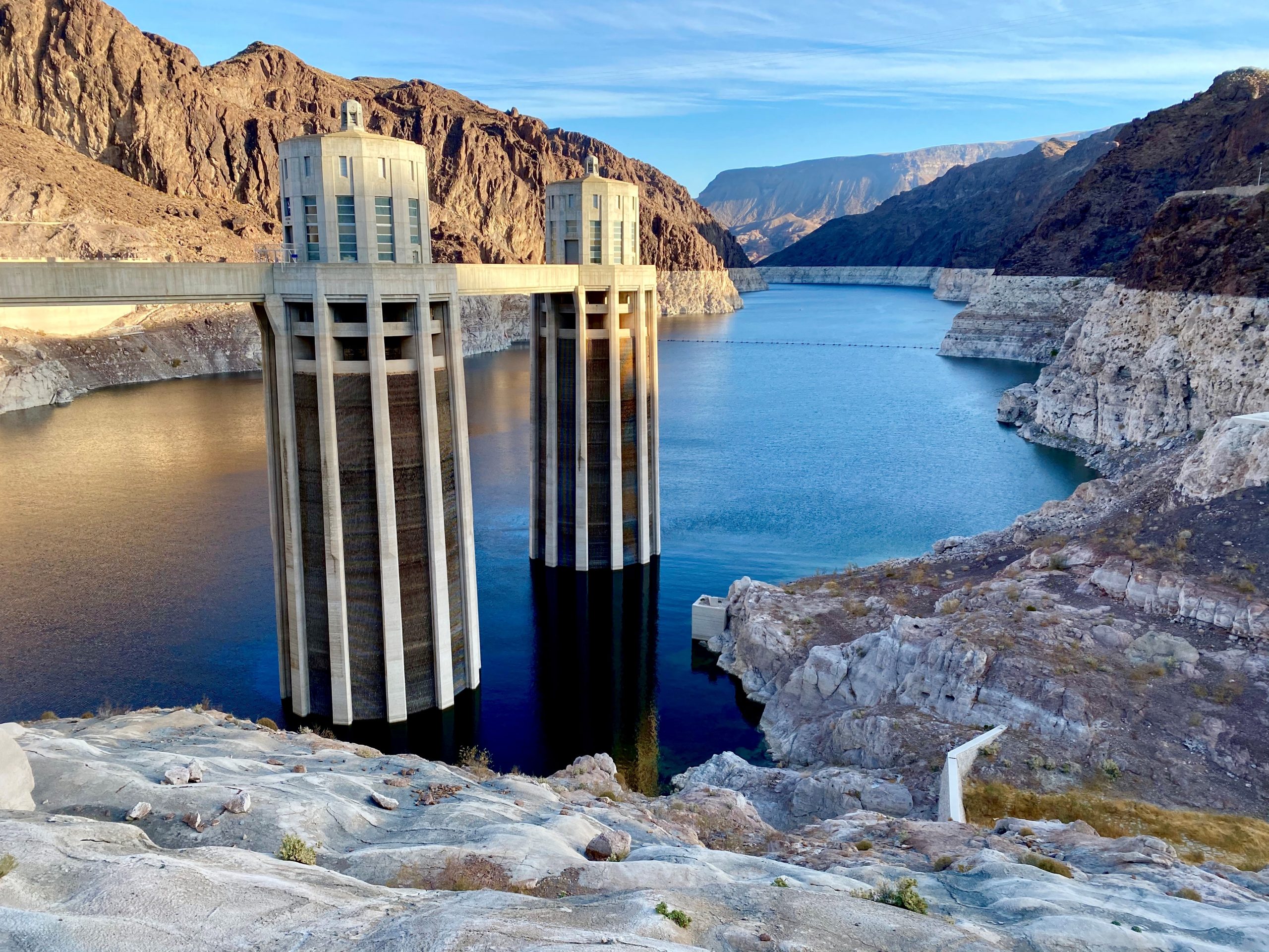
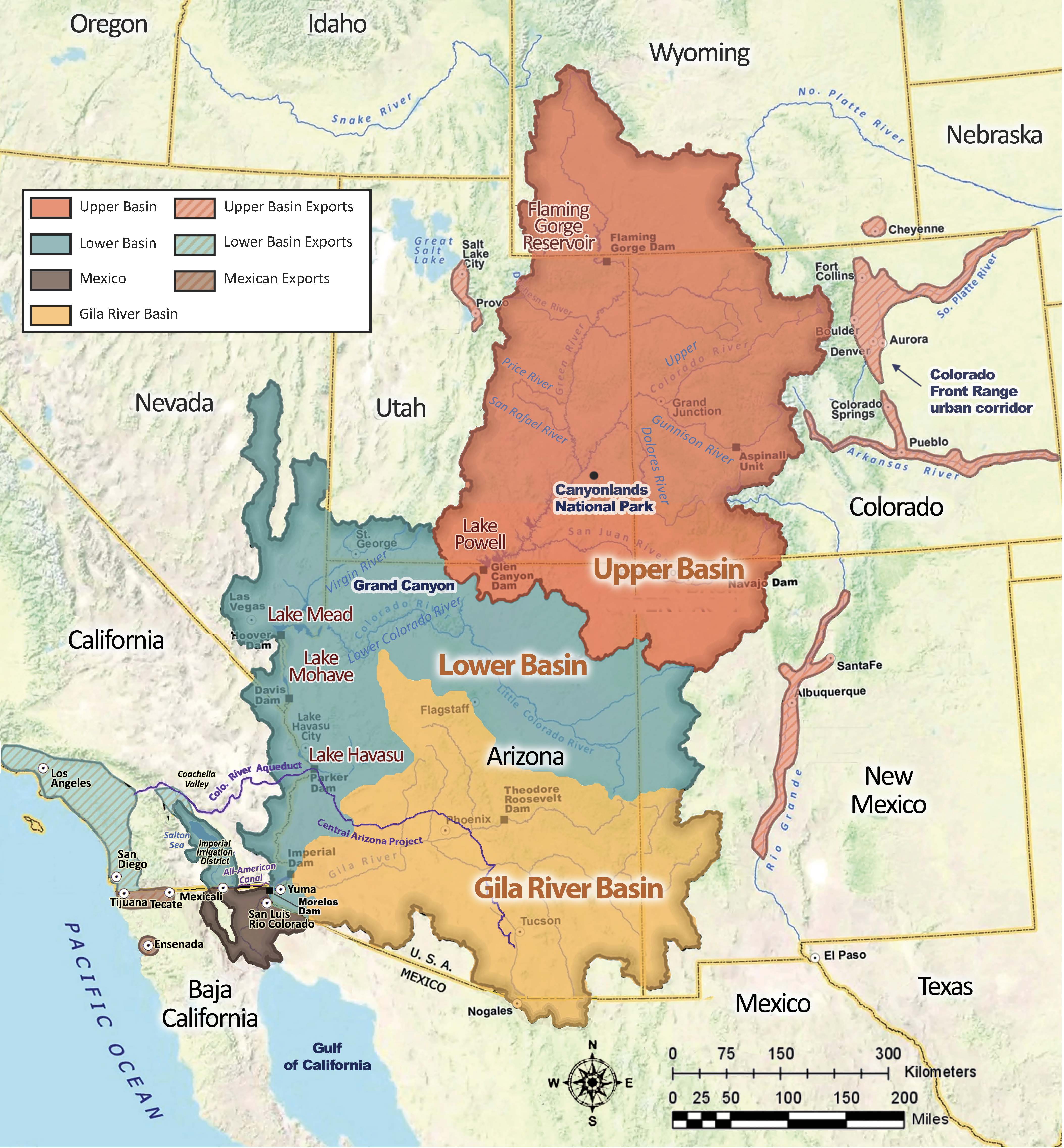

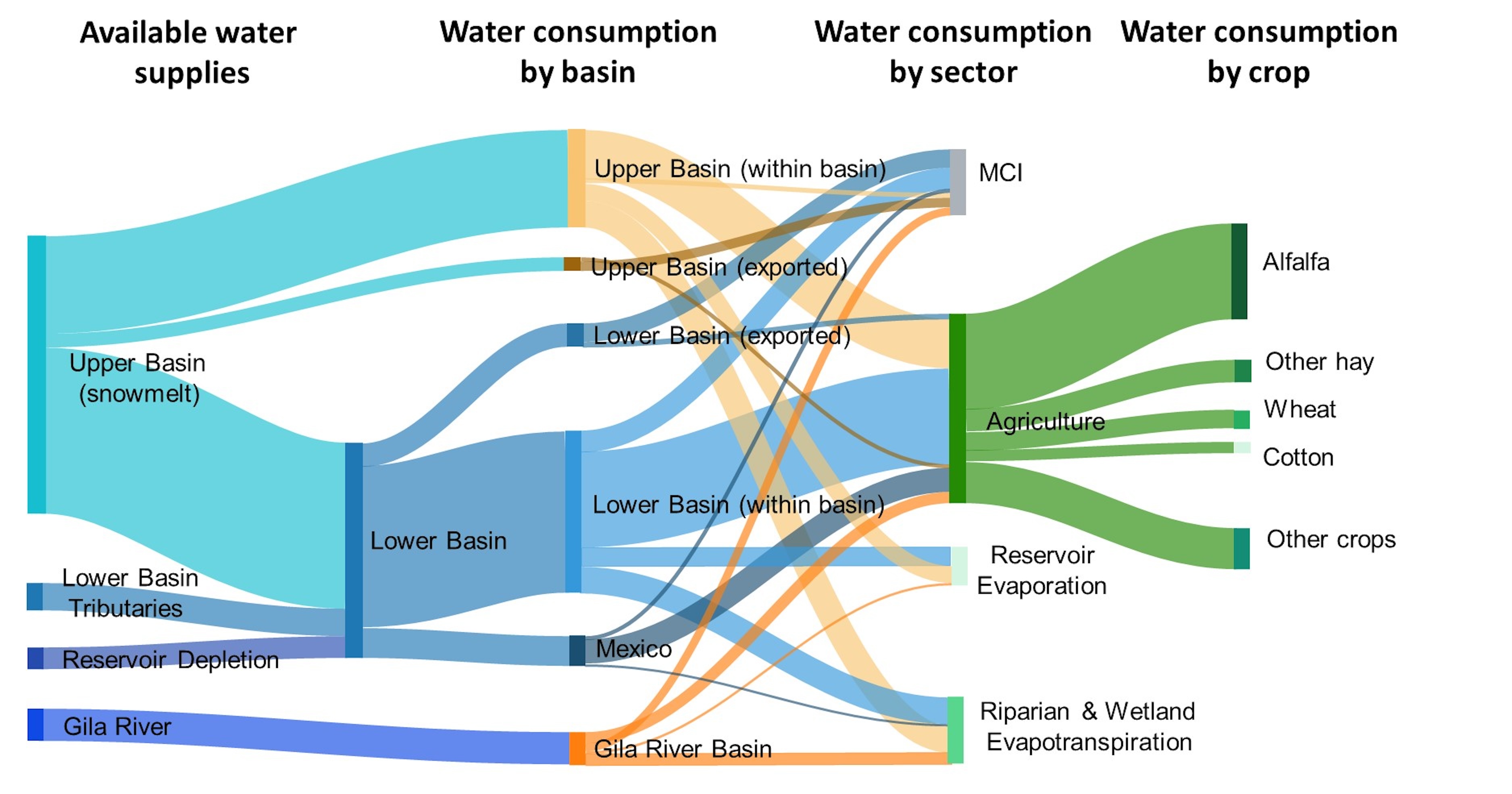
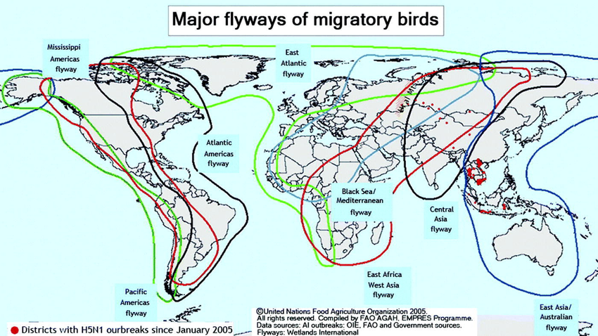

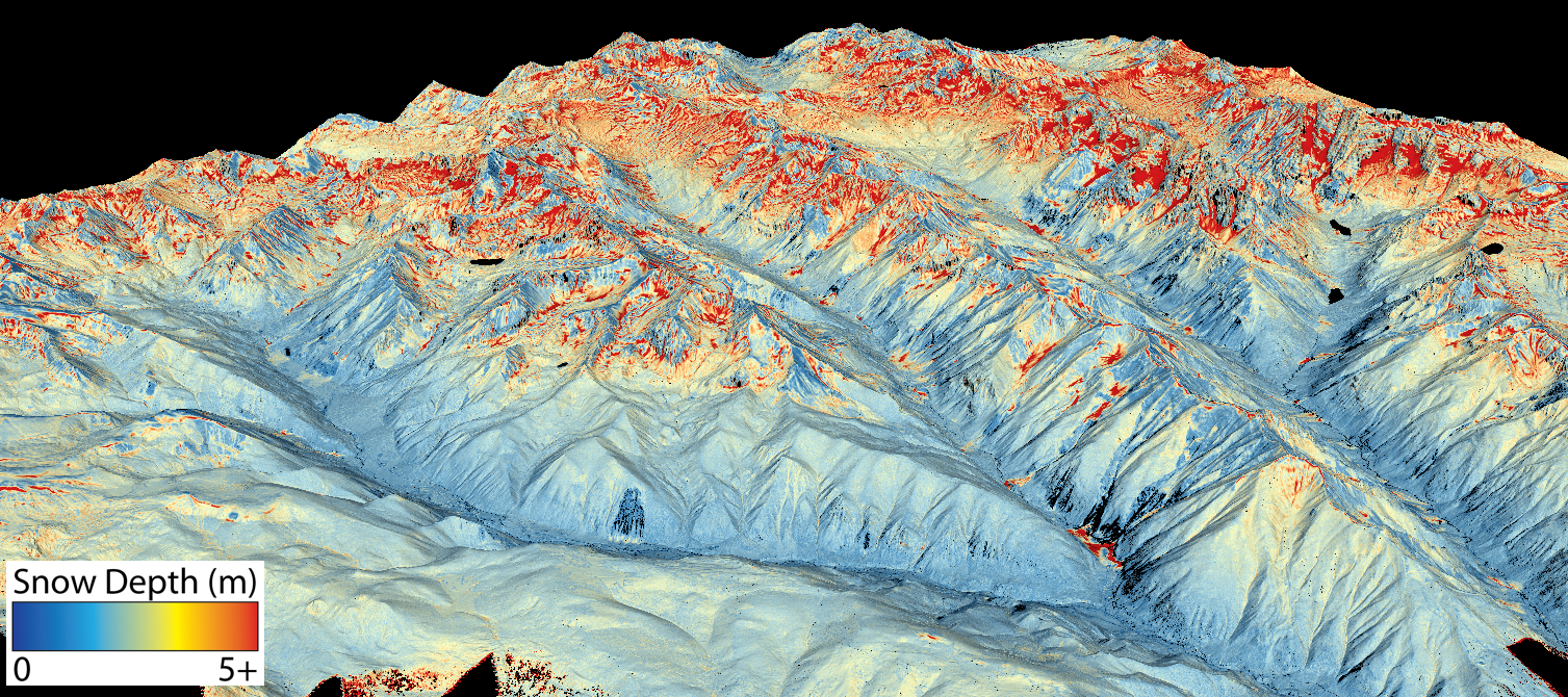

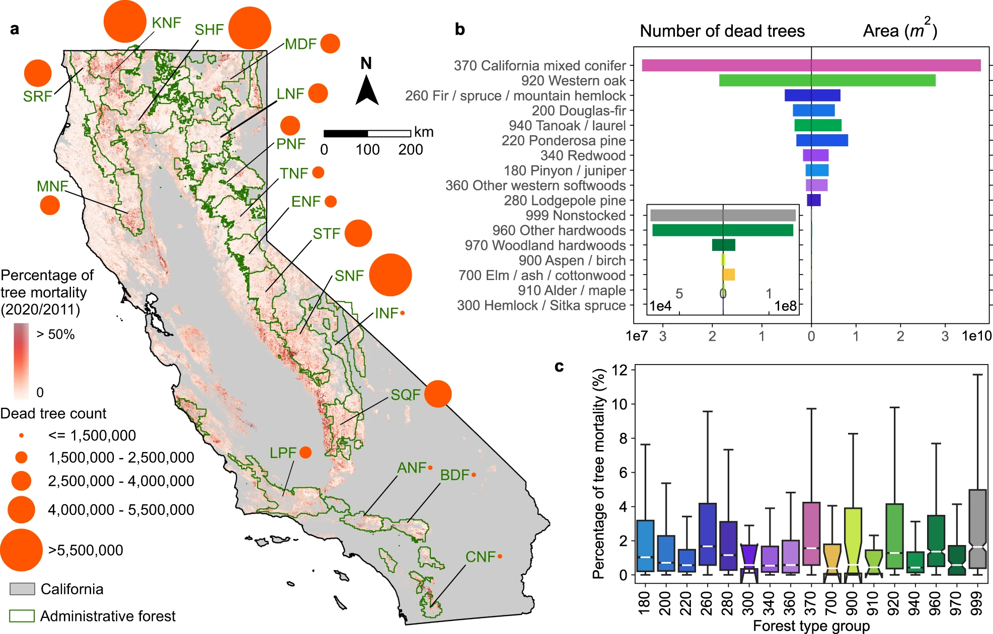


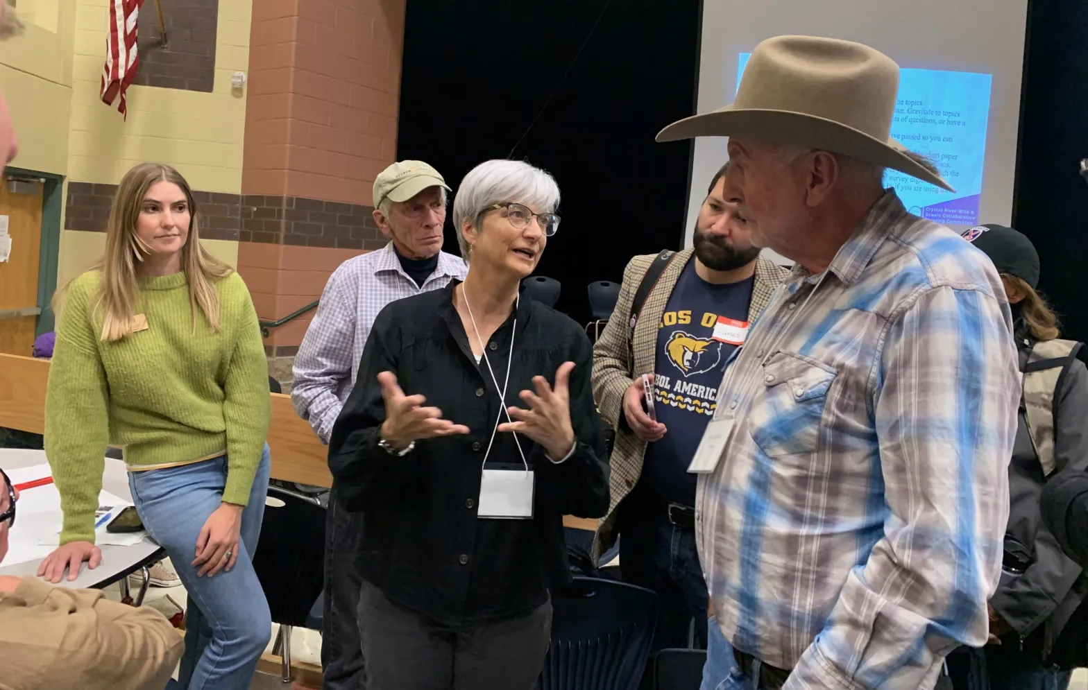


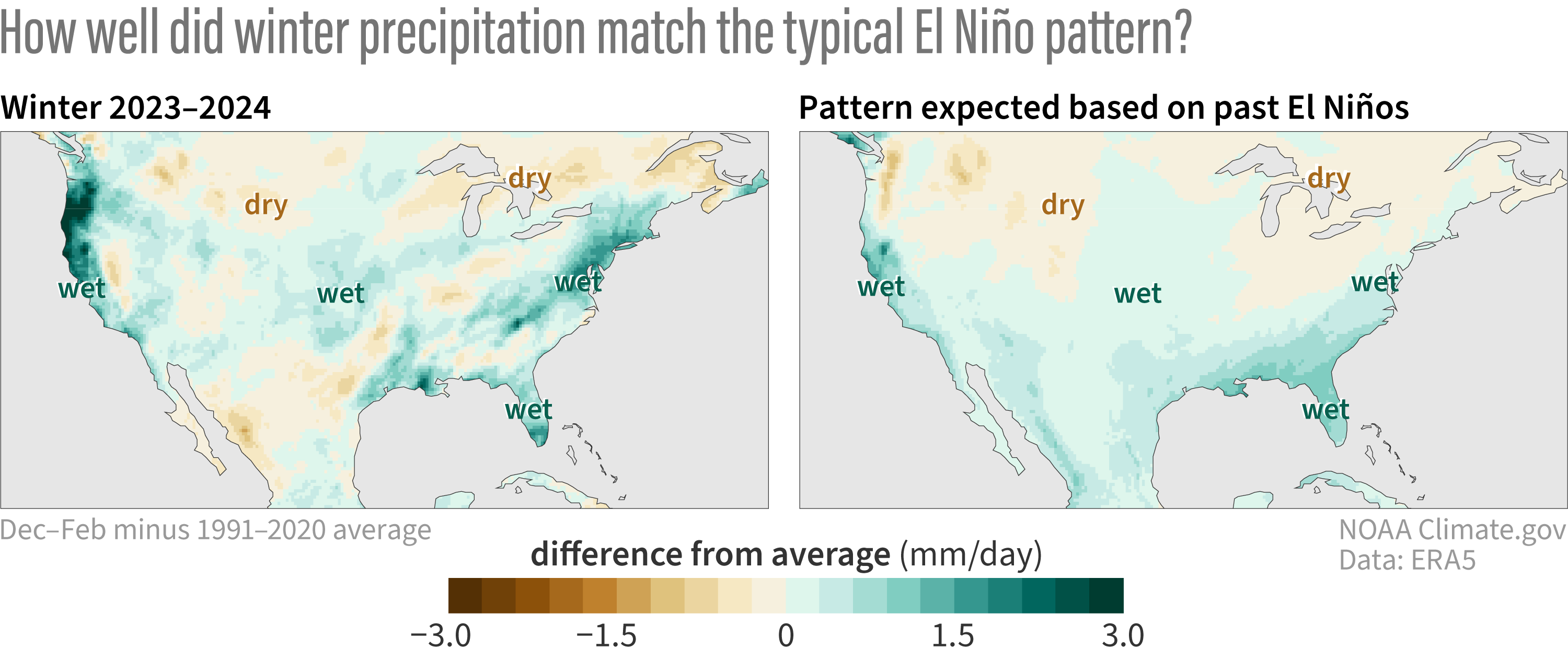
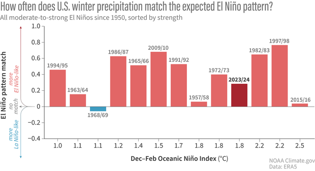
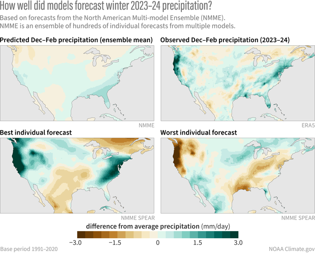
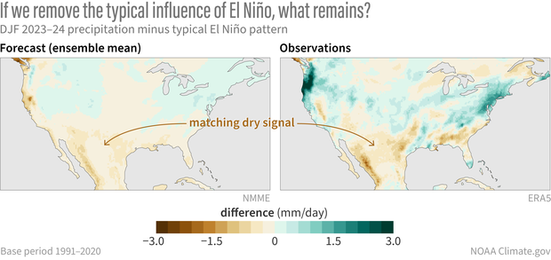


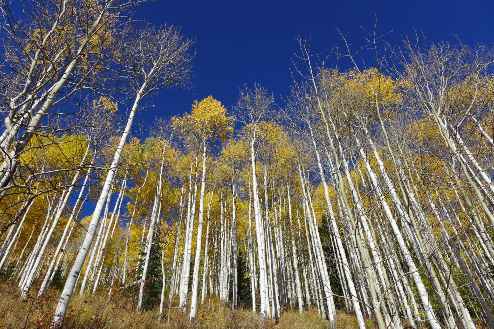
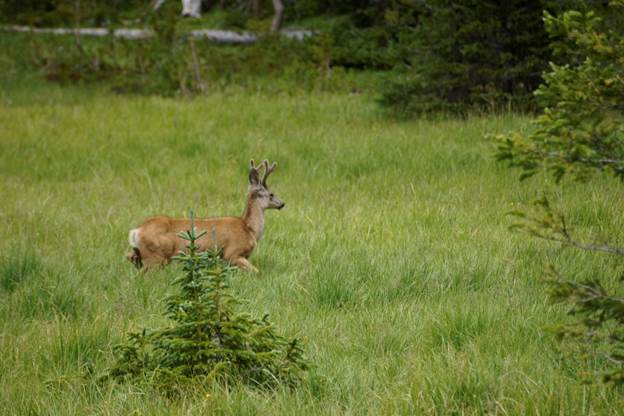
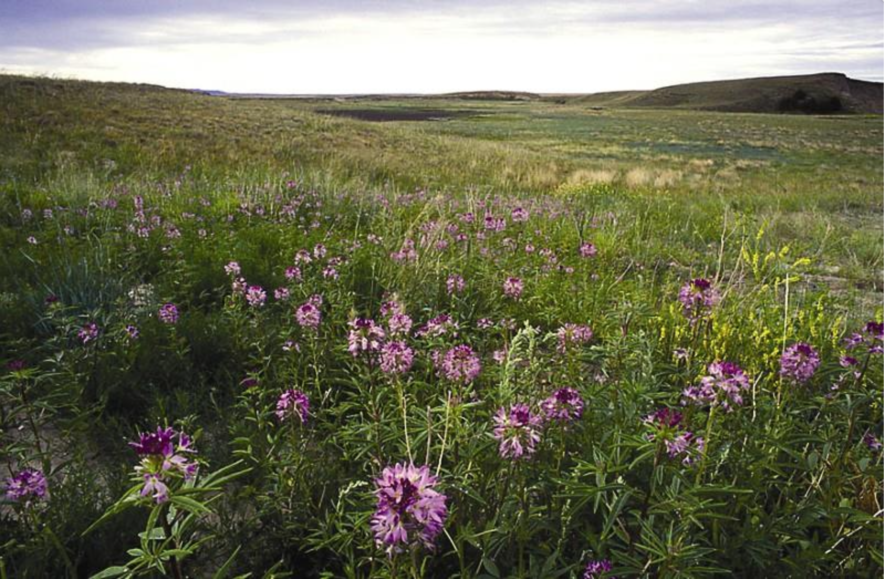
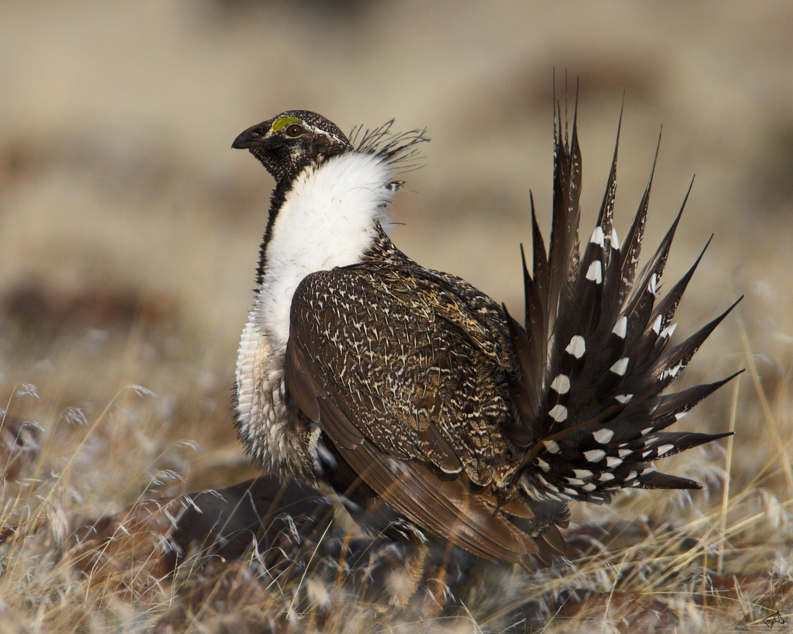
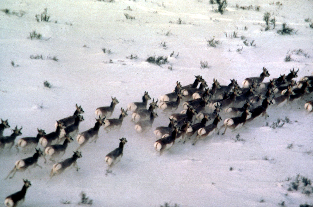

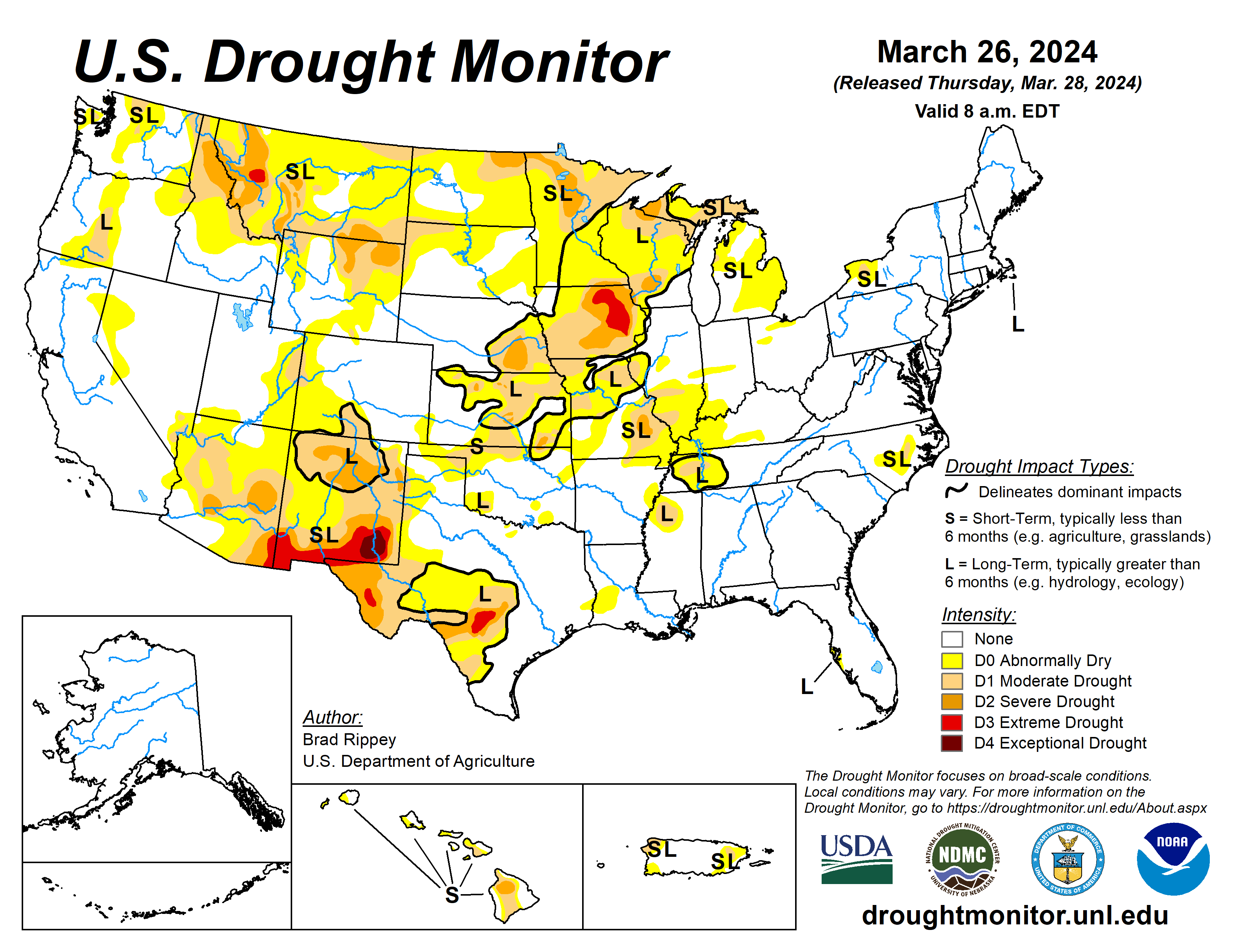

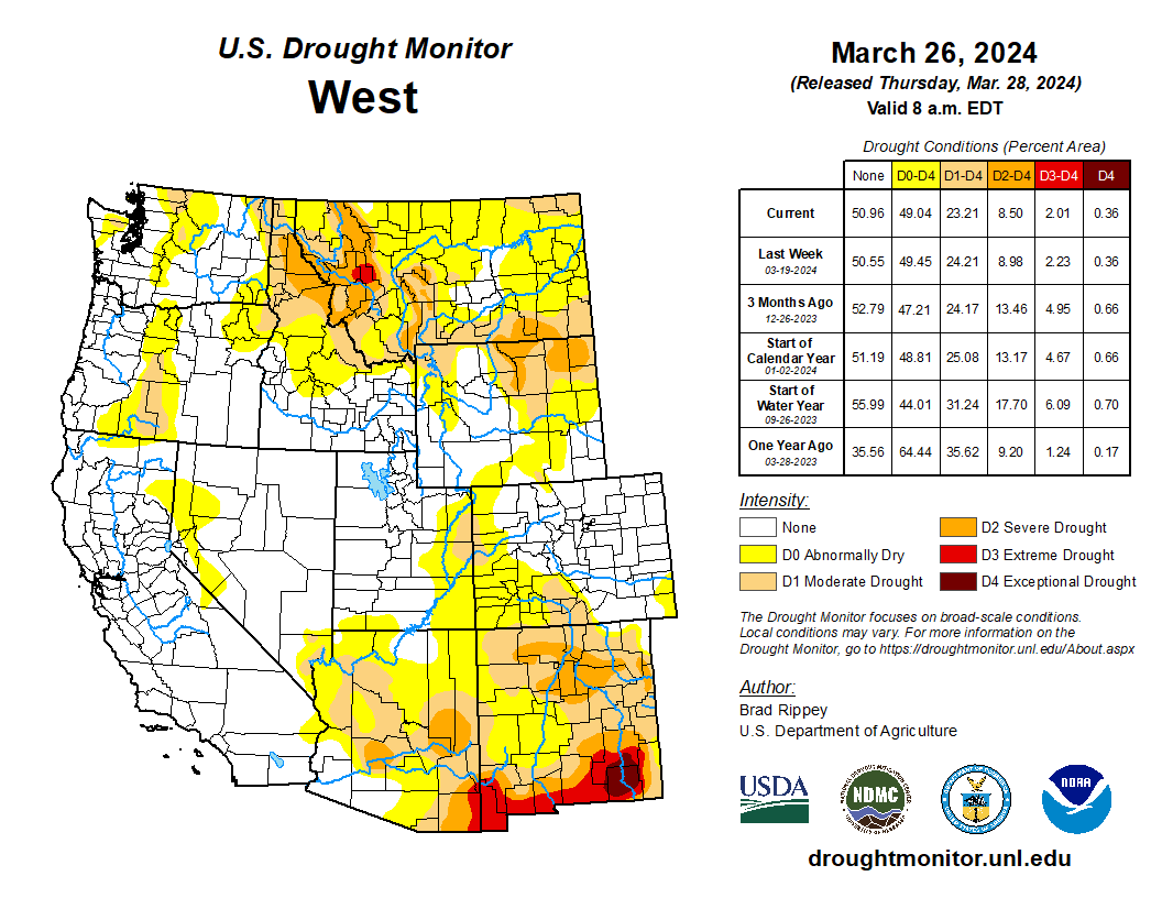

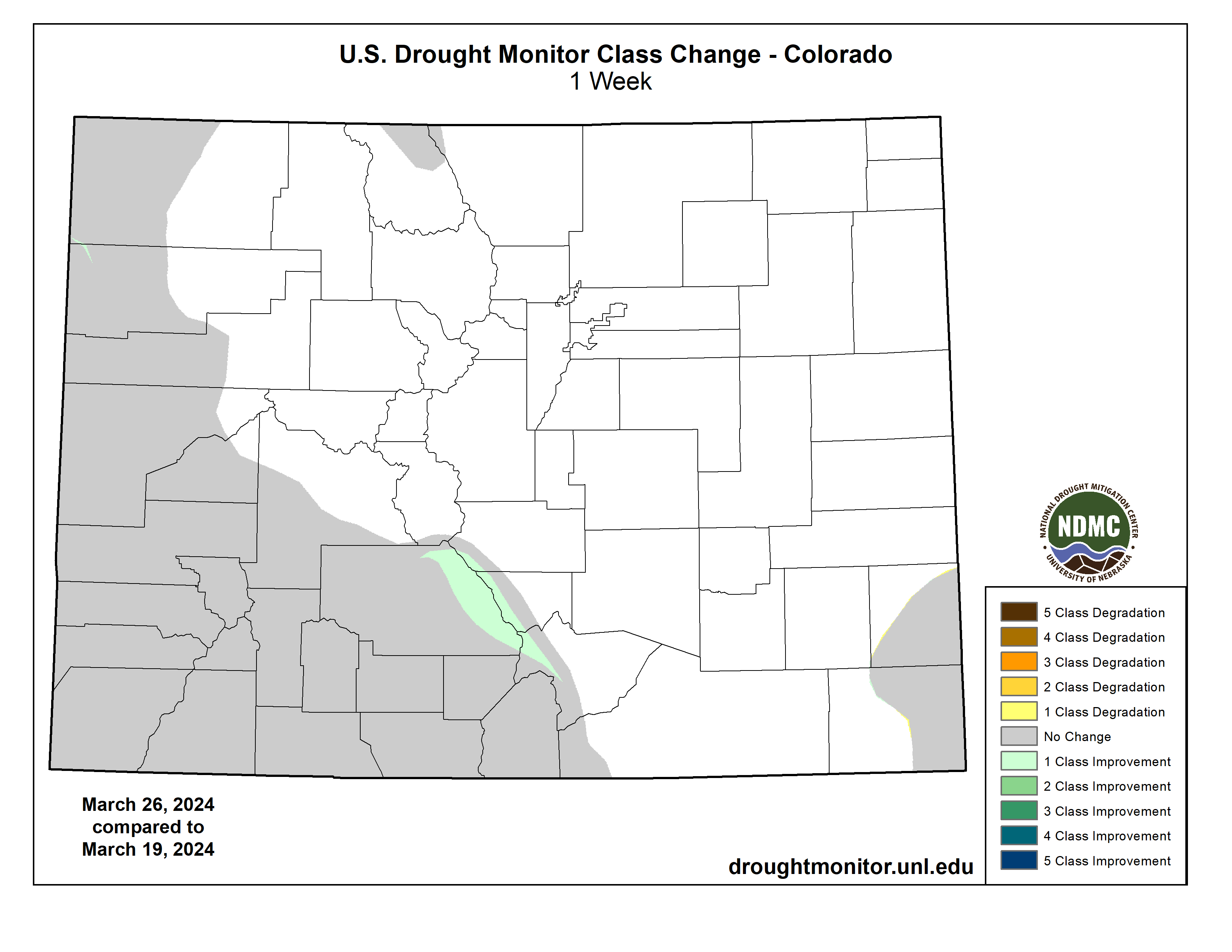
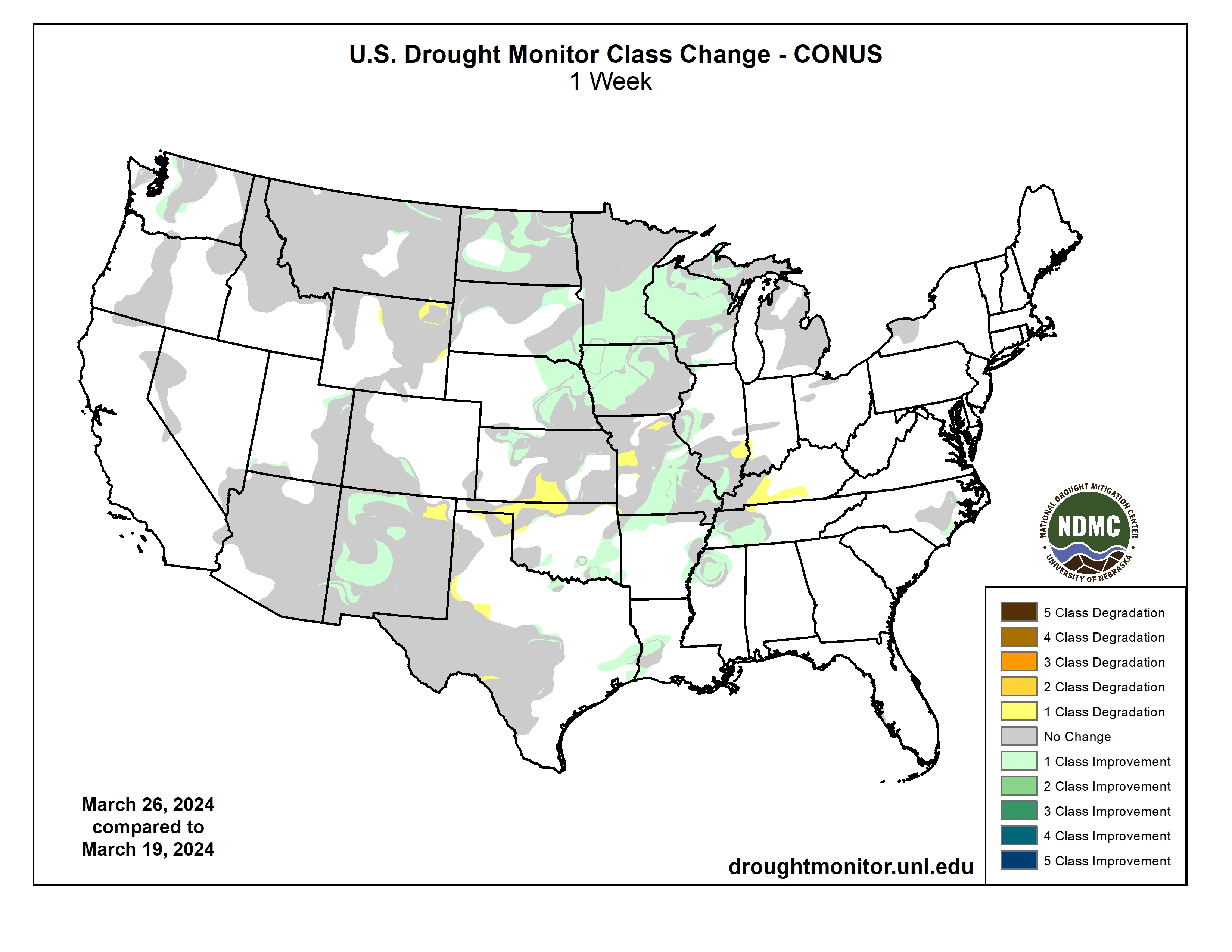
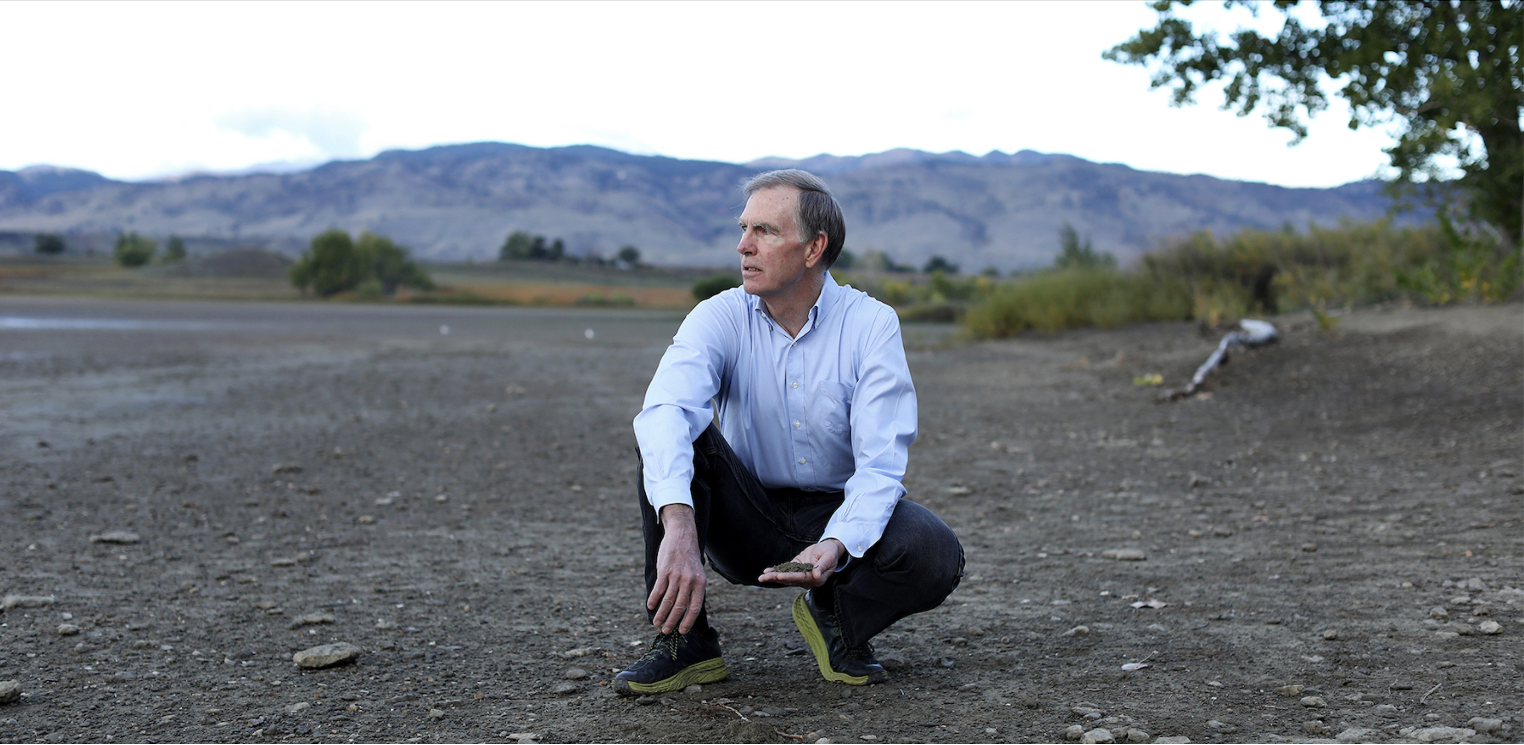


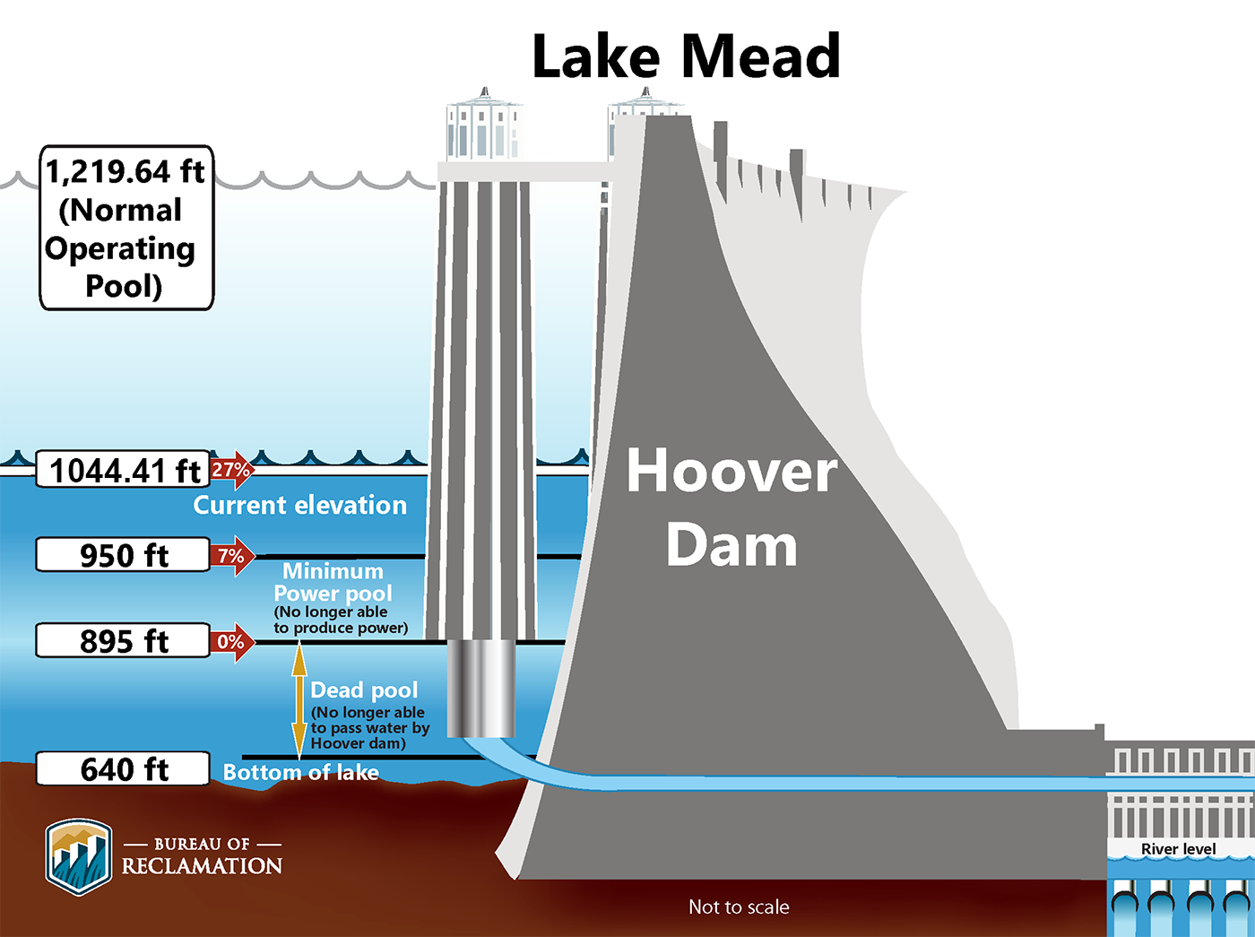


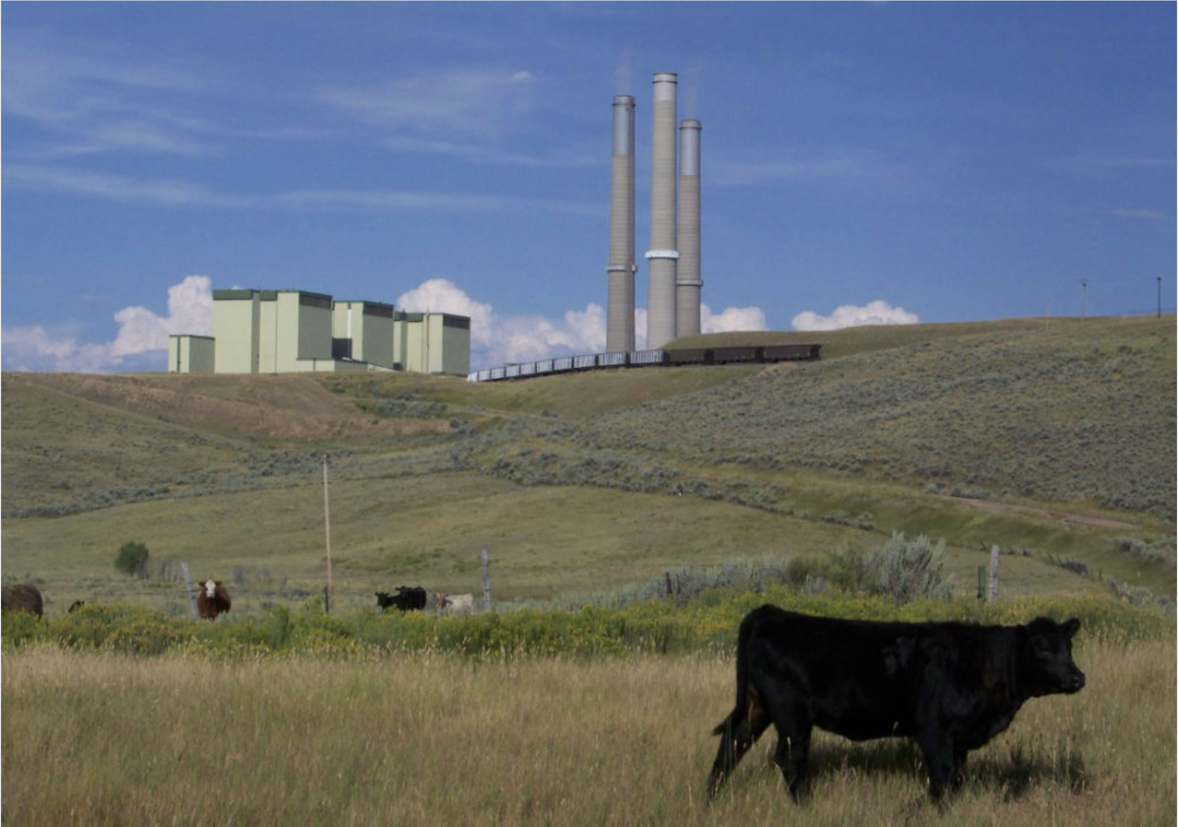


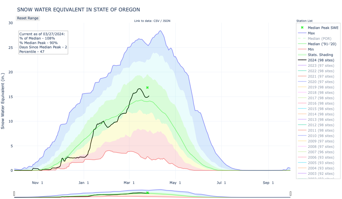
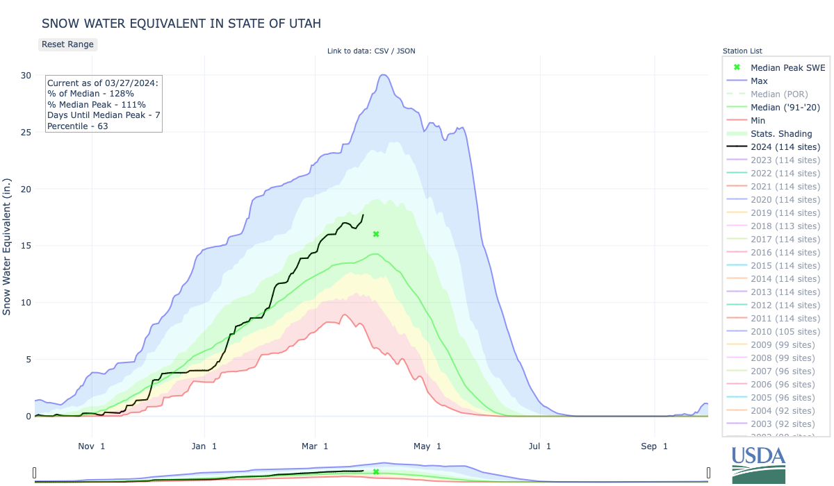
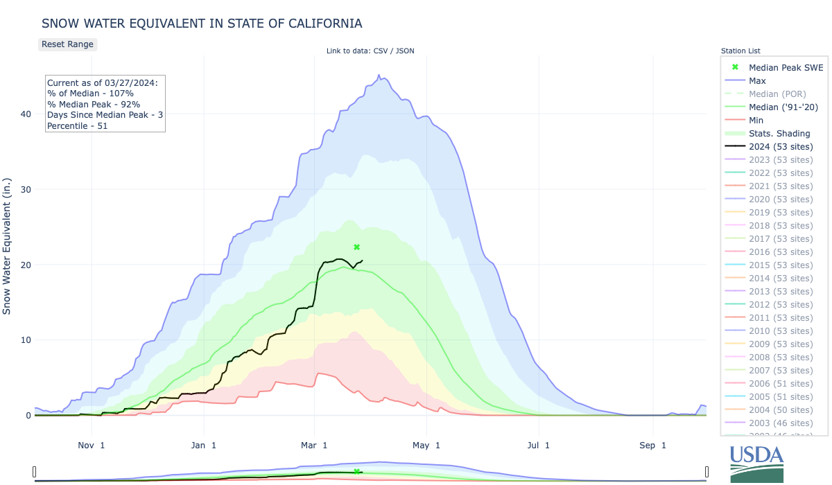
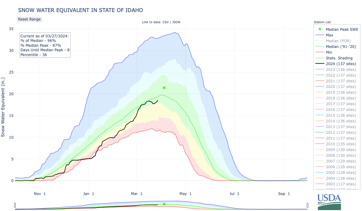

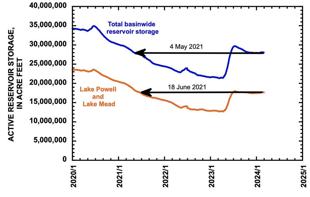


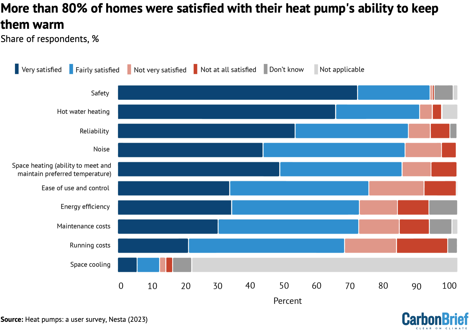


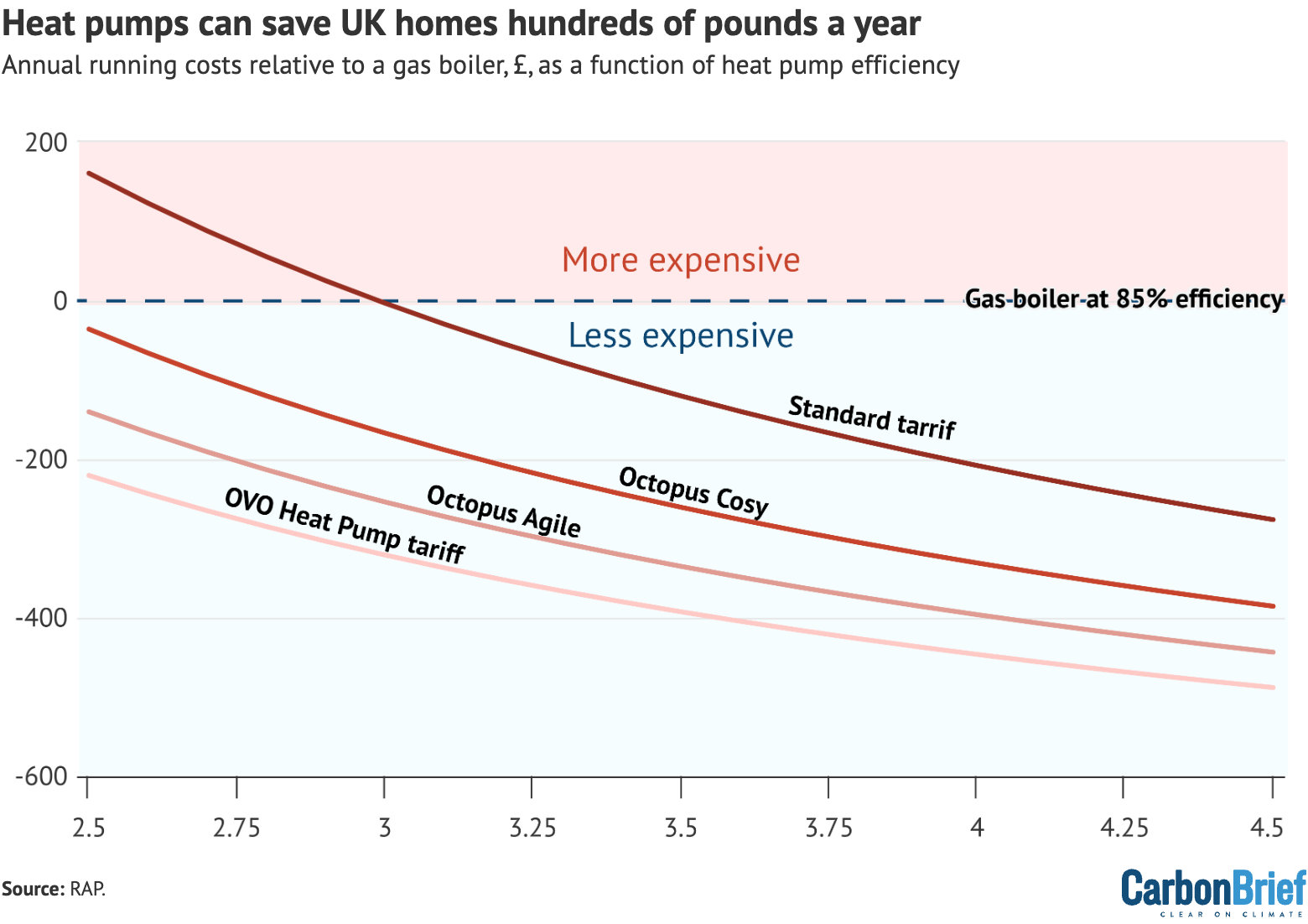
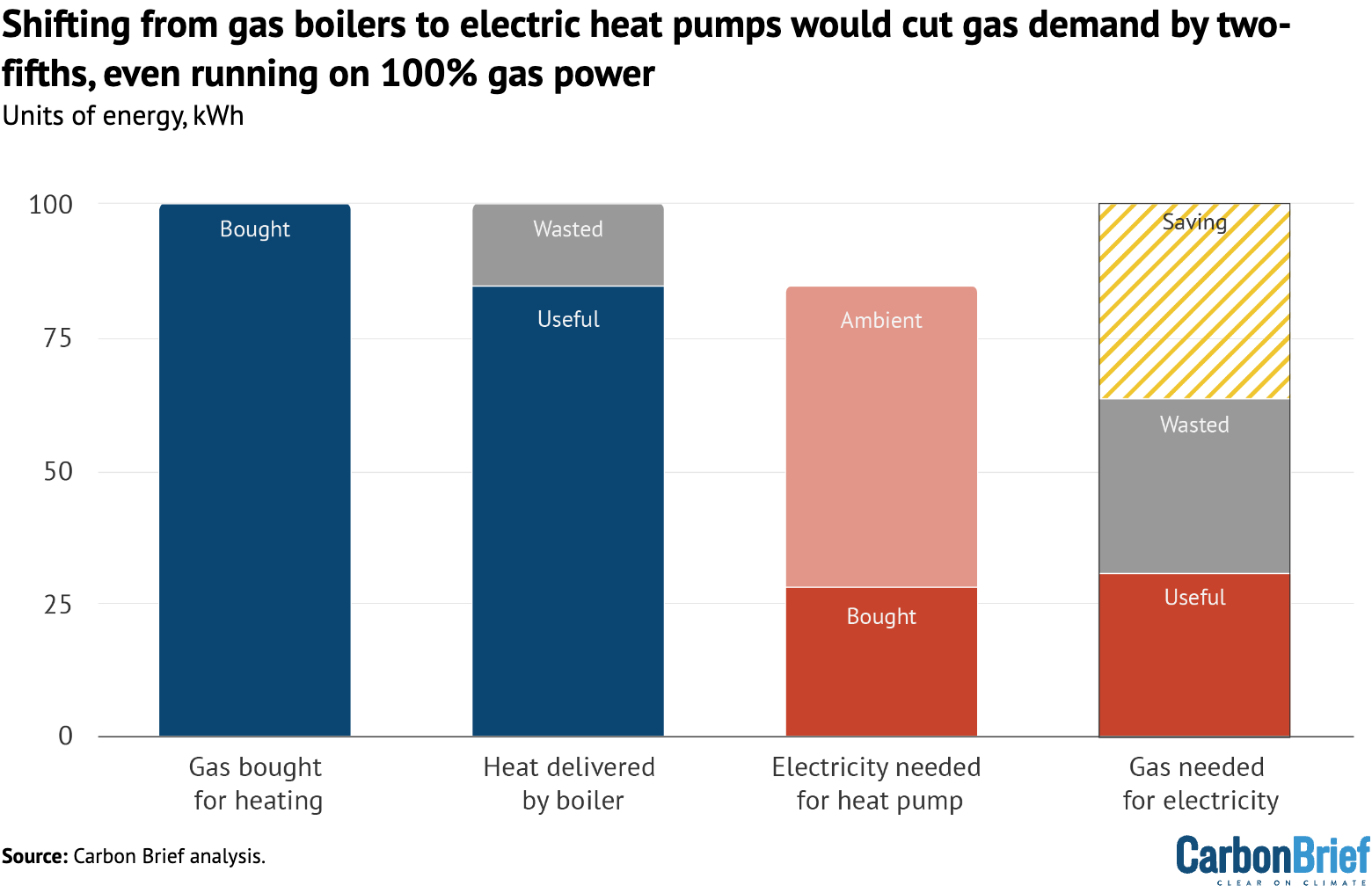

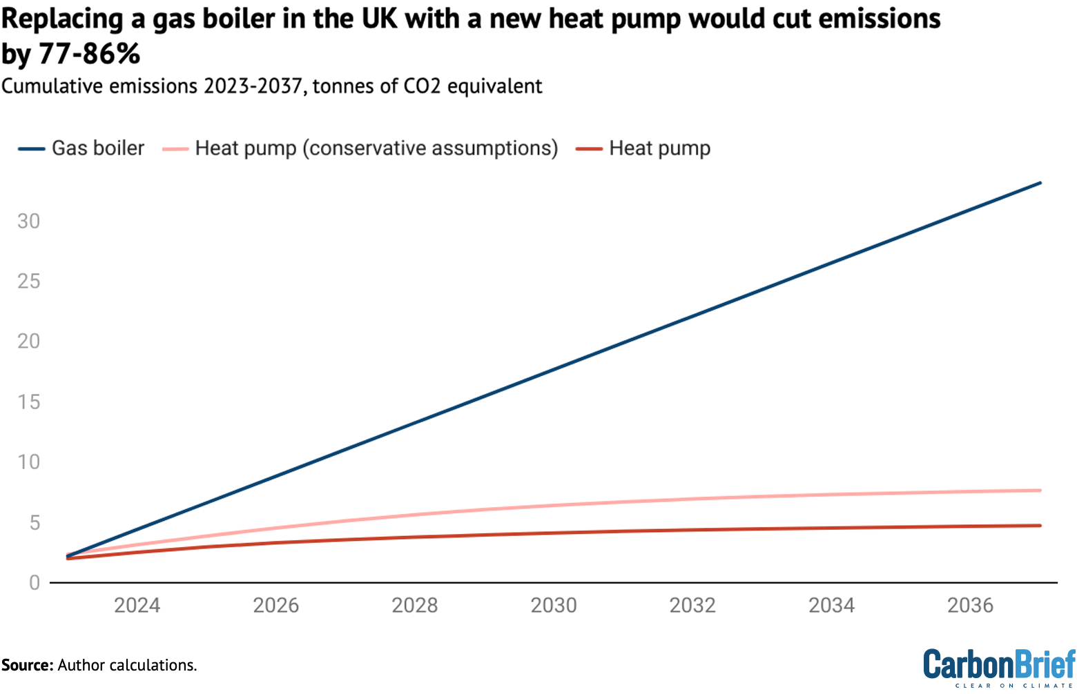
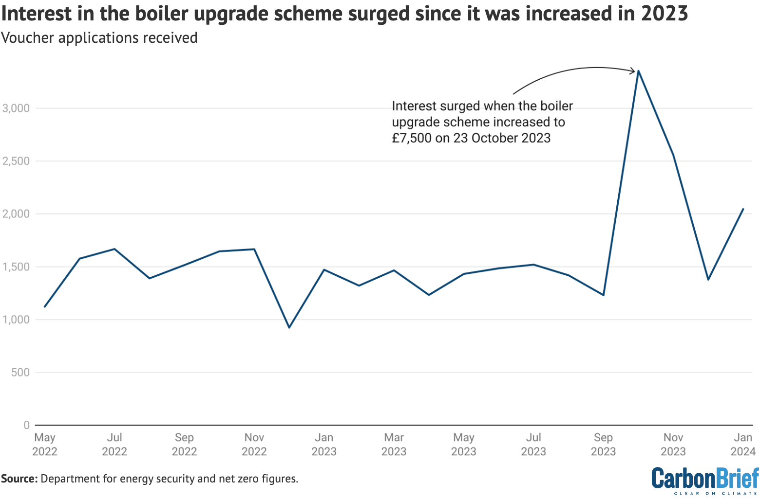


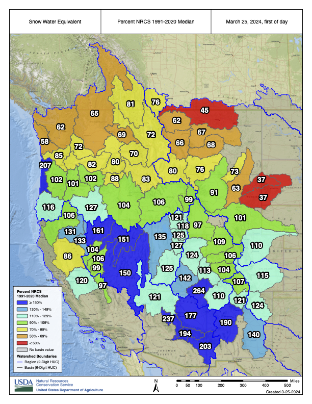


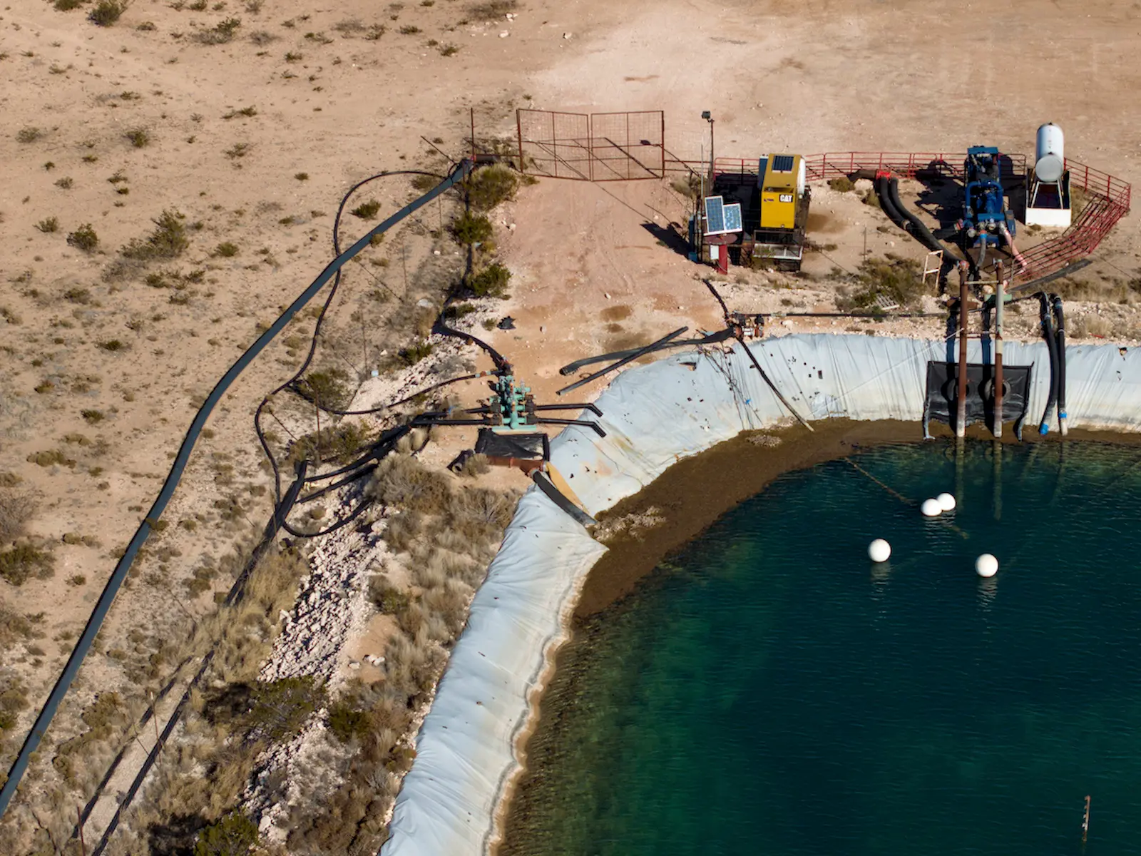

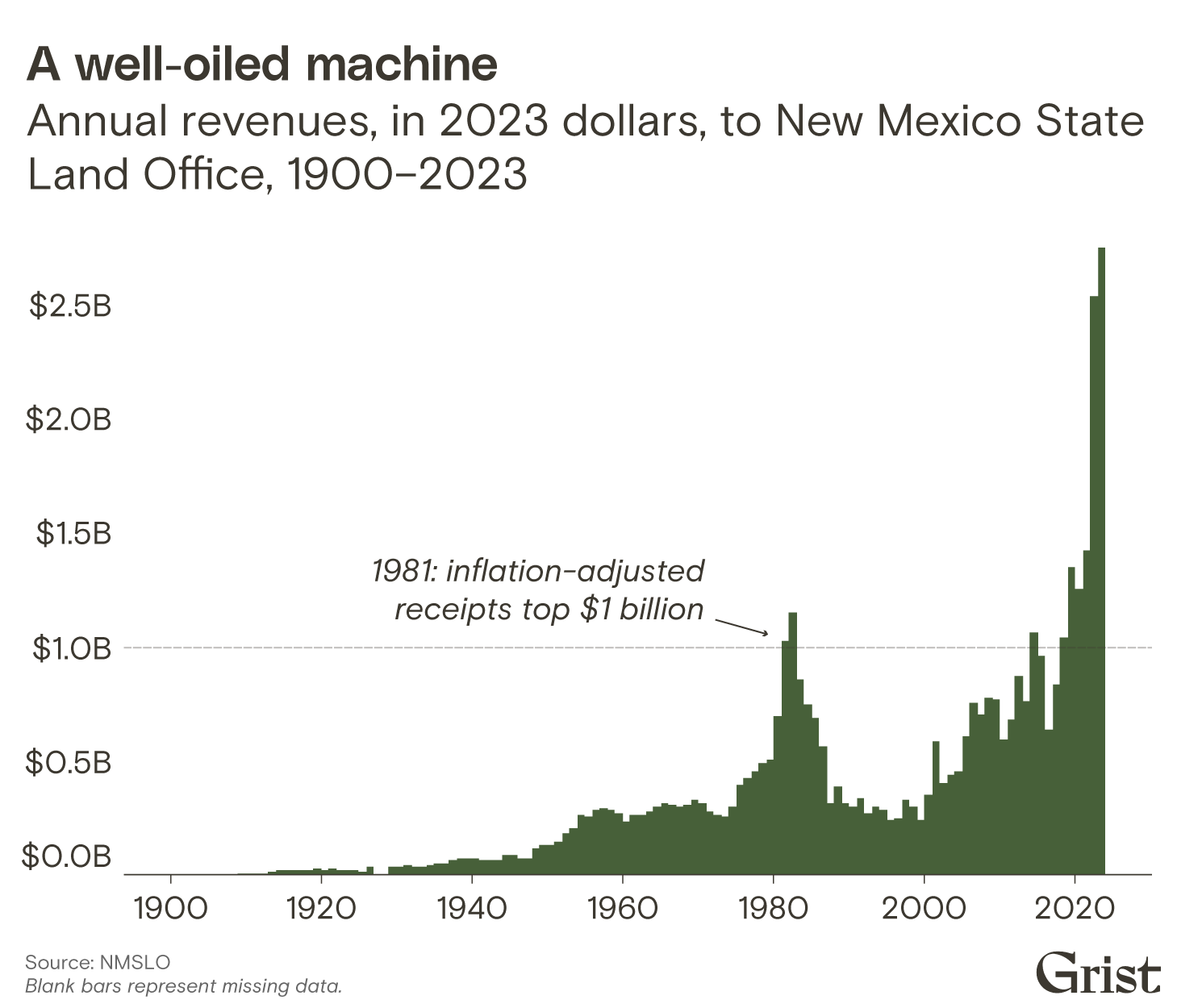


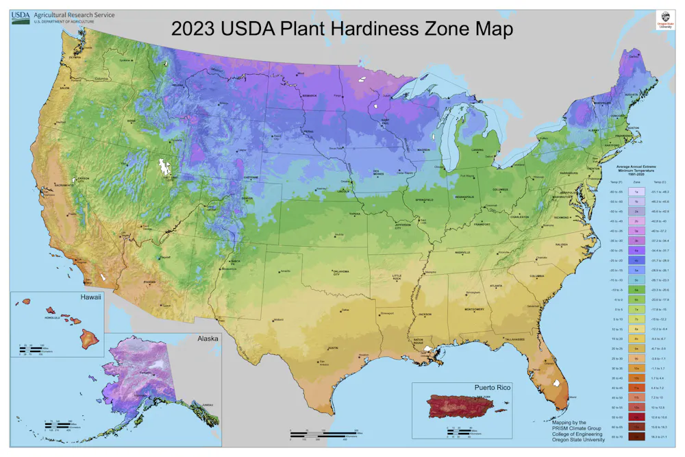
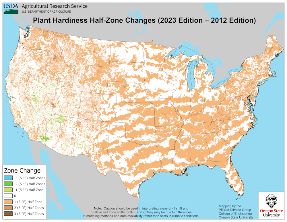


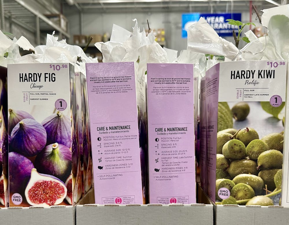
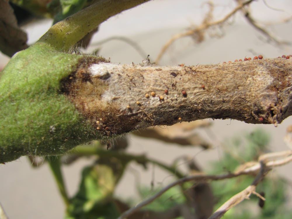


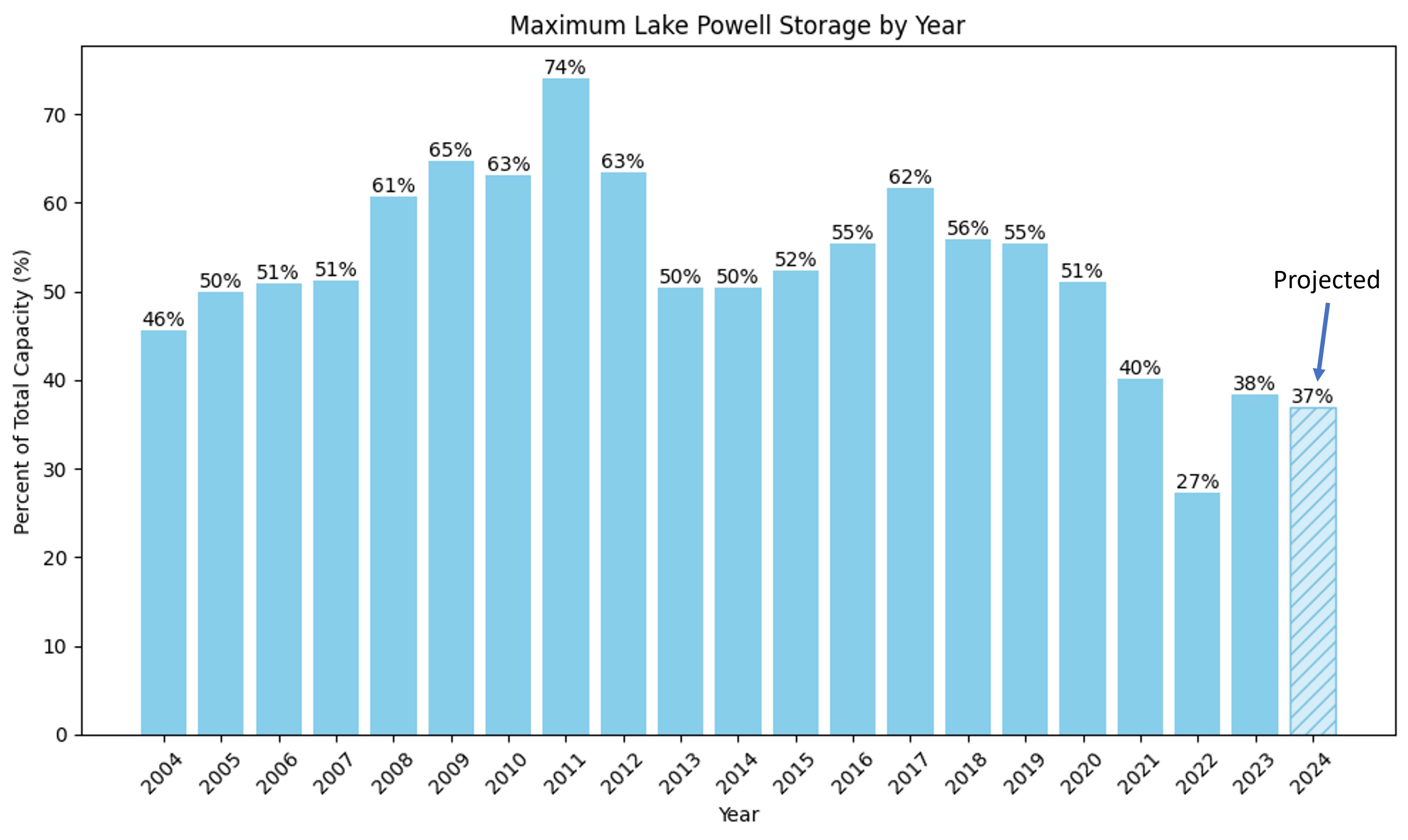


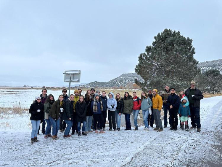


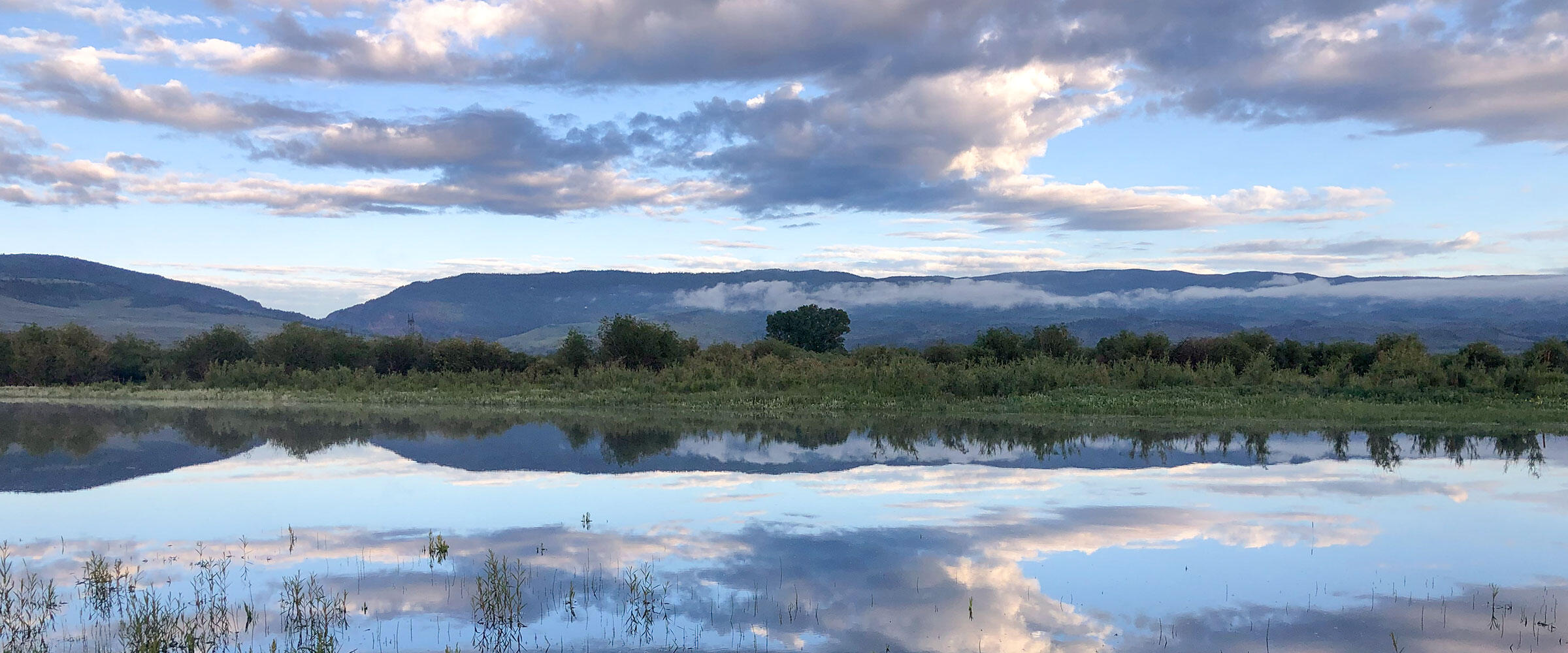

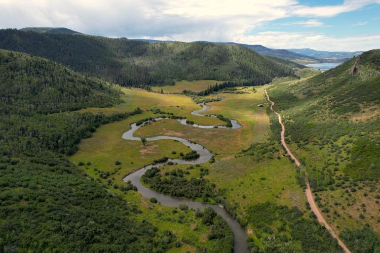


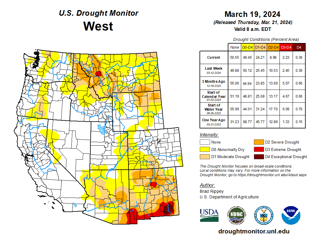

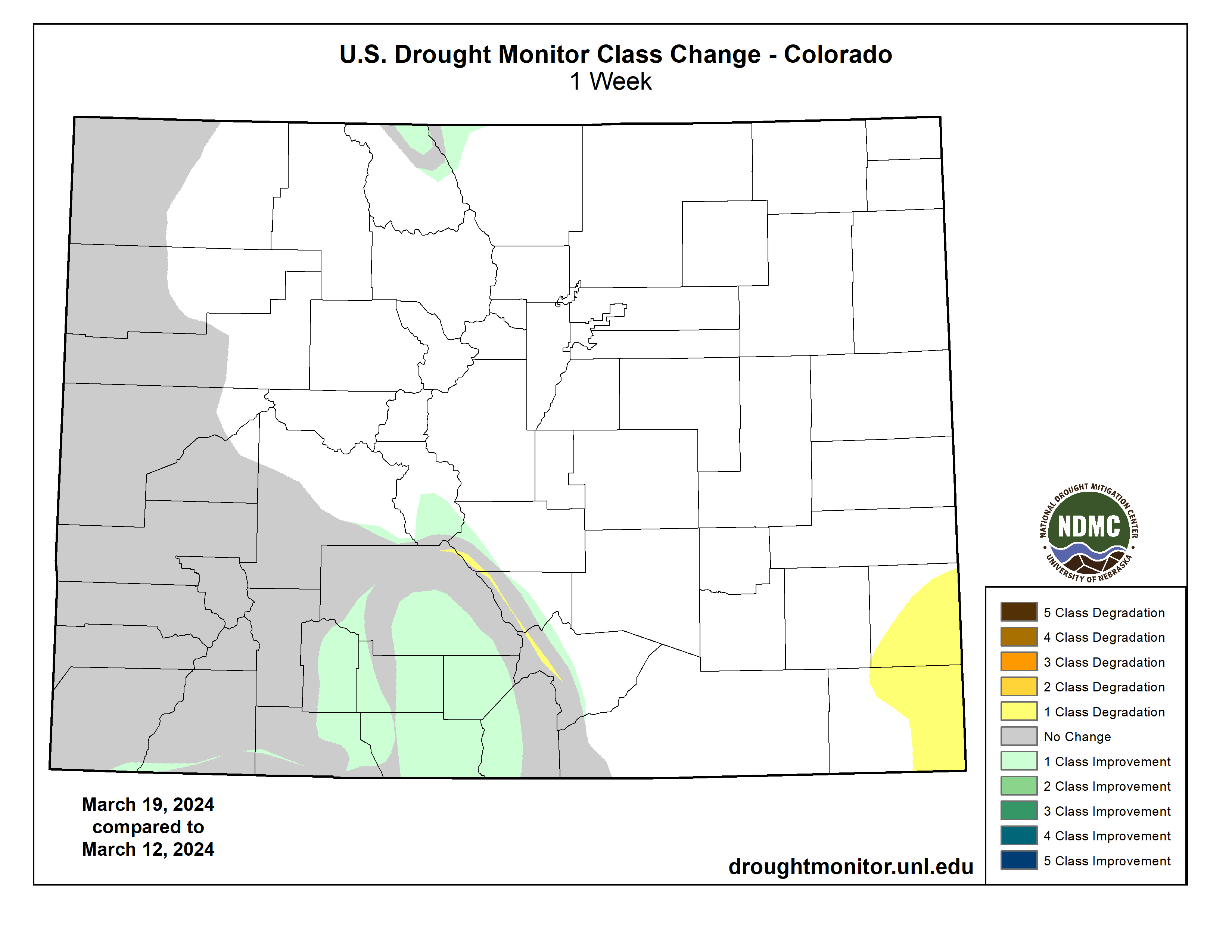
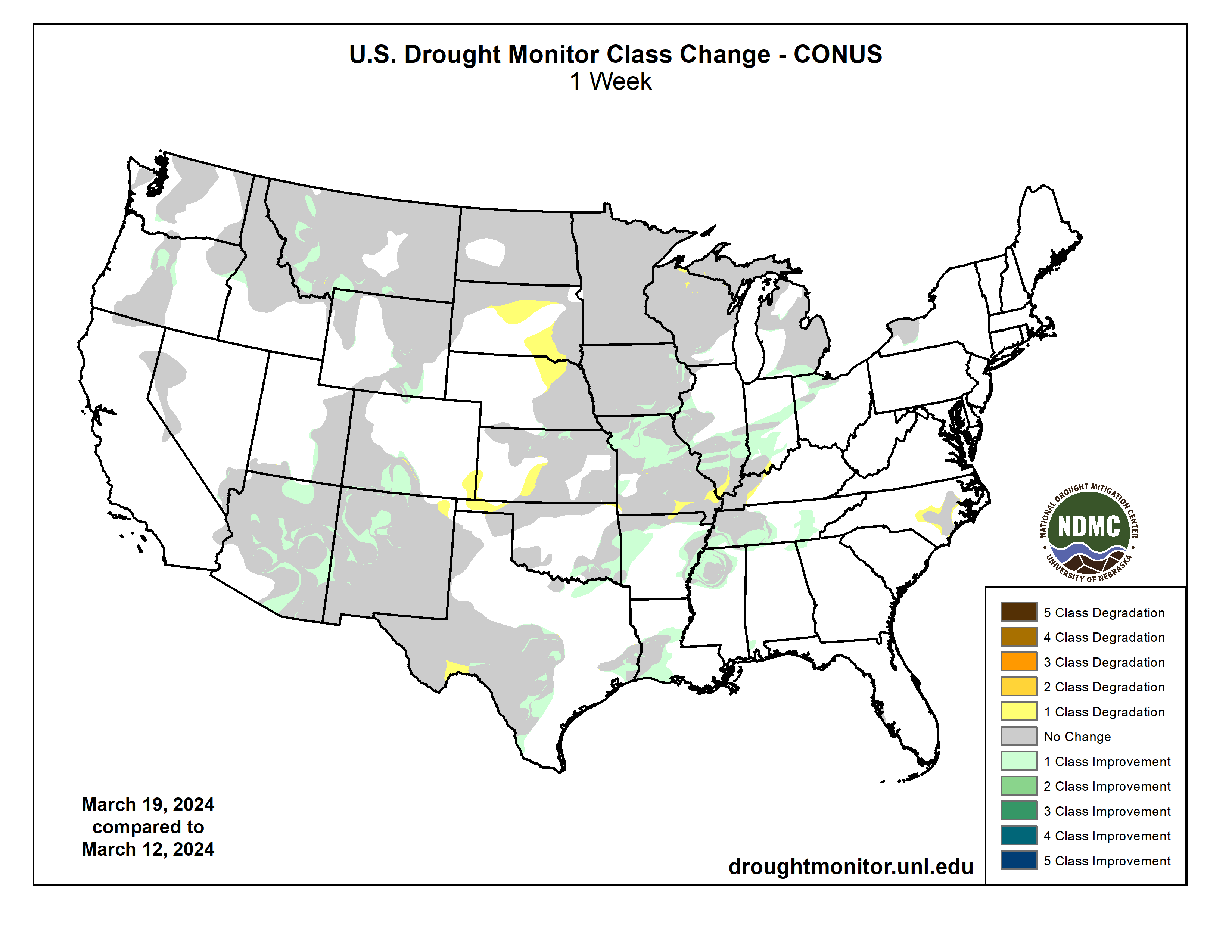
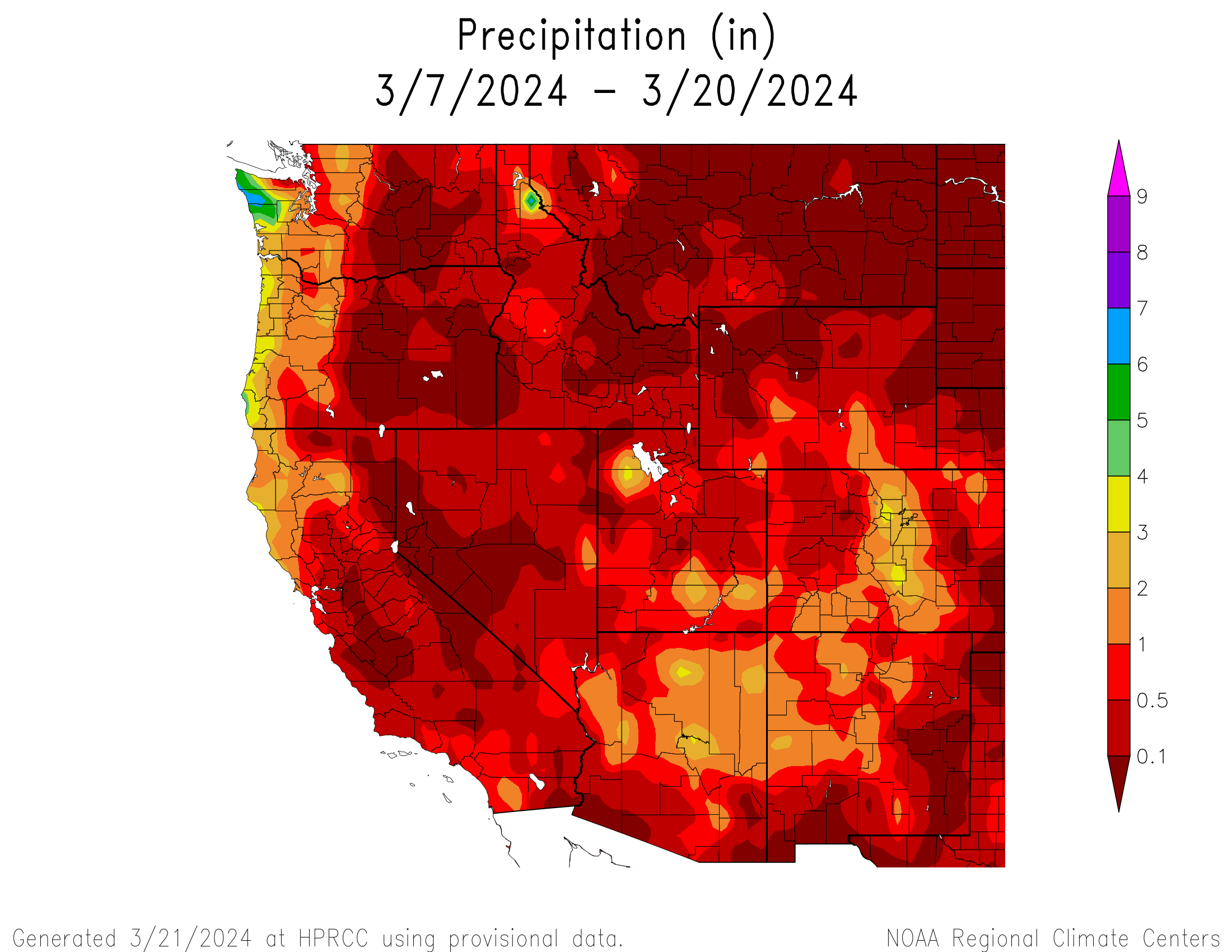

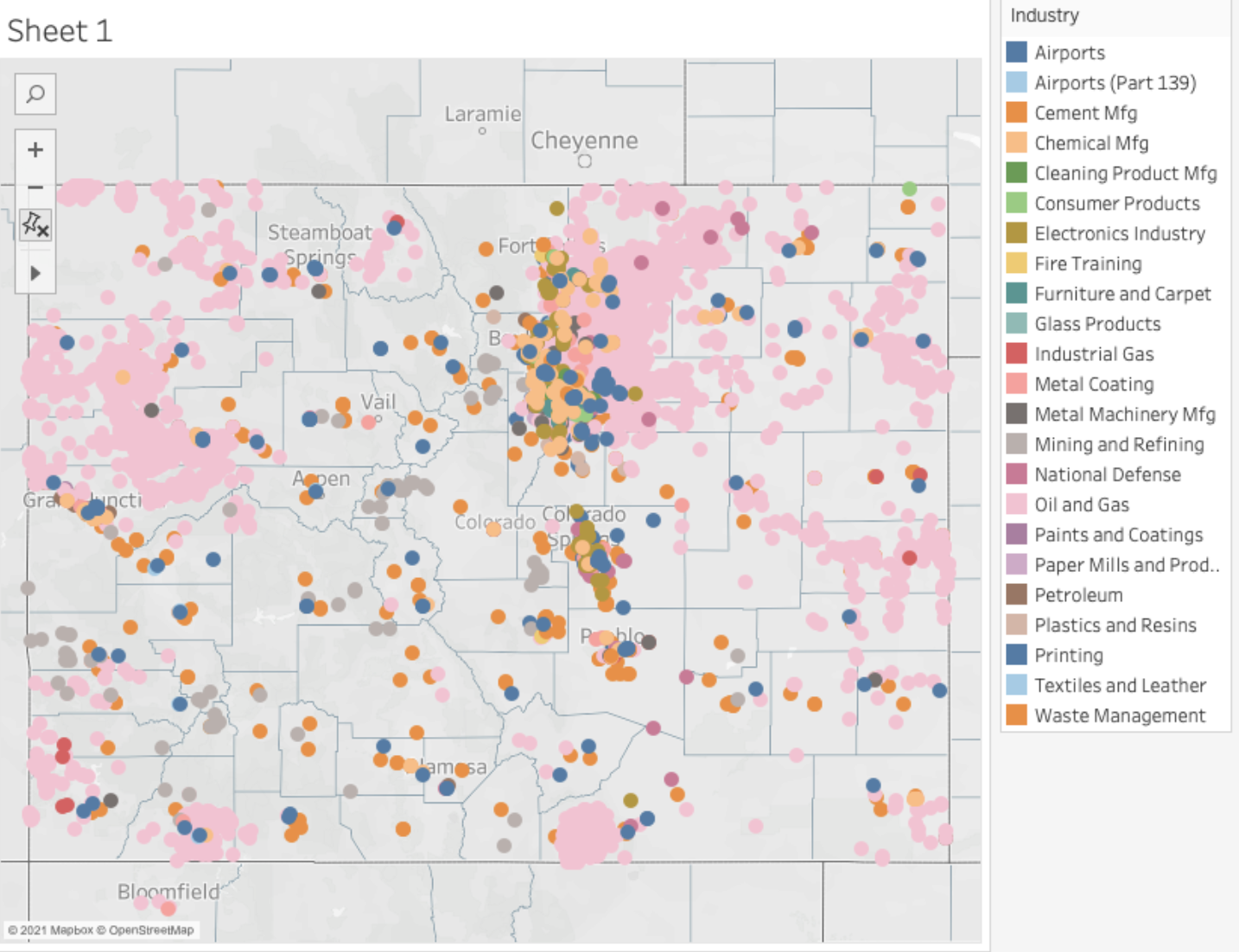

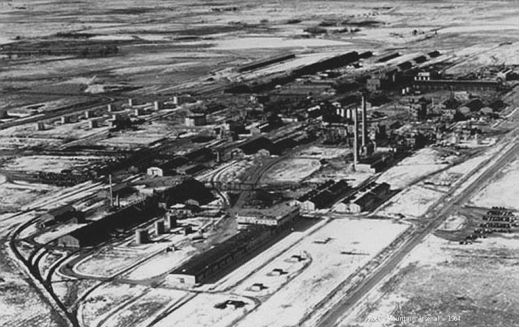


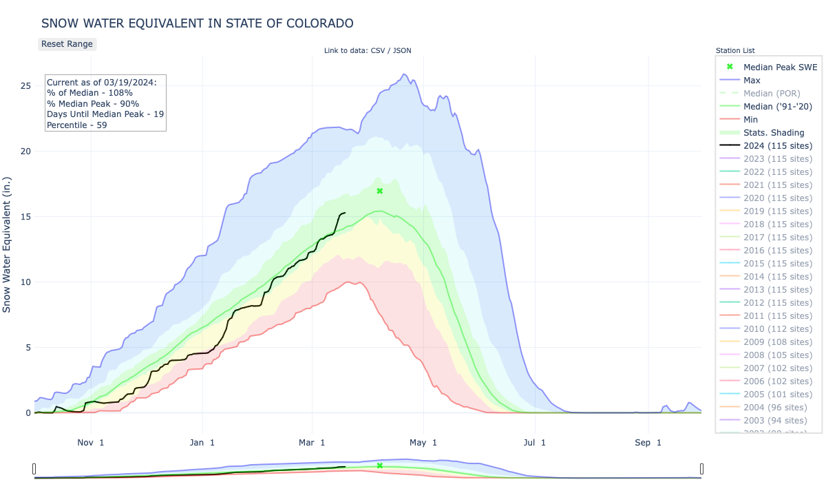

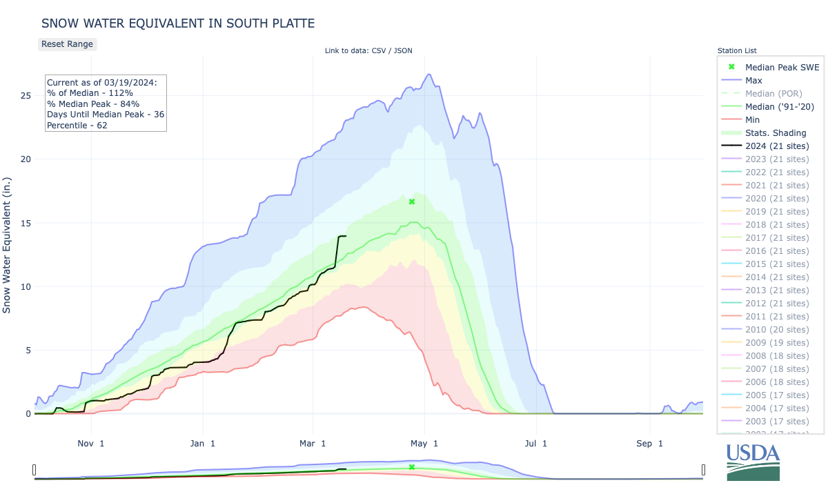
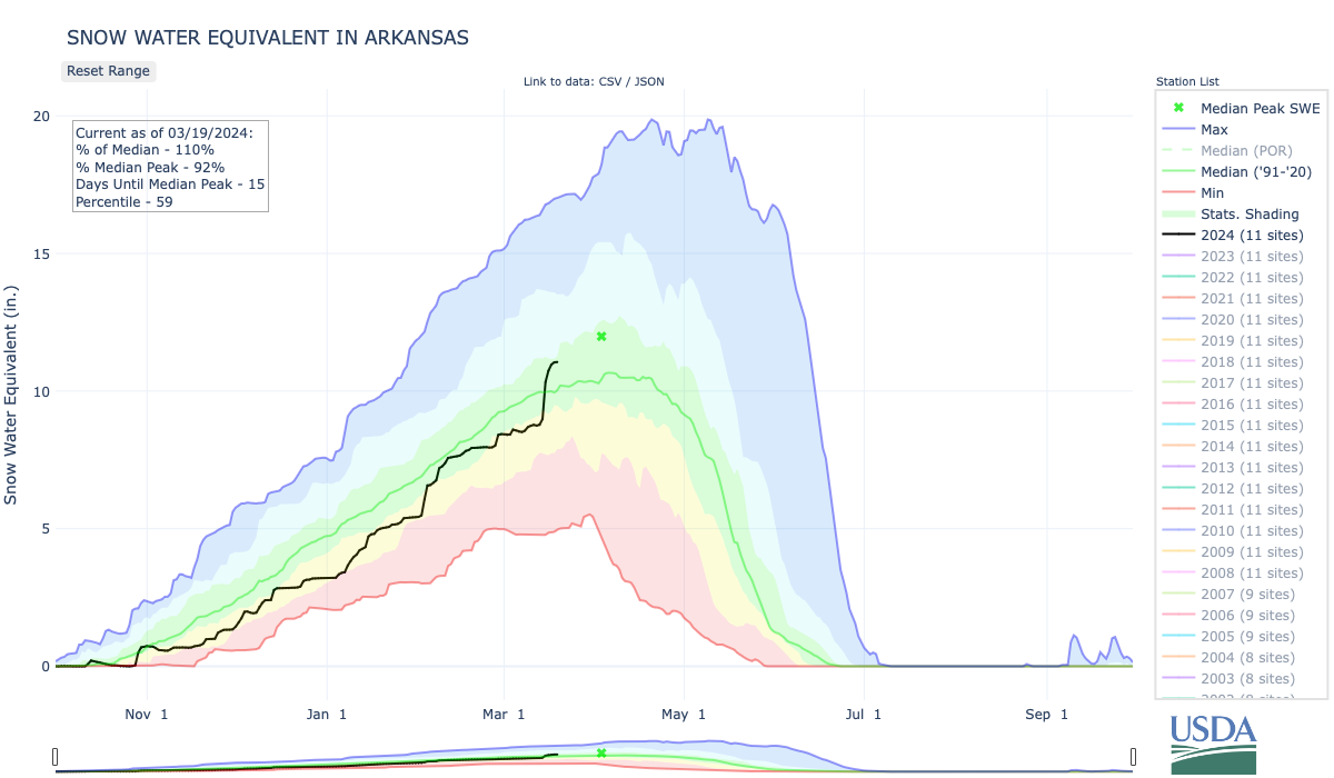
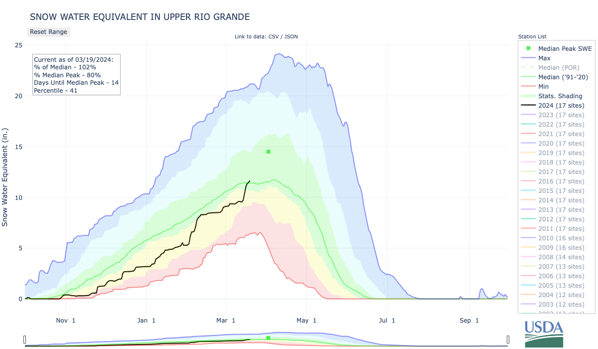
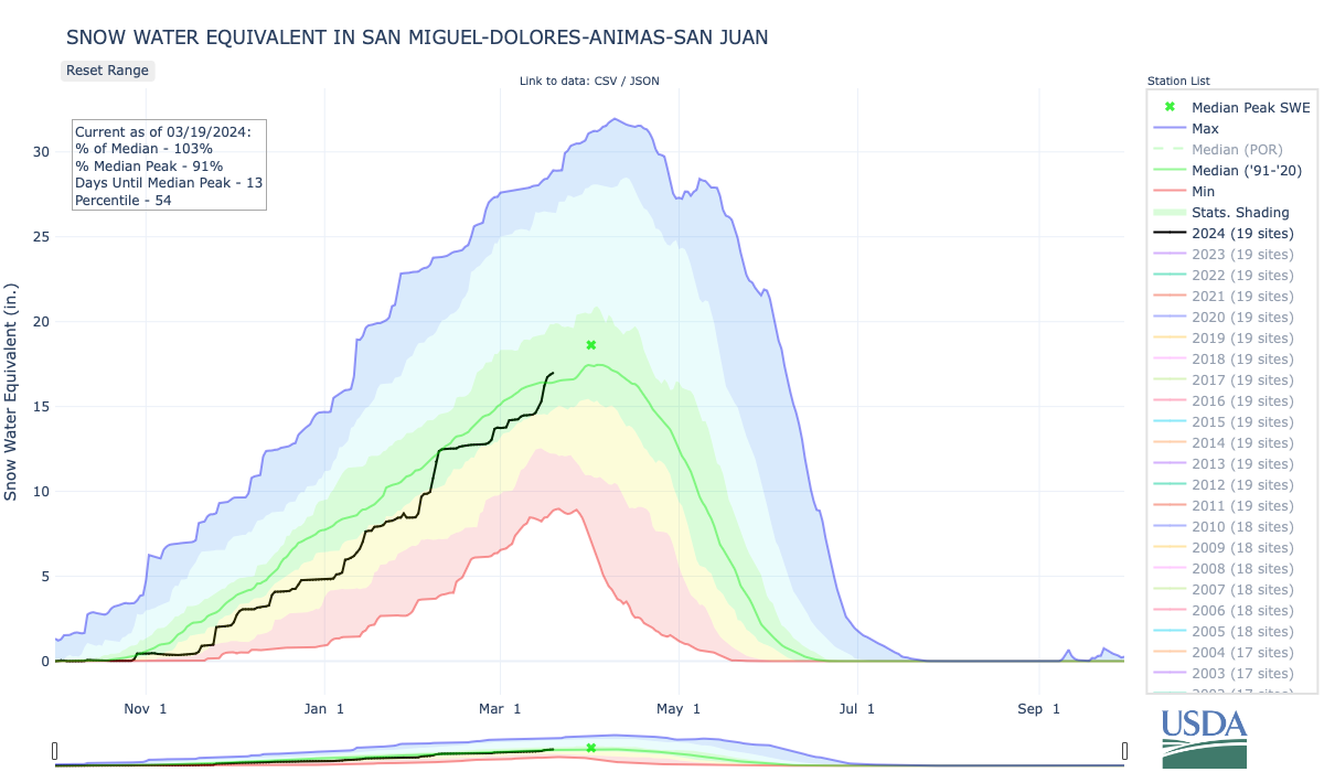

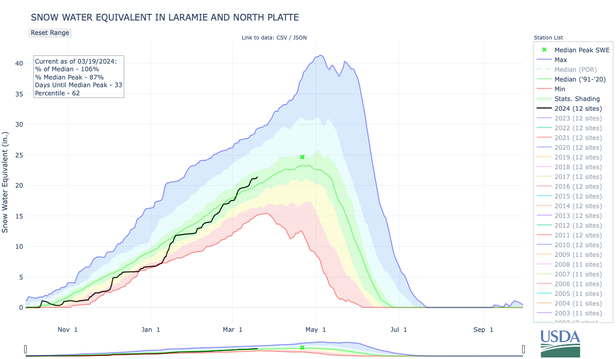
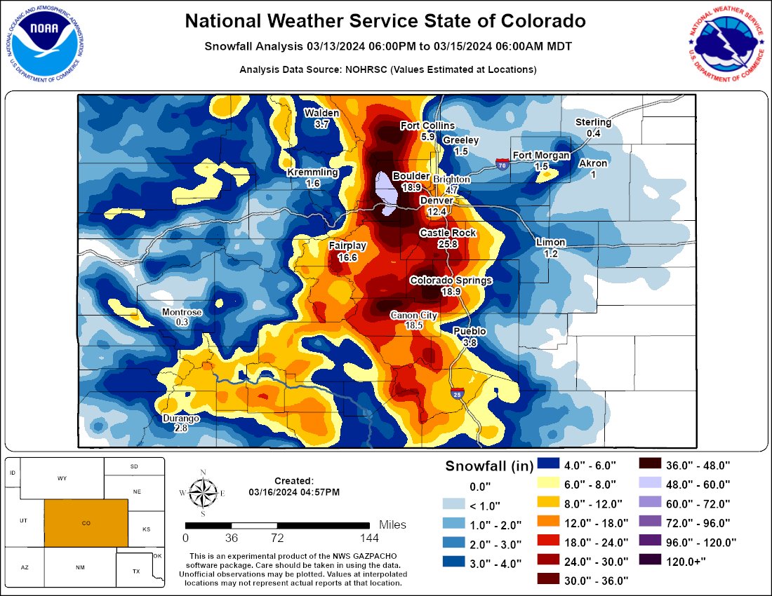
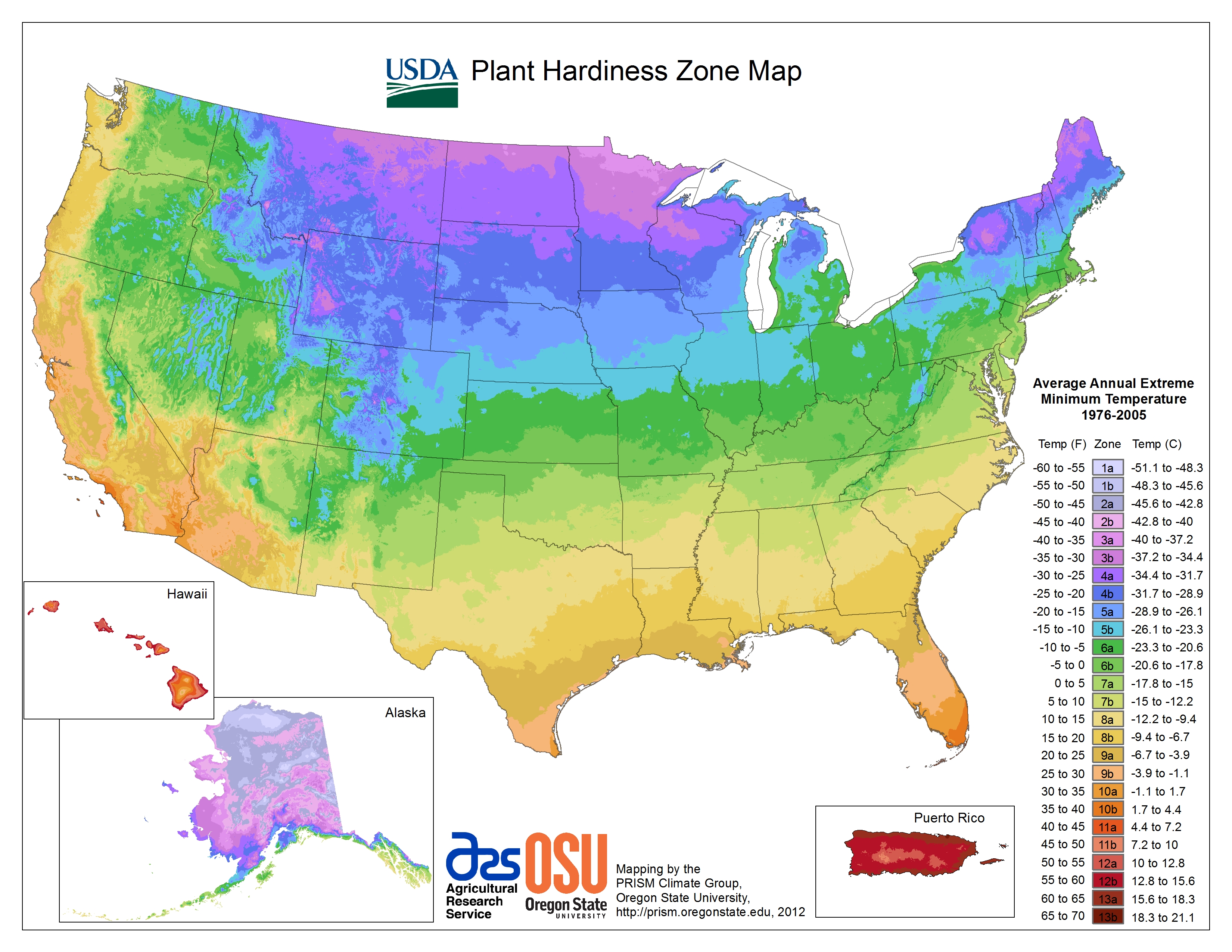