#Drought news April 25, 2024: According to the NRCS SNOTEL network (4/23), region-level (2-digit HUCs) median SWE levels are as follows: Missouri 80%, California 95%, Great Basin 108%, Upper Colorado 87%, Lower Colorado 145%, Rio Grande 78%, and Arkansas-White-Red 79%

Click on a thumbnail graphic to view a gallery of drought data from the US Drought Monitor website.

Click the link to go to the US Drought Monitor website. Here’s an excerpt:

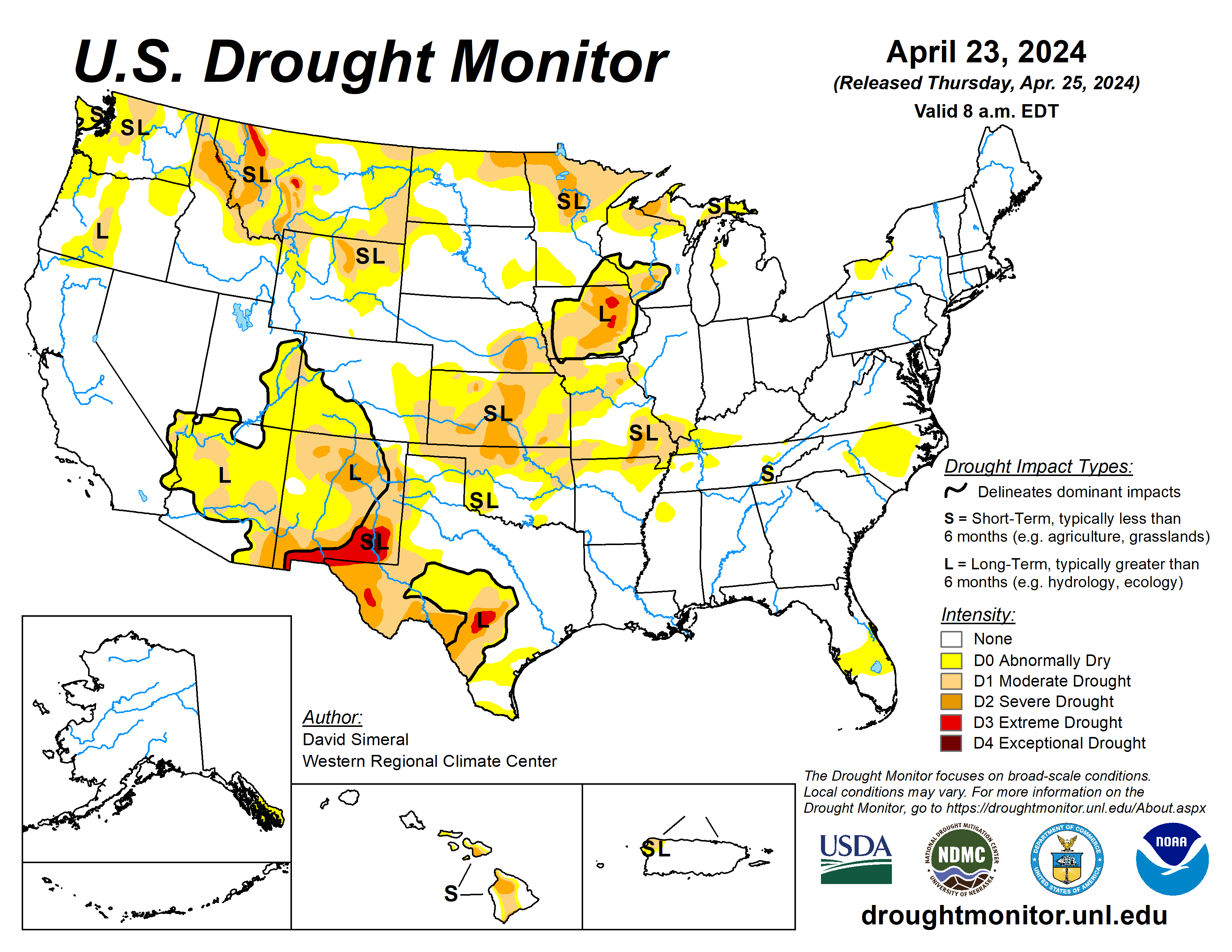
This Week’s Drought Summary

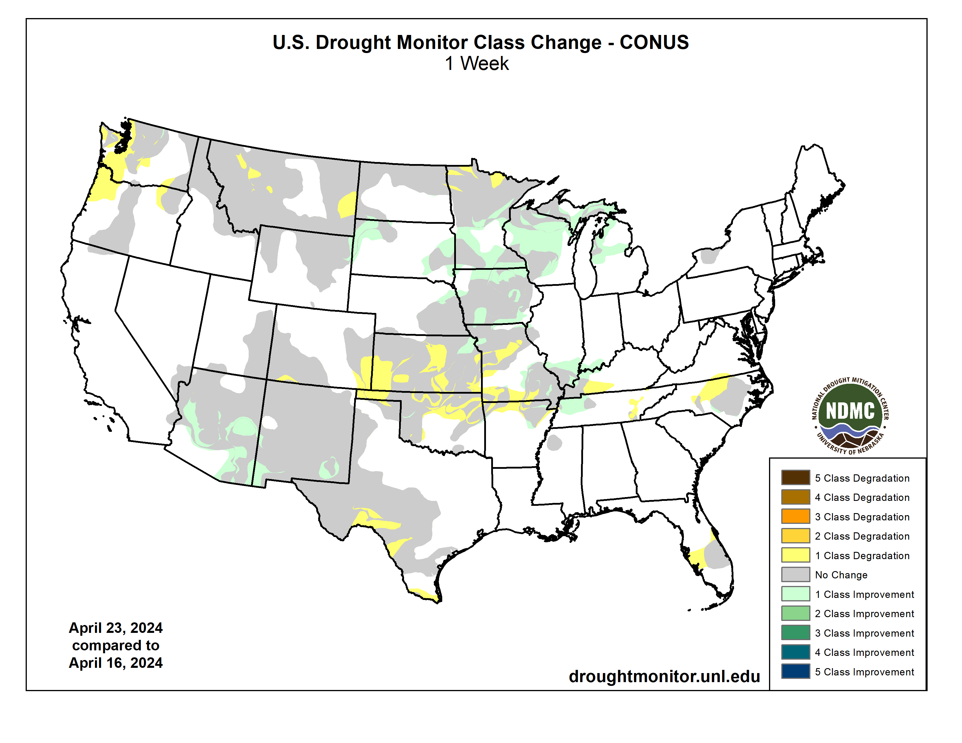
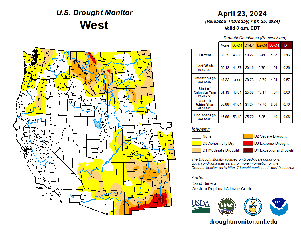
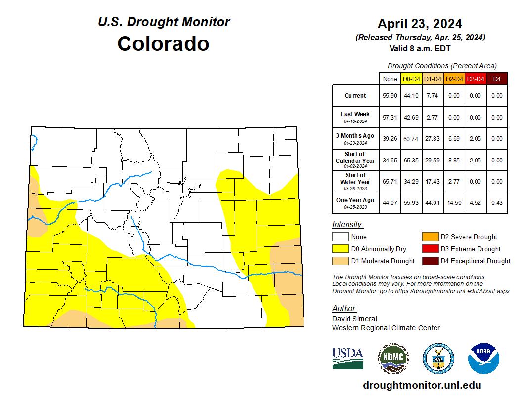
This U.S. Drought Monitor (USDM) week saw improvements on the map in drought-affected areas of the Southwest, Northern Plains, and the Midwest while conditions deteriorated in areas of the Pacific Northwest, Eastern Plains of Colorado and Montana, Southern Plains, and the South. In the Pacific Northwest, a combination of factors (below-normal snowpack conditions, short-term dryness, low streamflows) led to expansion of areas of Abnormally Dry (D0) and Moderate Drought (D1) in western portions of Oregon and Washington. In Montana, poor snowpack conditions in the northwestern and west-central part of the state led to expansion of areas of Extreme Drought (D3) where some SNOTEL stations were reporting record or near-record low snow-water equivalent (SWE) levels. In the Southern Plains, drier-than-normal conditions during the past 30-90-day period in addition to low streamflows, declining soil moisture, and impacts to crops led to expansion of areas of Moderate Drought (D1) and Severe Drought (D2) in Oklahoma and Kansas. Conversely, wetter-than-normal conditions have prevailed during the past 30-60 days in portions of the Midwest leading to widespread improvements across drought-affected areas of Iowa, Minnesota, Wisconsin, and Michigan. Likewise, improvements were made on the map in areas of the Southwest (Arizona and New Mexico) in response to beneficial precipitation received across much of the region since the beginning of the Calendar Year (January 1). In California, snowpack conditions moving into late April (4/24) were near normal levels with the statewide snowpack at 97% of normal, according to the California Department of Water Resources. Elsewhere in the West, below-normal SWE levels have persisted in the mountain ranges of Washington, northern Idaho, Montana, and northeastern Wyoming. According to the Natural Resources Conservation Service (NRCS) SNOTEL network (4/23), region-level (2-digit HUCs) median SWE levels are as follows: Pacific Northwest 75%, Souris-Red-Rainy 76%, Missouri 80%, California 95%, Great Basin 108%, Upper Colorado 87%, Lower Colorado 145%, Rio Grande 78%, and Arkansas-White-Red 79%…
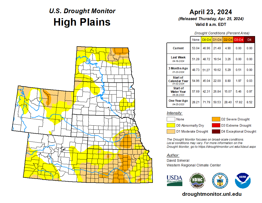
High Plains

On this week’s map, one-category degradations were made in Kansas where precipitation has been below normal during the past 90-day period with the greatest departures (4 to 5 inches) observed in south-central and eastern Kansas. Moreover, stream gages on numerous creeks and rivers in central and eastern Kansas were reporting much below-normal flows (< 10th percentile), according to the USGS. In terms of impacts, the USDA reported (4/21/24) that 26% of the winter wheat crop in Kansas was rated in poor to very poor condition. In addition to dry conditions, average temperatures across the Plains states have been well above normal levels (ranging from 4 to 8+ degrees F) during the past 90 days with the greatest anomalies observed in far eastern portions of the region. In North Dakota Climate Division 6 (East Central Division), the December-March period was the 2nd warmest on record with an +11.6 degrees F anomaly, according to NOAA NCEI. In northeastern Nebraska and northwestern South Dakota, shorter-term improvements in drought-related conditions led to reductions in areas of Abnormally Dry (D0) and Moderate Drought (D1). For the week, average temperatures were below normal (2 to 10+ degrees F) with the greatest departures observed in western portions of the Dakotas and Nebraska as well as along the eastern plains of Wyoming and Montana. Overall, the region was generally dry during the past week except for a few areas that benefitted from isolated shower activity in northeastern Kansas, north central and northeastern Nebraska, and southwestern South Dakota…

Colorado Drought Monitor one week change map ending April 23, 2024.

West

On the map, improvements were made across areas of central and southeastern Arizona and in southern New Mexico in response to a re-assessment of overall conditions looking at numerous drought metrics at various time scales. Since January 1, much of Arizona as well as western and northern portions of New Mexico have observed precipitation levels ranging from normal to well above normal. In contrast, below-normal precipitation has prevailed across much of eastern New Mexico. Looking at SWE levels (April 1) from the NRCS SNOTEL network, all basins (6-digit HUC) within Arizona and New Mexico were above normal. Elsewhere in the region, areas of Abnormally Dry (D0) were introduced in western Oregon and Washington in response to short-term dry conditions and very low streamflow levels that have significantly dipped in recent weeks. In Montana, poor snowpack conditions led to further degradations on the map…

South

In the South, light-to-moderate rainfall (up to 4 inches) was observed across isolated areas of the region during the past week with the heaviest accumulations logged in eastern Texas, northern Louisiana, southwestern Arkansas, and central Mississippi. For the week, average temperatures were near to slightly above normal in southern portions of Texas and Louisiana, while areas in the northern half of the region were generally cooler-than-normal (1 to 8 degrees F). On the map, conditions deteriorated in areas of the South Texas Plains and Edwards Plateau in response to a combination of factors including short-term dryness (past 30-90 days), low streamflows, declining soil moisture levels, and stressed vegetation. In terms of water supply, statewide reservoir conditions in Texas were at 73.9% full (4/24). However, some lingering low reservoir conditions are being reported in the western half of the state in the San Angelo and San Antonio areas, according to Water Data for Texas. In Oklahoma, dry conditions led to another round of degradations on the map across the northern portion of the state. According to the latest U.S. Department of Agriculture (USDA) Oklahoma Crop Progress and Condition report (4/21/24), the statewide soil moisture (topsoil) condition was rated 46% short to very short. In northwestern Tennessee, reductions in areas of Abnormally Dry (D0) and Moderate Drought (D1) were made in response to precipitation during the past 30-day period…

Looking Ahead

The NWS Weather Prediction Center (WPC) 7-Day Quantitative Precipitation Forecast (QPF) calls for moderate-to-heavy precipitation accumulations ranging from 2 to 5+ inches (liquid) across western Washington and Oregon as well as eastern portions of the Southern and Central Plains and lower Midwest. Lighter accumulations (< 2 inches) are expected in areas of the Central and Northern Rockies and Upper Midwest, while isolated light shower activity is expected in portions of Northern California, the Great Basin, and the Northeast. The NWS Climate Prediction Center (CPC) 6-10 Day Outlooks call for a moderate-to-high probability of above-normal temperatures across most of the conterminous U.S., with the exception of the Far West, and the western Great Basin where cooler-than-normal temperatures are expected. In Alaska, there is a low-to-moderate probability of above-normal temperatures in the southern half of the state and below-normal temperatures north of the Brooks Range. In terms of precipitation, below-normal precipitation is expected across the Eastern Tier of the conterminous U.S. as well as out West in western Colorado, Utah, and southern Nevada. Elsewhere, there is a high probability of above-normal precipitation across the Pacific Northwest, Northern California, eastern New Mexico, Texas, the Plains states, and the Upper Midwest.

US Drought Monitor one week change map ending April 23, 2024.

A flurry of public land protections: Biden’s rushing to get new rules in place, just in case … — Jonathan P. Thompson (LandDesk.org)

Beeweed and pumpjack. San Juan Basin, New Mexico. Jonathan P. Thompson photo.

Click the link to read the article on The Land Desk website (Jonathan P. Thompson):

The public lands beat has been rather busy, to put it mildly, as the Biden administration rushes to finalize rules, orders, and protections as soon as possible to make them less vulnerable to being rolled back if Biden were to lose in November to, ummm, a more hostile candidate. Maybe Biden’s also working to more clearly distinguish himself on environmental issues from Trump in advance of the election — as if the stark contrast isn’t abundantly clear already. 

So much has happened that I’ve fallen behind. So forget the pre-amble, let’s get to it:

In late March, the Bureau of Land Management finalized its methane waste prevention rule, which requires oil and gas operators on federal lands to find and repair leaks in their infrastructure and to phase out flaring and venting of methane — a.k.a. natural gas. The rules complement the EPA’s similar regulations finalized earlier this year. 

Methane is a potent greenhouse gas, having about 86 times the warming potential of carbon dioxide over the near-term (methane in the atmosphere breaks down into carbon dioxide and water over the long-term). While methane — which occurs alongside oil in underground reservoirs — can be captured and marketed as natural gas, oil drillers tend to vent or flare it and other associated gases, since it isn’t as profitable as oil.Ā 

Flaring and venting of methane and other gases shot up after horizontal drilling-multistage hydraulic fracturing opened up vast new stores of oil. Source: Bureau of Land Management.

Between 2010 and 2020, after the ā€œfrackingā€-enabled shale revolution got underway, oil and gas operations on federal and tribal land vented and flared an average of 44.2 billion cubic feet of methane annually. That’s as bad for the climate as burning around 9 million tons of coal. And since operators don’t pay royalties on gas they throw away,  that cost American taxpayers some $166 million in lost revenue over a decade. 

The rules look to rein that in by gradually decreasing the maximum amount of methane that can be flared or vented and charging royalties on the gases that are wasted. It is expected to slash greenhouse gas emissions and result in about $50 million annually in added royalty revenue.Ā 

Methane Madness: Part IJonathan P. Thompson

***

A few days later, the administration finalized its ban on new oil and gas leases and mining claims on about 220,000 acres along Western Colorado’s Thompson Divide. The protections cover a stretch of high-country BLM and USFS land between Glenwood Springs, Crested Butte, and Somerset. It does not affect valid, existing leases or claims. 

In the early 2000s an eclectic group of environmentalists, ranchers, and recreational users banded together to protect the Divide from the growing threat of oil and gas development. Their efforts goaded the feds to halt new development and cancel existing leases on much of the acreage, long before this spring’s move. Meanwhile, a similar uprising in the Crested Butte area blocked a proposed molybdenum mine on Mt. Emmons, or the Red Lady. 

The administration’s withdrawal bolsters these efforts and blocks new development for the next 20 years. By then, one would hope, the administration’s demand-side efforts to reduce fossil fuel consumption — including encouraging clean energy development and pushing zero-emission cars — will have kicked in.Ā 

***

And Biden and Interior Secretary Deb Haaland raised royalty rates and reclamation bonding amounts for oil and gas drilling on federal land. This one was a long-time coming. The previous 12.5% royalty rate has remained unchanged since Congress passed the Mineral Leasing Act in 1920. And oil and gas drillers have been getting away with posting bonds for all of their wells in a state that don’t get anywhere near covering the cost of cleaning up a single well. 

Environmentalists welcomed the reforms, but also criticized them for failing to address climate impacts of oil and gas development on public lands. Oh, and then there’s the thing about the faulty math: Mark Olalde and Nick Bowlin, for ProPublica and Capital & Main, found that even the new bonding amounts wouldn’t cover clean up. The problem? A BLM staffer miscalculated the cost to plug and reclaim a single well, and the inaccurate figure got incorporated into the analysis and final rule. Whoops. 

***

The administration blocked new oil and gas leases on 13 million acres of the National Petroleum Reserve-Alaska. That’s a huge amount of land and especially remarkable given that it’s in a petroleum reserve and it’s likely to result in some 50% less greenhouse gas emissions than Trump’s plan for the same area. Still, it may not be enough for the climate hawks who remain livid over the administration’s approval of a scaled-back, but still gargantuan, Willow (a.k.a. ā€œcarbon bombā€) drilling project in the reserve. Meanwhile, Biden’s Willow approval is not enough to soothe the anger of Alaska’s congressional delegation — including Democrat Rep. Mary Peltola — who blasted Biden for ignoring Alaska’s love for fossil fuels and called it an ā€œillegalā€ move that dealt a ā€œone-two punchā€ to the state’s economy. You just can’t win for losing, can you? 

***Ā 

Light and texture. Big Gypsum Valley, Colorado. Jonathan P. Thompson photo.

And last, but certainly not least: The Bureau of Land Management finalized its public lands rule, designed to put conservation on a par with oil and gas development, grazing, and other extractive uses.

The rule’s main provisions include:Ā 

  • It directs the agency to prioritize landscape health in all decision making, which is what it’s already supposed to do when assessing grazing allotments. It hasn’t done a very good job at that, so far.Ā 
  • It creates a mechanism for outside entities — states, tribes, or nonprofits — to lease public land for restoration projects — much as a rancher or oil and gas company might lease BLM land.Ā 
  • It allows firms to lease land for mitigation work to offset impacts from development elsewhere.Ā 
  • It clarifies the process for designating areas of critical environmental concern, or ACECs, where land managers can add extra regulations to protect cultural or natural resources.Ā 
  • And it directs the agency to incorporate Indigenous knowledge into decision-making, particularly when considering ACECs.Ā 

The rule is being hailed by conservationists as a ā€œgeneration-defining shiftā€ in public land management, and lambasted by Sagebrush Rebel-wannabes as a ā€œmisguided land grab meant to prevent oil and gas production … <and> … an attack on our ranchers and farmers that will end grazing on federal lands and will also prevent Coloradans from accessing their public lands.ā€ (A gold star to whoever guesses which MAGA-loving congress member made the latter grossly misinformed quote!).

Honestly, I’m not sure either side’s hoohas are warranted. It’s hard to see how a couple new leasing categories will be generation defining, I kinda doubt the rules will affect oil and gas production, and I’m absolutely certain they won’t end grazing or otherwise block access to public lands. 

The rule doesn’t add any new restrictions or put any land off-limits to development. It doesn’t give greens the power to kick a legitimate drilling, mining or grazing operation off public land to do a restoration or mitigation project. The mitigation leases could actually facilitate energy development. As for grazing, the Biden administration has indicated it considers ranching to be a type of land conservation, a theory that is manifested in the BLM’s policy of veering away from public lands grazing reform. Grazing is allowed in most ACECs. And the agency just set the 2024 grazing fee at $1.35 per animal unit month, the minimum Congress allows. I think the cows and their ranchers will be just fine under this new rule.

It seems to me that this rule’s provisions are fairly open to interpretation. That means the actual implementation — and how it plays out on the ground — will depend largely on BLM state, regional, and field-office managers. And those local-level bureaucrats can be swayed by the prevailing attitudes of the communities where they live and work, and by pressure from local or state officials.Ā 

In the end, the rule is essentially a reminder to the BLM that their job is not just to bend over for corporate and extractive interests, but to actually care for the land that belongs to all Americans. It is simply reinforcing the multiple-use charge Congress set forth when it passed the Federal Lands Policy and Management Act back in 1976. It’s not that big of a deal. But then again, FLPMA helped spark the Sagebrush Rebellion in the late 1970s. So who knows what this rule might inspire now…

šŸ“ø Parting Shot šŸŽžļø

Eagles in a tree near Norwood, Colorado. Jonathan P. Thompson photo.