Assessing the U.S. Climate in March 2024 — NOAA

Click the link to read the article on the NOAA website:

April 8, 2024

Severe storms brought large hail and tornadoes to portions of the Midwest; blizzard buried parts of California under feet of snow

Key Points:

  • March 12–15 saw the most intense severe weather outbreak of the year through March 31 after powerful storms brought baseball-sized hail and more than 20 tornadoes to portions of the Midwest, resulting in significant damage and loss of life. 
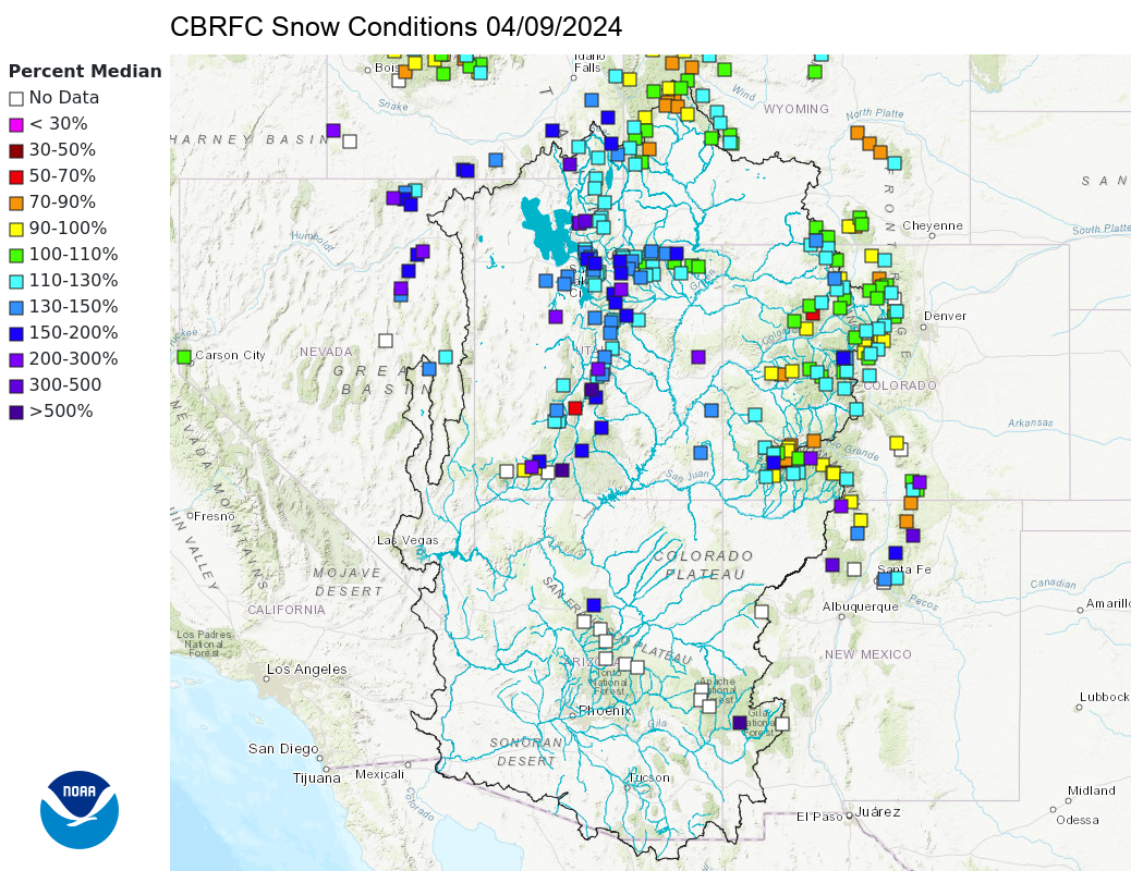
  • A blizzard blasted parts of California’s Sierra Nevada with gusts of up to 190 mph and more than 10 feet of snow at the beginning of March.
  • March 2024 was the 17th-warmest March on record for the nation and precipitation ranked in the wettest third of the historical record for the month.
     

Other Highlights: 

Temperature

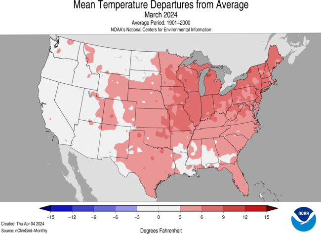
The average temperature of the contiguous U.S. in March was 45.1°F, 3.6°F above average, ranking 17th warmest in the 130-year record. March temperatures were above average across much of the contiguous U.S., while below-average temperatures were observed in small pockets of the West and Southwest.

The Alaska statewide March temperature was 14.1°F, 3.3°F above the long-term average, ranking in the warmest third of the 100-year period of record for the state. Above-average temperatures were observed across much of the state with near-normal temperatures in parts of the North Slope, Interior, Southwest and parts of the Aleutians and Panhandle.

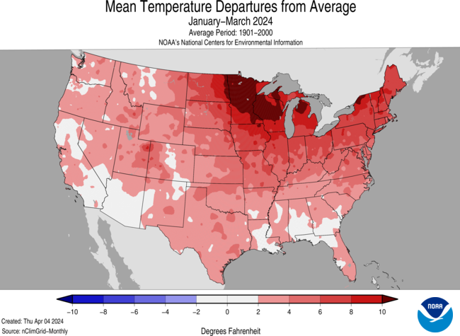
For January–March, the average contiguous U.S. temperature was 39.4°F, 4.2°F above average, ranking fifth warmest on record for this period. Temperatures were above average across most of the contiguous U.S., while record-warm temperatures were observed in parts of the Northeast. Wisconsin, Michigan, New York, Vermont, New Hampshire and Maine each ranked second warmest for the January–March period.

The Alaska January–March temperature was 9.4°F, 3.5°F above the long-term average, ranking in the warmest third of the historical record for the state. Much of the state was above normal for the three-month period while temperatures were near average across the eastern portions of the state and in parts of the Aleutians and Panhandle.

Precipitation

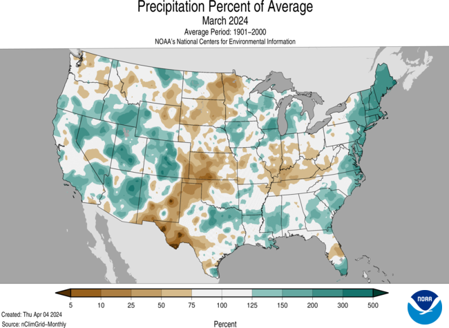
March precipitation for the contiguous U.S. was 2.85 inches, 0.34 inch above average, ranking in the wettest third of the historical record. Precipitation was above average across much of the West, in the Great Lakes and along the Gulf and East coasts and in parts of the northern Plains. Conversely, precipitation was below normal across much of the Ohio Valley, the Plains, and in parts of the Northwest and Florida. Maine and Rhode Island each had their second-wettest March on record.

Alaska’s average monthly precipitation ranked in the middle third of the historical record. Precipitation was above average in parts of the North Slope, West Coast and Southeast, while below-normal precipitation was observed in parts of the central Interior, south-central Alaska and in parts of the Panhandle during the month.

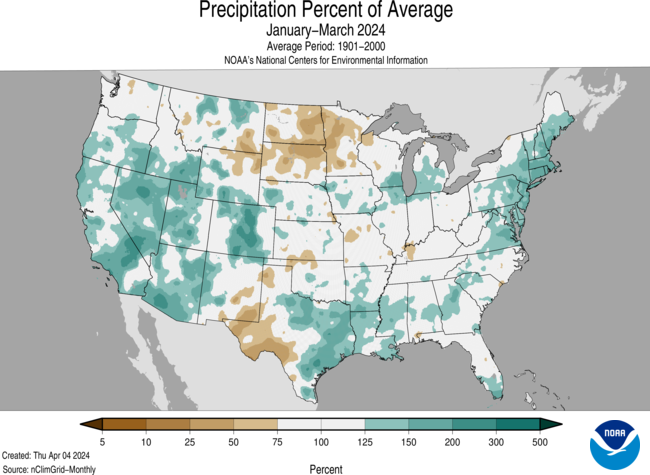
The January–March precipitation total for the contiguous U.S. was 8.15 inches, 1.19 inches above average, ranking 10th wettest in the 130-year record. Precipitation was above average across much of the contiguous U.S., with Rhode Island having its second-wettest year-to-date period on record. Conversely, precipitation was below average across much of the northern Plains and in small parts of the Northwest, central and southern Plains, Ohio Valley and Southeast during the January–March period.

The January–March precipitation for Alaska ranked in the wettest third of the 100-year record, with above-average precipitation observed in parts of the North Slope, West Coast and Southeast, while below-normal precipitation was observed in parts of the central Interior and south-central Alaska, as well as southern portions of the Panhandle during this period.

A map of the U.S. plotted with significant climate events that occurred during March 2024. Please see the story below as well as more details in the report summary from NOAA NCEI at http://bit.ly/USClimate202403 offsite link. (Image credit: NOAA/NCEI)

Billion-Dollar Disasters

One new billion-dollar weather and climate disaster was confirmed in March 2024 after a severe weather event impacted the central and southern U.S. during mid-March, with the most severe weather occurring on March 13–15. 
The U.S. has sustained 378 separate weather and climate disasters since 1980 where overall damages/costs reached or exceeded $1 billion (including CPI adjustment to 2024). The total cost of these 378 events exceeds $2.675 trillion.

Other Notable Events

Five wildfires, including the Smokehouse Creek wildfire, were finally contained in the Texas Panhandle, the largest cattle-producing region in the world. The wildfires resulted in approximately 1.1 million acres scorched, hundreds of destroyed structures, hundreds of miles of ruined fencing and more than 7,000 dead cattle.

Winter did not bring heavy snowfall to Wisconsin nor the temperatures necessary to maintain the snow, allowing fires to begin early and in high numbers. Between January–March 2024, there have been more than 220 fires across Wisconsin.
A 5.25-inch diameter hail stone fell in Ada, Oklahoma on March 14, which is the largest stone reported in Pontotoc County since 1950, as well as the largest to fall in the state in nearly 13 years.

A state of emergency was declared for Ohio as several tornadoes struck the state, resulting in 3 fatalities on March 14 when an EF-3 tornado crossed Auglaize and Logan Counties.

US Drought Monitor map April 2, 2024.

Drought

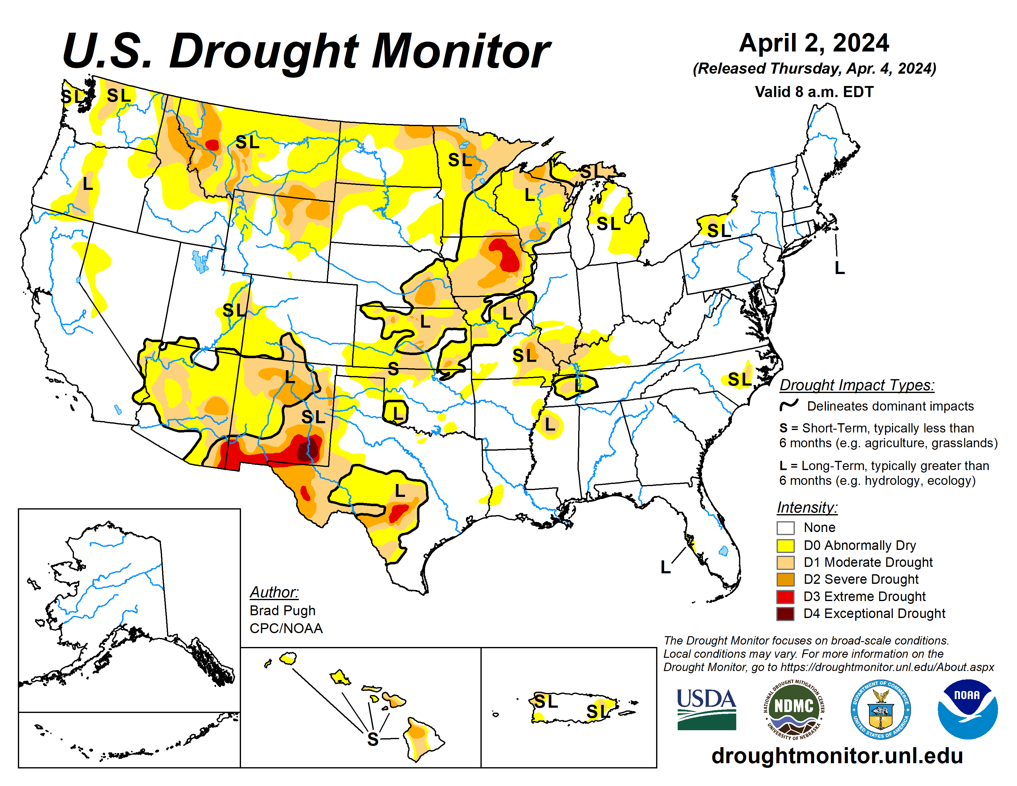
According to the April 2 U.S. Drought Monitor report, about 18% of the contiguous U.S. was in drought, down about 3.6% from the end of February. Drought conditions expanded or intensified in portions of the Plains and in parts of the Northwest, central Mississippi Valley, northern Great Lakes and Hawaii this month. Drought contracted or was reduced in intensity across much of the Mississippi Valley, Puerto Rico and the West, and in parts of the Plains, Great Lakes and Carolinas.

Monthly Outlook

Above-average temperatures are favored to impact much of the central U.S., Northwest and Northeast in April while above-average precipitation is likely from much of the Plains to parts of the East Coast and in much of the Southwest. Drought is likely to persist along portions of the Northern Tier, the Southwest, Hawaii and Puerto Rico. Visit the Climate Prediction Center’s Official 30-Day Forecasts and U.S. Monthly Drought Outlook website for more details.

Significant wildland fire potential for April is above normal across much of the Upper Midwest and in parts of the central and southern Plains. For additional information on wildland fire potential, visit the National Interagency Fire Center’s One-Month Wildland Fire Outlook.


This monthly summary from NOAA’s National Centers for Environmental Information is part of the suite of climate services NOAA provides to government, business, academia and the public to support informed decision-making. For more detailed climate information, check out our comprehensive March 2024 U.S. Climate Report scheduled for release on April 11, 2024. For additional information on the statistics provided here, visit the Climate at a Glanceand National Maps webpages.

Colorado River states get a wet winter, but Lake Powell will get below-average runoff, forecast says: Colorado River forecasters released new data for the reservoir on Friday [April 5, 2024] — The Salt Lake Tribune #COriver #aridification

Colorado River Basin snow conditions April 9, 2024. Credit: Colorado Basin River Forecast Center

Click the link to read the article on The Salt Lake Tribune website (Anastasia Hufham). Here’s an excerpt:

April 8, 2024

The National Weather Service Colorado Basin River Forecast Center on Friday estimated that Lake Powell will receive 5.7 million acre-feet of water between April and July as snow melts off the mountains…That volume is 89% of the normal runoff for that time period recorded between 1991 and 2020…

Three factors determine how much water ends up in Lake Powell: the amount of snowpack on Western mountains, spring temperatures (warmer weather can cause snow to melt faster) and soil moisture (dry soil absorbs melting snow, leaving less water for reservoirs)…Snowpack jumped in March throughout the Upper Colorado River Basin, the portion of the river basin that lies above Lake Powell and includes Colorado, New Mexico, Utah and Wyoming…

(Colorado Basin River Forecast Center) This graph depicts snowpack in the Upper Colorado River Basin, which includes Colorado, Utah, New Mexico and Wyoming. SWE stands for snow water equivalent, which is the measure of how much water is in snow. As of April 1, snow water equivalent in the Upper Basin is 113% of the median snow water equivalent recorded between 1991 and 2020.

Last month, the Upper Basin saw 130% of average precipitation, bringing precipitation above Lake Powell to 102% of average for October 2023 through March 2024. But an above-average year for snow doesn’t guarantee an above-average runoff, given the forecast of warm spring temperatures and dry soil conditions. Right now, forecasters say, soil moisture across the entire Colorado River Basin — which includes Arizona, California and Nevada as the Lower Basin — is close to below normal. Soil moisture is better in the Upper Basin than in the Lower Basin. When forecasting how much water Lake Powell will get, hydrologists release three possible scenarios. On Friday, forecasters reported that there is a 10% chance that the reservoir could receive as much as 8.3 million acre-feet of water or more from April through July. In a drier scenario, there is a 10% chance that runoff could drop to 4.4 million acre-feet of water or below. The most likely case is that Lake Powell sees about 5.7 million acre-feet of water.

This new proposal for #ColoradoRiver sharing prioritizes the environment — KUNC

A bird perches upon towering mud banks left behind by a shrinking Lake Powell on July 5, 2022. A new proposal for managing the Colorado River and its reservoirs encourages states to include environmental protections as they draw up water sharing plans. Photo credit: Alex Hager/KUNC

Click the link to read the article on the KUNC website (Alex Hager):

This story is part of ongoing coverage of the Colorado River, produced by KUNC and supported by the Walton Family Foundation. It was produced in partnership with The Water Desk, an independent initiative of the University of Colorado Boulder’s Center for Environmental Journalism.

April 1, 2024

A coalition of environmental groups is proposing a new set of rules for managing the Colorado River after 2026, when the current guidelines expire. Their proposal, which aims to weave environmental protections into river management policy, comes amid heated negotiations about how the shrinking river should be shared in the future.

In March, the seven states which use the river found themselves divided into two camps, each faction publishing its own proposal for managing water. The two groups have promised to work towards consensus and are aiming to agree on a singular plan before 2026. The authors of the new environmentally-focused proposal — a group of seven conservation nonprofits — say they don’t expect their own plan will be adopted in full, but hope to encourage state and federal water managers to consider plants, animals and ecosystems while drawing up their own Colorado River policies.

“If you integrate these ideas into those annual operations, you can have your water security — which the states want — but then you also get these environmental benefits that make sure that you do have a healthy flowing river that is the foundation for the entire system,” said John Berggren, a water policy expert at Western Resource Advocates, one of the conservation groups that co-signed the proposal.

All seven of the organizations that crafted the river management proposal receive funding from the Walton Family Foundation, which also supports KUNC’s Colorado River coverage.

“New plot using the nClimGrid data, which is a better source than PRISM for long-term trends. Of course, the combined reservoir contents increase from last year, but the increase is less than 2011 and looks puny compared to the ‘hole’ in the reservoirs. The blue Loess lines subtly change. Last year those lines ended pointing downwards. This year they end flat-ish. 2023 temps were still above the 20th century average, although close. Another interesting aspect is that the 20C Mean and 21C Mean lines on the individual plots really don’t change much. Finally, the 2023 Natural Flows are almost exactly equal to 2019. (17.678 maf vs 17.672 maf). For all the hoopla about how this was record-setting year, the fact is that this year was significantly less than 2011 (20.159 maf) and no different than 2019” — Brad Udall

Current negotiations about how to share the Colorado River are driven by one defining fact: The water supply for 40 million people across the Southwest is shrinking due to climate change. Talks about how to rein in demand accordingly have been contentious since states are reluctant to cut into water supply for the cities, farms and ranches within their borders.

Fish biologist Dale Ryden holds a razorback sucker on Jan. 26, 2024. The native fish species is one of many in the Colorado River protected by the Endangered Species Act. Photo credit: Alex Hager/KUNC

The “Cooperative Conservation Alternative,” as dubbed by the environmental proposal’s authors, offers a series of ideas on how to make sure decisions about the water supply for people and businesses don’t leave the environment behind.

The first idea outlined in the proposal is the implementation of a new way of measuring how much water is stored in reservoirs along the Colorado River, with water releases adjusted accordingly. Among other tweaks to measuring reservoir storage, the proposal suggests adjusting reservoir releases according to recent trends in climate conditions. For example, the new method would take into account snowmelt lost to dry, thirsty soilswhen determining release levels following particularly dry years.

The environmental groups also want to see fish habitats considered as a factor when determining how much water is released from major reservoirs. The proposal cites the health of aquatic ecosystems in the Grand Canyon, where native fish are threatened by predatory invasive species that have been able to travel downstream due to dropping water levels in Lake Powell – the nation’s second largest reservoir.

The proposal also suggests the creation of a “Conservation Reserve,” a program that would allow water users to store some of their supply in major reservoirs. That stored water would be used to help avoid low reservoir levels that could damage infrastructure– including hydropower generators – but would not be counted when determining how much water is released from major reservoirs in a given year. The “Conservation Reserve” would replace the existing “Intentionally Created Surplus” program.

The conservation groups say the ideas in their proposal are designed to benefit the environment, but shouldn’t be seen as objectionable by the water users along the Colorado River or the states which ultimately have the most say in the river’s fate.

“That water supply is available to all of us because of the function of the river as an ecosystem itself,” said Jennifer Pitt, Colorado River program director at the National Audubon Society. “If we ignore that entirely, and the system that sustains that functioning waterway erodes and breaks down, we may lose some of its ability to deliver us water in the first place.”

Pitt also said more robust ecosystem protections can occasionally help water users stay in legal compliance with environmental rules. There are 27 species covered by the Endangered Species Act in the lower Colorado River basin, and water users can face penalties if they’re unable to leave enough water in the river to maintain healthy habitatsfor those protected species.

A toad climbs a rock in a canyon near Lake Powell on July 6, 2022. The authors of a new proposal to protect ecosystems along the Colorado River said a healthy flowing river would benefit human water users as well as plants and animals. Photo credit: Alex Hager/KUNC

The environmental proposal joins prior suggestions from the Colorado River’s upper basin states of Colorado, Utah, Wyoming and New Mexico, and a competing proposal from the lower basin states of California, Arizona and Nevada.

Native America in the Colorado River Basin. Credit: USBR

A number of the 30 federally-recognized Native American tribes that use the Colorado River may also be working on water management proposals. The Gila River Indian Community in Arizona, which has positioned itself as a major tribal player in water management talks, said it did not support the lower basin states’ plan released in March and will soon release its own suggestions for managing the river.

A separate group of 16 tribes sent a letter to the Bureau of Reclamation – the federal agency that manages Western dams and reservoirs – outlining a series of “principles” the tribes want to see reflected in final Colorado River management plans.

While the current rules for sharing the river are set to expire in 2026, the Biden administration’s water officials want to arrive at a final set of replacement rules by the end of 2024 to avoid any complication that could come from a change in presidential administration after the November election.

Map credit: AGU

#GrandJunction commits $1 million to Shoshone water right purchase — The Grand Junction Daily Sentinel #ColoradoRiver #COriver #aridification

Shoshone Falls hydroelectric generation station via USGenWeb

Click the link to read the article on The Grand Junction Daily Sentinel website (Sam Klomhaus). Here’s an excerpt:

April 5, 2024

“The idea that we would allow this archaic little water right to disappear and watch it get siphoned off to benefit someone else’s future is really hard to take if you live and thrive here in Western Colorado.” — Colorado River District General Manager Andy Mueller

The city of Grand Junction became the latest entity to contribute to an effort to preserve a senior water right on the Colorado River Wednesday after City Council voted unanimously to pledge $1 million to the cause. The water right is from the Shoshone power plant in Glenwood Canyon, and provides 1,250 cubic feet per second under the senior right, and 158 cubic feet per second under the junior water right.

“It’s one of the oldest, largest rights on the Colorado River within our state,” said Colorado River District General Manager Andy Mueller said at Wednesday’s meeting. “It’s very unique in that it’s a non-consumptive water right built and first decreed in 1902 to generate hydroelectic power.”

In December, Xcel Energy and the river district agreed on a sale of the water rights for $99 million…Mueller said communities have relied on this water right for recreation, agriculture and development.

Global temperature is now hotter than any time in the Holocene – the entire history of human civilization — Stefan Rahmstorf (@rahmstorf) #ActOnCLimate

Credit: Stefan Rahmstorf

#RoaringForkRiver beavers underutilizing landscape, says U.S. Forest Service — The #Aspen Times

The White River National Forest hired two interns with funds from Pitkin County Healthy Rivers and Streams to study beaver utilization of Roaring Fork Watershed headwaters. U.S. Forest Service/Courtesy photo

Click the link to read the article on The Aspen Times website (Josie Taris). Here’s an excerpt:

April 7, 2024

The White River National Forest and Pitkin County Health Rivers and Streams gathered habitat data on the native keystone species in the Roaring Fork watershed throughout the summer of 2023. 

“We didn’t have a huge sample size, but we feel like we learned enough to take some stabs at things. My impression is that there is some greater capacity on the landscape than what we have at the moment,” said Clay Ramey, a wildlife biologist with the U.S. Forest Service (USFS). “And there are places on the landscape that we might be able to make a little better by putting posts or BDAs, or structures in the creek, that beavers can glom on to, we could put beavers in those places and they might be likely to do well.”

[…]

At the random sites, they identified 47 dams and 6 lodges. Only about half, 53 sites, showed signs of current or past beaver utilization, through damns, chewed trees, and other evidence. The team concluded that the dispersion of beavers in the subwatersheds was wide and sparse.  Vegetation at the sites varied if the site was occupied or unoccupied by beavers. Aspens, willows, and cottonwoods were prevalent on occupied sites. Conifers were more prevalent on unoccupied sites…Occupied sites were flatter with wider banks, flatter slopes, and lower elevation, but Ramey said that these high-elevation beavers did not always avoid high elevation…

[Lisa] Tasker and Ramsey said that a long-term goal of this study is to help the public learn to live among beavers, while also identifying potential relocation spots as necessary.