Click the link to read the article on the NOAA website (Tom Di Liberto):
February 27, 2025
…we’ve discussed ad nauseum how complicated El Niño and La Niña are, and how difficult it is to forecast all of the ENSO nuances. Heck, I even wrote a three–partseries 75 years ago that evaluated all of our seasonal forecasts (ok, it was 2014-2015 but it still feels that long ago). In a new paper, Azhar Ehsan, friend of the blog and a member of NOAA’s ENSO forecast team, and colleagues analyzed over 20 years’ worth of climate model forecasts of ENSO and found some interesting results.
Why is this paper unique? Well, most seasonal forecasting evaluations focus on model hindcasts, which are forecasts run using past observational data as the start (or initial) condition. For example, if the models are provided the initial conditions on July 1st, 1983, what forecast would it have made? The nice thing about running on past data is that you already know what occurred and can immediately see how well the forecast did. The downside is that sometimes the model development itself can be influenced by this past data. The purest test for models is how well they do in the future, on data that the model has never ever seen. This type of evaluation on “real-time forecasts” is much rarer, and is exactly what Azhar and his co-authors did.
ENSO Terms and conditions
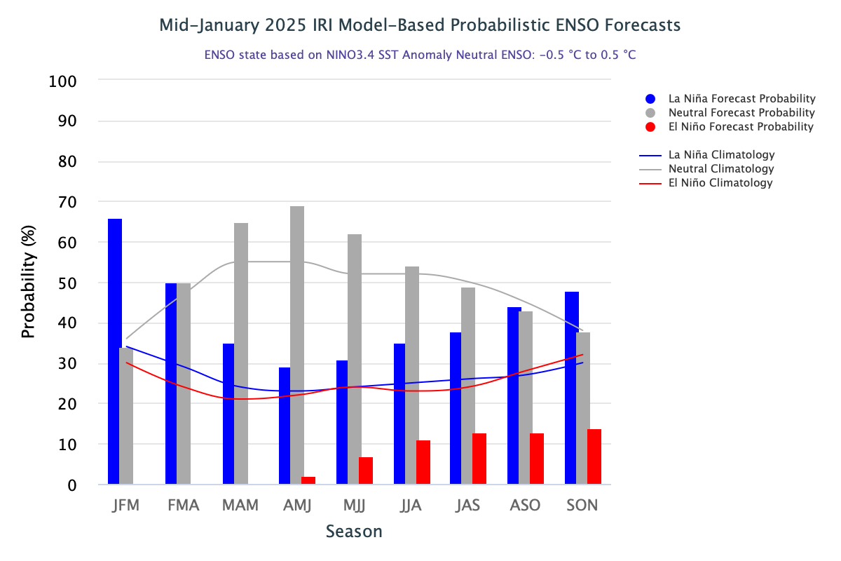
La Niña and El Niño make up the El Niño/Southern Oscillation, or ENSO. La Niña is characterized by cooler-than-average sea surface temperatures across the central and eastern tropical Pacific Ocean. El Niño is the opposite phase, with warmer-than-average water present across the tropical Pacific Ocean. These changes in sea surface temperature across the Pacific jumble up the atmosphere above which can lead to global impacts on climate patterns. Seems pretty important, right? And unlike most other climate phenomena, the state of ENSO can be forecast months in advance, giving communities time to prepare.
Tell me about that sweet, sweet data
Let me paint you a picture. It’s February 2002. Crossroads starring Britney Spears has just come out, while Ja Rule and Nickelback are burning up the music charts. At Columbia University’s International Research Institute for Climate and Society (IRI), a plucky group of scientists has begun issuing ENSO forecasts. That effort has now become the world’s longest archive of real-time monthly ENSO forecasts from modeling groups across the globe. The list of forecast contributors has continued to grow since 2002, and the tally of the treasure trove of climate model data currently stands at 28 different climate models.
Why so many? No single model forecast is ever going to be exactly correct all the time. To get a sense of the range of potential outcomes, it’s important to not only have a bunch of forecasts using the same climate model due to the chaos of climate but also forecasts from a bunch of different models due to the idiosyncrasies of each individual (we call these combined bunches multi-model ensembles). A well-constructed forecast ensemble won’t tell you precisely what outcome to expect, but it will tell you how much the odds are tilted toward one outcome or the other (i.e., probabilities).
The model forecasts can be split into two types, dynamical and statistical. Dynamical models refer to models which take observational data to simulate earth’s future climate by using equations that represent our best understanding of the laws of physics (e.g., like the computer climate models that make up the North American Multi-Model Ensemble, or NMME, that are frequently featured in this blog). Statistical models, on the other hand, use the historical relationships between ENSO and other climate variables from the observational record and then use these relationships to make predictions for the current situation.
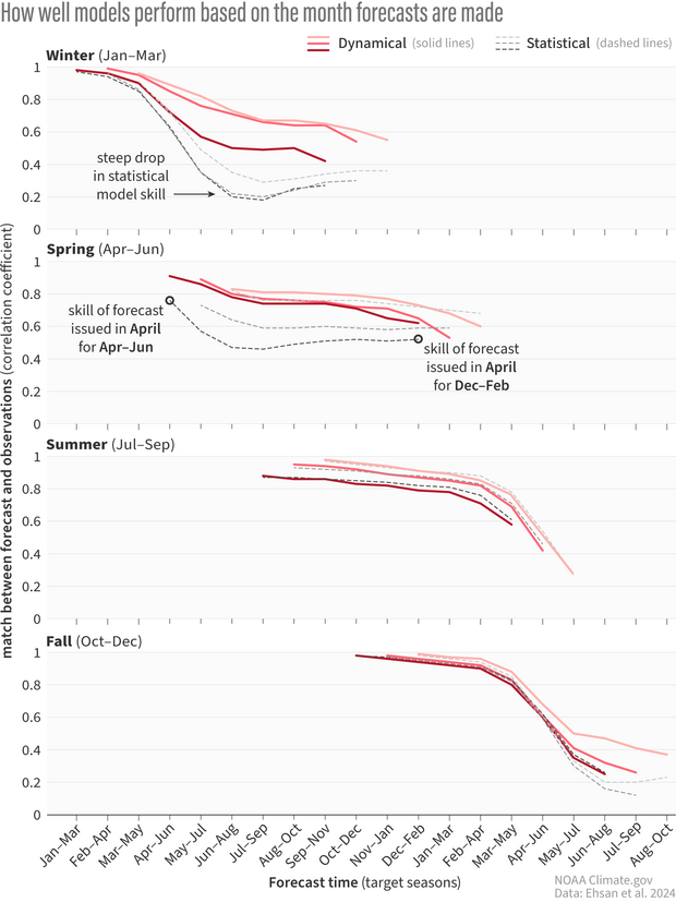
A stacked graph showing the correlation coefficient, or the match between the forecast and observations, of climate model forecasts for nine consecutive three-month periods starting from the month the forecast was issued. One means a perfect match, and zero is the complete opposite. Red lines refer to dynamical models while black dotted lines are statistical models. Each of the four graphs represents forecasts made during months in different seasons. The darkness of the line represents which month the forecast is from, with the darkest lines being the last month in the marked season. In winter, statistical model skill falls rapidly by the spring, while dynamical models don’t exhibit nearly as much decline in skill. Forecasts made in spring and summer show similar skill between statistical and dynamical models. Climate.gov image adapted from Ehsan et al., 2024.
How did the models do?
By analyzing all model forecasts of the seasonal (three-month) Niño-3.4 index from 2002 through 2023, Azhar and his co-authors discovered some interesting patterns. First, it was clear that there was a decent amount of variation in how well both the dynamical and statistical models performed given both when the forecast was made and what season was targeted. From past ENSO blog posts (here, here, and here), we know that the model skill for forecasts made during the spring predictability barrier—a time where models do particularly poorly in forecasting the fall/winter state of ENSO—is not great. But even then, the skill of statistical model forecasts issued just before and during the spring fell off a cliff for target months in early summer and beyond, much more so than dynamical models. However, the skill of statistical and dynamical model forecasts issued in summer and fall were comparable for all times in the future.
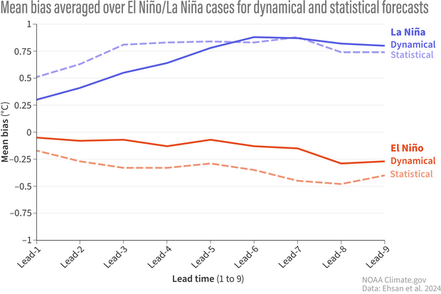
The mean bias of climate model forecasts averaged over El Nino (red) and La Nina (blue) events for each lead time, which refers to the three-month period forecasted. Solid lines are dynamical model forecasts, and dotted lines are statistical models. Overall, models have less bias when predicting El Nino than La Nina. And dynamical models have less bias in general compared to statistical models. Climate.gov image adapted from Ehsan et al., 2024.
Second, there were differences in model performance for predicting El Niño versus predicting La Niña. Overall, models had greater skill in predicting El Niño, compared to La Niña, no matter when the forecast was made, whether it was one month or nine months prior. Dynamical models also outperformed the statistical models in forecasting El Niño at all lead times, and for La Niña for short time horizons. For forecasts of La Niña made five or more seasons out, both statistical and dynamical models performed comparably (and not very well).
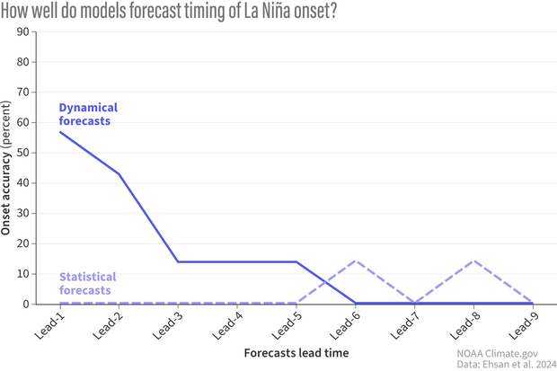
How often (percent) real-time climate model forecasts correctly predict the onset of El Nino (3-month average Nino3.4 values less than or equal to -0.5C) at increasingly far-off lead times. Solid lines represent the multi-model mean of dynamical models. Dotted lines are the multi-model mean of the statistical models. After the first three forecasted seasons, accuracy plummets below 20% in dynamical models. Statistical model accuracy is 0 for most leads except leads 6 and 8. This does not imply that statistical models have more “skill” at these leads as, given the variability in ENSO events and in model forecasts, it is probabilistically likely that models will occasionally correctly predict the onset by chance. Climate.gov image adapted from Ehsan et al., 2024.
Can someone tell me when this El Niño or La Niña turns on?
It’s one thing to predict the strength of an El Niño or La Niña event when its already at its peak and mature, and quite another challenge to correctly predict whenan event begins. And one rather interesting finding falls right in line with what we’ve observed so far during the current La Niña.
How often (percent) real-time climate model forecasts correctly predict the onset of El Nino (3-month average Nino3.4 values greater than or equal to 0.5C) at increasingly far-off lead times. Solid lines are the multi-model mean of dynamical model forecasts. Dotted lines are the multi-model mean of statistical model forecasts. Dynamical models have excellent accuracy at predicting the onset through the first three seasonal lead times before dropping to 30-40% accuracy from lead-4 onwards. Statistical models show less accuracy overall. Climate.gov image adapted from Ehsan et al., 2024.
Azhar and his team found that dynamical models are excellent at predicting the start of El Niño events up to a three-month lead (they are accurate more than ~60% of the time). But for La Niña, yikes. Dynamical models are ok for onset predictions two seasons in the future (40-60% accurate), but after that the accuracy drops to 20% and then to 0 (Footnote 1). Meanwhile, the less I say about statistical models predicting the onset of El Niño and La Niña, the better. Suffice to say, they’re not great.
Remember this analysis did not include 2024. So, the incredibly delayed start to the current La Niña, one that many models missed, was not in this analysis.
Caveats
When it comes to science, usually it’s easier to find the patterns then to determine exactly why those patterns exist. Azhar and his fellow authors shared some potential explanations but solid conclusions will need additional research.
Why is there a difference in skill between dynamical and statistical models? Dynamical models have seen a rapid evolution from 2002 to now. Advancements in computer resources, better observations, and a more complete understanding of our atmosphere and ocean have not just improved existing models but have led to an increase in the number of dynamical models over time. The number of statistical models has remained roughly the same. Though, over the last couple of years, the numbers have been increasing (Footnote 2).
So, why bother including statistical models? For one, statistical models serve as a valuable benchmark to measure more complicated models against. Two, they are much cheaper and thus faster to run. And three, unlike dynamical models where the factors that are driving a certain ENSO forecast may be too mixed together and unclear, statistical models with their simplicity can sometimes allow forecasters to unpack what factors are driving the forecast.
Of course, one major caveat here is that this analysis only looks at a small amount of ENSO events. Nevertheless, some conclusions are clear. Predicting the onset of an El Niño and La Niña event is hard. To which THIS ENSO forecaster (me) says “Tell me about it!”
Footnotes
1) Accuracy here is defined as the ratio of correctly forecasted ENSO onset times to the number of total episodes. A forecast is a “hit” if the forecasted Niño-3.4 index meets or exceeds the threshold for El Niño (+0.5°C) or La Niña events (-0.5°C) at the event onset. A 0% accuracy for a given lead time means that no model correctly forecast the onset of the event at that lead time.
2) There are new types of promising statistical models popping up that incorporate artificial intelligence and machine learning which have been added into the plume. Model evolution is not strictly the domain of dynamical models! Hopefully, additional statistical models can be incorporated into the IRI plume to potentially offer better real-time ENSO forecasts.
Photo credit: Colorado Department of Natural Resources
Click the link to read the release on the DNR website:
February 27, 2025
(DENVER) – Today, Governor Polis and the Colorado Department of Natural Resources (DNR) announced today $8.4 million through the Colorado Strategic Wildfire Action Program (COSWAP), which accelerates forest restoration and wildfire risk reduction through targeted projects that protect communities, watersheds and critical infrastructure.
This round includes 14 Workforce Development Grants to treat 1,045 acres of forested land and train over 150 wildfire mitigation individuals, and five Landscape Resilience Investments in partnership with the Colorado Water Conservation Board’s Wildfire Ready Watersheds(opens in new window) program to strategically support wildfire risk reduction and critical water infrastructure protection in high priority watersheds in targeted counties including in Garfield, Grand, Boulder, Jackson and Montezuma.
“Here in Colorado, no matter what happens in Washington DC, we are aggressively expanding fire prevention strategies that work, and that includes the Colorado Strategic Wildfire Action Program. This critical funding supports wildfire mitigation efforts across the state and helps Coloradans gain skills, and earn hands-on experience to become the next generation of well-equipped Colorado foresters,” said Governor Polis.
“This year, I am pleased we are able to provide significant new funding for on the ground hand crews and training and significant landscape scale projects to a wider range of Colorado communities for forest mitigation and watershed protection work,” said Dan Gibbs, Executive Director, Colorado Department of Natural Resources. Dan Gibbs. “Our COSWAP program rose up out of the devastating 2020 wildfire season and I am proud of the growth and innovation the program has shown. It provides essential on the ground funding to help protect lives, property and critical infrastructure while helping our communities become more resilient in the face of larger, more complex wildfires.”
COSWAP’s Workforce Development Grant is designed to reduce wildfire risk through entry-level training opportunities and hands-on experience. The mission of this program is strengthened by COSWAP’s partners at the Colorado Youth Corps Association (CYCA) and Department of Corrections’ State Wildland Inmate Fire Teams (DOC SWIFT) who offer the next generation of land stewards the skills, experience and career exposure to succeed in wildfire mitigation and forestry. Lt. Governor Dianne Primavera has been a leader in securing investments for CYCA and creating avenues so AmeriCorps members can gain skills to help better lead mitigation efforts in Colorado.
In this round of Workforce Development Grants, CYCA crews including Larimer County Conservation Corps, Rocky Mountain Youth Corps, Mile High Youth Corps and Southwest Conservation Corps received awards to complete six wildfire mitigation projects. Similarly, the DOC SWIFT crews will work on three projects. The remaining five workforce development awards will go towards training individuals in basic wildland firefighting and chainsaw operations.
“COSWAP is a transformational program in Colorado. Not only does it protect the lives and livelihoods of millions of Coloradans, it also unites people through service to their communities. This investment will develop the next generation of wildland firefighters, provide a pathway to the next chapter of service for the women and men of the National Guard, and bring a sense of purpose and accomplishment to conservation corps members. It represents the best of government, allocating resources to proven, impactful solutions,” said Scott Segerstrom, Executive Director, Colorado Youth Corps Association.
“The Pueblo Fire Department has obtained this grant funding every year since 2022, and it has had a significant positive effect on the spread of fire in those areas. The City of Pueblo cannot express how much we appreciate being awarded this grant for three years in a row continuing into 2025 and how much it increases the safety of our citizens,” said Deputy Fire Chief Kieth Novak from the City of Pueblo Fire Department. “The COSWAP grant has benefited the City of Pueblo, working with the Pueblo Fire Department and the City of Pueblo Parks Department, to mitigate wildland fire risks along the north Fountain River as well as multiple areas of the Arkansas River through the City of Pueblo by clearing areas along the rivers of underbrush, trees and other plants to make the area more accessible when there is a fire, as well as decreasing the possibility of fire spread by creating fire breaks and ground clearing. The work these crews do has significantly decreased the hazard risk associated with fire spread to homes around the rivers.”
This year, the Colorado Strategic Wildfire Action Program is proud to support Serve Colorado and Colorado National Guard in their pilot project working with the Rocky Mountain Youth Corps in the Medicine Bow-Routt National Forest. Although this project is located outside of COSWAP’s Strategic Focus Areas(opens in new window), it was a unique opportunity to leverage two service-oriented entities that provide workforce development for their members as well as wildfire mitigation benefits for the community.
“Members of the Colorado National Guard make up a population that are dedicated to serving their state and nation. By partnering with AmeriCorps to develop workforce pathways for National Guard personnel into the public sector, we as a nation receive substantial returns on our investments from multiple levels of government. Through this program, our part-time service members receive financial stability – building our military readiness-, our communities benefit from the military training those service members have already received, and our military forces benefit from well rounded service members who are able to bring the skills they’ve gained in AmeriCorps to the warfight.
This partnership is a perfect example of government efficiency and maximizes the return on investment for American tax dollars, all while ensuring our local communities and service members are more prepared for whatever the future throws at them,” said Major General Laura Clellan.
COSWAP’s Landscape Resilience Investments focus on large-scale, cross-boundary fuels reduction projects. This year, COSWAP launched a special release of this funding opportunity in partnership with the Colorado Water Conservation Board’s Wildfire Ready Watersheds program.
Through this special release, awardees will implement wildfire risk reduction projects that protect critical water infrastructure within high priority watersheds. COSWAP distributed $4,850,000 between the City of Boulder, City of Fort Collins, City of Glenwood Springs, Grand Fire Protection District and Mancos Conservation District to treat a combined 1,313 acres over the next three years.
All five recipients of the Landscape Resilience Investment are also developing a Wildfire Ready Action Plan to assess the potential impacts of wildfire on community infrastructure, and advance a framework for their community to plan and implement mitigation strategies to minimize these impacts before wildfires occur.
“The Wildfire Ready Watersheds program is designed to help communities understand and mitigate the risks that post-wildfire hazards, e.g. floods and debris flows, pose to their lives, property, water supplies, and other infrastructure. By integrating this work with COSWAP’s Landscape Resilience Investments, we’re ensuring that wildfire mitigation efforts not only protect homes and infrastructure but also safeguard the watersheds that sustain our communities,” said Chris Sturm, Watershed Program Director, Colorado Water Conservation Board. “These grants set our partners up for success by combining strategic planning with on-the-ground action, helping Colorado build more resilient landscapes and water systems before the next wildfire strikes.”
COSWAP’s special release leverages a vital partnership to integrate both forest and watershed health. For example, the City of Glenwood Springs and Grand Fire Protection District projects are both located in high wildfire risk areas as well as high priority watersheds that drain into the Colorado River. Ultimately, supporting projects that integrate forest and watershed health will promote long-term ecological resilience.
Through Senate Bill 21-258, COSWAP has invested $25.4 million into its Landscape Resilience Investment program, as well as $13.8 million towards its Workforce Development program. COSWAP releases Workforce Development Grant opportunities every year, while Landscape Resilience Investments are typically every other year, with about $5 million available annually.
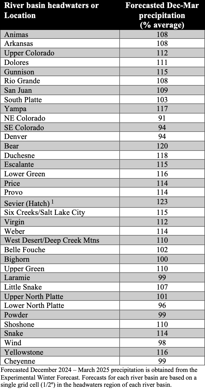
Congress ended a program that offered $8.3 million, mostly to ranchers, to conserve water in 2023. Wyoming wants it renewed.
Wyoming’s federal delegation has filed legislation to restore millions of dollars to pay state irrigators in the Colorado River Basin for conserving water.
Bills filed in the U.S. Senate and House would restore the System Conservation Pilot Program that Congress ended in December.The program contracted to pay $8.3 million in 2023 to 21 entities in Wyoming,
The conservation effort aims to supply more water to downstream states without harming Wyoming water users. Headwater upper-basin states of Wyoming, Colorado, Utah and New Mexico favor voluntary paid-for conservation over uncompensated reductions proposed by California, Nevada and Arizona.
The seven Colorado River Compact states propose competing programs to share dwindling flows in a river system that supports some 40 million people in the southwest and Mexico.
It’s uncertain whether the bills might enable the conservation program this year, according to members of the Upper Colorado River Commission who met Tuesday.
“With that uncertainty,” said Wyoming State Engineer Brandon Gebhart, “the four of us as [upper-basin] commissioners haven’t had sufficient time to figure out what a program would be.”
He made his remarks to fellow commissioners Becky Mitchell, Gene Shawcroft and Estevan Lopez representing Colorado, Utah and New Mexico respectively.
The federal representative on the commission, Anne Castle, resigned on Jan. 28 as requested by the Trump administration, according to her resignation letter obtained by journalist John Fleck. She stated she was worried that the administration’s policies are creating “a more disordered and chaotic Colorado River system.”
Bills moving
The pilot program contracted with 21 entities to conserve 15,571 acre feet of “consumptive use” in 2023, according to the latest report posted on the commission’s website published in June 2024. Eighteen of the contracts offered ranchers up to $611 an acre foot for water left in the stream.
(A report on the 2024 program has not been posted on the commission’s website, but could be available this summer if the previous publication schedule is followed.)
The four states and federal government had hoped to continue the program in 2025, but it expired in December when the U.S. House failed to reauthorize it.
“Last year, the Commission was hopeful that the SCPP would be reauthorized and could be used as a potential tool,” Mitchell, the chair of the Upper Colorado group said at the meeting. “However, that federal package that we saw [at] the end of last year did not include much in the way of natural resources legislation.”
Maps of ranch land along South Piney Creek show how low flows in 2022 resulted in curtailment of irrigation compared to the flush water year of 2023. The images were presented to the Upper Colorado River Basin Commission in February 2025. (Screengrab/UCRBC)
Although bills to resurrect the program have been filed, “the future of SCPP legislation remains unclear, as does federal funding,” she said. In 2023, the multi-state program administered by the Bureau of Reclamation received $125 million through the Biden administration’s Inflation Reduction Act.
The Colorado River Basin System Conservation Extension Act would extend the program through 2026, at which time stopgap rules governing drought allocations expire. U.S. Sen. John Hickenlooper, a Colorado Democrat, sponsored the Senate version with U.S. Sens. John Barrasso and Cynthia Lummis, Wyoming Republicans. U.S. Rep. Harriet Hageman, also a Republican, has offered a version in the U.S. House.
“Our bipartisan legislation extends these important programs to help address drought issues across our states.” Barrasso said in a statement. Lummis called the program “forward-thinking.”
Hageman said the pilot program to pay ranchers allows irrigators and water managers a chance to explore alternatives to “severe water regulation during droughts.”
Both bills have begun to advance in their respective chambers.
Yampa River Basin via Wikimedia.
Piney creeks, Little Snake River
The 2023 program saw significant contracts awarded in the Little Snake River drainage in Carbon County and also around Big Piney in Sublette County.
The largest single contract was for $2.6 million in the Little Snake. Irrigators along North, Middle and South Piney creeks collectively signed up for $3.4 million.
By the end of the 2023 summer, a consultant estimated the program conserved 8,477 acre feet of water or about 55% of the 15,507 acre-foot contracted goal for Wyoming, according to calculations made from the 2023 Upper Basin report.
In the Piney creeks area, the program saved about 55% of the stated goal, in the Little Snake about 42%.
“In all cases, the participant completed the required conservation activities,” the 2023 report states. “Variation in average estimated [conserved consumptive use] and actual [conserved consumptive use] is to be expected” due to annual variations in temperature and precipitation, the report said.
In theory, the water that ranchers — plus one municipal and one industrial entity — did not use would flow on to Lake Powell. That would help prevent lower basin states from demanding their share — allowed under laws, compacts and agreements — and forcing reductions in upper basin usage.
Myriad factors complicate that concept, however, including whether conserved water actually makes it to the reservoir, how and whether upper basin states are credited for conserved water, what toll evaporation takes and more.
Green River Basin
What’s not complicated is the impact of diminishing river flows to the economy of Wyoming’s Green River and Little Snake River basins and Cheyenne, which uses Colorado River Basin water diverted across the Continental Divide.
“Hydraulic shortages, the increased variability and the changed timing of the available water supply increases the uncertainty to all of our water-use sectors,” Gebhart told fellow commission. “If our farmers and ranchers are forced to reduce or eliminate the herd size because they don’t have the water to grow the food, it can take many years to recover and regrow these herds.”
There are larger implications, he said.
“These shortages also impact the fish, wildlife, wetlands, the riparian areas, and that has an impact on our tourism [and] recreation sectors,” Gephart said. “Not only do [lower flows] negatively impact our economy, but they impact our culture, and it impacts the relationships that have evolved and exist between all of our water use sectors. This can create conflict.”
Map of the Colorado River drainage basin, created using USGS data. By Shannon1 Creative Commons Attribution-Share Alike 4.0
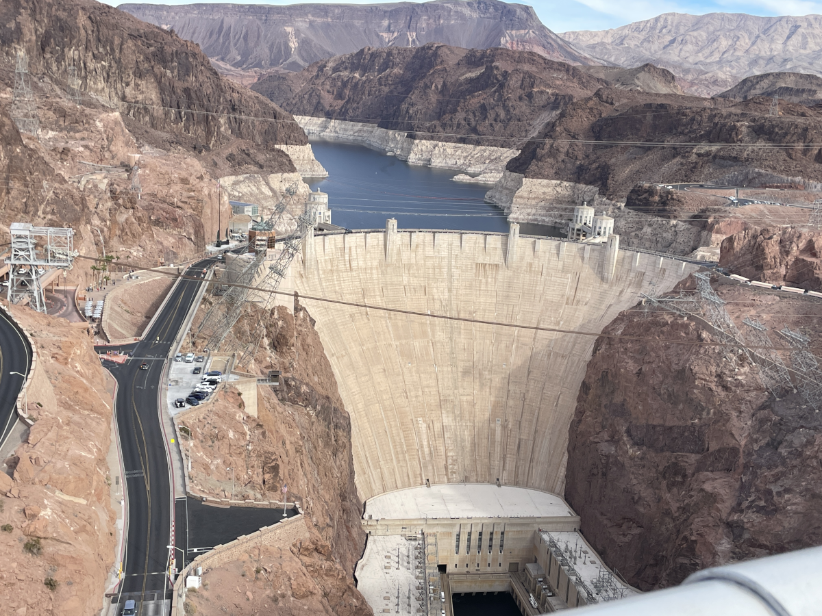
Hoover Dam from the U.S.-93 bridge over the Colorado River December 3, 2024.
Click the link to read the article on the AZCentral website (Brandon Loomis):
February 27, 2025
Key Points
Congress and the Biden administration committed $4 billion to Western drought relief, including money for users who agree to leave water in Lake Mead.
The money is apparently caught in a freeze of federal funds ordered by President Donald Trump, though questions remain without a Reclamation commissioner.
Lawmakers and Arizona’s top water official fear that without the funding, the Colorado River could be pushed deeper into drought, leading to more cutbacks in Arizona.
Facing a dwindling supply that provoked emergency actions to keep the river flowing past Hoover Dam, Congress directed $4 billion to Western drought relief, most of it aimed at shoring up Colorado River water storage. The U.S. Bureau of Reclamation signed deals with irrigators, tribes and other rights holders to forgo deliveries and save 1.5 million acre-feet of water over three years through 2025, with some extensions beyond this year. A second round of funds, which members of Congress say is also frozen, is intended to make long-term efficiency improvements, such as lining canals to stop losses when water is delivered to farms. Without the water or the agreements, some officials fear the ongoing negotiations among the seven river states could fall apart…
Officials with the Bureau of Reclamation did not respond to requests for comment or to confirm the freeze or how long it is intended to last. The administration has frozen various congressionally appropriated funds as cost-cutting aide Elon Musk’s team searches for fraud and savings. The president has not yet appointed a commissioner for the Reclamation Bureau, which manages the dams on the Colorado…
Projections for likely reservoir storage by the end of next year put Mead dangerously close to 1,050 feet above sea level, or the trigger that would cause Arizona to lose another 80,000 acre-feet, Arizona Water Resources Director Tom Buschatzke said this week…Failure to save water with the contractual deals that Reclamation made for 2025 could tip the region into that next shortage tier, he said, because the projections already assume that the water will have been saved.
“I have advocated strongly to my Arizona (congressional) delegation — the entire delegation — that that money in both the upper and lower basins that was committed needs to be spent,” Buschatzke said. “Those projects are critical to stabilizing the system as we continue to work toward a post-2026 world.”
The Biden administration inked three-year deals with about two dozen water users, including the cities of Phoenix, Tucson, Scottsdale and others, at a rate of $400 per acre-foot. California’s Imperial Irrigation District got a sweeter deal, at $777 for a one-year contract in 2023, but also has among the river’s safest rights against reductions when reservoir levels fall. Most of the water users who signed on were in Arizona, though the biggest deal, a four-year pact to leave 351,000 acre-feet in Mead, was with the Metropolitan Water District of Southern California and Paloverde Irrigation District of California. Arizona’s largest deal was with the Gila River Indian Community, for 341,000 acre-feet, according to a chart provided by Stanton’s staff. The contracts in the Lower Basin states — those downstream of Glen Canyon Dam — totaled nearly $664 million…A second batch of federal conservation funds, also reportedly frozen, is intended to make lasting water savings by, for instance, putting $87 million toward an advanced water purification plant in Tucson that will enable 56,000 acre-feet to stay in Lake Mead over a decade. A $107 million investment in the Gila River Indian Community, south of Phoenix, is projected to save 73,000 acre-feet over 10 years.
Udall/Overpeck 4-panel Figure Colorado River temperature/precipitation/natural flows with trend. Lake Mead and Lake Powell storage. Updated through Water Year 2024. Credit: Brad Udall
A high desert thunderstorm lights up the sky behind Glen Canyon Dam — Photo USBR
Click the link to read the article on the KNAU website (Melissa Sevigny). Here’s an excerpt:
February 24, 2025
This week’s scheduled meeting of a group focused on the management of Glen Canyon Dam was canceled by the Trump administration. It’s one of many scientific conferences and federal meetings that have been canceled or indefinitely postponed. The U.S. Bureau of Reclamation says the meeting will be rescheduled to ensure new Department of the Interior and Reclamation leadership are “fully briefed” on the Glen Canyon Dam Adaptive Management Work Group. The group advises the Secretary of the Interior on how best to manage Glen Canyon Dam in keeping with the 1992 Grand Canyon Protection Act. Matt Rice of American Rivers says that involves balancing the needs of water and hydropower users with cultural, environmental, and recreational values.
“And this group is the forum to balance and make management decisions based on all those values, to protect those values. So massively important.”
[…]
The canceled meeting comes amid a funding freeze that has stalled Colorado River conservation projects and amid layoffs at the U.S. Geological Survey, National Park Service and other federal agencies.
In rural Colorado, U.S. Department of Agriculture funding has long provided not only a safety net against disasters and shifting commodity prices but also the seed money for projects ranging from irrigation ditches to broadband expansion. President Donald Trump’s efforts to remake and slim down the federal government are putting that support in question.
“We lost an NRCS (Natural Resources Conservation Service) grant that totaled about $640,000 or $630,000,” said Michael Nolan, president of the Mancos Conservation District and a farmer himself. “We had spent down about 25 percent of that already implementing programs, paying staff time, and to have that rug just pulled out from underneath us means … potential furloughs, potential layoffs. It’s a big hit to our conservation district.”
Agriculture Secretary Brooke Rollins said last week the USDA will release about $20 million in Inflation Reduction Act funding that had been frozen, but the rest was still under review. And other grant funding is expected to be canceled…The Conservation District signed a contract with USDA in February 2024 to do conservation education. It involved listening sessions, equipment demonstrations, field trainings and agricultural education on issues from soil moisture to crop management.
“At the end of the day, we believe the funding was pulled because of two phrases in it. One was ‘equity’ and one was ‘underserved communities’,” Nolan said…
One Western Slope ag producer said right now there’s no certainty over what will or will not be funded…It’s not just individual producers that have been impacted by the USDA cuts. Six rural electric cooperatives in the state that received USDA grants funded through Biden’s signature climate and health bill have had their funding frozen, while the U.S. Forest Service, also under USDA, laid off more than 3,000 employees.
The stories are heartbreaking. US Forest Service, National Park Service and other federal workers — some of them within weeks of ending probationary periods — fired. And not for cause; these workers were just starting out on dreamed-of careers or taking on new responsibilities in agencies where they’d already been for years.
The Trump administration’s vaunted effort to “trim the fat” from the federal government and curb “waste and fraud” reveal one terrible — but not surprising — fact: The cost-cutters have no idea how government works or who does what in the federal workforce.
Probation doesn’t mean poor performers. It simply means that someone has only worked one or two years under authorities such as Veterans Recruitment Authority or Schedule A of a permanent job. Or it’s their first time in a supervisory position.
I worked for the Forest Service in forestry and then wildland fire for over 32 years before retiring in 2020. Because I’m now an advocate for firefighters, I’ve heard from many Forest Service workers who were suddenly fired by the Trump administration. I’ll tell you about two of them.
When he was 18, Cyrus Issari was hired to work with the Idaho Conservation Corps, building trail in the Sawtooth Mountains. He’d “found his passion,” he said, getting jobs as a temporary employee for the Bureau of Land Management and then the Forest Service. He cleared hazard trees with a chainsaw, cleaned campgrounds and also donned the Smokey Bear costume for public events. Best of all, he started fighting wildfires.
In 2022, Issari secured a permanent position — what he called his “dream job”—with a wilderness trail crew on New Mexico’s Gila National Forest. A few weeks ago, his entire eight-person trail crew was fired. Issari had been making $18.96 an hour.
“The land and people will suffer from (this) if nothing is done,” Issari told me.
Liz Crandall was fired last week from her field ranger position in Central Oregon. She started as a volunteer on the Umpqua National Forest in Southwest Oregon in 2016, helping a botanist get rid of invasive weeds.
The recreation shop scooped her up and put her to work doing sign maintenance, improving trails and cleaning campgrounds. Hired into a temporary recreation position in 2018, she also received wildland fire training and assisted on numerous wildfires.
She moved on to work for Oregon’s Willamette National Forest in recreation and then, in 2023, secured her permanent position as a field ranger on the Deschutes National Forest.
“I have dedicated my career and life to the US Forest Service,” Crandall said. Her performance evaluations were rated “excellent,” which is why she was outraged by the wording of her termination:
“The Agency finds, based on your performance, that you have not demonstrated that your further employment in the Agency would be in the public interest.” Liz had been making $19.10 per hour.
These folks love our public lands and have trained to do a variety of needed jobs. They feel a calling to serve the American taxpayers and countless visitors. They seek jobs that always pay more in sunsets than money.
Make no mistake, these hard-working and dedicated people aren’t the fat, they are the muscle.
These firings will have ripple effects. They are your neighbors who pay rent or take on mortgages. They shop in the local grocery stores and feed stores and coach basketball.
Many will have to move, and they will take their small, but meaningful, paychecks with them. They won’t be there to assist with search and rescue, to fight the wildfires that are becoming larger and more unpredictable, threatening the lives and livelihoods of countless Americans.
What can we do to support them? Show up for rallies. Write, or better yet call, your elected officials and tell them what effect these firings will have on you, your family, your business, your community. Be kind to those who are still working. Some were forced to fire the very people who never should have been let go.
There’s a big void to fill, now, and everyone needs to pitch in.
Riva Duncan is a contributor to Writers on the Range, writersontherange.org, an independent nonprofit dedicated to spurring lively conversation about Western issues. She is vice president of Grassroots Wildland Firefighters, grassrootswildlandfirefighters.com, and also works as an international consultant in emergency management.
Former U.S. Rep. Ed Perlmutter, left, responds to a question from Dick Wadhams January 31, 2025. Photo credit: Allen Best/Big Pivots
Click the link to read the article on the Big Pivots website (Allen Best):
February 22, 2025
One Democrat, the other Republican, shared their views of the Trump presidency, Colorado’s political shift and other topics at the Colorado Water Congress
Lauren Boebert in 2020 was running a gun-themed restaurant in Rifle called Shooters Grill and Smokehouse. A political unknown, having never been elected to so much as a town board, she defeated Scott Tipton, the incumbent representing Colorado’s Third Congressional District in the Republican primary. She was 34 years old.
Her ascendancy shocked many. It had a precedent of sorts, as was noted during a panel discussion during the Colorado Water Congress annual conference in late January.
“She had a great political antenna, “said Dick Wadhams, a Republican political consultant who moderated the discussion with two former members of Congress. “She saw an opportunity to take out a respected incumbent, Scott Tipton. And nobody saw that coming.”
Wadhams noted that another member of Congress from the Western Slope had also been upset in a party primary. That was in 1972. Wayne Aspinall, a Democrat and a vital member of Congress in delivering federal dollars to build the massive water infrastructure of the Colorado River Basin in the 1960s, was ousted by Alan Merson of Breckenridge. Democrats in that district decided that Aspinall was too conservative — although it was a Republican Jim Johnson of Fort Collins, who went on to win the general election.
“You do have upheavals in the parties from time to time,” said Wadhams. “That year it was the Democratic Party. This year it’s the Republican.”
Amid his analysis, Wadhams was posing questions to two former members of the U.S. House of Representatives.
Ed Perlmutter, a Democrat, represented the metropolitan area’s western suburbs in Congress from 2003 to 2023. Ken Buck represented the Eastern Plains of Colorado and some fringes of the Front Range beginning in 2015. If very clearly conservative in his political views, he took positions apart from the Trump-dominated Republican majority and resigned in 2024. He was facing a primary election he likely would have lost but denied that that was the cause for his resignation.
Wadhams asked the former members of Congress what did they make of the new Trump presidency?
“When I watch the left react to Trump, it makes me smile, because Trump does so many things that are crazy that the things that are really damaging to the left get missed in all the other crazy stuff,” said Buck. That crazy, he suggested, was part of his strategy.
“If you just look at what he says, it’s going to drive people crazy. If you look at the point of what he’s saying and the strategy behind what he’s saying, you still may think it’s wrong, but at least it’s a little more understandable and people will calm down a little bit.”
He cited the flow of fentanyl into the United States from other countries, especially Mexico, as a problem that the Biden administration had not taken seriously enough.
Perlmutter agreed that Trump’s outrageous behavior was intended to move the conversation.
But if Republicans hold a trifecta in Washington D.C. with a president, plus majorities in both the Senate and House, it’s a very narrow majority in the House: three votes. To actually get a bill passed, such as for appropriations, will require some help from Democrats. And that help, said Buck, comes at a high price.
“They want their programs in Greece, and that’s when you start getting the Marjorie Taylor Greene and others who will say, ‘OK, we’re going to take this speaker out because he’s now working with Democrats.’ Well, you don’t’ have a choice. You can either shut down government or work with Democrats. And that’s the choice that (House Speaker Mike Johnson) has. So he will work with Democrats.”
At that point, added Buck, there will be three or four weeks while Republicans figure out a new speaker of the House. That job, he added, is the worst.
Perlmutter said Democrats will likely regain the majority in the House in the 2026 election, and it will then be the task of the speaker they elect to rein in the wishes of the more extreme elements of the party. Nancy Pelosi, he said, did a pretty good job of it.
In the meantime, the extreme voices can be shrill. Perlmutter cited the example of Boebert. “Her voice is going to be loud now. Whether that’s to get stuff done productively or not. That’s a whole other question. She has the capacity and the ability to do it, and on a one-on-one basis, she’s okay. But you know, she can be pretty out there when she wants to be.”
The two former congressmen agreed that Colorado’s members in Congress, both Democrats and Republicans, can come together on many issues that are, as Perlmutter put it, Colorado-centric type issues such as water, transportation, and energy.
“There are going to be the hot-button issues of immigration, some environmental issues, but generally our members are very close on those kinds of things,” said Perlmutter.
“You’re talking about eight people who see each other every day on the floor (of the House) and oftentimes sit together and have conversations,” said Buck. “I think that Colorado is really well represented on both sides of the aisle.”
Both men served in the Colorado Legislature before their election to the federal offices. Since 2019, Democrats have had majorities in both chambers at the Capitol. Colorado’s electorate has changed dramatically in the last seven or eight years, Wadhams observed. Voters are younger, more socially liberal – and more inclined to be unaffiliated. They’re very anti-Trump and favorable to Democrats but – maybe not always so. He cited Proposition HH, a property tax proposal heavily supported by Democrats and opposed by Republicans. It was defeated by a 20% margin.
Perlmutter also noted swings in Colorado’s electorate. He was the first Democrat elected to the Colorado Legislature from the Jefferson County communities of Lakewood, Wheat Ridge, Arvada. and Golden in 50 years. It now is overwhelmingly Democrat.
Colorado Republicans held sway in 1998, the year that Bill Owens was elected governor. He was the only Republican governor in Colorado in the last 50 years.
Today’s unaffiliated voters – 50% of the electorate – swing left, noted Perlmutter. Biden won Colorado by 23 % percentage points and Kamala Harris in 2024 by 12%.
“It’s still obviously pretty left, but if you’re an independent, if you’re unaffiliated, you can move pretty quickly,” Perlmutter said. He suggested fellow Democrats need to be careful to not get too far afield from the core concerns of the electorate.
Outlet flow at Cochiti Dam in 2002. By U.S. Army Corps of Engineers, Douglas Bailey – U.S. Army Corp of Engineers Digital Visual Library[1]Image description pageDigital Visual Library home page, Public Domain, https://commons.wikimedia.org/w/index.php?curid=1813624
I got a text message yesterday afternoon about this, which is nuts:
Accidentally dumping 8,000 cubic feet per second into a river channel that hasn’t seen that much water since 1985 is a big deal. The gage data suggests the river level rose four feet basically instantaneously.
I’ve been thinking a lot lately about the stuff the federal government does in water management in the United States that we used to be able to take for granted, like, for example safely operate the dams.
We all love to complain about the federal government’s water management work, but the complaints are based on narrow questions and presume a broad societal consensus that there’s a bunch of stuff the federal government can be reliably counted on to do while we argue over details. Reclamation and the Corps are gonna operate the dams, for example. The details we argue about are at important margins, but they’re at the margins, based on the presumption that the basic stuff will get done.
Like, for example, spending the money that Congress approved to help us manage shortages in the Colorado River Basin. Which money has now been yanked out from under us by the autocrats who think they know better, as Alex Hager reported yesterday.
I have no idea what happened at Cochiti Dam yesterday, whether the person who made the “procedural error” was new because the old timer who knows how to run the dam took the early buyout and bailed. But I do know that is exactly the “what if” scenario I was gonna lay out in a blog post that’s been percolating in my head about this question of how we in the West go forward in water management when the federal government suddenly becomes an unreliable partner.
I am not saying this because complaining about the stunningly arrogant idiots crashing through the federal government right now is great clickbait. I’m tired of all the angry clickbait, frankly, which is why I hadn’t written the blog post until today.
My point here is a serious question, not a rhetorical one: What would it mean for us in Western water management if the federal government becomes an unreliable partner? What must we do to prepare? What does that even look like?
New Mexico Lakes, Rivers and Water Resources via Geology.com.
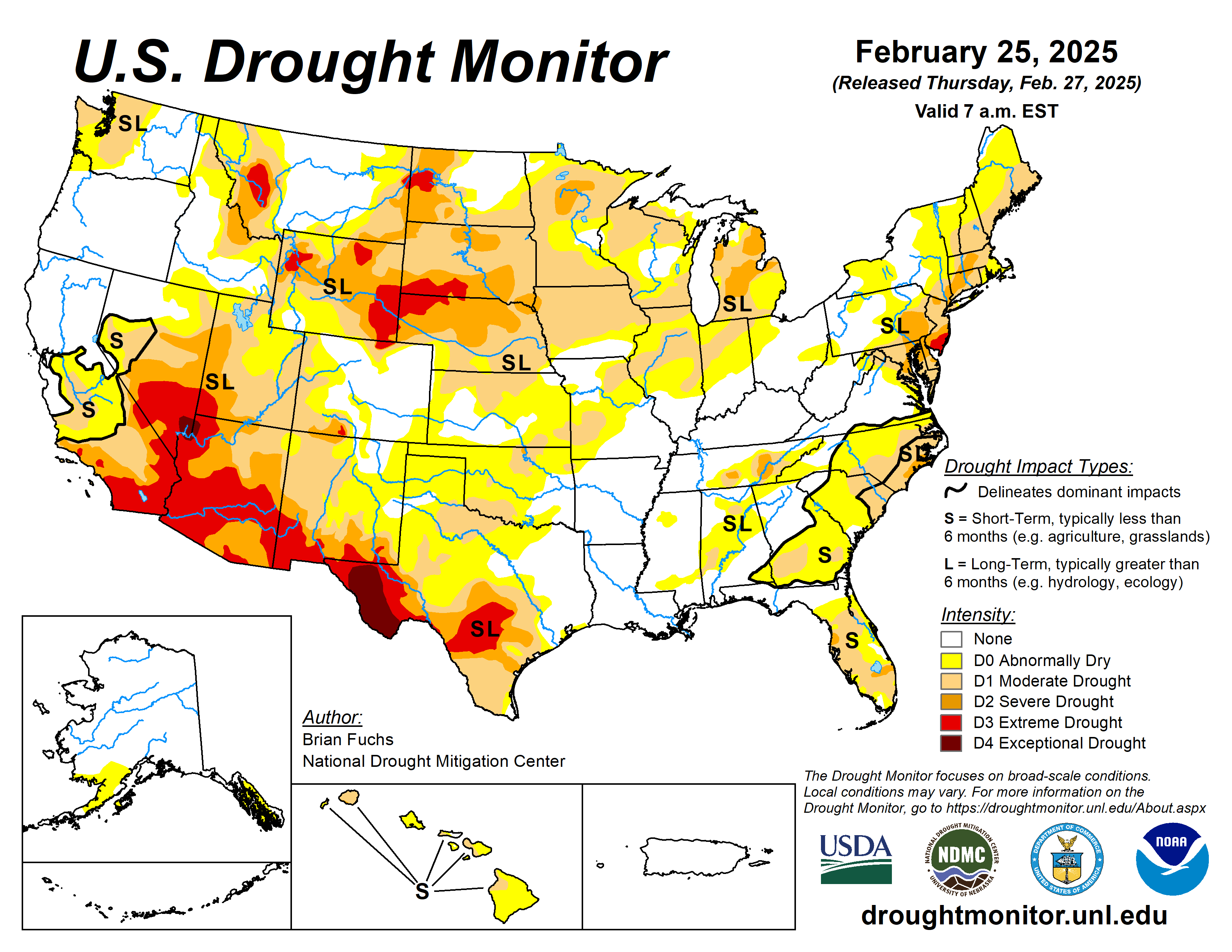
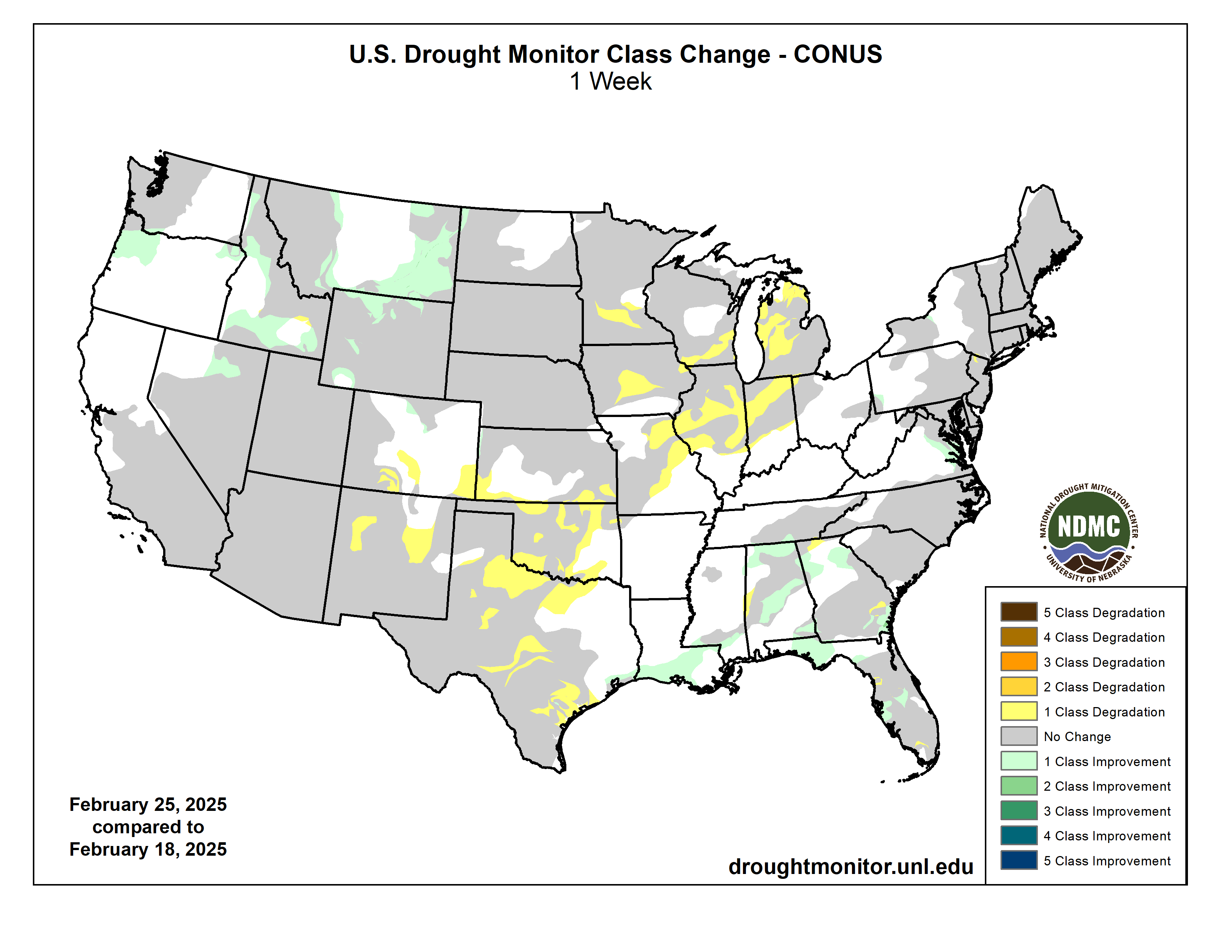
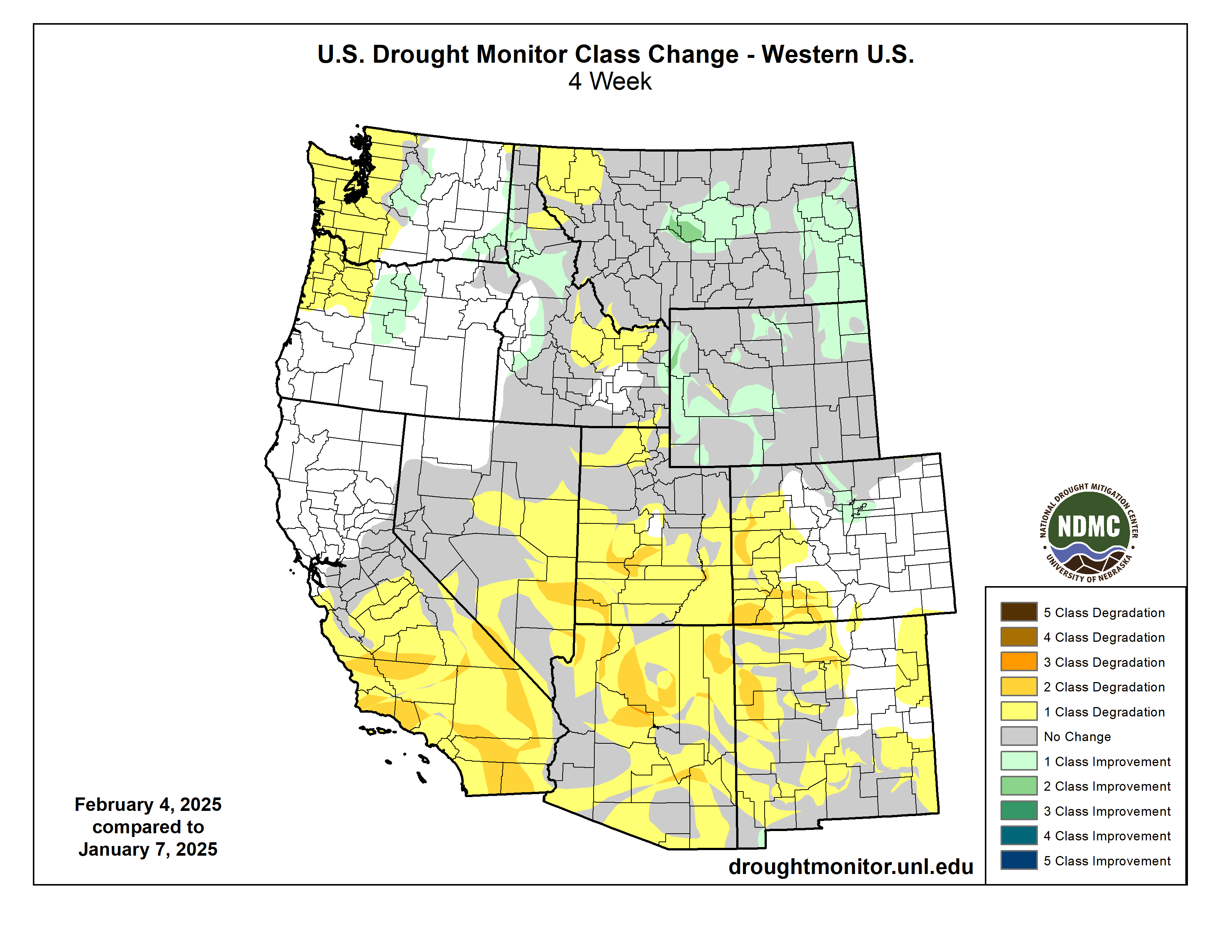
With limited precipitation during the week, most of the country was dry after a fairly active week prior. The week was highlighted by the wild temperature swings from the first part of the period to the end. The current period started off with temperatures that were well below normal over much of the country and ended with temperatures that were well above normal. Valentine, Nebraska, had an observed low temperature of -33°F on Feb. 20, and this rebounded to 69°F on Feb. 25, a swing of 102 degrees over that five-day span. Precipitation was greatest over the coastal areas of the Pacific Northwest as well as along the Gulf Coast and Florida. In southern Louisiana, 4-6 inches of rain was common for the region. Even with cold temperatures over much of the eastern half of the country, the West was normal to slightly above normal for the week…
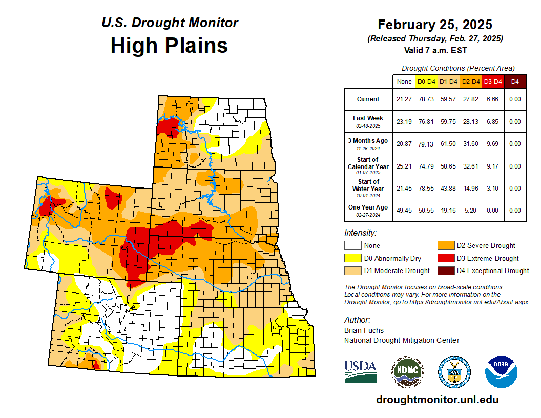
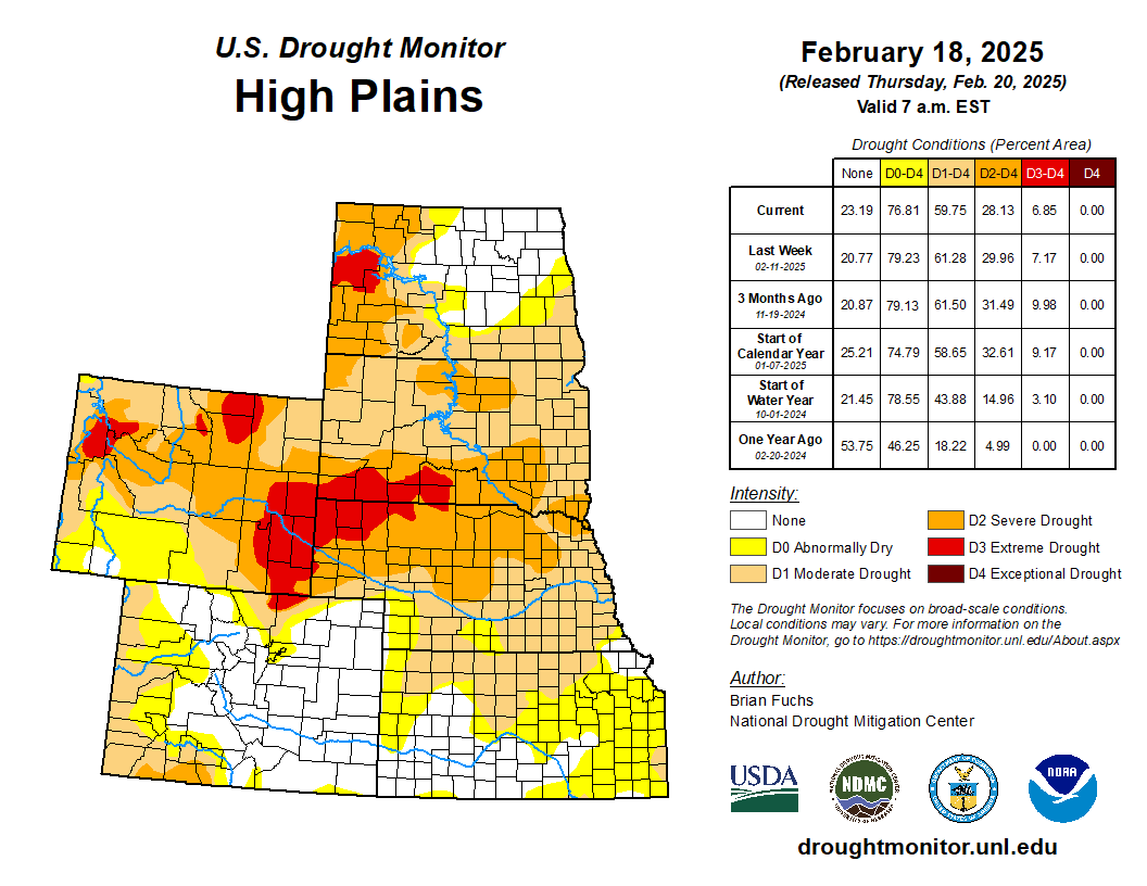
Light precipitation was measured from eastern Wyoming into Kansas and Nebraska as well as in portions of western North Dakota and the plains of eastern Montana. Most other areas were dry for the week. Colder-than-normal temperatures dominated the region with areas of southeast Kansas 20-25 degrees below normal for the week. With the dry conditions, moderate drought levels were expanded over southern Kansas along with additional abnormally dry conditions being shown…
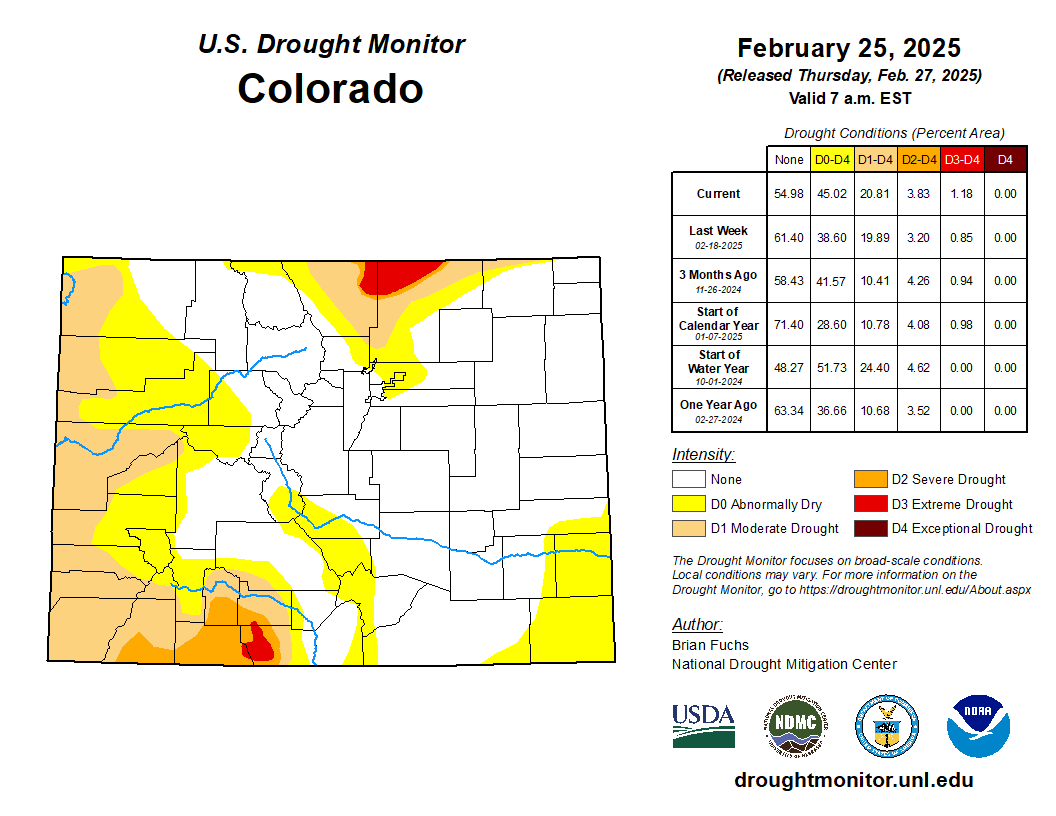
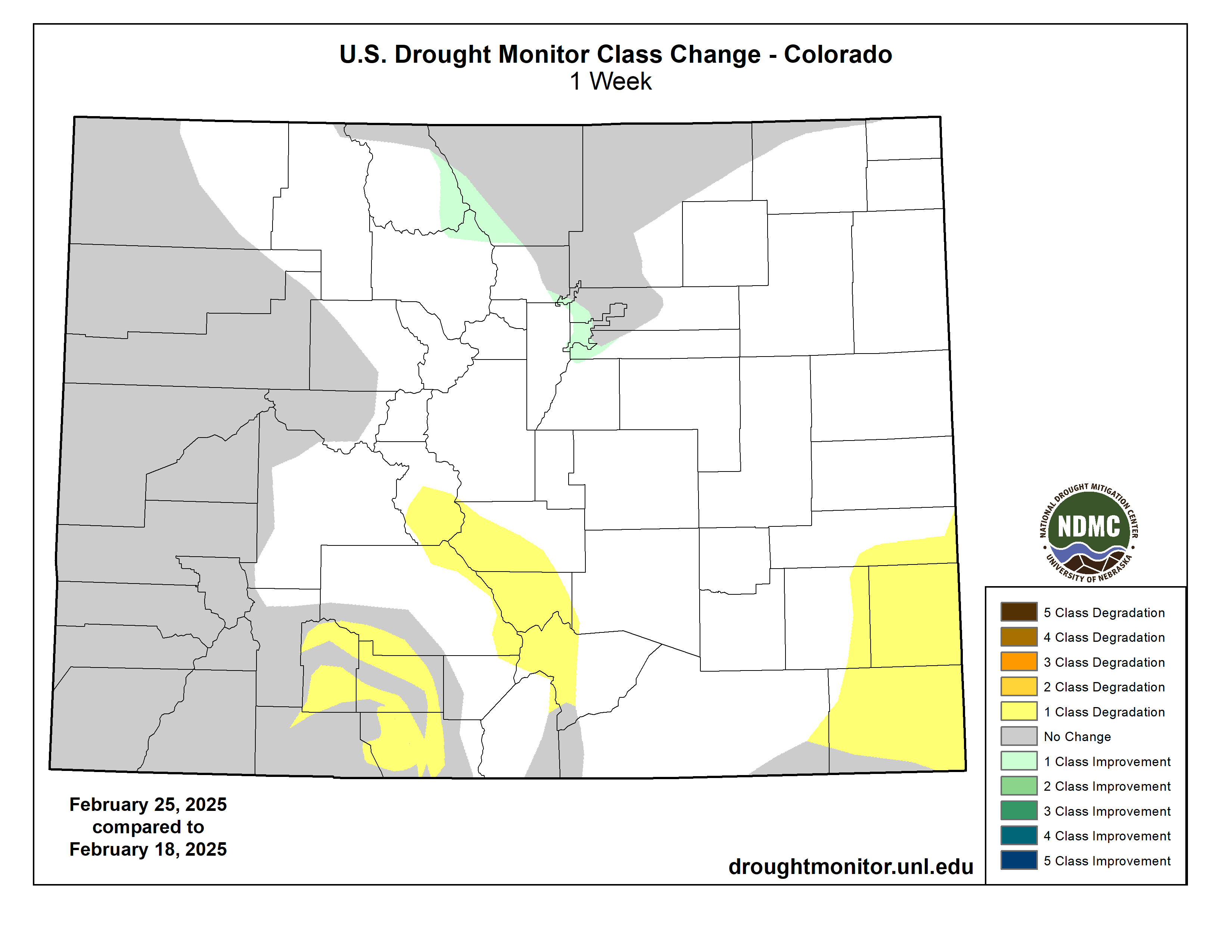
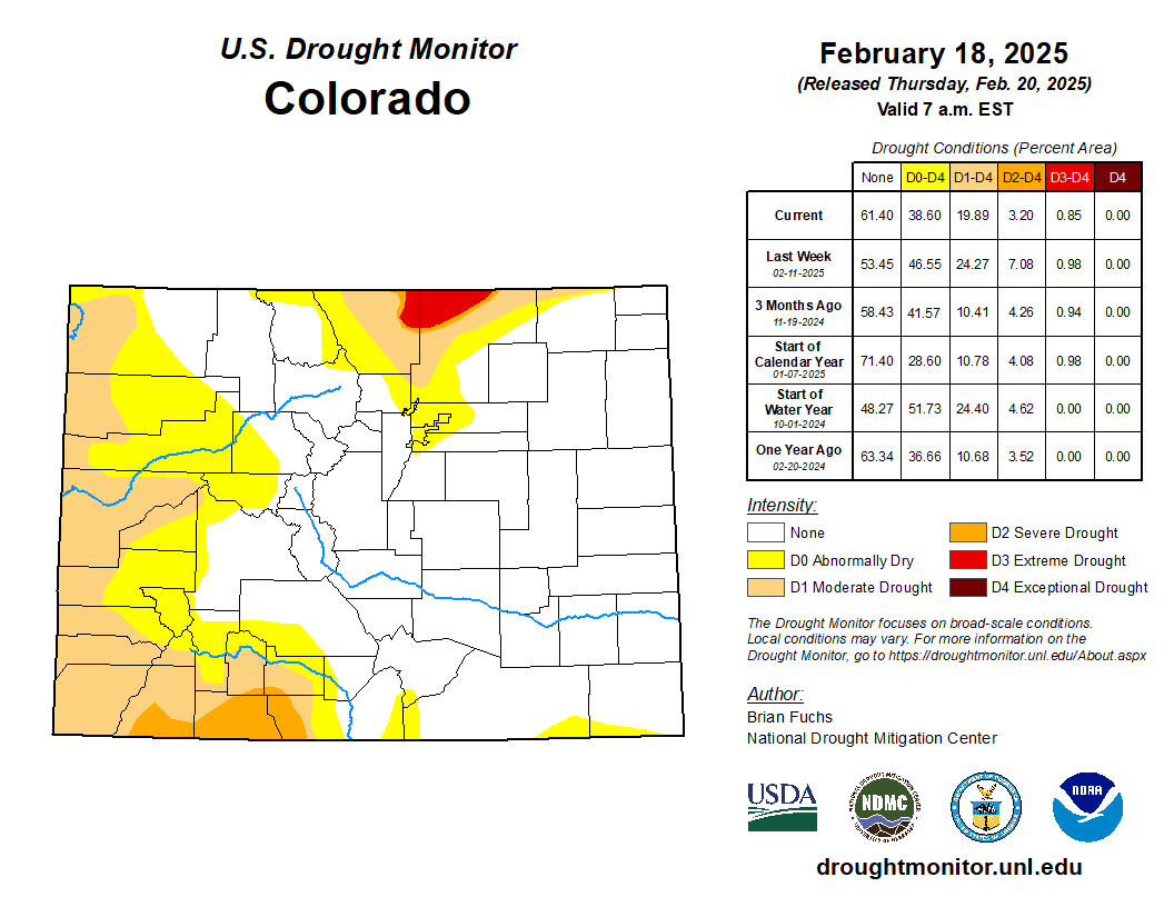
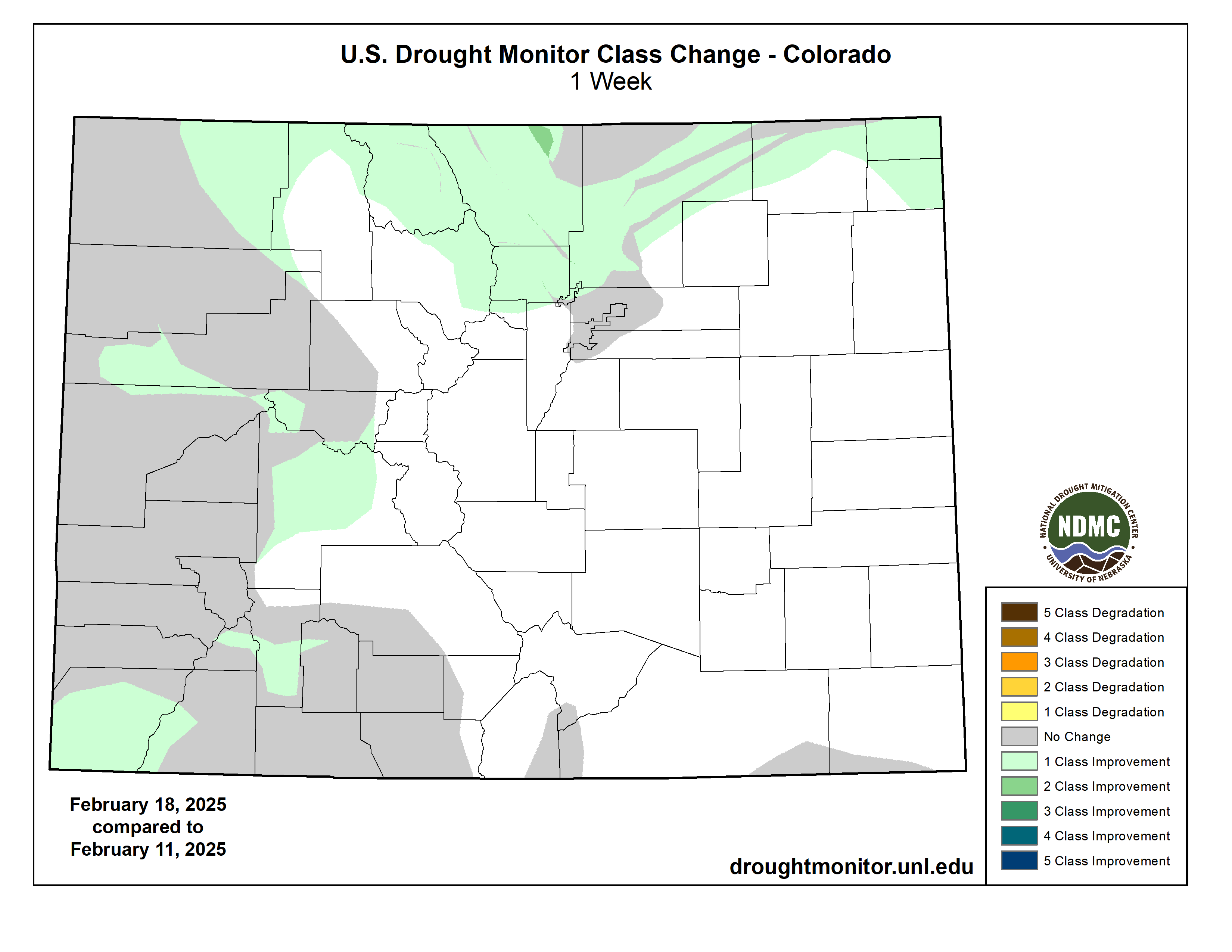
Colorado Drought Monitor one week change map ending February 25, 2025.
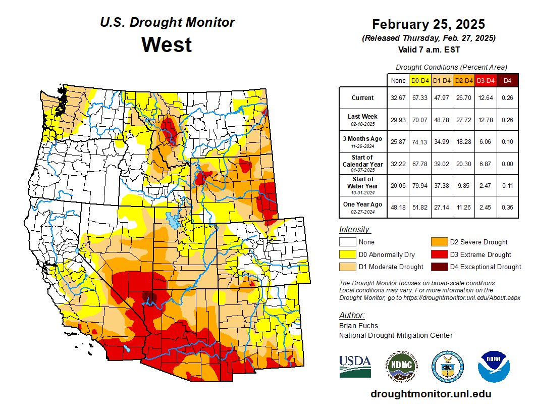
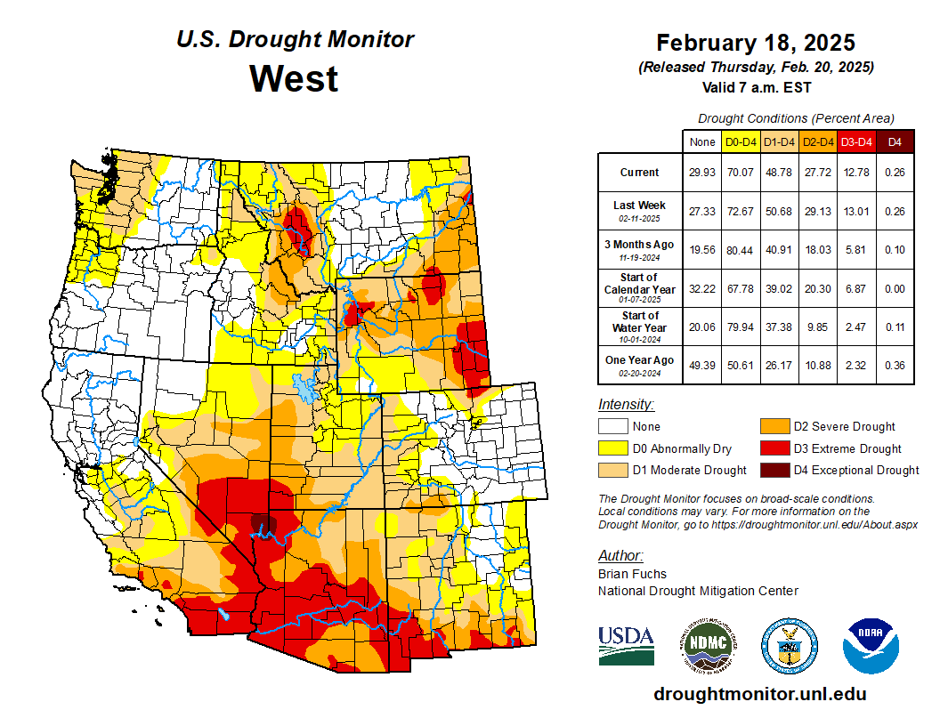
A very divided region with wetter-than-normal conditions in the north and zero precipitation in the south. The most abundant precipitation was along the coastal areas of Washington and Oregon and into Idaho and western Montana. Unlike the rest of the country, much of the West had near- to slightly-above-normal temperatures this week. The wetter pattern in Oregon allowed for abnormally dry conditions to improve in the west and both moderate drought and abnormally dry conditions improved in the northeast. No changes in Washington occurred this week as the most recent rains helped to stabilize conditions that had been deteriorating. In Idaho, abnormally dry conditions were improved over much of western and southern portions of the state. Abnormally dry conditions were improved over northern portions of Nevada. In Wyoming, abnormally dry conditions improved over the southwest part of the state while moderate, severe and extreme drought conditions improved over the northern and western parts of the state. Montana had improvements to moderate, severe and extreme drought over eastern portions of the state in response to the improving indicators. In Colorado, some abnormally dry conditions improved in the northcentral areas while they were expanded in the south. Moderate and severe drought expanded in the south along with a new pocket of extreme drought due to the long-term drought indicators and the poor snow season to date. In New Mexico, moderate drought expanded over the west and abnormally dry conditions expanded in the east…
It was a colder-than-normal week over the region with temperatures in the 10-20 degrees below normal range over the entire area. The greatest rain occurred across the coastal areas of east Texas, Louisiana and portions of northeast Oklahoma. The region has been dry over much of the winter after a few very wet weeks in the autumn. The short-term data are picking up the dryness that also was prevalent prior to the wet November. As the dryness persists, moderate drought was expanded into more of southwest Oklahoma and into northern and central Texas. Abnormally dry conditions were expanded over much of southern Oklahoma and north Texas. Due to ongoing hydrological drought issues in south Texas, drought expanded this week with more moderate, severe and extreme drought conditions. Abnormally dry conditions were improved over east Texas but were not removed completely due to some lingering dryness being observed at longer timescales. The recent rains allowed for the removal of the abnormally dry conditions over southern Louisiana and some improvements in southern Mississippi, where both moderate drought and abnormally dry conditions were improved…
Looking Ahead
Over the next five to seven days, it is anticipated that the best chances of precipitation will be over the West coast and into the Great Basin, the Mid-Atlantic into the Northeast, the upper Midwest and across the Ozark plateau and into portions of the southern Plains. Temperatures are anticipated to be above normal over most of the Plains and into the Southeast with coastal areas of the West below normal. The greatest departures from normal are expected over the southern Plains with departures of 10-13 degrees above normal.
The 6-10 day outlooks show the high probability of above-normal temperatures over the upper Midwest and from south Texas and along the Gulf Coast as well as Alaska. The best chances of cooler-than-normal temperatures will be over much of California and into the Four Corners region. Most of the country will have above-normal chances of above-normal precipitation, with the greatest chances over southern California and from the Ohio Valley into the Northeast. West and southern Texas has the best chances of below-normal precipitation.
US Drought Monitor one week change map ending February 25, 2025.
There’s a lot going on in the Land Desk beat these days, making it difficult to keep up and to focus on any one element of the orders and job and funding cuts coming out of the White House. I suspect that’s partially by design: They’re trying to disorient the American public so we lose track of what they’re actually trying to do. Rest assured, I’m doing my best to keep an eye on all of it and to watch where the pieces land.
Oh, and y’all gave some wonderful responses to Tuesday’s thread on coping. If you haven’t already, go over there and read through them. And thank you all for participating.
I want to use today’s dispatch to catch up on a few things, briefly …
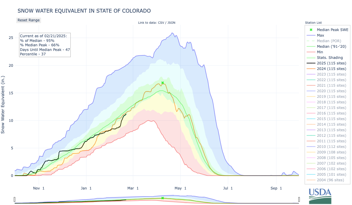
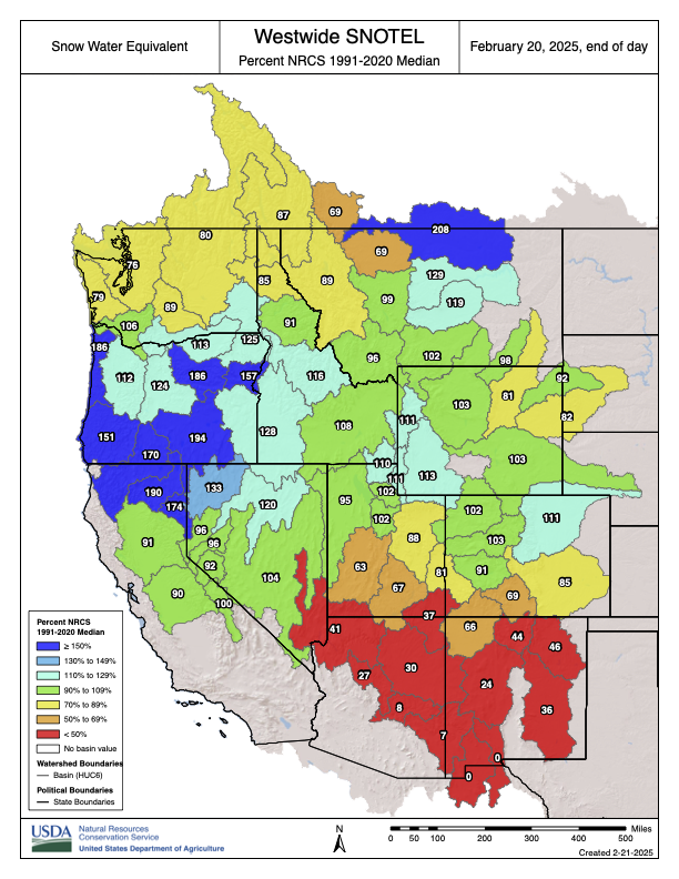
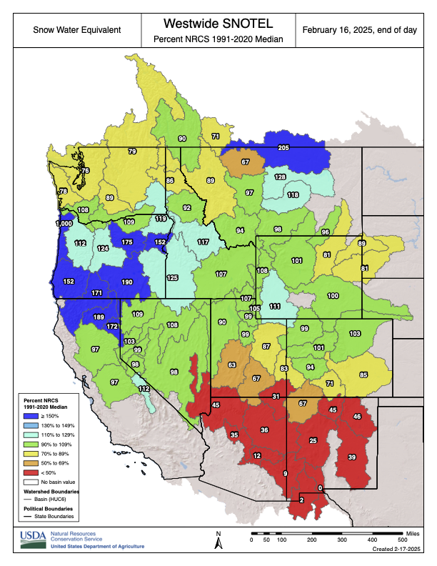
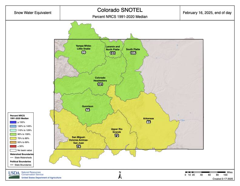
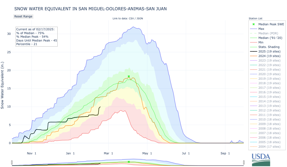
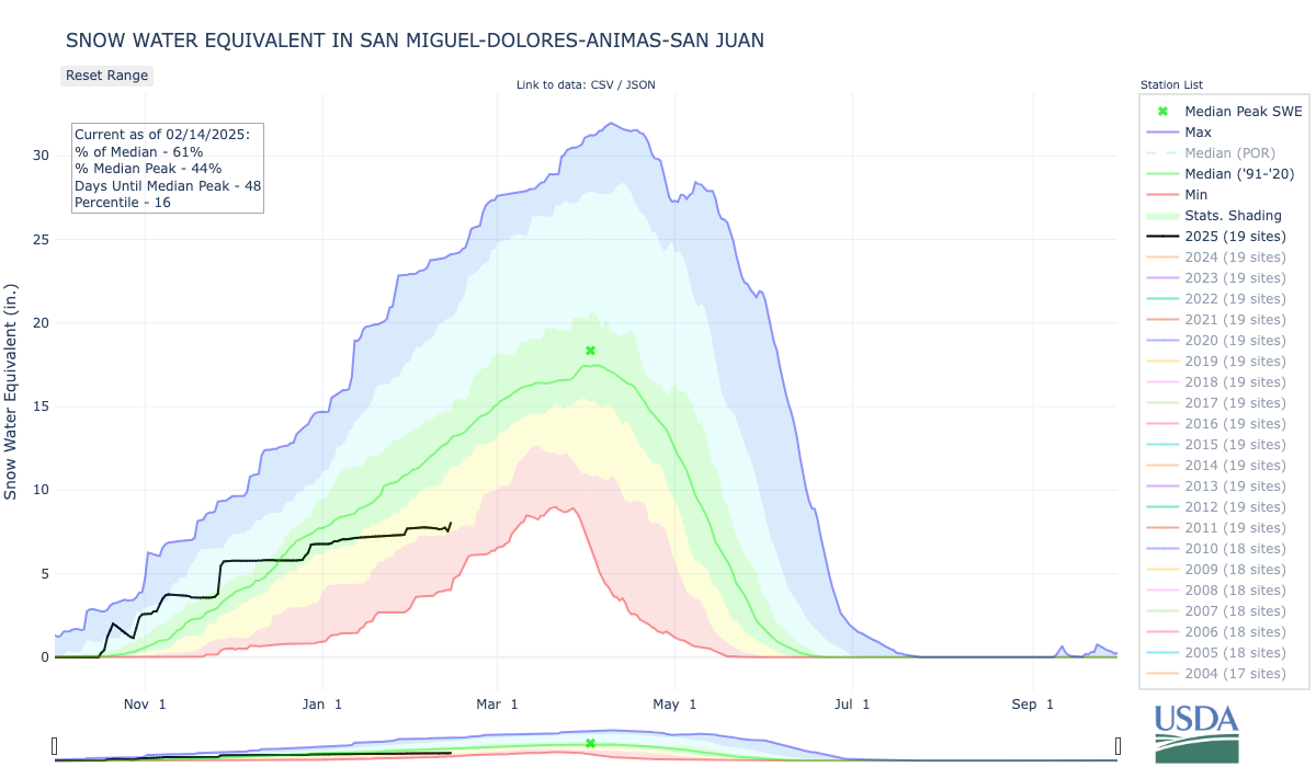
First, some good news: The storm that was expected to hit a big swath of the West delivered, bringing a fair amount of moisture to places that desperately needed it. The San Juan Mountains in southwestern Colorado were one of the biggest beneficiaries, with high-country SNOTEL stations gaining two to four inches of snow water equivalent (which amounts to a lot of snow). Red Mountain Pass’s snowpack was brought back up to normal for the date. Las Vegas, Nevada, which hadn’t seen measurable precipitation for more than 200 days, got a relative soaking (.57”). And the snowpack in the mountains above Flagstaff, where the snow situation has been especially grim this year, was also bolstered. Yet the snowpack remains below normal in the more southerly zones.
All of that new snow falling on top of old, rotten snow resulted in an unstable snowpack. That led to dozens of avalanches — many naturally triggered, others set off by skiers or snowmobilers — across the region, some of which buried people, one fatally. On Feb. 20, a backcountry skier and a snowboarder were on a feature called The Nose in the Mineral Creek drainage near Silverton, when they were caught in an avalanche. The skier was able to escape; the snowboarder, reportedly a 41-year-old woman from Crested Butte, was buried and did not survive. In February 2021, an avalanche on The Nose killed four caught four backcountry skiers, killing three of them.
🥵 Aridification Watch 🐫
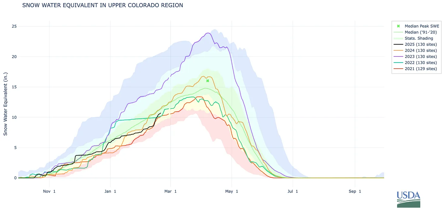
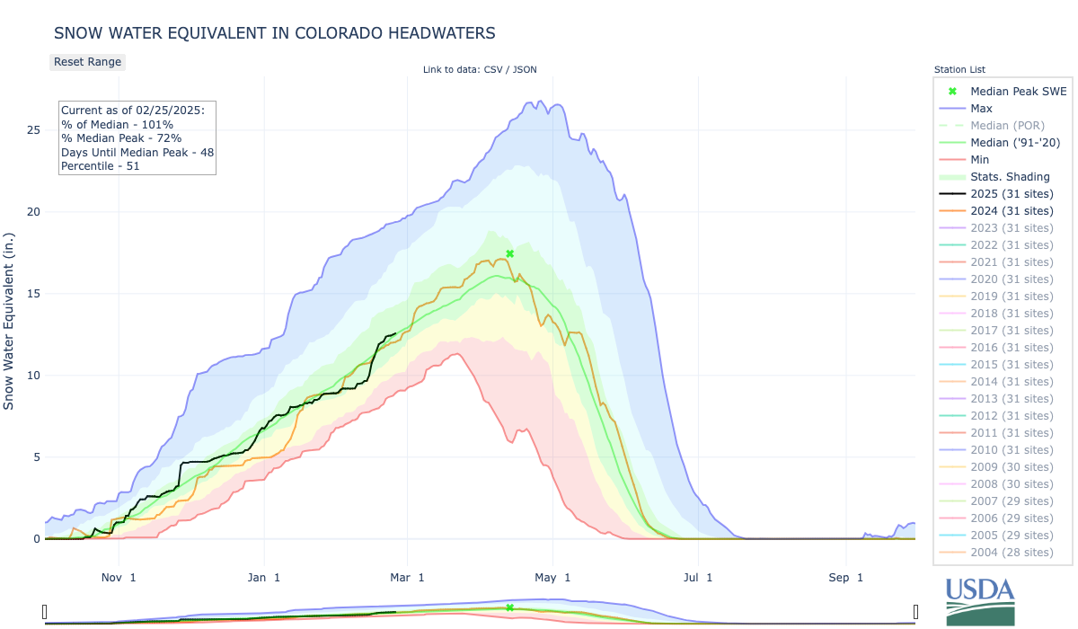
In somewhat related news … At the end of each water year, I like to run this chart of the “natural flows” at Lees Ferry on the Colorado River below Glen Canyon Dam. Natural flow is a calculation of how much water would have passed that point had there been no upstream diversions (because of Glen Canyon Dam, the actual flows at Lees Ferry are highly regulated and vary only slightly from year to year). In other words, it’s a reflection of the hydrologic health of the Upper Colorado River Basin. I forgot to run this one the WY 2024 data was first released, so here you go.
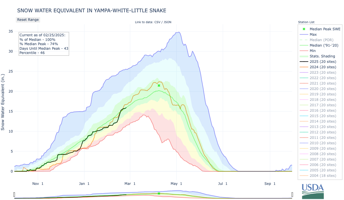
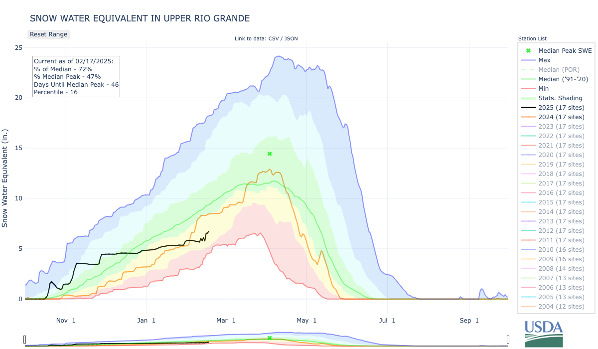
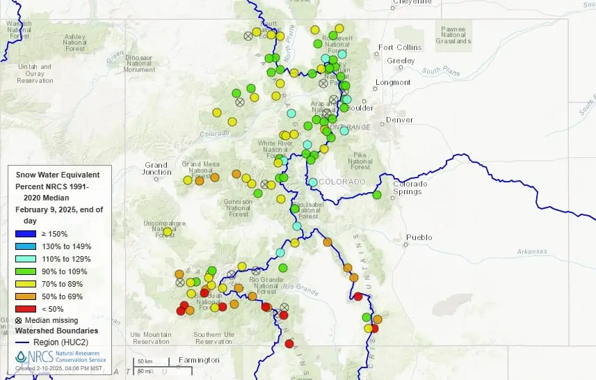
It’s worth noting that this year’s snowpack in the Upper Colorado River watershed (second graph below) is slightly below where it was last year on this date. If that trend continues, you can expect the natural flow to also be lower than last year’s, which is a bit worrisome.
Source: Bureau of Reclamation.
🌵 Public Lands 🌲
Earlier this month, Interior Secretary Doug Burgum addressed the National Congress of American Indians. It was a bit of a rambling speech in which he said this, about public lands, which I thought was rather telling:
First of all, his notion that any public lands that aren’t designated as a national park or monument is “inhospitable or unoccupied” and is therefore lacking in value (aside from the commodities contained within) is a bunch of bunk. And yet it reveals how this guy sees the millions of acres of public land he is charged with overseeing. Also, the guy apparently hasn’t been paying attention, because for him to say that “our return on that investment right now is almost nothing” is a load of horseshit. Last year, natural resource extraction from federal lands generated more than $16 billion in revenue, mostly from oil and gas drilling and coal mining, and mostly from lands that Burgum considers “inhospitable.”
***
Former President Joe Biden received a lot of flack from some greens for failing to live up to his campaign promise of ending oil and gas drilling on federal lands. He was also saddled with a not-quite-accurate claim that his administration issued more drilling permits than the first Trump administration. But what often escaped notice, is that Biden leased out far less public land to drillers than any other administration in years. This didn’t slow drilling or oil and gas production one bit, showing that oil and gas companies lease land speculatively, with no intention of developing it, to bolster their reserves and assets.
Source: Bureau of Land Management.
***
⛏️Mining Monitor ⛏️
There is a lot of talk about a looming uranium mining renaissance on the Colorado Plateau, but the only significant ore production appears to be at Energy Fuels’ Pinyon Plain, née Canyon, Mine on traditional Havasupai land near Red Butte and within the Baaj Nwaavjo I’tah Kukveni-Ancestral Footprints of the Grand Canyon National Monument.
The mining has sparked controversy, since it could contaminate groundwater, among other impacts. And so has the transportation of the ore, via tarp-covered big rigs, across the Navajo Nation to the White Mesa uranium mill in San Juan County, Utah. When Energy Fuels sent its first trucks northward, across an accident-riddled route, it ran into a figurative roadblock, as the Navajo Nation and Arizona’s attorney general protested. The shipments were put on hold.
Earlier this month, the Navajo Nation and Energy Fuels entered into an ore transport agreement and the shipments resumed last week. But the fight to stop the trucks has not subsided. Advocacy groups, Diné citizens, and the Havasupai Tribe continue to push back, and have condemned Navajo Nation President Buu Nygren and the tribal council for a lack of transparency and failing to include other tribal nations in its negotiations.
“This is real for us,” the Havasupai Tribal Council wrote in a statement. “We live here. Our culture and traditions originate here and are knit together with who we are as individual tribal members and as a tribe. … Today there are two trucks, by month’s end it will be four trucks, each hauling 24 tons of this dangerous and highly toxic material. It is clear that EFRI has no regard for others and is simply acting in their own interest. … We will not give up. We owe that to our ancestors, our children, and the generations to come. We will fight on.”
🏠 Random Real Estate Room 🤑
Got an extra $15 million lying around? Then you can buy the iconic Bear Creek Falls outside of Telluride, along with about 33 acres across five patented mining claims. The current owners allow the public to access the land via a nice trail from town. Let’s hope whoever buys it does the same. This particular part of the drainage is riddled with big slide paths, so you wouldn’t expect anyone to develop it. But then …
🗺️ Messing with Maps 🧭
I don’t have much to say about this one, except that I really love these old site sketches of Puebloan structures. This one is by W.H. Holmes, from “Report on the Ancient Ruins of Southwestern Colorado, Examined During the Summers of 1875 and 1876.”
The deadline for the U.S. Department of Interior to determine the post-2026 future of Lake Powell and Lake Mead — and the entire Colorado River basin — is now six months away. As precarious negotiations continue between the Upper and Lower Basin stakeholders, the new presidential administration has also cast concerns on the future of the critical water system.
“Honestly, I’ve seen nothing out of the administration that suggests that they even know there is a Colorado River,” said Democratic Sen. Michael Bennet during a press call on Thursday, Feb. 13. “I had a daily conversation with somebody at least, probably three times a day, in my office with somebody on the Colorado River, and we’ve seen nothing so far.”
[…]
On Thursday, Feb. 20, Colorado water officials provided state lawmakers in the House Agriculture, Water and Natural Resources Committee with a high-level update on the negotiations, which will set the basin’s future operating regime…In November, the Bureau of Reclamation released a document with five management options for the river’s post-2026 future. [Becky] Mitchell said that the Upper Basin states submitted an alternative that offers a more sustainable supply-driven approach to management, rather than allowing downstream demand to dictate releases. These states have also agreed to consider conservation efforts and strategic releases, she said…While elements of the Upper Basin’s proposal — and what was proposed by Lower Basin states— have been incorporated into the Bureau of Reclamation’s alternatives, negotiations are attempting to strike a balance…
“I’m hopeful that the change in administration won’t cause a significant change in policy direction on Colorado River issues. It hasn’t in the past, and I’m hopeful that it won’t now,” [Anne] Castle said. “But I’m less optimistic about that than I was a month ago. I still think that’s the case, but now I’m not sure.”
Map of the Colorado River drainage basin, created using USGS data. By Shannon1 Creative Commons Attribution-Share Alike 4.0
The Colorado River District’s State of the River meetings are a spring tradition in Western Colorado, bringing communities together to discuss the most pressing water issues facing our region. These free public events provide valuable insights into river forecasts, local water projects, and key challenges impacting West Slope water users.
Eleven meetings are planned across the Western Slope; see the list below. These events offer an opportunity to hear directly from water experts and better understand the factors shaping the future of our rivers. A complimentary light dinner will be provided, and all events include a Q&A session to address your questions and concerns.
While each program is tailored to reflect local water priorities, key topics at all events will include:
River flow forecasts
Updates on the Colorado River system
Local water projects and priorities
Current challenges facing Western Colorado water users
Shoshone Water Rights Preservation Project updates
If there are specific local issues or projects you would like to see highlighted, please include that information in your registration.
Registration is required, but attendance and dinner are free. We encourage all community members—whether deeply involved in water issues or just beginning to engage—to join us and participate in this important conversation.
Secure your spot today and be part of shaping the future of water in Western Colorado.
Click each event below to register!
Agendas will be posted for each meeting once they are finalized.
Photo illustration/digital “painting” by Jonathan P. Thompson. No AIs were used to produce this image.
Click the link to read the article on the Land Desk website (Jonathan P. Thompson):
February 25, 2025
😵 Trump Ticker 😱
One of the things the Land Desk is trying to do in these troubled times is to try to separate the rhetoric from reality, or to weed through the hype and alarmism to determine how a Trump administration action will play out or already is playing out on the ground.
It’s not easy, in part because the administration keeps working at cross purposes, making it very unclear who’s running the show or even what is actually being done. Is Trump, who yearns for the golden age of 1870 to 1913, when the Robber Barons ruled the roost and tariffs were in place to protect their industries, in charge? Or is it his billionaire benefactor (and Robber Baron of the AI age), Elon Musk, who has boasted of taking a “chainsaw” to the bureaucracy, purportedly in the name of efficiency?
On the one hand you’ve got Musk taking his figurative chainsaw to federal agencies in a ham-handed way, as one Land Desk commenter charitably put it, slashing jobs thoughtlessly and without foresight. And on the other, you have Trump urging Musk to get “more aggressive” with his chainsaw even as the administration scrambles to retract Musk’s actions by rehiring at least some of the fired employees — thus offsetting the claimed spending cuts. It’s hard to tell whether this is the result of sheer incompetence, or some elaborate shell game intended to confuse and distract us from even more sinister actions.
Maybe the goal is simply to traumatize federal employees — as Project 2025 architect and Office of Management and Budget Director Russel Vought put it — and make them afraid to go to work. That way they won’t be able to protect Americans and their land, water, and air from corporations. I’m not making this up:
What is wrong with these people!?!
That motive jibes with Musk, Trump, and far-right pundits characterizing federal employees as freeloading, paper-shuffling bureaucrats — even calling them members of the “parasite class.” Which is wrong, inaccurate, and frankly a rather shitty way to talk about the folks who keep airplanes in the air, work to ensure our food and water is safe, enforce federal laws, and maintain the trails, clean the restrooms, and work to prevent catastrophic forest fires on the public lands that make America great. If MAGA actually believes their own rhetoric, then it is more proof that they have no idea what they’re talking about or doing.
One thing is clear: There’s nothing efficient about any of this. Musk and his minions are not only wasting tens of millions of dollars on this ketamine-fueled charade, but also the goal clearly is not to tackle waste, fraud, and abuse. If it were, he’d bring in a team of forensic accountants — not software coders — to meticulously comb through the books and make surgical, precise cuts if and where they were needed. If cost-saving was the goal, he would not have fired more than 6,000 IRS employees — including more than 100 in Ogden, Utah — who were hired to ensure that the wealthy pay their fair share of taxes — and therefore increase revenues and more than offset their salaries.
And, if it were sincere about its stated mission, instead of eviscerating federal agencies, the administration would give the folks on the ground more latitude in determining how to cut costs and better serve the public — even if it meant increasing the number of employees. After all, a stretched-thin workforce does not make for a well-oiled machine, and it may even work against Trump’s other objectives. While firing a bunch of Bureau of Land Management folks might make the agency less able to enforce regulations on oil and gas companies, it also slows down the drilling permitting process. That’s why the New Mexico Oil and Gas Association donated $800,000 to the state BLM office in 2014: It wanted to grease the wheels, of course, but also increase staffing to speed up permit processing for drilling the Greater Chaco Region.
If Musk and Trump knew what they were doing, they would realize in advance that axing the staffers that oversee the nation’s nuclear arsenal was a bad idea, that firing National Park Service employees and freezing seasonal hires would wreak havoc on the parks and their gateway communities, and that terminating more than 400 employees of the Bonneville Power Administration would imperil reliability on the Northwest’s grid.
In the last several days, some of those firings have been reversed — or at least Trump has indicated that he will reverse them. But again, it’s not clear which positions will be restored or why or even when. At BPA, for example, they only brought back 30 of the employees (which was apparently a struggle, since they had already been cut off from their federal email accounts). The National Park Service has indicated it may hire more seasonal employees this year than in the past — but there are no plans to restore the jobs of 1,000 permanent workers who were unceremoniously fired. This in an agency that has seen staffing numbers decrease even as visitation has soared.
The result of all of this back and forth? More confusion.
What is clear is that thousands of federal employees are out of jobs and the effects are bound to ripple across communities and economies, especially in rural Western areas where the federal government is one of the largest, most stable employers and the private sector isn’t large or robust enough to reabsorb those workers. Visitors to the parks will experience it as well: Traffic into Zion National Park has been backing up into Springdale thanks to understaffed entrance booths, and Saguaro National Park is closing its visitor center on Mondays due to staff shortages. This, surely, is merely the beginning of the fallout.
I’ll do my best to keep track of how it plays out, and if you see any of the impacts on public lands near you, please let me know!
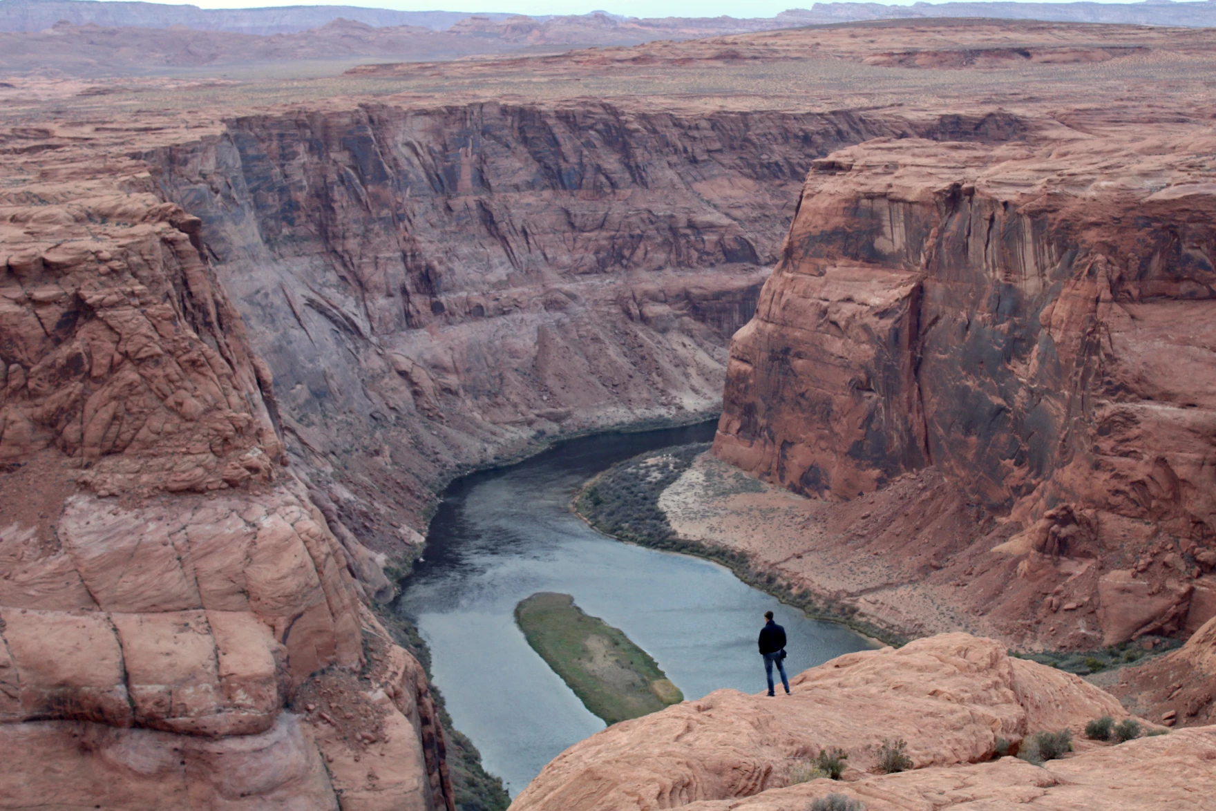
A person looks out over the Colorado River near Page, Arizona on November 2, 2022. The seven states that use its water are caught in a standoff about how to share the shrinking supply. They say they want to avoid a court battle, but some states are quietly preparing for that outcome. Alex Hager/KUNC
Click the link to read the article on the KUNC website (Alex Hager):
February 19, 2025
This story is part of ongoing coverage of water in the West, produced by KUNC in Colorado and supported by the Walton Family Foundation. KUNC is solely responsible for its editorial coverage.
When it comes to the Colorado River, a court battle between the states that use its water is sometimes referred to as “the nuclear option.” But now, as those states are locked in disagreement about how to share its water, they are tiptoeing closer toward litigation.
State leaders insist they want to avoid a trip to the Supreme Court, but some are quietly preparing for that outcome.
The Colorado River supplies water to about 40 million people from Wyoming to Mexico. Climate change is shrinking its supplies. The cities and farms that use it are under pressure to rein in demand accordingly.
Water managers from the seven states that use the Colorado River are caught in a standoff about who exactly should use less water, and they appear to have made little progress ahead of a 2026 deadline for new rules about how to share.
In January, Arizona’s government made headlines when a proposed state budget included up to $3 million for litigation related to the Colorado River.
“It’s really a backstop in case we don’t come to a collaborative agreement,” said Tom Buschatzke, Arizona’s top water negotiator.
Buschatzke described the litigation fund as a contingency plan and said state leaders were focused on collaborating.
“I think each state honestly does not want to be in a courtroom rolling the dice regarding how a judge might rule,” he said.
Nevada’s John Entsminger, Arizona’s Tom Buschatzke, and California’s JB Hamby sit on a panel of state water leaders at the Colorado River Water Users Association annual conference in Las Vegas on December 5, 2024. State leaders say they want to avoid litigation, but they are quietly preparing for that outcome. Alex Hager/KUNC
For all of their differences, the two sides of the current Colorado River dispute seem to agree on one central issue: they want to keep their debate out of the Supreme Court. That appears to be the case in the Lower Basin states of Arizona, California and Nevada, as well as the states on the other side of the disagreement — the Upper Basin states of Colorado, Utah, Wyoming and New Mexico.
“We are the ones who should really shape the outcome here,” said Amy Haas, executive director of the Colorado River Authority of Utah. “We’re the experts. We’re the water managers. We understand the system. Why would we want to relinquish that control and that responsibility?”
She said Utah would prefer to spend its money on avoiding a court battle rather than preparing for one.
“I think it would be folly for us to pursue a litigated outcome here,” Haas said.
An overwhelming majority of Colorado River policymakers — including Arizona’s — say they’d prefer to work amongst themselves instead of getting the federal government involved. Why, then, would Arizona make a show of its proposed litigation fund?
Some onlookers say it’s a negotiation tactic.
“This is definitely a posturing issue,” said Gage Hart Zobell, a Utah-based water lawyer with the firm Dorsey & Whitney. “I think a lot of what we see is the Lower Basin is trying to make it very clear they are willing and open to litigate this issue because they think they have the higher hand.”
Buschatzke outright denied that the litigation fund was a form of posturing, but Hart Zobell said there’s a financial reality that suggests Arizona’s move is a form of saber-rattling.
“In the event litigation does go forward,” he said. “You don’t have to build a litigation fund to come up with $5 million. Any state budget can come up with $1 million, $2 million, $3 million to fight this.”
Hart Zobell pointed to a recent Supreme Court case that helps give some clues as to how the Colorado River debate might get settled if it heads there. The 2024 case “Texas v. New Mexico” brought tensions over another Southwestern river, the Rio Grande, to the high court. The case gave the federal government more leverage in talks about managing that river’s water.
“Under the new Supreme Court precedent, if we get into a lawsuit, they have a right to intervene,” Hart Zobell said. “Once they’re in, we’re not just having Upper and Lower Basin discussing. We’ve got a third party that we’ve got to settle with.”
So Arizona’s litigation fund, Hart Zobell said, it may be a way to remind other states of the consequences if they don’t come to an agreement amongst themselves.
“I think that looming specter is really going to push the states a lot more to finding some negotiated settlement,” he said. “Because if the federal government does intervene, I don’t think any state is going to get what it wants.”
Rows of alfalfa grow in Imperial Valley, California on June 20, 2023. Agriculture uses the majority of the river’s water, and is often at the center of conversations about how to bring down demand on the Colorado River. Alex Hager/KUNC
Arizona’s Buschatzke said that other states, such as New Mexico, Wyoming, and Colorado were also preparing money for Colorado River litigation.
KUNC reached out to each of the seven states that use the Colorado River. Arizona was the only one that indicated it had a specific pool of money for Colorado River work.
A spokeswoman for Colorado’s negotiating team pointed to a “long-standing litigation fund” that could be used for the Colorado River, and a division of the Colorado Attorney General’s office that has been focused specifically on the Colorado River since 2006.
New Mexico and Wyoming’s top water offices declined to comment for this story. The Upper Colorado River Commission, a group that brings together water leaders from Colorado, Utah, New Mexico and Wyoming said that it was not preparing a litigation fund.
Native America in the Colorado River Basin. Credit: USBR
The Colorado River basin is also home to 30 federally recognized Native American tribes. Although Indigenous people in the Southwest have been using Colorado River water longer than any other group in the region, they have largely been excluded from discussions about how the river is shared. Tribes that use the river control about a quarter of its flow, but most lack the money and infrastructure to use their full allotments.
Jay Weiner, water counsel for the Quechan Indian Tribe of the Fort Yuma Indian Reservation, said that is likely to add another layer to any legal battle over water.
“There is no version of this that you do not have tribes seeking to intervene in this litigation,” he said. “Or potentially seeking to bring their own claims as part of whatever food fight that the states end up in the Supreme Court over.”
Whether the states settle their differences amongst themselves or in court, they will be forced to reckon with a water supply that has been significantly reshaped by climate change. More than two decades of dry conditions have forced the states into tough conversations about using less water across the farms and cities of the arid West.
“It is very, very hard to ask people to agree to sign up to make hypothetical future sacrifices of bone-cutting magnitude,” Weiner said.
Some state leaders have indicated that the threat of litigation might actually help them make those sacrifices. At a 2023 conference about water law, Nevada’s top water negotiator John Entsminger said the “federal anvil” hanging over the basin states was key to finding agreement during other contentious water-sharing talks over the past two decades.
Map of the Colorado River drainage basin, created using USGS data. By Shannon1 Creative Commons Attribution-Share Alike 4.0
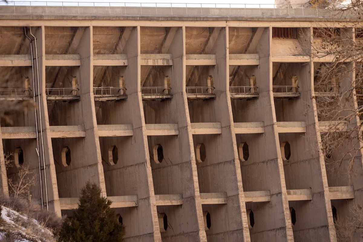
The aging LaPrele Dam is seen in Converse County on Jan. 31, 2025. Late last year, the state ordered the 116-year-old concrete structure to be breached and eventually demolished to avoid possible catastrophic failure. (Dan Cepeda)
Click the link to read the article on the WyoFile.com website (Dustin Bleizeffer):
February 18, 2025
As crews prepare to crack the dam this month, farmers who rely on that water prepare for lean times and lawmakers debate funding for a new structure.
As a kid, Casey Darr would hop in the truck with his father for the drive up the narrow canyon to LaPrele Dam to check outflow gauges and the water level behind the hulking concrete structure.
His family’s ranch relied on that storage water, and these excursions were a welcomed break from tending to livestock on the open prairie a few miles away.
During spring runoff, when water gushed from the overflow tunnel near the top of the structure and shot out of the dam’s lower outlet, the spray cast richly colored rainbows between the canyon walls and over lush, green flora below. The mist combined with the roar of moving water tamed by early 20th-century ingenuity created a weirdly tranquil atmosphere. It was an exclusive experience: The reservoir, dam and stretch of canyon leading to them are private property, accessible only to the landowners and irrigators who hold title to the dam.
“It was almost like going into Jurassic Park,” Darr said, noting the oddity of such a space hidden in what appears, from a distance, to be dull foothills of the Laramie Range. “It was just mind-blowing. It was just really, really beautiful to see, and you felt honored to be one of the few individuals that got to see it.”
Philip Dziardziel, Vice President of the LaPrele irrigation district board, and Casey Darr, Treasurer of the irrigation district board, pose on a small bridge near the LaPrele Dam on Jan. 31, 2025. They and many locals feel a special connection to the dam, which has allowed generations of families to thrive on the land it protects. (Dan Cepeda)
But in January, when Darr, who serves as treasurer on the LaPrele Irrigation District Board, and District Vice President Philip Dziardziel drove up the canyon with two journalists, they had to stop at a temporary, mobile office to ask permission to approach the dam. It’s now a condemned structure because it poses a catastrophic risk to humans and everything below it — including, according to engineers, Ayres Natural Bridge Park, several ranch homes and other structures, two bridges on Interstate 25 and, potentially, anything or anyone along the North Platte River banks all the way through Douglas, a town with 6,400 people 20 miles to the east.
In fact, it’s a wonder the dam has stood this long, engineers who have studied it say. Completed in 1909, it’s the last standing Ambursen-style flat-slab and fin-buttress dam in the U.S. — a design that was determined to be a bad idea decades later. With so many individual concrete slabs, there’s more potential for flaws and erosion, and there’s little redundancy to hold if there’s a failure in one piece. If any of the multiple concrete slabs fail while holding back a full reservoir, it wouldn’t merely leak, according to engineers. It would immediately crumble like a house of cards.
The aging LaPrele Dam is seen in Converse County on Jan. 31, 2025. Late last year, the state ordered the 115-year-old concrete structure to be breached and eventually demolished to avoid possible catastrophic failure. (Dan Cepeda)
Under a full reservoir scenario, the torrent of water would rip through about 1.5 miles of narrow canyon before it overcomes Ayres Natural Bridge while shredding old stands of cottonwood and boxelder trees and filling the natural bowl with flotsam before boiling over to continue its path of destruction.
‘Got to suck it up’
Darr and thousands of others who have relied on the LaPrele Dam for their livelihoods for more than a century have always carried with them a sense of nausea understanding their concrete savior that bestowed an unusually prolific agricultural economy to otherwise high-and-dry plains wouldn’t last forever. Now, with crews setting up to breach, then take down Darr’s Jurassic Park concrete wall, he and others are preparing for what will feel like a “funeral.”
“It’s been a part of our lives and these communities for over 100 years,” Dziardziel said, hands in his pockets, while standing next to Darr just below the dam.
“It’s been very emotional for a lot of people — ourselves included,” Darr agreed. “But at the same time, you’ve got to take your own personal feelings, thoughts, opinions aside and do what’s right for the safety of others.”
Not all irrigators reliant on the dam share the sentiment. Some suppose that engineers’ warnings and estimations of worst-case failure and destruction models amount to hyperbole, and insist the dam will hold until a replacement is constructed in about five years.
Farmland is seen near the LaPrele Dam in Converse County. (Dan Cepeda)
“It’s not necessary at all to destroy the old one and to open up all those people, all that land and everything else, to destruction [from potential flooding],” said Leonard Chamberlain, who grew up in the irrigation district and whose family business still has a stake in it. “I would like to see it in place to make sure all the funding, permitting and lawsuits are done, and it’s up before you take out the structure that’s protecting everybody.”
Dziardziel said he’d felt the same way and, for a long time, was dead set against taking the dam down before a replacement was built.
“But once I was up there with the engineers and actually put my hands on the surface of that dam, and they showed me the cracks, it was obvious that, just for safety reasons, we could not store water in that dam,” he said. “It would just put people at risk. There was absolutely no way we could do that.”
Though design plans are in the works for a new dam — estimated at $182 million — not all of the funding pieces have fallen into place. Nor is there unanimous support for how much or whether the state and federal government should pitch in.
Farmland is seen near the LaPrele Dam in Converse County. (Dan Cepeda)
There is one thing for certain: The dam will be mechanically breached before spring runoff — enough to ensure that LaPrele Creek free-flows through the structure without any water backing up behind it, according to state officials. Until a replacement is completed, LaPrele irrigators will be entirely at the whims of Mother Nature, which rarely provides enough natural flow for late-season irrigation. With the dam cracked open to the point of free flow, Mother Nature might also serve up floods in an agricultural community that, for the past 116 years, has built up an infrastructure without much consideration for a deluge.
“We just got to suck it up and deal with it for a few years in exchange for the safety of the community,” Darr said. “It’s been a hard decision. None of us are happy about this. But at the same time, the right decision isn’t always the easy one.”
Patchwork, boulder fall and a change of plans
Construction of the original dam was funded via the federal Carey Act of 1894, a measure pushed by Wyoming’s U.S. Sens. Francis E. Warren and Joseph M. Carey to help arid western states develop more water for irrigation. Completed in 1909 with an expected lifespan of about 50 years, the dam enabled a prosperous little agricultural community of 104 different family businesses that, in turn, became an integral part of the economy for the broader region.
The aging LaPrele Dam is seen in Converse County on Jan. 31, 2025. Late last year, the state ordered the 115-year-old concrete structure to be breached and eventually demolished to avoid possible catastrophic failure. (Dan Cepeda)
Irrigators were aware of concerns surrounding the dam’s Ambursen buttress-style design, but held a sort of cross-that-bridge-when hope for its longevity, which was first tested in 1970s when it was first determined to have reached the end of its safely useful life. Cost estimates for a replacement then seemed insurmountable for members of the LaPrele Irrigation District.
But the district received an offer from a private company that it couldn’t refuse.
The Panhandle Eastern Pipeline Co. was gunning to develop a coal-gasification project nearby, and it needed water. In return for a slice of storage water rights, the company agreed to finance major patching and concrete refurbishing. The work was completed, but Panhandle’s coal-gasification project never came to fruition. LaPrele irrigators retained all their storage rights — and a gussied-up dam, to boot — and carried on with their operations that continued to inject dollars into the economies of Glenrock, Douglas and beyond.
Until somebody noticed a boulder that had apparently tumbled — in 2016 — from the western side of the limestone-walled canyon just below the dam. It struck a dirt mound on the way down and, by luck, rolled away from the dam’s concrete fins instead of toward them, according to engineers’ accounts. Had it landed on the other side of the mound, it would have rolled toward the dam.
The aging LaPrele Dam is seen in Converse County on Jan. 31, 2025. Late last year, the state ordered the 115-year-old concrete structure to be breached and eventually demolished to avoid possible catastrophic failure. (Dan Cepeda)
The boulder aroused curiosity about the state of the dam.
Migrating cracks, observed from usual vantage points, were apparent. Engineers took a closer look by rappelling down the structure. Crack measurement devices were installed, and in November 2019 the data led to a state order to maintain the reservoir behind the dam at a lower level — to ease pressure on the structure — resulting in a 45% squeeze on available storage water for irrigation.
The dam continued to crumble and crack, and in August 2021 a tour was organized to begin underscoring the dam’s inevitable demise, setting into motion plans for a replacement and how to fund it. The plan, until recently, was to maintain the aging dam while constructing a new one just below, allowing for mostly uninterrupted irrigation. But cracks continued to widen, alarming state officials, and in November, State Engineer Brandon Gebhart issued a breach order, declaring the dam at risk of “catastrophic failure.”
The Ambursen-style design LaPrele Dam consists of a series of concrete walls — or “fins” — to support an angled, flat slab on the reservoir side. The design is prone to catastrophic failure, according to engineers. (Dustin Bleizeffer/WyoFile)
“This dam has significant structural deficiencies and has exceeded its useful life,” Gebhart said in issuing the order.
Funding, legislation and criticism
When Darr and Dziardziel guided a pair of journalists to the dam on a recent, breezy January day, they had to remain at a distance from the structure. Cold water gurgled under a bridge and beneath crusts of ice at the creek’s edges.
“I’ve been coming here for 50 years, and every time I come around that bend [and the dam comes into view],” Dziardziel said, “it always reminds me of what they accomplished back in the early 1900s. I mean it was just amazing, and it makes you proud to be an American, really.”
Self-described “hermits” who prefer the solitude of ditch riding and tending to their ranches (WyoFile had to twist their arms for an in-person interview), Darr and Dziardziel lamented their forced entrance into the bureaucracy and politics of government needed to negotiate a tangle of demolition and reconstruction matters.
Bison graze on farmland near the LaPrele Dam in Converse County, an area that has relied on the dam for stored irrigation water and flood control for more than a century. (Dan Cepeda)
“We were all petrified of having to go deal with all this stuff that we’re not experienced with,” Darr said. “But it’s been remarkable how members from both sides of the table see a problem and have come together with us to help work through it. It’s taken a lot of fear out of politics for me, to be honest.”
But the work isn’t over.
As LaPrele irrigators prepare for a spring of free-flowing water and a late season without storage, lawmakers are in Cheyenne debating how much money to provide, which pots of money to dip into and whether the state ought to demand public access for fishing and recreation in return for the investment or even, potentially, assume state ownership of the new structure.
The estimate for the dam’s replacement ranges from $116 million to about $182 million, according to state-level discussions. The Wyoming Legislature, in 2022, set aside $30 million and is now considering adding another $60 million.
So far, the state has secured a total $63 million in federal grants for the project via the Infrastructure Investment and Jobs Act to help cover both demolition and replacement costs.
With Wyoming potentially kicking in a total $90 million — which faces some opposition — lawmakers have said they’re hopeful the federal government will kick in an additional $34 million. Though LaPrele irrigators and state officials have received assurances of supplemental federal funding for the project in recent years, the picture has become less clear under the Trump administration.
The primary funding proposal for Wyoming’s potential $60 million appropriation lies within House Bill 117, “Omnibus water bill-construction.” The majority of that funding comes from redirecting $50 million away from the Alkali Reservoir. A prudent move, proponents say, because that project doesn’t have the easements needed to start construction.
A “backup” measure, of sorts, House Bill 143, “LaPrele dam rebuilding,” would provide the same level of funding without shifting dollars from the Alkali project.
Meantime, HB 117 has been amended to include a $1 million grant to the LaPrele Irrigation District to assess the feasibility of drilling one or more water wells to supplement water supplies during the expected five-year period between demolition and replacement. The amendments would also provide a loan of $19 million to construct the wells.
Members of the Wyoming Water Commission and a member of the LaPrele Irrigation District examine a diversion in LaPrele Creek. (Dustin Bleizeffer/WyoFile)
The funding proposals — like many water infrastructure construction projects — face criticism from many who see them as spending taxpayer money for the benefit of a limited number of irrigation operations. Such appropriations amount to “picking winners and losers,” Lander Republican Rep. Lloyd Larsen of Lander said during a recent committee discussion regarding one portion of the funding proposals. “Government can’t just step in and take care of things for everybody,” he added.
Regarding such criticism, Darr said, yes, the LaPrele Irrigation District and the family businesses it supports would be prime beneficiaries of the investment. But, he pointed out, this would be the first major state investment in an irrigation district that provides economic support to the broader communities in the area, including businesses in Glenrock, Douglas and beyond.
Click the link to read the article on the Sky-Hi News website (Ali Longwell). Here’s an excerpt:
February 23, 2025
The storms also put the water supply in the Colorado River headwaters basin near Kremmling just above the 30-year normal
At the Steamboat Resort, 40 snow inches fell at the mountain, bringing the resort’s snowpack to 110% of the 30-year median…At the Winter Park Resort, 46 snow inches fell at the mountain, bringing the resort’s snowpack to 114% of the 30-year median.
“The streamflow forecasts for the Colorado River Basin were not well before this storm. They were looking quite bad,” he said. “This storm will certainly help with the water supply forecast. But then now we’ll have another 10 days, maybe more, of dryness.”
Scientists also declared several other extinctions, including the first documented plant extinction in New Hampshire
Extinction Countdown
In 2009 teams of volunteers fanned out across 35 countries in Europe, Africa, and Asia looking for something that, in all likelihood, no longer existed.
The object of their quest: a 14-inch-long shorebird with long legs, a curved beak, and a mix of white and gray feathers.
Last officially seen in 1995, the slender-billed curlew (Numenius tenuirostris) had once been plentiful enough to hunt — perhaps most notably for museum specimens. That pressure, combined with habitat destruction, reportedly pushed the birds into decline.
In November 2024, after years of searches, scientists declared that the species was gone for good — the first documented extinction of a bird species from mainland Europe, North Africa and West Asia.
“It is a tragedy on a par with the dodo and the great auk, and we should hang our heads in shame,” wrote Mary Colwell of the conservation group Curlew Action. “Our disregard for wildlife speaks volumes for who and what we are. The slender-billed [curlew] may not have had an economic value, it contributed nothing to the bottom line of anyone’s financial spreadsheet, no one relied on these birds for their jobs or wellbeing, there was no conceivable reason to drive them to extinction. But it seems that is exactly what we have done.”
The biggest tragedy about this bird’s loss: We didn’t act soon enough to save it.
“Conservation attention came too late for the slender-billed curlew,” researchers wrote in the paper announcing its probable extinction. “The potential decline of the species was highlighted [in 1912] and stated more explicitly [in 1943]. These warnings were not acted on however, and the species was not recognized as being of conservation concern until 1988. After this, a [1991] review of the species and an action plan [in 1996] followed. Our analysis indicates the species was on the verge of extinction or extinct when the action plan was published.”
They continued, warning that this extinction is a call to action to prevent future species losses:
“Such extinctions are an indicator of the failure of international cooperation on biodiversity conservation as surely as climbing carbon levels currently measure our failure adequately to address climate change. With more advanced technologies than were available even 20 years ago — including optical and photographic equipment, bird-tracking and remote-sensing methods, and an evidence base on methods for protection, management and restoration — there is even less excuse for further failures.”
But the slender-billed curlew won’t be the last species we lose, and it wasn’t the only species scientists declared extinct (or regionally extinct) in 2024. Here are some of their stories.
Key Largo tree cactus (Pilosocereus millspaughii) — This coastal plant still grows on a few scattered islands, but not on the island that gave it its name. Encroaching seas have wiped it out in the past couple of years, making it “the first local extinction of a species caused by sea-level rise” in the United States. That’s shocking for a population that was considered “thriving” as recently as 2021.
“Unfortunately, the Key Largo tree cactus may be a bellwether for how other low-lying coastal plants will respond to climate change,” Jennifer Possley, director of regional conservation at Fairchild Tropical Botanic Garden, said in a statement announcing the extinction.
Key Largo cactus, photo courtesy Florida Museum of Natural History
Expect more in future. But we can also use this as an opportunity: Scientists saw it coming and collected enough cactus flowers and fruits to keep the species growing in a greenhouse. Maybe one day they’ll be able to return to Key Largo. Until then the island has a hole in its ecosystem.
Obliterated whitefish (Coregonus obliterus), Ören whitefish (Coregonus trybomi) and Zug whitefish (Coregonus zugensis) — These Swiss fish were among seven species redescribed and taxonomically reassigned by scientists in 2023. The IUCN assessed them as extinct in 2024, reflecting a greater scientific consensus.
The obliterated whitefish (a name that just kills me) was last seen in Lake Zug in 1939 and, according to a press release, “would have been completely forgotten if specimens had not been found by Eawag scientists Oliver Selz and Ole Seehausen in the historical Steinmann-Eawag Collection.” It and other species died out from eutrophication — lack of oxygen in lake water caused by algal blooms, themselves caused by phosphates from domestic wastewater and fertilizer runoff from agriculture. (The Ören declined due to introduced predators like Eurasian pikeperch and acid rain.)
Lest we get completely depressed, the press release presents a lovely counterpoint, noting that “the only whitefish species still found in Lake Zug today, spawning near the shore, is the ‘Balchen.’ Testifying to its survival is its new scientific name — Coregonus supersum (‘I have survived’).”
The seven Coregonus species. Courtesy: Eawag
Java stingaree (Urolophus javanicus): This small Indonesian stingray was only observed once, at a fish market in 1862. The IUCN declared it extinct in December 2023 — calling it the first marine fish extinction caused by human activity — although the media didn’t notice until after January (which is why it’s on this year’s list).
“Intensive, generally unregulated fishing was likely the major threat resulting in the depletion of the Java stingaree population, with coastal fisheries catches already declining in the 1870s,” the extinction assessment reads. “Catches on the northern coast of Java in 1940 were down to almost half the annual catch landed in the 1860s. Additionally, the northern coast of Java, particularly Jakarta Bay, is heavily industrialized, and extensive habitat loss and degradation may also have impacted this species.”
Round Island hurricane palm (Dictyosperma album var. conjugatum) — As reported by Mongabay, the last wild tree of its kind “snapped during a windstorm.” The tree had stood on Mauritius “for decades as the only survivor of its kind.”
Bogardilla (Squalius palaciosi) — Last seen in 1999, this Spanish fish disappeared after dams and weirs limited its habitat and a half-dozen introduced species either ate it, outcompeted it for resources, or brought new pathogens to the area. It serves as a reminder that extinction is often the result of multiple factors chipping away at a species’ survival — a death of a thousand indignities.
Seven plants in Bangladesh: The Asian nation released its updated Plant Red List in November and announced that seven native plant species were no longer found within its borders. Most appear to be regional extinctions and still grow in other countries or in private collections, with the sad exception of the last plant on this list.
Fita champa (Magnolia griffithii)
Ironweed tree (Memecylon ovatum)
Jiringa (Archidendron jiringa)
Kathphal (Myrica nagi)
Syzygium venustum
Drypetes venusta
Thurma jam (Syzygium thumri)
Four Egyptian plants: A paper published last January assessed many native plants of Egypt and declared four species and one subspecies extinct:
Bellevalia salah-eidii — a perennial bulb that grew in sandy areas but hasn’t been since 1966.
Muscari salah-eidii — a perennial bulb last seen in the field in 1967.
Vicia sinaica — an annual or perennial herb once restricted to North Sinai and last collected in 1955.
Limonium sinuatum romanum — a perennial herb last collected in the field in 1949. The main species is known as wavyleaf sea lavender.
The paper doesn’t speculate on what causes these species to disappear but notes a long list of threats to Egyptian plants, including climate change, extreme weather, droughts, pollution, habitat alteration, roads and railways, agriculture, and biological resource use.
Ethiopian wolf (Canis simensis citernii) with Helichrysum citrispinum, Sanetti Plateau, Ethiopia. By Charles J. Sharp – Own work, from Sharp Photography, sharpphotography.co.uk, CC BY-SA 4.0, https://commons.wikimedia.org/w/index.php?curid=66000154
Ethiopian wolves (Canis simensis) — A paper published this July reports several regional extinctions for this embattled predator, now down to a population of about 450 animals. “We describe three population extinctions and three local extinctions within fragmented populations, and present evidence of factors accelerating the extinction process, such as disease (rabies and canine distemper virus), persecution, road kills and poisoning.” The situation isn’t likely to improve: “Hard borders imposed by expanding subsistence agriculture lock Ethiopian wolves into further isolation, with few opportunities for dispersal and recolonization,” they write. Shockingly, this species is still assessed as “endangered,” when its plight has obviously reached critical levels.
Sangihe dwarf kingfisher (Ceyx sangirensis) — A bird we didn’t know to keep looking for before it disappeared. A paper published this past March details decades of taxonomic confusion — enhanced by poor documentation of the first scientific specimen in the 1870s — that kept the animal from being recognized as its own species. Once native to Sangihe Island in the Philippines, it apparently no longer exists there.
Malagodon honahona — A paper published this past April described this newly recognized fish species from Madagascar … and also announced its possible extinction. The researchers — Emily M. Carr, Rene P. Martin, and John S. Sparks from the American Museum of Natural History — recount how they first encountered this species in a small, isolated swamp in 1994, where introduced mosquitofish (Gambusiaholbrooki) were competing with the native fish for resources.
But that wasn’t the only pressure, as they wrote: “The region upstream of their only known habitat lies outside the Réserve Spéciale de Manombo protected area and is afforded no protection. As a result, the watershed has experienced rapid deforestation in recent decades such that the fragile type locality has suffered severe degradation. It is likely M. honahona became extinct in the late 1990s, not long after it was first discovered.” In that fate it joins a similar species, M. madagascariensis, which Sparks and other researchers declared extinct in 2018 as part of an IUCN assessment of Madagascar’s freshwater fish.
Smooth hornwort (Phaeoceros laevis) — This wide-ranging plant isn’t extinct, but a 2024 assessment of liverwort and hornwort species in Serbia calls it “possibly extinct” within that country, making it a noteworthy regional extinction.
Digitaria laeviglumis — This species of smooth crabgrass once grew in New Hampshire but was last seen in 1931 and had since almost been forgotten. A paper published this July declared it extinct. Some of the last samples of the crabgrass have sat in the University of New Hampshire’s Albion R. Hodgdon Herbarium for generations; recent DNA analysis helped to identify it as a unique species, revealing it as the first documented plant extinct in the Granite State.
“Documenting the extinction of Digitaria laeviglumis has significant implications for biodiversity conservation,” herbarium collections manager Erin Sigel said in a press release. “It highlights the vulnerability of endemic species, particularly those with very limited geographic ranges, and understanding the factors that led to the extinction of this grass can help inform conservation strategies for other at-risk species. This case underscores the vital role herbaria play in preserving specimens and providing essential data for scientific research.”
Hieracium tolstoii — This Italian plant presented scientists with some challenges. The Hieracium genus (better known as hawkweed) has more than 10,000 documented species, many of which remain under debate due to variations in their appearance and frequent hybridization, as well as a mutation process called polyploidization that can cause dramatic shifts in chromosomes. But a paper published this past September examined the records and confirms H. tolstoii (which once grew on “ancient brick walls” but hasn’t been seen since 1938) as a unique species — one that went extinct at some point in the 20th century. (Previous research had also declared it extinct but maintained some doubt it was a unique species.)
Fucus virsoides — This “glacial relict” algae species isn’t extinct, but it’s rapidly disappearing and deserves a shoutout. A paper published this past August warned that we could be heading toward “the first documented extinction of a marine macroalga in the Mediterranean Sea.” The researchers wrote that “F. virsoides could be considered functionally extinct in Istria (Croatia), critically threatened with extinction in Italy and Montenegro and locally extinct in Slovenia.” They hypothesize its decline has been caused by “a variety of anthropogenic stressors (e.g. habitat destruction, pollution, overgrazing) exacerbated by climate change,” all of which increased the Adriatic Sea’s surface temperature and salinity.
Taiwanese swallowtail butterfly (Papilio machaonsylvina) — Rumors of this butterfly’s extinction have fluttered around for years. It was last seen in 1999, before the Jiji earthquake struck Taiwan, killing more than 2,400 people, destroying the homes of 100,000 more, and causing $300 billion in damage. According to a paper published this past November, the earthquake also caused “multiple landslides” that “permanently altered” the butterfly’s habitat. Research published in 2018 and 2023 suggested the earthquake caused the butterfly’s extinction. This new research examines its morphological characteristics and DNA to confirm that it was a unique subspecies and notes that it “was well on its evolutionary track to become its own distinct lineage as a separate species.”
The paper also notes the butterfly’s importance to Taiwanese culture — “its image is imprinted on the personal ID cards of Taiwanese citizens,” the researchers write. They also suggest we keep looking for it: “Even though the butterfly has not been seen or collected since 1999, one can always hope that it still persists in the remote mountain regions in the Taiwan highlands.”
White-chested white-eye (Zosterops albogularis) — The Australian government has listed this 5-inch bird as extinct since 2000, but scientists kept looking for it for several years. The IUCN finally reassessed it as probably extinct in 2024. Native to Norfolk Island, the bird suffered most of their declines due to introduced black rats, which predated on their eggs. They were last officially observed in 1979, although possible sightings persisted into this century.
Multiple Polynesian tree snails — The IUCN listed several snail species as extinct this past year (although the scientific assessments were all done several years earlier). They include:
Partula langfordi — Last seen in 1992, wiped out by deforestation and the predatory invasive rosy wolfsnail.
Partula magistri — A “large, conspicuous” species observed alive just one time. The sole specimen was found in 1992 amid empty “freshly killed” shells left behind by wolfsnail predation.
Partula dentifera — Last seen in 1972, although it persisted until at least 1991, when only empty shells were found. The rosy wolfsnail again gets the blame.
Partula diminuta — Last seen on Tahiti in 1980, three years after the rosy wolfsnail arrived on the island. You can guess what happened next.
Pohnpei ground partula snail (Partula guamensis) — Another “large, conspicuous species” last recorded in 1936. This one has deforestation and a host of introduced species to blame: the New Guinea flatworm, three rat species, and possibly the rosy wolfsnail.
邛海白魚 or Qionghai white fish (Anabarilius qionghaiensis) — A freshwater fish frequently caught and eaten by the people living around China’s Qionghai Lake for decades (if not centuries), this species was last observed around 1970. Development, pollution from pesticides and fertilizers, overfishing, introduced species, and destruction of aquatic vegetation all conspired to do this fish in.
Limnophila limnophiloides — Scientists only documented this aquatic plant once, in 1918, in India’s Bhushi lake. Extensive surveys have failed to find it, so the IUCN this year declared it extinct. We don’t know exactly why or how it disappeared, but the assessment notes that the “area is converted into high intensity tourism area and the habitat is completely altered to a small reservoir which is used for bathing, swimming and other recreational purposes by more than a lakh (100,000) of people every year.”
Vachellia polypyrigenes and V. zapatensis — These Cuban plants were last seen in 1951 and 1940, respectively. The IUCN declared them extinct in 2024, blaming urbanization and petrochemical activity for the first species, and “the expansion of human activity” for the second.
Starnberg whitefish (Coregonus renke)and Chiem whitefish (Coregonus hoferi) — Native to the lakes in southern Germany for which they were named, these fish were last seen in the late 1800s and 1940s-1980s, respectively. They were assessed as extinct by the IUCN in 2024.
Orkney charr (Salvelinus inframundus) — This Scottish cold-water fish hasn’t been seen since the 1950s. Scientists suspect dams and other engineering projects build during the 19th century “disturbed tributary streams into which this species migrated to spawn.” The IUCN listed this species as “data deficient” for years but moved them into the “extinct” category in 2024. Nonetheless, some sources say the fish or another species that looks like it has recently been observed in Loch Meallt, so…fins crossed?
This list isn’t comprehensive, in several notable ways — because it can’t be.
First, these extinctions are not reported in real time. The last days of the last members of a species are rarely observed by human eyes. They occur in the cracks beyond our perception, out of sight, the disappearance of a shadow or a sunbeam, here and then gone.
Second, even when scientists suspect a species has died out, they don’t give up hope. They keep looking — often for decades. And on a not-uncommon basis, theyfindthem.
There’s an incentive to keep searching: Giving up too early ensures that a species won’t get the protection it deserves. Species have gone extinct simply because they were declared extinct too soon, protections were removed, and threats worsened as a result.
These endless quests aren’t easy: Tiny frogs who hide in deep jungles or plants that only flower a few nights a year don’t make themselves easily known.
It’s also hard to prove a negative: If you lay eyes on something, you know if exists. If you don’t see it, that’s not proof that it’s gone.
It’s also been a hard few years for science. Fewer researchers got into the field during the pandemic, and people still have a lot of catching up to do. Budgets have also gotten tighter or more unpredictable. We’ll see (or not see) the effects of the Trump administration’s slash-and-burn of federal research funding in the months and years ahead.
Finally, we must remember that most of the species we lose are “invisible extinctions” — species that have never been observed, documented, named, or studied by modern science. One study last year estimated that humans have caused 1,500 bird extinctions, half of which were of species we’d never documented. Another study estimated that Australia loses 1-3 invertebrate species every week. If a species doesn’t have a name and goes extinct, did it ever really exist?
Of course, it did — which is why stories of these extinct species remain so important. They’re a reminder to celebrate the diversity of life around us — and to protect it while we still can.
One of the editors of a new international agricultural journal recently invited me to write a guest essay about the impacts of climate change and water scarcity on irrigated farmland, which produces nearly 40% of global food supplies. My essay was published last week in Discover Agriculture.
The invitation to write this essay came as a surprise, a challenge, and an opportunity.
It was a surprise because I am by no means an expert on irrigation. Yes, I’ve been fortunate to have worked with very knowledgeable agricultural experts in recent years in publishing a series of papers on agricultural water use (see below), but the motivation behind those papers has been environmental conservation, not farming or food security per se.
Hence, the invitation was a challenge. I needed to learn a lot very fast if I was going to offer a credible account of the state of irrigated farming from a global perspective.
I accepted this challenge because it provided an opportunity to take stock of the food security risk posed by climate change and water scarcity, and to make the case that global food supplies, farmer livelihoods and farm viability, urban drinking water supplies, and the vitality of freshwater ecosystems are all tightly intertwined. In at least two-thirds of the water-stressed basins (rivers, lakes, aquifers) around the globe, you cannot make progress on any of these issues without addressing the use of water in agriculture because irrigated agriculture accounts for nearly 90% of all water consumed on our planet.
LEVEL OF WATER STRESS OF ALL SECTORS BY MAJOR BASIN, 2018. Source: FAO and UN-Water, 2021, modified to comply with UN, 2021.
The picture I paint in my essay is not pretty. Three-quarters of irrigated farmland suffers from water shortages. One-third of all water use is unsustainable, meaning we are consuming water supplies faster than they are being replenished, resulting in depletion of water stored in reservoirs and aquifers. Climate change is rapidly increasing water risks because of the impact of global warming on water availability. Water scarcity is measurably impacting our food supply, farmer livelihoods, and the economic viability of many farms around the globe.
Our unsustainable overuse of water is also impacting cities that depend on the same water sources as farmers. If water sources are heavily drawn down by irrigation diversions or groundwater pumping, there is less water to support vibrant urban communities and economies.
When the flow of rivers is depleted by diversions to farms and cities, it has a devastating impact on freshwater biodiversity and ecosystem services. Global populations of freshwater animals have declined by 85% over the past half-century, and water depletion is a leading cause.
In closing my essay I struggled mightily to offer hope for the future. As some of my colleagues have said about my usual glass-half-full mentality, “how can you be optimistic when there is so much evidence to the contrary?” The good news is that we have all the know-how and technology we need to feed a growing global population while also sustaining healthy rivers and lakes and wetlands. But the massive challenge is that we desperately lack the leadership, will power, and water governance to bring our knowledge to fruition, and to bring our water use back into balance with nature’s replenishment of our water sources.
It’s often said that people rise to a challenge when their back is against a wall. We’re there now, my friends.
For those interested in other recent work I’ve done with amazing colleagues on water and agriculture:
Richter, B.D., K.F. Fowler, G. Lamsal, C.L. Lant, W.J. Ripple, and R.R. Rushforth (2025). Reducing irrigation of livestock feed is essential to saving Great Salt Lake. Environmental Challenges,18. https://doi.org/10.1016/j.envc.2024.101065
Richter, B.D., G. Lamsal, L.Marston, S. Dhakal, L. Singh Sangha, R.R. Rushforth,D. Wei, B.L. Ruddell, K.F. Davis, A. Hernandez-Cruz, S. Sandoval-Solis, and J.C. Schmidt (2024). New water accounting reveals why the Colorado River no longer reaches the sea. Communications Earth & Environment 5, 134. https://www.nature.com/articles/s43247-024-01291-0
Richter, B.D., E. Prunes, N. Liu, P. Caldwell, D. Wei, K.F. Davis, S. Sandoval-Solis, G.R. Herrera, R.S. Rodriguez, Y. Ao, G. Lamsal, M. Amaya, N. Shahbol. (2023) Opportunities for Restoring Environmental Flows in the Rio Grande–Rio Bravo Basin Spanning the US–Mexico Border. Journal of Water Resources Planning and Management 150(2) https://doi.org/10.1061/JWRMD5.WRENG-6278
Richter, B.D., Y. Ao, G. Lamsal, D. Wei, M. Amaya, L. Marston & Davis, K.F. (2023) Alleviating water scarcity by optimizing crop mixes. Nature Water. https://doi.org/10.1038/s44221-023-00155-
Richter, B.D., D. Bartak, P. Caldwell, K.F. Davis, P. Debaere, A. Y. Hoekstra, T. Li, L. Marston, R. McManamay, M.M. Mekonnen, B. Ruddell, R.R. Rushforth, and T.J. Troy. 2020. Water scarcity and fish imperilment driven by beef production. Nature Sustainability, https://doi.org/10.1038/S41893-020-0483-
Richter, B.D., J.D. Brown, R. DiBenedetto, A. Gorsky, E. Keenan, C. Madray, M. Morris, D. Rowell, and S. Ryu. 2017. Opportunities for saving and reallocating agricultural water to alleviate scarcity. Water Policy, https://doi.org/10.2166/wp.2017.143
Click the link to read the article on the Land Desk website (Jonathan P. Thompson):
February 14, 2025
Plus: Going down the pipeline wormhole; Funding freeze wrecks the West
🌵 Public Lands 🌲
It’s a cliché, but it’s also accurate: The Trump administration is hiring the foxes to guard the henhouses, figuratively speaking. This week Trump nominated Denver resident Kathleen Sgamma to lead the Bureau of Land Management. Since 2006, Sgamma has been president of the Western Energy Alliance, an oil and gas industry group that works to open up more public land to drilling.
Sgamma’s job, in other words, is to lobby lawmakers to weaken the laws that protect human health and the environment in order to clear the way for petroleum corporations to rake in even more profit. That role has often included butting heads with the BLM and suing the Department of Interior on behalf of the industry. And she’s not merely a hired hand, but also a hard-right ideologue, one who, on social media, frequently downplays the effects of climate change, mocks efforts to stamp out institutional racism and foster diversity, equity, and inclusion, lets her fossil fuel-fetish flag fly, and who clearly has never seen a drill rig she doesn’t adore.
Now she will be charged with enforcing regulations on some 245 million acres of the public’s land, while overseeing the same agency that sells oil and gas leases and issues drilling permits to the same companies that have been paying her salary for nearly 20 years.
What could go wrong?
I’ve heard it said that picking a fossil fuel advocate is no different than Biden choosing Tracy Stone-Manning, who worked for environmental advocacy groups. This argument doesn’t hold up because of a stark difference. Energy companies — i.e. Sgamma’s former employers — stand to benefit financially from the BLM opening more land to drilling. Green groups, by contrast, did not reap any kind of monetary gain when Stone-Manning implemented policies that protected the land. In fact, green groups tend to bring in more donations when the administration is hostile towards the environment.
Now if Biden would have chosen a former solar or wind power executive or trade group employee, that would represent the same sort of conflict of interest. And it is valid to argue that someone with a career in federal land management — not an outsider, regardless of their political tendencies — should lead the agency that oversees federal lands.
In this case it may not really matter. Anyone that Trump picked, whether it was William Perry Pendley, Sgamma, or a career bureaucrat, would have had to follow the “drill, baby, drill” and “energy dominance” agenda — and demonstrate their unconditional loyalty to Trump — or risk being canned.
***
While Sgamma’s confirmation is almost certain, it is not so evident that there will be a BLM for her to lead.
Elon Musk and his sidekick President Trump have been busy eviscerating the federal government, laying off thousands of employees, withholding billions of dollars of funding for state and local governments, and generally wreaking chaos — purportedly in the name of efficiency. The Western U.S. stands to lose out big time.
The U.S. Forest Service, for example, is expected to fire about 3,400 employees, according to Politico, or about 10% of its workforce. While this doesn’t include firefighters, wildfire prevention jobs are being cut. NPR reports that the Energy Department has also slashed its workforce, including folks keeping an eye on the nation’s nuclear arsenal, and Veterans Affairs is cutting more than 1,000 employees. And the Bonneville Power Administration, the federal entity that runs hydropower dams and parts of the Northwest electrical grid, could lose nearly 20% of its workforce, raising safety and grid reliability concerns.
The administration also froze hiring for many agencies, which includes seasonal National Park Service workers. That has raised the specter of chaos at busy, understaffed parks this summer. The administration has backpedaled somewhat, saying they will hire for “certain” positions, though they haven’t released details.
Some 264,000 residents of Western states are employed by the federal government (this doesn’t include the Department of Defense), including 30,000 in Colorado. Many of those jobs are potentially on the chopping block.
Credit: Jonathan P. Thompson/Land Desk
The administration has also been withholding funds from the Infrastructure and Inflation Reduction laws passed by Congress and signed by President Biden in 2021 and 2022. This includes about $560 million for Colorado that was allocated for electric vehicle charger infrastructure, home electrification and energy efficiency programs, grid resilience, and the Solar for All program.
Nevada was promised $156 million for its Solar for All program, which was designed to bring rooftop and community solar to low- and moderate-income households. Trump froze the funds, then unfroze them, then refroze them, leaving the program, which was about to launch, in limbo. Other states have gone through a similar herky-jerkiness, with an emphasis on the jerk part. Courts have ordered the payments to resume; Trump and J.D. Vance have indicated they will defy those orders, a violation of the Constitution and the checks and balances that, yes, make America great.
There are probably folks out there who support these firings and funding cuts because you just don’t like solar or electric vehicles, or think the national parks and forests have too many rangers running around in them, or who kind of enjoy watching forests and neighboring communities go up in flames. Or maybe you believe that the government should be run more like a business and more efficiently, which often includes mass layoffs to please shareholders.
But 3,400 jobs, whether they are cut from a corporation or the Forest Service, are still 3,400 jobs taken out of the economy. And it’s 3,400 people deprived of their livelihood. And that $560 million, regardless of what it funds, is money coming into the state that creates jobs, supports local businesses, and — in the case of the solar program — would cut electricity bills for hundreds of residents. In the North Fork Valley of western Colorado, the future of a proposed agrivoltaics — which mixes solar panels and crops — project is in doubt due to the freeze.
In other words, these federal programs and jobs are good for states’ economies. And when those funds are cut off, where do you think they go? Do you think that Musk and Trump will use that $560 million they saved to cut a $93 check to each Coloradan? Nope: They’ll use the savings to justify cutting taxes, again, for the wealthy and the corporations.
And what of this ideal of running the government as if it were a business? If you were to take the concept to its logical end, if you were to aspire to turning the government into a lean, efficient, money-making machine, then you’d have to get rid of public roads, firefighters, cops, libraries, water systems, food safety regulators, flight controllers, public lands, and, well, all that other great stuff that doesn’t make a profit.
Which is probably one of the goals here. By hollowing out the government, its agencies, and the services it provides, Musk and Trump are creating a justification for privatizing everything that is public, whether it’s firefighting forces, highways, or the public lands. They continue to conspire to make an America by and for the ultra-wealthy.
🗺️ Messing with Maps 🧭
A Moab Times-Independent article about an explosion that occurred along the Mid-America pipeline during a 1998 expansion.
Jon Harvey, a Land Desk reader and an associate professor of geosciences at Fort Lewis College, sent me down a pipeline wormhole this week. In a comment on last week’s pipeline-focused Messing with Maps dispatch, he let readers know he had assigned his Fort Lewis College class to map and analyze the pipeline, but was having a hard time finding the origin story — if you will — of said pipeline. I was interested, too, and wanted some more insight into why a natural gas pipeline was carrying gasoline.
One of the things I learned is that the history of the line sort of follows the history of oil and gas development in the Interior West. So for all of you infrastructure nerds out there, here we go:
In 1979, MAPCO, Inc., (aka Mid-America Pipeline Company) proposed constructing 1,172 miles of pipeline to move 65,000 barrels per day of mixed-stream hydrocarbons — i.e. natural gas liquids — from Wyoming, Utah, and the San Juan Basin to Hobbs, New Mexico, and into Texas, where it would join up with a larger distribution system.
Map of the proposed Mid-America Pipeline from the 1979 EIS.
This was during the Carter administration when, on the one hand, public lands protection rules were tightened and, on the other, the government was going all out to achieve “energy independence,” in part by encouraging more federal land drilling and coal mining. The second energy crisis — this one triggered by the Iranian revolution — was well underway, sending oil and gasoline prices sky high and American politicians scrambling for more domestic energy sources.
Because the line crosses oodles of public land, the BLM had to do an environmental impact statement. The EIS process included scoping meetings in various towns along the route, from August through November 1979, just weeks after Carter had given his famous “Crisis of Confidence” speech. Some communities expressed concerns about damage to wilderness areas, and the National Park Service insisted it go around, not through, Arches National park. But in Durango, according to the terse summary, “the consensus was that the line had been well routed.”
From the 1979 Environmental Impact Statement for the Mid-America Pipeline construction.
MAPCO ultimately got the federal go-ahead to build the line, and operated it until 1997, when Williams purchased the company and its assets. At the time, according to SEC documents, the line was bringing in $716.4 million annually. In 1998, Williams set out to expand the line to carry 125,000 barrels per day, which entailed constructing a new, parallel-running 412-mile pipeline that extended from Vernal, Utah, to Huerfano, New Mexico. The project was riddled with delays and other mishaps. And in December 1998 a contractor’s bulldozer ruptured the live gas line near Moab, sparking a huge explosion that injured several people, shut down a highway, and forced evacuations from Arches National Park.
In 2002, Enterprise acquired the Mid-America Pipeline; by then the Rocky Mountain segment included a total of 2,548 miles of pipe. In the ensuing years, Enterprise increased the capacity, to 275,000 barrels per day in 2007 and to 350,000 barrels per day in 2014.
In the meantime, the market for hydrocarbons had shifted, both geographically and in terms of commodities. A nationwide natural gas glut led to a prolonged price slump that slammed the industry in methane-rich areas like the San Juan and Piceance Basins. Meanwhile, global oil demand shot up, bringing prices and rig numbers with it. There was no longer much of a need to ship Wyoming natural gas to Texas.
So, in 2024, Enterprise converted some of the pipeline’s capacity to carry refined products — i.e. gasoline and diesel — in the opposite direction. It now moves as much as 60,000 barrels per day from Texas Gulf Coast refineries to various terminals throughout the Southwest and Rocky Mountain areas. This includes a massive, new 400,000-barrel storage hub and truck-loading terminal adjacent to I-70 near the Utah-Colorado line. Fuel was on its way there when 23,000 gallons of it spewed into the ground in folks’ backyard and water wells south of Durango last December.
⛈️ Wacky Weather Watch⚡️
It looks like the Four Corners area is finally finding some relief from what was looking to be an unusually dry winter. A real San Juaner moved into the area last night and the snow is piling up. Forecasts called for feet of white stuff in the high country, prompting CDOT to preemptively shut down Hwy 550 over Molas and Coal Bank passes. Red Mountain Pass remained open as of early Friday morning, even though it looked like this:
Source: Cotrip.org
About ten inches stacked up in Durango, even, causing schools to call a snow day(!) Still, one storm, even a big one, won’t be enough to bring snowpack levels in the southwestern areas up to normal. But for the rivers’ and water users’ sake, here’s hoping this could be just the first of many whoppers this late winter and spring.
The construction project to build the Kayenta solar farms on the Navajo Nation, shown here in 2018, employed hundreds of people, nearly 90 percent of whom were Navajo citizens. Renewable energy is drawing increasing attention from tribes and others as a way to build jobs for the future. (Photo from the Navajo Tribal Utility Authority / Navajo Nation)
The Getches-Wilkinson Center and Center of the American West will co-host the 16th Annual Schultz Lecture in Energy on February 25, 2025 with special guest, Tommy Beaudreau, former Deputy Secretary of the Interior.
Tuesday, February 25, 2025 6:00-7:30 p.m. (Mountain Time) Wolf Law Building, Wittemyer Courtroom
A reception will be held immediately following the lecture for all in person registrants.
Two general CLE credits have been approved for Colorado attorneys.
“The Lords of Yesterday and the Imperatives of Now”
Beaudreau will discuss the structural, legal, and political challenges to energy transition on public lands. He will provide an exploration of the contemporary problems that must be solved for bringing public lands to bear in energy transition efforts, and how the roots of those issues rest in the legacy of American westward expansion and the displacement of Native people.
Student Lunch and Learns Tues, February 25, 2025 at the Center of the American West Wed, February 26, 2025 in Room 207 in Wolf Law
GWC and CWA respectively, will host a lunch and learn for students, where Tommy Beaudreau will share his professional experiences and offered advice and guidance to students and engage in a Q&A session.
Tommy Beaudreau
Tommy Beaudreau is co-chair of WilmerHale’s Energy, Environment and Natural Resources and Native American Law Practices. Mr. Beaudreau focuses his practice on a broad range of areas including conventional and renewable energy and large-scale infrastructure projects; environmental regulatory, litigation and enforcement matters; crisis management and response; and Tribal matters. In addition, Mr. Beaudreau leads internal investigations and responses to government investigations and congressional oversight.
Mr. Beaudreau served in senior leadership roles in the United States Department of the Interior for nearly a decade across two administrations. Most recently, he served as the Deputy Secretary of the Interior after being confirmed by the US Senate in June 2021 by a vote of 88-9, reflecting his strong reputation as a bi-partisan problem solver. In this role, Mr. Beaudreau was point on the most pressing and high-profile matters before the Department, including energy development on public lands and waters, water infrastructure and delivery to address sustained drought in the American west, infrastructure permitting and critical minerals development, implementation of the historic investments through the Bipartisan Infrastructure Law and Inflation Reduction Act, and a broad range of priorities relative to Indian Country.
Mr. Beaudreau previously served for nearly seven years at the Department of the Interior (DOI) during the Obama Administration, including as the first director of the Bureau of Ocean Energy Management, Acting Assistant Secretary for Land and Minerals Management, and chief of staff for the Interior Department.
He is a Distinguished Visiting Fellow at the Center on Global Energy Policy (CGEP) at Columbia University’s School of International and Public Affairs.
The Schultz Lectureship in Energy
In 2007, the Schultz Lecture in Energy was launched to support an annual lecture by renowned scholars in energy or natural resources law. This series was made possible by the generosity of John H. and Cynthia H. Schultz and allows the Getches-Wilkinson Center (GWC) to bring in thought leaders from across the country. Our speakers address emerging issues and challenges in the oil and gas, energy, and natural resources fields, providing valuable information to policymakers, practitioners, business executives, students, and the academic community.
John Schultz (CU Econ, Political. Science ‘51) (CU Law ‘53) was an oil and gas attorney whose impactful career in Colorado and the Western U.S. spanned the second half of the 20th century. John Schultz passed away on April 5, 2020, surrounded by family in the comfort of his own home in Lafayette, Colorado. Cynthia Schultz was a University of Colorado administrative staff member who served the University in many ways. She was a member of the Graduate School Advisory Council, the Graduate School Resource Committee, and on the Ad Hoc Task Force on Graduate Education. Cynthia passed away on December 20, 2011. Both John’s and Cynthia’s generosity of time with our students was exceptional.
Their legacies continue, in part, through their substantial gifts to the University of Colorado, Colorado Law, and to the GWC where we are so appreciative of the Schultz family’s generosity. The family’s continued commitment means that this lecture can be free and open to the public. The format (normally) includes a public reception following the talk, providing the opportunity to continue a lively discussion, as well as a dinner with the speaker, the extended Schultz family, the Dean, GWC faculty, and several law students.
Click the link to read the article on the NOAA website (Amy Butler and Laura Ciasto):
February 20, 2025
Because this is the Polar Vortex Blog, we would love to be able to tell you how the stratospheric polar vortex is doing super cool things that can explain how cold and snowy it’s been in many parts of the US this winter. But the truth is, in our opinion at least, while the stratosphere has been doing some interesting stretching and wobbling, there’s just not much evidence that this is really the main driver of our winter weather so far this year.
One way to track the polar vortex is through potential vorticity, which describes the amount of rotational energy, or “spin,” in a parcel of air. This animation shows daily potential vorticity in the stratosphere in February 2025. The darkest blues represent the coldest, most isolated air. In the second week of February, the vortex remained strong, but began to stretch out over North America. NOAA Climate.gov animation by Breanna Zavadoff, based on ERA5 reanalysis data.
Little typical communication between the stratosphere and troposphere
As we have described before, one measure of “typical” downward coupling between the stratosphere and the troposphere are these plots showing the difference from average atmospheric thickness (aka geopotential height anomalies) over the Arctic. When the entire column of air has the same sign/color, the atmosphere is coupled. Sometimes there is an obvious lag between the troposphere and the stratosphere. For example, after a polar vortex disruption, the largest signal appears in the stratosphere and then descends to the troposphere, sometimes for many weeks afterwards.
Differences from average atmospheric thickness (“standardized geopotential height anomalies”) in the column of air over the Arctic for the stratosphere and troposphere. For much of the recent period back to late December, the stratosphere and troposphere have been largely uncoupled. One exception was in late January when the low thickness anomalies (indicative of a stronger than average polar vortex) extended from mid-stratosphere to the surface. Recent positive thickness anomalies in the troposphere have been remarkably strong while the stratosphere shows negative thickness anomalies. Standardized anomalies are based on departures from the 1991-2020 Climate Forecast System Reanalysis climatologies and have been divided by the standard deviation. Data are from the Global Forecast System observational analysis and forecast. NOAA Climate.gov image, adapted from original by Laura Ciasto.
This winter, the polar vortex winds have stayed consistently stronger than average, corresponding to anomalously low atmospheric thickness over the Arctic (and generally warmer than averaged conditions across Europe and Asia). With the exception of a few weeks in late December and mid-January when lower-than-normal atmospheric thickness connected all the way to the surface, the troposphere and stratosphere have been mostly doing opposite things over the polar region.
This is particularly emphasized over the last 2-3 weeks, as a huge positive thickness anomaly in the Arctic troposphere [footnote 1] has been at odds with a negative thickness anomaly in the stratosphere. The negative anomalies did weaken slightly over the last few weeks, as the polar vortex took a break from its record daily high zoomies and relaxed to near average speeds. While this slight weakening of the vortex winds may have contributed a little to the build up of positive thickness anomalies in the troposphere, it seems unlikely that such a slight vortex weakening could fully explain such a strong anomaly in atmospheric thickness in the lower atmosphere.
Next week, it looks like the strong polar vortex signal may briefly couple all the way to the surface, as the polar vortex winds briefly strengthen once again to near daily records. However, the reign of the strong polar vortex looks to be coming to an end after that, with the polar vortex winds sharply decelerating, and then more gradually slowing down as we head into March [footnote 2].
Observed and forecasted (NOAA GEFSv12) wind speed at the 10-hPa pressure level and the 60-degrees North latitude circle. The forecast is initialized on 19 Feb 2025. The polar stratospheric winds have gone up and down over the last few months but have stayed consistently stronger than average. The wind are forecast to strengthen further this week, before the winds weaken again into March. During March there is large variability from one ensemble member to another in terms of what will happen with the polar vortex. NOAA Climate.gov image, adapted from original by Laura Ciasto.
Could the stratospheric polar vortex be driving cold weather in other ways?
As we have talked about other timesthis winter, some research suggests that perhaps it’s not always about the strength of the polar vortex, but the shape. At least qualitatively, it does seem like the stratospheric polar vortex has extended over North America more than it normally does this winter. However, there are a few reasons we feel like that connection is more uncertain than many news stories and social media posts would have you believe.
For one thing, scientists have not agreed on a common method for measuring this “extension,” which makes it hard to say on the fly whether the vortex really was more stretched than normal this winter. Additionally, decades of research have built our understanding of how “typical” coupling between the stratosphere and troposphere works, meaning the literal mechanics of it. In contrast, the idea of the polar vortex influencing weather patterns through stretching is relatively new, and the mechanics by which it might occur are less understood [footnote 3]. That uncertainty means it’s also unclear whether polar vortex stretching actually leads to, or is just a result of, the tropospheric conditions that drive cold air outbreaks over North America.
In short—and we can’t believe we’re saying this—we wish we weren’t seeing so many headlines blaming the polar vortex for this winter’s weather in the U.S. It turns out that for the polar vortex, there may be such a thing as bad publicity.
Footnotes
1. This corresponds to a strongly negative phase of the Arctic Oscillation.
2. Note that the forecast models do not include chemical reactions involving stratospheric ozone, which interact with the winds and temperatures. Because of the lack of tropospheric wave driving this winter– which means less stratospheric ozone is transported from the tropics to the pole and also a stronger and colder polar vortex– stratospheric ozone levels in the polar vortex region are already very low this year. We will talk about it in a future blog post, but it’s possible this could affect the March polar vortex winds in a way that the forecast models can’t perceive because they don’t have these processes.
3. It’s generally thought that polar vortex stretching is associated with a process called “stratospheric wave reflection”, which does seem to have been at play at least a few times this winter. We hope to discuss stratospheric wave reflection in a future post.
To claim that the elimination of water efficiency standards will “lower the cost of living” is a blatant falsehood.
The EPA had previously estimated that low-flush toilets enable American families to reduce their water use by 20-60% and save $110 per year on average and $2200 over the lifetime of a toilet (note that this web page has now been removed from EPA’s website).
The genesis of the Water Sense program was, interestingly, the National Energy Policy Act of 1992, passed under the administration of George HW Bush. The architects of this energy bill recognized that drinking water and wastewater plants are often the largest energy consumers within municipalities, typically accounting for 30–40% of total energy consumed. The Act thus set residential fixture and appliance standards that limit the volume of water used per flush or per minute for toilets, urinals, showerheads, and faucets. Most notably, it required that every toilet installed after 1994 use just 6 L (1.6 gallons) of water per flush, a 54% reduction from the pre-legislation norm of 13 L per flush (3.4 gallons). The associated reduction in energy resulting from use of low-flow plumbing fixtures has further reduced the cost of residential water bills.
US toilet manufacturers have thus been making low-flush toilets for more than 30 years.
The Water Sense label was created to push water conservation even further. It recognizes plumbing fixtures that are 20% more efficient than required under the energy act.
These federal initiatives have had a substantial influence on residential indoor water use in the US. The 1992 Act has been credited with saving an estimated seven billion gallons per day, equating to seven times the daily water use of New York City and 18% of total daily US public water-supply use. They are a major reason for the ‘decoupling’ of water use from population growth in the US; the graph below shows that as water-efficient plumbing fixtures began to become available in the 1980s, total water use in the US began to decrease for the first time. As cities began to encourage replacement of old water-guzzling toilets with new low-flush toilets by offering rebates on purchases of low-flush toilets, the decline in water use steepened further.
Why in the world would we want to take away the single-most important tool in the water conservation toolbox used by cities around the planet?
Source: USGS
Our manufacture of low-flush toilets and water-efficient dishwashers, washing machines, and other appliances is also important to our global trade economy. The US sold its low-flush toilets to 156 different countries last year. Similar to the sentiment of US farmers to “feed the world,” US manufacturers take pride in providing water-saving devices around the world. As Bill Darcy Jr., global president and CEO of the US National Kitchen and Bath Association has put it: “The commitment to water efficiency and hygiene is more crucial now than ever.” When Trump tried to weaken the efficiency standards in his first term, the International Association of Plumbing and Mechanical Officials offered a bunch of good reasons for not rolling back the standards.
Trump has falsely complained that low-flush toilets don’t work properly. “People are flushing toilets 10 times, 15 times as opposed to once.” His comment reminded me of a conversation I had with the president of American Standard, a leading US manufacturer of low-flush toilets in the US. He boasted that “Our toilets can flush a one-pound russet potato.” I will spare you the visual imagery of the YouTuber that easily flushed 56 chicken nuggets in his low-flush toilet.
Colorado River “Beginnings”. Photo: Brent Gardner-Smith/Aspen Journalism
NOTE: This is post 30,076 here on WordPress. Whew! I missed the turnover to 30,000 but here’s that post.
Click the link to read the article on the AZCentral.com website (Brandon Loomis). Here’s an excerpt:
February 19. 2025
Negotiators for the states haggling over future cuts to their use of Colorado River water say they’re committed to reaching consensus, though time and snow are running short. The seven states are effectively under a deadline to reach a deal by summer or face whatever water-use restrictions the federal government or courts may impose after the existing shortage guidelines expire next year. Meantime, a slow start to winter precipitation has dialed up the stakes, possibly leading to painful new cuts by the end of next year.
The Upper Colorado River Commission, representing Colorado, New Mexico, Utah and Wyoming, met virtually on Tuesday and heard projections from the U.S. Bureau of Reclamation suggesting that current trends indicate the natural flow into Lake Powell this year will be about 71% of the 30-year average, accounting for near-normal snowpack atop soils that were parched heading into winter. It’s not a great outlook for a reservoir that’s currently 35% full and that holds the key to providing water to the Lower Basin.
“It looks like hydrology is calling us to action,” Colorado’s river commissioner, Becky Mitchell, told colleagues…
Members of the Colorado River Commission, in Santa Fe in 1922, after signing the Colorado River Compact. From left, W. S. Norviel (Arizona), Delph E. Carpenter (Colorado), Herbert Hoover (Secretary of Commerce and Chairman of Commission), R. E. Caldwell (Utah), Clarence C. Stetson (Executive Secretary of Commission), Stephen B. Davis, Jr. (New Mexico), Frank C. Emerson (Wyoming), W. F. McClure (California), and James G. Scrugham (Nevada)
CREDIT: COLORADO STATE UNIVERSITY WATER RESOURCES ARCHIVE via Aspen Journalism
The rift flows out of a math problem that a previous generation of negotiators set up in 1922. The Colorado River Compact and a suite of subsequent deals tied to it envisioned a river spilling 16 million acre-feet of water in a typical year. The Lower Basin, below Lake Powell, would get 7.5 million acre-feet, and so would the Upper Basin, with some left over for Mexico. But the river today, after decades of drought and warming, sometimes provides only about 12 million acre-feet.
Upper Basin States vs. Lower Basin circa 1925 via CSU Water Resources Archives
Here’s the release from the St. Vrain and Left Hand Water District (Jenny McCarty):
February 21, 2025
LONGMONT – Funding approved by Longmont’s voters in 2024 is enabling the St. Vrain and Left Hand Water Conservancy District to leverage grants and other sources to provide $1.7 million this year to community partners working to address the most imminent water and watershed issues today. The funds will help mitigate wildfire risks, improve farm irrigation, save water by reducing non-functional turf grass, and enhance stream flows to benefit the environment.
In 2025, the District is partnering with and funding the Boulder Valley and Longmont Conservation Districts, Crocker Ditch, HFR Enterprises, Holland Ditch Company, Hover Park Home Owners Association (“HOA”), Town of Lyons, and The Watershed Center. 2025 marks the fourth year the District offered funding through their Partner Funding Program. Including $352,000 earmarked for 2025, the District has awarded 25 partners a total of $1.2 million, leveraging those dollars for more than $6.1 million since January 2022 (369%) toward improvements in water management within the St. Vrain watershed.
The St. Vrain Forest Health Partnership (“SVFHP”) includes 100+ partners including fire districts, agencies, towns and community members working to increase fire resilience to benefit communities, the forests and water quality. A portion of the District’s $352,000 will go to support the SVFHP’s outreach and education efforts. “We couldn’t accomplish this work without the District’s support and funding and are grateful to our community who voted for the ballot initiative,” said Yana Sorokin, Executive Director of The Watershed Center.
The Boulder Valley and Longmont Conservation Districts (“BVLCD”) are working alongside the SVFHP to develop forest management plans on private properties and conduct forest treatments to reduce risk of catastrophic wildfires. “These funds will help to reduce wildfire risk to life, property, and important surface waters within District boundaries,” explained Rob Walker, Director of BVLCD.
Boulder County Ditch and Reservoir map. Credit: The St. Vrain and Lefthand Water Conservancy District
The District is also partnering with Crocker Ditch, HFR Enterprises, and Holland Ditch Company to help improve local aging agriculture infrastructure and vegetation encroachment to support its future function.
Andy Pelster, Agriculture and Water Stewardship Sr. Manager for City of Boulder, which has ownership in Crocker Ditch, stated, “District funds will help improve water delivery efficiency and tracking.” Danna Ortiz, a representative of HFR Enterprises added, “This project gives us hope that the Knoth Reservoir may once again function, providing water for our ag neighbors and wildlife.” Larry Scripter, Vice President of the Holland Ditch Company said, “We wouldn’t be able to keep going with this work without the District’s financial support.”
Hover Park HOA is leading one of the first District-supported turf replacement projects in Longmont this year. In addition to funding support from other local agencies, Hover Park HOA is working to “replace over 8,200 square feet of thirsty turf grass with water-wise plants that support pollinators, look beautiful, and will create a more usable space for our community,” says Barbara Hau, resident representative for the HOA.
The Town of Lyons is using District funding to complete a preliminary analysis for managing stream flows on the St. Vrain Creek through Lyons for environmental benefit. Tracy Sanders, Lyons Flood Recovery Lead, said the District’s funds might “help determine whether environmental flows can improve creek conditions for temperature, and ultimately fish health.”
“These partnerships continue the District’s strong history of collaboration,” said Sean Cronin, Executive Director of the St. Vrain and Left Hand Water Conservancy District. “Each project advances our goals the voters approved: to protect water quality, maintain healthy rivers and creeks, support local food production, and protect forests that are critical to our water supply,” he added.
About the St. Vrain and Left Hand Water Conservancy District
The St. Vrain and Left Hand Water Conservancy District (“District” and “SVLHWCD”), created in 1971, is your trusted local government working to safeguard water resources for all. The District’s work is founded in the Water Plan five pillars: protect water quality and drinking water sources, safeguard and conserve water supplies, grow local food, store water for dry years, and maintain healthy rivers and creeks. Aligned with the Water Plan, the District is pleased to promote local partner water protection and management strategies through the Partner Funding Program.
As a local government, non-profit agency formed at the request of our community under state laws, the District serves Longmont and the surrounding land area and basin that drains into both the St. Vrain and Left Hand Creeks. Learn more at http://www.svlh.gov.
If you have any questions about the District’s Partner Funding Program, please contact Watershed Program Manager at: jenny.mccarty@svlh.gov or 303.772.4060.
Click the link to read the article on the Summit Daily website (Ali Longwell). Here’s an excerpt:
February 19, 2025
Since Valentine’s Day, several storms have brought six straight powder days and up to 50 inches of snow to some Colorado ski resorts — having varied but mostly positive impacts on the state’s snowpack…For example, the last six days and 50 inches of snow have brought Vail Mountain from 81% to 103% of its 30-year normal… At the Steamboat Resort, 40 of snow inches fell at the mountain, bringing the resort’s snowpack to 110% of the 30-year median…
As of Tuesday, the water supply in the Colorado River Headwaters was just above the 30-year normal in the basins around Kremmling and Eagle. Further west, in the Roaring Fork basin and near Glenwood Springs, the supply was still below average.
February snowstorms brought some relief to parched landscapes in the Colorado River Basin, but the river’s reservoirs are less than half full heading into a spring runoff season that is expected to be lower than normal, according to a briefing this week at the Upper Colorado River Commission.
The dry conditions underline water concerns in the drought-strapped river basin and come as high-stakes negotiations over new, post-2026 operating rules continue. If similar conditions occurred under any of the options for the new operating rules, it would mean deep cuts for Lower Basin states, which include Arizona, California and Nevada, officials said during the commission’s meeting Feb. 18.
It was a “stark” report, said Rebecca Mitchell, Colorado’s representative on the commission and the state’s lead negotiator on Colorado River issues.
“We have to acknowledge that cuts [in water use] are probable, possible and likely,” she said. “I want to reiterate: We are committed to working with the Lower Basin states toward that seven-state consensus.”
The Colorado River’s system of reservoirs store water to ensure critical supplies reach 40 million people across seven states, 30 tribal nations, and parts of Mexico.
As of Monday, the water stored in all of the basin’s reservoirs was 42% of the total capacity, according to a presentation during the commission meeting when the latest reservoir conditions were discussed.
Lake Powell, an immense reservoir on the Utah-Arizona border, was 35% full. And Blue Mesa, a federal reservoir and the largest reservoir in Colorado, was 62% full.
Westwide SNOTEL basin-filled map February 20, 2025 via the NRCS.
The reservoir levels will rise once the mountain snowpack melts in the spring. But the spring runoff forecast is low for all of the federal reservoirs in the Upper Basin, which includes Colorado, New Mexico, Utah and Wyoming. The runoff into Lake Powell is forecast to be 67% of average for April through July.
These conditions can change as more snow falls on the region, but the two-week outlook shows a return to dry conditions, according to the commission presentation.
In Colorado, the February snowstorms also helped boost the snowpack to 94% of the 30-year norm. The state’s snowpack typically peaks in early April.
“The snow brought us some positivity. I still like to remind folks, when we see Lake Powell at 35% full, that means it’s 65% empty,” Mitchell said. “That’s troubling.”
If any of those alternatives governed water in the basin right now, then the three Lower Basin states would need to cut their use by 1.8 million to 2.8 million acre-feet based on the conditions in February, said Chuck Cullom, the commission’s executive director. In the worst possible scenarios, the cuts would deepen to between 2.1 million and 3.2 million acre-feet.
How such cuts would play out among the four Upper Basin states, like Colorado, is less clear. Some options include cutting use by 200,000 acre-feet.
Each of the basins has the legal right to use about 7.5 million acre-feet of water per year. One acre-foot roughly equals the annual water use of two to three homes.
The post-2026 operating plans are not final, and negotiators from the seven basin states are still at odds over how cuts should be made in the river’s worst years.
Graphic credit: The Colorado River water crisis its origin and future Jock Schmidt, Eric Kuhn, Charles Yackulic.
Lower Basin officials have said everyone needs to cut back in dry years, and voluntary conservation does not provide enough certainty.
Upper Basin officials say their states should not have to make mandatory water cuts but could do voluntary conservation. The Lower Basin is using more than its legal share and should cut its water use first, Upper Basin officials have said.
“The opportunities for conservation and other activities in the Upper Basin is limited by water supply,” Cullom said. “You can’t conserve water that isn’t available.”
“Everyone is suffering”
Upper Basin water users already experience water shortages every year — and this must be acknowledged in how the river is managed in the future, officials said during this week’s meeting.
According to the commission’s analysis, water users in the Upper Basin end up using about 1.3 million acre-feet less than their full supply each year, based on data from 1991 to 2023.
The full supply is the maximum amount of water used. Across all four states, this maximum use typically totals about 5.18 million acre-feet per year. The commission says shortages happen when water users must use less than their normal maximum supply.
The Upper Basin hasn’t developed its full 7.5 million-acre–foot share because of the uncertain water supply, officials said.
Scott Hummer, former water commissioner for District 58 in the Yampa River basin, checks out a recently installed Parshall flume on an irrigation ditch in this August 2020 photo. Compliance with measuring device requirements has been moving more slowly than state engineers would like. CREDIT: HEATHER SACKETT/ASPEN JOURNALISM
To cut water use, ditch riders tell water users to shut their headgates, which control how much water runs from one river, stream or ditch to another. Farmers get two cuttings of hay instead of three, which reduces their profits. Ranchers, facing higher hay prices or hay production challenges, might end up raising smaller cattle herds, impacting beef and dairy production, officials said.
The impacts keep going from there: People hire fewer ranch hands. Cities tighten their summer watering restrictions. Local recreation economies take a hit — as do ecosystems that are overstressed by higher temperatures and drought.
Tensions rise between community members who need water for different reasons and are trying to share an uncertain supply, said Commissioner Brandon Gebhart of Wyoming.
“And trying to do that without completely destroying one or the other,” he said. “Oftentimes, this means that everyone is suffering.”
Westerners Who Prefer Public Land Conservation Over Energy Development Reaches All Time High
Fifteenth annual Conservation in the West Poll reveals there is no mandate from voters in the West to roll back public lands protections or expand oil and gas development
COLORADO SPRINGS—Colorado College’s 15th annual State of the Rockies Project Conservation in the West Poll released today shows Western voters continue to support strong conservation and protection policies as a new presidential administration takes power, promising rollbacks, budget cuts, and expanded energy development.
The poll, which surveyed the views of voters in eight Mountain West states (Arizona, Colorado, Idaho, Montana, Nevada, New Mexico, Utah, and Wyoming), found Westerners prefer public land conservation over oil and gas development at the highest margins measured in the poll’s 15-year history.
Western voters continue to express concern about issues related to land, water, and wildlife. Strong majorities of Western voters – including self-identified “MAGA” voters – support policies that focus on the protection and conservation of public lands and oppose policies that would open public lands up to drilling, mining, or other development.
Given a choice between protection and development, 72 percent of Westerners prefer their elected officials to place more emphasis on protecting clean water sources, air quality, and wildlife habitat while providing opportunities to visit and recreate on public lands. By contrast, only 24 percent prefer their elected officials to prioritize the production of more domestic energy by maximizing the amount of national public lands available for responsible oil and gas production. Self-identified MAGA voters are split on the question, with 51 percent favoring an emphasis on protecting public lands and 44 percent wanting to maximize oil and gas production on public lands.
The first Trump administration reduced the size of national monuments, an unpopular decision in the West at the time. Reducing or removing national monument protections are even more unpopular now, with 89 percent of voters opposing the idea, compared to 80 percent when the question was asked in January 2017. Similarly, proposals to give state governments control over national public lands are more unpopular now, with 65 percent of Westerners in opposition, compared to 2017 when 56 percent were opposed.
“The consensus favoring public lands conservation remains consistent and strong in the West,” said Katrina Miller-Stevens, Former Director of the State of the Rockies Project and an Associate Professor at Colorado College. “Westerners do not want to see a rollback of national monument protections and there is no mandate for oil and gas development. Voters from all political ideologies are united in support of public land conservation in the West.”
Proposals to reduce protection and expand energy development on public lands are deeply unpopular in the West:
72 percent oppose removing protections for parts of existing national public lands to allow more drilling, mining and other development.
63 percent oppose reducing protections for some of the rare plants and animals under the Endangered Species Act.
60 percent oppose expanding the amount of national forest and other public lands available to private companies for logging.
Instead, Westerners are supportive of initiatives to protect public lands and natural resources from the impacts of development:
92 percent support keeping the requirement that oil and gas companies, rather than taxpayers, pay for all of the clean-up and land restoration costs after drilling is finished.
88 percent support continuing to require oil and gas producers that operate on public lands to use updated equipment and technology to prevent leaks of methane gas during the extraction process and reduce the need to burn off excess natural gas into the air.
71 percent support only allowing oil and gas companies the right to drill in areas of public lands where the likelihood of actually producing oil is high.
84 percent support maintaining or increasing the royalty rates that oil companies pay for producing oil and gas on national public lands.
89 percent support managing public lands to ensure there are more outdoor places free of light pollution to see the stars at night.
86 percent support ensuring Native American Tribes have greater input into decisions made about areas within national public lands that contain sacred or culturally significant places to their Tribes
With hiring freezes and a reduction of the federal workforce underway, Westerners are clear about who they prefer to make decisions about public lands, water, wildlife and other natural resources. 87 percent prefer these decisions be made by career professionals such as rangers, scientists, fire fighters, and other specialists in the field, compared to just 9 percent who prefer decisions be made by new political appointees.
Overall, voters gave positive marks – ranging from 61 percent approval to 86 percent approval – for the federal agencies charged with protecting public lands and the environment, including the U.S. Forest Service, National Park Service, Environmental Protection Agency, U.S. Fish and Wildlife Service, and Bureau of Land Management. Three-quarters of Western voters – including bipartisan majorities – are opposed to reducing funding to these agencies. More than two-thirds (69 percent) of MAGA voters oppose funding reductions for these federal agencies as well.
Despite 81 percent expressing serious concern about the rising cost of living, Westerners do not want to sacrifice public lands to build more housing. 82 percent of Westerners prefer building more housing within or close to existing communities, compared with 14 percent who favor selling off public lands to develop housing on natural areas.
Westerners value the natural beauty of their states, with more than three-in-ten naming nature as the thing they like most about living in the West. 67 percent of Westerners report visiting national public lands three or more times in the past year, and 24 percent visited them more than 10 times.
That connection translates into concern around the loss of habitat and natural areas, wildlife declines, pollution, and inadequate water supplies. All the land, water, and wildlife issues tested in the poll are viewed as extremely or very serious problems by more than half of Western voters, with a level of concern that is consistent with prior years.
Against that background of concern, voters support a variety of efforts to reduce or mitigate the impacts of climate change:
72 percent support the federal government taking action to reduce the carbon pollution that contributes to climate change.
71 percent support the federal government taking action to ensure the reliability of water supplies that may be threatened by climate change.
91 percent support allowing private landowners the ability to conserve their lands as working farms, ranches, natural areas, and wildlife habitat through voluntary land conservation easements.
92 percent support promoting nature-based solutions to improve water quality, such as conserving forests and lands along rivers, lakes, and streams.
94 percent support allowing trained fire teams to use controlled burns to remove growth in forests that could fuel wildfires when and where it is safe to do so
This is the fifteenth consecutive year Colorado College gauged the public’s sentiment on public lands and conservation issues. The 2025 Colorado College Conservation in the West Poll is a bipartisan survey conducted by Republican pollster Lori Weigel of New Bridge Strategy and Democratic pollster Dave Metz of Fairbank, Maslin, Maullin, Metz & Associates. The survey is funded by the William and Flora Hewlett Foundation.
The poll surveyed at least 400 registered voters in each of eight Western states (AZ, CO, ID, MT, NV, NM, UT, & WY) for a total 3,316-voter sample, which included an over-sample of Black and Native American voters. The survey was conducted between January 3-17, 2024 and the effective margin of error is +2.46% at the 95% confidence interval for the total sample; and at most +4.9% for each state. The full survey and individual state surveys are available on the State of the Rockies Project website.
About Colorado College Colorado College is a nationally prominent four-year liberal arts college that was founded in Colorado Springs in 1874. The College operates on the innovative Block Plan, in which its 2,200 undergraduate students study one course at a time in intensive three and a half-week segments. For the past eighteen years, the college has sponsored the State of the Rockies Project, which seeks to enhance public understanding of and action to address socio-environmental challenges in the Rocky Mountain West through collaborative student-faculty research, education, and stakeholder engagement.
About Fairbank, Maslin, Maullin, Metz & Associates Fairbank, Maslin, Maullin, Metz & Associates (FM3)—a national Democratic opinion research firm with offices in Oakland, Los Angeles and Portland, Oregon—has specialized in public policy oriented opinion research since 1981. The firm has assisted hundreds of political campaigns at every level of the ballot –from President to City Council—with opinion research and strategic guidance. FM3 also provides research and strategic consulting to public agencies, businesses and public interest organizations nationwide.
About New Bridge Strategy New Bridge Strategy is a Colorado-based, woman-owned and operated opinion research company specializing in public policy and campaign research. As a Republican polling firm that has led the research for hundreds of successful political and public affairs campaigns, New Bridge has helped coalitions bridging the political spectrum in crafting winning ballot measure campaigns, public education campaigns, and legislative policy efforts.
About Hispanic Access Foundation Hispanic Access Foundation, a 501(c)(3) non-profit organization, connects Latinos with partners an opportunities to improve lives and create an equitable society. Our vision is that one day every Hispanic individual in America will enjoy good physical health and a healthy natural environment, a quality education, economic success, and civic engagement in their communities with the sum of improving the future of America. For more information visit www.hispanicaccess.org.
People walk through the Red Cliffs National Conservation Area, designated during Obama administration, in Washington County, Utah. Credit: Bob Wick/BLM
Colorado College’s annual survey included residents of 8 Western states, the majority of whom identified as politically conservative or moderate.
As oil and gas production in the U.S. continues to reach record highs, the margin of Westerners who support public land conservation over increased oil and gas development also continues to climb.
In a new “Conservation in the West Poll” released today by Colorado College, 72 percent of respondents from eight Western states said they would prefer their member of Congress to emphasize protecting clean air, water and wildlife habitat while boosting outdoor recreation over maximizing the amount of public land used for oil and gas drilling.
The figure marks a two-percent increase from last year’s poll, and only 24 percent of those surveyed expressed interest in more oil and gas drilling and mining on public lands. The 48-point margin in favor of conservation is the highest in the poll’s fifteen-year history.
“The consensus favoring public lands conservation remains consistent and strong in the West,” said Katrina Miller-Stevens, an associate professor at Colorado College and the former director of the State of the Rockies Project, which runs the annual polls, in a statement. “Westerners do not want to see a rollback of national monument protections and there is no mandate for oil and gas development. Voters from all political ideologies are united in support of public land conservation in the West.”
Colorado College worked with Lori Weigel of New Bridge Strategy, a Republican pollster, and Dave Metz of Fairbank, Maslin, Maullin, Metz & Associates, a Democratic pollster, to survey 3,316 respondents, most of whom identified as politically conservative or independent. The poll, funded by the William and Flora Hewlett Foundation, included at least 400 voters each from Arizona, Colorado, Idaho, Nevada, New Mexico, Montana, Utah and Wyoming. Just under 40 percent of the survey-takers said they supported President Donald Trump’s “Make America Great Again” platform.
The results come at a time when politicians in the nation’s capital and across the West are drumming up expansive, divisive plans for public lands.
Last Friday, the Trump administration fired over 5,400 employees across the departments of the Interior and Agriculture, most of whom worked for the National Park Service and U.S. Forest Service. The date of the firings have led them to be called a “Valentine’s Day Massacre,” a reference to the murders in Chicago nearly a century ago by gangsters working for Al Capone.
Since taking office, Trump has appointed people with close ties to the oil and gas industry to lead key federal agencies overseeing public lands. His secretary of the interior, Doug Burgum, who ordered last week’s Interior Department firings, was previously the governor of North Dakota, where he joined industry lawsuits to halt or overturn Biden-era regulations on oil and gas production. The Associated Press reported that he has relationships with several oil and gas executives and lobbyists.
Lawmakers in Utah and Wyoming have demanded the federal government give control of public lands in their states, including areas protected by the National Park Service, the U.S. Fish and Wildlife Service, the Bureau of Land Management and the U.S. Forest Service, back to state legislatures. Neither initiative went very far—Utah’s was rejected by the courts and Wyoming’s failed to make it out of the state’s Senate after a series of dramatic revotes.
“A lot of the actions that the Trump administration has taken or has proposed to take are pretty far out of step with what Westerners want to see in terms of our public lands,” said Rachael Hamby, policy director at the Center for Western Priorities. “Westerners care about public lands a lot and want to see them protected.”
No more than 40 percent of residents in any of the eight states offered approval for state-based land grabs, and an overwhelming majority of Westerners—87 percent—supported career officials at various federal departments making decisions regarding public lands; only nine percent wanted to see elected representatives appoint new officials “who come from other industries and may have different perspectives” on public land, water and wildlife decisions.
Nearly three-quarters of Westerners agreed with federal efforts to combat climate change, though state-by-state levels of approval varied widely. Of the respondents from New Mexico, which has voted for Democrats in all but one presidential election since 1992, 77 percent backed federal action to combat climate change; in Wyoming, the only state where a majority of respondents said they supported President Trump’s “Make America Great Again” agenda, 52 percent of those surveyed said they agreed with federal action on climate change.
Just under 90 percent of those surveyed expressed a desire to keep national monument designations implemented in the last decade in place. The new administration has begun to review those monument designations, and Trump shrunk some of them during his first term.
Other measures enjoying broad support across the West included giving private landowners the ability to conserve their land through conservation easements, using nature-based solutions to improve water quality and allowing the use of controlled burns to thin overgrown forests and lower the threats posed by wildfires.
As a new administration sets a different direction for public lands, Hamby warned that diverging from Westerners’ preferences would carry consequences.
“If elected officials are straying too far from what their constituents want to see,” she said, “they’re going to have to answer to their voters.”
A significant storm system moved through the South and into the Southeast during the week, which was associated with flooding rains over the Tennessee Valley and into Kentucky where some of these areas recorded 7-8 inches of rain or more. Portions of northwest Tennessee had CoCoRaHS reports of over 10 inches of rain over the previous week, with the greatest amount of 11.35 inches outside of Clarksville, TN. Many reports of 3 or more inches of rain were observed from northern Louisiana up to southern Virginia with pockets of northern South Carolina with widespread 6+ inches of rain recorded. With recent dryness and a prolonged rain event, many areas had good infiltration into the soil and even some runoff which helped the local hydrological conditions. The Northern and Southern Plains were mostly dry, with areas of east Texas seeing some benefits of rain. Rain returned to the lower elevations of California and up the West Coast as well as snow in the upper elevations in the West. Temperatures were colder than normal over most of the country, with the greatest departures over Montana and North Dakota where temperatures were greater than 25 degrees below normal. The warmest areas this week were in the Southwest and Southeast, where temperatures were near normal in the Southwest and 5-10 degrees above normal in Florida and southern Georgia…
The wettest areas were from eastern Colorado into western Kansas and most of Nebraska where over 200% of normal precipitation was measured. The driest areas were in North Dakota and South Dakota as well as in southern Kansas. It was a cold week for the region with areas of western North Dakota recording departures from normal of 25 degrees or more. Almost all of the High Plains were at least 15 degrees below normal for the week. Only a few slight changes occurred in the region this week, with far southeast Nebraska and far northeast improvements to Kansas’ abnormally dry and moderate drought conditions and abnormally dry conditions removed from northeast Colorado along the Kansas and Nebraska borders…
Drought Monitor one week change map ending February 18, 2025.
Widespread precipitation occurred over much of the region with only pockets of Nevada, Utah, Wyoming, southern California, southern Arizona and New Mexico missing out. Temperatures were below normal for the region outside of the southern deserts of California, Arizona, and New Mexico where they were near to slightly above normal. The coldest air was over Montana and into Wyoming where departures were greater than 25 degrees below normal. The wetter conditions over California allowed for some improvements in areas where the current water year indicators improved and eased some of the drought conditions. In Washington, continued dryness allowed the expansion of moderate drought in the western portions of the state. Nevada had degradation along the eastern areas, where severe drought expanded, while improvements were made to the moderate drought and abnormally dry conditions of western Nevada. Severe drought expanded over more of western Utah while extreme drought expanded into more of southern Arizona. The last few months have been dry over much of New Mexico coming off a wetter period prior. In looking at the values for the current water year, most areas were holding status quo but degradation to the drought status was made in southwest New Mexico into south central areas of the state. In Colorado, several small snow events occurred, which allowed for some chipping away at the drought designations as conditions showed some improvement. In southwest Colorado, moderate and severe drought improved and in western areas, abnormally dry and moderate drought improved. Northern Colorado continued to have a sharp gradient of areas where drought has developed, and some improvements were made here this week into southern Wyoming. Western areas of Wyoming continue to record better snowfall totals, improving the upper elevation snow numbers for this season. Improvements were made to the abnormal dryness and moderate drought in southern and western Wyoming while in northwest Wyoming, severe and extreme drought improved this week. With the active pattern over Montana as well, the recent improvements made over the last several weeks allowed for minimal changes with only some improvements to moderate drought over western Montana…
The cold from the north made its way into the region with most areas of Oklahoma, north Texas and northern Arkansas all being below normal for temperatures with departures of 6-12 degrees below normal. Areas of central to east Texas, eastern Oklahoma and most areas east of here had the greatest precipitation this week, with some areas of northeast Arkansas and northern Mississippi and Louisiana at greater than 800% of normal. Much of central and western Oklahoma and southern, western and northern Texas were dry this week. Improvements to moderate drought and abnormally dry conditions were made over northern Mississippi and northern Louisiana. A full category improvement was made to all drought and abnormally dry conditions in Tennessee. It was suggested that some of these areas could see more improvement and it was hoped that the hydrological response would allow for this in the coming weeks. The areas that missed out on the rain again did see some degradation, which included the expansion of severe and extreme drought in south Texas and abnormally dry conditions expanded in southern Louisiana…
Looking Ahead
Over the next five to seven days, it is anticipated much of the area in the Southeast and into portions of the South will see additional precipitation with some areas that missed out on the last event potentially recording up to an inch of precipitation with this next storm system. Areas along the East Coast also are anticipated to see additional precipitation while much of the Pacific Northwest and into the northern Rocky Mountains is anticipated to see additional precipitation during this period. Much of the Plains, Midwest and Southwest are anticipated to be dry. In a reversal of recent weeks, warmer-than-normal temperatures are expected over much of the area from the Plains westward with departures of 13-16 degrees above normal over much of the Southwest. The areas east of the Plains are anticipated to be near normal.
The 6-10 day outlooks show the high probability of warmer-than-normal temperatures over the western half of the country, with the best probability of above-normal temperatures over the Southwest and portions of the High Plains. The greatest chances of below-normal temperatures will be over Florida. The greatest probability of above-normal precipitation will be along the Canadian border with the best chances of above-normal precipitation in portions of the High Plains, Midwest and New England. Above-normal chances of below-normal precipitation will be over much of the West, southern Rocky Mountains and southern Plains.
US Drought Monitor one week change map ending February 18, 2025.
Well, with the fate of constitution democracy in the courts where we know the mills grind slowly (as opposed to the grinders who break things quickly); and with the money frozen for farmers doing well by doing good in water conservation; and neither white smoke nor black smoke arising from the chimneys of the enclaves trying to envision the next decade or so for the Colorado River – I’ll take a break from my wonkish efforts to think outside the box, to remember a friend and mentor, and friend of the River, who thought outside the box often in the last half of the 20th century.
The cantankerous Colorado River water community recently lost a valued member, L. Richard Bratton, a water attorney in the Upper Gunnison River Basin from 1958 till his death January 28.
Dick Bratton’s scope of influence went beyond the Upper Gunnison mountain valleys, however; he was a creative thinker who never met anyone he could not talk to – or listen to, or work with. A born “connector,” he became an active player in events on the cusp of major changes in the development of water in the entire Upper Basin of the Colorado River.
Born in 1932 and raised in Salida, Dick Bratton came to Gunnison to attend Western State College, then went to the University of Colorado Law School. While at school in Gunnison, he had met Ed Dutcher, a somewhat legendary West Slope water attorney. Shortly after Bratton completed law school, Dutcher invited him to join his firm in 1958.
Aspinall Unit dams
Bratton joined Dutcher’s firm that year – and in 1959, the Colorado River Storage Project (CRSP) came to the Upper Gunnison River Valley in a big way, with Congressional approval of funding for CRSP’s Curencanti Project (Blue Mesa, Morrow Point and Crystal Dams, now renamed the Wayne Aspinall Unit), and he found himself plunged into all of the ongoing and emerging challenges faced by small communities with agrarian roots in an urbanizing and industrializing world.
The first challenge was Theodore Roosevelt’s conservation vision. The “Father of American Conservation” had a different view of conservation than most of us have today; to him and his philosopher sidekick Gifford Pinchot, conservation meant first the orderly development of resources otherwise wasted – like the Colorado River pouring itself into the sea in a two-month uncontrolled and mostly unused flood of snowmelt. And when it came to what should be developed and by and for whom, their rule was “the greatest good for the greatest number,” with “for the longest time” sometimes remembered, sometimes not.
In the Upper Gunnison, the Bureau of Reclamation had chosen the Curecanti Reservoir site not to benefit the small ranches and farms of the Upper Gunnison valleys, in accord with their original Rooseveltian mission. It was chosen because it was a great site for a major reservoir in a regional water development for four states that were paranoid over their obligation to make sure a set amount of water passed on to the three more populous states below the Colorado River canyons. The greatest good for the greatest number.
The Curecanti Reservoir as originally proposed, however, would have backed 2.5 million acre-feet (maf) of water almost up to the city limits of Gunnison, with the shallow end exposing major mudflats every summer as the reservoir was drawn down, and the prevailing westerlies would have turned Gunnison into a dust bowl. Bratton’s partner and mentor Ed Dutcher had invested much of his career into opposing this local sacrifice for the greatest good for the greatest number – not just standard NIMBYism; the community was fighting for its life, and also for the life of two small towns that would be inundated along with 30 miles of legendary fishing stream, 23 small river resorts, and 6,000 acres of ranchland.
After much noisy negotiation with the Bureau of Reclamation for Dutcher and his “Committee of 39,” the Bureau dropped the reservoir size to just under one million acre-feet, saving Gunnison from the dust inundation, but still losing the two smaller towns and their economic activities – and the great fishing.
Being sensitive to the cost the project was imposing on the ranchers and farmers that the Bureau was actually created to serve, however, an “Upper Gunnison River Project” with seveeral small reservoirs was included as a future participating project in the CRSP Act, to be paid for partially by the revenues from the hydroelectric plant on the three largest CRSP dams: Glen Canyon, Flaming Gorge and the Curecanti Unit.
So one of Bratton’s first jobs in Gunnison was helping talk the people of the valley into taxing themselves a little to create an Upper Gunnison River Water Conservancy District under state law, both to help the Bureau lobby for project funding in Washington, and to nudge and harass the Bureau into getting project planning and execution done. Creating the Conservancy was accomplished in an election in 1959, a busy year for Dutcher and Bratton.
In 1961 Dutcher was appointed to a judgeship, and Bratton took over the law firm. That same year, the Bureau opened an office in Gunnison, and began the preliminary work for the Curecanti Project – clearing the land of trees, relocating roads, and buying out all of the human occupants, an unpleasant and depressing process in the valley. The “greatest good for the greatest number” rule, applied in many areas other than conservation, has nothing in the formula for the “lesser numbers” – probably one source of our current urban-rural troubles.
As construction proceeded on the Curecanti dams, though, a “big pivot” in the way the entire nation perceived the American West was becoming unignorable. The Bureau of Reclamation had depended on the willingness of the American people to continue investing in the “reclaiming” of arid lands to create more of the iconic “family farms” and to otherwise further the development of raw resources to feed the people and industries of an increasingly urbanized and industrialized economy. But the increasingly urbanized, industrialized – and after the Second War, increasingly mobilized – American people were enjoying a rising standard of living that included more time for recreation – paid vacations! – and “their” western public lands were increasingly perceived not as a resource hinterland, but as a vacation paradise, to be kept as pure and pristine as possible with millions of people trampling through.
On Bratton’s home front, the Crested Butte Ski Resort also opened in 1961 upvalley, forcing the beginning of a transition in the Upper Gunnison’s self-perception as part of the mining, farming and ranching “working west,” as opposed to a service sector serving visitors to the great western playground. “Conservation” was swinging from the Rooseveltian orderly development of otherwise “wasted” resources toward conservation as careful guarding of the West’s resources, including preservation of its residual wild magnificence, Wallace Stegner’s “society to match its scenery.”
Bratton himself was the son of a “working west” family, with a couple generations before him in Colorado engaged in mining and mining-related economic activities. But like the political creator of the Colorado River Storage Project, West Slope Congressman Wayne Aspinall, Bratton could see where things were going, and worked to make the transition at home as non-disruptive as possible for the “Old West” yielding to the “New West.” (Aspinall’s CRSP Act included provisions for recreational facilities around the major dam sites – but also provisions for a number of “Old West” valley-scale projects that could not meet cost-benefit analyses on their own without assistance from hydropower revenues.)
The Taylor River, jewel of the Gunnison River basin. Photo: Brent Gardner-Smith/Aspen Journalism
The creative quality of Bratton’s work in that transition is probably best shown in the story of the resurrection of the Taylor River. The Taylor River collected runoff from some of the highest and snowiest peaks of the Continental Divide and came down to the Gunnison River through 25 miles of canyons – a beautiful mountain river with a reputation among “anglers” (don’t even say “bait”) as a world-class fishery, even in the early 20th century.
But in the 1930s, the Bureau put a dam at the head of the canyons to store late-season water for farmers in the Uncompaghre River valley, more than a hundred miles downriver at the receiving end of the Gunnison Tunnel, the Bureau’s first big transbasin water project. That project to make life better for distant farmers effectively killed the Taylor and its aquatic life as a river, reversing its natural wet and dry cycles and turning it into an irrigation canal that ran at the will of the Bureau. This was a great loss to the people of the Upper Gunnison, who knew that the best time for fishing was after work anyway. The loss of the Taylor was their first lesson in what the greater good for a greater number meant for the lesser number.
And the Curecanti Project was their second lesson, inundating another twenty-some miles of world-class fishery, along with two small towns and a fishing-resort community that made decent livings from the river. But the Upper Gunnison farmers and ranchers held out hope that, once the Curecanti Unit was in place to play its role in the larger world of Colorado River Basin policy and politics, the Bureau would at least fulfill its promise and begin work on the Upper Gunnison River Project to give them a little help with late-season water.
But just in the decade-and-a-half from the difficult passage of the CRSP Act in 1956 to the completion of the Curecanti Project, public support for expensive irrigation projects to develop western lands basically dried up, replaced by active opposition to anything disturbing the natural beauty and magnificence of The West. It became obvious to the Upper Gunnison Conservancy board and Bratton – attorney on retainer to the board for its first 40 years – that there would be no federal funds for an Upper Gunnison River Project.
But Bratton – a convener and collaborator who managed to maintain good working relationships even with opponents – started to play on the Bureau’s guilt at not being able to fulfill their promise to the people of the Upper Gunnison. He found a willing collaborator in Bob Jennings, a Bureau manager in the West Slope office. Together, they devised a plan whereby the Bureau would let the Uncompaghre Valley Water Users Association store their Taylor Reservoir water in the Blue Mesa Reservoir – at least a day closer to where the water would be used. Then the water could be moved from the Taylor Reservoir down to Blue Mesa from in a schedule more in tune with the natural flow of a river. Maybe the Bureau could not create small upstream reservoirs for the “Old West” agrarian economy, but it could facilitate the resurrection of a beautiful river for the “New West” economy taking shape (and Old West workers who liked to fish).
This was accomplished with a 1975 agreement among the Uncompahgre Valley farmers, the Colorado River Water Conservation District, the Upper Gunnison River Water Conservancy, and the Bureau. The Bureau would manage the “new” river, but with input from the other three parties – input that begins each spring with a meeting of an Upper Gunnison River “Local Users Group”: representatives from Taylor River irrigators, whitewater recreation businesses, Taylor Reservoir flatwater businesses, anglers, and riparian residents. This group sits down with projections for the summer runoff, and compile suggestions for the Bureau on the operation of the Taylor River that will meet all their needs more or less (and being sure to get the Uncompahgre farmers’ water down to Blue Mesa storage in a timely way). The Bureau and other parties can override their recommendations, but seldom need to. And the Taylor is a beautiful mountain river again – “unnatural” only in being democratically operated by all of its Old West and New West users.
Bratton did not stop there. He led the Upper Gunnison River Water Conservancy District through the process of filing for rights on a secondfill of the Taylor Reservoir. Taylor Park above the reservoir gathers on average half again the 110,000 af needed for the Uncompahgre users first fill. Any water collected in a second fill would be left in the river, for wildlife and other environmental benefits downriver – a right consistent with Colorado’s 1973 instream flow law, to sustain the aquatic and riparian environment “to a reasonable degree.” This water right, inconceivable before the 1970s and NEPA awarenesss, was granted in 1990 – just in time to help thwart a proposal for a transmountain diversion to the Front Range from the adjacent Union Park.
Even then, Bratton was not yet done playing on Bureau guilt for imposing the Curecanti Unit on the Upper Gunnison with no compensatory project for the local water users – even though the Upper Gunnison community generates a lot of economic activity from the Curecanti National Recreation Area around Blue Mesa Reservoir. Early in the 21st century, Bratton wanted to develop some ranchland he owned adjacent to the City of Gunnison, with a tributary of the Gunnison River running through it. This development was not received by local residents with any great enthusiasm.
But Bratton remembered a ‘handshake agreement’ with the Bureau from the Curecanti construction era, that the Bureau would replace the great sport fishery the reservoir would inundate with some good public access fishing streams elsewhere in the basin. So rather than developing a standard golf-course-rimmed-with-expensive-homes development, Bratton reminded the Bureau of its promise, and sold it the stream corridor through his land for public access, to be managed by Colorado Parks and Wildlife.
Bratton was also deeply committed to his alma mater, Western State College (now Western Colorado University). In 1975 – obviously a busy year in his life – he orchestrated the creation of the Western State College Foundation, with bequests from former Colorado Governor Dan Thornton and his wife Jessie, valley ranchers; the Foundation continues as an important support for program development at the University.
The following year, 1976, he collaborated with Western history professor Duane Vandenbusche on a water education course. The next year, 1977, that evolved into the “Western Water Workshop,” to which Bratton invited an incredible lineup of speakers, including – in the same room – longtime West Slope Congressman Wayne Aspinall, Denver Water’s longtime chief counsel and bitter West Slope adversary Glenn Saunders, Assistant Bureau of Reclamation Director Cliff Barrett, former Governor John Vanderhoof, and a number of other luminaries of the “water buffalo era.” Your author was privileged to sneak into those summer sessions – one of the most memorable of which was Bureau man Cliff Barrett trying to suss out the implications of President Carter’s recently released “hit list,” a list of water projects, including a number of CRSP projects, that did not meet a new cost-benefit analysis – essentially the official end of the era of federally-funded western water development.
The Western Water Workshop continued for forty years; a place where East Slope and West Slope, Old West and New West participants could gather for a couple days of off-the-record escape from the physical and cultural heat of the cities in the summer. I sserved as director of the Workshop for six year after the turn of the century until I retired from Western, and I found Dick Bratton to still be a great resource and idea person. At that time he had been appointed by President G. W. Bush to be the federal representative on the Upper Colorado River Commission. He once took pains to save my Water Workshop job when I had inadvertently offended one of the old “water buffalo” with a couple invitees to a session; Bratton reminded his old friend that the Workshop promised “the presentation of all reasonable points of view.”
The reader may feel this article is more a history lesson than the remembrance of a man. (A full obituary can be found in the Feburary 6 Gunnison Country Times – www.gunnisontimes.com) But it is my feeling that some people cannot be understood outside of the history they are part of, and Dick Bratton was such a person. Like his friend Wayne Aspinall, he tried to help Colorado’s West Slope (and the larger intermountain West) negotiate the difficult, inevitable, and ongoing transition from the “Old West working economy” to the “New West amenity economy.” His heart may have been more with the former, but he became at home with the latter because, basically, he was at home in the world, whatever it was, and enjoying working with whomever he encountered there. And he was a fisherman as well as the son of a miner.
More than a year after an environmental group sued to stop a $2 billion northern Colorado water project, whispers of a settlement are being heard as the case winds its way through U.S. District Court in Denver.
Last January, Save The Poudre sued to block the Northern Integrated Supply Project, a two-reservoir development designed to serve tens of thousands of people in northern Colorado. The suit alleged that the Army Corps of Engineers had not adequately weighed the environmental impacts and less harmful ecological alternatives to the project…
Colorado-Big Thompson Project map. Courtesy of Northern Water.
Northern Water, which operates the federally owned Colorado-Big Thompson Project for the U.S. Bureau of Reclamation, is overseeing the permitting and construction of NISP. The agency also declined to comment on any potential settlement. Northern Water serves more than 1 million Front Range residents and hundreds of growers in the South Platte River Basin.
“We’re still moving forward with what we need to do on the litigation,” Northern spokesman Jeff Stahla said.
Northern Water’s board discussed the litigation in a confidential executive session last week at a study retreat and it is scheduled to discuss it in another private executive session Feb. 13 at its formal board meeting, according to the agenda.
Sources told Fresh Water News and The Colorado Sun that those discussions are related to the potential multimillion-dollar settlement.
Key developments this past year
In October, a federal judge delivered a favorable ruling to Wockner’s Save the Colorado on a case involving Denver Water’s Gross Reservoir expansion project. Now [envisonmental groups] are seeking an injunction to force Denver Water to stop construction of the dam, which began in 2022.
Workers from Denver Water and contractor Kiewit Barnard stand in front of Gross Dam in May to mark the start of the dam raise process. Photo credit: Denver Water.
Raising the Boulder County dam by 131 feet will allow Denver Water to capture more water from the headwaters of the Upper Colorado River on the Western Slope. In its ruling, the federal court said the U.S. Army Corps of Engineers had failed to consider the impact of climate change on the flows in the Colorado River.
What impact that ruling may have on the NISP case isn’t clear, but [the environmental group that sued Denver Water] said they believe it will give his organization more leverage to push for changes in NISP.
In addition, the City of Fort Collins has dropped its formal opposition to NISP. And Stahla said Northern has continued to push forward with key parts of the development, including the design work needed to relocate a 7-mile stretch of U.S. 287 northwest of Fort Collins.
Fort Collins Mayor Jeni Arndt said the city changed its stance because most of its environmental concerns had been met through the 21-year federal permitting process.
“The EPA had signed off, and the Corps of Engineers had signed off,” she said. “It was obvious that this was not going to be another Two Forks,” referring to a massive dam proposed in the 1970s by Denver Water on the South Platte River near Deckers. It was rejected by the EPA due to environmental concerns.
Arndt said the city also planned to use a later review process, known as a 1041 review, to address other environmental concerns that might arise.
If NISP is ultimately built, and most believe it will be, it will provide water for 15 fast-growing communities and water districts along the Interstate 25 corridor, including the Fort Collins-Loveland Water District, Fort Morgan, Lafayette and Windsor.
The largest participant in the giant project is the Fort Collins-Loveland District. Board member Stephen Smith said he believes NISP will move forward one way or another and that it is critical to serving the water-short region.
“NISP is going to get built and it will provide water to Fort Collins by 2033,” he said.
The Northern Integrated Supply Project, currently estimated at $2 billion, would create two new reservoirs and a system of pipelines to capture more drinking water for 15 community water suppliers. An environmental group is now suing the Army Corps of Engineers over a key permit for Northern Water’s proposal. (Save the Poudre lawsuit, from Northern Water project pages)
Elk Creek Marina at Blue Mesa Reservoir on the Gunnison River was temporarily closed so the docks could be moved out into deeper water in 2021 after federal officials made emergency releases from the reservoir to prop up a declining Lake Powell. Upper Colorado River Basin officials are requesting monthly drought-monitoring meetings with the U.S. Bureau of Reclamation in hopes of avoiding future last-minute emergency releases. Credit: Heather Sackett/Aspen Journalism
Water managers are preparing for another potentially lackluster runoff this year in the Colorado River Basin.
At a meeting Tuesday, water managers from the Upper Colorado River Commission agreed to write a letter to the U.S. Bureau of Reclamation asking for a monthly meeting to monitor drought conditions. Officials from the four Upper Basin states (Colorado, New Mexico, Utah and Wyoming) are hoping to avoid a repeat of 2021 when emergency reservoir releases caught them off guard.
“We want to be as prepared as possible since hydrology has flipped pretty quickly in previous years,” said UCRC Executive Director Chuck Cullom. “We think it’s prudent to collectively review the forecast and the water supply so that we aren’t caught in the situation we were in in 2021.”
Pine River Marina at Navajo Reservoir. Photo credit: Reclamation
From July through October of that year, Reclamation made emergency releases from three Upper Basin reservoirs: 20,000 acre-feet from Navajo, on the San Juan River; 125,000 acre-feet from Flaming Gorge, on the Green River; and 36,000 acre-feet from Blue Mesa, on the Gunnison River. The goal was to boost water levels at Lake Powell, which had fallen to a critical elevation, and ensure that Glen Canyon Dam could still produce hydroelectric power.
View below Flaming Gorge Dam from the Green River, eastern Utah. Photo credit: USGS
Guidelines for Upper Basin reservoir releases are laid out in the Drought Response Operations Agreement, which was signed in 2019 by the Upper Basin states and the federal government. The three reservoirs are part of the Colorado River Storage Project, and the federal government can authorize emergency releases from them without permission from the states or local entities.
But Colorado water managers were not happy about the timing or lack of notice from the bureau when the emergency releases happened in 2021. Drawing down Blue Mesa, Colorado’s largest reservoir, during the height of the summer boating season forced marinas to close early for the year and was a blow to the state’s outdoor recreation economy.
“It’s February, and we are seeing hydrology that could potentially impact reservoir operations,” Cullom said. “Let’s plan for it rather than reacting over a weeklong period. We’re trying to preempt some of the concerns and criticisms of reservoir operations in 2021.”
Water year 2021 was historically bad, with an Upper Basin snowpack that was near normal at 93% of average but translated to only 36% of average runoff into Lake Powell, the second-worst runoff on record. One of the culprits was exceptionally thirsty soils, which soaked up snowmelt before runoff made it to streams, due to 2020’s hot and dry summer and fall.
Credit: Laurine Lassalle/Aspen Journalism
Officials said current conditions could be setting the basin up for another year like 2021. Alex Pivarnik, a supervisor with the bureau’s Upper Colorado Operations Office, presented the latest data to commissioners Tuesday.
“Coming into the winter, soil-moisture conditions were pretty much dry throughout most of the basin,” Pivarnik said. “And January was a really bad month for us in the basin. … Coming into February, it was kind of a make-or-break for us.”
February’s “most probable” modeling projection for spring runoff into Lake Powell is 67% of average. The February forecast for total Powell inflow for water year 2025 is 71% of average.
Those numbers, taking into account snowpack conditions up until Feb. 5, were down from January’s most probable runoff forecast, which put Lake Powell’s spring inflow at 81% of average and total Powell inflow for water year 2025 at 82% of average.
After a storm cycle that brought snow to mountain ranges throughout the Upper Basin over Presidents Day weekend, snowpack for the Upper Basin stood at 94% of median as of Wednesday. In 2021, Upper Basin-wide snowpack on Feb. 19 was 89%.
“While the snow brought us some positivity, I still like to remind folks when we see Lake Powell at 35% full, that means it’s 65% empty and that’s troubling,” said Becky Mitchell, Colorado’s representative to the UCRC. “I want to note that we’ve been slightly optimistic because of the snow, but it still does not look as good as we’d like.”
Mitchell acted as chair of Tuesday’s UCRC meeting after former chair and federal representative Anne Castle was asked to resign by Trump administration officials last month. A new federal representative to the UCRC has not yet been appointed.
Snowpack for the Upper Colorado River Basin, water years 2021 vs. 2025
This chart shows how much snowpack has been measured at various SNOTEL stations located in the Upper Colorado River Basin.
Snowpack for the Upper Colorado River Basin, water years 2021 vs. 2025 This chart shows how much snowpack has been measured at various SNOTEL stations located in the Upper Colorado River Basin. Chart: Laurine Lassalle – Aspen JournalismSource: SNOTEL Get the dataCreated with Datawrapper
This is a critical time for Colorado River management as the Upper Basin states are in talks with the Lower Basin states (California, Arizona, Nevada) about how the nation’s two largest reservoirs, Lake Powell and Lake Mead, will be operated and cuts will be shared after 2026 when the current guidelines expire. Overuse, drought and climate change have driven reservoir levels to their lowest points ever in recent years.
Cullom gave an overview of the timeline needed to implement a new plan for post-2026 operations. The seven basin states need to reach agreement on a plan by early summer; the bureau would issue a final environmental impact statement by the spring of 2026 and a record of decision by August 2026. New guidelines would take effect in water year 2027, which begins Oct. 1, 2026.
Negotiations with the Lower Basin states, which ground to a halt at the end of 2024, have resumed, and Upper Basin commissioners said they are hopeful that they will reach a consensus. Failure to do so would mean river management decisions would be imposed by the federal government, which is something that state representatives want to avoid.
“A consensus is the best option out there for everyone, and I’m hopeful that we’ll get there,” Mitchell said, adding that “the highest level of certainty that we will have as seven basin states is if we can determine our own future. … I want to reiterate that we are committed to work with the Lower Basin states toward that seven-state consensus.”
Udall/Overpeck 4-panel Figure Colorado River temperature/precipitation/natural flows with trend. Lake Mead and Lake Powell storage. Updated through Water Year 2024. Credit: Brad Udall
Click the link to read the release on the Nature Conservancy website (Shaina Clifford, Linda Crider, and Chris Anderson):
January 27. 2025
More than a dozen Indigenous communities welcomed over 540 buffalo, also known as American bison, back to ancestral grazing lands across the nation late last year as part of a multi-state, Indigenous-led initiative by the InterTribal Buffalo Council (ITBC), Tanka Fund and partner The Nature Conservancy (TNC). The initiative’s goal is to restore this keystone species, which plays a crucial role in spiritual and cultural revitalization, ecological restoration and conservation, food sovereignty, health and economic development for Indigenous Peoples.
Since 2020, partnerships with organizations such as ITBC and Tanka Fund have facilitated the return of over 2,300 buffalo from TNC preserves in Colorado, Illinois, Indiana, Iowa, Kansas, Missouri, Nebraska, North Dakota, South Dakota and Oklahoma to Indigenous communities.
In late 2024, 543 buffalo from TNC preserves were transferred to ITBC Member Nations and Tanka Fund caretakers in Iowa, Kansas, Minnesota, Montana, Nebraska, Oklahoma, South Dakota, Texas, Washington and Wisconsin.
“The buffalo’s journey back to Tribal lands is a journey of healing for the land, our people and future generations,” said Ervin Carlson, ITBC’s Board President. “This past year has marked another step forward, and the future holds even greater possibilities for restoration and growth.”
Buffalo rematriation within Native lands is an essential step in repairing the relationships severed by U.S. government policy and the ensuing violence against Native people, as well as the extensive conversion of natural areas. Each buffalo brought home represents a positive force of partnership and perseverance, supporting sustainable economies, workforce development, youth empowerment, food sovereignty and the preservation of Indigenous knowledge for future generations.
“Our collaboration with The Nature Conservancy to restore buffalo to their native lands and caretakers not only honors the rich cultural heritage of Indigenous communities, but it also reinforces our shared commitment to ecological restoration and sustainable practices,” said Dawn Sherman, Executive Director of Tanka Fund. “Together, we are revitalizing families and communities, healing the land and nurturing a thriving future.”
The presence of buffalo, which can weigh upwards of 2,000 lbs., helps build resilience against a changing climate. Bison hooves work the ground to create space for new plants to grow, their droppings provide nutrients for soil microorganisms, and native grass seeds can stick to their fur and disperse as the animals move across the land. Their grazing behavior and the effects they have on the prairie help a wide range of wildflowers, plants, insects and amphibians to flourish.
“The Nature Conservancy is a proud partner of this Indigenous-led movement, and we are thrilled that more than 2,300 buffalo have returned home to their ancestral lands,” said Corissa Busse, Buffalo Restoration Program director for The Nature Conservancy. “The restoration of buffalo has been a profound journey of healing for Indigenous communities and for our prairies and grasslands. Together, we are building a future where culture and ecology thrive.”
About The InterTribal Buffalo Council (ITBC) ITBC is a federally chartered Tribal organization, formed in 1992 as a gathering of 17 Tribes. Today, it has a membership of 86 Tribal Nations and growing every year, sharing a mission to restore buffalo to Indian Country to preserve our historical, cultural, traditional, and spiritual relationship for future generations. To reestablish healthy buffalo populations on Tribal lands is to reestablish hope for Indian people. Returning buffalo to Tribal lands will help to heal the land, the animal, and the spirit of Indian people.
About Tanka Fund The Tanka Fund is a Native American-led 501(c)(3) nonprofit organization located on the Pine Ridge Reservation that aims to revitalize Native American buffalo populations, ecosystems and economies. The organization provides grants, technical assistance and other resources to Native American tribal producers that are working to restore buffalo populations and promote sustainable buffalo-based businesses.
About The Nature Conservancy (TNC) The Nature Conservancy is a global conservation organization dedicated to conserving the lands and waters on which all life depends. Guided by science, we create innovative, on-the-ground solutions to our world’s toughest challenges so that nature and people can thrive together. We are tackling climate change, conserving lands, waters and oceans at an unprecedented scale, providing food and water sustainably and helping make cities more sustainable. Working in 76 countries and territories—37 by direct conservation impact and 39 through partners—we use a collaborative approach that engages local communities, governments, the private sector and other partners. To learn more, visit www.nature.org or follow @nature_press on X.
There are increasing calls to incorporate indigenous knowledge (IK) into climate adaptation planning (CAP) and related projects. However, given unique attributes of IK and the positionality of tribal communities to scientific research, several considerations are important to ensure CAP efforts with IK are ethical and effective. While such topics have been thoroughly explored conceptually, incorporation of IK into CAP is a nascent field only beginning to report findings and improve science production and delivery. Based on recent work with Ute Mountain Ute (UMU) resource managers and knowledge holders, we reflect on key considerations for incorporating IK into CAP: the importance of sustained and multi-level tribal engagement, operational approaches to IK incorporation, cross-cultural challenges with risk-based approaches, and how CAP can support existing tribal priorities. We hope exploring these considerations can help set appropriate expectations, promote ethical interactions, and increase the effectiveness of tribal CAP and related efforts.
1 Introduction
Climate change adaptation planning (CAP) increasingly seeks to incorporate the valuable knowledge held by indigenous communities (Makondo and Thomas, 2018; Mbah et al., 2021; Petzold et al., 2020). Indigenous knowledge (IK; a body of observations, oral and written knowledge, innovations, technologies, practices, and beliefs developed by Indigenous Peoples through interaction and experience with the environment; U.S. Department of the Interior, 2023) offers unique insights into past and present climatic conditions and can inform adaptation strategies (Nyong et al., 2007). However, incorporating IK into CAP raises critical considerations of ethics, effectiveness, and the unique positionality of IK vis-à-vis western science (WS; Latulippe and Klenk, 2020; Makondo and Thomas, 2018; Mathiesen et al., 2022).
Related topics such as IK research ethics, IK integration, and tribal sovereignty, have been explored theoretically for a variety of applications, but lessons learned from on-the-ground CAP with IK are still needed (Petzold et al., 2020). In this manuscript, we reflect on an on-going CAP effort that incorporates IK with the Ute Mountain Ute (UMU) Tribe and share considerations for others seeking to incorporate IK in CAP. While these considerations are not exhaustive—indeed, we encourage others to build upon this initial set—sharing this initial set is motivated by the growing number of calls to incorporate IK and WS (Gadgil et al., 1993; Hoagland, 2017; Jessen et al., 2022; Nyong et al., 2007; Sidik, 2022; Williams et al., 2020) and the attendant risks to tribal communities (Carroll et al., 2020; Keane et al., 2017). We share practice-based lessons with the aims of supporting CAP practitioners and researchers navigating the complex terrain of IK incorporation and fostering ethical collaboration for the benefit of tribes, federal agencies, and environmental managers.
The UMU climate project (hereafter UMU-CP) first began during a conversation between staff at the North Central Climate Adaptation Science Center (NC CASC) and the UMU Environmental Department during a site visit to Towaoc, CO, in December of 2019. The UMU-CP was designed to support implementation of the recently completed UMU climate adaptation plan (UTE Mountain UTE Tribe, 2020) by using both IK and WS to mainstream climate information into UMU manager decision making processes. The project team includes the UMU Climate Change Coordinator, NC CASC researchers, a USDA Forest Service adaptation specialist, a non-profit scientist, and UMU natural resources personnel. To date, the UMU-CP has entailed site visits, regular virtual meetings, and a scenario planning workshop. Through these engagements, the project has brought remote sensing analysis, IK, climate data, and subject-matter expertise to bear on a climate-informed assessment of ongoing and future UMU resource stewardship projects and planning.
Engagement of tribal governments including tribal natural resource management programs does not, however, de-facto constitute incorporating IK expertise as such institutions may or may not reflect and/or represent traditional tribal cultural systems (Ciocco et al., 2023; Cohen, 1942; O’brien, 1993). Although the terms traditional ecological knowledge (TEK) and indigenous knowledge have been used in various contexts (see Green, 2008; Onyancha, 2024 for details), their recognition as valid evidence for inclusion in federal policy, research, and decision-making requires adherence to specific standards regarding the quality and transparency of data sources, as well as the preservation of tribal intellectual property (Brush, 1993; Lefthand-Begay et al., 2024; Ornstein, 2023). For this reason, incorporation1 of IK can be approached as a sub-component of broader engagement with a tribal government (Figure 1). While tribal engagement alone in a project does not constitute IK incorporation, intentionally designed and comprehensive engagement can pave the way for IK incorporation (Steen-Adams et al., 2023).
Graphic credit: Frontiers in Climate
This engagement can take multiple forms, including inform (notifying collaborators of research results), consult (indirect engagement of collaborators through interviews, expert elicitation and related methods), participate (direct and sustained engagement in the knowledge production process), and empower (sustained and direct engagement with methods designed to address power imbalances; Bamzai-Dodson et al., 2021). Here, consult engagement should not be confused with tribal consultation—the formal government to government process (Blumm and Pennock, 2022; Executive Office of the President, 2022; Washburn, 2023). Projects with the goal of IK incorporation may need to engage with multiple entities or organizations within a tribe, rather than solely engaging with an individual entity within a tribe (for example, just the tribal department of natural resources or the tribal historic preservation officer).
Importantly, multiple modes of engagement can be applied within a single project to engage with the multiple entities within a tribe, as was done for the UMU-CP (Figure 1). The overall process was led by biophysical and adaptation scientists and the UMU climate change coordinator (lead engagement). Engagement between these team members began a year before the formal start of the project and included a site visit and many conversations about how to support UMU climate adaptation efforts. Once the formal project began, this project team obtained consent to implement the project from the UMU Tribal Council and coordinated with the UMU THPO in the collection and preservation of IK (inform engagement). IK was elicited from UMU IK-holders via interviews and was then incorporated into the CAP process by managers and researchers (consult engagement; see section 2 for details). UMU resource managers were involved in various stages of the project, but their participation in the scenario planning process, which entailed the translation of climate information into insights for adaptation (empower engagement), was especially important. Deliberately identifying a project’s modes of engagement with various partners is important for scientific transparency and setting expectations. Flexibility in project aims and timeline were also critical to responding to evolving constraints (e.g., COVID-19 pandemic) and partner needs and capacity.
3 Operational approaches to incorporating indigenous knowledge into climate adaptation planning
IK may be incorporated throughout each of the stages of CAP (e.g., consider etic-emic dialectic methods; Chen, 2010; Dalton et al., 2018; Darling, 2017; Eckensberger, 2015; Miller et al., 2017); however, a common approach is to rely on WS throughout CAP and incorporate IK in a limited fashion for select stages. As a generic example, limited incorporation may entail a western scientist saying to IK-holders:
This can be contrasted with a more comprehensive incorporation, or even integration, of IK:
While broadening the scope of IK incorporation may be laudable, limited IK incorporation may be necessary or preferred by IK-holders, tribal institutions, or scientists (Dalton et al., 2018).
As mentioned in Section 1, our approach to operationalizing these theoretical concepts may be described as a form of consult engagement with IK holders to inform the assessment of climate change impacts (Figure 1). At the project outset, the depth of IK incorporation was left open ended, as it was difficult to determine a priori the most appropriate roles IK would play in the UMU-CP. The UMU Climate Change Coordinator and a local Ute elder conducted interviews with individual Ute elders, selected by recommendation of the Ute elder collaborator. Semi-structured interviews were generally conducted in the respondents’ home setting with a few in an office setting. All interviews were conducted in English with the audio recorded. To maintain data sovereignty, IK interviews were kept as an internal-tribal data source, housed in coordination with the THPO for tribal member access. Excerpts selected by the UMU Climate Coordinator were made available for review by workshop participants.
By employing interviews with IK holders in this engagement, we expand the set of consult engagement tools from commonly applied expert elicitation methods such as Delphi (Mukherjee et al., 2015; Tseng et al., 2022) to include other social science methods of knowledge elicitation that may not typically be considered tools for “consultation” per se. However, IK incorporation into environmental management decision making without involvement of dedicated anthropologist or ethnographic expertise can mean that important methodological considerations may be inadequately addressed (Davis and Wagner, 2003).
We offer a non-comprehensive conceptual roadmap of important methodological considerations for IK incorporation (Figure 2). These include the type of source IK is derived from (e.g., group interviews/focus groups/councils/panels; Frey and Fontana, 1991; McLafferty, 2004; textual analysis; Marcus and Cushman, 1982); and how that source was sampled to represent the larger body of IK (Bernard, 2017; Davis and Wagner, 2003; Lichtman, 2017). The location, setting, and language within which the IK was elicited, which can influence cultural-linguistic code-switching (Molinsky, 2007; Wehi et al., 2009). For example, interviewing an IK-holder at a sacred site in their native language may produce very different responses than an interview conducted in an office setting in English (Wehi et al., 2009). Rapport is heavily emphasized in indigenous research methods and may include interviews conducted by fellow tribal members and close family members, and long-term relationship building between researchers and IK-holders (Albuquerque et al., 2019) and ideally within broader co-management arrangements (Chapman and Schott, 2020; Schott et al., 2020; Washburn, 2022). We also include coarse typologies of methods for design, elicitation, interpretation, and aggregation as used throughout social science research (Bennett et al., 2017; Bernard, 2017; Charnley et al., 2017; Skinner, 2013; Cox, 2015). This roadmap is not a substitute for involving social scientists; rather, we hope that wider use of such a roadmap might raise awareness of the methodological decisions entailed in IK elicitation and promote collaboration with social scientists that are attuned to the nuances of these and other methodological choices.
Graphic credit: Frontiers in Climate
4 Risk-based framing of climate adaptation planning presents inter-cultural challenges
Risk-based approaches to climate adaptation require assessment of climate-related threats and vulnerabilities for specific environmental resources (Kettle et al., 2014; Kuklicke and Demeritt, 2016). Climate change scenario planning (Miller et al., 2022) and related CAP methods thus involve envisioning future climate conditions and events—including severe droughts, floods, and fires—and their implications. Implications include climate change “winners” or management opportunities, and even the undesirable implications can be effective at increasing awareness and motivating action (Burt and Nair, 2020; Davidson and Kemp, 2023). Recognizing that CAP often deploys such methods with the aim to empower managers to meet their management goals, nuanced attention to the cross-cultural impact of risk-based approaches is nonetheless critical to ethical IK engagement.
For example, consider the relative moral obligation and self-efficacy experienced by a hypothetical manager and an elderly IK-holder in addressing a drying fresh-water spring. The manager may see the spring as a livestock drinking station, an economically valuable but replaceable commodity, and may be equipped with funding, equipment, operational guidelines, and staff to address it. The IK-holder may view the same spring as an irreplaceable home to deities known in visceral relational terms and may have relatively limited capacity to implement restoration.
For the UMU-CP scenario planning workshop, the primary audience was UMU environmental managers, and the scenario planning exercise seemed to promote productive recognition of the climatic changes confronting the Tribe. Two IK-holders also had the opportunity to participate directly in the workshop. Envisioning implications of different future climate conditions for resources yielded scenarios involving extreme drought, loss of traditional foods, and desertification of rangelands. These implications evoked sincere discussions by IK-holders regarding the ability of young generations to/not to continue cultural traditions, community health and survival, and historical and future resolve to stay in their homelands.
Deepening the sense of moral obligation, some IK systems may entail a feeling of responsibility for climatic changes, perceiving climate change as occurring in part due to lack of community adherence to ceremonial protocols (Boillat and Berkes, 2013). Envisioning environmental catastrophes may also invoke apocalyptic prophecies found throughout many Native American religions (Irwin, 1997; Irwin, 2014).
In so much as IK-holders may muster proactive responses to envisioned climate change scenarios, such responses may take unique forms (Ford et al., 2016) such as ceremonial activities, youth engagement, or restoring traditional cultural practices (Boillat and Berkes, 2013; Schramm et al., 2020). For example, the Tribal Climate Adaptation Menu lists ‘Consider cultural practices and seek spiritual guidance’ as the first adaptation strategy for addressing climate change impacts (TAM (Tribal Adaptation Menu) Team, 2019). Given that ceremonial practices are not widely supported climate adaptation strategies in formal management settings, such thinking may inadvertently be stifled in lieu of more normative management interventions.
5 Climate adaptation planning can support and align with tribal priorities
Federally recognized tribes retain political and legal sovereignty, including the right to self-determination (Cornell and Kalt, 2010; Tsosie, 2011), yet often face an onslaught of proposals and requests from extractive industries, religious institutions, renewable energy, gaming and other economic enterprises, environmental organizations, and other sectors (Blumm and Pennock, 2022). In this context, it is all the more important that researchers and federal agencies respect the authority of tribal leaders and communities to determine what is in their own best interest and support such efforts by providing impartial information to empower tribal-led solutions.
Tribes often must weigh climate adaptation measures at serious opportunity costs. Many tribes face complex social challenges including but not limited to addiction crises, unemployment, lack of housing and basic utilities of running water and electricity, heightened rates of violence and suicide, chronic disease, pollution, culture and language loss (Akee et al., 2024; Ehrenpreis and Ehrenpreis, 2022; Hardy and Brown-Rice, 2016; Hilton et al., 2018). Tribal citizens ultimately pay the price (often a visceral and existential price to themselves and family members) of diverting resources from these immediate challenges toward climate adaptation or other concerns. Yet our experience illustrated the rapidly closing window for IK incorporation into environmental management (Aswani et al., 2018; Tang and Gavin, 2016; Okui et al., 2021), as multiple elders set to be interviewed during the project passed away before interviews were conducted.
In tribal natural resource management, a salient and under-recognized concern is that tribes may lack comprehensive natural resource management plans (Ciocco, 2022; Jampolsky, 2015). The American Indian Agricultural Resource Management Act (AIARMA; 25 USC Ch 37), tribal forest management policy (25 USC Ch 33), and a host of related federal policies call for the development of tribal agriculture, water, forest, wildlife, and other management plans, ostensibly coalesced into an Integrated Resources Management Plan (Hall, 2001). When tribes lack such planning documents to organize management under current climatic conditions, planning for potential future conditions may be seen as putting the cart before the horse. With foresight, however, CAP may be strategically used to both plan for climate change while back-filling more immediate or fundamental natural resource planning needs. In a similar vein, CAP may present opportunities to intersect with many of the broader aforementioned social challenges faced by tribes (Castells-Quintana et al., 2018; Poiani et al., 2011; Tucker et al., 2015).
The UMU-CP effort sought to build on the Tribe’s recently developed climate action plan. While the UMU-CP project team explored the possibility of tying research projects to high-level tribal management planning documents, managers ultimately preferred to connect the UMU-CP to a number of active management projects, reassessing those projects’ objectives and strategies. The ongoing collaboration with UMU may further lead to new projects and other future directions, but this is contingent on the Environmental Department’s priorities and capacity.
6 Conclusion
Integrating indigenous knowledge (IK) into climate adaptation planning (CAP) requires thoughtful attention to tribal engagement, operational approaches to IK incorporation, the cultural implications of risk-based approaches, and support for tribal priorities. Addressing these factors is crucial for more comprehensive incorporation of IK at the programmatic level (Ciocco et al., 2023), ensuring culturally relevant climate adaptation for tribes (Reid et al., 2014), and realizing the potential of IK to inform broader climate adaptation efforts (Pisor et al., 2023). However, effective CAP efforts involving IK often encounter challenges due to incentives that encourage researchers and agencies to reduce costs and time commitments. While dedicated expertise and long-term relationship-building may mitigate some of these challenges, genuine personal and institutional investments are irreplaceable.
Data availability statement
The original contributions presented in the study are included in the article/supplementary material, further inquiries can be directed to the corresponding author.
Happy Valentine’s Day! Every mid-February we take a day to let our romantic partners know how much they mean to us, or perhaps more cynically, to give money to Hallmark. Growing up, this was never one of my favorite holidays. For one, I was a nerd, and usually single. For two, I suffer from a tinge of seasonal affective disorder. Once the glow of Christmas, New Year’s, and a holiday break wears off, we are left to suffer through the remainder of the cold season with relatively few festivities. Growing up in northern Colorado my rule of thumb was always “things get better after Valentine’s Day.”
If you are somebody who is impacted by the short daylight hours and low sun angles, chances are you have already noticed things getting better. Here in Fort Collins, the sun rose at 7:21 AM and set at 4:37 PM on the winter solstice in late December. Today the sun rose at 6:54 AM and will set at 5:34 local time. That is over an hour and a half of improvement! Having said that, if you are somebody who is impacted more by cold temperatures than short days, yesterday morning’s low of -5 ˚F probably did you no favors. Of course, not every mid-February day is so cold, but even the average daily minimum temperature on Valentine’s Day is only 20 ˚F, just three degrees warmer than the average low in late December. Similarly, the mean daily temperature (daily max + daily min)/2 on Valentine’s Day is 33 ˚F, only 3 ˚F warmer than late December.
We know that the sun is our primary source of energy here on Earth, and we know that winter is cold because the northern hemisphere, in which we live, is tilted away from the sun. Conversely, summer is warmer because the northern hemisphere is tilted towards the sun, leading to longer days and more direct sunlight. The days are already getting much longer. Why are we not heating up more quickly?
As it turns out, at a large scale, the atmosphere takes about one month to adjust to an increase or decrease in solar forcing. This creates a cycle wherein changes in average temperatures lag changes in daylight by about a month. This plays out almost like a dance between light and heat where light leads and heat follows. To illustrate this point, I grabbed the Fort Collins 1991-2020 daily temperature normals data from SCACIS, and sunrise/sunset times for 2025 from timeanddate.com. A 15-day smoothing filter was applied to the temperature data for the sake of improved visualization (this means each day’s temperature normal is an average of the current day, and the seven calendar days before and after). The plot of our daylight hours throughout the year is nearly a perfect sine wave peaking at the summer solstice in June and hitting a minimum at the winter solstice in December (it is not a perfect sine wave because the earth’s orbit is not perfectly symmetrical). The plot of average temperatures similarly looks like a sine wave, but is phase shifted by about one month.
Light and heat’s annual dance is not perfectly choreographed here in Fort Collins, nor in most any other location. If you’re looking closely at these graphics you probably also noticed some asymmetries and additional wiggles in our average temperature curve. I want to talk about two of the main ones, which I will define with the following terms: the summer:winter asymmetry and the spring shimmy. The summer:winter asymmetry refers to the fact that average temperatures are at their lowest right around the winter solstice, but at their highest a full month after the summer solstice (July 20-24). Were this a dance, you could imagine light spinning heat out in the summer and corralling heat back in for the winter.
Our summertime average temperatures peaking in late July fits perfectly with the explanation above of temperatures trailing solar forcing. Temperatures reaching a minimum just about in lockstep the winter solstice does not fit with our above explanation. According to climatologist Brian Brettschneider, who wrote a tremendous blog post on seasons back in 2017, there is actually a dearth of scientific literature over why seasonal fluctuations vary from place-to-place the way they do. My hypothesis is that average precipitation is a bit higher on the northern Front Range in November and December than January and February, so there may be a slightly higher probability of cloudy conditions during this time, keeping averages lower in December than January.
The spring shimmy refers to the wiggle in average temperature’s increase in April. In our dance analogy, heat is accelerating pace to catch light, but does a toe drag. This behavior is much easier to explain. Fort Collins sees its highest average precipitation in late April through early June. We definitely see cloudier conditions around this time, and more of the sun’s energy goes into evaporation and transpiration during this time because of the wetter surface conditions. Both of these factors slow our warming pattern in spring.
The spring shimmy shows up even more prominently if we find a way to display both daylight and temperatures using one line on the same graph. In the image below I computed what we’ll call a “heat fraction” for each day of the year. This is computed as follows: [Current day average temperature – Lowest day average temperature]/[Highest day average temperature – lowest day average temperature]. The highest average daily temperature is 74F (in July) and the lowest is 30 F (in December). The formula above gives a unitless quantity with a max value of 1 (in July) and a minimum value of 0 (in December). As an example, the average temperature on October 1st is 56 F, so the heat fraction would be [56-30]/[74-30] = 26/44 = 0.59. I did the same for “light fraction” which uses the same formula above, but for daylight hours. Below I plotted the difference between the two: heat fraction – light fraction. It reaches a maximum value of +0.21 on September 8th and a minimum value of -0.3 on April 30th, right during our wettest time of year.
The temperature dataset actually includes some additional even smaller wiggles. My supposition is that these wiggles are mostly due to the fact that we are only using 30 years of data: 1991-2020. Our climate normals are just an average of wildly varying day-to-day weather conditions. Even though we used 30 years of data and applied a smoothing filter to the temperature dataset, there are still likely to be some small peaks and dips due to highly anomalous individual weather events. Take for instance December 2022 (see graph below): temperatures were mostly warmer than normal until right before Christmas when we quickly plummeted to a low of -17 ˚F. It takes a lot of years of data to fully smooth out events like this.
Other locations: Not all locations in the northern hemisphere experience their average peak summer heat or frigid winter weather at the same time. Using data from the National Centers for Environmental Information we can see that much of the country does experience the coldest weather in January rather than December. The image below from Brian Brettschneider’s blog shows that the start and end of the average coldest 90-day stretch of the year varies significantly across North America. The Arctic Circle does not see any sunlight all winter, so it is not surprising that the average coldest 90-day period is later: lasting from late December all the way until late March. Most of the country sees the coldest weather of the year between late November and late February, but the northeastern United States sees a bit longer lag with the coolest 90 days lasting from early December to early March. Conversely, most of North America experiences its warmest weather between early June and early September. Coastal areas tend to see their warmest weather a little later in the season because ocean waters heat up and cool down more slowly in response to solar forcing than land and air.
After all this information, I want to bring the focus back to my opening statement about seasonal affective disorder that “Things get better after Valentine’s Day.” We see in the data that our days are already getting longer, and at an accelerating pace. Furthermore, while average temperatures have not warmed much yet, they are certainly about to. The average temperature on Valentine’s Day is 33 ˚F, but one month later it’s 41 ˚F. Three months from now it’s 57 ˚F. Even so, winter is not over yet. This is neither medical nor even climatological advice, but my advice for staying happy during cold weather is to embrace it. February and early March is a perfect time of year for all sorts of winter fun like downhill and cross-country skiing, snowshoeing, and ice skating. You don’t even have to do anything fancy. When I go outside to walk in cold weather I rarely regret it unless conditions are also windy. In contrast, if I use cold weather as an excuse to hibernate, eat unhealthy food, and overconsume insipid short-form content on my phone, I regret that every time.
The storm is good news for the region’s water supply, which has languished in recent weeks. The SNOTEL site at Cascade Creek, just north of Purgatory Resort, reported 18 inches of snow accumulation since Thursday afternoon, which translated to 1.2 inches of snow-water equivalent. The side near the top of Coal Bank Pass reported 20 inches of snow accumulation and 1.8 inches snow-water equivalent. Lemon Reservoir had received 16 inches of snow with 1½ inches of snow-water equivalent as of 6 p.m. Friday….
Peter Goble, an assistant state climatologist at the Colorado Climate Center, said the snowpack is lower than it has been since 2018 – and one storm won’t turn that around.
“Every storm like this is a storm we’ll take, at this point,” he said, but he noted that the region needs several more storms to catch up to normal snowpack levels.
Soil moisture in the region is not as dry as recent years, he said. And that’s good news because arid soils suck up snowmelt, reducing runoff.
Colorado snowpack basin-filled map February 16, 2025 via the NRCS
Click the link to read the article on the Land Desk website (Jonathan P. Thompson):
February 11, 2025
🗺️ Messing with Maps 🧭
Detail of a 1931 New Mexico oil and gas map showing part of the San Juan Basin, where commercial drilling began in earnest in the early 1920s. Note that there were already pipelines running from Bloomfield to Albuquerque, from the Ute Dome to Durango and from the Rattlesnake Dome to Gallup.
On the afternoon of December 5, 2024 at least seven homes were evacuated in rural La Plata County, Colorado, after a major pipeline ruptured and spilled some 23,000 gallons of gasoline 1. Two months later, lingering fumes and contamination kept at least one of the evacuated households from returning home, according to the Durango Herald.
The spill tainted nine domestic wells with benzene concentrations of up to 300 parts per billion; the carcinogen’s maximum allowable level is 5 parts per billion. And the nearby Rainbow Springs trout farm suffered an 80,000 fingerling die-off in the days following the spill, according to the Herald, though a conclusive link between the two has yet to be made.
Graphic credit: The Land Desk
That a bunch of hydrocarbons broke free from their confines in that part of the country didn’t shock me: La Plata County is in the San Juan Basin, where oodles of natural gas has been pumped from the ground over the last century or so, and leaks, breaches, and spills have been frequent — sometimes with deleterious results. But I was a bit taken aback to read that the material that spilled was gasoline that came from a major, interstate pipeline.
In fact, several Facebook commenters expressed their doubts, saying it must have been drip condensates or liquid natural gas, instead, coming from one of the lines associated with the gas fields or the processing plant nearby. But the Herald reporter got his info directly from the pipeline operator (and they should know). And I double-checked the Pipeline and Hazardous Materials Safety Administration incident report, which said Enerprise Products’ Four Corners Lateral Loop pipeline, which was installed in 1980, had spilled 544 barrels (or 22,848 gallons) of non-ethanol gasoline.
Curiously, both Energy Information Administration and PHMSA records show that only natural gas-carrying lines pass through the county. But apparently the line now carries auto fuel from Texas to New Mexico, Colorado, and Wyoming, where it helps keep pump prices affordable, or so the pipeline operator told the Herald.
It’s one of seven natural gas, carbon dioxide, or hazardous liquids pipelines — totaling 225 miles — that cross La Plata County. The Western states contain about 93,024 miles of these long-distance methane and petroleum carrying lines (this does not include local gathering systems that web their way through the oil and gas fields or natural gas distribution lines that run through towns and cities).
The top 15 counties in the Western U.S. in terms of gas transmission and hazardous liquid pipeline mileage. Source: PHMSA.
That’s one of those things about pipelines. You might be subtly aware they exist, thanks to the strips of land that have been cleared of vegetation and the signs warning you not to dig there. But the fact that there are large quantities of flammable, sometimes explosive, climate-altering substances rushing beneath your feet on their way to distant destinations is not something that is often at the top of one’s mind. At least not until they leak, rupture, or explode.
Graphic credit: The Land Desk
And they do, more often than most of us would hope. Usually the cause is corrosion, a failed weld, or some other type of equipment or material failure, though excavation-caused ruptures are also up there. Cars and trucks run into pipelines and break them, floods or seismic activity can tear them apart, and sometimes lightning strikes them.
Natural gas is composed mostly of methane, a potent greenhouse gas with about 86 times the atmospheric warming potential than carbon dioxide. So every release is contributing to climate change. A major breach or a slow leak that goes undetected can emit massive amounts of methane; in April, a construction worker breached a pipeline that released 118,000 MCF (thousand cubic feet) of natural gas before it was shut off 2. Plus, when the stuff builds up it can explode, which makes gas line leaks especially dangerous. Crude oil and gasoline spills, meanwhile, can harm wildlife, waterways, and people, and even carbon dioxide pipeline ruptures can be fatal.
So it’s good to have strong regulations around pipelines, as well as a well-staffed agency to enforce those regulations. It’s also nice to know where the major pipelines are around you. And for now, at least, you can find out by consulting the PHMSA’s National Pipeline Mapping System. Just enter your state and county and you get a map of the big hazardous liquid and natural gas transmission lines. You can also do an accident query and see where there have been accidents near you. One drawback is that the system limits how far you can zoom in on the map, apparently because they’re worried about saboteurs using it to locate targets. Here’s what the zoomed in map looks like. This is about the same view as the opening image from 1931.
Graphic credit: The Land Desk
Here are some zoomed out maps to give you a sense of where the pipelines are concentrated, with the highest densities in the Permian Basin and Louisiana.
Graphic credit: The Land Desk
Graphic credit: The Land Desk
Graphic credit: The Land Desk
Graphic credit: The Land Desk
DATA DUMP:
122 Number of U.S. interstate natural gas transmission system incidents, accidents, and spills in 2024, resulting in 7 injuries.
1.82 million MCF Volume of natural gas released during those incidents.
Corrosion The leading cause of natural gas transmission pipeline incidents.
13, 28 Number of fatalities and injuries, respectively, resulting from natural gas distribution system incidents nationwide in 2024.
309,560 MCF Volume of natural gas released during distribution system incidents.
$549,000 Total damages, as of early February, resulting from the Enterprise pipeline spill in La Plata County in December.
192 Number of incidents reported on Enterprise Products Operating pipelines between 2017 and 2025.
294 Number of incidents in interstate hazardous liquid pipelines nationwide in 2024.
80 Number of hazardous liquids incidents in 2024 that occurred in pipelines that were installed prior to 1985. Ten of the damaged lines were installed prior to 1940.
16,708 Barrels of crude oil spilled in 2024 pipeline incidents.
3,333 Barrels of refined petroleum products spilled or lost in 2024 pipeline incidents.
$70 million Total damages resulting from hazardous liquid (crude oil, gasoline, and other products) pipeline incidents in 2024.
Parting Poem
Now for something completely different, I’d like to leave you with this lovely poem by Richard Shelton. It’s from his Selected Poems, 1969-1981, which is easily my most read book, as I come back to it time after time. No one captures the essence of the desert like Shelton.
1 Which is about enough gasoline to fuel the ol’ Silver Bullet (the Land Desk’s official mascot) for another 800,000 miles or so.
2 The average U.S. residence uses about 65 MCF of natural gas per year.
Golden mussels are clustered on a buoy during a survey in November 2024 at O’Neill Forebay at the foot of San Luis Reservoir in Merced County. (Source: California Department of Water Resources)ion Foundation
A new aquatic invader, the golden mussel, has penetrated California’s ecologically fragile Sacramento-San Joaquin Delta, the West Coast’s largest tidal estuary and the hub of the state’s vast water export system. While state officials say they’re working to keep this latest invasive species in check, they concede it may be a nearly impossible task: The golden mussel is in the Golden State to stay – and it is likely to spread.
The fingertip-size mussel is believed to have hitchhiked into the Delta in the ballast water of a freighter from Asia that docked at the Port of Stockton. The mussel was first detected there in October 2024, and its discovery set off alarm bells among water managers and environmental scientists. The reason: Unlike their cousins the quagga mussels, which have infested major Colorado River facilities in Southern California, golden mussels can tolerate a wider range of aquatic environments and may have more opportunities to do so.
The golden mussel is just the newest invasive headache for water agencies across the West. Quagga mussels turned up in the lower Colorado River in 2007, and agencies in California, Arizona and Nevada that draw water from the river have had to intensify monitoring and costly maintenance to try to limit their impact. Another cousin, the zebra mussel, was discovered last summer in the upper Colorado River in Colorado. The zebra mussel also has turned up in a small reservoir in San Benito County south of San Francisco that, as a result, has been closed to the public since 2008.
In Northern California, federal, state and local water managers are already trying to limit the golden mussels’ spread. They’re inspecting boats entering and leaving many lakes and reservoirs or have even shut down boat ramps entirely until more is known about the threat. And operators of state and Northern California water agencies have stepped up monitoring, inspections and cleaning of equipment where they’ve found mussels.
Golden mussels have been found at various locations in the Sacramento-San Joaquin Delta and at O’Neill Forebay, at the foot of San Luis Reservoir in Merced County. (Source: California Department of Fish and Wildlife)
State officials believe the golden mussels may have arrived a couple of years ago given their size and spread. The mussels have been found as larvae and adults in about 30 areas around the central and southern Delta. More concerning because it suggests a wider infestation, golden mussels have been detected in O’Neill Forebay at the foot of San Luis Reservoir in Merced County. The reservoir impounds water exported from the Delta by both the State Water Project and the federal Central Valley Project, two of California’s largest water projects. From O’Neill, golden mussels could potentially spread deep into the San Joaquin Valley via the Central Valley Project, and all the way to San Diego through the State Water Project.
Andrew Cohen, director of the Center for Research on Aquatic Bioinvasions based in Richmond, believes that their presence in O’Neill Forebay is just an indicator of things to come.
Given how far they’ve spread from the Delta and how interconnected the state and federal water projects are, Cohen said, “there’s no precedent for thinking we’re going to be able to eradicate them.”
A different kind of mussel
Golden mussels are native to the rivers and creeks of Southeast Asia and can be distinguished by the yellow-brown hue of their shell. While they were known to have spread to South America, they had not been detected in North America until their discovery in the Delta last fall.
Adult golden mussels, like those shown here, are about the size of a fingertip. (Source: California Department of Water Resources)
They are prolific reproducers and prodigious filter feeders that can alter the food web, rob native species of food sources and, by clarifying source water, contribute to algal blooms. Golden mussels are an added burden in the Sacramento-San Joaquin Delta, which already must contend with more than 185 other non-native plants, fish and animals.
Golden mussels are similar in size and shape to quagga and zebra mussels, which have invaded other waters of the state but not the heart of the Delta.
Like their more established cousins, golden mussels are known to attach in clusters to hard surfaces like pipelines and other water system infrastructure, clogging pipes and screens. Clearing them from water facilities could add millions to maintenance costs.
An important factor that differentiates golden mussels is biology. They are able to complete their lifecycle in water bodies with lower calcium levels than what is needed to sustain shell growth for quagga or zebra mussels. That means more areas of the California watershed are vulnerable to infestation.
Eradicating mussels from larger bodies of water is nearly impossible, experts say. Nascent efforts in South America employ genetic splicing to produce sterile golden mussels in the hopes that in the wild they will neutralize proliferation. Whether it will work remains to be seen.
Quagga and zebra mussels have been eradicated only from closed systems where water has been drawn down to expose the mussels to air or by flooding the water body with a chemical biocide. Neither of those methods is possible in the Delta. Chemical treatment could affect a host of other life forms.
“We can’t draw the Delta down. We can’t flood it with any kind of biocide,” said Cohen, with the Center for Research on Aquatic Bioinvasions. “It’s just not possible to do those things, aside from the fact that the environmental impacts will be such that we would never do them.”
With eradication unlikely, Thomas Jabusch, a senior environmental scientist with California’s Department of Fish and Wildlife, said more resources are going to be needed to contain golden mussels and limit their spread. “We have to up the ante now,” he said, “because more water bodies are open to an infestation by invasive mussels and all the consequences that brings.”
Slowing the inevitable
If golden mussels do spread throughout California, experience with mussel infestations elsewhere suggest it may take years or decades to occur. Cohen noted that in the East, zebra and quagga mussels have spread slowly, riding the flow of water or hitchhiking on boats.
Their impact on the Great Lakes, however, has been costly. A 2021 report titled Economics of Invasive Species estimated that zebra mussels cause $300 million to $500 million annually in damages to power plants, water systems and industrial water intakes in the Great Lakes.
Their impact in California, so far, has been more limited. The state Department of Water Resources spends around $3.3 million annually on early mussel detection and prevention at its various State Water Project facilities.
Additional prevention costs are shouldered by California State Parks and Los Angeles County. The focus right now is on preventing golden mussels from proliferating.
Tanya Veldhuizen, Special Projects Section Manager for DWR’s Environmental Assessment Branch, said that efforts are being made to increase the cleaning of infrastructure, application of anti-fouling coatings, and manual cleaning and flushing of small diameter piping. Boats are required to pass inspection before entering a State Water Project reservoir. If they fail inspection, boats must dry out for seven days.
State Fish and Wildlife Warden Timothy Bolla and K-9 Warden “Luna”, a German shepherd, perform a routine random quagga mussel inspection of a boat before it is put in on this ramp to the Sacramento River in August 2020. (Source: California Department of Water Resources)
All watercraft leaving State Water Project reservoirs with established golden or quagga mussel populations are required to undergo an exit inspection in which boat drain plugs are pulled so that all residual water in bilges, livewells and ballasts drains out.
Some facilities – like the East Bay Municipal Utility District’s Pardee and Camanche reservoirs and the Bureau of Reclamation’s New Melones Lake, all in the Sierra foothills – have elected to suspend boat launches until the threat from golden mussels can be better evaluated.
California’s Department of Fish and Wildlife uses three methods to search for mussels. They check their infrastructure by looking and feeling for mussels. They also place sediment samplers in strategic locations to see if mussels are growing on them. Finally, they filter plankton out of the water and then look at those samples under microscopes.
“Once mussels are in a water body, it’s more about control and containment than specifically about eradication,” Jabusch said. “The main focus should really be on prevention; containment in the places where they currently are and preventing water bodies that don’t have mussels from getting mussels.”
Containing the Spread of Mussels
Metropolitan Water District, which serves 19 million Southern Californians as the largest supplier of treated water in the United States, has been on the front lines of the battle against quagga mussels and expects a lengthy fight to keep its infrastructure clear of golden mussels. Although a costly nuisance, the mussels don’t directly affect the quality of treated drinking water, Metropolitan says.
Paul Rochelle, Metropolitan’s water quality manager, said that chemical controls have played a large role in controlling the spread of quagga mussels.
Metropolitan Water District continually injects a low dose of chlorine into three locations of the Colorado River Aqueduct to target quagga mussel larvae and keep them from settling and becoming adults. The annual cost just for chlorine is between $3 million and $5 million, Rochelle said.
“The challenge with chlorinating large volumes of water or large distances of water is that chlorine eventually either dissipates or it gets bound up by organic material in the water,” Rochelle said. “So we apply chlorine at the start of the Colorado River Aqueduct. And by 12 to 15 or so miles in, much of the chlorine has dissipated.”
Metropolitan crews also put muscle into mussel control. Every year, the entire aqueduct is shut down for three weeks for routine maintenance, allowing it to dry out and for mussels to be scraped off the concrete and equipment. Those costs for quagga control are part of the agency’s larger operation and maintenance budget, he said, and aren’t broken out.
Rochelle said it would be harder to chlorinate State Water Project pipelines because the water has different characteristics than Colorado River water. Chlorine could react with organic matter in the State Water Project and produce potentially harmful disinfection byproducts. Still, he said, water agencies are evaluating the feasibility of chemical controls due to the lingering presence of quagga mussels in Pyramid and Castaic lakes in Northern Los Angeles County, which receive State Water Project water.
Quagga mussels were first found in both Pyramid and Castaic lakes in 2016. Years later, the frequency of the mussels significantly increased. Metropolitan believes the calcium concentration in Lake Castaic increased enough so that quagga mussels could thrive. What accounts for the rise in calcium is hard to pin down, but Rochelle said wildfires may release calcium in the soil and rain may wash that into the water.
Quagga mussels like the ones seen here were first detected in the lower Colorado River in 2007 and have since spread to a number of Metropolitan Water District facilities in Southern California. (Source: California Department of Water Resources)
Two of Metropolitan’s reservoirs in Riverside County, which receive Colorado River water, have also been infested with quagga mussels. But a third reservoir, the massive Diamond Valley Lake, Southern California’s largest at 810,000 acre-feet, quit receiving Colorado River water about a year before quaggas were discovered. The lake now receives only State Water Project water and has been protected from quagga infestation by rigorous boat inspections.
“If boat inspections hadn’t been effective, then it’s possible Diamond Valley Lake would’ve been infested by now,” Rochelle said.
For now, Rochelle believes the best prevention against the spread of golden mussels lies in monitoring. Metropolitan conducts eDNA testing on plankton samples that can identify golden and quagga genetic material. It is consulting with other agencies on the best way to protect bodies of water connected to the State Water Project.
“Because if you can prevent the infestation, job done,” Rochelle said. “It’s a lot harder to eradicate them once they’re established.”
The old is new again and this time, it’s saving water. Residents in the desert southwest are rediscovering the use of clay pots for watering plants and there’s a company in Tucson that’s trying to mass produce the “olla balls” for wider use. Experts say they use much less water than typical present-day irrigation methods. Producer: Tony Paniagua
Produced water. Graphic credit: U.S. Department of Energy
Feb 13, 2025
This webinar, aired on February 11, 2025, focuses on produced water. We cover some basics about water in the oil and gas industry, learn about proposed new rules focused on reusing that water (which are expected to be adopted in early 2025) — and the negotiations that have surrounded them, hear about the Colorado Produced Water Consortium, and explore opportunities and challenges as the industry and environmentalists look at what it means to stretch freshwater use and to reuse more water. With speakers: Harmony Cummings, the Green House Connection Center Hope Dalton, Colorado Produced Water Consortium Josh Kuhn, Conservation Colorado John Messner, Colorado Energy and Carbon Management Commission Grant Tupper, Select Water Solutions
Click the link to read the article on The Denver Post website (Elise Schmelzer). Here’s an excerpt:
February 11, 2025
Snowpack across Colorado ranges from close to normal levels near the Colorado River headwaters, outside Grand Lake, to troublingly low along the state’s southern border. The pattern of snow conditions worsening from north to south is also visible across the broader mountain west — where snowpack is near normal in the most fortunate places and drastically below normal in the southern tail of the Rocky Mountains…
West Drought Monitor map February 11, 2025.
The drought across much of the mountain west follows a year when many states recorded some of their warmest average temperatures in the last 130 years. 2024 was Colorado’s fourth-warmest year in that time period, and it was the second-warmest year for New Mexico and Utah and the third-warmest year for Arizona and Wyoming…
A map from the U.S. Department of Agriculture’s National Water and Climate Center shows Colorado snowpack levels as of Feb. 9, 2025, compared to the median recorded from 1991 to 2020. (Image courtesy of National Water and Climate Center)
Statewide, the snowpack is at 82% of the median between 1991 and 2020. Snowpack in the mountains from near Rocky Mountain National Park to the ranges in the south near Aspen, Silverthorne and Buena Vista are generally sitting at near-to-above normal. Mountains farther south and west, however, remain much more dry. A snow observation station near Mancos is recording snowpack at 31% of normal — the lowest in the state.
In southwest Colorado, snowpack in the San Miguel, Dolores, Animas and San Juan basins is at only 61% of median. The Upper Rio Grande Basin, similarly, sits at 64% of median.
Three of Colorado’s top water experts hammered home the idea that Colorado’s water situation id precarious, at best, and almost always on the brink of crisis. The day-long Voices of Rural Colorado symposium in Denver was the setting for an hour-long discussion of Colorado water. Attendees heard from, and interacted with, Rebecca Mitchell, former executive director of the Colorado Water Conservation Board and now Colorado’s representative on the Upper Colorado River Commission; Zane Kessler, director of government relations for the Colorado River District; and Jim Yahn, Logan County Commissioner and manager of the North Sterling Irrigation District. One of the points that was repeatedly made during the discussion was that the Colorado River is Colorado’s River. Besides watering most of the Western Slope of Colorado, the river is tapped for more than a half-million acre feet of water to the Front Range and eastern plains. Nearly half of that, about 200,000 acre feet per year, is fed directly into the Big Thompson River at Estes Park, primarily for irrigation in the South Platte River Basin. The remaining 330,000 acre feet is diverted to cities on the Front Range like Denver, Colorado Springs and Pueblo. That water ends up in the South Platte and Arkansas River basins…
Yahn told the attendees that continued drought in the Colorado River Basin will have an impact on the South Platte Valley, which is why projects like the Chimney Hollow Reservoir, nearing completion next to Carter Lake west of Berthoud, are important…Mitchell said that the crisis on the Colorado is easily seen in the water levels of the two largest reservoirs on the river, Lake Mead on the Nevada-Arizona state line near Las Vegas, and Lake Powell, halfway between Salt Lake City and Phoenix on the Utah-Arizona state line.
In January, precipitation varied across the region, from much below average conditions in Utah and western Colorado to much above average conditions in eastern Colorado and southeastern Wyoming. January temperatures were colder than usual, especially in Colorado and Wyoming where temperatures were 6 to 10°F below average. Snow-water equivalent (SWE) was generally below normal, particularly in southern Utah and southwestern Colorado. Seasonal streamflow forecasts for February 1st indicate below average runoff for much of the region, with the worst forecasts for Utah. Drought coverage increased across the region, affecting 56% of the region as of February 4th. La Niña conditions emerged in the Pacific Ocean but are expected to transition back to ENSO-neutral by spring 2025. NOAA seasonal forecasts for February-April suggest an increased probability of below average precipitation for the majority of the region.
January precipitation was below to much below average in Utah, western Colorado, and southwestern Wyoming, and above to much above average in eastern Colorado and central to southeastern Wyoming. Large areas of 200-400% of average precipitation occurred from Laramie County in southeastern Wyoming down to Pueblo County in southeastern Colorado, with small pockets of 200-400% of average precipitation in Natrona County in central Wyoming and Uintah County in northeastern Utah. Large areas of less than 2% of average precipitation occurred in southern Utah. Record-dry conditions occurred across Utah and in the West Slope of Colorado.
Precip_1.2025
Precip_Percentile_1.2025
January temperatures were near to below average in Utah and below to much below average in Colorado and Wyoming. Temperatures of 6 to 8°F below average occurred throughout most of Colorado and Wyoming with scattered pockets of 8 to 10°F below average. One pocket of lower than 10°F below average temperatures occurred in Carbon County in southern Wyoming.
Temp_1.2025
temp_Percentile_1.2025
Snow-water equivalent (SWE) was near to below normal for the majority of the region, with much below normal conditions in southern Utah and southwestern Colorado. The majority of river basins in Colorado and Utah saw a significant decrease in SWE conditions relative to median during January, whereas many Wyoming river basins saw a significant increase, particularly the Belle Fourche, Cheyenne, Tongue, Bighorn, and Powder River Basins. On a statewide basis, February 1st SWE conditions in Colorado were near normal (90%) and below normal in Wyoming (85%) and Utah (76%). Southern Utah is still experiencing the worst snow drought conditions with the Virgin River Basin at 26% of normal and the Escalante River Basin at 40% of normal. According to the Real-Time Spatial Estimates of Snow-Water Equivalent (SWE) tool, all major river basins in the region have below average February 1 SWE except for the Tongue and Powder River Basins in Wyoming which are slightly above average at 113% and 108%, respectively. The Lower Colorado and Lower San Juan River Basins in southern Utah are experiencing the lowest average SWE at 4% and 1%, respectively.
swe_2.1.25
SWE_basin_020125
Real-Time-SWE_HUC_2.1.2025
February 1st seasonal streamflow forecasts suggest below average runoff throughout much of the region, with much below average runoff in Utah, and near average runoff in eastern Colorado and northeastern Wyoming. In Colorado, seasonal streamflow forecasts for the Animas, Upper Colorado, and Gunnison are below average (70-89%), and the Dolores and San Juan River Basins are much below average (50-69%). In Utah, seasonal streamflow forecasts for the Lower Green, Price, Provo, and Six Creeks are below average and the Bear, Colorado, and Weber are much below average, with exceptionally below average forecasts for the Duchesne, Sevier, and Virgin River Basins (<50%). In Wyoming, seasonal streamflow forecasts for the North Platte and Snake are below average and the Bighorn, Upper Green, Shoshone, and Wind River Basins are much below average.
Streamflow_Forecast_2.1.2025
ForecastByBasin_020125
Regional drought coverage increased in January and now, as of February 4th, covers 56% of the region, compared to 39% in early January. Drought coverage nearly quadrupled in Utah and doubled in Colorado, while Wyoming saw a slight decrease in drought coverage. In Colorado, moderate (D1) drought expanded in the West Slope and severe (D2) drought developed in the southwest. In Utah, D1 drought expanded across the state, D2 drought expanded in the southwest, and extreme (D3) drought developed in the southwest. Despite Wyoming still experiencing over 80% drought coverage, there was a slight improvement in drought conditions across the state in January.
Drought_2.4.25
Drought_Change_2.4.25
After many months of ENSO-neutral conditions, La Niña conditions emerged during January. These conditions will most likely be short-lived as there is a 60-70% probability of ENSO-neutral conditions emerging by spring 2025. NOAA monthly forecasts for February suggest an increased probability of above average precipitation for northern Utah and western Wyoming, above average temperatures for southeastern Utah and southwestern Colorado, and below average temperatures for northeastern Wyoming. NOAA seasonal forecasts for February-April suggest an increased probability of below average precipitation for the majority of the region, below average temperatures for northern and eastern Wyoming, and above average temperatures for southern Utah and southwestern Colorado.
Precip_Outlook_1.31.25
Precip_Seasonal_Outlook_1.16.25
Temp_Outlook_1.31.25
Temp_Seasonal_Outlook_1.16.25
The new Experimental Winter Forecast predicts December-March precipitation in the western United States using Pacific and Atlantic Ocean temperatures. The most current forecast uses October-December ocean temperatures and indicates slightly above average winter precipitation for much of the region. The regional pattern of precipitation reflects average Pacific Ocean and warm Atlantic Ocean temperatures. Slightly above average winter precipitation is forecasted for most of the region with the highest precipitation relative to average in southern Utah and the lowest in central Wyoming and eastern Colorado.
ExpWinterForecast_020425
ExpWinterForecast_020425
Significant weather event: Polar vortex descends on Intermountain West. A severe cold wave impacted the Intermountain West on January 19-23. Winter cold waves in temperate latitudes are sometimes referred to as a polar vortex. A polar vortex is an area of low pressure and cold temperatures that always occurs around the North and South Poles. During winter, the polar vortex periodically expands in size and covers more temperate latitudes; this is the source of a cold wave, or Arctic blast in the United States. The severity of the cold wave peaked on 1/20 and 1/21 in Wyoming and Colorado, with slightly warmer temperatures in Utah. Considering weather sites with at least 50 years of data, daily minimum temperature records were set at 9% and 17% of Colorado sites and 21% and 5% of Wyoming sites on 1/20 and 1/21. Daily minimum high-temperature records were set at 17% of Colorado sites on 1/20 and 30% of Colorado sites on 1/21. Temperatures were particularly cold in the lower Arkansas River valley with record daily minimum temperatures of -19ºF in Pueblo and -22ºF in Tacony, CO on 1/21. In Colorado, -40ºF was the coldest temperature of the event, observed at Harbison Meadow near Grand Lake. In Crested Butte, -36ºF was the coldest temperature recorded since 2011. The coldest temperature observed in Wyoming, while not a daily record, was a frigid -40ºF at Old Faithful in Yellowstone, the site’s coldest temperature since 2016. The cold wave was not as severe in Utah as a whole, but a unique site at Peter’s Sink in northern Utah bottomed out at -56.1ºF. In case you were wondering, the coldest recorded temperature in the Lower 48 was -69.7ºF at Rodger’s Pass Montana; the second coldest temperature recorded was at Utah’s Peter’s Sink where temperatures dipped to -69.3ºF in 1985. For the week surrounding the cold wave, average temperatures were 15ºF to 20ºF below normal for large parts of Colorado and Wyoming with small areas up to 25ºF below normal.
Click the link to read the global climate report for January on the NOAA website:
January Highlights:
Temperatures were above average over much of the globe, but much below average over the United States, Greenland and far eastern Russia.
Eurasian snow cover extent and Arctic sea ice extent both ranked second lowest on record for January.
Global tropical cyclone activity was slightly below average with five named storms, three of which occurred in the Indian Ocean.
Temperature
The January global surface temperature was 2.39°F (1.33°C) above the 20th-century average of 53.6°F (12.0°C) and 0.05°F (0.03°C) above the previous record set last year, making last month the warmest January on record. According to NCEI’s Global Annual Temperature Outlook, there is a 7% chance that 2025 will rank as the warmest year on record.
The new January global record is particularly notable for having occurred during a La Niña episode, the cold phase of El Niño Southern Oscillation (ENSO). Global temperatures tend to be cooler during periods of ENSO-neutral conditions and even cooler during La Niña. According to NOAA’s Climate Prediction Center’s January 9 ENSO Diagnostic Discussion, La Niña conditions emerged in December 2024 and are expected to persist through February–April 2025 (59% chance), with a transition to ENSO-neutral likely during March–May 2025 (60% chance).
January temperatures were above average across much of the global land surface, particularly over Alaska, much of western Canada and most of central Eurasia. The United States, Greenland, far eastern Russia and parts of southern Africa and Antarctica were colder than average. Overall it was the warmest January on record over global land areas. Sea surface temperatures were above average over most areas, while much of the central and eastern tropical Pacific was below average (consistent with La Niña), as were parts of the southeast Pacific, western North Atlantic and the northwestern Indian Oceans. The global ocean was the second warmest on record for January.
Snow Cover
The Northern Hemisphere snow cover extent in January was the fourth lowest on record. While snow cover over North America and Greenland was slightly above average (by 80,000 square miles), Eurasia ranked second lowest on record (940,000 square miles below average). Areas of below-average snow cover stretched across most of Europe southeastward into central Asia.
Sea Ice
Global sea ice extent was the seventh smallest in the 47-year record at 6.89 million square miles, which was 1.17 million square miles below the 1991–2020 average. Arctic sea ice extent was below average (by 330,000 square miles), ranking second lowest on record, and Antarctic extent was slightly below average (by 130,000 square miles).
Tropical Cyclones
Five named storms occurred across the globe in January, which was below the average of seven. Three named storms formed in the southwestern Indian Ocean, the most impactful being Intense Tropical Cyclone Dikeledi, which made landfall on Madagascar and Mozambique, bringing high winds and heavy rains to the affected regions.
An annotated map of the world plotted with the most significant climate events of January 2025. See the story below as well as the report summary from NOAA NCEI at http://bit.ly/Global202501offsite link. (Image credit: NOAA/NCEI)
Synopsis: La Niña conditions are expected to persist in the near-term, with a transition to ENSO-neutral likely during March-May 2025 (66% chance).
La Niña conditions continued this past month, as indicated by the below-average sea surface temperatures (SSTs) across the central and east-central equatorial Pacific Ocean. The latest weekly indices were -0.6°C in Niño-3.4 and -0.9°C in Niño-4, with values close to zero in Niño-1+2 and Niño-3. Below-average subsurface temperatures persisted, with below-average temperatures dominating the central and eastern equatorial Pacific Ocean. Low-level wind anomalies remained easterly over the western and central Pacific, while upper-level wind anomalies were westerly over the central Pacific. Convection was suppressed over the Date Line and western Pacific and was enhanced over Indonesia. The traditional and equatorial Southern Oscillation indices were positive. Collectively, the coupled ocean-atmosphere system indicated La Niña conditions.
The IRI multi-model average predicts weak La Niña conditions to continue through February-April 2025 and then transition to ENSO-neutral. The IRI dynamical model average and several of the models from the North American Multi-Model Ensemble (NMME) predict an earlier transition to ENSO-neutral in January-March 2025. The forecast team favors a weak La Niña through February-April, but there is also a 41% chance of ENSO-neutral emerging in this season. A weak La Niña is less likely to result in conventional winter/spring impacts, though predictable signals can still influence the forecast guidance (e.g., CPC’s seasonal outlooks). In summary, La Niña conditions are expected to persist in the near-term, with a transition to ENSO-neutral likely during March-May 2025 (66% chance).