Click the link to read the paper on the InkStain.net website (Kathryn Sorensen, Sarah Porter, Eric Kuhn, and Cynthia Campbell). Here’s an excerpt:
April 18, 2025
Conserving water now in reservoir savings banks, as a hedge against future risks associated with drought and declining flows, has emerged as one of the central tools for managing the Colorado River. The Lower Basin “Intentionally Created Surplus” program, created in the 2007 Interim Guidelines, has shown the idea’s promise and given the basin nearly two decades to learn the strengths and weaknesses of the approach. With tweaks to allow similar efforts in the Upper Basin and other modifications based on what we have learned about the current ICS approach, such “Floating Pools” are one of the key tools being considered as negotiators try to thread the needle of a seven-state agreement for post-2026 Colorado River management. Done properly, they have the potential to finesse the states’ disagreement over the terms of the 1922 Colorado River Compact in a way that could avoid potentially disruptive litigation. But getting the details right will be crucial to the development of an enduring bargain that can help the basin avoid the risk of interstate litigation.
Context
Negotiations over post-2026 operating rules for Lakes Powell and Mead are a proxy battle over whether the 1922 Compact acts as a limitation on yet-to-be used water in the Upper Division States or as a cut to existing water uses in the Lower Division States. Much of the conflict focuses on Article III(d) of the Colorado Compact, which states, “The states of the Upper Division will not cause the flow of the river at Lee Ferry to be depleted below an aggregate of 75,000,000 acre-feet for any period of ten consecutive years. . .”
The Upper Division States have a fundamentally different interpretation of their Compact obligations at Lee Ferry than the Lower Division States. Clearly, the best-case scenario for the Lower Division States, especially in Central Arizona, is a court decision that confirms the Upper Division States have a compact obligation to not deplete the flow of the river below 75 million acre-feet every ten years plus ½ of the annual delivery to Mexico under the 1944 Treaty, approximately 82 million acre-feet every ten years. This outcome would mostly stabilize the water supply available to the Lower Division States and likely limit consumptive uses in the Upper Division States to about the same or a little less water than they are currently using, approximately 4 million acre-feet per year. If the high court rules instead that the Upper Division States have a non-depletion obligation, and that consumptive uses in the Upper Division States are not the “cause” of inadequate flows needed to deliver 8.23 million acre-feet to the Lower Division States and Mexico, the result in a declining river system is a cut, potentially even to zero, for water delivered via the Central Arizona Project (CAP) into the Sun Corridor from Phoenix to Tucson and potential cuts to water-right holders in Western Arizona, Southern California and Nevada who are next on the chopping block.
Distilled to its core, here is the question before us: in a declining river system and in the absence of an agreement among the Divisions, does the operation of Article III(d) of the Compact result in a limitation on future new uses in the Upper Division States or an elimination to existing ones in the Lower Division States?
Map of the Colorado River drainage basin, created using USGS data. By Shannon1 Creative Commons Attribution-Share Alike 4.0
Udall/Overpeck 4-panel Figure Colorado River temperature/precipitation/natural flows with trend. Lake Mead and Lake Powell storage. Updated through Water Year 2024. Credit: Brad Udall
It’s easy to take for granted the accounting innovations in the Colorado River governance regime’s 2007 guidelines, which have governed river management and the upstream-downstream relationships between the upper and lower basins. “Intentionally Created Surplus” (ICS) is now part of the lexicon, and the idea behind it shows enough promise that it’s at the heart of the current negotiations over the post-’07 guidelines management of the river.
But we need to be careful about the lessons that we learn, and the details of how we implement the successor to ICS. How should the successor to ICS related to action levels for reservoir management? How do we ensure that water in ICS-like accounting pools is really conserved water, part of a sincere effort to reduce basin consumptive use?
Those questions are at the heart of the argument in Floating Pools & Grand Bargains, a new white paper by Kathryn Sorensen from Arizona State University and a group of colleagues, including Eric Kuhn:
As Save the Colorado and Denver Water prepare to face off in a federal courtroom Tuesday, water officials across the state are watching the Gross Dam expansion case closely for its environmental impact and its affect on water projects across the West.
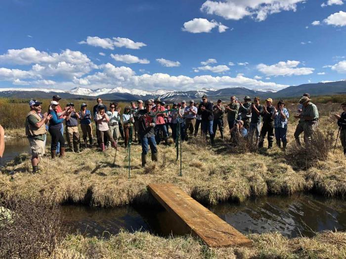
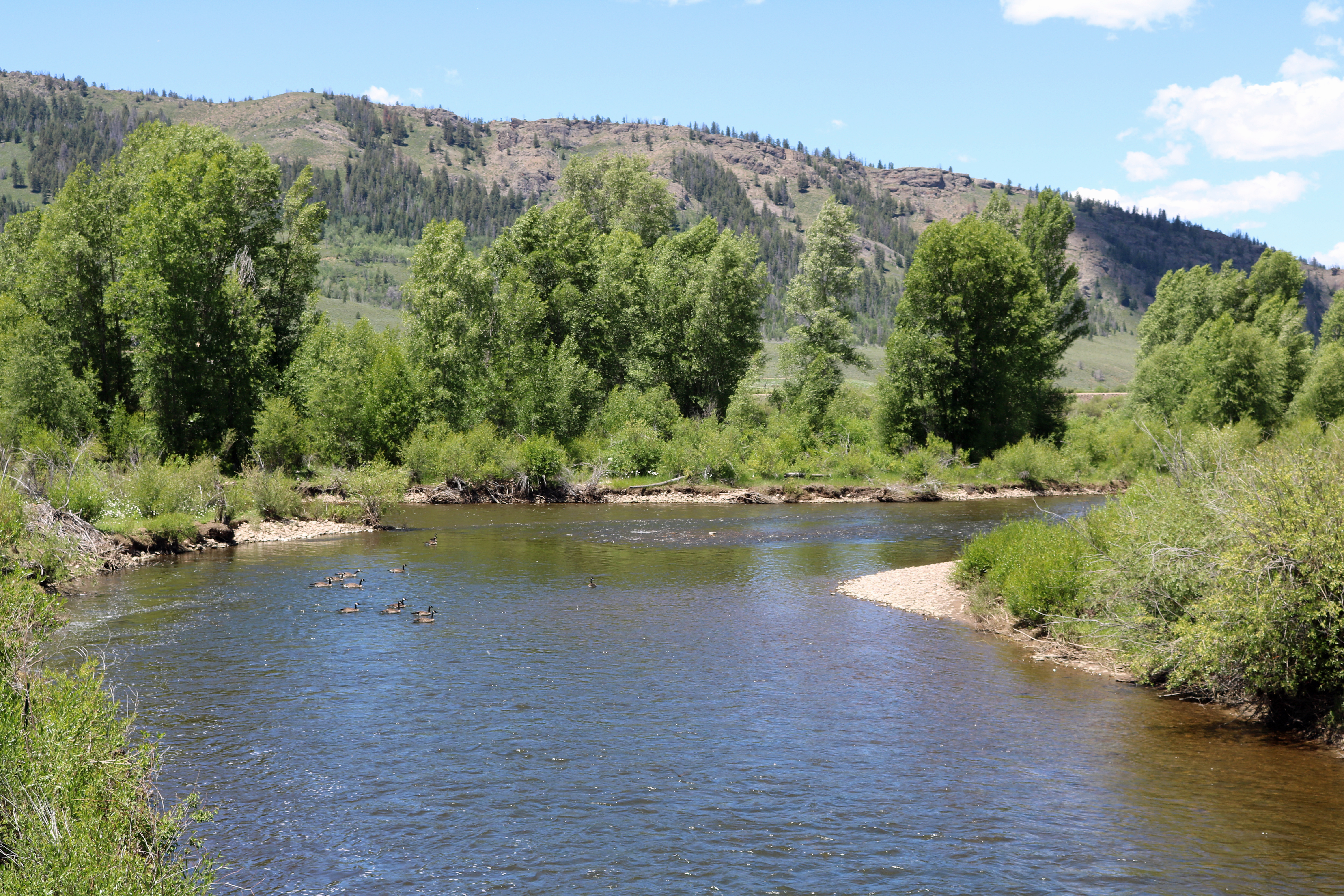
Kirk Klancke, a long-time Grand County environmentalist and president of the Colorado River Headwaters Chapter of Trout Unlimited, said a decision that shuts down the $531 million water project, could also shut down 12 years of work on the Fraser River and its tributaries.
Denver Water is one of 18 partners who signed the Colorado River Cooperative Agreement in 2013, ushering in a new era of cooperation between the utility and West Slope stakeholders, all with the vested interest in protecting watersheds in the Colorado River Basin. As part of that agreement, a process called “Learning by Doing” was created, which has helped the utility stay better connected on river conditions in Grand County. The partnership is a collection of East and West Slope water stakeholders who help identify and find solutions to water issues in Grand County. “Denver Water has been part of Grand County for over 100 years, and we understand the impact our diversions have on the rivers and streams,” said Rachel Badger, environmental planning manager at Denver Water. “Our goal is to manage our water resources as efficiently as possible and be good stewards of the water — and Learning By Doing helps us do that.”
Here’s why: Denver Water owns much of the Fraser with water rights dating back more than 100 years. And it is that water that has historically been piped through the Moffat Tunnel near Rollinsville to fill the existing Gross Reservoir. The new water for the expanded reservoir will come largely from that river as well.
After what’s known as the 2013 Colorado River Cooperative Agreement was signed, Denver Water agreed to conduct extensive restoration work on the river in exchange for being able to raise Gross Dam and bring more water from the Fraser River over to the Front Range.
Klancke said the heavily diverted, scenic waterway would suffer if the deal falls apart. “To dissolve that partnership will be the death of the Fraser River,” he said.
Under the terms of the Colorado River Cooperative Agreement, the work on the Fraser River can only be finalized if the Gross Dam expansion proceeds.
On the upside though, Klancke said, if a new environmental settlement were reached, it could mean more money and more work to restore South Boulder Creek on the other side of the Continental Divide. The creek carries that Fraser River water from the reservoir to Denver Water’s northern storage system.
“I would love to see Denver put a whole bunch of money into South Boulder Creek,” Klancke said.
Gary Wockner, the head of Save The Colorado, disputes the notion that the case could harm environmental work already underway in Grand County.
“We are not causing environmental damage,” he said. “If Denver Water chooses to stop, that’s their choice. That’s on their shoulders. Not ours.”
For its part, Denver says it hopes to continue the Grand County work, but that the terms of the Fraser River agreement are all based on the successful completion of the Gross Dam expansion.
The agency also says it has already set aside $30 million to help offset any environmental harm caused by the massive construction project, including providing 5,000 acre-feet of water to improve streamflows along a 17-mile stretch of South Boulder Creek. An acre-foot of water equals nearly 326,000 gallons, enough water to serve two to four urban households for one year.
Roller-compacted concrete will be placed on top of the existing dam to raise it to a new height of 471 feet. A total of 118 new steps will make up the new dam. Image credit: Denver Water.
Denver Water first moved to raise Gross Dam more than 20 years ago when it began designing the expansion and seeking the necessary federal and state permits.
After years of engineering, studies and federal and state analyses, construction began in 2022. It has involved taking apart a portion of the original dam, built in the 1950s, and raising its height by 131 feet to nearly triple the reservoir’s storage capacity to 119,000 acre-feet from 42,000 acre-feet.
Save The Colorado has launched several unsuccessful challenges to the project, but in 2022 it won an appeal that put the legal battle back in play. Despite months of settlement talks, no agreement was reached.
Then the case took center stage again April 3, when Senior U.S. District Court Judge Christine Arguello put a temporary halt to construction of the higher dam, at Save The Colorado’s request.
Almost immediately, Denver Water filed for temporary relief from the order, saying, in part, that it would be unsafe to stop work as the incomplete concrete walls towered above Gross Reservoir.
Arguello granted that request, too, allowing Denver to continue working on the dam.
Gross Dam case spurred $100 million settlement in a different lawsuit
What happens next is anyone’s guess. Jennifer Gimbel, a water policy scholar at Colorado State University who also serves on Northern Water’s board of directors, said the case has already had an impact on a $2 billion water project to deliver water to residents of fast-growing northern Colorado. The Northern Integrated Supply Project, as it is known, also faced a legal challenge from Save The Colorado, and ultimately the water agency opted to settle the case for $100 million. The cash will help restore the Cache la Poudre River with new diversion agreements and improved streamflows, among other benefits.
Gimbel said the Gross Reservoir case was a key factor in that settlement. “Because of Denver’s troubles with Save the Colorado, Northern Water decided to resolve their lawsuit because they were worried about their own permit getting stale and because as you delay construction costs increase.”
The Gross Dam case is also noteworthy because it has stopped a major construction project already underway and may significantly change it. Judge Arguello has ordered the U.S. Corps of Engineers, the major permitting agency, to redo its original permitting work.
Denver Water General Manager Alan Salazar has said his agency would take the case to the U.S. Supreme Court, if they lose in the lower courts.
As both sides prepare for Tuesday’s hearing, the 10th Circuit Court of Appeals panel has said it will wait to see what information emerges from the Tuesday hearing before it rules on Denver Water’s appeal before the 10th Circuit, according to Denver Water General Counsel Jessica Brody. That action seeks to permanently protect what Denver believes is its right to raise Gross Dam.
Denver Water has also raised national security concerns in the case because Save The Colorado has asked and been granted the right to review construction documents on the dam project, documents that would normally be kept from public view.
In response, the judge has told participants to expect the court to be closed periodically during the hearing to address those security concerns.
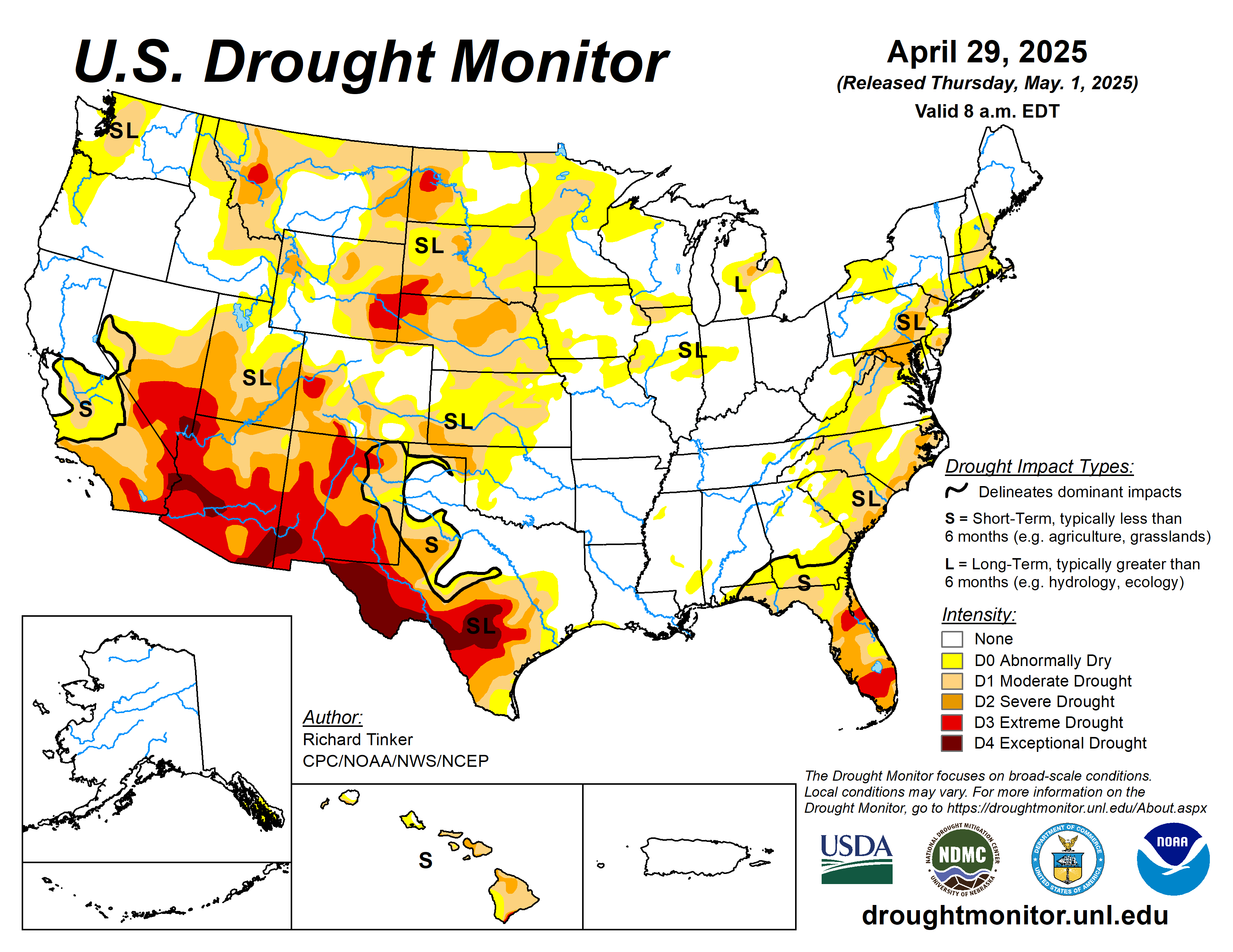
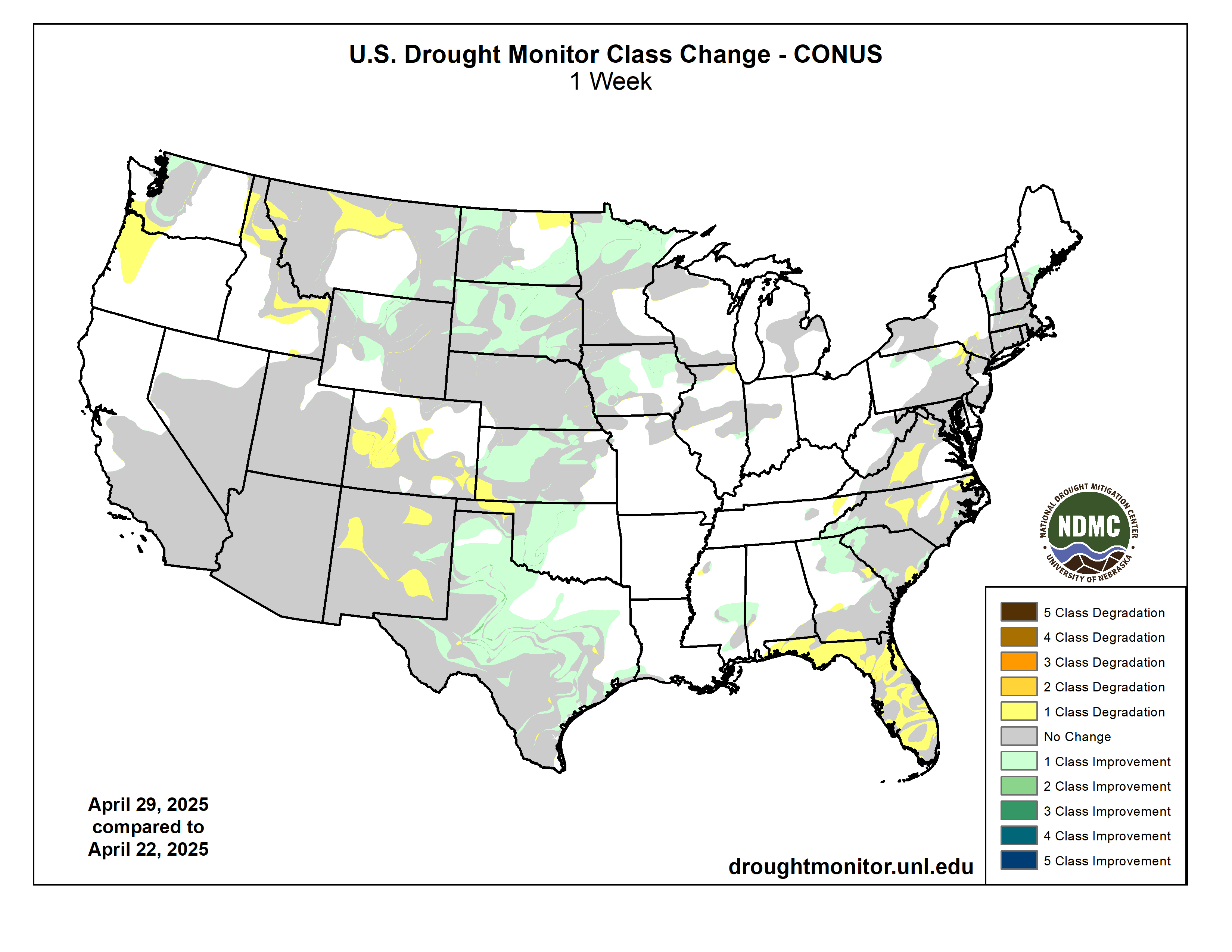
Strong thunderstorms and heavy precipitation again affected parts of the central and eastern Contiguous United States, although coverage was spotty in all but a few areas. Heavy to excessive rains (at least 2 inches) doused portions of the Plains, Mississippi Valley, Upper Southeast, and scattered to isolated sections of the northern and western Great Lakes, Ohio Valley, Carolinas, Northeast, and northern Rockies. In several sizeable areas of the Plains where there was relatively solid coverage of heavy precipitation, conditions improved significantly. Meanwhile, rainfall was negligible (several tenths of an inch at best) in most areas from the Rockies westward and in a few areas farther to the east, including much of southern and western Texas, the Oklahoma Panhandle, southeastern Kansas, central and western Nebraska, central and western North Dakota, a band from parts of the middle Mississippi Valley through the southern and eastern Great Lakes region, much of the immediate Gulf Coast, central North Carolina, central and eastern Virginia, and most of Florida and adjacent southeastern Alabama and southern Georgia. This led to another week with significant dryness and drought expansion and deterioration in the latter areas of the Southeast…
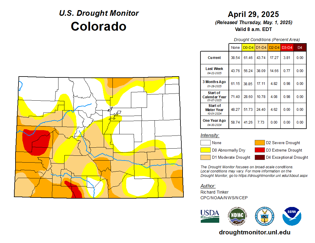
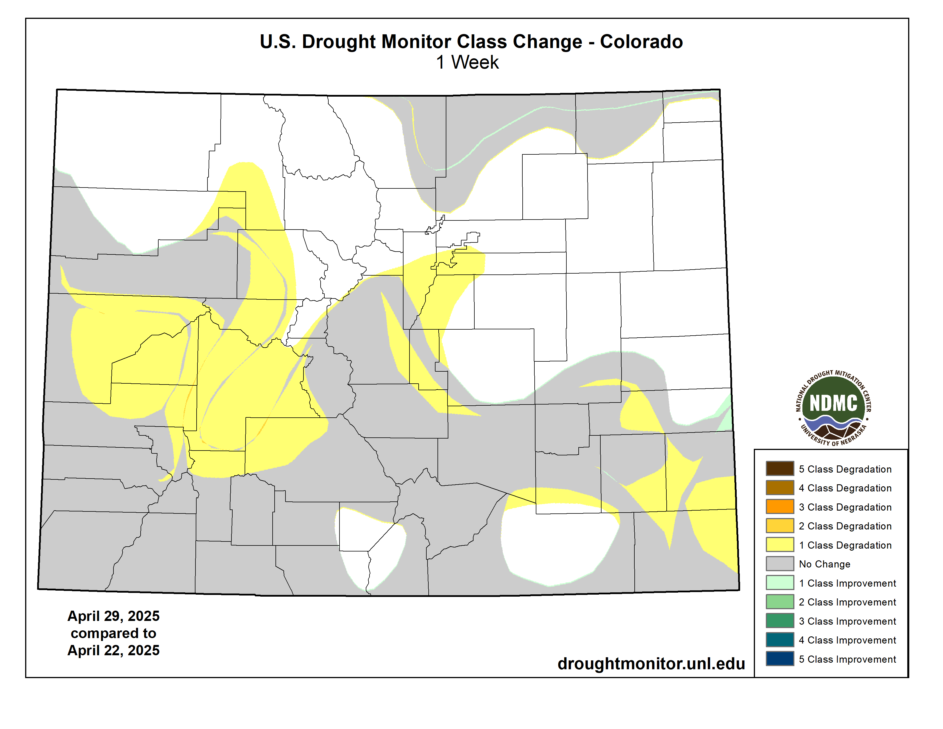
Precipitation totals varied significantly across this region this week, but more areas were hit by heavy rains and improving conditions than dryness and deterioration. The dry week led to deterioration across southwestern Kansas, southeastern Colorado, and much of the central tier of Colorado. Farther north and east, however, widespread heavy rains were noted in several swaths of the Plains and Wyoming, leading to reductions in the intensity and extent of dryness and drought. Improvements were most widespread across central and northwestern Kansas, and most of the state of South Dakota, where heavy rains were most widespread. Still, despite the improvement in many areas, 60-day precipitation totals were under 25 percent of normal in southwestern Kansas and southeastern Colorado, with less than half of normal reported in adjacent areas plus parts of central Kansas, central and northeastern Nebraska, and a few other scattered areas…
Colorado Drought Monitor one week change map ending April 29, 2025.
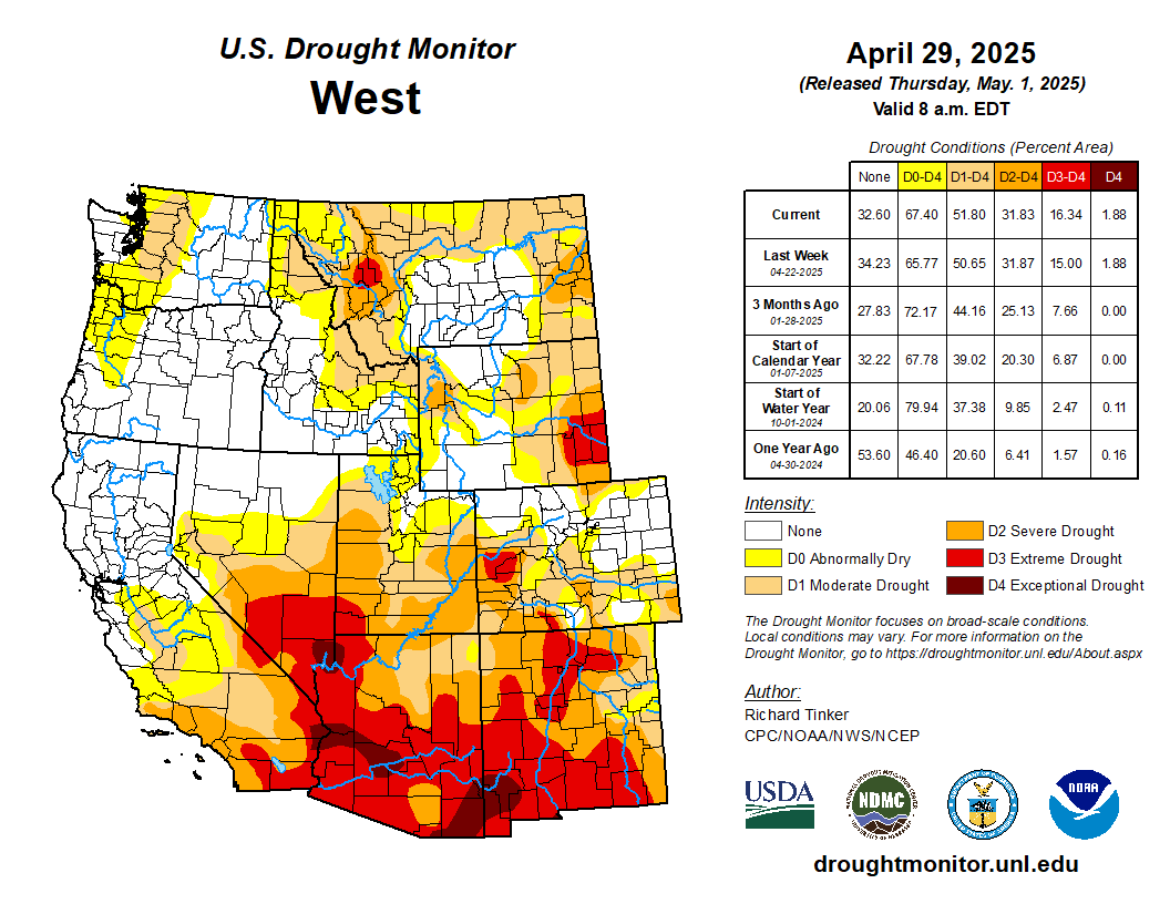
A band of moderate to heavy precipitation (1 to 3 inches) fell across southeastern and south-central Montana, plus isolated spots in eastern Idaho. The rest of the West Region was dry this past week, outside a narrow corridor of heavy rain in east-central New Mexico. As a result, dryness and drought eased its grip in these areas. In addition, some limited improvement was brought into northern and western Washington, and small parts of northern Montana, based on a re-assessment of conditions. Most observed changes, however, were for the worse. Conditions were broadly downgraded across interior northern Montana, and increasing moisture deficits led to the expansion of D0 (abnormal dryness) into southwestern Washington and much of northwestern Oregon. In addition, surface moisture depletion has become increasingly obvious across several areas in New Mexico, leading to a significant increase in D3 (extreme drought) coverage there. The dryness was more climatologically seasonable across Arizona, Nevada, and California, where conditions were unchanged this week…
The heaviest rain in the Contiguous United States fell on a band from central Oklahoma southwestward across the Red River (south) into part of northwestern Texas. An area covering several counties recorded 4 to locally 8 inches of rain. Lesser but still heavy amounts (over 2 inches) fell on many areas across the rest of northern, central, and eastern Texas, portions of Louisiana and Mississippi, part of southern Tennessee, and a few scattered locations across Arkansas. Rainfall during the current and past few weeks led to large areas of improvement across the central, northern, and eastern portions of the Texas dryness and drought coverage, in addition to north-central Oklahoma and the western portions of the state outside the Panhandle. Dryness and drought remains widespread across most of Texas outside the northeast and over western portions of Oklahoma, with some deterioration to D2 (severe drought) noted in the Oklahoma Panhandle, which missed the week’s heavy rains. A broad area of exceptional drought (D4) remained entrenched across a large swath in central and western Texas, though there was some erosion of its eastward extent. East of this area of solid drought coverage, most areas are free of dryness and drought, and locally heavy rains reduced the coverage even further in part of southeastern Mississippi. Small, isolated areas of abnormal dryness (D0) elsewhere were limited to northwestern Mississippi and eastern Tennessee. Arkansas is entirely free of any dryness or drought…
Looking Ahead
During May 1-5, 2025, heavy rain (2 to locally 5 inches) is forecast for central and northeastern Texas, northern Louisiana, and southern Arkansas. Moderate to locally heavy totals (1 to 2.5 inches) are expected over much of Mississippi and Alabama, the central and southern Appalachians, the middle and upper Ohio Valley, Pennsylvania and adjacent New York and New Jersey, and a small portion of the central Great Lakes. Light to moderate totals (a few tenths to locally over an inch) is expected across the remainder of the eastern Contiguous United States, with the lowest amounts expected across coastal South Carolina, most of Georgia, and the northern and western sections of the Florida Peninsula. Several tenths to an inch are also forecast from the central and southern Plains westward through much of the Rockies, Nevada, and most of California, with locally higher amounts in some higher elevations of the Sierra Nevada and Great Basin. Little or none is forecast across the northern tier from the upper Mississippi Valley westward to the Pacific Coast, and in some climatologically drier parts of the Southwest. Warmer than normal weather is expected from the western Great Lakes through the northern Rockies and Intermountain West, with daily highs averaging 10 to 13 deg. F above normal in the northern Plains and adjacent areas. Meanwhile, cooler than normal conditions are anticipated from central and southern California through the Great Basin, southern Rockies, and central and western Texas. Highs are expected to average 8 to 10 deg. F below normal from western Texas through portions of the Great Basin and central through southern California.
The Climate Prediction Center’s 6-10 day outlook valid May 6-10, 2025 favors subnormal precipitation across the Great Lakes, middle and upper Mississippi Valley, the Ohio Valley, the interior Southeast, the mid-Atlantic region, the lower Northeast, and western New England. In contrast, enhanced chances for wetter than normal conditions cover Florida and the immediate southern Atlantic Coast, the Gulf Coast, the lower Mississippi Valley, the central and southern Plains and Rockies, most of the Great Basin, the Southwest, southeastern portions of Alaska, and Hawaii. Higher than normal temperatures are favored across roughly the northern two-thirds of the Contiguous United States, with odds exceeding 70 percent in the northern Plains and adjacent Mississippi Valley. Enhanced chances for warmer than normal weather also extend across Hawaii, especially central and western parts of the island chain. Increased odds for subnormal temperatures cover Florida, central and western Texas, the central and southern Four Corners region, and southeastern Alaska. Chances for significantly cooler than normal conditions exceed 50 percent across central and southern New Mexico.
US Drought Monitor one week change map ending April 29, 2025.