Mountain snowmelt is the lifeblood of the Great Salt Lake, providing the vast majority of its fresh water. On average the mountains around the lake contribute approximately 1.9 to 2.1 million acre-feet of surface runoff annually.1 However on February first of this year – with Utah’s snowpack in near record-poor condition, Utah’s Natural Resources Conservation Service released a report that forecast a reduction in snowmelt that ranges from 21% to 77% of average.2
This (potentially) dramatic drop in snowmelt forces our attention to the Great Salt Lake’s other major source of water, the Bear River, and there the news is equally alarming. The Bear River in Utah faces a variety of environmental threats primarily from human activities like agriculture, water management, and development. These impact water quality, habitats, and flows into the Great Salt Lake. The following list of challenges the river faces are ranked in order of prevalence and severity, from reports like wetland studies and conservation plans.3
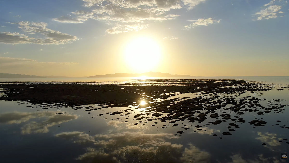
Clusters of microbialites, potentially thousands of years old, are endangered by The Great Salt Lake’s declining water levels and the water’s rising salinity. Video by Robert Marcos.
Water Diversions: Proposed and existing diversions, such as the Bear River Development project, threaten to reduce flows by up to 220,000 acre-feet annually, lowering Great Salt Lake levels by 8.5-14 inches and exposing lakebed dust with toxins like arsenic. This exacerbates drought effects and harms migratory birds reliant on Bear River Bay wetlands.4
Agricultural Runoff: Runoff from intensive farming affects 83% of wetlands, delivering excess nutrients, sediments, and pollutants that cause eutrophication, algal blooms, and oxygen depletion. The Bear River is impaired throughout the study area due to these inputs, worsened by upstream sources in Utah, Idaho, and Wyoming.5
Hydrologic Alteration: Dams, irrigation, and impoundments alter flow timing and flooding, impacting nearly all wetlands and degrading riparian habitats. Reservoirs like Cutler divert spring runoff, leading to inconsistent river flows and wetland desiccation.6
Invasive Species: Non-native plants like Phragmites australis cover 11% of wetlands, outcompeting natives and reducing biodiversity, especially in disturbed mudflats. Agricultural species such as foxtail and clover invade via forage planting.7
Sediment and Pollution: Erosion from tributaries and livestock causes siltation, while point sources (69% of wetlands) and nanoparticles from boat paints add contaminants. Legacy issues like high alkalinity and industrial wastes persist.8
A photo of Glen Canyon Dam from 2022, when the dam’s intake points were 33 feet away from minimum power pool. The top of the grate-like penstocks can be seen in this photo. Luna Anna Archey / High Country News
Floyd Dominy, the commissioner of the federal Bureau of Reclamation in the 1960s, was largely responsible for the construction of Glen Canyon Dam on the Colorado River. In 1963, when the dam was completed, he could not have foreseen the climate situation we find ourselves in today, with declining snowpack, record-high temperatures and alarmingly low water levels in Lake Powell, year after year. But he and his engineers could have, and should have, foreseen that the way they designed the dam would leave little room to maneuver should a water-supply crisis ever impact the river and its watershed.
Indeed, a state of crisis has been building on the Colorado for decades, even as the parties that claim its water argue over how to divide its rapidly diminishing flows. Lately, things have entered a new and perilous phase. Last Nov. 11 was a long-awaited deadline: Either the states involved — California, Arizona, Nevada, Utah, New Mexico, Colorado and Wyoming — would have to agree on a new management plan, or else the federal government would impose its own, something none of the parties would welcome. Meanwhile, the 30 tribes that also hold claims to the river have historically been and continue to be excluded from these negotiations.
Udall/Overpeck 4-panel Figure Colorado River temperature/precipitation/natural flows with trend. Lake Mead and Lake Powell storage. Updated through Water Year 2025. Note the tiny points on the annual data so that you can flyspeck the individual years. Credit: Brad Udall
That deadline came and went, and instead of acting, the government punted, this time to Feb. 14. Nobody was surprised: Unmet deadlines and empty ultimatums have been business as usual on the river for years. Decades of falling reservoir levels and clear warnings from scientists about global warming and drought have prompted much hand-wringing and some temporary conservation measures, but little in the way of permanent change in how water is used in the Colorado River Basin.
The downstream face of Glen Canyon Dam, which forms Lake Powell, America’s second-largest water reservoir. Water is released from the reservoir through a hydropower generation system at the base of the dam. Photo by Brian Richter
For decades, the seven Basin states have used more water than the river delivers by drawing their entitlements from surpluses banked in reservoirs during the wet 1980s and ’90s, chiefly in Lake Mead and Lake Powell. Never mind that those entitlements were based on an over-estimate of river flows in 1922, when the Colorado River Compact was established, rendering the “paper” water of the entitlements essentially a fiction, not to mention a source of continual conflict. That savings account has now been drained: Mead and Powell are each below 30% full, and the trend is steadily downward. Global warming has only accelerated the decline: So far this century, the river’s flow has fallen 20% from its long-term annual averages, and scientists forecast more of the same as the climate continues to heat up.
The back of Glen Canyon Dam circa 1964, not long after the reservoir had begun filling up. Here the water level is above dead pool, meaning water can be released via the river outlets, but it is below minimum power pool, so water cannot yet enter the penstocks to generate electricity. Bureau of Reclamation photo. Annotations: Jonathan P. Thompson
Meanwhile, the physical infrastructure that enables Colorado River water management is on the verge of its own real and potentially catastrophic crisis — and yet Reclamation has barely acknowledged this, with the exception of an oblique reference in an unposted technical memorandum from 2024. The falling reservoir levels reveal another, deeper set of problems inside Glen Canyon Dam, which holds back the Colorado and Lake Powell. The 710-foot-tall dam was designed for a Goldilocks world in which water levels would never be too high or too low, despite the well-known fact that the Colorado is by far the most variable river in North America, prone to prodigious floods and extended droughts. But the Bureau, bursting with Cold War confidence — or hubris — chose to downplay the threat. In the record-breaking El Niño winter of 1983, the Bureau almost lost the dam to overtopping, due to both its mismanagement and its design, because the dam lacks sufficient spillway capacity for big floods. Only sheets of plywood installed across its top and cooler temperatures that slowed the melting of that year’s snowpack saved Glen Canyon Dam.
The four 96-inch diameter steel pipes of the River Outlet Works. If the dam’s penstocks are closed, these pipes are the only remaining way to pass water through the dam, and are unsafe to use for extended intervals. Luna Anna Archey / High Country News
Gus Levy, Glen Canyon Dam’s plant facility manager, walks past hydropower turbines. In 2022, due to the low water level of Lake Powell, only five of the eight turbines operated on a daily basis, though all eight were kept in working order. Luna Anna Archey / High Country News
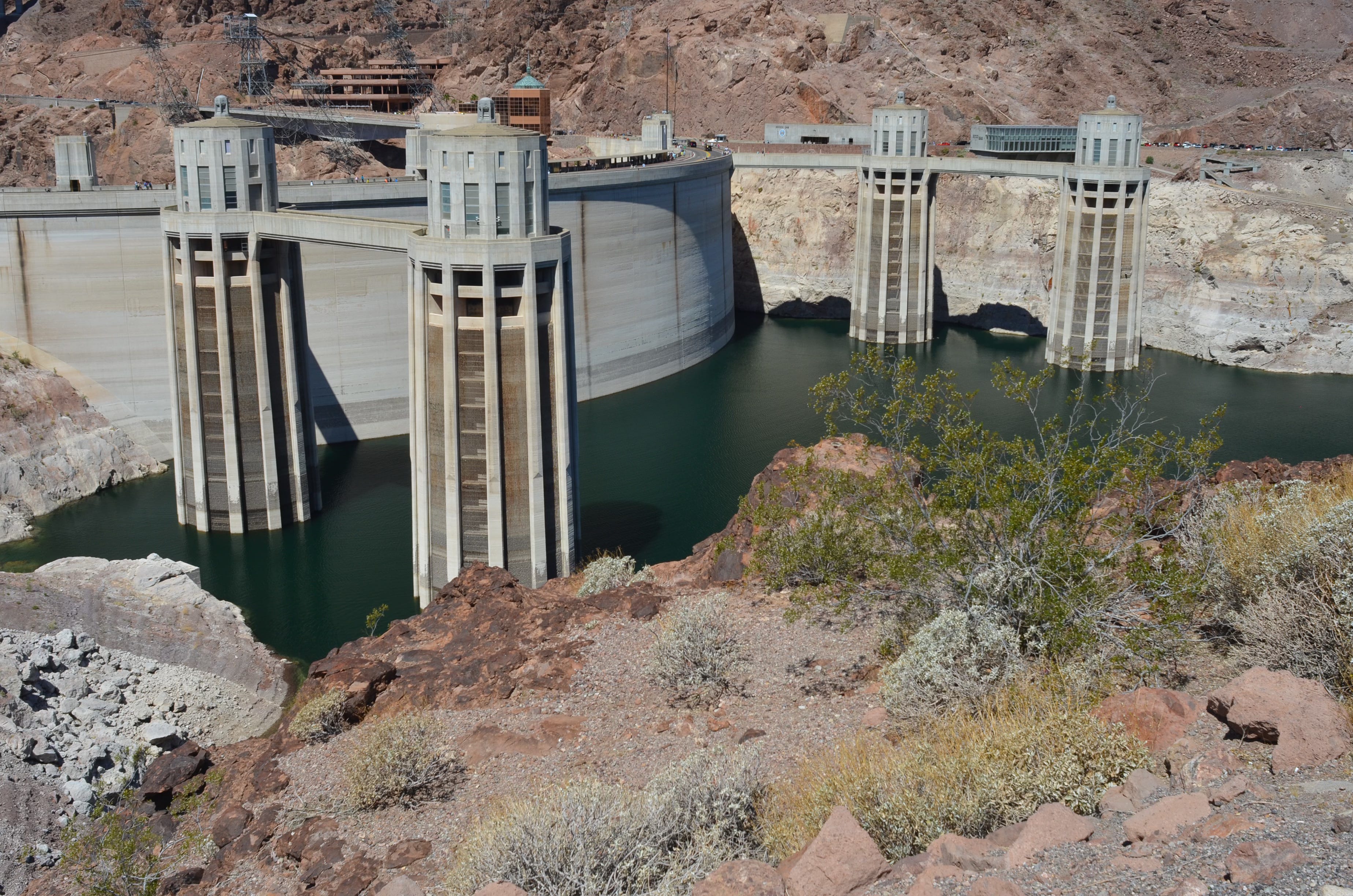
Today, the dam is threatened not by too much water but too little. In March 2023, the water level of Lake Powell dropped to within 30 feet of the minimum required for power generation, known as “minimum power pool.” At 3,490 feet above sea level, minimum power pool is 20 feet above the generators’ actual intakes, or penstocks, but the dam’s eight turbines must be shut down at minimum power pool to avoid cavitation — when air is sucked down like a whirlpool into the penstocks, forming explosive bubbles which can cause massive failure inside the dam.
Even more worrisome is what would happen next. At minimum power pool, the penstocks would have to be closed, and the only remaining way to pass water through the dam is the river outlet works, or ROWs: two intakes in the rear face of the dam leading to four 96-inch-diameter steel pipes with a combined maximum discharge capacity of 15,000 cubic feet per second. However, the ROWs, also known as bypass tubes, have a serious design flaw: They are unsafe to use for extended intervals, and start to erode when the reservoir is low.
In 2023, when the ROWs were used to conduct a high-flow release into the Grand Canyon at low-reservoir levels, there was, in fact, damaging cavitation, and the Bureau has warned that there would likely be more in the event of their extended use. In practice, safe releases downstream may only be a fraction of their claimed capacity — and if the tubes begin to experience cavitation, flows may need to be cut off entirely. Such a scenario would compromise the dam’s legal downstream delivery requirements, or, to put it bluntly, its ability to deliver enough water to the 25 million people downstream who rely on it — as well as the billions of dollars’ worth of agriculture involved. This means that Lake Powell — and with it, the entire Colorado River system — is perilously close to operational failure.
If reservoir levels drop to the ROWs’ elevation of 3,370 feet above sea level, Lake Powell would reach “dead pool,” where water would pass through the dam only when the river’s flow exceeded the amount of water lost to evaporation from the reservoir. No other intakes nor spillways exist below the ROWs. There is no “drain plug.” Yet there is more dam — 240 feet more before the bottom of the reservoir, effectively the old riverbed. This not-insignificant impoundment — about 1.7 million acre-feet of water — would be trapped, stagnant and heating in the sun, prone to algal blooms and deadly anoxia. The lake would rise and fall wildly, as much as 100 feet in a season, because of the martini-glass shape of Lake Powell’s vertical cross section.
Illustration from the report, <a href=”https://utahrivers.org/blog-post/2022/8/9/lenapost“>Antique Plumbing & Leadership Postponed</a> from the Utah Rivers Council, Glen Canyon Institute and the Great Basin Water Network. Courtesy of Utah Rivers Council
Insufficient or no flows through Glen Canyon Dam would be a disaster of unprecedented magnitude, affecting vast population centers and some of the biggest economies in the world, not to mention ecosystems that depend on the river all the way to the Gulf of California in Mexico. The Lower Basin states of California, Arizona and Nevada warned as much in a recent letter to Interior Secretary Doug Burgum, saying that Reclamation’s failure to mention the dam’s plumbing problems in its current environmental impact statement for post-2026 operations is against federal law. The letter reads: “Addressing the infrastructure limitations may be the one long-term measure that would best achieve operation and management improvements to the Glen Canyon Dam.”
To date, however, the Bureau has made no formal response.
One thing is clear: Glen Canyon Dam will need to be modified to meet its legal and operational requirements. In the process, the health of the ecosystems in Glen Canyon, above the dam, and in Grand Canyon, below it, must be considered. The best way to avoid operational failure and the economic and ecological disasters that would follow is to re-engineer the dam to allow the river to run through it or around it at river level, transporting its natural sediment load into the Grand Canyon.
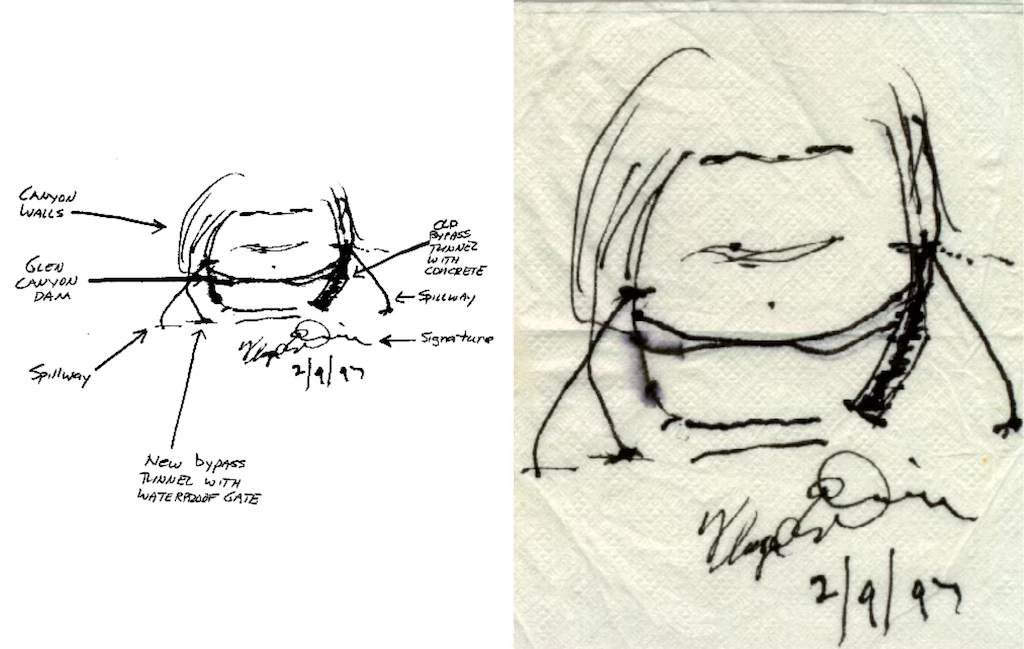
Sketches by Floyd Dominy show the way he’d end the Glen Canyon Dam. From the article “Floyd Dominy built the Glen Canyon Dam, then he sketched its end on a napkin” on the Salt Lake Tribune
As it happens, Floyd Dominy himself provided us with a simple and elegant plan for how to do it. In 1997, the former commissioner sketched on a cocktail napkin how new bypass tunnels could be drilled through the soft sandstone around the dam and outfitted with waterproof valves to control the flow of water and sediment. What it prescribes is treating the patient — the Colorado River, now on life support — with open-heart surgery, a full bypass. Dominy’s napkin, which he signed and gave to my colleague Richard Ingebretsen, the founder of Glen Canyon Institute, is effectively a blueprint for a healthier future for the Colorado River and the people and ecosystems that depend on it.
But the window for action to avoid dead pool is dauntingly narrow and closing fast, especially given the time that would likely be required for the government to study, design and implement a fix. The Trump administration’s gutting of federal agency expertise and capacity adds yet more urgency to the issue. Whatever may or may not get decided on Feb. 14, the feds and the basin states need to look beyond the water wars and start building a lasting, sustainable future on the Colorado River.
The seven states that take water from the Colorado River have a deadline of February 14 to come up with a river management plan that they can all agree on. And every day that passes it looks as if that deadline, not the first one they have faced, will also be missed. Valentines Day may not be one of shared love by all.
The Colorado River basin is experiencing the greatest drought and loss of flows in the past 1200 years and the various agreements crafted to deal with deepening drought, particularly the 2007 Interim Guidelines and subsequent Drought Contingency Plans, are set to expire at the end of this year.
The major sticking point is centered around how water diversions from the river will be cut, and there will be substantial cuts. Most of that burden will fall on the Lower Basin states of California, Arizona and Nevada. They are the largest users of Colorado River water. Cuts for the four Upper Basin states; Colorado, Wyoming, Utah and New Mexico are not considered in either the previous guideline and agreements nor in the recently released Draft Environmental Impact Statement (DEIS) for Post-2026 Operational Guidelines and Strategies for Lake Powell and Lake Mead by the Bureau of Reclamation. The DEIS only looks at the river below the upper reaches of Lake Powell.
This has the Lower Basin up in arms. They are demanding mandatory, verifiable and enforceable cuts by the river diversions in the Upper Basin. The Upper Basin is refusing this demand, and Arizona in particular is threatening to unleash its historical use of litigation to try and get what it wants.
Underlying this, however, is a very fundamental misunderstanding of how water diversions work between the Lower and Upper Basins. I’m starting to think that misunderstanding is deliberate, primarily to mislead the public constituents within the Lower Basin states. [ed. emphasis mine]
Tom Buschatzke, director of Arizona’s Department of Water Resources, has said, “We need certainty there are reductions in upper basin usage because that is one of the two tools that we have… You can’t make it snow or rain. But you can reduce your demand”.
But in the Upper Basin that is not as easy as it sounds.
I have read that the true skill of a good negotiator is in being able to truly understand the other sides position. There are skilled and knowledgeable negotiators in the Lower basin, but I don’t think that they truly understand the Upper Basins position. They have been accustomed, some would say addicted, to the reliable delivery of stored water for all their needs since Hoover Dam was built and began releasing stored water some 90 years ago. Only until very recently, even in the face of an unrelenting drought, have they had to deal with shortages. For the Upper Basin shortage is an annual reality.
The Lower Basin takes water from the Colorado River mainly through a small handful of very large diversions such as the All American Canal, which provides water for Imperial and Coachella Valley agriculture, the Central Arizona Project (CAP) providing water for Pheonix, Tucson, Tribes, and Arizona agriculture and the California Aqueduct, which provides water for Los Angeles, San Diego and most Southern California cities. While distribution from these few large diversions to individual contract uses may be complicated by drought, reducing the intake at their diversion points isn’t.
That situation is very different in the Upper Basin. In Colorado, Wyoming and New Mexico there are many thousands of small diversions taking water from the Colorado River, the Green River and their myriad headwater tributaries. There are a few large diversions in the Upper Basin, primarily for water taken out of the basin to Colorado’s East Slope cities and farms and to Utah’s Wasatch Front, but these diversions are still quite small compared to those in the Lower Basin.
The largest reservoirs in the Upper Basin are those built through the Colorado River Storage Act (CRSP, 1956), such as Flaming Gorge, Blue Mesa and Navajo. These reservoirs were not built to supply Upper Basin water needs, but to provide a “bank account” for Colorado River Compact compliance. In other words, for the benefit of the Lower Basin. Releases from these reservoirs are contemplated in the Post-2026 DEIS to maintain water elevations in Lake Powell that protect vital dam infrastructure and hydropower generation.
Lake Powell is also an Upper Basin reservoir in the CRSP Act of 1956. It was built entirely for Compact compliance and water deliveries to the Lower Basin. It has no water supply benefit to the Upper Basin other than as a Compact savings account.
A major wrinkle in any mandatory curtailments in Upper Basin diversions is simply in administrative logistics. It would be a complete nightmare for water administration and the State water engineers offices. And in Colorado it would be in the Water Courts as well.
A little legal background is needed here as well.
See Article 6.
All of the Colorado Basin states have Prior Appropriation as the bedrock doctrine for their water laws. California has a bit of a mix with Riparian law, but as far as the Colorado River diversions are concerned prior appropriation rules. Prior appropriation is the doctrine of “first in time, first in right” to divert the available water. Colorado was the first to codify prior appropriation in its state constitution, in 1876. Article 16, Section 6:
“The right to divert the unappropriated waters of any natural stream to beneficial uses shall never be denied. Priority of appropriation shall give the better right as between those using the water for the same purpose; but when the waters of any natural stream are not sufficient for the service of all those desiring the use of the same, those using the water for domestic purposes shall have the preference over those claiming for any other purpose, and those using the water for agricultural purposes shall have preference over those using the same for manufacturing purposes.“
In Colorado you don’t actually need a court decreed right to divert water to a beneficial use. Just a shovel and a ditch. However, you are still subject to prior appropriation and can be the first cut off if a call is placed on the stream. There are a lot of such small diversions without an adjudicated right. I used to water my lawn in Eagle that way.
The Colorado River Compact of 1922 was created to avoid prior appropriation between the states. The US Supreme Court had decided that when there is a dispute over water between States that held prior appropriation as their foundational water law, seniority applies across state lines. Southern California was starting to grow at a much more rapid pace than the other states, greatly alarming the headwater, Upper Basin states. The Compact was crafted so that water from the river could be allocated “equitably”, allowing each state to grow and develop its water at its own pace. The Compact became the foundation of what is now known as the Law of the River. Laws based on prior appropriation still govern water use and administration within each State.
Arizona and California began arguing and litigating almost immediately, with Arizona usually on the losing end. That changed in 1963 when the US Supreme Court handed down a decision that once and for all set the water allocations for the Lower Basin, based on the allocations created in the 1928 Boulder Canyon Project Act, which finally ratified the Compact and paved the way for Hoover Dam, Lake Mead and the All American Canal.
Then the seniority picture between states changed with the passage of the 1968 Colorado River Projects Act that authorized construction of Arizona’s long fought for dream of the Central Arizona Project. To get passage, Arizona had to subordinate its water rights to California, making it the junior and first to take cuts in times of drought.
Upper Colorado River Basin map via the Upper Colorado River Commission.
None of that extended into the Upper Basin, where the States had been getting along just fine, mostly, since the Compact was signed. These four states drafted their own Upper Colorado River Basin Compact in 1948, mainly so they could get more money from the Federal Government to build water storage and delivery projects. They did something novel, allocating each states share by a percentage of the rivers flow, not by set volumes of water as the 1922 Compact had done.
Udall/Overpeck 4-panel Figure Colorado River temperature/precipitation/natural flows with trend. Lake Mead and Lake Powell storage. Updated through Water Year 2025. Note the tiny points on the annual data so that you can flyspeck the individual years. Credit: Brad Udall
Everything was fine so long as the major reservoirs of Lakes Mead and Powell were full. That has changed considerably since the onset of the current mega, or Millennial drought began in 2000. The two reservoirs have dropped to very low levels, levels never anticipated or planned for.
Here is the crux of the matter. The Lower Basin is demanding mandatory cuts from Upper Basin uses so that more water can flow downstream for their use. The 1922 Compact says clearly that the Upper Basin states “will not cause the river flow at Lee Ferry to be depleted below and aggregate of 75,000,000 acre feet for any period of ten consecutive years…”. The Lower Basin states argue that this constitutes an “obligation” to deliver that much water to them. The Upper Basin states say no, there is no delivery obligation. It is a non-depletion requirement, that through diversions and actual consumption the states can’t let those flows drop below 75 million acre feet (maf) in a ten year running average.
That has never been a problem, until now. The 1922 Compact and its non-depletion requirement is a priority right in itself. Any water right in the Upper Basin that was adjudicated, perfected by actual use and consumption, after 1922 is subject to curtailment for fulfilling the non-depletion requirement. Any and all rights perfected prior to November 1922 are exempt.
So far, as of 2026, the required flows over a ten year running average have not yet hit that non-depletion trigger of 75 maf running average over ten years. Not yet, but it could be getting close.
The Upper Basin states live by a “run of the river” system as there are no large storage units dedicated to their use as the Lower Basin has with Powell and Mead. There are many small reservoirs used for a single irrigation season, filled with the spring runoff and then empty by the end of the growing season. But they also are subject to how much water comes in the spring and downstream senior calls.
Every year, especially since this mega drought and increased aridification began, Upper Basin irrigators are curtailed each summer as the streams shrink and the small reservoirs are drained. Some years this curtailment includes water rights that are senior to the Compact as well.
The Upper basin, in short, is forced to live within its means, with what it has and no more than Mother Nature provides with the winter snowpack. As Tom Buschatzke said, “You can’t make it snow or rain. But you can reduce your demand”. The Upper Basin does exactly that every year, especially in years like this with a record low snowpack.
The mandatory, verifiable and enforceable cuts demanded by the Lower Basin would be more than difficult to achieve. And again, it would be an administrative and legal nightmare for those assigned the task on the thousands of relatively small, individual diversions that make up the Upper Basin’s water use from the Colorado River. There are those larger trans-basin diversions to the Colorado East Slope and cities, but even if they took substantial cuts, it would still be a pretty small amount of water. No where near the amounts that the Lower Basin has become accustomed to.
Right now the Upper Basin uses roughly half their Compact allocation, roughly around 4 maf a year, while the Lower Basin has historically used more than their full Compact allocation. To their credit, the Lower Basin has made substantial cuts, some voluntary and some enforced by agreements and obligations. California was forced to cut their water use by 800,000 acre-feet with the 2007 Interim Guidelines, back to their actual decreed limit, a cut some claim as an example of how much “sacrifice” they have made. They and Arizona have made additional cuts as well, now taking around 6 maf, from a historic high near 10 maf per year.
I agree that the Upper basin needs to work harder at conservation, and they have been trying hard over the last few years. They haven’t been hording water or ignoring the needs of the Lower Basin or those spelled out in the Compact and subsequent agreements as some in the Lower Basin claim. But “mandatory” cuts beyond those already happening each and every summer will require significant changes with state water law and administration. In Colorado’s case it could well require a change to Article 16, Section Six, of the state’s constitution which has held unaltered since 1876.
We live now in a very different world from the 1800’s and 1922 when the Compact was drafted, using highly optimistic flow calculations that they already knew were wrong. But the men who drafted it were boosters, as were their fathers, seeing the West as they wanted to, not as it really was. America’s westward expansion has always been driven by dreams of abundance, and for a while the river was able to provide that through massive engineering, a still small but growing population and some pretty wet years. Many still hold on to that misguided dream of abundance in an increasingly arid region.
That has all evaporated. All water users in the West, especially the Colorado River basin, expect certainty and reliability, as Tom Buschatzke declared. We’ve built an entire system, and an entire economy based on those principals. Certainty and reliability are now fading rapidly in the rear view mirror, if we dare to look. Many won’t. The Colorado River has made the desert bloom and let us build great cities. But its dwindling supply is placing all that in jeopardy. We need to adapt. The only certain and reliable future is one with less water, greater aridity and warmer and much drier climate.
Maybe our great civilization built on a desert river will go the way of the Hohokam who filled the valley Pheonix now inhabits with irrigation canals and a thriving population. Maybe. We can change that scenario if we adapt to the new reality. That will be both hard and painful. Parochial self-interest must be balanced with regional ties and interests, and that is never easy. Nor is it politically palatable. The Lower Basin is railing against the Upper Basin’s refusal to provide water it just doesn’t have. The Upper Basin is living within its means while honoring its commitments to the Compact as best it can.
The Bureau of Reclamation in its DEIS for Post-2026 river management introduced a new concept, at least new for Colorado River management. Decision making under Deep Uncertainty, or DMDU. Many, seemingly, aren’t familiar with that concept. Even the Bureau’s recommendations may not go far enough with that concept. They don’t seriously engage the reality that both Powell and Mead are headed for deadpool, meaning that the only water available from either reservoir will be what flows in. There will be no storage to rely on. None. That will have far more devastating impacts than what any of the alternatives contemplate. [ed. emphasis mine]
But when the well runs dry there isn’t much we can do. A few years ago the concept of stationarity in climate norms, basing predictions within the parameters of historical extremes, was declared dead. The ideas of certainty and reliability are now headed for the same graveyard.
Colorado River “Beginnings”. Photo: Brent Gardner-Smith/Aspen Journalism
Click the link to read the assessment on the NOAA website:
February 11, 2026
January Highlights:
The global surface temperature was the fifth-warmest January on record—the smallest temperature departure since 2023.
Snow cover extent was below average for North America and near average for Eurasia.
Sea ice extent was near record low for the Arctic and below average for Antarctica.
Global tropical cyclone activity was above normal with 11 named storms.
Map of global notable weather and climate anomalies and events in January 2026.
Temperature
January 2025 ranked as the fifth-warmest January in NOAA’s 177-year record, with a global surface temperature 2.02°F (1.12°C) higher than the 20th-century baseline. All 10 of the warmest Januarys on record have occurred since 2007, with the most recent five years (2022–26) among the top 10.
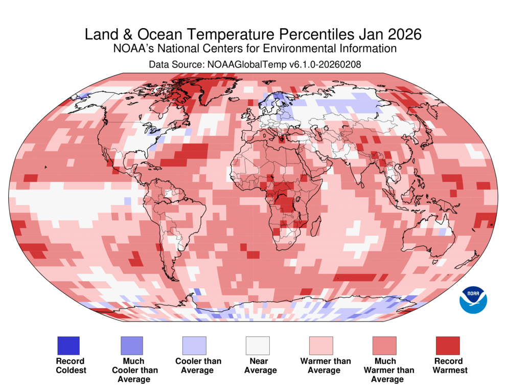
Land and Ocean Temperature Percentiles for January 2026. Red indicates warmer than average and blue indicates colder than average.
In January 2026, unusually high temperatures prevailed across much of the Earth’s surface. The most notable high temperature departures were observed across the Arctic, Greenland, the western U.S., Canada, Africa, southern and eastern Asia and parts of Australia, where temperature departures were at least 3.6°F (2.0°C) above average. Several regions across the globe experienced their warmest January on record, including parts of Greenland, Africa, Asia, the Atlantic and parts of the Pacific and Southern Oceans. Notably, Africa experienced its warmest January on record, while North America, South America and Oceania had a top 10 warm January.
In contrast, notable below-average temperatures were observed in Alaska, the eastern U.S., Europe, northern Asia and across parts of Antarctica and the central and eastern tropical Pacific Ocean. However, no land or ocean areas experienced record-cold January temperatures.
Snow Cover
In January 2026, snow cover extent across North America and Greenland was 150,000 square miles below average, tying with 2002 for the 12th-smallest January extent on record. Meanwhile, Eurasia saw near-average coverage at 11.48 million square miles. Overall, Northern Hemisphere snow cover for January was slightly below average at 18.12 million square miles.
Regionally, snow deficits were most pronounced across the western half of the contiguous U.S. and central Asia extending into China. In contrast, above-average snow cover was observed in the south-central U.S. extending towards the Northeast, central and eastern Europe, Japan and parts of northern and northeastern China.
Sea Ice
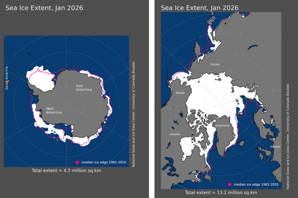
Global sea ice extent was the fifth smallest for January in the historical record at 550,000 square miles below the 1991–2020 average. The Arctic sea ice extent was below average by 340,000 square miles, tying with 2025 as the second-smallest January extent in the 48-year record. The Antarctic sea ice extent for January was the 13th smallest at 210,000 square miles below average.
Map of the Antarctic (left) and the Arctic (right) sea ice extent in January 2026.
Tropical Cyclones
Global tropical cyclone activity in January was above normal, producing 11 named storms. Four of these reached tropical cyclone strength, and two intensified into major tropical cyclones. Most of the activity occurred in the Southern Hemisphere (South Indian, Australian and Southwest Pacific basins), with one named storm in the West Pacific. No storms formed in the North Atlantic, East Pacific or North Indian basins, which is typical during January.
Notably, Tropical Cyclone Fytia, in the Southern Indian basin, made landfall in northern Madagascar at the end of the month as a strong cyclone, bringing heavy rainfall and widespread flooding. The storm caused at least 12 deaths, displaced thousands and damaged or destroyed thousands of homes.
More than 8,500 daily heat records have been tied or broken in the West this winter. "I have not seen a winter like this," said NSIDC director Mark Serreze, who has been in Colorado almost 40 years. "This pattern that we're in is so darned persistent." https://t.co/nn3WylQ9uL