How can cities across the American West reuse and recycle #water to combat drought? — The #Denver Post

The Las Vegas Wash is the primary channel through which the Las Vegas Valley’s excess water returns to Lake Mead. Contributing approximately 2 percent of the water in Lake Mead, the water flowing through the Wash consists of urban runoff, shallow groundwater, storm water and releases from the valley’s four water reclamation facilities. Photo credit: Southern Nevada Water Authority

Click the link to read the article on The Denver Post website (Conrad Swanson). Here’s an excerpt:

Even when water is scarce, “people still flush their toilets,” former U.S. Bureau of Reclamation Commissioner Dan Beard said.

This story is one part of a broader series about ways to save water from the drying Colorado River. See the full project here.

We all use the bathroom, clean our clothes, wash our dishes, take showers or baths, why not collect that water and reuse it? It’s already happening around the world and it’s a technology that’s proven to work.

Graywater system schematic.

Water providers can collect what’s called grey water from sinks, bathtubs, showers and laundry machines or even sewage, called blackwater, and treat it for reuse. Fort Collins began allowing grey water systems to be installed in the new buildings this summer and that water can be used to flush toilets or for below-ground irrigation. Mayor Jeni Arndt said using that water twice, whenever possible, is the responsible thing to do. She acknowledged that the approach might only save a few gallons per home each day but everything counts, plus the approach is a good way to encourage residents to think more sustainably about their water use…In some cases, the water can be treated and transformed back into drinking water. But it’s even easier to use the water again for non-potable purposes like irrigating crops, watering lawns, recharging groundwater sources and industrial uses, depending on how thoroughly it’s treated. Unlike desalination plants, Beard said water treatment plants could be built for much less money and within the span of a year or two. So they’re relatively quick and effective and a wise way to care for the water that’s already in use…

Plus, Jay Famiglietti, director of the Global Institute for Water Security at the University of Saskatchewan, said there’s only ever going to be so much water available for reuse.

“It’s driven by your supply of human waste,” he said. “That’s as much as you’re going to get.”

#Colorado’s Changing Politics — The Buzz

Click the link to read the post on The Buzz website (Floyd Ciruli):

Not only has Colorado shifted to the sapphire “Blue” side of the spectrum, but its counties are being rearranged politically.

The chart below which compares the 15 percent margin in the November election between Michael Bennet and Joe O’Dea in Colorado’s largest counties, shows El Paso and Douglas are becoming more like swing Republican counties providing only modest Republican margins. They are now similar to the formerly strong Democratic Pueblo County, which regularly offers only small Democratic margins.

Denver delivers the biggest statewide vote, even in a lower turnout (67% in 2022 vs 76% in 2018) off-year election ahead of liberal Boulder and the new Democratic strongholds of Arapahoe and Jefferson counties. Among larger counties Republicans still win Mesa on the Western Slope and Weld in the North Front Range.

Among the biggest factors shifting Colorado’s voting patterns were the rapid growth of voters during the last decade (about 1 million voters). They largely settled in the Denver metro area with some overflow in Larimer and Weld in the North Front Range and El Paso in the south. They also primarily registered as unaffiliated. In 2012, unaffiliated voters were 37% or 900,000 voters. In 2022, they were 46%, and 1,734,000 voters. Since 2016, they have been primarily voting for Democratic Party candidates.

#Drought hits lowest level in #Colorado since 2019 (January 8, 2023) — OutThereColorado.com

Colorado Drought Monitor map January 3, 2023.

Click the link to read the article on the OutThereColorado.com website (Spencer McKee). Here’s an excerpt:

According to the US Drought Monitor, drought is at its lowest level in Colorado since October 1, 2019, with just 33.83 percent of the state classified as being in technical drought in this week’s report. This comes after heavy rounds of wet snow hit the state around the turn of the new year. This recent update compares to 42.37 percent of the state being in drought when the report was released last week – nearly a nine percent drop in just seven days. This shift also resulted in a major drop in the Drought Severity and Coverage Index rating, which is now at a 108. The last time this number was that low was also on October 1, 2019, when it was a 97. Between then and now, that number has gotten as high as 398 in late December of 2020 and into the first week of the following year…

It’s also worth noting that 39.97 percent of the state has no drought classification at all, which includes areas in this ‘D0’ level of drought, termed as being ‘abnormally dry’. This number hasn’t been that low since September 7 of 2021.

Addressing #water shortage will be “centerpiece” of #Colorado’s legislative agenda, new speaker says: Legislative leaders addressed the crisis at a Chamber of Commerce panel Wednesday — The #DenverPost #COleg

Updated Colorado River 4-Panel plot thru Water Year 2022 showing reservoirs, flows, temperatures and precipitation. All trends are in the wrong direction. Since original 2017 plot, conditions have deteriorated significantly. Brad Udall via Twitter: https://twitter.com/bradudall/status/1593316262041436160

Click the link to read the article on The Denver Post website (Nick Coltrain). Here’s an excerpt:

Colorado’s top lawmakers spared no superlative in describing the need to address the state’s water crisis at the annual pre-legislative breakfast Wednesday morning. The annual Business Legislative Preview, hosted by the Denver Metro Chamber of Commerce, serves as an unofficial start to the legislative session. While crime, housing, and decarbonization were all discussed, it was water that incoming Speaker of the House Julie McCluskie said would be “the centerpiece” of the legislative agenda.

Senate Majority Leader Dominick Moreno joined McCluskie on the Democratic side of the panel, and incoming Senate Minority Leader Paul Lundeen and House Minority Leader Mike Lynch represented the Republican side. Each side noted the political reality of the upcoming legislative session…

…each side underscored the importance of water and the desire to be part of the conversation. They also noted the complexity of laws governing the resource, other states’ rights — and over-slurping of — water.

“For almost all of us up here, and quite frankly probably most of you folks in the room, this is an issue we don’t have the depth of knowledge we ought to have,” Lundeen said. “Water is critical, it’s not only critical today, but it’s critical to the future of Colorado that our children and grandchildren will live in.”

He warned of the state’s “parched” future if something isn’t done to secure water and pledged his caucus’ engagement on the issue. Lynch likewise said water “will dictate the future of this state.” Each emphasized the need for new reservoirs to store water before it flows out of state.

Poudre School District investigating high copper levels found in new #Wellington school’s #water — The #FortCollins Coloradoan

Looking west on Cleveland Avenue in Wellington. By Jeffrey Beall – Own work, CC BY 3.0, https://commons.wikimedia.org/w/index.php?curid=47841975

Click the link to read the article on the Fort Collins Coloradoan website (Erin Odell). Here’s an excerpt:

Editor’s note: Rice Elementary School became the second Wellington school to find elevated copper levels in some of its drinking water sources over PSD’s winter break, according to a district email sent to the school’s staff and families Wednesday. The Coloradoan will continue its reporting on this development.

Poudre School District is investigating the cause of issues with Wellington Middle-High School’s drinking water after two science classes at the school found high levels of copper in it late last year. Following the class tests — which showed levels more than double the Environmental Protection Agency’s action level for copper in drinking water at two water bottle filling stations — PSD took its own water samples from around the school Dec. 22, later confirming through a third-party lab that copper levels in several fixtures and bottle filling stations exceeded the EPA’s threshold, according to a district email to the school’s staff and parents Tuesday [January 3, 2023]…

The Town of Wellington also took samples of its own around the same time, ultimately ruling out the town’s water distribution lines as the cause for the elevated copper levels, the town and PSD both said. While PSD hasn’t yet confirmed what’s causing the elevated copper levels, the general contractor who built Wellington Middle-High School believes the issue could be tied to the newly constructed building’s water softener equipment, according to the district.

#Wyoming: Unhappy in its own way at the top of the #ColoradoRiver — The Desert Review #ImperialValley #COriver #aridification #GreenRiver

Map of the Colorado River drainage basin, created using USGS data. By Shannon1 Creative Commons Attribution-Share Alike 4.0

Click the link to read the article on The Desert Review website (Brian McNeece). Here’s an excerpt:

The system for irrigating is vastly different between Wyoming and Imperial Valley, and because of this, water negotiators of the region have vastly different points of view. In the Green River Basin, there are 2500 gates diverting water onto ranchers’ lands, but in the greater scheme of things, the basin is essentially a collector system. Some of those far-flung gates are “unregulated,” or unmonitored. The Green River has 2,000 named natural tributaries. Accurately measuring the supply and consumption of water in such a system is a work in progress. 

The All American Canal diverts water from the Lower Colorado River to irrigate crops in California’s Imperial Valley and supply 9 cities. Graphic credit: USGS

In the Imperial Valley, we have one gate diverting water from the Colorado River. It is where Imperial Dam turns water into the All-American Canal. While the Green River Basin is a collector system like the roots of a tree, ours is a distribution system like the branches to the leaves. The IID has 5500 gates. Since every one of them is monitored by the IID, water supply and consumption are easy to measure with gauges throughout the system. 

Water management is a world apart as well. In the Green River Basin, there are thirty-seven small water distribution agencies, both public and privately owned, often with zero or a handful of fulltime employees. There are irrigation districts, conservancy districts, ditch companies, and canal companies. Ranchers, and often non-agricultural property owners, pay an assessment, or a flat fee, or a per-acre fee, or a price per share for water delivery. The water itself is owned by the state of Wyoming and is made available for free. The overseer of all this is the Wyoming State Engineer, which in turn has a representative on the Upper Colorado River Commission, the governing agencies for the Upper Basin states. 

In the Imperial Valley, the Imperial Irrigation District is the sole holder of water rights to Colorado River water and the sole manager for water distribution. Here, as in all the Lower Basin States, the Bureau of Reclamation is our overseer. With nearly 500 employees in its water division, IID outguns the whole state of Wyoming for water workers about 2 to 1. The Bureau also supplies IID’s 3.1 million acre-feet of water for free, and IID charges farmers $20 an acre-foot (af), a fee subsidized by revenue from the transfer of water to the San Diego County Water Authority. Industrial water users pay a much higher fee…

So far, the cuts that Mother Nature has forced on Wyoming and others in the Upper Basin states, and the cuts agreed to by Arizona, Nevada, and California, are far below the amount necessary to save the reservoirs from circling the drain in the next few years. Negotiators have until the end of this month to reach consensus on a plan to satisfy the Bureau of Reclamation’s demand for 2-4 million acre-feet of cuts in water use next year. We’re all unhappy in our own way on the Colorado River. Like the sparsely populated Cowboy state, we can only fight the good fight against the odds.

What is an #AtmosphericRiver? — Scripps Oceanography

Atmospheric rivers are long, narrow bands in the atmosphere that transport water vapor, like a river in the sky. When an atmospheric river makes landfall, it often releases this water vapor as rain or snow. Atmospheric rivers are responsible for up to half of California’s annual precipitation, and can cause flood damages averaging $1.1 billion annually throughout the West. Learn more about how atmospheric rivers form, and a scale to categorize their intensity and impacts, in this animation. 0:19 How do atmospheric rivers form? 0:45 What is the atmospheric river scale? 1:05 Why do we research atmospheric rivers? Get atmospheric river forecasts from the Center for Western Weather and Water Extremes (CW3E): https://cw3e.ucsd.edu/ Subscribe to Scripps Oceanography: http://bit.ly/2PVlvmp Subscribe to Scripps’ explorations now newsletter: http://bit.ly/2ZAGhLx Check out Scripps Oceanography: https://scripps.ucsd.edu/ Scripps Oceanography on social: Facebook: https://www.facebook.com/scrippsocean Twitter: https://twitter.com/Scripps_Ocean Instagram: https://www.instagram.com/scripps_ocean

#WolfCreek receives 59 inches of snow — The #PagosaSprings Sun (January 8, 2023) #snowpack #SanJuanRiver #ColoradoRiver #COriver #aridification

Click the link to read the article on the Pagosa Springs Sun website (Josh Pike). Here’s an excerpt:

Sites in Archuleta County received between 6.3 and 17.8 inches of snow in the storms be- tween Saturday, Dec. 31, 2022, and Jan. 4, according to the Community Collaborative Rain Hail and Snow Network (CoCoRaHS) website. Higher snowfall totals were concentrated in the northern and southern portions of the county, with the highest reported precipitation amount located east of Chromo, according to CoCoRaHS. A Jan. 4 report from Wolf Creek Ski Area that was issued at approximately 6 a.m. indicated that Wolf Creek had received 11 inches of snow in the previous 24 hours and 59 inches in the last week, bringing the midway snow depth to 83 inches and the season-to-date snowfall total to 154 inches.

According to the U.S. Department of Agriculture National Water and Climate Center’s snowpack report, the Wolf Creek summit, at 11,000 feet of elevation, had 15.9 inches of snow water equivalent as of noon on Wednesday, Jan. 4. The Wolf Creek summit was at 106 percent of the Jan. 4 snowpack median. The San Miguel, Dolores, Animas and San Juan river basins were at 125 percent of the Jan. 4 median in terms of snowpack…

River report

Stream flow for the San Juan River at approximately 10 a.m. on Jan. 4 was 73.8 cubic feet per second (cfs), according to the U.S. Geological Service National Water Dashboard. This reading is up slightly from last week’s reading of 72.5 cfs at 10 a.m. on Dec. 28, 2022.

White Paper 1: Fill Mead First: A Technical Assessement — #Utah State University #LakeMead #LakePowell #ColoradoRiver #COriver #aridification

A bend in Glen Canyon of the Colorado River, Grand Canyon, c. 1898. By George Wharton James, 1858—1923 – http://digitallibrary.usc.edu/cdm/ref/collection/p15799coll65/id/17037, Public Domain, https://commons.wikimedia.org/w/index.php?curid=30894893

Click the link to access the paper from the Utah State University website (John C. Schmidt, Maggi Kraft, Daphnee Tuzlak, and Alex Walker | November 10, 2016):

The Fill Mead First (FMF) plan would establish Lake Mead reservoir as the primary water storage facility of the main-stem Colorado River and would relegate Lake Powell reservoir to a secondary water storage facility to be used only when Lake Mead is full. The objectives of the FMF plan are to re-expose some of Glen Canyon’s sandstone walls that are now inundated, begin the process of re-creating a riverine ecosystem in Glen Canyon, restore a more natural stream-flow, temperature, and sediment-supply regime of the Colorado River in the Grand Canyon ecosystem, and reduce system-wide water losses caused by evaporation and movement of reservoir water into ground-water storage. The FMF plan would be implemented in three phases. Phase I would involve lowering Lake Powell to the minimum elevation at which hydroelectricity can still be produced (called minimum power pool elevation): 3490 ft asl (feet above sea level). At this elevation, the water surface area of Lake Powell is approximately 77 mi2, which is 31% of the surface area when the reservoir is full. Phase II of the FMF plan would involve lowering Lake Powell to dead pool elevation (3370 ft asl), abandoning hydroelectricity generation, and releasing water only through the river outlets. The water surface area of Lake Powell at dead pool is approximately 32 mi2 and is 13% of the reservoir surface area when it is full. Implementation of Phase III would necessitate drilling new diversion tunnels around Glen Canyon Dam in order to eliminate all water storage at Lake Powell. In this paper, we summarize the FMF plan and identify critical details about the plan’s implementation that are presently unknown. We estimate changes in evaporation losses and ground-water storage that would occur if the FMF plan was implemented, based on review of existing data and published reports. We also discuss significant river-ecosystem issues that would arise if the plan was implemented.

Executive Summary 

15 Northern Colorado communities win key federal #water project OK as legal battle looms — @WaterEdCO #PoudreRiver #SouthPlatteRiver

Erie is among 15 Northern Colorado entities participating in the Northern Integrated Supply Project. Water to supply new growth is a key driver of the project. Construction underway in Erie. Dec. 4, 2022. Credit: Jerd Smith, Fresh Water News

Click the link to read the article on the Water Education Colorado website (Allen Best):

Fifteen towns, cities and water districts in northern Colorado hope to begin building two dams and other infrastructure in 2025 to deliver enough water to meet needs for a quarter-million people, many of them along the fast-growing Interstate 25 corridor.

Northern Water, the agency overseeing what’s known as the Northern Integrated Supply Project (NISP), hailed federal approval of a critical permit last month as a milestone. “This action is the culmination of nearly 20 years of study, project design and refinement to develop water resources well into the 21st century,” said Brad Wind, general manager of Northern Water. Wind said that NISP will enable the 15 project members, including Windsor, Erie and Fort Morgan, to grow without buying farmland, then drying it up and using its water for growth.

The environmental group, Save the Poudre, hopes to dash those plans. The nonprofit says it will file a lawsuit in an attempt to block the $2 billion NISP. To succeed, the group will have to overcome precedent. It failed to block Chimney Hollow, the dam that Northern Water is constructing as part of a separate project, in the foothills west of Berthoud whose construction began in 2022 after a three-year court case.

“We have a much stronger case against NISP because the project would drain a dramatic amount of water out of the Poudre River, which would negatively impact the river’s ecology, its habitat, and its jurisdictional wetlands — protected by the Clean Water Act — all the way through Fort Collins and downstream,” said Gary Wockner, director of Save The Poudre.

This new court challenge was set up by a U.S. Army Corps of Engineers announcement Dec. 9 that it was issuing a crucial permit under the Clean Water Act. Directors of Northern Water, the overarching agency for the participating jurisdictions, are scheduled on Thursday, Jan. 5, to take up whether to accept the terms of the permit. Staff members have advised them to do so.

Northern Integrated Supply Project (NISP) map July 27, 2016 via Northern Water.

The impetus for NISP can be traced to the early 1980s when Northern Water began drawing up plans to dam the Poudre River in the foothills near Fort Collins. Federal agencies balked at Denver’s plans for a similar project on the South Platte River at Two Forks, in the foothills southwest of Denver. Northern shelved its initial plan. But after the scorching drought that began in 2002, Northern developed plans for NISP, which it submitted to federal agencies in 2004.

Two reservoirs are central to NISP. Glade Park, an off-channel reservoir, would be built north of La Porte, bounded by the Dakota hogbacks and a dam that would cross today’s Highway 287. It would have a capacity of 170,000 acre-feet, slightly larger than the 157,000 acre-feet of Horsetooth Reservoir. Northern’s water rights are relatively junior, dating from the 1980s and would only generate water in spring months during high runoff years.

The project promises delivery via pipeline of 40,000 acre-feet of high-quality water annually to the 11 mostly smaller towns and cities and the 4 water districts. Erie is buying the largest amount of water from the new project, claiming 6,500 acre-feet. An acre-foot equals 326,000 gallons.

The second storage pool, Galeton Reservoir, at 45,000 acre-feet, would impound water northeast of Greeley. Unlike the water from Glade, which is to be strictly dedicated to domestic use, Galeton would hold water that will be delivered to farms in Weld County that otherwise would have received water from the Poudre River. This will be done via a water-rights swap with two ditches north of Greeley. Those agreements have not been finalized.

Preservation of agricultural land, costs of water, and water quality figure prominently in the talking points both for — and, in some cases, against — the project.

Northern and its project participants argue that NISP will allow them to grow without drying up farms. It can do so, they say, by delivering the water at a lower cost.

The federal environmental impact statement’s no-action alternative found that population growth would occur regardless of whether a federal permit was issued, said Jeff Stahla, the public information officer for Northern Water. That analysis found that in the absence of NISP, the 15 cities and water districts would look to buy water rights currently devoted to agriculture, ultimately taking 64,000 acres — or 100 square miles — out of production.

The 15 utilities will be able to get NISP’s new water at $40,000 per acre-foot, substantially below current market rates for other regional water sources such as the Colorado-Big Thompson Project shares. Those shares, which constitute seven-tenths of an acre-foot, have been selling for about $75,000.

In some cases, expanding cities will take farmland out of production — and presumably gain access to the water, but not always.

“We do not want to dry up northern Colorado,” says John Thornhill, Windsor’s director of community development.

Thornhill said that Windsor, a town of 42,000 with its 20th Century sugar beet factory still standing, is participating in NISP to improve the resiliency of its water portfolio as it prepares for another 10,000 to 15,000 residents in the next 10 to 15 years.

“The town of Windsor has just as much interest in having a clean, healthy river as anybody else does,” he says. “[The Poudre River] goes right through our town.”

Fort Collins is not participating in the project. In a 2020 resolution, it said it would oppose the proposal or any variant that failed to “address the City’s fundamental concerns about the quality of its water supply and the effects on the Cache la Poudre River through the city.”

Water quality will be at the heart of Save the Poudre’s lawsuit against the Army Corps of Engineers’ 404 permit. The group’s Wockner says the diversion to Glade Reservoir will reduce peak flows in the Poudre, a river already suffering from E. coli and other pollutants, by up to 40%. “The water quality in the river will worsen because as you take out the peak flows what is left is dirty water,” he says.

Also at issue, says Wockner, will be the impacts to Fort Collins’ wastewater treatment. With reduced flows downstream from its two treatment plants, those plants would have to be upgraded.

On the flip side, Fort Morgan got involved partly because of Glade Reservoir’s higher water quality, according to City Manager Brent Nation.

The city of 12,000 historically relied upon aquifer water heavily laden with minerals for its domestic supply. As the aquifer became increasingly tainted by chemicals used in agricultural production, the city, in the late 1990s, began importing water through an 80-mile pipeline from Carter Lake, a reservoir that stores imported Colorado River water southwest of Loveland.

To use aquifer water for its new population growth Fort Morgan would need to upgrade its water treatment system to use reverse osmosis. That’s a more expensive treatment that also produces a problem of brine disposal.

Both Fort Morgan and Windsor have started working on land-use regulations that will restrict high-quality water for domestic use, at least in some subdivisions, leaving lower-quality water for landscaping.

If NISP as proposed survives Save the Poudre’s legal challenge, it may still need a 1041 permit from Fort Collins. Those regulations have not yet been adopted, however.

Allen Best grew up in eastern Colorado, where both sets of grandparents were farmers. Best writes about the energy transition in Colorado and beyond at BigPivots.com.

Political Landscape – #Colorado #Water Congress Panel — The Buzz #CWCAC2023

Click the link to read the post on The Buzz website (Floyd Ciruli):

Politics in 2023 will be the topic in a January 25 panel of Colorado political pundits at the annual Colorado Water Congress conference. Republican Dick Wadhams, Democrat Mike Dino, and pollster Floyd Ciruli will visit the hot Colorado topics in 2023 and heading into the 2024 presidential election.

Among the topics are:

  • Congressmen Boebert and Caraveo were in the five closest elections in the country in 2022. Will they have difficult 2024 reelections?
  • Will the large Democratic legislative majority affect the ideological/partisan shape of legislation in 2023? Are there any restraints on Democratic legislative priorities, especially of the far left? Can Republicans have influence?
  • Colorado’s Independent voters (46% of electorate, 40% of 2022 voters) are center stage. How are they changing the state’s politics? Can Democrats lose them, can Republicans reach them?
  • Can the current Colorado political distribution of power address the urban-rural divide (agriculture, endangered species, water, oil & gas)?
  • Does the changing political leadership (mostly Democrats) among Colorado River states affect the possibility for new agreements on saving or sharing water?
  • Will Joe Biden and Donald Trump be the two presidential nominees in 2024? If not, who? Will Governor Polis be a factor in the 2024 national race? Hickenlooper, Bennet?

#California #snowpack is far above average amid January storms, but a lot more is needed — The Los Angeles Times

Click the link to read the article on The Los Angeles Times website (Ian James). Here’a an excerpt:

A series of atmospheric river storms has brought California heavy rains and above-average snowpack across the Sierra Nevada, but experts say the state still needs many more storms to begin to emerge from drought. The Sierra Nevada snowpack measures 174% of average for this time of year, but there are still three months left in the snow season, and the snow that has fallen to date remains just 64% of the April 1 average.

“It’s definitely a very exciting start to the year and a very promising start to the year. But we just need the storm train to keep coming through,” said Andrew Schwartz, lead scientist at UC Berkeley’s Central Sierra Snow Laboratory.

Storms swept in from the Pacific last week, bringing torrential rains and triggering major flooding in the Central Valley and other areas…

State water officials held their first manual snow survey of the year Tuesday at the Phillips Station snow course, one of more than 260 sites across the Sierra Nevada where the state tracks the snowpack…California’s largest reservoirs remain very low after the state’s driest three years on record. Shasta Lake is at 34% of capacity, while Lake Oroville is 38% full. Yet the start of this wet season has brought California some much-needed relief. State officials said the snowpack for this time of year is the third largest in the last 40 years, ranking behind 1983 and 2011.

Rivers in the Sky: 6 Facts you Should Know About #AtmosphericRivers — USGS

Click the link to read the article on the USGS website (Alexandra (Allie) Weill):

Atmospheric rivers have been in the news a lot over the past couple of months, from a late October atmospheric river that brought record-breaking rainfall across Northern California to a mid-November storm that led to catastrophic flooding in Washington. A new atmospheric river storm is hitting the Western U.S. now and more are likely on their way. But what exactly is an atmospheric river?

Atmospheric rivers aren’t a new phenomenon on the West Coast, but this type of storm has drawn greater attention in recent years as scientists have learned more about how they work.

Here are 6 things to know about atmospheric rivers as the West’s wet season continues:

1. Atmospheric rivers transport water vapor from the tropics towards the poles.

Sources/Usage: Public Domain. Visit Media to see details. Animation showing AR plumes over the Pacific during January 2012.

The formation of an atmospheric river starts near the equator. The sun heats the earth most directly at the equator, and these warm temperatures cause water to evaporate and rise into the atmosphere.

Some of that water vapor is pulled away from the equator by atmospheric circulation, forming a narrow band that transports the water vapor to other regions like a conveyer belt. Atmospheric rivers flow in the lowest part of the atmosphere, only about half a mile to a mile above the ground. When they reach the coasts and flow inland over mountains, the atmospheric river is pushed upwards, causing much of that water vapor to condense and fall to the ground as rain or snow, creating an atmospheric river-driven storm.

2. Atmospheric rivers are the largest “rivers” of fresh water on Earth.

While atmospheric rivers are pretty different from rivers of liquid water down on the ground, they transport enough water to deserve their moniker as rivers. Studies of atmospheric rivers over the Pacific have found that they transport water vapor at a rate equal to 7–15 times the average daily discharge of the Mississippi River. They can be hundreds to thousands of miles long, and though they are narrow in the context of weather systems, “narrow” can mean up to 300 miles across! 

Atmospheric rivers are always flowing somewhere on Earth, even though they don’t consistently stay in one place like rivers on the ground. At any given time, 90% of the water vapor moving toward the poles is concentrated in about 4-5 atmospheric rivers across the globe. Together, these narrow bands of flowing water vapor cover less than 10% of the circumference of the planet. 

Atmospheric river storms can affect people around the country and the world. Scientists estimate that atmospheric rivers provide over half of the mean annual runoff on the east and west coasts of North America, France, northern Spain and Portugal, the United Kingdom, southeastern South America, southern Chile, Southeast Asia, and New Zealand.

Sources/Usage: Public Domain. Visit Media to see details. Atmospheric rivers occur all over the world in this global view from February, 2017.

3. There’s a rating system for atmospheric rivers like there is for hurricanes.

Like the scales for hurricanes and other hazards, the rating scale for atmospheric rivers is based both its physical characteristics (wind speed for hurricanes, quantity of water vapor for atmospheric rivers) and on the level of destruction it causes.  

While other rating systems are focused solely on the hazards of the event, the atmospheric river system incorporates the idea that these events can be beneficial, hazardous, or both. On the low end of the scale, AR Cat 1 events rated as primarily beneficial and at the high end, AR Cat 5 events primarily hazardous.

Atmospheric River rating system. Sources/Usage: Public Domain. Visit Media to see details.

A scale that categorizes atmospheric river events based on the maximum instantaneous integrated water vapor transport (IVT) associated with a period of atmospheric river conditions (i.e., IVT ≥ 250 kg m–1 s–1) and the duration of those conditions at a point. 

Atmospheric river storms can be beneficial in places like drought-stricken California—up to 50% of California’s annual precipitation can come from atmospheric rivers, and atmospheric rivers can bring enough water to end a drought. USGS research has found that 33%–74% of droughts on the West Coast between 1950 and 2010 were broken by the arrival atmospheric river storms (the October atmospheric river eased but did not end California’s current drought, however). On the other hand, high-intensity atmospheric rivers can be as destructive as hurricanes and lead to widespread flooding, landslides, and debris flows.  

The atmospheric rivers that hit Northern California on October 24, 2021 and the Northwest on November 15, 2021 have both been rated 5, AR Cat 5 (Exceptional): Primarily hazardous.

Sources/Usage: Public Domain. Before a fire, forests act like a sponge and a water filter, meaning that rainwater can recharge drinking water supplies and only needs minimal treatment before use. After a fire, forests respond to rainfall as if the ground is covered in a layer of plastic wrap. Water cannot penetrate into the soil and huge amounts of surface runoff from rainstorms carry ash, sediment and other pollutants downstream into streams and reservoirs.

USGS scientists regularly conduct post-fire debris-flow hazard assessments for select fires in the Western U.S. not long after the fire burns. The hazard maps produced during these assessments help officials identify potentially dangerous conditions so they can take action to protect lives and property before and during extreme weather events. For example, USGS hazard maps of the 2020 Bond Fire informed response during subsequent atmospheric river storms in early 2021. 

Atmospheric rivers can influence the impacts of future fires, too. In 2017, USGS scientists studying this topic found that atmospheric rivers could actually increase the area burned by fires in the year following an event, especially in the most arid parts of the interior Southwest. Though wet winters can lead to higher soil moisture in the short term and increase snowpack in the mountains, wet winters also mean a lot of vegetation growth at lower elevations. Much of that growth is invasive grasses that dry out quickly come summertime and become highly flammable fuels for fast-moving wildfires.

Sources/Usage: Public Domain. Post-wildfire flooding and debris flow in a small canyon above the Las Lomas debris basin in Duarte, the winter after the the June 2016 Fish Fire in Los Angeles County, California.

5. An atmospheric river mega-storm could be California’s other “Big One.”

Visualization of the ARkStorm Scenario. Credit: USGS

If you live on the West coast, you’ve likely heard about “the big one” or even “the really big one,” phrases that refer to potential major earthquake events along the faults of California and the Pacific Northwest. But there’s another “big one” you may not have heard of: according to USGS natural hazards scientists, an atmospheric river-driven mega-storm that could cause catastrophic damage is plausible, if not inevitable, for California. Such a storm could cause extensive flooding across the state, raising environmental health concerns, causing thousands of landslides, disrupting critical infrastructure for days or weeks and causing 350 billion dollars in damages and 290 billion dollars in business interruption losses.

USGS scientists have developed ARkStorm, a hypothetical, scientifically realistic future winter storm scenario, to figure out all the details of what such an event would look like. ARkStorm (for Atmospheric River 1,000) was designed to be similar in intensity to the California winter storms of 1861 and 1862, the largest and longest California storms in the historic record and the cause of the Great Flood of 1862. This type of storm would produce precipitation at levels only experienced on average once every 500 to 1,000 years.

Artist’s drawing of flooded streets in Sacramento, California (view up K Street from the levee) during the flood of 1862.

6. Atmospheric rivers are expected to increase in intensity in California due to climate change.

Human-caused climate change is increasing the intensity of many extreme weather events, and atmospheric rivers are no exception, at least in California. Research by USGS scientists and partners has found that over the past 70 years, there is a pattern of increasing water vapor transport onto the West Coast associated with ocean surface warming. Atmospheric rivers aren’t predicted to become more frequent, but California’s precipitation will become more volatile, with more water concentrated into a smaller number of higher-intensity atmospheric river events. 

High-intensity atmospheric river storms can cause a lot of damage, and there are likely to be more such storms in our future. But with the help of USGS science, we have the information and tools to prepare for even a “big one.” Unlike earthquakes or fires, scientists can predict the timing and strength of atmospheric rivers several days in advance, allowing people to stock up on emergency food and water, make preparations for shelter, and avoid high-risk areas.  

Over the long term, the studies like the ARkStorm Scenario can help raise awareness of a future big storm and inform major logistical planning and infrastructure development, helping people prepare for major atmospheric river storms and limit their destruction. 

Sources/Usage: Public Domain. An atmospheric river hit the central California coast and stalled there between January 26 and 28, 2021 — with catastrophic consequences. Rainwater washed dead trees, ash, mud, and rock downslope from the nearby watershed, scorched by the Dolan Fire in Los Padres National Forest in the fall of 2020. Drain pipes that run below Highway 1 were rapidly clogged with the debris and were eventually overwhelmed. The roadway was no match for the overflowing culverts, resulting in a massive collapse of the rocky cliff.

Well, the West is Getting a Lot of Snow and Rain: But conservation mindset still needed — Audubon #snowpack

The Colorado River flows through Gore Canyon in Colorado. Photo: Mitch Tobin/The Water Desk

It’s early January, and while snow season in the Southern Rockies continues for another three months, we already see snowpack at 59% of the seasonal average. That is something to celebrate, as the Colorado River Basin has been in an extended drought going on 24 years, with consequences for people, birds and every other living thing that depend on rivers in this region. But the abundant start to the snow season does not mean Colorado River managers get a reprieve from their aggressive efforts to reduce water use and reform Colorado River operations.

In recent years we have seen “above average” early season snowpack turn into below average snowpack and far-below-average runoff. In 2021 for instance, 85% of average snowpack turned into runoff of 36%. A variety of factors created these dynamics, including fewer storms later in the snow season, warmer temperatures both increasing evaporation and evapotranspiration (evaporation from plants) and drying out soils which then soak up melting snow. Of course, we don’t yet know this how this year will turn out for Colorado River water supply. But we know it is too early to draw conclusions, other than – gee, sure would be nice if it keeps snowing.

With Colorado River reservoirs two-thirds empty, federal and state water managers have sounded alarms, pointing to the risk of infrastructure failure and even the ability to deliver water and hydroelectric power to tens of millions of people. The available storage space in the reservoirs can hold more than three years of the Colorado River’s average undepleted flow. So even a bomber snow season is not going to end the drought. Tom Buschatzke, who leads the Arizona Department of Water Resources acknowledged this in a recent interview with CNN:  “One good year doesn’t fix us—even a couple of good years doesn’t fix us…We’ve got to rebuild that bank account.”

With climate warming projected to increase, there’s an urgent need to balance Colorado River water uses with supply, even to reduce uses below supply so that there’s less risk to the dams, to people and to nature. Best to keep the pedal to the floor on reforming Colorado River management—because while winter storms are inherently good for water supplies, there is no guarantee winters will be long, sustained, or consistent.

Biden signs #water bills benefiting 3 tribes in #Arizona — The Associated Press #ColoradoRiver #COriver #aridification

Agriculture is the main economic venture on CRIT’s reservation, where a range of crops like alfalfa, cotton and sorghum thrive in the rich soil along the banks of the Colorado River. (Source: CRIT)

Click the link to read the article on the Associated Press website (Felicia Fonseca). Here’s an excerpt:

Amelia Flores, chairwoman of the Colorado River Indian Tribes. (Source: CRIT)

A Native American tribe that has one of the largest and most secure rights to Colorado River water now has approval to lease some of it in Arizona, a state that’s been hardest hit by cuts to its water supply and is on a perpetual search for more. President Joe Biden signed legislation Thursday giving leasing authority to the Colorado River Indian Tribes, whose reservation tracks its namesake on the Arizona-California border. Biden also approved a water rights settlement for the Hualapai Tribe and authorized additional funding to complete water projects for the White Mountain Apache Tribe.

The Colorado River Indian Tribes passed a resolution in 2020 to seek the federal legislation to help bolster the tribe’s economy and improve housing, health care and education on the reservation. Revenue from water leases also will help fund a nursing home, substance abuse….The tribe has the right to divert more than 662,000 acre-feet of Colorado River water in Arizona but hasn’t taken full advantage because it lacks the infrastructure. It also has rights to nearly 57,000 acre-feet of water in California…

[Amelia] Flores said the tribe is committed to helping its neighbors and maintaining the habitat along the river as water becomes more scarce and others face deeper cuts.

The #ColoradoRiver Compact at 100: Can it survive another century? — Audubon #COriver #aridification #CRWUA2022

A March 31, 1922 photo of the Colorado River Commission. Standing left to right: Delph E. Carpenter (Colorado), James G. Scrugham (Nevada), R. E. Caldwell (Utah), Frank C. Emerson (Wyoming), Stephen B. Davis, Jr. (New Mexico), W. F. McClure (California) and W. S. Norviel (Arizona). Seated: Gov. Emmet D. Boyle (Nevada), Gov. Oliver H. Shoup (Colorado), Herbert Hoover (federal representative and chair) and Gov. Merritt C. Mecham (New Mexico). The governors were not members of the Commission. Photo: Colorado State University Library

Click the link to read the article on the Audubon website (Jennifer Pitt):

On November 24, 1922, representatives of the seven Colorado River basin states—Arizona, California, Colorado, New Mexico, Nevada, Utah, and Wyoming—gathered in Santa Fe, N.M., to sign the Colorado River Compact, cementing into law a regime for dividing the river’s water. Without exception, these men were newcomers to a region inhabited since time immemorial by Native American Tribes. Two of them represented states just a decade old, none represented states more than 75-years-old, and their purpose was to enable colonial settlers to establish a foothold through irrigation-driven economic development.

Updated Colorado River 4-Panel plot thru Water Year 2022 showing reservoirs, flows, temperatures and precipitation. All trends are in the wrong direction. Since original 2017 plot, conditions have deteriorated significantly. Brad Udall via Twitter: https://twitter.com/bradudall/status/1593316262041436160

On the centennial anniversary of the creation of that consequential document, as Colorado River reservoir levels have plummeted to historic lows, Native American Tribes remain deprived of access to water rightfully theirs, and we see degradation of freshwater-dependent ecosystems throughout the basin, it seems worth asking whether the Compact serves us well.

Today, elected leaders of these seven states still regard the Compact as an essential, foundational document, and despite its flaws, it is still considered the bedrock of “the Law of the River” which also includes International Treaties with Mexico, federal and state laws, and regulations.

They point to the primary intent of the Compact: “to provide for the equitable division and apportionment of the use of the waters of the Colorado River System.” By 1922, “prior appropriation” was established as the law of the land within each of the Colorado River Basin States, meaning those who first took water from the river would have senior water rights and water developments that followed would be subordinated. If there wasn’t enough water to fulfill all the rights, the senior right would get water and the junior would get none. The negotiators from the “Upper Basin” states of Colorado, New Mexico, Utah, and Wyoming shared a concern that water users in “Lower Basin” states California and Arizona would put Colorado River water to use before they could (Nevada is also in the Lower Basin, but so few people lived there in 1922 they were not seen as a threat). The evidence: in 1901, irrigators began diverting vast quantities of Colorado River water onto farms in the Imperial Valley in California and the Yuma Valley in Arizona. The Upper Basin states were not putting anywhere near those volumes of water to use and sought the right to develop at their own pace in the future, without having to worry that the Lower Basin states would claim the entire Colorado River supply in senior rights. The solution in the Compact was to divide the Colorado’s water equally between the Upper and Lower Basins, regardless of the rate at which water was developed.

It is this “equitable division” of the Colorado’s water that many continue to view as essential. A century later, “equitable apportionment” between the basins still sounds reasonable, but if the seven Colorado River Basin States want to keep the Colorado River Compact in place, they have a lot of work to do, because it is indisputable that in 2022 Colorado River management is broken. The most visible problem is evident in reservoirs at historic lows and extraordinarily high risk of crisis-level water shortages for the 40 million people, and 5.5 million acres of farmland that rely on the river—but that’s hardly the extent of it. The Compact overlooked—or deliberately avoided—values we should uphold today as important, including equity for tribal communities and sustainable ecosystem management. Today’s states may view the Compact as essential to keeping the peace, but if they want the Compact to survive, they will need quickly to adapt the Compact to today’s standards by adopting rules and agreements that solve a host of problems:

The Compact cannot not achieve what the states defined as equitable apportionment with today’s river flows. Extended drought exacerbated by climate change has led to an average Colorado River yield of 12.4 million acre-feet of water in recent decades, while the Compact is premised on a flow of at least 16 million acre-feet. The Compact defines how to accomplish equitable distribution of water between the Upper and Lower Basins by prohibiting the Upper Basin from depleting flows to the Lower Basin below an average of 75 million acre-feet in any 10-year period, but there is not enough water for the Upper Basin to meet that obligation and develop another 7.5 million acre-feet of water for annual use. Moreover, as climate change increases aridification in the basin and the average water yield decreases further, the Upper Basin’s access to Colorado River will continue to shrink. In other words, drought and climate change have thrown a wrench into the Compact’s framework for managing the basin. Going forward, the states need either to find a way to fold the realities of climate change into a workable management framework or risk the ramifications of an uncertain future for communities, economies, and ecosystems throughout.

The states negotiated the Compact domestically, and without Mexico at the table they acknowledged both the Upper and Lower Basins would have responsibilities to provide water in event of a subsequent treaty; years later the 1944 Treaty was adopted, but there’s no clarity on which basin is responsible for providing the water. The fact that the states in 1922 saw fit to allocate the Colorado’s water without including Mexico speaks volumes about how their negotiators saw their neighbors to the south. Regardless, the 1944 Treaty guaranteed to Mexico 1.5 million acre-feet of water annually except in the event of extraordinary drought. While the Compact holds that the two basins should share the obligation to deliver that water when there is not enough over and above the U.S. allocations, there is no agreement on what that means legally. For example, does the Upper Basin need to ensure flows reaching the Lower Basin include an extra 0.75 million-acre-feet every year? What would that do to the Upper Basin’s chances of being able to develop its half of the Colorado’s water?

Click the image to read the 2018 Tribal Water Study, this graphic shows the location of the 29 federally-recognized tribes in the Colorado River Basin. Map credit: USBR

The Compact deliberately avoided incorporating allocations for Native American Tribes, who remain largely cut out of decisions about Colorado River management and in too many cases have not yet gained access to their water. This seems particularly egregious given that the Supreme Court ruled on the basis for determining Tribal water rights in 1908. Winters v. United States holds that Tribes could have an implied right to water based on the terms of their reservation, with seniority based on the Treaty date establishing the reservation. Today, the 30 federally recognized Tribes in the Colorado River Basin have secured rights to as much as 20% of all Colorado River water in the Basin. However, more than a third of the Basin’s Tribes have yet to settle their Colorado River water rights.  Moreover, even those with settled rights still lack sufficient infrastructure to access their water rights in a meaningful way, and all the Tribes still lack a formal seat at the table where Colorado River management decisions are made.

Red-winged Blackbird. Photo: Jake Mosher/Audubon Photography Awards

The Compact did not recognize and does not acknowledge nature’s water needs. Nowhere in the Compact is there language recognizing the value of water to natural systems as well as the legions of birds, fish, and other wildlife that depend on freshwater-dependent ecosystems. That failure underpins a century of devastating losses. Several programs have been established under the 1973 Endangered Species Act, but too many of the Colorado Basin’s rivers remain unhealthy and at risk. Dozens of species of Colorado River fish and wildlife are listed as threatened or endangered, and the Colorado River Delta, a lush ecosystem of 1.5 million acres, was allowed to dry up and disappear in the middle of the 20th century. The U.S. Bureau of Reclamation has raised the prospect that within the next year or two, it may become impossible to pass water through the Glen Canyon Dam, effectively eliminating the Colorado River surface flows from the Grand Canyon. The Compact’s promise of water for development depends on healthy rivers, and the region’s economies are dependent on the sustainability of natural systems. Yet, in its application, the Compact has allowed harm to the Colorado River and its tributaries, every living thing that depends on them, and all of us who value it for recreational, cultural, and spiritual reasons.

The looming water crisis in the Colorado River Basin calls for urgent management adjustments and adaptations to meet the challenges of today. As the Colorado River Basin States consider how they will share the diminishing water supply, they should at the same time be rectifying the Compact’s mistakes, oversights, and omissions. Audubon will continue to advocate for management that provides improved reliability of water for the 40 million people who depend on it, increased benefits for Native American Tribes from their water rights, and sustainable habitat for the hundreds of species of birds and wildlife that call it home. The Colorado River Basin States need to prove this can be done through adaptation within the framework of the Colorado River Compact and the Law of the River. If they instead use the Compact and other venerable laws to argue these outcomes are not possible, they will be proving the legal framework will need more than adjustment—it will need complete reform.

Map credit: AGU

#Colorado ski area #snowpack far above January average (January 6, 2023): 10 resorts, including Steamboat, Vail and Crested Butte, are more than 30% above normal — The #Denver Post

West snowpack basin-filled map January 5, 2023 via the NRCS

Click the link to read the article on The Denver Post website (John Meyer). Here’s an excerpt:

Last fall the U.S. Climate Prediction Center’s 90-day forecast for our region predicted above-normal temperatures and below-normal precipitation. Instead, the opposite has occurred. Temperatures have been mostly normal or colder, while the Colorado snowpack as a whole stands 26% above normal…

According to figures posted by OpenSnow, three ski areas — Steamboat, Powderhorn and Sunlight — have snowpacks that are more than 40% above normal. Seven more are 30-39% above normal, including Beaver Creek, Buttermilk, Crested Butte, Monarch, Purgatory, Snowmass and Vail. Another seven stand at 20% to 29%. Only two are currently below average, and barely so: Breckenridge (97%) and Cooper (99%). Here’s another eye-popping number: Rocky Mountain National Park stands at 60% above normal.

Colorado snowpack basin-filled map January 5, 2023 via the NRCS.

#Water Resources Development Act signed with NGWA-supported MAR study

Figure 2: Recharge basin with down-gradient recovery well.

Click the link to read the release on the NGWA website:

President Joe Biden signed the National Defense Appropriations Act, which also included the Water Resources Development Act of 2022 (WRDA), on December 23.

WRDA is a biennial bill that grants authority and funding to the U.S. Army Corps of Engineers (USACE) to carry out water resource development projects and studies.

For the first time since its creation, this year’s Water Resources Development Act contains a provision focused on studying the expansion of managed aquifer recharge (MAR) in current and future USACE projects. MAR is the purposeful resupply of water to aquifers for subsequent recovery or for environmental benefit.

The provision was drafted with the assistance of NGWA and its members and was a key policy focus for the Association throughout the year.

The provision:

  • Authorizes the USACE, in consultation with nonfederal partners, to conduct a national assessment on the implementation of MAR in current and future projects
  • Creates a working group within the USACE to centralize the corps’ knowledge on MAR and assist with feasibility studies
  • Requires a report to Congress on the results and data collected from the study and an evaluation of the benefits of a potential center of expertise for MAR
  • Authorizes up to 10 MAR feasibility studies with a 90:10 federal/nonfederal partner cost share.

The study would focus specifically on regions that have experienced prolonged drought, aquifer depletion, or water scarcity issues. The study would also include tribal lands and territories.

“Our country’s water future will rely heavily on finding new opportunities to expand and implement managed aquifer recharge programs which is why this study is so vital,” said NGWA CEO Terry S. Morse, CAE, CIC. “I would like to thank the NGWA membership who helped advocate for this provision and those lawmakers who continuously fought for it throughout the process.”

NGWA has been a leader in MAR research. The November-December 2022 issue of its hallmark technical journal, Groundwater®, was a special issue dedicated to MAR. The Association is also hosting a conference titled Managed Aquifer Recharge: Unleashing Resiliency, Protecting Groundwater Quality April 24-25, 2023, in San Antonio, Texas. Learn more about MAR by visiting the resource center NGWA has dedicated to it.

Tribal #water settlements slipped into must-pass budget bill — The Payson Roundup

Many Indian reservations are located in or near contentious river basins where demand for water outstrips supply. Map courtesy of the Bureau of Reclamation.

Click the link to read the article on The Payson Roundup website (Peter Aleshire). Here’s an excerpt:

The White Mountain Apache Tribe scored a last-minute coup last week, with the inclusion of funding for a long-studied, long-delayed water project in a must-pass, year-end budget bill. Arizona Senators Kyrsten Sinema and Mark Kelly managed to wedge money for tribal water settlements into the bill. The bill’s failure would have resulted in a government shutdown. However, the long-standing water rights claim for the Tonto Apache Tribe remains in limbo. The finagle included funding for the White Mountain Apache water settlement, which includes money to build a $100 million dam and distribution system on the Salt River. The Miner Flat Dam will include a pipeline and pumping station that will provide water to Cibecue and other communities on the White Mountain Apache Reservation…

Many tribes have centuries-old claims to water, which they have pursued through decades-old lawsuits and negotiations. Most of the water settlements involve tribes giving up long-standing claims in return for money to actually utilize a portion of the water they claimed. Settling the claims has the net effect of removing a layer of uncertainty about who has a legal right to water from the Colorado River and other waterways. Tribes that have pursued their claims for decades found themselves at the head of the line, when the infrastructure money intersected with the water crisis.

Other tribes have been largely shut out of the rush to settle claims and fund projects. For instance, the Tonto Apache Tribe in Payson has a long-standing claim to water — which includes a claim to water in the Colorado River. The tribe and the Town of Payson tried to convince the federal government to settle that claim when Payson was seeking help funding the $50 million C.C. Cragin pipeline. The deal would have given the tribe rights to water in the pipeline in return for several million in federal funding. In return, the tribe would have dropped claims to water from the Colorado River.

#Drought news January 5, 2023: 1-category improvement in W. #Colorado. Beneficial precipitation also prompted improving drought conditions across north-central and northeastern Colorado

Click on a thumbnail graphic to view a gallery of drought data from the US Drought Monitor website.

Click the link to go to the US Drought Monitor website. Here’s an excerpt:

This Week’s Drought Summary

An atmospheric river (AR) led to heavy rain and high-elevation snow across the West with the largest amounts throughout California on December 30 and 31. Preceding this AR, enhanced onshore flow also resulted in widespread rain and high-elevation snow from the West Coast eastward to the Continental Divide. 7-day total amounts (liquid equivalent), from December 27, 2022 – January 2, 2023, ranged from 2 to 6 inches (locally more) across much of California, western Oregon and Washington, and parts of the Great Basin and central Rockies. A pair of low pressure systems brought widespread, heavy rainfall (1 to 3 inches, locally more) from the lower Mississippi Valley northward to the Ohio Valley. A winter storm affected southern South Dakota and western to central Nebraska where 6 to 18 inches of snowfall occurred on January 2. Mostly dry weather prevailed along most of the East Coast and southern Great Plains. Following the Arctic air outbreak during late December, a rapid warming trend began during the final days of 2022. 5-day temperatures (December 27, 2022 – January 2, 2023) averaged more than 10 degrees F above normal across the central and eastern U.S…

High Plains

Based on heavy precipitation (1 to 3 inches, liquid equivalent) this past week along with above-normal snowpack, a 1-category improvement was made to western Colorado. Beneficial precipitation also prompted improving drought conditions across north-central and northeastern Colorado. A decrease in the spatial coverage of extreme (D3) drought was made to central Nebraska. 12-month SPI and the long-term blend support the continued widespread severe (D2) to exceptional (D4) drought coverage for the central Plains. Norfolk, Nebraska, with a period of record dating back to 1888, had its driest year on record in 2022…

Colorado Drought Monitor one week change map ending January 3, 2023.

West

A long-term drought, dating back to the 2019-2020 winter, continues across California, the Great Basin, and parts of the Pacific Northwest. One-category improvements to severe (D2), extreme (D3), and exceptional (D4) drought made this week in California, Nevada, and Utah balanced recent heavy precipitation with 24 to 36-month SPIs. As of January 4, snow water equivalent (SWE) is running 133, 182, and 205 percent of normal for the Northern, Central, and Southern Sierra Nevada Mountains, respectively. Water-year-to-date (WYTD) precipitation, valid since October 1, 2022, has averaged more than 150 percent of normal across central California. Despite this favorable start to the wet season across California, a number of major water supply reservoirs remain below 60 percent of their historical average. The Trinity reservoir in northern California was only 38 percent of average, as of January 3. The lowest 36-month SPIs (< -2) are focused across northern California and south-central Oregon. In addition, WYTD precipitation remains below-normal across northwestern California despite the heavy precipitation at the end of December 2022. Elsewhere, across northwestern Oregon and western Washington, improvements were necessary after above-normal precipitation this past week and the short-term drought impact was discontinued given the recent wetness. Near and to the east of Seattle, 28-day streamflows remain below the 20th percentile, supporting moderate (D1) drought. Abnormal dryness (D0) was maintained for the Olympic Peninsula where SWE is running below-normal. A mix of small improvements and degradations were made to Montana based on SPI/SPEI at various time scales and current snowpack…

South

Widespread heavy rainfall (2 to 6 inches) resulted in a broad 1-category improvement to the lower Mississippi Valley and eastern Texas, which makes much of these areas drought-free. Degradations made to central and southern Texas were based on SPI at various time scales and 28-day streamflow. Following a dry week, much of Oklahoma and northwestern Texas remain designated with severe (D2) to exceptional (D4) drought…

Looking Ahead

During the next five days (January 5-9), enhanced onshore flow is forecast to bring additional heavy rain and high-elevation snow to California and the Pacific Northwest. According to the Weather Prediction Center, the heaviest amounts (more than 7 inches, liquid equivalent) are forecast across the coastal ranges of northern California and the Sierra Nevada Mountains. Periods of snow may spread inland over the Great Basin and central Rockies. Light to moderate rainfall is expected to accompany a low pressure system as it tracks across the lower Mississippi Valley. Elsewhere for the central and eastern U.S., little or no precipitation is forecast.

The Climate Prediction Center’s 6-10 day outlook (valid Jan 10-14) depicts a persistent pattern with enhanced onshore flow affecting the West Coast. Probabilities exceed 70 percent for above-normal precipitation throughout much of California with increased probabilities for above-normal precipitation forecast for the West and central Great Plains. Above-normal precipitation is also favored for much of the East. Below-normal precipitation is slightly favored for much of Texas, the northern high Plains, and Great Lakes. The long duration of Pacific flow and persistent pattern continues to increase chances for above-normal temperatures for nearly all of the contiguous U.S.

US Drought Monitor one week change map ending January 3, 2023.

Just for grins here’s a gallery of early January US Drought Monitor maps for the past few years.

Can the West save the #ColoradoRiver before it’s too late? Here are 8 possible solutions — The #Denver Post #COriver #aridification

A coiled distillation membrane system for desalinating hypersaline brine. Rolling the system into a coil demonstrated the possibility of adopting a common space-saving, water-filtration format. (Photo by Kuichang Zuo/Rice University)

Click the link to read the article on The Denver Post website (Conrad Swanson). Here’s an excerpt:

Desalination

The gist: The Pacific Ocean has more than enough water to supplement whatever the Colorado River has lost. But, as it is, ocean water is not safe to drink, nor can it be used on crops. Running ocean water through a desalination plant can filter out its dangerously high salt content, bacteria and other impurities to make it safe for use…

The recently opened PUR Water facility in Oceanside turns blackwater into potable water, or toilet to tap as it was once called, by pumping it into the ground then filtering it through a warehouse full of white filtration tubes. The colored pipes represent the different types of water at different stages. his facility in Oceanside, California turns recycled water into potable water by running it through filtration tubes. TED WOOD

Reuse and recycling

The gist: Collect water that’s already been used and use it again

This proposed pipeline divert water from the Atchafalaya River in Louisiana through Louisiana, Texas, New Mexico, Arizona and up to the Glen Canyon Dam. Credit: Don Siefkes

Importing water

The gist: If the Colorado River is losing water so fast, why not take water from the places that have it and transport it into the basin that needs it, likely with a system of pipes?

[…]

Cloud-seeding graphic via Science Matters

Cloud seeding

The gist: By spraying a chemical compound — typically silver iodide — into certain types of clouds, seeders can agitate super-chilled water particles inside, causing them to freeze and fall to the ground as snow…

The downtown Denver skyline from Arvada. Photo credit: Allen Best/Big Pivots

Managing growth

The gist: The more people, industries and businesses that call the American West their home, the more water those communities will need. Cities and states can encourage current residents to use less water, especially with aspects like water-dependent lawns. And they can require new homes and businesses to ensure they have a water supply before building…

Photo of Crowley County by Jennifer Goodland

Agriculture

The gist: State and federal officials could use huge chunks of now-available money to “buy and dry” farmland, farmers could periodically let their fields lay fallow or they can switch to less water-consumptive crops. Likely, the basin needs a combination of all of these combined with efficiency improvements throughout the industry to save water from the irrigating process…

Wildlife biologist Bill Vetter and Western Rivers Regional Program Manager with Audubon Rockies Abby Burk walk along an irrigation ditch in Grand County. An avian monitoring program aims to learn more about how birds use irrigated agriculture. CREDIT: HEATHER SACKETT/ASPEN JOURNALISM

Demand management

The gist: Pay people not to use water or to use less. Or hike the price of water to encourage less use…

From the 2018 Tribal Water Study, this graphic shows the location of the 29 federally-recognized tribes in the Colorado River Basin. Map credit: USBR

Native American tribes

The gist: By legally cementing the water rights for the tribes depending on the Colorado River, state and federal governments could begin to lease, buy or otherwise compensate the tribes for their water. In addition, this would give the tribes better access to their own water, which they need to drink, farm and develop their communities.

CRES history Part 7: Next steps? #Colorado is briskly decarbonizing electricity, but huge challenges remain. What is the role for a grassroots group like CRES? — @BigPivots

Click the link to read the article on the the Big Pivots website (Allen Best):

In Colorado’s energy transition, some work has advanced at a remarkable pace in the last 15 years. Other aspects are as perplexing now as in 2011 when Dave Bowden interviewed Matt Baker, then a Colorado public utilities commissioner, for a documentary film commemorating CRES’s accomplishments on its 15th anniversary.

Baker described a two-fold challenge. One was to achieve the legislative mandate of getting 30% of electricity from renewables while keeping the cost increase below 2%.

Check that box. In 2021, renewables provided 35% of Colorado’s electricity, according to the Energy Information Administration, even as costs of wind, solar and batteries continue to decline. And utilities now say they can achieve at least 70% by 2030 (and some aim for 100%).

With its sunny days and its windy prairies, Colorado has resources many states would envy. Plus, it’s nice to have NREL in your midst.

Clean energy technologies can and must ramp up even faster. At one time, the atmospheric pollution could be dismissed as unpleasant but worth the tradeoff. That debate has ended. The science of climate change is clear about the rising risks and unsavory outcomes of continuing this 200-year devotion to burning fossil fuels.

Big, big questions remain, though. Some are no more near resolution than they were in 2011 when Baker, who now directs the public advocates office at the California Public Utilities, identified the “desperate need to modernize the grid,” including the imperative for demand-side management.

Leave that box unchecked. Work is underway, but oh so much remains to be figured out.

For example, how much transmission do we need if we emphasize more dispersed renewable generation? Can we figure out the storage mechanisms to supplement them? Might we need fewer giant power lines from distant wind and solar farms? This debate is simmering, on the verge of boiling.

In buildings, the work is only beginning. Colorado has started, in part nudged by the host of laws adopted in 2021, among them the bill that Meillon had worked on for a decade.

John Avenson took a house with strong fundamentals, most prominently southern exposure, and tweaked it until he was confident that he could stub the natural gas line. Photo/Allen Best

Others had been working on the same issue in a different way. Consider John Avenson. Now retired, he was still working as an engineer at Bell Labs when he began retrofitting his house in Westminster to reduce its use of fossil fuels.

The house had a good foundation. It was built in the early 1980s in a program using designs created in partnership with SERI, the NREL precursor. It was part of a Passive Solar Parade of Homes in 1981. And unlike about 80% of houses in metro Denver according to the calculations of Steve Andrews, it faces south, allowing it to harvest sunshine as needed and minimizing the need for imported energy.

Avenson then tweaked and fussed over how to save energy here and then there. Finally, in 2017, he convinced himself that he no longer needed natural gas. He ordered the line stubbed.

To those who want to follow the same path, Avenson has been generous with his time. He can commonly be seen pitching in on other, mostly behind-the-scene roles, for CRES and affiliated events.

CRES’s membership is full of such individuals, people committed to taking action, whether in their own lives or in making the case why change must occur in our policies.

Graphic credit: The Nature Conservancy

But what about the carbon dioxide already in the atmosphere? Can it be mopped up just a bit? Certainly, it’s better to not emit emissions. But we’re cornered now. Focus is growing on ways to return carbon from the atmosphere into the soil. Revised and rewarded agricultural practices may be one way. That will be a component of a major bill in the 2023 Colorado General Assembly climate change docket.

This is also a topic that Larson, since his time in Africa after the Reagan administration short-sheeted the solar laboratory in Golden, has avidly promoted. In 2007, the idea got a name: biochar. It is one technique for restoring carbon to soils. Today, it remains an obtuse idea to most people. It may be useful to remember that a renewables-powered economy sounded weird to many people in 1996, if they thought about it at all.

CRES has been regaining its financial health. “Through disciplined and lean operations, we have been able to slowly grow our annual income to nearly $40,000 a year,” said Eberle, the board president at a 25th anniversary celebration in October. “We have a solid financial base to not only maintain our current programs but consider new opportunities.”

The question lingers for those deeply engaged in CRES about what exactly its role can be and should be.

Always, there are opportunities for informed citizens such as those who are the lifeblood of CRES. Mike Kruger made this point clear in a CRES presentation in October 2022. As the executive director of COSSA, he routinely contacts elected officials and their staff in Washington D.C.

“The same thing happens at the State Capitol,” he said. Two or three phone calls to a state legislator has been enough to bring to their attention a particular issue or even change their vote.

And that takes us to the big, big question: What exactly has CRES achieved in its 26 years?

In this history you have read about a few salient elements:

  • the shove of Xcel into accepting Colorado Green;
  • the passing of Amendment 37, which raised Colorado’s profile nationally and set the stage for the election of Bill Ritter on a platform of stepped-up integration of renewables;
  • the work in recent years to revamp the calculations used in evaluating alternatives to methane.

Teasing out accomplishments, connecting lines directly can be a difficult task. Perhaps instructive might be a sideways glance to other major societal changes. Much has been written about the civil rights movement after World War II that culminated in the landmark federal legislation of the mid-1960s.

There were individuals, most notably the Rev. Martin Luther King Jr. and, in some contexts, his key lieutenants, John Lewis and Jessie Jackson.

But there were others. Consider the march from Selma to Montgomery. There were strong-willed individuals such as Amelia Boynton Robinson and, at one point in the Selma story, the school children themselves who took up the cause as their parents and other elders hesitated.

Civil rights and the energy transition have differences. The former had a deep moral component that was not yet clearly evident in energy when CRES was founded in 1996. The seriousness of climate change was not at the same level then, although arguably it is now.

Now Colorado has emerged as a national leader in this energy transition. For that, CRES deserves recognition. It’s not a singular success. CRES has had teammates in this. But it can rightfully take credit.

Other installments in this series about the history of CRES:

Part 1: A coming together of minds in Colorado.

Part 2: Why note wind?

Part 3: Why note wind?

Part 4: The path to the governor’s mansion

And also: How Bill Ritter rode wind

Part 5: Growth, a stumble, then new chapters

Part 6: Influence in the Polis years

Or download the whole series in one e-magazine of Big Pivots 64.

#Colorado #snowpack numbers continue to soar thanks to plentiful mountain snowfall — CBS Colorado (January 3, 2023)

Colorado snowpack basin-filled map January 3, 2023 via the NRCS.

Click the link to read the article on the CBS Colorado website (Ashton Altieri). Here’s an excerpt:

Snowpack is above normal across six of Colorado’s eight river basins including the Slate Platte basin which includes the metro area. The two basins that remain below normal are the Upper Rio Grande basin which includes the San Luis Valley as well as the Arkansas basin. This is largely because recent storms have mostly missed the Sangre de Cristo and Wet mountains near Cañon City, Walsenburg, and Trinidad. The Yampa and White River basin in northwest Colorado is in the best shape with snowpack nearly 50% above normal for the first week in January. That basin includes the Steamboat Ski Resort which had the snowiest December in a decade and has received over 200 inches so far this season.

$1 million fire mitigation project planned near #ColoradoSprings Utilities’ reservoir — The Colorado Springs Gazette

A 300-acre fire mitigation project scheduled for 2023 is shown on the map in light green. COLORADO STATE FOREST SERVICE

Click the link to read the article on The Colorado Springs Gazette website (Mary Shinn):

Contracted crews will remove trees across 300 acres to reduce the high risk of catastrophic wildfire near North Catamount Reservoir south of U.S. 24, said Luke Cherney, a forester with the State Forest Service. The area on U.S. Forest Service land was prioritized for fire mitigation because of the dense trees, damage from pests and proximity to drinking water infrastructure. The goal is to ensure when the forest burns, it will not be as extreme and hot as some of the state’s most destructive fires, such as the Waldo Canyon fire, that run through the crowns of trees, blackening the landscape and killing nearly all the vegetation. This type of fire can hurt the watershed and water infrastructure because without living plants the ash and sediment will wash into reservoirs and intake pipes, creating major problems for water managers. Areas hit by intense fire also can see major debris flows without any vegetation to hold back soils. Thinning trees will help create conditions where fires will burn at a lower intensity through the underbrush, leaving many trees alive…

View of Pikes Peak from the South Catamount Reservoir. Photo: Andy Schlosberg, CSFS

The parcel, adjacent to areas that Colorado Springs Utilities already has mitigated, never has been mitigated for fire risk, said Jeremy Taylor, Utilities’ forestry program manager, and the work will protect pipelines, electrical lines and the overall watershed. Runoff from a healthy watershed is also far cleaner and easier to treat.  

“We are restoring the landscape to a more historic and healthy condition that previously would have been achieved by wildfire,” he said in an email. 

The project will remove about half the trees in an area where western spruce budworm and Douglas-fir beetle have damaged the forest, Cherney said. The work will increase the space between trees and allow each tree more access to water and nutrients to improve their health, putting them in a better position to fend off pests, he said.

Bobcat® Compact Track Loader with Masticating Attachment. Photo credit: Wilderness Forestry, Inc.

The crews may use masticators to thin trees, Cherney said. The masticators, similar to front-end loaders, are equipped with large drums loaded with metal teeth to remove and mulch trees. In steep areas, crews may also need to use chain saws.

#Snowpack at 142% after week of storms in Upper #ColoradoRiver Basin — KLAS #COriver (January 3, 2023)

West SWE basin-filled map January 3, 2023 via the NRCS.

Click the link to read the article on the KLAS website (Greg Haas). Here’s an excerpt:

Dec. 27 measurements of 102% snowpack in the region — just above normal — had risen to 142% as of today (Jan. 3) in the Upper Colorado River Basin. That week-to-week change is good news but demonstrates the volatility of snowpack levels. Just as rainfall makes little to no impact on the level of Lake Mead, snowpack levels in early January shouldn’t be seen as a sign that a few snowstorms will erase years of drought, experts say…The “atmospheric river” conditions that are feeding moisture into the Colorado mountains are certainly helping. That pattern was expected to end sometime this week…

Currently, snowpack conditions throughout the basin are above normal. Mountains that feed the headwaters of the Colorado River are at 129% of normal. The highest levels are in Utah, where mountains that feed the Green River are at 180% of normal snowpack and the Lower San Juan region is at 175% of normal…

And climate change’s effects are now being quantified as more data becomes available.

“In effect, temperature is opening up a gap between precipitation and streamflow,” according to Jeff Lukas of the Western Water Assessment, a team of scientists from the University of Colorado, the University of Utah and the University of Wyoming…

“In the past 40 years, a warming trend of about 2 degrees Fahrenheit has discernably impacted basin hydrology. This regional warming, like that at broader scales, has been linked to human causes,” Lukas said in summarizing a study of hydrology in the Colorado River basin released in 2000.

#SouthPlatteRiver #Water & #Drought Symposium: February 1, 2023 — #Colorado Ag Water Alliance

8:50 – Welcome, Phil Brink Colorado Cattlemen’s Ag Water NetWORK

9:00 – Proven Drought Mitigation Strategies Joel Schneeklolth, CSU Water Resources Specialist, Great Plains Research Station

9:40 – Colorado Water Plan Update – Ag Focus Nora Flynn, Senior Agricultural Specialst, Colorado Water Conservation Board

10:10 – Break

10:20 – Lower South Platte River Update Joe Frank, GM, Lower South Platte Water Conservancy District 

11:00 – Funding for Irrigation Projects Greg Peterson, Exec. Director, Colorado Ag Water Alliance

11:30 – Update on USDA-NRCS Programs David Colburn, Resource Team Lead – DC 1

1:50 Lunch — grab and go or stay and chat (Lunch sponsored by Centennial Conservation District)
Please RSVP: Amber Beeson, centennialcd1@gmail.com (970) 571-5296 or Madeline Hagan, morganconservationdistrict@gmail.com (970) 427-3362

Water “Bank Account” running low in #Nevada — USGS

Click the link to read the release on the USGS website:

In a new report published today, U.S. Geological Survey scientists determined that groundwater in the Smith and Mason Valleys, a key agricultural region in Nevada, is being used up by humans at rates faster than it can be replenished.

The report documents water-level changes between 1970 and 2020, estimating groundwater storage-volume declines of 287,600 acre-feet in Smith Valley and 269,000 acre-feet in Mason Valley. The study also demonstrates that even during wet years, the Walker River is not able to adequately recharge the groundwater supply.

Sources/Usage: Public Domain. Line-graph plot showing the magnitude of water-level decline in a well in Smith Valley, 1970-2020.

“Looking at groundwater, streamflow, and climate data from over half a century, it is clear that we are running into a water deficit,” said Gwendolyn Davies, USGS hydrologist and lead author of the report. “Groundwater is like a bank account, and when you take more out than you are putting in, at some point the account runs dry.”

Sources/Usage: Public Domain. Visit Media to see details. Low stream flows at USGS Wabuska stream gage (10301500) on the Walker River in Nevada, near the end of the 2011-2016 drought. Link to streamgage data.

In the report, valley-wide water-level change was calculated by comparing water-table maps for the periods 1970-1995, 1996-2006, and 2007-2020; as well as the overall change from 1970-2020. Trends in water-level change corresponded with patterns in groundwater pumping and stream efficiency.

The introduction of supplemental groundwater pumpage in the 1950’s was initially intended to offset surface water deficits only during dry years, but pumpage continues even in years when average or above average stream flows meet surface water demands. Reliance on supplemental groundwater pumpage has resulted in widespread groundwater storage decline and decreased stream efficiency. With each successive drought cycle, the ability of Walker River to sustain stream flows and convey water downstream has diminished.

“This report will provide essential information to communicate recent status and trends in water resources in Smith Valley and Mason Valley, and to help the local water users move forward on developing a long-term plan for sustainable water use.” said Adam Sullivan, the State Engineer with the Nevada Division of Water Resources.  

Above average wet periods have a marginal and short-lived effect on rebounding the groundwater levels outside of the river corridor.

The Walker River originates in the Sierra Nevada Mountains and flows nearly 160 miles to its terminus at Walker Lake in west-central Nevada. The river provides a source of irrigation water for tens of thousands of acres of agricultural lands in California and Nevada and is the principal source of inflow to Walker Lake.

Sources/Usage: Public Domain. The extent of water-level declines in Smith and Mason Valleys, Nevada, 1970-2020. Large water-level declines are signified by warmer colors.

Influence in the Polis years: CRES history Part 6 — @BigPivots

Colorado Gov. Jared Polis signed HB21-1238 into law in a ceremony at the Denver Botanic Gardens in June 2021. From left, State Sen. Chris Hansen, CRES member Laurent Meillon, State Rep. Tracey Bernett, Gov. Jared Polis, Becky Long, and Howard Geller of the Southwest Energy Efficiency Project. Photo credit: Big Pivots

Click the link to read the article on the Big Pivots website (Allen Best):

CRES has been busy in recent years trying to advance Colorado’s clean energy agenda. The most compelling evidence of success is a law that tilts the table on natural gas. It’s wonky stuff but terribly important if Colorado is to attain its carbon reduction goals.

About the time that CRES hit a speed bump when it hired a full-time executive director, Colorado also slowed its pace in energy innovation. Gov. John Hickenlooper, who had spoken at the CRES 2010 annual meeting in Montrose, was popular but was seen by many in the environmental community as sluggish. Too, the Legislature was divided politically during his years in the governor’s mansion. Always, bipartisan legislation is best. In important cases it’s useful to have majorities.

Those majorities arrived in the 2018 election along with the election of Jared Polis as governor. Wealthy from shrewd investments and with sharp political instincts, Polis had announced his gubernatorial campaign in Pueblo at Solar Roast Coffee. If elected governor, he said in his Main Street announcement, he would push Colorado to 100% renewables by 2040. He breezed to victory. Renewables had gone mainstream.

A month later, Xcel Energy officials staged a public announcement in the sunshine-splashed atrium of the Denver Museum of Nature and Science. They proclaimed their intent to dramatically reduce carbon emissions from electrical generation by 2030 and expand that to emission-free electricity by 2050. A week later, directors of Platte River Power Authority, the utility serving four northern Colorado cities, announced an even more ambitious target: 100% renewable energy by 2030. Holy Cross in 2020 adopted the same goal for its service territory in the Vail-Aspen-Rifle area but without conditions.

In the early months of 2019, Colorado legislators adopted a deluge of bills built around the idea of pivoting rapidly to renewables. Amid solar panels in Arvada, Polis signed a law that formally created the framework for building what Ritter had long before described as a New Energy Economy.

CRES has tried to flex more muscle in this friendly atmosphere. Singularly important has been the CRES policy committee. The 12 to 15 members meet by conference call or video about an hour weekly during the legislative session and bi-weekly during other months. The policy committee has a diversity of voices and opinions but tends to consist of the wizened elders. For example, while 10 out of 12 people participating in the MCRES chapter are under age 40, the inverse holds true for the policy committee.

Policy members take on responsibility for researching individual topics, helping decide whether CRES wants to get engaged and how. In some cases, this involves meeting with legislators, other times in giving testimony to legislative committees. CRES has also had a more robust presence in proceedings of the Colorado Public Utilities Commission.

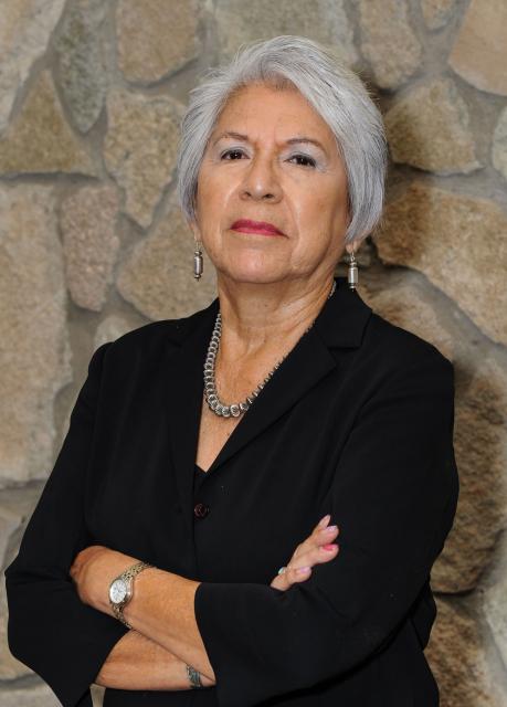
Rebecca Cantwell has been a member of this committee. She has worked policy from several sides. She had worked for Tim Wirth when he was a U.S. representative from Boulder and adjoining areas, then became a Denver journalist for 16 years. While at the Rocky Mountain News, she covered the evolution of communications technology, a task that gave her a deep understanding of how the PUC operates. From 2002 to 2005, while supervising political coverage for The Denver Post, she noticed the vigor of the grassroots movement in support of an energy transition.

“I remember actually advocating internally at The Denver Post of the importance of this effort,” she says. “Clearly the passage of Amendment 37 in 2004 set Colorado on a renewable energy future more than any other single event.”

By then, she was chafing in her capacity as an observer. “I wanted to stop telling about what other people were doing and actually work on progress,” she says.

That motivation put her on a winding path that included editing a magazine published by Smart Energy Living Alliance, a stint at the Colorado Energy Office, and then beginning in 2012 several years as director of what is now the Colorado Solar and Storage Association, or COSSA.

Cantwell had become familiar with CRES after meeting Larson at a wind energy conference in 2005. While at the solar trade group, she worked to implement a solar thermal roadmap developed in conjunction with CRES that laid out steps needed to make solar thermal a larger presence in Colorado. The roadmap had value at the Legislature and elsewhere, she says, even if it failed to produce much public policy for quite a while.

Vince Calvano shepherds the CRES advocacy work, tracking legislation and PUC matters in spreadsheets, no small undertaking any time of year but especially when the General Assembly is in session. He had studied earth sciences at Penn State. There, he had an advisor, William Easterling, who had helped write one of the International Panel on Climate Change reports. “I learned how much of an issue global warming was, and I wanted to be part of the solution,” says Calvano.

He then worked as a geophysical technician for a year and a half before returning to Colorado—which he had visited while as an undergrad – to attend law school in Boulder, graduating in 2008. Now he believes he is part of the solution through his pro bono work for CRES.

Like all others interviewed for this history, Calvano sees CRES having an importance primarily on the margins. One important edge is how CRES can influence the position of other environmental groups or even the Colorado Energy Office. Other parties in negotiations “can be more concerned with the give and take with Xcel and holding back,” he says. The extra voice provided by CRES, through its persistence, can push them to take stronger stands.

Social cost of methane

The most compelling recent evidence of CRES influence can be found in HB21-1238. It effectively requires state regulators to consider the costs of pollution using a different set of metrics. It did this by revising the methodology used by the PUC to determine the cost-effectiveness of demand-side management programs of public utilities selling natural gas. Like many big ideas, it had a long gestation period.

Laurent Meillon, a member of the CRES policy committee, began pushing the principles behind the bill nearly a decade ago. Frank, the CRES executive director, had introduced him to then-State Sen. Gail Schwartz. She understood the inadequacy of the metrics used by state regulators in evaluating effectiveness of demand-side management programs, says Meillon. She understood that heating of buildings needed to “change a lot, away from cheaply priced fracked gas and toward clean solutions with no hidden costs.”

Schwartz accomplished much during her time in the Colorado Senate but could not get the bill she fashioned with Meillon’s assistance approved before she was term-limited.

Next, Senators Mike Foote and Chris Kennedy took up the legislation, but they also could not get it passed. In 2020, the legislative majority was there for Foote, a Democrat, then something got in the way. “It was literally on the Senate president’s desk to be introduced in March of 2020 when we went into covid lockdown,” he says. Foote, after being term-limited, passed along the idea to Rep. Tracey Bernett, then a new representative from Boulder County. In addition to her engineering background, Bernett has a master’s in business administration from Harvard.

State Sen. Chris Hansen co-sponsored the bill. It passed without great difficulty.

Meillon cites literally dozens of organizations and individuals. He credits the Colorado Solar and Storage Association (then called COSEIA) with breaking the intellectual ground two years before he seized the issue.

“I know I can sound like stereotypical PR messaging when I say that it was a team effort, yet I really mean it,” says Meillon. “Sure I drove this with my persistence, yet nothing would have happened without all these people helping and pushing as best they could.

Among those in CRES who urged him, he says, were Cantwell, Becky English, and Leslie Glustrom. He also singles out Will Toor, director of the Colorado Energy Office in the Polis administration.

Lehr also had a role in Meillon’s account, as he “had been talking publicly about the ‘pernicious role of the discount rate against clean energy’ for 10 years before we even got started and first made me aware of it.”

Foote, who now provides pro bono expertise as an attorney representing CRES in PUC matters, describes Meillon’s case as exceptional for CRES.

“To have a sustained presence at the PUC and/or the Legislature takes funding and paying people, but their funding is light and they don’t pay people,” says Foote of CRES. “It all depends on who is volunteering and what they have the time and passion to do.”

In this case, Meillon was able to bring the expertise and advocacy of CRES and its members. “I know it would not have been a bill had he not kept the idea alive,” says Foote.

Other installments in this series:

Part 1: A coming together of minds in Colorado.

Part 2: Why note wind?

Part 3: Why note wind?

Part 4: The path to the governor’s mansion

And also: How Bill Ritter rode wind

Part 5: Growth, a stumble, then new chapters

Or download the whole series in one e-magazine of Big Pivots 64.

#Snowpack skyrockets above to-date norm in #Colorado (January 3, 2023) — OutThereColorado.com

Click the link to read the article on the OutThereColoado.com website (Spencer McKee). Here’s an excerpt:

With heavy snow falling across much of Colorado over the past week, snowpack has skyrocketed, with much of the state now above the typical to-date 30-year snowpack median. The state was roughly even with the 30-year snowpack norm through the morning of December 28. As of January 3, the state of Colorado is at 125 percent of the to-date norm, according to the USDA. It’s the farthest ahead in the Yampa and White river basin, found in the northwest corner of the state. There, it’s at 148 percent of the to-date median. Snowpack is above the to-date norm everywhere else, with the exception of the Upper Rio Grande River basin and the Arkansas River basin. That being said, the snowpack situation has improved in those places in recent days, as well.

2022 full year precipitation ranking from the Prism Group grids. Very few areas ended with their wettest (green) or driest (red) year — Brian Brettschneider @Climatologist49

Reeling in the last of last year’s news: Dying coal; parking vs. people; housing silliness; snow, snow, snow — @Land_Desk #snowpack (January 3, 2023)

Click the link to read the newsletter on The Land Desk website (Jonathan P. Thompson). Here’s an excerpt:

Aridification Watch

Okay, “aridification” may be the wrong header this time, since the West is getting battered by atmospheric rivers and bomb cyclones and power grid-wrecking snows and winds and rains. It’s record-breaking craziness — at least it seems that way, since we haven’t had much like it in a bit. But is it really all that unusual? Here’s a mini-Data Dump on early winter snowpack levels to help us figure it out: 

19: Number of monthly precipitation records broken during the first 28 days of December 2022 in the Western climate region (the final three days aren’t yet recorded in the system). 

8.2: Inches of precipitation recorded during a 24-hour period at Sierraville Ranger Station in California on Dec. 2, 2022, shattering the previous all-time record set in 1913. 

27: Inches of new snow that fell in the Tahoe City, California, area on Jan. 1, 2023. It contained about 3.33 inches of water. On Dec. 11 the area received 31 inches of snow in one day. 

210,000: Approximate number of utility customers who lost power along the West Coast as a result of the late December storms. 

30,000: Number of utility customers who lost power in the Northwest after vandals attacked four electrical substations in Washington state on Christmas day. 

3: Number of people killed by avalanches so far this season, including two skiers/snowboarders in Colorado and a snowmobiler in Montana. 

Further inland, the moisture is giving a needed boost to the giant snowpack “reservoir” that feeds the beleaguered Colorado River system. After tracking close to median levels for the first three months of the 2023 water year, this year’s Upper Colorado Basin snowpack shot up to 142% of the Jan. 3 “normal.” It may be a little too early to get excited, though — last year’s snows followed the same early season abundant pattern before dropping off in January.

Zooming in on the San Juan Mountains and Southwest Colorado we see a similar but slightly less wet pattern. Levels are above the median, but still below last year and 2020.

And zooming in even further to our three go-to SNOTEL stations, all located in Southwest Colorado, we find that snowpack levels are about at the average for each station’s period of record (which varies from station to station), but are still tracking ahead of 2019, which turned out to be a BIG snow year.

All of which is to say, it’s too early to really know what winter will bring us. So be sure to enjoy the snow while it’s here!

Feds set deadline (February 13, 2023) for West Fork Dam comments — @WyoFile #LitteSnakeRiver #YampaRiver #GreenRiver #ColoradoRiver #COriver #aridification

Water developers want to construct a 264-foot high dam on the West Fork of Battle Creek south of Rawlins. This artist’s conception shows in a Google Earth rendition what the reservoir would look like. (Wyoming Water Development Office)

Click the link to read the article on the WyoFile website (Angus M. Thuermer Jr.):

Federal authorities have set a Feb. 13 deadline for comments on a proposal to build a 264-foot-high concrete dam in the Medicine Bow National Forest in Carbon County.

The proposed West Fork Dam and reservoir would impound 6,500 acre-feet of irrigation storage in the Little Snake River Valley and parts of Colorado. Another 1,500 acre-feet would maintain a “minimum bypass flow” into Battle Creek and the Little Snake, Yampa, Green and Colorado Rivers downstream.

Officials announced the deadline in the Federal Register on Dec. 28 where they said they would accept written comments for 45 days. The Natural Resources Conservation Service has scheduled three public meetings Jan. 10-12 in communities in the impacted region.

The meetings are not designed as forums at which officials will accept public comment, Aaron Voos, a spokesman for the Medicine Bow said. Officials will use them to explain plans for construction of the proposed West Fork Dam and reservoir and the parallel Forest Service examination of a land exchange that would enable the project. 

Why it matters

The dam would cost some $80 million, according to a 2017 estimate, and the state would pay $73.6 million of that, original plans state. The dam and reservoir would generate an estimated $73.3 million in public benefits such as recreation and fishing, according to developers. Those benefits allow the state to reduce the amount irrigators would have to contribute, according to documents outlining the plan.

The proposal to impound more water in the Colorado River Basin and extract it from waterways for “increased pasture and hay production” comes at a time when seven Western states and Mexico are at odds over who can use what water in the overtaxed system. Even though officials are struggling to maintain water levels in Lake Powell, Wyoming believes it has the right to construct the reservoir and use flows from the basin’s network of waterways.

 Who said what:

The Natural Resources Conservation Service, an agency of the U.S. Department of Agriculture, will prepare an environmental impact statement analyzing six alternatives, including no-action and an option that would use “alternate means such as … water conservation projects and habitat improvement projects” to achieve watershed-plan goals.

Yampa River Basin via Wikimedia.

Lawmakers will begin the 2023 session next week with Democrats holding historic majorities — The #Denver Post #COleg

Colorado Rivers. Credit: Geology.com

Click the link to read the article on The Denver Post website (Nick Coltrain and Seth Klamann). Here’s an excerpt:

Clean air and eyes on water

[Steve] Fenberg said members are working on several bills to reduce ozone emissions and aiming to boost air quality in the state . First, officials need to separate out what is in state control and what isn’t, while also balancing that regulations come with economic and personal costs. Fenberg cited the temporary closure of the Suncor refinery specifically: It may lead to cleaner air for a few months, but it may also mean people already under the thumb of inflation may pay more for energy. Lawmakers will also continue to look at the oil and gas industry, though Fenberg said those details aren’t yet finished. He mentioned incentivizing the electrification of drill rigs to tamp down on pre-production drilling emissions as one likely effort. Regulators have also been working on new rules for energy production, a product of 2019’s Senate Bill 181, and lawmakers will be watching to see if it accomplishes what they wanted, he said.

“I want to be careful and make sure the appropriate things are at the regulatory side so that we’re not over-prescribing at the legislative level,” Fenberg said.

Water remains a defining aspect of life in the West, and Colorado’s water crisis remains as acute as ever. Fenberg called it “a bit of an existential threat” to the state’s economy and its communities. Conservation, drought resilience and infrastructure efforts will be big aims, though the legislative leaders did not have specific policies yet.

“One of the biggest frustrations when we talk about water quantity is certainly the diverse interests that come to the table,” McCluskie said. “This isn’t a Republican and Democrat issue, this is a Western Slope and eastern slope issue. It is an ag economy, a tourist economy and outdoor recreation economy interest.”

Right now, the goal is to convene stakeholders to find common ground across those sometimes disparate interests, she said. And the bevy of new lawmakers also need time to brush up on the dissertation-worthy topic of western water law. McCluskie said state Rep. Karen McCormick, who will chair the Agriculture, Water and Natural Resources Committee, has been putting together a “water boot camp” for her members.

The impacts of urban sprawl on #Colorado’s #water supply — 9News.com

The downtown Denver skyline from Arvada. Photo credit: Allen Best/Big Pivots

Click the link to read the article on the 9News.com website (Cory Reppenhagen). Here’s an excerpt:

The state of Colorado is projected to gain 1.8 million more residents by the year 2050.  While that can be a sign of economic prosperity, a study by NumbersUSA indicates most residents think that growth will have too many negative impacts.  

“We as a society, and the Western world in general, have got to find ways to have long-term sustainable prosperity that doesn’t depend on population growth,” said Leon Kolankiewicz, the science director for NumbersUSA, an advocacy group that favors immigration levels that would allow for population stabilization…

The study includes a scientific survey of 1,024 Colorado residents conducted by the Rasmussen research group. It focuses on several environmental issues, including water. Citing increased traffic, the loss of open space, and a strain on the water supply, 75% of Coloradans surveyed said urban sprawl, which is the encroachment of cities into natural space and agricultural space, is making Colorado a worse place to live.  Kolankiewicz said urban sprawl damages natural waterways, takes water away from agriculture and reduces the supply of water. Of those surveyed, 70% said water should not be diverted away from agriculture in favor of supporting further urban development.  And 76% said water should be kept in streams to support wildlife.  

Rebecca Mitchell, Director of the Colorado Water Conservation Board, said even with a stable or reduced population, there still may not be enough water because of a 20-plus-year mega-drought in the West.

“We don’t fight with Mother Nature; we dance with her, and we embrace her. And I think how we do that is by living within what she provides,” she said. 

#Snowpack news January 2, 2023

West snowpack basin-filled map January 1, 2023 via the NRCS.
Colorado snowpack basin-filled map January 1, 2023 via the NRCS.

‘The brink of disaster’: 2023 is a critical year for the #ColoradoRiver as reservoirs sink toward ‘dead pool’ — CNN #COriver #aridification

Updated Colorado River 4-Panel plot thru Water Year 2022 showing reservoirs, flows, temperatures and precipitation. All trends are in the wrong direction. Since original 2017 plot, conditions have deteriorated significantly. Brad Udall via Twitter: https://twitter.com/bradudall/status/1593316262041436160

Click the link to read the article on the CNN website (Ella Nilsen and Rachel Ramirez). Here’s an excerpt:

The cuts that are needed are on an unprecedented scale, and officials will be fighting an uphill battle against a deep, multi-year drought to get them done. State officials tried drastic measures to cut their usage this year, but the river’s continued decline was an alarming reality check…Experts told CNN that even with a good winter and spring runoff season, water managers still need to plan for the worst-case scenario.

“You can’t live with no water in the reservoirs hoping for good years; you need to refill the system,” Eric Kuhn, former manager of the Colorado River Water Conservation District, told CNN. “People realize that you can’t live on the brink of disaster.”

[…]

Anxiety is growing in the West as reservoir levels plummet. Negotiations between the states on voluntary water cuts have been tense and closely watched, particularly between the Lower Basin states of California, Arizona and Nevada. Those talks have stalled amid disagreement on how much water each state should sacrifice and how much money farmers, tribal nations and cities should be paid to reduce their water consumption. State negotiators are themselves waiting for the feds to decide how it will dole out $4 billion in drought relief money, which the Biden administration fronted from the Inflation Reduction Act to essentially pay people to not use water.

“I would not say it has put anything on hold,” Buschatzke told CNN.

Colorado River “Beginnings”. Photo: Brent Gardner-Smith/Aspen Journalism

Say hello to the “Monday Briefing” newsletter from @AlamosaCitizen #SanLuisValley #RioGrande #COleg

Rio Grande through the eastern edge of Alamosa July 5, 2022. Photo credit: Chris Lopez/Alamosa Citizen

Click the link to read the briefing on the Alamosa Citizen website. Here’s an excerpt:

The top story is always water

The Citizen’s 2022 Year in Water compilation will help you see more of the big picture – both with the unconfined aquifer and the confined aquifer of the Upper Rio Grande Basin. It’s important to see the fuller landscape, and we think the 2022 year in review does the trick. We would also direct you to our most recent podcast with state Sen. Cleave Simpson, who talks both about the upcoming 2023 legislative session and the critical time we’re in when it comes to water and irrigated ag in the San Luis Valley.

Navajo Dam operations update January 3, 2023: Bumping down to 300 cfs #SanJuanRiver #ColoradoRiver #COriver #aridification

The outflow at the bottom of Navajo Dam in New Mexico. Photo: Brent Gardner-Smith/Aspen Journalism

From email from Reclamation Susan Novak Behery:

In response to sufficient flows in the critical habitat reach, the Bureau of Reclamation has scheduled a decrease in the release from Navajo Dam from 350 cubic feet per second (cfs) to 300 cfs for Tuesday, January 3rd, at 4:00 AM.

Releases are made for the authorized purposes of the Navajo Unit, and to attempt to maintain a target base flow through the endangered fish critical habitat reach of the San Juan River (Farmington to Lake Powell).  The San Juan River Basin Recovery Implementation Program recommends a target base flow of between 500 cfs and 1,000 cfs through the critical habitat area.  The target base flow is calculated as the weekly average of gaged flows throughout the critical habitat area from Farmington to Lake Powell.

EPA and Army Finalize Rule Establishing Definition of #WOTUS and Restoring Fundamental Water Protections

Colorado River headwaters tributary in Rocky Mountain National Park photo via Greg Hobbs.

Click the link to read the release on the EPA website:

Today [December 30, 2022], the U.S. Environmental Protection Agency (EPA) and the U.S. Department of the Army (the agencies) announced a final rule establishing a durable definition of “waters of the United States” (WOTUS) to reduce uncertainty from changing regulatory definitions, protect people’s health, and support economic opportunity. The final rule restores essential water protections that were in place prior to 2015 under the Clean Water Act for traditional navigable waters, the territorial seas, interstate waters, as well as upstream water resources that significantly affect those waters. As a result, this action will strengthen fundamental protections for waters that are sources of drinking water while supporting agriculture, local economies, and downstream communities.

“When Congress passed the Clean Water Act 50 years ago, it recognized that protecting our waters is essential to ensuring healthy communities and a thriving economy,” said EPA Administrator Michael S. Regan. “Following extensive stakeholder engagement, and building on what we’ve learned from previous rules, EPA is working to deliver a durable definition of WOTUS that safeguards our nation’s waters, strengthens economic opportunity, and protects people’s health while providing greater certainty for farmers, ranchers, and landowners.”

“This final rule recognizes the essential role of the nation’s water resources in communities across the nation,” said Assistant Secretary of the Army for Civil Works Michael L. Connor. “The rule’s clear and supportable definition of waters of the United States will allow for more efficient and effective implementation and provide the clarity long desired by farmers, industry, environmental organizations, and other stakeholders.”

This rule establishes a durable definition of “waters of the United States” that is grounded in the authority provided by Congress in the Clean Water Act, the best available science, and extensive implementation experience stewarding the nation’s waters. The rule returns to a reasonable and familiar framework founded on the pre-2015 definition with updates to reflect existing Supreme Court decisions, the latest science, and the agencies’ technical expertise. It establishes limits that appropriately draw the boundary of waters subject to federal protection.

The final rule restores fundamental protections so that the nation will be closer to achieving Congress’ goal in the Clean Water Act that American waters be fishable and swimmable, and above all, protective of public health. It will also ensure that the nation’s waters support recreation, wildlife, and agricultural activity, which is fundamental to the American economy. The final rule will cover those waters that Congress fundamentally sought to protect in the Clean Water Act—traditional navigable waters, the territorial seas, interstate waters, as well as upstream water resources that significantly affect those waters.

More information, including a pre-publication version of the Federal Register notice and fact sheets, is available at EPA’s “Waters of the United States” website.

Accompanying the issuance of the final rule, the agencies are also releasing several resources to support clear and effective implementation in communities across America. Today, a summary of 10 regional roundtables was released that synthesizes key actions the agencies will take to enhance and improve implementation of “waters of the United States.” These actions were recommendations provided during the 10 regional roundtables where the agencies heard directly from communities on what is working well from an implementation perspective and where there are opportunities for improvement. The roundtables focused on the geographic similarities and differences across regions and provided site specific feedback about the way the scope of “waters of the United States” has been implemented by the agencies.

Today, the agencies are also taking action to improve federal coordination in the ongoing implementation of “waters of the United States.” First, EPA and Army are issuing a joint coordination memo to ensure the accuracy and consistency of jurisdictional determinations under this final rule. Second, the agencies are issuing a memo with U.S. Department of Agriculture to provide clarity on the agencies’ programs under the Clean Water Act and Food Security Act.

Background
On June 9, 2021, EPA and the Department of the Army announced their intent to revise the definition of “waters of the United States” to better protect our nation’s vital water resources that support public health, environmental protection, agricultural activity, and economic growth. On Nov. 18, 2021, the agencies announced the signing of a proposed rule revising the definition of “waters of the United States.”

The Clean Water Act prohibits the discharge of pollutants from a point source into “navigable waters” unless otherwise authorized under the Act. “Navigable waters” are defined in the Act as “the waters of the United States, including the territorial seas.” Thus, “waters of the United States” is a threshold term establishing the geographic scope of federal jurisdiction under the Clean Water Act. The term “waters of the United States” is not defined by the Act but has been defined by the agencies in regulations since the 1970s and jointly implemented in the agencies’ respective programmatic activities

Clean drinking #water is a human right because humans with human rights can’t live without drinking water. That this even needs to be explained in a public policy sense is a measure of nothing good — @CharlesPPierce #ColoradoRiver #COriver

LadyDragonflyCC — Creative Commons, Flickr

Click the link to read the article on the Esquire website (Charles P. Pierce). Here’s an excerpt:

Meanwhile, in arctic Canada, the First Nations people who live around North Spirit Lake have been boiling their water for 20 years, and they’re still doing so despite having won a notable court case on the subject a year ago.

“For years, and in some cases decades, Canada has failed to provide safe drinking water to many of its Indigenous communities, including North Spirit Lake, a remote reserve in northwestern Ontario that has been under a boil water advisory nearly continuously since 2001. Decaying infrastructure at water plants and a lack of trained operators has, on many reserves, rendered the treated water undrinkable. Since 1995, more than 250 First Nations have been affected, according to court records. As a result, Indigenous people have fallen ill from gastrointestinal infections, respiratory illnesses and severe rashes, with some ending up hospitalized. Boiling water has become a daily inconvenience, and entire communities, already struggling with chronic financial hardship, must rely on shipments of expensive bottled water.”

So the Native people went to court, and won, and nothing much has changed.

“Last year, Canada’s federal court approved a settlement of a class-action lawsuit filed by three Indigenous communities accusing the government of breaching its legal obligations to First Nations by failing to guarantee access to sanitary drinking water…In the year since the settlement, Canada has spent more than the agreement requires and several First Nations have received new infrastructure, which “represents important progress,” Michael Rosenberg, a lawyer for the First Nations, said in an email. But the government is still a long way from solving the problem. “We’re at a point where the lack of drinkable water on First Nations stands as a really sharp symbol of the failures of the Canadian state,” said Adele Perry, a history professor and director of the Centre for Human Rights Research at the University of Manitoba.”

Just as was the case with the horrors of the residential schools, Canada’s crisis supplying water to its Native peoples presages a similar one in this country, something that the administration is trying to mitigate in advance. But there are complications here that don’t exist around North Spirit Lake. For example, 29 federally recognized tribes depend on the beleaguered Colorado River for their water. Those tribes own the rights to around 20 percent of the water in the Colorado River basin. And this complication has complications.

From the 2018 Tribal Water Study, this graphic shows the location of the 29 federally-recognized tribes in the Colorado River Basin. Map credit: USBR

Snow falls in region, more in the forecast — The #PagosaSprings Sun #snowpack

Click the link to read the article on the Pagosa Springs Sun website (Josh Pike). Here’s an excerpt:

According to the Community Collaborative Rain Hail and Snow Network (CoCoRaHS) website, sites in Archuleta County received between 2 and 5.5 inches of snowfall over Tuesday night and Wednesday morning. A Dec. 28 report from Wolf Creek Ski Area indicated that, as of about 6 a.m.,Wolf Creek had received 4 inches of snow in the previous 24 hours, bringing the midway snow depth to 43 inches and the year- to-date snowfall total to 95 inches. According to the U.S. Department of Agriculture (USDA) Na- tional Water and Climate Center’s snowpack report, the Wolf Creek summit, at 11,000 feet of elevation, had 10.9 inches of snow water equivalent as of noon on Wednes- day, Dec. 28. The Wolf Creek summit was at 78 percent of the Dec. 28 snowpack median. The San Miguel, Dolores, Ani- mas and San Juan River basins were at 78 percent of the Dec. 28 median in terms of snowpack.

Pagosa Area #Water & Sanitation District approves budget and $38 million in loans, discusses rate increases — The #PagosaSprings Sun

The water treatment process

Click the link to read the article on the Pagosa Springs Sun website (Josh Pike). Here’s an excerpt:

At its Dec. 15 meeting, the Pagosa Area Water and Sanitation District (PAWSD) Board of Directors approved its 2023 budget and a loan agreement for $38,444,000 for the expansion of the Snowball water treatment plant. The board also discussed rate increases and potential additional fees to fund the plant’s construction…

The group then circled back to discuss the rate increases further, with [Justin] Ramsey indicating that the staff recommendation is to implement the 6 percent water rate increase in 2023, as recommended by the 2018 study, move up the 2.5 percent wastewater rate increase in the 2018 study up a year to 2023 and hold off on any other rate increases for the Snowball plant until the new rate study is finalized.

San Juan Water Conservancy District discusses budget and public access along the #SanJuanRiver — The #PagosaSprings Sun

Click the link to read the article on the Pagosa Springs Sun website (Derek Kutzer). Here’s an excerpt:

On Thursday, Dec. 14, the San Juan Water Conservancy District (SJWCD) held a meeting where it conducted a public hearing and discussed its 2023 budget and discussed the possibility of a public take-out point along the San Juan River, among other items.

Engineering/Studies/Surveys appeared as the largest line-item expenditure in the proposed 2023 budget, amounting to $45,000. And since the board did not entertain reducing this item, it will “pull $20,000 out of sasvings” to pay for it and also maintain a zero deficit, explained Tedder.

Public access to the San Juan River

At the same meeting, the board heard about efforts to have public access to the river on land owned by the SJWCD and Pagosa Area Water and Sanitation District (PAWSD). [Al] Pfister, and possibly a representative from PAWSD, will be sitting down with representatives from Colorado Parks and Wildlife (CPW ), mainly to discuss fishery issues and potential funding, according to Pfister.

“This is basically being done under the watershed enhancement project,” Pfister said.

San Juan Mountains December 19, 2016. Photo credit: Allen Best

#Snowpack news December 31, 2022

Colorado Snowpack basin-filled map December 31, 2022 via the NRCS.
West SNOTEL snowpack basin-filled map December 30, 2022 via the NRCS.

Conserving the #DoloresRiver: a decades-long effort — KSJD #ColoradoRiver #COriver #aridification

The Dolores River, below Slickrock, and above Bedrock. The Dolores River Canyon is included in a proposed National Conservation Area. Photo: Brent Gardner-Smith/Aspen Journalism.

Click the link to read the article on the KSJD website (Gavin McGough). Here’s an excerpt:

The Dolores River starts high in the San Juans southwest of Telluride, passes through Dolores, Colorado, where it fills the Reservoir at McPhee Dam. From then on it trickles north through hundreds of miles of desert, meeting the San Miguel and feeding eventually into the Colorado River. Those who have boated it say it’s a river like no other.

“You start below the dam and you head into the Ponderosa Gorge with these big canyon walls and amazing majestic Ponderosa Pines, and you start to see more and more of this red rock coming out,” said Amber Clark, director of Dolores River Boating Advocates (DRBA) which promotes stewardship and recreation along the river.

“Then you transition down into less trees and more red rock canyon walls, and the Wilderness Study Area, and at different places it opens up more, and it’s kind of this ever-changing landscape, but the majesty of it never diminishes,” she said…

The DRBA is one of dozens of stakeholders who have been working to protect the Dolores as a National Conservation Area, or an NCA. Some rivers are protected by Congress under The Wild and Scenic Rivers Act, but protection as an NCA is less controversial, especially amongst agricultural interests. Al Heaton, a cattle rancher in Dolores, is involved in the conservation effort.

“Wild and Scenic comes with some rules and regulations, some laws, that are pretty dramatic and would affect a lot of things, private property and things down the river,” said Heaton.

“Of course, grazing could continue in a Wild and Scenic setting but it could also be restricted, so I felt there had to be a better way.”

Dolores River watershed

Interview: Giving Rivers the “Freedom Space” to Heal Themselves and Protect Against #ClimateChange: Investments in natural infrastructure improve river health and help us become more climate #resilient — The Walton Family Foundation #ActOnClimate

Click the link to read the article on The Walton Family Foundation website (Sheldon Alberts):

Time has not been kind to our rivers. For centuries, humans have diminished, degraded and simplified rivers around the world, creating unhealthy waterways that have lost ecological value.

The good news is that our collective understanding of how to restore rivers is improving, with a greater focus on using natural systems to meet society’s needs while also protecting the environment. With nature-based management, we have an opportunity to rebuild rivers with the space and freedom they need to thrive. In turn, these healthier rivers lead to healthier communities and a healthier planet.

I spoke with Peter Skidmore, senior program officer with the foundation’s Colorado River initiative, about how restoring river health through natural processes can help us in the battle against climate change. He is the co-author of a recent article in the journal Anthropocene exploring the issue.

Can you describe some of the ways that rivers have been degraded over the past several hundred years?

As a society, we have relegated rivers and streams to constrained channels. These simplified and stabilized channels have lost a lot of their freedom, complexity and biodiversity. Starting in the 19th century, the extermination of beavers fundamentally changed the character of streams as dams were removed and riparian wetlands disappeared. With development in their valley bottoms, rivers have also lost the space to run free, flood, erode and deposit soil. The construction of dams and diversions have further constricted river flows.

What are we learning about emerging opportunities to restore the health of rivers so they can provide critical ecosystem services?

There has been a lot of hard work done to restore river health over the past few decades, but we’ve fallen short in addressing the challenge at a scale to have lasting impact. Over this time, we learned a lot about the potential of “natural infrastructure” to better manage rivers and restore their health through dynamic, natural processes. That can mean removing constraints wherever possible – setting levees back, concentrating infrastructure at a few pinch points, reconnecting rivers to their floodplains and renewing native vegetation.

Peter Skidmore is a senior program officer in the Environment Program focusing on the Colorado River initiative. Photo credit: Walton Family Foundation

Is there an example of how natural infrastructure can restore river health and improve climate resiliency?

One way is by promoting the return of beavers and beaver-related wetlands that reintroduce much-needed complexity into river systems. Messy rivers and streams – with features like braided and irregular channels, wetlands, eroding banks and gravel bars – are more diverse, dynamic and healthy. A success story is Bridge Creek, in Oregon, where the installation of beaver-inspired natural dams led to the expansion of beaver activity. These structures create a virtuous cycle of restoration that slows down water flow, revives mountain meadows and recreate stream meanders and wetlands that are ultimately maintained forever by beavers. They help maintain and retain groundwater, provide natural firebreaks and refuge for wildlife, and can alleviate the sedimentation impacts of post-fire flooding. Since 2005, Bridge Creek has had a dramatic increase in aquatic habitat and native fish populations. In addition to those fish and wildlife benefits, scientists are also finding that this kind of low-cost, low-tech restoration helps with carbon sequestration, nutrient capture and moderation of stream flow and temperature – critical ecosystems services in the face of drought and climate change.

A beaver dam on the Gunnison River. Beaver dams serve as inspiration for restoration projects that re-establish small, leaky and temporary dams in degraded stream systems. Photo: Brent Gardner-Smith/Aspen Journalism

What potential does this kind of restoration have to increase climate resiliency if done on large scale?

River ecosystems have a tremendous capacity for passive restoration if given the freedom space for dynamic interactions between the channel and the floodplain. They can literally heal themselves, often more quickly and effectively than we can. Just like humans need exercise to stay healthy, rivers also need that exercise. They need the space to move around. That’s important because, right now, ongoing development is exacerbating the impacts of a warming climate and straining the capacity of aging, expensive gray infrastructure to provide water security and protection from floods and drought. Natural infrastructure holds the potential to be a cost-effective and self-sustaining way to improve environmental health. It can be a critical component in a mix of solutions to the social and ecological challenges posed by climate change.

The good news is that if we give the incised streams some room, they can be restored to their healthy state and bring us the fire protection and water storage benefits that we really need. Graphic credit: SLO Beaver Brigade: http://www.slobeaverbrigade.com/2021/06/01/something-to-chew-on/

How is the foundation supporting natural infrastructure in the Colorado River basin?  

The foundation’s five-year Environment program strategy increases our efforts to improve river and watershed health by working to improve public policy so it promotes nature-based solutions, and leveraging funding to implement them on a larger scale. We’re working with partners to test and increase the use of nature-based solutions that improve water security for farms and cities and also provide environmental benefits. We’re investing in beaver-related restoration that re-establishes wetlands and begins to restore degraded stream systems. And we’ve initiated an effort to identify and map changes in vegetated wetlands and beaver ponds throughout the basin as a way to measure progress and assess the potential of this work to provide system-wide benefit for the Colorado River.

Colorado River “Beginnings”. Photo: Brent Gardner-Smith/Aspen Journalism

Standley Lake Boating: what was lost — #Northglenn #Thornton Sentinel

Standley Lake sunset. Photo credit Blogspot.com.

Click the link to read the article on the Northglenn Thornton Senitinel website (Luke Zarzecki). Here’s an excerpt:

Many members of Standley Lake’s boating community saw a huge aspect of their community taken away with the ban of trailered boats in 2019. [Gary] Gambino used to work a graveyard shift and after, went straight to the lake. 

“I would come home, hook up my boat, go out onto Standley, take it out in the back bay anchor in and take my four hours of sleep,” he said…

With Westminster’s city council revisiting the item, Northglenn’s council sent a letter signed by all council members indicating they will not be revisiting the item. 

“Northglenn’s water in Standley Lake is irreplaceable, valued at more than $209 million dollars. There is no level of risk that our community is willing to accept when it comes to protecting our drinking water supply,” the letter reads.

Clear Creek, Standley Lake watersheds including the Standley Lake Canal Zone via the Clear Creek Watershed Foundation.

Click the link to read “Standley Lake heads toward fifth summer with a firm no to powerboats” on The Denver Post website (John Aguilar). Here’s an excerpt:

But Westminster Councilman Dave DeMott said it’s “not realistic” to operate on a zero-risk basis “as there is no area where zero risk exists in this world.” He’s heard from boating enthusiasts that they are “frustrated” with the ban, which was made permanent in late 2019

Northglenn — along with Westminster, Thornton and the Farmers Reservoir and Irrigation Company — own the 42,000 acre-feet of water in the lake, which serves as the sole supply of drinking water for both Westminster and Northglenn. Standley Lake, which is fed by three canals diverted off of Clear Creek, accounts for about a quarter of Thornton’s drinking water supply. It, too, is in favor of maintaining the trailered boat ban. Any change in boating policy would have to be agreed to by the three cities…

Northglenn’s decision was likely re-affirmed by the September discovery of a single zebra mussel in Highline Lake State Park, northwest of Grand Junction. In late October, Colorado Parks & Wildlife announced more zebra mussels had been found in Highline Lake, giving the lake an official infestation listing. CPW says Highline Lake is currently the only Colorado body of water infested with zebra mussels. No quagga mussels are known to exist in the state, though Lake Powell in Utah has them.

“We don’t see the value in risking our drinking water supply for the benefit of a small group of people,” said Tami Moon, Northglenn’s environmental manager. “That is the only place we have to store our water.”

In May of 2018, USGS Hydrologic Technician Dave Knauer found a batch of zebra mussels attached to the boat anchor in the St. Lawrence River in New York. (Credit: John Byrnes, USGS. Public domain.)

Water officials reboot paid, volunteer conservation program: #ColoradoRiver upper basin states, including #Wyoming, hope paying irrigators to keep water in streams will help satisfy federal call for voluntary #water #conservation — @WyoFile #GreenRiver #COriver #aridification

An irrigation operation, pictured Sept. 28, 2022, near Farson. (Dustin Bleizeffer/WyoFile)

Click the link to read the article on the WyoFile website (Dustin Bleizeffer):

The Upper Colorado River Commission plans to revive a program that pays irrigators and other valid rights holders to voluntarily leave water in streams that feed the beleaguered Colorado River.

The System Conservation Pilot Program is one strategy among a handful that Upper Colorado River Basin states — Wyoming, Colorado, Utah and New Mexico — have offered to help satisfy their role in meeting a challenge by federal officials to conserve 2 million to 4 million acre-feet of water system-wide in 2023.

“The goal is to have water conservation projects underway in April 2023 to reduce consumptive uses in the Upper Basin Colorado River system,” the UCRC stated in a Dec. 14 press release. More “durable” and “longer-term” solutions are still needed, however, the UCRC said. “The SCPP is a significant step to begin to partially mitigate the water supply crisis in the Upper Colorado River Basin brought on by a drier climate and depleted storage.” 

The SCPP was initially implemented from 2015 through 2018 using funds from Lower Colorado River Basin stakeholders, including large municipalities such as Las Vegas. This time around, the UCRC proposes to instead use $125 million from the Inflation Reduction Act — an appropriation that backers hope Congress will approve in a spending bill.

Water users have only until Feb. 1 to submit proposals in response to a call for applications that was issued Dec. 14. 

Water users are urgently trying to keep Lake Powell on the Utah-Arizona border from dropping to a point where Glen Canyon Dam can no longer generate electricity. (Source: Bureau of Reclamation)

The UCRC scrambled in recent months to relaunch the SCPP water conservation program under pressure to lay the groundwork for both short- and long-term water savings amidst a growing crisis along the Colorado River. The river system serves some 40 million people in seven western states and Mexico. 

The 22-year “megadrought” that has parched much of the American southwest — combined with growing demands on the river — has drained Lake Powell and Lake Mead to their lowest levels in history and shows no signs of abating, according to the federal Bureau of Reclamation.

The ongoing crisis, if drought conditions continue, could result in mandated water curtailments in Wyoming by 2028, according to the Wyoming State Engineer’s Office. Municipalities, including Cheyenne, Green River and Rock Springs, are among the most vulnerable because — generally — they hold junior water rights that, under the Colorado River Compact and Wyoming water law, would be among the first to be restricted under a curtailment. About one-fifth of Wyoming’s population relies on domestic water supplies subject to a curtailment under the Colorado River Compact. 

Compensated conservation

Despite the quick turnaround to attract volunteer projects under the revived SCPP, water officials and conservation advocates in Wyoming believe there’s growing interest. Conservation groups such as Trout Unlimited played an integral role in the first iteration of the SCPP, seeing an opportunity to promote water conservation measures that also benefit fisheries and the general biological health of waterways by keeping more water in streams and rivers late in the summer.

Map of the Upper Colorado River Basin showing major tributaries and sub-basins. Credit: https://www.mdpi.com/2073-4441/14/23/3813#

Wyoming Trout Unlimited Water & Habitat Program Director Cory Toye helped introduce many agricultural water users to the SCPP in the first go-round, and that work has resumed in recent months, he said.

“It’s certainly on people’s minds,” Toye told WyoFile. “For the most part, it still makes economic sense for a lot of [irrigated ag] operations.”

Participation among Wyoming water users increased incrementally over the first four years of the program. All told, the SCPP in Wyoming saved a total 23,886 acre-feet at 26 project sites. It cost $4,079,233 — about $171 per-acre foot, according to a report by the upper basin commission.

For now, the commission envisions a “fixed term” compensation of $150 per acre-foot under the SCPP in 2023, although it may consider higher rates based on circumstances, according to the agency’s request for proposals.

Dipping toes

Eric Barnes, an irrigator on Fontenelle Creek — a tributary of the Green River in western Wyoming — was among the first SCPP participants in the state, and he’s eager to enroll in the program in 2023, he said. Barnes irrigated as usual in the spring to grow an early season crop, he said, then curtailed irrigation later in the summer — a water conservation practice known as “split season deficit irrigation.” All 26 projects in Wyoming during the first four years of the program fell under this category.

“It was beneficial for me,” Barnes said. “I was able to take advantage of the water early in the season and then shut [irrigation headgates] off and get paid for [conserving water] in the same year.”

A pump pulls water from the Green River at a Sweetwater County-managed recreation area Sept. 27, 2022. (Dustin Bleizeffer/WyoFile)

The practice — at least on Fontenelle Creek, Barnes said — left more water in the creek to support the trout fishery; a benefit to the local recreation economy and a priority for groups like Trout Unlimited.

“It was a good way to help people understand what life may look like with less water and what diversifying [irrigation] operations might look like,” Toye said. “And the scale of the projects went from scattershot those first couple of years to tying entire tributaries together.”

For now, the program makes sense for a lot of Wyoming ag irrigators subject to the Colorado River Compact, according to Toye, particularly in the upper reaches of the Green River and its tributaries. Although Wyoming and its fellow upper Colorado River basin states are eager to revive the program, it will soon evolve and be replaced by a larger conservation program with more sophisticated water-accounting protocols that are recognized by stakeholders throughout the system.

Those changes may entice ag irrigators like Barnes to take on water conservation strategies beyond simply foregoing a second round of summer irrigation, Toye said. However, he added, the program isn’t intended to shrink or replace ag production.

“The goal is to make sure people can do as much as they have historically with less water, or at least be prepared to do that,” Toye said. “So the intent is to explore different irrigation patterns and perhaps identify places where efficiencies can occur.”

The Value of Clarifying #Water Rights — AgEconMT

Territories of the Salish (Flathead), Salish-Tunaxe, Kutenai-Tunaxe, Pend d’Oreille and Semteuse in early time (1700?). By Naawada2016 – Own work, CC BY-SA 4.0, https://commons.wikimedia.org/w/index.php?curid=64845072

Click the link to read the article on the Department of Agricultural Economimcs at Montana State University website (Nick Hagerty):

Imagine you keep an old truck in your driveway. Sometimes when you want to use it, it’s gone – your neighbor has driven it somewhere. When you ask your neighbor to stop using your truck, he says it’s his truck too. Confused, you inform him you inherited the truck from your dad, but he says it came with the property when he bought his house. You resist any temptation to make physical threats and instead hire an expensive lawyer who slaps your neighbor with a lawsuit. To prove your ownership, the court requires you to put together detailed records of not only every time you’ve ever used your truck and how far you drove it, but also the same for your dad, going back all the way to when he bought it. If you’re missing any of this paperwork you might lose the truck. Even if you win the case, you still might sometimes catch your neighbor taking your truck for a spin in the middle of the night.

Sounds ridiculous, right? But this scenario is not too far off what water rights are like.

I was thinking about water rights recently because I saw some ads objecting to the Confederated Salish and Kootenai Tribes–Montana Water Compact. The CSKT Water Compact is an agreement between the Tribes, the State of Montana, and the federal government to settle disputes over water rights in and around the Flathead Indian Reservation in northwestern Montana. Essentially, the Tribes have given up most of their claims to water rights in exchange for more certainty around the ones they retain.

(The Compact was the product of bipartisan negotiation involving both Senators Daines and Tester. It was approved by both Trump and Biden administrations and ratified by Congress, the Montana Legislature, and the CSKT. It now must be adopted by the Montana Water Court, but while I’m not an expert in water law, it sounds like only some kind of extraordinary new information would be able to stop it at this point.)

I won’t go into the details of the Compact, but it’s a chance to explain why economists generally see efforts to clarify water rights as good for society overall – and why some people still oppose individual settlements.

The truck story shows just how much we take for granted the basic assumptions that underlie a well-functioning market economy. Ownership is clearly defined: when you buy a car, you register it with the country and receive a title. Property rights are reliably enforced: if someone steals your car, law enforcement officers will try to find it and return it to you. If there is ever a dispute, it gets settled by a fair justice system. Most importantly, the fact that we all have confidence in these institutions of government means that they are rarely needed: 99.99% of the time, everyone just accepts that your truck is yours, and my car is mine.

Scott Hummer, water commissioner for District 58 in the Yampa River basin, checks out a recently installed Parshall flume on an irrigation ditch in this August 2020 photo. Compliance with measuring device requirements has been moving more slowly than state engineers would like. CREDIT: HEATHER SACKETT/ASPEN JOURNALISM

Water rights aren’t usually nearly as secure. This is partly because water itself is slippery: it’s a lot harder than a car to measure, store, and tell yours apart from other people’s. (Though one time my friend and I did accidentally get into someone else’s Toyota Camry because it was the same color as his, it was parked next to his, and his key worked on it!) But it’s also because across the West we haven’t invested in the kinds of record-keeping, monitoring, and enforcement systems that would be necessary to give water users the kind of certainty we take for granted when it comes to vehicles, houses, and land.

As a result, water resources are too often a chaotic mess of uncertainty, arguments, litigation, and political battles. Farms and ranches, developers, water utilities, and government agencies have to spend their time and energy thinking about water conflicts instead of focusing on the main things they care about. They have to pay water lawyers for years-long court battles. Worse, uncertainty can hamper investment and wise decisions about the future. If you aren’t sure whether you’re going to get the water you think you’re entitled to, you might not move forward with that purchase you’ve had your eye on.

See also Are Wheat Markets “Due” for a Supply Crash?

All of this has real economic costs, and could be considered deadweight loss in economics terminology. So any efforts to resolve disputes, codify water rights, and reduce uncertainty can bring big benefits to everyone involved (and maybe the broader economy too). Since 1979, Montana has slowly conducting a statewide adjudication, in which water rights are formalized and recorded. One study found that a similar adjudication in Idaho, conducted between 1987 and 2014, increased the state’s agricultural output by $250 million per year.

The CSKT Water Compact could be considered another piece of the effort to reduce deadweight loss around water rights. By quantifying and officially recognizing CSKT water rights and creating new streamlined procedures for resolving disputes, the hope is that the Compact will reduce future litigation and bring more certainty and predictability to all water users.

So why do some people still oppose settlements like the Compact? Probably because even if clarifying water rights and resolving ongoing disputes is efficient – meaning that it benefits society overall – it doesn’t mean that every individual water user benefits from it. There may be some water users who find themselves with lower-priority water rights than they had before. There also may be some users who did not in fact hold secure water rights but were holding out hope for a more favorable settlement – they actually preferred the uncertainty.

This is why policymaking is so hard – it’s rare to find a solution that makes everyone involved better off.

Montana Rivers Map via Geology.com, https://geology.com/lakes-rivers-water/montana.shtml

Bring new water to the #ColoradoRiver, and a national infrastructure bank to finance it — Don Siefkes and Alphecca Muttardy #COriver #aridification

Two egrets on the limbs of a cypress in the Atchafalaya flood basin. By Team New Orleans, US Army Corps of Engineers – Flickr: Atch Egrets-2-LL, CC BY 2.0, https://commons.wikimedia.org/w/index.php?curid=12729536

“One of the big problems with bringing water from somewhere else is a false sense of security. When we live long distances from our water, we may not understand the limits of that supply or ecosystem- so conservation is less likely” — Abby Burk

Reprinted with permisssion from Don Siefkes:

Mike Wade, “Imperial Valley can’t sustain another water cut,” Dec. 14, is absolutely right. However, if we can’t get new water to the Colorado River, and even though conservation is important, no amount of conservation is going to fix this problem.

Here’s one solution to avoid the looming disaster. The National Infrastructure Bank (NIB) set out in House Resolution 3339 would provide $5 trillion in low-cost loans for a broad range of public infrastructure projects – including massive water systems – without the need for increasing taxes or any deficit budget spending. This bill is modeled on the successful Reconstruction Finance Corporation (RFC) started by President Herbert Hoover and used by President Franklin D. Roosevelt to build Hoover Dam and bring water and electricity to the Southwest.

Credit: Dan Swenson

The NIB is prepared to invest up to $400 billion to bring new water to the Colorado River and the Southwest. One possibility would be to divert water from the Atchafalaya River in Louisiana through Louisiana, Texas, New Mexico, Arizona and up to the Glen Canyon Dam.

In this proposal, no water would be taken from the main channel of the Mississippi. As of Dec. 19, 1.43 million gals/sec of Atchafalaya River water was simply going into the Gulf of Mexico without producing electricity or supporting commercial shipping. Taking just 100,000 gals/sec (7%) of this water would fill Lakes Powell and Mead to 50% capacity in one year and 9 months. The project would save on construction costs by using an existing facility – the Old River Control Complex just south of Vidalia, Louisiana, where the Army Corps of Engineers diverts 30% of the downflow of the Mississippi to prevent flooding in New Orleans.

This undertaking would build a 1,400 mile series of pipelines, open channels, tunnels and pumping stations (similar to the California, Los Angeles, Colorado River Aqueducts and the Central Arizona Project). It could be built in a year, along interstate highway rights-of-way, using huge earth-moving machines like those employed in Holland for their canal systems.

There is historical precedent for building systems like this project with deliberate, urgent, speed. In less than a year between 1942 and 1943, the RFC financed and built two pipelines of similar length, 1,200 and 1,400 miles, to carry crude oil from Texas oil fields to the East Coast. These pipelines rescued the entire East Coast industrial oil refining system and won World War II for the Allies.

This proposed pipeline divert water from the Atchafalaya River in Louisiana through Louisiana, Texas, New Mexico, Arizona and up to the Glen Canyon Dam. Credit: Don Siefkes

Such a water aqueduct system might cost on the order of $14 billion-23 billion, a small amount for a $5 trillion bank and also small compared to cutting off water supplies to farmers in the Southwest who produce $39 billion worth of our annual food supply. Without new water in the Colorado, food prices will skyrocket more than they already have, and we will all needlessly suffer. It is also unthinkable to allow water levels in Lakes Mead and Powell to fall to the point where the dams can no longer generate electricity or provide drinking water.

We don’t think anything about pumping crude oil and gasoline through 190,000 miles of U.S. pipelines from areas that have oil and gasoline to areas that don’t. We certainly can do the same with water.

All U.S. senators and representatives, regardless of party, should get behind HR 3339 and vote for the National Infrastructure Bank.

Alphecca Muttardy is a Macroeconomist with the Coalition for a National Infrastructure Bank (NIBCoalition.com), and 25 year veteran of the International Monetary Fund. Don Siefkes is an MIT-trained chemical engineer who represents the Coalition for the NIB in the San Francisco Bay AreaTheir emails are, respectively, amuttardy@gmail.com and donsiefkes@aol.com.

Map of the Mississippi River Basin. Made using USGS data. By Shannon1 – Own work, CC BY-SA 4.0, https://commons.wikimedia.org/w/index.php?curid=47308146