A center-pivot irrigation system that replaced a less efficient irrigation system in Diamond Valley through a Nevada Department of Agriculture grant. (Courtesy of Nevada Department of Agriculture)
Click the link to read the guest column on Nevada’s only statewide nonprofit newsroom The Nevada Independent website (Bruce Babbit):
As Lake Mead continues to decline toward dead pool, federal officials are requesting the Colorado River states to offer major cuts in water usage.
Nevada has responded with a detailed and innovative plan set forth in a December 20, 2022 letter to the Bureau of Reclamation, calling for basic reform of water management throughout the entire Colorado River system. It is centered on protecting water levels in Lake Powell and Lake Mead with new rules for apportioning reduced water deliveries throughout the system.
The plan assures that water levels behind Glen Canyon Dam in the upper basin will not fall below a level necessary to protect hydropower production and the structure of the dam itself.
For Lake Mead in the lower basin the plan would set rules assuring that water levels cannot fall below a new “Lake Mead Protection Level” sufficient to provide an 18 month reserve for “public, health and safety” of municipal users.
The plan calls on the three lower Basin states, Arizona, California and Nevada, to offer a million and a half acre feet of reductions, in addition to cuts previously agreed upon in the 2019 Drought Contingency Plan (DCP). This new round of cuts calls for “equitable sharing of evaporation and system losses” among the three states in proportion to their “average annual consumptive use for the period 2019 to 2021.”
Reaching consensus on such an inventive, far reaching proposal, will take time. The seven basin states and the Interior Department have until 2026, when current regulations expire, to reach agreement on new rules.
However, one critical provision—the 1.5 million acre feet reduction in diversions from Lake Mead—cannot wait that long. It must be agreed upon and implemented immediately to avoid disaster.
Arizona and California have not responded in public. They remain on the sidelines, unable to summon the political will to either agree or to propose an alternative.
The reason Arizona and California are internally deadlocked can be summed up in one word: agriculture. Irrigated agriculture uses more than 70 percent of the water allocated to the two states from Lake Mead. A fair settlement will not be possible unless agriculture takes its share of the cuts.
Agricultural Irrigation districts in Arizona and California resist offering cuts, claiming an absolute priority under century-old legal doctrines. They claim an unqualified priority right to continue growing alfalfa for cattle feed that comes ahead of an adequate water supply for Los Angeles, Phoenix, Tucson, San Diego and Los Angeles.
The Interior Department has the power to break this deadlock. The department, as water master of the lower Colorado River, has broad authority over water allocation and management. A federal regulation, known as Section 417, gives the department authority to limit agricultural water deliveries to that amount “reasonably required for beneficial use.”
What is reasonably required is a judgment that can take into account many factors, including the needs of cities, towns, power plants, mineral extraction, recreation, and more. And what is reasonable for irrigation allocations in normal years may be entirely unreasonable when Hoover Dam, Glen Canyon Dam and the entire Colorado River system are at risk of collapse.
It is now time for the Interior to use its Section 417 authority for an expansive review of all agricultural use contracts and to reduce allocations to reflect a fair measure of burden sharing. This review should begin in an open and transparent process without further delay.
Bruce Edward Babbitt is an attorney and politician from the state of Arizona. A member of the Democratic Party, Babbitt served as the 16th governor of Arizona from 1978 to 1987, and as President Bill Clinton’s secretary of the interior from 1993 to 2001.
Aurora is planning an expansion to its innovative Prairie Waters project with the help of a $5 million federal grant, a project that city staffers say could recover enough water to support thousands of homes. The grant, which the federal government says the city is likely to receive, would be used toward the $11.5 million undertaking of digging a new pump station and radial well, which would draw water from below the South Platte River.
“Drought has been something we’re needing to tackle and handle more and more as the years go on, and so having this resource come from the South Platte instead of the mountains is definitely a drought resiliency component,” said Aurora Water staffer Justin Montes, who applied for the federal grant…
Radial wells consist of a single vertical shaft ending in multiple horizontal shafts that radiate outward like the spokes of a wheel. The radial well and pump station would be part of an expansion to the Prairie Waters project including another radial well that the city plans to dig in 2024. Aurora Water representatives say the entire expansion has the potential to double the water recovered by the project, which uses wells dug near the South Platte River to collect water that has been absorbed and naturally filtered by the riverbank. By the time water is collected by the wells, it has already passed through hundreds of feet of sediment beneath the South Platte, filtering out pathogens, organic chemicals and other contaminants. Montes said the process can also filter out debris introduced by wildfires.
would you believe that 2/3 of total precipitation observations in NOAA's dataset came from @CoCoRaHS volunteer observers in 2022?! Incredible stat from Imke Durre at our session celebrating 25 years of the network. #AMS2023pic.twitter.com/LY5oqK4gzB
Emergency measures are required to avert a catastrophe in Utah’s Great Salt Lake, which has been drying up due to excessive water use, a new report warns. Within years, the lake’s ecosystems could collapse and millions will be exposed to toxic dust contained within the drying lakebed, unless drastic steps are taken to cut water use. A team of 32 scientists and conservationists caution that the lake could decline beyond recognition in just five years. Their warning is especially urgent amid a historic western megadrought fueled by global heating. To save the lake, the report suggests 30-50% reductions in water use may be required, to allow 2.5m acre-feet of water to flow from streams and rivers directly into the lake over the next two years.
“We really need to increase the speed of our response, and also increase our ambition for how much water we restore to the lake,” said Ben Abbott, an ecologist at Brigham Young University and one of the report’s lead authors…
Despite growing political momentum, Abbott said that existing policies and action plans will not be enough to save the lake from collapse. Already, the lake has lost 73% of its water and 60% of its surface area, as trillions of litres of water are diverted away from it to supply farms and homes. As a result, the lake is becoming saltier and uninhabitable to native flies and brine shrimp. Eventually, the lake will be unable to sustain the more than 10 million migratory birds and wildlife that frequent it. Declining lake levels could also make magnesium, lithium and other critical minerals extraction infeasible within the next two years. Dust from the exposed lakebed could further damage crops, degrade soil and cause snow to melt more quickly – triggering widespread economic losses for Utah’s agriculture and tourism industries. Toxic sediment, laced with arsenic, from the lakebed can exacerbate respiratory conditions and heart and lung disease, and could increase residents’ risk for cancer…
The climate crisis, which has increased average temperatures in northern Utah by 4F since the early 1900s, is further imperilling the lake, fuelling more severe droughts and heatwaves. But studies suggest that only about 9% of the lake’s decline due to evaporation and reduced runoff can be blamed on climate change. A legacy of water overuse is the main threat to the largest saltwater lake in the western hemisphere, and huge water diversions to irrigate vast operations to grow alfalfa and hay are no longer sustainable in Utah, Abbott said, nor are lush lawns in cities and suburbs.
The All-American Canal conveys water from the Colorado River to the Imperial Valley in Southern California. The Imperial Irrigation District is the largest user of Colorado River water. CREDIT: HEATHER SACKETT/ASPEN JOURNALISM
Imperial Irrigation District Vice President and Division 2 Director JB Hamby will serve as Chairman of the Colorado River Board of California following his unanimous election during Wednesday’s meeting held in Ontario, California.
Imperial Irrigation District Vice President and Division 2 Director JB Hamby will serve as Chairman of the Colorado River Board of California following his unanimous election during Wednesday’s meeting held in Ontario, California.
Hamby has served on the Colorado River Board since April of 2021 and is IID’s fourth member to serve as its chairman. IID’s Executive Superintendent, President, and Division 1 Director Evan T. Hewes served as the board’s first chairman from 1938 to 1947, followed by the district’s Executive Officer Munson J. Dowd from 1962 to 1965, and last by Division 3 Director Lloyd Allen from 2002 to 2006.
As chairman, Hamby serves ex-officio as the Colorado River Commissioner for the State of California. The commissioner is responsible for conferring with representatives of the seven Colorado River basin states and United States on the use of Colorado River water and safeguarding the rights and interests of the state, its agencies, and citizens, pursuant to the federal Boulder Canyon Project Act and the California Water Code.
“This is a historic time of reckoning on the Colorado River where growing demand over the decades exceeds a shrinking supply due to chronic drought and aridification,” Hamby said. “Protecting California’s stake on the Colorado River is vital to our future in Southern California. I look forward to working closely with the board’s member agencies — both agricultural and urban — to develop solutions that respect the Law of the River for the benefit of all Californians.”
The Colorado River Board is composed of representatives of the Coachella Valley Water District, Imperial Irrigation District, Los Angeles Department of Water and Power, the Metropolitan Water District of Southern California, Palo Verde Irrigation District, San Diego County Water Authority, and the state directors of Water Resources and Fish and Wildlife.
California’s Colorado River contractors have proposed to conserve up to an additional 400,000 acre-feet of water in Lake Mead each year, beginning in 2023 through 2026. The water, which would otherwise be consumed by California’s communities and farms, would leave up to 1.6 million acre-feet of water behind Hoover Dam at Lake Mead as part of a seven state and federal effort to stabilize the rapidly declining Colorado River system.
California has the largest entitlement to Colorado River water of the seven basin states which serves drinking water to over 19 million people in Southern California and irrigates over 600,000 acres of highly productive agricultural lands that produce fruits, vegetables, and other crops that are a core part of the national and global food supply.
Aspen Journalism is compiling a data dashboard highlighting metrics of local public interest, updated weekly.
Snowpack at McClure Pass roughly 150% of average
Snowpack in the Roaring Fork basin reached 126% of average for Jan. 8 with 9.7 inches of snow-water equivalent, according to NOAA. Recent snowfall has increased the basin snowpack by 43% in the past two weeks.
SNOTEL sites that monitor snowfall throughout the winter measured the snowpack at Independence Pass at 94.9% of average on Jan. 8, with a “snow water equivalent” (SWE) of 7.4 inches, up from 6.81 inches on Jan. 8. Last year on Jan. 8, the SNOTEL station up the pass (located at elevation 10,600 feet) recorded an SWE of 8.58 inches, or 110% of average.
The monitoring station at McClure Pass located at elevation 9,500 feet recorded a SWE of 11.18 inches on Jan. 8, or 149.1% of average. That’s up from a SWE of 9.09 inches on Jan. 1. Last year, on Jan. 8, the station also measured a snowpack holding 8.39 inches of water.
On the northeast side of the Roaring Fork Basin, snowpack at Ivanhoe, which sits at an elevation of 10,400 feet, reached 8.5 inches on Jan. 8, or 123.2% of average.
Snowpack at Schofield Pass reached 18.11 inches on Jan. 8, which represents 123.2% of average. Schofield Pass sits at an elevation of 10,700 feet between Marble and Crested Butte.
Snow water equivalent — the metric used to track snowpack — is the amount of water contained within the snowpack, which will become our future water supply running in local rivers and streams.
Colorado snowpack basin-filled map January 12, 2023 via the NRCS.
Figure 1. A bridge where the Bear River used to flow into Great Salt Lake. Photo: EcoFlight.
Click the link to access the paper on the Brigham Young University website (Benjamin W. Abbott, Bonnie K. Baxter, Karoline Busche, Lynn de Freitas, Rebecca Frei, Teresa Gomez, Mary Anne Karren, Rachel L. Buck, Joseph Price, Sara Frutos, Robert B. Sowby, Janice Brahney, Bryan G. Hopkins, Matthew F. Bekker, Jeremy S. Bekker, Russell Rader, Brian Brown, Mary Proteau, Gregory T. Carling, Lafe Conner, Paul Alan Cox, Ethan McQuhae, Christopher Oscarson, Daren T. Nelson, R. Jeffrey Davis, Daniel Horns, Heather Dove, Tara Bishop, Adam Johnson, Kaye Nelson, John Bennion, Patrick Belmont). Here’s the executive summary:
Great Salt Lake is a keystone ecosystem in the Western Hemisphere. The lake and its wetlands provide minerals for Utah’s industries, thousands of local jobs, and habitat for 10 million migratory birds1–4. Fertilizer and brine shrimp from the lake feed millions of people worldwide5,6. The lake provides $2.5 billion in direct economic activity yearly7–10, as well as increasing precipitation, suppressing toxic dust, and supporting 80% of Utah’s wetlands11–17.
Excessive water use is destroying Great Salt Lake. At 19 feet below its average natural level since 1850, the lake is in uncharted territory18–22. It has lost 73% of its water and 60% of its surface area23–26. Our unsustainable water use is desiccating habitat, exposing toxic dust, and driving salinity to levels incompatible with the lake’s food webs1,24,27–29. The lake’s drop has accelerated since 2020, with an average deficit of 1.2 million acre-feet per year. If this loss rate continues, the lake as we know it is on track to disappear in five years.
We are underestimating the consequences of losing the lake. Despite encouraging growth in legislative action and public awareness, most Utahns do not realize the urgency of this crisis. Examples from around the world show that saline lake loss triggers a long-term cycle of environmental, health, and economic suffering30–35. Without a coordinated rescue, we can expect widespread air and water pollution, numerous Endangered Species Act listings, and declines in agriculture, industry, and overall quality of life1–4,36.
The lake needs an additional million acre-feet per year to reverse its decline. This would increase average streamflow to ~2.5 million acre-feet per year, beginning a gradual refilling. Depending on future weather conditions, achieving this level of flow will require cutting consumptive water use in the Great Salt Lake watershed by a third to a half. Recent efforts have returned less than 0.1 million acre-feet per year to the lake37, with most conserved water held in reservoirs or delivered to other users rather than released to the lake.
Water conservation is the way. While water augmentation is often discussed (pipelines, cloud seeding, new reservoirs, and groundwater extraction, etc.), conservation is the only way to provide adequate water in time to save Great Salt Lake33,38–41. Conservation is also the most cost effective and resilient response42,43, and there are successful examples throughout the region44–48. Ensuring financial, legislative, and technical support for conservation will pay huge dividends during this crisis and for decades to come1,38,46,49.
We need to increase trust and coordination. New legislation allows users to return water to the lake while retaining rights50. However, lack of trust and cooperation between farmers, cities, managers, and policymakers is hobbling our response33,38. Users often have financial disincentives to conserve, and farmers often lack legal counsel to navigate policy changes.
We call on the governor’s office to implement a watershed-wide emergency rescue. We recommend setting an emergency streamflow requirement of at least 2.5 million acre-feet per year until the lake reaches its minimum healthy elevation of 4,198 feet51. Executive leadership is needed for water leasing, farmer compensation, water donations, and conveyance52. Every major water user needs to be educated, empowered, and assured that their conserved water will be shepherded to Great Salt Lake. We need clear thresholds that trigger binding emergency conservation measures to stop the lake’s collapse.
We call on the legislature to fund and facilitate the rescue. Recent bills have laid the groundwork, and a surge of funding is now needed to lease or purchase water and support farmers and cities to dramatically reduce consumption. Likewise, legislation is needed to put in place the policies, accounting, and monitoring for water shepherding to the lake and long- term sustainable water use52.
We call on every water user and manager to conserve water and support state efforts. We are in an all-hands-on-deck emergency, and we need farmers, counties, cities, businesses, churches, universities, and other organizations to do everything in their power to reduce outdoor water use. We believe that our community is uniquely suited to face this challenge, but only if we implement a unified and pioneering rescue. By taking a “lake first” approach to water use, we can leave a legacy of wise stewardship for generations to come.
Satellite photo of the Great Salt Lake from August 2018 after years of drought, reaching near-record lows. The difference in colors between the northern and southern portions of the lake is the result of a railroad causeway. The image was acquired by the MSI sensor on the Sentinel-2B satellite. By Copernicus Sentinel-2, ESA – https://scihub.copernicus.eu/dhus/#/home, CC BY-SA 3.0 igo, https://commons.wikimedia.org/w/index.php?curid=77990895
Visitors to Elephant Butte State Park fish despite the diminishing water levels that have exposed wide sand flats all around the lake, on Sept. 23. (Corrie Boudreaux/El Paso Matters)
A proposed agreement between Texas, New Mexico and Colorado was unsealed Monday, months after the states announced a deal to end nearly a decade-old Supreme Court case over Rio Grande water.
The deal would amend the 83-year old legal basis for how the three states split water from the river under the Rio Grande Compact. If allowed by the Supreme Court, the decree would end the lawsuit that’s called Original No. 141 Texas v. New Mexico and Colorado. The case has stretched over nine years and cost New Mexico and Texas taxpayers tens of millions of dollars. Map showing new point to deliver Rio Grande water between Texas and New Mexico, at an existing stream gage in East El Paso. (Courtesy of Margaret “Peggy” Barroll in the joint motion)
Map showing new point to deliver Rio Grande water between Texas and New Mexico, at an existing stream gage in East El Paso. (Courtesy of Margaret “Peggy” Barroll in the joint motion)
Among the changes, Texas’ share of Rio Grande water would be measured at a point on the state line at an El Paso Gage instead of NM’s current requirement to deliver Texas’ water 100-plus miles upstream at the Elephant Butte Reservoir.
The agreement offers a new set of calculations to determine what water is owed to southern New Mexico farmers and far west Texans, and incorporates groundwater pumping in the formulas.
Finally, it also offers conditions for New Mexico and Texas to handle disputes about over- or under-deliveries of Rio Grande water.
To provide water for those deliveries, the New Mexico Office of the State Engineer could shut down wells, or use other limits such as paying farmers to retire land from farming to save irrigation water, court documents show.
In sworn statements attached to the proposed agreement, top water officials from New Mexico and Texas urged the Supreme Court to accept the proposal.
Bobby Skov, the Rio Grande compact commissioner for Texas, called the deal “fair” and “consistent with the compact.”
State Engineer Mike Hamman, who is also New Mexico’s compact commissioner, said the agreement resolves the long-standing issues between the two states and offers clear directions for how to stay in compliance with the agreements.
“I anticipate the consent decree will help the states avoid future conflicts,” Hamman wrote.
A key change to the document includes transfers of water between New Mexico and Texas irrigation districts to balance out years when New Mexico pumping or diversions cause not enough Rio Grande water to reach the state line. Courtesy photo showing the both Elephant Butte Reservoir, where Texas’ Rio Grande water is currently stored to new location to measure New Mexico’s compliance with delivering water at the existing El Paso Gage, just over 100 miles downstream. (Courtesy of Willian Hutchison declaration).
Courtesy map showing the both Elephant Butte Reservoir, where Texas’ Rio Grande water is currently stored to new location to measure New Mexico’s compliance with delivering water at the existing El Paso Gage, just over 100 miles downstream. (Courtesy of Willian Hutchison declaration).
If the state fails to meet new delivery requirements for three consecutive years, then the agreement requires the state to send additional water from the New Mexico irrigation district to the Texas irrigation district.
In order to provide water to make up for any shortfalls, Hamman offered seven bullet points in his letter supporting the agreement.
Hamman said the N.M. Office of the State Engineer could curb groundwater pumping; monitor groundwater pumping, buy water rights to retire groundwater wells; fallow farmland temporarily; increase conservation in both municipal and agricultural use; or attempt to import water to the Lower Rio Grande.
Hamman warned the state office will enforce well shutdowns if voluntary or compensated measures aren’t working.
New Mexico is still embroiled in the lengthy court process that started in 1996 to determine the legal order of water rights between Caballo Reservoir and the state line for farmers, municipalities, businesses and the federal government.
As for next steps, a hearing on the proposed decree is tentatively scheduled for February 2023.
HOW WE GOT HERE
The Supreme Court case was sparked by decades of litigation over the Lower Rio Grande — the region between Caballo Reservoir and where the river often evaporates above Fort Quitman, about 90 miles along the Texas-Mexico border.
In 2014, Texas filed a complaint in the Supreme Court alleging New Mexico groundwater pumping below Elephant Butte illegally captured Rio Grande water promised to Texas.
The proposed agreement is the product of monthslong confidential negotiations between the parties in the case — New Mexico, Texas, Colorado and the federal government. The discussions included input from impacted organizations such as farming associations, the two regional irrigation districts, the cities of Las Cruces and El Paso, New Mexico State University, and water utilities in Albuquerque and El Paso.
In earlier filings, the federal government and El Paso’s major irrigation district asked the special master overseeing the case to throw out the proposed decree because it was the result of an incomplete settlement and makes concessions the states cannot enforce, according to legal filings.
Last week, Judge Michael Melloy overruled the federal government’s arguments that the proposed agreement must be kept secret, ordering most of the documents to be made public.
The United State’s objections to the proposed decree remain filed under seal, and are not public at this time.
Source New Mexico is part of States Newsroom, a network of news bureaus supported by grants and a coalition of donors as a 501c(3) public charity. Source New Mexico maintains editorial independence. Contact Editor Marisa Demarco for questions: info@sourcenm.com. Follow Source New Mexico on Facebook and Twitter.
Map of the Rio Grande watershed. Graphic credit: WikiMedia
We are seeing the best start to our snowpack in over a decade. But it is only a start – most of the winter season has yet to unfold, major reservoirs hold below-average storage, and last years’ experience demonstrates that powerful storms can punctuate but not end a drought. Photo credit: California DWR
At the UC Berkeley Central Sierra Snow Laboratory in Donner Pass on Wednesday, snow was piled so high that lead scientist Andrew Schwartz no longer needed stairs to exit the second floor.
“We just walk directly out onto the snow!” Schwartz said. The nearly 11 feet of snow surrounding the lab was the deepest he’d seen so far this year.
The piles of powder are the result of a series of powerful atmospheric river stormsthat have pummeled California over the last two weeks. The storms have claimed at least 19 lives as they topple trees, overtop levees and send people scrambling for higher ground.
West Drought Monitor map January 10, 2023.
But while the storms have delivered chaos, they have also helped to make a dent in drought conditions. The state’s snow water equivalent — or the amount of water contained in the snow — was 226% of normal on Wednesday, marking a high for the date not seen in at least two decades. The last time snowpack neared such a high on Jan. 11 was in 2005, when it was 206% of normal, according to state data. Even more promising, the Sierra snowpack on Wednesday measured 102% of its April 1 average, referring to the end-of-season date when snowpack in California is usually at its deepest. This is the first time that’s happened on Jan. 11 in at least 20 years…
DWR water operations manager Molly White said reservoirs were also seeing boosts from the storms, with some smaller reservoirs recovering fully from drought-driven deficits. But the state’s two largest reservoirs, Lake Shasta and Lake Oroville, remain far from full, topping out at 42% and 47% of capacity, respectively, on Wednesday…
[John] Abatzoglou said Wednesday’s snowpack levels were impressive, and noted that the most recent U.S. Drought Monitor update saw the worst category, “exceptional drought,” erased from California’s map altogether. Only a week before that update, more than 7% of the state was in that category.
Click the link to access the paper on the Science Direct website (Geoffrey Supran and Naomi Oreskes). Here’s the summary:
Highlights
ExxonMobil’s public climate change messaging mimics tobacco industry propaganda
Rhetoric of climate ‘‘risk’’ downplays the reality and seriousness of climate change
Rhetoric of consumer ‘‘demand’’ (versus fossil fuel supply) individualizes responsibility
Fossil Fuel Savior frame uses ‘‘risk’’ and ‘‘demand’’ to justify fossil fuels, blame customers
SCIENCE FOR SOCIETY A dominant public narrative about climate change is that ‘‘we are all to blame.’’ Another is that society must inevitably rely on fossil fuels for the foreseeable future. How did these become conventional wisdom? We show that one source of these arguments is fossil fuel industry propaganda. ExxonMobil advertisements worked to shift responsibility for global warming away from the fossil fuel industry and onto consumers. They also said that climate change was a ‘‘risk,’’ rather than a reality, that renewable energy is unreliable, and that the fossil fuel industry offered meaningful leadership on climate change. We show that much of this rhetoric is similar to that used by the tobacco industry. Our research suggests warning signs that the fossil fuel industry is using the subtle micro-politics of language to downplay its role in the climate crisis and to continue to undermine climate litigation, regulation, and activism.
696 One Earth 4, 696–719, May 21, 2021 ª 2021 The Author(s). Published by Elsevier Inc. This is an open access article under the CC BY-NC-ND license (http://creativecommons.org/licenses/by-nc-nd/4.0/).
SUMMARY This paper investigates how ExxonMobil uses rhetoric and framing to shape public discourse on climate change. We present an algorithmic corpus comparison and machine-learning topic model of 180 ExxonMobil climate change communications, including peer-reviewed publications, internal company documents, and advertorials in The New York Times. We also investigate advertorials using inductive frame analysis. We find that the company has publicly overemphasized some terms and topics while avoiding others. Most notably, they have used rhetoric of climate ‘‘risk’’ and consumer energy ‘‘demand’’ to construct a ‘‘Fossil Fuel Savior’’ (FFS) frame that downplays the reality and seriousness of climate change, normalizes fossil fuel lock-in, and individualizes responsibility. These patterns mimic the tobacco industry’s documented strategy of shifting responsibility away from corporations—which knowingly sold a deadly product while denying its harms—and onto consumers. This historical parallel foreshadows the fossil fuel industry’s use of demand-as-blame arguments to oppose litigation, regulation, and activism.
Bill McKibben, right, conferring with Land Institute founder Wes Jackson at the 2019 Prairie Festival, has strongly motivated many, including some CRES members. Photo/Allen Best
Click the link to read the post on the Substack website (Bill McKibben):
An important new study that came out a few minutes ago makes painfully clear precisely how much (and precisely how precisely) Exxon understood climate change, back in the days when it could have made a huge difference if they’d simply been honest. [ed. emphasis mine]
It’s not, of course, as if we didn’t know a lot of this story already, and in some depth. In 2015, the Pulitzer Prize-winning website Inside Climate News published a landmark series of reports drawing on archives and whistleblowers to demonstrate that Exxon had set its scientists to work studying what we then called the greenhouse effect back in the 1970s, and that those scientists had reached the same conclusion as researchers working at NASA and elsewhere: the carbon dioxide coming from the fossil fuel industry was about to heat the earth in dramatic fashion. That was huge news—and it explains the picture above, when I staged a one-man sit-in at an Exxon station near me till the police took me away in handcuffs. I was desperate that this story not go away—and it didn’t. It helped fuel the massive fossil fuel divestment campaign, as well as a score of lawsuits aimed at making Exxon pay up.
But this new study—from Harvard’s Naomi Oreskes and Geoffrey Supran, and Stefan Rahmstorf of the Potsdam Institute for Climate Impact Research—actually looks at the specific results that Exxon’s scientists predicted back in those years, and sees how well they panned out. Remarkably well: their temperature projections had an average “skill score” of roughly 75%, which is higher than many government researchers.
“‘These findings corroborate and and add quantitative precision to assertions by scholars, journalists, lawyers, politicians and others that ExxonMobil accurately foresaw the threat of human-caused global warming, both prior to and parallel to orchestrating lobbying and propaganda campaigns to delay climate action action,’ the authors write.”
As lead author Geoffery Supran (who has just taken up a new post at the University of Miami) put it,
“‘This is the nail-in-the-coffin of Exxon Mobil’s claims that it has been fasely accused of climate malfeasance. Our analysis shows that ExxonMobil’s own data contradicted its public statements, which included exaggerating uncertainties, critizing climate models, mythologizing global cooling, and feigning ignorance about when—or if—human-caused global would be measurable.'”
What Supran is referring to is the decades-long effort, organized by Exxon and others, to minimize and obfuscate the reality of climate change; its high point may have come when then CEO Lee Raymond went to the World Petroleum Congress in Beijing, just weeks before the Kyoto climate talks, and insisted that the world was cooling, and that even if it wasn’t it would make no difference if people delayed action for a few decades. We now know in greater detail just how precisely Exxon’s scientists had been saying the opposite.
It makes me think, once more, of what may be the greatest climate counterfactual of all. What if, on the night in 1988 that NASA’s Jim Hansen had told Congress about global warming, Exxon’s CEO had gone on the nightly news (which was still a thing then) and said: “That’s what our scientists have been telling us too. It’s a real problem.” That seems the minimum any religious or ethical system would require, and it would have had enormous impact—no one was going to accuse Exxon of climate alarmism. We could have gotten down to work as a society.
They chose another course instead, and in certain ways it worked for them: in some of the years that followed, Exxon set the record for highest annual corporate profit. But that’s not what history is going to remember about them.
Exxon’s private prediction of the future growth of carbon dioxide levels (left axis) and global temperature relative to 1982 (right axis). Elsewhere in its report, Exxon noted that the most widely accepted science at the time indicated that doubling carbon dioxide levels would cause a global warming of 3°C. Illustration: 1982 Exxon internal briefing document
“The data from 2022 is stark, however you look at it. Whether you view the raw figures, or look at the data as another red line added to the climate stripes, the message is clear. Excess heat is building up across the planet at a rate unprecedented in the history of humanity.”
“The latest stripe added is the second-darkest red, but is very close to being in the darkest red category. This is remarkable, given that La Nina has helped to hold temperatures down. When we see a return of a warming phase of El Nino, the darkest red stripes will return.”
“This should be a cause for alarm, but not alarmism. If you think how hot 2022 was, and then realise that those 12 months will likely be one of the coolest years of the rest of our lives, I think we will regret not having acted sooner on these warnings.”
Click the link to read the article on the Associated Press website (Seth Borenstein and Cathy Bussewitz). Here’s an excerpt:
Exxon Mobil’s scientists were remarkably accurate in their predictions about global warming, even as the company made public statements that contradicted its own scientists’ conclusions, a new study says. The study in the journal Science Thursday looked at research that Exxon funded that didn’t just confirm what climate scientists were saying, but used more than a dozen different computer models that forecast the coming warming with precision equal to or better than government and academic scientists. This was during the same time that the oil giant publicly doubted that warming was real and dismissed climate models’ accuracy. Exxon said its understanding of climate change evolved over the years and that critics are misunderstanding its earlier research.
Scientists, governments, activists and news sites, including Inside Climate News and the Los Angeles Times, several years ago reported that “Exxon knew” about the science of climate change since about 1977 all while publicly casting doubt. What the new study does is detail how accurate Exxon funded research was. From 63% to 83% of those projections fit strict standards for accuracy and generally predicted correctly that the globe would warm about .36 degrees (.2 degrees Celsius) a decade…
Study lead author Geoffrey Supran, who started the work at Harvard and now is a environmental science professor at the University of Miami, said this is different than what was previously found in documents about the oil company.
“We’ve dug into not just to the language, the rhetoric in these documents, but also the data. And I’d say in that sense, our analysis really seals the deal on ‘Exxon knew’,” Supran said. It “gives us airtight evidence that Exxon Mobil accurately predicted global warming years before, then turned around and attacked the science underlying it.”
The paper quoted then-Exxon CEO Lee Raymond in 1999 as saying future climate “projections are based on completely unproven climate models, or more often, sheer speculation,” while his successor in 2013 called models “not competent.”
[…]
Exxon, one of the world’s largest oil and gas companies, has been the target of numerous lawsuits that claim the company knew about the damage its oil and gas would cause to the climate, but misled the public by sowing doubt about climate change. In the latest such lawsuit, New Jersey accused five oil and gas companies including Exxon of deceiving the public for decades while knowing about the harmful toll fossil fuels take on the climate. Similar lawsuits from New York to California have claimed that Exxon and other oil and gas companies launched public relations campaigns to stir doubts about climate change. In one, then-Massachusetts Attorney General Maura Healey said Exxon’s public relations efforts were “ reminiscent of the tobacco industry’s long denial campaign about the dangerous effects of cigarettes.”
Bath tub ring seen at Lake Mead Marina on Wednesday , Aug. 17, 2022. (Jeff Scheid/Nevada Independent)
Click the link to read the article on the NOAA website (John Bateman):
The large coverage and long duration of drought conditions across the U.S. set several records in 2022.
The year was also marked by numerous severe weather events, devastating hurricanes and deadly flooding across parts of the country.
Here is a summary of the climate and extreme weather events across the U.S. in 2022:
Climate by the numbers
2022
The average annual temperature across the contiguous U.S. was 53.4 degrees F — 1.4 degrees above the 20th-century average — ranking in the warmest third of the 128-year record.
Florida and Rhode Island both saw their fifth-warmest calendar year on record while Massachusetts ranked sixth warmest. Four additional states experienced a top-10 warmest year on record — California, Connecticut, Maine and New Hampshire. Alaska saw its 16th-warmest year in the 98-year record for the state.
Annual precipitation across the contiguous U.S. totaled 28.35 inches (1.59 inches below average), which placed 2022 in the driest third of the climate record. Nebraska saw its fourth-driest year on record while California had its ninth driest. Meanwhile, above-average precipitation caused Alaska to have its fourth-wettest year on record.
Drought coverage across the contiguous U.S. remained significant for the second year in a row, with a minimum extent of 44% occurring on September 6 and a maximum coverage of 63% on October 25 — the largest contiguous U.S. footprint since the drought of 2012.
In the western U.S., drought conditions reached a peak coverage of 91.3% of the region on May 3. Drought coverage across the West shrank as the summer monsoon reduced some of the coverage in the Southwest. The multi-year western U.S. drought resulted in water stress/shortages across many locations in 2022 as some major reservoirs dropped to their lowest levels on record.
Billion-dollar disasters in 2022
Map of the U.S. plotted with 18 separate billion dollar disasters that occurred in 2022. For more, go to https://www.ncdc.noaa.gov/billions/. (NOAA/NCEI)
Last year, the U.S. experienced 18 separate billion-dollar weather and climate disasters, leading to the deaths of at least 474 people. The following 18 events, each exceeding $1 billion, put 2022 in third place (tied with 2011 and 2017) for the highest number of disasters recorded in a calendar year, behind 2021 — with 20 events — and 2020, with a record 22 separate billion-dollar events:
One winter storm/cold wave event (across the central and eastern U.S.).
One wildfire event (wildfires across the western U.S., including Alaska).
One drought and heat wave event (across the western and central U.S.).
One flooding event (in Missouri and Kentucky).
Two tornado outbreaks (across the southern and southeastern U.S.).
Three tropical cyclones (Fiona, Ian and Nicole).
Nine severe weather/hail events (across many parts of the country, including a derecho in the central U.S).
Damages from these disasters totaled approximately $165.0 billion for all 18 events. This surpasses 2021 ($155.3 billion, inflation adjusted) in total costs, which makes 2022 the third most costly year on record, only behind 2017 and 2005; all inflation adjusted to 2022 dollars).
Hurricane Ian was the most costly event of 2022 at $112.9 billion, and ranks as the third most costly hurricane on record (since 1980) for the U.S., behind Hurricane Katrina (2005) and Hurricane Harvey (2017).
Over the last seven years (2016-2022), 122 separate billion-dollar disasters have killed at least 5,000 people, with a total cost of more than $1 trillion in damages. Five of the last six years (2017-2022, with 2019 being the exception) have each had a price tag of at least $100 billion.
Other notable climate and weather events in 2022
A map of the U.S. plotted with significant climate events that occurred throughout 2022. Credit: NOAA
An average but destructive hurricane season: During 2022, 14 named storms formed in the North Atlantic Basin (four tropical storms, eight hurricanes and two major hurricanes), which is near the historical average. Several notable storms brought destruction and flooding to portions of the U.S.
Hurricane Fiona brought massive flooding to Puerto Rico, with some areas receiving 12-18 inches of rain. Hurricane Ian, with 150 mph sustained winds, made landfall in southwest Florida resulting in major flooding, damage and loss of life. Later in the year, Hurricane Nicole made landfall along Florida’s eastern shore, flooding the coast and knocking out power for hundreds of thousands of people. Nicole was the first hurricane to hit the U.S. during November in nearly 40 years.
An above-average tornado year: The preliminary U.S. tornado count for 2022 was approximately 9% above the 1991-2020 average across the contiguous U.S. with 1,331 tornadoes reported. March 2022 had triple the average number of tornadoes reported (293) and the most tornadoes reported for any March in the 1950-2022 record.
Wildfires scorched the West, Alaska: In addition to the active wildfire year across the western U.S., Alaska saw one million acres burned by June 18 — the earliest such occurrence in a calendar year than any other time in the last 32 years. By July 1, 1.85 million acres had been consumed — the second-highest June total on record and the seventh-highest acreage burned for any calendar month on record for Alaska.
A ribbon-cutting ceremony for the Hydro building on Jan. 6, 2023, marked the completion of the CSU Spur campus, a center for innovation and learning focused on water, land and life. Photo credit: CSU Spur.
Colorado State University’s marching band, university mascot CAM the Ram and the enthusiastic clamor of cowbells joined with dignitaries from the city, state and nation on Friday to celebrate the opening of the new Hydro building at the CSU Spur campus in north Denver.
The Hydro building will be the home of Denver Water’s new, state-of-the-art water quality laboratory, replacing a small and outdated facility in southwest Denver that Denver Water had outgrown.
It’s the third of a three-building research innovation and education complex called CSU Spur built at the heart of the National Western Center, the historic site of the old stock show complex now undergoing a massive redevelopment effort.
See inside the Hydro building, which opened on Friday, Jan. 6:
Denver Water is partnering with Colorado State University to be part of the new CSU Spur campus on the National Western Center campus. Learn about Denver Water’s role at the new building.
Prior to cutting the ribbon to open the new building, Denver Water CEO/Manager Jim Lochhead noted that the building offers far more than laboratory space, which is expected to be fully operational later this spring.
“Here at CSU’s Spur campus, Denver Water will be the heart of a new research environment where we can work closely with academics and scientists in planning for water demands and challenges of tomorrow,” Lochhead said.
“Climate change and emerging water quality issues require innovation. Spur provides a collaborative opportunity with all water interests to help Denver Water provide leading solutions to water challenges for our customers, the state and the West in a public and engaging way,” he said.
One of the exhibits in the Hydro building provides a hands-on demonstration of how moving water, such as a river, shapes the land around it over time. Photo credit: CSU Spur
The utility’s water quality team conducts nearly 200,000 tests every year to ensure the water delivered to 1.5 million people every day is clean, safe and meets all state and federal water quality standards. The new facility provides room for Denver Water scientists to test three times that amount in the future.
Denver Water’s Youth Education team also will use the site to teach students about their water — where it comes from, how it’s cleaned and how its delivered to their homes.
“This space also provides us with new ways to connect with the next generation of water leaders and highlight career paths that many students may not have been aware of before. It’s a win for all of us,” Lochhead said.
The connections created by the people working at the CSU Spur campus will be “a win for all of us,” said Jim Lochhead, the CEO/Manager of Denver Water. Photo credit: Denver Water.
Hydro, which is Greek for water, joins two completed buildings at the CSU Spur campus.
The first building, Vida, which means “life” in Spanish, opened in January 2022. It’s home to a community veterinary hospital for the Dumb Friends League; Temple Grandin Equine Center, which offers equine assisted services; and a 9-foot model of a kitten named Esperanza, quite possibly the largest cat in the West.
The second building, Terra, which means “earth” or “land” in Latin, opened in the summer of 2022. It features rooftop greenhouses and a teaching kitchen, along with food innovation labs for new product creation, agricultural diagnostic labs and exhibits focused on food and agricultural systems.
The intersection of those three areas — water, land and life — represent the global challenges facing our world.
“I don’t think we can imagine what will be accomplished in the next 20, 40, 50 years at this campus. But I believe when we think about the human potential that will be unlocked here, the creativity that will be unleashed to make progress around these great global challenges, CSU Spur is something we’ll be incredibly proud to be a part of,” said Tony Frank, the chancellor of the Colorado State University System, at the opening ceremony.
Terra, one of the three buildings at the CSU Spur campus, focuses on agriculture and has a teaching kitchen. Photo credit: CSU Spur.
The connections the three buildings will foster — between people dedicated to public health and animal care, the land and the food it provides, and the life-giving water that circulates throughout — was noted by several speakers during the ceremony.
Denver Mayor Michael Hancock said Denver Water’s presence at the building, with its water quality experts, will feature the mission of Hydro — to bring research and innovation to the questions of water resilience and sustainability.
Tom Vilsack, the U.S. Secretary of Agriculture, has been involved in the planning for the CSU Spur campus for years. The end of construction means the start of opportunity and change on a local and international level, he told the crowd.
“These buildings are not just buildings. They’re not just incredible educational opportunities. They’re not just a place to celebrate the science and arts. They’re not just a place to connect rural and urban,” Vilsack said.
“This is the center of transformation. This is a center for a brighter and better future, not just for Colorado agriculture, not just for United States agriculture, but for global agriculture. It’s that important what you all are doing here.
“I hope as you go through here, you understand and appreciate how proud you should be to be connected to a university, to a city, and to a state that is so committed to this endeavor,” he said.
The Vida building at the CSU Spur campus has a veterinary clinic for professionals, and a learning space for students exploring future opportunities. Photo credit: CSU Spur.
Colorado Gov. Jared Polis said he viewed the campus and the connections it will foster as a place that will drive the state’s economy and sustainability efforts.
“Water is life in our state, and the challenges that Colorado and the West face around water are really reaching a critical point in less water, more demand, our straining of our streams and our waterways, making the work here, inventing innovative, a future that works for the West, that works for Colorado is more important than ever before,” Polis said.
“This is a place where we can continue our leadership on water, fostering conversations that lead to local, regional, statewide solutions.”
After the ribbon was cut, all three buildings were open to the public.
Children, parents and adults walked through Hydro, learning about the importance of water from Denver Water employees who staffed the “Water and Land” hands-on exhibit demonstrating how moving water, such as a river, shapes the land around it.
On the third floor of the building, they peered through the glass at the new laboratory space that will be set up and operational in coming months. And they gathered around a column of water, watching bubbles rise through the water and using an information table to explore different indicators that scientists look for to determine water quality.
Interactive exhibits explore the world of water at the Hydro building. Photo credit: Denver Water.
At the Terra building, students explored food options, while at Vida they learned about veterinary care – even trying on lab coats while bandaging a stuffed dog.
Before the celebration, John Gritts, a member of the Cherokee Nation, blessed the building:
“Creator, as we gather here today to open and celebrate Hydro, the last building in this educational complex, we ask for your blessings upon this sacred ground,” Gritts said.
“We ask for your blessings for this place where people can learn the importance of the relationship between animals, plants — and how sacred water is to us as human beings. May we recognize and honor those relationships.
“Thank you for this day that we can celebrate.”
John Gritts, a member of the Cherokee Nation, sought a blessing for the Hydro building prior to its opening on Jan. 6, 2023. Photo credit: CSU Spur.
Lots of snow and favorable water supply forecasts are the December climate headliner. Snowpack is above average for nearly the entire region with statewide SWE ranging from 116% normal in Colorado to 132% in Wyoming to 155% in Utah. Regional precipitation was generally above average and temperatures were below average during December. January 1st seasonal streamflow forecasts are near-to-above average except for the river basins east of the Continental Divide in Colorado, where forecasts are below average. Neutral ENSO conditions are expected to form by late winter and there is an increased probability of above average January precipitation throughout the region.
Precipitation was above to much-above average for much of the Intermountain West during December. Large areas of Colorado, Utah and western Wyoming received greater than 150% of average December precipitation. Some locations in south-central Wyoming experienced the wettest December on record. Southeastern Colorado, northwestern Utah and southeastern Wyoming received below average precipitation. Precipitation from strong atmospheric rivers comprised the majority of December precipitation at many locations. For most regional mountain locations, water year precipitation is near-to-above normal.
For the third month in a row, regional temperatures were mostly below average. December temperatures below normal in Wyoming and slightly below normal in northern Colorado and northern Utah. Southern Colorado and southern Utah experienced slightly above normal temperatures. Below normal temperatures were observed in the first three months of the water year (October-December) in the entire region for the first time since 2019.
Regional snowpack was above to much-above average for all river basins except the Arkansas (70%) and Rio Grande (77%). As of January 1st, statewide snow water equivalent was highest in Utah (155%) and much above average in Wyoming (132%) and above average in Colorado (116%). Over the last 20 years in Utah, January 1st percent normal SWE was higher only in 2005 and 2011; both of these water years ended with SWE at greater than 150% of normal. Significant snowfall during the first three days of January led to higher percent normal SWE values in the westwide snotel map from 1/3/23 compared to the SWE by basin table. Notably, the Arkansas (80%) and Rio Grande (89%) River basins crept closer to average by January 3rd.
January 1st seasonal streamflow forecasts in the Upper Colorado River and Great Basins are near-to-above normal. Near-normal seasonal streamflow volumes (90-110%) are forecasted for the Upper Bear, Colorado, Dolores, Upper Green, Gunnison, San Juan, Sevier and Virgin Rivers. Above normal seasonal streamflow (110-120%) is forecasted for the Lower Bear, Lower Green, White and Yampa River basins. Much-above normal seasonal streamflow (>130%) is forecasted for the Provo River, Weber River and Six Creeks basins. Seasonal streamflow forecasts for all large Upper Colorado River Basin reservoirs are near normal and Lake Powell’s inflow forecast is 105% of normal. East of the Continental Divide in Colorado, seasonal streamflow forecasts are below normal for the Arkansas and Rio Grande Rivers and much-below normal for the South Platte River. Wyoming seasonal streamflow forecasts near-to-slightly above normal for all river basins. While late fall soil moisture remained below normal for much of the region, above normal precipitation and below normal temperatures since October 1st led to favorable streamflow forecasts. It is important to note that there is still three months of the snow accumulation season left and January 1st streamflow forecasts contain significant uncertainty. As observed in 2022, water supply conditions can change dramatically from January to April.
Regional drought conditions improved slightly during December. On January 3rd, drought covered 58% of Colorado, Utah and Wyoming, down from 66% in late November. Drought remains across all of Utah, but significant removal of extreme drought conditions occurred during December. Extreme drought coverage in Utah decreased from 50% in late November to 27% on January 3rd. Drought conditions remain in about 50% of Colorado and Wyoming, but some portions of extreme drought were removed in eastern Colorado and there was a one category improvement in drought conditions across the northern half of Colorado.
La Niña conditions persisted during December, but all ocean temperature models forecast warming waters in the eastern Pacific Ocean. There is a 65% probability of La Niña conditions continuing through February, but neutral ENSO conditions are forecasted for spring and summer (60-80% probability). There are some signs that El Niño conditions may form during fall 2023. The NOAA January precipitation outlook suggests an increased probability of above average precipitation for most of the region, especially in eastern Wyoming. The NOAA seasonal outlook for January-March suggests an increased probability of above average precipitation for northern Wyoming and below normal precipitation for southern Utah and much of Colorado. There are equal chances of above or below normal temperatures for most of the region from January to March.
Significant December weather event. Severe cold wave. A strong Arctic cold front brought extreme winds, cold temperatures and record-hourly temperature decreases to the region on 12/21-12/23. Extremely high pre-frontal winds battered the Wasatch Mountains. At 11,000 feet on Hidden Peak, east of Salt Lake City, winds blew above hurricane force for 14 hours with peak hourly wind speeds of 88 mph, gusting to 124 mph. Elsewhere in the Wasatch Mountains, winds peaked at 80-100 mph. Further east, the intense Arctic cold front caused record hourly temperature decreases. Record hourly temperature decreases occurred with frontal passage in Cheyenne (40ºF), Denver (37º.1F) and Fort Collins (42.3ºF). In Cheyenne, the temperature dropped 32ºF in 9 minutes and 51ºF in 2 hours. Intense snow squalls associated with the cold front created blizzard conditions and closed highways along the Front Range and in eastern Wyoming.
Daily record low temperatures and daily record low maximum temperatures were observed in Colorado and Wyoming on 12/22-12/23. In Wyoming, all-time minimum temperature records were set in Atlantic City (-36ºF), Casper (-42ºF), Midwest (-42ºF) and Powder River (-40ºF). All-time low maximum temperature records were set in Atlantic City (-15ºF), Powder River (-13ºF), Shoshoni (-12ºF) and Worland (-20F), Wyoming. Limón, CO set an all-time low maximum temperature of -10ºF on 12/23. Daly record minimum and minimum maximum temperatures were set across Colorado and Wyoming on 12/22 (22 records) and 12/23 (47 records). Only locations with at least 60 years of weather data were considered for this analysis.
Inlet/Outlet Tunnel (left), Bald Mountain Interconnect (center) and Main Dam (right). Credit: Northern Water
From the Chimney Hollow “E-Newsletter” from Northern Water:
Chimney Hollow Reservoir construction crews made significant progress in 2022. Work started in August 2021 and is scheduled to continue until August 2025. Here are some highlights from this year’s work.
Main Dam Foundation Prep: In November 2022, crews completed the main dam rock excavation, which marked a huge milestone in reservoir construction after 15 months of work on this component.
Hydraulic Asphalt Core: Chimney Hollow construction crews began the asphalt placement in October 2022. For the next two years, the asphalt will be placed in 9-inch increments per lift until the dam reaches a height of about 350 feet. Rockfill and filter/drain construction occur concurrently to complete the embankment construction at any given elevation.
Bald Mountain Interconnect: One of the most time-sensitive aspects of the Chimney Hollow Reservoir Project was the Bald Mountain Interconnect. A shutdown of the Colorado-Big Thompson (C-BT) Project occurred from mid-September through mid-December as crews cut into existing infrastructure to tie in a 126-inch diameter section of steel pipe with a 72-inch diameter steel offtake (known as a wye) to add the ability to deliver water into Chimney Hollow Reservoir from the C-BT Project.
Larimer County and Saddle Dam Access Roads: On Nov. 15, the Larimer County and saddle dam access roads were completed. When the reservoir opens to the public, the Larimer County access road will be the entry road to Chimney Hollow’s future public recreation and open space facilities. The saddle dam road is not a public road and extends to the saddle dam for Northern Water maintenance access.
Downstream Tunnel and Valve Chamber: The downstream tunnel portal and excavation of the 26-foot diameter downstream portion of the tunnel, which runs 667 feet to the center of the main dam was completed in October 2022. A 30-foot diameter valve chamber was also excavated to provide room for mechanical equipment installation and maintenance. A 72-inch diameter steel conduit will be placed inside the tunnel to bring water in and out of Chimney Hollow Reservoir.
Northern Water’s Joe Donnelly and Jeff Drager explain in this video how the new 90,000 acre-foot Chimney Hollow Reservoir, located southwest of Loveland, will be filled with water once construction is completed in 2025.
This page contains location-specific information related to PFAS manufacture, release, and occurrence in the environment as well as facilities potentially handling PFAS:
Recent atmospheric rivers have put California’s San Joaquin watershed up to 274% of normal. Nevada and Utah are also in good shape. But the coastal Washington and Oregon watersheds are struggling a bit more.
Palm Lake at Hassayampa River Preserve, East side of Wickenburg, Arizona. By John Menard from Phoenix, USA – Palm Lake at Hassayampa River PreserveUploaded by PDTillman, CC BY-SA 2.0, https://commons.wikimedia.org/w/index.php?curid=11769047
That fabled Hassayampa is in the news these days, down in Arizona. The Hassayampa River does exist, by the way: an intermittent stream that flows off the south slopes of the Colorado Plateau, and down through a desert valley west of the sprawling phenomenon of Phoenix, where it joins the Gila River, which in turn joins the Colorado River down near Yuma and the Mexican border.
A new development has been proposed for the lower Hassayampa Valley, catering to those trying to stay out ahead of the sprawl: the Howard Hughes Corporation wants to turn 37,000 acres of Sonoran desert land there, just west of the White Tank Mountains, into a new development, Teravalis, with 100,000 homes for maybe 300,000 people, and 55 million square feet of commercial space. According to a story in the New York Times, ‘Teravalis is seen by local and state leaders as a crowning achievement in a booming real estate market.’
Arizona Rivers Map via Geology.com.
Truly someone has been drinking from the fabled Hassayampa. Teravalis, in fact, plans to tap an aquifer under the Hassayampa Basin for a water supply for this massive development; they will all be drinking from the Hassayampa. Some Arizonans have, however, looked at the naked facts about water supplies in the desert, and the Phoenix area has a law in effect stating that every development has to show evidence that it has a 100-year water supply, and can replace groundwater it consumes. This law was mandated back in 1980 by the Interior Department, as a condition for funding and constructing the Central Arizona Project that brings water 300 miles from the Colorado River to the Phoenix-Tucson corridor. (The law, it should be noted, only applies to urban ‘Active Management Areas,’ and does not apply to the non-urban parts of the state where agriculture consumes a much larger share of the state’s water.)
Teravalis is on hold for now, under that law, until a believable estimate is made of how much water the Hassayampa aquifer actually contains. But – this is only one of several new developments proposed for the Phoenix area alone; remember that Arizona is one of the seven Colorado River states that have been told by the Interior Department that they must collectively cut their water consumption by maybe as much as a third, to prevent a collapse of the region’s water supply system, centered on storage in Mead and Powell Reservoirs.
Yet the Teravalis story is replicated in all seven of those states to some extent; each state has at least one metropolitan area that continues to spread like a cowflop on a flat rock, ever outward into dry lands. We have one right here in the little City of Gunnison where I live, spreading out into our pastureland, that is just completing its infrastructure of pipes and wires. We are a very small ‘city’ of five or six thousand that will never be considered a metropolis or even a micropolis (he bravely projects, back here in 2023), but when our ‘Teravalis’ is built out, mid-century, our current population will have increased by 30 percent, plus or minus.
We seem to be oriented to grow even when we sense that it might be unwise. American historian Richard White commented on this in his history of the West, It’s Your Misfortune and None of My Own. Parsing what he saw as the post-World War II ‘rise of the metropolitan West,’ he credited it mostly to a cycle of planning based on growth, created by ‘what scholars have called growth networks – that is, alliances of bankers, corporate executives, real estate interests, politicians, and labor leaders… [which] gained popular support by arguing that growth equals prosperity.’ We are, in short, culturally and economically organized for growth; it is who and what we are: the growth network creates new jobs for newcomers in the growth industries, building Tervalises for another wave of newcomers who will be employed by the growth industries in building ever newer Teravalises for et cetera et cetera….
Most of the West’s SMAs (Statistical Metropolitan Areas) today boast about the fact that, despite major increases in population, they are actually distributing about the same amount of water they were distributing around 1970. This means that people are using significantly less per capita than they were around 1970 – which is to say: they are conserving water, or using what they use in more efficient fixtures, or both. But this does not necessarily improve their situation. It just ensures enough water for more people to move to their SMA, which (even with sprawl) increases the general density of humanity in the SMA, which causes more traffic congestion, more people in the parks and pools, more queues for restaurants and DMVs, and generally a diminishing quality of life. Conservation loses some of the romantic radiance of civic virtue when the citizen realizes conservation functions mostly to make things available for ever more people.
The development plans do get better and more resource conscious – more ‘watersmart,’ to use a popular buzzword. But they are still intended to fill up with new people who will be using a water resource that we now know is not just limited, but is diminishing. Five or six percent more of it just disappears back to the atmosphere with every degree we increase the ambient temperature – a relentless process of increase that will be facilitated by our development here in the Upper Gunnison, as well as Phoenix’s and everyone else’s. This is not just the usual dire and depressing predictions by scientists; it is what we are already seeing in the diminishing Colorado River water supply – down 20 percent over the last 40 years (faster even than predicted by prescient scientists).
One wants to ask, about that ‘naked fact’ cited in scores of articles about the river just this year: why are there 40 million of us are living in the driest parts of the continent, with more of us coming all the time to fill up these developments? The short answer to that question: we have become a swarming species on the planet – the biologist’s descriptor for a species over which natural ecosystemic processes have lost control. We have been, over the past 10,000 years, a remarkably adaptive species, able to fit into practically every land-based environment, and we have become the dominant species in all of those environments, thriving and increasing at the expense of most of their other animal and plant inhabitants. The deserts are not the only place where there are so many of us; nearly everywhere we go – there we are, lots of us, and more coming all the time.
Through the romantic prisms of what we call civilization, we have been a remarkable success, and all indications are that we plan to become even more successful. It is clear that there is no public will for trying to rein in the swarm, to put limits on our population expansion. When nature tries to control us, bring us back into some degree of balance with the rest of creation, we declare open war on nature and its controls – no COVID or cancer will have its way with us! We fight on all fronts for a world in which people do not die of diseases or malfunctioning parts, a world in which no children die before they are grown, in which everyone can live to be 100, 110, 140, or maybe someday forever.
In other words, we demonstrate through our works and our wars, that we are not going to limit or control ourselves – the first species with the capacity to successfully challenge the often harsh natural systems that restore balance in species swarms. Therefore – so it seems to me – we give ourselves no choice but to make the planet ever more human-centered, to direct ever more of its resources and systems to the meeting of our ever-expanding needs and wants. To put this another way – we can applaud ourselves for quickly finding a vaccine for the COVID virus nature threw at us, but we have to put that in the context of our very active participation in the greatest species die-off since an asteroid took out the dinosaurs and much of the rest of nature’s life project millions of years ago. Is there any other alternative way of seeing what’s going on? Am I missing something?
Updated Colorado River 4-Panel plot thru Water Year 2022 showing reservoirs, flows, temperatures and precipitation. All trends are in the wrong direction. Since original 2017 plot, conditions have deteriorated significantly. Brad Udall via Twitter: https://twitter.com/bradudall/status/1593316262041436160
That is where we find ourselves today, at any rate, in the Colorado River region: confronting the challenge of fitting a finite and even diminishing essential resource to an apparently unlimited demand. ‘Teravalis is seen by local and state leaders as a crowning achievement in a booming real estate market.’ It’s Teravalises all the way down – down, in that particular case, to an unquantified aquifer related to an intermittent desert stream from whose fabulous waters all humankind seems to want to drink. Does anyone really doubt, at this point, that the Hassayampa aquifer, or that aquifer combined with a pipe from some other aquifer, or some even more complex plumbing arrangement, will be proven to be sufficient to provide Teravalis with the radiant vision of a 100-year water supply? It’s the economy, stupid.
As I write here, we are tracking toward a February deadline set by the Interior Department/Bureau of Reclamation, mandating that the ‘seven city-states of Cibola’ come up with massive cuts in the consumptive use of the Colorado River’s waters – at least two million acre-feet, maybe up to four, in order to ‘save’ the river’s storage and distribution system. If the states fail at this (as they did with an earlier Interior deadline), then the Interior Department will make the cuts for them (as they threatened or promised, but didn’t do, when the states failed to meet that earlier deadline). This time, presumably, they really mean it.
This time, the state with the smallest share of the river, Nevada, has drafted up a plan that the other states have agreed is at least a reasonable way to start discussions. If it can be hammered with its current numbers into something acceptable to all the states, even California, it would reduce consumptive use this coming year by around 2.5 million acre-feet. Most of it would come out of the Lower River Basin’s water budget, and would include things like finally acknowledging that their share of the river includes responsibility for the evaporation from their reservoirs and fields. The Upper River Basin would be contributing maybe half a million acre-feet, since its usage quantification already reflects its evaporation plus most of the depletions to date from climate change. (The Upper River Basin produces 80-90 percent of the river’s entire flow.)
The goal, according to Nevada officials, is to share the pain across the entire system. That seems like a reasonable goal – except that it is at odds with the most sacred cow in western water use, the appropriations doctrine, which says that junior appropriators should bear the pain before any senior users are asked to. A ‘naked fact’ that California – holder of the largest senior appropriations on the river – has already been asserting. But as John Entsminger, General Manager of the Southern Nevada Water Authority, has said, ‘If 27 million Americans don’t have water, then those laws will not be followed.’
But… again: what are 27 million, or 40 million, or by mid-century 60 million people doing, demanding water from a modest and diminishing river in the desert lands of the Southwest? I ask myself, being one of them. And can only think to say: Welcome to the Anthropocene. Still all radiant with the color of romance, which lets us still think that a water supply problem is somehow a problem with the water supply…. The second century of the Anthropocene awaits the woke. Stay tuned.
Meanwhile – a belated wish, to all of you who have read this far, for a good year coming: a year filled with wondrous things, like a union between our naked facts and the radiant color of romance that would not be merely cultureporn; a year filled with interesting things that are not merely the fulfillment of a Chinese curse; a year in which we learn to distinguish between a river in trouble and a civilization in trouble.
When we think about the Colorado River water shortage, it’s natural to blame it on the burgeoning population in desert cities like Phoenix and Las Vegas and Los Angeles. Too many people are sucking up too much water to keep their lawns green and their swimming pools full. And as more people move to these cities, their overall water consumption increases proportionally, putting more and more strain on the Colorado River system.
This pattern held true for eight decades after the 1922 signing of the Colorado River Compact: The number of people relying on the river’s waters shot up from less than 1 million to nearly 40 million, and overall water consumption climbed consistently as well, peaking at just under 20 billion cubic meters in 2000.
Suffice it to say, the population has increased a bit in the last century and some. Though it has also decreased in some places: Morenci, Arizona, is now down to 1,500 people; Jerome, Arizona’s population is less than 500; Silverton, Colo., has also shrunk considerably to around 600 year rounders. Source: USGS, 1916.
But then, according to a new study in the Journal of Water Resources Planning and Management by Brian Richter, the pattern was broken. Even as the population of the region continued to shoot up, consumption of Colorado River water actually dropped and then plateaued. That is to say, water use and population growth were decoupled.
Although the finding is counterintuitive, it won’t come as a surprise to those who have been paying close attention to the Colorado River. The crisis that has manifested over the past 20 years is rooted not in a constantly growing population, but in an already overtaxed river diminished by the most severe drought to hit the region in the last 1,800 years.
From Decoupling Urban Water Use from Population Growth in the Colorado River Basin, by Brian D. Richter. Journal of Water Resources Planning and Management, Feb. 2023.
Richter’s study not only confirms that, but it also shows how, when faced with hard limits, we can reduce consumption and work toward more sustainable systems without compromising quality of life.
Richter evaluated water use by 28 municipal utilities that collectively serve about 23 million people. More than half of them had reduced per capita water use enough to decrease total water deliveries by 18%, even as their populations grew by 24%. Albuquerque, Fort Collins, Phoenix, Los Angeles, and San Diego followed the trend. Perhaps the most impressive was the least expected: The Las Vegas metro area added nearly 1 million residents between 2000 and 2020, yet total water deliveries dropped by more than 40 million cubic meters, or 10%, during that same time. In other words, the land of conspicuous overconsumption cut per capita water consumption in half.
While larger cities have been able to cut consumption while growing, mid-sized communities have guzzled and grown at the same time. Figures from Richter.
So does this mean that Las Vegans are suffering from perpetual dehydration? Have the golf courses turned to sand? Have the Bellagio fountains gone dry? Nope, (at least not yet). I’d bet most Las Vegans don’t even notice the difference in their own collective water use, though they might have sensed the gradual disappearance of ornamental turf around the city. Same goes for the other cities with big savings.
That’s because they are realizing these consumption cuts not by rationing water, but by implementing system-wide efficiencies and incentives. New ornamental turf is banned in many of these places, for example, but folks are paid to remove the existing stuff. Same goes for switching to more efficient appliances. Most Las Vegas golf courses are irrigated with treated wastewater and a high-tech, vigilant leak detection and repair program saves hundreds of millions of gallons of water per year. The oil and gas industry ought to hire the Las Vegas leak police to deal with their methane problem.
One of the reasons Las Vegas and other cities were able to make such big gains is because there was so much waste in the system to begin with. Many of the low-hanging fruit have been plucked, but some still remain: Las Vegas’ top residential water users — ultra-wealthy mansion owners — still use tens of thousands of gallons of water per day; water pricing structures are not adequately progressive; and Nevada’s accounting system for Colorado River use disincentivizes indoor water conservation. 1.
Source: Decoupling Urban Water Use from Population Growth in the Colorado River Basin.
1.3 million gallons: Daily water use by the Venetian Casino Resort in Las Vegas, the metro’s largest commercial user.
35,646 gallons: Daily water use by Trophy Hills Residence, LLC, the Las Vegas mansion owned by the late Sheldon Adelson.
25,682 gallons: Daily water use by Via Tivoli LLC, the 75,000 square foot Henderson, Nevada, mansion owned by EBay founder Pierre Omidyar.
112 gallons: Average total daily per capita water use in Las Vegas (includes residential, commercial, industrial).
30 million gallons: Daily water loss to evaporation at Lake Powell in July.
So even Las Vegas still has ample room for cuts. Meanwhile, some cities remain ridiculously wasteful — we’re looking at you, Farmington and St. George and Scottsdale. The good news is that if these smaller cities follow the larger metros’ lead, they could realize significant cuts. The bad news is that it still won’t be nearly enough to save the Colorado River system on which so many of us depend.
And even if population and water consumption have been partially decoupled, they aren’t completely divorced. Las Vegas and Phoenix and L.A. eventually will hit a limit of per capita cuts, at which point a growing population will again cause overall consumption to increase. Thing is, there is no extra water in the system to sustain it, and the old practice of cities “buying and drying” farms and transferring the water rights to new housing development is untenable. Any agricultural water saved through efficiency or fallowing or crop-changes must go back to the river, not to new subdivisions.
For the last century, the Southwestern Growth Machine — fueled by greed, cheap and dirty power, and the mirage of abundant water — has churned away relentlessly. Now it’s time to shut it down and to practice not only water consumption-control, but also growth control — decoupling or not.
Colorado River “Beginnings”. Photo: Brent Gardner-Smith/Aspen Journalism
The upper reaches of Haggarty Creek on the Medicine Bow National Forest. (Angus M. Thuermer, Jr./WyoFile)
Click the link to read the article on the WyoFile website (Angus M. Thuermer):
Above the Colorado-Wyoming border, the Sierra Madre Mountain snowpack holds water that ranchers say flows downstream too fast. Some question whether a proposed 10,000-acre-foot reservoir is pork or progress.
As officials this week outline plans for a 264-foot-high concrete dam proposed for a wooded canyon in the Medicine Bow National Forest, irrigators and critics remain divided over the project’s benefits and impacts. The two sides disagree whether the estimated $80-million structure and accompanying 130-acre reservoir are pork or progress, boon or bane.
Federal officials begin receiving public comments on the proposed dam on the West Fork of Battle Creek in Carbon County as ranchers and environmentalists disagree over whether 450,000 cubic yards of concrete should plug a forested gorge and whether federal and state agencies are conducting environmental examinations appropriately. In what one official admitted is a complex process with parallel reviews, two federal agencies will make key findings to resolve the project’s fate.
The federal Natural Resource Conservation Service will examine dam construction and alternatives in an environmental impact statement. Meantime, the U.S. Forest Service will launch a separate “feasibility study” todecide whether it should take part in an estimated 6,282-acre land exchange facilitating construction of the dam. The study will determine whether trading the federal dam site to Wyomining “is in the best interest of the American public,” Medicine Bow spokesman Aaron Voos said.
Proponents want the dam and reservoir to yield 6,500 acre-feet of late-season irrigation for between 67-100 irrigators in Wyoming and Colorado. The 10,000 acre-foot impoundment would hold 1,500 acre-feet as a minimum bypass flow for fish and wildlife. The state would pay for most of the estimated $80 million cost, a figure calculated in 2017.
“We would like to have a project here because it’s good for our valley,” said Pat O’Toole, a former state representative who ranches along the Little Snake River. “The public interest is clearly that the storage project [aids] biodiversity” and boosts food production while creating “a really healthy landscape.”
[…]
The land exchange is an end-run around environmental reviews, he said, an assertion dam supporters and review agencies reject. [Gary] Wockner is worried that Medicine Bow officials won’t apply the same scrutiny to the land exchange that they would to the construction of a dam on National Forest property, he said. Building on federal land would require a more extensive review, he said, echoing dam backers’ own public statements.
Medicine Bow spokesman Voos rejected the assertion his agency is shirking its responsibilities. It is speculation to assert what level of review a proposal to build the dam on federal property would require, he said.
Wyoming agrees the process is sound. “It wouldn’t limit the environmental review at all,” Jason Crowder, deputy director of the Office of State Lands and Investments, told WyoFile.
In addition to its public-interest swap determination, the Medicine Bow is participating in a separate environmental impact review and statement — conducted by the Natural Resources Conservation Service — that will consider environmental and social impacts of dam and reservoir construction and operation. All that “satisfies the environmental review requirements for the land exchange,” Voos said.
Dwindling basin flows
At the upper reaches of the Colorado River Basin, where dwindling flows put seven Western states and Mexico at odds over historic and future use, the project comes at an uneasy time. It will test Wyoming’s willingness to impound and use what it believes river laws allow, despite an arid landscape of dwindling Colorado River flows, oversubscribed demands, climate change and growth.
Federal regulations state that a land exchange can take place only if the public interest “will be well served.”
One benefit to the Medicine Bow could be acquiring 640 acres of state-owned school-trust sections inside the national forest. “Quite a few of them are either in or adjacent to [a] wilderness area or roadless areas,” said Jonathan Bowler, watermaster for the Savery-Little Snake River Water Conservancy District.
Little Snake River agricultural lands along the Colorado-Wyoming border. Angus M. Thuermer, Jr./WyoFile)
“The public could potentially see an expansion of roadless and wilderness in those areas,” he said.
The reservoir itself would flood land within about a half mile of the boundary of the Medicine Bow’s 31,057-acre Huston Park Wilderness Area, according to maps.
Bowler outlined other ways existing irrigation aids the environment; the dam would expand those benefits.
“You’ve got hundreds of ranchers pretty much doing the work of beavers to build riparian areas and habitat,” he said. Such irrigation-induced wetlands today cover more than 7,000 acres in the area, he said.
Birds and water at Bosque de Apache New Mexico November 9, 2022. Photo credit: Abby Burk
Irrigation aids amphibians and species like sandhill cranes that migrate to the Bosque del Apache National Wildlife Refuge in New Mexico, he said. “Our irrigation actually directly benefits that mating grounds down there that’s quite a tourist attraction.” Elk and other wildlife benefit from the open private land, he said.
Irrigation “basically fills up the soil … the largest reservoir that we have,” he said. When that moisture starts coming back out to the river, “that means that our rivers are higher [in] flow [in] late summer, early fall than historically they were.”
Wyoming calculates those returning flows — about 45% of what’s diverted onto fields — as water that can be used for irrigation again and counted as a benefit, according to a Water Development Office study.
“That late-season irrigation especially can help cool down river temperatures, which helps to provide for those big game populations as well as fish and other wildlife,” Bowler said.
Cutthroat trout historic range via Western Trout
The dam also could benefit Colorado River cutthroat trout because it would be an upstream barrier to competitors, helping fisheries managers enlarge a sanctuary for the species in and above the reservoir.
Said O’Toole, “this is may be as conservation-minded a place I know of in the western United States.”
Environmental review
…Wyoming wants 1,700 acres of Forest Service land for the dam and would analyze the value of between 2,024 and 4,400 acres of Wyoming school-trust land inside the Medicine Bow for the trade. Public announcements differ over the state acreage to be considered for trade.
The valley in which the West Fork dam and reservoir would be constructed. (Angus M. Thuermer, Jr./WyoFile)
State and federal officials agree a land swap would make approval of the 130-acre reservoir easier. Wyoming’s exchange request states that a land swap “would eliminate the need for a USFS special use permit.”
Federal land ownership of the dam site “adds millions of dollars to that [permitting] process,” Harry LaBonde, former director of the WWDO told lawmakers in 2018. “Dealing with the Forest Service … very much complicates the NEPA process,” he said, and an exchange “very much streamlines” potential development.
Dam proponents “were running into a bit of a roadblock with Forest Service on Forest-Service-managed land,” OSLI Deputy Director Crowder told the Wyoming Board of Land Commissioners in 2021.
The Medicine Bow told Wyoming officials that building on federal, not state, land “would not be the best approach just due to all the regulations that would come along with a [required] special use permit,” Voos said in an interview. “And so I think that [land swap] has been our suggestion.”
The value of exchanged parcels can be balanced by adjusting the acreage or paying for a difference, according to Wyoming’s proposal.
Any increase in federal acreage — the state offered 4,400 acres for analysis and potential trade for 1,700 acres of Medicine Bow land — could run afoul of Carbon County’s Natural Resource Management Plan. That plan supports valuable exchanges but also calls for “no net loss of private or state lands in exchange for federal lands.”
Gov. Mark Gordon, too, “is not supportive of the federal government expanding their [sic] estate in Wyoming,” Gordon’s spokesman Michael Pearlman told WyoFile when the governor protested the 35,670-acre conservation purchase of the private Marton Ranch along the North Platte River last year.
Of the 1,700 acres of Medicine Bow property Wyoming would acquire, the state wants 1,336 acres for the dam and reservoir itself and another 426 acres covering parts of Haggarty Creek and the Belvidere Ditch, site of a water spatamong area irrigators.
Owning all the property would “provide for the efficient operation of the reservoir and surrounding lands,” the state said in its land-swap proposal.
The state would lease the newly acquired land to the Water Development Commission, which would eventually transfer ownership to Carbon County or some other entity, according to plans. That final owner would be responsible for compensating the school trust — whose land the state would trade away.
A mining company that owns land at the reservoir site also would be involved with the project. American Milling LP of Cahokia, Illinois owns about 124 acres inside the national forest at the proposed site of the reservoir. The Carbon County assessor lists the market value of the property, site of mineral claims, at $40,675. Wyoming would presumably have to acquire that property too, or somehow arrange for it to be flooded.
WyoFile did not receive a response to a certified letter sent to the company seeking comment on Wyoming’s plans to inundate the private land.
Equal values
The Forest Service must show that values and public objectives of the state parcels “equal or exceed” those that would be swapped, regulations state. Medicine Bow land that would become the dam site must “not substantially conflict with established management objectives on adjacent Federal lands,” the Forest Service said.
Medicine Bow officials last week couldn’t immediately outline those objectives.
A WWDO study, however, listed the benefits of a new dam, saying it would generate $73.7 million in public benefits. Reservoir releases would be coordinated with those from the High Savery Dam.
A fish barrier on Haggarty Creek provides an upstream sanctuary for Colorado River cutthroat trout. (Angus M. Thuermer, Jr./WyoFile)
Critics have questioned the accounting of benefits, including rosy projections for recreational revenue and the acreage that would benefit from irrigation.
The cost/benefit ratio allows the state to reduce the required contributions from irrigation districts from the typical 33% to 8% of construction costs.
Wyoming, however, has seen costs for dam construction increase dramatically in recent years, potentially upsetting the cost/benefit ratio. The environmental review will update those figures, Jason Mead, interim director of the WWDO, wrote in an email.
Construction would require an estimated 450,000 cubic yards of concrete, according to an application to appropriate water filed with the state engineer in 2014. The Forest Service public-interest determination and separate NRCS environmental impact statement seek to examine the construction plan through two separate reviews.
A 70-step process
The parallel review process is complex, Voos said. The Medicine Bow is engaged with the federal Natural Resources Conservation Service and the U.S. Army Corps of Engineers in a larger analysis of the dam’s environmental and social impact. Other state and federal agencies also are involved.
The separate Forest Service public-interest decision is entwined in that process, both to be explained at public meetings in the region on Tuesday, Wednesday and Thursday.
The public-interest determination, “that’s kind of a parallel process to the land exchange,” Voos said. “We are piggybacking in essence, on those public meetings,” to get comments on the swap.
“We have a full, almost … 70-step process that we have to go through for the land exchange,” Voos said. Reservoir construction on National Forest System lands “is not commonplace,” the Medicine Bow said in a statement.
After determining the public-interest benefit, “we proceed or don’t proceed with the rest of the land exchange process,” Voos said. The Forest Service is “not for or against the project.”
[…]
Interested parties can read a legal notice published by the NRCS or weigh in online, by post or hand-delivery. The comments go to the NRCS, which will forward relevant land-swap ones to the Forest Service, Voos said. Meetingsoutlining the scope of the analysis and potential alternatives will be held Tuesday, Wednesday and Thursday in Craig, Colorado, and Baggs and Saratoga respectively.
Back in 2017, at the Biennial of the Americas, Colorado State University and Denver Water announced plans to work together to support a new future for water research, policy, education and innovation. This week, that vision comes fully to life with the opening of the Hydro building on the CSU Spur campus at the National Western Center.
Jim Lochhead. Photo credit: Denver Water
Historically, water has been viewed through the lens of starkly different choices. Do we use it for agricultural lands and food production, urban life and expansion, recreation and the environment — or something else?
When CSU and Denver Water announced our partnership, we chose not to view water that way. We didn’t want to focus solely on the water needs of agriculture (a primary concern for CSU), nor just on issues connected to municipal water supplies (where Denver Water is focused). Instead, we approached it as all just water – a life-giving, flexible, finite resource that has to work for all of us, an approach much more closely tied to that of the Indigenous people who relied on the life-giving flows of the South Platte long before there were cities here. And we wanted to bring great minds, experimentation and learning about water together in one place where we could collectively focus on addressing the complex water challenges facing all sectors of our state and the American West.
Hydro is that place, and we’re honored to open its doors to the people of Colorado.
CSU Spur, with funding from the State of Colorado, is a three-building complex at the National Western Center nestled up against the Platte River. It’s a place where people of all ages and education levels can explore learning, research and demonstrations connected to food, water, and human and animal health. The Vida building, focused on human and animal health, opened a year ago. The Terra building, which opened this past summer, spotlights food and agricultural systems.
The partnership between CSU and Denver Water is centered in the third building at Spur, Hydro (named for the Greek word for water), which opens this week in conjunction with the National Western Stock Show.
Tony Frank March 22, 2018. Photo by Ellen Jaskol via CSU.
With its physical connectivity to the Platte, and a backyard space demonstrating the concepts of headwaters and watersheds, Hydro is uniquely positioned as a resource for teaching about the importance of water and how it flows to different users and communities. But for the people of Denver, its importance is even greater. Hydro will be the home to Denver Water’s new water quality lab, dramatically expanding our ability to ensure a safe and reliable water supply for the people we serve.
The lab is responsible for ensuring 1.5 million people across the Denver metropolitan area have safe, clean drinking water that meets all state and federal standards. Denver Water currently performs nearly 200,000 tests every year to monitor water quality and the effectiveness of our treatment and distribution systems. Thanks to the expanded capacity and state-of-the-art equipment at CSU Spur, the new laboratory will provide capacity for nearly three times as many tests.
The location at Spur also positions Denver Water to interact more closely with the University’s scientists and students. Planning for the water demands of tomorrow requires innovation and understanding as customer needs and policies surrounding water in our state are changing. It requires that all voices be brought into the mix of how water is discussed and treated. The partnership at Spur will help Denver Water provide leading solutions to water challenges for its customers, the state,and West in a more public-facing and engaging way than ever before.
The quality of the water around us — knowing what it is, how it changes, and how it affects our food, our health and our lives — will be crucial as we address new and emerging issues and uses, from the “forever chemicals” moving from consumer products into our environment to the cutting-edge use of wastewater to heat new buildings at the old Stock Show complex. Water quality also underpins the rehabilitation work underway at the edge of the Spur campus, where the South Platte River is becoming a place for recreation and wildlife habitat.
This is a neutral, science-based campus focused on finding solutions to real-world problems. We are interested in helping bring together people representing agencies and interests across many disciplines to work on challenges common to all of us. And the location at the National Western Center allows us to leverage the entire site to educate the water industry and the many types of visitors to the main NWC campus – starting with the North Denver community. Free educational programming will be a cornerstone of this campus for everyone.
When we announced this partnership back in 2017, we were inspired by the Biennial of the Americas and its mission to create connections, build community and inspire change. With Hydro, that mission is coming into focus in ways that will serve Colorado and its water future for generations to come.
Click the link to read the release on the USDA website:
Colorado Natural Resources Conservation Service (NRCS) State Conservationist, Clint Evans, announced the 2023 application cut-off dates for eligible entities to participate in the Agricultural Conservation Easement Program – Agricultural Land Easement (ACEP-ALE) in Colorado. There is one signup offered for complete and eligible applications to compete for available funding. Application packages are due on Friday, February 17, 2023, by 4:00 PM Mountain Standard Time (MST) for funding. Ranking pools offered for parcel applications are General, Grasslands of Special Significance (GSS), GSS Gunnison Sage Grouse, GSS Greater Sage Grouse, and General Urban Agriculture
The purpose of the ACEP-ALE program is to (1) protect the agricultural viability and related conservation values of eligible land by limiting nonagricultural uses of that land that negatively affect the agricultural uses and conservation values and (2) protect grazing uses and related conservation values by restoring or conserving eligible land.
Applicants (eligible entities) must be a federally recognized Indian Tribe, state or local units of government, or a non-governmental organization. Applicants must have an established farmland protection program that purchases agricultural conservation easements for the purpose of protecting agriculture use and related conservation values by limiting conversion to nonagricultural uses of the land.
USDA provides up to 50 percent of the appraised fair market value of the conservation easement in this voluntary program and up to 75 percent for qualifying Grasslands of Special Significance (GSS), including projects in Sage Grouse territory. The qualified landowner retains ownership and continues to use the land for agricultural purposes.
To be eligible to receive ALE funding, eligible entity applicants must demonstrate a commitment to long-term conservation of agricultural lands; a capability to acquire, manage, and enforce easements; adequate staff capacity for monitoring and easement stewardship; and the availability of funds. All landowners of record and the land being offered for enrollment must also meet specific eligibility criteria as outlined in the application materials posted to the State ACEP website.
Fully completed application packets must be received by no later than 4:00 PM MST on an advertised signup date to be considered. Application packets may be sent to the attention of Easements Program Manager, by email (preferred) to laura.trimboli@usda.gov; by FedEx or UPS to USDA-NRCS, Denver Federal Center, Building 56, Room 2604, Denver, CO 80225; or by USPS to USDA-NRCS, Denver Federal Center, PO Box 25426, Denver, CO 80225.
Applications postmarked or time stamped after the deadline WILL NOT be accepted. Only fully completed and properly executed applications that are submitted by the signup date on the appropriate forms and accompanied by all required supporting documentation will be considered for funding in FY 2023. All qualified applications will be reviewed, ranked, and considered for funding according to the Final ACEP rule, policy, and guidance. Complete applications received after the cutoff date may be considered if another sign-up date is announced
Incomplete applications WILL NOT be considered.
For more information about ACEP-ALE, please contact Laura Trimboli at 970-403-6379 or laura.trimboli@usda.gov. You can also visit your local NRCS at your nearest USDA Service Center or visit the Colorado NRCS ACEP website.
Click the link to read the article on The Deseret News website (Amy Joi O’Donoghue). Here’s an excerpt:
For the third time in six years, a convoluted case pitting public access to rivers and streams against private property rights is back in court, raising the question of whether this increasingly important issue in the West will ever be settled. The protracted legal fight hinges on the argument of whether the recreating public has a right of access to streams or rivers, even if they cross the private property of landowners to get there. A hearing is set [January 9, 2023] before the Utah Supreme Court where justices will be asked to determine if the 4th District Court erred when it dismissed a case involving the assertion that because navigating public waterways was a widespread practice by early Utah settlers, a public easement had been established. Herbert “Bert” Ley, vice president and director of the Utah Stream Access Coalition, said that argument failed because although there were newspaper articles and a digital record regarding the practice, the documentation happened before Utah gained statehood and there, of course, was no law on the books…
Utah, a state with a deep and long legal practice of honoring private property rights, has fought what it contends is unfettered access that torments landowners because of the trash, property damage and feces left behind by anglers and others. The Utah Farm Bureau has echoed that argument and contends such access imperils the rights of ranchers and farmers as well. One former executive with the bureau argued that the ruling affects what a landowner is allowed to restrict on private property, ultimately devaluing not only the land itself but the rights of an owner to have privacy and be secure in their investment…
One of the stream access fights involved a portion of the Weber River, while Victory Ranch wants to restrict public recreation in a section of the Provo River that abuts its property. The coalition said it is committed to the principle that the waters flowing in all of Utah’s rivers and streams are owned by the public, and therefore the public should have the right to make use of those waters for lawful recreational purposes, regardless of who holds title to the lands beneath them.
Updated Colorado River 4-Panel plot thru Water Year 2022 showing reservoirs, flows, temperatures and precipitation. All trends are in the wrong direction. Since original 2017 plot, conditions have deteriorated significantly. Brad Udall via Twitter: https://twitter.com/bradudall/status/1593316262041436160
Click the link to read the article on the KUNR website (Kaleb Roedel). Here’s an excerpt:
In Nevada, more than $1.7 million will pay for Las Vegas Valley homeowners using septic tanks to convert to the municipal sewer system. This recycles water back into Lake Mead, which is fed by the drought-stricken Colorado River, said Doa Ross, deputy general manager of engineering for the Southern Nevada Water Authority…
In Colorado, $5 million will be used to build a collector well in Aurora. On the state’s Western Slope, Deutsch Domestic Water Company is getting $585,000 for storage and efficiency improvements…
In New Mexico, $5 million will go toward a groundwater well in Gallup. Another $1.5 million will help pay for new tools and strategies in regions with acequia water distribution systems, which are gravity-fed earthen canals that divert stream flow for distribution to fields…
Utah is getting the largest chunk of funds among states in the Mountain West. The state has seven different projects receiving a total of about $22.5 million
Supermoon over the San Luis Valley August 11, 2022. Photo credit: Chris Lopez/Alamosa Citizen
From the “Monday Briefing” newsletter from the Alamosa Citizen:
The new year likely will bring a new amended Plan of Water Management for irrigators in Subdistrict 1 of the Rio Grande Water Conservation District. The subdistrict’s board of managers in December approved a new amended plan that ties the allowable groundwater pumped to the natural surface of water of the property. This is a huge change that values snowpack, and if there isn’t any, irrigators can expect to pay a handsome fee to get surface water from a neighbor. The plan will get a hearing and vote before the Rio Grande Water Conservation District on Jan. 17. If approved there, as is likely, the amended Plan of Water Management then gets filed with Colorado Division of Water Resources for its blessing, or not.
We frequently note the activity of farmers in Subdistrict 1 because it is the subdistrict that pulls from the unconfined aquifer of the Upper Rio Grande Basin and is under state watch to reduce its groundwater pumping to recover water flows in the unconfined aquifer. It’s also the Valley’s most lucrative corridor for irrigated agriculture, and as such, the bellwether for farming in the Valley. The amended Plan of Water Management is a way for farmers in the subdistrict to try to stay in business while making gains in recovering the unconfined aquifer. More to come in 2023.
Wheat fields along the Colorado River at the Colorado River Indian Tribes Reservation. Wheat, alfalfa and melons are among the most important crops here. By Maunus at English Wikipedia, CC BY-SA 3.0, https://commons.wikimedia.org/w/index.php?curid=47854613
Click the link to read the article on the AZCentral.com website (Debra Utacia Krol). Here’s an excerpt:
Five Arizona tribes celebrated after President Joe Biden signed legislation that secured water rights, funding to develop water infrastructure and historically important tribal lands. Some tribes have been pushing for these bills for years, including the Colorado River Indian Tribes, which worked for more than two decades to secure the right to lease a portion of its Colorado River allotment. The bills were passed in the waning days of the 117th Congress. The Colorado River Indian Tribes Water Resiliency Act, the Hualapai Tribe Water Rights Settlement Act, and the White Mountain Apache Tribe Water Rights Quantification Act were signed by Biden Jan. 5.
Amelia Flores, chairwoman of the Colorado River Indian Tribes. (Source: CRIT)
The Colorado River Indian Tribes, known as CRIT, had sought to lease part of its 719,248 acre-feet Colorado River allotment for more than 20 years, said CRIT Chairwoman Amelia Flores. The tribe has saved a portion of its allotment using conservation measures and will use the revenues from leasing it to help stabilize its economy and enable water service extensions to tribal members, she said. CRIT, which operates a large farm and casino, also plans to improve its canal system and conserve even more water. More importantly, Flores said, these measures will enable the tribe to help save the life of the river.
“The river’s the person. The river can’t speak for itself. And we as stewards need to step up and protect the river,” she said.
The Mojave and Chemehuevi have lived in the Colorado River Valley and the surrounding lands for millennia, and in recent years, Navajo and Hopi people relocated to the area. All four tribal cultures hold water as the source of life…Further up the river, the Hualapai Tribe finally secured a small water settlement that will provide a huge boost to its economy and community. The settlement provides 4,000 acre-feet from the river and authorizes the construction of a pipeline and other infrastructure to deliver the water to the tribe’s biggest enterprise, Grand Canyon West. Water will also be delivered to homes…The 2,300-member tribe had pushed for more than a decade to secure the allotment from the Colorado River. The tribe’s lands lie on the south side of the Grand Canyon along 108 miles of the river…
In eastern Arizona, the White Mountain Apache Tribe Water Rights Quantification Act amends a 2010 water rights settlement for the 15,000-member tribe. It authorizes federal funding and extends the time the tribe needed to complete its rural water system and Miner Flat Fam project.
Sources/Usage: Public Domain. Visit Media to see details.
Animation showing AR plumes over the Pacific during January 2012.
Click the link to read the guest essay on The New York Times website (Erica Gies). Here’s an excerpt:
Ms. Gies is the author of “Water Always Wins: Thriving in an Age of Drought and Deluge.”
The big hope is that an array of paleo valleys could be turned into giant storm drains to quickly absorb heavy rain. Storm water spread over the valleys would sink underground and then move into the surrounding clays and silts, for more than 12 miles on either side of the valley and for hundreds of feet in depth, according to one study. It would raise the diminished water table, which is important because a healthier underground water system can feed rivers from below and allow people to continue to pump water from wells. It can also make more water available to plants and soil, help to sustain the rain cycle and reduce fire risk.
There is enough unmanaged surface water from rain and snow statewide to resupply Central Valley aquifers, making more water available to farmers, urban dwellers and the environment. Even with climate change, the state will most likely have enough water for recharge in the future in part because of more extreme weather, according to a 2021 study.
To use paleo valleys to store these big rains, the land above them must be conserved for groundwater recharge. And that’s already a challenge: One paleo valley found outside of Sacramento has been slated for housing developments, which would cover it with impermeable concrete and asphalt. Such decisions are typically governed by city and county governments, but the state could incentivize areas with paleo valleys to protect the land above them.
Land use isn’t the only issue. The state’s major aqueducts that move water from north to south can also play a big role in helping floodwater reach the paleo valleys. The aqueducts are underused in winter when fewer growers need to irrigate their crops and could transport excess storm water to depleted aquifers. Pipes could be added to them to move the water to the paleo valleys…
Erica Gies is a National Geographic explorer and journalist. She is the author of “Water Always Wins: Thriving in an Age of Drought and Deluge.”Erica Gies is a National Geographic explorer and journalist. She is the author of “Water Always Wins: Thriving in an Age of Drought and Deluge.”
BKW Farms is a model for what sustainable water consumption and conservation can look like in the heart of Arizona’s Sonoran Desert | Photo: Sinjin Eberle
Brian Wong has a lot on his shoulders. A third-generation farmer, Wong grows crops — including nearly extinct heritage grains like white Sonora wheat — on 4,500 acres in the heart of the parched Sonoran Desert, about 25 minutes northwest of Tucson, Arizona. Bakeries, restaurants, breweries, and flour mills as far away as Minnesota and Florida rely on his grain to sustain their own businesses.
Wong’s BKW Farms is among the 80 percent of the state’s agricultural producers that rely on the Colorado River to irrigate their crops. And with the Colorado at precariously low levels, his family business faces its largest challenge in nearly 85 years. “We have a great understanding of and place great importance on water,” Wong says. “Water is something you need in almost every aspect of agriculture. Everything we grow is irrigated. We need to have a water source to put on the crops so we can continue growing food.”
The Central Arizona Aqueduct delivers water from the Colorado River. Photo credit: U.S. Bureau of Reclamation
All of the water irrigating Wong’s farm arrives via the Central Arizona Project (CAP), a 336-mile canal system that shuttles Colorado River water to customers throughout the state. Altogether, the Colorado irrigates 5 million acres of farm and ranch land across seven Southwestern states and Mexico. It supplies 40 million people with drinking water and supports a $1.4 trillion economy.
But climate change, extreme drought, and explosive population growth are taking an enormous toll on the river. The Colorado and its two largest reservoirs, Lake Powell and Lake Mead, dwindled to calamitously low levels in 2022, forcing the U.S. Department of the Interior to declare, for the first time in history, a Tier 1 Water Shortage. The declaration triggered deep cuts in the volume of Colorado River water delivered to Arizona, Nevada, California, and Mexico. Arizona agriculture took the biggest hit because CAP is on par to get 30 percent less water from the shrinking river. Even deeper restrictions will go into effect in 2023, with cities and Tribes shouldering more of the brunt.
Alongside farmers like Wong, American Rivers is urgently working together with partners at utilities, municipalities, and conservation groups to fix the massive imbalance between demand and a shrinking Colorado River.
Colorado River, AZ | Photo by Fred Phillips
From working with ranchers to restore habitat in the river’s headwaters, to encouraging municipalities to use less and eliminate unnecessary uses of valuable Colorado River water, to working on new guidelines for long-term management of the river, American Rivers is involved in decisions that span 1,700 miles of the Colorado River, from its headwaters in Colorado to its delta in Mexico.
“The hard truth is, there just isn’t enough water to go around for everyone,” Wong says.
We have to learn to live with a smaller Colorado River. Wong says the way forward is by partnering with advocates like American Rivers, who work with policymakers and stakeholders to elevate stories and shape water-management strategies into the future.
The bottom line is that “I” doesn’t work. We all rely on rivers, and water, and their continued existence. Our future demands that we invest boldly and immediately in strategies that will work — and that will build for all of us the kind of future we want for our children.
Part of the memorial to Wayne Aspinall in Palisade. Aspinall, a Democrat, is a legend in the water sector, and is the namesake of the annual award given by the Colorado Water Congress. Photo: Brent Gardner-Smith/Aspen Journalism
From email from Reclamation (Erik Knight):
The next coordination meeting for the operation of the Aspinall Unit is scheduled for Thursday, January 19th, 2023 at 1:00 pm
As of now, the meeting is planned to be held in person as well as virtually.
The meeting is planned to be held at the Western Colorado Area Office in Grand Junction, CO. Even if the in-person meeting needs to be cancelled, the meeting will still be held via webinar.
Information for connecting to the meeting virtually will be emailed out prior to the meeting, along with the agenda and handouts.
WHEN State Sen. Cleave Simpson reports for duty at the Colorado Capitol this week, he does so representing a newdistrict that was carved out as part of the 2021 Colorado redistricting process.
What isn’t changing is his legislative focus and the issues he plans to continue working on. He also has some serious thinking to do, specifically on what his political future may look like entering 2024.
Colorado redistricting shifted Simpson into Senate District 6 which consists of the San Luis Valley’s six counties and then lower southwest Archuleta, Dolores, La Plata, Montezuma and counties north to Montrose County. In 2020, when he was first elected, he represented state Senate District 35 which included the San Luis Valley and counties of southeastern Colorado.
“It’s really about people, and honestly it will still be about water,” Simpson told Alamosa Citizen ahead of the 2023 legislative session. “Folks on the Rio Grande and the Arkansas (River) worry about water. The folks on the Western Slope, given the condition of the Colorado River and how much water gets moved out of that transbasin to support front range interests, that similarity will continue and that sense of urgency may even escalate more going west.”
AS a Republican in a Colorado Senate controlled by Democrats, Simpson finds himself in an oddly comfortable spot. In his two years as state senator, he’s managed to carve out a reputation as a leading bipartisan legislator who Republicans and Democrats alike can work with.
He has major pieces of bipartisan legislation to his name, including Colorado’s 988 Crisis Hotline in 2021 and the Groundwater Compact Compliance Fund which remarkably sailed through both the state senate and state house with no opposition in the 2022 session. He’s also focused his early legislative work on behavioral health legislation and sits on the legislature’s influential Capitol Development Committee and his favorite, Agriculture & Natural Resources Committee.
“I like to think I spent two years building some credibility where folks will listen to what’s important to me, which is hopefully what’s important to rural Colorado,” he said.
“It’s been very intentional,” he said of his bipartisan approach, “but it’s also who I am. I didn’t change who I was when I got elected to the legislature. It feels like I’ve built that reputation in two years and folks on the other side of the aisle are always willing to engage with me.”
Not always the case with the Colorado Republican Party. He still smarts about the time the party chair wouldn’t help when he was rallying state leaders to oppose the proposed transbasin diversion of water from the Rio Grande to Douglas County that former Colorado Gov. Bill Owens, a fellow Republican, is behind through Renewable Water Resources. Owens himself has called out Simpson. “When the attorney general and state Sen. Cleave Simpson claim they will do all they can to stop the voluntary selling of water rights, they are saying to Coloradans that they know better than you do what to do with your private property,” Owens penned in an op/ed published just a year ago.
Will he run again?
Simpson finds himself uncomfortable with the politics of the time and wonders if he will run again when his state senate term expires in two years. His job as general manager of the Rio Grande Water Conservation District and farming with his dad and son provide him with more than enough to do. When he travels north for legislative work he thinks about the work he’s leaving behind and wonders if being a gentleman legislator it’s what he truly wants to do.
Friends back home in the Valley are in his ear about running again in 2024, some even suggesting he challenge Rep. Lauren Boebert to represent the 3rd Congressional District. He’s heard the calls and understands the water issues he cares so much about will find their way to the nation’s capital.
Like others in the water community he’s frustrated by Boebert’s apparent lack of engagement on the critical issues of the Colorado and Rio Grande basins. There was frustration at the Rio Grande Water Conservation District that a federal House bill called the Rio Grande Water Security Act was introduced last session by New Mexico Rep. Melanie Stansbury without their knowledge and without Boebert, their congressperson’s, involvement.
The bill actually made it out of the House but was detoured through the U.S. Senate through political maneuvering to make sure it wouldn’t advance into law. Simpson and his team at the Rio Grande Water Conservation District, along with staff in U.S. Sen. Michael Bennet’s office, helped bring attention to the flaws they saw in the bill.
If Simpson is tempted to challenge Boebert it would be because of the water issues on the Colorado and Rio Grande basins.
He’s vowed to work the 2023 legislative session and then give more thought to his political future. He has a new state senate district to represent and spent the summer traveling to Telluride, Cortez, Durango and other communities west of the San Luis Valley which coincidentally aligns to the 3rd Congressional District.
“They are definitely different, but they are also similar in a lot of respects,” he said of representing communities west of the San Luis Valley versus his travels east the past two years.
“It’s still rural Colorado,” he said. “The southeast is dominated by irrigated agriculture. There is certainly an abundance of some of that going west but not to the same level. There will be more ranching and there’s a lot more public land going west.”
And there’s the Colorado River and its troubles, which Simpson is deeply attuned to given his work at the Rio Grande Water Conservation District and efforts to recover the Upper Rio Grande Basin.
It’s the water issues on the Colorado and Rio Grande that Simpson said are most critical and where he plans to continue to focus his legislative attention.
“There’s just such a compelling and growing concern on my part and others about where water is going to push this state, and I think legislators need to be better engaged and better informed,” he said.
Heading into this third legislative session he enters the Capitol more confident and with friends, as they say, on both sides of the aisle.
Colorado State Capitol. Photo credit: Allen Best/Big Pivots
U.S. Sens. John Hickenlooper and Mitt Romney, along with Colorado Rep. Joe Neguse, have teamed up to ensure the continuation of conservation programs aimed at protecting native and endangered fish species through the Upper Colorado and San Juan Basins Recovery Act. The recovery act has been included with the Fiscal Year 2023 Omnibus Government Funding Bill that has already been passed by the U.S. House of Representatives and is awaiting approval from President Joe Biden…
The Upper Colorado and San Juan River Recovery Programs are set to expire on Sept. 30. The recovery act would extend any programs that currently study, monitor and stock four endangered fish species of the Upper Colorado and San Juan rivers through the end of 2024…
{Senator] Romney also showed interest in the impact of human activity and climate change on the Colorado River and its native species in 2021, when he went on a rafting trip with Sen. Michael Bennett and the Colorado River Commissioner and director of the Colorado Water Conservation Board, Becky Mitchell.
A series of so-called atmospheric rivers flowing in from the West have been drenching Colorado with welcome snow that by Friday had helped lift the state’s snowpack level to 124% of normal for this time of year…In Colorado, [Atmospheric Rivers have] helped produce snowpack levels now totaling 146% of normal in the Yampa/White river basins, 136% in the Gunnison River Basin, 128% in the Upper Colorado River Basin, and 122% in combined river basins in far-southwestern Colorado, which has been particularly hit by drought over the years. Only the Arkansas River Basin (78%) and Upper Rio Grande Basin (91%) have below-normal snowpack in Colorado, according to federal Natural Resources Conservation Service snow-measurement data…
West Drought Monitor map January 3, 2023.
As of this week, none of western Colorado remains in drought. The last remaining areas of drought in the region, in far-southwestern and far-northwestern Colorado, improved after heavy snowfall consisting of 1 to 3 inches of liquid equivalent fell over the past week, according to the U.S. Drought Monitor. Much of eastern Colorado remains in various stages of drought. Snowpack on Grand Mesa, important to meeting irrigation needs in surrounding valleys and providing some local municipal water supplies, is ranging between 130% and 157% of normal, according to the NRCS. Powderhorn Mountain Resort says it has gotten 150 inches of snow so far this season.
Carlyle Currier, a Molina rancher and president of the Colorado Farm Bureau, said that on top of the considerable snowpack, the ground under the snow is wet, “so that’s different than it’s been the last several years, since we’ve had a lot of rain in the fall.”
NRCS snowpack basin-filled map January 8, 2023 via the NRCS.
Click the link to read the release on the EPA website:
Today, the U.S. Environmental Protection Agency (EPA) announced the automatic addition of nine per- and polyfluoroalkyl substances (PFAS) to the Toxics Release Inventory (TRI) list.
TRI data are reported to EPA annually by facilities in certain industry sectors and federal facilities that manufacture, process, or otherwise use TRI-listed chemicals above certain quantities. The data include quantities of such chemicals that were released into the environment or otherwise managed as waste. Information collected through TRI allows communities to learn how facilities in their area are managing listed chemicals. The data collected also helps to support informed decision-making by companies, government agencies, non-governmental organizations, and the public.
The addition of these PFAS supports the Biden-Harris Administration’s commitment to address the impacts of these forever chemicals, and advances EPA’s PFAS Strategic Roadmap to confront the human health and environmental risks of PFAS.
“Communities have a right to know how and where PFAS are being managed, released, or recycled,” said Assistant Administrator for the Office of Chemical Safety and Pollution Prevention Michal Freedhoff. “EPA continues to work to fill critical data gaps for these chemicals and ensure this data is publicly available.”
These nine PFAS were added to the TRI list pursuant to the Fiscal Year 2020 National Defense Authorization Act (NDAA), which provides the framework for the automatic addition of PFAS to TRI each year in response to certain EPA activities involving such PFAS. For TRI Reporting Year 2023 (reporting forms due by July 1, 2024), reporting is required for nine additional PFAS, bringing the total PFAS subject to TRI reporting to 189.
Addition of four PFAS no longer claimed as confidential business information
Under NDAA section 7321(e), EPA must review confidential business information (CBI) claims before adding a PFAS to the TRI list if the chemical identity is subject to a claim of protection from disclosure under 5 U.S.C. 552(a). EPA previously identified four PFAS for addition to the TRI list based on the NDAA’s provision to include certain PFAS upon the NDAA’s enactment. However, due to CBI claims related to their identities, these PFAS were not added to the TRI list at that time. The identities of these PFAS were subsequently declassified in an update to the TSCA Inventory in February 2022 because at least one manufacturer did not claim them as confidential during prior CDR reporting. Because they were no longer confidential, pursuant to the NDAA, the four chemicals were added to the TRI list:
Alcohols, C8-16, γ-ω-perfluoro, reaction products with 1,6-diisocyanatohexane, glycidol and stearyl alc. (2728655-42-1)
Acetamide, N-(2-aminoethyl)-, 2-[(γ-ω-perfluoro-C4-20-alkyl)thio] derivs., polymers with N1,N1-dimethyl-1,3-propanediamine, epichlorohydrin and ethylenediamine, oxidized (2742694-36-4)
Addition of five PFAS with final toxicity values
The 2020 NDAA includes a provision that automatically adds PFAS to the TRI list upon the Agency’s finalization of a toxicity value. In December 2022, EPA finalized a toxicity value for Perfluorobutanoic acid (PFBA), its anion, and its related salts. Pursuant to the NDAA, the following five chemicals have been added to the TRI:
PFBA (375-22-4)
Perfluorobutanoate (45048-62-2)
Ammonium perfluorobutanoate (10495-86-0)
Potassium perfluorobutanoate (2966-54-3)
Sodium perfluorobutanoate (2218-54-4)
As of January 1, 2023, facilities which are subject to reporting requirements for these chemicals should start tracking their activities involving these PFAS as required by Section 313 of the Emergency Planning and Community Right-to-Know Act.
As part of EPA’s PFAS Strategic Roadmap, the Agency also proposed a rule in December 2022 to enhance PFAS reporting to TRI by eliminating an exemption that allows facilities to avoid reporting information on PFAS when those chemicals are used in small, or de minimis, concentrations. Because PFAS are used at low concentrations in many products, this rule would ensure that covered industry sectors and federal facilities that make or use TRI-listed PFAS will no longer be able to rely on the de minimis exemption to avoid disclosing their PFAS releases and other waste management quantities for these chemicals.
California has seen so much rain over the past few weeks that farm fields are inundated and normally dry creeks and drainage ditches have become torrents of water racing toward the ocean. Yet, most of the state remains in severe drought.
All that runoff in the middle of a drought begs the question — why can’t more rainwater be collected and stored for the long, dry spring and summer when it’s needed?
As a hydrogeologist at the University of California at Santa Cruz, I’m interested in what can be done to collect runoff from storms like this on a large scale. There are two primary sources of large-scale water storage that could help make a dent in the drought: holding that water behind dams and putting it in the ground.
Why isn’t California capturing more runoff now?
When California gets storms like the atmospheric rivers that hit in December 2022 and January 2023, water managers around the state probably shake their heads and ask why they can’t hold on to more of that water. The reality is, it’s a complicated issue.
California has big dams and reservoirs that can store large volumes of water, but they tend to be in the mountains. And once they’re near capacity, water has to be released to be ready for the next storm. Unless there’s another reservoir downstream, a lot of that water is going out to the ocean. https://www.youtube.com/embed/sKx-wSICxQQ?wmode=transparent&start=0 Video captures flooding from record rainfall on the last weekend of 2022.
In more populated areas, one of the reasons storm water runoff isn’t automatically collected for use on a large scale is because the first runoff from roads is often contaminated. Flooding can also cause septic system overflows. So, that water would have to be treated.
You might say, well, the captured water doesn’t have to be drinking water, we could just use it on golf courses. But then you would need a place to store the water, and you would need a way to distribute it, with separate pipes and pumps, because you can’t put it in the same pipes as drinking water.
Putting water in the ground
There’s another option, and that’s to put it in the ground, where it could help to replenish groundwater supplies.
Managed recharge has been used for decades in many areas to actively replenish groundwater supplies. But the techniques have been gaining more attention lately as wells run dry amid the long-running drought. Local agencies have proposed more than 340 recharge projects in California, and the state estimates those could recharge an additional 500,000 acre-feet of water a year on average if all were built.
One method being discussed by the state Department of Water Resources and others is Flood-MAR, or flood-managed aquifer recharge. During big flows in rivers, water managers could potentially divert some of that flow onto large parts of the landscape and inundate thousands of acres to recharge the aquifers below. The concept is to flood the land in winter and then farm in summer.
Flood-MAR is promising, provided we can find people who are willing to inundate their land and can secure water rights. In addition, not every part of the landscape is prepared to take that water.
You could inundate 1,000 acres on a ranch, and a lot of it might stay flooded for days or weeks. Depending on how quickly that water soaks in, some crops will be OK, but other crops could be harmed. There are also concerns about creating habitat that encourages pests or risks food safety.
Another challenge is that most of the big river flows are in the northern part of the state, and many of the areas experiencing the worst groundwater deficits are in central and southern California. To get that excess water to the places that need it requires transport and distribution, which can be complex and expensive.
Encouraging landowners to get involved
In the Pajaro Valley, an important agricultural region at the edge of Monterey Bay, regional colleagues and I are trying a different type of groundwater recharge project where there is a lot of runoff from hill slopes during big storms.
The idea is to siphon off some of that runoff and divert it to infiltration basins, occupying a few acres, where the water can pool and percolate into the ground. That might be on agricultural land or open space with the right soil conditions. We look for coarse soils that make it easier for water to percolate through gaps between grains. But much of the landscape is covered or underlain by finer soils that don’t allow rapid infiltration, so careful site selection is important.
We did a cost-benefit analysis of this approach and found that even when you add in all the capital costs for construction and hauling away some soil, the costs are competitive with finding alternative supplies of water, and it is cheaper than desalination or water recycling.
Is the rain enough to end the drought?
It’s going to take many methods and several wet years to make up for the region’s long period of low rainfall. One storm certainly doesn’t do it, and even one wet year doesn’t do it.
For basins that are dependent on groundwater, the recharge process takes years. If this is the last rainstorm of this season, a month from now we could be in trouble again.
The Las Vegas Wash is the primary channel through which the Las Vegas Valley’s excess water returns to Lake Mead. Contributing approximately 2 percent of the water in Lake Mead, the water flowing through the Wash consists of urban runoff, shallow groundwater, storm water and releases from the valley’s four water reclamation facilities. Photo credit: Southern Nevada Water Authority
Click the link to read the article on The Denver Post website (Conrad Swanson). Here’s an excerpt:
Even when water is scarce, “people still flush their toilets,” former U.S. Bureau of Reclamation Commissioner Dan Beard said.
This story is one part of a broader series about ways to save water from the drying Colorado River. See the full project here.
We all use the bathroom, clean our clothes, wash our dishes, take showers or baths, why not collect that water and reuse it? It’s already happening around the world and it’s a technology that’s proven to work.
Graywater system schematic.
Water providers can collect what’s called grey water from sinks, bathtubs, showers and laundry machines or even sewage, called blackwater, and treat it for reuse. Fort Collins began allowing grey water systems to be installed in the new buildings this summer and that water can be used to flush toilets or for below-ground irrigation. Mayor Jeni Arndt said using that water twice, whenever possible, is the responsible thing to do. She acknowledged that the approach might only save a few gallons per home each day but everything counts, plus the approach is a good way to encourage residents to think more sustainably about their water use…In some cases, the water can be treated and transformed back into drinking water. But it’s even easier to use the water again for non-potable purposes like irrigating crops, watering lawns, recharging groundwater sources and industrial uses, depending on how thoroughly it’s treated. Unlike desalination plants, Beard said water treatment plants could be built for much less money and within the span of a year or two. So they’re relatively quick and effective and a wise way to care for the water that’s already in use…
Plus, Jay Famiglietti, director of the Global Institute for Water Security at the University of Saskatchewan, said there’s only ever going to be so much water available for reuse.
“It’s driven by your supply of human waste,” he said. “That’s as much as you’re going to get.”
Click the link to read the post on The Buzz website (Floyd Ciruli):
Not only has Colorado shifted to the sapphire “Blue” side of the spectrum, but its counties are being rearranged politically.
The chart below which compares the 15 percent margin in the November election between Michael Bennet and Joe O’Dea in Colorado’s largest counties, shows El Paso and Douglas are becoming more like swing Republican counties providing only modest Republican margins. They are now similar to the formerly strong Democratic Pueblo County, which regularly offers only small Democratic margins.
Denver delivers the biggest statewide vote, even in a lower turnout (67% in 2022 vs 76% in 2018) off-year election ahead of liberal Boulder and the new Democratic strongholds of Arapahoe and Jefferson counties. Among larger counties Republicans still win Mesa on the Western Slope and Weld in the North Front Range.
Among the biggest factors shifting Colorado’s voting patterns were the rapid growth of voters during the last decade (about 1 million voters). They largely settled in the Denver metro area with some overflow in Larimer and Weld in the North Front Range and El Paso in the south. They also primarily registered as unaffiliated. In 2012, unaffiliated voters were 37% or 900,000 voters. In 2022, they were 46%, and 1,734,000 voters. Since 2016, they have been primarily voting for Democratic Party candidates.
According to the US Drought Monitor, drought is at its lowest level in Colorado since October 1, 2019, with just 33.83 percent of the state classified as being in technical drought in this week’s report. This comes after heavy rounds of wet snow hit the state around the turn of the new year. This recent update compares to 42.37 percent of the state being in drought when the report was released last week – nearly a nine percent drop in just seven days. This shift also resulted in a major drop in the Drought Severity and Coverage Index rating, which is now at a 108. The last time this number was that low was also on October 1, 2019, when it was a 97. Between then and now, that number has gotten as high as 398 in late December of 2020 and into the first week of the following year…
It’s also worth noting that 39.97 percent of the state has no drought classification at all, which includes areas in this ‘D0’ level of drought, termed as being ‘abnormally dry’. This number hasn’t been that low since September 7 of 2021.
Updated Colorado River 4-Panel plot thru Water Year 2022 showing reservoirs, flows, temperatures and precipitation. All trends are in the wrong direction. Since original 2017 plot, conditions have deteriorated significantly. Brad Udall via Twitter: https://twitter.com/bradudall/status/1593316262041436160
Click the link to read the article on The Denver Post website (Nick Coltrain). Here’s an excerpt:
Colorado’s top lawmakers spared no superlative in describing the need to address the state’s water crisis at the annual pre-legislative breakfast Wednesday morning. The annual Business Legislative Preview, hosted by the Denver Metro Chamber of Commerce, serves as an unofficial start to the legislative session. While crime, housing, and decarbonization were all discussed, it was water that incoming Speaker of the House Julie McCluskie said would be “the centerpiece” of the legislative agenda.
Senate Majority Leader Dominick Moreno joined McCluskie on the Democratic side of the panel, and incoming Senate Minority Leader Paul Lundeen and House Minority Leader Mike Lynch represented the Republican side. Each side noted the political reality of the upcoming legislative session…
…each side underscored the importance of water and the desire to be part of the conversation. They also noted the complexity of laws governing the resource, other states’ rights — and over-slurping of — water.
“For almost all of us up here, and quite frankly probably most of you folks in the room, this is an issue we don’t have the depth of knowledge we ought to have,” Lundeen said. “Water is critical, it’s not only critical today, but it’s critical to the future of Colorado that our children and grandchildren will live in.”
He warned of the state’s “parched” future if something isn’t done to secure water and pledged his caucus’ engagement on the issue. Lynch likewise said water “will dictate the future of this state.” Each emphasized the need for new reservoirs to store water before it flows out of state.
Editor’s note: Rice Elementary School became the second Wellington school to find elevated copper levels in some of its drinking water sources over PSD’s winter break, according to a district email sent to the school’s staff and families Wednesday. The Coloradoan will continue its reporting on this development.
Poudre School District is investigating the cause of issues with Wellington Middle-High School’s drinking water after two science classes at the school found high levels of copper in it late last year. Following the class tests — which showed levels more than double the Environmental Protection Agency’s action level for copper in drinking water at two water bottle filling stations — PSD took its own water samples from around the school Dec. 22, later confirming through a third-party lab that copper levels in several fixtures and bottle filling stations exceeded the EPA’s threshold, according to a district email to the school’s staff and parents Tuesday [January 3, 2023]…
The Town of Wellington also took samples of its own around the same time, ultimately ruling out the town’s water distribution lines as the cause for the elevated copper levels, the town and PSD both said. While PSD hasn’t yet confirmed what’s causing the elevated copper levels, the general contractor who built Wellington Middle-High School believes the issue could be tied to the newly constructed building’s water softener equipment, according to the district.
The system for irrigating is vastly different between Wyoming and Imperial Valley, and because of this, water negotiators of the region have vastly different points of view. In the Green River Basin, there are 2500 gates diverting water onto ranchers’ lands, but in the greater scheme of things, the basin is essentially a collector system. Some of those far-flung gates are “unregulated,” or unmonitored. The Green River has 2,000 named natural tributaries. Accurately measuring the supply and consumption of water in such a system is a work in progress.
The All American Canal diverts water from the Lower Colorado River to irrigate crops in California’s Imperial Valley and supply 9 cities. Graphic credit: USGS
In the Imperial Valley, we have one gate diverting water from the Colorado River. It is where Imperial Dam turns water into the All-American Canal. While the Green River Basin is a collector system like the roots of a tree, ours is a distribution system like the branches to the leaves. The IID has 5500 gates. Since every one of them is monitored by the IID, water supply and consumption are easy to measure with gauges throughout the system.
Water management is a world apart as well. In the Green River Basin, there are thirty-seven small water distribution agencies, both public and privately owned, often with zero or a handful of fulltime employees. There are irrigation districts, conservancy districts, ditch companies, and canal companies. Ranchers, and often non-agricultural property owners, pay an assessment, or a flat fee, or a per-acre fee, or a price per share for water delivery. The water itself is owned by the state of Wyoming and is made available for free. The overseer of all this is the Wyoming State Engineer, which in turn has a representative on the Upper Colorado River Commission, the governing agencies for the Upper Basin states.
In the Imperial Valley, the Imperial Irrigation District is the sole holder of water rights to Colorado River water and the sole manager for water distribution. Here, as in all the Lower Basin States, the Bureau of Reclamation is our overseer. With nearly 500 employees in its water division, IID outguns the whole state of Wyoming for water workers about 2 to 1. The Bureau also supplies IID’s 3.1 million acre-feet of water for free, and IID charges farmers $20 an acre-foot (af), a fee subsidized by revenue from the transfer of water to the San Diego County Water Authority. Industrial water users pay a much higher fee…
So far, the cuts that Mother Nature has forced on Wyoming and others in the Upper Basin states, and the cuts agreed to by Arizona, Nevada, and California, are far below the amount necessary to save the reservoirs from circling the drain in the next few years. Negotiators have until the end of this month to reach consensus on a plan to satisfy the Bureau of Reclamation’s demand for 2-4 million acre-feet of cuts in water use next year. We’re all unhappy in our own way on the Colorado River. Like the sparsely populated Cowboy state, we can only fight the good fight against the odds.
Atmospheric rivers are long, narrow bands in the atmosphere that transport water vapor, like a river in the sky. When an atmospheric river makes landfall, it often releases this water vapor as rain or snow. Atmospheric rivers are responsible for up to half of California’s annual precipitation, and can cause flood damages averaging $1.1 billion annually throughout the West. Learn more about how atmospheric rivers form, and a scale to categorize their intensity and impacts, in this animation. 0:19 How do atmospheric rivers form? 0:45 What is the atmospheric river scale? 1:05 Why do we research atmospheric rivers? Get atmospheric river forecasts from the Center for Western Weather and Water Extremes (CW3E): https://cw3e.ucsd.edu/ Subscribe to Scripps Oceanography: http://bit.ly/2PVlvmp Subscribe to Scripps’ explorations now newsletter: http://bit.ly/2ZAGhLx Check out Scripps Oceanography: https://scripps.ucsd.edu/ Scripps Oceanography on social: Facebook: https://www.facebook.com/scrippsocean Twitter: https://twitter.com/Scripps_Ocean Instagram: https://www.instagram.com/scripps_ocean
Sites in Archuleta County received between 6.3 and 17.8 inches of snow in the storms be- tween Saturday, Dec. 31, 2022, and Jan. 4, according to the Community Collaborative Rain Hail and Snow Network (CoCoRaHS) website. Higher snowfall totals were concentrated in the northern and southern portions of the county, with the highest reported precipitation amount located east of Chromo, according to CoCoRaHS. A Jan. 4 report from Wolf Creek Ski Area that was issued at approximately 6 a.m. indicated that Wolf Creek had received 11 inches of snow in the previous 24 hours and 59 inches in the last week, bringing the midway snow depth to 83 inches and the season-to-date snowfall total to 154 inches.
According to the U.S. Department of Agriculture National Water and Climate Center’s snowpack report, the Wolf Creek summit, at 11,000 feet of elevation, had 15.9 inches of snow water equivalent as of noon on Wednesday, Jan. 4. The Wolf Creek summit was at 106 percent of the Jan. 4 snowpack median. The San Miguel, Dolores, Animas and San Juan river basins were at 125 percent of the Jan. 4 median in terms of snowpack…
River report
Stream flow for the San Juan River at approximately 10 a.m. on Jan. 4 was 73.8 cubic feet per second (cfs), according to the U.S. Geological Service National Water Dashboard. This reading is up slightly from last week’s reading of 72.5 cfs at 10 a.m. on Dec. 28, 2022.
Click the link to access the paper from the Utah State University website (John C. Schmidt, Maggi Kraft, Daphnee Tuzlak, and Alex Walker | November 10, 2016):
The Fill Mead First (FMF) plan would establish Lake Mead reservoir as the primary water storage facility of the main-stem Colorado River and would relegate Lake Powell reservoir to a secondary water storage facility to be used only when Lake Mead is full. The objectives of the FMF plan are to re-expose some of Glen Canyon’s sandstone walls that are now inundated, begin the process of re-creating a riverine ecosystem in Glen Canyon, restore a more natural stream-flow, temperature, and sediment-supply regime of the Colorado River in the Grand Canyon ecosystem, and reduce system-wide water losses caused by evaporation and movement of reservoir water into ground-water storage. The FMF plan would be implemented in three phases. Phase I would involve lowering Lake Powell to the minimum elevation at which hydroelectricity can still be produced (called minimum power pool elevation): 3490 ft asl (feet above sea level). At this elevation, the water surface area of Lake Powell is approximately 77 mi2, which is 31% of the surface area when the reservoir is full. Phase II of the FMF plan would involve lowering Lake Powell to dead pool elevation (3370 ft asl), abandoning hydroelectricity generation, and releasing water only through the river outlets. The water surface area of Lake Powell at dead pool is approximately 32 mi2 and is 13% of the reservoir surface area when it is full. Implementation of Phase III would necessitate drilling new diversion tunnels around Glen Canyon Dam in order to eliminate all water storage at Lake Powell. In this paper, we summarize the FMF plan and identify critical details about the plan’s implementation that are presently unknown. We estimate changes in evaporation losses and ground-water storage that would occur if the FMF plan was implemented, based on review of existing data and published reports. We also discuss significant river-ecosystem issues that would arise if the plan was implemented.
Erie is among 15 Northern Colorado entities participating in the Northern Integrated Supply Project. Water to supply new growth is a key driver of the project. Construction underway in Erie. Dec. 4, 2022. Credit: Jerd Smith, Fresh Water News
Fifteen towns, cities and water districts in northern Colorado hope to begin building two dams and other infrastructure in 2025 to deliver enough water to meet needs for a quarter-million people, many of them along the fast-growing Interstate 25 corridor.
Northern Water, the agency overseeing what’s known as the Northern Integrated Supply Project (NISP), hailed federal approval of a critical permit last month as a milestone. “This action is the culmination of nearly 20 years of study, project design and refinement to develop water resources well into the 21st century,” said Brad Wind, general manager of Northern Water. Wind said that NISP will enable the 15 project members, including Windsor, Erie and Fort Morgan, to grow without buying farmland, then drying it up and using its water for growth.
The environmental group, Save the Poudre, hopes to dash those plans. The nonprofit says it will file a lawsuit in an attempt to block the $2 billion NISP. To succeed, the group will have to overcome precedent. It failed to block Chimney Hollow, the dam that Northern Water is constructing as part of a separate project, in the foothills west of Berthoud whose construction began in 2022 after a three-year court case.
“We have a much stronger case against NISP because the project would drain a dramatic amount of water out of the Poudre River, which would negatively impact the river’s ecology, its habitat, and its jurisdictional wetlands — protected by the Clean Water Act — all the way through Fort Collins and downstream,” said Gary Wockner, director of Save The Poudre.
This new court challenge was set up by a U.S. Army Corps of Engineers announcement Dec. 9 that it was issuing a crucial permit under the Clean Water Act. Directors of Northern Water, the overarching agency for the participating jurisdictions, are scheduled on Thursday, Jan. 5, to take up whether to accept the terms of the permit. Staff members have advised them to do so.
Northern Integrated Supply Project (NISP) map July 27, 2016 via Northern Water.
The impetus for NISP can be traced to the early 1980s when Northern Water began drawing up plans to dam the Poudre River in the foothills near Fort Collins. Federal agencies balked at Denver’s plans for a similar project on the South Platte River at Two Forks, in the foothills southwest of Denver. Northern shelved its initial plan. But after the scorching drought that began in 2002, Northern developed plans for NISP, which it submitted to federal agencies in 2004.
Two reservoirs are central to NISP. Glade Park, an off-channel reservoir, would be built north of La Porte, bounded by the Dakota hogbacks and a dam that would cross today’s Highway 287. It would have a capacity of 170,000 acre-feet, slightly larger than the 157,000 acre-feet of Horsetooth Reservoir. Northern’s water rights are relatively junior, dating from the 1980s and would only generate water in spring months during high runoff years.
The project promises delivery via pipeline of 40,000 acre-feet of high-quality water annually to the 11 mostly smaller towns and cities and the 4 water districts. Erie is buying the largest amount of water from the new project, claiming 6,500 acre-feet. An acre-foot equals 326,000 gallons.
The second storage pool, Galeton Reservoir, at 45,000 acre-feet, would impound water northeast of Greeley. Unlike the water from Glade, which is to be strictly dedicated to domestic use, Galeton would hold water that will be delivered to farms in Weld County that otherwise would have received water from the Poudre River. This will be done via a water-rights swap with two ditches north of Greeley. Those agreements have not been finalized.
Preservation of agricultural land, costs of water, and water quality figure prominently in the talking points both for — and, in some cases, against — the project.
Northern and its project participants argue that NISP will allow them to grow without drying up farms. It can do so, they say, by delivering the water at a lower cost.
The federal environmental impact statement’s no-action alternative found that population growth would occur regardless of whether a federal permit was issued, said Jeff Stahla, the public information officer for Northern Water. That analysis found that in the absence of NISP, the 15 cities and water districts would look to buy water rights currently devoted to agriculture, ultimately taking 64,000 acres — or 100 square miles — out of production.
The 15 utilities will be able to get NISP’s new water at $40,000 per acre-foot, substantially below current market rates for other regional water sources such as the Colorado-Big Thompson Project shares. Those shares, which constitute seven-tenths of an acre-foot, have been selling for about $75,000.
In some cases, expanding cities will take farmland out of production — and presumably gain access to the water, but not always.
“We do not want to dry up northern Colorado,” says John Thornhill, Windsor’s director of community development.
Thornhill said that Windsor, a town of 42,000 with its 20th Century sugar beet factory still standing, is participating in NISP to improve the resiliency of its water portfolio as it prepares for another 10,000 to 15,000 residents in the next 10 to 15 years.
“The town of Windsor has just as much interest in having a clean, healthy river as anybody else does,” he says. “[The Poudre River] goes right through our town.”
Fort Collins is not participating in the project. In a 2020 resolution, it said it would oppose the proposal or any variant that failed to “address the City’s fundamental concerns about the quality of its water supply and the effects on the Cache la Poudre River through the city.”
Water quality will be at the heart of Save the Poudre’s lawsuit against the Army Corps of Engineers’ 404 permit. The group’s Wockner says the diversion to Glade Reservoir will reduce peak flows in the Poudre, a river already suffering from E. coli and other pollutants, by up to 40%. “The water quality in the river will worsen because as you take out the peak flows what is left is dirty water,” he says.
Also at issue, says Wockner, will be the impacts to Fort Collins’ wastewater treatment. With reduced flows downstream from its two treatment plants, those plants would have to be upgraded.
On the flip side, Fort Morgan got involved partly because of Glade Reservoir’s higher water quality, according to City Manager Brent Nation.
The city of 12,000 historically relied upon aquifer water heavily laden with minerals for its domestic supply. As the aquifer became increasingly tainted by chemicals used in agricultural production, the city, in the late 1990s, began importing water through an 80-mile pipeline from Carter Lake, a reservoir that stores imported Colorado River water southwest of Loveland.
To use aquifer water for its new population growth Fort Morgan would need to upgrade its water treatment system to use reverse osmosis. That’s a more expensive treatment that also produces a problem of brine disposal.
Both Fort Morgan and Windsor have started working on land-use regulations that will restrict high-quality water for domestic use, at least in some subdivisions, leaving lower-quality water for landscaping.
If NISP as proposed survives Save the Poudre’s legal challenge, it may still need a 1041 permit from Fort Collins. Those regulations have not yet been adopted, however.
Allen Best grew up in eastern Colorado, where both sets of grandparents were farmers. Best writes about the energy transition in Colorado and beyond at BigPivots.com.
Click the link to read the post on The Buzz website (Floyd Ciruli):
Politics in 2023 will be the topic in a January 25 panel of Colorado political pundits at the annual Colorado Water Congress conference. Republican Dick Wadhams, Democrat Mike Dino, and pollster Floyd Ciruli will visit the hot Colorado topics in 2023 and heading into the 2024 presidential election.
Among the topics are:
Congressmen Boebert and Caraveo were in the five closest elections in the country in 2022. Will they have difficult 2024 reelections?
Will the large Democratic legislative majority affect the ideological/partisan shape of legislation in 2023? Are there any restraints on Democratic legislative priorities, especially of the far left? Can Republicans have influence?
Colorado’s Independent voters (46% of electorate, 40% of 2022 voters) are center stage. How are they changing the state’s politics? Can Democrats lose them, can Republicans reach them?
Can the current Colorado political distribution of power address the urban-rural divide (agriculture, endangered species, water, oil & gas)?
Does the changing political leadership (mostly Democrats) among Colorado River states affect the possibility for new agreements on saving or sharing water?
Will Joe Biden and Donald Trump be the two presidential nominees in 2024? If not, who? Will Governor Polis be a factor in the 2024 national race? Hickenlooper, Bennet?

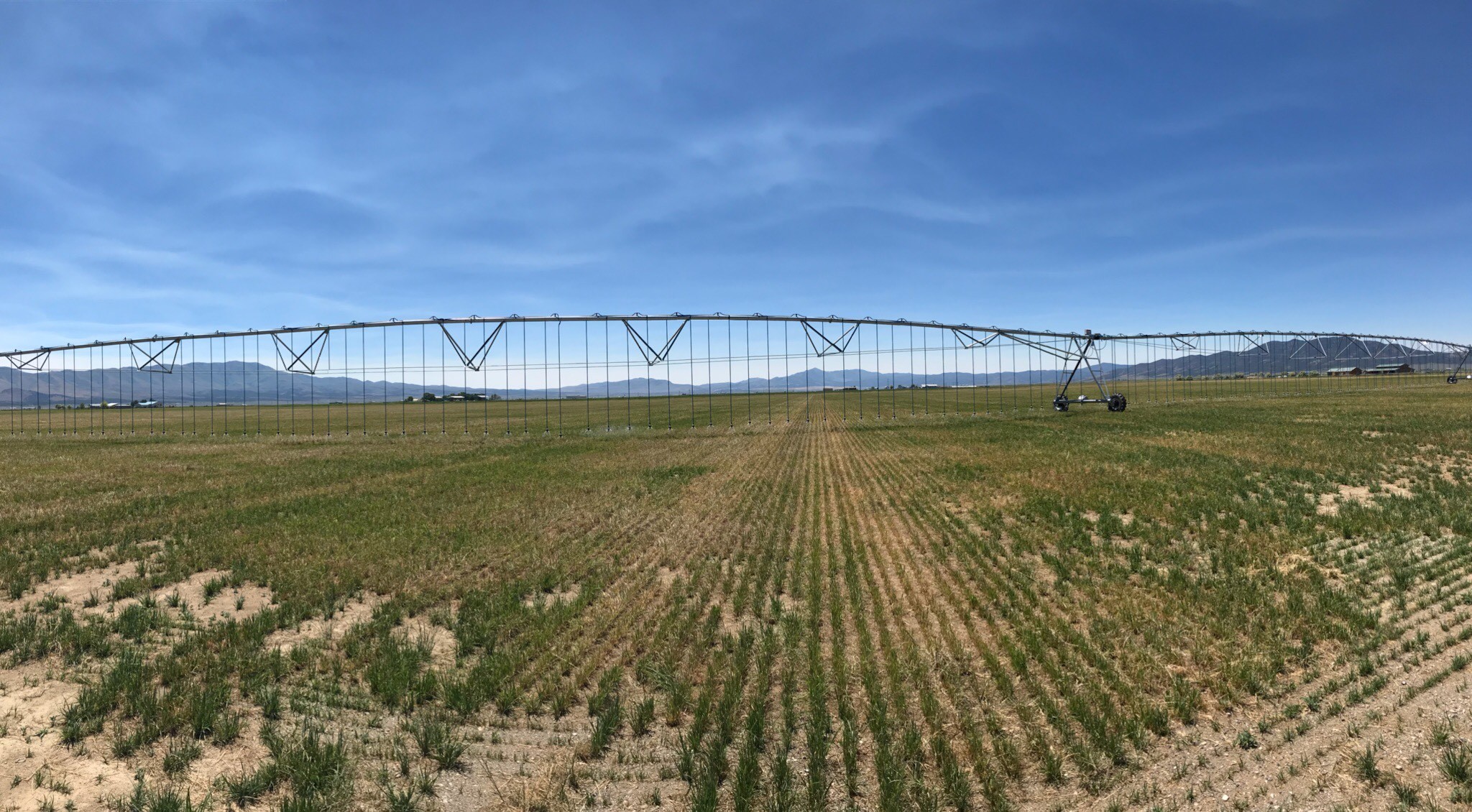


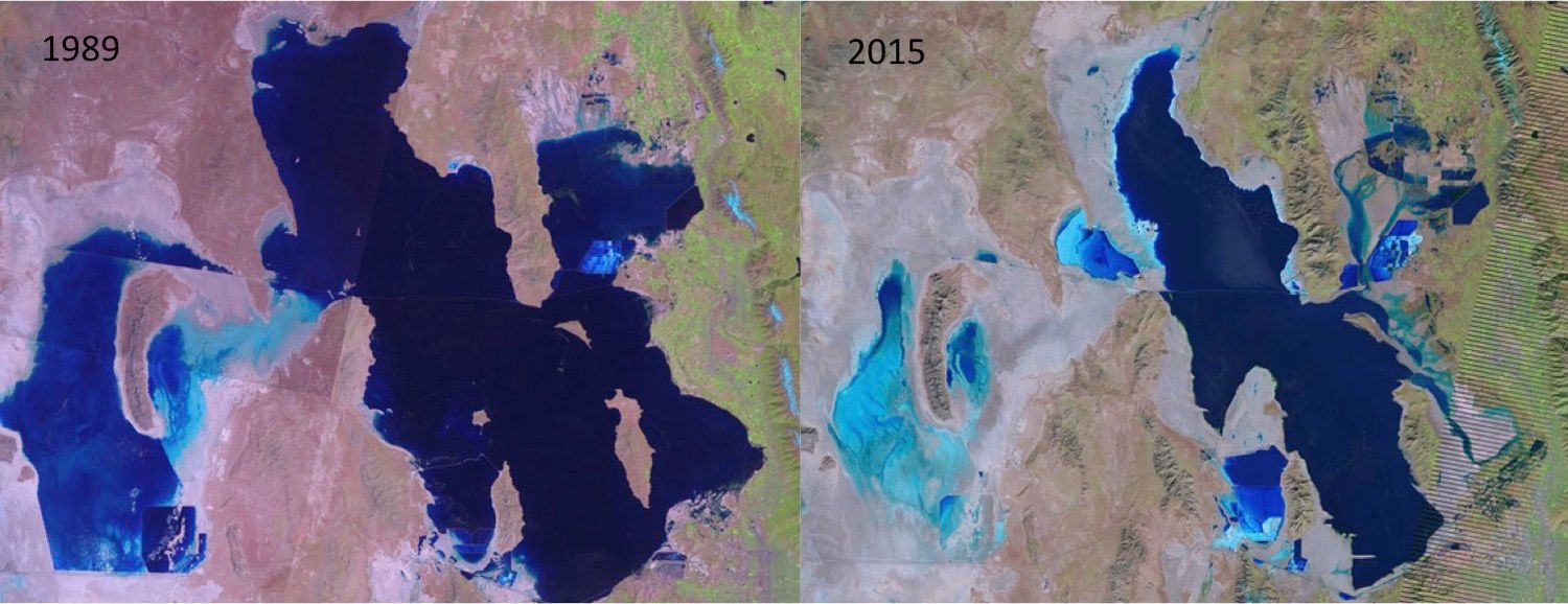


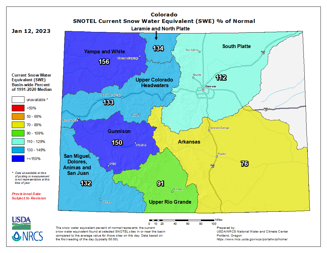

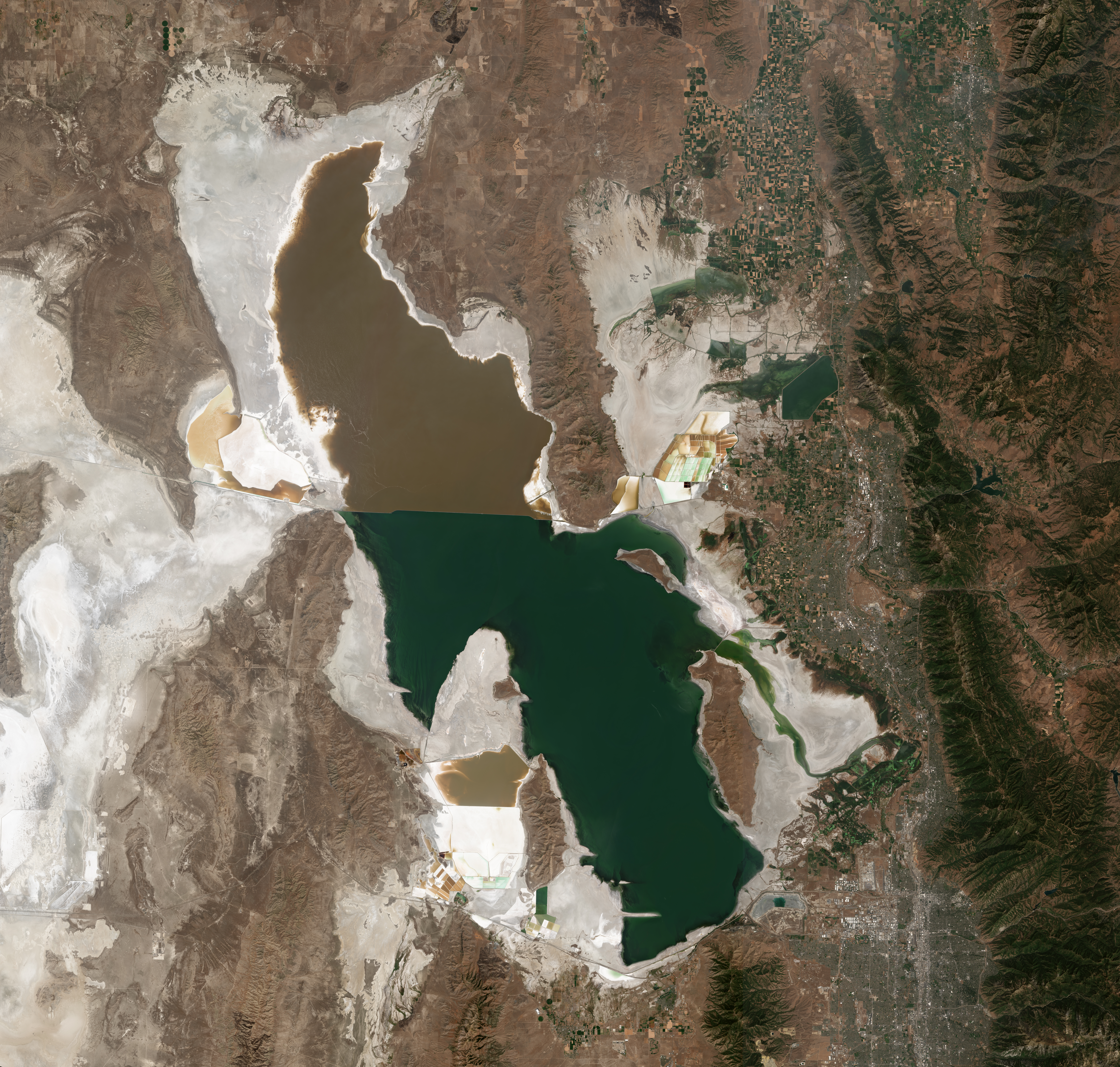
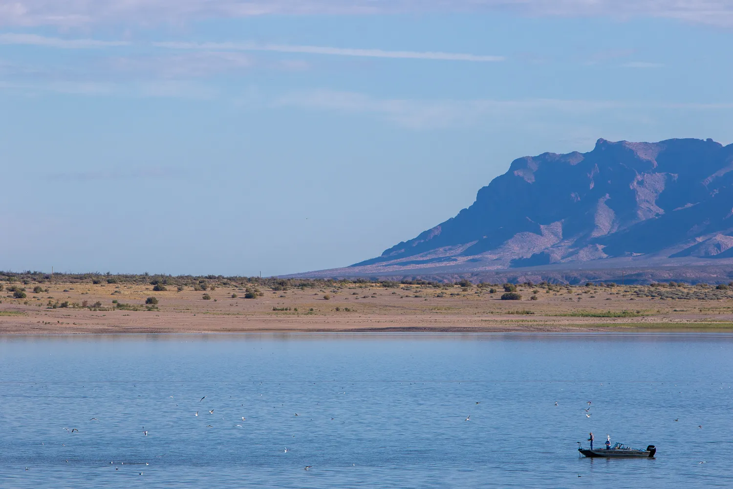

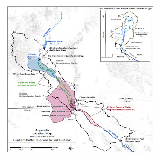


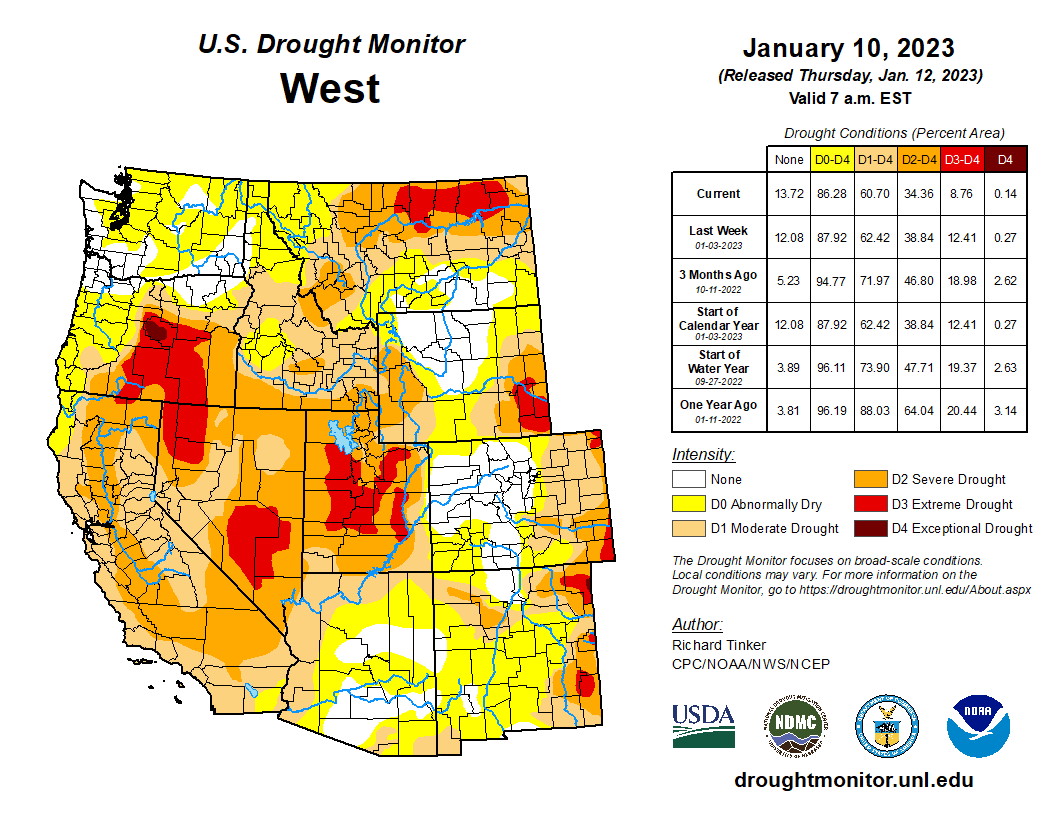

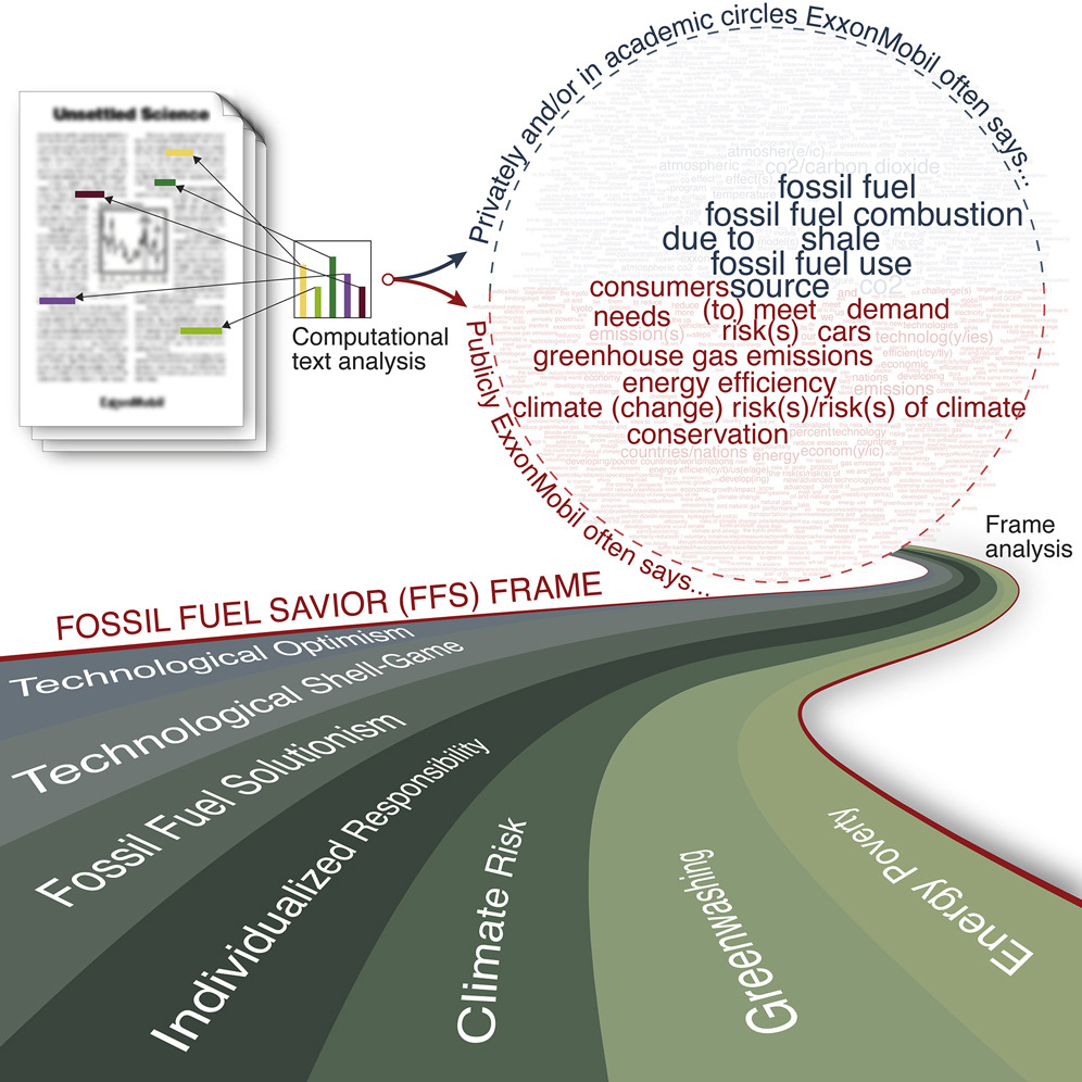

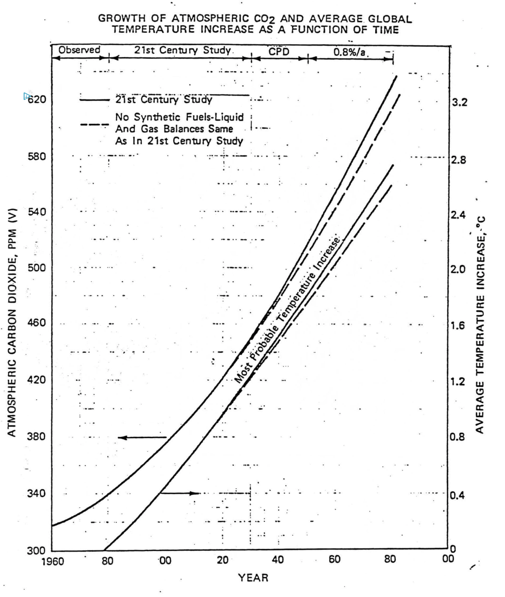


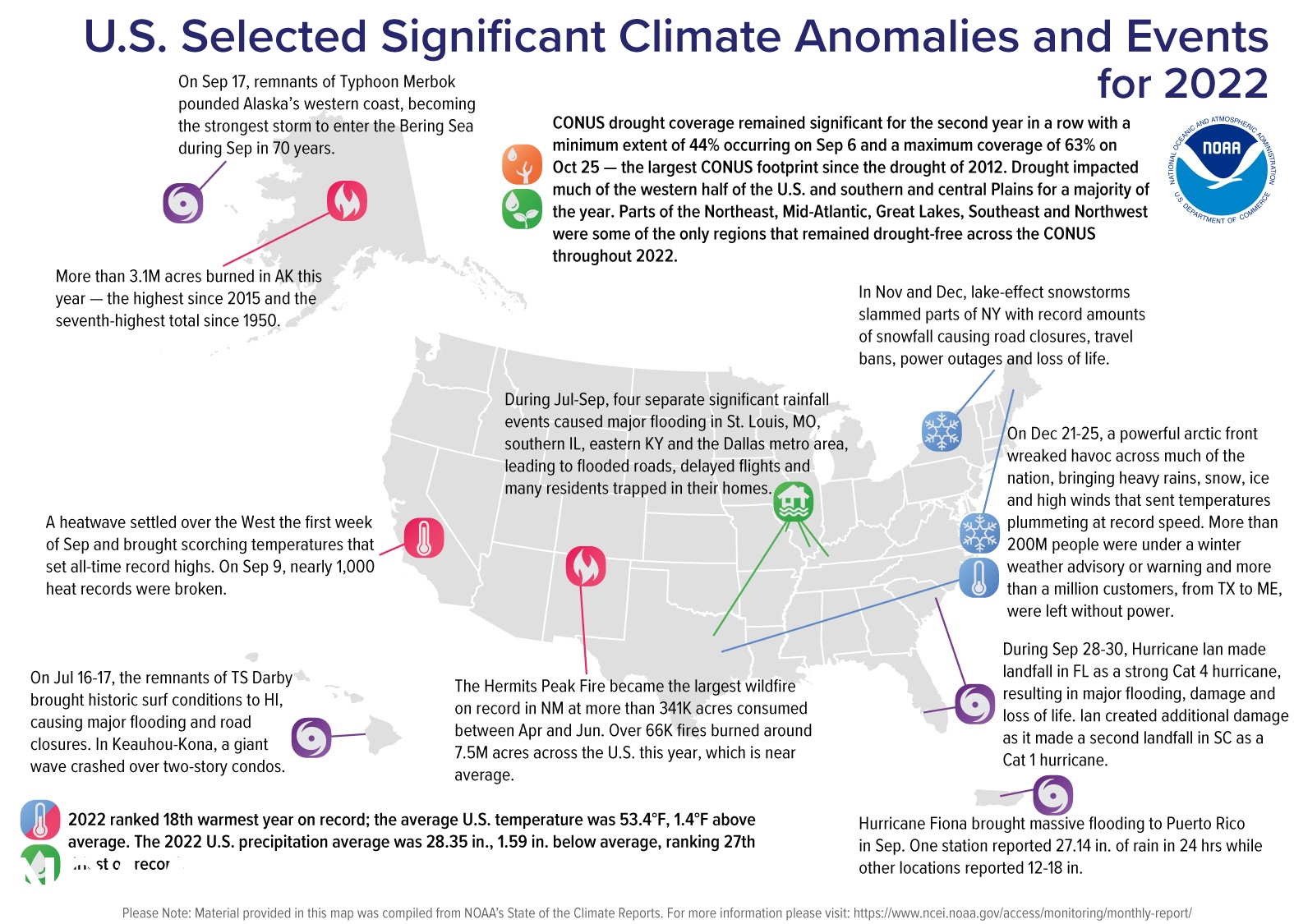
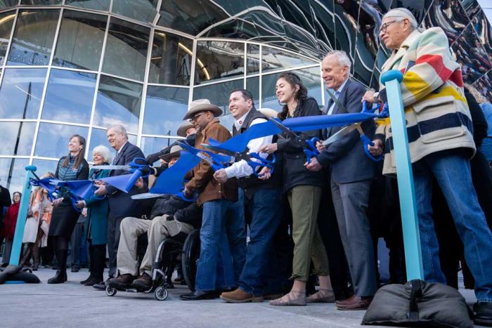

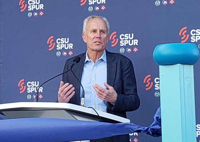


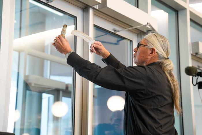

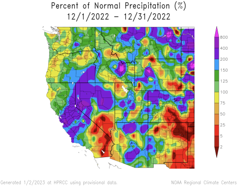


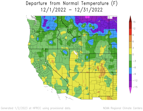
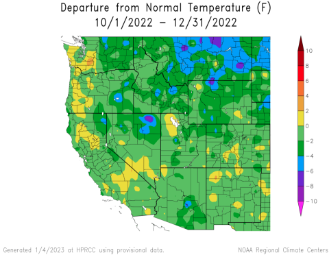

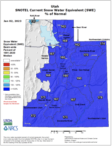


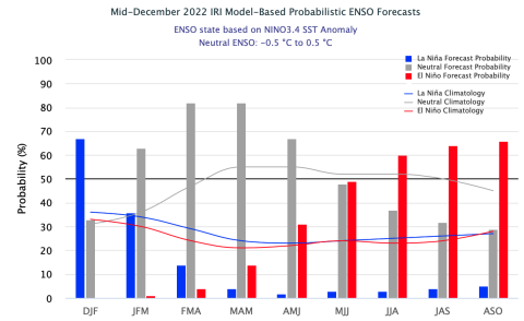
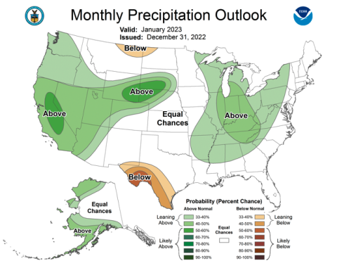
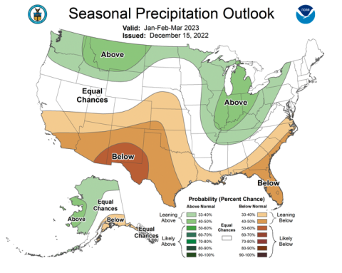
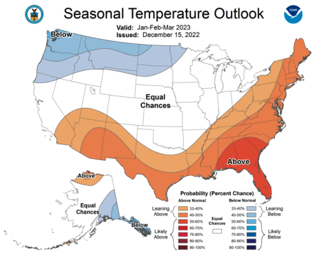
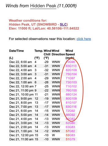
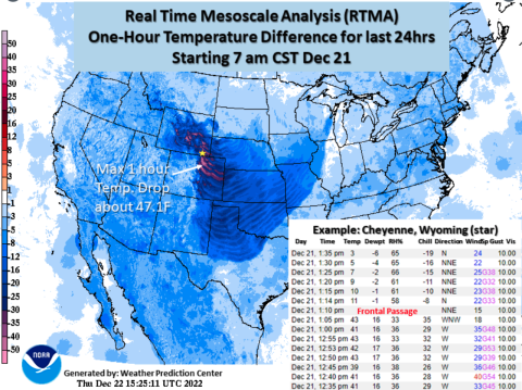
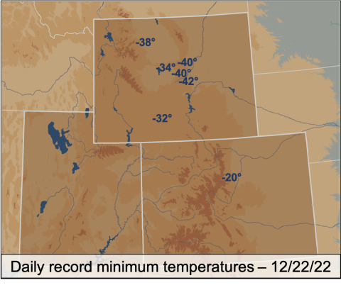
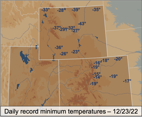

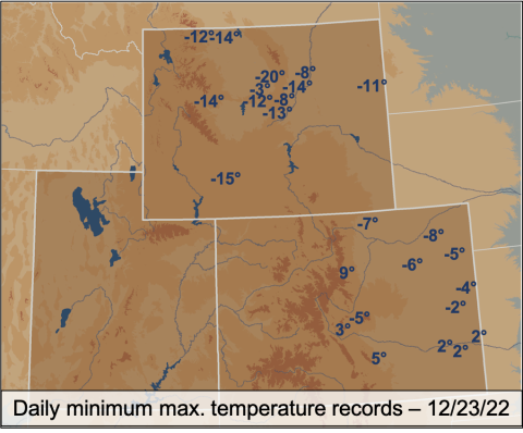
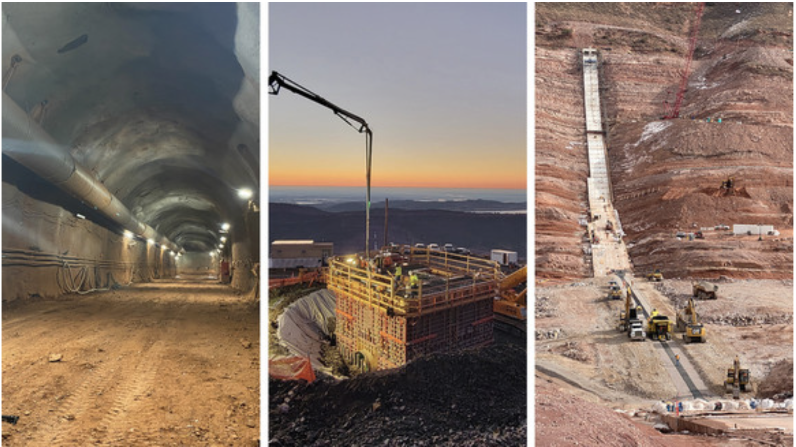

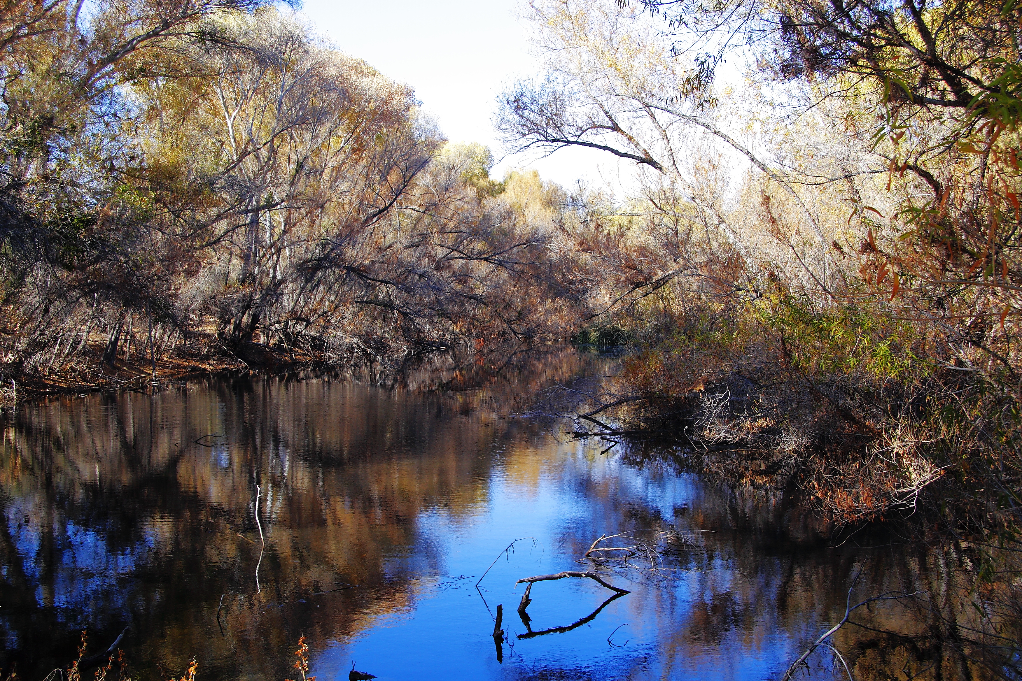


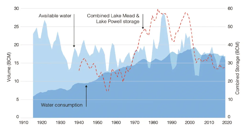

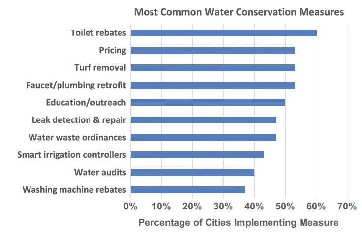

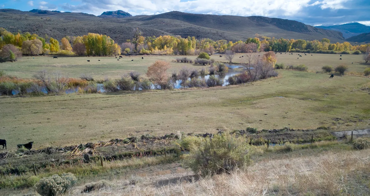


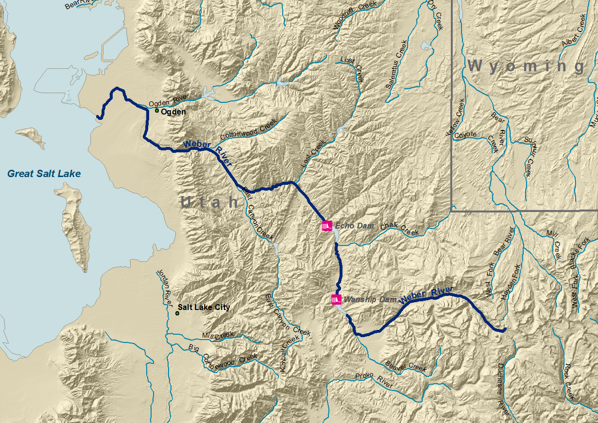


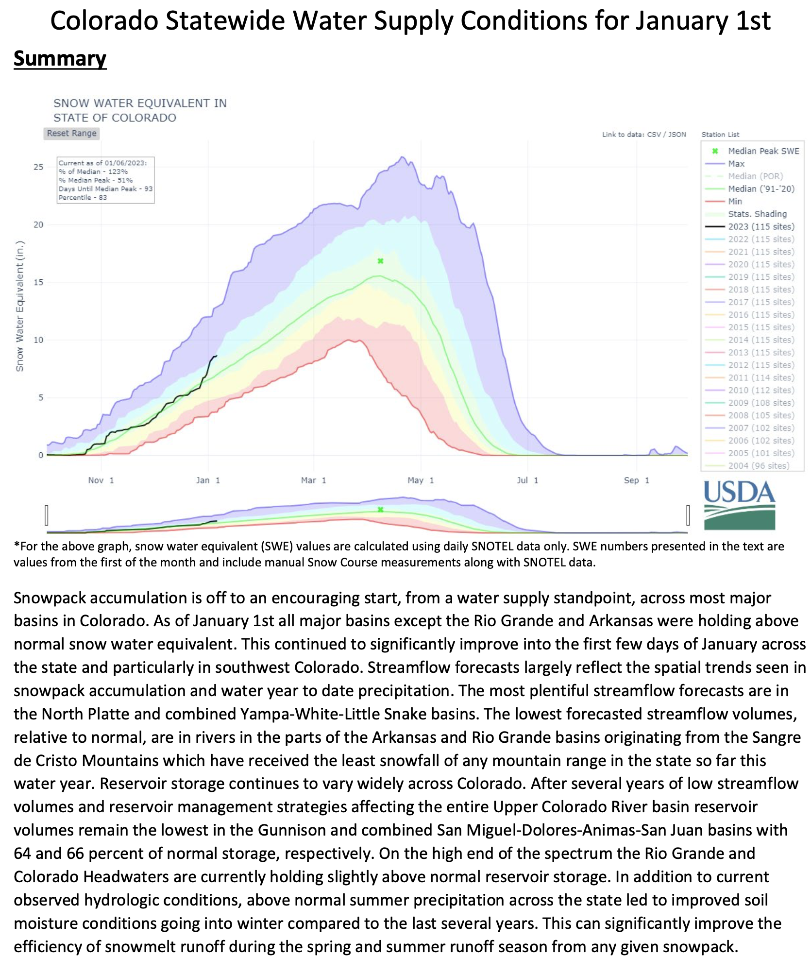
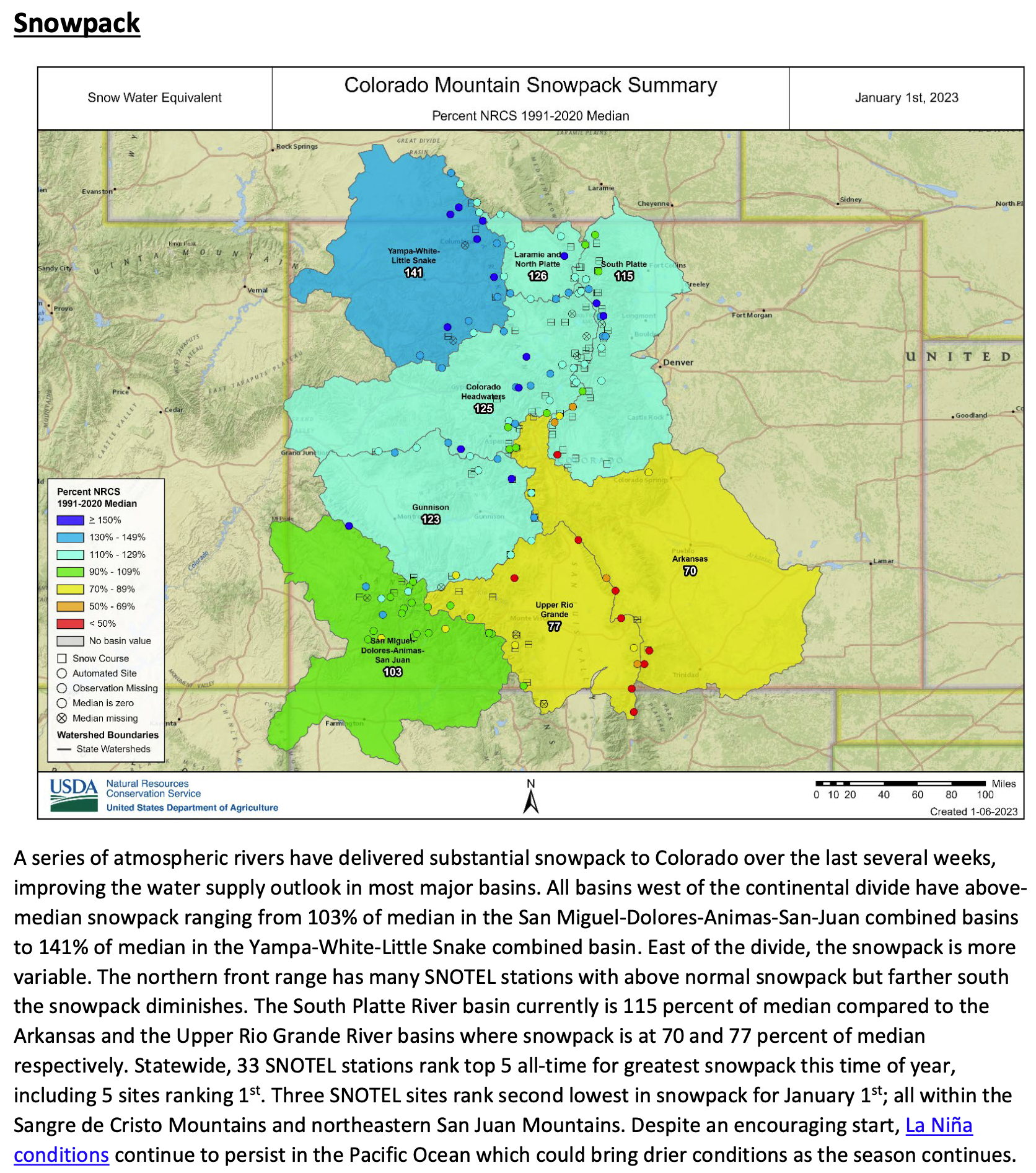
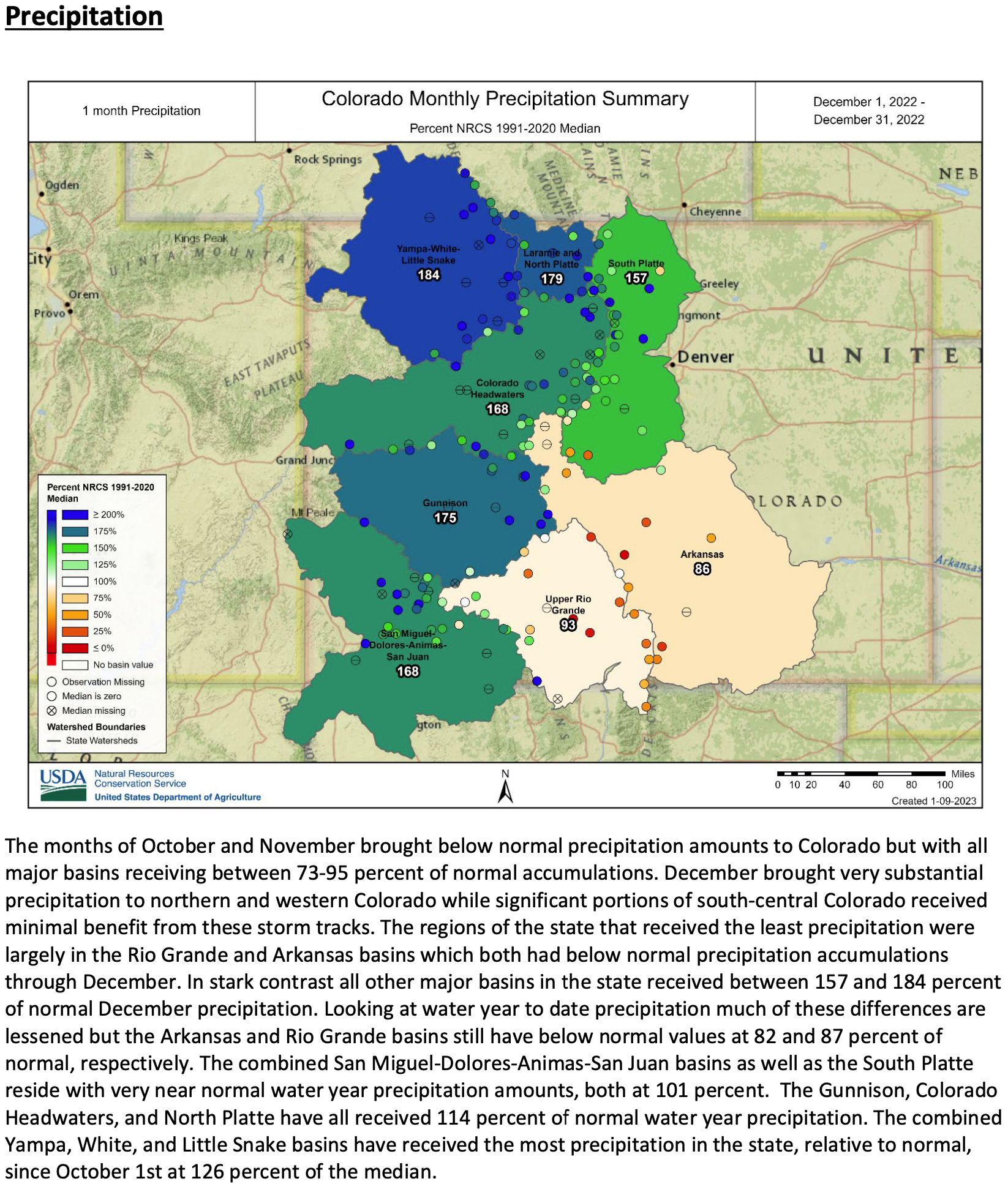
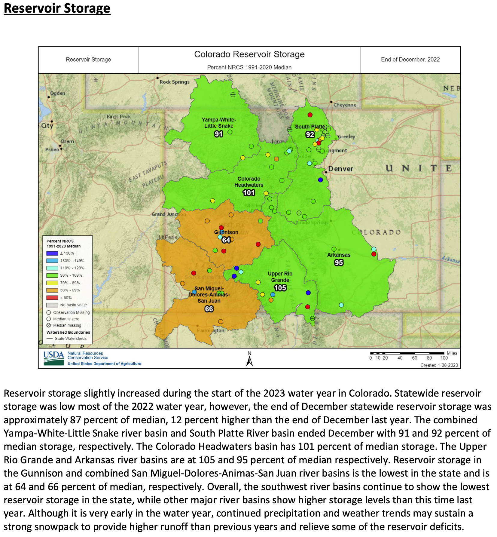
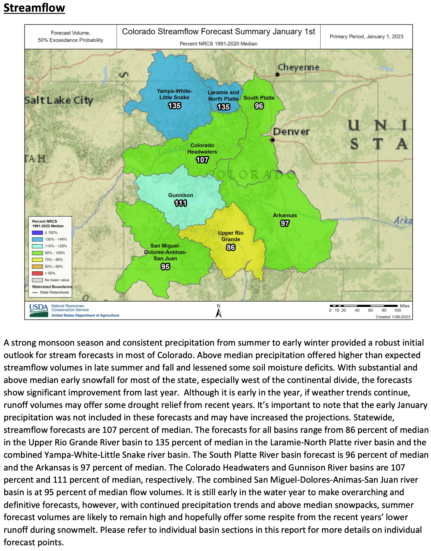


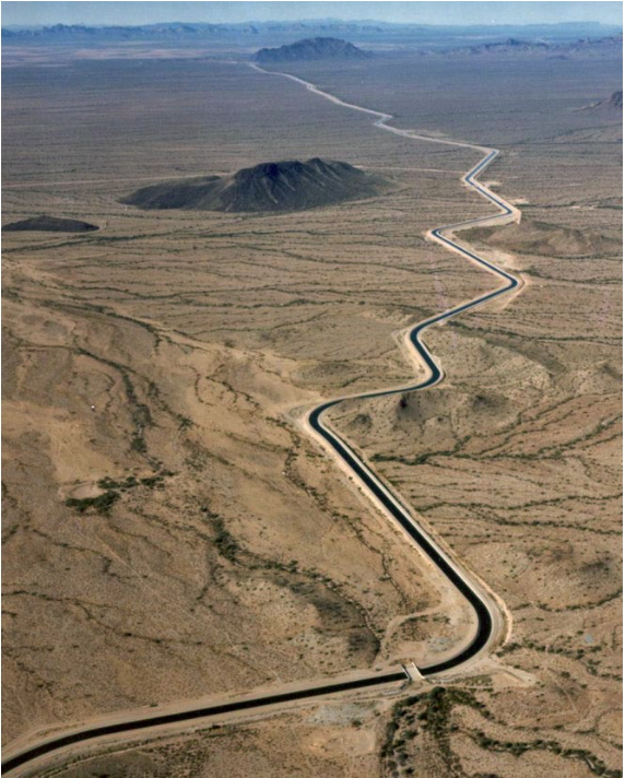

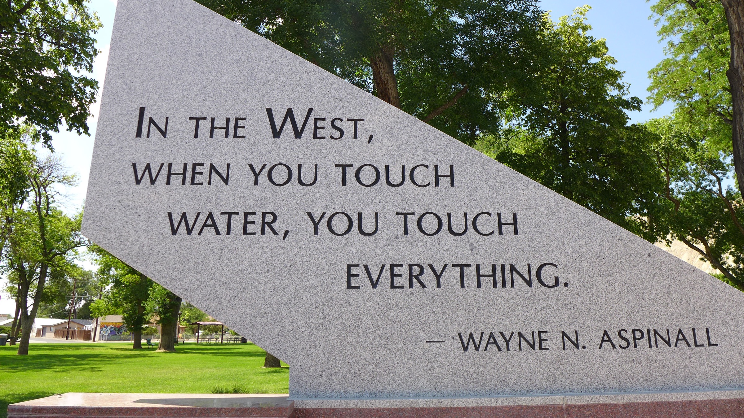
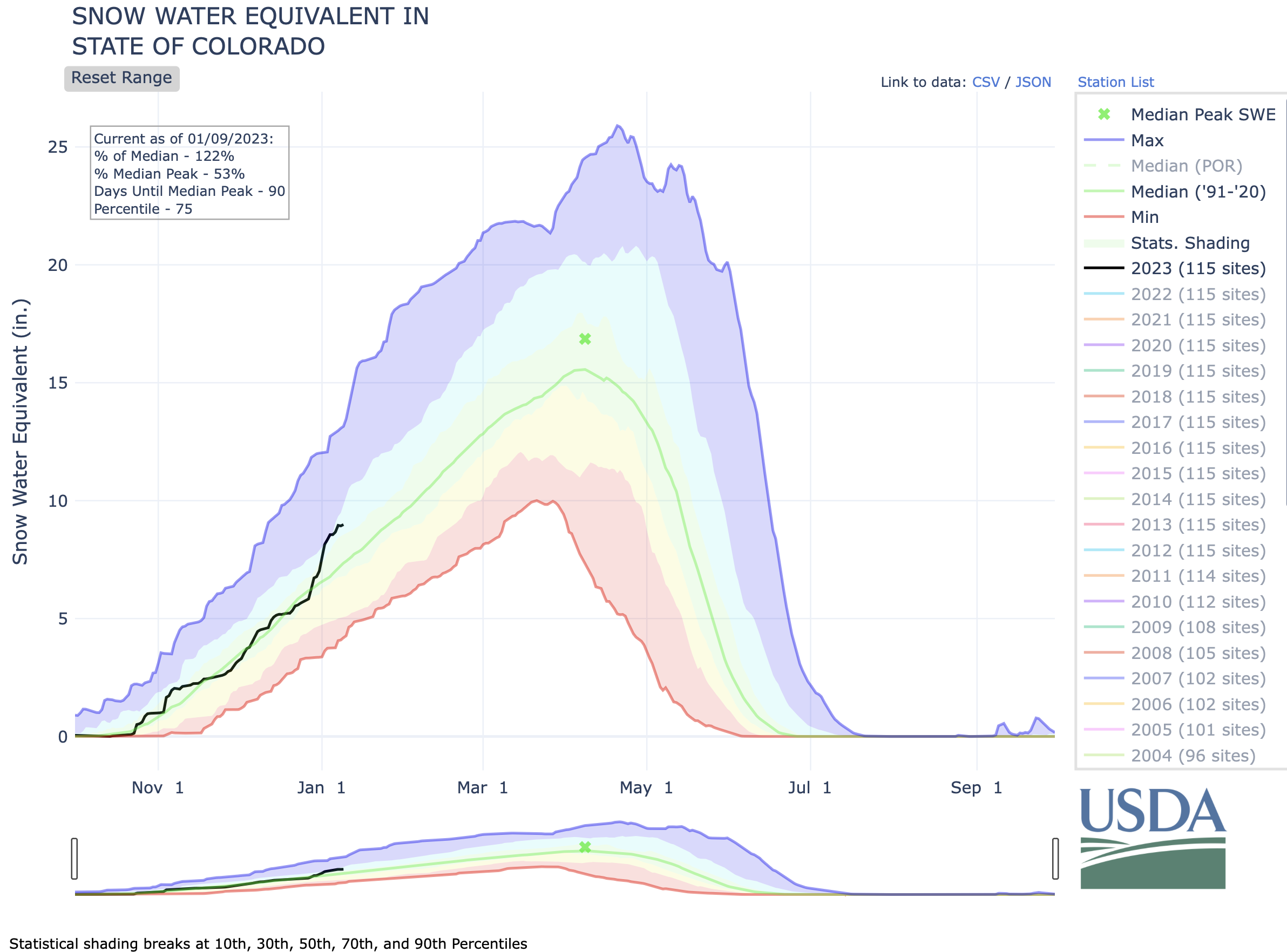

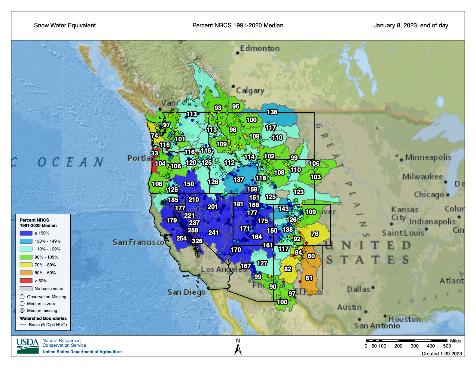

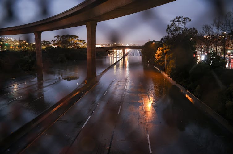
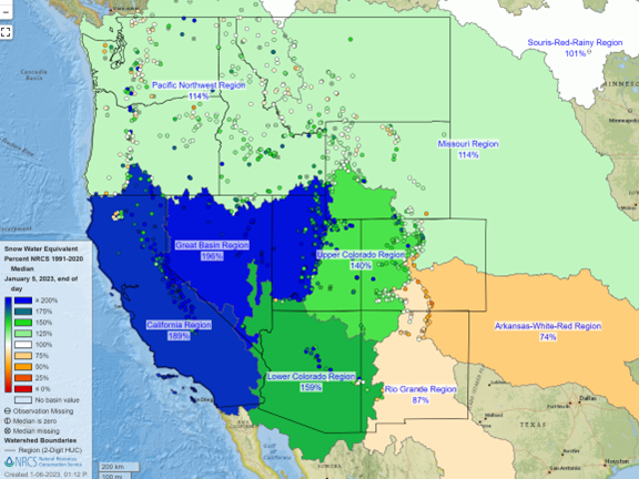


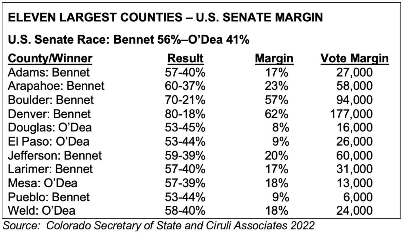


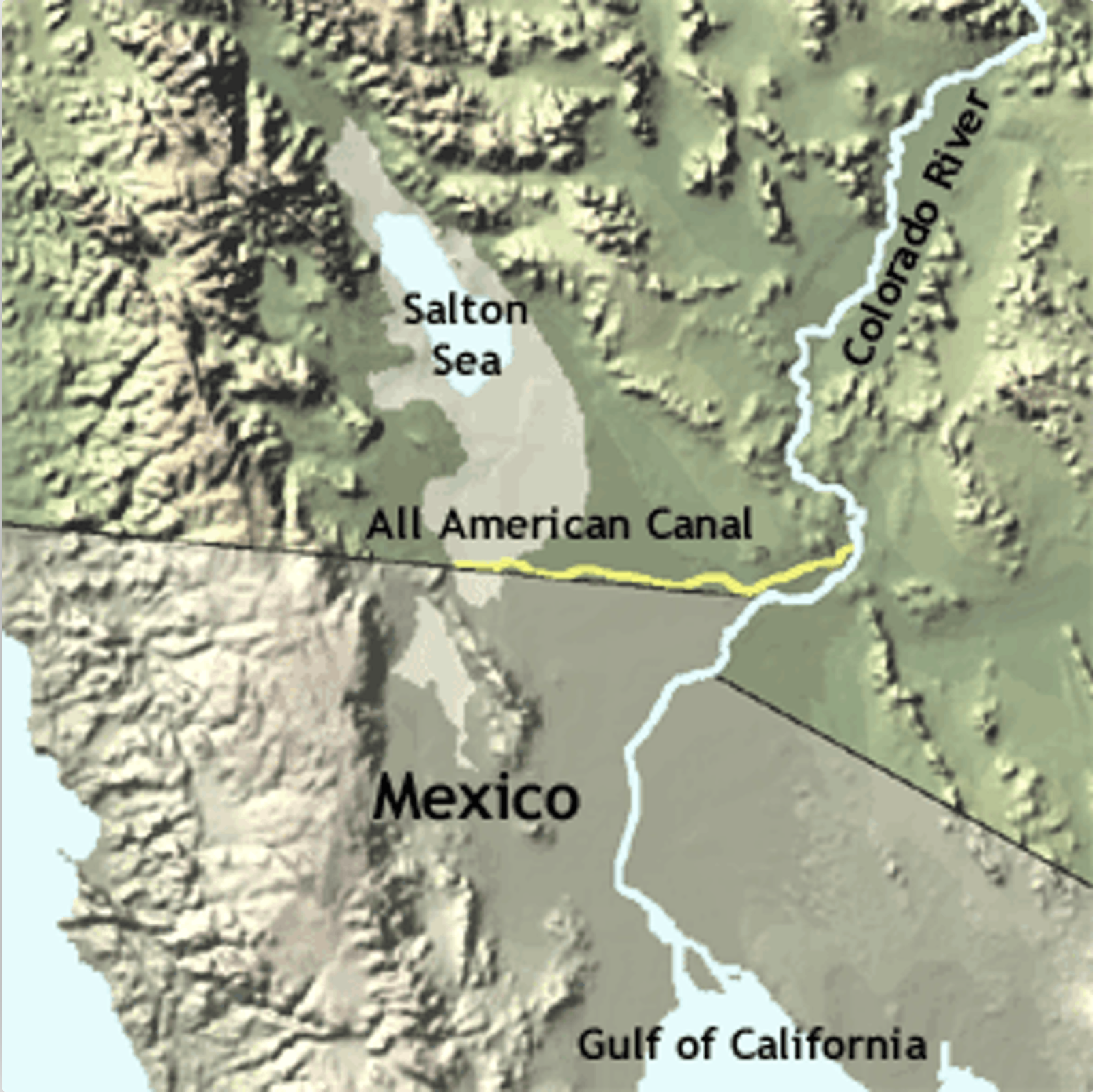
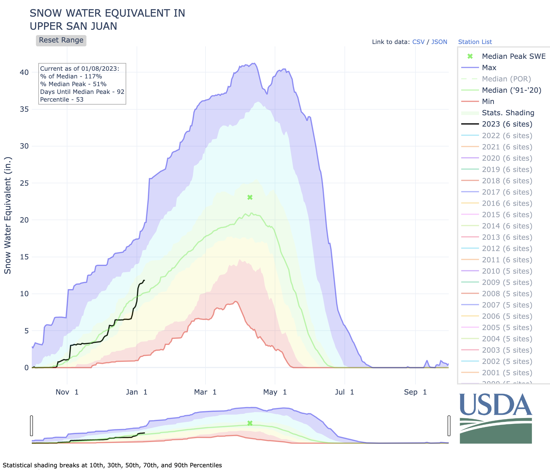
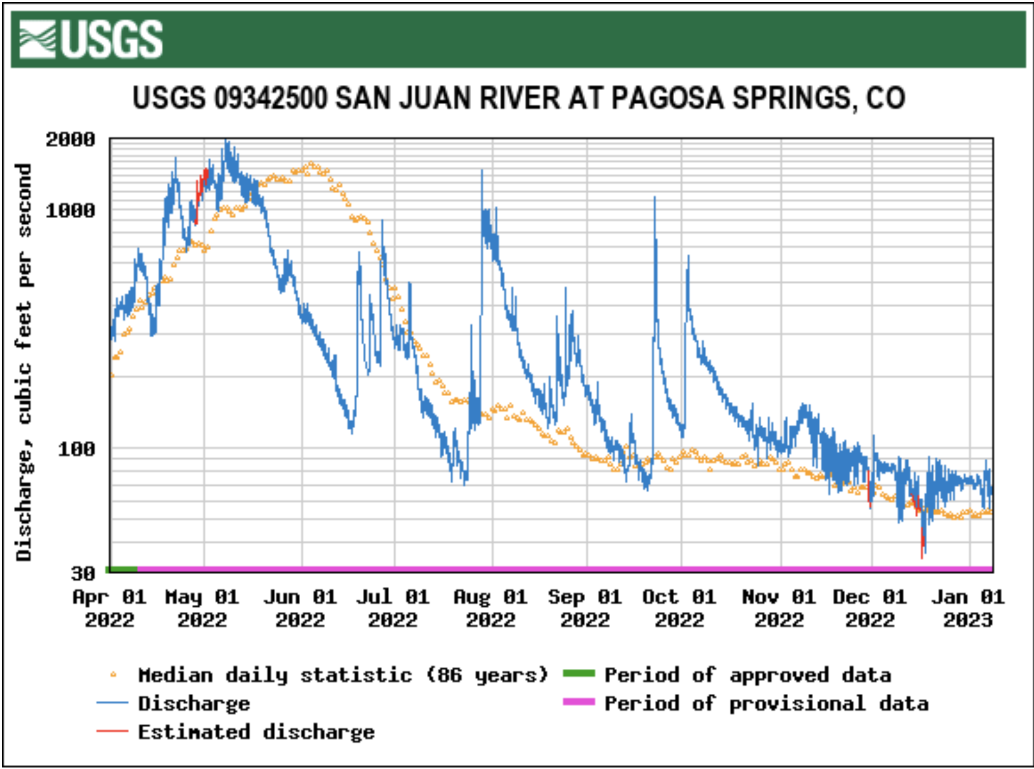


