Audubon’s Jennifer Pitt testifies before Congress on Colorado River habitats. Photo: Caitlin Wall/Audubon
Click the link to read the release on the Audubon website (Jennifer Pitt):
November 20, 2024
The following is the oral testimony of Jennifer Pitt, Audubon’s Colorado River Program Director before a House Natural Resources Subcommittee on Water, Wildlife and Fisheries:
Chair Bentz, Ranking Member Huffman, and members of the Subcommittee, thank you for holding this hearing on proposed legislation addressing water management in the western United States. My name is Jennifer Pitt and I serve as the Colorado River Program Director for the National Audubon Society, with over 25 years of experience working on water issues in the Colorado River Basin. National Audubon Society is a leading national nonprofit organization representing more than 1.4 million members and supporters. Since 1905, we have been dedicated to the conservation of birds and the places they need, today and tomorrow, throughout the Americas using science, advocacy, education, and on-the-ground conservation. Audubon advocates for solutions in the Colorado River Basin that ensure adequate water supply for people and the environment.
Audubon supports H.R. 9515, the Lower Colorado River Multi-Species Conservation Program Amendment Act of 2024. The Program constructs habitats along the Colorado River below Hoover Dam, and that habitat is essential not only for the 27 species the program targets, but also for many of the 400 species of birds that rely on the Lower Colorado River, including Yellow-billed Cuckoos, Sandhill Cranes, and Yuma Ridgway’s Rails. Today, because the Program spending does not keep pace with the collection of funds from non-federal partners, about $70 million is held in non-interest-bearing accounts. If these funds were held in an interest-bearing account, the Program would have about $2 million in additional funds per year, and be more able to maintain program implementation in the face of increasing costs.
Audubon appreciates the inclusion of H.R. 9969 in this hearing. This bill directs Reclamation and the Western Area Power Administration, in consultation with the Glen Canyon Dam Adaptive Management Work Group, to enter into a memorandum of understanding to explore and address potential impacts of management and experimental actions to help control invasive fish passage in the face of drought and declining water levels. Rapidly changing conditions on the Colorado River warrant the experimental approach of adaptive management, with the Work Group bringing together varied interests to a consensus on how to protect downstream resources and strike a balance on river operations. Results of this collaboration include improved sediment flows that help maintain sandy beaches used by plants and animals that dwell in the floodplain, as well as by people traveling the canyon by boat.
The context for these bills is the current crisis on the Colorado River. Climate change continues to ravage the Colorado River Basin, which is now in its 25th year of drought. The forecast for this winter is for above-normal temperatures and below-normal snowpack, which could impact Colorado River water supply. With a 2026 deadline looming for the expiration of existing federal guidelines for operation of federal Colorado River infrastructure – with implications for water supply reliability for people and the river itself – human nature is creating unacceptable risks. Colorado River water managers are preparing for conflict to protect their share of an increasingly scarce water supply, rather than focusing on holistic solutions.
Earlier this year, Audubon joined with conservation partners in submitting to Reclamation our Cooperative Conservation Alternative for consideration in the post-2026 NEPA process for developing Colorado River Operating Guidelines. Cooperative Conservation is designed to improve water supply reliability, reduce the risk of catastrophic shortages to farmers and cities, create new flexible tools that can protect infrastructure, incentivize water conservation, help Tribes realize greater benefits from their water rights, and improve river health. We urge Reclamation and all Colorado River Basin parties to consider our approach as they proceed through the NEPA process.
From a bird’s eye view, the whole system matters. That needs to hold true for water users who must figure out how to share the Colorado River. The old adage applies: united we stand, divided we fall. The Colorado River community – in particular Upper Basin and Lower Basin interests – must stop thinking parochially and start thinking about how we survive drier times together.
I would like to thank Congress for funding water conservation programs, such as WaterSMART and the Cooperative Watershed Management Program, and the crucial funding in the Bipartisan Infrastructure Law and the Inflation Reduction Act, both of which include funding to improve the resilience of the Colorado River Basin. With this funding, and states working together, we have avoided a crisis, but we are still just one bad winter away from catastrophic shortages. To be effective, this funding needs to get out of federal coffers and into the hands of water users and water managers, to incentivize water conservation and efficiency, to improve the health of the forests and headwater streams that are the river’s source, and to stabilize the river itself – the natural infrastructure that supplies water to more than 40 million people. Congress will need to help in the future with additional funding to support continued resilience investments in the Colorado River Basin as warming continues.
Thank you very much for the opportunity to testify and I would be happy to answer your questions.
Water runs down a spillway at the Shoshone hydro plant in Glenwood Canyon. Rockfalls, fires and mudslides in recent years have caused frequent shutdowns of plant operations. Credit: Heather Sackett/Aspen Journalism
A $99 million plan to buy and permanently preserve some of the oldest water rights in Colorado is inching closer to securing all of its funding. But President-elect Donald Trump’s promise to gut climate spending could throw a wrench in the deal, despite its bipartisan support. The Colorado River District, which advocates on behalf of Western Slope water users, submitted a funding application today to the U.S. Bureau of Reclamation under a program for drought mitigation. The district is seeking $40 million from the federal agency to help purchase water rights from Xcel Energy, the state’s largest utility…
Since the agreement, around 25 Western Slope water providers, the river district and the state of Colorado have committed $56 million to purchase the water rights. The state’s water conservation board, much of Colorado’s congressional delegation, and a bipartisan group of state lawmakers support the plan. To make up the remaining funds, the river district is banking on money from the Inflation Reduction Act, the nation’s largest climate law, which was signed by Biden in 2022. Bureau of Reclamation records show the agency has $450 million remaining under the law to dole out to state, local and tribal governments in the upper Colorado River Basin for projects that offset the effects of drought and climate change…
That stream of federal funding for the Shoshone water deal has not yet been committed and could be in jeopardy, according to Martin Lockman, a law fellow at the Sabin Center for Climate Change Law. President-elect Trump said he would rescind any remaining funds from the inflation law when he returns to office. Project 2025, a conservative policy blueprint influential among the president-elect’s advisors, has called for repealing elements of the law.
The Bureau of Reclamation released a sort of teaser of its eagerly anticipated plan for dealing with the demand-supply imbalance on the Colorado River. And like most teasers, it gives very little insight into what to expect from the actual plan. It presents four alternative ways forward, but doesn’t say which one the agency is leaning towards. But they all are at least partially aimed at keeping Lake Powell’s surface level above the minimum power pool, so that water can continue to be released via the penstocks and hydroelectric turbines. This would put most of the burden for cuts on the Lower Basin states, which could experience up to a 3.5-million-acre-feet shortage some years. This doesn’t cut it for John Weisheit, Living Rivers’ Conservation Director, who noted:
This shows that Colorado’s Western Slope is the biggest supplier of water to the Colorado River. Source: David F. Gold et al, Exploring the Spatially Compounding Multi‐Sectoral Drought Vulnerabilities in Colorado’s West Slope River Basins, Earth’s Future (2024). DOI: 10.1029/2024EF004841
But there may be even less water than previously anticipated in the Colorado River in the future, throwing even the best laid plans askew. That’s the finding of a recent study, in which researchers ran historic data and climate change forecasts through modeling programs, yielding hundreds of thousands of streamflow scenarios for the Colorado River and its tributaries originating on Colorado’s West Slope. They concluded that relying on the historic streamflow record risks underestimating the magnitude of future drought events. And these droughts could significantly reduce the amount of water flowing in Colorado River tributaries, throwing supply and demand further off balance.
And if less water is going into Lake Powell, then its operators will release even less water from Glen Canyon Dam, meaning deeper shortages for the millions of folks downstream who rely on the river.
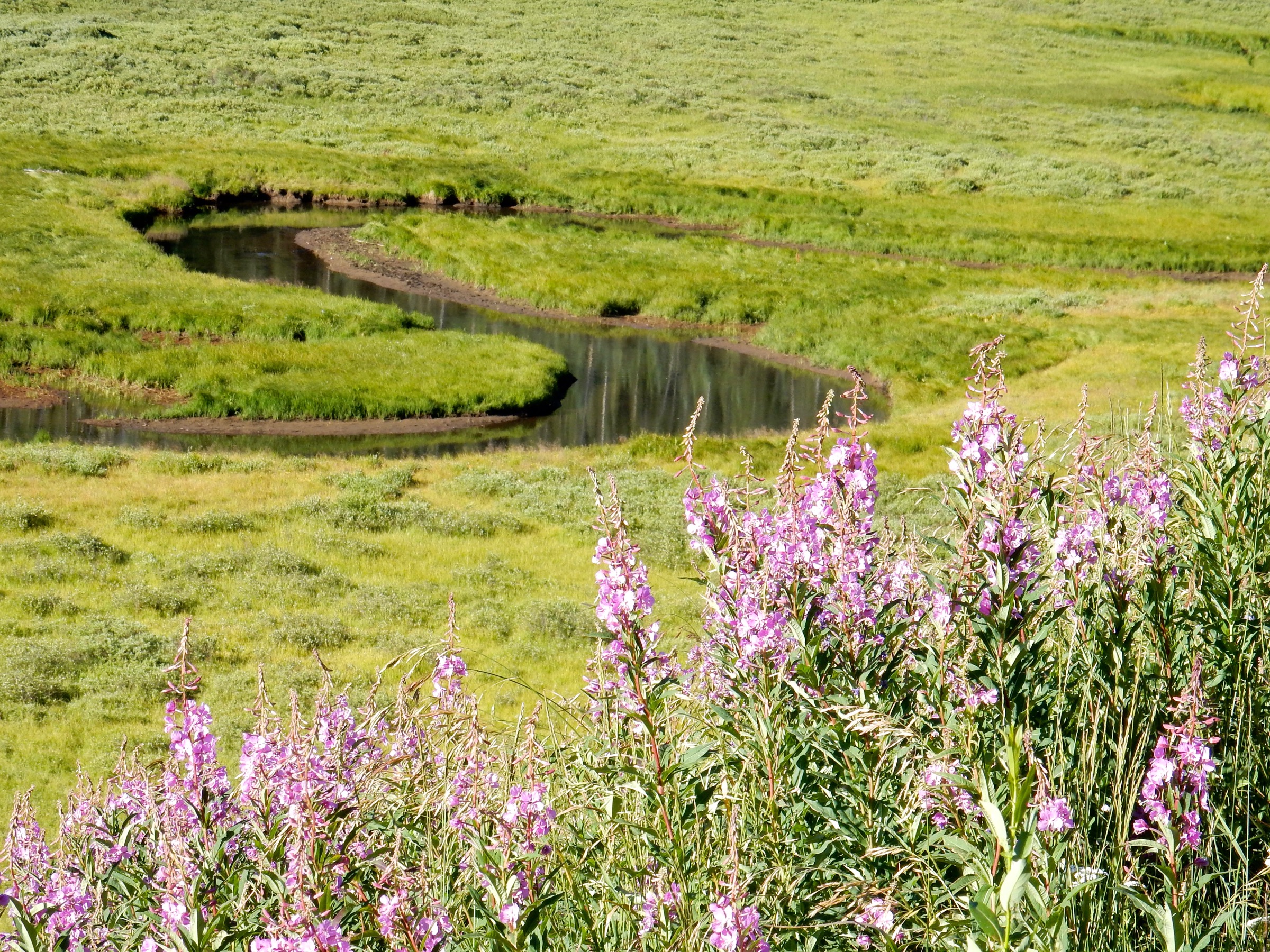
For now, however, things are looking alright for the Colorado River. Some good autumn storms built up the snowpack, which is now sitting right at about the median level for this time of year in the Upper Colorado River Basin.
Meanwhile, things are quite nice, snowpack-wise, down in the San Juan Mountains, where snow-water levels are higher than this date’s normal and significantly healthier than at this time in 2024 or 2023. And another storm is on its way.
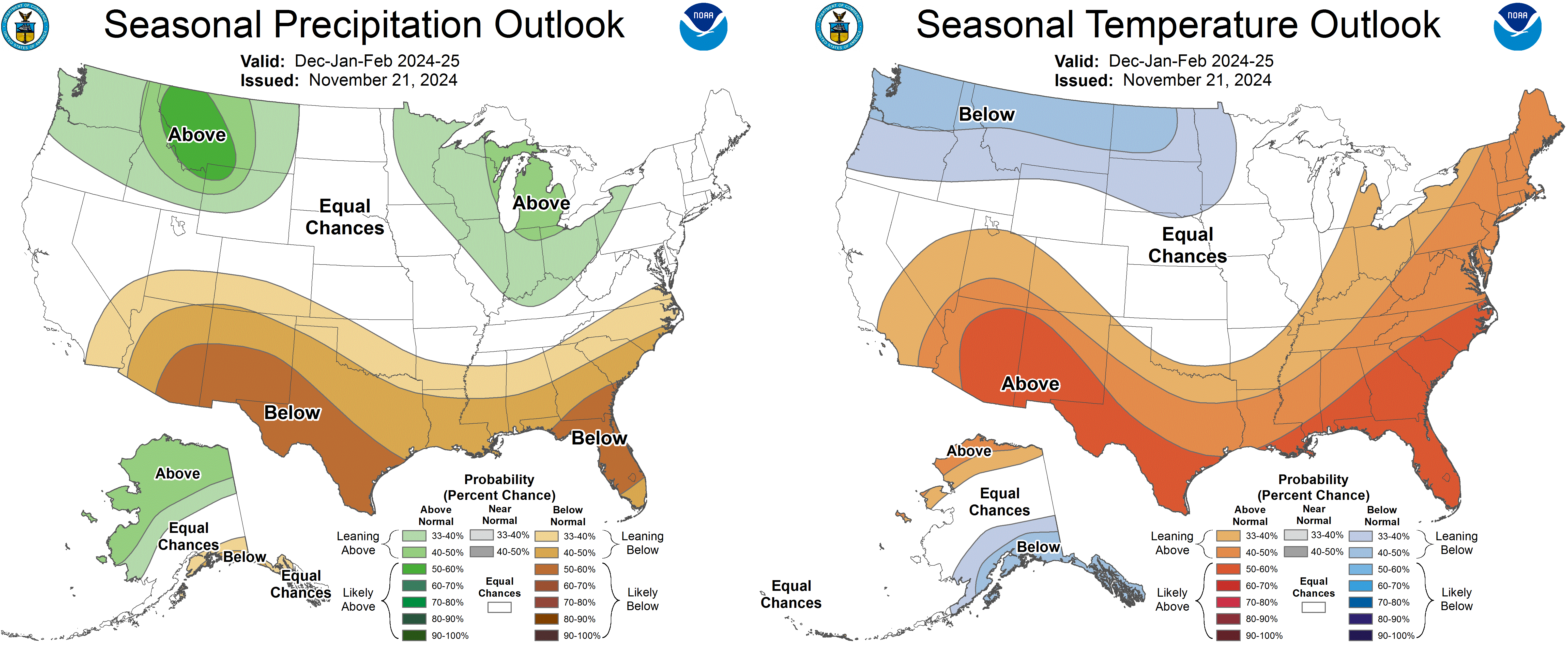
Will the good times last? According to the latest seasonal climate outlook, probably not. Forecasters are expecting it to be drier and warmer than normal in the Southwest, though things could go either way in the northern portion of the Colorado River Basin. But then, it’s always best to take these long-term forecasts with a hefty grain of salt.
Where can you get, in 2024, 1.36 acres that includes an old post office, a 104-year-old cabin, a converted bus, and at least one RV for just $75,000? Cisco, Utah, that’s where. The property was immortalized by Sarah Gilman in her 2018 High Country News article “The Pioneer of Ruin,” a profile of the owner and Cisco’s sole resident Eileen Muza. Miranda Trimmier also wrote about Cisco and Muza for Places Journal in 2019, and a variety of other media attention followed about their effort to restore that piece of the “ghost town.” The property was listed in July for $275,000 — Muza’s partner apparently was not interested in living out there — but the price was dropped to $75,000 this month. It’s certainly one of the funkier properties on the market and probably the least expensive housing for sale in the greater Four Corners area. But the “housing” part isn’t official: Even though Muza lived there and it sports several dwellings, the property is listed as land, not a residence (so it won’t show up on searches for houses). But you’d better move quick if you’re interested: It showed up on the 2.9-million-follower @cheapoldhouses Instagram feed recently, so it could go fast. Heck, at that price, I even briefly considered it for the Land Desk/Lost Souls Press global HQ!
And just down the road, in that illustrious Cisco suburb known as Moab, about 100 people gathered to protest the proposed Kane Creek Development. The developers want to build nearly 600 housing units and associated infrastructure at a place called Kings Bottom on the banks of the Colorado River a couple miles downstream from Moab. It’s not going over so well with many locals. That’s just a crap ton of houses, it would all be vulnerable to flooding (meaning a good portion of the homes, and the contents of a planned sewage treatment plant, could end up floating in Lake Powell someday). I suppose the developers could move the whole operation up to Cisco.
In an alternate reality, in which the Bureau of Reclamation circa 1946 had its way, Cisco might be waterfront property right now. For more on that, check out this piece from the Land Desk archives (available to paid subscribers only):
The Bureau of Reclamation has selected 36 projects to receive a total of $3.3 million in federal funding to enhance water efficiency across the Western United States. The funding, provided through the Small-Scale Water Efficiency Projects program, will support initiatives such as the installation of flow measurement or automation systems, canal lining to reduce seepage, and other similar projects that aim to improve water management on a smaller scale.
“As stewards of vital water resources, it is our responsibility to ensure that every drop is used efficiently,” said Bureau of Reclamation Chief Engineer David Raff. “These investments, while focused on smaller-scale projects, have a lasting impact on our ability to conserve water, protect ecosystems, and support the communities that depend on these critical resources.”
The Bureau of Reclamation is now accepting applications for the next Small-Scale Water Efficiency Projects program funding opportunity, with a deadline of January 14, 2025.
For more information on how to apply for funding, visit grants.gov. To learn more about the program and find details about projects in your area, visit the program’s website.
The projects selected are:
Arizona:
Coldwater Canyon Water Company, Upgrade Manual Read Meters to Advanced Meter Reading Technology: Reclamation Funding: $91,786
Global Water Resources, Turf Removal Incentive Program for Residential and Non-Residential Customers: Reclamation Funding: $50,000
Joshua Valley Utility Company, Phase III: Upgrade 400 Meters to Advanced Reading Technology: Reclamation Funding: $100,000
Sonora Environmental Research Institute, Inc, High-Efficiency Clothes Washer Replacement Program for Low-Income Households: Reclamation Funding: $47,500
California:
City of Hercules, Enhancing Park Irrigation Efficiency with Cloud-Based Controllers: Reclamation Funding: $100,000
Cucamonga Valley Water District, Water Savvy Parkway Transformation Program: Reclamation Funding: $100,000
Desert Water Agency, Grass Removal Program: Reclamation Funding: $100,000
Fresno Irrigation District, Meter Installation Program: Reclamation Funding: $100,000
Jackson Valley Irrigation District, Propeller Meter Upgrades: Reclamation Funding: $100,000
Pajaro Valley Water Management Agency, Remote Data Acquisition for High Production Groundwater Wells: Reclamation Funding: $97,878
San Lorenzo Valley Water District, AMI Water Meter Replacement Project: Reclamation Funding: $100,000
Upper San Gabriel Valley Municipal Water District, Water Use Efficiency Plant Voucher Project: Reclamation Funding: $100,000
Colorado:
Community Agriculture Alliance Inc, Automate Headgates on the Bear River: Reclamation Funding: $100,000
Town of Fraser, 2026 Water Meter Modernization and Replacement Project: Reclamation Funding: $100,000
Town of Simla, Municipal Water Meter Upgrade for Water Efficiency: Reclamation Funding: $100,000
Idaho:
A&B Irrigation District, Water Accounting Software Implementation and Project Upgrade: Reclamation Funding: $47,500
Boise Project Board of Control, Automation of the Brooks Lateral: Reclamation Funding: $24,967
Fremont Madison Irrigation District, Fremont-Madison Irrigation District Automation and SCADA Project Phase 4: Reclamation Funding: $100,000
Jefferson Irrigation Company, Flow Measurement of Irrigation Canal Turnouts for Jefferson Irrigation Company, LTD: Reclamation Funding: $99,715
Long Island Irrigation Company, Main Diversion Replacement: Reclamation Funding: $100,000
Upper Wood River Water Users Association, Inc, Bypass Canal Lining Project: Reclamation Funding: $100,000
North Dakota:
Agassiz Water Users District, Agassiz Water Users District 2024 Remote Read Water Meter Project: Reclamation Funding: $100,000
City of Bottineau, City of Bottineau, Advanced Metering Infrastructure Project – Phase I: Reclamation Funding: $100,000
City of Mandan, Mandan Advanced Metering Infrastructure System Update Project: Reclamation Funding: $100,000
City of Watford City, Watford City Advanced Metering Infrastructure Project – Phase II: Reclamation Funding: $100,000
Southeast Water Users District, Southeast Water Users District: Advanced Metering Infrastructure Improvements Phase II Project: Reclamation Funding: $100,000
Nevada:
City of Boulder City, Boulder City Water Meter Upgrades: Reclamation Funding: $98,613
Oregon:
Colton Water District, Automated Meter Reading: Reclamation Funding: $100,000
Reclamation provides cost share funding the Small-Scale Water Efficiency Projects to irrigation and water districts, Tribes, states and other entities with water or power delivery authority for small water efficiency improvements, prioritizing projects that have been identified through previous planning efforts.
Small-Scale Water Efficiency Projects are part of the WaterSMART Program. It aims to improve water conservation and sustainability, helping water resource managers make sound decisions about water use. The WaterSMART Program identifies strategies to ensure this generation, and future ones, will have enough clean water for drinking, economic activities, recreation and ecosystem health. To learn more, please visit www.usbr.gov/watersmart.
Hopi Chairman Timothy L. Nuvangyaoma breathed a sigh of relief on Tuesday as Arizona Gov. Katie Hobbs signed the Northeastern Arizona Indian Water Rights Settlement Act, a significant step that sends the measure on to Congress. It’s poised to become the largest Indian water rights settlement in history…
“This is a historic moment for the state of Arizona, tribal nations, and all parties to these agreements. They create a consequential and lasting impact by securing a sustainable water supply for tens of thousands of Arizonans and helping local economies thrive,” Hobbs said. “I’m proud to be a part of this solution that many Arizona families have fought to get for generations. It’s a testament to their strength and determination, as well as my commitment to collaborate with Arizona’s tribal nations and protect water supplies for all Arizonans.”
The settlement act resolves long-standing tribal water rights claims to the Colorado River, the Little Colorado River and groundwater sources in northeastern Arizona. The water infrastructure funded by the settlement will address the critical need for safe and reliable water supplies for members of three tribes — Navajo, Hopi and San Juan Southern Paiute — ensuring access to clean running water, a necessity all Arizonans deserve…Congress must ratify the settlement before it adjourns at the end of the year. If the measure fails to pass, supporters will have to reintroduce it when the new Congress convenes in January.
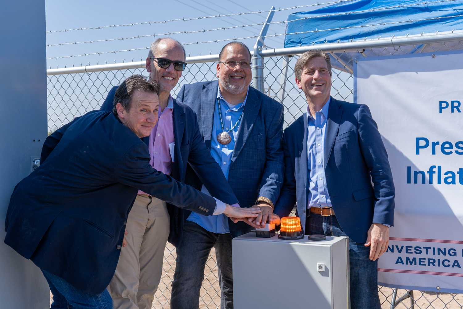
Investments from President Biden’s Investing in America agenda have staved off crisis in the Colorado River Basin
Alternatives released today lay out necessary steps towards consensus agreement for post-2026 operations
Since Day One of the Biden-Harris administration, the Department of the Interior has led critical discussions over how to bring the Colorado River back from the brink of crisis in the face of a 24-year drought. Having achieved overwhelming success in 2023 on interim operation plans to guide operations through 2026 with a historic consensus agreement, and following more than a year of collaboration with the states and Tribes who call the Colorado River Basin home, the Biden-Harris administration today released the next step in a responsible path to guide post-2026 operations for the Colorado River.
Today, the Department released five proposed alternatives that will be analyzed as part of the Post-2026 Operations for the Colorado River. These alternatives represent a wide range of actions that respond to a broad spectrum of hydrology for the Colorado River Basin and reflect elements from proposals submitted by Basin states, Tribes, cooperating agencies and non-governmental organizations, as well as ongoing conversations and collaborations with all Basin stakeholders. As Basin partners continue to work towards a consensus agreement, the range of alternatives provides the framework for a realistic and fair path to meet the goals and needs of the communities and users that rely on this important and diminishing water source. This range includes a “Basin Hybrid Alternative,” that is designed to reflect components from the proposals and concepts submitted by the Upper Division States, Lower Division States, and Tribal Nations to present elements that could provide a basis for coordinated operations and may facilitate greater agreement across the Basin. All five alternatives will be formally analyzed to ensure the long-term stability of the Colorado River Basin for all of the communities and habitats that rely on it.
“With historic investments from President Biden’s Investing in America agenda, the Department of the Interior has successfully fostered an unprecedented level of collaboration and partnerships with Colorado River Basin states and Tribes,” said Acting Deputy Secretary Laura Daniel-Davis. “We continue to support and encourage all partners as they work toward another consensus agreement that will both protect the long-term stability of the Colorado River Basin and meet the needs of all communities. The alternatives we have put forth today establish a robust and fair framework for a Basin-wide agreement. As this process moves forward, the Biden-Harris administration has laid the foundation to ensure that these future guidelines and strategies can withstand any uncertainty ahead, and ultimately provide greater stability to the 40 million water users and the public throughout the Colorado River Basin.”
“In the face of a climate change-fueled megadrought, communities and ecosystems in the Colorado River Basin need both near-term and long-term solutions to ensure the stability of this precious resource for generations to come,” said John Podesta, Senior Advisor to the President for International Climate Policy. “Over the past four years, thanks to the resources from President Biden’s Investing in America agenda and our Administration’s efforts to work with states and Tribes, the future of the Colorado River Basin is much brighter. The alternatives released today will help support ongoing efforts for all Basin partners to reach consensus on a sustainable path forward that will help ensure that Colorado River Basin communities are healthy and thriving, now and into the future.”
“As the West continues to face drought conditions, now is the time for more investment, innovation and collaboration for urgent and essential progress across the Colorado River Basin. The river is one of our nation’s most invaluable natural resources – providing clean water, hydropower and habitat for more than 40 million people, 30 Tribal Nations, and a wide diversity of species. When the Basin was on the brink of collapse, the Biden-Harris administration helped bring it back – thanks to historic investments from President Biden’s Investing in America agenda,” said White House National Climate Advisor Ali Zaidi. “Those efforts helped stabilize the Colorado River for the short-term – but now, we owe it to future generations to find long-term solutions that ensure the river’s continued stability. Harnessing the best-available science, the Administration today continues to lead the Basin to stability by offering a framework that will build a more sustainable and equitable future for communities across the West. We continue to encourage all Basin partners to find a consensus agreement that meets the needs of all the river’s users.”
Over the last three years, the Biden-Harris administration has led a comprehensive effort to make Western communities more resilient to climate change and address the ongoing megadrought across the region by harnessing the full resources of President Biden’s historic Investing in America agenda. As climate change has accelerated over the past two decades, the Colorado River Basin experienced the driest period in the region in over one thousand years. Together, the Inflation Reduction Act and Bipartisan Infrastructure Law provide the largest investment in climate resilience in our nation’s history, including $15.4 billion for western water across federal agencies to enhance the West’s resilience to drought and deliver unprecedented resources to protect the Colorado River System for all whose lives and livelihoods depend on it. This includes $5.35 billion for over 577 projects in the Colorado River Basin states alone.
In June 2023, the Department initiated the formal process to develop future operating guidelines and strategies to protect the stability and sustainability of the Colorado River for future generations. The release of the proposed alternatives sets the basin on a course that allows for timely development of final operating guidelines. This is a step that must be taken by August 2026 to inform future operations – the existing guidelines expire in December 2026. Today’s announcement comes as Bureau of Reclamation Commissioner Camille Calimlim Touton convenes the ninth Federal–Tribal–State forum, an unprecedented working group created under Secretary Haaland’s leadership to bring the seven Basin states and 30 Tribes together to regularly discuss the shape and substance of post-2026 operations.
“We have worked tirelessly over the past several years to bring Colorado River Basin stakeholders together for a transparent and inclusive post-2026 process that has fostered collaboration and compromise. Importantly, we have also put Tribal governments at the table for the first time in history,” said Commissioner Touton. “Today, we show our collective work. These alternatives represent a responsible range from which to build the best and most robust path forward for the Basin. I have confidence in our partners and the Reclamation team in continuing this work to meet the needs of the river for the future.”
Addressing the Short-Term Crisis
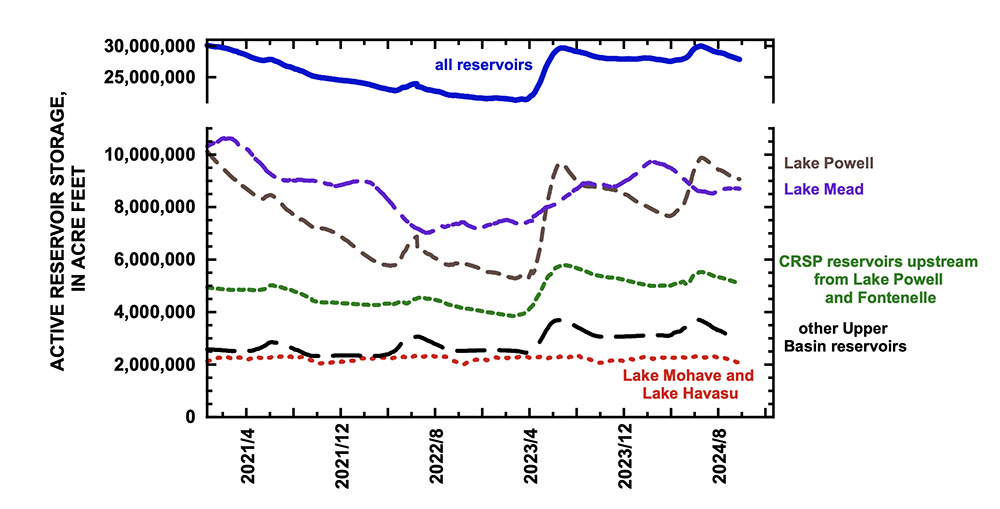
The lifeblood of the American West, the Colorado River Basin provides water for more than 40 million people and fuels hydropower resources in seven U.S. states. It is a crucial resource for 30 Tribal Nations and two states in Mexico, and it supports 5.5 million acres of agriculture and agricultural communities across the West, in addition to important ecosystems and endangered species. In 2021, historic drought along the river brought the communities it serves to a near crisis. This megadrought diminished the river’s largest reservoirs — Lake Mead and Lake Powell — to critically low elevations. Ravaged by the climate crisis, extreme drought, and unsustainable water use, this vital artery was drained to perilous lows, jeopardizing agriculture, urban areas, and ecosystems.
To provide decisive intervention and bold action, the Biden-Harris administration launched an all-of-government approach to address the short-term risk and set the stage for the development of long-term solutions to help avoid a similar crisis in the future. By collaborating with states, Tribes, federal partners and interested stakeholders – the Department paired innovative investments through President Biden’s Investing in America agenda with operational strategies to address water shortages and promote sustainable management. The consensus agreement for near-term operations, announced in 2023, stabilized the system in the short-term, as the Department embarked on the broader effort to address long-term conservation needs. Today, Lake Mead is replenished, up nearly 20 feet from two years ago, and Lake Powell has rebounded 50 feet. The lower Basin states and the Country of Mexico are on track to save 1.6 million acre-feet by the end of 2024, an unprecedented level of conservation for the Colorado River Basin.
President Biden’s Investing in America Agenda
President Biden’s Investing in America agenda represents the largest investment in climate resilience in the nation’s history and is providing much-needed resources to enhance Western communities’ resilience to drought and climate change. Reclamation is leveraging nearly $13 billion in critical investments across the west through the Bipartisan Infrastructure Law and Inflation Reduction Act.
The post-2026 process is a multi-year effort to identify a range of alternatives and ultimately determine operations for Lake Powell and Lake Mead and other water management actions in a future of persistent drought and increasing climate variability. These operations will be critical in defining water allocations for cities and agriculture, guiding future management, and guarding against the need for the kind of short-term fix the Biden-Harris administration successfully negotiated and completed earlier this year.
Guided by the lessons learned and best practices developed through the Department’s short-term effort and using the best-available science, Reclamation analyzed how future operational guidelines and strategies can be sufficiently robust and adaptive to withstand a broad range of hydrological conditions and ultimately provide greater stability to water users and the public throughout the Colorado River Basin.
In addition to public comment, virtual seminars, frequent meetings with the Basin states and the Federal-Tribal-State forum, Reclamation has conducted 30 nation-to-nation consultations and held 40 Tribal Information Exchanges to ensure ongoing dialogue and information sharing. To date, Department staff have visited and met with each Basin state Governor or designee and have visited more than half of the 30 Colorado River Tribes on their own land – a demonstration of the Administration’s commitment to meaningful nation-to-nation engagement.
Reclamation will now analyze these alternatives to develop a draft Environmental Impact Statement (EIS). Once published, the draft EIS will include a public comment period. This puts Reclamation on a path to publish a final EIS, which would then be followed by a Record of Decision in 2026.
While the post-2026 process will determine domestic operations, the Biden-Harris administration has collaborated with the Country of Mexico in recognition of their equities in the Basin. The International Boundary and Water Commission will continue to facilitate consultations between the United States and Mexico on Binational Cooperative Processes under the 1944 Water Treaty.
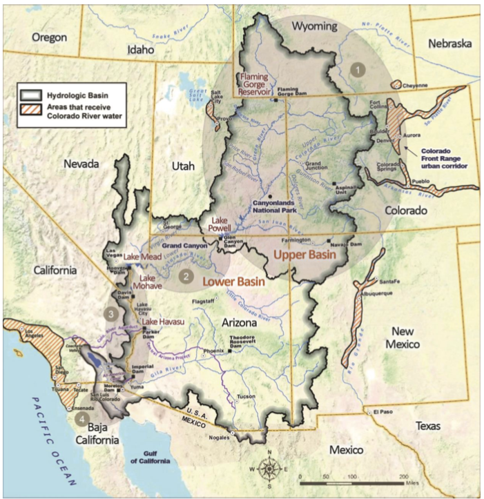
Detailed Colorado River Basin map via the U.S. Bureau of Reclamation.
Features of all action alternatives will ensure a broad range of alternatives for analysis. Reclamation’s goal for the post-2026 process is to allow for the adoption of specific guidelines for the coordinated reservoir management of Lake Powell and Lake Mead through their full operating range and to provide for the sustainable management of the Colorado River system and its resources under a wide range of potential future system and hydrologic conditions.
An operating plan must be in place by August 2026. We are sharing the five alternatives now as a voluntary step in the National Environmental Policy Act (NEPA) process to enhance transparency and create a framework for a realistic and fair path for Colorado River Basin states, Tribes, and non-governmental organizations to continue to work toward a consensus agreement that protects the stability and sustainability of the Colorado River System into the future.
Releasing the alternatives in advance of publishing the draft Environmental Impact Statement (DEIS) affords the public and affected water users more information about the process and provides greater opportunities for collaboration, to ensure that we have a plan in place before the current guidelines expire.
Concepts Common to All Alternatives
All alternatives will undergo a detailed analysis of impacts on the natural and human environment as necessary to develop a Draft EIS. The analysis will also compare the performance of alternatives over a common set of key hydrologic metrics including reservoir elevations, water use and reductions, and deviations from Glen Canyon objective releases, pursuant to the Long Range Operating Criteria (LROC).
Releases from Lake Powell may be less than the specified release below elevation 3,490 ft due to Glen Canyon Dam infrastructure limitations.
Additional Lower Basin shortages (and potential additional reductions in water deliveries to Mexico) may be necessary under future hydrologic scenarios where Lake Mead reaches dead pool.
As in the 2001 and 2007 Guidelines, the Secretary retains all applicable authority to respond to exigent and emergency conditions.
The determination of deliveries to Mexico is not a part of the proposed federal action. Any such determination would be made in accordance with the 1944 Treaty. Nevertheless, modeling assumptions with respect to the distribution of shortages for the Lower Division States include operationally aligned water delivery reductions to Mexico in order to analyze potential impacts to hydrologic and other environmental resources. Shortage amounts described are amounts of total shortage, including Mexico. Modeling assumptions that identify water deliveries to Mexico pursuant to the 1944 Treaty with Mexico would be developed after all necessary and appropriate discussions have been completed with the United States International Boundary and Water Commission in consultation with the Department of State.
Description of Alternatives No Action
The No Action does not meet the purpose of and need for the federal action, but it is included as a requirement of NEPA.
Operations would revert to annual determinations announced through the Annual Operating Plan (AOP) process.
Lake Powell release would be 8.23 maf unless a higher release is required for equalization or a lower release results from Glen Canyon Dam infrastructure limitations.
Shortages to the Lower Basin would be based on priority and reach a maximum of 600 kaf.
This would not represent a continuation of current operations but is generally based on the preexisting operating guidance that was in place before the adoption of the 2007 Interim Guidelines Record of Decision (ROD), and thus includes no specific activities above Lake Powell beyond existing authorities (e.g., to make emergency releases from Colorado River Storage Project (CRSP) Initial Units to protect infrastructure at Glen Canyon Dam).
Existing Intentionally Created Surplus (ICS) would be delivered in accordance with existing agreements, but there would be no new delivery and storage mechanisms.
Alternative 1: Federal Authorities
This alternative is designed to achieve robust protection of critical infrastructure within the Department and Reclamation’s current statutory authorities and absent new stakeholder agreements.
Lake Powell releases would be determined based on Lake Powell elevations, unless equalization releases are required. Lake Powell releases would range from 9.5 to 5.0 maf. Releases could be less than 5.0 maf, and Lake Powell elevations could be increased by CRSP Initial Units, to protect infrastructure at Glen Canyon Dam.
Lower Basin shortages of up to 3.5 maf would be distributed consistent with the priority system and would be triggered based on combined storage in Lake Powell and Lake Mead.
Existing ICS (Intentionally Created Surplus) would be delivered in accordance with existing agreements, but there would be no new delivery and storage mechanisms.
There would be explicit accounting of unused/undeveloped quantified Tribal water
Alternative 2: Federal Authorities Hybrid
This alternative is designed based on proposals and concepts from Tribal Nations, federal agencies, and other stakeholders to achieve robust protection of critical infrastructure while benefiting key resources (e.g., natural, hydropower and recreation) through a new approach to distributing storage between Lake Powell and Lake Mead that enhances the reservoirs’ ability to support the Basin.
Lake Powell releases would be determined based on a combination of Lake Powell and Lake Mead elevations, 10-year running-average hydrology, and Lower Basin deliveries. Lake Powell elevations could be increased by releases from CRSP Initial Units to protect infrastructure at Glen Canyon Dam.
This alternative would include new delivery and storage mechanisms for Lake Powell and Lake Mead with federal and non-federal storage pools and maximum flexibilities for all users. The operations incorporate Basin-wide shared contributions to the sustainability of the system, including Upper Basin conservation that would be stored in Lake Powell and Lower Basin shortages starting at 1.5 maf, which exceeds average annual evaporative and system losses at and below Lake Mead, and reaching a maximum of 3.5 maf.
Shortages would be triggered based on combined storage in Lake Powell and Lake Mead and distributed pro-rata.
There would be explicit accounting of unused/undeveloped quantified Tribal water.
Some elements of this alternative would require additional federal statutory authorities and stakeholder agreements.
Alternative 3: Cooperative Conservation
This alternative is informed by a proposal submitted by a consortium of conservation organizations with the goal of stabilizing system storage, integrating stewardship and mitigation strategies of Lakes Powell and Mead, maintaining opportunities for binational cooperative measures, incentivizing water conservation, and designing flexible water management strategies.
Lake Powell releases would range from 11.0 maf to 5.0 maf and would be determined by total Upper Basin system storage and recent hydrology. Releases would switch to “run-of-river” when Lake Powell is at 3,510 ft or lower. The operations incorporate Basin-wide shared contributions to sustain system integrity, including up to 4.0 maf of shortages in the Lower Basin triggered by combined seven-reservoir storage and recent hydrology, and voluntary water contributions from both basins.
Some elements of this alternative would require additional federal authorities and stakeholder agreements.
Alternative 4: Basin Hybrid
This alternative is designed to reflect components from the proposals and concepts submitted by the Upper Division States, Lower Division States, and Tribal Nations to present elements that could provide a basis for coordinated operations and may facilitate greater agreement across the Basin.
Lake Powell releases would be determined primarily based on Lake Powell elevation with consideration in some scenarios of Lake Mead elevation. Releases would range from 12.0 to 5.0 maf. Lake Powell elevations could be increased by releases from CRSP Initial Units to protect infrastructure at Glen Canyon Dam.
This alternative would include new delivery and storage mechanisms for Lake Powell and Lake Mead, including incentivizing conservation and managing/offsetting reductions, to afford the Tribal and non-Tribal entities the same ability to use these mechanisms. The operations incorporate Basin-wide shared contributions, including Upper Basin conservation that would be stored in Lake Powell and up to 2.1 maf of Lower Basin shortages triggered by combined seven reservoir storage.
This alternative would analyze shortage distribution using two approaches: priority and pro-rata, both of which would be analyzed with and without shortages to Tribes.
There would be explicit accounting of unused/undeveloped quantified Tribal water.
Some elements of this alternative would require additional federal authorities and stakeholder agreements.
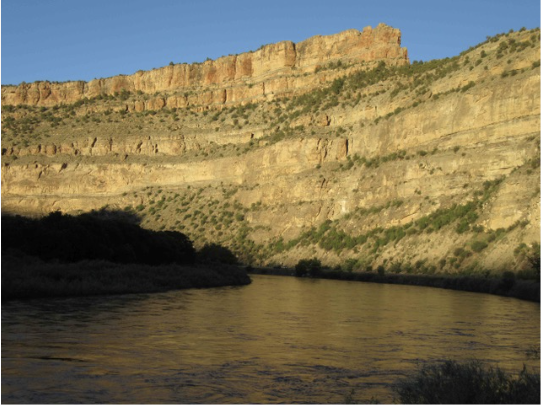
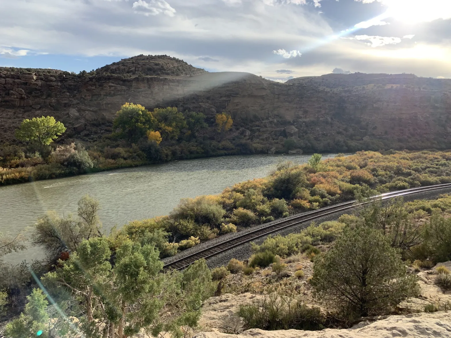
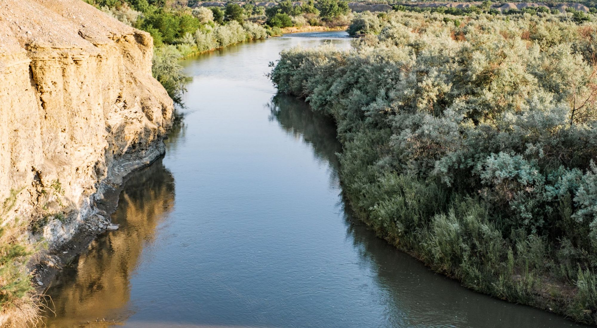
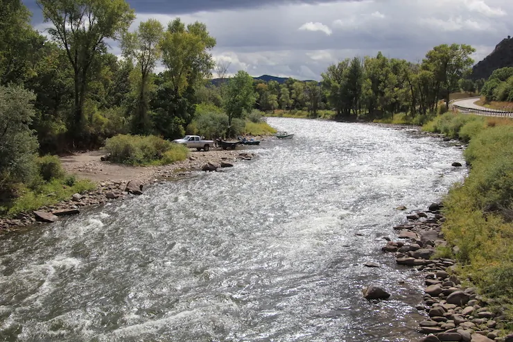
Colorado River “Beginnings”. Photo: Brent Gardner-Smith/Aspen Journalism
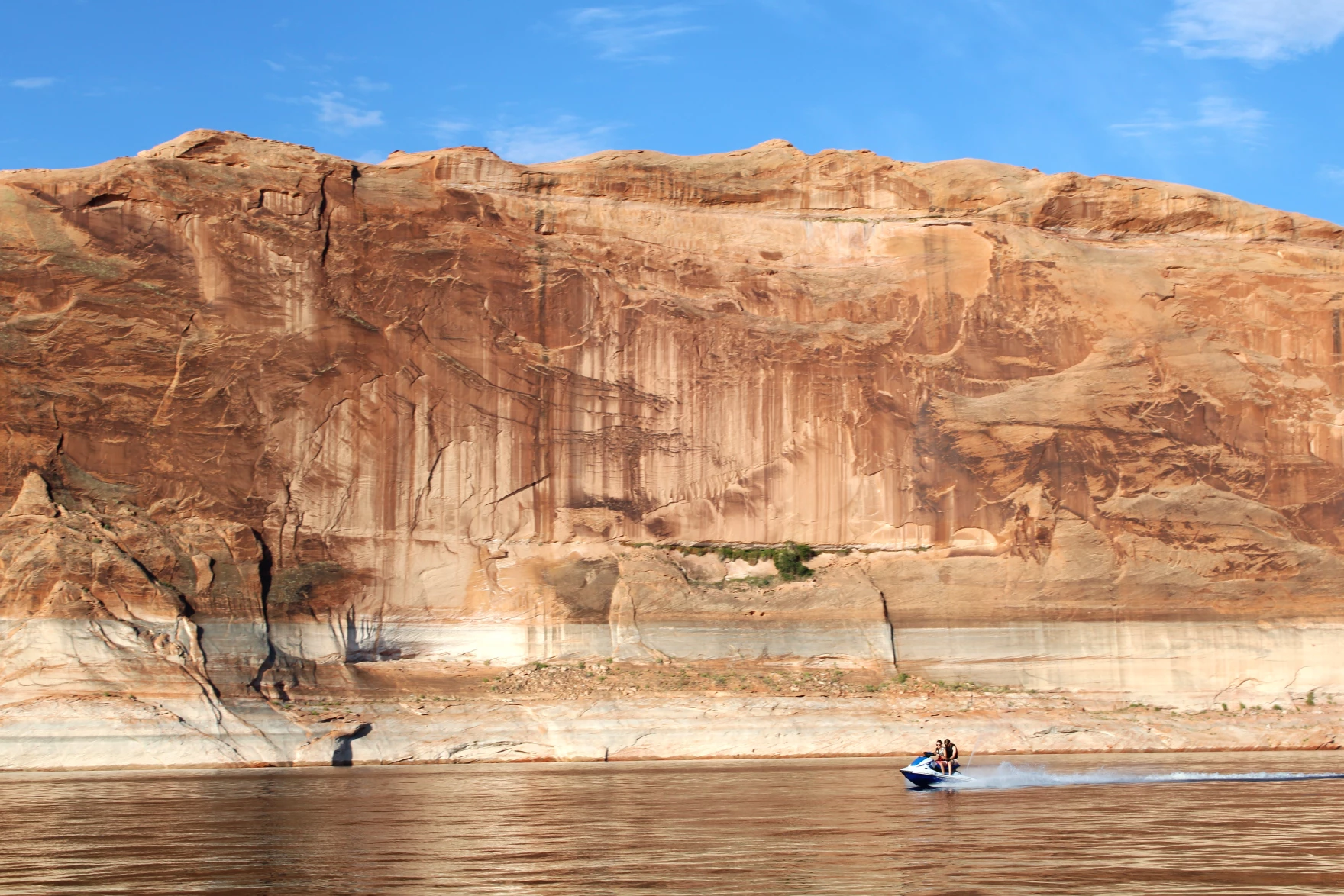
A personal watercraft speeds across Lake Powell on July 16, 2024. The fate of the nation’s second-largest reservoir hangs in the balance as states that use the Colorado River remains stuck in a standoff about how to manage it in the future. Photo credit: Alex Hager/KUNC
Click the link to read the article on the KUNC website (Alex Hager):
Federal water officials released a set of possible plans for managing the shrinking Colorado River in the future. They urged state negotiators to agree on a single plan, since the states are deeply divided about how to share the pain of cutbacks during dry times.
“We can either remain stuck at an impasse, or secure a future for future generations that promises the stability and sustainability of one of our greatest natural resources,” said Ali Zaidi, White House climate advisor.
The current rules for sharing Colorado River water expire in 2026, and the seven states that use it are on the hook to come up with a replacement before then. They’re split into two camps, and each submitted a separate proposal to the federal government in March. State negotiators say they want a collaborative solution, but they don’t appear any closer to agreement than they did in March and have publicly dug in their heels about their ideological differences.
In a call with reporters on Wednesday, multiple federal officials encouraged states to pick up the pace in those negotiations.
“To get to the other side here,” Zaidi said, “there’s going to be a requirement, an imperative on all of us, to find the common ground to move the process forward with urgency.”
Although federal agencies operate the dams and reservoirs that hold Colorado River water, they have historically implemented management plans drawn up by states.
But today, in an apparent attempt to nudge the states towards agreement, the Interior Department released four “alternatives” – each a different proposal for managing the river – and none of them are exactly in line with either of the competing state proposals.
“Now really is the time for the basin states and tribes to redouble their work toward a consensus alternative,” said Laura Daniel Davis, the acting deputy secretary of the interior. “The alternatives we’re announcing today show that path and I urge them to do so.”
The alternatives released by Interior are relatively light on details, but seem to include input from some of the 30 native tribes which use the river, and environmental groups which campaigned for more protections for wildlife and their habitats.
Kyle Roerink, director of the nonprofit Great Basin Water Network, said the alternatives don’t give any serious clues about a final plan for managing the river, but rather attempt to push forward the conversation among the states.
“It’s hard to make a broad and sweeping statement about it,” he said. “We’re waiting for the big picture. We’ve been thirsting for it for well over a year, but we’re dealing with a recipe that only lists a few of the ingredients and we can only make assumptions.”
By releasing alternatives, the Biden administration may be attempting to influence negotiations ahead of its departure from the White House. It’s unclear exactly how Donald Trump’s upcoming return to the presidency could shape talks about the Colorado River, but state leaders said they don’t expect the change to disrupt their process.
This story is part of ongoing coverage of the Colorado River, produced by KUNC in Colorado and supported by the Walton Family Foundation. KUNC is solely responsible for its editorial coverage.
Updated November 20, 2024 to include video of the lecture.
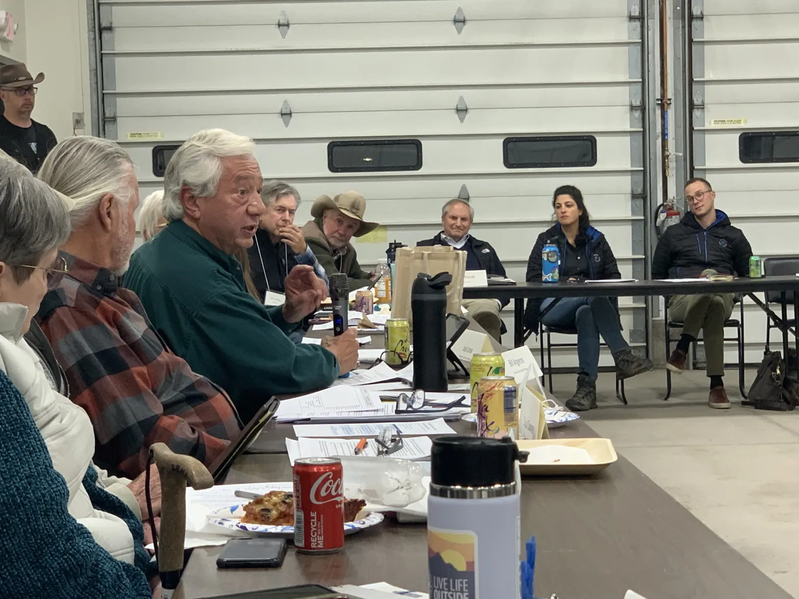
Ms. Mulroy’s lecture yesterday evening focused on increasing water supply in the Lower Basin (after setting the stage with the reality of a declining Colorado River due to climate change). One solution she offered was a pipeline from northwest Mexico to the Imperial Valley. The water would be used to replenish the Salton Sea and then be desalted for irrigation to lessen the diversion of water from the Colorado River in the Imperial Valley. The Imperial Irrigation District holds the largest water rights on the river and is an important source of food for the U.S. so her solution is an attempt to keep them in production and also cutting Lower Basin diversions.
She acknowledges the costs involved and the problem of disposing of the brine but is convinced that conservation, while very important, cannot solve the crisis of a declining supply in the basin. She has observed desalination in the Middle East where it is piped across the landscape to meet demands. This is the solution that Cape Town has embraced since nearly hitting “Day Zero” a few years ago during a particularly long and deep drought.
Augmentation of the Lower Basin water supply would benefit the entire basin, she maintains, taking pressure off the Upper Basin which already shoulders the burden of reduced water supplies during drought years.
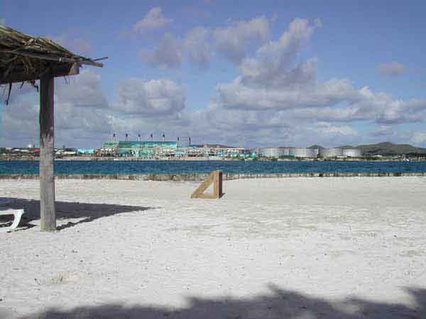
Desalination plant, Aruba, December 2004.
The 2024 Norm Evans Lecture was hosted by the Colorado Water Center at CSU Spur and featured distinguished speaker Pat Mulroy. Mulroy, former general manager of the Southern Nevada Water Authority and negotiator for the state of Nevada on the Colorado River, discussed the challenges and opportunities for the Colorado River Community at the intersection of law and climate change.
On Wednesday morning I woke up in Holbrook and, before leaving, did a little tour around the high desert crossroads town, awed by the weirdness of it all. I don’t mean that in a bad way. Holbrook, with its Bucket of Blood Street, grinning plastic dinosaurs, and mid-century kitsch, is truly unique, the product of the interstate, railroad, and Route 66 running through the nearest community to Petrified Forest National Park.
I headed west, doing my best to avoid driving on I-40. This led me to no fewer than three dead ends, forcing me to backtrack. But it also took me down some cool, if defunct, segments of Route 66, and almost got me creamed by a big rig hauling coal ash from the Cholla power plant, which looms over the sere landscape. After touring Joseph City and Winslow, I veered away from the Little Colorado River and headed southward across the Navajo Nation, up to Hopi, past the wintering corn fields at Moenkopi, and through Tuba City before continuing south on Hwy. 89.
The historic Navajo Bridge, now for pedestrians only, was built in 1929 and replaced by the larger bridge in the 1990s. Jonathan P. Thompson photo.
Whenever I’m in this part of Arizona, I try to get to Navajo Bridge (which is actually a pair of bridges), which spans Marble Canyon and the Colorado River downstream from Lees Ferry. One of the bridges was built in 1929, and is now for pedestrians, the other in 1993. They resemble the bridge that crosses the Colorado just below Glen Canyon Dam. I like to go out on the dam-bridge, too, but I also find it a bit frightening: the dam exudes an aura of, for lack of a better term, ominous violence. The Navajo Bridge, by contrast, is a place of serenity. You can stand out on it and, unimpeded by chain link fences, look straight down on the deep, murky green, slow-moving waters of the Colorado and do a bit of vertiginous meditation.
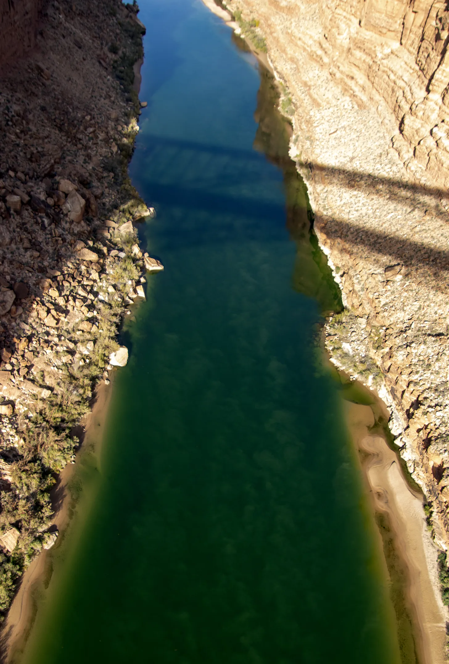
The Colorado River from the Navajo Bridge. Jonathan P. Thompson photo.
The light was crisp, almost harsh, on this visit, and the parking lot almost empty. I got out of the Silver Bullet, stretched, and ambled toward the bridge, noticing as I did a trio looking intently downriver through binoculars. It appeared as if they were studying the engineering of the automobile bridge, and I wondered if maybe it were cracking and getting ready to fail catastrophically. I readied my camera, just in case, and followed their gaze. That’s when I saw them: a trio of giant birds perched on the steel beams of the bridge, some 470 feet above the river, doing a bit of meditating of their own (or perhaps waiting for carrion to float by).
Condors perched on steel girders some 450 feet above the Colorado River. Jonathan P. Thompson photo.
The magnificent creatures, their pink bald heads jutting out from brown-feathered bodies, are California condors, some perhaps the descendants of six birds released in the area in 1996, others that were introduced in later years. They are huge — sporting up to ten-foot wingspans — but live a fragile existence. After being driven nearly to extinction, federal wildlife officials began rearing California condors in captivity and reintroducing them throughout the West. Now there are more than 500 California condors in the wild, but humans continue to imperil them.
Condors 6Y and 2A (I’m sure they have their own, more interesting names, but …) at the Navajo Bridge. According to condorspotter.com, 6Y is a male born in March 2019 at the Oregon Zoo. And 2A is a female hatched at the World Center for Birds of Prey in May 2021. Jonathan P. Thompson photo.
Perhaps the greatest threat is lead poisoning, which comes from ingesting carrion contaminated by lead ammunition. Lead ammunition is designed to shatter and fragment when it hits an animal, increasing its lethality. These fragments end up in the animal’s flesh and the guts, which hunters often discard in the field to be eaten by scavengers. This fall a condor in Zion died from lead poisoning, and wildlife officials say nearly every condor they test has some level of lead in its bloodstream.
Federal and state-level efforts to ban the use of lead ammunition for hunting have run into strong resistance from gun rights advocates, who claim (erroneously) that the initiatives are aimed at stopping all hunting. So some states, including Arizona and Utah, have implemented voluntary programs that incentivize hunters to use non-lead ammunition and dispose of gut piles in a scavenger-safe way. In 2019, California prohibited the use of lead ammo for hunting, but did not ban the sale of the ammunition.
A young condor on the pedestrian bridge. Jonathan P. Thompson photo.
I spent a good part of the afternoon mesmerized by the birds, hoping they would spot something dead and rotting and delicious so I could witness one in flight. It didn’t happen, but I consider myself fortunate nonetheless: As I was preparing to leave I looked straight down from my place on the bridge for one last glimpse at the mighty Colorado, all emerald green down below, and there, only about ten feet below me, sat a young condor, pink beak protruding from a fuzz of black feathers.
The Grand Valley Irrigation Company Canal is one of the canals that brings water to agricultural lands in the Grand Junction area. About 1,500 acres of GVIC farmland were enrolled in the System Conservation Pilot Program in 2024, which water managers say negatively impacted the Cameo call. Credit: Brent Gardner-Smith/Aspen Journalism
An irrigation company in western Colorado says it is disappointed in an Upper Basin water conservation program, its impacts to the company’s operations and the local agricultural community.
Grand Valley Irrigation Company President Sean Norris, in a September letter to state officials, said that GVIC shareholders will no longer be allowed to participate in the System Conservation Pilot Program without advance approval from the board. This year, seven GVIC irrigators participated in the federally funded program, which Norris said violates GVIC policies and bylaws as well as injures other shareholders on the system.
“The board has even broader concerns with the SCPP,” the letter reads. “As the program grows, the agricultural economy in the Grand Valley will suffer adverse economic impacts.”
In 2023, the Upper Colorado River Commission rebooted the System Conservation Pilot Program, which was first tested from 2015 to 2018. Infused with $4 billion from the Inflation Reduction Act for Colorado River programs, SCPP pays water users in the Upper Basin states — Colorado, New Mexico, Utah and Wyoming — to leave their fields dry for the season or enact other conservation measures and let their water flow downstream. Over two years, the program has saved about 101,000 acre-feet of water at a cost of about $45 million.
Graphic credit: Laurine Lassalle/Aspen Journalism
The reason for Norris’ disappointment is because GVIC’s participation in the conservation program resulted in impacts to one of the biggest, oldest and most important water rights on the Western Slope: the Cameo call. This group of agricultural water rights is able to take up to 1,950 cubic feet per second from the Colorado River to irrigate the peach orchards, vineyards and hayfields of the Grand Valley.
When this senior water right isn’t receiving the full amount it is entitled to, it places a “call.” This means that upstream junior water users — some of them Front Range water providers that take water across the Continental Divide from the basin’s mountainous headwaters — must shut off so that Cameo can receive its full amount of water.
Flows in the main stem of the Roaring Fork River on Tuesday, June 14, 2016 below the diversion dam on the upper Roaring Fork. CREDIT: BRENT GARDNER-SMITH/ASPEN JOURNALISM
The Cameo call comes on most years late in the irrigation season: July through October. And its impacts can be felt far upstream. The Cameo call has the ability to command the flow of water throughout the headwaters of the Colorado River basin. For example, residents of Aspen and Pitkin County like to see Cameo come on because it means that more water is flowing down Lincoln Creek and the Roaring Fork River as the Twin Lakes Reservoir and Canal Co., which provides water to mainly to Pueblo and Colorado Springs, is forced to shut off its diversion at Grizzly Reservoir.
This year, however, officials at the Colorado Division of Water Resources reduced the amount of the Cameo call because of GVIC irrigators’ participation in the conservation program. State engineers said that since the irrigation company was not using its full amount to irrigate, it couldn’t call for the full amount and reduced the call by about 25 cfs. About 1,500 acres under GVIC were enrolled in SCPP in 2024, and engineers calculated that the call should be reduced by 1 cfs for every 64 acres.
The Cameo call this year was on from Sept. 3 to Oct. 23. According to state officials, without the 25 cfs reduction, Cameo would have come on two days earlier: Sept. 1.
Norris said that GVIC’s system of nearly 100 miles of canals that serve about 40,000 acres between Palisade and Mack needs all of its water to function properly and that reducing the call harms all of the company’s water users. The full diversion is needed to maintain water levels in the canals and provide the “push water” to reach the farthest downstream ditches.
“The decrease in GVIC’s call adversely affects all shareholders in the system and especially those shareholders who continue to farm and irrigate while SCPP participants collect government paychecks for doing nothing,” the letter reads.
Norris said GVIC management believed that the Cameo call would not be affected by GVIC shareholders’ participation in SCPP and that state officials had assured them that this would be the case.
“At the beginning of the program, we were told that our calls would not be affected by this participation,” he said. “Then, in the middle of the summer, we had this meeting, and we were informed that that was indeed not the case and that our call would be affected.”
But even if the GVIC staff and board members believed the call would not be affected, individual participants in SCPP were informed that the call would be cut back when they signed up for the program. State and UCRC officials had to approve verification plans for each of GVIC’s seven projects. The plans contained the following language: “The Colorado Division of Water Resources will reduce the amount of the Cameo call … based upon an average delivery of 1 cfs to 64 acres and the number of acres not being irrigated at the time of the call.”
The headgates of the Grand Valley Irrigation Company Canal pull water from the Colorado River. GVIC’s water rights are part of an important group of rights known as the Cameo call, which have the ability to command the flow of the river far upstream. Credit: HEATHER SACKETT/Aspen Journalism
River District warned of impacts
With its location near the state line, some of the biggest and most senior water rights on the Colorado River and huge expanses of irrigated farmland, the Grand Valley is an ideal location for an interstate water conservation program. But SCPP has also faced criticism about its high cost, the limited water savings, the difficulty in measuring and tracking conserved water, and the potential damage it could cause to local agricultural economies.
The Colorado River Water Conservation District, whose mission is to protect and develop water for the Western Slope, warned in a January comment letter to state officials that a call reduction could happen. River District officials pointed out that the water that GVIC doesn’t use, instead of flowing downstream, could be picked up by Front Range transmountain diverters.
The River District’s position has long been that these types of conservation programs need careful consideration and guidelines to avoid harming local communities and other water users. River District General Manager Andy Mueller spoke to Colorado Basin Roundtable members at the September meeting and explained that Front Range water providers such as Denver Water, Northern Water, Colorado Springs Utilities and Aurora Water could take that 25 cfs. That is the opposite of SCPP’s intent, which is to respond to drought and falling reservoir levels at Lake Powell and Lake Mead.
“The federal government, in its effort to put water in the system, has just unwittingly provided an exportation of water out of the river at its headwaters,” Mueller told the roundtable. “We shouldn’t be setting up a system like that. Just that plain and simple.”
State officials said no TMDs benefited from the reduction in the Cameo call this year because the upstream call at the Shoshone hydro plant in Glenwood Canyon had already turned off the TMDs on the mainstem of the Colorado River. A maintenance project on Grizzly Reservoir this year meant that Twin Lakes did not take the 25 cfs either. Jason Ullman, the top engineer with the Department of Water Resources, said a few upstream junior water users probably picked that water up.
The Grand River Diversion Dam, also known as the “Roller Dam”, was built in 1913 to divert water from the Colorado River to the Government Highline Canal, which farmers use to irrigate their lands in the Grand Valley for the Grand Valley Water Users Association. Photo credit: Bethany Blitz/Aspen Journalism
The valley’s other large irrigation company, Grand Valley Water Users Association, did not have any shareholders participate in SCPP in either 2023 or 2024 because the board did not approve participation. But if irrigators from both GVWUA and GVIC had participated in SCPP in 2024, it could have resulted in an even bigger reduction of the Cameo call.
“If there was a much larger amount of acreage that would participate in a program, then that resulting call reduction would be larger,” Ullmann said.
Water managers don’t know yet whether SCPP will happen again in 2025 or beyond — federal authorization is pending in Congress. But Norris said that irrigators who want to participate in any future conservation programs like SCPP will have to get approval from the board to make sure the project is in compliance with GVIC’s bylaws. Because the bylaws include a prohibition on changes to water use that could prevent the company from being able to divert its full amount, it’s unlikely the board would approve future SCPP projects that would reduce the Cameo call.
Norris said he sees the 2024 SCPP as an experiment to gather data.
“A lot of the data is numbers and money-driven and acres watered,” he said. “But a lot of the data is the social impacts, the operational impacts that are harder to quantify. Having companies say they’re not going to participate because it unfairly impacts some of their users is a data point they hadn’t necessarily considered, but now they’ve got that in their experiment.”
Native America in the Colorado River Basin. Credit: USBR
Click the link to read the article on the InkStain.net website (Eric Kuhn, Rin Tara, and John Fleck):
November 5, 2024
The pending Northeastern Arizona Indian Water Rights Settlement Agreement settles Navajo Nation, Hopi Tribe, and San Juan Southern Paiute Tribe claims to the Upper Colorado River Basin in Arizona. To do so, Arizona’s 50,000 AF entitlement of Upper Colorado River Basin water will be allocated.
Although Arizona’s testimony during the ratification of the 1948 Upper Colorado River Basin Compact indicated that Arizona’s cut would be used for tribes, Arizona fashioned the deal to benefit the Central Arizona Project. Charles A. Carson, Arizona’s Upper Basin Compact Commissioner, originally requested 136,200 AF/yr for Arizona in the negotiation but ultimately accepted 50,000 AF/yr in the interest of sweetening the deal for the rest of the states to sign on to stream depletion theory as the means for measuring system use. Stream depletion theory, under Arizona’s interpretation of the 1922 Colorado River Compact allowed Arizona to consume two million acre-feet per year on the Gila River system, while only being charged for one million acre-feet of compact apportionment.
This theory, in combination with the Upper Basin relationships strengthened by Carson’s choice to accept only 50,000 AF/yr, is what Carson envisioned would be used to convince Congress Arizona had a sufficient legal water supply for the Central Arizona Project. The CAP project was approved in 1968 and completed in the 1990s, though tribal water in Arizona’s northeast corner was not quantified. Even after CAP was built, a portion of the power generated at Navajo Generating Station, which consumed a significant portion of that 50,000 AF/yr apportion, powered the pumps that transported CAP water from Lake Havasu to central Arizona.
Eight decades after Arizona acknowledged that the 50,000 AF of Upper Colorado River Basin water was destined for tribes, Congress is on the cusp of approving the settlement that would resolve some water rights for Navajo Nation, Hopi Tribe, and San Juan Southern Paiute Tribe. This settlement is critical and long overdue, especially considering Arizona’s acknowledgement of tribal entitlement in the 1940s.
The “backstory” behind Arizona’s 50,000 acre-feet of Upper Basin water.
At the recent Water Education Foundation Colorado River meeting in Santa Fe, we heard an update on the status of Congressional approval of the water rights settlement among Arizona the Navajo, San Juan Southern Paiute and Hopi nations. Among other things, the settlement divides up the use of the 50,000 acre-feet of water apportioned to Arizona by the 1948 Upper Colorado River Basin compact. How Arizona ended up with 50,000 acre-feet of Upper Basin water is a fascinating story. At first blush, it may seem somewhat arbitrary, but the reality is that it was based on a well-conceived and executed strategy by Arizona’s negotiators At the time, the deal was cut, Arizona’s negotiator made clear that the only likely users of the water would be Native American communities in northeast Arizona. The deal was not designed for their benefit, but rather for the ultimate benefit of Arizona’s quest to build the Central Arizona Project.
While Arizona’s motives may have focused entirely on cutting an interstate deal to enable construction of the CAP, the state’s leadership were frank in acknowledging that the only people who might put Arizona’s Upper Basin allotment to use where Native Americans.
“There is not much possibility of using water on that land except … on the Navajo Reservation,” Arizona’s Charles A. Carson told members of Congress during the 1949 Upper Basin Compact hearings.
Colorado River Allocations: Credit: The Congressional Research Service
The 1922 Colorado River Compact divides the basin into two sub-basins: the Upper Basin and the Lower Basin. The dividing point is Lee Ferry, located in Northern Arizona, a mile downstream of the confluence of the Colorado and Paria Rivers. Lands that drain into the Colorado River above Lee Ferry are in the Upper Basin, including about 7,000 square miles of lands in northeastern Arizona. Today all but a small portion of these lands are located on the Navajo reservation. Likewise, both Utah and New Mexico have lands that drain into the river below Lee Ferry. The Upper Gila River in New Mexico and Kanab Creek and the Virgin River in Utah are Lower Basin streams.
Although Arizona has lands in the Upper Basin, it is not a State of the Upper Division, a critically important distinction under the 1922 Compact. As a state with Upper Basin lands, Arizona in entitled to use some portion of the beneficial consumptive use apportioned to the Upper Basin under Article III(a) of the 1922 Compact, but since it is not a State of the Upper Division, it does not share in the joint obligations of the Upper Division States to provide certain flows at Lee Ferry under Articles III(c) and III(d). This is a nuance the negotiators of the 1948 Upper Basin Compact understood from the get-go (UCRBCC Official Record, 1st meeting, pages 25-26).
Arizona’s Upper Basin Compact Commissioner was Charles A. Carson. He was the state’s special counsel for Colorado River matters. Carson, an accomplished lawyer and skilled negotiator, began representing Arizona in the mid-1930s. By the 1940s, Arizona’s top water priority was obtaining Congressional approval of the Central Arizona Project (CAP). Carson negotiated the 1944 contract between Arizona and the United States for 2.8 million acre-feet of Hoover Dam water. He orchestrated his state legislature’s ratification of the Colorado River Compact a few weeks later. In 1945 he chaired the legal sub-committee of the Six-State Committee that successfully lobbied for Senate ratification of the 1944 Water Treaty with Mexico. During this time, he became a close associate and friend of Colorado’s Clifford Stone and Royce Tipton. Stone was Colorado’s Upper Basin Compact Commissioner, its first Executive Director of the Colorado Water Conservation Board, and the long-time chair of the Committee of Fourteen that advised the U.S. State Department on the treaty negotiation with Mexico. Tipton was a consulting engineer that worked for Colorado on four major interstate compacts. He was an engineering consultant to the State Department during the negotiations of the 1944 Treaty. With Stone’s blessing, Carson hired Tipton to help with Arizona’s efforts to advance the Congressional approval of the CAP.
Carson’s appointment as Arizona’s Upper Basin Compact Commissioner was likely welcomed by the negotiating teams from the other states. He was designated as Chair of the Commission’s Legal Committee, which would ultimately make numerous recommendations to the Commission on the language and structure of the Upper Basin Compact. Among the many important recommendations the legal committee made were the decisions to include the water requirements of the Upper Basin’s tribes within the apportionments made to each individual state (rejecting an option by New Mexico to consider the tribal needs as a “sixth state”) and the language of Article IV which prescribes how the UCRC will determine the timing and amount and distribute among each Upper Division State a curtailment (aka – “compact call”), if necessary to be in compliance with 1922 Compact.
Upper Colorado River Basin map via the Upper Colorado River Commission.
Carson first spelled out what Arizona wanted from an Upper Basin Compact during the second meeting of the Upper Basin Compact Commission in September 1946, almost two full years before the other four (?) states put their cards on the table during the marathon seventh meeting in July 1948. Carson suggested Arizona be apportioned “all of the waters (on its Upper Basin lands) precipitated thereto, and in addition thereto, 1000 acre-feet from the Paria River” (Official Record, 2nd meeting, page 4). When the other states were finally ready to negotiate the allocations (Colorado had insisted that the Commission not address this core issue until the Engineering Committee had completed its report), Carson reiterated his request–Arizona wanted the right to use all the water that fell on its lands as precipitation plus an additional thousand acre-feet from the Paria River. Now that the Engineering Committee had completed its report, this number was now quantified–136,200 acre-feet (Official Record, 7th Meeting, page 69). According to the Engineering Committee, these 136,200 acre-feet represented 0.87% of the natural (virgin) flow at Lee Ferry (Official Record, 7th Meeting, page 22). This number may seem very high based on our recent experience, but it was the number the Commission had in front of it and in the 1940s the estimated natural flow of the river at Lee Ferry was about 16 million acre-feet per year.
The problem facing the Commission was that collectively the states had requested a total of 117% of the available water. Since Arizona had requested a fixed amount, the problem was with the four Upper Division States, but that did not prevent the other states from suggesting that Arizona consider taking less. Wyoming’s legal advisor Bill Wehrli asked Carson if Arizona would accept an apportionment of 49,200 acre-feet. Carson responded, “I am willing to do that in order to try to help make a compact.” Interestingly, Wehrli responded, “we would be willing to be a little more generous and give you one percent” (7th meeting, page 109). The 49,200 acre-feet referenced by Wehrli was taken from the 1947 comprehensive basin report prepared by the Bureau of Reclamation. The report included very little detailed backup information. Although no tribal members were consulted or invited to the negotiations, the Office of Indian Affairs (now the BIA) provided some input to the Commission on tribal needs. It suggested that present and future depletions from tribal use on Arizona’s Upper Basin lands would total about 25,000 acre-feet per year but cautioned that this estimate was preliminary (Official Record, 5th Meeting, pages 49-51).
When the dust settled, Carson accepted a fixed 50,000 acre-feet per year, only 37% of Arizona’s contribution to the flow of the river at Lee Ferry. The only other state that accepted an apportionment smaller than its contribution was Colorado. It produces 70% of the river’s flow at Lee Ferry but accepted a 51.75% apportionment (~72% of its contribution). In contrast, New Mexico which contributes only 1.6% of the river’s flow, got an apportionment of 11.25%. What made Arizona happy was the package deal that accompanied the agreement on the state apportionments. The three other Upper Division States accepted a proposal by Colorado and Arizona that apportionments be measured by the stream depletion theory. Under the stream depletion theory, the Upper Basin’s compact apportionment is measured as the net impact of man-made depletions on the natural flow of the Colorado River at Lee Ferry. The agreement on the stream depletion theory was made a part of Article VI of the Upper Basin Compact. Article VI is applicable to the Upper Basin only, but Upper Basin officials, including Stone and Tipton, would later testify before Congressional committees that it was their opinion that the Lower Basin’s 1922 Compact apportionment was supposed to be measured as the net impact of the Lower Basin’s man-made depletions on the natural flow of the Colorado River at the international boundary with Mexico.
Why was adoption of the stream depletion theory an important victory for Arizona? Simply put, under Arizona’s interpretation of the 1922 Compact at the time, using the stream depletion theory, Arizona’s could consume two million acre-feet per year on the Gila River system, but only be charged for one million acre-feet of compact apportionment. In its natural state, the Gila River loses an average of one million acre-feet per year as it flows from the Phoenix area to its confluence with the Colorado River at Yuma. Under the stream depletion theory, the net impact of consuming two million acre-feet per year of Gila system on the natural flow of the Colorado River was only a million acre-feet. If Arizona was going to be limited under the 1922 Compact to the use of about 3.8 million acre-feet (2.8 million under its Boulder Canyon Project Act allocation plus all one million acre-feet of III(b) water (less a small amount set aside for Utah and New Mexico), using the stream depletion theory freed up a million acre-feet that the CAP could pump from Lake Havasu to Central Arizona.
California, of course, had a different theory on how 1922 Compact apportionments were supposed to be measured. It advocated for the “diversions minus return flows” theory. Under this theory, all two million acre-feet of Arizona’s Gila River use would be charged to Arizona as compact apportionment. Under this method, the water available for the CAP would be a million acre-feet less, likely making the project economically unfeasible. For more details on the different theories and why Colorado believed the stream depletion theory benefited the Upper Basin, see Science Be Dammed chapter 12.
During the negotiations of the Upper Basin Compact, Wyoming had initially opposed using the stream depletion theory. Speaking for its delegation, Wehrli questioned the basic legal assumption that the 1922 Compact apportioned depletions, noting that California’s legal argument had merit. He concluded that stream depletion theory benefited the Lower Basin more than the Upper Basin and he stated, “Wyoming is desirous of staying completely out of the controversy between Arizona and California, Lower Basin States” (Official Record, 7th Meeting, pages 58-60). To reach a final compact agreement, Wyoming ultimately accepted the stream depletion theory, but unlike Colorado, it never championed it in Congressional testimony or court filings. Note, with perfect hindsight, Wehrli was mostly right, but also note that the question of how to measure apportionments under the 1922 Compact has never been resolved.
What Carson accomplished by accepting a small apportionment was to strengthen the close working relationship between his state and the four States of the Upper Division. It’s apparent that Carson believed that this relationship would help Arizona in its battle with California over the Congressional authorization of the CAP. In his compact report to the Governor, Carson writes that his engineers and the Indian Service believed that Arizona would never use more than about 30,000 acre-feet per year on its Upper Basin lands and therefore Arizona received 50,000 acre-feet as a measure of safety. He makes no mention of any input or consultation with the Navajo Nation, nor does he refer to the 49,200 acre-feet estimate made by the Bureau of Reclamation. Concerning Article VI and the stream depletion theory he writes, “[t]his of course is in complete accord with Arizona’s construction of the Colorado River Compact, and it is believed will be helpful to Arizona in opposing California’s arguments on the Gila River.” Carson concluded his report with “I believe it to be fair, just, and equitable to all of the States, and particularly valuable to Arizona in that it supports Arizona’s position in opposition to the arguments made by certain California interests” (Carson’s report is included in the record of the 1949 Congressional Hearings on the Upper Basin Compact, pages 128-139).
After a minor kerfuffle with California’s Congressional delegation which was settled by report language making it clear that by approving the Upper Basin Compact, Congress was not committing the United States to any interpretation of the 1922 Compact, it was approved by Congress and became effective on April 6, 1949.
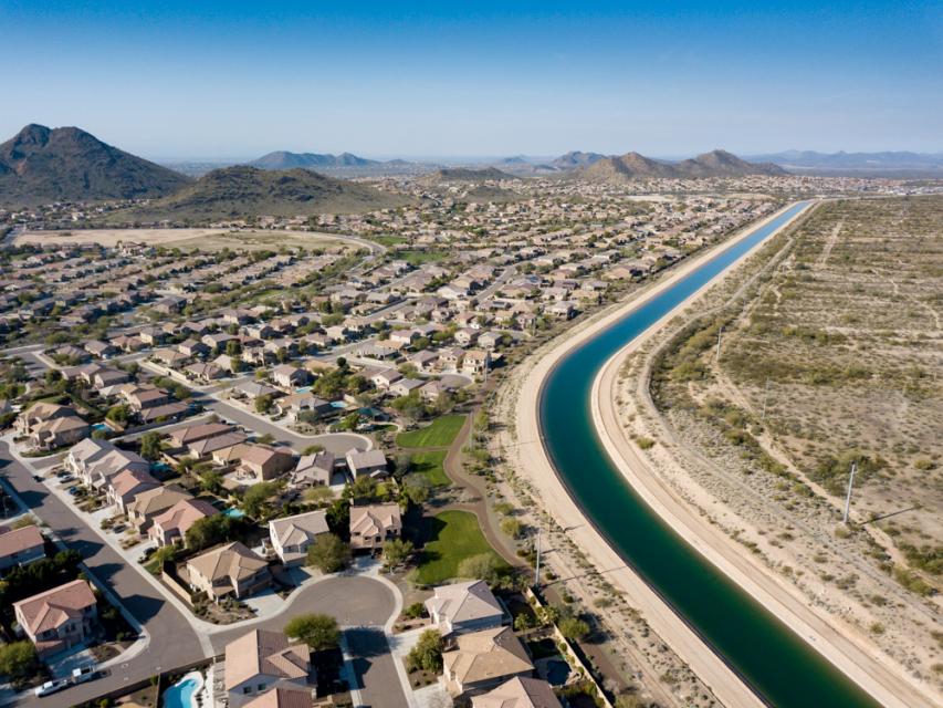
The Central Arizona Project canal cuts through Phoenix. Photo credit: Ted Wood/The Water Desk
Was the Carson strategy to minimize its claims for Upper Basin water and enlist the Upper Division States as close allies in Arizona’s quest to build the CAP successful? The short answer is yes, the result was that the CAP was authorized in 1968 and has been fully operational for about three decades. The path that Arizona used to get there, however, differed from the one that he envisioned. Carson who died in 1951, believed that Arizona would use the stream depletion theory to convince Congress, or if that failed, the Supreme Court, that Arizona had a sufficient legal water supply under the 1922 Compact to build and operate the CAP. Indeed, in 1952 when Arizona filed suit against California, one of its claims for relief was that it asked the Supreme Court to find that the stream depletion theory was the proper method of measuring apportionments under the 1922 Compact.
In one of the first major turning points in the case, in 1954 California filed a joinder motion to bring the Upper Basin States into the case arguing that the compact issues that Arizona wanted the court to interpret such as how apportionments are measured, how the surplus is measured for Mexican Treaty purposes, and how mainstem reservoir evaporation is handled were basin wide issues that impacted all seven states. From today’s perspective, California’s logic seems obvious, but that was not the case in the 1950s. In a coordinated response, Arizona and the Upper Divisions States convinced Special Master George Haight that the case involved Lower Basin matters only. While the Upper Division States had independent reasons to stay out of the case, they were concerned that their participation in the case would delay Congressional approval of the Colorado River Storage Project, clearly had they decided that they needed to be in the case, the Special Master would most likely have let them in. Note, New Mexico and Utah were parties to the case as to their Lower Basin interests only.
Ultimately, Haight’s successor, Simon Rifkind determined that the 1922 Compact did not need to be interpreted to decide the case. Thus, the disputed compact issues raised by Arizona in 1952 remain unresolved. In 1963 the Supreme Court agreed, ruling that the 1928 Boulder Canyon Project Act allocated 2.8 million acre-feet per year of mainstem water to Arizona, but subject to water availability under the 1922 Compact. This gave Arizona sufficient water to gain Congressional approval of the CAP. Had Arizona not followed Carson’s advice and chosen a more adversarial approach to dealing with the Upper Basin States, it is unclear if the CAP would exist today.
Arizona’s 50,000 acre-feet apportionment was also used to support the CAP because a portion of the power generated by the Navajo Generating Station was used to power the pumps used by the CAP to move water from Lake Havasu to central Arizona. At its peak the coal-fired plant consumed over 28,000 acre-feet per year. The plant was shut down in 2019. Today, the average use of Arizona’s Upper Basin apportionment is about 11,000 acre-feet per year (U.S. Bureau of Reclamation, Upper Colorado River Basin Consumptive Uses and Losses Spreadsheet, 20240624 version. Note the consumptive use numbers on this spreadsheet are not necessarily the same as Arizona’s use under Article VI of the Upper Basin Compact).
Now nearly eight decades after the water needs of the Native Americans living in Arizona’s Upper Basin lands were subordinated to its interests in the authorization and construction of the CAP, Arizona, the Navajo Nation, the Hopi Tribe, the San Juan Southern Paiutes, the United States and others have reached a water rights settlement. The settlement divides Arizona’s 50,000 acre-feet of Upper Basin water into three ways: 44,700 acre-feet per year for the Navajo Nation, 2,300 acre-feet per year for the Hopi Tribe, and 3,000 acre-feet per year for the City of Page. Note, the settlement goes beyond just allocating Arizona’s Upper Basin water, it also addresses the Lower Basin Colorado River, groundwater, and the Little Colorado River (a Lower Basin stream).
We thus have finally reached the point where the water Carson told Congress was intended for use by Native Americans might actually be theirs to use.
At the Santa Fe meeting, there was general support and enthusiasm for Congressional approval (and funding) of the settlement. Tom Buschatzke, Director of AWDR missed the meeting because he was in Washington advocating support of legislation authorizing the settlement. The Salt River Project, IID, and CAP all support the settlement.
The settlement of tribal rights has always raised difficult issues for both basins. The rights of Navajo, Hopi, and Southern San Juan Paiute people to use the Colorado River for both consumptive and cultural purposes predate statehood of all four Upper Division States. Their rights are “pre-compact” rights and thus, under Article VIII, are not impaired by the 1922 Compact. The use of water by tribal sovereigns has never fit well into the state-centric water use rules established by the Euro-American settlers. When the Navajo Nation, a sovereign entity, signed its1868 Treaty with the United States, it was one community. Today, it is crisscrossed with boundary lines. It has land and water in three Upper Division States, in both the Upper and Lower Colorado River Basins, and in the Rio Grande as well.
Whatever the detailed issues are, it is now time to get past them and move the Basin toward unanimous support for approval and implementation of this important settlement.
The Colorado River in De Beque Canyon, near Grand Junction, Colo. Photo/Allen Best
Click the link to read the article on the Big Pivots website (Allen Best):
November 14, 2024
New study says greenhouse gases, not natural drought, have been swinging a heavier bat in Western states since 2000
Yet another scientific study finds that rising heat has been playing an outsized role in the spreading and lengthening drought in the American West during the 21st century. The question remains how exactly we will act on this information.
“This study further confirms we’ve entered a new paradigm where rising temperatures are leading to intense droughts with precipitation as a secondary factor.”
Previous studies had demonstrated the influence of precipitation and evaporative demand on drought. The researchers in this new study explicitly sought to disentangle the influences of natural variability from human causes, i.e. warming produced by the addition of greenhouse gases to the atmosphere.
They concluded that around the year 2000 that human-caused warming became the dominant factor in the severity of drought in the 11 Western states and also expanded areas affected by drought conditions.
They attributed 61% of the severity of the drought from 2022 to 2022 to high temperatures and only 31% to reduced precipitation.
“This study has uncovered that rising temperatures and the resulting high evaporative demand have surpassed precipitation deficit as the dominant drought driver around the year 2000 in the (Western United Sates),” wrote Rong Fu, a UCLA climate researcher, a lead author of the study.
“This change cannot be explained by natural climate variability and is mainly caused by warming due to anthropogenic forcing. This drought regime shift has led to increased drought severity and coverage since the turn of the 21st century, marking the beginning of a new era where (western United States) droughts are increasingly driven by evaporative demand rather than precipitation deficits.”
This study builds upon the work of Brad Udall of Colorado State University and other studies. Udall and Jonathon Overpeck, then of the University of Arizona, completed a study in 2017 that found a third to a half of the nearly 50% in reduced flows in the Colorado River from 2004 to 2014 could be attributed to warming. Their study was called “The twenty-first century Colorado River hot drought and implications for the future.”
That study helped spread the use of the word “aridification” for what is occurring. Unlike drought, it is not necessarily something that will end.
Flows in the Colorado River have declined 20%, a process often called aridification. The river and its tributaries provide water from Albuquerque to Denver to Cheyenne, as well as to most of southern California, plus most places between.
Udall last week told the Los Angeles Times that this new study came to the same conclusion of his and other studies.
Grass front yards are rare in some subdivisions in Albuquerque, a city heavily dependent upon diversions of water from the San Juan River, a tributary to the Colorado River. Photo/Allen Best
“They found, just like all these other studies, that higher temperatures have been, and are going to be, a cause of more severe droughts as it warms in the 21st century,” he said. “That means that we need to plan for a hotter and drier future.”
“New plot using the nClimGrid data, which is a better source than PRISM for long-term trends. Of course, the combined reservoir contents increase from last year, but the increase is less than 2011 and looks puny compared to the ‘hole’ in the reservoirs. The blue Loess lines subtly change. Last year those lines ended pointing downwards. This year they end flat-ish. 2023 temps were still above the 20th century average, although close. Another interesting aspect is that the 20C Mean and 21C Mean lines on the individual plots really don’t change much. Finally, the 2023 Natural Flows are almost exactly equal to 2019. (17.678 maf vs 17.672 maf). For all the hoopla about how this was record-setting year, the fact is that this year was significantly less than 2011 (20.159 maf) and no different than 2019” — Brad Udall
Russ Schumacher, the Colorado climatologist, said temperatures can be expected to increase an average of between 1 and 4 degrees Fahrenheit unless emissions can be abated, creating a climate in Denver more akin to that now found in Albuquerque or El Paso and likely further reducing flows of the Colorado River that have averaged 12.5 million acre-feet this century to possibly 9.5 million acre-feet.
Colorado statewide annual temperature anomaly (F) with respect to the 1901-2000 average. Graphic credit: Becky Bolinger/Colorado Climate Center
The seven-basin states that share the river are already struggling to come to grips with this existing hotter and drier reality than the compact that was struck a century ago and assumed more than 17.5 million-acre feet.
This, in turn, will force shifts in what crops we grow on farms as well as the choices made in urban landscaping.
Others areas in the 11 Western states don’t rely upon the Colorado River but have parallel problems. For example, portions of eastern Colorado overlie the Ogallala Aquifer, a body of water deposited up to two million years ago that is being drawn down rapidly. Most of the water goes to creating feedstock for livestock.
In his comments to the LA Times, Udall also expressed dismay at the policies that many expect Donald Trump will institute as president, rolling back efforts to hurry the energy transition.
“We know how to solve this problem,” Udall said. “Much of this will now be sidelined to pursue an anti-science agenda that will further enrich the gigantic companies that created this problem in the future place.”
Another way of understanding the study findings is that the higher temperatures caused primarily by burning fossil fuels have made ordinary droughts into exceptional droughts.
A release posted on the NOAA website explained that droughts-induced by natural fluctuations in rainfall still exist, but there’s more heat to suck moisture from bodies of water, plants, and soil.
“A warmer atmosphere can hold more water vapor before the air mass becomes saturated, and precipitation can form. This creates a cycle in which the warmer the planet gets, the more water can evaporate from the landscape and remain stored in the atmosphere longer before it returns to earth as rain or snow.”
Droughts can form even if precipitation patterns remain within a normal range as higher temperatures and evaporation remove water from soils. They can last longer, cover wider areas, and be even drier with every little bit that the planet warms.
To tease out the effects of higher temperatures on drought, the researchers have separated “natural” droughts due to changing weather patterns from droughts due to human caused climate change in the observational data over a 70-year period. Previous studies have used climate models to conclude that rising temperatures contribute to drought. But without observational data about real weather patterns, they could not pinpoint the role played by evaporative demand due to naturally varying weather patterns.
This graph shows the full record of monthly mean carbon dioxide measured at Mauna Loa Observatory, Hawaii. The carbon dioxide data on Mauna Loa constitute the longest record of direct measurements of CO2 in the atmosphere. They were started by C. David Keeling of the Scripps Institution of Oceanography in March of 1958 at the NOAA Weather Station on Mauna Loa volcano. NOAA started its own CO2 measurements in May of 1974, and they have run in parallel with those made by Scripps since. (Image credit: NOAA Global Monitoring Laboratory)
Over 300 people attended Montrose County’s 6th Annual West Slope Water Summit…Water is a big part of the Western Slope’s identity. Montrose County held a water summit and invited everyone to drop by and hear speakers like Andy Mueller of the Colorado River District speak on the issues.
“We really want to make sure they understand where the situation is with the Colorado River, the things we have to do,” said Sue Hansen, Montrose County Commissioner of District 2.
Rest assured, our state representatives in Denver are looking to keep water on the Western Slope, on the Western Slope. “We are the biggest water rights holder, and we need to make sure that we can protect that as we go forward. Downstream is continuing to want more and more and more. There is no way any of us can continue to supply them with what they think they want,” commented Catlin.
Above image shows a Parshall flume measurement structure, with additional telemetry to collect and transmit data, off the Bear River in South Routt County. Photo credit: CWCB
From email from the CWCB:
November 15, 2024
The Colorado Water Conservation Board and the Colorado Division of Water Resources are excited to announce $7 million in funding for Colorado water users within the Upper Colorado River Basin in need of a device to measure their water diversions.
The Upper Colorado River Commission approved the $7 million for Colorado on October 28. The funding comes from the Commission’s federal Bipartisan Infrastructure Law (BIL) Spend Plan. In total, the BIL provides $8.3 billion to the Bureau of Reclamation for western water infrastructure.
The funding comes at a time when the Colorado Division of Water Resources is working on implementing new water measurement rules in the Colorado River, including Divisions 4, 5, 6 and 7. Rules for Division 6, which includes the Yampa, White, and Green River basins, were signed on January 16, 2024. DWR is currently in the rulemaking process for Division 7, which includes the San Juan and upper Dolores River Basins. Division 4 covers the Gunnison River basin, San Miguel River basin, lower Dolores River basin, and the Little Dolores River basin. Division 5 covers the mainstem of the Colorado River.
The new rules provide clarity on what an acceptable water measurement device is and where they are needed. While Colorado statute gives the State and Division Engineers authority to require water users to install measuring devices, it does not include specifics on what are considered acceptable measuring methods.
“Accurate measurement of diversions is critical to protect Colorado’s entitlement to water, including under the Colorado River Compact, and to ensure we are maximizing the beneficial use of the public’s water resource,” said Jason Ullmann, State Engineer. “We appreciate this funding from the UCRC to help Colorado water users with the costs of installing a measurement device.”
The Colorado Water Conservation Board will manage the $7 million program and will hire an engineering consultant to assist with the administration. Details about program eligibility and applications will be announced in 2025.
“This new program is a testament to CWCB’s mission to conserve, develop, protect, and manage Colorado’s water resources for both present and future generations,”said Lauren Ris, CWCB Director. “Colorado is a longstanding leader in water measurement and administration, and we aim to extend these benefits to as many West Slope users as possible, ensuring sustainable water management for years to come.”
CWCB expects to roll out a competitive application process that will allow water users in the Upper Colorado River Basin who are in need of measurement devices, such as flumes and weirs, to apply for funding over the next several years.
Ralph Parshall squats next to the flume he designed at the Bellevue Hydrology Lab using water from the Cache la Poudre River. 1946. Photo Credit: Water Resource Archive, Colorado State University, via Legacy Water News.
The Hoover Dam is a powerhouse! With an impressive output of about 3 billion kilowatt-hours of electricity annually, it provides enough energy to light up about 1 million households in Nevada, Arizona, and California, ensuring the lights stay on un the Southwest. Photo credit: USBR
Western states are mired in negotiations over future Colorado River cutbacks, but state officials agree on one point: A presidential changeover won’t derail the process.
Colorado River Basin officials have to stick to a tight, federally regulated timeline to replace water management rules that were created in 2007 and will expire in 2026. Negotiations over the new rules will overlap with leadership changes in Washington, D.C., when President-elect Donald Trump steps back into office. But new administrations have not disrupted basin negotiations in the past, and state officials don’t expect big issues this time around either.
“The deadline’s the deadline, regardless of who’s at Interior, who’s at Reclamation and frankly who’s representing the states,” said John Entsminger, Nevada’s top negotiator and general manager for the Southern Nevada Water Authority.
The 2007 rules were created in response to several years of drought — the beginning of a two-decade megadrought that elevated concerns about the future water supplies for 40 million people, including Coloradans from the Western Slope to the Front Range.
The Bureau of Reclamation is analyzing several alternatives for the new, post-2026 rules. Reclamation declined to comment on questions about the upcoming transition, saying it plans to keep working with basin stakeholders.
But replacing the 2007 guidelines comes with a strict timeline: Reclamation needs time to draft the new rules, hold public comment, handle revisions, comply with required waiting periods and more before 2026, said Anne Castle, who formerly oversaw water and science policy for the Department of the Interior.
“If you back up all those timelines, there’s not that much time left,” Castle, the federal representative on the Upper Colorado River Commission, said.
If the basin states want Reclamation to consider a seven-state agreement in its analysis, they have until spring 2025 to submit it, she said.
State negotiators, including Colorado River Commissioner Becky Mitchell of Colorado, said they are committed to continuing the negotiations.
“I don’t think there’s any doubt that if we come up with something that we — the seven states — can live with, that it would be satisfactory to Reclamation,” said Gene Shawcroft, Utah’s top negotiator and chair of Colorado River Authority of Utah. “The onus is still on us as states to come up with a solution.”
But the talks are at an impasse, said JB Hamby, California’s top negotiator. In recent years, federal involvement has helped push the states to consensus, and that involvement is vital going forward, he said.
However, over the next year, that federal involvement could be hampered by leadership transitions. Historically, presidents install new officials in top leadership positions, and it can take up to a year to install new leaders, like the Secretary of the Interior and Bureau of Reclamation commissioner.
“Whatever the background the next commissioner will have, no matter where in the West they may come from … it’s critical to have that direct federal involvement in that particular role as promptly as possible,” said Hamby, chairman and Colorado River commissioner for the Colorado River Board of California.
This isn’t the first time basin officials are debating weighty river issues during an administration change, several state negotiators said. Party politics don’t typically cause seismic shifts in Colorado River policy — the basin splits more along geographic lines or by type of water use.
For example, the transition from former President Barack Obama’s administration to the first Trump administration did not interrupt the basin’s negotiations over additional drought-response plans, which were finalized under Trump in 2019.
Tom Buschatske, who is the director of the Arizona Department of Water Resources and the state’s top negotiator, said he is not expecting delays this time either.
“I’m going to somewhat hang my hat on the fact that, over the last almost 25 years now, when you see past administrations change, we’ve not really seen that impacting the path forward, or the pinch points and deadlines, at least for the Colorado River,” Buschatzke said.
Hunter Thompson put the term ‘fear and loathing’ into our cultural dialogue in the early 1970s: first in 1971 with ‘Fear and Loathing in Las Vegas,’ then with ‘Fear and Loathing on the Campaign Trail’ in 1973, a long rambling essay into America’s political character based on his coverage for Rolling Stone of the 1972 election of Richard Nixon over George McGovern.
‘Fear and loathing’ is a pretty accurate description of the campaign that Donald Trump ran: fear of a tidal wave of immigrants, mostly criminals; fear of a tidal wave of crime; fear of Promethian women unbound; fear of – well, fear of the future in general, along with a massive denial of things that most Americans apparently don’t want to think about, as discussed in my last post. That those tidal waves of fear were devoid of any factual reality, and the denials chin-deep in ignored factual realities – all that was immaterial; fear and anger work their dark magic best in darkness.
As for ‘loathing’: he and his minions worked hard, with considerable success, to make the gullible loath liberals, progressives, enviros, believers in the rule of law, people wanting to make their own decisions about their own bodies, anyone who still harbors the vision that we can save the planet from ourselves and that life can be made decent for everyone. He and his minions have said, will continue saying, things about people like me that are vicious fictions – I am the evil spawn of the devil just because I’d like to see more equity in our society, and have a commitment to the now-receding hope that we can pass a still-livable planet on to the next generations?
And he won with that campaign. The vote by a majority of my fellow Americans indicate that the Untied States (sic) is no longer going to even be trying to be Thompson’s ‘monument to all the best instincts of the human race this country might have been.’ Not now, anyways. Might we hope that we will recover our more positive vision after four more years with Trump and his dark xenophobic vision? There’s really nothing but hope, but like the guy in the lifeboat said, ‘Pull for the horizon, boys. It’s better than nothing.’
So – back to the river: ‘Let us gather by the river, the beautiful, the beautiful river….’
This map shows the Colorado River Basin and surrounding areas that use Colorado River Water, with four regions delineated, based on the degree to which flow is regulated and the channel physically manipulated. The dividing line for the upper and lower basin is Lee Ferry near Glen Canyon Dam. CREDIT: CENTER FOR COLORADO RIVER STUDIES
What were we doing when so rudely interrupted by the election? We were taking advantage of these ‘interim months’ in the Colorado River Basin to engage in a little thinking ‘outside the box’ about the Colorado River, while the seven basin states remain stalemated in the ‘Colorado River Compact Box.’ The Compact’s division into Upper and Lower Basins has devolved at this point to a situation that can legitimately be compared to the 1860 division of states into North and South with a downward spiral toward conflict and chaos. Only in the rich imagination of Paolo Bacigalupi does it descend to open uncivil warfare physically in the Colorado River region (read his worst-case book, The Water Knife, if you haven’t already). But the biggest action step recently in the stalemate was when Arizona’s state director of Water Resources, Tom Buschatzke, asked his governor and legislature to ‘set aside’ a million dollars in the event that going to court becomes unavoidable.
So in our ongoing ‘romance’ with the river, we could either hover and dither over that stalemate, like the rest of the media, trapped in the ‘Compact Box’ – or just take advantage of the ominous quiet to heist ourselves up on the edge of the box, to look over and out at possible alternative futures.
We’ve been exploring the anomaly of a river in a desert – a river created through natural atmospheric processes in a mountainous region of sufficient elevation to force precipitation onto land steep enough so that a large portion of the water created runs off its slopes rather than sinking in – a water-producing region. Whose produced water then runs off into desert lands, where the water produced in the highlands is gradually consumed by the same natural processes – evaporation, transpiration from riparian vegetation, and replenishment of low groundwater tables, and also by human cultures that learn how to use the river to grow things – mainly food crops and cities. The river is not significantly replenished for those losses by precipitation in the arid deserts, so it gradually diminishes, disappears on its way to sea level. The sun giveth the river, and the sun taketh the river away. The vaporized river water rides the wind, usually eastward in search of another condensing factor in the environment, to again become liquid precipitating on the increasingly thirsty earth as we relentlessly drive the planet’s temperature upward.
For cultures trying to live in desert lands with a heavy dependence on a river in the desert, there are two kind of obvious fundamental principles for using the river’s water: 1) first, collaborate on an equitable and efficient division of the use of the river’s water among all its desert consumers, and make that use contingent on the application of best practices in avoiding waste. And 2) take care of the water-producing region in order to maintain or achieve its optimal flows into the deserts. I’ll say that again: it is the responsibility of all the desert water users to take care of the water-producing region for their water, as well as being careful with the water that reaches their desert. Another principle the Colorado River Compact not only ignored, but made worse with the assumption that management of the Headwaters for the river would be up to high-desert users in the Upper Basin, and none of the Lower Basin’s business.
Despite the current disputatious stalemate between the seven states trying to share the river and their division into two camps of north states and south states (with the state boundaries themselves making no geographic or hydrological sense) – there are actually things going on internally within the states, mostly led by the huge metropolitan ‘city states,’ that work toward that first principle of collaboration on the best use of the river and its water. There are water-sharing agreements between desert cities and desert farmers; there are expensive efforts by the cities to maximize efficiency in the use of their current shares of the river, as well as the usual striving for larger shares. Considering that the division of the use of the waters is still bound by the foundational ‘first come first served’ appropriation doctrine, it is all the more remarkable that cooperation and efforts toward maximal and equitable efficiency are beginning to break out here and there, transcending strict appropriation law enforcement.
There is not, however, much conscious and coordinated attention among river users in the desert region for the water-producing region of the river in the desert – the 15 percent of the Basin lands (largely uninhabited) that produces 90 percent of their water. That’s what we’ve been trying to explore in some recent posts – beginning with the river’s ‘mystery’: the fact that of the estimated 170 million acre-feet (maf) of precipitation that falls over the Basin, roughly half of it in the water-producing region, only around 10 percent of that actually shows up in the river.
In a previous post we looked at some of the reasons why so much of the river’s water disappears from the river’s water-producing region – all attributable to sun and wind: sublimation (direct conversion of water from solid to vapor) diminishing the snowpack throughout the whole winter; evaporation as the snowpack melts and forms streams exposed to the desert sun; and transpiration through trees and other vegetation of groundwater that sinks into their root zone. Together these processes consume around three-fourths, at least two-thirds, of the water that falls on the Headwaters.
That is a Sibley guesstimate, by the way. We haven’t devised really accurate measures for any of these naatural processes (although there is currently serious scientific work toward better measures). The Western Water Assessment study I’ve been citing is somewhat stuck in the Compact Box, breaking most of its analysis down into Upper and Lower Basin data, which does not work for the ‘water-producing and water-consuming’ model, since most of the Upper Basin is part of the water-consuming desert region (ten inches or less annual precipitation). The WWA estimates the ‘runoff efficiency’ for the whole Upper Basin at 16 percent – an estimated 14.8 maf at the Lee Ferry version of the Mason-Dixon Line from an estimated 92 maf of precipitation – meaning that for every 6 acre-feet of precipitation, only one acre-foot makes it into the river for surface water users. (The WWA estimates Lower Basin runoff efficiency at three percent – one acre-foot dribbling into the river for every 33 acre-feet of precipitation – in areas with way less than 10 inches of annual precipitation.
While we’re talking numbers, the 14.8 maf at Lee Ferry is not an actual measure of water flowing past the division point, but an estimate of what the flow there would have been if there were no human water consumers upstream. There are of course hundreds of farmers and ranchers upstream as well as some substantial cities and lots of towns in the three major tributaries of the Colorado River mainstem: the Green, the Colorado-Gunnison confluence, and the San Juan. Towns and cities can estimate their consumption fairly accurately (especially the half a million acre-feet that go through tunnels to the Front Range metropolis. But more than 80 percent of Upper Basin consumptive use is agriculture, and the largest portion of that is hay production in mountain valleys not easily adapted to modern large scale irrigation technology (even if the small ranches could afford it). Flood irrigation is the default process; and how much water gets used in that makes the ag consumption figures a really rough guesstimate.
September 21, 1923, 9:00 a.m. — Colorado River at Lees Ferry. From right bank on line with Klohr’s house and gage house. Old “Dugway” or inclined gage shows to left of gage house. Gage height 11.05′, discharge 27,000 cfs. Lens 16, time =1/25, camera supported. Photo by G.C. Stevens of the USGS. Source: 1921-1937 Surface Water Records File, Colorado R. @ Lees Ferry, Laguna Niguel Federal Records Center, Accession No. 57-78-0006, Box 2 of 2 , Location No. MB053635.
While we’re talking numbers, the 14.8 maf at Lee Ferry is not an actual measure of water flowing past the division point, but an estimate of what the flow there would have been if there were no human water consumers upstream. There are of course hundreds of farmers and ranchers upstream as well as some substantial cities and lots of towns in the three major tributaries of the Colorado River mainstem: the Green, the Colorado-Gunnison confluence, and the San Juan. Towns and cities can estimate their consumption fairly accurately (especially the half a million acre-feet that go through tunnels to the Front Range metropolis. But more than 80 percent of Upper Basin consumptive use is agriculture, and the largest portion of that is hay production in mountain valleys not easily adapted to modern large scale irrigation technology (even if the small ranches could afford it). Flood irrigation is the default process; and how much water gets used in that makes the ag consumption figures a really rough guesstimate.
The question for the water-consuming region then – aware as we ought to be, that we are losing in our changing climate 5-6 percent of our river’s water for every one degree F increase in average temperature – is whether there might be better management strategies for the Headwaters that would improve that ratio even just a little, to help compensate for coming losses…. And don’t be thinking that maybe what we need is less management, not more (more wilderness!). If we are going to keep adding more people to this planet, we are going to need better management everywhere – maybe not more, definitely not less, but certainly better.
Colorado River “Beginnings”. Photo: Brent Gardner-Smith/Aspen Journalism
We can say, with some confidence, that about the only part of the Headwaters where we have significant management options is the broad band of forests and grasslands ringing the Southern Rockies above the 8,000-foot elevation where most of the river region’s precipitation falls. These forests and grasslands occupy most of the water-producing region below the alpine tundra where the sun and wind rule uncontested, and above where the high deserts begin below the 8,000-foot elevation. Those forests – the subalpine spruce-fir forest and the montane pine forest (splashes of aspen everywhere in both) – are almost all public lands, designated National Forests, managed by the U.S. Forest Service.
The 1897 ‘Organic Act’ that turned existing ‘Forest Reserves’ into National Forests, and created the Forest Service to ‘improve and protect’ them, gave a broad overview of the National Forest mission:
‘No public forest reservation shall be established, except to improve and protect the forest within the reservation, or for the purpose of securing favorable conditions of water flows, and to furnish a continuous supply of timber for the use and necessities of citizens of the United States.’
The use of the conjunctions ‘or’ and ‘and’ there indicate that this law might have been written by a lawyer trying to hedge something by writing like a lawyer. Does the ‘or’ indicate a choice had to be made between the two ‘use’ clauses and ‘improving and protecting’ the reserved forest? And why the negative-sounding start: ‘No public forest reservation shall be established, except…’?
We need to remember that 1897 was Very Early Anthropocene (1850s-1950s): we were simultaneously trying to do two things. On the one hand, we were developing increasingly effective and efficient fossil-fueled methods for vacuuming up the resources of the continent and turning them into production infrastructure and consumer goods. The assault on the forests for timber to turn to lumber to feed the insatiable call for more houses got seriously industrialized with steam-powered sawmills and railroads to haul the forest products quickly in great volume.
But on the other hand, we were becoming ‘woke’ to the consequences of these resource-mining activities. The 19th century equivalent to Rachel Carson’s Silent Spring in 1962 was Man and Nature, published in 1864 by the early conservationist George Perkins Marsh. Marsh laid out in plain language the consequences of timber-mining and grass-mining, as well as the more conventional mining of other valued resources. Clogging and gullying of the rivers and streams were the worst consequences of these practices, choked with soil and debris washed off the denuded slopes – which also diminished the ability of the forests and grasslands to grow again. The farmable floodplains were devastated by larger and more violent spring floods.
It’s easy but not very accurate to say the one hand did not know what the other hand knew; but anyone dependent on the rivers for water knew the unpaid cost of all their houses and barns. It was, however, knowledge for them like the knowledge of the climate crisis is for us today: knowledge to be acknowledged only through the five-step process of accepting what we don’t want to accept: denial, anger, negotiation, depression and finally, acceptance.
This probably explains the negative beginning the Forest Service mission statement – ‘No public forest reservation shall be established’ – except when we think we have to. Goddam right! This the people’s land, not the government’s! Ours to put to beneficial use! But – yeah. We’ve got to do something about the mess running of the mountains into the rivers…. But can’t it wait till we’ve converted a little more of it into wealth?
Well, that’s a good place to stop for now. Denial and anger have a long history in American exceptionalism.
Next time – a closer look at the forests and water production.
As a young girl growing up on the Southern Ute Indian Reservation, Lorelei Cloud learned the value of water in life lessons every week outside her uncle’s home.
“I lived with my grandparents in an old adobe home they had remodeled. We didn’t have any running water and so we always hauled water to our house,” says Cloud, Vice Chairman of the Southern Ute Indian Tribe in southwest Colorado.
“Every Sunday, my uncle would come and pick up my sister and me. We would fill up our water jugs from the garden hose outside his house and take it back to our house. That was our water for the week.”
On the occasions when her family’s supply didn’t last, Cloud’s grandmother would collect water from a nearby ditch and boil it for safe use – tiding them over until the next trip to her uncle’s.
Those early memories – of water scarcity, not abundance – have helped shape Cloud’s work today as a state leader in water conservation, and as a champion for Tribal voices in water decision-making in Colorado.
Native America in the Colorado River Basin. Credit: USBR
Native American Tribes hold some of the most senior water rights in the Colorado River Basin and have thousands of years of knowledge about water management.
But they have been historically excluded from decisions around allocations and management of the river and water resources. And on many Reservations, including the Southern Ute, access to clean, safe drinking water is still far from universal.
“When we pray, we always pray about water,” Cloud says of her Tribe’s traditions. “We pray it’s always going to be there to take care of our people.”
Lorelei Cloud grew up without running water in her home. Every week, she and her sister would fill up water jugs from her uncle’s home for the family and haul them back to her family’s house. Photo Credit: Hans Hollenbeck
For Cloud, action follows prayer. In 2023, she was named to the Colorado Water Conservation Board, becoming its first Indigenous member. She also chairs the Indigenous Women’s Leadership Network, which aims to create a bigger platform for Indigenous women working on water and natural resource issues.
And she has served as chair of the Ten Tribes Partnership, a coalition of Tribes in the Upper and Lower Colorado River Basin seeking a greater voice for Indigenous communities in management of the river.
“Traditionally, as a people, we value water. We know that water is sacred. We also know that water is alive. It has a spirit just like all living things have a spirit,” Cloud says.
“As a people, we value water,” says Lorelei Cloud. “We know that water is sacred. We also know that water is alive. It has a spirit.” Photo Credit: Hans Hollenbeck
“We’ve never taken more than what we could use. What we couldn’t use, we always gave back. That belief in respecting nature is always at the center of my thought process and my decision-making.”
Bringing more voices to the table when making water management decisions leads to better solutions, Cloud says. That’s critically important in the Colorado River Basin, which provides water to 40 million people in seven states, even as climate change and drought are ushering in an uncertain water future.
In 2023, Lorelei Cloud became the first Indigenous person named to the Colorado Water Conservation Board. Photo Credit: Hans Hollenbeck
“Being that first Indigenous person on the water conservation board, it really helped open my eyes on how other people make the decisions about water use within the state of Colorado,” Cloud says.
“I have a greater understanding and respect for all of the water users in Colorado because they are very conscious about how water is being used and how water is being allocated.”
In turn, Cloud says she hopes non-Tribal water users in Colorado are gaining a better understanding of the unique water challenges facing Indigenous people.
The Southern Ute Indian Tribe has its own water treatment facility. But dozens of families in more remote areas lack universal access to clean water. Water hauling services can cost hundreds of dollars.
“Tribal residents have to make the decisions if they can flush their toilets, if they have the water to wash their dishes, if they can take showers, on a daily basis,” she says. “Other people in the basin don’t have to make those decisions. They don’t consciously think about paying for the water before they use it.”
Cloud understands the significance of her status as the first Indigenous member of Colorado’s water board. Every meeting, every conversation she joins helps normalize Tribal involvement in water decision making.
“Bridging those gaps, highlighting inequities that exist – it’s all part of changing how the world views Tribes and Tribal water rights,” she says. “Having Tribes in all of those conversations is really, really important. We are the senior water right holders. We are the first inhabitants of this continent. We are the first conservationists.”
She believes Indigenous women bring a particularly unique, important – and overlooked – perspective to discussions in the future of water in the Colorado River Basin.
“Indigenous women are naturally in leadership roles in conservation, because we tap into the generational knowledge and intuition and experience that can help solve complex environmental challenges,” she says.
“Women have always been the caretakers. When they go out and gather water for their home, they need to know how much water is available. They need to know the quality of the water that’s available. So they understand the connection between water demand and water supply.”
Cloud cites her grandmother – Sunshine Cloud Smith – as the most influential and inspiring person in her own life. Cloud calls her grandmother “a rebel for her time” who lied about her age to leave the reservation to go to school at 16. She also joined the Army and later became a member of the Southern Ute Tribal Council and led Head Start programs to benefit Tribal children.
Cloud remembers her grandmother taking her to a bridge crossing the Pine River, on the Reservation, for water ceremonies.
“My grandmother was the glue in my family,” she says. “She would pray and make offerings to the spirit so that we would have rain for the season and have water. Since then, the Pine River has always been a place where I can go and pray and leave offerings for the spirits.”
Today, Cloud sees it as her “personal duty” to help elevate Indigenous women to leadership roles on water issues.
“I’m not a gatekeeper in my knowledge. I always want to share my knowledge with other women.”
The city of Durango’s approach to stormwater management is largely reactionary: When storm drains become clogged, crews reshuffle their priorities to clean the drains. Infrastructure around the city is failing, and after heavy rains, debris is often swept across streets, parking lots and into riverways. The Public Works Department is in desperate need of dedicated staff to implement a proper preventive maintenance program, Bob Lowry, interim Public Works director, said. Besides two street sweeper operators in its streets division, Public Works lacks any staff dedicated to preventive maintenance to stormwater infrastructure, he said. And it lacks a dedicated funding source for managing its stormwater system. He said the system consists of nearly 55 miles of pipe and 2,392 storm drainage inlets in curbs and gutters, in addition to natural drainage channels.
Residents have expressed concerns about sediment unloading into the Animas River after heavy rain and snow melt, which threatens ecology and wildlife, and flood-prone zones and failing stormwater infrastructure around town imperiling private and public property.
Last week, Lowry pitched City Council the idea of establishing a stakeholder committee tasked with identifying a suitable long-term funding source. Councilors will consider a resolution establishing such a group at their next meeting in November. In a presentation with photos of problem areas around town, he highlighted pipes clogged by debris, flood zones and erosion…
A dedicated stormwater maintenance fund would facilitate a crew of four additional staff and a supervisor, street sweeping, inspecting pipes and infrastructure with camera feeds, and inlet and pipe cleaning operations, he said…And, he hopes such a committee and the Durango Financial Advisory Board would conclude stormwater management fees that would be charged through residents’ and businesses’ utility accounts are the best funding option.
The sun sets on Lake Powell near Bullfrog Marina in Utah on July 15, 2024. The Colorado River’s reservoirs have shrunk to record lows in recent years, and negotiators are tasked with decreasing demand on the shrinking river. Those negotiators say an upcoming Trump presidency is likely to alter the course of current talks. Photo credit: Alex Hager/KUNC
Click the link to read the article on the KUNC website (Alex Hager):
November 7, 2024
The people who will determine the future of the Colorado River said they do not anticipate major changes to their negotiation process as a result of former president Donald Trump’s return to the White House.
Multiple officials from states that use the Colorado River pointed to historical precedent and said that similar negotiations in the past were largely unaffected by turnover in presidential administrations. Historically, state leaders have written the particulars of river management rules, and the federal Bureau of Reclamation implements the states’ ideas.
“I think if you’re using history as your guide, the election probably doesn’t mean a whole lot,” said John Entsminger, Nevada’s top water negotiator. “We have seen both Democratic and Republican administrations over the last two and a half decades have pretty consistent Colorado River policy.”
The Colorado River is used by 40 million people from Wyoming to Mexico. Climate change is shrinking its supplies, and policymakers are trying to agree on ways to rein in demand. They are under pressure to come up with a new set of rules for sharing its water by 2026 when the current guidelines expire.
Those policymakers – a group of seven appointed officials from each of the states that use the Colorado River – are split into two factions. Those two groups released competing proposals for how to manage the river after 2026, and they do not appear close to an agreement.
Brenda Burman, who was appointed by then-President Donald Trump to run the Bureau of Reclamation, speaks at a conference in Las Vegas in December 2019. Western water leaders say previous administration changes have done little to alter the course of Colorado River negotiations. Photo credit: Luke Runyon/KUNC
The Biden Administration had urged those states to coalesce around one proposal before the presidential election to help ensure it could go through the necessary paperwork and be implemented smoothly, but state leaders failed to do that.
On the campaign trail, Trump suggested major shakeups to the federal government, suggesting that he would gut or dissolve some federal agencies entirely. Entsminger said he does not think those efforts will extend to the federal agencies that help manage water in the West.
“I expect there to be a Department of the Interior,” he said. “I expect there to be a Bureau of Reclamation because someone has to actually operate the dams on the Colorado River.”
However, the Trump Administration may not be in a hurry to appoint new heads of those agencies. Entsminger pointed to past administrations that have prioritized other agencies, and Interior Department leaders haven’t been appointed until eight or nine months after inauguration day.
“The basin states can’t afford to sit around and wait to hear who that’s going to be,” Entsminger said. “It’s incumbent upon the basin states to keep working towards a solution in the interim, until we know who the new administration’s representatives are going to be.”
“New plot using the nClimGrid data, which is a better source than PRISM for long-term trends. Of course, the combined reservoir contents increase from last year, but the increase is less than 2011 and looks puny compared to the ‘hole’ in the reservoirs. The blue Loess lines subtly change. Last year those lines ended pointing downwards. This year they end flat-ish. 2023 temps were still above the 20th century average, although close. Another interesting aspect is that the 20C Mean and 21C Mean lines on the individual plots really don’t change much. Finally, the 2023 Natural Flows are almost exactly equal to 2019. (17.678 maf vs 17.672 maf). For all the hoopla about how this was record-setting year, the fact is that this year was significantly less than 2011 (20.159 maf) and no different than 2019” — Brad Udall
Scientists and policymakers broadly agree that climate change is driving the two-decade megadrought that is shrinking the Colorado River, but Trump has denied that climate change even exists. His administration appears poised to expand fossil fuel extraction, which would accelerate climate change. Western water leaders don’t expect those attitudes to get in the way of finding ways to rein in water demand.
“I don’t think that the debate over climate change is going to change the view of the federal administration about the need to deal with a smaller river, or how we’re going to get there,” said Tom Buschatzke, Arizona’s top water negotiator. “I just don’t see it happening.”
Even if Colorado River management at the federal level is stable, discord between the states could make things tricky. Currently, the Upper Basin states of Colorado, Utah, Wyoming and New Mexico are in disagreement with their Lower Basin neighbors – California, Arizona and Nevada. The two camps have a rivalry going back more than a century, and it still divides them today.
John Entsminger (left), JB Hamby, and Tom Buschatzke sit on a panel at the Colorado River Water Users Association annual meeting in Las Vegas on Dec. 14, 2023. The three men are top negotiators for the Colorado River’s lower basin states of Nevada, California and Arizona. They say they will press forward with river management talks even as the presidential administration changes. Photo credit: Alex Hager/KUNC
Elizabeth Koebele, who researches water policy at the University of Nevada, Reno, said that creates a risky level of instability.
“I worry that when our house isn’t in order inside the [Colorado River] basin,” she said, “Then these bigger, national level, ‘big-P Political’ changes are more likely to impact policy making, or more likely to add more stress to policy making.”
Koebele said federal leaders have often helped spur action and agreement among states by giving them “ultimatums” and deadlines to submit water management plans. The federal water officials appointed by Trump, she said, will face a tall order if they want to do that this time around.
“The stakes are probably higher than ever,” Koebele said, “And the Upper Basin and Lower Basin are facing major conflicts about who’s responsible for doing something about this. So I’m maybe not as optimistic as the state [negotiators] are.”
State water negotiators in both basins said they plan to keep pressing forward, and seemed optimistic about agreement, even amid shifting politics at the national level.
“We’re committed to coming up with a solution,” said Gene Shawcroft, Utah’s top negotiator. “This is a seven state solution, not an administration solution, if you will. And so there’s no waffling in our commitment to come up with a solution.”
Shawcroft said he believes any plan agreed upon by all seven states would be accepted by a future Trump administration.
This story is part of ongoing coverage of the Colorado River, produced by KUNC and supported by the Walton Family Foundation. KUNC is solely responsible for its editorial coverage.
The Upper Basin continues to take baby steps toward a formal conserved consumptive program. On Oct. 28, the Upper Colorado River Commission signed a memorandum of understanding with the U.S. Bureau of Reclamation establishing a provisional accounting for water saved through approved Upper Basin conservation projects. The Upper Basin states — Colorado, New Mexico, Utah and Wyoming — want to “get credit” for water they save through programs like System Conservation and potentially others, which they call “qualifying activities.” That water, thus accounted for, could be stored in Upper Basin reservoirs and tapped in the event of a future compact call or other circumstances where it would be needed.
But the MOU is still a dry run until a formal program comes about either in whatever post-2026 reservoir operation framework is adopted or with the establishment of a demand management program.
“The important thing to keep in mind is this provisional accounting exercise is not an operational exercise,” said UCRC attorney Nathan Bracken. “It’s a paper exercise and as a result it will not change the operations of any reservoirs in the upper division states, nor will it provide actual credit itself.”
“New plot using the nClimGrid data, which is a better source than PRISM for long-term trends. Of course, the combined reservoir contents increase from last year, but the increase is less than 2011 and looks puny compared to the ‘hole’ in the reservoirs. The blue Loess lines subtly change. Last year those lines ended pointing downwards. This year they end flat-ish. 2023 temps were still above the 20th century average, although close. Another interesting aspect is that the 20C Mean and 21C Mean lines on the individual plots really don’t change much. Finally, the 2023 Natural Flows are almost exactly equal to 2019. (17.678 maf vs 17.672 maf). For all the hoopla about how this was record-setting year, the fact is that this year was significantly less than 2011 (20.159 maf) and no different than 2019” — Brad Udall
From email from the Community Agriculture Alliance (Sally Cariiveau):
November 5, 2024
The Colorado River Basin is in the midst of a 23-year drought. Reduced precipitation, mostly in the form of snow in the westernmountains, has caused water administrators at the federal, state and local level to seek ways to cut back usage. But many of us in thehigh country do not need water managers to tell us to reduce usage. Mother nature kindly, or unkindly, does that for us.
With limited storage at higher elevations, snowpack is the source for virtually all water on the West Slope.As the Basin experiences asteady decline in precipitation, West Slope water users, especially irrigators, find that in many years, they are subject to “naturalcurtailment.” Less snowpack means less water.
Snowpack is a shared resource in the Mountain West. The water from snowmelt that feeds the West Slope also feeds the Colorado River.The Colorado serves Lake Powell and then Lake Mead, and ultimately consumers in the Lower Basin (Arizona, California and Nevada).
With minor exceptions, all Colorado River water used in those Lower Basin states is stored in the Powell/Mead reservoir system, whichinsulates them from the near-term impact of reduced hydrology upriver from Powell. This system has led to a commonbelief that theUpper Basin states (Colorado, New Mexico, Utah and Wyoming) can mitigate drought-induced problems in the Lower Basin simply bysending more water downstream.
Unfortunately, data indicates that during times of hydrological shortfall, the Upper Basin is already naturally experiencing reductions.Recent history provides a high-level example. In the five years from 2016 to 2020, usage averaged 4.6 million acre-feet in the UpperBasin. In 2021, a low-precipitation year, that figure fell to 3.5 MAF, clearly demonstrating the natural curtailment effect.
During the 2016 to 2020 period, Lower Basin usage averaged 10.7 MAF, an amount which actually climbed to over 11.0 MAF in 2021.As abenchmark, the 1922 Colorado River Compact optimistically allocates 7.5 MAF to each basin.
Yampa River Basin via Wikimedia.
In dry years, natural curtailment impacts nearly everyone on the West Slope. Ranchers on tributary creeks often have to choose whichheadgates and ditches to operate.Even irrigators on the mainstem of the Elk and Yampa have years when, in late summer, they arerequired to use far less than their adjudicated rights.
Fishing, rafting/tubing and other recreational uses on the Yampa are often restricted, while water districts experience cutbacks duringlate-season low flows.
Meanwhile, solutions to Colorado River shortages have been elusive, and discussions difficult to facilitate. Politics and public messaginghave played a major role; Lower Basin organizations have used every major media outlet to build public sympathy for their argument thatthey should not be the only ones to “sacrifice.”
Natural curtailment in the Upper Basin has been, until very recently, far outside of public perception. But it exists, and water users andorganizations of the Lower Basin must acknowledge and understand it as a key component of future operating agreements.
We in the Upper Basin need to make natural curtailment a part of our story. Raising public awareness of this elemental fact can help usto defend our rights in the Colorado River.
The Ute Mountain Ute Tribe received $7.5 million for a new design of a pipeline that delivers drinking water to Towaoc. The funding for the design is the first step toward the pipeline’s replacement. The funding is focused on 18 miles of the 22-mile pipeline, which delivers water from the McPhee Reservoir before it is treated in Cortez and piped to Towaoc…This funding for the pipeline comes from an Inflation Reduction Act program. The funding is under IRA Section 50231, based on the Tribal Domestic Water Supply Program. Administered by the Bureau of Reclamation, the funding supports the planning and construction of domestic water infrastructure projects…
[Manuel] Heart said the soil was not tested before the part of the pipeline was originally installed, which has caused maintenance issues…Heart said the water leaks have cost between $80,000 and $300,000 to fix depending on where the water break is.
Aspen City Council unanimously passed a first reading of an ordinance aimed at updating the city’s water service line requirements. Called Ordinance 19, it sets out to be in compliance with new federal and state lead and copper regulations…The primary goal of the ordinance is to align Aspen’s water system with the U.S. Environmental Protection Agency’s Lead and Copper Rule Revisions and Lead and Copper Rule Improvements, which were finalized in December 2021…These rules, which Aspen utilities staff had to meet by Oct. 16, impose stricter requirements for lead in drinking water, including mandatory service line inventories and replacement plans for all public water systems. In that inventory, Aspen’s Water Department showed that 98% of the city’s 4,121 accounts are free of lead, with the majority of pipes being copper or plastic.
Aerial image of entrenched meanders of the San Juan River within Goosenecks State Park. Located in San Juan County, southeastern Utah (U.S.). Credits Constructed from county topographic map DRG mosaic for San Juan County from USDA/NRCS – National Cartography & Geospatial Center using Global Mapper 12.0 and Adobe Illustrator. Latitude 33° 31′ 49.52″ N., Longitude 111° 37′ 48.02″ W. USDA/FSA, Public domain, via Wikimedia Commons
From email from Reclamation (Western Colorado Area Office):
Reclamation will be fulfilling a request to release the second block of the Jicarilla Apache Nation (JAN) subcontracted water that has been leased to the New Mexico Interstate Stream Commission (NMISC) and The Nature Conservancy (TNC) for calendar year 2024.
The subcontracted water released from the Navajo Unit will augment the current release of 350 cfs as requested by the NMISC and TNC. The table below shows the release schedule. Any changes to this schedule will be sent out in subsequent notices. The total volume of JAN subcontracted water for this release is 10,000 acre-feet over our current release.
Following this operation, the release will return to 350 cfs, or whatever is required to maintain the target baseflow through the endangered fish critical habitat reach of the San Juan River (Farmington to Lake Powell). The San Juan River Basin Recovery Implementation Program recommends a target base flow of between 500 cfs and 1,000 cfs through the critical habitat area. The target base flow is calculated as the weekly average of gaged flows throughout the critical habitat area from Farmington to Lake Powell.
This scheduled release change is subject to changes in river flows and weather conditions. If you have any questions, please contact Susan Behery (sbehery@usbr.gov or 970-385-6560), or visit Reclamation’s Navajo Dam website at https://www.usbr.gov/uc/water/crsp/cs/nvd.html
This photo shows the newly-installed headgate stem wall at the Sheriff Reservoir dam in Routt County. The town is moving forward with repairs to the dam’s spillway after the Colorado Division of Water Resources placed restrictions on the 68-year-old structure in 2021.
Town of Oak Creek/Courtesy photo
On Tuesday, Oct. 15, the Colorado River District Board of Directors unanimously approved $366,655 in funding from the Community Funding Partnership program to support two critical water infrastructure and restoration projects. The Sheriff Reservoir Dam Rehabilitation Project and the Gunnison River Basin Drought Resiliency and Restoration Project aim to increase water security for agriculture, protect local drinking water supplies, and enhance environmental health on Colorado’s western slope. Including these recent approvals, the Community Funding Partnership has awarded a total of $3.3 million to 26 West Slope water projects in 2024.
“These projects are a perfect example of our mission in action—protecting critical drinking water supplies while also improving infrastructure and supporting productive agriculture,” said Melissa Wills, Community Funding Partnership program manager at the Colorado River District. “By investing in these efforts, we are also leveraging significant federal and state funds and delivering long-term benefits to communities throughout the region.”
The Sheriff Reservoir Dam Rehabilitation Construction Project, spanning Routt and Rio Blanco counties, aims to restore the dam’s safety and functionality, protect downstream communities, secure water supplies for the Town of Oak [Creek], and improve flows in both Trout Creek and Oak Creek. Additionally, the Gunnison River Basin Drought Resiliency and Restoration Project will enhance irrigation efficiency and restore riparian habitats along Kiser, Tomichi, and Cochetopa creeks. Led by Trout Unlimited, this effort will work to reconnect floodplains, reduce streambank erosion, lower water temperatures, and boost late-season stream flows in Delta, Gunnison, and Saguache Counties.
Since its establishment in 2021, the Colorado River District’s Community Funding Partnership has funded over 125 projects and leveraged more than $95 million in federal funding to benefit local communities across the West Slope. The program, supported by voters through ballot measure 7A in November 2020, focuses on five key areas: productive agriculture, infrastructure, healthy rivers, watershed health and water quality, and conservation and efficiency. By serving as a catalyst for securing matching funds from state, federal, and private sources, the program continues to play a vital role in advancing multi-purpose water projects in the region.
The two projects approved by the board on October 15th are listed below. Detailed project descriptions and staff recommendations are available in the public meeting packet HERE.
Sheriff Reservoir Dam Rehabilitation Construction Project
Applicant: Town of Oak Creek
Total Approved: up to $232,155.00
Location: Routt and Rio Blanco Counties
Gunnison River Basin Drought Resiliency and Restoration Project
Applicant: Trout Unlimited
Total Approved: $134,500
Location: Gunnison, Delta, and Saguache Counties
For more information on the Colorado River District and the Community Funding Partnership program, visit coloradoriverdistrict.org.
The twin turbines of Xcel Energy’s Shoshone hydroelectric power plant in Glenwood Canyon can generate 15 megawatts. The plant was down for about a year and a half, according to the Colorado Division of Water Resources. Credit: Heather Sackett/Aspen Journalism
The Shoshone Hydropower Plant in Glenwood Canyon was not operating for nearly all of 2023 and more than half of 2024, adding urgency to a campaign seeking to secure the plant’s water rights for the Western Slope.
According to records from the Colorado Division of Water Resources, the Shoshone Hydropower Plant was not operating from Feb. 28, 2023 until Aug. 8, 2024. According to Michelle Aguayo, a spokesperson from Xcel Energy, the company that owns the plant, there was a rockfall which forced an outage as well as maintenance which impacted operations during that time period.
The Grizzly Creek Fire burning along the Colorado River on August 14, 2020. By White River National ForestU.S. Forest Service – Public Domain
In 2024 the plant has been down for 221 days; in 2023 for 307 days; in 2022 for 91 days and in 2021 for 143 days. Water Resources Division 5 Engineer James Heath said he began tracking Shoshone outages in 2021 when they began to happen more frequently, starting with the post-Grizzly Creek fire mudslides in Glenwood Canyon.
“It was all these extended outages and just being able to have some sort of record of what was going on,” Heath said. “I kept getting questions from the parties on how many days we were operating ShOP and what the priorities were on those different days.”
The recent extended outages of the plant increase the urgency of the effort by the Colorado River Water Conservation District to acquire Shoshone’s water rights, which are some of the oldest and most powerful non-consumptive rights on the main stem of the Colorado River. If the plant were to shut down permanently, it would threaten the Western Slope’s water supply. The water rights could be at risk of being abandoned or acquired by a Front Range entity.
At a tour of the Shoshone plant in October, hosted by the Water for Colorado Coalition, River District Director of Strategic Partnerships Amy Moyer explained why the Shoshone water rights are important for improving water security and climate resilience on the Western Slope.
“As we’re sitting here in the iconic Glenwood Canyon. … It is a beautiful place, but we have an active highway, a railroad, a hydro power plant, all nestled in this tiny canyon that has experienced its fair share of natural hazards and risks over the years,” Moyer said. “When we’re looking at the level of risk, that is why we are looking for permanent protections for these water rights, and why we have a willing partner in Xcel Energy realizing that they had an incredible asset that was meaningful to Colorado’s Western Slope and the Colorado River itself.”
Water runs down a spillway at the Shoshone hydro plant in Glenwood Canyon. Rockfalls, fires and mudslides in recent years have caused frequent shutdowns of plant operations. Credit: Heather Sackett/Aspen Journalism
According to the terms of ShOP, when it is on during the summer, the plant can call 1,250 cfs. In the wintertime, that number falls to 900 cfs. The agreement is in place for 40 years (with 32 remaining), a relatively short period in water planning, after which it could be renegotiated. And ShOP doesn’t have the stronger, more permanent backing of a water court decree.
“ShOP came about as a band aid to kind of maintain the river flow and the river regime when the plant was out,” said Brendon Langenhuizen, River District director of technical advocacy. “ShOP wasn’t meant to be for year after year after year of the plant being down.”
The Shoshone hydro plant in Glenwood Canyon. The River District has made a deal with Xcel Energy to buy the water rights associated with the plant to keep water flowing on the Western Slope. Credit: Heather Sackett/Aspen Journalism
The River District’s campaign to acquire the Shoshone water rights has been gaining momentum over the last year, with about $55 million in committed funding so far from entities across the Western Slope, the River District and the state of Colorado. The River District plans to apply for $40 million in funding from the U.S. Bureau Reclamation’s B2E funding. This money from the Inflation Reduction Act is earmarked for environmental drought mitigation.
The River District’s plan is to add an instream flow use to the water rights in addition to their current use for hydropower. That requires working with the Colorado Water Conservation Board, which is the only entity in the state allowed to hold instream flow rights which preserve the environment, as well as getting a new water court decree to allow the change in use.
That way, when the Shoshone plant is offline, the instream flow right would be activated to continue pulling water downstream, making ShOP obsolete and solidifying a critical water right for the Western Slope.
Xcel would lease the water right for hydropower from the River District for as long as the plant is in operation.
“New plot using the nClimGrid data, which is a better source than PRISM for long-term trends. Of course, the combined reservoir contents increase from last year, but the increase is less than 2011 and looks puny compared to the ‘hole’ in the reservoirs. The blue Loess lines subtly change. Last year those lines ended pointing downwards. This year they end flat-ish. 2023 temps were still above the 20th century average, although close. Another interesting aspect is that the 20C Mean and 21C Mean lines on the individual plots really don’t change much. Finally, the 2023 Natural Flows are almost exactly equal to 2019. (17.678 maf vs 17.672 maf). For all the hoopla about how this was record-setting year, the fact is that this year was significantly less than 2011 (20.159 maf) and no different than 2019” — Brad Udall
“Colorado’s Western Slope is truly at an epicenter of increased temperatures and decreased streamflows that are exacerbating temperature issues, creating water quality issues,” Moyer said. “So it’s imperative that we look for these legacy level, permanent solutions to build resiliency in our basin.”
Lake Nighthorse and Durango March 2016 photo via Greg Hobbs.
Click the link to read the article on The Durango Herald website (Maria Tedesco). Here’s an excerpt:
November 1, 2024
The Ute Mountain Ute Tribe has tried to obtain compensation for water rights from the Inflation Reduction Act, but the Bureau of Reclamation has not acted. U.S. Sens. John Hickenlooper and Michael Bennet, as well as Colorado Gov. Jared Polis, wrote a letter to the Bureau of Reclamation on Oct. 22 urging the bureau to work with the Ute Mountain Ute and Southern Ute tribes for alternative routes of funding, after they were not able to be compensated from the IRA.
“We strongly encourage you to explore other avenues for Colorado’s Tribal Nations to pursue funding related to drought response, recognizing that they are currently forgoing their water use not by choice, but resulting from a history of inequity reflected in their long-term lack of infrastructure,” the letter said.
Combined, the Ute Mountain Ute Tribe and Southern Ute Tribe hold about 33,000 acre-feet of water rights in Lake Nighthorse. Lawmakers provided funds only for the construction of the A-LP and not a delivery system in 2000. Without a pipeline out of Lake Nighthorse, water flows downstream. Since the tribes are not compensated for the water to which they are entitled, but do not use, lawmakers asked the Bureau of Reclamation to explore alternative routes of funding…Aside from receiving compensation for water rights, the Ute Mountain Ute Tribe also needs $500 million for a water delivery project for water from Lake Nighthorse, said Manuel Heart, chair of the Ute Mountain Ute Tribe.
Beaver Lake and the Crystal River in Marble seen from the air. Three subcommittees are continuing to work on exploring protections for the river. Credit: EcoFlight
Three subcommittees exploring ways to protect the Crystal River met in Marble on Monday to share their status and findings after six months of work.
The Crystal River Collaborative Steering Committee split into three subcommittees in March, each focused on evaluating a different method of river protection: a peaking instream flow; an intergovernmental agreement; and a federal Wild & Scenic designation.
Some Crystal Valley residents, along with Pitkin County, have pushed for a Wild & Scenic designation for years as the best way to prevent future dams and diversions. Others, wary of any federal involvement, have balked at the idea, instead proposing different types of protections. But nearly everyone involved agrees that some type of protection is necessary to ensure that one of Colorado’s last free-flowing rivers stays that way.
A peaking instream-flow water right could protect about 25,000 acre-feet of river flows during peak runoff so that that water could not be claimed by a new transbasin diversion or dam project. Committee member Andrew Steininger said the group has hired environmental consultant Brad Johnson to study the issue and write a report on the feasibility of a peaking instream-flow water right on the Crystal. The water right is designed to protect special riparian ecosystems, including plants that need annual floodwaters to survive, and it’s not clear how it would be adapted to the Crystal.
“We are anxiously awaiting Brad’s work, and I think that will really help inform what an avenue might look like,” Steininger said.
Gunnison County Commissioner Liz Smith gave an update on the intergovernmental agreement committee, or IGA. An IGA would include representatives from Gunnison County, Pitkin County, Marble, Colorado River Water Conservation District and West Divide Water Conservancy District. The IGA would have two main goals: Signatories would agree to not support any new reservoir or impoundment of water on the main stem of the Crystal and would agree to oppose in water court any water rights application that would remove water from the Crystal River basin.
Steering committee members agreed that Smith will work on a draft IGA with the local governments, which will be reviewed by the steering committee before the governments sign it.
The view looking upstream on the Crystal River below Avalanche Creek. Pitkin County and others wants to designate this section of the Crystal as Wild & Scenic. CREDIT: CURTIS WACKERLE/ASPEN JOURNALISM
Wild & Scenic
Members of the subcommittee dedicated to exploring a Wild & Scenic designation said the process is a lot more complicated than they initially thought it would be. The group provided 13 pages of information with many links to additional resources. Every white paper that the group reads and every expert that they talk to generates new questions, said committee member Hattie Johnson.
“One takeaway from this process is that we don’t have a draft to share, we don’t have a formal recommendation,” said committee member Lea Linse. “There is a lot more to this act than a lot of us starting this process realized.”
The U.S. Forest Service first determined in the 1980s that the Crystal River was eligible for designation under the Wild & Scenic Rivers Act, which seeks to preserve rivers with outstandingly remarkable scenic, recreational, geologic, fish and wildlife, historic and cultural values in a free-flowing condition. There are three categories under a designation: wild, which are sections that are inaccessible by trail, with shorelines that are primitive; scenic, with shorelines that are largely undeveloped, but are accessible by roads in some places; and recreational, which are readily accessible by road or railroad and have development along the shoreline.
The Crystal could include all three types of designation: wild in the upper reaches of the river’s wilderness headwaters, scenic in the middle stretches and recreational from the town of Marble to the Sweet Jessup canal headgate.
Each river with a Wild & Scenic designation has unique legislation written for it that can be customized to address local stakeholders’ values and concerns.
The teeth of the designation comes from an outright prohibition on federal funding or licensing of any new Federal Energy Regulatory Commission-permitted dam, on the mainstem of the river or its tributaries. A designation would also require review of federally assisted water resource projects.
According to section 7 of the Wild & Scenic Rivers Act, a project requires review when it meets both of the following criteria: it is proposed in the bed or banks of a designated river and it is proposed by a federal agency or it requires some type of federal assistance such as a permit, license, grant or loan. Projects on the bed or banks of a tributary of a designated river stretch also trigger a review when they are proposed by a federal agency or if they require some type of federal assistance such as a permit, license, grant or loan; and are likely to affect a designated river.
Subcommittee members said better understanding how that would play out in the Crystal River basin will require more work.
“The process where the broad and easy questions to answer have been covered, and now we are starting to get into tricky territory where additional facilitated conversations would be important to this group,” said committee member and Pitkin County Commissioner Kelly McNicholas-Kury. “Section 7 is always the sticking point. It’s always the area of the law where the negotiation and the learning and the clear understanding needs to be very intentional.”
Crystal River Valley resident and Wild & Scenic proponent Bill Argeros speaks at a steering committee meeting Monday at the Marble firehouse. Argeros said it’s time for the subcommittee to start drafting a proposal for legislation. Credit: HEATHER SACKETT/Aspen Journalism
There was some disagreement among the group about how fast they should move forward with a draft proposal for Wild & Scenic legislation. Crystal Valley resident Bill Argeros, who favors Wild & Scenic, said the committee’s task was very clear. The group’s charter says they are charged with creating a draft Wild & Scenic legislative proposal and map that protects the community-held values on the Crystal River, while addressing local concerns.
“Draft a proposal — that’s what we need to do, and I think that’s what everybody here is waiting for,” he said. “We need to work on that really hard and as quickly as we can.”
But others cautioned that pushing too fast would be a mistake and that there’s still a lot to learn. Carbondale rancher Bill Fales is familiar with these sometimes-messy community processes; he helped advocate to protect public land from new oil and gas leases in the Thompson Divide. Earlier this year, the Biden administration announced the 20-year withdrawal of nearly 222,000 acres from oil and gas development. The effort eventually paid off, but it took decades of work by ranchers and environmentalists.
“Look at Thompson Divide,” Fales said. “Eight months is premature. Don’t expect to do something this consequential in one year.”
All three subcommittees will continue working, and another meeting of the larger steering committee is scheduled for April.
From email from the Gunnison Basin Roudtable (Savannah Nelson):
October 29, 2024
As residents of the Gunnison River Basin, we are privileged to live alongside one of Colorado’s most remarkable natural treasures. The Gunnison River is more than just a waterway—it’s a vital part of our history, our environment, and our daily lives.
The Gunnison River was named after U.S. Army officer and explorer John W. Gunnison, who surveyed the area in the mid-19th century. However, long before Gunnison’s expedition, Indigenous peoples, including the Ute tribes, called this area home. They relied on the river as a source of food, water, and transportation, establishing deep connections with the land and its resources.
The East River Valley, northwest of the historic town of Gothic, home to the Rocky Mountain Biological Laboratory. The mountain with the pointed peak in the distance is Mount Crested Butte. Photo credit: Mark Stone/University of Washington
Our river begins at the confluence of the East River and Taylor River near Almont and flows for about 180 miles until it merges with the Colorado River in Grand Junction. Other tributaries include the North Fork, the Uncompahgre, Cimarron, and Lake Fork. Along its course, the Gunnison carves through some of the most dramatic landscapes in the state, including the striking Black Canyon of the Gunnison—its sheer cliffs dropping over 2,000 feet.
Recreation opportunities are a major piece of local life and tourism; fishing, rafting, swimming, kayaking, and boating are part of the culture surrounding the water.
The Gunnison River is also a lifeline for our local ecosystem. Its waters support a variety of fish species, such as brown and rainbow trout, which are great for anglers, but also contribute to the rich biodiversity of our area.
Sweet corn near Olathe, CO photo via Mark Skalny, The Nature Conservancy.
In addition to the fact that all of us rely on the Gunnison river and its tributaries for drinking water, they play a crucial role in the diverse agricultural activities of the basin. The agricultural uses vary and include a range of cattle and crops, including fruit production and Olathe sweet corn.
Our river is many things: a heritage that we share and a resource we must protect for future generations. To learn more about water and ways to get involved, head to gunnisonriverbasin.org.
On Wednesday and Thursday, October 30 and 31, diversions to the Gunnison Tunnel will be ramped down for the season. Releases from the Aspinall Unit will be adjusted in coordination with the ramp down schedule for Gunnison Tunnel diversions in order to keep Gunnison River flows near the current level of 370 cfs. There could be fluctuations in the river throughout these days until the Gunnison Tunnel is completely shut down.
On Wednesday, October 30, releases from the Aspinall Unit and Gunnison Tunnel diversions will be reduced by 300 cfs. On Thursday, October 31, releases from the Aspinall Unit and Gunnison Tunnel diversions will be reduced by 650 cfs and Tunnel diversions will be ended until next year.
Flows in the lower Gunnison River are currently above the baseflow target of 1050 cfs. River flows are expected to stay above the baseflow target for the foreseeable future.
Pursuant to the Aspinall Unit Operations Record of Decision (ROD), the baseflow target in the lower Gunnison River, as measured at the Whitewater gage, is 1050 cfs for October through December.
Currently, diversions into the Gunnison Tunnel are around 980 cfs and flows in the Gunnison River through the Black Canyon are around 370 cfs. After the shutdown of the Gunnison Tunnel, flows in the Gunnison River through the Black Canyon will still be near 370 cfs. Current flow information is obtained from provisional data that may undergo revision subsequent to review.
This scheduled release change is subject to changes in river flows and weather conditions. For questions or concerns regarding these operations contact Erik Knight at (970) 248-0629 or e-mail at eknight@usbr.gov
From email from Reclamation Western Colorado Area Office:
October 28, 2024
With cooler weather and forecast sufficient flows in the critical habitat reach, the Bureau of Reclamation has scheduled a decrease in the release from Navajo Dam from 450 cubic feet per second (cfs) to 350 cfs for Wednesday, October 30th, at 7:00 AM. Reclamation is still currently utilizing the 4×4 for the release point due to a maintenance project. This project will continue throughout October and November.
Releases are made for the authorized purposes of the Navajo Unit, and to attempt to maintain a target base flow through the endangered fish critical habitat reach of the San Juan River (Farmington to Lake Powell). The San Juan River Basin Recovery Implementation Program recommends a target base flow of between 500 cfs and 1,000 cfs through the critical habitat area. The target base flow is calculated as the weekly average of gaged flows throughout the critical habitat area from Farmington to Lake Powell.
This scheduled release change is subject to changes in river flows and weather conditions. If you have any questions, please reply to this message, call 970-385-6560, or visit Reclamation’s Navajo Dam website at https://www.usbr.gov/uc/water/crsp/cs/nvd.html.
Sainfoin (Onobrychis viciifolia) has amazing properties and was largely ignored during the post war years of industrial agriculture. Not surprisingly, it’s making a bit of a comeback. Photo credit: Soil Association
On Tuesday, The Water for Colorado Coalition hosted several tours along the Colorado River corridor looking at different water conservation projects. The last stop was at the CSU Western Colorado Research Center where Dr. Perry Cabot, a research scientist with CSU, is conducting trials on alternative forage or hay crops.
“If (growers are) trying to ride out a really rough cropping season or they know it’s going to be rough for the foreseeable future, which we do,” Cabot said, “how can they actually get something growing on that land that doesn’t require the consumptive use demand of alfalfa?”
Hunter Doyle with The Land Institute is working with Cabot and several Colorado growers to help answer that question. They told the group they are looking at crops that produce good yield while potentially using less water or have the ability to bounce back better after experiencing drought. One crop in particular, Kernza, is of interest because it can produce both hay and grain, Doyle said…
“Most of what we use the Colorado River Basin water for is agriculture, and most of that is to grow hay,” [Hannah] Holm said. “So, the grand theory is if we can find alternatives, you can take some pressure off the system and off rivers. That’s why American Rivers cares about this.”
Lake Powell has been about a quarter-full. The snowpack looks strong now, but it’s anybody’s guess whether there will be enough runoff come April and May to substantially augment the reservoir. May 2022 photo/Allen Best
Click the link to read the article on the Big Pivots website (Allen Best):
October 24, 2024
Colorado River Basin states have scaled back their demands on the river. But agreement about solutions proportionate to the challenge remains distant as the 2025 deadline nears.
The story so far: Andy Mueller, the manager of the Colorado River District, the lead water policy body for 15 counties on the Western Slope of Colorado, used his organization’s annual seminar this year to call for the state to begin planning for potential curtailments of diversions. The river has delivered far less water in the 21st century than was assumed by delegates of the seven basin states when they drew up the Colorado River Compact in 1922. Might higher flows resume? Very unlikely, given what we know about climate change. See Part Iof the series and Part II.
“Having a state plan for compact curtailment has been on the table for what seems like forever, likely 2005 to 2007,” said Ken Neubecker. Now semi-retired, he has been carefully watching Colorado River affairs for several decades and has represented several organizations at different times.
Why hasn’t Colorado moved forward with this planning? When I called him to glean his insights, Neubecker shared that he believes it’s because such planning encounters a legal and political minefield.
“It’s not as simple as pre-1922 rights are protected and post-1922 rights are going to be subject to curtailment based on the existing prior appropriation system.”
Denver Water’s Moffat Tunnel diversion from the Fraser River to Boulder Creek. Most of water diverted to Colorado’s Front Range cities from Western Slope rivers and creeks have legal rights junior to the Colorado River compact. Photo/Allen Best
Front Range municipal water providers and many of Colorado’s agriculture diversions are post-1922 compact. And so are some agricultural rights on the Western Slope.
“I think everybody thinks that well, we’re on the slow-moving train and the cliff is getting closer but it’s not close enough – and there are other things that we can do to slow the train down.”
Taylor Hawes, Colorado River Program director for the Nature Conservancy via Water Education Colorado.
Taylor Hawes, who has been monitoring Colorado River affairs for 27 years, now on behalf of The Nature Conservancy, suspects that Colorado doesn’t want to show its legal hand or even admit the potential need to curtail water use in Colorado. She contends that planning will ultimately provide far more value.
“The first rule you learn in working with water is that users want certainty. Planning is something we do in every aspect of our lives, and planning is typically considered smart. It need not be scary,” she told Big Pivots. “We have all learned to plan for the worst and hope for the best.”
Colorado can start by creating a task force or some other extension of the state engineer’s office to begin exploring the mechanisms and pathways that will deliver the certainty.
“We don’t have to have all the answers now,” Hawes said. “And just because you start the process for exploring the mechanism to administer compact compliance rules doesn’t mean you implement them. It will give people an understanding of what to expect, how the state is thinking about it.”
Rio Grande near Monte Vista. Meeting Colorado’s commitments that are specified in the compact governing the Rio Grande requires constant juggling of diversions. Photo/Allen Best
Compacts have forced Colorado to curtail diversions in three other river basins: the Arkansas, Republican and Rio Grande. The Rio Grande offers a graphic example of curtailment of water use as necessary to meet compact obligations on a week-by-week basis.
The Republican River case is a more drawn-out process with a longer timeline and a 2030 deadline. In both places, farmers are being paid to remove their land from irrigation. The Colorado General Assembly this year awarded $30 million each to the two basins to bolster funding for compensation.
A study commissioned by the Nature Conservancy that involved interviews with water managers and others in those river basins had this takeaway message: “the longer (that) actions are delayed to address compact compliance, the less ability local water users have to tailor compliance-related measures to local conditions and needs and reduce their adverse impacts.”
In the Arkansas Basin, Colorado had to pay $30 million and water available to irrigators was reduced by one third.
“That’s the first lesson in how not to do compact compliance: do not wait to be sued because (then you lose) the flexibility to do stuff the right way,” said one unidentified water manager along the Arkansas River.
Neubecker points to another basin, the South Platte. Even in 1967, Colorado legislation recognized a connection between water drawn from wells along the river and flows within the river. The 2002 drought forced the issue, causing Hal Simpson, then the state engineer, to curtail well pumping, creating much anguish.
Ken Neubecker via LinkedIn
Creating a curtailment plan won’t be easy, Neubecker warns. “It could easily take 10 years. ’Look how long it took to create the Colorado Water Plan. It took a couple years and then we had an update five years later. And that was easy compared to this.”
All available evidence suggests the Colorado River Basin states are nowhere near agreement.
In August, Tom Wilmoth provided a perspective from Arizona in a guest opinion published by The Hill under the title of “Time is running out to solve the Colorado River crisis.” As an attorney he has worked for both the Arizona water agency and the Bureau of Reclamation before helping form a law firm in 2008.
“It has taken 24 years for the problem to crystalize, but less than 24 months remain to develop a solution,” he wrote. “Yet there appears to be little urgency in today’s discussion among the Colorado River Basin’s key players.”
Wilmoth said ”Deferring hard conversations today increases the risk of litigation later.” He, like all others, sees a reasonable chance it would end up before the Supreme Court – with the risk of the justices appointing a special master to adjudicate the conflict. “Its recent tendency has been to appoint individuals lacking in subject matter expertise, a troubling prospect given the complex issues at play.”
The area around Yuma, Ariz., and California’s Imperial Valley provide roughly 95% of the vegetables available at grocery stores in the United States during winter months. February 2017 photo/Allen Best
Monitoring the conversations from Southwest Colorado, Rod Proffitt sees Mueller trying to prepare people in the River District for the challenges ahead.
“I think he has tried to scare people. He is trying to get them prepared to make some sacrifices, and limiting growth is a sacrifice.”
A semi-retired water attorney, Proffitt is also a director of Big Pivots, a 501-c-3 non-profit.
Make no mistake, says Proffitt, more cuts in use must be made – and they need to be shared, both in the lower basin and in the upper basin. What those cuts need to be, he isn’t sure. Nor do they necessarily need to be the same.
For example, he can imagine cuts that are triggered by lowering reservoir levels. At a certain point, lower basins must reduce their use by X amount and upper basin states by Y amount.
The federal government has mostly offered carrots to the states to reduce consumption, a recognition of the river’s average 12.4 million acre-feet flows, far short of the flows assumed by the compact. It also has sticks, particularly regarding lower-basin use, but has mostly avoided using its authority. Instead, the lower-basin has reduced use voluntarily, if aided by the federal subsidies.
The Inflation Reduction Act and the Bipartisan Infrastructure Act, have yielded a river of money for projects in the West that broadly seek to improve resiliency in the face of drought and climate change. The seeds have been planted in many places. For example, a recent round of funding produced up to $233 million for the Gila River Indian Community in Arizona for water conservation efforts.
The federal government has also offered incentives to reduce consumption in the upper basin. The System Conservation Pilot Program ran from 2015 to 2018. The 2024 program was funded with $30 million through the Inflation Reduction Act and had hopes for conserving about 66,400 acre-feet.
The federal government, through the Bureau of Reclamation, has clear authority to declared water shortages in the lower basin. It has warned that three million acre-feet less water must be used. The lower-basin argues that the upper basin should share in some of this burden.
Grand Junction has a maze of irrigation canals but the municipal water utility gets water from a creek that flows from the Grand Mesa. Some diversions in Colordo are pre-compact, but many others occurred after 1922. This is a scene from Grand Junction. Photo/Allen Best
Should the federal government get out the stick?
“Nobody wants to apply vinegar this close to the November election,” said James Eklund when we talked in late September about the stalemate on the river.
Eklund has had a long association with the Colorado River. His own family homesteaded on the Western Slope near Colbran in the 1880s and the ranch is still in the family. He lives in Denver, though, and was an assistant attorney in the state attorney general’s office in 2009, when I wrote my first story. He later directed the Colorado Water Conservation Board, the lead agency for state policy.
For the last few years Eklund has been on his own, more or less, a water attorney now working for Sherman and Howard, a leading Denver firm, while trying to represent clients with diverse agriculture water rights.
“Litigation is a failure,” he said when I asked him about Mueller’s remarks in Grand Junction. He contends the upper basin must come to the table with more ideas about how to solve the structural imbalance between supplies and demands than it has so far. And this, he said, will involves some pain.
Creating compact curtailment will involve rule-making, though, and that will take time and effort. Echoing Denver Water’s position, he says it will divert Colorado from the more important and immediate work of helping negotiate solutions.
Eklund suspects an ulterior motive of the River District: to get the state to play its cards on what curtailment could look like so that it can begin jockeying for position.
On the other hand, he believes cutbacks should be premised on two bedrock principles: voluntary and compensated. But Eklund also says that if the situation becomes desperate enough, water will continue to find its way to cities. “The Front Range is not going to bend its knee to alfalfa plants. It’s not going to do it.”
And then, Colorado’s Constitution allows municipalities to take water. It requires compensation.
The Bureau of Reclamation has said the same thing in the lower basin. Las Vegas and other cities will not be allowed to dry up.
The Bureau of Reclamation has said that Las Vegas and other cities will not be cut off from water in the Colordo River. . Photo/Allen Best
But what if compact curtailment means making the hard decision about who doesn’t get water and does not get compensated – people like the farmers near Fort Morgan who, in 2002, had to cease pumping water?
Neubecker characterizes the position of Colorado as one of conflict avoidance. Look at where it got Neville Chamberlain, the British prime minster, in his negotiations with Hitler.
What Colorado must do is prepare for the worst-case scenario. “It’s a doomsday plan,” Neubecker says of compact curtailment. “Make the plan, involve all the people who are going to be effected by the plan, and put it on the shelf – but not too far back on the shelf, just in case you need it”
For now, water levels in the two big reservoirs are holding more or less steady.
Another winter like 2002 could trigger renewed clanging of alarm bells.
John Fleck at Morelos Dam, at start of pulse flow, used 4/4/14 as my new twitter avatar
In New Mexico, Fleck, the author, who also monitors Colorado River matters at his Inkstain blog, rejects the metaphor of the Titanic or the idea that conflict is inevitable. In 2002, California was still using 5.1 million acre-feet from the Colorado River, both for agriculture and to supply the metropolitan areas of Southern California. This was well above the state’s apportionment of 4.4 million acre-feet. “The rhetoric was that it will be a disaster to California’s economy” to return to the allocated flows.
California eventually did cut back and it has done just fine. “Everybody would prefer not to do the adaptation, but they have done it just fine. We see that over and over again in community responses to drought in the Western United States,” he said.
Lake Powell currently has filled to 40% of capacity, a marked improvement from February 2023, when the reservoir had fallen to 22% of capacity. Mead is at 36% of capacity. The situation is not as tense as it was two years ago. That could change in the blink of another hot, dry runoff like that in 2002.
Figure 2. Graph showing reservoir storage between 1 January 2023 and 15 October 2024, highlighting the amount of reservoir recovery during each snowmelt season and the amount of reservoir drawdown during intervening periods. Credit: Jack Schmidt/Center for Colorado River Studies
Click the link to read the article on the Denver Water website (Cathy Proctor and Jay Adams):
October 23, 2024
Preparing a water system to meet future challenges means investing in a flexible, resilient operation that’s ready for just about anything — such as a warming climate, pandemics, population growth, periodic droughts, competition for water resources, security threats and changing regulatory environments.
From meeting day-to-day challenges to addressing long-range issues, Denver Water is building and maintaining just such a system, one that stretches from the mountains to homes and businesses across the Denver metro area.
The goal: Ensuring a clean, safe, reliable water supply for 1.5 million people, about 25% of Colorado’s population, now and in the future.
To continue meeting that goal, Denver Water expects to invest about $1.8 billion into its water system during the next 10 years, from large projects to regular inspection and maintenance programs designed to ensure the system is flexible, resilient and efficient.
In addition to rates paid by customers, funding for Denver Water’s infrastructure projects, day-to-day operations and emergency expenses, like water main breaks, comes from bond sales, cash reserves, hydropower sales, grants, federal funding and fees paid when new homes and buildings are connected to the system. The utility does not make a profit or receive tax dollars.
Here’s an overview of some of Denver Water’s recently completed and ongoing work:
Northwater Treatment Plant
Denver Water in 2024 celebrated the completion of the new, state-of-the-art Northwater Treatment Plant next to Ralston Reservoir north of Golden. The new treatment plant was completed on schedule and under budget.
The treatment plant can clean up to 75 million gallons of water per day and the plant’s design left room for the plant to be expanded to clean up to 150 million gallons of water per day in the future as needed.
A major feature of the site visible from Highway 93 is the round, concrete tops of two giant water storage tanks. Most of the two tanks are buried underground; each tank is capable of holding 10 million gallons of clean, safe drinking water.
The plant is a major part of Denver Water’s North System Renewal Project, a multi-year initiative that included building a new, 8.5-mile pipeline between the Northwater Treatment Plant and the Moffat Treatment Plant. The new pipe, completed in 2022, replaced one that dated from the 1930s.
The Moffat Treatment Plant, which also started operations in the 1930s, is still used a few months during the year and will eventually transition to a water storage facility.
Lead Reduction Program
The water Denver Water delivers to customers is lead-free, but lead can get into drinking water as the water passes through old lead service lines that carry water from the water main in the street into the home.
The Lead Reduction Program, which launched in January 2020, is the biggest public health campaign in the utility’s history and considered a leader in the effort to remove lead pipes from the nation’s drinking water infrastructure.
Denver Water crews dug up old lead service lines from customers’ homes for years of study that led to the utility’s Lead Reduction Program. Denver Water has replaced more than 28,000 old, customer-owned lead service lines at no direct cost to the customer. Photo credit: Denver Water. Photo credit: Denver Water.
The program reduces the risk of lead getting into drinking water by raising the pH of the water delivered and replacing the estimated 60,000 to 64,000 old, customer-owned lead service lines at no direct cost to the customer. Households enrolled in the program are communicated with regularly and provided with water pitchers and filters certified to remove lead to use for cooking, drinking and preparing infant formula until six months after their lead service line is replaced.
To date, Denver Water has replaced more than 28,000 customer-owned lead service lines at no direct cost to the customers. The program received $76 million in federal funding in 2022 to help accelerate the pace of replacement work in underserved communities, resulting in thousands of additional lines being replaced during 2023 and 2024.
Water storage
Work on the Gross Reservoir Expansion Project, the subject of more than 20 years of planning, got underway in April 2022. Expected to be complete in 2027, the project will raise the height of the existing dam by 131 feet.
The higher dam will nearly triple the amount of water that can be stored in Gross Reservoir, providing Denver Water with more flexibility to manage its water supply in the face of increasingly variable weather and snowpack patterns.
Check out the work done on Gross Dam during summer 2024:
After two years of preparation and foundation work, Gross Dam’s new look began to take shape in 2024 when workers began placing new, roller-compacted concrete at the base of the Boulder County dam in early May.
Raising the dam involves building 118 steps on the downstream side of the dam. Each step is 4 feet tall with a 2-foot setback.
At the height of construction, there will be as many as 400 workers on-site, and when complete the dam will be the tallest in Colorado.
Ongoing investments for the future
As the metro area grows and changes, it’s often an opportunity for Denver Water to upgrade older elements of its system.
Denver Water is continuing its investment in replacing about 80,000 feet of water mains under streets every year while also installing new water delivery pipe where needed. The utility has more than 3,000 miles of pipe in its system, enough to stretch from Seattle to Orlando.
In early 2025, Denver Water will wrap up a major project: replacing 5 miles of 130-year-old water pipe under East Colfax Avenue, from Broadway to Yosemite Street. The pipe replacement work was done in advance of the East Colfax Bus Rapid Transit project. That effort, led by the Denver Department of Transportation and Infrastructure, broke ground in early October.
In addition to replacing the water mains under Colfax, Denver Water crews are replacing any lead service lines they encounter during the project.
Changing our landscapes
In recognition of the drought in the Colorado River Basin, Denver Water and several large water providers across the basin in 2022 committed to substantially expanding existing efforts to conserve water.
Among the goals outlined in the agreement is the replacement of 30% of the nonfunctional, water-intensive Kentucky bluegrass in our communities — like the decorative expanses of turf grass in traffic medians — with more natural ColoradoScapes that include water-wise plants and cooling shade trees that offer more benefits for our climate, wildlife and the environment.
Denver Water supported a new state law passed in 2024 designed to halt the expansion of nonfunctional, water-thirsty grass by prohibiting the planting or installation of high-water-using turf in commercial, institutional, or industrial property or a transportation corridor. The bill takes effect Jan. 1, 2026. The new law doesn’t affect residential properties.
To help customers remodel their landscapes to create diverse, climate-resilient ColoradoScapes, Denver Water offered two workshops this year and is planning additional workshops in 2025. Photo credit: Denver Water.
Denver Water also is working with partners — including local governments, fellow water providers and experts in water use and landscapes — to develop programs that will help transform our landscapes and expand our indoor and outdoor conservation efforts.
The utility in 2024 held water-wise gardening workshops and offered a limited number of customer discounts on Resource Central’s popular Garden In A Box water-wise garden kits and turf removal services.
Get tips and information about rebates available for conserving water indoors and out at denverwater.org/Conserve.
The utility also has started work transforming its own landscapes, including about 12,000 square feet around its Einfeldt pump station near the University of Denver. It’s Youth Education program has helped Denver-area students remodel landscapes at their schools.
And it’s supporting partners, such as Denver’s Parks and Recreation Department, which is replacing 10 acres of water-intensive Kentucky bluegrass covering the traffic medians on Quebec Street south of Interstate 70. The project is replacing the homogenous expanse of turf with a closely managed, water-wise Colorado prairie meadow filled with grasses and wildflowers that provide habitat to pollinators.
These projects are examples of how Denver Water is planning for a warmer, drier future by partnering with our community. Together, we can build a system and a landscape that supports our customers and creates a thriving, vibrant community now and in the future.
Denver Water’s collection system via the USACE EIS
The Grand River Diversion Dam, also known as the “Roller Dam”, was built in 1913 to divert water from the Colorado River to the Government Highline Canal, which farmers use to irrigate their lands in the Grand Valley. Photo credit: Bethany Blitz/Aspen Journalism
In 2019, Coloradans voted to direct tax dollars generated from sports betting to projects that create a more secure water future for the state. More than 90% of this revenue now goes to fund the Colorado Water Plan. But a state-imposed cap limits the amount of revenue that can be used for water projects. As a result, the program is oversubscribed — there are more critical water projects in need of support than current funding limits will allow. On the ballot this November, Prop JJ would rectify this problem by removing the current cap. Its passage would enable more revenue coming in from sports betting to go towards addressing the state’s water needs. This, coupled with increasing funding for drought resilience and other infrastructure needs from the federal government, can help us implement the long-term solutions necessary to manage a hotter and drier climate.
Recent efforts in the Grand Valley have shown the importance of investments in water projects for our community and our environment. The projects include building a new hydropower plant on the Orchard Mesa Irrigation District system, leasing water to help supply it and work underway to upgrade the iconic but aging Roller Dam in DeBeque Canyon. These infrastructure projects not only benefit farmers and generate clean energy, they also play a key role in delivering water to the 15-Mile Reach of the Colorado River between the major irrigation diversions and the confluence with the Gunnison River. Due to high demand, this stretch of the river can reach critically low levels. Increasing water flows in the reach supports critical habitat for native endangered fish and can also keep rafts from running aground on town floats when flows diminish after spring runoff. As managers of the Grand Valley Water Users Association (GVWUA), which runs the Roller Dam, and the Orchard Mesa Irrigation District (OMID), which works with GVWUA to run the power plant, we collaborate with numerous stakeholders and agencies. This includes working to enhance flows in the 15-Mile Reach to protect endangered species while fulfilling our responsibilities to deliver water to producers of hay, corn, wine grapes, produce and peaches.
A “water year” with two troubling features — a slow start to winter’s mountain snowpack and a very hot, very dry summer — wound up in surprising ways.
In short, despite those two big factors, supplies for Denver Water remained strong and the 2023-24 water year, having opened with drama, closed as a quiet success.
Strontia Springs Dam, seen here about 6 miles up Waterton Canyon, received enough water to fill in 2024, with extra spilled into the South Platte River. Photo credit: Denver Water.
What’s a water year? It’s that span from Oct. 1 through Sept. 30 that water utilities, hydrologists and other experts use to track the flow of annual precipitation, from early snowfall through runoff and the months of water use on farm fields and in cities.
And the water year ending last month, on Sept. 30, 2024, clocked in as a good one for Denver Water.
After the slow start, snowpack improved over late winter and spring, reservoirs filled and spilled and customers mostly stuck to watering rules, even amid a scorching, low-rain summer in Denver Water’s service area.
Some high notes from the past 12 months:
It marked the first year since 2019 that peak snowpack in both of Denver Water’s key river basins was above normal: 101% in the South Platte River basin and 124% in the Colorado River basin.
Denver Water’s reservoirs hit capacity, always an important outcome. And a two of those — Cheesman and Strontia Springs — spilled with excess water for the first time since 2019. Two others, Dillon and Williams Fork, spilled for the second straight year.
Supplies were so strong on the Front Range that Denver Water kept Roberts Tunnel — the conveyance that brings water from Dillon Reservoir on the West Slope — turned off for six months, from January to mid-July. The Moffat Tunnel that brings water from the Fraser River to Gross Reservoir was offline for three weeks in June.
It marked a remarkable turnaround from some big obstacles earlier in the year.
By mid-January 2024, anemic snowpack was ranked among the five worst totals for that time of year on record.
After a slow start to the year, a series of snowstorms boosted the snowpack, supporting recreation on Denver Water’s reservoirs, including paddleboarding on Dillon Reservoir, throughout the summer. Photo credit: Denver Water.
And a tough summer awaited. Denver Water’s records put the summer of 2024 as the fifth-hottest in the region. And precipitation was weak, ranking fourth worst in the utility’s service area.
But after that slow start, the snowpack rallied. Big snows occurred in late January, followed by normal snows in February and a big March storm that pushed snowpack numbers up, especially in the North Fork of the South Platte River.
Then, in a big surprise, the storms kept coming. Not only in April but in May, also, weeks beyond the point snowpack typically stops building.
More good news followed. Spring soil moisture was in good shape, so water stayed in streams and filled reservoirs instead of soaking into bone-dry ground, a frequent problem in recent years.
Then, customers did their part, largely adhering to watering rules that kept water use stable even amid such a hot and dry summer.
Daily use in Denver Water’s service area never soared above average and total summer demand from customers hewed close to normal.
“Customers continue to understand the basics: Don’t water in the heat of the day, turn off your irrigation after rainstorms. Keep your watering to two or, at most, three days a week,” said Nathan Elder, Denver Water’s manager of water supplies.
More customers are remodeling their yards and replacing water-needy Kentucky bluegrass with water-wise ColoradoScapes like this one that thrives in our semi-arid climate. Photo credit: Denver Water.
For Elder, the success story of the 2024 water year was how well Denver Water was able to manage its system to maximize flows for recreation and the environment.
Healthy supplies meant more water releases from Dillon that bolstered rafting in the Blue River. Good supplies also helped support rafting on the North Fork for the annual BaileyFest event. It also kept reservoir elevations high for flatwater recreation, such as boating and paddleboarding.
It also allowed releases to help aquatic environments, such as keeping stream temperatures in a safe range for fish in the Fraser River and providing flushing flows to improve fish habitat on the South Platte.
Supplies also helped ensure Denver Water could provide water downstream on the Colorado River to support endangered fish above Grand Junction.
“After a nerve-wracking start, the water year improved in a hurry,” Elder said. “Full reservoirs and good runoff give us the flexibility to move water around in a way that helps a lot of interests while serving our customers.”
Now, as the new water year kicks off, the watch for precipitation begins.
And we enter the new water year with good news: Denver Water reservoirs begin the 2024-25 water year with good supplies. But a dry summer in the region has left dry, thirstier soils that could drink up melting snow next spring. That could make 2025 trickier.
The wait, and watch, is on.
With the 2023-24 water year now in the books, Denver Water’s planners are eyeing the weather patterns to see what the winter storms will bring. Mountain snowpack, captured and stored in mountain reservoirs such as Strontia Springs (pictured) supplies most of Denver’s water. Photo credit: Denver Water.
The Gila River Indian Community, alongside partners from the White House, Congress and the Bureau of Reclamation, celebrated the activation of the first power generated by the Western Hemisphere’s first-ever solar-over-canal project on Oct. 3, 2024. (Photos Courtesy of the Gila River Indian Community)
The Gila River Indian Community celebrated a historic milestone in its work to provide solutions for water conservation and renewable energy by activating the first-ever solar-over-canal project in the country.
“The Gila River Indian Community is proud to be at the forefront of this groundbreaking solar-over-canal project, which not only generates renewable energy but also conserves our most precious resource — water,” Gila River Indian Community Gov. Stephen Roe Lewis said in a written statement.
The project spans over 2,700 linear feet of the Casa Blanca Canal, which is located along Interstate 10 near Sacaton.
The tribe said the project represents a groundbreaking solution to the intertwined crises of energy, water and climate change, specifically addressing the unique needs of the Gila River Indian Community, the State of Arizona, the southwest region and the Colorado River Basin.
“This project builds on the work of our ancestors, who found innovative ways to harness our water and natural resources throughout the generations,” Lewis said.
The Gila River Indian Community held an event on Oct. 3 to commemorate activating the power of the solar project near Sacaton and hosted federal leadership: White House Senior Advisor and Assistant to the President Tom Perez, Bureau of Reclamation Deputy Commissioner David Palumbo and U.S. Rep. Greg Stanton.
The project is the first solar-over-canal initiative of its kind in the Western Hemisphere, according to the tribe, and it is setting a new standard for sustainable water and energy management.
“The Gila River Indian Community, known for its long-standing leadership in water conservation and irrigation innovation, continues to pave the way for cutting-edge solutions to the challenges of the 21st century,” the tribe stated.
The Casa-Blanca Canal Solar project is developed by the Pima-Maricopa Irrigation Project a department of the Gila River Indian Community and funding support from the Bureau of Reclamation.
The $5.6 million for the project came from President Joe Biden’s Investing in America Agenda. The tribe said the project was developed as part of the administration’s broader strategy to promote innovative renewable energy solutions and water conservation technologies.
“The Gila River Indian Community is a national leader in creating practical solutions to some of the most pressing environmental challenges we face today,” Perez said in a statement.
“This project serves as a model for communities across the country as the Administration continues to invest in America and work to build a sustainable, resilient future,” he added.
The tribe highlighted how the solar-over-canal project offers numerous environmental and operational benefits, including generating clean and renewable energy, reducing water evaporation from the canal, reducing maintenance requirements for the canal infrastructure, and contributing to the tribe’s goal of a carbon-neutral energy footprint.
The Gila River Indian Community announced that two additional phases of the project are planned, with funding and design work already in progress. The next phase involves work covering a larger portion of the irrigation system.
“Water savings here on Gila River Indian Community Land means savings for the entire Colorado River System – and in this drought, every acre-foot counts,” U.S. Rep. Greg Stanton said in a statement. “These projects show what’s possible with strong partnerships between the federal government, states and Tribal leaders.”
The project to create a reservoir on the Bolts Lake Reservoir site is moving forward as planned, with a tentative 2032 completion date for the potentially $100 million project. The reservoir will be located south of Minturn, on the site of the long-drained Bolts Lake. The Eagle River Water & Sanitation District and Upper Eagle Regional Water Authority boards received updates from the project leadership team during a joint meeting on Thursday, Aug. 22 and then again separately during their regular meetings on Thursday, Sept. 26. The construction engineering company Black and Veatch is serving as the project manager for the project, with Ben Johnson leading the team. Johnson presented to the boards in the August meeting…
When completed, the Bolts Lake Reservoir should hold up to 1,200 acre feet of water…to serve as additional water supply due to the risk of water supply shortage in the future. In 2020, the boards adopted a strategic reserve and system policy to guide water planning efforts and mitigate climate uncertainty.
“Our previous approach to water supply was, essentially, whatever we didn’t use in a 2002-type drought was available for new service commitments. That approach didn’t really take into account the impact of a warming climate on our available supply,” or a drought worse than 2002 or consecutive drought years, said Jason Cowles, director of engineering and water resources with the water district.
Click the link to read the article on the KSL.com website (Amy Joi O’Donoghue). Here’s an excerpt:
September 23, 2024
The Eagle County Conservation District will receive $994,437 over three years to expand virtual fencing for cattle grazing on Bureau of Land Management lands in Colorado. Virtual fencing — which the bureau has pioneered on public lands — is a way to improve rangeland health and drought resilience using rancher-led innovation and technology to set boundaries on grazing areas instead of physical fences, which are challenging to maintain. The foundation said that by keeping livestock contained to specific areas, virtual fences provide real-time data on the location of cattle and support active, rotational grazing to help prevent soil erosion. Virtual fencing also supports range restoration activities that improve rangeland health and drought resilience outcomes…According to the USDA’s Natural Resources Conservation Service, virtual fencing involves the absence of physical barriers to restrict cattle’s movement. The cattle wear a GPS collar that tracks movement and if a wayward animal crosses the “barrier,” it receives a series of auditory beeps to deter it from advancing. If that does not work, the animal receives a benign shock.
“Cattle have demonstrated the ability and tendency to rapidly learn the virtual fencing cues, eventually responding to the audio cue alone,” the federal agency said. “Several studies have documented success with sheep and goats as well.”
In its first year, the project will:
Expand range restoration activities on ground covered by virtual fencing, combined with monitoring of range health, to track anticipated improvements in water and soil quality.
Introduce virtual fencing and rotational grazing to Bocco Mountain in northwest Colorado, which has not been utilized by cattle in more than 30 years due to lack of fencing infrastructure.
Provide staff and equipment to scale the project to include more ranchers and bureau grazing lessees.
Roaring Fork River September 2022. Photo credit: Allen Best
Click the link to read the article on the Big Pivots website (Allen Best):
October 22, 2024
Our story so far: Andy Mueller used the Colroado River District seminar this year to call for Colorado to begin planning for potential curtailment of the Colorado River. The state engineer, who is legally responsible for such planning, it it occurs, pushed back, saying first things first. For Part I, go here.
Andy Mueller, general manager of the Colorado River District, has used the district’s annual seminar in Grand Junction in years past to warn of a worsening situation in the Colorado River Basin. Two years ago, for example, he warned that flows were already well below the 20th century averages. Might those flows of 13.5 to 14 million acre feet further decline to 9.5 million acre-feet in decades ahead?
Even relatively healthy snowfalls don’t necessarily produce robust volumes of runoff. For example, snow during the winter of 2023-24 was good but runoff just 84% of average.
“A new different” is how Dave Kanzer, the River District’s director for science and interstate matters, described the runoff numbers. [ed. emphasis mine]
“We are just kind of treading water, and where we are next year could be similar to where we are this year — unless something changes,” he added during the district’s seminar in Grand Junction. “There’s a lot of uncertainty.”
Warming temperatures most likely will produce continued declines in river flows. That was a key takeaway of the presentation by Russ Schumacher, the state climatologist. He’s a careful scientist, clear to differentiate what is known from that which is not. Much of what he said was not particularly new. Some of the conclusions he offered were little changed from those of a decade ago – but with one key difference. Another decade of data has been compiled to support those conclusions.
Seven of Colorado’s nine warmest years have occurred since 2012. The rise can be seen most clearly in summer and fall records. This past summer was part of that trend. It was the sixth hottest summer in Colorado’s recorded history going back to the late 1800s.
Some places were hotter than others, though. In Grand Junction, gages at Walker Airfield recorded the hottest June-August period ever, an average of more than 80 degrees. That’s the average temperature 24/7, day and night.
Precipitation? No clear trend has emerged. Levels vary greatly from year to year.
Graphic credit: Russ Schumacher/Colorado Climate Center
Integration of temperature and precipitation records tell a more complex and concerning story. Rising temperatures have produced earlier runoff. The warmth also exacerbates evapotranspiration, which is also called evaporative demand. The warmer it is, the more surface air draws water from the plants and dries out the soils.
The most powerful way of explaining all this was in two sequences of slides, one of which is reproduced here.
“The timing shift, even if the peak doesn’t change all that much – the timing is quite important,” said Schumacher. Colorado River flows at Dotsero, near Glenwood Canyon, have already declined 25% during late summer.
Schumacher and other scientists describe predictions with various degrees of confidence. There is, he said, high confidence of a future warming atmosphere that to an even greater degree reduces runoff no matter how much snow falls in winter. We can be sure of temperatures rising between one and four degrees F by mid-century, he said.
Unless Colorado gets far more snow and rain, the ColoradoRiver will decline further. [ed. emphasis mine]
Future warming depends upon how rapidly greenhouse gas emissions rise globally. In mid-October, they were at 418 parts per million high on the slopes of Hawaii’s Mauna Loa. They were 315 when the first measurements were taken there in 1958 and roughly 280 at the start of the industrial era.
Graphic credit: Russ Schumacher/Colorado Climate Center
And that returns us to the Colorado River Compact, the foundation for deciding who gets what and where in the basin — and who doesn’t.
In 1922, when the Colorado River Compact was drawn up at a lodge near Santa Fe, the Colorado River had been producing uncommonly robust flows. In their 2019 book, “Science Be Dammed,” Fleck and Eric Kuhn, the former general manager of the River District, explained that ample evidence even in 1922 existed of drier times just decades before. Later evidence documented lesser flows in the centuries and millennia before.
Not only were flows in the Colorado River during the 20th century much less than was assumed by the compact, the document failed altogether to acknowledge water rights for Ute, Navajo and 28 other Native America tribes in the basin who were to get water as would be necessary to sustain agricultural ways of life. Just how much had not been determined, although it’s now estimated at 20% of the river’s total flow. Some claims still have not been adjudicated.
Mueller called it a “flawed document” produced by a “flawed process” that had “faulty hydrological assumptions” and did not include “major groups of people who reside in and own water rights in this basin.”
A March 31, 1922 photo of the Colorado River Commission. Standing left to right: Delph E. Carpenter (Colorado), James G. Scrugham (Nevada), R. E. Caldwell (Utah), Frank C. Emerson (Wyoming), Stephen B. Davis, Jr. (New Mexico), W. F. McClure (California) and W. S. Norviel (Arizona). Seated: Gov. Emmet D. Boyle (Nevada), Gov. Oliver H. Shoup (Colorado), Herbert Hoover (federal representative and chair) and Gov. Merritt C. Mecham (New Mexico). The governors were not members of the Commission. Photo: Colorado State University Library
For its time, though, the compact was a grand bargain. Colorado’s Delph Carpenter was a key negotiator. He had realized that if diversions from the Colorado River were determined by the doctrine of prior appropriation, the bedrock for water law in Colorado and most other states, the upper-basin states would lose out because they would develop the Colorado River more slowly. Instead, the compact created an equitable apportionment, essentially a 50-50 split of the water between upper and lower-basin states.
It was the foundation for what is now called the Law of the River, by which is meant the many laws, court decrees and agreements concerning both surpluses and droughts.
Dams were built, diversion structures constructed – including, because of a law of Congress in 1968, the Central Arizona Project (which also resulted in dams on the Animas and Dolores rivers in Western Colorado). That 1968 legislation, the Colorado River Basin Project Act, recognized that the river would be short by as much as two million acre-feet, said Mueller.
And then the agreements of the 21st century have tried to acknowledge lesser flows. But they have also deferred the really hard questions. The harder questions, as Mueller suggested, may yet provoke the states to get out their legal swords.
Central to the dispute is how much water should the upper basin states be releasing from Lake Powell? This is the key clause in the compact: “The States of the Upper Division will not cause the flow of the river at Lee Ferry to be depleted below an aggregate of 75,000,000 acre-feet for any period of ten consecutive years …”
Lee Ferry, located in Arizona but a few miles downstream from Glen Canyon Dam, is the formal dividing point between the upper-basin states and lower-basin states in the Colorado River. It is also the put-in location for boaters rafting or kayaking the Grand Canyon. Photo/Allen Best
Flows from Colorado and other upper-division states have been about 86 million acre-feet over the last 10 years.
Lower-basin states say no, that’s not enough. They argue that the upper basin states need to accept cuts, too.
For now, there is no dispute that the upper basin states are meeting that obligation. But what if a string of years like those of 2002-2004 return? And what if the case ends up before the Supreme Court and that court ultimately rules against the upper basin?
This sets up the potential – Mueller characterized it as a certainty – for conflict, a court case that will have to go before the U.S. Supreme Court.
“I don’t believe we’re violating the compact today, and I don’t think we’re going to be violating the compact necessarily if the river drops, if our delivery below Glen Canyon drops,” he said. “What I can tell you is we’re going to have litigation.”
In May 2022, a couple paused at once had been the bottom of the boat put-in ramp in Antelope Canyon to lok down on the receding waters of Lake Powell. The reservoir at that point was 22% full. Photo/Allen Best
Colorado, Mueller asserted, must put together rules for how it will handle shortages if the state must curtail it diversions in order to allow water to flow downstream. He called it a painful process but warned that the “future is not far away.”
The River District position is that the burden within Colorado cannot fall entirely on the Western Slope and its ag users. Programs designed to reduce compensation have been focused solely on the Western Slope and agriculture, says Lindsay DeFrates, deputy director of public relations.
“If we are looking to reduce water long term, we can’t put it on the backs of West Slope users,” she says. “It has to be a shared burden.”
Journalists insist that it’s Western Slope. People in the water community invariably say “West Slope.”
Next: Colorado River Basin states have scaled back their demands on the river. But But agreement about solutions proportionate to the challenge remain distant as deadline near.
Colorado transmountain diversions via the State Engineer’s office
The Ute Mountain Ute and Southern Ute Indian tribes, which have reservation land in Colorado, have rights to water they currently can’t access in Lake Nighthorse Reservoir near Durango. Lake Nighthorse, near Durango, Colorado on May 26, 2023. Bureau of Reclamation officials have promised more tribal inclusion in the negotiation of the post-2026 reservoir operating guidelines. Mitch Tobin/The Water Desk
Click the link to read the article on the Water Education Colorado website (Shannon Mullane):
October 24, 2024
Colorado elected leaders this week rallied behind two tribal nations who are willing to forgo future water use in exchange for payment through a new federal conservation fund meant to address drought in the Colorado River Basin.
At issue is whether the tribes’ proposal is eligible for the funding under federal rules.
The Southern Ute and Ute Mountain Ute tribes would like funding for a program that pays tribes to save water by not developing it for future use. Federal officials say the tribes’ proposal doesn’t fit the parameters of the new conservation fund. This week, Colorado Gov. Jared Polis and U.S. Senators John Hickenlooper and Michael Bennet called on the U.S. Bureau of Reclamation to change its mind.
“We write to urge you to ensure that the Southern Ute Indian Tribe and Ute Mountain Ute Tribe have the opportunity to apply for funding programs that address drought and water supply management in the Colorado River Basin, including through upcoming drought mitigation funding under the Inflation Reduction Act,” the lawmakers wrote in a joint letter released Tuesday.
The funding in question, known as Bucket 2 Water Conservation or B2W for short, will focus on long-term projects that cut down on water use or demand for water. Water officials are already eyeing it while waiting to learn about application guidelines, like final eligibility rules.
It’s a much-anticipated addition to billions of taxpayer dollars that are already pouring into the West from big COVID-era programs, like the Inflation Reduction Act. Millions of dollars are filtering down to communities in the Colorado River Basin to help conserve water, upgrade water infrastructure, address drought impacts and restore ecosystems.
It’s the type of money that can make a water official’s long-held dreams come true.
Funding a forbearance program — a top priority for Southern Ute and Ute Mountain Ute officials — would incentivize tribes not to use or develop all their water rights.
The idea could help reduce future demand in an already overburdened river system, supporters say. But it runs counter to ongoing water conservation efforts, which have primarily called on irrigators to cut back on their existing water use.
Paying tribes, who already aren’t using water, to continue to not use it does not fit funding requirements, according to Reclamation. Conservation projects need to offer measurable, new additions to the amount of water flowing through rivers and streams in the Colorado River Basin, Reclamation said.
Native America in the Colorado River Basin. Credit: USBR
“A matter of fairness and justice”
Incentivizing tribes not to fully develop their water rights could have a big impact in the Colorado River Basin. The 30 federally recognized tribes within the basin have recognized rights to a total of about 26% of the river’s average flow.
But when programs, like the Bucket 2 conservation fund, require water to be used before it can be conserved, it poses a challenge for tribal nations across the Colorado River Basin.
About a dozen tribes are still trying to quantify their rights, a long legal process that must be completed before the water can be used. Others have quantified rights but lack the infrastructure to deliver water to homes, businesses and farms on tribal lands.
The Southern Ute and Ute Mountain Ute Tribes fall into the latter camp: Both tribes have the need for water, plans to use their water, and quantified rights to water held in Lake Nighthorse, a federal reservoir outside of Durango.
Neither tribe has put that water to use, citing expensive fees and the high costs of building new water infrastructure.
Until September, tribal officials thought they would be eligible for Bucket 2 funding to launch a compensated tribal forbearance program.
During the Colorado River District’s annual seminar in Grand Junction on Sept. 20, Southern Ute Vice Chair Lorelei Cloud shared Reclamation’s determination, just days prior, that the proposed program was not eligible for the upcoming round of conservation funding.
“We had something on the table until Wednesday when that changed,” Cloud told the room of water professionals. “Sorry, this is emotional to me, because we worked very hard so that we could get the compensation for our water.”
When unused water passes reservations, downstream water users have the option to get paid with federal money to forgo using what is, essentially, tribal water, said Peter Ortego, general counsel for the Ute Mountain Ute Tribe. But the tribes are not always able to participate in those same programs.
“It’s a matter of fairness and justice,” he said in a written statement.
Colorado officials weigh in
Reclamation officials say the upcoming round of conservation funding is limited by legal language in the Inflation Reduction Act that requires new, verifiable contributions to Colorado River system water. Tribal and nontribal projects that meet this standard are eligible, the agency said in a prepared statement Wednesday.
Hickenlooper, Bennet and Polis urged Reclamation to ensure the tribes could apply for the next round of funding.
The lawmakers stressed that, although Reclamation believes the forbearance program would not qualify, the lack of opportunity to develop water supplies does not equal a lack of demand, the letter said. They also urged Reclamation to consider other funding avenues for the tribes.
Colorado River Commissioner Becky Mitchell, Colorado’s top negotiator on river matters, also weighed in to support the tribes’ efforts.
“I continue to urge Reclamation to address this historic inequity and to identify a funding source for Tribal forbearance projects,” she said in a written statement.
If funding through the upcoming Bucket 2 Water Conservation Program isn’t an option, the Southern Ute Indian Tribe asked the Department of Interior, which houses the Bureau of Reclamation, to provide funding for a separate, standalone program.
“To rectify historical wrongs, the Tribe must be adequately compensated for its unused water, especially knowing that junior water users and the Colorado River system are being propped up by our unused water,” the tribe’s statement said.
Unfortunately, water use between now and next April is on track to exceed the inflows of the snowmelt season, resulting in a net loss of reservoir storage. The persistent decrease in runoff is severely challenging the quest to rebuild reservoir storage.
Summary
Reservoir storage in the Colorado River basin is now approximately equal to two year’s average annual consumptive use. In the three months since reservoir storage peaked in July 2024, drawdown of those reservoirs lost more than 80% of the increase accomplished by the 2024 snowmelt inflow season, which had increased basin reservoir storage by only 2.5 million acre feet despite the Upper Basin snowpack having peaked at a snow water equivalent that was 13.5% greater than the long-term average1. If this rate-of-use continues for the next six months, there will be a net loss in basin reservoir storage. Water supply reliability and security for Colorado River water users can only be accomplished if we replenish the amount of water stored in reservoirs and not further deplete the declining supply.
Details
On 15 October 2024, total contents of the reservoirs of the Colorado River Basin upstream from the Gila River were 27.8 million af (acre feet). This amount of reservoir storage would support two years of consumptive use of the Colorado River2, assuming that basin consumptive uses remain approximately 13 million af/yr, the average between 2021 and 2023. Reservoir storage today is comparable to conditions in mid-June 2021 (Fig. 1) when there was increasing concern among the basin’s water managers about the security and reliability of water supplies provided by the Colorado River. Today, we should be just as concerned as we were in 2021.
Figure 1. Graph showing total basin reservoir storage (blue line), and storage in different parts of the Colorado River watershed between 1 January 2021 and 15 October 2024. CRSP reservoirs are those authorized by the Colorado River Storage Project Act. Credit: Jack Schmidt/Center for Colorado River Studies
The only way to increase the security and reliability of the water supply is to increase reservoir storage, and we are not doing a very good job of achieving that goal. There is no doubt that the large reservoir inflows of 2023 benefitted the basin water supply, allowing us to take a step back from the edge of the cliff of crisis. Basin reservoirs in mid-March 2023 were the lowest they had been (21.3 million af) since late May 1965, when the Colorado River Storage Project’s reservoirs were just beginning to fill and other reservoirs had yet to be built. Snowmelt runoff in 2023 recovered 8.4 million af of reservoir storage, nearly a 40% increase from the March 2023 low point (Fig. 2)
Figure 2. Graph showing reservoir storage between 1 January 2023 and 15 October 2024, highlighting the amount of reservoir recovery during each snowmelt season and the amount of reservoir drawdown during intervening periods. Credit: Jack Schmidt/Center for Colorado River Studies
However, little additional progress in reservoir recovery was made in 2024. We were encouraged that reservoir drawdown during the nine months immediately following the 2023 inflow season was remarkably small, only 2.15 million af and only 26% of the preceding gain in storage. However, snowmelt inflow only resulted in 2.5 million af of gain in reservoir storage in 2024 (Fig. 2).
In contrast to last year, basin uses and losses are much greater this year. In the first three months following the 2024 inflow season that ended in mid-July, reservoir drawdown has been 2.14 million af, more than 80% of the gain of the preceding inflow season (Table 1). Slightly more than half of the drawdown during the last three months has been from the 42 reservoirs upstream from Lake Powell. Those releases supported the needs of mid- and late summer irrigated agriculture, were exported out of the basin, or flowed into Lake Powell. It is likely that the drawdown from these reservoirs will decrease during winter. Slightly more than 30% of the drawdown has been from the combined contents of Lake Mead and Lake Powell. Recent agreements to decrease diversions in the Lower Basin hopefully will reduce drawdown from Mead-Powell combined storage during the next six months. The continued drawdown from Mead-Powell storage will be a robust test of the effectiveness of recent drought management measures.
Table 1. Reservoir drawdown during the first three months following the 2024 snowmelt compared to the total drawdown during the nine months following the 2023 snowmelt season. Credit: Jack Schmidt/Center for Colorado River Studies
Basin water use between now and April 2025 is on track to exceed the inflows of the 2024 snowmelt season, resulting in a net loss of reservoir storage since the bounty of 2023. The persistent decrease in runoff in the 21st century is severely challenging the quest to rebuild reservoir storage. We desperately need to accomplish that goal to avoid another water supply crisis such as occurred between 2020 and 2022.
The only way to replenish the amount of water stored in reservoirs is to decrease reservoir drawdown to match or exceed each year’s gains that occur during the inflow season. For the next six months, that is our goal.
Workers from Denver Water and contractor Kiewit Barnard stand in front of Gross Dam in May to mark the start of the dam raise process. Photo credit: Denver Water.
Click the link to read the article on the InkStain website (John Fleck):
October 18, 2024
A federal judge this week criticized the federal government for failing to consider the risk of a Colorado River Compact call in its environmental review of the planning for Denver Water’s expansion of Gross Reservoir in Boulder County.
Wrangling over the risk of a compact call – which the judge said could force water use reductions in the Upper Basin if the Upper Basin states fail to deliver enough water past Lee Ferry to the Lower Basin – has been a key point in current negotiations between the two basins over future Colorado River operations.
The ruling, in a lawsuit against Gross Reservoir expansion by Save the Colorado River and others, allows construction to proceed, but criticizes the project’s planners for not considering the fact that the risk of a compact call means there might not be enough water to fill it. (Here’s Elise Schmelzer’s article about the decision.)
In the decision, federal judge Christine Arguello noted that the Army Corps of Engineers environmental review of the project “rests on the assumption that there will be no compact call…. However, considering the American West’s last few decades of severe aridity, such an assumption warrants considerable scrutiny.”
Here’s the full language from Arguello’s ruling. I’ve bolded the key bits:
Environmental Program Manager Jenny Frithsen with nonprofit Friends of the Yampa conducts water quality sampling in fall 2023 on a tributary to the Yampa River. Friends of the Yampa/Courtesy photo
Click the link to read the article on the Craig Press website (Suzie Romig). Here’s an excerpt:
October 5, 2024
In early fall with lower and warmer water levels, river users commonly see algae coating rocks or floating in the Yampa River, in coves and edges of area reservoirs and especially in stagnant ponds of water left over from higher flows. However, this fall watershed study groups and some citizens are raising algae alarm bells and asking questions about what appears to a strong presence of algae in the watershed. Some residents are asking water experts if the toxic level spike from a blue-green algae bloom in early September at Stagecoach Reservoir, which led the state to issue a brief red warning level closure at Morrison Cove, may be a foreshadowing of greater, growing concerns systemwide in the Yampa River watershed…
“As there are warmer temperatures and less water, this is the risk that we are going to face in the future, and a healthy watershed is more important than ever,” said Jenny Frithsen, environmental program manager at nonprofit Friends of the Yampa, during an Upper Yampa River Watershed Group meeting on Wednesday.
For the first time since the state algae monitoring program was formalized in 2018, an algae bloom caution warning occurred at Elkhead Reservoir in September, said Water Quality Monitoring and Assessment Specialist Ashley Rust with Colorado Parks and Wildlife…COepht.colorado.gov/toxic-algae shows that of the 10 waterbodies listed at a yellow caution level for algae, three are in Routt County including Elkhead, Stagecoach and Steamboat reservoirs. In August 2020, a red warning level was issued briefly for a toxic spike from an algae bloom at Steamboat Lake…Supervisory Hydrologic Technician Patricia Solberg with the U.S. Geological Survey said algae was present at very noticeable levels in the river through Steamboat this year during the August sampling. Solberg said the USGS has been testing once annually since 2019 in late summer or early fall for the aquatic indicator chlorophyll-A as well as algae biomass at three sites, including upstream of Stagecoach, in Steamboat and in Milner.
Full parking lots, like those at the base of Smuggler Mountain on a recent fall morning, can contribute to a sense of crowding on the trail, according to researchers with Utah State University who are conducting recreational surveys for the Roaring Fork Outdoor Coalition. The coalition is working to develop plans that strike a balance between recreation and conservation at a regional level. Credit: Elizabeth Stewart-Severy/Aspen Journalism
There’s a certain whiplash that accompanies conversations about trails, crowding and conservation in the Roaring Fork Valley.
Sure, the parking lots are full, but does that mean that trails are crowded? Maybe your answer depends on how recently you tried to hike or bike somewhere else, east of the Continental Divide or farther west, or how long ago your core memories of that particular trail were imprinted.
More broadly, are we making the right recreational choices at the right time of year to protect wildlife and the landscapes that draw so many people to the Roaring Fork Valley?
The 3-year-old Roaring Fork Outdoor Coalition, headed up by Pitkin County Open Space and Trails, is looking for expert and community involvement to help answer those questions and establish a plan for natural resource conservation and recreation in the Roaring Fork Valley.
The coalition, which includes representatives from six local governments, two federal land management agencies and Colorado Parks and Wildlife, has entered the third and final phase of a five-year process with a $125,000 grant from the state. Representatives from Pitkin and Eagle counties, the cities of Aspen and Glenwood Springs, and the towns of Basalt and Snowmass Village are working with the state wildlife agency, the Bureau of Land Management and the U.S. Forest Service to identify regional priorities and possible projects, and map out a guide for future decisions involving recreation and conservation.
The coalition will also include a community advisory group and is asking for participation from experts and stakeholders, including conservation-focused organizations such as Wilderness Workshop and American Rivers, local fire and ambulance districts, recreation heavy-hitters such as Aspen Skiing Co., outfitters and guides, and more.
Some of these groups have given feedback on the first two phases of the project, which included listening sessions, gathering data and building a framework for the coalition’s work. In the final phase, land managers aim to create a plan that helps anticipate current and future trends while exploring the best strategies to harmonize recreation and conservation.
Although there are many documents that guide recreation and conservation decisions around the valley, “We haven’t worked at the valleywide scale before,” said Carly O’Connell, senior planner and landscape architect for Pitkin County Open Space and Trails. Even when trails cross several jurisdictions, such as the Rio Grande Trail, recreation and conservation management “happens ad hoc, as needed, and there’s not a ton of coordination.”
O’Connell said the regional effort is not meant to replace any existing plans.
“We want this to be a strategic and higher level vision for the planning of recreation and conservation in the valley,” she said.
Colorado Gov. Jared Polis signed an executive order in 2020 that called for the creation of regional planning groups such as the Roaring Fork Outdoor Coalition and for funding to support those efforts.
“The state is looking for actions and priority projects to fund that have widespread support,” O’Connell said, so part of the coalition’s goal is to identify those projects in this area.
Winter is a critical time for elk and deer, since food is scarce and the animals are more sensitive to disturbance from recreation. Research from the Colorado Natural Heritage Program identified the best habitat quality for elk and deer in the winter; the data will help inform conservation and recreation decisions as the Roaring Fork Outdoor Coalition works on a regional plan. Credit: Courtesy CNHP and Watershed Biodiversity Initiative
Watershed biodiversity report informs conservation values and needs
Recreation and conservation are both at the heart of Roaring Fork Valley community values, and are simultaneously in tension and deeply reliant on each other.
“The region’s growing popularity threatens to overwhelm the very attributes that make it special,” the Roaring Fork Outdoor Coalition’s March 2024 vision framework notes. “The surrounding White River National Forest is the most heavily used National Forest with more than 18 million annual visitors. Land managers in various agencies and organizations are at capacity responding to growing recreational pressure at portals within their respective jurisdictions.”
It is less clear if the lands and trails themselves are at or near capacity. Two recent studies have worked to unpack the realities involving both recreation and conservation in the area, and the coalition will work to bring the studies together to inform future planning.
Beginning in 2018, the Watershed Biodiversity Initiative set out to identify and map the biodiversity and habitat quality for both wide-ranging, large animals such as deer and elk and rare species in the Roaring Fork Valley. The local nonprofit hired scientists with Colorado State University’s Colorado Natural Heritage Program (CNHP) to produce the Roaring Fork Watershed Biodiversity and Connectivity Study, which includes detailed mapping and ranking of habitat by conservation and restoration value.
“What we saw is that the overall conservation health or conservation index for the Roaring Fork Valley is really quite healthy. It really has a lot of conservation value,” said Renee Rondeau, conservation planner and ecologist at CNHP and a lead scientist on the report. Rondeau will serve as a biodiversity expert for the Roaring Fork Outdoor Coalition.
There are areas that are heavily impacted by development, particularly along Highway 82 and Highway 133.
“Those highways have a huge impact on large wildlife, especially deer and elk,” Rondeau said. “As density goes up, it impacts biodiversity. As our footprint increases, it impacts biodiversity.”
Researchers at the Colorado Natural Heritage Program studied the habitat quality and conservation values across the Roaring Fork watershed to identify the areas that are most critical for conservation and those with potential for restoration to protect local biodiversity. Red and orange areas on the map show spots – many along highways 82 and 133 – where restoration work could improve habitat connectivity for elk and deer. Credit: Courtesy CNHP and Watershed Biodiversity
As both Colorado’s population and the popularity of recreation grow, Rondeau expects to see human impact on biodiversity and habitat increase as well. A main concern is conserving low-elevation lands where deer and elk spend winters, a critical time for the animals’ health.
“How can we make sure that people have a place to live and thrive and enjoy life, but also protect all those things that people came here for?” Rondeau said. “Biodiversity is at the forefront.”
Certainly, recreation is not the only stressor for biodiversity and wildlife, and the impact that recreation has is both species- and timing-specific. For example, recreation during summer months in many popular areas does not impact elk and deer, but recreation can be highly disruptive in the spring months during calving season or in the winter when the animals are trying to conserve energy.
The biodiversity and connectivity report gives a general overview of the conservation values across the watershed, and its advanced mapping tools also can provide highly specific details about when and why some areas are critical to protect.
“I’m going to help [the Roaring Fork Outdoor Coalition] make sure that people know how to unpack this and use it wisely,” Rondeau said.
Rondeau anticipates helping the coalition identify a series of questions that will guide decision-making and plans for conservation and recreation, something like a dichotomous key for planning. And she will be an advocate for conservation as a top priority, because once land is used for other purposes, it’s very difficult to go back.
“Restoration is super, super expensive,” Rondeau said. “Conserving the land, if it’s in good shape, is the cheapest thing you could possibly do.”
Rondeau also sees the value in recreation, alongside measures to protect the best remaining lands for biodiversity and habitat.
“Recreation is super important for lots of reasons, from economics to our well-being, our joy, our children. We can’t say no to recreation,” Rondeau said. “Most conservation biologists understand that there are some compromises that we have to make, even for the benefit of some animals. The more people who get out and observe them, the more likely they are to want to protect them.”
Responses from surveys at trailheads show that trail users, including hikers and mountain bikers, do not feel that local trails are too crowded. The Roaring Fork Outdoor Coalition will use data from the surveys and a biodiversity report to generate a regional plan for recreation and conservation. Credit: Elizabeth Stewart-Severy/Aspen Journalism
Trailhead surveys show limited concerns about crowding, even at recreational hotspots
A series of surveys paid for by the coalition and begun in 2022 and are ongoing look closely at the motivations and experiences of people recreating in the Roaring Fork Valley. The coalition will use the survey responses alongside the biodiversity report and mapping data, working to bring the reports together for the first time. O’Connell said such an inquiry will help answer key questions for the coalition.
“Are these portals for recreation in the right spot? Are we managing for the right experiences in the right places?” she asked. “Are there places that are seeing high levels of use that maybe shouldn’t be? And are there places in the valley that could accommodate higher levels of use where we could be prioritizing recreation?”
Recreation experts from Utah State University conducted a series of surveys at 14 trailheads in the Roaring Fork Valley that they labeled as primitive, semiprimitive, concentrated, or urban-proximate and developed. At each location, the researchers looked to understand the visitors’ demographics, motivations and perceptions of crowding, as well as the use patterns of each spot.
Christopher Monz, who is with Utah State’s Recreation Ecology Lab, headed up the research and will serve as a recreation expert for the Roaring Fork Outdoor Coalition. He said the information is meant to provide a baseline from the perspective of visitors to local trails, but it is not meant to dictate what management should be.
Instead, it reveals what drives people to visit certain trails and what their experiences are like once there.
The report reveals some commonalities in why people visit certain areas, including a desire for exercise and fitness at trails such as the Ute Trail in Aspen and Arbaney Kittle near Basalt, and more focus on nature and tranquility at more remote trailheads such as Capitol Creek and Snowmass Creek.
“Visitors come to those locations with very different motivations,” Monz said. “We need to know that to be able to provide a fulfilling experience.”
With more people than ever recreating in Colorado, crowding has been a concern.
Monz’s team asked visitors to rate statements such as “trailhead parking is adequate” and “other people affected my recreation experience” on a scale of 1-5. Monz notes that visitor demographics – their age, where they live, how long they’ve been recreating in a particular location – all affect perceptions of crowding. Most of the 1,212 surveys indicated that people do not feel that local trails are very crowded.
“In a very broad brush, we’re not seeing strong signals from this group that crowding is at some sort of critical level,” Monz said.
Asked to rate if other people affect their recreational experiences, survey respondents had a mean score that fell near 2 on the scale – “somewhat disagree” – across primitive, semiprimitive and concentrated sites. At urban-proximate trails such as the Ute Trail and Smuggler, the mean was closer to 2.5 – between “somewhat disagree” and “neither agree nor disagree.”
Asked if parking is adequate, the same respondents had a mean score between 3.4 and 4.2 – between “neither agree nor disagree” and “somewhat agree.”
“If you can obtain a parking spot at your desired destination with relative ease, there’s a perception that it’s not very crowded,” Monz said. “If you can’t, then there’s this sense that it is highly crowded, regardless of the experience you have when you get out on the trail.”
Survey respondents reported using different trails, visiting trails during less busy times of the day or year and avoiding places with difficult parking; Monz and his team call such adjustments “coping behavior” that shows adjustment to growing crowds.
Surveys given at trailheads such as this are inherently limited — not only because people don’t want to spend much time filling out a survey, but also because they do not reach the very people who feel most impacted by crowds. Those who opt out of hiking the Ute because it’s too crowded will not be filling out a survey at the base of the trail.
“Everybody wants to turn the clock back 30 years or 40 years, but that’s not the reality. What we can do is try to manage the current conditions with the best information possible,” Monz said. “We have some responsibility to the contemporary visitor.”
The Utah State team also collected vehicle traffic data from 50 trailheads, including more remote locations, around the Roaring Fork Valley this year, and O’Connell said she expects an analysis of that data early next year.
O’Connell said the coalition is also planning to conduct both a statistically valid and an online opt-in survey about recreational use that will target more households in the Roaring Fork Valley.
Aspen Journalism is supported by a grant from Pitkin County’s Healthy Community Fund. Aspen Journalism is solely responsible for its editorial content.
Colorado River headwaters-marker. Photo credit: Allen Best/Big Pivots
Click the link to read the article on the Big Pivots website (Allen Best):
October 20, 2024
Andy Mueller, the general manager of the Colorado River District, delivered a strong message at the organization’s annual seminar in September. It was time, he declared, for Colorado to plan for potential curtailment of Colorado River diversions as necessary to comply with the compact governing the river among the seven basin states.
Colorado transmountain diversions via the State Engineer’s office
Compact curtailment, sometimes described as a compact call, means that those with water rights junior to or filed since the Colorado River Compact of 1922 would be vulnerable to having no water. That could potentially include most of Colorado’s Front Range cities, which get roughly half of their water from the Colorado River and its tributaries. It could also include some towns and cities on the Western Slope and even some farmers and ranchers on the Western Slope as well as some ag users reliant upon transmountain diversions.
The precise trigger for such a call, reduced flows to lower-basin states, is open to argument. An ambiguous clause in the compact could be hotly debated, and likely will be, if river flows continue to decline. Mueller spoke of legal saber rattling by lower basin states.
This is not entirely a new subject. Colorado has been talking about the potential for compact curtailment for about 20 years but has not pursued it. The state government disputes the immediate need. What almost everyone can agree upon, however, is that it will be foolish to assume that the near-average or better river flows of the last two years will prevail.
Reservoir levels in the basin have been sagging for most of the 21st century. Most dramatic was the runoff in 2002 when the river yielded only 3.8 million acre-feet. Delegates of the seven basin states who had gathered near Santa Fe in 1922 to apportion the river assumed average flows of at least five times that much.
“New plot using the nClimGrid data, which is a better source than PRISM for long-term trends. Of course, the combined reservoir contents increase from last year, but the increase is less than 2011 and looks puny compared to the ‘hole’ in the reservoirs. The blue Loess lines subtly change. Last year those lines ended pointing downwards. This year they end flat-ish. 2023 temps were still above the 20th century average, although close. Another interesting aspect is that the 20C Mean and 21C Mean lines on the individual plots really don’t change much. Finally, the 2023 Natural Flows are almost exactly equal to 2019. (17.678 maf vs 17.672 maf). For all the hoopla about how this was record-setting year, the fact is that this year was significantly less than 2011 (20.159 maf) and no different than 2019” — Brad Udall
Flows in 2003 and 2004 were only marginally better. Slowly, there was acceptance of extended drought unknown in the 20th century. In 2017, a study by Brad Udall and Jonathon Overpeck identified warming temperatures as just as important as drought in explaining the declines. They called it aridification.
By May 2022, the situation looked grim at Powell, the reservoir that the upper basin uses to fulfill its commitment to lower basin states as specified by the compact to the lower-basin states. Water levels had receded so much that tracks laid into the canyon wall to construct Glen Canyon Dam emerged. They had been underwater since the reservoir began filling in the mid-1960s.
It might have worsened. Modeling evaluated the risk of Powell having too little water to generate electricity by the next year. Some talked about potential for the reservoir to have too little water to pass any downstream, what is called dead storage.
Snow fell in prodigious quantities in the winter of 2022-2023 in Steamboat Springs and some other locations along the headwaters of the Colorado River and its tributaries, temporarily averting crisis on the Colorado River. Photo/Allen Best
Instead of further decline, snow fell in prodigious quantities during the next winter of 2022-2023 across parts of Colorado, which is responsible for 55% of total flows in the river, as well as in Wyoming and other upstream locations. Stock fences were entirely buried in some places of the Yampa Valley.
The runoff that resulted was the third-best in the Colorado River in the 21st century. Five more consecutive runoffs of the same magnitude would fill Powell and all the other reservoirs in the Colorado River Basin, according to Utah State University’s Jack Schmidt.
What if, instead of epochal snows in the Rockies, pitiful runoffs parallel to those of 2002 to 2004 return?
“Let’s hope for the best and plan for the worst,” Mueller said at the seminar in Grand Junction held by the River District. The Glenwood Springs-based district — its official title is the Colorado River Water Conservation District — was created in 1938 to represent the interests of 15 of the 20 counties on the Colorado River drainage.
Several people who heard Mueller’s remarks applauded them. Colorado, they say, should not wait until the very last minute before devising a strategy. Curtailing water use will be a very difficult and lengthy process. Better to get on it now.
But there is also another level to the discussion, one of moral and ethical questions, according to one long-time Colorado Rive observer
“How do we, as a community of two nations, seven states and Mexico, and 30 sovereigns (Native American tribes) — how do we come together to recognize that this is a shared resource, and climate change is changing the resource. We need to understand how to collaboratively share the resource in a way that will be necessary to live in a climate-altered world,” says John Fleck, an Albuquerque-based author of several books, including “Water is for Fighting Over: And Other Myths about Water in the West.”
Colorado and other upper basin states, he observes, are saying it’s not their problem because they have met their commitments.
”That is morally wrong to me,” he said in an interview. As a practical matter, it’s also “seems really dumb” because in the political and legal system the upper basin states are unlikely to win that argument in a drier 21st century. “That just ain’t gonna work.”
The Colorado River Compact of 1922 apportions waters between the upper and lower basins. Lee Ferry, just a few miles below Glen Canyon, along the Utah-Arizona border, divides the two. Water from the river is also exported outside the basin to agricultureal areas of eastern Colorado and cities of the Front Range as well as southern California, Albuquerque and other places. Map credit: AGU
The 1922 compact apportioned 7.5 million acre-feet for the upper basin states – Colorado as well as New Mexico, Utah and Wyoming — and 7.5 million acre-feet for the three lower basin states of Arizona, California and Nevada. The compact assumed deliveries to Mexico would be required by a future compact, and they also realized significant evaporation. Altogether, they assumed more than 20 million acre-feet flows in the river. That has rarely happened.
The debated clause is called the “non-depletion obligation.” It says the upper basin states must allow river flows of 75 million acre-feet over a rolling 10-year average at Lee Ferry. Lee Ferry is in Arizona, just below Glen Canyon and a few miles above the Grand Canyon.
Colorado’s position is two-fold. It argues that the lower basin overuse remains the primary problem coupled with climate change. And Colorado and its siblings in the upper basin didn’t create either.
“We take the position that we are not the cause of trending lower flows over the past 20 years,” said Jason Ullman, the state water engineer in a statement from the Colorado Department of Water Resources in response to a query by Big Pivots. “Climate change and aridification impact snowpack and soil moisture, which in turn reduce flows into the Colorado.”
Colorado and other upper-basin states altogether use between 3.5 and 4.5 million acre-feet annually compared to roughly 10 million acre-feet by the lower-basin states.
Denver Water, which provides water for the city and many of its suburbs, warns that compact curtailment planning might distract Colorado from negotiations with other states. Photo/Allen Best
“This is why Colorado believes that the responsibility to bring the river back into balance primarily lies with the lower basin and the need to bring uses within their compact apportionment with a plan to use less during times of shortage,” Ullman said.
Mueller, in his remarks at Grand Junction, didn’t disagree with that stance. But he insisted that Colorado needs to prepare a backup plan if the state must releases more water downstream, forcing the curtailment of its diversions.
“I think the best thing our state can do is, while continuing to make a very good case that we’re not the cause of this and that climate change is causing it, we need to be prepared in the event it occurs,” said Mueller
River District directors had recently asked Ullmann to “please get moving with compact curtailment rules,” he said.
The state needs to come up with the “right funds, have the right personnel, and get moving with our compact curtailment rules,” said Mueller.
This, he added, should not be seen as a sign of weakness by Colorado in the interstate negotiations, but rather as a sign “that we’re smart, that we’re helping our water users and our communities plan for the future.”
Colorado and other basin states are in the midst of negotiating new guidelines that govern operation of the two big reservoirs, Mead and Powell. The first set of guidelines were adopted by the states and the Bureau of Reclamation in 2007.
The regulations were abetted by the drought contingency plan, which brought cuts in water use to the lower basin and new water management tools to the upper basin.
The 2007 guidelines expire at the end of 2026. The states must come up with a new agreement that recognizes the shifted realities by the end of 2025.
Lake Powell was at 22% of capacity in May 2022 when this photograph was taken, revealing a ledge near the dam that had been used to construct Glen Canyon Dam. Photo/Allen Best
Lake Powell was at 22% of capacity in May 2022 a few weeks prior, a track used in that construction emerged from the receding waters, the first time it had been above water since Powell filled in the 1960s. Photo/Allen Best
State government does not absolutely reject the need for compact compliance rules, but the statement attributed to Ullman cites these negotiations.
“It would be imprudent to undertake any rule-making for compact compliance without knowing the terms of any seven-state consensus regarding operating guidelines that includes releases from Powell. Therefore, it is the position of the state engineer that undertaking compact compliance rule-making now would be premature.”
That sounds like no. But there’s more.
The state engineer has the exclusive authority to make and enforce regulations that enable Colorado to meet its compact commitments.
“Colorado recognizes that the first critical step in being able to administer to the compact, if necessary, is the ability to accurately measure diversions,” said Ullman in the written statement. “The state engineer is pursuing measurement rules for diversions to establish accuracy standards and better define where measurement is necessary. The goals of this effort include increasing the consistency of water right measurement so that Colorado sends only what is required to maintain compact compliance and not more.”
How much Colorado might have to curtail would depend upon findings of the Upper Colorado River Commission, which is governed by a 1948 compact.
The state engineer has adopted rules for one of the four water divisions on the Western Slope, and work is progressing in a second district. The engineer plans to also adopt measurement rules in the other two districts.
What do the big Front Range diverters with post-compact water rights have to say?
Denver Water falls in line behind the state position. It has major diversions from the Colorado River tributaries in Grand and Summit counties.
“We recognize interest from some in rules for compact administration, but it’s very important that this effort be undertaken at the right time, with thoughtful collaboration among water interests statewide. We know that the State Engineer laid out a potential process a few years ago, with the first step being a focus on measurement rules. If and when it becomes necessary to take further action, we trust the State Engineer to so do. In the meantime, we think it’s critical that states, including Colorado, should keep their focus on the post-2026 guidelines being negotiated now, and not be distracted during a process of the greatest importance to Colorado’s future.”
Northern Water, operator of the Colorado Big-Thompson diversions from the Colorado River headwaters in Grand County, says it will defer to the state. “Northern Water looks to the State of Colorado as the leader on matters related to interstate water agreements,” said public information officer Jeff Stahla.
Colorado’s Eagle County and a coalition of environmental groups are urging the U.S. Supreme Court to reject what they called an attempt to “dramatically remake” federal environmental law by the backers of a controversial oil-by-rail project in eastern Utah.
First proposed in 2019, the 88-mile Uinta Basin Railway would connect Utah’s largest oil field to the national rail network, allowing drillers there to ship large volumes of the basin’s “waxy” crude oil to Gulf Coast refineries — with the vast majority of the traffic routed through Colorado.
Eagle County and five environmental groups sued to overturn the railway’s 2021 approval by federal regulators, and in a decision last year the U.S. Court of Appeals for the D.C. Circuit sided with the plaintiffs, finding “numerous” and “significant” violations of the National Environmental Policy Act in regulators’ analysis of the project’s risks. The Seven County Infrastructure Coalition, a group of Utah county governments backing the project, appealed that ruling to the Supreme Court, which agreed to hear the case this year.
In separatebriefs filed Friday, attorneys for both Eagle County and the environmental groups urged the court, where conservatives hold a 6-3 majority, to affirm the Court of Appeals decision.
“Petitioners are asking this Court to impose limits on NEPA that have no basis in its text whatsoever,” Eagle County’s attorneys wrote in their filing. “They ask this Court to give agencies broad permission not to study the consequences of their actions.”
The Court of Appeals’ August 2023 ruling found that Surface Transportation Board regulators had violated NEPA by failing to analyze a wide range of “reasonably foreseeable upstream and downstream impacts” of the railway’s construction, including increased air pollution and the “downline” risk of train derailments and wildfires in Colorado and elsewhere. If the lower court’s decision is ultimately upheld, the project would be remanded back to the STB for a more thorough environmental review.
“It’s disgraceful that the railroad’s backers want federal agencies to turn a blind eye to those harms,” said Wendy Park, a senior attorney at the Center for Biological Diversity, one of the groups that sued to block the project, in a press release Friday. “A robust environmental review that takes a hard look at all the train’s threats is crucial for protecting communities near and far from this railway.”
At an estimated capacity of up to 350,000 barrels exported per day, the Uinta Basin Railway would rank among the largest sustained efforts to transport oil by rail ever undertaken in the U.S., singlehandedly more than doubling the nationwide total in 2022, and causing a tenfold increase in hazmat rail traffic through environmentally sensitive and densely populated areas in Colorado.
In their petition for Supreme Court review, the railway’s backers argued that federal agencies conducting NEPA reviews must be limited to considering “proximate effects of the action over which the agency has regulatory authority.”
“There is simply no role under NEPA’s text and this Court’s precedents for stymying development projects based on environmental effects that are so wildly remote in geography and time,” attorneys for the Seven County Infrastructure Coalition wrote in an Aug. 28 brief.
A long list of conservative advocacy organizations and fossil fuel industry groups have filed amicus briefs in support of the Seven County Infrastructure Coalition’s argument. Among them is a filing by Anschutz Exploration Corporation, the oil and gas company owned by conservative Colorado billionaire Phil Anschutz, whose ties to Supreme Court Justice Neil Gorsuch have repeatedly come under scrutiny.
In their response brief, Eagle County’s attorneys argued that adopting the petitioners’ view of NEPA’s requirements would “change it beyond recognition.”
“NEPA makes clear that agencies must study the ‘reasonably foreseeable’ environmental consequences of their actions,” they wrote. “And the environmental consequences of, for example, a derailment of an oil-laden train next to the river are eminently foreseeable.”
Oral arguments in the case, Seven County Infrastructure Coalition v. Eagle County, are scheduled to be heard on Dec. 10.
The Upper Yampa Water Conservancy has launched a new website gathering historic, current and forecasted watershed data from the Yampa River Basin last week. The new website, the Yampa River Dashboard, provides a centralized location to access watershed data as a way to assist local water managers and the public with timely information related to recreation, water quality standards, flood irrigation and reservoir management.
“The new Yampa River Dashboard is an essential tool for the City in our ongoing efforts to monitor, protect and enhance the health of the Yampa River,” said Julie Baxter, water resources manager for the City of Steamboat Springs, in a statement. “The dashboard is also a valuable resource for community members, offering updated information on river conditions.”
The conservancy is encouraging both water professionals and the public to utilize the new tool. Whether looking for recreational opportunities, timing flood irrigation, managing reservoir releases, or looking for water quality standards, users can find the data needed to make more informed decisions about the Yampa River.
The outflow at the bottom of Navajo Dam in New Mexico. Photo: Brent Gardner-Smith/Aspen Journalism
From email from Reclamation’s Western Colorado Area Office:
With forecast sufficient flows in the critical habitat reach, the Bureau of Reclamation has scheduled a decrease in the release from Navajo Dam from 550 cubic feet per second (cfs) to 450 cfs for Tuesday, October 22nd, at 7:00 AM. Reclamation is still currently utilizing the 4×4 for the release point due to a maintenance project. This project will continue throughout October and November.
Releases are made for the authorized purposes of the Navajo Unit, and to attempt to maintain a target base flow through the endangered fish critical habitat reach of the San Juan River (Farmington to Lake Powell). The San Juan River Basin Recovery Implementation Program recommends a target base flow of between 500 cfs and 1,000 cfs through the critical habitat area. The target base flow is calculated as the weekly average of gaged flows throughout the critical habitat area from Farmington to Lake Powell.