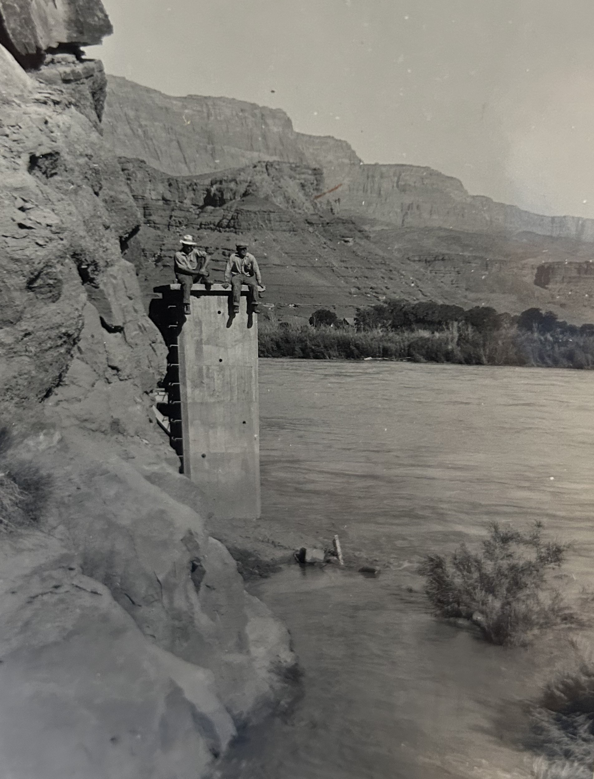
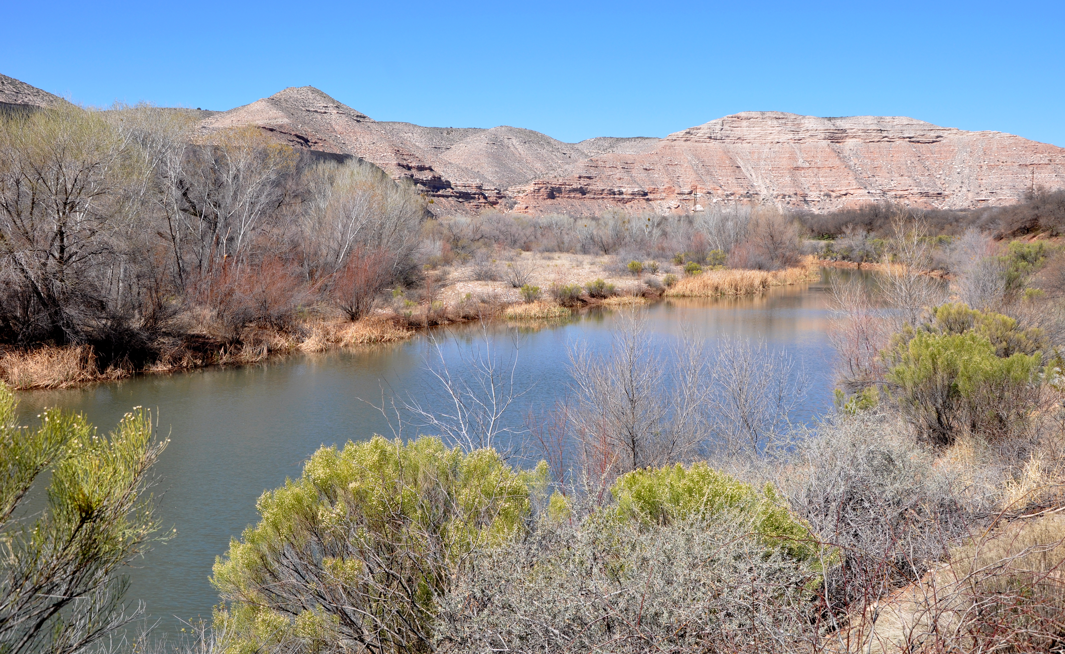
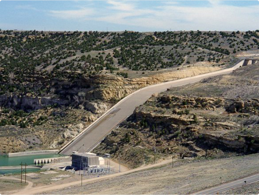
The outflow at the bottom of Navajo Dam in New Mexico. Photo: Brent Gardner-Smith/Aspen Journalism
From email from Reclamation’s Western Colorado Area Office:
With forecast sufficient flows in the critical habitat reach, the Bureau of Reclamation has scheduled a decrease in the release from Navajo Dam from 550 cubic feet per second (cfs) to 450 cfs for Tuesday, October 22nd, at 7:00 AM. Reclamation is still currently utilizing the 4×4 for the release point due to a maintenance project. This project will continue throughout October and November.
Releases are made for the authorized purposes of the Navajo Unit, and to attempt to maintain a target base flow through the endangered fish critical habitat reach of the San Juan River (Farmington to Lake Powell). The San Juan River Basin Recovery Implementation Program recommends a target base flow of between 500 cfs and 1,000 cfs through the critical habitat area. The target base flow is calculated as the weekly average of gaged flows throughout the critical habitat area from Farmington to Lake Powell.
The $33 million Colorado River Connectivity Channel diverts the river around the Windy Gap Dam to improve river health, fish passage and habitat in the upper headwaters of the Colorado River. (Northern Water, Contributed)
With the snip of a ribbon Tuesday, Colorado water managers officially opened a new waterway in Grand County that reconnects a stretch of the Colorado River for the first time in four decades to help fish and aquatic life.
The milelong waterway, called the Colorado River Connectivity Channel, skirts around Windy Gap Reservoir, where a dam has broken the natural flow of the river since 1985. The $33 million project’s goal is to return a stretch of the river to its former health, a river where aquatic life thrived and fish could migrate and spawn. But getting to the dedication ceremony Tuesday took years of negotiations that turned enemies into collaborators and can serve as a model for future water projects, officials say.
“It speaks to the new reality of working on water projects, which is that it doesn’t have to be an us-versus-them situation,” Northern Water spokesperson Jeff Stahla said. “People can get together and identify things that can help not only the water supply, but also help the environment.”
Windy Gap Reservoir and the new channel are just off U.S. 40 near Granby, a few miles southwest of popular recreation areas around Lake Granby and Grand Lake.
The reservoir was designed to deliver an average of 48,000 acre-feet of water per year from Grand County through numerous reservoirs, ditches, canals and pipelines to faucets in homes and sprinklers on farms across northeastern Colorado. One acre-foot roughly equals the annual water use of two to three households.
But soon after construction finished in 1985, locals and fly fishermen started noticing problems — starting with the bugs.
Drivers used to cleaning insects out of their radiators suddenly had one less chore as certain types of mayflies, stoneflies and caddisflies disappeared. In 2011, state biologists calculated a 38% loss in diversity between the early 1980s and 2011.
The dam blocked fish passage, and the reservoir became a breeding ground for whirling disease, a deadly condition for local trout caused by a microscopic parasite.
Windy Gap Reservoir before construction started for the Colorado River Connectivity Channel. The dam, built in 1985, blocked the Colorado River and inhibited a healthy fishery. The new channel around the reservoir will improve the health of the Upper Colorado River. (Northern Water, Contributed)
It choked seasonal high flows. Without the flows to flush the sediment from between small rocks, the habitat for a fundamental food source, small organisms called macroinvertebrates, diminished. The sculpin, a small fish that often serves as an indicator of river health, disappeared entirely.
Macro Invertebrates via Little Pend Oreille Wildlife Refuge Water Quality Research
“The ecosystem started crashing,” said Kirk Klancke, a longtime conservationist in the area. “It didn’t die out completely, but it certainly started crashing. We lost all the sensitive, most important macroinvertebrates.”
The fishery’s gold medal status was threatened, and losing that would have been a blow to the local economy, he said.
The reservoir also couldn’t reliably serve its main purpose: catching water and pumping it 6 miles to Lake Granby to eventually reach the Front Range. When the lake is filled to the brim in wet years, it can’t store Windy Gap’s water, leaving northeastern communities in the lurch, according to Northern Water.
Restoring a river channel in the Upper Colorado Basin. Graphic credit: Northern Water
The new channel is the fix.
To create the channel, the Northern Colorado Water Conservancy District started work in 2022, draining Windy Gap Reservoir and cutting its size in half. The result is a smaller reservoir and a floodplain through which the channel flows.
Crews built a new diversion headgate — the main focus of the dedication this week — that manages how much water enters the reservoir from the channel. They removed a small, upstream dam crossing the Fraser River that blocked fish passage.
After vegetation is established, the channel will open to fishing and recreation, likely around 2027.
Water has been flowing through the channel for about a year, and officials are already seeing benefits: Colorado Parks and Wildlife said Tuesday that the sculpin has been detected in that stretch for the first time in 20 years.
“Seeing the project come to fruition, and then getting the bonus of having wildlife biologists tell you, ‘Yep, we’re already seeing signs of biological healing,’ was just mind blowing,” said Tony Kay, former president of Trout Unlimited who has been working on connecting the river for 26 years.
It was emotional. Not everyone who started this process was able to see it through to the end, like Bud Isaacs, a downstream landowner who was one of the first to raise the alarm and who passed away in 2022, Kay said.
“We never actually thought that this would happen,” he said.
The channel is also one facet of a sweeping, multimillion-dollar plan to fix multiple problems in one go.
Through the Windy Gap Firming Project, growing Front Range communities will have more reliable water storage in the form of Chimney Hollow Reservoir, which is under construction near Loveland and will work in tandem with Windy Gap to provide water supplies.
The effort to build the connectivity channel has seemed slow moving at times, but officials, environmentalists and urban areas are celebrating it as an example of hard-won collaboration.
“It was a gamble to partner with Front Range water diverters. There were a lot of people who told us you can’t do deals with the devil. You’re going to end up really regretting it,” Klancke said. “The connectivity channel has proved we went down the right road.”
It’s also just one step in addressing chronic low-flow issues along the upper Colorado River caused by drought and massive water diversions to Colorado’s Front Range, Klancke said.
In five years time, Kay hopes to see a healed river through the new channel and farther downstream. He’ll be saying “thank you” every time he drives past that stretch of the river.
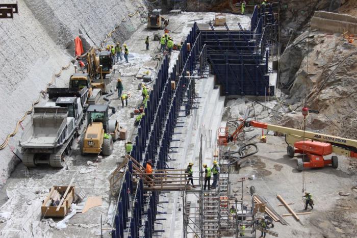
The dam raise process begins at the bottom of the dam using roller-compacted concrete to build the new steps that will go up the face of the dam. Photo credit: Denver Water.
Click the link to read the article on The Denver Post website (Elise Schmelzer). Here’s an excerpt:
October 17, 2024
The U.S. Army Corps of Engineers violated the Clean Water Act and the National Environmental Policy Act when approving permits for the construction of the dam, U.S. District Court Judge Christine Arguello found in the ruling, issued Wednesday. The federal agency failed to sufficiently consider other options that could be less environmentally damaging than dam expansion, Arguello wrote in her order. Arguello did not order Denver Water to stop construction on the dam, in part because the utility already plans to halt construction in November for the winter season. An abrupt halt to the project could also affect the integrity of the dam, she wrote. The defendants and plaintiffs will now work to create a remedy for the improperly issued permits. Each side must submit briefs on proposed solutions to Arguello by Nov. 15. In a statement, Denver Water said it still hopes “to move the project toward completion.”
[…]
Denver Water argued in its filings that the issues raised were moot since construction had already begun and one of the permits in question already used. Arguello, however, dismissed that argument, as the reservoir had not yet been expanded and the 400 acres of land and 500,000 trees it would drown still remained above water…
One of the Army Corps of Engineers’ failures was its lack of analysis of how climate change could impact the project. As climate change shrinks the amount of water available in the Colorado River system, Arguello asked, is it practical and reasonable to build a reservoir to store water that doesn’t exist? The lack of analysis shows that the USACE did not fully analyze the practicality of the dam project, as required by law, she wrote.
There’s a lot of anxiety about climate change shrinking Lake Powell, but it also means whitewater rapids upstream have re-emerged. Thrillseekers can now run them for the first time since the 1960s.
ARI SHAPIRO, HOST:
At the bottom of a deep, red rock canyon in the desert southwest, the Colorado River is restoring itself, or at least a part of itself, even as climate change shrinks its volume. And that has river enthusiasts celebrating. Long-forgotten whitewater rapids are reemerging upstream. Reporter Luke Runyon set out to find more.
LUKE RUNYON, BYLINE: Ah. We just docked our boats to scout Gypsum Canyon Rapid. The sky is blue. The sun is out. It’s hot, and you can hear the water roaring.
PETE LEFEBVRE: I’m just going to go down this main wave train and look for this doamer (ph) rock and tuck underneath that.
RUNYON: Professional river guide Pete Lefebvre has been down Cataract Canyon more than 130 times, but he’s never seen Gypsum Rapid. And it looks mean, a churning, roiling mess of water and boulders.
PETE LEFEBVRE: It’s steep. It’s sharp. It’s a must-make move. And I’m nervous (laughter).
RUNYON: Lefebvre has never seen this rapid because for more than 50 years, it’s been buried under mud. Cataract Canyon is a transition zone, where the dammed up waters of Lake Powell start backing up, and sediment buries whatever’s on the bottom. But since 2000, Lake Powell has dropped 100 feet. So here, the river is starting to behave like a river again, carving down and excavating these long-buried boulders. Mike DeHoff is another experienced river-runner.
MIKE DEHOFF: Cataract Canyon, I think, these days is like a friend that was in a car accident or had a terrible sickness that has come home from the hospital.
RUNYON: In 2019, he and Pete Lefebvre started the Returning Rapids Project. DeHoff’s wife, Meg Flynn, a librarian in nearby Moab, keeps its archive. Using old photos from before Lake Powell’s dam was built, they anticipate when and where new rapids might again show themselves.
MEG FLYNN: We see here how flowing water brings life and that the river, if you give it a chance, can recover at a rate that is really astounding to all of us.
On Monday, Oct. 7, six members of the state’s congressional delegation sent a letterto the U.S. Bureau of Reclamation, demonstrating support for the district’s forthcoming application for funding from the Inflation Reduction Act. The district anticipates seeking $40 million toward the total $99 million required to acquire the water rights. The letter was signed by Colorado’s U.S. Sens. Michael Bennet and John Hickenlooper and four of its eight representatives, Reps. Joe Neguse, Jason Crow, Brittany Pettersen and Diana DeGette. All six lawmakers are Democrats. According to a spokesperson from Bennet’s office, all members of the Colorado delegation were approached to sign the letter…
“We recognize the Shoshone Permanency Project’s complex nature and ongoing technical review, but believe the opportunity to protect historical Colorado River flows deserves your attention,” the letter reads. “We encourage you to give the River District’s proposal your full and fair consideration consistent with all applicable rules and regulations.”
The importance of the Colorado River cannot be overstated for the American West. The river and its tributaries serve more than 40 million people by providing drinking and municipal water. The water from the river basin irrigates more than 5 million acres of land, which produces around 15% of the nation’s crops. The dams in the basin generate 4,200 megawatts of hydro-power. Overall, the river system sustains over 16 million jobs, contributes $1.4 trillion per year to the economy, and supports terrestrial and aquatic ecosystems (USBR, 2012.)
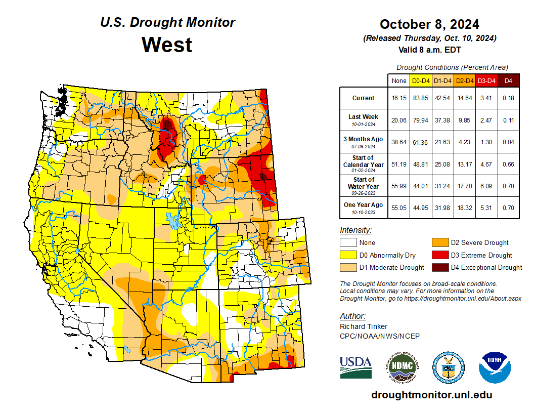
West Drought Monitor map October 8, 2024.
However, the current drought that has lingered for decades now poses a significant threat to everything that depends on the mighty Colorado River. The river basin lies in the region which is infamous for its natural variability. Over the course of history, the region has had cycles of dry and wet periods, which may also make the present drought look like a natural phenomenon alone. However, a study conducted in 2021 showed that around 19% of the current drought conditions can be attributed to human-induced climate change. Not only that, but the conditions are worse than they have been in at least 1200 years.
Since 90% of the streamflow in the Colorado River originates in the upper part of the basin,several studies over the years have focused on watershed modeling in that region many studies have investigated historical flows, while others have included baseflow – the steady release of groundwater that seeps into a stream or river. Some have gone further to use historical streamflow and baseflow to predict future conditions in the river basin using various climate models. However, almost all studies have either used pre-development scenarios – conditions when there was little to no water infrastructure such as dams, canals, levees, etc., management, and regulations – or have used oversimplified models that ignore the complexities of groundwater movement, storage, and interactions with the surface water.
The Colorado River Basin is one of the most highly regulated and over-allocated river systems in the world. As a result, basing studies on pre-development scenarios seems to be of little practical importance in this day of rapidly changing climate. Moreover, the importance of groundwater and its interactions with surface water cannot be ignored, as more than half of the streamflow in the basin is contributed by baseflow.
Colorado transmountain diversions via the State Engineer’s office
The river basin also has trans-basin or trans-mountain diversions. These diversions bring water from the western slope of the Rocky Mountains, which are in the Colorado River Basin, to the eastern slope of the Rockies outside of the basin. These diversions have also been ignored in previous models.
Map credit: AGU
Therefore, my team, which includes my Ph.D. advisor at CSU, Associate Professor Ryan Bailey, and two scientists from the Agricultural Research Service, is working to address this knowledge gap by incorporating key hydrological processes that were overlooked in previous research studies. We are using a physically based and spatially distributed model to build and quantify historical streamflows and groundwater levels in the Upper Colorado River Basin for the post-development scenario. A physically based model simulates how water moves through the environment, using real-world processes, instead of relying on statistical patterns. A spatially distributed model, on the other hand, takes into account differences in the landscape and natural features across different areas. In our model, we have included reservoirs, canals, irrigation schedules, floodplains, trans-basin diversions, and tile drainage – an agricultural drainage system that removes excess subsurface water from irrigated fields. The model also simulates groundwater fluxes such as groundwater recharge, canal seepage, tile drainage flow, saturation excess flow, lake and reservoir seepage and evaporation, and groundwater-floodplain exchanges, which can be used to identify spatio-temporal patterns in the river basin.
Once we simulate the historical hydrology and fluxes, we plan to run what-if scenarios, hypothetical situations to help us analyze different options, for several water management, land use change, and climate change scenarios. This will allow us to come up with best management practices to address water issues and manage water resources more effectively and efficiently.
Historic photo of the Lee’s Ferry gage on the Colorado River. Photo credit: USGS
In the final phase of the study, we use what-if scenarios to assess the political and socio-economic aspects of the model. This includes, crop budgets, agricultural productivity in monetary terms, possibility and probability of Denver getting shut out from trans-mountain diversions in case of a drought, economic implications of sustainable groundwater use, the amount of water flowing at Lee’s Ferry in Arizona – the dividing point of the upper and lower basins, and so on.
The findings of this study can influence how water managers, government agencies, farmers, and other stakeholders approach water use and management for higher revenues and sustainability. Ecologists can gain insights into future streamflows and their potential impacts on aquatic ecosystems. Additionally, it will provide the scientific community with a solid foundation and valuable catalyst for future research. In the long run, these findings can help shape water policy, advancing the goal of achieving integrated regional water management.
M. Raffae
The fate of the Colorado River Basin does not only depend on the climate and its variability, but also on the policies we create that define how we store, move, use, and manage our water. To come up with policies that help us sustain the economy, environment, and society, it is imperative that we conduct a comprehensive hydrological modeling study for the post-development scenario that shows us both our best- and worst-case scenarios for the future to better prepare for it. This study is an ambitious attempt to do so.
About the author: M. Raffae is a Ph.D. student in the Department of Civil and Environmental Engineering at Colorado State University (CSU) funded by the Fulbright Foreign Student scholarship program. He is also a fellow in the NSF Research Traineeship (NRT) Program InTERFEWS at CSU.
With leaky water and sewer pipe infrastructure dating to the early 1970s, the Steamboat II Metropolitan District is facing a proposed steep increase in water and sewer base rates to be voted on at a board meeting Monday, Oct. 21, 2024. The district water and sewer service covers three neighborhoods, two schools and a church, pictured in 2022 from above. Charlie Dresen/Courtesy photo
With aging water and sewer pipe infrastructure dating to the early 1970s, a water main break repair and a section of line replacement in the Steamboat II Metropolitan District in 2022 cost more than $500,000…Those types of expensive repairs hit hard for the special taxing district that currently has $600,000 in reserves for capital improvements, said Jeb Brewster, a mechanical engineer and Steamboat II metro district manager since April. Regional experts say shortages in funds to repair aging infrastructure is a problem threatening various residential-based special taxing districts across Routt County that do not have as deep of pockets as cities and counties.
So, the Steamboat II district that serves water and sewer customers for some 420 residential properties, two schools and a church is faced with approving a proposed water and sewer combined rate jump of approximately 46%. The five-member volunteer district board is expected to vote on the increase at its next meeting Oct. 21…Metro district leaders note the water and sewer base rates charged to their customers have not increased significantly for at least 20 years except for minor increases in usage tiers. Water tap fees for homes being built helped supplement the budget in the past, but now the district is very close to full build-out.
This photo shows the Thompson Creek drainage on the right as it flows into the Crystal River just south of Carbondale. A company with oil shale interests has voluntarily abandoned its conditional water rights for a reservoir on Thompson Creek. CREDIT: ECOFLIGHT
The Colorado Water Quality Control Commission on Aug. 21 unanimously designated roughly 385 miles of waterways across 15 rivers and streams in the upper and lower Colorado, Eagle, Yampa, and Roaring Fork River basins as Outstanding Waters. The Outstanding Waters designations are authorized by the Colorado Water Quality Control Act and the Clean Water Act…
“An Outstanding Waters designation is a protection that can be given to reaches of streams that offer water quality protection. It is the highest level of water quality protection that can be given by the state of Colorado,” Anderson said. “With the protection, future projects that may happen along these reaches have to ensure that the water quality will not be diminished.”
This designation can protect creeks and rivers from future developments and pollution. He noted that all existing industries, ranches, homes, and utilities along these sections of designations will be grandfathered in…For creeks, streams, and rivers to receive this designation, the water quality must already be of a high standard. Eleven respective criteria points must be met as it relates to water quality before this designation can be obtained.
Animas River. Photo credit: The Southern Ute Indian Tribe
From email from John Berrgren:
August 15, 2024
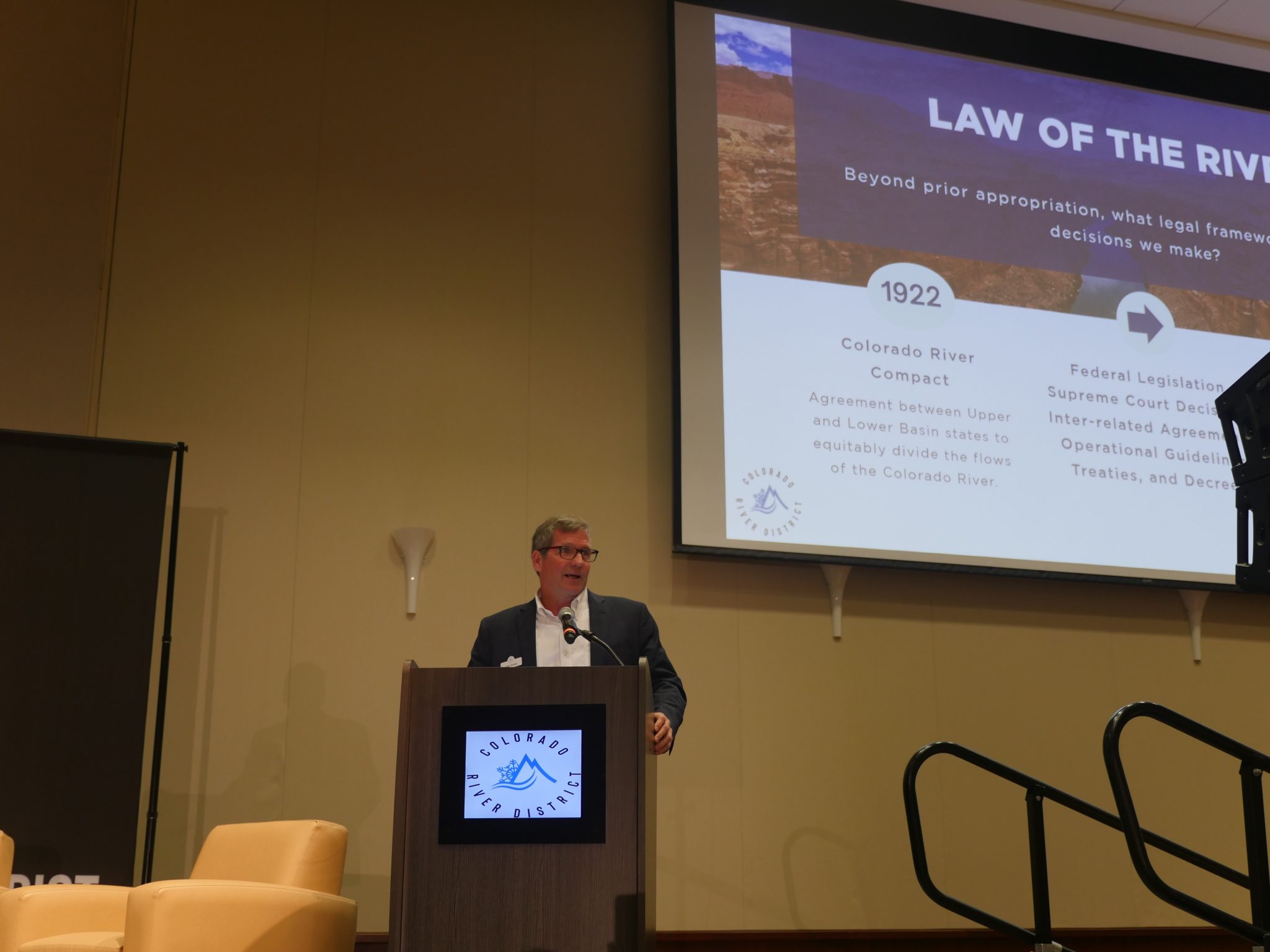
The foundation of the laws, treaties, acts and policies that govern the Colorado River is the Colorado River Compact of 1922. Over the past 100 hundred years, dozens of additional agreements and decisions have been layered on top, providing for the management framework we know today.
As we look to the future, and as individuals who represent Tribal and environmental interests in the Colorado River Basin, we believe it is time to return to — and reimagine — one of the primary stated purposes of the 1922 Compact: to provide for the equitable use of water.
For me, Lorelei, it’s personal. Rooted in the Southern Ute Indian Tribe and raised on the Reservation in southwestern Colorado, my life has been deeply intertwined with water.
We lived in one of the first adobe houses on the Reservation and did not have running water. We relied in part on groundwater, but the well often dried up. So, we hauled water once a week and my grandmother boiled ditch water for drinking water as needed.
Water was a scarce resource, and we often had to choose between using water for drinking, taking showers or flushing the toilet. This scarcity is still a reality for many Native Americans today across the country.
I grew up knowing that water is a living, sacred being. Our Ute (Nuuchiu) culture centers around water, and we offer prayers for and with it. Water is the heart of our ceremonies. We were taught early on to take and use only what is needed. Above all else, we must care for the spirit of the water.
From the 2018 Tribal Water Study, this graphic shows the location of the 29 federally-recognized tribes in the Colorado River Basin. Map credit: USBR
When I was first elected to the Southern Ute Tribal Council in 2015, I was asked to participate in the Ten Tribes Partnership, or TTP, which is a coalition of the 10 Tribes along the Colorado River focused on securing and using tribal water. After one year, I was asked to chair TTP.
I drew on my personal and spiritual connection to water and started learning about the complex legal and technical issues related to managing water in the American West. I was stunned to learn that Tribes have historically delegated to have little to no role in managing Western water, and that tribal needs and interests are often marginalized.
In recent years, I have had the opportunity to work alongside many people from diverse walks of life to begin addressing these inequities: lack of inclusion in decision-making; lack of access to clean water; and lack of capacity to manage, develop and use water.
I became a founding member of the Water and Tribes Initiative, or WTI, for the Colorado River Basin; was the first Native American appointed to the Colorado Water Conservation Board and the Colorado Chapter of The Nature Conservancy; co-founded the Indigenous Women’s Leadership Network, a program of WTI; and helped forge an historic agreement among the six tribes in the Upper Basin the Colorado River and the states of Wyoming, Colorado, Utah, and New Mexico to allow Tribes to be more meaningfully involved in collaborative problem-solving (but not decision-making per se).
Like Tribes, environmental interests have mostly taken a backseat to the use of the Colorado River for municipal and agricultural purposes. Most adjustments to address cultural and ecological values have been treated as subservient to the allocative laws that largely service municipal and agricultural interests.
Returning to the primary purpose of the 1922 Compact, we believe that providing for the equitable use of water includes substantive and procedural elements. There’s a huge difference between how the Colorado River is managed for multiple values (substance) and how people who care about such issues determine what ought to happen (process).
We are offering a process improvement. We believe it’s time to establish an ongoing, whole-basin roundtable that would embrace the entire transboundary watershed, address the major water issues facing the basin, and, importantly, provide an equitable process to engage all four sets of sovereigns (United States, Mexico, seven basin states and 30 Tribal nations), water users and stakeholders.
The late University of Colorado law professor David Getches, an astute observer of Colorado River law, noted in 1997 that “the awkwardness and the intractability of most of the Colorado River’s problems reflect the absence of a venue to deal comprehensively with Colorado River basin issues.” He called for “the establishment of a new entity that recognizes and integrates the interests and people who are most affected by the outcome of decisions on major Colorado River issues.”
Many other scholars and professionals have supported a whole-basin approach to complement, not duplicate, other forums for engagement and problem-solving in the basin. Establishing a whole-basin forum is also consistent with international best practices, as most transboundary river basins throughout the world have some type of river basin commission.
A whole-basin forum would be a safe place to have difficult conversations, to exchange information, build trust and relationships, and to develop collaborative solutions. It should rely on the best available information, including Indigenous knowledge.
Addressing the historic inequities built into the fabric of governing the Colorado River requires innovative substantive tools as well as procedural reforms focused on engagement and problem-solving. We look forward to working with all of you to shape a more equitable, more sustainable future for the Colorado River.
Vice Chairman Lorelei Cloud lives on the Southern Ute Indian Reservation and is the first Native American appointed to the Colorado Water Conservation Board and the Colorado Chapter of The Nature Conservancy.
John Berggren lives in Boulder and is the Regional Policy Manager, Healthy Rivers for Western Resource Advocates.
As volunteers with Trout Unlimited Yampa Valley Fly Fishers, husband and wife Steve Randall and Kathy McDonald were happy to help with the release of some 20,000 rainbow trout fingerlings into the Yampa River on Monday…Randall and other volunteers helped Colorado Parks & Wildlife staff carry, release and disperse into the Yampa River many tubs of squirming 3-inch trout raised at the fish hatchery in Glenwood Springs. The small fish were dispersed where CPW supervised $500,000 is aquatic habitat improvement work this summer at the upstream reach of Chuck Lewis State Wildlife Area…
Randall called it “so cool” to see the newly restored section of the river that before was full of “old cars, junk and eroded streambanks silting in different places.”
[…]
CPW Aquatic Biologist Billy Atkinson said with rapid initial grown of young trout, the released fingerlings should be 10 inches and ready to challenge anglers in about two years. Standing along the river in waders, Atkinson explained that a previous restoration project in 2008 in the river section was not successful for sustained habitat for bigger fish and not structurally sound. The previous project failed so much so that the river was threatening to reroute and cut west away from the fixed point of a bridge downstream, he said. The redesigned restoration project that started in mid-July included constructing multiple rock structures to direct stream energy away from banks, adding bank full bench features with coir fiber wrapped sod and willow vegetation mats, adding an inner berm design feature to help fish during lower flows, regrading vertical eroding banks and removing transverse and mid-channel bars to reshape the channel bed to appropriate dimensions. The project is intended to prevent further degradation that would result in more costly maintenance, additional loss of habitat and continued contributions of excessive gravel to the river system, according to CPW.
The Rockford Ditch has the oldest water rights on the Crystal River. It irrigates some agricultural land as well as the lawns and gardens of the Colorado Rocky Mountain School and the Satank neighborhood of Carbondale.
CREDIT: HEATHER SACKETT/ASPEN JOURNALISM
The old water law adage doesn’t capture just how difficult it is to lose a water right. And state policy limits the pool of possibly abandoned water even further.
In December 2020, the Summit County Open Space and Trails Department bought a 15-acre property with a small pond, three ditches and a well.
Known as the Shane Gulch property, it was the only remaining private property north of Heeney Road between Green Mountain Reservoir and the Williams Fork Range. The land, just east of Colorado 9 and the Blue River, has stunning views of the snow-capped peaks that form the Continental Divide. Summit County purchased the property, which consists of three parcels of rolling hills and meadows, to preserve the unique scenic, wildlife and agricultural heritage values of the area.
The water on the property had historically been used for irrigation. But according to the state Division of Water Resources, the former owners of the property had not used the water rights on one of those ditches, the Culbreath Ditch, in the previous 10 years. The water rights were placed on the initial 2020 abandonment list, leaving them at risk of being lost.
Abandonment is the official term for one of Colorado’s best-known water adages: Use it or lose it. As the saying goes, a user must do something of value with their water (use it) or the state could take it away (lose it). Once abandoned, the right to use the water is canceled and goes back to the stream where someone else can claim it and put it to use.
Every 10 years, officials from the Colorado Division of Water Resources review every water right — through diversion records submitted by water users and site visits — to see whether it has been used at some point in the previous decade. If it has been dormant, it’s added to the preliminary abandonment list. But there’s a safety net. Not using the water is just one part of abandonment; a water user must also intend to abandon it.
The goal of abandonment is to preserve the water law system that the West relies upon. That legal framework, known as prior appropriation, is the bedrock of Colorado water law in which the oldest rights get first use of the river. If an upstream user with a senior water right resumes using it again after decades of letting it sit dormant, that’s not fair to downstream junior water users because it leaves less water for them. The abandonment process prevents people from locking up a resource they aren’t using.
The view from the Shane Gulch property, owned by Summit County, where the Blue River begins forming Green Mountain Reservoir. The county bought the property and water rights from the Culbreath Ditch in 2020. Credit: Courtesy of Summit County Open Space and Trails
Abandonment-process protections
Although the concept of abandonment may loom large in the minds of water users, only a tiny percentage of water rights ends up on the abandonment list every 10 years, and it’s rare for the state to formally abandon a water right.
In the last round of cancellations, in 2021, 3,439 water rights ended up on the final abandonment list out of 171,578 total water rights in the state, or 2%. On the Western Slope, 658 water rights out of about 75,000, or less than 1%, ended up on the final revised abandonment list.
Water users have two opportunities to fight an abandonment listing, and state policies have given an extra layer of protection from abandonment to the oldest water rights for the past 20 years. In most, if not all, cases, the water rights that were abandoned truly were not used in the previous decade.
In an example near Glenwood Springs, a ditch had been filled in and turned into a trail, and the land it had once irrigated was now home to a hotel and recreation center. And those who aren’t using their water because they are participating in state-approved conservation programs, such as the System Conservation Program currently happening in the Colorado River’s Upper Basin (Colorado, New Mexico, Utah, and Wyoming), are protected from abandonment.
“It’s a lot harder than people think to actually abandon water rights,” said Jason Ullmann, the top water engineer at the Colorado Division of Water Resources. “I think people feel like there’s this constant potential for their water right to be abandoned, but because it’s a personal property right to use the public’s resource, you don’t want it to be easy to come in and abandon that right.”
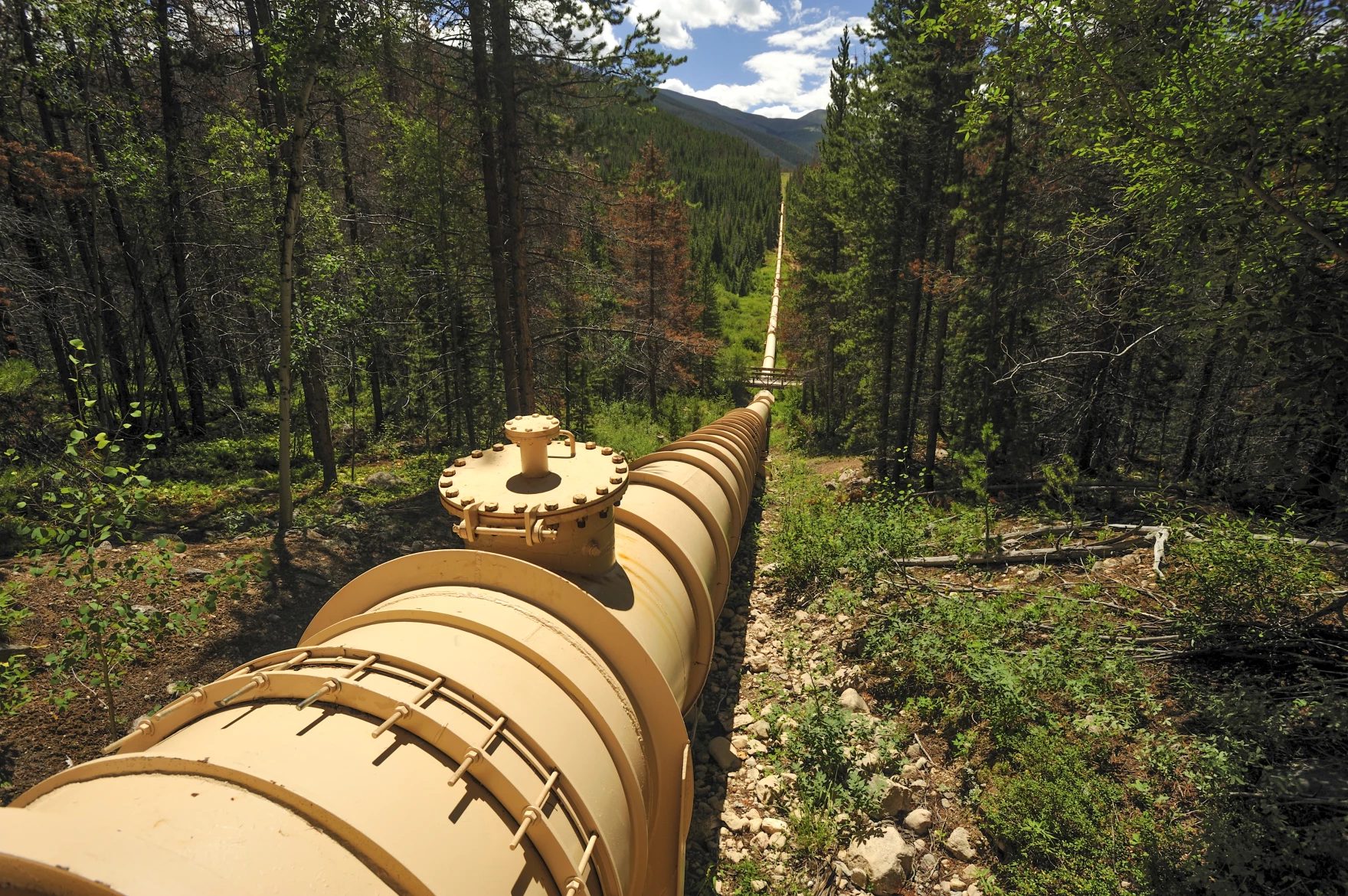
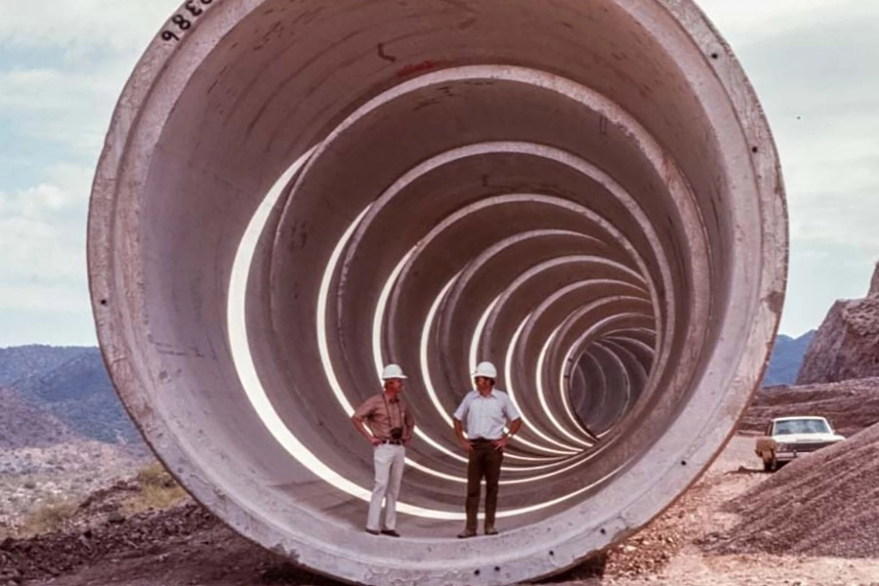
A complex system of pipes, tunnels and canals carries water around the Western U.S., like this one in Colorado’s Fraser Valley. However, policy experts say a cross-country pipeline wouldn’t make sense for political, financial and engineering reasons. Ted Wood/The Water Desk
Click the link to read the article on the KUNC website (Alex Hager):
September 30, 2024
This story is part of a series on water myths and misconceptions in the West, produced by KUNC, The Colorado Sun, Aspen Journalism, Fresh Water News and The Water Desk at the University of Colorado Boulder. KUNC’s coverage of the Colorado River is supported by the Walton Family Foundation.
The Colorado River is a lifeline for about 40 million people across the Southwest. It supplies major cities like Los Angeles, Phoenix, and Denver and a multibillion-dollar agriculture industry that puts food on tables across the nation. But it doesn’t have enough water to meet current demands.
Policymakers are struggling to rein in demand on the river, which has been shrinking at the hands of climate change. The region needs to fix that gap between supply and demand, and there’s no obvious way to do it quickly.
But one tantalizingly simple solution keeps coming up. The West doesn’t have enough water, but the East has it in abundance. So, why don’t we just fix the Colorado River crisis by piping in water from the East?
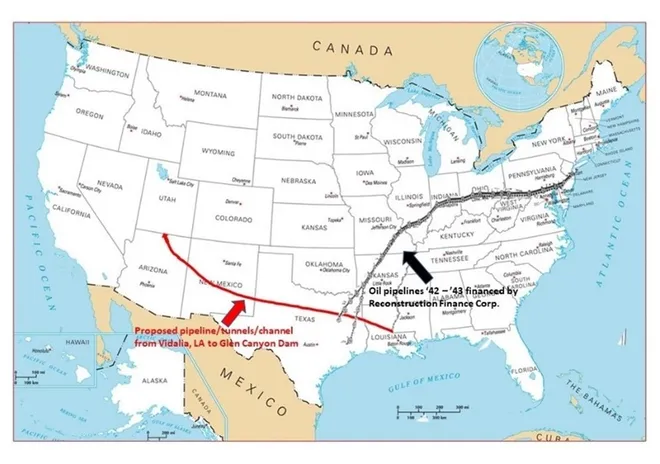
This proposed pipeline divert water from the Atchafalaya River in Louisiana through Louisiana, Texas, New Mexico, Arizona and up to the Glen Canyon Dam. Credit: Don Siefkes
The answer is complicated, but experts say it boils down to this: It doesn’t make sense to build a giant East-to-West water pipeline anytime soon for three reasons — politics, engineering, and money.
Political headwinds
If the West’s leaders wanted to take some water from the East, who would they even ask? Right now, there’s no national water agency that could oversee that kind of deal.
“I would argue that there aren’t many entities with the authority across the country to do this,” said Beaux Jones, president and CEO of The Water Institute in New Orleans. “I don’t know that the regulatory framework currently exists.”
Water is often managed using a messy patchwork of different government agencies and laws. The Colorado River is managed through a fragile web of agreements between cities, states, farm districts, native tribes and the federal government. Even though they’re all pulling from the same water supply, there’s no central Colorado River government agency.
A similarly complex system applies to many watersheds in the East. Even if a single city or state in the Western U.S. seriously wanted to build a pipeline from the East, it’s not even clear who they’d meet with to ask for water from a different area. And there’s no single federal agency that could sign off on such a deal and make sure it doesn’t harm people or the environment.
Colorado Water Conservation Board Executive Director and commissioner to the Upper Colorado River Commission Becky Mitchell, center, speaks on a panel with representatives of each of the seven basin states at the annual Colorado River Water Users Association conference in Las Vegas Thursday, December 15, 2022. The UCRC released additional details of a water conservation program this week.
CREDIT: HEATHER SACKETT/ASPEN JOURNALISM
Any serious effort to pull new water in from the East to the Southwest would likely touch some part of the Mississippi River basin. It’s a sprawling network of smaller rivers that covers 31 different states, from Montana to Pennsylvania.
It’s a busy river with a lot of uses. And while its shortages aren’t as severe as dry times in the West, the Mississippi River basin goes through its own droughts. So even if, someday, the governments of the East and West set up a formal way to negotiate a water transfer, the cities, farms, boaters and wildlife advocates to the east might not be willing to share.
“The very nature of there being sufficient availability of water in the Mississippi River Basin to, in a large scale way, export that water,” Jones said. “I think there are many people on the ground within the Mississippi River basin that would fundamentally disagree with that.”
Engineering limits
There are countless examples of large pipelines and canals moving liquids around the U.S. at this very moment. The longest existing today is the Colonial Pipeline, which carries gasoline from Houston to northern New Jersey through 5,500 miles of pipe.
So if we have the engineering capacity to do that, could we build similar infrastructure for water? In theory, yes. But it would have to be much larger than existing pipes for oil and gas.
“It takes so much more water to supply a city than it takes gasoline,” said John Fleck, a water policy professor at the University of New Mexico. “So the size of the pipe or the canal has to be a lot bigger, has to be much wider, has to cover a lot more ground.”
Because that pipeline or canal would be so big, it is more likely to ruffle some feathers along the way. Fleck suggested that landowners in its path, including local governments, could push back on a giant new piece of infrastructure running through their properties and mire any pipeline project in regulatory red tape.
Phoenix, Los Angeles, Denver and Salt Lake City wouldn’t look like they do today without giant water-moving systems, like this pipe that is part of the Central Arizona Project. Experts say all of the feasible water pipelines have already been built, and a system to carry water in from the East is too difficult to be worth building. Photo credit: Central Arizona Project
All that said, a pipeline is still physically possible. There is perhaps no better argument for an East-West water transfer than the fact that the Western U.S. is already crisscrossed by multiple huge pipes and canals that carry water across long distances.
The West as we know it today wouldn’t exist without that kind of infrastructure. Much of Colorado’s population only has water due to a series of underground tunnels that bring water across the Rocky Mountains. Phoenix and Tucson have been able to welcome new residents in the middle of the desert with the help of a 336-mile canal that carries water from the Colorado River. Los Angeles, Albuquerque and Salt Lake City would not be the cities they are today without similarly ambitious water delivery systems built decades ago.
The existence of those water-moving projects isn’t proof that we should build a new, even bigger water pipeline from the East, Fleck said. In fact, he pointed to those systems as proof that we shouldn’t.
“All the feasible ones have largely been done, and the ones that are left are the ones that weren’t done because they just turned out not to be feasible,” he said.
Money problems
Even in a world where the West’s leaders could find a willing water seller, get the right permits and put shovels in dirt, experts say an East-to-West water pipeline would simply be too expensive.
Any solution to the Colorado River crisis will require massive amounts of public spending. The federal government alone has thrown billions of dollars at the problem in just the past few years. But water economists and other policy experts say a cross-country pipeline isn’t the most efficient use of taxpayer dollars.
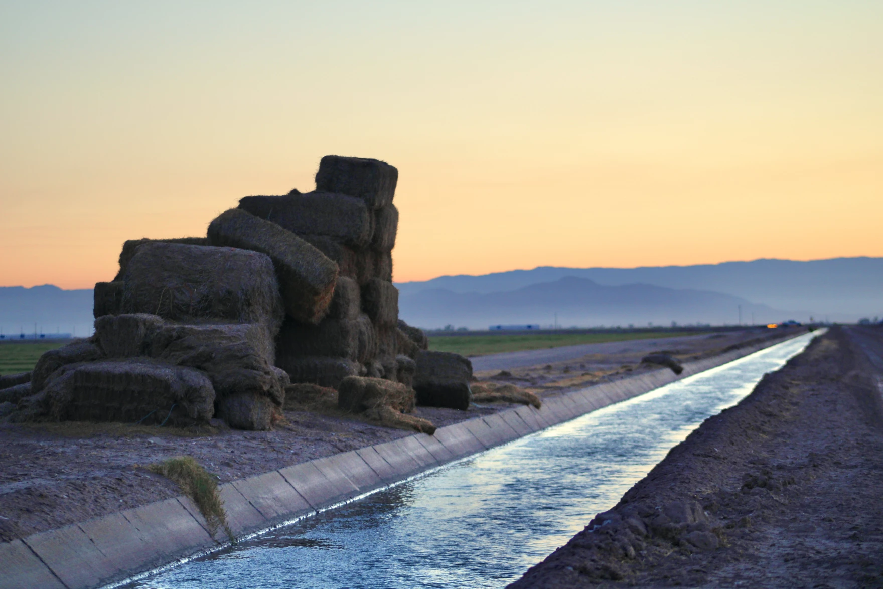
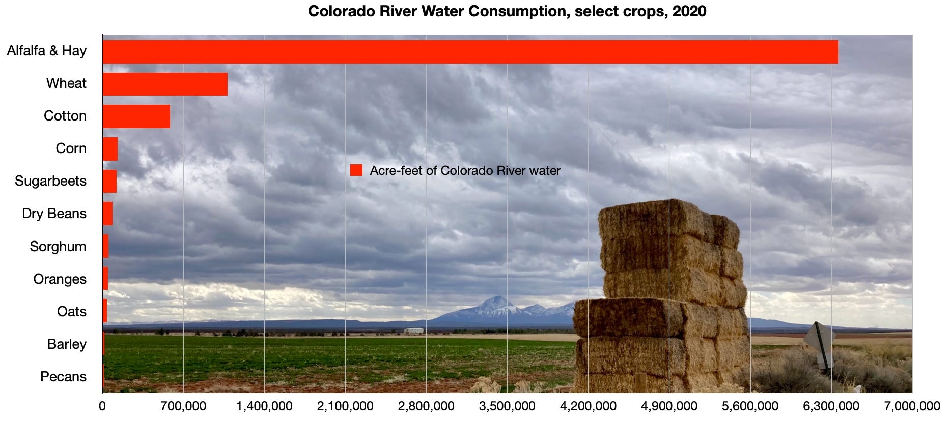
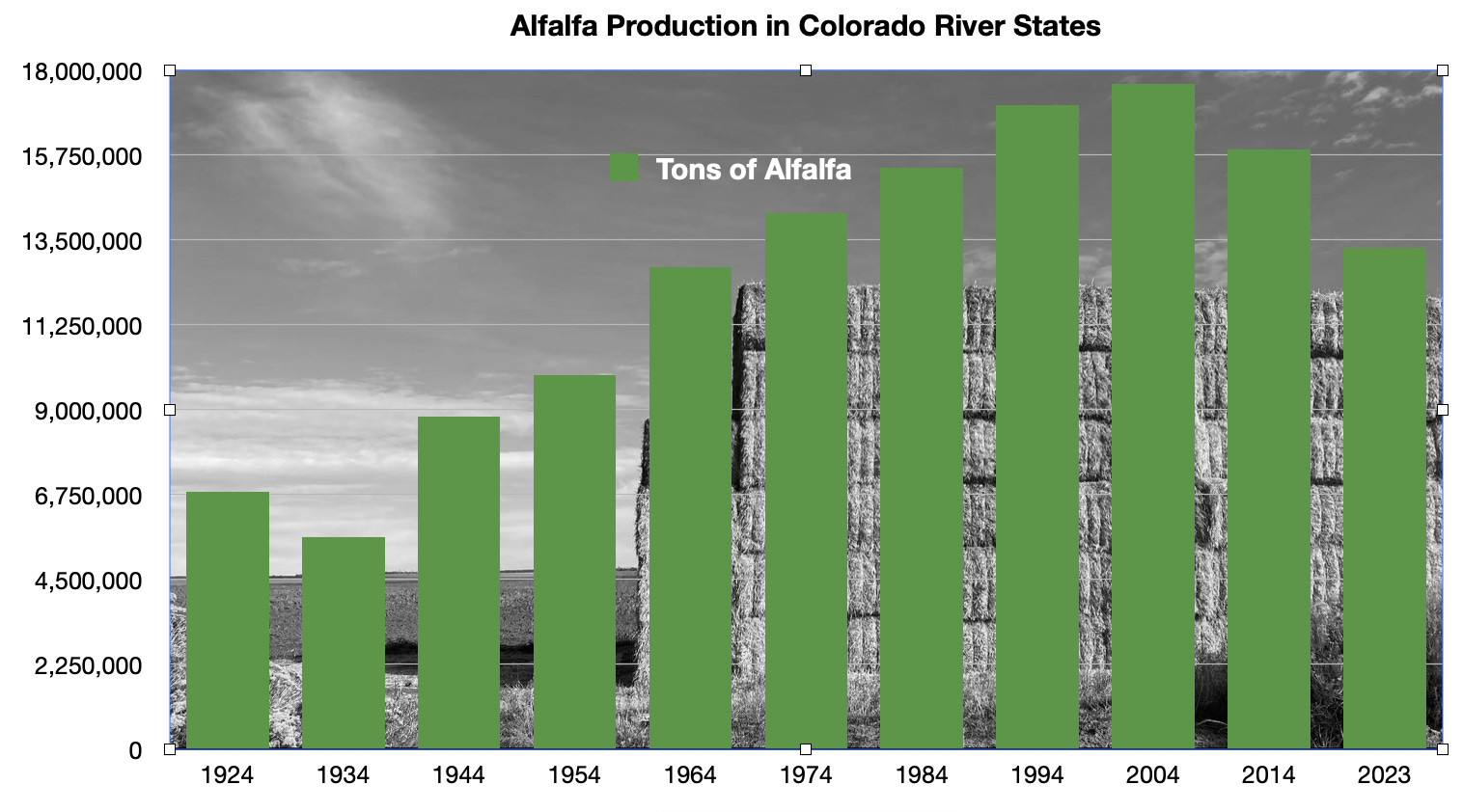
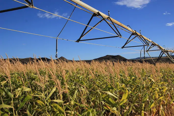
Stacks of hay bales sit beside an irrigation canal in California’s Imperial Valley on June 20, 2023. Experts say there are more cost-effective ways to fix the Colorado River crisis than building a cross-country canal, like paying farmers to pause growing thirsty crops such as alfalfa. Alex Hager/KUNC
Kathleen Ferris, former director of the Arizona Department of Water resources, pointed to two ongoing efforts that might be a more cost-effective way to help correct the region’s supply-demand imbalance. One involves paying farmers to pause growing on their fields, freeing up water to bolster the region’s beleaguered reservoirs. Another uses expensive, high-tech filtration systems to turn wastewater directly back into drinking water.
“Sometimes I feel like people don’t want to do the heavy lifting,” said Ferris, who is now a water policy researcher at Arizona State University. “Instead, they want to just find the next water supply and be done with it and have somebody else pay for it.”
Ultimately, she said, those kinds of programs already have momentum and cost less money than an East-to-West water pipeline.
“Why don’t we do the things that we know are possible and that are within our jurisdiction first,” Ferris said, “Before we go looking for some kind of a grand proposal that we don’t have any reason to believe at the moment could succeed.”
Pipe dreams becoming reality
Piping in water from outside of the Colorado River basin, for all of its challenges, is a tempting enough idea that the federal government has given it a serious look.
In 2012, a Bureau of Reclamation report analyzed ways to bring new water into the Colorado River Basin, including importing piped water from adjacent states.
The study concluded that strategy was not worth the money and effort.
“It just isn’t the time yet,” said Terry Fulp, a retired Reclamation official who helped write the study. “We felt that there were other things we could be doing in the basin, particularly in the Lower Basin, that would relieve the pressure.”
This map from the Bureau of Reclamation’s 2012 “Colorado River Basin Water Supply and Demand Study” shows places where water could theoretically be imported. One of the report’s authors said now “isn’t the time” to pipe water in from the East. Credit: U.S. Bureau of Reclamation
Fulp said the study was a worthwhile endeavor, and that the idea of importing water from the East might make sense down the road. The scale of the challenge posed by the Colorado River crisis, he said, will take some big thinking, “on the order of the thinking when we built the Hoover Dam.”
“It’s one of those possible solutions that should always stay, if not forefront on the table, somewhere on the table, so that you don’t lose sight of it,” Fulp said.
Despite the fact that many Colorado River experts have cast doubt on the feasibility of a cross-country water pipeline, even some sitting state officials say it deserves more research. Chuck Podolak, director of the Water Infrastructure Finance Authority of Arizona said the idea deserves “serious attention.”
“We understand that every option is hard, every option is expensive, every option has political hurdles, every option is a daunting engineering task,” he said. “Right now, we’re in a let’s-look-at-everything mode with eyes wide open.”
Arizona and other states around the region, with their eyes on continued growth, are already looking at ways to stretch out the water they already have using technology. Terry Fulp said those efforts may need to expend past the spendy and ambitious engineering projects that are already helping facilitate that growth.
“It’ll be the time someday, if we want the Southwest to continue to grow the way it’s been growing,” he said. “There’s only so much water in the basin.”
Arkansas Valley water districts and Aurora plan to open talks as soon as December aimed at providing aid to the region to offset the impact of a controversial, large-scale water purchase by Aurora that will periodically dry up thousands of acres of farmland.
The talks are likely to include renegotiating a hard-fought, 21-year-old agreement among water providers, Aurora, Pueblo, Colorado Springs and the U.S. Bureau of Reclamation, and others.
A map filed as part of Southeastern’s diligence application that shows the extent of the Fry-Ark Project. On its southern end, it diverts water from creeks near Aspen. The conditional rights within the Holy Cross Wilderness are on its northern end.
The agreement is not set to expire until 2047, but Bill Long, president of the Southeastern Water Conservancy District, which manages the Fryingpan-Arkansas Project for the Bureau of Reclamation, said the districts and Aurora have agreed to reopen the pact early to find ways to compensate the valley for the new loss of farm water.
“We hope that this issue can be resolved in a way that’s beneficial to both parties,” Long said. “What that looks like at this point I am not sure. We strongly believe the agreement has been violated and appropriate mitigation, or them not taking the water out of the valley, needs to occur. In our minds, there is no gray area.”
Aurora declined an interview request, but spokesman Gregory Baker acknowledged via email that Aurora has agreed to the talks, though a firm date has not been set.
Baker also confirmed that the water rights have been placed in a special account and won’t be used for two years while negotiations are underway.
The original 2003 agreement helped settle a number of lawsuits and disputes with Aurora after it asked to use the federally owned Fryingpan-Arkansas Project and Pueblo Reservoir. The deal gave Aurora the right to use the federal system for moving farm water it owned at the time in exchange for $25 million in cash payments over the 40-year life of the deal, among other provisions. The contract with the federal government was finalized in 2007.
Catlin Ditch water serving the Arkansas Valley an Otero County Farm to be purchased by Aurora Water. The purchase allows for periodic water draws from the Arkansas River basin for Aurora, a unique water transfer proposal in Colorado, officials say. PHOTO COURTESY OF AURORA WATER
Southeastern’s board quickly voted unanimously in April to oppose the purchase, and others, such as Colorado Springs and the Lower Arkansas Valley Water Conservancy District in Rocky Ford, followed suit.
Jack Goble, general manager of the Lower Arkansas Valley district, said the planned talks should pave the way for ensuring the valley’s farmers and ranchers are better protected against urban water harvesting.
“This is a big deal,” Goble said.
Aurora facing growth pressures
While Lower Arkansas officials argue that the 2003 agreement prohibits future water exports by Aurora, city officials have said previously that the purchase does not violate the pact, in part, because it involves leasing the water temporarily, rather than permanently removing it from the valley.
Fast-growing Aurora, Colorado’s third largest city, has had a controversial role in the history of agricultural water in the Arkansas Valley. In the 1970s and 1980s, it purchased water in several counties, drying up the farms the water once irrigated, and moving it up to delivery and storage systems in the metro area.
The Fryingpan-Arkansas project was built in the 1950s to gather water from the Western Slope and the headwaters of the Arkansas River and deliver it to the cities and farms of the Arkansas Valley. Local residents, via property taxes, have repaid the federal government for most of the construction costs and continue to pay the maintenance and operation costs of the massive project, according to Southeastern’s Long.
Aurora isn’t the only city that has moved to tie up agricultural water in the Lower Arkansas Valley. Recently, Colorado Springs inked a deal with Bent County and Pueblo Water has purchased water in the historic Bessemer Ditch just east of Pueblo.
At the same time, irrigated farm and ranch lands, the backbone of the state’s $47 billion agricultural economy, have been disappearing across the state. A new analysis by Fresh Water News and The Colorado Sun shows that 32% of irrigated ag lands have been lost to drought and urban development, and to other states to satisfy legal obligations to deliver water.
Long said the pending talks are “a recognition by Aurora that when making deals to acquire ag water, they need to be responsible and make sure there are benefits for all the parties. When we get to the table they may play hard ball, but I truly do think they want to fix this issue. That is in the best interest of all of the parties.”
More by Jerd Smith. Jerd Smith is editor of Fresh Water News. She can be reached at 720-398-6474, via email at jerd@wateredco.org or @jerd_smith.
Brad Udall, a senior water and climate researcher at the Colorado Water Center at Colorado State University, has been honored with the prestigious 2024 David Getches Flowing Waters Award. The award recognizes Udall’s substantial contributions to water science and policy.
Named after the renowned water law scholar David Getches, the award celebrates individuals who have made significant contributions to water policy and law. Getches, best known for his influential textbook Water Law in a Nutshell and his extensive work on the Colorado River, left a lasting legacy in the field.
The award was presented to Udall by the Colorado Water Trust on Sept. 24 at a ceremony at the Denver Botanic Gardens.
Kate Ryan, executive director of the Colorado Water Trust, said that presenting Udall with the award celebrates “the innovative and collaborative spirit exemplified by both David and Brad over their careers.” She continued, “By researching and communicating to broad audiences and key policymakers how climate change impacts hydrology in the Colorado River Basin, Brad has given water users including the Colorado Water Trust tools that are essential for protecting healthy flows in our rivers.”
Udall said that receiving the David Getches Flowing Waters Award is a deeply meaningful honor and acknowledged the critical role Getches played in shaping modern water law and policy.
“David was beloved by students, by faculty, by his family – by anybody who knew him,” Udall said. “Being a part of this legacy is a gift that is hard to come up with words for, frankly.”
Early influences and career path
Udall’s journey into the world of water science and policy was shaped by a long-standing family tradition of public service. Coming from a family with strong political roots – his father, uncle, brother and grandfather all held significant public offices – Udall initially seemed destined to follow in their footsteps.
“In some ways, my story starts with my political family, which deeply influenced who I am,” Udall said. “There’s a deep commitment to public service in my family. It extends back to my grandfather, who was a Supreme Court justice in Arizona.”
However, he carved out his own path, pursuing a career in engineering and earning degrees from Stanford University and Colorado State University.
Udall began his career as a consulting engineer but soon found his calling in the intersection of climate science and policy. His work with the University of Colorado’s Western Water Assessment, a National Oceanic and Atmospheric Administration-funded Regional Integrated Sciences Assessment program focused on integrating climate science with regional water management decisions, was instrumental in shaping his career.
“The goal at the Western Water Assessment was to connect climate science with decision-makers in a meaningful way,” Udall explained.
In 2014, Udall transitioned to the Colorado Water Center at CSU, where he continues to focus on making climate science accessible to both policymakers and the public. His mission to translate complex scientific concepts into actionable insights to guide better decision-making around water management in the U.S. West aligns with the Colorado Water Center’s mission. Since 1965, the center has served as a hub for water-related research, education and outreach to address complex water management issues in Colorado and the West.
Bridging science communication and decision-making
Udall sees science communication as a critical tool in making research meaningful and applicable to real-world decisions. “It’s not enough for scientists to understand the data,” he emphasized. “We need to be able to explain it in a way that decision-makers and the public can understand, and then that understanding can fuel action.”
Udall’s experience working with CU’s RISA program helped sharpen his communication skills. However, he acknowledges the challenges of conveying the intricacies of climate science, particularly when it comes to long-term projections and uncertainty.
“Too many scientists want to caveat their findings to the point where they’re truly worthless for decision-making,” Udall said. “That’s where communication and journalism come in – many scientists don’t know that there’s a real art in being able to condense science down into stuff that decision-makers and the public can hear and understand.”
In his role at the Colorado Water Center, Udall strives to communicate the urgency of water issues in the U.S. West while providing clear, actionable recommendations for policymakers.
Looking ahead: Ongoing research and future challenges
While Udall is now working part time, his research and outreach efforts remain a top priority. He recently submitted a paper focused on groundwater issues in Arizona, highlighting the complexities of maintaining water balance in a state that is heavily dependent on groundwater resources.
Udall is also leading a review paper on the future of the Colorado River, a waterway that is central to the region’s economy and ecosystem. The paper aims to provide a comprehensive summary of the current state of knowledge on the river and offer guidance on future management strategies.
“Understanding the political and social context of water law is essential to producing better science,” Udall said.
In a statement by the Colorado Water Trust, Udall is described as a humble person with a passion for the environment that “leads him to share what he knows about climate change and the coming impacts on rivers with audiences nationwide.”
“Brad was one of the original voices speaking out on climate change impacts on water in the West long before many of us even had climate change in our vocabulary,” said Karen Schlatter, interim director of the Colorado Water Center. “His unwavering quest to educate and inform decision-makers and the public on water and climate change issues has shifted the dialogue from the abstract to reality, heightening awareness that climate change is now, it affects everyone and we must adapt to an altered water future. Brad is highly deserving of this award, and we are excited to celebrate his impactful career to date.”
Reflections on a changing climate
Udall reflected on the broader challenges facing water management in the West. “Water is everything out here,” he said, “and climate change is altering the water cycle in ways we’re only beginning to understand.”
He emphasized the need for adaptive management strategies that can respond to the unpredictable nature of climate change. “The only constant is change,” he remarked, “and we have to be ready for it.”
“New plot using the nClimGrid data, which is a better source than PRISM for long-term trends. Of course, the combined reservoir contents increase from last year, but the increase is less than 2011 and looks puny compared to the ‘hole’ in the reservoirs. The blue Loess lines subtly change. Last year those lines ended pointing downwards. This year they end flat-ish. 2023 temps were still above the 20th century average, although close. Another interesting aspect is that the 20C Mean and 21C Mean lines on the individual plots really don’t change much. Finally, the 2023 Natural Flows are almost exactly equal to 2019. (17.678 maf vs 17.672 maf). For all the hoopla about how this was record-setting year, the fact is that this year was significantly less than 2011 (20.159 maf) and no different than 2019” — Brad Udall
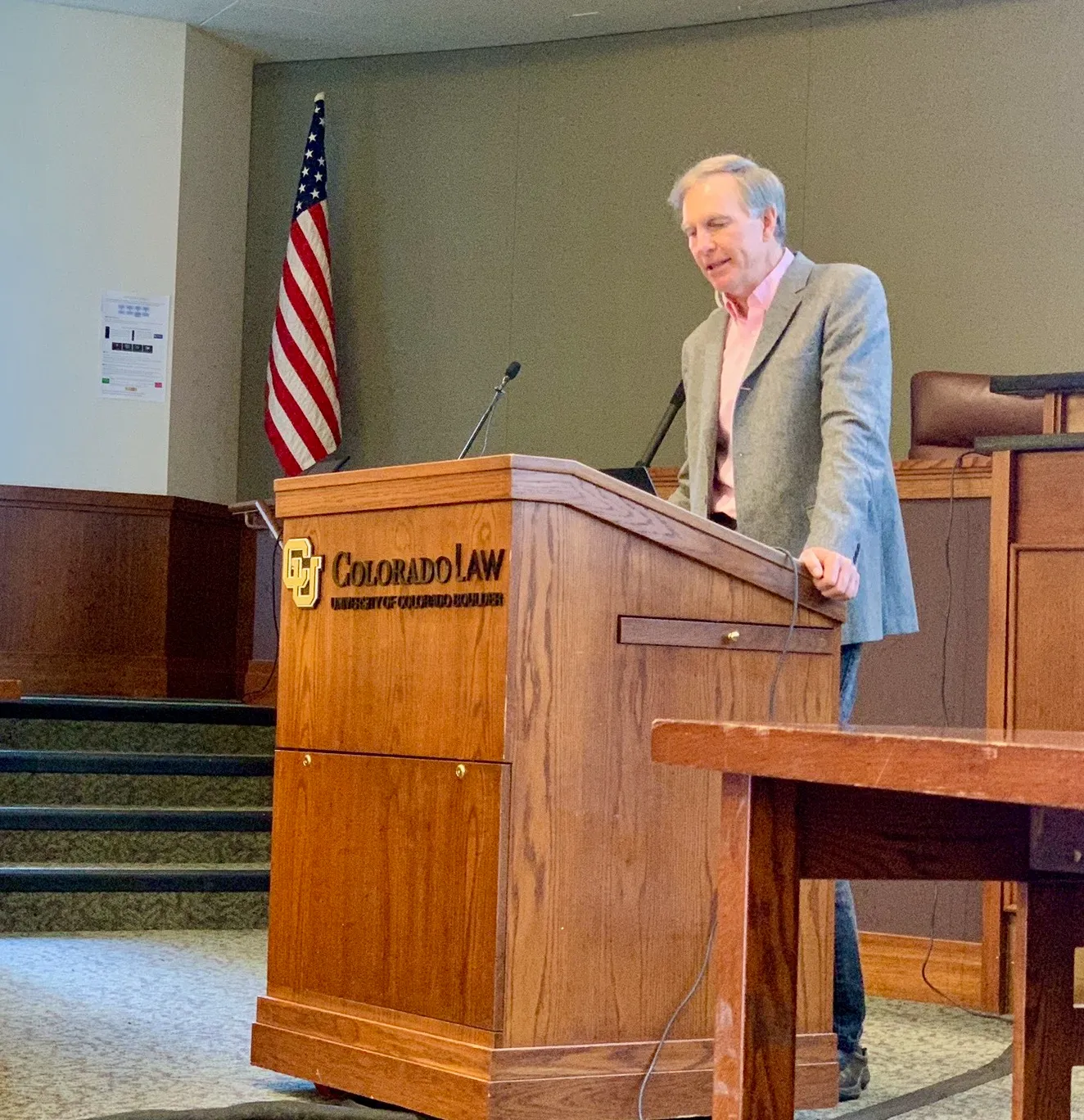
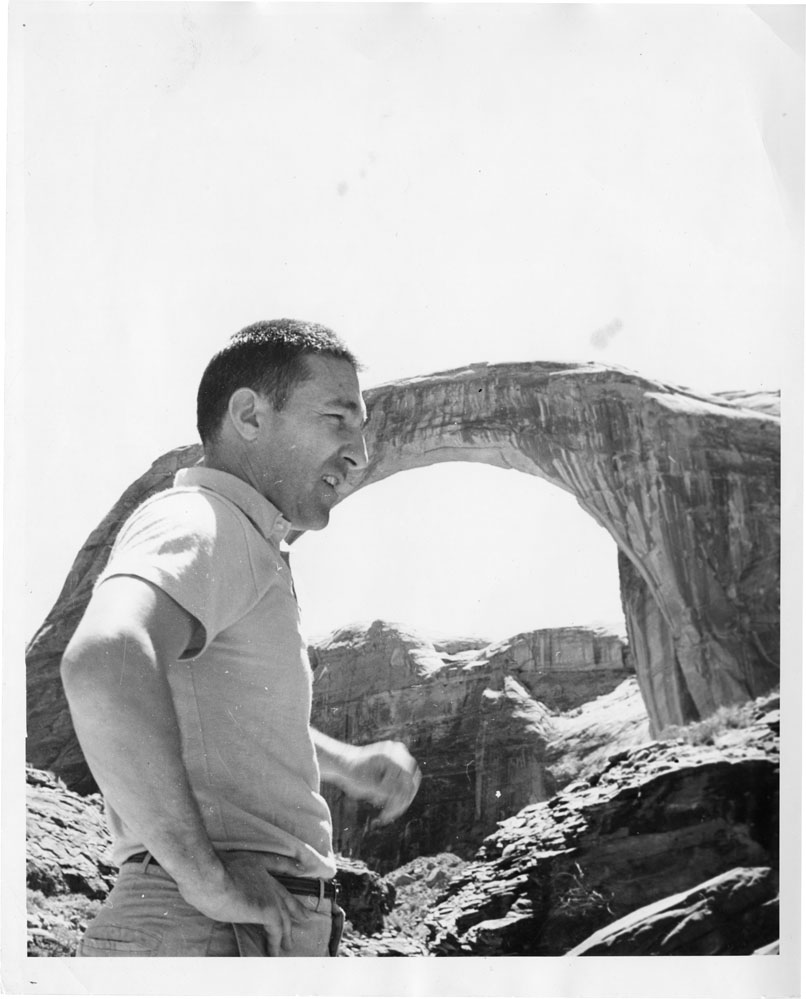
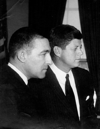
Water and climate scientist Brad Udall speaks at the annual Colorado Law Conference on Natural Resources at the University of Colorado Boulder last week. Udall has been one of the loudest voices calling for audacious leadership on issues of climate and the Colorado River. Photo credit: Heather Sackett/Aspen JournalismBrad Udall, senior research scientist at Colorado State University’s Colorado Water Institute and co-author of the “Thinking About Risk” report on “black swan” events in the Colorado River Basin. Source: Water Education FoundationStewart Udall stands at Rainbow bridge, one of the world’s largest known natural bridges, in Utah.
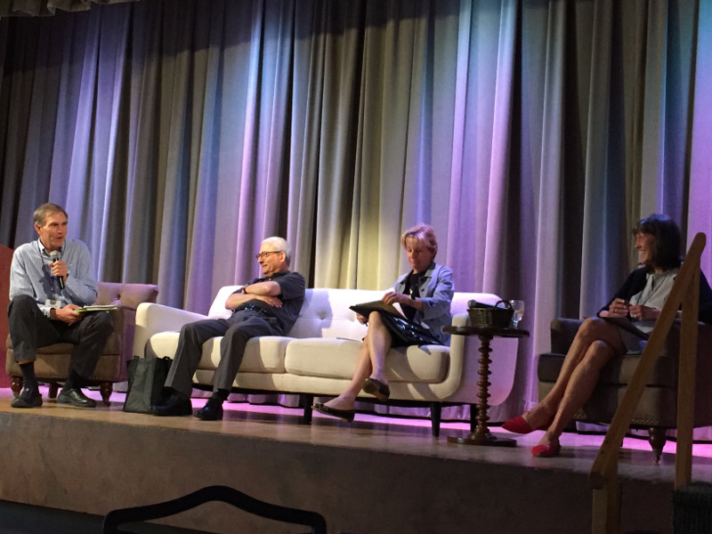
Courtesy of the Udall familyCarbondale’s Randy Udall conferred with Gov. Bill Ritter during the 2009 Association for the Study of Peak Oil conference. Udall, who died in 2013, was a beloved and influential participant in CRES during its early days, with his essays and analysis of energy topics even more relevant and insightful today. Photo/Paul TrantowBrad Udall’s panel at Shed ’17. From left, Brad Udall, Sam Mamet, Martha Rudolph, Maggie Fox.Senior water and climate research scientist at Colorado State University and one of the authors of the National Climate Assessment. Photo credit: Colorado State University Water InstituteStewart Udall and John Kennedy.
Aquatic Biologist Jon Ewert stocks Trojan Male brook trout into Bobtail Creek during a historic stocking event in the headwaters of the Colorado River basin. Photo credit: Colorado Parks & Wildlife
On Tuesday, Sept. 17, in an effort to restore native cutthroat populations in the headwaters of the Williams Fork River, Colorado Parks and Wildlife stocked 480 Trojan male or YY brook trout into Bobtail and Steelman creeks.
“This is a pretty historic moment for Colorado and native cutthroat trout restoration across the state,” said CPW Aquatic Biologist Jon Ewert. “This is a combination of both the hard work and dedication of CPW biologists current and retired.”
“This is yet another example of the groundbreaking work done by CPW biologists and researchers to preserve native species,” said George Schisler, CPW Aquatics Research Section Chief. “While Bobtail and Steelman creeks are the first to be stocked with YY brook trout, they will not be the last. This is just the first of many for Colorado.”
In 2010, an alarming number of non-native brook trout were discovered after completing a fish survey in the headwaters of the Williams Fork River. While it is unknown when brook trout invaded these creeks, it was evident the thriving brook trout had nearly decimated the native cutthroat population over time.
Cutthroat trout found within these two creeks are some of the highest-valued native cutthroat populations in the headwaters of the Colorado River basin. Considered a species of special concern in Colorado, this subspecies of trout is genetically pure and naturally reproducing.
“In 2011 we found 123 cutthroat trout combined in both creeks. Today, after 13 years of hard work by dedicated biologists we are seeing a little more than 1,400 cutthroats in these creeks,” said Ewert.
Trojan male brook trout are often called YY because they have two Y chromosomes, unlike wild males with an X and Y chromosome. These trout are stocked into wild brook trout populations and reproduce with the wild fish, producing only male offspring. Without a reproducing population (male and female fish), the brook trout will eventually die out, allowing for native cutthroat trout to be restored.
Colorado Parks and Wildlife will continue to stock both streams with YY brook trout over the next several years to sustain the number of Trojan males in the population, eliminating the production of female brook trout in the creeks.
To learn more about Trojan male brook trout and cutthroat trout restoration project in the Upper Williams Fork drainage, read our latest Colorado Outdoors Online Magazine article.
Taylor Park Dam. Photo credit: Allen Best/Big Pivots
Click the link to read the article on the Big Pivots website (Allen Best):
September 25, 2024
When work was completed on Colorado’s Taylor Park Dam in 1937, at least some thought existed that it would eventually be modified to produce electricity.
In 2024, it is finally happening. The first commercial power production has or will very soon happen in the first days of autumn.
The new 500-kilowatt hydroelectric turbine and generator installed in the dam will operate at or near full capacity 24/7/365. It is projected to produce an average 3.8 million kilowatt-hours annually. That compares to a 2.5-megawatt fixed-til solar array.
The electricity will get used by Gunnison County Electric Association. Mike McBride, the manager, says the electricity delivered will immediately save the cooperative money compared to the power delivered by Tri-State Generation and Transmission.
Under its contract with Tri-State, Gunnison County Electric can generate up to 5% of its own power. This hydroelectric facility will get it to 3%. The association is working to gain the other 2% from local solar array developments, one near Crested Butte and the other near Gunnison.
The Taylor River originates on the west side of Cottonwood Pass in the Sawatch Range. The road across the pass connects Buena Vista and Crested Butte and Gunnison. After being impounded by the dam that creates Taylor Park Reservoir, the river descends to meet the East River, which originates near Crested Butte. Together they become the Gunnison River.
Grand opening of the Gunnison Tunnel in Colorado 1909. Photo credit USBR.
The 206-foot-high earthen dam is owned by the U.S. Bureau of Reclamation but operated by the Uncompahgre Valley Water Users Association, which delivers water to the Montrose and Delta area via [the Gunnison Tunnel].
In 2020, that water association joined with the Gunnison County Electric Association to form a legal entity to finance the $3.6 million project.
George Sibley, a historian of all things water in the Gunnison Basin (and beyond), said the dam was originally intended for storing water for July through September.
In the 1970s that changed in a collaboration of the Bureau, the Uncompahgre water district, and Upper Gunnison Regional Water Conservation District. That collaboration allowed them to store water from Taylor in Blue Mesa Reservoir. This allowed water to be released continuously through the year.
“That year-round flow potential made it more possible to think of the Taylor Dam as a possible year-round power source,” he says.
But the coal-burning units at Craig were delivering plenty of cheap power. Only in the last couple of decades have the electrical cooperative started getting pressure from some members and “other cultural entities” to reduce emissions associated with their electricity, he says.
A study was commissioned in 2009 and wrapped up in March 2010. Beyond were more complications — but now success.
In the last two posts here (one of which you got twice, my apology), I’ve been trying to ‘revision’ the Colorado River as the classic desert river that it is. All rivers are composed of runoff – water from precipitation that did not soak into the ground, collecting in streams that ‘run off’ to the next lower watershed. Humid-region rivers receive new water from unused precipitation all the way along their course to the sea, but a river in the arid lands obtains nearly all of its water as runoff from a highland area high enough to force water vapor to condense into precipitation. The resulting runoff from that precipitation then flows down into the arid lands where it receives very little additional moisture and thus starts to diminish through natural processes on its way to the sea – evaporation under the desert sun, riparian vegetation use, absorption into low desert water tables. When the deserts are large enough, and the rivers’ highland water supplies erratic enough, some desert rivers disappear entirely, seasonally if not year round, before they get to the ocean.
As a desert river, the Colorado River divides naturally into a water-producing region in mountains mostly above ~8,000 feet elevation (only about 15 percent of the basin area, mostly in the Southern Rockies), and a much larger water-consuming region of arid lands, both orographic ‘rain-shadow’ deserts and hot subtropical deserts. Because the majority of its surface water comes from snowmelt, the pre-20th-century Colorado River regularly sent an early summer flood of water down into the Gulf of California, but later in the water year, snowpack gone, it probably did not always make it all the way through its jungly delta to the sea. Today, with 35-40 million water users in the Colorado River’s water-consuming region as well as those natural processes, the highly controlled river only makes it (almost) to the ocean in an occasional planned release.
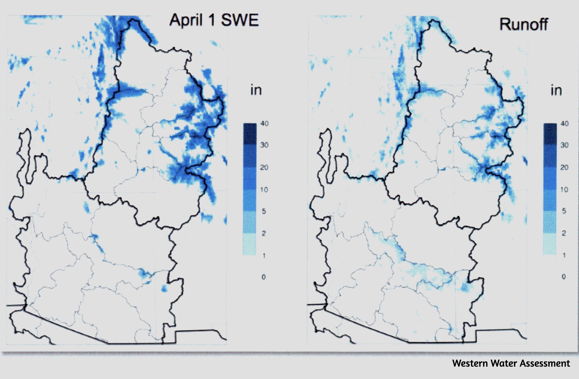
In the last post we began exploring the river’s Headwaters – its water-producing region. To refresh your memory, here’s is the set of maps that, in effect, show the river’s water producing region – the blue areas on the map on the left, which show the average quantities of water (snow water equivalent) held in the peak snowpack, usually late March or early April:
It’s important to note that the water-producing and water-consuming regions of the Colorado River region are not congruent with the Colorado River Compact’s Upper and Lower Basins (above and below the line dividing the area outlined in black). The water-consuming region consists of nearly all of the Lower Basin and most of the Upper Basin – and includes all the trans-basin consumptions via long canals and tunnels).
The river’s actual water-producing region (blue areas inside the black line) is barely a fourth of the Upper Basin and some Lower Basin uplands that produce water for the Gila, Virgin and Little Colorado Rivers. That region is our focus today.
I will begin by suggesting that the 35-40 million of us in the water-consuming region of the Colorado River Basin (plus extensions) should have an investment of at least interest and concern, if not (yet) a fiscal investment, in our river’s water-producing region.
Whoa! What’s that? In addition to doing everything we can to conserve and extend the water we use in our deserts – we arid-land river users have to be involved – maybe eventually financially – with the river’s water-producing Headwaters as well? Why shouldn’t the people that live there take care of that?
One obvious reason is the fact that comparatively very few people live in the Headwaters above 8,000 feet. Nearly all of it is public land, National Forests managed for the ‘multiple uses’ of all the people. But the larger reason for water users in the consumption region to be investing at least attention and political interest in the Headwaters is the fact that we – the 40 million of us consumptive users – are the people with the greatest direct interest in what happens in the mountains. We depend on those Headwaters for 90 percent of our water supply, and our concern ought to be apparent: we want as much water as possible making its way out of water-producing region into the region of consumption, especially as our river’s flow diminishes by the decade.
Because the border between the water-producing region and the water-consuming region is a natural rather than political boundary, it is not really a line at all (like the 8,000-foot contour), but more of a blurry edge zone, an ecotone with varying levels of both water production and consumption in it. In Gunnison where I live, for example, at 7,700 feet elevation, we receive on average just a little over 10 inches of precipitation annually – the upper edge of an arid region that continues down through the Colorado River Basin to the river’s end in the subtropical deserts. But 30 miles up the valley from Gunnison, the town of Crested Butte at 9,000 feet gets around 24 inches a year on average, a water-consuming community up in the water-producing region – and all of the valley floodplains between the two towns that are not yet subdivisions are in irrigated hay fields. This is the ecotone, the edge zone in which the net balance between water production and water consumption gradually shifts, over a mere 30 miles, from mostly production to mostly consumption, as precipitation diminishes to desert levels.
Mining and resort towns above 8,000 feet are, however, pretty minor consumers of precipitation-produced water, compared to consumption by natural forces at work in the area. In the last post we explored some of those natural forces in addressing a mystery posed by the Western Water Assessment’s report on the ‘State of Colorado River Science’: ~170 million acre-feet of precipitation fall on the Colorado River Basin every year on average, but only ~10 percent of that becomes the river’s water supply. What happens to the other 90 percent?
The perpetrators of this loss turn out to be the sun that originally ‘distills’ the freshwater from the salty ocean and the prevailing winds that carry it across a thousand miles of mountain and desert to condense it into a snowpack in the high Rockies. The sun and wind give, and the sun and wind take away – starting immediately after the giving.
The precipitation forced from water vapor in the air by our mountains is barely on the ground before the sun and wind are trying to return it again to vapor. Throughout the main water accumulation period, the winter, sublimation – the conversion of ‘solid water’ directly to water vapor by sun and wind – is eating away at the exposed snowpack every sunny or windy day, even at temperatures well below freezing.
Then once the mountains warm up enough for the snow to melt, the sun and wind evaporate what they can of the water that runs off on the surface, especially where it is pooled up or spread out on the streams’ floodplains. The snowmelt water that sinks into the ground goes into the root zone of all the vegetation on the land – grasses, shrubs, brush and trees – where it is sucked up by the thirsty plants, with most of that being transpired back into the atmosphere as water vapor to cool and humidify the working environment of the plants.
Sublimation, evaporation, transpiration – exactly how much water each of these activities of sun and wind convert back to water vapor is difficult to measure, but the end result is that less than a quarter of the water that falls on the mountains stays in the liquid state as runoff creating the streams that become the river flowing into the desert regions where 35-40 million of us depend on it, and less than five percent of what falls on the water-consuming desert regions augments the river there. The sun and wind give, and take away.
The question arises: are there not some ways in which we might retain or recover some of that lost water? That question may begin to sound like another charge for planet engineering – crystals in the stratosphere to reflect heat away from the planet, et cetera. I am not so ambitious as that.
But we know that the Colorado River has lost as much as 20 percent of its water over the past several decades from a combination of climate warming and drought, and even if the drought ends, we will lose morein the decades to come from the warming of the climate already made inevitable from our ongoing reluctance to do much about it. Scientists estimate that for every Fahrenheit degree of average temperature increase, we will lose 5-7 percent of our surface waters from heat- sublimation, evaporation and transpiration. So is there anything we can do – affordably, and undestructively – down here where the water is, to mitigate that loss, if only partially?
Obviously, the sun and wind rule unchallenged in the highest Headwaters, the treeless alpine tundra. But as one moves down into the treeline – another ecotone with the subalpine spruce-fir forest gradually becoming the dominant ecology over the miniature plants and windbeaten krumholz trees of the tundra. The forest shades the snow that makes it down to the snowpack from the sun, and shelters it from the wind. But the forest also catches a lot of snow on its branches, and that snow is prey to the sublimating sun and wind.
The shading trees also slow how fast the ground snowpack melts; in the deep forest, patches of dirty snow can last into the early fall. A slower melt means a higher ratio of water sinking into the ground over water running off to the 35-40 million of us waiting for it downriver. But the trees of the forest exact a high price for their protective efforts; the water sinking in is sipped up by the roots of all the forest vegetation, and the trees are heavy drinkers, transpiring most of what they drink.
Nearly all of the forests that run a wide belt through the Colorado River Headwaters region – the subalpine spruce-fir forests and the montane pine forests – are, as mentioned earlier, public lands designated National Forests, set aside to protect them.from the Early Anthropocene Age of Plunder. A huge number of them were designated by President Theodore Roosevelt, considered the Father of American Conservation, with forester Gifford Pinchot riding shotgun. Pinchot probably had a hand in crafting the 1897 Organic Act that created the National Forest concept out of scattered federal ‘Forest Reserves’ set aside under earlier legislation, but with no management or legally impowered managers explicit.
The Organic Act was fairly explicit in defining the purpose for creating National Forests:
Recognizing that just setting the land aside with no process for ‘improving and protecting the forest’ was, in the still pretty wild West, equivalent to hanging a sign on the reserve saying ‘Get it while you can, boys, because someday you might be banned,’ the Organic Act also provided for ‘such service as will insure the objects of such reservations’ – which ‘service’ became, under Roosevelt and Pinchot, the U.S. Forest Service.
Note that there are two fairly specific charges in the quotation from the Organic Act: ‘securing favorable conditions of water flows,’ and ‘furnishing a continuous supply of timber.’ Given the circumstances of a nation continually growing and building, with the American dream being a home of one’s own, it goes without saying which of those two tasks the evolving Forest Service has been mandated to prioritize. For much of their history, the Forest Service has been expected to fund themselves with a surplus to the U.S. Treasury through timber sales – always harvesting of course in ways that ‘improve and protect the forest’ (possible, but increasingly improbable when demand grows extreme and supply trudges along at nature’s unhurriable rate).
The charge to secure favorable conditions of water flows, however, has been given much less attention. Pinchot said that ‘the relationship between the forests and the rivers is like the relationship between fathers and sons: no forests, no rivers.’ That is clearly not the case; the forests are not the creators of rivers, they are instead just the first major user of the rivers’ waters; they protect the snowpack and slow the melt for their own needs. Pinchot was right in perceiving a relationship between forests and rivers, but had it backward: ‘No water, no forests’ is more accurate.
One might think, then, that in the Headwaters of the most stressed and overused river in the West, if not the world, the managers of the Headwaters forests might be expending serious effort to make sure that they are securing the most favorable flows possible from their forests.
What I am having trouble discerning is whether the Forest Service is paying any attention at all to any responsibility for a water supply that 35-40 million people are depending on. In my ‘home forest,’ for example, the Gunnison National Forest – now bundled together for management efficiency with two other National Forests as the ‘Grand Mesa Uncompahgre Gunnison National Forests (GMUG): the first draft of a GMUG Forest Management Plan being drafted over the past 2-3 years did not even mention the Colorado River Basin by name as a larger system they are part of, and hugely important to. Response letters from ecofreaks like me (I assume others also wrote them about this) got a paragraph about that larger picture into the final draft – but nowhere in the plan itself did I find explicit discussion of the larger mission that implied and of specific management strategies for making sure that the plan was fulfilling that organic charge of securing favorable – one might say ‘optimal’ – conditions of water flows.
Well – that launches into an exploration of National Forest management policies and activities that I am still trying to muddle through, but that can wait till next month. I’ve gone on long enough here for now, in this effort to peer over the edge of the box we’re all supposed to be trying to think outside of – the ‘Compact Box’ that all the water buffalo are still stalemated over, as we all try to envision river management after the expiration of the Interim Guidelines from 2007. Stay tuned.
This new SNOTEL site near the headwaters of Castle Creek measures snowpack, temperature, soil moisture and other weather data. The city of Aspen will use the data to better understand its water supply. Credit: Heather Sackett/Aspen Journalism
Water managers at the city of Aspen have a new tool to help them better understand and plan for the city’s water supply.
Last week, after four years of planning and permitting, crews from the National Resources Conservation Service installed a new snow telemetry (SNOTEL) site in the headwaters of Castle Creek. Named Castle Peak, the new SNOTEL site is one of the highest in the state at 11,500 feet.
The SNOTEL network is a collection of over 900 automated remote sensing sites in high-elevation, mountainous watersheds across the West. The stations collect data about snowpack depth and water content, air temperature, wind, solar radiation, humidity, precipitation and soil moisture.
This publicly available data provides a real-time snapshot of conditions in Colorado’s high country. It can help avalanche forecast centers know how much new snow is in the backcountry after a storm; soil moisture data can help wildland firefighters know when forests are dangerously dry.
Perhaps most importantly, SNOTEL data helps scientists understand climate change impacts to water supply and predict how much water will be available come spring.
“In the western United States, about 80% of the annual water used in many basins comes from mountain snow,” said Brian Domonkos, NRCS Colorado snow survey supervisor. “That means it’s a resource we can monitor and get an idea of how much water we have in the snowpack and anticipate how much will be melting in the spring for use throughout the summer.”
The city of Aspen staff requested the site just below treeline off of Pearl Pass Road because the city gets the majority of its water from Castle Creek. NRCS agreed it would be a good spot to enhance their network of SNOTEL sites. Aspen paid the $45,000 cost of setting up the site, while NRCS will be responsible for maintaining it going forward.
“Most folks are pretty psyched that we have another piece of data and something that will be more representative of the basin than what we’ve had in the past,” said Steve Hunter, utilities resource manager with the city of Aspen.
Castle Creek flows downstream from the bridge on Midnight Mine Road, just above the city of Aspen’s diversion. Aspen is hoping to get a stream gauge on this stretch of river to better understand its water supply. Credit: Heather Sackett/Aspen Journalism
Site fills a data gap
Aspen water managers previously have used SNOTEL sites on Independence Pass, Schofield Pass, North Lost Trail, Upper Taylor in the Gunnison River basin and sites in the Fryingpan River basin to estimate how much water was in the Castle Creek drainage.
“There was really this big hole, a missing gap in this area,” Hunter said.
In many cases, SNOTEL data can help officials manage their reservoirs, releasing more water to make room for a big spring runoff or holding more back in years with a sparse snowpack. Aspen does not have a big storage bucket; the Leonard Thomas Reservoir it uses to store municipal water only holds about 10 acre-feet. Hunter said Aspen will use the SNOTEL data to make decisions about water conservation and when to enact outdoor watering restrictions.
“It gives us a way to quickly adapt, depending on what we’re seeing up there as far as snowpack,” he said. “I think that’s going to be super helpful.”
Aspen received several letters of support for the project when it was applying for a grant from the U.S. Bureau of Reclamation in 2020, including from Pitkin County, Colorado Water Conservation Board, Roaring Fork Conservancy and Aspen Global Change Institute. While the grant wasn’t funded, it demonstrated strong support for the new SNOTEL site.
“Since all data from these proposed stations will be public, these monitoring sites would benefit both the city of Aspen and other mountain towns and municipalities seeking to better understand potential climate change impacts on water supplies,” reads the letter from AGCI.
The Castle Peak SNOTEL is just one piece of Aspen’s effort to better understand its water supply availability. It’s 2020 Municipal Drought Mitigation and Response Plan says the city would benefit from a stream gauge on Castle Creek above its diversion point to improve monitoring and make drought declaration decisions. The city is still working on the Castle Creek stream gauge.
Along with other governments across the state, Aspen has also funded Airborne Snow Observatories, a company that measures snowpack from the air using LiDAR, a laser technology that can sense snowpack depth across a wide area. Aspen contributed $50,000 to ASO flights in the Roaring Fork watershed this year.
Real-time data from the new SNOTEL site can be found on the NRCS website. The site does not yet have “percent of normal” values since this is its first year of operation.
Cracked mud – memories of Lake Mead’s low stand. Art and photo by L. Heineman.
Click the link to read the article on the InkStain website (John Fleck):
September 29, 2024
Two years ago, when the level of Lake Mead was hovering near elevation 1,040, my artist wife Lissa Heineman and I drove out over UNM’s fall break to see it for ourselves.
Out beyond the old Boulder Harbor, we walked a half mile across mud flats to get to the water. I could look out across the water to see the elbow of the old Southern Nevada Water Authority intake, above the water line. I was gut-punched by the visceral reality.
Lake Mead in the 1,040s, October 2022. Photo credit: John Fleck/InkStain
On the walk back to the car, Lissa carefully picked up some pieces of cracked mud. Her art has always been wrapped up in the conceptual properties of her materials. So she carefully packed up the cracked mud in a box and took it home. It’s been sitting in her studio ever since, and last month she tried firing some of it atop some small ceramic plates in her kiln.
It worked, and she gave me the results to give to my Lower Basin/Lake Mead friends. The texture of the mud, with ripples across the sandy and muddy reservoir bottom, captures a moment in history I hope we never repeat.
So last week, with the Colorado River brain trust in Santa Fe for the Water Education Foundation’s always-fascinating Colorado River symposium, I drove up to see folks and stuck a couple of Lissa’s pieces in my backpack.
I shared them with a message: That was scary. Let’s not go back there again. Please don’t fuck this up.
I’ve got a lot going on – revisions to the new book, teaching my fall semester graduate-level water resources class, nervously eyeing the levels in Lake Powell and Lake Mead, and the gridlock in Colorado River negotiations. So when my brain suggested listening to Rubber Soul Friday night, I was resistant. But we’ve been together for a long time, and I trust my brain’s judgment. So Rubber Soul it was.
What a great album.
This post is lengthy and rambly, so for those who are annoyed by my discursive side trips and just here for the Colorado River stuff, I’ve added anchors to the key material:
Eugene Clyde LaRue measuring the flow in Nankoweap Creek, 1923. Photo credit: USGS
Rubber Soul and my fascination with innovation
When Eric Kuhn and I set out to write Science Be Dammed, the project arose in part out of a mutual fascination with E.C. LaRue, the early 20th century hydrologist who first tried to map out the supply of water, and possible uses of it, across the entire Colorado River Basin. The thing that first drew me to LaRue, long before I knew Eric, was the fundamental innovation of what LaRue and the others working at the time on similar projects were doing. No one had ever tried to envision managing a continental-sized river at the full basin scale.
Rubber Soul
In an entirely different context and framework, it’s a theme Bob Berrens and I take up in our new book Ribbons of Green, about the making of a city.
The first time I remember thinking hard about this was when Lissa, my sister Lisa, and I saw the Hermitage exhibition at the Los Angeles County Museum of Art in 1986. It was a magnificent sweep of early modern painting that had been collected by rich Russians before the revolution. I remember rounding a corner and being gobsmacked by a big Picasso canvas, Three Women, one of the first few cubist paintings that he and George Braque had been making in Paris in 1907-08. Lissa, who understood the history, took me back through the rest of the exhibit to see the roots – the impressionists breaking one way, Matisse another, and Cezanne sweeping them all away with the beginnings of the deconstruction of the picture plane that led to Braque and Picasso.
My own father had been deeply influence by the reverberations of that work, and I had always seen it in Dad’s work, but it wasn’t until Lissa held my hand and walked me through the history that I began thinking about pathways. How does this happen? Once I saw, read, and learned about it once, I became hungry for examples. My intellectual life is now littered with them. I have long since soured on Picasso himself (what an asshole!), but the genre of intellectual journey continues to fascinate.
The most interesting books I’ve read in recent years all document this – Patti Smith’s Just Kids, about the birth of punk and her invention of Patti Smith; Amartya Sen’s memoir Home in the World; Henry Threadgill’s Easily Slip Into Another World (I still can’t grasp the music, but his story of innovation is a joy); Stanley Crouch’s biography of early Charlie Parker, Kansas City Lightning. In each case (three memoirs, one not), the innovation is rooted in a deep understanding of the past and foundations, and then the ability to see, out of that, something entirely new. And all four books are ripping good reads.
I love playing this game with the Beatles, because thanks to streaming services it is possible to dive in and listen to them learning on the fly, to watch the way the bar band Beatles learned how audiences responded to the old things and began envisioning something new.
This is metaphor.
The path to elevation 1,040
As we near the Sept. 30 end of the water year, Lake Mead is at elevation 1,064 feet above sea level, twenty feet above where it was when Lissa picked up the cracked mud two years ago.
In 2021-22, it took one year to drop from the 1,060s to the 1,040s. Could this happen again?
The short answer is probably not in a single year, because of a couple of things that have changed since then. But in two years? Yup. Lissa and I could have a chance to collect more 1,040s cracked mud.
The first thing that has changed since 2022 is the release from Lake Powell. In 2022 the Basin was in the midst of its hair-on-fire crisis management because of fears of Powell dropping dangerously low, so the Powell release that year was just 7 million acre feet. This year, it’s 7.48 million acre feet. So more water coming into Mead.
Things are also better on the outflow side. In 2022, the three Lower Basin States used 6.66 million acre feet. This year, the latest forecast number is 6.09 million acre feet.
Between the higher inflows and lower use, the latest midpoint forecast has Mead ending next year at 1,059 feet above sea level, with Reclamation’s most pessimistic model runs (the “minimum probable”) at ~1,054. But the min probable clearly shows risk out at the edge of what our headlights can illuminate right now, of dropping back into the 1,040s again by the summer of 2026.
The game of chicken on the Colorado River
The “game of chicken” is a game theory classic. It involves a conflict which, in the classic storytelling version, involves two drivers headed toward one another on a collision course. We’ll call them “U” and “L”. Each has the option to swerve or stay on course. The best outcome for each driver is for the other to swerve and lose face (water), while the driver who stays the course demonstrates dominance (keeps its water). But if neither swerves, we end up with a catastrophic collision. In the game theory matrix, it looks like this, with the payoffs for each:
Driver U Swerves
Driver U Stays
Driver L Swerves
(0,0)
(-1,1)
Driver L Stays
(1,-1)
(-10,-10)
I’m obviously talking about the Upper Basin and the Lower Basin here, which are at impasse over the Lower Basin’s proposal to cut deeply up to a point (1.5-ish million acre feet total) and, if any deeper cuts are needed, to share them among the two basins.
The Upper Basin’s counter is basically “no.” If deeper cuts are needed, the Lower Basin should make them.
The payoff matrix, though, is a lot more complicated than my toy example above. First, both sides can gamble on good hydrology, which could avert the crash. So even if the impasse remains, the collision is not a sure thing. (In this regard, it’ll be interesting to see how the players’ strategies shift if we have a really bad winter.)
The second is the nature of the collision itself. No one knows quite what it will look like.
In the classic chicken game, both drivers know about the crash that happens if neither swerves. But part of the risk calculation we all have to live with right now is the uncertainty about what happens if the Upper and Lower Basin states can’t come to an agreement. We also have a situation where the nature of the game is changing over time.
Walking down a Santa Fe sidewalk Wednesday evening after dinner, one of my Colorado River friends observed that both sides seem to think that, if the collision comes, they have a winning legal argument.
If you think that, your understanding of what happens in the bottom right quadrant of the matrix, the crash scenario, is very different.
The Upper Basin seems to have convinced itself, at least based on public pronouncements, that it has a winning legal argument in terms of its obligation, or lack thereof, to send water downstream past Lee Ferry. This seems dangerous to me given my understanding of the history and the law, but it doesn’t matter what I think. The Upper Basin seems happy to keep hammering down the road.
Once deliveries past Lee Ferry drop below one of the “tripwire” triggers (82.5maf / ten years or 75/10), the Lower Basin states have nothing to lose by suing. And when that happens, my community’s water supply is at risk if my basin’s lawyers aren’t right.
Crash!
A few years back Kaveh Madhani and Bora Ristic wrote a paper working out the details of a game theory example that seems to fit what we’re currently seeing in the Lower Basin’s proposal to “own” the 1.5 million acre feet of structure deficit, and to try to negotiate some sort of sharing arrangement if the cuts need to go deeper. This would appear to be what Ristic and Madhani describe as “strategic loss.”
Which seems to model what the Lower Basin has done.
I would prefer to live in the upper left quadrant of the chicken game matrix, where both sides compromise. My values: mindful shared reductions across the basin can leave us all with healthy, thriving communities. I wrote a whole book about this path. But one of my smart friends pointed out something that is a reasonable hypothesis: The model I laid out in that book, written a decade ago, was sufficient on a river that shrinks some, but seems to be failing on a river that has shrunk a lot.
Risti? and Madhani seem to be suggesting a game theoretic path that could get us back on track.
“New plot using the nClimGrid data, which is a better source than PRISM for long-term trends. Of course, the combined reservoir contents increase from last year, but the increase is less than 2011 and looks puny compared to the ‘hole’ in the reservoirs. The blue Loess lines subtly change. Last year those lines ended pointing downwards. This year they end flat-ish. 2023 temps were still above the 20th century average, although close. Another interesting aspect is that the 20C Mean and 21C Mean lines on the individual plots really don’t change much. Finally, the 2023 Natural Flows are almost exactly equal to 2019. (17.678 maf vs 17.672 maf). For all the hoopla about how this was record-setting year, the fact is that this year was significantly less than 2011 (20.159 maf) and no different than 2019” — Brad Udall
In 1998, when I was in fourth grade, I joined a class field trip to Mesa Verde National Park in Colorado. But when we got to Cortez, the road was barricaded. Hours earlier, three men had stolen a water-tanker truck and killed a police officer before fleeing into the desert.
In his book Dead Run, writer Dan Schultz makes the case that the criminals were inspired by Edward Abbey’s 1975 novel, The Monkey Wrench Gang. The men were survivalists planning to turn the water truck into a mobile bomb, Schultz says. Their probable goal: To pack the tanker truck with explosives and blowup Glen Canyon Dam.
Back then, the idea of draining Lake Powell was a fringe idea, attractive to anti-government extremists and radical environmentalists. Those who advocated a legal decommissioning of the Glen Canyon Dam, including supporters of the Glen Canyon Institute in Salt Lake City, were often laughed out of the room.
In those years, the dam was working as intended. Lake Powell was nearly full in the late ‘90s. Hydropower production was going full tilt, and millions of people were visiting the reservoir annually to fish, houseboat, and water ski.
But since the year 2000, Lake Powell has been in decline. Climate change has reduced runoff throughout the Colorado River Basin by around 20% compared to the previous century. In 2022, the reservoir—the second-largest in the country after Lake Mead—was less than a quarter full.
The back of Glen Canyon Dam circa 1964, not long after the reservoir had begun filling up. Here the water level is above dead pool, meaning water can be released via the river outlets, but it is below minimum power pool, so water cannot yet enter the penstocks to generate electricity. Bureau of Reclamation photo. Annotations: Jonathan P. Thompson
Nearly every boat ramp on Lake Powell was unusable last spring, and there was barely enough water to sustain hydroelectric generation. One more bad snow year would have pushed the Colorado River system to the brink of collapse, dropping the reservoir’s surface toward the lowest outlets on the Glen Canyon Dam—a point known as “dead pool.”
At dead pool, the 27 million people who rely on Colorado River water downstream from the dam would likely be forced to reduce water use quickly and involuntarily.
But Lake Powell would still stretch 100 miles into Glen Canyon at dead pool.
That’s because there is a significant design flaw in the dam: There is no drain at the bottom. Billions of gallons of water would be trapped in the dead-pool reservoir with no easy way to release them into the Grand Canyon.
Luckily, that catastrophic scenario didn’t play out in 2023 thanks to a near-record snow year that brought Lake Powell to around 40% full. After another decent runoff this spring, the reservoir level held steady.
Twenty-four years of low levels in Lake Powell haven’t been all bad, either. Over 100,000 acres of land that were once flooded had been exposed by early 2023, including countless cultural sites sacred to Indigenous people. Along Glen Canyon’s tributaries, whole ecosystems have sprung back to life, biologically diverse and dominated by native species. Ecologists have been surprised by just how healthy the reemerging landscape is, despite spending decades underwater.
This 2023 diagram shows the tubes through which Lake Powell’s fish can pass through to the section of the Colorado River that flows through the Grand Canyon. Credit: USGS and Reclamation 2023
The Bureau of Reclamation has been studying potential modifications to the Glen Canyon Dam, including the drilling of tunnels at or near river level that would allow Lake Powell to be emptied if necessary. Until those modifications are made, however, the potential for a crisis—caused in part by the current dam design—remains as real as ever. Two back-to-back years of severe drought, such as we’ve seen several times since 2000, would halt hydropower production at the dam and bring us dangerously close to dead pool.
Allowing the Colorado River to flow freely through Glen Canyon was a radical idea in the 1990s, but the opposite is true today. Climate change and steady water demand in the Southwest have shown us that the Glen Canyon Dam, instead of being a boon to water users, is part of the problem. Modifying the dam would give water managers greater flexibility in dry years, and it would allow Glen Canyon to continue its ecological rebirth. Since dam modifications would likely take several years to complete, there is no time to waste.
Zak Podmore. Photo credit: Writers on the Range
The extremists today are those who deny climate change, assuming that Lake Powell will refill again soon. In a rapidly warming world, business as usual should be treated as the fringe position. [ed. emphasis mine]
Zak Podmore is a contributor to Writers on the Range, writersontherange.org, an independent nonprofit dedicated to spurring lively debate about Western issues. He is a Utah-based journalist and the author of Life After Dead Pool: Lake Powell’s Last Days and the Rebirth of the Colorado River, published by Torrey House Press in August.
The Salton Sea (pictured above ) straddles the Imperial and Coachella valleys and has long been a sticking point in Colorado River deals. But the federal government recently committed up to $250 million for restoration efforts at the sea. (Source: Water Education Foundation)
Click the link to read the article on the InkStain website (John Fleck):
Imperial’s projected 2.2 million acre foot take on the Colorado River in 2024 is on track to be the lowest on record, with data going back to 1941.
California’s total projected main stem withdrawals are again under 4 million acre feet, the lowest they’ve been since the 1950s. Arizona’s main stem withdrawals remain under 2 million of their nominal 2.8 maf allocation for the second year in a row, basically the lowest they’ve been since the Central Arizona Project was built. Nevada is once again hovering around 200,000 acre feet of its 300,000 acre foot allocation.
Taken together, water use by the three lower basin states is currently on track to be the lowest since detailed record keeping began in 1964.
A note on the data
The Bureau of Reclamation has complete reported data back to 1964, when the modern accounting system was established as a result of the Supreme Court’s Arizona v. California decree. I have stitched that data together with a separate dataset that pushes California records back into the 1940s, assembled some years ago by the Metropolitan Water District of Southern California and kindly shared with me. For my current version of the dataset, I extend a huge thanks to Sami Guetz, who spent time QA’ing it as part of her masters project at UC San Diego.
“New plot using the nClimGrid data, which is a better source than PRISM for long-term trends. Of course, the combined reservoir contents increase from last year, but the increase is less than 2011 and looks puny compared to the ‘hole’ in the reservoirs. The blue Loess lines subtly change. Last year those lines ended pointing downwards. This year they end flat-ish. 2023 temps were still above the 20th century average, although close. Another interesting aspect is that the 20C Mean and 21C Mean lines on the individual plots really don’t change much. Finally, the 2023 Natural Flows are almost exactly equal to 2019. (17.678 maf vs 17.672 maf). For all the hoopla about how this was record-setting year, the fact is that this year was significantly less than 2011 (20.159 maf) and no different than 2019” — Brad Udall
Silly me. Silly, silly me. And that goes for all of those federal and state officials who have been wringing their hands and gnashing their teeth over the West’s water situation, trying to find some way to keep the region from drying up as the Colorado River shrinks. When all along, the answer was staring us all right in the face: We just had to turn on the big faucet. You know, the big one up there somewhere that collects all the water from the snowcaps that climate change is melting. I think?
Former President Donald Trump unveiled this solution in an address in California. Seriously. You can watch it yourself on this YouTube clip Jeff Tiedrich put up on his newsletter:
And just in case the link doesn’t work or something, here’s the transcript (with punctuation added by me where it seemed to fit):
I had to watch the clip several times, and search around for the context, to make sure I wasn’t missing a lead-in or punchline to the joke. I wasn’t. He was serious.
As much as my snarky side would like to draw this whole thing out for humor’s sake, none of us have time for that. So I’m going to end the suspense: There is no faucet. There is no pipeline, canal, or other infrastructure in place that could move that water southward. And all that gibberish about the Department of Commerce, Gov. Newsom, and 30 gallons per day is nonsense. Maybe Trump believes in the Giant Faucet. Or maybe he just thinks the people listening to him are dumb enough to believe it and vote for him so that he can get someone to go up there and turn the big-as-a-wall faucet and turn California’s brittle forests into lush oases.
There are those who will get mad because I’m being too partisan by beating up on Trump. Believe me, if a Democrat said something this silly I’d be even more scathing in my response. Others will say I should just laugh it off; you can’t take anything the guy says seriously. Which is true. And yet, if Trump is elected, he or someone he appoints will be in charge of big water-related decisions. What are they going to tell him when he orders them to turn on the Giant Faucet?
As I Googled around on this one, it was interesting to see the lengths to which various water experts — especially those friendly ones from Canada — went to explain what Trump might have been talking about. Sure, there’s no faucet, but there have been proposals to ship water from the Columbia River southward — proposals that will never come to pass, because they would cost trillions of dollars and would involve a war with Canada. That’s probably what he was talking about. (It was called the North American Water and Power Alliance. Michelle Nijhuis wrote a fascinating history of the scheme in now-defunct Buzzfeed, which is preserved on the Wayback Machine).
I doubt it. More likely, he was just pulling a random assemblage of concepts out of his a&%. Maybe it’s best to just laugh it off as the ravings of a lunatic in cognitive decline, like all the talk of sharks and batteries and Hannibal Lecter. Thing is, even if it is crazy, it does come from — and reinforce — a common misconception that we can build our way out of the water crisis. It is the tragic Myth of More: If we just add a few more dams, diversions, and canals; if we just shoot some more silver iodide into the clouds; if we could just find some great big person to turn that Giant Faucet, everything will be fine.
Desalination is one of those infrastructure ideas that has long-been held up as an easy solution to the West’s water problems, but which has never caught on because of the crazy expense, energy-intensity, and the environmental impact of sucking water out of the ocean and disposing of the leftover brine. But Hannah Ritchie, at her Sustainability by the Numbers Substack, gives the technology another look. She finds that the technology has evolved, bringing energy use and operating costs down. A U.S. household would use less energy to desalinate all of its water than it does to heat the same water or to heat or cool the home. And it would end up costing the average American household about $154 per year. Not nothing, but not terrible, either.
If all irrigation of alfalfa and hay was stopped, it would put more than 6 million acre-feet of water back into the Colorado River system. But it would also wreak havoc — and conflict with the law and values. Credit: Jonathan P. Thompson/The Land Desk
So can we solve the Colorado River shortage by desalinating seawater? Probably not. In theory, municipalities near the coasts could get most of their water from desalination. They could even pump and pipe that water further inland (which requires energy, and therefore increases cost). But relying on desalination for agricultural irrigation would be prohibitively expensive due to the huge volumes of water needed for crops. And, as you’ve read here before, agriculture takes up the lion’s share of the Colorado River.
***
📈 Data Dump 📊
I’ve had a lot of charts on here showing how many drilling permits the Biden administration has issued vs. other administrations. It’s more than some, less than some. But perhaps more important over the long-term is how much new land is leased to oil and gas companies. And by that measure, Biden is way ahead — or behind — of everyone else, depending on your point of view. He’s leased out a record-low amount of land. The totals aren’t yet in for fiscal year 2024 (which ends at the end of this month), but I’m fairly sure they’ll look more or less the same as 2022 and 2023.
Click the link to read the article on the Pagosa Springs Sun website (Danyelle Leentjes). Here’s an excerpt:
September 30, 2024
The Upper San Juan Watershed Enhancement Partnership (WEP) is inviting the public to attend a presen- tation and Q-and-A of the 60 percent designs of the Pagosa Gateway River Project on Oct. 10 from 5:30 to 7 p.m. at the Ross Aragon Community Center.
The public can also view and make comments on the designs on mypa- gosa.org.
The Pagosa Gateway Project is a vital restoration endeavor targeting approximately 2 miles of the San Juan River upstream of the Town of Pagosa Springs. A recent environmental and rec- reational water supply needs assess- ment, commissioned by the WEP, identified potentially significant changes in hydrology and limiting conditions for aquatic life in this sec- tion of the San Juan River. Assessment results suggest late summer and fall flows may restrict the availability and quality of aquatic habitat for fish and other aquatic species, as well as the number of days in a year when recreational craft can successfully navigate this segment of the San Juan mainstem.
The decrease in reservoir storage following the 2024 inflow season has been thankfully modest, but not as favorable as it was at this time last year. Perseverance reducing consumptive uses and losses is needed for reliability and security in the water supply and to regain reservoir storage.
Between mid-April and early July 2024, reservoir storage in the Colorado River basin increased by 2.45 million acre feet (af). Now we are in the nine-month period of progressive decline as reservoir storage supports consumptive uses and losses throughout the basin until the 2025 spring snowmelt season begins. As of 1 September 2024 basin reservoir storage was 28.9 million af, and the combined storage in Lake Mead and Lake Powell was 18.0 million af. Those amounts are similar to conditions from spring 2021 when media outlets began reporting on the emergence of a water crisis. That crisis continues.
It is useful to monitor changes in basin reservoir storage because it is the “bank account” from which we can make withdrawals during dry years. Basin water managers have little control over each year’s watershed runoff, but they have a continuing ability to reduce water consumption.
Basin water managers have a long way to go to replenish reservoir storage to amounts that ensure a secure and reliable water supply. Today’s water in the basin’s reservoirs is slightly more than a two-year supply, based on the average rate of water consumption and losses[1] in the basin. It remains in a precarious state should a string of very dry years occur, as was the case between 2002 and 2004 and between 2020 and 2022.
Although the ultimate cause of the ongoing crisis in water supply is a declining watershed runoff associated with a warming climate, the proximate cause is the inability to reduce consumptive uses to match the declining supply[2]. John Fleck summarized recent progress in reducing Lower Basin water use[3]— that is the kind of progress needed throughout the basin.
Where We Stand Today
Figure 1 is a reminder that present reservoir storage remains low in relation to conditions throughout the 21st century. Today, 62% of total basin storage is in Lake Mead and Lake Powell, 30% of storage is in reservoirs upstream from Lake Powell, and 8% of storage is in Lake Mohave and Lake Havasu. Storage in reservoirs upstream from Lake Powell increases during each year’s snowmelt season, and subsequently decreases to sustain consumptive uses. Storage in Lake Mohave and Lake Havasu change little. The big changes in the basin are mostly due to changes in storage in Lake Mead and Lake Powell.
Figure 1. Graph showing reservoir storage in the Colorado River basin between 1 January 1999 and 31 August 2024.
The water supply in Lake Mead and Lake Powell, as well as Lake Mohave and Lake Havasu, supports water use in the Lower Basin and in Mexico. Lake Powell is downstream from virtually all Upper Basin water use. Essentially, Lake Powell and Lake Mead are one reservoir, separated into two parts by the Grand Canyon. Nevertheless, Lake Mead and Lake Powell are operated differently, as is evident in Figure 2. In spring and early summer, snowmelt runoff is captured in Lake Powell, and storage increases there even though storage at the same time decreases in Lake Mead in some years. Once the snowmelt season ends, water is transferred to Lake Mead, and Lake Powell storage slowly declines. Figure 2 demonstrates that changes in water storage in Lake Mead occur over longer cycles than do the annual cycles of storage change that occur in Lake Powell. Because of the different operating rules of the two reservoirs, basin water storage conditions are better reflected by the combined storage contents of the two reservoirs rather than conditions in either Lake Mead or Lake Powell.
Figure 2. Graph showing reservoir storage in different parts of the Colorado River basin since 1 January 2021.Note that water storage in Lake Powell increased greatly during the 2023 inflow season, declined thereafter until the beginning of the 2024 inflow season, increased again in spring 2024, and is now declining.
Despite the modest inflow season of 2024 when unregulated inflow to Lake Powell was only 83% of average, reservoir storage increased by 300,000 af, because losses from the basin’s reservoirs between mid-July 2023 and early April 2024 were less than the gains in storage that occurred in spring 2024[4]. The total decrease in storage between mid-July 2023 and early April 2024 was the smallest in the past decade and was primarily due to reduced consumptive uses in the Lower Basin.
One way to keep track of the loss in reservoir storage due to consumptive uses and losses is to monitor changes in storage that occur after the early summer peak occurs, as is depicted in Figure 3. For example, the dark blue line in Figure 3 was computed by subtracting the total basin reservoir storage on each day from the peak value of 30.0 million af that occurred on 6 July 2024. On 31 August 2024, total basin storage of 28.8 million af was 1.12 million af less than the early July peak. This amount of loss is midway in the range of reservoir loss that has occurred during the past decade. Reservoir storage declined little following inflow in 2017 (2017-2018); 2019 (2019-2020); and 2023 (2023-2024). Storage declined by large amounts following inflow in 2018 (2018-2019); 2020 (2020-2021); and 2021 (2021-2022). These data demonstrate that the current rate of decrease in reservoir storage has been “average” for the last decade but is much greater than the remarkably small rate of loss last year.
Figure 3. Graph showing the decrease in total basin reservoir storage in 2024 (2024-2025) following the early summer peak, compared with the decrease in some other years of the past decade. Loss in reservoir storage was greatest following the 2020 inflow season (2020-2021) and least following the 2023 inflow season (2023-2024). This year’s loss is midway between those extremes.
The rate of decrease in the combined contents of Lake Mead and Lake Powell since early July 2024 has been comparable to the loss in other years of small decline, as is evident in Figure 4. It is especially encouraging that storage in Mead and Powell greatly slowed since mid-August.
Figure 4. Graph showing the decrease in the combined contents of Lake Mead and Lake Powell following peak storage of 18.5 million af that occurred on 8 July 2024, compared with the decrease in some other years of the past decade. Loss in reservoir storage was greatest following the 2020 inflow season (2020-2021) and least following the 2023 inflow season (2023-2024). This year’s loss is similar to years when the loss in combined storage was relatively small.
[1] Basin consumptive uses and losses averaged 13.0 million af/yr for 2021-2023, based on the latest published reports of the Bureau of Reclamation.
[2] Schmidt, J. C., Yackulic, C. B., and Kuhn, E. 2023. The Colorado River water crisis: its origin and the future. WIREs Water 2023;e1672.
[3] Fleck, J. 2024. Imperial Irrigation District’s water use on track for a record low, as is U.S. Lower Basin use. Inkstain, 9 September 2024, https://www.inkstain.net/.
[4] The gain is reservoir storage during the 2024 inflow season was 2.45 million af, and preceding decreases in storage between mid-July 2023 and mid-April 2024 were only 2.15 million af. Thus, inflows in 2024 added 300,000 af to total basin reservoir storage (Schmidt, 2024. The 2024 runoff season comes to an end- how did we do? Center for Colorado River Studies, 17 July 2024, https://qcnr.usu.edu/coloradoriver/).
The challenge, they argue, is the lack of the institutional framework we need to address evolving societal values around the river’s management in a changing world.
Cloud is Vice-Chairman of the Southern Ute Tribe and has become a major voice in the effort to rethink the role of indigenous people in management of the Colorado River. Berggren, now at Western Resource Advocates, is the author of one of the most insightful analyses of Colorado River governance we’ve had in recent years. (I hope that link works for folks, this might also.)
They catalog the remarkable efforts within the last decade or more to create new frameworks for Tribal involvement in Colorado River governance, notably the Ten Tribes Partnership and the Water and Tribes Initiative. Here’s Cloud:
The challenge, as Berggren documented in his thesis, is a set of water management institutions – by “institutions” here I mean the formal rules we wrote to manage water – which are antecedent to the government agencies and political power centers that emerged to carry them out – created to allocate water for municipal and agricultural use.
Because those rules were allocative in nature, the government agencies and political power centers that emerged to carry them out focused almost entirely on carving up the water supply and getting it efficiently to farms and cities. Which worked great, until it didn’t. As the twin challenges of climate change and evolving values emerged, those institutional structures have proven maladaptive.
But it’s a path dependence from which it is hard to dislodge ourselves as new, changing values emerge. These new values (“New” here seems weird, the indigenous communities represent the oldest values! Maybe “newly recognized”?) don’t have a seat at the table.
I don’t know if their proposed solution, is the right one:
But if not this tool, then what should we do instead?
Native America in the Colorado River Basin. Credit: USBR
The U.S. House of Representatives passed a bill sponsored by Utah Republican Rep. John Curtis on Tuesday that includes the Great Salt Lake in the federal government’s Colorado River water conservation plan, possibly freeing up federal funds to help the Beehive State’s beleaguered saline lake.
The Great Salt Lake Stewardship Act tweaks the Central Utah Project Completion Act, which takes water from the Colorado River basin in eastern Utah, and through a system of reservoirs, rivers and pipelines, diverts it to the Wasatch Front where it’s used for municipal and industrial use. The project is described by the Department of Interior as Utah’s “largest and most comprehensive federal water resource development project.”
Now, the secretary of the department can use their budget authority to take water conservation measures “within the Great Salt Lake basin,” according to the bill text.
Curtis says this will give water managers greater flexibility when making conservation decisions regarding the Great Salt Lake, allowing them to take steps to protect “Utah and the West from the economic and public health risks of an ecological disaster.”
“Utahns have worked tirelessly to protect the Great Salt Lake, but persistent drought conditions now threaten its long-term viability. Recognizing the urgency of this issue, the Great Salt Lake Stewardship Act would expand the Colorado River water conservation program to include the lake,” Curtis said in a statement.
The bill was co-sponsored by members of the Utah Delegation, including Republican Reps. Celeste Maloy, Blake Moore and Burgess Owens.
Utah’s Great Salt Lake Commissioner Brian Steed said the bill could have “a huge impact on the lake and its future.”
“It is great to have partners in Congress who recognize these issues and are willing to collaborate to create innovative and effective solutions,” Steed said in a statement.
Water levels at the Great Salt Lake have been in steady decline since peaking in May — currently the south arm of the lake sits at about 4,192.5 feet, with the north arm, separated by a railroad causeway, at about 4,191.8 feet.
That’s a far rosier outlook than years prior, when the lake hit a historic low of 4,188.5 feet in November 2022.
Still, according to the Great Salt Lake Strategic Plan released earlier this year, the lake needs between 471,000 and 1,055,000 acre-feet of additional water delivered each year for it to reach 4,198 feet in elevation, which is considered the “low end” of the healthy range. An acre-foot is almost 326,000 gallons.
Curtis, who has represented Utah’s 3rd Congressional District since 2017, is not running for reelection, instead vying to replace outgoing Utah GOP Sen. Mitt Romney.
The Department of the Interior today marked major progress for the short and long-term health of the Colorado River System. In Santa Fe, New Mexico, Bureau of Reclamation Commissioner Camille Calimlim Touton joined leaders from the Imperial Irrigation District (California), Bard Water District (California), Metropolitan Water District (California) and Gila River Indian Community (Arizona) to sign five water conservation agreements that will leverage funding from President Biden’s Investing in America agenda to help advance water conservation across the West.
Short-term agreements with the Imperial Irrigation District, Bard Water District and Metropolitan Water District are expected to conserve over 717,000 acre-feet of water by 2026. The agreements with the Gila River Indian Community are the first long-term agreements to be signed and have the potential to create system conservation of over 73,000 acre-feet within the next 10 years.
“The Biden-Harris administration is committed to making western communities more resilient to the impacts of climate change,” said Secretary Deb Haaland. “With transformational resources provided through President Biden’s Investing in America agenda, the Interior Department is collaborating with states, Tribes and partners to make smart investments to strengthen the stability and sustainability of the Colorado River System to support the families, farmers and ecosystems that rely on this vital basin.”
“We are proud to announce these agreements that will support the long-term health of the Colorado River System by shoring up elevations,” said Reclamation Commissioner Camille Calimlim Touton. “The agreements with the Imperial Irrigation District and the Bard Water District in partnership with the Metropolitan Water District will contribute a significant amount of system conservation through 2026 and the new agreements with the Gila River Indian Community are the beginning of our long-term investments that will improve the sustainability of our river for generations to come.”
The lifeblood of the American West, the Colorado River Basin provides water for more than 40 million people and fuels hydropower resources in seven U.S. states. It is a crucial resource for 30 Tribal Nations and two states in Mexico and supports 5.5 million acres of agriculture and agricultural communities across the West, in addition to important ecosystems and endangered species. It is currently experiencing the longest and worst drought on record, driven by hotter temperatures under climate change. The Biden-Harris administration is leading a comprehensive effort to make Western communities more resilient to climate change and address the ongoing megadrought across the region, by harnessing the full resources of President Biden’s historic Investing in America agenda.
Short Term Conservation Agreements
Conservation agreements signed today with the Imperial Irrigation District and Bard Water District in partnership with the Metropolitan Water District signify the final short-term agreements signed under “Bucket 1” of the Lower Basin System Conservation and Efficiency Program with funding from the Inflation Reduction Act. The agreement with the Imperial Irrigation District is the largest from the Bucket 1 effort, expected to provide up to 700,000 acre-feet of system conservation water to Lake Mead between 2024-2026 with a total investment of approximately $589.2 million. The agreement with the Bard Water District in partnership with the Metropolitan Water District conserves up to 17,100 acre-feet of water during the same time period at a cost of about $6.8 million. This water will remain in Lake Mead in an effort to benefit the Colorado River System and its users.
Reclamation has now executed 25 agreements that are projected to conserve more than 2.28 million acre-feet of water. The agreements are part of the three million acre-feet of system conservation commitments made by the Lower Basin states.
Long Term Conservation Agreements
An initial $700 million investment from the Inflation Reduction Act was announced in June to support long-term conservation in the system. Today’s agreements with the Gila River Indian Community represent the first agreements signed under this investment. The agreements invest approximately $107 million into three projects with the potential to create system conservation of over 73,000 acre-feet within the next 10 years. Reclamation is also working with Southern Nevada Water Authority, the Metropolitan Water District of Southern California, Coachella Valley Water District, City of Tucson, San Diego County Water Authority, Town of Gilbert, Salt River Valley Water Users’ Association & Salt River Project Agricultural Improvement and Power District and City of Phoenix in the Lower Colorado Basin to negotiate water conservation contracts for up to 10 additional proposed projects.
Overall, the funding for long-term water conservation initiatives in the Lower Basin is expected to save more than 1 million-acre-feet of water, putting the Colorado River Basin on a path to a more resilient and sustainable water future.
Historic Investments to Address the Drought Crisis
President Biden’s Investing in America agenda represents the largest investment in climate resilience in the nation’s history and is providing much-needed resources to enhance the resilience of the West to drought and climate change, including to protect the short- and long-term sustainability of the Colorado River System. Through the Bipartisan Infrastructure Law, Reclamation is investing $8.3 billion over five years for water infrastructure projects, including water purification and reuse, water storage and conveyance, desalination and dam safety. The Inflation Reduction Act is investing an additional $4.6 billion to address the historic drought.
To date, the Department has announced the following investments for Colorado River Basin states, which will yield hundreds of thousands of acre-feet of water savings each year once these projects are complete:
Aging Infrastructure: More than $1.02 billion for infrastructure repairs on water delivery systems in the Colorado River Basin states from the Bipartisan Infrastructure Law, which will preserve ability to deliver water and power benefits to over 40 million people every year in the Colorado River Basin.
Water Storage and Conveyance: More than $648 million in new water storage and conveyance investments in Colorado River Basin states, which will grow the supply of new water or enhance benefits from existing reservoirs within the Basin states.
Water Recycling: $505 million for 26 water recycling projects in the Colorado Basin that are expected to increase annual water capacity by hundreds of thousands of acre-feet annually
Water Conservation: More than $416 million in WaterSMART grants in Colorado River Basin States, which will conserve tens of thousands of acre-feet of water and make Basin water supplies more resilient.
The Town of Palisade is pursuing a federal grant that would help it fund the remediation and regrading of its sewer lagoons and turn a portion of that property into a constructed wetlands for migrating waterfowl. Town Administrator Janet Hawkinson told the Palisade Board of Trustees at its Tuesday meeting that the grant is through the Bureau of Reclamation and could provide several million dollars without requiring a match.
“We are working right now with our town engineers on a cost estimate to look at if it’s $2 million, $3 million or $6 million we’ll request for this grant application,” Hawkinson said.
The town has a grant and loan from the Department of Agriculture to build a pipeline to the Clifton Sanitation District’s wastewater facility for its sewage. Once that is complete the current lagoons will be remediated. Palisade Community Development Director Devan Aziz said the proposed plan would improve water quality, mitigate health hazards and restore habitat in the area of the sewer lagoons. The lagoons are located along the Colorado River just east of Riverbend Park.
“The proposal would be to create a constructed wetlands for migratory waterfowl, as well as removing invasives like tamarisk and Russian olive and enhancing plant biodiversity,” Aziz said. “This project directly addresses drought related habitat loss while fostering environmental regeneration.”
Andy Mueller, general manager of the Colorado River District, speaks at the district’s annual water seminar on Friday, Sept. 20 at Colorado Mesa University in Grand Junction. Colorado River District/Courtesy photo
Water availability on Colorado’s Western Slope is under increasing pressure and uncertainty from climate change, population growth, and ongoing negotiations.
“We’re seeing a shrinking resource, and one trend that is likely to continue to accelerate whether we have more precipitation or not … is the warming temperatures are going to drive less water available for human use,” said Andy Mueller, general manager of the Colorado River District. “The question is: Can we as a society come together and plan for that? We haven’t done a great job of doing that so far, but perhaps we can.”
He posed this question to a room full of water managers, agricultural producers, and elected officials in Grand Junction on Friday, Sept. 20, for the Colorado River District’s annual water seminar. This year’s seminar encouraged attendees to “meet the moment” and to find clarity, solutions, and opportunities amid water insecurity in the West. As the event kicked off, attendees were asked to share the biggest challenge facing water management in their community. Words like “drought,” “scarcity,” “lack,” “quantity,” “politics,” “knowledge,” “climate change,” and “agreement” dominated the responses from attendees…
With these negotiations underway in the basin, conflict is likely unless stakeholders begin working together, planning, and learning from past mistakes and challenges…This collaboration includes bringing more voices to the table, particularly those left out of historic water negotiations. Lorelai Cloud, vice chairman of the Southern Ute Indian Tribal Council and director for the Colorado Water Conservation Board, said the 30 Native American tribes in the Colorado River Basin are 100 years behind on the conversations after being left out of the initial compact negotiations and many of the subsequent discussions.
“New plot using the nClimGrid data, which is a better source than PRISM for long-term trends. Of course, the combined reservoir contents increase from last year, but the increase is less than 2011 and looks puny compared to the ‘hole’ in the reservoirs. The blue Loess lines subtly change. Last year those lines ended pointing downwards. This year they end flat-ish. 2023 temps were still above the 20th century average, although close. Another interesting aspect is that the 20C Mean and 21C Mean lines on the individual plots really don’t change much. Finally, the 2023 Natural Flows are almost exactly equal to 2019. (17.678 maf vs 17.672 maf). For all the hoopla about how this was record-setting year, the fact is that this year was significantly less than 2011 (20.159 maf) and no different than 2019” — Brad Udall
From email from Reclamation (Western Colorado Area Office):
With forecast sufficient flows in the critical habitat reach, the Bureau of Reclamation has scheduled a decrease in the release from Navajo Dam from 700 cubic feet per second (cfs) to 600 cfs for Friday, September 27th, at 4:00 AM.
Next week, on October 1st at 7:30 AM, Reclamation will begin a maintenance project that will necessitate a switch to the 4×4 for the release point. The release may fluctuate slightly during the switch, and the water downstream of the dam may be silty for a day or two following this release point change. The maintenance project will continue throughout October and November.
Releases are made for the authorized purposes of the Navajo Unit, and to attempt to maintain a target base flow through the endangered fish critical habitat reach of the San Juan River (Farmington to Lake Powell). The San Juan River Basin Recovery Implementation Program recommends a target base flow of between 500 cfs and 1,000 cfs through the critical habitat area. The target base flow is calculated as the weekly average of gaged flows throughout the critical habitat area from Farmington to Lake Powell.
This scheduled release change is subject to changes in river flows and weather conditions. If you have any questions, please reply to this message, call 970-385-6560, or visit Reclamation’s Navajo Dam website at https://www.usbr.gov/uc/water/crsp/cs/nvd.html.
Before and after photos show a drastic change to the landscape. Credit: National Forest Foundation
Click the link to read the article on the 9News.com website (Brianna Clark). Here’s an excerpt:
September 17, 2024
Wetlands play a major role in keeping our water clean. Yet, according to the National Forest Foundation, the U.S. has lost more than half of them in the lower 48 states because of infrastructure development and agricultural practices. The Soda Creek Restoration Project hopes to undo some of that loss in Colorado…The project is part of a larger effort to restore 40 acres of wetlands in the White River National Forest, reestablishing nearly 30 acres while rehabilitating another 12.5 acres. The NFF started the project last month and all the work is being done by hand with the help of volunteers. One of several things they’re doing is creating dams to slow down the water allowing it to spread out over the valley. NFF Colorado River Watershed Program Coordinator Adde Sharp said the historic wetland in Summit County was converted into a cabbage farm more than a hundred years ago, causing the area to dry up and the landscape to change. Sharp said turning the area back into a wetland is a big deal because Soda Creek is upstream of Dillon Reservoir, which provides drinking water to the Denver area.
“Wetlands dramatically improve water quality because they’re like sponges or filters that are filtering out sediment and different contaminants in the water, heavy metals, etc.,” said Sharp. “If you live downstream of a wetland- and we all do, there are wetlands upstream of all of us- this is really improving your water quality.”
Local electric cooperative Gunnison County Electric Association (GCEA) has a new way of generating energy for the Gunnison Valley with the recent completion of its Taylor River Hydropower construction project. GCEA and the Uncompahgre Valley Water Users Association (UVWUA) commemorated the completion of the plant’s construction phase last week with a ribbon cutting ceremony, and plan to begin commercial power production around September 20. The $3.6 million project located at the Taylor Park Dam is a partnership between GCEA and the UVWUA. The new 500-kilowatt (kW) hydroelectric turbine and generator at the site will operate at or near full capacity 24 hours a day, year round, to produce an average of 3.8 million kilowatt-hours (kWh) annually. That amount of generation compares to some 2,500 kW (2.5 megawatt) fixed tilt-solar arrays and, according to GCEA strategy execution specialist Matt Feier, will provide clean electricity to approximately 500 local homes and businesses in Gunnison County…Construction on the project began in May 2023, but the hydroelectric vision has been in the works far longer…
GCEA provides the electric infrastructure and UVWUA manages the water flowing through the dam. The plant connects to the existing dam penstock and GCEA’s single-phase distribution line. Feier explained the process: “The new facility draws approximately 65 cubic feet per second of water out of the eastern penstock within the existing valve house. This water is piped to our Frances turbine within the newly constructed metal building at the base of the dam. The turbine spins, which in turn spins the generator and generates an electric current. This energy flows into GCEA’s existing distribution system and down to GCEA’s Alkali substation (located near Jack’s Cabin Cutoff) where it is distributed within GCEA’s service territory. After turning the turbine, the water flows back into the same spilling basin as the Taylor Dam’s main outflow,” he said. “This hydro generator will be a ‘run of the river’ facility and will not affect river flows within the Taylor River.” Feier said the Taylor River Hydro project is a welcome addition to GCEA’s current clean energy portfolio, and it will bump up GCEA’s local renewable energy generation. “This new hydroelectric facility will get us to approximately 3% local generation and we are working to gain the other 2%+ from local solar array developments,” he said.
The Taylor River, jewel of the Gunnison River basin. Photo: Brent Gardner-Smith/Aspen Journalism
View of Shoshone Hydroelectric Plant construction in Glenwood Canyon (Garfield County) Colorado; shows the Colorado River, the dam, sheds, a footbridge, and the workmen’s camp. Creator: McClure, Louis Charles, 1867-1957. Credit: Denver Public Library Digital Collections
The 2024 Annual Water Seminar was hosted by the Colorado River District at Colorado Mesa University. The event featured many big names in the community including John Marshall, Andy Mueller, David Payne, Merrit Linke, Bart Miller, Cleave Simpson, and many more…Their goal was to highlight the challenges the Western Slope faces now and will face in the future. These challenges pertain to the ever-present climate change crisis and bureaucracy…
According to Andy Mueller, the general manager of the Colorado River Water Conservation District, one of those bureaucratic obstacles is an agreement that was signed in the 1920s. This limits our entitlement to around 55% of the flow of the Colorado River. Another issue he tells us is communities in the Lower Basin—areas in California and Arizona—are keen on securing water. And with a growing population on the Front Range, Mueller says there is a heightened emphasis on securing the Shoshone Water Rights. “We are concerned that if we do not lock in the Shoshone Water Rights, we will see more water leave the Colorado River Basin, and there will be less water for the population and environment on the Western Slope.”
The Shoshone Water Plant is expected to have a $99 million price tag and is slated to increase the amount of available water to farmers and consumers. So far, we are told $56 million has been raised.
“New plot using the nClimGrid data, which is a better source than PRISM for long-term trends. Of course, the combined reservoir contents increase from last year, but the increase is less than 2011 and looks puny compared to the ‘hole’ in the reservoirs. The blue Loess lines subtly change. Last year those lines ended pointing downwards. This year they end flat-ish. 2023 temps were still above the 20th century average, although close. Another interesting aspect is that the 20C Mean and 21C Mean lines on the individual plots really don’t change much. Finally, the 2023 Natural Flows are almost exactly equal to 2019. (17.678 maf vs 17.672 maf). For all the hoopla about how this was record-setting year, the fact is that this year was significantly less than 2011 (20.159 maf) and no different than 2019” — Brad Udall
Click the link to read “Climatologist: Warming of state almost certain to continue” on the Grand Junction Daily Sentinel website. Here’s an excerpt:
September 21, 2024
On the heels of Grand Junction’s hottest summer on record, Colorado’s state climatologist advised Friday that the state’s warming trend over recent decades is all but certain to continue in coming ones. Russ Schumacher, also director of the Colorado Climate Center at Colorado State University, said at an event at Colorado Mesa University that temperatures in Colorado and globally have been warming and the projection is for continued warming in the future, “and there is very high confidence in that.”
Colorado statewide annual temperature anomaly (F) with respect to the 1901-2000 average. Graphic credit: Becky Bolinger/Colorado Climate Center
There’s less certainty about what the future holds for precipitation levels in the future in the state, other than that they will continue to be highly variable. But increasing temperatures will have water-related impacts even if precipitation patterns don’t change much, he said during the Colorado River District’s annual water seminar. He said seven of Colorado’s nine warmest years on record, averaged across the state, have occurred since 2012 and the warming trend has been particularly notable in the summer and fall. This year’s climatological summer, from June through August, tied for the sixth-warmest on record in the state, and the nine hottest summers all have been since 2000, he said. The average summer temperature at the Grand Junction Regional Airport this year was the hottest on record, he said…lows in the Colorado River have been declining since 2000. Annual flows at Lees Ferry below Lake Powell averaged 15 million acre feet during the 20th century but have averaged about 12.5 million acre feet since 2000, which has had some very dry years, he said…
The Colorado Climate Center addressed the impacts of climate change in the state in a report it issued in January. It projects that by 2050, under a medium-low carbon emissions scenario, Colorado statewide annual temperatures will warm between 2.5 to 5.5 degrees Fahrenheit compared to a 1971-2000 baseline, and 1 to 4 degrees compared to today.
Shumacher said that although there’s less certainty how climate change will affect precipitation in the state, warmer temperatures along with wind and low humidity result in increased evaporative demand, with dry air pulling moisture from trees, soils, crops and surface waters. That means there are times even when precipitation levels are higher that the water doesn’t go as far. Higher evaporative demand also increases the odds of drought happening and makes droughts more intense…At the Colorado River at Dotsero, peak flows already are declining and there has been about a 25% decline in flows in July and August, he said. Climate projections for the river at Dotsero show increased streamflows in the spring as runoff happens earlier due to earlier snowmelt, but then big declines in flows in July and August, “which is when you really need (water), especially if you don’t have storage,” Schumacher said. The changing climate also is expected to result in a continued trend of more and bigger wildfires, and possibly cause more extreme precipitation and flooding, among other hazards. But Schumacher said it’s important to remember that what is projected to happen in the Colorado Climate Center report isn’t all locked in, as it is a trajectory based on where things are headed now in terms of carbon emissions and the climate policies currently in place.
Audubon supports the Yavapai-Apache Nation’s water rights settlement and pending legislation, the Yavapai-Apache Nation Water Rights Settlement Act of 2024.
The Yavapai-Apache Nation and other parties in Arizona have come to a historic agreement with the settlement now before Congress. Not only will this settlement—when passed by Congress and signed by the President—ensure a reliable and sustainable water supply for the Yavapai-Apache Nation in north central Arizona’s iconic “Verde Valley,” it will preserve the Verde River and its precious habitat by reducing reliance on groundwater.
Healthy mountain meadows and wetlands are characteristic of healthy headwater systems and provide a variety of ecosystem services, or benefits that humans, wildlife, rivers and surrounding ecosystems rely on. The complex of wetlands and connected floodplains found in intact headwater systems can slow runoff and attenuate flood flows, creating better downstream conditions, trapping sediment to improve downstream water quality, and allowing groundwater recharge. These systems can also serve as a fire break and refuge during wildfire, can sequester carbon in the floodplain, and provide essential habitat for wildlife. Graphic by Restoration Design Group, courtesy of American Rivers
Within the Verde Valley, Audubon has identified four Important Bird Areas, all of which rely on healthy groundwater levels to sustain flowing rivers and streams and the rich plant life and wildlife they support. One of the many benefits of this settlement includes helping to sustain a portion of the Verde River downstream of the Yavapai-Apache Nation that was designated as a Wild and Scenic River by Congress in 1984.
The settlement is the result of innovative and creative thinking from the Yavapai-Apache Nation, Salt River Project, the Town of Camp Verde, the Town of Cottonwood, the Town of Clarkdale, and others. The settlement includes building a 60-mile water pipeline from C.C. Cragin Reservoir on the Mogollon Rim, north of Payson, increasing the capture of wastewater into sewer systems, boosting the use of reclaimed water, and the potential for regional water planning and collaboration among nearby municipalities and the Yavapai-Apache Nation.
Audubon Southwest, our regional office in Arizona and New Mexico, is also part of the Water for Arizona Coalition. In 2022, Water for Arizona outlined a vision for how to improve Arizona’s water outlook, called the Arizona Water Security Plan. One of the six key tenets is: Continue to support Tribes in resolving Tribal water issues. This settlement is a key milestone as Arizona works to improve its overall water security.
It is long past due for the Yavapai-Apache Nation to have secure and reliable water supplies, and this settlement is a monumental step forward for their growing community. Bipartisan, bicameral legislation to enact and fund the settlement is sponsored by Arizona’s Senators Kelly (D) and Sinema (I) in the U.S. Senate. Representative Schweikert (R) introduced the U.S. House bill, cosponsored by Representatives Ciscomani (R), Lesko (R), Stanton (D), and Gallego (D).
Audubon supports the passage of the settlement legislation and the provision of approximately $1 billion to ensure the project is brought to completion. As part of our support, we sent a letter to Arizona’s Congressional delegation, which you can view below.
Note: Here’s the second and final part of this little essay/data dump. Yeah, it’s paywalled AGAIN! I know, I know. I’ll be back next week with more good content for you free-riders. In the meantime, consider becoming a paid supporter of the Land Desk and knock down that paywall in the process.
The math and the charts in Part I of this essay are discouraging to many of us because they mess with our value system. There’s just not enough water in the places that we feel should be cut, for moral or practical or aesthetic reasons, to make much of a difference. I mean, sure, halting evaporation from the reservoirs would get you about 2 million acre-feet in cuts. But the only way to do that is to come up with a couple 250-square-mile swimming pool covers — one for Lake Mead and one for Lake Powell. Or you could just take down the dams, but I won’t wade into that one right yet.
The math dictates that the biggest user, irrigated agriculture, is going to have to make the biggest cuts. And the crop that uses the most water? Alfalfa — by a mile. About 6.3 million acre-feet of Colorado River water is consumed to irrigate alfalfa and other hay crops.
If all irrigation of alfalfa and hay was stopped, it would put more than 6 million acre-feet of water back into the Colorado River system. But it would also wreak havoc — and conflict with the law and values. Credit: Jonathan P. Thompson/The Land Desk
This isn’t news to Land Desk readers; I’ve been pointing it out for a long time. And it’s this simple observation, this acknowledgment of the math, that has the Family Farm Alliance demonizing me for supposedly demonizing alfalfa. Apparently those folks would rather we journalists ignore these numbers and fuzzy-up the math, make some insignificant cuts here and there while continuing to send gobs of water to hay fields, and continue drawing down the reservoirs until there’s no savings account left. Then, when we have another year like 2002 or 2021, when there were 10 million acre-feet deficits, the entire region will devolve into chaos. Seems like a bad idea to me.
Alfalfa has a lot of uses: It can be made into pellets for rabbits and other animals, it is a good cover crop that retains soil nutrients, it can be fed to horses, and you can even go down to your health food store and pay a small fortune for some alfalfa extract, which is apparently full of nutrients. But mostly it goes to livestock, especially cattle.
This is state-level data, so includes alfalfa grown with water that’s not from the Colorado River system. But a look at the county level shows similar trends in Colorado River-irrigated areas, especially in Arizona and California. Also note that some alfalfa in Arizona is grown using groundwater, which is not included in Colorado River accounting (although really, it should, since groundwater pumping ultimately affects surface water). Credit: Jonathan P. Thompson/The Land Desk
Over the past five decades, the Colorado River states have grown more and more alfalfa. There are a number of reasons for this. Alfalfa is a valuable crop that is relatively drought tolerant, it can be harvested a couple of times each summer even in cold climates — more than that in southern California — and it’s a perennial, meaning you don’t have to till the soil every year.
But the main driver is demand, and demand is growing because people want more beef, right? Well, yeah, maybe. But — to the chagrin of my vegetarian friends — beef is not the primary culprit, it’s the world’s ever-growing hunger for dairy. Because of the specific nutrients in alfalfa, it is favored by dairy operators: At least 75% of the 3 million tons of alfalfa grown annually in California goes to milk cows. Which is to say that my ice-cream and cheese habit is playing an even bigger role in draining the Colorado River dry than my green-chile hamburger. The growing demand is regional: Over the past several decades there has the astronomical rise in the number of large-scale dairies in the West, especially in California and New Mexico.
Colorado was a big milk state back in the 1930s, then the dairy industry collapsed over time before bouncing back (my grandparents’ small-scale dairy farm outside Durango shut down in the mid-1970s). New Mexico and Arizona, meanwhile, have seen a substantial increase in industrial dairies over the last couple of decades. Credit: Jonathan P. Thompson/The Land Desk
California has more than twice the number of dairy cattle now — more than 1.7 million — than it did fifty years ago. Wyoming is one of the only Western states where beef cattle dominate. Note: Different charts have different scales. Credit: Jonathan P. Thompson/The Land Desk
There’s also been an explosion of demand on the global level, as other nations that once mostly relied on goat or sheep milk have developed a taste for cow’s milk. That has led to a rise in alfalfa exports from Western states — hitting over $1 billion in value in 2022. However, exports still represent a small proportion of total production.
Credit: Jonathan P. Thompson/The Land Desk
Credit: Jonathan P. Thompson/The Land Desk
So, that’s the math. And it seems to suggest the Colorado River’s problems all could be solved if growing alfalfa stopped, right?
Maybe. But I kind of doubt it. This isn’t about a crop. It’s about water consumption.
This is where the law comes in and screws with both the math-oriented and the value-oriented solutions.
I mean, first of all, I doubt that a state or federal decree banning alfalfa growing would fly in the courts unless alfalfa was determined to be an illicit drug or something. And even if you could pull that one off, it wouldn’t accomplish much.
Alfalfa tends to be thirstier than other crops, but not significantly so. It uses such a huge percentage of Colorado River mostly because there’s so much of it and because of its long growing season. That means that if you were to replace all the alfalfa with other crops, you wouldn’t necessarily cut water consumption by that much. Maybe the new crop would use less water, but would the farmers then simply return the surplus water to the river? Not likely. Probably they would just grow more of the new crop and, ultimately, consume the same amount of water.
The only thing that would work is cutting off irrigation to all of those alfalfa fields, no matter what is being grown there. That would certainly be effective, though it would probably lead to a Dust Bowl, would make Ben & Jerry’s ice cream — and a lot of other food products — more expensive, and would wreck economies. And legally? I think not.
Western water law can be distilled down to one sentence: First in time, first in right. It is an almost sacred concept among Western water users, akin to the first lines of the U.S. Constitution or even the Bible.
It means, in the simplest of terms, that whoever appropriates a set amount of water for “beneficial use” first has the most senior rights to it1. When there’s not enough water in the river to fulfill all of the rights, then the senior users can make a “call,” forcing the most junior rights-holders to take the first cuts, and it goes on down the line from there. These rights are usually for a particular ditch or diversion, not an individual user. In the North Fork Valley, for example, the Farmers Ditch has some of the most senior rights, with 1896 appropriation and 1901 adjudication dates; individual property owners own shares of that ditch and the water in it. During dry years, Farmers Ditch is usually among the last to lose water. But if a downstream, more senior user were to put a legitimate call on the river, Farmers Ditch might also be shut down. These water rights are administered state-by-state.
If you have two shares of the Farmers Ditch, then you have no incentive to use less than that. If you conserve, the surplus water will simply keep going down the ditch to the next person. In fact, in most states there’s a “use it or lose it” provision. Though rarely enforced, and revoked in some places, it is still a dominant mindset; I’ve seen property owners pull their full share of water out of the ditch just to let it run down their driveway, perhaps because they just want what’s “theirs,” or maybe because they worry about losing their rights due to non-use.
The largest single water user on the Colorado River, which happens to have some of the most senior water rights, is the Imperial Irrigation District in southern California. They grow a lot of crops, but their primary one is alfalfa. The Colorado River Compact — and a series of compacts and court cases that ensued — adds another layer to all of this by apportioning water between the basins and the states2. Under this set of laws, California and the Imperial Irrigation District are senior, for example, to the Central Arizona Project, which conveys Colorado River water to Phoenix and Tucson.
In theory, the Upper Basin states and Lower Basin states are on an equal footing: Each gets 7.5 million acre-feet of water from the river. Since the Upper Basin uses less than its full allotment, it should be able to continue to use water at its current rate. But there’s one little provision in the Compact that makes that impossible, and that essentially makes the Upper Basin into the junior water rights holders. It reads:
There are conflicting interpretations over the clause, “will not cause … to be depleted.” But for now let’s go with the predominant, historic understanding of the whole sentence, which is that an average of 7.5 million acre-feet must come out of Lake Powell, the Upper Basin’s savings account, and pass Lee Ferry each year to be “delivered” to the Lower Basin’s savings account, i.e. Lake Mead.
This is no problem during an especially wet decade, or even during a dry one when Lake Powell is fairly full. But a string of drought years now, when the savings account has been depleted, could theoretically force the Upper Basin to either violate the provision, or to make some seriously painful cuts to comply.
So if values are trumped by math, and math is trumped by law, how the hell are we supposed to make this all work?
“New plot using the nClimGrid data, which is a better source than PRISM for long-term trends. Of course, the combined reservoir contents increase from last year, but the increase is less than 2011 and looks puny compared to the ‘hole’ in the reservoirs. The blue Loess lines subtly change. Last year those lines ended pointing downwards. This year they end flat-ish. 2023 temps were still above the 20th century average, although close. Another interesting aspect is that the 20C Mean and 21C Mean lines on the individual plots really don’t change much. Finally, the 2023 Natural Flows are almost exactly equal to 2019. (17.678 maf vs 17.672 maf). For all the hoopla about how this was record-setting year, the fact is that this year was significantly less than 2011 (20.159 maf) and no different than 2019” — Brad Udall
All I know for sure is there are no easy answers. We all can eat less cheese and ice cream and beef, we can install low-flow shower-heads and tear out those turf lawns. Cities can limit the size of or ban swimming pools and golf courses, implement tiered and progressive water rates that incentivize efficiency and hit gluttons in the pocketbook, and ban ornamental turf. They can embark on major leak-detecting and repair programs (it’s amazing how much water is lost to leaky pipes). And they can recycle water by treating it and reusing it for, at the very least, irrigation. With today’s treatment technology “toilet-to-tap” is just fine, and is not as gross as it sounds.
Federal and state governments can lease water from farmers for a year or so, paying them to shut off their headgates so the water stays in the river, instead. And they can incentivize folks to put less water on their crops, be it alfalfa or something else. That’s happening in the Imperial Valley, where the federal government is paying farmers some $700 million to stop irrigating alfalfa for 60 days this summer3. The effort is expected to save about 700,000 acre-feet of water, or twice the amount southern Nevada uses each year, through 2026, according to an excellent story by the Desert Sun’s Janet Wilson. Already the effects are being seen, with the IID forecast to pull their lowest amount of water from the Colorado River since 1941, according to John Fleck at his Inkstain blog. That should leave more water for the savings account-reservoirs, and for the river, itself.
As Wilson points out, there are drawbacks to the plan: irrigation runoff from the Imperial Valley fields runs into the Salton Sea. Without as much of it, the waterbody will shrink, exposing an additional 13,000 acres of lakebed, which is bad for the sea and for the air, as it will liberate a lot of pesticide-laden dust that will be picked up by the wind and dropped on nearby communities. The savings are large, but still not large enough. Plus, what happens when the funding runs out?
And, finally, the small ditch companies and farmers, including the ones in the North Fork or McElmo Canyon, are going to have to get more efficient. This will probably mean lining some laterals, piping some ditches, replacing flood irrigation with low-evaporation sprinklers or drip lines, and replacing water-intensive crops with ones that can get by on less irrigation. My question is how can this be done without destroying the distinct, post-irrigation character of these places? Could you leave some leaks to allow water to flow to some of the artificial wetlands? Could you lease water from the guy who allows the ditch to run down his driveway unused and irrigate the cottonwoods, willows, and milkweed? I’d love to hear readers’ ideas on this and, especially, examples of places where efficiency measures have worked to save water — without killing the character.
It’s true that the water saved would likely reach California, eventually, and might even be used to water a lawn or irrigate an alfalfa field. But in the many miles in between the two places, it would also add a little more water to the river for the fish and for boaters and for all of us. Maybe values, math, and Western water law can align.
Pitkin County’s Healthy Rivers Board voted unanimously to approve a $28,000 grant request from the Roaring Fork Valley Wildfire Collaborative to fund a project that will produce a wildfire action plan for the valley’s watershed. The project will identify high-risk areas and potential post-fire hazards in the Roaring Fork Valley’s water systems to create an action plan in the event of a wildfire. Several town and city water sources come from single streams. In the event of a wildfire, ash could contaminate stream water, degrading the quality of the water system, and potentially making it undrinkable, said Roaring Fork Valley Wildfire Collaborative Executive Director Angie Davlyn during her Thursday presentation to the board in Basalt…
While the Roaring Fork Valley is at significant risk for wildfires, a state evaluation also noted the high susceptibility of the Roaring Fork Watershed’s water infrastructure in the event of a wildfire. This leaves residents, property, and natural resources vulnerable to this disaster but also to other post-wildfire hazards, like flooding and mudslides, Davlyn said…Davlyn also said that the region has been pro-active in performing wildfire mitigation tasks, but there is a lack of a data-driven approach to identify the most critical threats and most opportune areas for a wildfire…To bridge this gap, the Wildfire Collaborative applied for funding from several sources, including Pitkin County. Last week, Wildfire Collaborative signed a contract with the Colorado Water Conservation Board for $224,000 and more than $150,000 in technical assistance for this project, which Davlyn said is the first of its kind in this area. These funds, however, require a 25% match before work can begin. The Wildfire Collaborative will provide half of the match through staff time, but the organization needs Pitkin County’s $28,000 to complete the match. Fire Adapted Colorado also awarded $5,000, the town of Carbondale awarded $3,000, Roaring Fork Conservancy awarded $500, Holy Cross Energy awarded $3,000, and other municipalities, counties, and the Colorado River District awarded $5,000. These funds, along with Colorado Water Conservation Board’s $374,000 and Pitkin County’s $28,000, totals $446,500.
Milkweed, sweet peas, and a plethora of other flora billow from Farmer’s Ditch in the North Fork Valley of western Colorado. Jonathan P. Thompson photo.
Note to readers: Sorry this piece is late. I injured my hand in a way that makes typing a bit difficult and that has slowed me down a bit. And to non-paid subscribers: Sorry for the paywall and all, but we gotta pay the bills — and give the paid folks their premium content! If you’re interested, consider knocking down that paywall and accessing all the archives by becoming a paid subscriber!
This spring, I had the pleasure to sit on a panel on water in the West with Paolo Bacigalupi and Heather Hansman, two writers I’ve long admired. During the question & answer period, a local woman lamented the fact that some ditches were being piped or lined with concrete, because it would dry out the wetlands and ecosystems that had come to rely on the leaky laterals and ditches. And she was angry because the point, as she understood it, was to save water only to send it downstream to California. Her beloved valley, it seemed, was being dried out to fill up LA pools, which just seems wrong.
Jonathan P. Thompson, Paolo Bacigalupi, and Heather Hansman on a writer’s panel in Paonia in April, 2024.
I’ve thought about this a lot in the months since, because I think it gets down to the big, conceptual tug-of-war that’s happening around the Colorado River. There’s one battle between the different users of the river’s water. And then there’s another in which the values different communities hold are clashing with the “law of the river” and the overwhelming math that is driving the need to make massive changes.
The following meditation on this clash was catalyzed by a slide a friend sent me from a Family Farm Alliance presentation at the Colorado Water Congress’s summer meeting. It accused me — via a piece I wrote for High Country News — of “demonizing” alfalfa.
Well, Family Farm Alliance, this is my response to you:
VALUES
The woman at the panel was referring to the North Fork Valley in western Colorado, a place with an extensive network of open canals, laterals, and ditches that irrigate peach, apple, and pear orchards, small vineyards, organic farms, and alfalfa fields. A handful of center-pivot sprinkler systems reveal themselves in the geometric perfection of their dependent fields, but most of the farms rely on older methods to bring water to the crops, namely by flooding the field or directing water down dirt rows where they soak into the plants’ roots.
Most of the canals and ditches are unlined and uncovered, and have been that way since they were built over a century ago. Many of them leak, some prolifically, their fugitive water blanketing the beige-gray earth with grass and nourishing cottonwoods, feral apricot and plum trees, sunflowers, willows, cosmos, reeds, sweet peas, milkweed, and cattails — along with a host of fauna that depend on those plants.
The intentional and accidental irrigation combine to form an irregular, pastoral patchwork of relative lushness amid the arid landscape of the kind that can be found in northern New Mexico, where a network of acequias irrigate long, rock-lined fields, or McElmo Canyon, where voluptuous pink sandstone rises up from a sea of emerald alfalfa. These places, where the cultivated and feral and wild collide, evoke the Provence of Jean Giono’s novels.
These are artificial landscapes, colonial ones, even, created by damming rivers and diverting their waters away from the fish and aquatic life in the streams and throwing off the natural balance of things. They rely heavily on inefficiencies in the system, from leaky laterals and ditches to flood-irrigation runoff. But they are, to my eye, lovely nonetheless, and contrast favorably with the more efficient farming areas, where high-tech irrigation systems deliver every drop of water to the linearly planted crops in laser-leveled fields.
Agricultural productivity has grown 20% in the 21st century. Organic corn in Colorado’s North Fork Valley. Photo credit: Allen Best
And yet, because of math and water laws and compacts and the need to devote every drop of the shrinking Colorado River to “beneficial uses,” the character of these landscapes is likely doomed. It won’t happen next month or even next year, but over time. Nor will the lands be dried up altogether: In places like the North Fork the ditches — at least the ones with senior water rights — will continue to deliver water to the fields.
But more and more, those old leaky ditches will be upgraded, lined with concrete or other impermeable materials, or even put into pipes so that all of the water goes to those who hold the rights to that water, not to evaporation or the accidental ecosystems that have sprung up along the ditches’ banks. The farmers, too, may be forced or incentivized to become more efficient, replacing the flood irrigation with sprinklers or drip lines. Some will be paid to not irrigate at all. Most of the open ditches like the ones my cousins and I held stick-boat races in on my grandparents’ Animas Valley farm will be gone, along with the runoff of the kind that spilled from their corn and alfalfa fields to fill the cattail- and willow-tangled slough down below.
It is this loss that the woman in Paonia is mourning. It is heartbreaking. And it’s something I think about every time I write about the Colorado River and the looming crisis it and the communities and industries that rely on it face in the not-so-distant future.
If the crisis could only be solved — and the needed cuts in consumption made — based on our values alone, things would certainly be a lot easier. There would likely be fairly wide agreement that we should fallow the golf courses and drain the swimming pools before drying up the leaky-ditch wetlands and leaving the red-winged blackbird homeless. Farmers might join me in calling for tearing out thirsty turf lawns from Denver to San Diego, implementing progressive water rates to stem gluttony, and putting hard limits on household water use — if it meant keeping the sprinklers flowing to food crops, including alfalfa and other forage. After all, I value cheese and ice cream and green-chile burgers over the Sultan of Brunei or Miriam Adelson, who guzzled 12 million and 10 million gallons of water, respectively, last year to keep their Las Vegas estates green.
Ah, and yes, if all of this could be solved by prioritizing cuts based on values, alone, the Family Farm Alliance would have no reason to accuse me of “demonizing” alfalfa and other livestock forage crops (though I imagine the golf groupies would get me for vilifying them). But, alas, it’s just not that simple. Why? Because even the most lofty values are trumped by the cold, hard math.
MATH
The pertinent numbers in the equation include:
16.5 million acre-feet: Total human-related consumptive use of Colorado River water in 2020. This means all of the water that was withdrawn from the river and not put back into it, including reservoir evaporation. It does not include the 2.8 million acre-feet consumed via riparian and wetland evapotranspiration, nor does it include the 1.7 million acre-feet of water use from the Gila River, a tributary to the Colorado.
14.5 million acre-feet: The Colorado River’s median “natural flow” at the Lee Ferry stream gage, which is the official dividing line between the Upper Basin and Lower Basin, from 1906 through 2023. This is used as a measure of how much water is in the Colorado River, since downstream tributaries are relatively insignificant.
12.4 million acre-feet: The Colorado River’s average natural flow at Lee Ferry from 2000 through 2023.
This leaves us a few options for the big math problem that needs solving:
The optimistic equation (assumes the last 20 years was an anomaly and the river will go back to its old-normal flow soon, i.e. the median for 1906-2023):
14.5 million – 16.5 million = 2 million acre-feet deficit
The new-normal equation (assumes the next few decades will look like the most recent couple of decades — which is to say a megadrought) :
12.4 million – 16.5 million = 4.1 million acre-feet deficit
The pessimistic (realistic?) equation (assumes human-caused climate change will continue to deplete the river):
10.4 million – 16.5 million = 6.1 million acre-feet deficit
Estimated natural flow of the Colorado River at Lee’s Ferry (the dividing line between the Upper Basin and the Lower Basin). The natural flow is basically the total amount of water the river delivers each year, or the volume that would pass by Lee’s Ferry if there were no upstream diversions. Source: USBR.
Which is to say … we’re screwed no matter how you juggle the numbers! Sorry, that’s not very solution-oriented is it? No matter how you cut it, though, the Colorado River budget is running a massive deficit and has been for a while. That’s why Lake Powell, the Upper Basin’s savings account, has been shrinking and now is less than 40% full — even after a couple of decent winters. A couple of consecutive new-normal winters could bring the reservoir down below minimum power pool, shutting down the hydropower turbines and potentially setting the scene for a mega plumbing disaster.
While it’s highly unlikely that the Colorado River’s flows will increase enough to fill Lakes Powell and Mead to capacity anytime soon, it’s not impossible. During the extraordinarily wet and snowy four years between 1983 and 1986, nearly 80 million acre-feet of water ran into Lake Powell — which should be enough to fill both reservoirs and still deliver adequate flows downstream. If it happens, great! It would be foolish and potentially catastrophic to bet on a repeat, however.
That means the users of the river must erase the deficit by cutting anywhere from 2 million to 6 million acre-feet of consumption annually. The big question, and one that the basins and their member states have been debating, is: Where will those cuts come from? I’m not going to get into the many layers of these negotiations here, as that’s not the purpose of this essay, which is a bit of a thought experiment. Suffice it to say it’s complicated, and made more so by glaring errors and injustices committed when the Colorado River Compact was originally crafted.
Let’s say we’re going to make these cuts based on values. Obviously everyone has different values, so we’ll just go with those expressed at the Q&A session I lead this piece with, which can be summed up as prioritizing rural farmland, food crops, and the artificial wetlands that can be found in the North Fork Valley over urban lawns, golf courses, and billionaires’ estates.
Where better to begin than Las Vegas? Let’s pull up some water user data and, holy cow! Look at those numbers. The Vegas resorts and the rich sure know how to use water:
The Venetian and Mandalay Bay resorts each use more than 500 million gallons of water per year. Meanwhile the top residential water users are mostly billionaires: 99 Spanish Gate Dr. — which goes through 12 million gallons per year — was owned by the Sultan of Brunei until tech-giant Jeff Berns purchased the 37,500 sf mansion for $25 million. Other top water gluttons include Miriam Adelson — a top Trump donor — and UFC CEO Dana White. The average Las Vegas household uses about 120,000 gallons per year, though newer, more efficient homes use far less.
When folks start throwing $25 million around for an unfinished house is when you know it’s time for a wealth tax. And when they use 100 times as much water as the average home, it’s also time for a new, progressive water rate structure, that incentivizes conservation and punishes gluttony. Las Vegas already has something like this, but the rates in the upper tiers are too low to be meaningful; they need to be so high that this kind of profligacy will sting even a billionaire’s pocketbook. Hell, better yet, why not just fallow these properties and xeriscape them?
When the numbers are added up, you’ve got:
227,243,000 gallons Top 100 Las Vegas residential water users’ combined consumption in 2023.
3,774,780,000 gallons Top 10 Las Vegas non-residential water users’ combined consumption in 2023.
Wow, so by shutting down just these folks, we could save 4 billion gallons of water, or … 12,275 acre-feet? Oh, that’s not as much as it seemed.
So how about we go to other cities and tear out turf, mandate low-flow appliances, ban lawn watering and swimming pools. I mean, if you could get Scottsdale and St. George residents to cut back to Tucson or Los Angeles per capita water levels, you’d make some more huge cuts.
If Scottsdale’s per-capita consumption were cut to Tucson’s levels it would save about 42 million gallons per year.
You could save millions of gallons through that effort, which is great. The problem is, this problem requires bigger thinking — you’ve got to make multiple cuts in the tens of billions of gallons range for it to make a significant difference. Once again, math, the ultimate buzz killer, raises its ugly head. See, as noble as all of these efforts might be, there just isn’t enough overall water use in the urban sector to come up with all the necessary cuts. You could drain the pools, dry up the lawns, seal up the Bellaggio fountains — hell, even shut off the massive pumps that convey water from Lake Mead to the Las Vegas metro area altogether — and you would still need to come up with at least another 1.6 million acre-feet of cuts. Entirely cutting off all of the Basin’s cities and industrial applications wouldn’t even get you to 4 million acre-feet of cuts. But boy, it sure would be interesting to watch — from afar.
To conclude Part I, some charts that drive the point home:
Irrigated agriculture gulps up about 10.1 million acre-feet per year, accounting for about 52% of the total consumptive use on the Colorado River. Meanwhile the municipal, commercial, industrial sector only uses 3.5 million acre-feet, meaning if you cut off all of the water to every Southwestern city, you still might have a water deficit in the Colorado River Basin. Source: New water accounting reveals why the Colorado River no longer reaches the sea, by Brian Richter et al
The chart on the left shows consumptive use within the Colorado River watershed only, where irrigated agriculture uses about 50% of the water. By contrast, Colorado River water sent over the Continental Divide to Colorado’s Front Range and New Mexico’s Rio Grande watershed is mostly used by cities, with about one-third going to agriculture.
About 59% of the non-exported Lower Basin consumptive use goes to irrigated agriculture. Exports follow the same pattern as in the Upper Basin, with most of the water going to urban use.
SOURCES: New water accounting reveals why the Colorado River no longer reaches the sea, by Brian Richter et al.; Decoupling Urban Water Use from Population Growth in the Colorado River Basin, by Brian Richter; Bureau of Reclamation, Las Vegas Valley Water District, Southern Nevada Water Authority, Zillow.
The San Juan Water Conservancy District (SJWCD), with a grant from the Colorado Water Conservation Board, has released the first of three short educational films regarding the watershed and the future of the water supply in Archuleta County. The video, “The Value of Snow,” will be shown in multiple venues in the county and can also be viewed online via the SJWCD website: sjwcd. org. The SJWCD is organized and funded by the citizens of Archuleta County to be an active leader in all issues affecting the water resources of the Upper San Juan River Basin. In order to enhance the understanding of our limited water resources, the district employed professional filmmaker Christi Bode to produce these films.
All water uses — environmental, agricultural, recreational, industrial and municipal — are important and need to be understood. It is the goal of the SJWCD to use these tools to help our constituents gain knowledge and understanding of the benefits and the risks associated with our watershed and the water it provides. Our community’s economy and our residents’ well-being are directly dependent on the health of our watershed. The risks are many and include drought, wildfires, mass earth movements (landslides), pollution and diversions.
Currently, Colorado’s hunters and anglers have perhaps a once-in-a-lifetime opportunity to protect a wide swath of public lands habitat in southwest Colorado’s Dolores River Canyons region. In April, we joined hunters, anglers, rafters, business owners, and many others from across the state and region in supporting a proposed Dolores River Canyons National Monument…The Dolores River faces threats from industrial scale mining, habitat fragmentation, and unmanaged recreation. Protecting intact habitat for mule deer, elk, and desert bighorn sheep, particularly winter range and movement corridors, is essential for retaining quality sporting opportunities. Now is the time for action. A national monument designation will help everyone better manage the change that is already occurring while also protecting public lands habitat and ensuring future generations of hunters, anglers, and many others experience the area as we have. For additional information see Sportsmen for the Dolores.
Decades of drought and taking more water from the Colorado River than it can afford to give have put both the river and the $1.4 trillion economy it supports in jeopardy. Investing in water resilience is essential for companies operating in the region, but it requires a different approach than many are used to.
A tested and successful model can be found on the Verde River, a Northern Arizona tributary of the Salt River in the Colorado River Basin. The Verde River provides water for local farms and delivers up to 40 percent of in-state surface water for major urban locations in the Phoenix metro area. But its long-term health is at risk from withdrawals, groundwater pumping, a warming climate and drought.
Companies including Boeing, REI, Coca-Cola, Meta, Microsoft, Cox, PepsiCo, Google, Procter & Gamble, EdgeCore and Intel have partnered with groups such as The Nature Conservancy, Friends of the Verde River, National Forest Foundation and the Salt River Project to support dozens of resilience projects over the past decade in the Verde River. The Nature Conservancy (TNC) reports that over the past five years, projects spanning seven irrigation districts have saved nearly 50,000 acre-feet of water. That’s enough to support 100,000 U.S. households for a year.
These projects have focused on creating healthier streams and wetlands, reducing the risk of catastrophic wildfires and increasing the efficiency of water delivery systems. Here are some examples.
Reducing wildfire risk
An overabundance of small shrubs and trees in the Verde River’s forested headwater areas significantly increased the risk of devastating wildfires that would affect communities and regional water supplies and infrastructure. Partnerships that include agencies, nongovernmental organizations and corporate funders have scaled up projects that remove overgrowth and restore healthy forest conditions. This work has reduced fire risk, improved water availability and increased water security for the region. Corporate partners, including EdgeCore, PepsiCo, Apple, Meta and Google, were critical to the success of these projects.
“Meta’s water stewardship efforts include investing in projects that help put in place the enabling conditions for sustainable water management,” said Stefanie Woodward, water stewardship lead at Meta. “We’re proud to support projects that help to restore healthy forest conditions in the Verde and empower environmental nonprofits and communities to build long-term capacity in Arizona.”
Increasing water conservation
Outdated irrigation ditches convey water from the Verde River to farms across the middle Verde watershed. Leakage across many miles of the system increased the amount of water withdrawn from the river and made it difficult to irrigate farmland.
Multiple Verde River irrigation districts partnered with The Nature Conservancy to pipe more than 4 miles of irrigation ditch and improve water management by installing new water control structures. The work has increased water conservation and improved streamflows. Companies participating in the project include Swire Coca-Cola USA, Coca-Cola, Procter & Gamble, Meta, Coors Seltzer, Microsoft, PepsiCo, Advanced Semiconductor Materials (ASM) and Pulliam Trust.
“Together with The Coca-Cola Company, our support of conservation organizations along the Verde River aims to address the critical water challenges facing this vital ecosystem,” said Mike Bernier, director of sustainability at Swire Coca-Cola. “By funding projects like the piping of the Verde Ditch, we’re helping implement a long-term solution to reduce leakage, in turn improving water-efficiency and ensuring the sustainability of this water source for millions downstream.”
Shifting agricultural water demand
Many traditional crops in the Verde Valley are water-intensive and require significant irrigation during summer months when river flows are low. A partnership that includes Sinagua Malt, TNC and local farmers implemented an innovative program that replaced high-water-use crops, such as alfalfa, with barley, which requires less water in the summer season. The project delivered a solution that provides brewers with premium Arizona malt while improving water flows in the Verde River.
Tamarisk
Improving river flows
In addition to conservation and efficiency projects, removing invasive plant species can also improve water flows. Companies and funders including REI, Intel and Forever Our Rivers each funded work to remove invasive Arundo and Tamarisk plants from the middle Verde River and areas near the mouth of the Verde on the Salt River. These plants force out native vegetation and can use water at a higher rate. Removing them has helped restore habitat, improve biodiversity and keep more water flowing in the Verde River.
Setting the stage for success
Ready-to-fund water resilience projects that directly reinforce corporate goals are rare. Understanding the history and context for the Verde River work can help companies replicate success in other areas.
Social stronghold: Most projects in the Verde developed in areas where extensive groundwork had already been done by organizations that would later partner with corporations. Nonprofit groups and agencies spent time building relationships and credibility with landowners, agencies and partners prior to corporate investment. A foundation of social infrastructure was in place, or was positioned to expand.
Takeaway:Consider the need to support essential enabling actions such as planning, project design or outreach. It’s rare that “shovel-ready projects” are lined up in the right places and on the right timeline to perfectly align with corporate goals. Understanding and supporting pre-project strategies, including relationship building, can be essential.
Community relevance: A shared understanding of water challenges and solutions is necessary to achieve progress. There must be an overlap between community, corporate and conservation goals. On the Verde River, an analysis conducted by TNC and others of water issues, challenges and solutions helped identify areas where community interests intersected with corporate and conservation priorities.
Takeaway: Long-term, larger-scale resilience projects require significant community buy-in to succeed. Specific corporate stewardship, volume or replenishment goals should be based on a solid understanding of local priorities and context. This includes current public sentiment as well as the availability, likelihood, cost and timing of projects in a given location.
The long game: Many projects require years of preparation — for example, overhauling and improving centuries-old irrigation ditches that cross many land ownership boundaries required years of trust-building, engineering, problem-solving and fundraising. In the case of the Verde, several philanthropic organizations, including the Walton Family Foundation and the Nina Mason Pulliam Charitable Trust, provided early funding that allowed on-the-ground partners to build trust incrementally and set the stage for later success. It took 5-10 years to fully develop a pipeline of projects that could be funded and linked to corporate goals.
Takeaway: Be realistic and informed about the timeline and partnerships required for success. Corporate timelines should reflect real conditions and needs on the ground.
Setting flexible goals: Goals that rigidly define success metrics can create a scenario in which targets cannot be achieved — or where corporate goals do not address the real issues and concerns of local communities. For example, a narrow, inflexible goal such as “by 2030, our company will support projects that reduce water contaminants by at least 20 percent in all regions where we operate” will make it difficult to adapt to real conditions and needs that reflect evolving water challenges and community priorities across diverse locations.
Takeaway: Invest in multiple projects and set goals that are flexible enough to respond to local conditions, needs and context. Don’t expect a single project or narrow approach to meet both corporate water objectives and relevant regional needs.
A hot summer in Las Vegas pushed water consumption in August to the highest it has been all year, but the 2-year outlook for Lake Mead continues to improve. The U.S. Bureau of Reclamation’s 24-month study, updated each month with projections that guide how dams along the Colorado River are managed, shows continued stability for Lake Mead for the rest of the year and through 2025. Currently, Lake Mead is at 1,063.77 feet, about the same as it has been since mid-June, give or take a foot. Lake levels are expressed as feet above sea level — altitude, not depth. Lake Mead is the nation’s largest reservoir, and it’s currently about 165 feet down from “full pool” level — 1,229 feet. It’s down to a third of its maximum capacity.
A chart shows Lake Mead’s levels from 2019 to present. The lake is currently at 1,063.77 feet.
Southern Nevada used 188,000 acre-feet of water in 2023. That’s far less than the state’s allocation from the Colorado River. So far this year, use is at 157,872 acre-feet.
Utilities Engineer for the City of Aspen Phil Overeynder at the hydroelectric plant at Ruedi Reservoir. Releases from the reservoir in recent years have been too high in the summer and too low in the winter for Aspen to make hydropower efficiently. Credit: Heather Sackett/Aspen Journalism
The city of Aspen wants to add a second turbine and generator unit to its hydroelectric plant at the base of Ruedi Dam, which officials say will allow for more power generation during times of high and low flows.
Officials say an additional turbine, which is estimated to cost about $4.6 million, will restore the plant’s power production capacity to its originally intended 5 megawatts and allow the city to maintain its renewable energy goals. Since 2012, increased releases from Ruedi to benefit downstream endangered fish have meant that late summer and early fall flows are too high for the existing turbine to operate efficiently.
Adding another turbine requires amending Aspen’s license for the Ruedi facility with the Federal Energy Regulatory Commission. According to the city’s draft FERC application for an amendment posted on the Aspen Community Voice website, which officials say they plan on filing by the end of the month, the timing and amount of water released from Ruedi Reservoir has changed since the hydro project began operating in 1986. Power production has diminished in recent years to just 68% of what was originally intended.
Hydroelectric Dam
“After 40 years of reservoir and hydroelectric operations, it is now clear that achieving power output (maximum capacity and energy values) that approximates the original level authorized under the license will require additional generation equipment,” the application reads.
The City of Aspen has a hydroelectric power plant at the base of Ruedi Reservoir, which helps them meet renewable energy goals. Aspen officials want to add a second turbine to make power more efficiently. Credit: Heather Sackett/Aspen Journalism
The facility is most efficient at flows between 100 and 225 cfs. But summer and fall flows are often higher than this range and winter flows often lower. Aspen has no control over how much water is released from the reservoir, which is managed by the U.S. Bureau of Reclamation.
According to the city’s application, gross energy production has declined from an average of 18.5 million kilowatt hours annually from 1986 to 2004 to 15 million kWh over the last decade.
“The equipment is kind of mismatched for what’s going on with those releases,” said Phil Overeynder, utilities engineer for the city of Aspen. “So we’re losing all of that energy above 225 cfs. If we have an additional turbine, we’ll be able to hit the sweet spot for the releases and generate the full amount of energy when it’s available.”
Also, an error in the design of the powerplant introduces air into the water column, reducing the efficiency of the turbine. Because of this flawed design, the hydro plant can’t efficiently make power above about 225 cfs. The city looked at options to fix this problem, Overeynder said, including raising the floor of the building, but the least expensive solution is adding another turbine.
A new turbine would be rated for 1.2 megawatts of production and the original turbine would be downgraded to a 3.8 megawatt capacity, for a total of 5 megawatts — the same as the plant’s current rating, but split between two turbines. During periods of higher releases, about 230 cfs would be routed through the existing turbine and 70 cfs would be routed through the new turbine for about 92% efficiency.
The project would also upgrade the hydro plant so it can be operated remotely, and would let the city continue making hydropower with one turbine if the other one is down for maintenance. The total project cost including the new turbine would be around $8.6 million, according to Overeynder.
“The proposed second turbine at Ruedi, together with other planned actions, will enable Aspen to restore the balanced power supply, which will maintain grid reliability and resiliency while continuing to provide 100% renewable energy,” the application reads.
Ruedi Reservoir on the Fryingpan River is operated by the U.S. Bureau of Reclamation. Releases for the Colorado River Endangered Fish Recovery Program have boosted late summer and fall river flows in recent years. Credit: Heather Sackett/Aspen Journalism
Fish flow
Releases out of Ruedi have changed since the hydro plant began operating, with the reservoir now one of the most important sources of water for the Colorado River Endangered Fish Recovery Program. The program, designed to get water into a chronically de-watered section of the Colorado River near Grand Junction known as the 15-mile reach, has about 15,000 acre-feet of water available most years in Ruedi. Entities that own water in Ruedi such as Garfield County, Caerus Energy, Grand Junction area water provider Ute Water and the Colorado River Water Conservation District have also in recent years leased their water to the recovery program to boost flows beyond the dedicated 15,000 acre-foot pool.
All of the recovery program’s releases are made in July through October, when streamflows naturally are reduced, but irrigation demands in the Grand Valley leave diminished river levels for endangered fish. According to numbers provided by recovery program staff, the Ruedi fish water releases increased from an average of 18,586 acre-feet in the time period from 1998 to 2012, to 20,460 acre-feet in the time period of 2013-2023.
“Ruedi is an essential piece of our ability to manage water for the endangered fish,” said Juile Stahli, director of the Upper Colorado Endangered Fish Recovery Program. “Ruedi has become really critical in helping us affect the ecology downstream.”
According to Tim Miller, a hydrologist with the U.S. Bureau of Reclamation who manages Ruedi, the current reservoir release pattern — higher flows in the late summer and lower flows in the winter — began after 2012 when the water in the reservoir was fully contracted. The owners of this contracted water (like those mentioned above) release it when they need it, and many lease it to the recovery program. Because more contract water is released from Ruedi, Miller said he has to make up that loss to the reservoir by releasing less water over the winter, resulting in low winter flows.
“I can tell you with absolute certainty that since Ruedi has been fully contracted we have released more water for fish augmentation than we did since the program started,” Miller said. “Because we’ve released more contract water, given an average fill, it’s going to take more water to fill the reservoir the next year. So my releases during the winter were lower to recover that.”
According to data from USBR, the average flow out of the reservoir from July to October before the endangered fish recovery program started from 1980 to 1997 was 180 cfs. The average release after the program began in 1998 has been 204 cfs. The number of days releases have exceeded 225 cfs has also been trending upward since the recovery program began.
Aspen’s 100% renewable energy goals
Aspen first achieved its goal of 100% renewable energy in 2015, when a project that retrofit the Ridgway Reservoir dam in the Uncompahgre River basin to generate hydroelectric power came online. The city of Aspen was integral in launching the project, funding a feasibility study in the early 2000s and signing a 10-year contract in 2012 to purchase about 10 million kwh a year from Ridgway once it became available. Ridgway now accounts for about one-seventh of Aspen’s total power portfolio, according to Overeynder. In an effort to continue meeting its 100% renewable goal, the city is also looking to continue and potentially expand its hydroelectric power generation capacity on Maroon Creek.
Aspen has begun the process of relicensing the project with FERC, which is smaller than the Ruedi project and has a capacity of 450 kilowatts. Aspen is also proposing to add additional units on Maroon Creek for a total of 500 kw.
Hydropower, including energy Aspen buys from projects at Ridgway Reservoir and Western Area Power Administration, is supposed to make up about 45% of the city’s energy portfolio. But that percentage has dropped with the declining power production at Ruedi in recent years. The city also buys wind and solar power to achieve 100% renewable energy.
“If we do this (project at Ruedi) plus what we did already at Ridgway and are proposing to do at Maroon Creek, we will get back up to that 45%,” said Justin Forman, Aspen’s Utilities Director. “For us, every megawatt counts and if it’s something local like this, we’re super proud of it and it certainly fits into the values that we have.”
The FERC relicensing process will take several years, with sign-offs also needed from the Colorado Department of Public Health and Environment, the U.S. Army Corps of Engineers and Pitkin County. Overeynder expects the new turbine to be operating sometime in 2027.
The city of Aspen supports Aspen Journalism with a community nonprofit grant. Aspen Journalism is solely responsible for its editorial content.
The U.S. Forest Service has finalized a land exchange with Mt. Emmons Mining Company located in Gunnison and Saguache counties.
Under the agreement, finalized on Aug. 29, the Forest Service exchanged 539 acres of federal land located adjacent to the Keystone Mine for 625 acres of land owned by Mt. Emmons Mining Company located within the Grand Mesa, Uncompahgre and Gunnison National Forests and Rio Grande National Forest.
Iron Fen. Photo credit from report “A Preliminary Evaluation of Seasonal Water Levels Necessary to Sustain Mount Emmons Fen: Grand Mesa, Uncompahgre and Gunnison National Forests,” David J. Cooper, Ph.D, December 2003.
The land exchange allows the Forest Service to improve wildlife habitat and recreation opportunities by reducing private inholdings and creating more contiguous public land. The parcels acquired by the Forest Service include riparian and wet meadow habitats, which are vital to various bird and aquatic species.
Additional benefits of the land exchange include an established Conservation Easement and Mineral Extinguishment Agreement, prohibiting mining and allowing for non-motorized recreation in the future. It allows Mt. Emmons Mining Company to address mining remediation efforts, including water quality and facilitated the transfer of ownership and administration of the Kebler Winter Trailhead to Gunnison County.
“We are pleased to see this momentous exchange finalized,” said Dayle Funka, Gunnison district ranger. “This project was truly a collaborative effort with local non-profits, private landowners and local and federal governments working to benefit future generations. We encountered obstacles throughout the process but found ways to move forward in the spirit of collaboration. As a result of many people’s dedication and perseverance, this land exchange will enhance public access and enable future non-motorized recreational opportunities. I commend the Mt. Emmons Mining Company for their commitment to mining remediation efforts and water quality, while honoring the values of the community.”
Click the link to read the article on The Durango Herald website (Christian Burney). Here’s an excerpt:
September 14, 2024
About 20 people attended the event. They heard the panelists discuss Florida and Animas river trends, how Southwest Colorado’s climate is changing over time and fast facts about where Durango’s water comes from. Pool said Durango’s water comes predominantly from the Florida River and is supplemented by the Animas River. The city uses about 1.5 billion gallons of water per year for all utility use types, he said…He said both the Florida and Animas rivers are trending downward in total water volume; in dry years, groundwater recedes, which affects the total amount of surface water available. But Durango’s water consumption has remained flat despite a growing population, he said.
“Per capita, water use is going down. Total water use is staying pretty flat, with some seasonal fluctuations due to irrigation,” [Marty Pool] said.
While the city uses all the water from the Florida River it has legal rights to every year, it’s not even approaching the maximum usage of water from the Animas River, he said…Durango is lucky in that not all communities have that many second or third water options, he said.
On September 3, 2024 the board of the Pagosa Springs Sanitation General Improve- ment District (PSSGID) voted to move $500,000 from town funds to kick-start critical repairs on its sewer system, pushing off a bigger decision on financing for a larger overhaul of the system. Public Works Director Karl Johnson said that he fears a “catastrophic event” could be in the cards if the district doesn’t do something now to shore up the system.
Town Manager David Harris added, “We need to get moving here … and we need to move sooner rather than later.”
Johnson explained to the board that the biggest project on the district’s radar would be to continue repairing what has been deemed category 4 and 5 problems with sewer pipes, as well as its obligation to upgrade the Vista Treatment Plant, owned and operated by the Pagosa Area Water and Sanitation District (PAWSD), to bring it into compliance with state Regulation 85.
From email from the Reclamation Western Colorado Area Office:
With a wetter weather pattern and increasing forecast flows downstream, the Bureau of Reclamation has scheduled a decrease in the release from Navajo Dam from 800 cubic feet per second (cfs) to 700 cfs for Tuesday, September 17th, at 4:00 AM.
Releases are made for the authorized purposes of the Navajo Unit, and to attempt to maintain a target base flow through the endangered fish critical habitat reach of the San Juan River (Farmington to Lake Powell). The San Juan River Basin Recovery Implementation Program recommends a target base flow of between 500 cfs and 1,000 cfs through the critical habitat area. The target base flow is calculated as the weekly average of gaged flows throughout the critical habitat area from Farmington to Lake Powell.
This scheduled release change is subject to changes in river flows and weather conditions. If you have any questions, please reply to this message, call 970-385-6560, or visit Reclamation’s Navajo Dam website at https://www.usbr.gov/uc/water/crsp/cs/nvd.html.
“New plot using the nClimGrid data, which is a better source than PRISM for long-term trends. Of course, the combined reservoir contents increase from last year, but the increase is less than 2011 and looks puny compared to the ‘hole’ in the reservoirs. The blue Loess lines subtly change. Last year those lines ended pointing downwards. This year they end flat-ish. 2023 temps were still above the 20th century average, although close. Another interesting aspect is that the 20C Mean and 21C Mean lines on the individual plots really don’t change much. Finally, the 2023 Natural Flows are almost exactly equal to 2019. (17.678 maf vs 17.672 maf). For all the hoopla about how this was record-setting year, the fact is that this year was significantly less than 2011 (20.159 maf) and no different than 2019” — Brad Udall
Click the link to read the article on the KUER website (David Condos). Here’s an excerpt:
September 10, 2024
“We will have less water. Forever,” Rice said. “We have to accept that and … it’s up to us to be more efficient.”
That’s why Rice applied for funding from Utah’s Agricultural Water Optimization Program — a big money push to help farmers and ranchers modernize their irrigation. With roughly three-fourths of the state’s water going to agriculture, the situation has put a bullseye on farming when it comes to stretching that H20. Utah is counting on the program — which covers half the cost of buying new, more efficient gear — to save more water for communities, rivers and reservoirs downstream.
As he stood next to a center pivot irrigation system the program helped pay for, Rice reached for one of the dozens of spray nozzles that dangle a few feet over the ground. Compared to the equipment it replaced, he said, the difference is night and day.
“If hundreds of farms can save millions of gallons of water, I mean, we can fix it. … And do I feel like we have a responsibility to do that? Yeah, hell yeah.” — [Andy Rice]
That’s the idea behind Utah’s optimization program. If state money lowers the financial barrier for farmers to upgrade, the water savings might add up to help Utah maximize the little moisture it has…
Rice is just one example of the state’s approved projects, 551 of them and counting, said Program Manager Hannah Freeze, since the program began in 2019. The Utah Legislature has allocated $276 million so far and $108 million has gone to approved projects. A majority of that money is flowing toward the Great Salt Lake — $23 million has been approved for 112 projects in Utah’s Colorado River Basin. It’s a good start, Freeze said, but a drop in the bucket compared to what it might take to significantly improve Utah’s water outlook.
“If we were going to make a real dent or reach the majority of the farmers that we have, it’s more like a $2 billion number.”
Map of the Colorado River drainage basin, created using USGS data. By Shannon1 Creative Commons Attribution-Share Alike 4.0
The Colorado River flows through the Shoshone diversion structure on Jan. 29, 2024. Northern Water, which supplies cities and farms on the Front Range, is asking for more data about how much water will stay on the Western Slope after the Colorado River District purchases rights to the water that flows through Shoshone. Photo credit: Alex Hager/KUNC
Click the link to read the article on the KUNC website (Alex Hager):
September 11, 2024
This story is part of ongoing coverage of the Colorado River, produced by KUNC and supported by the Walton Family Foundation. KUNC is solely responsible for its editorial coverage.
A Front Range water distributor is pushing back on a planned transfer of rights to water from the Colorado River. It has led to a disagreement between two major water agencies — a minor flare-up of longstanding tensions between Eastern Colorado and Western Colorado, which have anxiously monitored each others’ water usage for decades.
Northern Water, which serves cities and farms from Fort Collins to Broomfield, is asking for more data about the future of the Shoshone water right. Meanwhile, the Colorado River District, a powerful taxpayer-funded agency founded to keep water flowing to the cities and farms of Western Colorado, says Northern Water may be attempting to stymie its purchase of the water rights.
In early 2024, The Colorado River District announced it would spend nearly $100 million to buy rights to the water that flows through the Shoshone power plant, near Glenwood Springs. Shoshone’s water right is one of the oldest and biggest in the state, giving it preemptive power over many other rights in Colorado.
Shoshone Falls hydroelectric generation station via USGenWeb
Even in dry times, when water shortages hit other parts of the state, the Shoshone power plant can send water through its turbines. And when that water exits the turbines and re-enters the Colorado River, it keeps flowing for a variety of users downstream.
Since that announcement, the river district has rallied more than $15 million from Western Colorado cities and counties that could stand to benefit from the water right changing hands. Those governments are dishing out taxpayer money in hopes of helping make sure that water stays flowing to their region, even if demand for water goes up in other parts of the state.
The river district plans to leave Shoshone’s water flowing through the Colorado River. It’s an effort to help settle Western Colorado’s long-held anxieties over competition with the water needs of the Front Range, where fast-growing cities and suburbs around Denver need more water to keep pace with development.
The water right is classified as “non-consumptive,” meaning every drop that enters the power plant is returned to the river. The river district wants to ensure the water that flows into the hydroelectric plant also flows downstream to farmers, fish and homes. The agency plans to buy rights to Shoshone’s water and lease it back to the power company, Xcel Energy, as long as Xcel wants to keep producing hydropower.
Almost all of the $98.5 million for the river district’s purchase of Shoshone’s water will come from public funds. In addition to money from its own coffers and Western Colorado governments, the river district also plans to apply for federal funding to pay for its purchase of Shoshone’s water. It is planning to seek $40 million from the Inflation Reduction Act.
Despite decades-long tensions between water users on the Western Slope and the Front Range, leaders on the East side of the mountains have stayed mostly quiet about the Shoshone transfer.
Bicycling the Colorado National Monument, Grand Valley in the distance via Colorado.com
Northern Water’s recent statements about Shoshone perhaps mark the most notable public pushback to the pending deal. The agency supplies water to Front Range cities such as Loveland and Greeley, as well as farms along the South Platte River all the way to the Nebraska border.
The agency outlined its concerns in a letter to elected representatives, including Colorado Senators Michael Bennet and John Hickenlooper and congresspeople Joe Neguse, Lauren Boebert, Yadira Caraveo and Greg Lopez.
In short, Northern said it supports the concept of the transfer, but wants an independent study of how much water the Colorado River District plans to send down the river each year.
“We want to make sure that we’re all going into this with the same data to make sure that everyone’s interests are being addressed,” said Jeff Stahla, Northern Water spokesman.
Northern posits that the Western Slope could pull more water than the amount that has been historically used by Shoshone – enough to increase strain on upstream reservoirs that also supply the Front Range.
The River District calls that claim a “gross mischaracterization” of its plans.
“Their points ignore the stated intent of the effort and are counter to the stated values,” said Matthew Aboussie, a spokesman for the River District, “And they 100% know that.”
The River District published its own letter about the matter. The agency’s director said Northern Water’s efforts “were received as intentional obstacles intended to threaten the viability of the Shoshone Permanency Project,” and said Northern’s calls for more data collection could require a time-intensive study of the project and tie it up in litigation for up to a decade.
“We are not looking to change the historic flows,” Aboussie said. “So the intention is to protect the status quo.”
The River District is currently compiling data about the history and future of the Shoshone water right and plans to present it in Colorado’s water court, which is part of the state’s normal process to approve the transfer or sale of water rights.