The National Weather Service on Saturday issued flood advisories for the Mancos, Animas and La Plata rivers, and residents reported flooding along the Dolores River about 10 miles north of town.
“We have major flooding on Road 37, Dolores, 10 miles north of Dolores,” Jeffrey L. Jahraus told The Journal. Eight to 10 properties were getting water, he said.
The flooding began Tuesday and has continued intermittently, Jahraus said. About a half-acre of his neighbor’s property was under water.
Flooding has happened at their property once or twice before, he said, but never like this. The Jahrauses live along Road 37, right by where the now-famous rock slide happened on Memorial Day Weekend…
At the gauge in Dolores, the river was flowing Saturday morning at 4,200 cubic feet per second, about 256% the average June 8 rate of 1,604 cfs. Saturday afternoon, it reached 6.7 feet at the gauge, more that a foot shy of the 8-foot flood stage…
Meanwhile, flood advisories continued Saturday until further notice for the Mancos, Animas and La Plata rivers.
Mancos River
The river flow along the Mancos River was expected to remain near to slightly above bankfull, and minor lowland flooding was possible. Saturday morning, the river was at 5.3 feet – several inches above bankfull – and flood stage was at 6 feet. The river was expected to rise to about 5.4 feet around midnight Sunday.
La Plata River
A flood advisory also continued Saturday for the La Plata River at Hesperus. The flows along the La Plata River were expected to remain slightly above bankfull, and flooding is possible, the National Weather Service said. Bankfull stage is 5 feet, and flood stage is 5.5 feet. Saturday morning, the river was at 5.1 feet and expected to rise to nearly 5.3 feet by Monday morning.
Animas River
The Animas River was flowing Saturday at 6.6 feet. The National Weather Service said the river was expectd to reach 6.93 feet by Sunday morning, a foot shy of the flood stage of 8 feet. Moderate flooding would occur at 9 feet, and major flooding at 10.5 feet. The record height of the Animas is 11 feet, the weather service says.
San Juan River Basin. Graphic credit Wikipedia.
From the Brigham Young University The Daily Universe (Josh Carter):
Lake Powell is benefitting considerably from this year’s runoff following a strong snow year in the Rocky Mountains. The lake has risen 16 feet in the last month and is experiencing an inflow of 128% the average. While water levels are expected to continue to rise until the peak month of July, there is still a long way to go before the lake reaches full capacity.
“This year definitely helps,” said Bureau of Reclamation Public Affairs Officer Marlon Duke.
“But people need to keep in mind that when we came into this season Lake Powell was about 140 feet low. Even after this year, we’re going to be about 100 feet below full pool. So what we really need is three or four years just like this in a row.”
Lake Powell is currently stuck in the worst drought of its 56-year history. Its water levels and inflow have dropped significantly since the summer of 1999 — the last time Lake Powell was essentially full at 97% of capacity. The lake hit an all-time low in 2005 when its elevation sank to 3,555 feet, 145 feet below full pool.
The lake did experience a spike during the summer of 2010, when its levels got within 40 feet of full capacity. The drought has since continued, however, affecting not only Lake Powell but its sister reservoir Lake Mead as well.
“In 2000, when the drought started, Lake Powell and Lake Mead were both full,” Duke said. “Today Lake Powell is about 42% full and Lake Mead is even lower than that. Before we can start talking about whether or not the drought is over we need those reservoirs to be full again.”
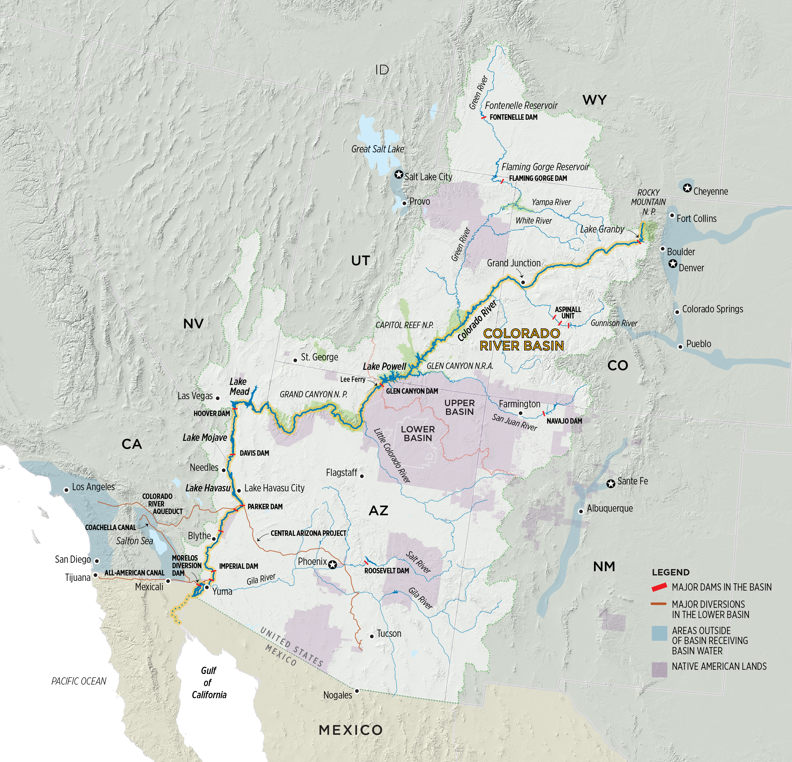
Lake Mead was formed in 1935 and Lake Powell in 1963 after the completion of the Hoover and Glen Canyon dams, respectively, along the Colorado River. They were created in hopes to store and provide water for the Colorado River Basin states during times of drought. Lake Powell predominately serves the Upper Basin states of Utah, Colorado, Wyoming and New Mexico, while Lake Mead provides for the Lower Basin states of Arizona, Nevada and Southern California.
The Glen Canyon Dam was completed in 1963 and subsequently caused the formation of Lake Powell. Photo credit: Esri Photo Library/Flickr via Brigham Young University
While both man-made reservoirs have served their purpose throughout the current drought, experts are thankful for this year’s runoff after a particularly low year in 2018.
“We’re coming off of 2018 which was the second-driest year ever since we’ve been keeping records in the Basin,” Duke said. “We were worried because if we had another year like 2018 then that would have really put us in some trouble.”
The drought hasn’t been the only threat to the lake’s water levels in recent years. A couple different proposals and campaigns are calling for Lake Powell to be drained and to distribute its water to Lake Mead and elsewhere.
“Fill Mead First” is a campaign first started in 1996 to encourage conversation about restoring the dammed Glen Canyon to its natural state. As the drought continued, the campaign has gained traction, arguing that Lake Mead needs more water from Lake Powell to ensure big cities such as Las Vegas, Phoenix, Los Angeles and San Diego have enough. The campaign also argues that Lake Powell loses water through both rapid evaporation and water seeping into the porous sandstone walls.
BYU geology professor Gregory Carling talked about the potential benefits that could come from restoring Glen Canyon to what it once was.
“When the Glen Canyon Dam was built, it not only flooded one of the most beautiful canyons in the world but also thousands of archeological sites and side canyons,” Carling said. “Also, the way it is now with Lake Powell and Lake Mead half-full, both are losing lots of water through evaporation. So there probably is some sense in looking into what the benefits would be of draining Lake Powell and filling Lake Mead.”
Carling added, however, the proposal would have to go through a lengthy legislative process in order for anything to change.
“There are a lot of legal requirements and bureaucracy behind that, so it’s not just as easy as saying, ‘let’s drain one and fill up the other,’” Carling said. “You’d have to go back through a hundred years of the law of the river.”
Those opposing the “Fill Mead First” campaign argue that Lake Powell, one of the most popular boating and camping spots in Utah, supports the local economy through both recreation and tourism. The lake saw over 4 million visitors during each of the past two years for the first time in its history. Lake Powell supporters also argue the lake ensures a steady water supply to Lake Mead and the Lower Basin states.
Lake Powell attracts millions of boaters and tourists every year. Photo credit:Bernard Spragg/Flickr via Brigham Young University
The Lake Powell Pipeline is another proposal aimed at transferring water from Lake Powell to nearby Kane and Washington Counties in southern Utah. The proposed pipeline would run approximately 140 miles underground and deliver over 82,000 acre-feet of water per year to Washington County and 4,000 acre-feet of water per year to Kane County.
The proposal did take a hit last year when the Federal Energy Regulatory Commission ruled it would need greater oversight from other federal land agencies such as the Bureau of Land Management, the Bureau of Reclamation and the National Park Service. Officials expect a final decision to be made on the project by 2020.
Even amid the recent controversies experts hope the Colorado River Basin can take full advantage of its water resources, especially in times of drought. Representatives from all seven Colorado River Basin states recently met to sign drought contingency plans for the Upper and Lower Basins.
“This brings us one step closer to supporting agriculture and protecting the water supplies for 40 million people in the United States and Mexico,” said Bureau of Reclamation Commissioner Brenda Burman. “Working together remains the best approach for all those who rely on the Colorado River.”
“The City of Farmington has temporarily closed sections of trails in Berg Park due to rising water levels.” City spokesperson Georgette Allen said in a press release June 7. “Trails on the north side of the Animas River near the All Veterans Memorial Plaza will be closed throughout the weekend.”
Perfluorinated compounds, commonly known as PFAS, turned up in levels exceeding recommended federal standards in the aquifer underneath the Air Guard base, said the consultant’s report.
But while the contamination appears to be moving toward city drinking wells on Tucson’s south side, the pollution doesn’t pose any immediate health risk to water users, Tucson Water officials say…
That’s because PFAS pollution already detected on the south side is being routed to a treatment plant that’s cleaning it up, and because the city drinking wells nearest the Air Guard base already are shut down.
The newly discovered contamination was widespread, tainting eight monitoring wells across the base and at least one more well at the base’s northern boundary, the report found. Sampling for the report was done from January through March 2018…
The pollutant concentrations ranged from nearly 70 times the EPA’s recommended health advisory level at a well at the base’s northern boundary, to just above the EPA advisory farther south on the base, said the report.
Another monitoring well contained about 30 times the EPA health advisory level of 70 parts per trillion, the consultant’s study found…
Measurable levels of PFAS compounds turned up in soil samples collected on 14 locations on the Guard base, but exceeded recommended health limits only at one of those locations, the report said…
At the same time, Tucson Water officials note that the nearest city wells, lying 1.5 to 2.7 miles northwest of the base, are already out of service because of previously discovered contamination from PFAS, trichloroethylene and 1,4-dioxane.
Polluted water from those wells is being funneled to a south-side treatment plant known as the Tucson Airport Remediation Project.
There, it’s being treated so thoroughly that the compounds are no longer detected as the water leaves the plant to be served to people in the downtown area and just north and south of there…
The ADEQ said it doesn’t have the legal authority to require the Guard base to clean up the contamination on its site.
That’s because the EPA has no formal drinking water limit for PFAS compounds and because Arizona law doesn’t allow the state to have more stringent environmental regulations than the federal government has.
FromThe Glenwood Springs Post Independent (Thomas Phippen):
“What a difference a year makes,” Zane Kessler of the Colorado River District said at the State of the Rivers meeting in Carbondale Thursday, comparing current snowpack averages to last year.
But as Kessler pointed out, 134 percent of average is only 34 percent better than average, and one good year doesn’t change the rising temperatures or the facts of living in the west, or the southwestern states that rely on Colorado River water are using more and more water.
The high snowpack will translate to fuller rivers and reservoirs, but it won’t solve the larger issues of what happens during the next low-precipitation year.
“One thing we noticed this year … is that our soil moisture was horribly low. So a lot of the moisture that came in the early part of this season, went to restoring those soils, and a lot of the water was sucked up,” Kessler said.
More water is being used up as temperatures rise, and both natural forests and agriculture lands have longer growing seasons.
This year, however, the biggest reservoirs in the region “are all expected to fill,” Alan Martellaro, division engineer with the Department of Water Resources, said at the meeting Thursday.
With the exception of [Granby] Reservoir, “the rest are expected to fill and spill. Hopefully, not spill,” Martellaro said.
As the weather warms and more snow melts, there is a risk of flooding on the Crystal River near Carbondale and near the Fryingpan River in Basalt.
The Crystal River “definitely will be above-bank full” at the peak flow for the year, which will likely be weeks later than usual, Martellaro said.
The usual peak occurs by June 7, but this year it will likely be between June 12 and 25, Martellaro said. The peak is also projected to last for weeks instead of days.
While snowpack is well above last year’s average and historical averages, river flows for many rivers only exceeded historical averages this week. The Colorado River just below Glenwood Springs reached 12,700 cubic feet per second Friday, above the historic median peak of 11,200 cfs, according to the USGS…
Another likely flooding area is on the Roaring Fork River just after the confluence with the Fryingpan in Basalt, Lewin said. The park was designed in part to allow the river to overflow there, she said.
From the Associated Press via Colorado Public Radio:
The EPA said it will drill into the American Tunnel next month to measure water levels and investigate how the passage is connected to other shafts.
The agency is looking for ways to stop or treat contaminated water pouring into rivers from old mine sites in the Bonita Peak Superfund area north of Silverton…
The EPA said it would follow strict safety guidelines when drilling the test well into the American Tunnel.
On April 7, 2016, the Environmental Protection Agency proposed adding the “Bonita Peak Mining District” to the National Priorities List, making it eligible for Superfund. Forty-eight mine portals and tailings piles are “under consideration” to be included. The Gold King Mine will almost certainly be on the final list, as will the nearby American Tunnel. The Mayflower Mill #4 tailings repository, just outside Silverton, is another likely candidate, given that it appears to be leaching large quantities of metals into the Animas River. What Superfund will entail for the area beyond that, and when the actual cleanup will begin, remains unclear. Eric Baker
The U.S. Drought Monitor recently reported that, for the first time in its nearly 20-year history, none of the contiguous states was showing symptoms of severe or exceptional drought. That report includes Arizona, as this year’s abnormally wet May helped push the state out of a 10-year drought period.
According to the monitor’s weekly report for late last week, only 20.5% of Arizona was showing moderate drought or “abnormally dry” symptoms. Data for the same week in 2018 found 100% of the state in moderate drought or abnormally dry, with a majority of the state experiencing severe (97 percent) or extreme drought (73.2 percent).
Richard Heim, a meteorologist with the National Oceanic and Atmospheric Administration’s National Centers for Environmental Information, said the change was tied to this year’s wet spring.
“Rain and snow have been falling in the areas that needed it, so the drought’s contracted a lot,” he said.
State climatologist Nancy Selover said the increased rain and snow came from winter storms over the Southwest that lingered longer and provided more moisture than in the past.
“Typically, that pattern stops in April, if we even get it,” Selover said. “Last year it was so dry, we never even got that pattern. … So it was really warmer than normal, really drier than normal. This year, we had what I would consider a more normal pattern.”
Heim said this kind of shift in drought status is normal for the desert. Although the U.S. Drought Monitor has been collecting data on drought since 2000, he said, such records as the Palmer Drought Index, with recorded data from as far back as the early 1900s, indicate that drought in Arizona ebbs and flows regularly.
Selover noted that the Drought Monitor’s map only reflects short-term drought, not long-term.
“In the western U.S., water resources is a long-term issue,” she said. “Reservoirs don’t fill in a year and aquifers don’t drain in a year or fill in a year. It takes multiple years that are dry or that are wet in order to change that.”
This year, instead of supplying helicopters with water to dump on fires, Denver Water is draining water from Dillon Reservoir in anticipation of runoff, which is expected to really begin coming down in the next few weeks.
“This year being a high snowpack year, we know there’s going to be a lot of water getting into the reservoir,” Denver Water supply manager Nathan Elder said. “We’re trying to have enough space to catch that runoff while providing for safe outflows to the Blue River below the reservoir.”
[…]
At the moment, the reservoir — which is the main drinking water supply for 1.4 million people in the Denver metro area — is 75% full with 192,554 acre-feet of water. When full, the reservoir holds 257,304 acre-feet. An acre-foot of water would cover an area the size of an acre 1-foot deep. Given the current estimate for runoff volume, there will be more than enough water to fill it.
“The forecasting for the rest of June and July project a volume of anywhere from 169,000 acre-feet to 211,000 acre-feet coming into the reservoir,” Elder said. “That’ll fill it, but we’re probably not going to fill it until the Fourth of July to make sure we’re past that peak-inflow time.”
Elder said peak inflow to the reservoir is expected to start about a week later this year than usual, which also means Summit’s two marinas in Dillon and Frisco will have to wait before the reservoir is full enough for boating. However, boaters should have a lot more time for play this year compared with last, when boat ramps were retracted weeks before they normally would be due to low water.
“Typically, every year we target June 18 to be at 9,012-foot elevation needed for both marinas to be completely operational, but it’s going to be a little delayed this year,” Elder said. “But while the boating season might be shortened by a week on the front end, on the tail end, it should last quite a bit longer.”
The delay also means local emergency officials will be watching streamflows longer into the month, looking to spring into action if Tenmile Creek, Straight Creek or the Blue River approach the verge of flooding.
Current two-week projections show all three waterways approaching “action stage,” the threshold at which the towns and county are called to start flood mitigation preparations, by June 15.
Summit County’s director of emergency management Brian Bovaird said he closely has been watching the forecasts for flooding. That is opposed to last June when Bovaird, who recently had gotten the job as emergency director, was given a literal trial by fire.
“It’s like picking your poison,” Bovaird said. “Last year, it was wildfire. This year, it’s flooding. We’re expecting heavy runoff moisture, which is good for wildfire but makes us uneasy about the flooding risk.”
Barker Dam’s scheduled spill is expected to begin over the next few days, officials said. Each spring as temperatures warm, runoff from melting mountain snow increases stream flows. Before peak stream flows occur at lower elevations, like in the City of Boulder, mountain reservoirs must first fill and start spilling, officials said.
“This is a normal and expected event that will increase flows in Boulder Creek throughout the city,” The City of Boulder said in a statement.
The Barker Dam spill normally occurs between mid May to late June, but is dependent on weather, snowpack and early spring reservoir levels. This spring, cool temperatures and continued snow accumulation have delayed snowmelt runoff, the city said.
The waters of the Gunnison River are currently at 10.7 feet. It has passed the bankfull stage. This means some water is beginning to spill out into the floodplain. The floodplain is the low-lying area next to the river. The Gunnison’s Flood stage is at 13 feet. It’s expected to rise near 10.8 feet by Saturday.
Orchard Mesa and Whitewater are under the current advisory.
Parts of the Colorado River are rising, but it’s not under an advisory. The Colorado River near Loma is nearing bankfull. According to data from a National Weather Service gauge near the state line, water levels are at about 10.5 feet and are expected to rise to 12.5 by Saturday afternoon.
PHOTO CREDIT: McKenzie Skiles via USGS LandSat The Great Salt Lake has been shrinking as more people use water upstream.
The south arm of the Great Salt Lake is up by 2.5 feet since December and its north arm is 2 feet deeper thanks to the wet water year, and the Western Hemisphere’s largest saltwater lake will take on even more water in the weeks to come.
“It’s a pretty good jump so far, but we’re not done yet,” said Todd Adams, deputy director of the Utah Division of Water Resources.
The highest elevation snowpack has yet to melt, and with most reservoirs brimming, that water will bypass those storage infrastructures and help quench the thirsty saltwater body…
Water managers along the Wasatch Front will be keeping their eye on stream flows and reservoir levels to keep enough storage going into the summer and time releases into rivers to hopefully avoid flooding.
While most reservoirs are already full, Echo above East Canyon sits at just 49 percent of capacity and Rockport sits at 78 percent, ready to take on snowmelt.
“We could have filled it (Echo) twice this year,” said Tage Flint, general manager of the Weber Basin Water Conservancy District. “The peak flows have not occurred yet coming out of the Uinta Mountains coming down the Weber River, so we are purposefully leaving Rockport down some and Echo down more to use them as shock absorbers to take those big flows.”
Much of that extra water will be sent on downstream to the Great Salt Lake…
The lake is critical to wildlife, multiple industries, recreation interests and more, contributing $1.3 billion into Utah’s economy and drawing tourists from all over the globe.
It serves as the Pacific “flyway” for thousands of migratory birds and supports a $57 million brine shrimp industry…
Mike Styler, who recently retired as executive director of the Utah Department of Natural Resources, said maintaining the viability of the Great Salt Lake will be one of the critical challenges the state faces going into the future.
He stressed that as agricultural water gets converted for urban use in Weber and Davis counties and reuse of waste water becomes more popular, that threatens to dry up marshes and wetlands that support the lake.
The Great Salt Lake has an average depth of 16 feet, covers 1,700 square miles during an average year and is two to seven times saltier than the ocean.
Karen Guglielmone, the Town of Telluride’s environment and engineering division manager, presented the yearly water audit to Town Council in a Tuesday work session, which emphasized the importance of conservation, despite the town’s abundant water supply.
“We are a steward to our water resources,” she told council. “We are stewards for what we need now and into the future.”
The annual report has been produced since 2014, when the town adopted a Water Efficiency Plan, which was subsequently approved by the Colorado Water Conservation Board (CWCB) late that year. The annual report reveals figures such as overall municipal water use — and losses — and indicates trends that can help officials modify the plan.
Water losses are attributed to a number of factors including leaks, unauthorized consumption, faulty metering and data errors.
Leaks, Guglielmone explained, are common in municipal water systems as they age. One such leak occurred under East Columbia Avenue in 2018, which officials then said had likely been a progressive event due to pressure from a rock. Directly on the waterline. There are more of those, Guglielmone said.
“We can expect a slow increase of leaks over time,” she said. “We have others we can’t locate precisely.”
Despite the challenges of controlling losses, in 2018 the loss rate dipped by 13.5 percent when compared to the last five years of collecting data. Last year’s losses were calculated to be 26 million gallons, down from 2017’s 37 million gallons. Telluride’s losses are still high compared to other municipalities.
“We’re high on our water loss,” she said. “Fifteen percent is the goal, though 25-30 percent is more the reality,”
Residential water use is holding steady, according to the report. The fact that it stayed about the same (118 million gallons) is “pretty cool,” Guglielmone said…
Town Attorney Kevin Geiger noted that overall the town is in good shape as far as its supply is concerned.
“Our water portfolio is robust,” he said. “(Blue Lake) is a very large reservoir for our town. It is the envy of municipalities in Colorado.”
Telluride’s water rights are also strong…
Incorporating the Blue Lake reservoir and the Pandora water treatment plant became necessary when the town’s growth overtook what Mill Creek could provide, Geiger explained. Past water usage reports, which reflected peak days such as those that occur during the Telluride Bluegrass Festival, necessitated the work to bring Blue Lake into the fold…
Council member Geneva Shaunette said she liked the idea of the stricter irrigation practices that the town imposed during last year’s parched summer.
“I’m a fan of every other day irrigation,” she said. “Maybe grass isn’t the best thing.”
Unfortunately, even though low maintenance buffalo grass uses half the water, many landscapers’ clients prefer water-hungry Kentucky bluegrass, Guglielmone said. “We can’t police everything.”
FromThe Grand Junction Daily Sentinel (Dennis Webb):
Aldis Strautins, hydrologist for the National Weather Service in Grand Junction, said so far snow has been melting off in a manageable fashion, with some minor flooding in lowland locations but nothing serious so far.
“We’re not totally out of the woods yet. It bears monitoring and keeping aware of the situation,” he said.
He said the Colorado River is coming up and may peak locally around Sunday. Andy Martsolf, emergency services director for the Mesa County Sheriff’s Office, said flows on the Colorado River at the state line are expected to peak at about 36,000 cubic feet per second this weekend. That’s up considerably from the 24,900 cfs being reported there by the U.S. Geological Survey Wednesday.
Officials expect a possible second peak later this month.
The Gunnison River already is cranking, but that’s by design, under the operational protocol for the Aspinall Unit dams on the river. Erik Knight, a hydrologist with the Bureau of Reclamation, said releases began on Saturday in an attempt to hit a target goal of flows of 14,350 cfs for 10 days on the lower Gunnison at Whitewater, to help critical habitat for endangered fish in that stretch.
He said it appears flows will fall 1,000 cfs short of that goal.
The National Weather Service has issued a flood advisory in the lower Gunnison River due to the extra water releases affecting river levels there. Strautins said it wasn’t a flood warning, but an effort to make people aware of dangers such as banks giving way due to the high water.
Knight said it doesn’t appear that flows through Delta will exceed 13,000 cfs during the 10-day release. That’s below the level at which the Bureau of Reclamation would cut back releases during the 10-day period to protect the community from flooding.
Wilma Erven, Delta’s parks, recreation and golf director, said some water is showing up in a park at the confluence of the Gunnison and Uncompahgre rivers, something that can occur in years like this one…
Strautins pointed to a mix of warmer and cooler weather in the forecast in coming days as opposed to a prolonged hot stretch that could drive water levels particularly high, with cloud cover also expected to moderate melting of snow.
Knight, who several months ago could hardly have imagined Blue Mesa Reservoir filling this year after last year’s low snowpack and drought, said it now appears almost certain to fill…
…the snowpack levels remaining in areas such as southwest Colorado are impressive, as evidenced by the mere fact that many sites that normally are dry by now still have snow.
According to one of the data sets [Brian] Domonkos uses, current snowpack levels in those combined basins and in the Gunnison basin are the second-highest on record, he said. But peak levels this year in basins in western Colorado don’t compare nearly as well to other high snowpack years, with the southwest Colorado basins ranking perhaps fourth or fifth, and other basins not coming in that high, Domonkos said.
He said one of his statistical tools indicates there are about 12.3 inches of snow water equivalent left in the Gunnison basin, which peaked at 24 inches.
“So we’re halfway through the melt of that peak snowpack,” he said.
The Colorado basin has about 11 inches of snow water equivalent left, after peaking at about 20 inches, Domonkos said.
He said snowpack normally melts at a rate of an inch a day or a little less of snow water equivalent.
“So snowpack on average probably won’t be hanging around too much longer,” he said.
While more than half of the Colorado basin’s snowpack already is melted, that snowpack was above-average, and Martsolf said the remaining snowpack is still about 71 percent of an average peak snowpack for the basin.
“We’re definitely melted off from where we would be for a seasonal peak but we still have a ways to go,” he said…
Nowhere in western Colorado is the combined threat of rising rivers and avalanche debris causing more concern than in Hinsdale County. Federal, state and county funding is paying the nearly $1 million cost for the ongoing, emergency removal of the historic, defunct Hidden Treasure Dam. While it no longer holds water, there’s concern that avalanche debris washing down Henson Creek combined with high water flows could destroy it, releasing water and debris and causing downstream flooding…
Both Henson and the Lake Fork of the Gunnison creeks pose threats to Lake City. Lyon said there’s currently no flooding occurring, but creek levels have come up considerably in recent days. Warming temperatures and possible rainstorms both could influence what ultimately occurs in coming days and weeks.
Last month was the snowiest May in Aspen since 1999, with 20 more inches added to the already substantial snowpack. Meanwhile, forecasters are predicting a wet June.
Total snowfall for May was four times the average, according to city of Aspen water department figures. It follows the second snowiest March ever recorded — and the records go back to the winter of 1934-35. Only 6 inches fell in April, but with May’s snowfall, the water department has recorded 210 inches thus far, well above the winter average of 155 inches.
The water department also tallied 3.8 inches of rain for the month, which is double the average. One factor behind the heavy winter and wet spring can be found in the Pacific Ocean, said Erin Walter, a meteorologist with the National Weather Service in Grand Junction.
Winter and spring storms were fueled by weak El Niño conditions that shifted atmospheric rivers laden with moisture farther south than in an average year. (El Niño occurs when, among other conditions, sea-surface temperatures are warmer than average.)
Unceasing storm systems that usually blanket the Northwest, Alaska and Canada instead inundated California’s Sierra Nevada mountain range…
he weak El Niño “definitely influenced the track of storms and the general circulation of our low and high pressure systems,” Walter said. “It’s been a very abnormal winter and spring for us.”
And that may not change anytime soon. Walter said the federal Climate Prediction Center’s one-month outlook for western Colorado, as of May 31, “falls within a 40 percent probability of being above average for precipitation.” The center also is predicting average temperatures for the region.
While the wet, cool spring has meant little snowmelt and allowed for continued skiing, the Colorado Water Conservation Board and local emergency managers are keeping a close watch on river levels…
CWCB also cited a forecast for June that indicates a “wet month for the entire state,” and adds that areas downstream of recent burn scars, like those on Basalt Mountain and surrounding environs from the Lake Christine Fire, are at heightened susceptibility to flash floods, and mud and debris flows. The board reminded “individuals and business owners [to] consider, be aware of, prepare for, and insure against flood threats.”
“It is also important to note that Colorado’s worst flood events have historically occurred from general spring rainfall and summer thunderstorms, which are completely unrelated to snowmelt flooding resulting from mountain snowpack,” the summary says. “For this reason, even residents in areas with lower snowpack should exercise caution in evaluating flood risk.”
Floods directly related to the melting snowpack are possible but unlikely, and for boaters, “an extended season of high water is a near certainty this year,” the board reported.
A flood advisory has been issued for the La Plata River near Hesperus as rising temperatures and increasing snowmelt have pushed the river toward flood stage.
The National Weather Service in Grand Junction said flows along the La Plata River will remain near to slightly above the bank throughout the rest of the week, with the possibility for minor lowland flooding.
As of 7 a.m. Tuesday, a river gauge measured the flow of the La Plata River at 5 feet. A flood stage for the waterway is considered 5½ feet…
The Animas River in Durango was flowing at about 1,500 cubic feet per second Saturday. As of Tuesday morning, the river had reached more than 5,000 cfs and is expected to peak around 7,000 cfs later in the week.
Butch Knowlton, director of La Plata County’s Office of Emergency Management, said Monday that the Animas River begins to spill out onto some areas of the Animas Valley around 7,000 cfs.
The Animas River…was at about 1,500 cubic feet per second Saturday. On Tuesday, the river was running at more than 5,000 cfs and is expected to keep rising.
By the end of the week, the Colorado River Basin Forecast Prediction Center is calling for the Animas to hit nearly 7,000 cfs. (The Animas River usually hits a peak flow of about 4,700 cfs in early June at the height of spring runoff.)
[…]
If the Animas does reach 7,000 cfs, it would mark the largest peak since 2005 in the April-to-July snowmelt window, when the river hit 8,070 cfs on May 26. The last big water year was in 2015 when the Animas peaked at 6,210 cfs on June 12.
The Animas River at 7,000 cfs starts to spill out on the low-lying areas and fields in the lower Animas Valley north of Durango, Knowlton said. At 8,000 cfs, areas around Trimble Lane start to flood.
The water flow for the Animas River to be considered in a flood stage is about 10,500 cfs, Knowlton said. While the river may not hit that mark this year, there is a wild-card type scenario that has emergency managers concerned.
The National Weather Service has issued a river flood advisory for the Gunnison River in Mesa County. Water flows are expected to increase throughout the week.
“Some may start to get above bank full by this weekend. But it’s just something we’re monitoring. It’s not a sharp increase where we expect to see flooding in a couple of days. We are starting to see runoff and an increase in higher flows and higher levels,” said Matthew Aleksa, National Weather Service Grand Junction.
The Yampa River flows through the Carpenter Ranch. Photo courtesy of John Fielder from his new book, “Colorado’s Yampa River: Free Flowing & Wild from the Flat Tops to the Green.”
From Colorado Parks and Wildlife (Jack Taylor) via Steamboat Pilot & Today:
Are you familiar with Colorado Parks and Wildlife’s Habitat Partnership Program (HPP)? If you are in the livestock/agriculture business or a landowner in Routt County you should be.
CPW’s HPP program works to reduce wildlife conflicts, particularly conflicts associated with forage and fences, and to assist CPW in meeting game management objectives. HPP efforts are primarily aimed at agricultural operators and focus on problems and objectives for deer, elk, pronghorn and moose. HPP is funded by receiving 5% of the deer, elk, pronghorn and moose license revenue from each HPP area. This results in millions of dollars annually that can be spent on projects on both private and public land across Colorado.
The local HPP committee in Routt County is the Upper Yampa River HPP committee. The committee is comprised of several local agricultural producers, local sportsman and agency representatives (CPW, Bureau of Land Management, U.S. Forest Serivce). This combination of local knowledge allows for innovative project ideas and novel solutions to problems specific to Routt County.
The Upper Yampa River HPP committee has recently funded several habitat improvement projects, specifically projects that enhanced the amount of water available to both wildlife and livestock on private property. These projects allowed for better grazing practices that will benefit wildlife and livestock into the future.
Other common projects for the Upper Yampa River HPP committee involve assisting landowners with fencing projects. This could be providing materials for a strong welded wire hay stack-yard that can stand up to the snow loads in Routt County or supplying vinyl-coated top wire. The vinyl-coated top wire program helps to reduce the damage that deer and elk can cause to fencing while they are crossing it because the vinyl-coated wire is more visible, which also results in fewer deer and elk fence entanglement issues.
The possibilities do not end there. In addition to fence and forage type projects, the Upper Yampa River HPP committee also assists landowners with funding a portion of the transaction costs for conservation easements.
HPP looks for a 50/50 cost split to approve the project being submitted. This means if you are asking the HPP committee to contribute $2,000 to a habitat improvement project on your property, they would be looking for a contribution from you worth $2,000.
The Upper Yampa River HPP committee also considers any other partners associated with the project, like a neighbor, if the project can span multiple parcels of property.
To submit a project with the Upper Yampa River HPP committee, contact your local district wildlife manager directly or call the CPW Steamboat Springs Service Center at 970-870-2197. Upper Yampa River HPP meetings are typically held once a month. Contact Colorado Parks and Wildlife to learn more.
Jack Taylor is a district wildlife manager for Colorado Parks and Wildlife.
Christmas Elk via the Middle Colorado Watershed Council December 2013
Brad Wind, general manager of the Northern Colorado Water Conservancy District based in Berthoud, and Jim Hall, Northern Water’s senior water resources engineer, briefed the LSPWCD’s board of directors on Northern’s efforts to keep Colorado-Big Thompson water from leaving the Northern District…
Wind told the Lower board that Northern is working to enforce Article 19 of the 1938 contract between Northern Water and the federal government, known as the Project Repayment Contract. That article, one of 27 contained in the contract, specifies that all seepage and return flows from the use of Colorado-Big Thompson project water are reserved to Northern Water and are not to be taken outside the district’s boundaries.
On May 9, Northern adopted a resolution saying it would “take appropriate actions to enforce Article 19 consistent its interpretation of Article 19.”
Wind said the heavy lifting in that effort will be tracking how C-BT water, and resulting seepage and return flow, are used. He used the phrase “colors of water,” which is a concept that holds that, through close monitoring and accounting, mixed waters from various sources actually can be tracked through multiple uses. For instance, water that is native to the South Platte Basin can be accounted differently from C-BT water, which is diverted from the Colorado River into Grand Lake and piped through the Adams Tunnel to Estes Park and held in Horsetooth Reservoir and Carter Lake for distribution to C-BT members.
Return flows are water that has been diverted from the river, used to irrigate crops or for municipal use, and either seeps back to the river through the ground or is discharged after treatment. Much of the river’s flow in the lower reaches in late summer and through the winter is from return flows from upstream use. Return flows are crucial to irrigators in Weld, Morgan, Washington, Logan and Sedgwick counties.
“To protect return flows, we have to know what they are,” Wind said. “We have to be able to quantify what return flows are coming from C-BT use and what’s from native water. It’s complicated.”
Hall told the Lower board that there is the danger that “change of use” cases going through Colorado water courts could result in return flows from C-BT water being shipped out of the Northern district in violation of Article 19.
“We’re starting to see change cases on irrigation ditches moving water outside the district boundaries,” Hall said. “That’s why it’s important to track this stuff. It’s easier to track municipal water because we can look at their (wastewater treatment facility) discharges, but it’s harder to prove agricultural return flows.”
Hall said return flows from native water are not subject to Article 19, only C-BT return flows.
Wind said Northern will be watching closely all change of use cases that go through Colorado’s water courts and will continue monitoring water usage in the district to make sure C-BT water doesn’t leave the district.
From email from the Colorado Department of Water Resources:
[Please find below] two documents relating to the investigation of demand management feasibility – both at the Upper Basin level and within Colorado. First, a statement from Director Mitchell on the path forward on demand management feasibility investigations within Colorado. Also, information regarding an upcoming workshop hosted by the Upper Colorado River Commission on the topic of demand management feasibility.
For more information on these topics email demandmanagement@state.co.us.
Demand Management Investigation: The Path Forward
Colorado water users, stakeholders, and interested parties:
Now that the Colorado River Basin Drought Contingency Plan (DCP) is finalized, the Colorado Water Conservation Board (CWCB) is beginning its efforts to investigate the feasibility of a potential demand management program within Colorado.
The strong connection between Coloradans and our water has established a foundation of public input, deliberation, and participation in the decision-making process, which leads to informed and thorough policymaking. This is the model that informed the Colorado Water Plan, and it is this model that the CWCB will utilize to assess demand management: by Colorado, for Colorado.
At the March 2019 meeting, the Board of Directors of the CWCB approved the 2019 Work Plan for Intrastate Demand Management Feasibility Investigations. Below are highlights of the current and upcoming steps that the CWCB staff will be taking to implement the 2019 Work Plan, including opportunities for engagement, processes to inform the Board, and informational events. These elements are designed to ensure that the CWCB and all interested water users and stakeholders are fully informed of demand management concepts and challenges as they are identified. Through this process, the multitude of considerations demand management presents will be fully understood, to promote an informed and fully realized public policy discourse.
General Outreach: Staff will continue to work directly with interested water users and stakeholders to inform them of the process for investigating demand management feasibility within Colorado, and to solicit input on specific elements of potential implementation and solution identification. The direct interaction between staff and the various basin roundtables, policy boards, water users, and stakeholder groups is where the conversations begin. This will then lead to identification of considerations and development of potential solutions, which will be used to inform an evaluation of demand management.
Workgroups: Staff has begun to reach out to subject matter experts on various elements that must be considered for any potential demand management program within Colorado. The purpose of these workgroups is to help CWCB staff identify and frame the complex issues associated with demand management feasibility for public and Board consideration. In this capacity, workgroup members operate like “think tanks” to help CWCB staff prepare to conduct meaningful public discussion of the issues associated with demand management based on useful insight and understanding from experts in the field. Workgroup members have been selected for their subject matter expertise and willingness to work in assisting the State as it implements the public process to evaluate a potential demand management program.
To respect the integrity of the workgroups, members are being asked to participate in a non-disclosure setting. This will allow the participants to brainstorm all sides of an issue, and to have open and frank discussions as they assist CWCB staff in framing demand management considerations for public discussion and evaluation. The decision-making process for consideration of demand management solutions and approaches for potential implementation will be achieved in public meetings and through the comment and input process established in the formulation of the Colorado Water Plan. The workgroups serve as the “think tank” for staff as they begin to develop an understanding of the full complement of considerations, issues, and challenges that demand management presents.
Transparency of Process – Demand management investigations and decision-making by the CWCB will be done through an open dialogue. Once the range and multitude of complex topics associated with demand management are identified and framed, they will be introduced in a process akin to the development of the Water Plan, including workshops, basin roundtable presentations, consideration of public comment, and the like. Additionally, the CWCB will be updated regularly in open session on the progress of the demand management investigation process, and provided with any staff recommendations as appropriate.
Upcoming Demand Management Investigation Events –
CWCB will be hosting an Orientation Webinar for members of the workgroups in July. This Orientation Webinar will be open to the public. The Webinar will provide an overview of the evolution of DCP and demand management, discuss the statewide perspective for analysis of demand management, and outline the timeline and process for the workgroups’ assistance in demand management issue identification. Information about the Webinar will be forthcoming as details are finalized.
The Upper Colorado River Commission will be hosting a Demand Management Stakeholder Workshop in Salt Lake City, Utah on Friday, June 21. The goal of this regional workshop is to provide a baseline understanding of the Colorado River DCP and discuss proposed next steps to examine the feasibility demand management in the Upper Basin. Additionally, Upper Basin State representatives will receive comment and input from interested water users and stakeholders on possible considerations in evaluating the feasibility of a successful demand management program throughout the Upper Basin. When the agenda is finalized, more information regarding the Workshop and registration will be posted on the CWCB website and circulated to interested parties.
CWCB staff will be scheduling public demand management workshops around the state, as outlined in the 2019 Work Plan. These workshops will be in addition to the usual array of roundtables, Interbasin Compact Committee, informational forums, and other water meetings in which staff participate to discuss and receive feedback on demand management. Staff hopes to schedule the first intrastate workshop in alignment with the summer conference of Colorado Water Congress.
The investigation of the feasibility of a potential Demand management program presents a challenge for the CWCB, water users, and stakeholders across Colorado. The Board and staff take this assessment very seriously, and are committed to providing an opportunity for everyone with an interest in Colorado River system sustainability to make their voices heard, while remaining true to the water values identified in the Colorado Water Plan. For more information, to provide comments, or to learn more about the 2019 Work Plan and demand management feasibility process, email demandmanagement@state.co.us or contact CWCB staff.
The upper Colorado River, looking upstream toward Gore Canyon, near Pumphouse. Photo: Brent Gardner-Smith/Aspen Journalism
From the Colorado River Water Conservation District via the The Sky-Hi Daily News:
Colorado’s eponymous river is doing relatively well in early June 2019 with significant snowpack still lingering at higher elevations, making the river basin’s water managers cautiously optimistic as they look at the state of one of the nation’s key waterways.
Last Thursday evening the Colorado River District, a special taxing district dedicated to the conservation and management of the Colorado River and its stream flows, held a public forum at West Grand High School in Kremmling regarding the current status of the Colorado River. Each year officials from the River District present a series of public forums called “state of the river” meetings in various communities up and down the length of the basin. State of the River meetings are typically held each year in the late spring prior to the start of high runoff periods and irrigation season.
The state of the Colorado River is relatively strong in 2019 following a solid year for snowfall in Colorado’s High Country but despite plentiful precipitation water managers are struggling against a surprising impediment: low temperatures.
“With this cold and wet weather, the snow is lingering much longer than normal,” Victor Lee, a hydrologic engineer with the federal Bureau of Reclamation, said. “It has not run off like it typically does. We are going into June with a very delayed peak runoff.”
Despite the delayed start to high water season in the Rockies water managers are cautiously optimistic about the state of the river this year and the impacts from this year’s snowpack. Multiple officials presenting at the State of the River meeting noted they plan to fill, but not spill, the major reservoirs in Grand County with the exception of Wolford Mountain, which is expected to spill sometime later this summer. Nathan Elder, with Denver Water, said the entity he works for anticipates reduced diversions out of Grand County this year thanks to predicted higher than average native stream flows in East Boulder Creek.
Even with the improved snowpack in 2019 though officials continue to sound alarm bells about the future of the key waterway of the American southwest, noting the river basin currently consumes more water than Mother Nature replaces, even in wet years. Andy Mueller, General Manager for the Colorado River District, gave a presentation on drought contingency planning for the Colorado and made several sobering statements about the future water in the west.
According to Mueller the Colorado River basin uses up roughly 16 to 17.5 million acre-feet of water each year, though on average the basin rarely receives that much precipitation annually. To cover the gaps between how much water is consumed and how much is received water managers rely on the massive network of reservoirs that dot the western US to provide the supply. That supply is dwindling though as the water deficit continues to grow.
Mueller noted that the 10-year running average for the amount of water deposited by the environment into the Colorado River basin continues to decline. The current 10 year running average is now just above 12 million acre-feet a year. Mueller noted the ongoing impacts of climate change and a warming environment on the water picture in the west and presented a slide showing average temperature data for the Colorado River going back to 1900.
According to Mueller the Colorado River is now, on average, a full two degrees warmer than it was 30 years ago. The slide provided by Mueller shows a marked uptick in river temperatures beginning in the early 1980s. Since 1983 the Colorado River has experienced only three years when river temperatures were below historic averages.
“Recent studies indicate there is a three to four percent decline in annual runoff in Colorado for every one degree of warming,” Mueller said, noting that researches believe the decreased runoff is a result of a longer growing season, allowing vegetation to consume more water naturally.
“The forests are using more water, the riparian area is using more water,” Mueller said. “We have a supply problem. The question is, where are we headed?”
Yampa and White Basins High/Low Precipitation Summary May 31, 2019 via the NRCS.
From the Steamboat Pilot & Today (Eleanor C. Hasenback):
According to data from a National Weather Service cooperative weather station, Steamboat Springs receives a long-term average of 2.15 inches of water in May.
Data from that station shows the area received nearly double that average, with a total of 4.26 inches in May. This data is preliminary, and the National Weather Service will release its official tally of May precipitation later this month.
Steamboat received 9.3 inches of snow in May, well over the long term May average of 2.8 inches at the station.
That snow hasn’t melted off the mountains, either. The Natural Resource Conservation Services’ snow telemetry site atop the Continental Divide on Buffalo Pass measured 115 inches of snowpack on the ground on Sunday. There were 35 inches at the Rabbit Ears Pass site…
“This has been a pretty active year — a pretty wet winter and spring. … I think that’ll have some influence on the temperatures too because as the sun is melting the snow, it’s not able to heat the ground as much. That could be a reason why our temperatures could be at or below normal for this short-term forecast,” said Erin Walter, a meteorologist at the Weather Service Forecast Office in Grand Junction…
“The warmer temperatures are just going to increase the runoff, so that’s kind of the big threat right now for Western Colorado,” she said.
The river runners’ adage states that the Yampa River peaks when two brown spots atop Storm Peak meet. Those brown spots have yet to make an appearance this spring.
The Yampa River sees an average peak in early June around 2,250 cubic feet per second at the U.S. Geological Survey’s Fifth Street gauge in downtown Steamboat, though the peak has ranged from 1,570 to 5,200 cfs in the last ten years.
For much of the last month, the river has flowed relatively consistently between 1,000 and 1,500 cfs through Steamboat, though the Weather Service forecast that the Yampa will rise to about 3,600 cfs later this week amid sunny weather starting Tuesday.
Walters said the forecast for June looks to see average temperatures and a slightly above average chance for “wetter than normal conditions.”
While this year is shaping up to be a good water year so far, climatologists and water managers are still concerned by a trend of drought intensified by warmer temperatures and an earlier spring in the West.
“Just because we have one good year … doesn’t negate the realities we’re seeing with consistent warming trends,” Taryn Finnessey, a senior climate change specialist with the Colorado Water Conservation Board told the Durango Herald on Wednesday…
The Yampa River flows into the Colorado River, and then into Lake Powell, where it helps fulfill Colorado’s annual obligation to provide a certain amount of water to downstream states. As of Saturday, Lake Powell was only 43% full, and even with Colorado’s healthy snowpack, the U.S. Bureau of Reclamation estimated that Powell would fill to 54% of its storage capacity this water year. The lower Powell falls, the more concerned water managers become about meeting obligations to other states.
From inside a small airplane, tracing the Colorado River along the Arizona-California border, it’s easy to see how it happened.
As the river bends and weaves through the American Southwest, its contents are slowly drained. Concrete canals send water to millions of people in Phoenix and Tucson, Los Angeles and San Diego. Farms, ribbons of green contrasted against the desert’s shades of brown, line the waterway.
Further downstream, near Yuma, Arizona, the river splits into threads, like a frayed piece of yarn.
A massive multi-state plumbing system sends its water to irrigate the hundreds of thousands of farm acres in southern California and Arizona, hubs for winter vegetables, alfalfa, cotton and cattle.
When it hits the final dam, located on the U.S.-Mexico border, every drop has been claimed and put to use. In a typical year, what’s left of the river’s flow — promised to Mexico in a 75-year-old treaty — is sent to farm fields in the Mexicali Valley, and then on to the Mexican cities of Tijuana, Mexicali and Tecate.
All this reliance on an overallocated river has left its final hundred miles as the ultimate collateral damage. Since the early 1960s, when Glen Canyon Dam impounded the river near Page, Arizona, it has rarely reached the Pacific Ocean. The thread is frayed beyond recognition, leaving no water for the river itself.
“About 90 percent of the water is retained on the U.S. side and it’s used and diverted,” said Karl Flessa, a researcher at the University of Arizona. He studies the Colorado River Delta.
“In effect, one of the things we’ve done historically — not meaning to especially — what we’ve done is export some of the environmental consequences of water diversions,” Flessa said. “We’ve exported them to Mexico.”
The Colorado River’s inability to complete its journey from the Rocky Mountains to the Sea of Cortez has become one of its defining characteristics. Its historic delta, a haven for birds and mammals in the Sonoran desert, is a husk of its former self.
From the air, in a flight arranged by non-profit group LightHawk, the Colorado River Delta transitions from a jigsaw of farms to a staggering sprawl of muddy salt flats. (LightHawk receives funding from the Walton Family Foundation, which also funds KUNC’s Colorado River coverage.) The river’s historic channel in most parts through Mexico is nothing more than a sandy bed, scattered with saltcedar.
Where the river used to meet the ocean, tidal pools and drainages carve the sand and soil into organic patterns, like the cross-section of a lung.
Within the last twelve years, both the U.S. and Mexico have acknowledged the delta’s problems, signing agreements to commit both water and funding to restoring it to some semblance of its former self.
The splashiest of those efforts took place five years ago this spring, and left a lasting imprint on those who witnessed it.
The pulse flow
Around 8 o’clock on a Sunday morning in March 2014, water began spilling through Morelos Dam on the U.S.-Mexico border. The release was a culmination of years of negotiation between the U.S., Mexico and environmental organizations.
It was known as the pulse flow — flujo pulso in Spanish.
“You think of it as this wall of water that’s going to come down, but really it was this creeping tongue of water across the sand,” said Jennifer Pitt, who worked for the Environmental Defense Fund at the time, and now directs the Colorado River program for the National Audubon Society. Both groups receive Walton Family Foundation funding. Pitt was a key negotiator to make the pulse flow possible…
It took a few days after the dam opened for the water to arrive at the bridge, where Pitt and her colleagues gathered to wait. About 70 people in garden chairs sat in anticipation. A community clean-up a few days prior left the riverbed scrubbed of trash and debris.
For many young people, it was the first time they had ever seen water flowing in this stretch of the Colorado River. For older residents, it had been decades since they saw this much water here.
“They started getting up just one by one, people coming over to the water and getting down on their hands and knees and just touching it,” she said. “It was like the arrival. The great arrival of the river.”
A spontaneous festival started, complete with music, food vendors, horses and boats.
“I’ve spent 20 years thinking about how we can restore the Colorado River from where it dries out to where it reaches the sea,” Pitt said, “And in all of that thinking have never imagined that this site could bring so many people in as a magnet for people to enjoy something.”
Within weeks the flow was soaked up by depleted soils, though it did eventually reach the Pacific Ocean. From where Pitt and I are standing at the bridge in early December 2018, you’d never know the West’s mightiest river was supposed to flow here.
The pulse flow was about 105,000 acre-feet of water, enough to turn the channel again into a river for a few weeks. One acre-foot generally provides enough water for two average American households for a year. Historically more than 12 million acre-feet flowed into the delta each year…
Combined, that amount of water led to a green up along the river corridor, and sustained more than 275,000 new trees, according to a December 2018 report from the International Boundary and Water Commission.
The pulse flow’s biggest effects were short-lived. Both the green up and increases in certain species dropped again after the water stopped flowing.
The pulse flow’s biggest effects were short-lived. Both the green up and increases in certain species dropped again after the water stopped flowing.
A study from U.S. Geological Survey scientists confirmed that. It found that the amount of water in the pulse flow was too small to change the channel in a significant way, or scrub the riverbed, which would’ve happened during a more natural spring flood when flows would be much higher.
Because of the delta’s low water table, a lot of water seeped into the ground before it could do any good on the surface to help establish new wildlife habitat in expanded restoration areas. It was an experiment, said University of Arizona researcher Karl Flessa. Scientists experiment all the time, chart the results and move on.
Does he think the delta will ever see another pulse flow on the scale and magnitude of the one seen in 2014?
“Probably not,” he said. “Because you can get the water to do more restoration work by delivering it in smaller doses as it were, and delivering it to the right places where the vegetation can really take advantage of it.
“I think restoration, like any other activity with water, we’re really obliged as a society to be as water efficient as possible.”
An irrigation ditch south of Silt, and the Colorado River, moves water toward a field. The state of irrigated agriculture in Garfield County is expected to get a closer look as part of an integrated water management plan being prepared by the Middle Colorado Watershed Council. Photo credit: Brent Gardner-Smith
The 2019 Garfield County State of the River meeting is coming up next week, Wednesday, June 5th, at the Rifle Branch Library.
Please join us for this evening of presentations, discussions, and updates on the Western Slope’s most important natural resource: The Colorado River.
Presentations at this year’s event will include information and updates about local planning efforts, current and forecasted conditions for the summer months, and an overview of “big river” issues including recent Drought Contingency Plans (DCP’s) for the Upper and Lower Basin states.
Who: Garfield County Water Users (That’s all of us!)
When: June 5. Free food and drink at 5:30pm – Program begins at 6:00pm.
Where: Rifle Branch Library, 207 East Avenue, Rifle, CO
We hope you’ll attend to hear ongoing efforts at the local, regional and national levels to sustain and enhance critical water resources in the Colorado River Basin.
1983 – Color photo of Glen Canyon Dam spillway failure from cavitation, via OnTheColorado.com
This is quite a series of video from the USBR and Awesome Science detailing the problems in 1983 at Glen Canyon Dam after first fill of Lake Powell and the destruction in the left spillway. They also show the reconstruction of the spillways and testing afterward. They’ll likely never be used again.
Seldom Seen’s prayer at about Glen Canyon Dam from The Monkey Wrench Gang — Edward Abbey
From the Carlsbad Current-Argus (Adrian C Hedden):
A decades-long drought across New Mexico appears to be subsiding, with drought conditions remaining in the southeast and northwest regions of the state.
Recent data from the U.S. Drought Monitor shows about 64 percent of New Mexico is showing no drought conditions, up from 39 percent three months ago and 0.16 percent last year.
About 35 percent of the state is experiencing “abnormally dry” conditions, records show, down from 61 percent three months ago and 99 percent last year.
“Moderate drought” conditions were reported in about 19 percent of the state, with 42 percent reported three months ago and 99 percent reported last year…
Severe, extreme and exceptional drought conditions were not reported anywhere in the state.
Following months of discussion the town of Frisco finally pulled the trigger on a new water rate structure, along with increased tap fees, in hopes of incentivizing water conservation while keeping a well-maintained fund balance for future capital improvements.
The ordinance passed in a split 6-1 vote, with Councilman Dan Fallon as the lone dissenter. The ordinance should see a second reading during the council’s next meeting in early June.
Prior to this year, the last time Frisco completed a water rates study was in 2006 and the scheduled rate increases were in effect until 2016, meaning the town hasn’t increased its water rates in more than two years. In November last year, the council asked staff to complete an in-house five-year study on the rates, resulting in the new ordinance.
The town landed on a base water rate of $45 a quarter, on top of an escalating fee structure wherein the more water a consumer uses, the more they’ll have to pay. The structure is organized so that on top of the base rate, customers will pay $1.12 per 1,000 gallons for those using up to 8,000 gallons; $2.24 per 1,000 gallons for those using between 8,000 and 16,000 gallons; $4 per 1,000 gallons for those using between 16,000 and 50,000 gallons; and $5 per 1,000 gallons for those using more than 50,000 gallons a quarter.
While the new rate structure was easily accepted within the council, other language within the ordinance was more heavily scrutinized, with council members going back and forth on proposed annual increases in service fees and usage rates…
Ultimately the council voted to move forward with an annual 5% rate increase over the next five years, which would allow the town to maintain an estimated $2.38 million fund balance through 2024, as opposed to a $2 million balance under a 3% annual increase. Town officials said they would look into potential programs to help subsidize capital costs for businesses looking to improve their water fixtures on Fallon’s suggestion.
The town then turned the discussion to increases in tap fees, hoping to create fees more competitive with the surrounding communities, without undermining developers who already have projects in the works in town. Frisco currently charges a tap fee of $4,300, while Breckenridge, Silverthorne and Dillon all currently have tap fees in excess of $7,500.
“In fairness to people that have done their due diligence, I don’t want to see a big increase right away,” said Councilwoman Melissa Sherburne. “It’s on us that we kept it so low for so long. We need to be fair to the people who do business with us. I certainly support the increase, but we need something incremental over the years to get up to that goal of market standard.”
The council finally settled on an increase to $5,000 per tap starting on Jan. 1, 2020, followed by a 10% annual increase every October. If the council chooses to pass the ordinance on second reading, the new water rate structure will go into effect on Oct. 1.
When Greg Wetherbee sat in front of the microscope recently, he was looking for fragments of metals or coal, particles that might indicate the source of airborne nitrogen pollution in Rocky Mountain National Park. What caught his eye, though, were the plastics.
The U.S. Geological Survey researcher had collected rain samples from eight sites along Colorado’s Front Range. The sites are part of a national network for monitoring changes in the chemical composition of rain. Six of the sites are in the urban Boulder-to-Denver corridor. The other two are located in the mountains at higher elevation.
The monitoring network was designed to track nitrogen trends, and Wetherbee, a chemist, wanted to trace the path of airborne nitrogen that is deposited in the national park. The presence of metals or organic materials like coal particles could point to rural or urban sources of nitrogen.
He filtered the samples and then, in an inspired moment, placed the filters under a microscope, to look more closely at what else had accumulated. It was much more than he initially thought.
“It was a serendipitous result,” Wetherbee told Circle of Blue. “An opportune observation and finding.”
In 90 percent of the samples Wetherbee found a rainbow wheel of plastics, mostly fibers and mostly colored blue. Those could have been shed like crumbs from synthetic clothing. But he also found other shapes, like beads and shards. The plastics were tiny, needing magnification of 20 to 40 times to be visible and they were not dense enough to be weighed. More fibers were found in urban sites, but plastics were also spotted in samples from a site at elevation 10,300 feet in Rocky Mountain National Park.
The findings are detailed in a report published online on May 14.
Map via the Carbondale and Rural Fire Protection District.
From the Carbondale and Rural Fire Protection District via The Aspen Daily News:
Two community meetings in June will address the threat of runoff, flooding and debris flow in the area.
A news release from the Carbondale and Rural Fire Protection District states that the first gathering will be held from 6-7 p.m. June 5 at the Redstone Fire Station. It will focus on the threat of flooding from the Crystal River Valley due to heightened snowpack and the delay in runoff due to lower than normal spring temperatures.
The public will get the opportunity to ask questions about how to prepare for flooding and other incidents. Representatives of the fire district will be present, as will emergency officials from Pitkin County government and the Colorado Department of Transportation.
The release also says that a similar meeting is scheduled for June 10 starting at 6 p.m. at the Eagle County annex building, 20 Eagle County Drive in El Jebel. Officials plan to discuss the threat of runoff and debris flow in areas that were scarred by last summer’s Lake Christine Fire.
“Emergency officials are advising residents who live in and around the Lake Christine burn scar area to be aware of the high risk for flash flooding and mud and debris flows that could occur after heavy rainfall,” the release states. “The precipitation, coupled with the burn scar, warmer temperatures and above-average snowpack, is expected to produce a faster and heavier runoff period.”
Wildfires result in a loss of vegetation and leave the ground charred and unable to absorb water, according to the release, creating conditions for flooding.
“Even areas that are not traditionally flood-prone are at risk of flooding for up to several years after a wildfire. The prospect for a wetter-than-normal spring has emergency officials from Eagle, Pitkin and Garfield counties planning for mud and debris flows,” the release adds.
Following higher-than-normal snowfall, officials prepare for the likelihood of flooding that can occur in and around local creeks, rivers and reservoirs, the release says. The weather forecast through May indicates a higher chance of above-normal precipitation over western Colorado, including the central mountains, Aldis Strautins, a service hydrologist for the National Weather Service, said in a prepared statement.
“With the anticipated high water runoff, potential flooding and increased risk of debris flows, it is important that all of our public safety and support agencies work together to plan and coordinate our response before there is an emergent need. We also want to make sure our communities are aware of the above-average risk for these events and prepare for them this year,” Eagle County Sheriff James van Beek said.
Midvalley residents, regardless of whether they live in Eagle or Pitkin County, are encouraged to register for Pitkin alerts. When the weather service issues a flash flood warning in the Lake Christine burn areas, the alert system will send out notifications to users who are registered via pitkinalert.org. Registered users of EC Alert also will receive notifications.
Those who only want to receive information about the threat of flash floods, mudslides and debris flows from the Lake Christine burn scar are invited to text LCFLOOD to 888777, the release says.
“People should remember to use caution around fast-moving streams and rivers, especially in a high runoff year,” the release says. “Those who live near the Lake Christine burn scar should be prepared to quickly move to higher ground or evacuate if necessary.”
The ungated spillway at Ruedi Dam and Reservoir, which automatically spills water into the lower Fryingpan River should the reservoir ever fill beyond its holding capacity of 102,373 acre-feet.
Those who keep an eye on the lower Fryingpan River, below Ruedi Reservoir, may have noticed that the river’s flow increased this week in three distinct steps.
On Monday, the river was flowing steadily at just about 200 cubic feet per second.
On Tuesday, it stepped up to 250 cfs, and on Thursday, it took another 50 cfs jump, to 300 cfs.
And on Friday, the river jumped another 25 cfs, heading into the weekend flowing at about 325 cfs. (See USGS gage).
The increases in flow were directed by Tim Miller, a U.S. Bureau of Reclamation hydrologist who manages water levels in Ruedi and also manages water releases from the reservoir, which is about 14 miles above Basalt.
The water from the reservoir was being released through the dam’s outlet structures, as well as through the hydropower plant at the base the dam, into an area that’s popular with anglers, and large fish, and nicknamed the “Toilet Bowl,” due to its swirling waters.
Miller’s goal is to fill the reservoir by July 4, while avoiding overfilling the reservoir, which would cause water to flow over the dam’s spillway, which does not have a flow-controlling gate, as some spillways do.
The top of the ungated spillway at Ruedi Dam. Photo credit: Brent Gardner-Smith/Aspen Journalism
Balancing act
Miller is now balancing some factors beyond his control: the deep snowpack above Ruedi, lingering cold temperatures and varying flow levels in the transmountain diversions tunnels in the upper Fryingpan Basin.
On Friday, Ruedi was 64.6 percent full and holding 66,116 acre-feet of water, according to Reclamation. When full, the reservoir holds 102,373 acre-feet.
But, given the deep snowpack above Ruedi, Miller said “it’s very possible” the reservoir could spill, something that, to his knowledge, has only happened a few times since the reservoir and dam were completed in 1968.
The Ivanhoe snow-telemetry, or SnoTel, site above Ruedi, in the Ivanhoe Creek subbasin, is at 10,400 feet. The site shows there was still 54 inches of snow at that elevation Friday. That’s up from 42 inches a week ago but still below the March 14 peak of 90 inches.
“It just really depends on the weather,” Miller said of future releases into and out of Ruedi.
Peak runoff in the upper Colorado River basin within Colorado is now expected to arrive late, between June 15 and June 25, as more cool weather is in the forecast.
Once water reaches this point on the spillway on Ruedi Dam, it’s heading for the river some 285-feet below.
Not for flood control
Victor Lee, also a hydrologist with the Bureau of Reclamation, made a presentation on Ruedi and Green Mountain reservoirs Monday at the Colorado River Basin roundtable in Glenwood Springs.
He said he expected, because of the snowpack, to see above-average releases out of Ruedi as the reservoir fills and to see above-average diversions through the Boustead Tunnel, which sends water collected by the Fryingpan Arkansas Project diversion system under the Continental Divide to Turquoise Lake, near Leadville.
Since 1972, the Fry-Ark Project has diverted an average of 54,000 acre-feet a year through the Boustead Tunnel, but it’s expected to divert 84,000 acre-feet this year, according to Lee.
On Friday, the tunnel was sending east a relatively modest 38 cfs of water, but it had been sending about 300 cfs on May 17.
Lee also sounded a cautionary note about the rare prospect of Ruedi filling, spilling and sending at least 600 cfs of water down the lower Fryingpan.
“I have to stress that Ruedi is not a flood-control project, and if we get filled, there are no gates on the spillway to stop water from going,” Lee said. “And so, if we’re full, and we fill before peak runoff, there is always that chance that we would have excess flows beyond 600 cfs.”
Aspen Journalism covers rivers and water in collaboration with The Aspen Times. The Times published a version of this story on Saturday, May 25, 2019.
This month marks the 150th anniversary of John Wesley Powell’s expedition down the Green and Colorado rivers. The anniversary is a time to reflect on Powell’s forward-thinking ideas when it comes to water conservation and river management — especially in an era of climate change.
A stopover during Powell’s second expedition down the Colorado River. Note Powell’s chair at top center boat. Image: USGS
Follow us on Instagram as we track Powell’s journey over the next several months with National Geographic photographer Pete McBride.
One hundred fifty years ago this month, John Wesley Powell –scientist, explorer, and Union Civil War veteran (he lost his right arm at the Battle of Shiloh) – launched his wooden boat on the Green River in Wyoming in what would be the first scientific study and expedition down the Green and Colorado rivers.
John Wesley Powell
Powell and his men mapped and described the wild rivers and stunning landscapes. His journal entries chronicled the whitewater rapids and challenges in the Colorado River’s Grand Canyon. River runners today read his words aloud around evening campfires: “We have an unknown distance yet to run, and unknown river to explore.”
In some ways, Powell was clearly a man of his time. Like other explorers of the American West, his work ultimately caused tremendous harm to Native American communities, opening traditional lands to development and exploitation and supporting government efforts to exterminate traditional ways of life.
In other ways though, Powell was far ahead of his time, particularly when it came to water. In 1878, he delivered his Report on the Lands of the Arid Region to Congress, which presented his ideas on how to encourage settlement of the west while respecting and conserving scarce water supplies.
“Many droughts will occur; many seasons in a long series will be fruitless,” he warned.
Lake Mead, behind Hoover Dam, shows the effects of nearly two decades of drought. (Image: Bureau of Reclamation)
Powell didn’t just sound the alarm about the perils of destroying scarce water resources with unchecked development. He presented solutions that, today, are more relevant than ever. He advocated planning around watersheds – the natural basins through which water flows — as opposed to using traditional political boundaries. His ideas around local decision-making, scrapping government subsidies for big water projects, and the importance of living within our means when it comes to water should help inform water management today.
The Green and Colorado rivers, and the communities along their banks, have changed a lot in 150 years. And while climate change now poses serious threats to our rivers and water resources, there is cause for hope. Today, we have a new generation of explorers and pathfinders – one that, unlike Powell and his 19th century comrades, includes indigenous, Latinx and others who are blazing new trails toward equitable water solutions and a more sustainable future.
We’re also seeing unprecedented collaboration among states that share Colorado River water, to ensure the west will be a place of thriving cities, productive agriculture and a healthy environment for generations to come.
As we mark the anniversary of Powell’s exploration, we should amplify Powell’s calls for water sustainability and stewardship in the west and nationwide. We should also learn from the mistakes of the past by ensuring that historically marginalized communities and communities of color play a lead role in making critical decisions about rivers and water. When it comes to managing our most precious natural resource, water, for the next 150 years and beyond, we must chart this course together.
No photos were taken during John Wesley Powell’s pioneering 1869 expedition of the Colorado River. This photo, taken along the Green River in northern Colorado, dates from Powell’s 1871 expedition, which retraced the 1869 journey. Credit: National Park Service
FromEarth and Space Science News (Korena Di Roma Howley):
One hundred fifty years ago, the explorer and scientist argued that the West needed smart development. Now the fast-growing region is playing catch-up.
The American West, while steeped in mythology, is also a region that depends heavily on science for its long-term livability—and perhaps no one was quicker to realize that than John Wesley Powell. A Civil War veteran and an indefatigable explorer, Powell landed on the national stage in 1869, after an expedition he led became the first to navigate the Colorado River’s path through the Grand Canyon.
In the decades that followed, Powell would argue that careful, democratic management of water resources in the West must be a crucial component of its development and that a pattern of settlement and land cultivation based on the 19th century status quo would prove unsustainable.
He couldn’t have had a more unreceptive audience. Elected officials, industry titans, and even fellow scientists wanted a narrative that better supported the westward march of “progress,” narrowly defined.
Fast-forward 150 years, and Powell’s 19th century appeals are making modern headlines on the strength of their perception and foresight. Even while western states lead the nation in population and economic growth—Arizona, Colorado, Nevada, and Utah were among the top five states with the fastest growing gross domestic product between 2016 and 2017—drought conditions that have persisted for decades have left parched cities under constant threat of water emergencies.
On the Colorado River, the country’s two largest reservoirs—Lake Mead on the border between Nevada and Arizona and Lake Powell (so named for John Wesley) on the border between Arizona and Utah—are being drained faster than they can replenish. The effects of climate change are only adding to the pressure on limited water supplies.
In Powell’s account of his explorations, published in 1895 as Canyons of the Colorado, he describes the river’s waters emptying “as turbid floods into the Gulf of California.” Today, only in very wet years does the river reach the ocean. Meanwhile, communities that rely on the Colorado for water, including sprawling metropolitan areas like Phoenix, Denver, and Los Angeles, are facing the possibility of having their supply cut off or severely limited in a future that’s moving alarmingly nearer.
Unforeseen Potential
It’s tempting, then, to imagine how the West might have evolved had Powell’s vision for its development been implemented, rather than shunned, a century and a half ago.
What if Congress, undeterred by the siren song of American expansion, had listened to the call of the pragmatic?
Would L.A. be a backwater?
Would Tucson even appear on the map?
Would the Colorado still rush freely to the gulf from its headwaters in the Rocky Mountains?
Speculation about what might have been is complicated by society’s shifting priorities and values, as well as by technology. Powell, for his part, envisioned much smaller communities dispersed over the western landscape.
“One thing that he didn’t anticipate [was] the degree to which we would accumulate western society in big, urban complexes,” says Jack Schmidt, the Janet Quinney Lawson Chair in Colorado River Studies at Utah State University and former chief of the U.S. Geological Survey’s (USGS) Grand Canyon Monitoring and Research Center.
Powell, Schmidt says, might not have imagined that these urban complexes “would have these tentacles that extended way out into the distant landscape [or] the degree to which these big urban centers would be maintained by these really long canals…these really complicated electricity transmission systems that bring in power from distant coal-fired and nuclear and hydroelectric dam facilities.”
Although Powell’s vision of small communities was largely focused on irrigated agriculture, water management, he thought, would be developed at a more local scale. This would, among other benefits, help to hedge against the uncertainties of climate variation. When, for instance, the 1922 Colorado River Compact apportioned shares of Colorado River water to seven states, it was during a particularly wet period, leading to overestimated water allocations.
“One of the big things that would’ve happened if we’d listened to Powell is that we…would have responded earlier to the information about global climate change,” says John F. Ross, author of The Promise of the Grand Canyon: John Wesley Powell’s Perilous Journey and His Vision for the American West. “He was a great proponent of America’s potential; he just wanted to do it in a way that was sensible to what was on the ground.”
When the West Was Young
In 1869, as the post–Civil War United States was knitting itself back into a union, the sparsely settled expanse of states and territories that stretched between the 100th meridian and the Pacific coast was still a great unknown for many Americans. That year, Ulysses S. Grant was inaugurated as the 18th president of the United States, Wyoming became the first U.S. state or territory to grant women’s suffrage, and a spike driven at Promontory Summit in Utah connected the country’s first transcontinental railroad.
To many communities in the East and Midwest, the newly accessible West was brimming with possibility and scarcely tapped resources. John Wesley Powell, then a professor of geology at what is now Illinois State University, had identified an opportunity as he contemplated the last blank spot on the map of the continental United States: the Colorado Plateau. Today it’s an area made up of eight national parks—including Arches, Zion, and Grand Canyon—and nearly two dozen national monuments, historic sites, and recreation areas. In Utah alone, the region’s five national parks brought in 15.2 million visitors in 2017.
But in the late 19th century it was an altogether different story. When Powell undertook the 3-month descent of the Colorado River in the name of science, the journey was considered by some to be all but suicidal. Still, the Union Army major—who was wounded while fighting in the Battle of Shiloh—conquered the unpredictable 1,600-kilometer route with one arm, a small fleet of wooden rowboats, and a cobbled-together team of nine willing but inexperienced adventurers (all white men).
The expedition departed from Wyoming’s Green River City on 24 May 1869, with 10 months’ worth of supplies, an optimistic collection of scientific tools, and, among some of the men, hopes of finding a fortune. Four men would eventually abandon the expedition, one at the first opportunity and three others less than 2 days before the remaining team successfully emerged from the Grand Canyon. (Those three men were never seen or heard from again.)
lthough Powell’s scientific ambitions for the expedition were largely scuttled by the demands of survival, the widely heralded trip would help to launch his decades-long career as a geologic surveyor, shrewd political player, and government administrator. His recommendations to Congress would be instrumental in the creation of the U.S. Geological Survey, and he would later serve a dozen years as its director while also leading the Smithsonian’s Bureau of Ethnology and helping to found the Cosmos Club and the National Geographic Society.
But it was Powell’s unswaying advocacy for land and water management in the West that would prove to be one of his most remarkable legacies.
A Watershed Idea
It was the railroad that made it possible for Powell and his team to launch the expedition from the banks of the Green River. The conveniently located station at Green River City meant that Powell could easily bring his boats and supplies by train. But the technology that benefited Powell’s plans in 1869 would also facilitate the idealistic expansion that he would ultimately spend the latter part of his career warning against.
The completion of the transcontinental railroad was especially timely for a nation in pursuit of Manifest Destiny, which disregarded the realities of climate and the native peoples who occupied the land in favor of spreading American industrialism and progress from coast to coast. Politicians, speculators, and homesteaders were eager to exploit the promise of the West’s seemingly endless resources and would be quick to deny the hard truth that lives and livelihoods depended on one all-important ingredient: water.
In his 1879 Report on the Lands of the Arid Region of the United States, with a More Detailed Account of the Lands of Utah, with Maps, Powell foresaw the consequences of applying American optimism—and opportunism—in a part of the country where annual rainfall measured below 50 centimeters a year. He warned that there wasn’t enough water to support large-scale farming or the rapid settlement of federal lands stimulated by the Homestead Act of 1862. In addition, the costs of establishing effective irrigation systems threatened to keep control out of the hands of small farmers.
Certain conditions, Powell said, had to be met to develop the region successfully, including the identification of irrigable areas and local control of dam and irrigation projects.
It was a position Powell would refuse to abandon.
John Wesley Powell’s recommendation for political boundaries in the west by watershed
While testifying before a congressional committee in 1890, when he was head of the USGS, Powell deployed a unique visual aid: a map that divided the western states and territories into a series of drainage districts.
On first viewing, it’s a surprising example of 19th century cartography, made all the more striking with rich colors and irregular, organic-looking boundaries that contrast sharply with the boxy borders we’re familiar with today.
But the schematic didn’t hold water, so to speak, with a nation determined to grow and expand. The outlook of the nation was invested in myths that encouraged development and defied science, whereas Powell, Schmidt says, lacked the tolerance for pursuing such myths, including the widely held belief that “rain follows the plow.”
In 1902, the year Powell died, Congress passed the Reclamation Act to “reclaim” the arid region for agriculture and settlement.
“That set the stage for this really large-scale water development in the West that almost defied the functioning of the watershed from an ecological perspective,” says Sandra Postel, founder and director of the Global Water Policy Project and author of Replenish: The Virtuous Cycle of Water and Prosperity.
Today, “the river is really operated more according to needs for hydropower, flood control, irrigation, and water supply,” Postel says. “You couldn’t have cities like Las Vegas and Los Angeles and Phoenix and Tucson without this extra water.”
Although deeply unpopular at the time, today, it’s apparent that Powell’s insistence on viewing the West’s water problem with scientific objectivity was a forward-thinking approach. Now science is taking a leading role in helping to reclaim the region for the environment while facilitating ways for a growing population to live there sustainably.
Powell believed that “science is a process of continually improving the details of our understanding of natural processes, and he would be very proud of the role of science in informing river management and protection,” says Schmidt.
According to Ross, Powell set the stage for the type of conversation we should be having about our natural resources. “He introduced the idea that arid cultures either stood or fell…not on the absolute amount of water, but on how equitably—politically and economically—the system divided that resource,” he says.
And what lessons can be taken from Powell as the West moves forward?
Says Ross, “We’re seeing this kind of bioregionalism now, where decisions are made not by the federal government but on a more local, or regional, basis—[which is] really the only way to work out these very knotty issues.”
Postel says that successful restoration often involves collaboration, such as conservationists working with farmers to find solutions to water management issues.
“If we get smarter about using and managing water, we can do better with what we’ve got than we’re currently doing,” she says.
As the challenges and accomplishments of western settlement continue to ebb and flow, Powell’s influence still lingers.
Like Postel, Schmidt believes that the key to water management in the West is in working together as a watershed community. “In a sense, that’s an idea of Powell’s that still exists today. It’s just that the community that we call the watershed includes the entire Colorado River basin. It includes every one of the seven states, all sitting around the table together.”
—Korena Di Roma Howley (korenahowley@gmail.com), Freelance Journalist
The directors of the Colorado Water Conservation Board have consented to let staffers hold closed-door meetings of nine workgroups that would explore a water demand-management program and to let staffers require the participants to sign confidentiality agreements.
“Workgroup members will be expected to sign a confidentiality agreement to abstain from discussing outside of the workgroup forums any information that is deemed confidential or privileged per the terms of the agreement,” read a slide shown at the state agency’s most recent meeting, which took place here May 15.
In presenting the closed-meeting plan, Brent Newman, the chief of CWCB’s interstate, federal and water information section, told the agency’s 15 directors: “We need these groups to be able to candidly identify, discuss and examine important issues without undue attribution.”
Newman also stressed that any recommendations formed in the closed-door workgroups, expected to meet throughout the year, would be shared in a series of public workshops. He also said any decisions about whether, and how, the state sets up a demand-management program will be made by CWCB directors.
The closed-door meetings about demand management, also known as water-use reduction, are being slated just as the prospect of such a program in Colorado is increasing.
On Monday [May 20, 2019] at Hoover Dam, representatives of seven states and the federal government signed a set of drought contingency planning agreements to better manage falling water supplies in federal reservoirs, including Lake Powell and Lake Mead.
The DCP agreements outline a process for the four states in the upper Colorado River basin — Colorado, Utah, Wyoming and New Mexico — to each develop demand-management programs.
And the agreements also create a new regulatory pool to store, mainly in Lake Powell, up to 500,000 acre-feet of water, conserved through such water-use reduction programs.
Demand management also could get a financial boost this fall if voters approve a statewide ballot question legalizing sports betting in Colorado.
The betting question, now slated to be question “DD” on the ballot, includes a provision for the state to keep up to $29 million a year from a 10% tax on gambling revenue, most of which is to go to the CWCB to make grants tied to the state water plan.
A fiscal note prepared for the bill estimated tax revenue of between $9.7 million and $11.2 million for the first full year of the program, while a January study done for a race track near Aurora estimated $361 million in total revenue by 2023, which would produce $36.1 million in tax revenue.
But the tax revenue, according to [HB19-1327], which sets up the sports-betting program, can be used for more than water plan grants. It can also be used for “expenditures to ensure compliance with interstate water allocation compacts” and “to support projects and processes that may include compensation to water users for temporary and voluntary reductions in consumptive use.”
The primary compact in question is the 1922 Colorado River Compact, which requires the upper basin states to deliver a set amount of water to the lower-basin states: California, Arizona and Nevada.
Lake Powell, formed by Glen Canyon Dam on the Colorado River in Arizona, serves as the upper basin’s storage vessel to meet its requirements in dry years. Today, the giant reservoir is 41 percent full.
And while the reservoir’s water level is expected to rise with this spring’s healthy runoff, the Colorado River basin has been in a lingering drought since 2000 and there is a concern the reservoir could drop so low that the upper basin would fail to meet its compact obligations.
State Sen. Kerry Donovan, a Democrat representing District 5, which includes Pitkin County, was a sponsor of the sports-betting bill. She confirmed that the bill’s language about “temporary and voluntary reductions in consumptive use” refers to a potential demand-management program.
“It may fund demand management,” she said. “It could. It’s not a ‘shall.’”
She also pointed out that demand management is referenced in the state’s water plan.
Demand management in Colorado was also given additional momentum this year when the state legislature approved $10 million in revenue from the state’s general fund for the CWCB, with $1.7 million of that earmarked for both investigating the feasibility of demand management and for outreach and education about the potential program.
In November, the CWCB adopted a policy to guide the development of a demand management program. The policy said the agency would “investigate voluntary, temporary and compensated reductions in consumptive use of waters that otherwise would deplete the flow of the upper Colorado River system for the specific purpose of helping assure compact compliance.”
Such reductions are expected to come mainly by fallowing fields and crops or reducing water in urban areas on the Front Range, which rely heavily on water from the Colorado River system delivered via transmountain diversion systems, including at the headwaters of the Roaring Fork and Fryingpan river basins.
In addition to investigating voluntary curtailment though demand management, the state is studying how a mandatory curtailment program, if necessary, might be managed.
The nine closed-door workgroups are being set up by CWCB staff to explore aspects of demand management: law and policy; monitoring and verification; water-rights administration and accounting; environmental considerations; economic considerations; funding; education and outreach; agricultural impacts; and tribal interests.
Several veteran water managers in Colorado interviewed for this story said they couldn’t remember the CWCB inviting participants to serve on workgroups in closed-door settings and requiring confidentiality agreements.
Denver Water CEO Jim Lochhead served as CWCB director from 1983 to 1994 and as director of state’s Department of Natural Resources, where the CWCB is housed, from 1994 to 1998.
He said he has not seen the approach before, nor has he or anyone else at Denver Water yet been invited to serve on a workgroup.
“I’m just presuming that they want smaller groups that are going to have very candid and frank conversations with the state about how this can be implemented,” Lochhead said.
And he said any recommendations about any new policies or legislation must be made public eventually.
While some of the CWCB’s directors had clarifying questions for Newman about the staff’s recommended closed-door approach, none of the directors challenged it during last week’s meeting.
“I certainly support the idea of allowing these workgroups to operate in the right environment without a lot of public interference,” said director Steve Anderson, who represents the Gunnison River basin.
Anderson said he was comfortable with that closed-door approach because the product of those workgroup discussions would eventually be shared with the state’s nine river-basin roundtables.
In an interview Wednesday, Newman said the basin roundtables are already talking about demand management, and he sees the workgroups as engaging in “parallel conversations.”
For example, the Colorado Basin Roundtable, which meets monthly in Glenwood Springs, has set up a demand management workgroup, for example, and it has developed and circulated a draft list of questions and concerns it has about the program after holding several public meetings and phone calls.
Celene Hawkins, who represents that San Juan, Dolores and San Miguel river basins on the CWCB, asked Newman if CWCB directors could attend the closed workgroup meetings.
Newman said no, but that CWCB directors could attend the planned workshops about demand management, which would be open to the public.
“When you have a decision-making body like this board, having you all directly participate in some of the conversations of these working groups, it contravenes some open meeting requirements, and we don’t want to do that,” Newman told Hawkins and the other CWCB directors “The workgroups are kind of an extension of staff at this point, that’s how we’re seeing them. They’re here to help inform staff about these solutions from a more technically diverse perspective. And then we’re going to bring those solutions to you guys.”
Invitations to serve on the CWCB’s new workgroups are to be extended to various “subject-matter experts,” who will be told they need to sign confidentiality agreements.
Newman told the directors that people are not being invited based solely on their affiliation with different water organizations and that, generally, the invitees “are not already an active voice or in a leadership role in other forums and groups discussing demand management.”
And any professional consultants who want to serve on a workgroup are advised they should not do so if they plan on bidding on related state contracts in the future.
The final roster of workgroup participants will be posted on the CWCB’s website by the end of the month, Newman said.
The workgroup participants are expected to gather for an “all-hands” meeting in June, and then meet periodically through 2019 and beyond.
The development of a demand management program is seen as a large undertaking for the staff at CWCB. Rebecca Mitchell, the director of the CWCB, likened it in scale and intensity to the effort taken by CWCB staff to produce the state water plan in 2015.
“We all know that this is going to be heavy lift,” Mitchell said during the CWCB meeting in Gunnison. “Some of the folks that are involved in this were involved in Colorado’s water plan, and know what that effort took. And I think this is going to be a similar type effort.”
Aspen Journalism covers water and rivers in collaboration with The Aspen Times. The Times published a shorter version of this story on Friday, May 24, 2019.
Western Water Q&A: University of Colorado’s Charles Wilkinson on Powell, water and the American west
From Gary Pitzer writing for the Water Education Foundation (Click through for the photo gallery.)
Explorer John Wesley Powell and Paiute Chief Tau-Gu looking over the Virgin River in 1873. Photo credit: NPS
Powell scrawled those words in his journal as he and his expedition paddled their way into the deep walls of the Grand Canyon on a stretch of the Colorado River in August 1869. Three months earlier, the 10-man group had set out on their exploration of the iconic Southwest river by hauling their wooden boats into a major tributary of the Colorado, the Green River in Wyoming, for their trip into the “great unknown,” as Powell described it.
Powell’s trip down the Colorado River and his subsequent account are a staple of the history of the American West and a key moment in the understanding of the region’s geology and hydrology. One hundred and fifty years after Powell and his party began their trip on May 24, 1869, the magnitude of his accomplishment remains fascinating. After enduring a harrowing ride through pounding rapids while surviving on near-starvation rations, six exhausted men emerged from the 930-mile journey on Aug. 30, 1869. (One man quit after a month, while three others departed on Aug. 28, never to be seen again.) Powell would return in 1871 for a second trip.
University of Colorado Professor Emeritus Charles Wilkinson has written about Powell and his legacy, including the foreword to an upcoming book on Powell by a collection of contributors called “Vision & Place: John Wesley Powell & Reimagining the Colorado River Basin.” Wilkinson described the Western icon and one-armed Civil War veteran as a complex character, a larger-than-life person and an early visionary of wise water use in an arid West. Powell, the second director of the U.S. Geological Survey, “could be viewed as an early climate scientist,” according to USGS’ official biography, because of his belief that lands west of the 100th meridian were not generally suitable for agricultural development but for a small percentage. He advocated for organizing settlements around water and watersheds, which would encourage collaboration and local control and force water users to conserve.
“I tell you gentlemen you are piling up a heritage of conflict and litigation over water rights, for there is not enough water to supply the land,” Powell told an audience of farmers and developers in October 1893, a year before he resigned from the USGS.
Wilkinson spoke recently with Western Water about Powell and his legacy and how Powell might view the Colorado River today.
WW: How did you first become acquainted with Powell’s story?
CHARLES WILKINSON: A lot of people of my vintage give the same answer, which is Wallace Stegner’s book. (“Beyond the Hundredth Meridian: John Wesley Powell and the Second Opening of the West.”) I proceeded to read about half of Stegner’s other works in a month. Finally, I wrote him a letter. He said come down and we’ll talk, and we became close friends. [Former Secretary of the Interior] Bruce Babbitt said Stegner’s book was the “rock that came through the window” for him, and I think Powell is somebody you can look at that way. He opened so much for us. He was the Lewis and Clark of the Southwest. The country didn’t know about the region and Powell picked up so much information about it.
WW: What’s the context in which we view Powell and his journey today?
Route of Powell’s expedition with key locations noted via OARS Outfitters. Used with permission
WILKINSON: It’s the specifics of going down the canyon — the sense of daring, bravery, ambition and looking out into the future. Along the way, he’s meeting with Indian tribes, Hispanic communities, Mormon communities and so you are starting to get a sense of land-based people and diverse societies. Powell believed in cooperation in water policy and public land policy. On the public land side, he had ideas about homesteading. He favored it, but the problem in the mid-19th century was the big combines were the ones benefiting because they would find ways to buy up homestead land and make money out of it. Also, there was this notion that the U.S. wanted everyone to move west and there were a whole lot of people coming out saying, ‘there’s no rain out here through the summer’ and everything was brown instead of green. Powell favored a truth-in-lending approach toward homesteading so that potential homesteaders knew what they were in for.
WW: What did Powell contribute to our modern thinking about water in the West?
A stopover during Powell’s second expedition down the Colorado River. Note Powell’s chair at top center boat. Image: USGS
WILKINSON: David Getches [former dean of the University of Colorado Law School] wrote the best legal book about the Colorado River and he called for community governance, but he got that from Powell. The idea of the people of the watershed and the different large river tributaries being communities and being able to have their own values evidenced in land policy and water policy really dates to Powell. Would Powell be an environmentalist? Not exclusively in any way explicitly. He was kind of just before John Muir … and during his formative years … environmentalism in any modern sense hadn’t come about yet. He never would have argued for using every drop of the river, but he thought agriculture was the future of the West, the Jeffersonian ideal, and so he saw Western rivers and the Colorado River watershed as having a lot of diversions from it for agriculture.
WW: Does the attention paid to Powell’s story come at the expense of others?
John Wesley Powell
WILKINSON: When we talk about Powell, we talk about what he had to offer us. One was intellectual ambition. Powell came up with comprehensive plans for the settlement of the West that were beyond what anyone was thinking. He did think big. He thought big about going down the river in the first place. His policy proposals were easily the most important work done in the 19th century in terms of Western land. He was a man who refused to have any limitations to his intellect and there wasn’t any idea he didn’t want to take on. He wanted to take on the biggest and toughest ones he could find.
With Indians, it’s a big subject and as a starting point, I think you have to say Powell had a very unfortunate impact on Indian policy. He was the head of the Bureau of Ethnology and his ethnologies were very patronizing. He didn’t think of governance for tribes. Of course, today, tribes are known as sovereign. He has these immense proposals of different kinds for how to govern Western lands and paid a lot of attention to water rights generally, but he never proposed any right for tribes, so this is a black mark against him.
WW: How would he view the issues that exist on the Colorado River today?
WILKINSON: We had [with the Drought Contingency Plan] a partial approach toward reconciling Upper Basin and Lower Basin water interests and I think Powell would have liked that very much because it fits with his idea of local government and people of the watershed making decisions. He favored reclamation, and the Reclamation Act of 1902 was partly his work. But I can’t help but feel that the way it spun out of control with so much development on so many rivers, that he would have thought it was out of proportion. But who can say?
The best way to go about Powell is to recognize his general philosophical position and be inspired that somebody could do so much conceptualizing about what the West ought to be. It tells us that we should think big. His belief in science is something we should really respect. He was the person who started the use of public science in American natural resource management, and that’s an example of a person thinking big.
Reach Gary Pitzer: gpitzer@watereducation.org, Twitter: @gary_wef
Know someone else who wants to stay connected with water in the West? Encourage them to sign up for Western Water, and follow us on Facebook and Twitter.
Prior to mining, snowmelt and rain seep into natural cracks and fractures, eventually emerging as a freshwater spring (usually). Graphic credit: Jonathan Thompson
FromThe Associated Press (Dan Elliott) via The Denver Post:
The work includes dredging contaminated sediment from streams and ponds, diverting water away from tainted mine waste piles and covering contaminated soil at campgrounds.
The agency first outlined the plan last June and finalized it Thursday.
This summer’s work is aimed at reducing the volume of toxic heavy metals that escape from mining sites and into rivers while the EPA searches for a more comprehensive solution under the Superfund program…
The Gold King is not on the list of 23 sites chosen for this summer’s work. The EPA installed a temporary treatment plant below the Gold King two months after the spill, and it’s still cleaning up wastewater flowing from the mine.
Two of the 23 sites are campgrounds, and three are parking areas or places where people meet for tours. The EPA plans to cover contaminated rocks and soil at those sites with gravel or plant vegetation to reduce the chance of human exposure and keep contaminants from being kicked into the air.
Besides the dredging work, the EPA will dig ditches and berms to keep rain, melting snow and mine wastewater from reaching piles of contaminated waste rock and carrying pollutants into streams.
The initial project will cost about $10 million and take up to five years, the agency said.
The EPA said last year the initial cleanup would include 26 sites. But three mines were removed from the list because work will be done there later.
Several towns and counties in Colorado are preparing for flooding after a snowy winter and several spring snowstorms have led to the state’s best snowpack in eight years, which is now on the verge of melting into runoff…
Take the above-average snowpack, add in historic avalanches that deposited debris in Tenmile Creek, and the town of Frisco wants to be ready for potential spring flooding. That’s why they’re taking extra steps this year to prepare.
“Are we sounding the alarm at this point? No, but we’re preparing,” said Frisco’s communications director Vanessa Agee.
Aerial shots of the avalanche areas show full trees, branches, large rocks, sediment, and snow still covering the recreation path that runs along I-70 and partially in the creek. That waterway eventually flows right through downtown Frisco.
The Frisco Public Works Department is inspecting the creek’s street crossings twice a day to look out for and remove any debris built up in the creek, and the town has staged a construction backhoe along Main Street near Tenmile Creek in case any backups happen. Sandbags are also being offered to residents, as they are every year…
Summit County says they are prepared to respond to flooding if it happens. A statement from a spokesperson read in part: “In the case of a significant flooding event anywhere in Summit County, we will establish a fire-rescue and law-enforcement incident command to respond to and manage the event.”
[…]
Frisco residents can pick up sandbags at the Public Works building (102 School Road) Monday through Friday from 8 a.m. to 4 p.m. The first 100 bags per lot are free, and are 25 cents apiece beyond that.
But residents are asked to fill their own sandbags at three piles set up throughout the town: 6th Ave./Galena Street; Madison Ave./Sunset Dr. or the Public Works shop on School Road. Once residents are done using the bags, the town is asking people to return to the sand back to the piles…
Hinsdale County, in central Colorado, held community meetings earlier this week to discuss evacuation plans, with flooding expected to hit the county seat of Lake City in coming weeks.
Avalanches this winter and spring sent large amounts of trees, rocks and earth into Henson Creek and the Lake Fork River, which runs through town.
When [the log and ice jams] release it could cause extensive damage to the town and the local infrastructure,” the Mineral County Sheriff’s Office wrote on its Facebook page.
Combined with typical runoff that happens each year, the county says it expects flooding to occur as the waterways become backed up with water. Henson Creek Road and Lake Road are closed at certain points until further notice, the county said.
FromThe Durango Herald (Mary Shinn) via The Pine River Times:
While the region was blessed with a wet winter and spring, the town of Bayfield is investing in a plan to guide the town in dry times.
“Even though we’re getting dumped on right now, it’s not going to happen every single year,” Mayor Matt Salka said.
The Bayfield Board of Trustees unanimously agreed to spend $30,000 Tuesday on a plan that Wright Water Engineers will develop, Town Manager Chris La May said. Funding for the plan is coming from a Colorado Water Conservation Board grant.
The plan will assess the town’s vulnerability to drought and the best ways to respond in a worst-case scenario, he said.
“(The town) needs to have a plan that has a longer life than the election cycle or the term of the city manager,” he said.
The exceptional drought conditions last year especially demonstrated the need for a drought plan, which is expected to be completed in the next 8 to 10 months, La May said.
Bayfield relies on water from the Los Pinos Ditch, and by mid-summer there were questions about whether there would be enough water in the ditch to fulfill the town’s water rights because the rights are subject to the state’s priority water system.
When water is scarce, more senior water users have a right to the water before the town receives it.
The town owns water rights in Vallecito that can be called on when there is not enough water available for the town to draw from the Los Pinos Ditch.
Last year, the town’s leadership was constantly debating whether it was time to purchase more expensive water rights in Vallecito Reservoir, Salka said.
The plan would help determine the criteria for investing in more expensive water rights in the future, he said.
The May 15th forecast for the April – July unregulated inflow volume to Blue Mesa Reservoir is 990,000 acre-feet. This is 147% of the 30 year average. Snowpack in the Upper Gunnison Basin peaked at 143% of average. Blue Mesa Reservoir current content is 457,000 acre-feet which is 55% of full. Current elevation is 7473.2 ft. Maximum content at Blue Mesa Reservoir is 829,500 acre-feet at an elevation of 7519.4 ft.
Based on the May forecasts, the Black Canyon Water Right and Aspinall Unit ROD peak flow targets are listed below:
Black Canyon Water Right
The peak flow target is equal to 7,158 cfs for a duration of 24 hours.
The shoulder flow target is 966 cfs, for the period between May 1 and July 25.
Aspinall Unit Operations ROD
The year type is currently classified as Moderately Wet.
The peak flow target will be 14,350 cfs and the duration target at this flow will be 10 days.
The half bankfull target will be 8,070 cfs and the duration target at this flow will be 20 days.
(The criteria have been met for the drought rule that allows half-bankfull flows to be reduced from 40 days to 20 days.)
Pursuant to the Aspinall Unit Operations ROD, releases from the Aspinall Unit will be made in an attempt to match the peak flow of the North Fork of the Gunnison River to maximize the potential of meeting the desired peak at the Whitewater gage, while simultaneously meeting the Black Canyon Water Right peak flow amount. The latest forecast for flows on the North Fork of the Gunnison River keeps river flows below their projected peak flow level for most of the 10 day forecast period. Warmer weather and higher flows are forecast to return by the first days of June.
Therefore ramp up for the spring peak operation will begin on Wednesday, May 22nd, with the intent of timing releases with this potential higher flow period on the North Fork of the Gunnison River. Releases from Crystal Dam will be ramped up according to the guidelines specified in the EIS, with 2 release changes per day, until Crystal begins to spill. The release schedule for Crystal Dam is:
Crystal Dam will be at full powerplant and bypass release on May 26th. Crystal Reservoir will begin spilling by May 27th and the peak release from Crystal Dam should be reached on May 30th or 31st. The flows in the Gunnison River after that date will be dependent on the timing of the spill and the level of tributary flow contribution. Estimates of those numbers will be determined in the upcoming days.
The current projection for spring peak operations shows flows in the Gunnison River through the Black Canyon between 7,000 cfs and 8,000 cfs for 10 days in order to achieve the desired peak flow and duration at Whitewater. Actual flows will be dependent on the downstream contribution of the North Fork of the Gunnison River and other tributaries. Higher tributary flows will lead to lower releases from the Aspinall Unit and vice versa.
Dust streaming across Four Corners April 29, 2009 via MODIS
Here’s the release from Arizona State University (Karin Valentine):
An interdisciplinary team of researchers at Arizona State University has received a $1 million grant from NASA’s Earth Science Division to provide long-range scenarios for water management for the Colorado River Basin.
“Water management is a pressing issue for Arizona,” said Enrique Vivoni, principal investigator of the project and professor in the School of Earth and Space Exploration and the School of Sustainable Engineering and the Built Environment. “This grant will assist in helping local, state and federal entities with their drought contingency planning.”
Arizona depends heavily on the Colorado River Basin, the drainage area of the Colorado River that includes parts of seven states in the U.S. and the country of Mexico and supplies the majority of the state’s current renewable water.
With this grant, the team will provide a comprehensive evaluation of climate and land-use changes and how these impact the Colorado River Basin. Data collection for the study will involve Earth-observing satellites as well as ground data from the U.S. Geological Survey, the National Oceanic and Atmospheric Administration and other entities.
The Colorado River is one of the most engineered watersheds in the world with three major tributaries and 10 major regulating reservoirs. In the U.S. and Mexico, the river supplies more than 40 million people with renewable water in nine states, 22 Native American nations and 22 national parks and refuges. It is also used to irrigate 5.5 million acres of agricultural land and to produce 4,180 MWh of hydroelectric power.
This crucial water resource is currently under threat from rising demands linked to population growth and economic activities, as well as declining amounts of available streamflow and reservoir storage.
“The focus on a major freshwater source in the Colorado River Basin and how it impacts stakeholders highlights how and where we want to target NASA Earth observations and science to meet our freshwater management challenges,” said Bradley Doorn of NASA’s Science Mission Directorate Earth Science Division. “We are focusing on advancing the use of satellite observations and hydrologic modeling to monitor and assess local and regional water quality and quantity for improving water resource decisions.”
For this grant, ASU has partnered with Central Arizona Project (CAP), Arizona’s largest resource for renewable water supplies. CAP brings water from the Colorado River to central and southern Arizona via aqueducts, tunnels, pumping plants and pipelines.
Mohammed Mahmoud, a senior policy analyst at CAP and co-investigator on the grant team, will provide expertise on the Colorado River management system.
“The work produced by this project will be beneficial not only to CAP, but to many of our partners in the Colorado River Basin,” said Mahmoud. “We are fortunate to have been a selected recipient of this grant. This is a testament to the quality and importance of the work in the submitted proposal, which was made possible by our continued partnership with professor Vivoni and his team at ASU.”
In addition to Vivoni and Mahmoud, the interdisciplinary team includes ASU co-investigators Theodore Bohn of the School of Earth and Space Exploration, Dave White of the School of Community Resources and Development and director of the Decision Center for a Desert City, Giuseppe Mascaro of the School of Sustainable Engineering and the Built Environment, and graduate students Kristen Whitney of the School of Earth and Space Exploration and Zhaocheng Wang of the School of Sustainable Engineering and the Built Environment.
From the Steamboat Pilot & Today (Nicole Seltzer):
Boring. Arcane. Those are words I hear when I ask people their opinions on water management. If you don’t own a water right or rely on water for your paycheck, it’s usually an afterthought in the grand scheme of things.
Until it isn’t.
Until there isn’t enough water in the river to bring in tourism dollars. Until low river levels mean ranchers without senior water rights must stop irrigating hay fields. Until water levels in Nevada’s Lake Powell go low enough to require all Colorado water users to send more water downstream. These realities are at the forefront for only a small percentage of people, but the rest of us will notice the ripple effects eventually.
One of the reasons I moved to Routt County a few years ago was the slow pace of change. Having witnessed 15 years of Front Range growth, I was ready to celebrate the value of maintaining the status quo. The Yampa River is healthy and hard working, and most water users don’t face imminent threats. But we can’t let the lack of an emergency blind us to a slow accumulation of changes that require good planning.
That’s why I am involved in helping the Yampa-White-Green Basin Roundtable develop the first Integrated Water Management Plan for the Yampa River basin. The planning effort takes advantage of state grant dollars available for water planning. A coalition of Basin Roundtable members, local water agencies and NGO partners has raised over $500,000 to make progress on roundtable goals and build relationships with water users.
This plan will combine top-down and bottom-up tactics. The roundtable is currently hiring segment coordinators to meet with water users and other stakeholders to understand the opportunities they see and the challenges they face. They will also hire science and engineering experts to characterize existing conditions and identify future trends.
The outcome of the plan will be a prioritized list of actions that users can take to protect existing and future water uses and support healthy river ecosystems in the face of growing populations, changing land uses and climate uncertainty. The roundtable has its own grants to help fund implementation of those actions and will identify federal, state and local partners that can contribute as well.
The plan is just starting to take shape, and there will be ample opportunity for involvement. You can learn more at yampawhitegreen.com.
Nicole Seltzer is the science and policy manager for River Network, a national nonprofit that empowers and unites people and communities to protect and restore rivers. She lives in Oak Creek and now owns more irrigation boots than high heels.
FromThe Cortez Journal (Jim Mimiaga) via The Durango Herald:
A 10-day whitewater boating release is planned for the Dolores River below McPhee dam and reservoir, managers said this week.
The recreational water flows will be let out from Tuesday to May 30 and are scheduled to accommodate boaters over Memorial Day weekend.
“Timing the release early for the three-day holiday was a big interest for the boating community,” said Mike Preston, general manager for the Dolores Water Conservancy District.
Beginning Tuesday, the managed “spill” will increase at a rate of 400 cubic feet per second per day to achieve a 1,200 cfs flow by the morning of May 24. The high flow will be maintained through May 27, then ramp down to 800 cfs through noon May 30. A gradual ramp down over a few days will follow.
However, the managed release is expected to continue after May 30, but to what extent has not yet been determined, water officials said.
Winter snowpack that reached 140% of normal is enough to fill McPhee Reservoir and provide the boating release below the dam. Recent cooler and rainy weather in Southwest Colorado has slowed the snowpack runoff, creating uncertainty about the final timing…
The inflow rate will depend on hard-to-predict temperatures and potential rain in the coming weeks. McPhee is expected to reach full capacity by mid-June, said district engineer Ken Curtis, and all irrigators will get a full supply for the season…
The 97-mile stretch of the Dolores River below the dam from Bradfield Bridge to Bedrock is revered by boaters for its challenging rapids and remote, red-rock canyon wilderness.
The three- to five-day Slick Rock-to-Bedrock section through winding Slick Rock Canyon offers a pristine river running experience. The 18-mile, one-day Ponderosa Gorge has convenient access and fills with locals and tourists when the river runs. No permit is required to boat the Dolores River.
Dolores River near Bedrock
The expert Snaggletooth Rapid is especially notorious for drenching boaters and occasionally flipping boats. A road along the river accessed from Dove Creek is a popular spot to spend the day watching boaters negotiate the wild hydraulics created by the rapid’s “fangs.”
[…]
Also this week, temperature suppression flows of 100 cfs were released from the dam to benefit the downstream native fishery. The strategy is to delay the spawning of the bluehead and flannelmouth suckers and roundtail chub until after the whitewater release.
Here’s the release from the Bureau of Reclamation (Marlon Duke/Patti Aaron):
The Department of the Interior, Bureau of Reclamation and representatives from all seven Colorado River Basin states gathered today and signed completed drought contingency plans for the Upper and Lower Colorado River basins. These completed plans are designed to reduce risks from ongoing drought and protect the single most important water resource in the western United States.
“This is an historic accomplishment for the Colorado River Basin. Adopting consensus-based drought contingency plans represents the best path toward safeguarding the single most important water resource in the western United States,” said Reclamation Commissioner Brenda Burman. “These agreements represent tremendous collaboration, coordination and compromise from each basin state, American Indian tribes, and even the nation of Mexico.”
In addition to the voluntary reductions and other measures to which the basin states agreed, Mexico has also agreed to participate in additional measures to protect the Colorado River Basin. Under a 2017 agreement, Minute 323 to the 1944 U.S. – Mexico Water Treaty, Mexico agreed to implement a Binational Water Scarcity Contingency Plan but only after the United States adopted the DCP.
The Colorado River, with its system of reservoirs and water conveyance infrastructure, supplies water for more than 40 million people and nearly 5.5 million acres of farmland across the western United States and Mexico. The reservoirs along the river have performed well—ensuring reliable and consistent water deliveries through even the driest years. But, after 20 years of drought, those reservoirs are showing increasing strain; Lake Powell and Lake Mead, the two largest reservoirs on the system and in the United States, are only 39% and 41% full respectively. And, while the basin experienced above-average snowpack in 2019, the total system storage across the basin began the water year at just 47% full.
“The urgency for action in the basin is real, and I applaud all of the parties across the seven states and Mexico for coming together and reaching agreement to protect the Colorado River,” said Burman. “I’m glad to finally say that ‘done’ is done.”
The Colorado River just got a boost that’s likely to prevent its depleted reservoirs from bottoming out, at least for the next several years.
Representatives of seven Western states and the federal government signed a landmark deal on Monday laying out potential cuts in water deliveries through 2026 to reduce the risks of the river’s reservoirs hitting critically low levels.
Yet even as they celebrated the deal’s completion on a terrace overlooking Hoover Dam and drought-stricken Lake Mead, state and federal water officials acknowledged that tougher negotiations lie ahead. Their task starting next year will be to work out new rules to re-balance the chronically overused river for years to come.
Figuring out how to do that will be complicated because the Colorado River, which supplies water for vast farmlands and more than 40 million people, is managed under a nearly century-old system of allocations that draws out more than what flows in from rain and snow in an average year.
The river’s reservoirs have fallen since 2000 during one of the driest periods in centuries, and global warming is cranking up the pressures by contributing to the declines in the river’s flow.
“Look at all we have accomplished by working together,” said federal Reclamation Commissioner Brenda Burman, who signed the agreements alongside the states’ representatives. “All the states should be commended for finding a path forward.”
She called the deal historic and said it adds an important new chapter to the rules that govern the river.
“But our work is not done,” Burman said. “We know we have even greater challenges ahead.”
Federal and state officials began talking about the need for a drought deal in 2013, and the negotiations got underway in 2015.
The set of agreements includes two separate but interrelated drought contingency plans: one for states in the river’s Upper Basin — Colorado, Wyoming, Utah and New Mexico — and the other for the Lower Basin states — Arizona, Nevada and California.
The drought plans are designed to prop up the levels of Lake Mead and Lake Powell, the nation’s largest reservoirs, between 2020 and 2026. Lake Powell is now 40% full, and Lake Mead sits 41% full.
During the talks on the agreement last year, Lake Mead had appeared headed for a first-ever declaration of a shortage by the federal government. But this winter left the Rocky Mountains blanketed with heavy snow, unleashing a bounty of runoff that’s expected to avert a shortage for another year.
“One good year is helpful,” Burman said. “But it doesn’t fix a 19-year drought and it doesn’t do anything to predict for us what’s going to happen next.”
The audience of water managers and government officials broke into applause after the signing and posed for photos with the Hoover Dam, its low water levels starkly outlined, in the background.
Missing from the celebration was the largest single user of the Colorado River, California’ Imperial Irrigation District, which is suing to challenge the deal.
A new reality driven by global warming
Water managers and supporters of the deal have praised the Lower Basin’s Drought Contingency Plan, or DCP, as “bridge solution” to get the region through the next several years until 2026 while reducing the risks of a crash. But they also stress that it’s merely a stopgap measure — a temporary fix on top of the existing 2007 guidelines for managing shortages — and that it will provide a short window of time to start to plan bigger steps.
“We’re in a moment where we’re going to take a pause and recognize the progress we’ve made. But I think it needs to be a short pause so that we get working on the renegotiation of the guidelines,” said Kevin Moran, who leads the Environmental Defense Fund’s Colorado River program. “I think it’s in everyone’s interest that we move those conversations as quickly as possible forward.”
[…]
When water officials finished negotiating the last set of rules for dealing with a potential shortage in 2007, they had expected those rules to work through 2026. But only halfway through that period, they realized the measures weren’t nearly strong enough. And that forced them to negotiate the new set of drought agreements to finish off the period…
Adapting that system to a hotter planet, Moran said, will require posing tougher questions and looking at ways of boosting conservation and managing demand for water across the Colorado River Basin.
“The modeling looking forward would say we probably ought to be planning for somewhere between 15 and 35% additional reduction in flows driven by climate change,” Moran said. He said climate models present an outlook that is “very dire” and demands action…
A shortage is unlikely next year
Cynthia Campbell, a water adviser for Phoenix, said the challenges that lie ahead for negotiators are sobering.
“They know that they have a daunting task ahead of them, beginning in 2020, to try to come up with new operating rules that are going to keep us sustainable further into the 21st century,” Campbell said. “When they come back, Arizona is certainly going to be on the business end of cuts.”
There’s no way around that, she said, because the state holds the junior-most position in the water priority system. Under the framework that emerges from the next round of negotiations, she said, the state will probably face bigger reductions during a shortage than under the newly signed drought plan.
The latest projections by the U.S. Bureau of Reclamation show that in 2020 it’s unlikely a shortage will be declared at Lake Mead. The reservoir’s level now stands at 1,088 feet above sea level, about 13 feet higher than the threshold that would trigger a shortage declaration…
Critics: Arizona plan is not sustainable
Arizona water officials have called the state’s internal plan a landmark consensus agreement that effectively “shares the pain” and will address the water shortfall for the next several years.
But Arizona’s plan has also drawn criticism.
Some experts and environmentalists are concerned about the plan’s promotion of more groundwater pumping in parts of the state. They say using state money to drill more wells in Pinal County will only lead to declining aquifers. They also argue the state missed an opportunity to do more to encourage conservation.
“It is positive that the Colorado River basin states are looking at cutting back on river water use, but it is unfortunate that our state has chosen to augment the river water with more groundwater pumping,” said Sandy Bahr, director of the Sierra Club’s Grand Canyon Chapter. “Sadly, the Arizona plan is not sustainable and is designed to keep Arizona doing more of the same — unsustainable and thirsty agriculture and more and more sprawl development.”
She said looking past 2026, all the states should consider the river’s long-term water deficit, the effects of climate change, and how to do more for conservation while considering the health of the river.
“It is way past time for a Colorado River sustainability plan that centers on a healthy river that flows all the way to the sea and that provides for people, plants, and animals along the way,” Bahr said. “There is not time for patting ourselves on the back. We need to do more, now.”
In the meantime, even as the drought has eased across the West with the wet winter, concerns remain that the 19-year run of mostly dry years could continue. Earlier this month, a group of experts in a state advisory group recommended to Gov. Doug Ducey that a declaration of drought in Arizona should remain in effect.
Tom Buschatzke, director of the Arizona Department of Water Resources, called the Drought Contingency Plan “a huge incremental step forward.”
“It sets us up to have good conversations about what we need to do to deal with the projections of our drier future, climate change forcing reductions in flow, etcetera,” Buschatzke said. Discussions on the next round of plans should start soon in Arizona, he said, because “keeping the momentum going is really important.”
Now that we have a DCP, what does this mean in practice?
According to the most recent Bureau of Reclamation 24-month study, Lake Mead is projected to end 2019 at elevation ~1,085 feet above sea level. Prior to the DCP, Lower Basin water users (Mexico, Arizona, Nevada, California) got a full allocation of water as long as Lake Mead’s elevation was above 1,075. Under the DCP, a new shortage tier has been added between elevations 1,090 and 1,075. The result is that, for the first time in the history of Colorado River management, there will now be mandatory water use reductions on the Colorado River.
What does this mean in practice? I ran down a quick summary this morning of the relevant data, comparing recent use with the cuts mandated under the DCP. It shows that, at this first tier of shortage, permitted use is less than the voluntary cuts water users have been making since 2015:
In other words, all of the states are already using less water than contemplated in this first tier of DCP reductions.
Here’s the notice from the the Colorado Division of Water Resources (Scott Hummer):
South Routt County Water Users Meeting
Bear River at CR7 near Yampa / 3:30 PM, May 16, 2019 / Flow Rate = 0.52 CFS. Photo credit: Scott Hummer
Wednesday, May 29, 2019
Soroco High School / Oak Creek, CO
6:30 PM – 8:00 PM
Representatives from the Colorado Division of Water Resources (DWR), Upper Yampa Water Conservancy District (UYWCD), United States Forest Service (USFS), and Natural Resources Conservation Service (NRCS)
The agenda will address the agencies specific roles regarding:
Authority and Responsibilities associated with Administration, Management, and Oversight of water matters in the Morrison Creek, Oak Creek, and all Tributary drainages above Stagecoach Reservoir
All waters users are encouraged to Attend
Special recognition to the Soroco High School, FFA Chapter for helping organize the event!
Heather Hansman is the author of “Downriver: Into the Future of Water in the West.”
Coming into the crush of the first real rapid, Red Creek, I white-knuckle my paddle, try to keep breathing and think about what John Wesley Powell must have felt when he teed up to the trough of the first wave.
It’s May, the same time of year that, 150 years ago, Powell and a nine-man crew put onto the Green River just upstream from here and paddled on down the Colorado through the Grand Canyon — the first non-Native Americans on record to do so.
When Powell made his trip, the Homestead Act was less than a decade old, and the chalk-dust canyons of the Colorado Plateau were a big blank space on the map. America’s manifest destiny was just manifesting itself, but he could see that as the West filled up, human demand for its resources would outstrip supply.
His predictions about water shortages have proved eerily true. The Colorado River — of which the Green is the biggest tributary — is the main water source for 40 million people. It’s already overallocated, and climate change is predicted to shrink flows by up to 50 percent by the end of the century. We’re finally coming to grips with those forecasts and beginning to heed Powell’s century-and-a-half-old warnings. But it’s taken drought and desperation to get us there, and we have to do better.
This spring, the seven states in the Colorado River Basin signed a drought contingency plan. For the first time, each of the states has agreed to take less than its individual allocated share of water, to try to shore up the supply for a drier future. It’s a small but significant step in dialing back demand to meet supply — the heart of Powell’s prediction — but no one, not even the state leaders who agreed to it after almost 100 years of battling over water rights, thinks it goes far enough.
Climate change and overuse are still advancing. I followed Powell’s path because I wanted to understand how water conflicts were going to play out, and my first move was the same as his: get on the river to see what’s going on. Today, Red Creek is in the tailwater of Flaming Gorge Dam, and I can see the impacts of a highly regulated waterway: the non-native trout, the unnaturally clear water, because the dam stops sediment that would normally make the current milky and thick. We’ve constructed a vast network of pipes, reservoirs and dams and built up a society around that man-made river, and that’s not going to change. No one wants to cut off water to Salt Lake City or to stop growing food in Yuma, Ariz.
This winter brought above-average snowfall, but it barely dents two decades of extended drought that experts are now calling aridity, because drought sounds temporary and fixable. It was another anomalous winter in the swinging yo-yo of climate change: unpredictable and hard to manage, in a river system that’s managed down to every drop.
We’ve been okay so far, in part because reservoirs give us a buffer in the dry years, but we’re sucking down our storage, and in the fragile interlocking mesh of current water use, our squeezed supply won’t last for long.
As I paddled, I saw the intractability of an overstretched water system firsthand: ranchers with decades of family history who told me they were unable to pass down their land, cities building new reservoirs to shore up their reserves, desiccated tribal reservations where opportunity has been thwarted by withheld water rights. It was obvious, as Powell anticipated, that the math didn’t line up.
In his “Report on the Lands of the Arid Region of the United States,” he predicted that there wouldn’t be enough water for unchecked westward growth in the drylands beyond the Great Plains; he warned that groundwater wouldn’t be enough to sustain agriculture and that the most sustainable way to use water in the West would be lightly, and within a river’s own watershed.
The prevailing climate theory at the time, pushed by land speculator Charles Dana Wilber, was that “rain follows the plow” — that is, agriculture itself could change the climate of arid regions — so Powell’s message of moderation was inconvenient to the culture of optimism and American exceptionalism. It still is. We know better than that now, I think, but it’s hard to shake the outdated dreams that we can keep growing and not suffer consequences. The drought contingency plan is an important step in addressing that, but there will need to be more compromises and creative ways to incentivize using less.
Spring, if you’re a boater, always comes with the fragile dream of following the hydrograph, watching for the spike of runoff, trying to predict your risk and your rush as you hope that snowmelt and spring rains have provided the depth to make your way downstream. But at some point, that risk has to line up with reality. You can’t float if you don’t have any water.
Ruedi Reservoir on Friday was just under 63 percent full as it continues to recover from the recent drought, but the wet, cool spring — more snow and rain is possible today — means there is plenty of snow remaining in the upper Fryingpan River Valley.
Gauges at and near the reservoir show winter is loosening its grip, albeit slowly. The Ivanhoe Snotel site, which sits at 10,400 feet, had a snowpack Friday that is 185 percent of normal for the day, while the Kiln site (9,600 feet) stood at 161 percent of average.
That simply means more snow is locked in at high elevations than normal for this time of the year, said John Currier, chief engineer with the Colorado River District.
“This year the snow is melting out a little later higher up,” he said. “I do expect water to be fairly high for the reservoir.”
Currier predicted Bureau of Reclamation officials, who control releases from Ruedi, to keep flows in the Fryingpan at around 300 cubic feet per second (CFS) for most of the summer. That level, which will increase drastically as snowmelt increases and fills the tub, is preferable for “fisherman wade-ability reasons,” he said. “They are typically going to have to bypass [that CFS rate] because there’s much, much more water during runoff.”
Ruedi being roughly three-quarters full in mid-May is somewhat below normal, said Mark Fuller, who recently retired after nearly four decades as director of the Ruedi Water and Power Authority. That’s a sign of both a stubborn snowpack and the reclamation bureau “trying to leave plenty of room for late runoff in anticipation of a flood out of the upper Fryingpan when it gets warm,” he said…
Releases from Ruedi may make fishing the gold-medal waters below the reservoir a bit more difficult when they occur, but greatly aid the river environment in the long term, said Scott Montrose, a guide with Frying Pan Anglers.
Click here to go to the Resource Central website for all the inside skinny:
The Watershed Summit is rapidly becoming the region’s top event for water industry leaders. Join 250+ water utility executives, business leaders, conservation experts, and other professionals to gain the new insights you need to help position your organization for success.
Watershed Summit 2019 is produced through a collaborative partnership between the Colorado Water Conservation Board, Denver Water, the City of Boulder, Aurora Water, the One World One Water Center, Resource Central, and the Denver Botanic Gardens. Building on the success of the last 4 years, this one-day summit helps you get connected to industry leaders and what works best across the Mountain West.
Standard Registration: $65
We are thrilled to feature a dynamic line-up of experts in the water field who are excited to share their knowledge and join in on the conversation.
Special Guest: Phil Weiser, Attorney General for the State of Colorado
J. J. Ament, CEO, Metro Denver Economic Development Corporation
Ze’ev Barylka, Marketing Director US, Netafim
Cynthia S. Campbell, Water Resources Management Advisor, City of Phoenix
Beorn Courtney, President, Element Water
Lisa Darling, Executive Director, South Metro Water Supply Authority
Carol Ekarius, Executive Director, Coalition for the Upper South Platte
Jorge Figueroa, Chief Innovation Officer, Americas for Conservation
Brent Gardner Smith, Journalist, Aspen Times
Dan Gibbs, Executive Director, Colorado Department of Natural Resources
Kate Greenberg, Colorado Commissioner of Agriculture, State of Colorado
Jim Havey, Filmmaker, HaveyPro Cinema
Jim Lochhead, CEO/Manager, Denver Water
Peter Marcus, Communications Director, Terrapin Care Station
Fernando Nardi, Professor, Università per Stranieri di Perugia, Italy
Cristina Rulli, Professor, Milan Polytechnic, Italy
Luke Runyon, Reporter, KUNC
Harold Smethills, Founder, Sterling Ranch
Jamie Sudler, Executive Producer, H2O Radio
Weston Toll, Watershed Program Specialist, CO State Forest Service
Chris Treese, External Affairs Manager, Colorado River District
Larry Vickerman, Director, Denver Botanic Gardens Chatfield Farms
Scott Winter, Water Conservation Specialist, Colorado Springs Utility
Panel Topics Include:
The Colorado River
Water and Business
Agriculture
Watershed Health
Conservation and Storage
MSU Denver sustainable-systems engineering senior Michael May talks about the atmospheric water capture appliance at Denver Botanic Gardens and how it utilizes two energy methods. Photo by Alyson McClaran
Denver Botanic Gardens via the One World One Water Center at Metropolitan State University at Denver.
Denver Botanic Gardens via Metropolitan State University at Denver
The large and exceptionally smelly Amorphophallus titanum or corpse flower is almost ready to bloom. (Courtesy: Denver Botanic Gardens)
Here’s the release from the Southeastern Colorado Water Conservancy District (Chris Woodka):
Agriculture received the lion’s share of water from the Fryingpan-Arkansas Project this year, when an abundant water supply is expected to boost Arkansas River flows as well as imported water.
Allocations totaling 63,000 acre-feet were made by the Southeastern Colorado Water Conservancy District board on Thursday (May 16), with 48,668 acre-feet going to agriculture, and 14,332 going to cities. The district is the agency responsible for management of the Fry-Ark Project, which is operated by the U.S. Bureau of Reclamation.
“This is a remarkable outcome for the Arkansas River basin, given the dry conditions we faced last year,” said Garrett Markus, water resources engineer for the district. “The conditions look favorable during the next three months, when rainfall should add to the abundant snowpack already in the mountains.”
Water users in nine counties benefit from the supplemental water provided by the Fry-Ark Project, ranging from large cities in Pueblo and El Paso counties to irrigation companies in the Lower Arkansas Valley. Fry-Ark Project water accounts for about 10 percent of flows in the Arkansas River annually.
While cities are entitled to more than 54 percent of project water, their accounts in Pueblo Reservoir are relatively full, freeing up additional water for agriculture. Municipal allocations include:
Fountain Valley Authority, 7,353 acre-feet;
Pueblo Water, 2,000 acre-feet;
Cities west of Pueblo, 2,312 acre-feet;
Cities east of Pueblo, 2,667 acre-feet.
In the event of changing conditions – a reduction of precipitation or rapid melt-off of snow – the District initially will release only 28,256 acre-feet of water to irrigation companies until final imports are certain, with the remainder delivered as soon as the expected total is reached. Municipal allocations would not be affected by a shortfall, because they are all below allocation limits.
Another 17,338 acre-feet of irrigation return flows were allocation, and 10,016 acre-feet will be initially released.
Reclamation estimates the project will yield 84,000 acre-feet this year, but deductions from that total are made for evaporation, transit loss and obligations to other water users reduce the amount of water available to allocate.
The Fry-Ark Project imports an average of about 56,000 acre-feet through its collection system in the Fryingpan River and Hunter Creek watersheds above Basalt. Water comes through the Boustead Tunnel into Turquoise Lake, through the Mount Elbert Power Plant at Twin Lakes and into terminal storage at Pueblo Reservoir.
Three-month projections from the National Oceanic and Atmospheric Administration predict cooler and wetter than average conditions for eastern Colorado.
The outflow of the Bousted Tunnel just above Turquoise Reservoir near Leadville. The tunnel moves water from tributaries of the Roaring Fork and Fryingpan rivers under the Continental Divide for use by Front Range cities, and Pitkin County officials have concerns that more water will someday be sent through it.
Boustead Tunnel Construction via The Aspen Times
The end of the tunnel that brings water from Hunter Creek to the Fryingpan River drainage, and then on to the eastern slope. Photo credit: Brent Gardner-Smith, Aspen Journalism.
A portion of the flow in Hunter Creek is diverted to the Front Range and to locations downvalley from Aspen.
Can the City of Moab take water out of the Colorado River if its springs and wells become depleted? Is climate change data being factored into water use planning in Moab and in the State of Utah?
These were two questions raised on Tuesday, May 14, at the Moab City Council workshop discussing an assessment and recent report detailing surface and groundwater resources in and around Moab.
Moab City Engineer Chuck Williams delivered the hour-long workshop presentation along with the authors of the report, Kenneth Kolm and Paul K.M. van der Heijde. Kolm works at Hydrologic Systems Analysis LLC in Golden, Colorado, while van der Heijde works at Heath Hydrology Inc. based in Boulder, Colorado.
The report contains a three-phase plan for Moab’s springs and wells. The first phase, to use mapping and data to perform a Hydrologic and Environmental System Analysis (HESA) of Moab’s springs and wells to develop a comprehensive and updated understanding of the groundwater system, has been completed. The second phase, collecting hyrodological and hydrogeological data currently available to use in a water budget, has also been completed.
The third phase, which has not yet been completed, aims to update the Water Protections Plans for the city’s springs and wells.
The city’s plans are not the same as the Groundwater Management Plan currently under development, and spearheaded by, the Utah Department of Natural Resources Division of Water Rights for Moab and Spanish Valley. The report presented at the workshop explained surface water and groundwater flows and how the geologic rock formations influence the flow, storage, distribution of water, and did not talk about water rights.
However, the city’s data from the assessment and its plans will be considered in the development of the Groundwater Management Plan, said Marc Stilson, the southeastern regional engineer for the Division of Water Rights, along with data from his agency’s work on water rights adjudication in the valley and a recent U.S. Geological Survey (USGS) study.
Moab City Council member Rani Derasary asked during the workshop if climate change data is reflected in the assessment and planning.
“In terms of climate change, is there a standard, either percentage or formula, that, if you wanted a community to plan out 40 years, does the state allow you to calculate that in?” Derasary asked. “Is that all based on the engineer calculating anyway, then it would be based on consultation from a hydrologist on how you should help calculate that? Just cause it seems like that’s something we’re facing. I don’t know how it’s going to affect these numbers.”
Van der Heijde responded by saying that climate change data has not been included and explained that a change would mean either more snow and precipitation or less, which would create a “major change” in the use of water by plants and the in-flow of water from Mill Creek from the La Sal Mountains.
“I would say in this right now, we don’t have it,” he said. we didn’t locate it right now, because there was not this question,” he said. “If you are concerned for a 40-year plan, I think that there are already studies that give some indication for this area … not certain what those predictions are, we (have not) looked into that… I’m not certain where to find it, but it is possible.”
Ed Quillen used to say that oil shale had been the, “Next big thing for 100 years.”
Here’s the release from the Southern Utah Wilderness Alliance (Ray Bloxham) via Earth Justice:
Conservation groups today sued the Trump administration to challenge what would be the nation’s first commercial-scale oil shale mine and processing facility. The lawsuit says officials failed to protect several endangered species when they approved rights-of-way across public lands to provide utilities to the proposed oil shale development.
The massive Enefit project in northeast Utah’s Uintah Basin would also drain billions of gallons of water from the Green River, generate enormous amounts of greenhouse gas pollution and exacerbate the Uintah Basin’s often-dismal air quality.
Today’s lawsuit, filed in U.S. District Court in Utah, argues that the U.S. Fish and Wildlife Service violated the law by ignoring the potential harm to endangered fish. In its biological opinion, the agency considered only the harm from water depletions necessary to build the pipeline, not the billions of gallons of Green River water that will be sent through the pipeline to Enefit’s oil shale development.
“The responsible federal agencies have worn blinders in approving this project, leaving themselves and the public in the dark about the immense ecological harm it would cause,” said Alex Hardee, attorney at Earthjustice. “We’re going to court to uphold the nation’s environmental laws and save the Upper Colorado River Basin from the devastating effects of oil shale.”
The Bureau of Land Management also violated the law by failing to adequately analyze the significant environmental impacts of the proposed oil shale development, which likely would not occur but for the agency’s approval of the rights-of-way.
“This is a prescription for disaster for our climate, wildlife, and the Colorado River Basin,” said Ted Zukoski, a senior attorney at the Center for Biological Diversity. “Draining the Green River to mine one of the most carbon-intensive fuels on the planet sends us in exactly the wrong direction. It’s putting us on a collision course with climate catastrophe so a foreign fossil-fuel company can make big bucks.”
The Trump administration paved the way for the project last year by approving rights-of-way for electricity, oil, gas, and water lines across public lands. At full buildout, the Estonian-owned Enefit American Oil facility would produce 50,000 barrels of oil every day for the next 30 years or more from the Green River Formation.
Map of oil shale and tar sands in Colorado, Utah and Wyoming — via the BLM
“The environmental destruction, air pollution and water pollution inherent in this proposed oil shale mining project is something that every citizen of Utah should be alarmed about,” said Dr. Brian Moench, president and founder of Utah Physicians for a Healthy Environment. “That it would become a long-term public health disaster is being callously dismissed by a BLM that is being run as a subsidiary of the dirty energy industry.”
Huge amounts of water are required in the oil shale production process. The water pipeline will allow Enefit to drain more than 10,000 acre feet annually from the Green River, harming critical habitat for endangered fish, including the Colorado pikeminnow and the razorback sucker. The project comes as Western states struggle with record droughts and climate-driven declines in river flows in the Colorado River Basin.
“Our region is already feeling the effects of pollution and climate change. To destroy our public lands in order to drill for more polluting fossil fuels would be a disaster for our communities and our planet,” said Dan Mayhew, conservation chair of the Utah Chapter of the Sierra Club. “We should be accelerating the transition to clean energy, not sacrificing our water, air quality, and climate for an investment in one of the dirtiest fossil fuels in the world. Today we continue the fight to ensure that federal agencies can’t continue to approve dangerous, dirty energy projects without fully considering the totality of environmental damage that would result.”
Enefit intends to strip-mine about 28 million tons of rock a year over thousands of acres of high-desert habitat, generating hundreds of millions of tons of waste rock. It will also construct a half-square-mile processing plant, about 45 miles south of Dinosaur National Monument, to bake the rock at extremely high temperatures to turn pre-petroleum oil shale rock into refinery-ready synthetic crude oil. That will require vast amounts of energy and emit huge amounts of ozone precursors in an area recently listed by the U.S. Environmental Protection Agency as not in attainment with healthy ozone standards.
Oil shale is one of world’s most carbon-polluting fuels, with lifecycle carbon emissions up to 75 percent higher than those of conventional fuels.
“BLM’s approach here is to ignore the elephant in the room, which never ends well,” said Ann Alexander, senior attorney with Natural Resources Defense Council. “They’ve focused exclusively on the relatively small impact of building some power lines and pipes, hoping no one will notice that this infrastructure will facilitate large-scale environmental destruction. Well, we noticed.”
The project would produce 547 million barrels of oil over three decades, spewing more than 200 million tons of greenhouse gas — as much as 50 coal-fired power plants produce in a year. Those emissions would contribute to global warming and regional drought already afflicting the rivers and their endangered fish.
“Enefit’s proposed oil shale operation could deplete more than 100 billion gallons over three decades,” said Sarah Stock, program director at Living Rivers. “That’s water taken away from other current water users and the downstream river ecosystem. The BLM needs to stop side-stepping their responsibilities by ignoring the devastating impacts that oil shale development will have on the climate and downstream water availability in the Colorado River Basin.”
“As a result of mismanagement, drought, and accelerating climate change, the Colorado River system is on the verge of collapse,” said Daniel E. Estrin, advocacy director at Waterkeeper Alliance. “Yet despite this crisis, BLM and FWS have approved rights-of-way across public lands for a project that could remove 100 billion gallons of water from the basin, push several endangered species closer to extinction, and rapidly degrade the water supply of almost 40 million people. These approvals, that will allow an Estonian hard rock oil shale company to exploit US public lands and resources, must be reversed.”
“The BLM approved the rights-of-way to service Enefit’s proposed oil shale mine and processing facility based on an utterly inadequate analysis of potentially devastating air, water, climate and species impacts,” said Michael Toll, a staff attorney at Grand Canyon Trust. “Considering the rights-of-way are a public subsidy of an otherwise economically unfeasible oil shale development, the public has a right to know exactly how Enefit’s project will impact their health and environment.”
The groups filing today’s lawsuit are Living Rivers/Colorado RiverKeeper, Center for Biological Diversity, Grand Canyon Trust, Natural Resources Defense Council, Sierra Club, Utah Physicians for a Healthy Environment and Waterkeeper. The groups are represented by attorneys from Earthjustice, Grand Canyon Trust and the Center for Biological Diversity.
From the Public Policy Institute of California (Gokce Sencan):
A much-anticipated plan to address chronic water shortages in the Colorado River Basin was recently signed into law by President Trump. This drought contingency plan (DCP) aims to slow the long-term decline in Lake Mead’s water levels caused by over-allocation of Colorado River water and 19 years of drought, as well as address future water shortages in the basin.
The DCP is the fruit of a decade of negotiations among the seven basin states to resolve the over-allocation problem through cuts and water storage. (Mexico receives water from the river but is not part of this plan.) California has the largest share of the Colorado, with senior rights to more than a quarter of the river’s average annual flow.
Graphic credit: The Public Policy Institute of California
Lake Mead is a water source for 600,000 acres of farmland and 19 million people in Southern California. California agencies can also store up to 250,000 acre-feet of water in Lake Mead.
Without the DCP, Lake Mead’s water level could drop too low to allow releases from Hoover Dam. As the lake nears this threshold, senior water right-holders in California might be tempted to withdraw their water before it becomes inaccessible. While such a move would be permissible, it would accelerate the drop in the lake level and affect future deliveries for junior water right-holders in the other lower-basin states.
The DCP eliminates this concern and delivers an orderly and mutually agreed upon method to manage shortages until 2026. It provides assurance against curtailments for water stored behind the dam. This is especially important for the Southern California water agencies, whose ability to store water in Lake Mead is crucial for managing seasonal demands.
Some significant challenges must still be addressed, however. The Imperial Irrigation District, the largest Colorado River water user, opted out of the plan due to a dispute over funding to restore the shrinking Salton Sea. The district also filed a lawsuit that calls for the DCP to be suspended until an environmental review of the plan is completed.
The lawsuit alleges that the Metropolitan Water District (MWD), which would contribute most of the water required to fulfill California’s obligations under the DCP in times of system-wide shortage, unlawfully approved the DCP. IID claims that MWD did not consider the “sources of water that would be necessary for [it] to fulfill its commitment and the environmental effects associated with obtaining water for those sources.” The outcome of this lawsuit is uncertain.
Currently, the Colorado supplies about a third of all water used in Southern California’s urban areas. The region’s water agencies are taking steps to develop more local supplies and increase water efficiency to help them meet water demand if DCP cuts are triggered during a future water shortage.
The plan won’t cause immediate water cuts. This year’s wet winter means that Lake Mead’s elevation, currently 1,090 feet above sea level, may remain above the 1,045-foot threshold at which the mandate is triggered for California. But the basin states now have a plan in place to address the next dry spell.
Graphic credit: Public Policy Institute of California
Changing nature of Colorado River droughts, Udall/Overpeck 2017.
FromThe Grand Junction Daily Sentinel (Katie Langford):
Despite plentiful snowfall this winter and a rainy spring on the Western Slope, local water experts took a cautious tone at the 2019 State of the River meeting Tuesday night.
Snowpacks and inflow at reservoirs across the state are well above average, but that isn’t necessarily an indicator for the future, said Erik Knight, a hydrologist with the U.S. Bureau of Reclamation.
There have been multiple examples of precipitation swinging from very dry to very wet and back again the next year, Knight said…
Hannah Holm, coordinator for the Hutchins Water Center at Colorado Mesa University, said while a wet year can give water users a break, it doesn’t change trends.
“The long-term trend is that it’s drier,” Holm said. “The overall precipitation trend is flat, but because of increased temperatures over that same time frame, the amount of water in the river is going down.”
Water users like towns and cities, farmers and the recreation industry are still collaborating on a solution for the problem of less water to go around, Holm said.
“The Colorado River runs right right behind our backyard on the (border) of our reservation if you look at the map,” said [Damon] Clarke in an interview. “And we don’t get a drop from it. You guys, down there in the Valley, you get tons and tons of water from the river.”
If a water rights settlement became law, the Hualapai Tribe would get 4,000 acre-feet of Colorado River water each year…
The current bills, introduced in both the U.S. House and Senate, include:
$134.5 million to construct a pipeline bringing most of that water to the reservation, which includes the community of Peach Springs and Grand Canyon West, the tribe’s tourist hotspot;
$32 million for operations, maintenance and repairs once the tribe assumes title over the pipeline;
$5 million for the Department of Interior to operate it before that time;
$2 million for DOI to provide technical assistance to the Hualapai Tribe.
But Interior is still against the specific terms of the settlement.
During testimony in late 2017, Alan Mikkelsen, who was then the deputy commissioner of the Bureau of Reclamation, told the Senate Indian Affairs Committee that while the Department of Interior generally supports settlements for Indian water rights, “we believe the cost to construct a 70-mile pipeline from the Colorado River lifting water over 4,000 feet in elevation will greatly exceed the costs currently contemplated.” In his testimony, Mikkelsen also worried about litigation.
Mikkelsen is now senior adviser to DOI Secretary David Bernhardt. Interior declined an interview, but a spokeswoman said via email that the department’s position on the Hualapai water settlement remains the same.
Rep. Tom O’Halleran (D-AZ01), the lead sponsor of the settlement legislation in the House, said the only sticking point is the dollar amount.
Many Indian reservations are located in or near contentious river basins where demand for water outstrips supply. Map courtesy of the Bureau of Reclamation.
The 17-acre Two Bridges property and 10-acre State Bridge property were acquired by Eagle County in 2011 to improve public access to the river. Additionally, the Eagle County Open Space Program financed improvements at both sites, including boat launches, bathroom facilities, and developed parking areas. During the county’s ownership, the sites were managed collaboratively with the BLM, together with nine existing BLM recreational sites within the Upper Colorado Special Recreation Management Area.
Sticking to the plan
While county officials decided eight years ago that it was important to purchase the formerly private parcels for public use, it was never the county’s intention to keep the sites as part of its open space inventory.
“They always intended to be an interim owner,” said Christine Quinlan of The Conservation Fund. “Everything has now come full circle. The parcels are in the BLM’s hands.”
“It’s also a win for the county because they have recouped $1.8 million through the sale,” Quinlan added.
“This sale fulfills our plan to enhance these two recreational properties for the public, while returning funds to Eagle County Open Space for future uses,” said Eagle County Commissioner Kathy Chandler-Henry. “We are proud of our partnerships to protect land and water while supporting excellent recreation management on the Colorado River.”
Bipartisan support
U.S. Senators Michael Bennet and Cory Gardner and U.S. Representative Scott Tipton (CO-3) supported Colorado’s request for federal Land and Water Conservation Fund dollars and helped secure the Congressional appropriations for permanent protection of the State Bridge and Two Bridges properties. Permanently reauthorized by U.S. Congress this winter, LWCF is a 50-year-old bipartisan, federal program that uses a percentage of proceeds from offshore oil and gas royalties — not taxpayer dollars — to acquire critical lands and protect natural resources.
The State Bridge and Two Bridges properties are heavily used for boating and recreation. The Two Bridges property provides a popular put-in and take-out site on the 10-mile stretch between State Bridge and the Catamount Bridge Recreation Site.
The conservation of the Two Bridges and State Bridge parcels complemented the previous addition of the 9-acre Dotsero Landing site to the Upper Colorado River Special Recreation Management Area. In 2016, in cooperation with Eagle County and The Conservation Fund, the BLM used similar federal funding to acquire Dotsero Landing, providing continued river access where the Eagle and Colorado Rivers join. Quinlan noted that together, the three river access sites are helping to secure the significant scenic, recreational, cultural, and wildlife resources along the upper basin of the Colorado.
During recent testing mandated by the Colorado Department of Public Health and Environment at 20 different sites earlier this year, the town discovered that seven had lead levels in excess of the state’s maximum allowable limit of 15 parts per billion. The finding comes just months after Frisco discovered a similar issue in their sampling pool.
Dillon officials stress that the town has good, clean surface water.
“We don’t have lead in our source water,” said Scott O’Brien, Dillon’s public works director. “We’ve monitored for that, and it’s not the issue. … The issue is the materials that were used prior to 1987 for constructing homes, copper pipe with leaded solder. In addition to that, a lot of fixtures like faucets were constructed with either brass or bronze — metal alloys that contain lead.”
O’Brien said that because the source water is so “aggressive,” it’s leeching the lead out of older pipes and fixtures at testing sites, resulting in the elevated rates. In determining aggressiveness, the town looks at four main factors: pH levels, alkalinity, temperature and hardness.
The pH level in the water measures how acidic or basic the water is on a scale of 0 to 14 — anything below 7 is considered acidic, and anything higher is considered basic. In general, high acidity means the water is more corrosive, and more likely to leech metal ions like lead and copper. Dillon’s source water is naturally about 7.3, or slightly leaning towards the basic side.
Alkalinity is a measure of the buffering ability of the water, essentially the ratio of hydrogen ions versus hydroxide ions that determines the water’s ability to neutralize acid. O’Brien noted that Dillon’s water has low alkalinity. Temperature is self-explanatory, literally describing how hot or cold the water is — wherein hotter water is more reactive and aggressive than cold water. Hardness measures the mineral concentration in the water, or what it’s naturally picking up as it flows along. Because Dillon uses its source water so quickly, it is relatively soft.
“We’re the first in line to pick it up, and it doesn’t have the chance to pick up these other minerals and other things that help reduce the aggressiveness of the water,” said O’Brien.
This is a problem that Dillon has dealt with in the past. The town’s testing also returned high lead levels in both 2012 and 2014, and officials have been working with the state since to address the issue. In 2014, the town attempted to adjust the pH levels up to about 8.5 on the scale, which appeared to have worked over the last five years. Though, due to recent changes in regulations from the state level — which essentially requires towns to zero in on high-risk testing sites to determine the worst-case scenarios for water quality issues — new issues are being discovered.
“To get a representative sample pool they don’t want us to go over the distribution system geographically, and sample it spread out,” said Mark Helman, chief water plant operator. “They want us to sample these particular sites built from 1983 to 1987 (before the Lead Contamination Control Act in 1988) they know are going to give us the worst results. … This is a process of us learning where the worst sites are that we have, testing those sites, seeing how our water is doing at those sites, and if we have a problem we want to address the worst case scenario.”
Both O’Brien and Helman noted that they already have a plan to try and address the issue of overly aggressive water. The plan is to add soda ash — sodium carbonate or baking soda — during the water treatment process to increase pH levels, alkalinity and hardness to the water to reduce aggressiveness. However, because it includes changes to the plant, the new process must first be signed off on by the state.
O’Brien said that once the state approves the town’s new water treatment methods they’ll be able to implement the new process quickly, though the review process could take between 30 and 60 days.
From the Water Education Foundation (Gary Pitzer):
Western water in-depth: talks are about to begin on a potentially sweeping agreement that could reimagine how the Colorado River is managed
Lake Mead, behind Hoover Dam, shows the effects of nearly two decades of drought. (Image: Bureau of Reclamation)
Even as stakeholders in the Colorado River Basin celebrate the recent completion of an unprecedented drought plan intended to stave off a crashing Lake Mead, there is little time to rest. An even larger hurdle lies ahead as they prepare to hammer out the next set of rules that could vastly reshape the river’s future.
Set to expire in 2026, the current guidelines for water deliveries and shortage sharing, launched in 2007 amid a multiyear drought, were designed to prevent disputes that could provoke conflict.
Those guidelines have been successful so far and the drought plan — signed March 19 — is expected to help. But as the time for crafting a new set of rules draws near, some river veterans suggest the result will be nothing less than a dramatic re-imagining of how the overworked Colorado River is managed to ensure its very survival as a source of water for 40 million people from Wyoming to Mexico.
Negotiators will face some daunting challenges: Under the 1922 Colorado River Compact that divided its waters among the states, more water has been promised to users than the river carries in an average year. A two-decade drought has amplified the shortfall, particularly in the main reservoirs serving the three Lower Basin states of Arizona, Nevada and California and the country of Mexico. Scientists believe climate change is likely to make things worse.
There are other issues. The Upper Basin states of Wyoming, Utah, Colorado and New Mexico, which have never used their full apportionment of the river’s waters, have their own ambitions for growth. The Lower Basin states are drawing on Lake Mead faster than it can be replenished — creating a so-called structural deficit. Native American tribes throughout the Basin, many of whom have priority rights to the river’s flow, are increasingly expected to assert those rights. And in southeastern California, there’s general agreement the ailing Salton Sea will need to be addressed.
Addressing the Structural Deficit
Resetting how the river is managed is critical because of the fear surrounding the once-unthinkable scenario of Lake Mead, the nation’s largest reservoir that sits near Las Vegas, falling too low to function as a water supply reservoir and hydropower producer.
Pat Mulroy, a senior fellow at the University of Nevada, Las Vegas’ Boyd School of Law and the former longtime general manager of the Southern Nevada Water Authority, is an advocate for extensively rethinking how the Colorado River is managed. (Image: University of Nevada, Las Vegas’ Boyd School of Law)
“There are some real serious issues that the next seven years have to address or there won’t be a continuation of the next chapter of the 2007 agreement,” Pat Mulroy, the former longtime general manager of the Southern Nevada Water Authority, said in late March at the Lincoln Institute of Land Policy’s Future of Water conference in Phoenix. “The structural deficit has to be addressed. Period. End of conversation.”
Solving the structural deficit could require some unconventional and controversial aspects, such as allocating water evaporation in Lake Mead (about 600,000 acre-feet annually) among the Lower Basin states.
“Those are the things that we need to look at now because we have the opportunity and space to do that creative thinking,” Anne Castle, former assistant secretary for water and science at the Department of the Interior, said at the Phoenix conference.
The evaporation allocation could be justified because the Upper Basin bears its own evaporation from Lake Powell (about 386,000 acre-feet annually), meaning that in order to deliver the requisite 8.23 million acre-feet annually to the Lower Basin, more than that has to be stored in Lake Powell to account for evaporation.
Mulroy, now a senior fellow at the University of Nevada, Las Vegas’ Boyd School of Law, said all options must be on the table during upcoming talks. The 2007 guidelines and Drought Contingency Plan, she said, are “Band-Aid” approaches that do not provide a foundational structure for resilience.
“We can’t go on the way we are,” she said. “Are we willing to sit here and say we are going to work from the premise that our Upper Basin neighbors are never going to develop their supply? It’s not a safe assumption, it’s not logical and we can’t continue to work from that.”
She stopped short, however, of advocating a reopening of the 1922 Colorado River Compact that divided its waters, calling such an effort a “a fool’s mission.”
Indeed, water supply development in the Upper Basin is happening through efforts such as Utah’s proposed pipeline from Lake Powell to St. George in the southwest corner of the state. The 139-mile pipeline would pump about 86,000 acre-feet of water annually from Lake Powell to Washington and Kane counties. The Upper Colorado River Commission estimates that Upper Basin use, currently about 4.5 million acre-feet, will reach about 5.4 million acre-feet by 2060.
“The Upper Basin has the prerogative to develop its allocation and we are starting to see that, and when that occurs it’s going to make that whole issue of the structural deficit even more complicated,” Amy Haas, executive director of the Upper Colorado River Commission, said in an interview. She is especially concerned because while the Upper Basin has been providing more than its share of water to the Lower Basin, the elevation at Lake Mead continues to fall.
Jim Lochhead, longtime chief of Denver Water, said in an interview that demand for water in the Upper Basin has actually been relatively flat the past 30 years. But the combination of the structural deficit and warming conditions means the system “isn’t adequate to meet today’s demands.”
Meanwhile, there is an increasing body of scientific evidence pointing to a warmer and drier basin on a scale previously unseen. In 2018, a report authored by climate scientists Brad Udall, Mu Xiao and Dennis Lettenmaier reported that between 1916 and 2014, streamflow in the Upper Colorado River Basin declined by 16 percent and that “pervasive warming” has reduced snowpack and contributed to the long‐term decline of runoff.
The structural deficit refers to the consumption by Lower Basin states of more water than enters Lake Mead each year. The deficit, which includes losses from evaporation, is estimated at 1.2 million acre-feet a year. (Image: Central Arizona Project)
The gravity of the situation – drought and an overallocated, drying basin – pushes people to confront the reality of what’s before them.
“I think folks need to have a real unvarnished conversation about what the shared vision of the basin looks like,” Chuck Cullom, Colorado River Program Manager with the Central Arizona Project, said in an interview. “That conversation … has to include the aspirations of all the water users as well as a recognition that it’s a shared system that benefits all the water users from Mexico to the headwaters in Wyoming and Colorado.”
‘Focus on Risk and Vulnerability’
Analysis of tree ring data shows that drought has frequently occurred in the Colorado River Basin. A 60-year period during the mid-1100s was marked by a 25-year stretch when river flow averaged 15 percent below normal, according to the University of Arizona.
More recently, the system has been shaken by a chronic two-decade drought that saw Lake Mead drop to its lowest level ever in July of 2016. According to Reclamation, the combined storage of Lake Powell and Lake Mead is at its lowest point, 39 percent of capacity, since Powell began filling in the 1960s. A wet winter this year has helped, but there is no guarantee that the reservoirs will ever be full again.
Cullom said that Lake Mead’s precipitous decline will provide those working on the 2026 guidelines with the “visceral experience” and “emotional clarity” of knowing the possible extremes that are lurking.
“The drought has caused everyone to focus on risk and vulnerability in a way that we didn’t in the 2007 guidelines,” he said.
While water managers and policymakers crave certainty, precision and specificity don’t exist when the climate change variable is added to an already volatile Colorado River Basin. That doesn’t mean, however, that plans can’t be made.
“We cannot tell water managers what the future will look like, but we do understand the trends,” Kathy Jacobs, director of the University of Arizona’s Center for Climate Adaptation Science and Solutions, said in Phoenix. “If water managers understand the trends, they can make decisions.”
‘Tethered to the Salton Sea’
An unavoidable part of the conversation is the fate of the Salton Sea, California’s largest lake and a haven for waterfowl on the Pacific Flyway that is receding, exposing a playa that generates swirling dust storms that pose a public health risk. Created more than a century ago by flooding from the Colorado River, the sea in southeastern California is in crisis as it slowly dries up, due in part to water transfers to San Diego. Officials for years have sought a Salton Sea solution that preserves it as a habitat for birds and fish while minimizing its negative impact to air quality.
The Imperial Irrigation District’s insistence that the Drought Contingency Plan include $200 million for the Salton Sea (which was not authorized) ultimately resulted in the district’s exclusion from the drought plan as other stakeholders pushed to get it signed.
“The challenge we see on the river is, we’ve got everybody hooked into a smaller but sustainable Salton Sea. But evidently everybody outside of California is focused on a smaller sea, not the sustainable part,” Tina Shields, Imperial’s water manager, said in an interview.
Imperial in April filed suit to halt the Drought Contingency Plan, asking for a thorough analysis under the California Environmental Quality Act of the plan’s impact on the Salton Sea. The episode reflected Mulroy’s view that deciding what to do about the Salton Sea has to be a part of the future discussions.
“Nothing can happen on the river, whether it’s exchanges, whether it’s conservation, that doesn’t inevitably affect the Salton Sea,” she said. “We are all tethered to the Salton Sea.”
Seeking Lasting Solutions
Complicated, multi-stakeholder agreements regarding Colorado River water use are tough enough in the best of circumstances. Add in more extreme drought, tribal access to long-held water rights and the uncertainty of the river’s sustainability and it’s clear finding a long-lasting solution will not be easy.
Terry Fulp, director of the Bureau of Reclamation’s Lower Colorado Region, reminded the audience in Phoenix that measures such as voluntary reduction agreements and new operating guidelines are intense and complicated processes that require deliberation and patience.
“It took us 2,090 days to set up the [drought plan],” he said. “These are really hard things.”
Lochhead, the Denver Water CEO, echoed that view, noting how difficult it was to reach agreement on the Drought Contingency Plan. Renegotiating the 2007 guidelines by 2026, he added, is going to be far more challenging — “maybe a circus isn’t quite the right word, but not far from it.”
Despite this winter’s snowpack, experienced people know that hard times can be right around the corner. Near-crashing conditions in the early 2000s served as the catalyst for interstate discussions that resulted in the 2007 Interim Guidelines.
That agreement was a significant achievement because it encouraged users to leave water in Lake Mead to shore up its surface level.
“Despite 12 years of dry conditions since the guidelines were put in place, there have been no shortages on the Colorado River because of the incentives to store water in Lake Mead,” said Bill Hasencamp, manager of Colorado River resources with the Metropolitan Water District of Southern California, which provides water for more than 19 million people. “Additionally, those guidelines have provided Metropolitan flexibility to fill its Colorado River Aqueduct during California’s record drought, which has been critically important to our region.”
There is general agreement that what happened in 2007 was but a step in the continuing evolution of river management.
Colorado River Basin. Graphic credit: Water Education Colorado
“The 2007 guidelines were put in place for a certain amount of time and that’s because we had to learn about the system,” Reclamation Commissioner Brenda Burman said in Phoenix March 19 at the signing of the Drought Contingency Plan. “What we learned was that it wasn’t enough. The risk we expected in 2007 increased four times between then and now.”
While the 2007 agreement provided a framework for getting water users through tough conditions, more action is needed beyond conservation, Mulroy said.
“Conservation is foundational. That’s a given,” she said. “But at what point is conservation no longer able to answer the entire question? Simply solving the structural deficit does not in any way, shape or form address the hydrologic impacts [from climate change] that we are going to see on top of the structural deficit.”
What’s Ahead For Negotiators
Under the 2007 Interim Guidelines, talks on a new agreement must begin by 2020, although most expect them to begin this fall. There is a small army of people dedicated to the task, including representatives of the federal government and each of the seven basin states, water users, Native American tribes, nongovernmental organizations and Mexico. Furthermore, the U.S. continues to work with Mexico to implement Minute 323 of the 1944 U.S.-Mexico Water Treaty. Signed in 2017, Minute 323 specified reductions in water deliveries to Mexico during a shortage and allows Mexico to store water in Lake Mead. It expires in 2026.
The negotiations must forego the idea of winners and losers and must ensure that Mexico and Native American tribes are part of the conversation, Mulroy said, adding that a discussion about augmentation has to be on the table.
“We can’t get through this next seven years simply by taking away,” she said. “Trades, exchanges, reuse and stormwater capture and all of those smaller, urban regional discussions absolutely are part of the equation. The idea is to use every flexibility the Compact offers while respecting its four corners.”
Stephen Lewis, governor of the Gila River Indian Community near Phoenix, said that the Drought Contingency Plan could not have been done without the support of tribes. Those same tribes, he said at the Phoenix conference, “need to be at the table” discussing the parameters of the next agreement.
The Imperial Irrigation District, the single largest rights-holder of Colorado River water at 3.1 million-acre feet, will keep fighting to protect the Salton Sea and the viability of the district’s water supply.
“Anytime you talk about less supplies and potential impacts … IID always feels like everybody’s looking at us with that target on our backs since we are the largest user. But they tend to forget we are already conserving and transferring more than 15 percent of that entitlement to benefit other urban water agencies,” Shields, the district’s water manager, said.
There is also the question of the extent of outreach and transparency. Castle, the former Interior official, said it’s essential to leave room in the process for small, closed-door meetings among the state representatives and Interior because “there are things that need to get done that elected and appointed officials can’t get done in public and that’s just the fact.”
Promoting grandiose, “silver bullet” solutions distracts people from the results that can be achieved through multiple “nickel-sized” projects, said Jennifer Pitt, National Audubon Society’s Colorado River Program Director.
“We are going to use less water one way or another, so the question is how do we do it?” she said. “The thought that we are going to get there one way or another because that’s what the water supply is, is a reality that may help drive some of the policy discussions going forward.”
Cullom said the upcoming talks will demonstrate that neither an extension of the 2007 guidelines nor the recently negotiated drought plan will be enough to carry the shared vision of the river’s future. “The drought plan gives us space to develop the next set of operating rules without doing that in a crisis mode,” he said, “so we can take our time and have a rational, thoughtful discussion instead of doing it before a collapse of the system.”
Fulp, the Bureau of Reclamation official who has been through four presidential administrations, said the Colorado River is “essentially apolitical and it’s extremely important that we keep it that way.” He also pointed to the track record of success of the 2007 Interim Guidelines and the Drought Contingency Plan as proof that people can work together.
“We know how to do this,” he said. And he remains optimistic that as new people come to the negotiating table, they will continue that legacy. “We have to make sure we are bringing up the right people behind us because we need the same momentum to get there.”
Reach Gary Pitzer: gpitzer@watereducation.org, Twitter: @gary_wef
Know someone else who wants to stay connected with water in the West? Encourage them to sign up for Western Water, and follow us on Facebook and Twitter.
The May 1st forecast for the April – July unregulated inflow volume to Blue Mesa Reservoir is 970,000 acre-feet. This is 144% of the 30 year average. Snowpack in the Upper Gunnison Basin peaked at 143% of average. Blue Mesa Reservoir current content is 384,000 acre-feet which is 46% of full. Current elevation is 7462 ft. Maximum content at Blue Mesa Reservoir is 829,500 acre-feet at an elevation of 7519.4 ft.
Based on the May 1st forecast, the Black Canyon Water Right and Aspinall Unit ROD peak flow targets are listed below:
Black Canyon Water Right
The peak flow target is equal to 7,158 cfs for a duration of 24 hours.
The shoulder flow target is 966 cfs, for the period between May 1 and July 25.
Aspinall Unit Operations ROD
The year type is currently classified as Moderately Wet.
The peak flow target will be 14,350 cfs and the duration target at this flow will be 10 days.
The half bankfull target will be 8,070 cfs and the duration target at this flow will be 20 days.
(The criteria have been met for the drought rule that allows half-bankfull flows to be reduced from 40 days to 20 days.)
Projected Spring Operations
During spring operations, releases from the Aspinall Unit will be made in an attempt to match the peak flow of the North Fork of the Gunnison River to maximize the potential of meeting the desired peak at the Whitewater gage, while simultaneously meeting the Black Canyon Water Right peak flow amount. The magnitude of release necessary to meet the desired peak at the Whitewater gage will be dependent on the flow contribution from the North Fork of the Gunnison River and other tributaries downstream from the Aspinall Unit. Current projections for spring peak operations show that flows in the Gunnison River through the Black Canyon could be over 8,000 cfs for 10 days in order to achieve the desired peak flow and duration at Whitewater. With this runoff forecast and corresponding downstream targets, Blue Mesa Reservoir is currently projected to fill to an elevation of around 7515.5 feet with an approximate peak content of 795,000 acre-feet.
t’s been about 35 years since the mill at Uravan closed and about 33 since the former West End town was designated a Superfund site, eventually to be bulldozed, burned and buried. But roughly 2 miles away is the Ballpark at Historic Uravan, Colorado, which was never contaminated by uranium and vanadium mining — and the one place people who grew up there still have to gather and remember.
The ballpark, with its primitive camping, has also attracted its share of hobbyist gold miners who access the San Miguel River from there. But when some began showing up with machinery, locals sounded the alarm and on Thursday, Montrose County passed an ordinance prohibiting unauthorized, mechanized mining along the river acreage it owns there. The ordinance can go into effect May 28…
A problem reared its head, though, when she discovered a video on the Facebook page of a hobbyist prospecting group. Thompson said the video showed compressors and a hose that was pumping the river — plus the site was promoting the location to other hobbyists, as was a prospecting book, which has since delisted the location.
“There was a big group that was going to come. They were all going to bring their machinery and have a big weekend there. We decided we probably better let the county know what was happening,” Thompson said.
Although it’s one thing to pan for gold in the river, or put up a small sluice box — that’s still allowed under the new ordinance — mechanized mining imperils the river and the habitat it provides.
“We contacted the group and told them … it belongs to the county. We lease it to the historical society. They have spent many countless hours down there and have turned that into a beautiful little park we encourage people to use. We don’t want it destroyed,” said Montrose County Commissioner Roger Rash, a former Uravan resident.
The county also put up a sign barring machinery in the river.
“But we needed to have some teeth,” Rash said. “We don’t want mechanized mining going on in our park.”
The new ordinance allows panning within the river channel, as long as it occurs at least 2 feet from the bank. Among other provisions, the ordinance prohibits motorized mining activities, including motorized suction dredging.
It also bars activity that undercuts or excavates banks and the ordinance further restricts access to the channel to existing roads and trails.
People cannot disturb more than 1 cubic yard of soil per day and anything that cannot be removed by hand must remain undisturbed.
All digging has to be filled in and the work area must be cleaned up before departure.
Violations are treated as a petty offense, which carry fines between $100 on first occurrence and up to $1,000 for repeat offenses.
If the county property, river or surrounding area sustains damages in excess of $100, violators can be charged with a class-2 misdemeanor punishable by stiffer fines and up to a year in county jail.
Thompson said she and other Rimrockers didn’t understand why anyone would be mining the river with machinery to begin with. The park is open to the public — although it relies upon donations to sustain the picnic structures and fire pits former residents paid for — and has had only minor vandalism issues prior to the mechanized mining.

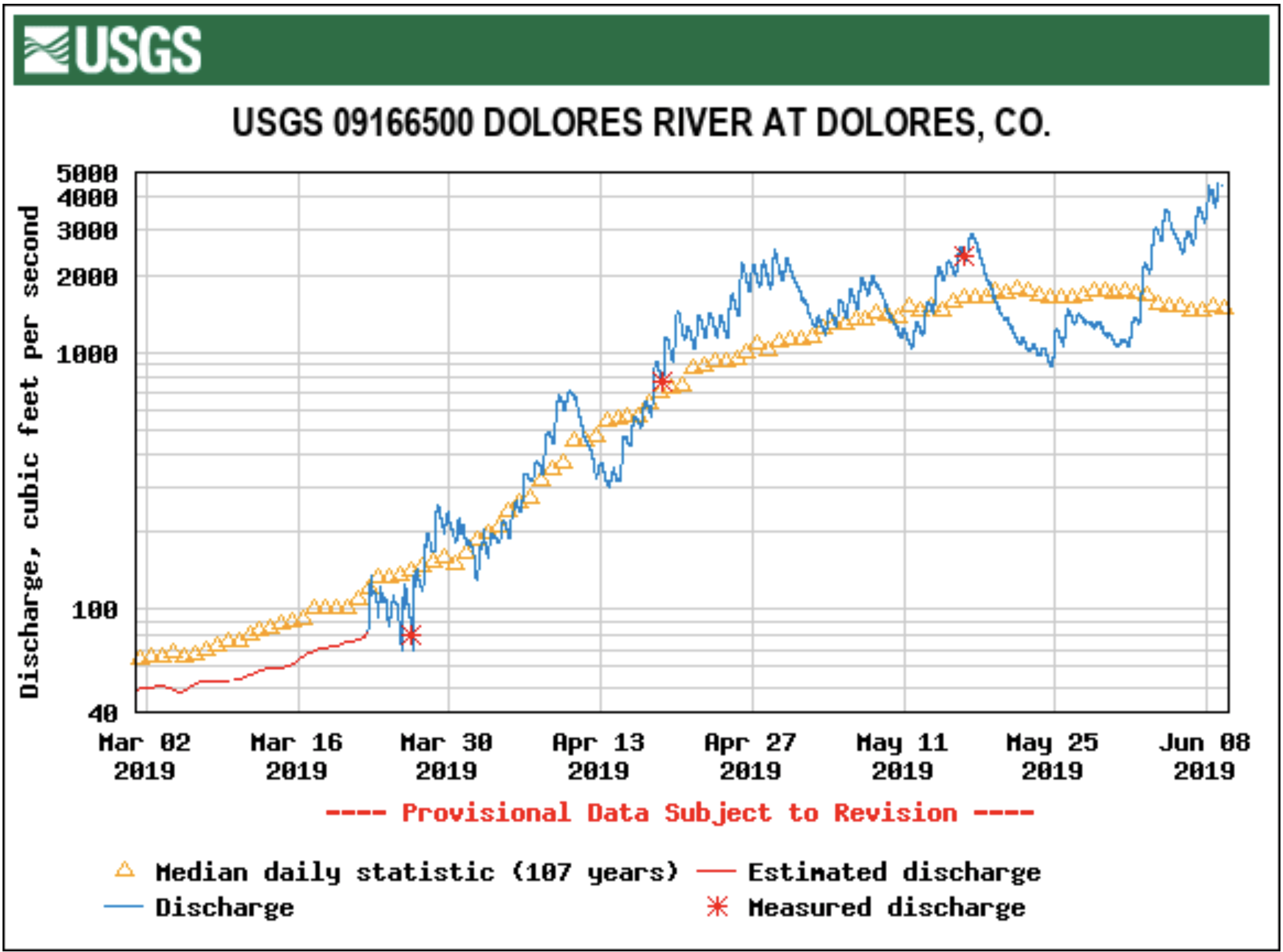

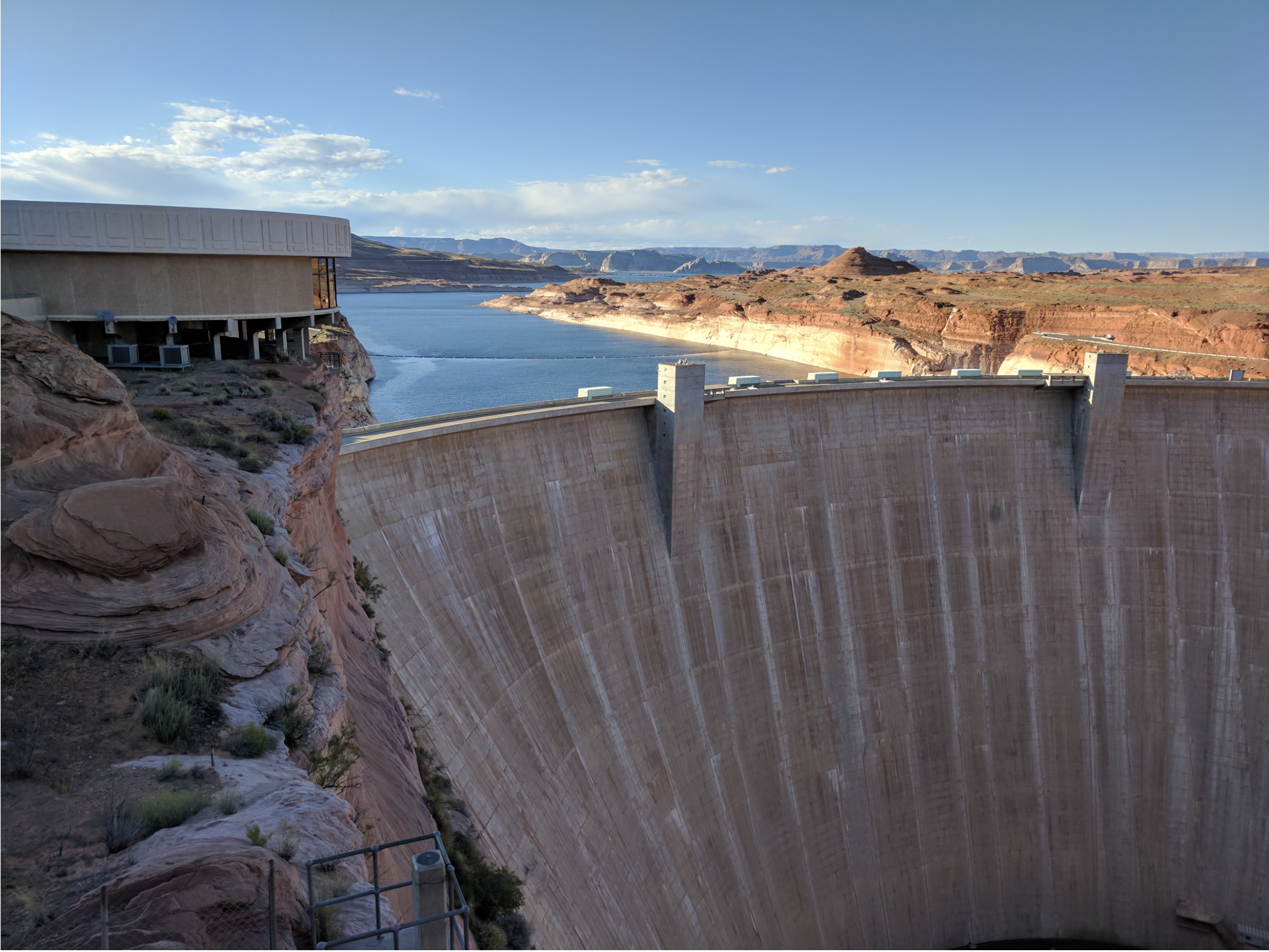
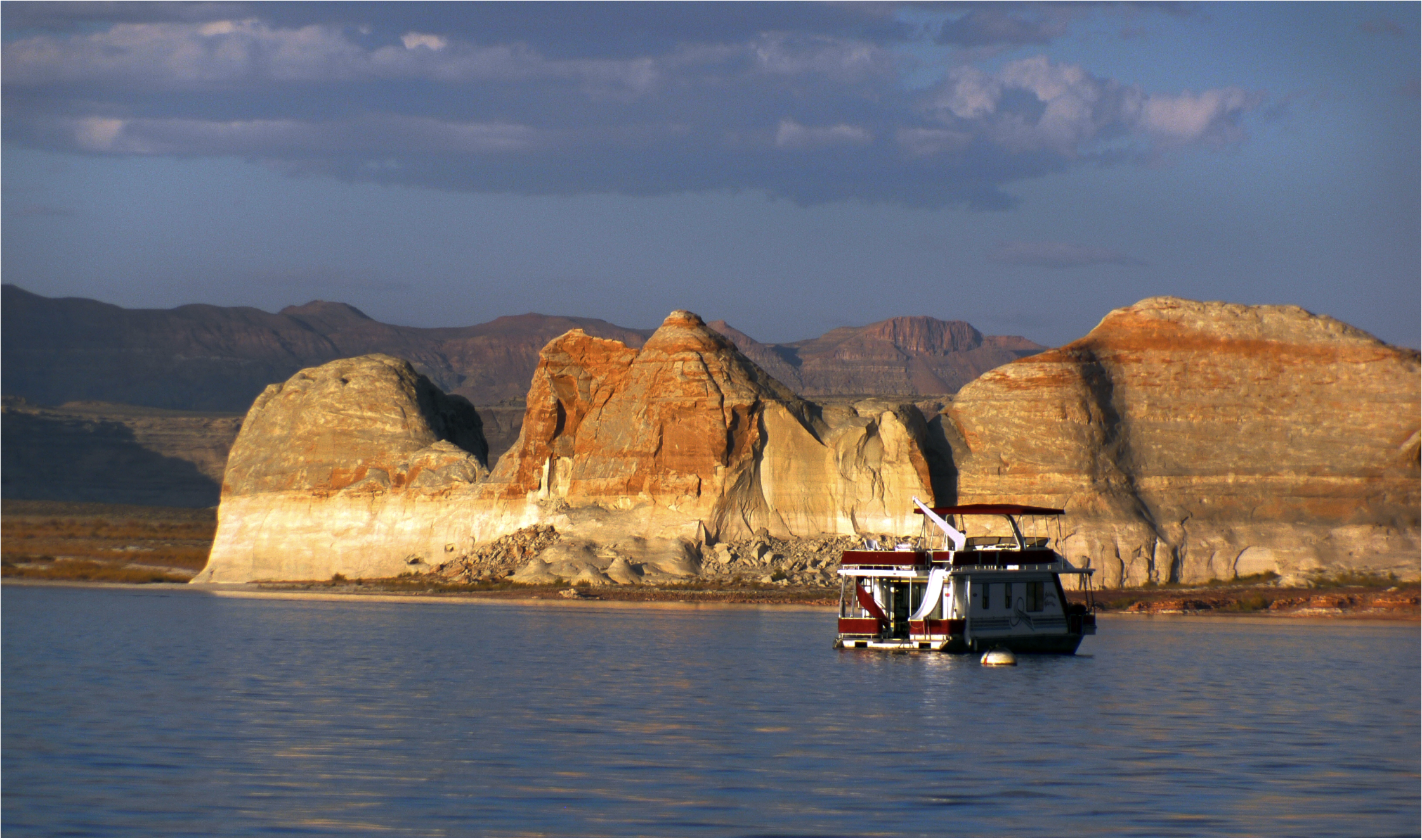
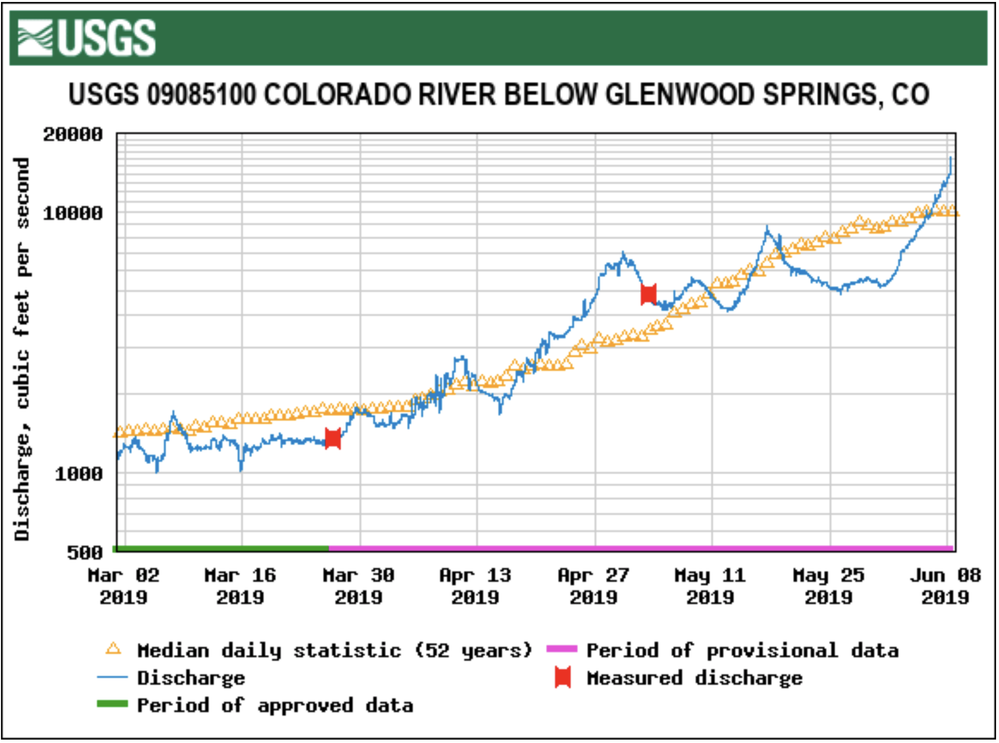
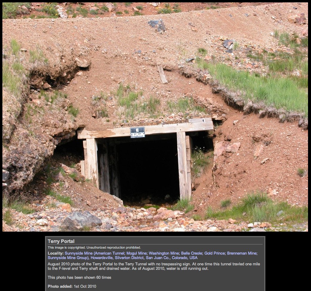

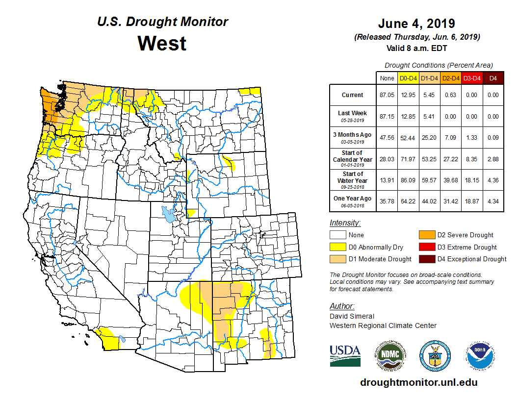

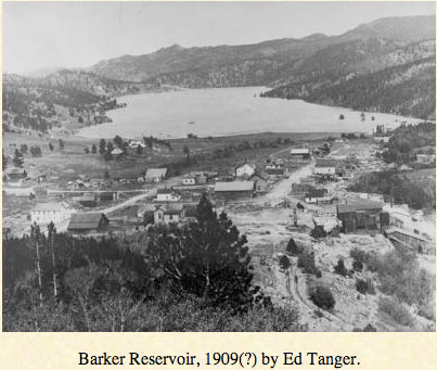

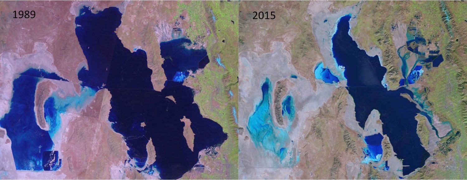

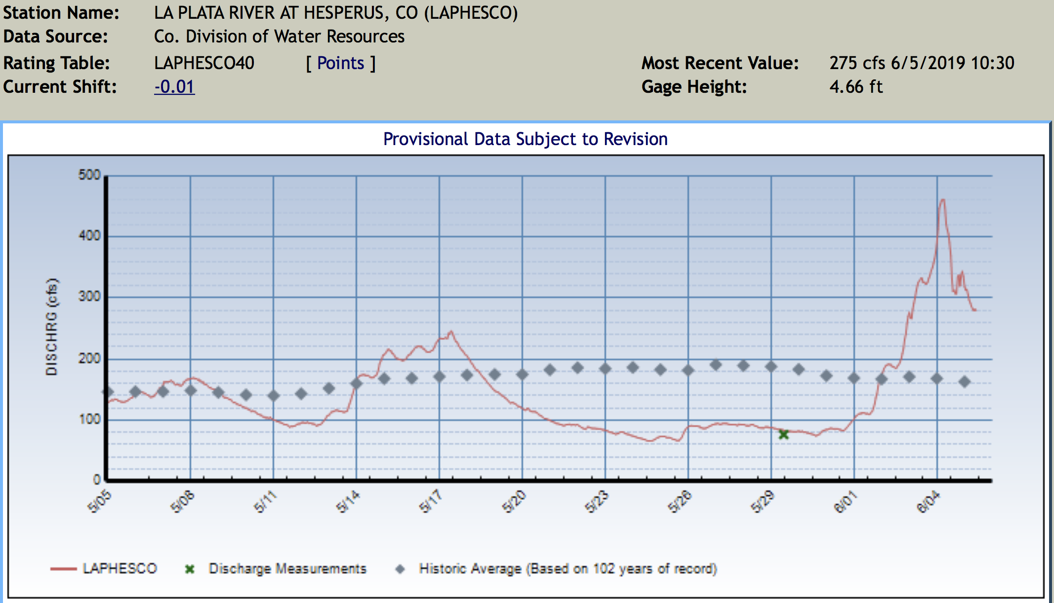

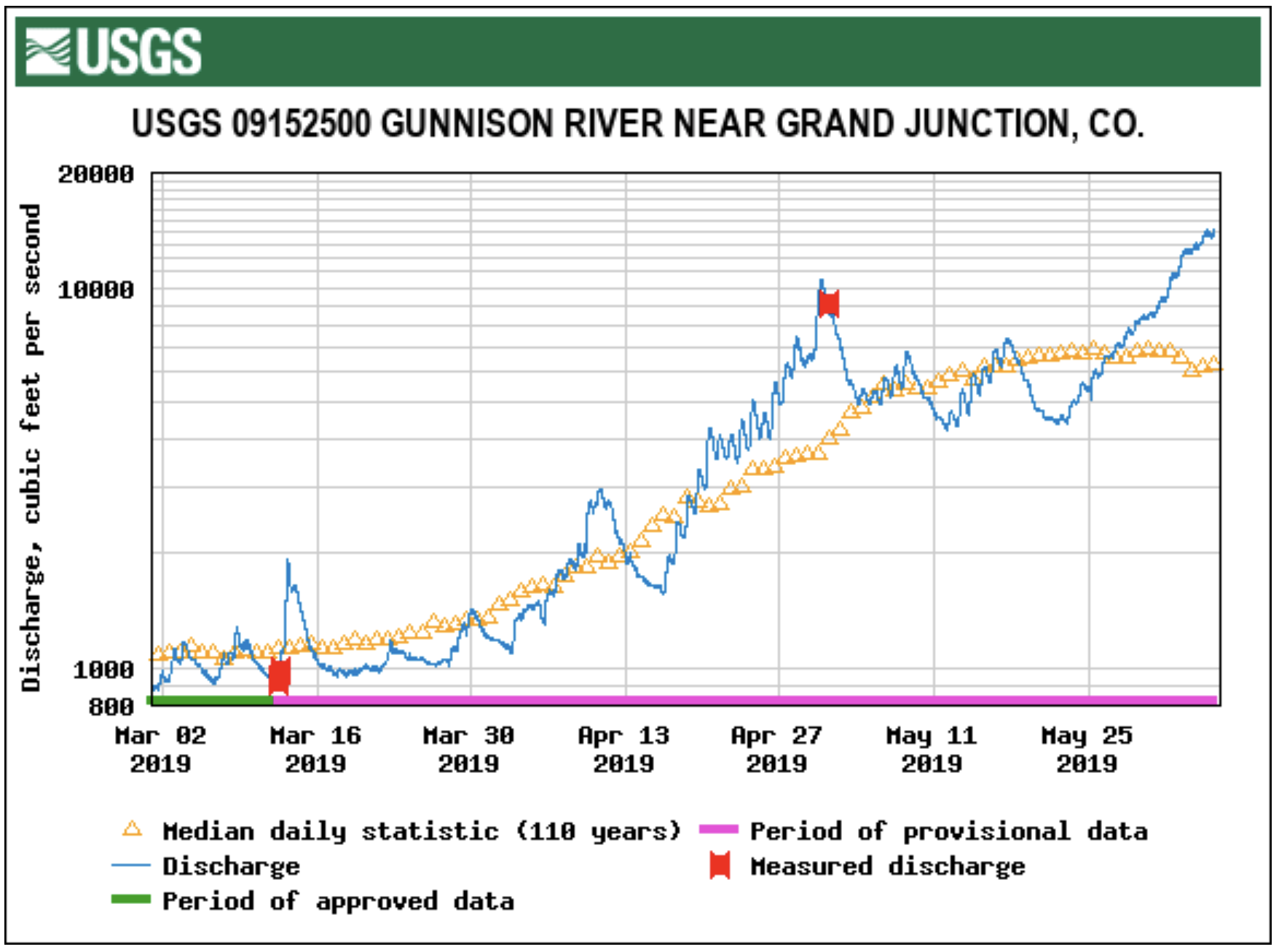
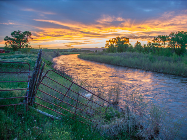


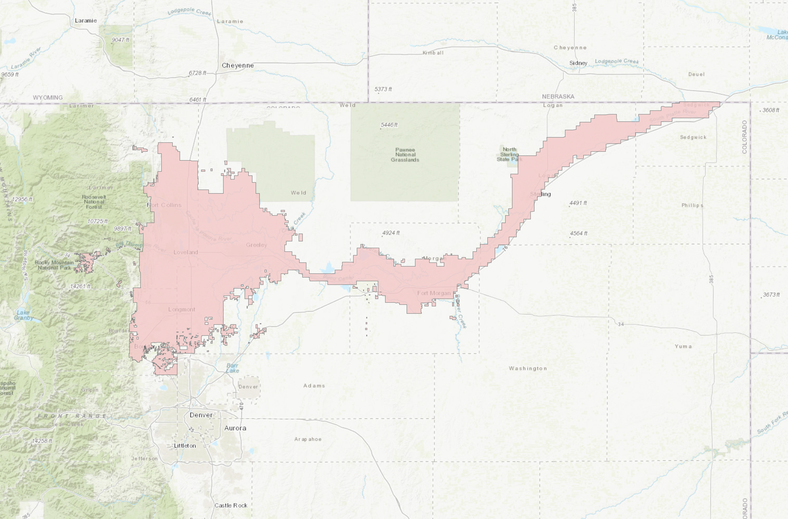

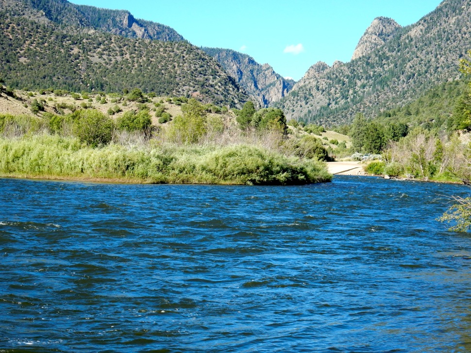
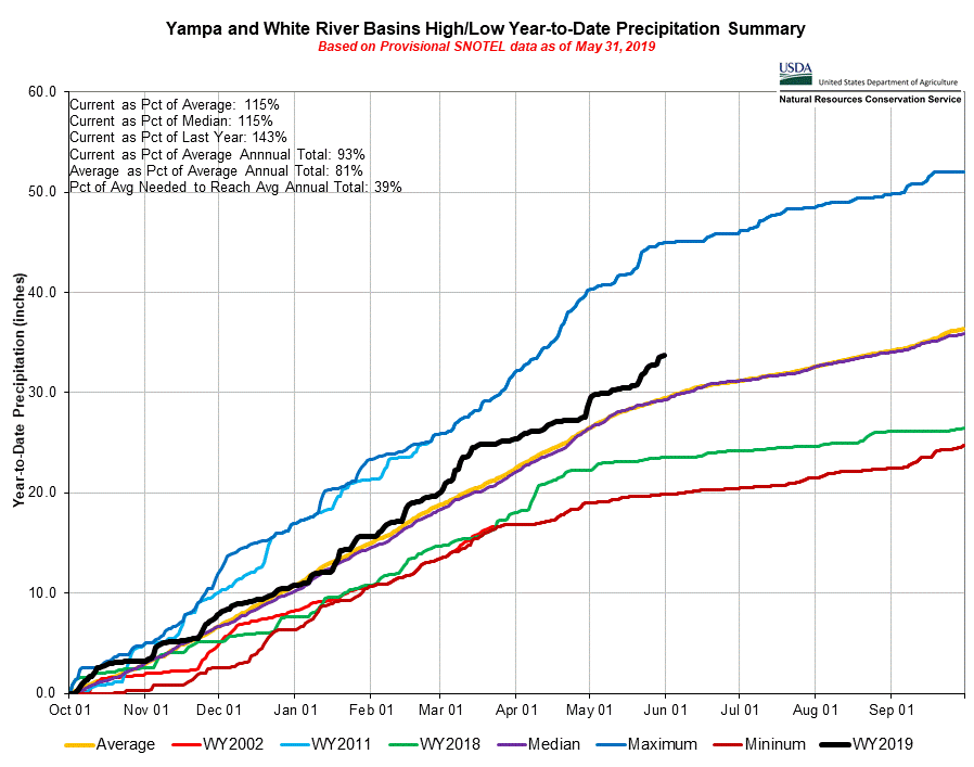

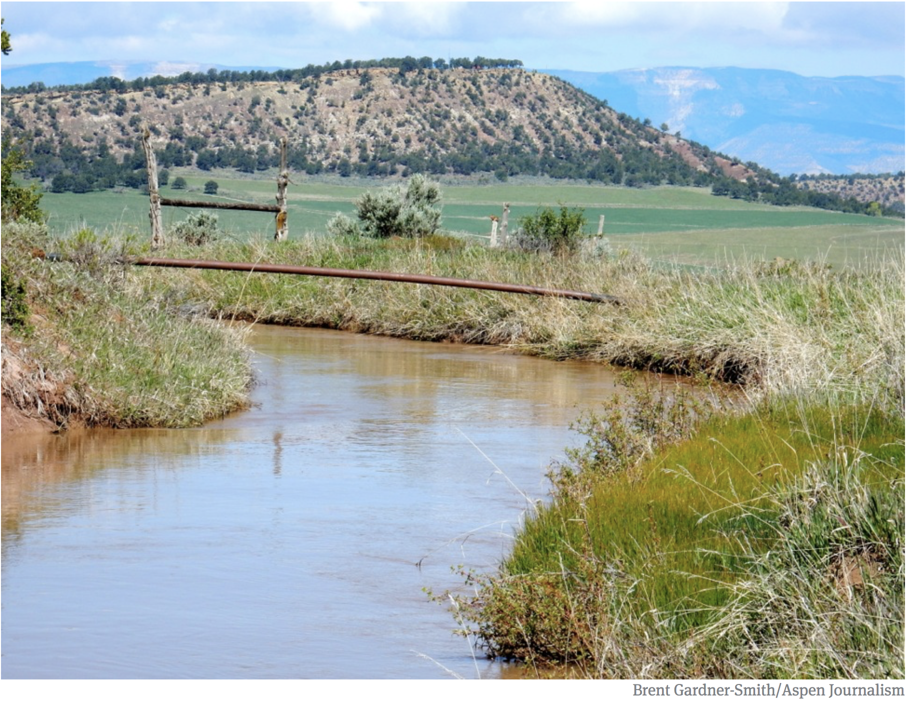


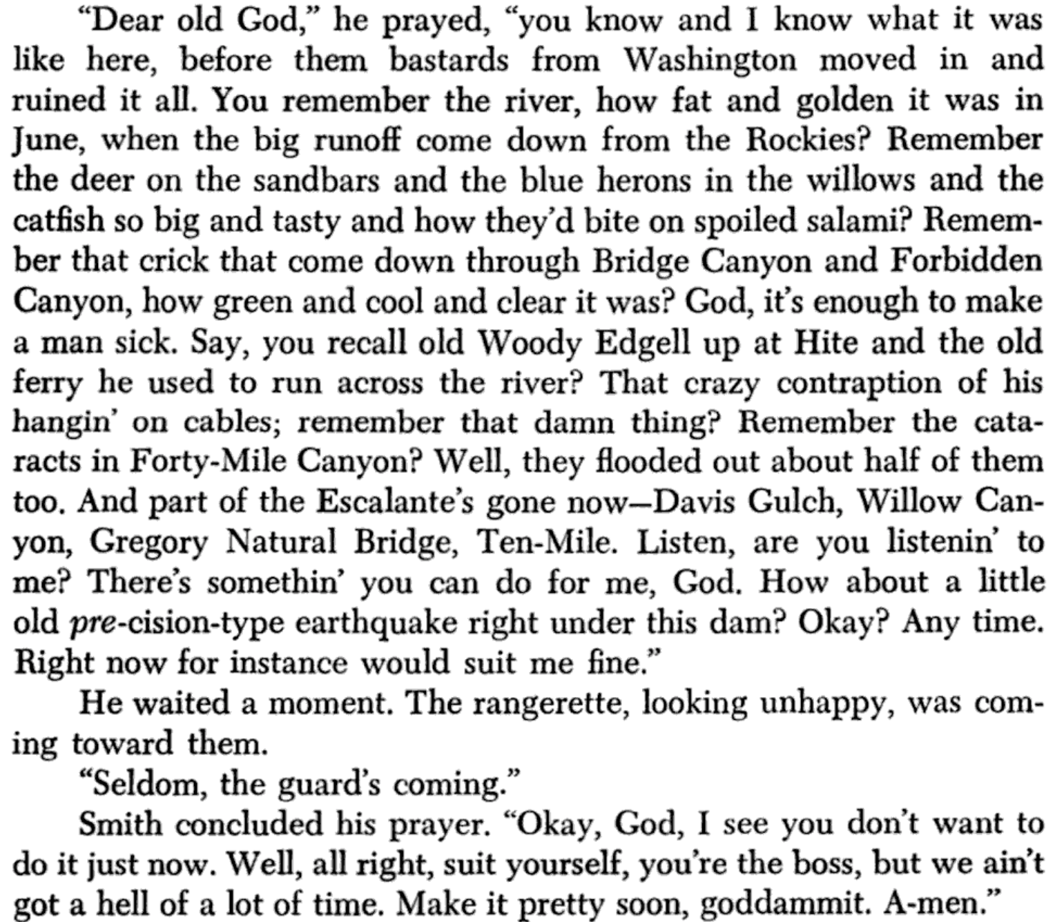
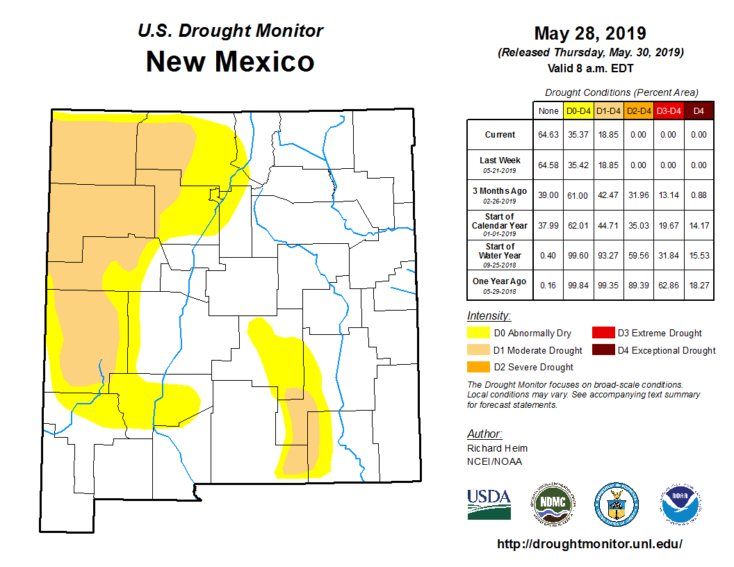

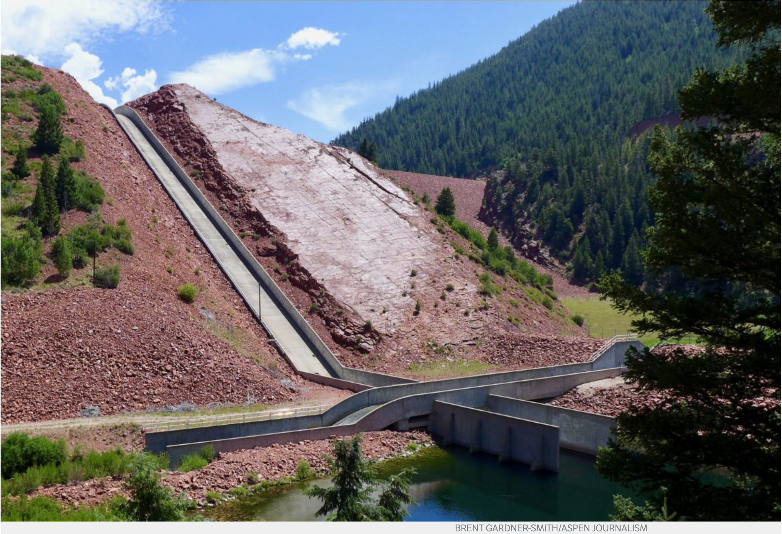
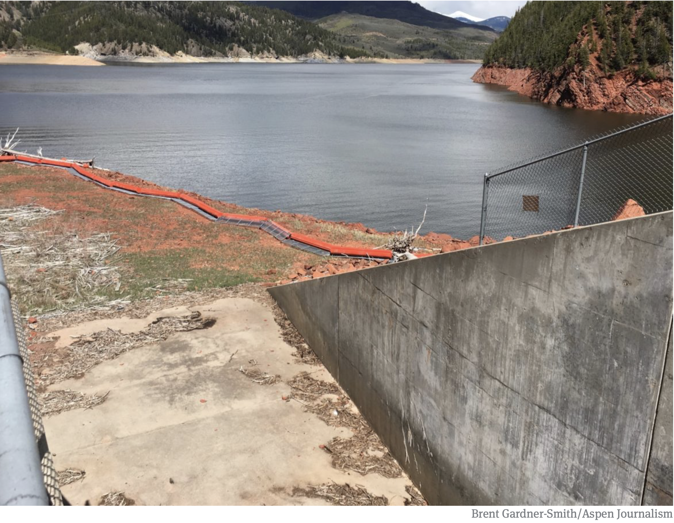
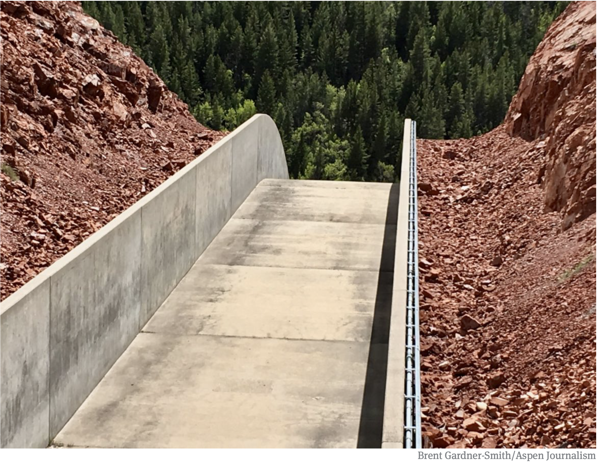

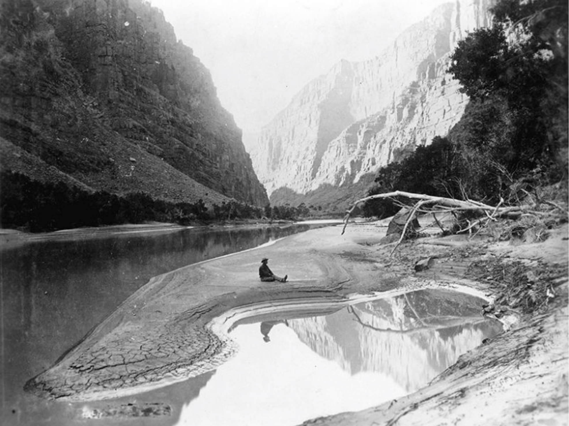


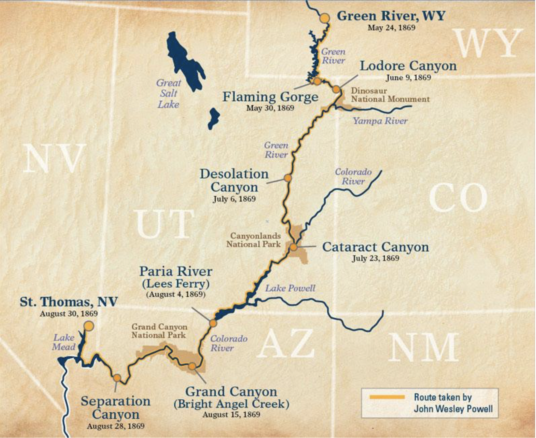

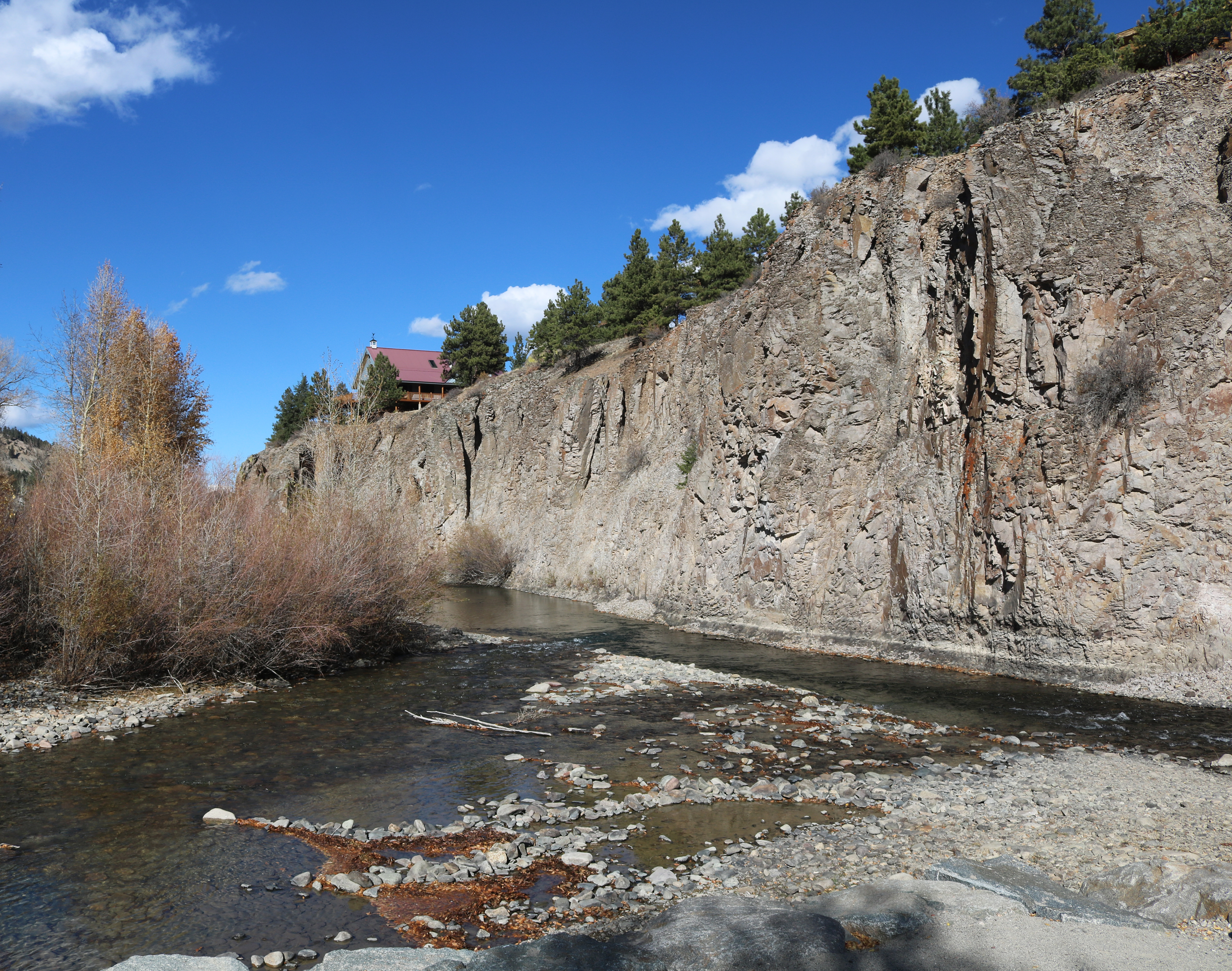

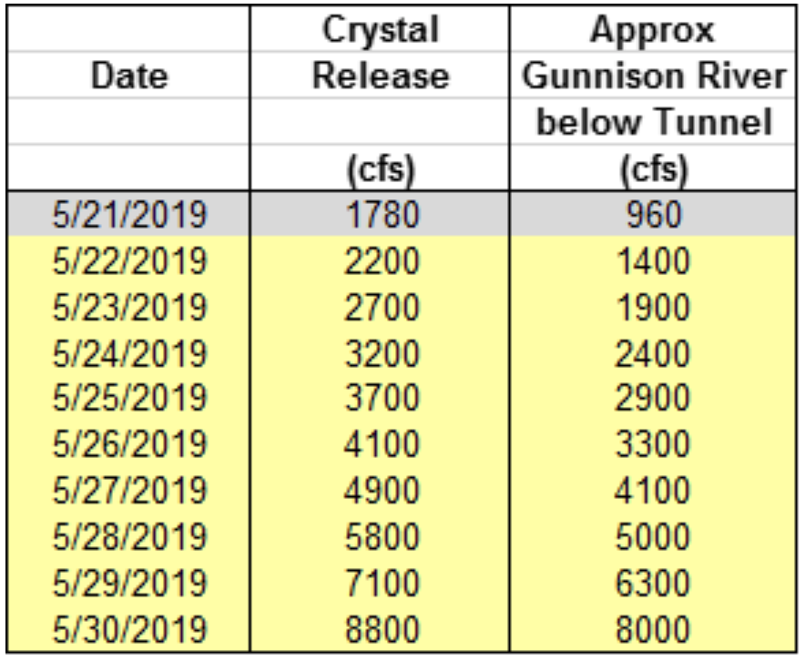
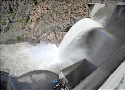


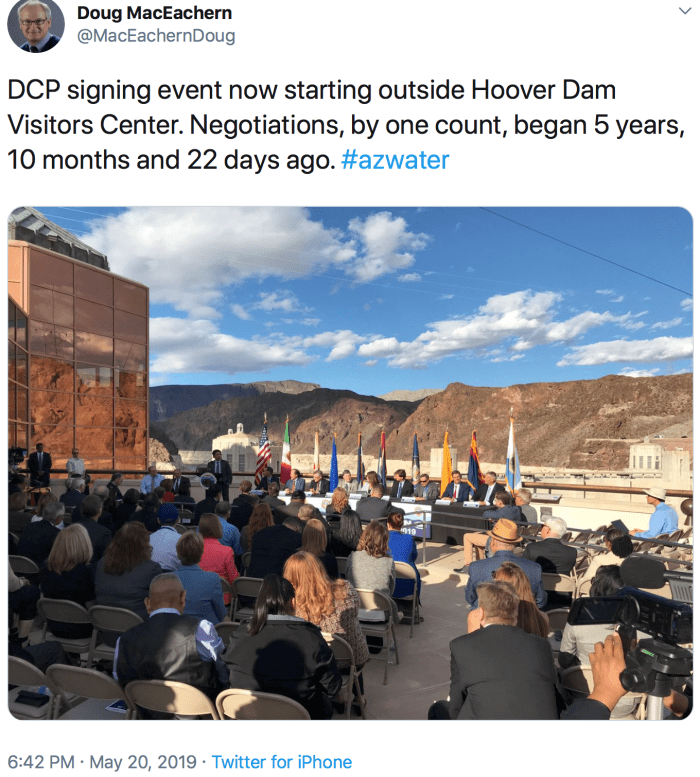
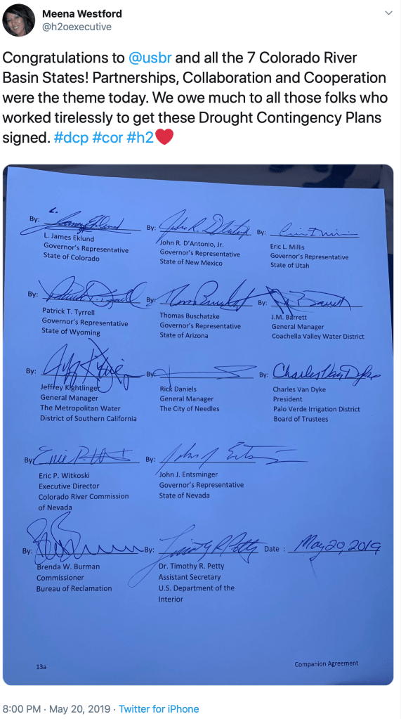


")