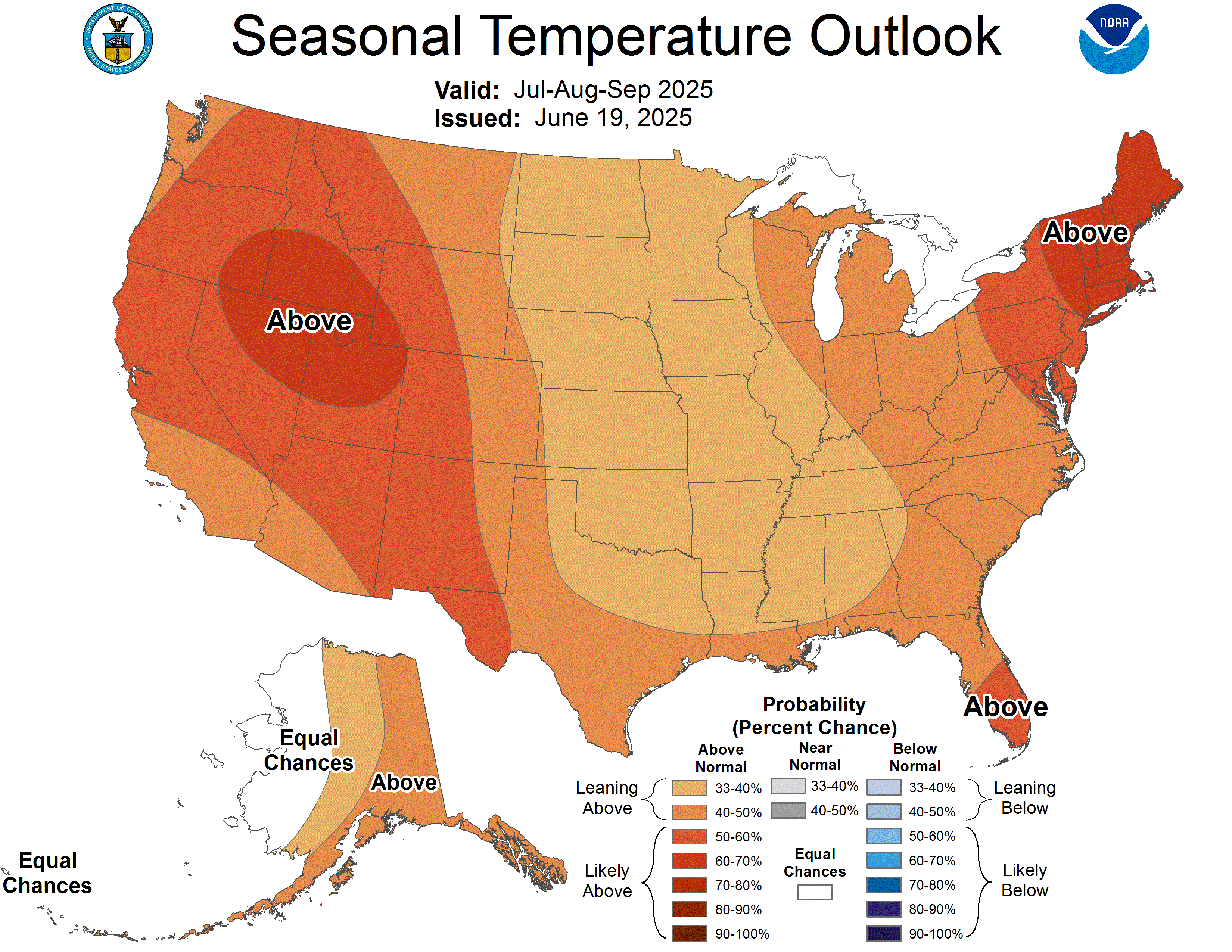
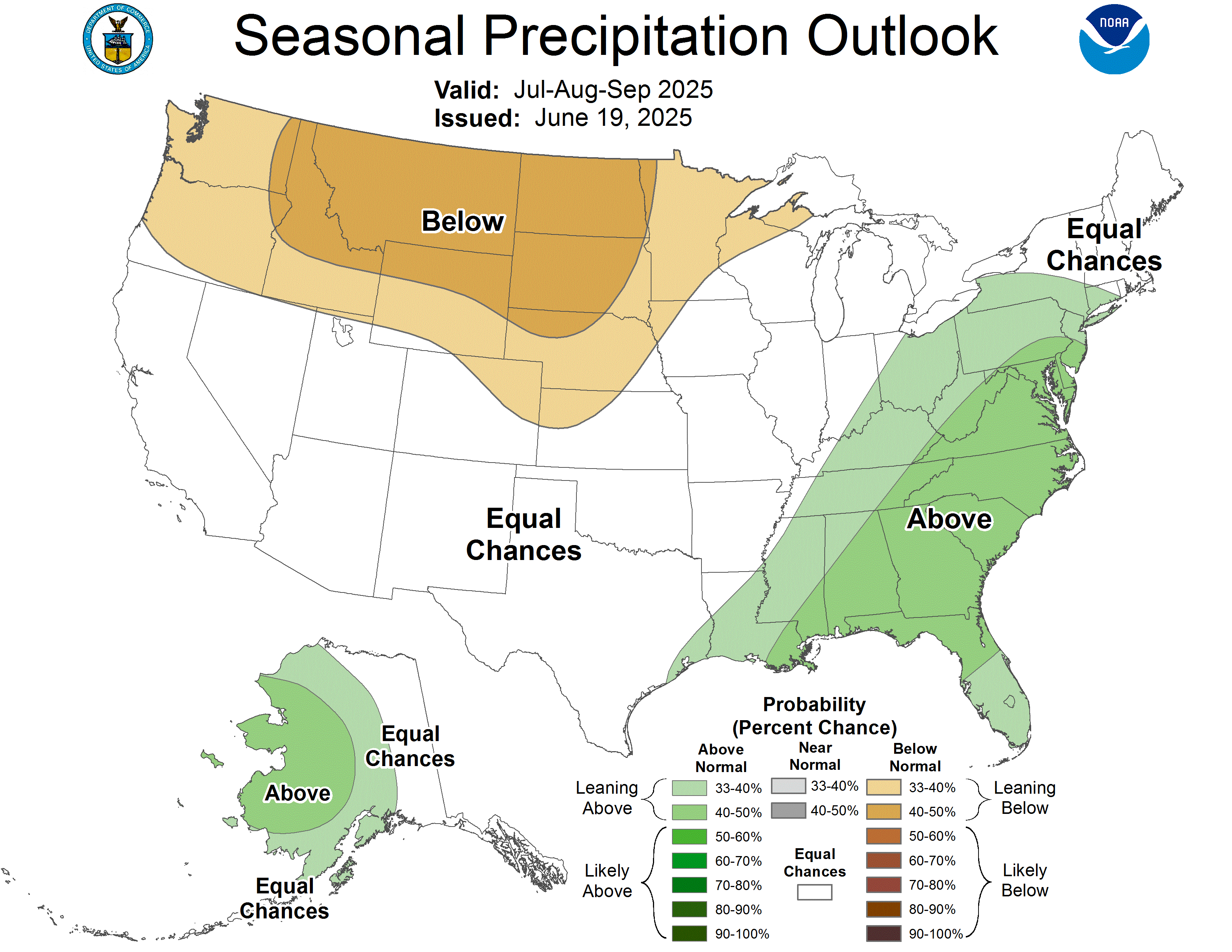
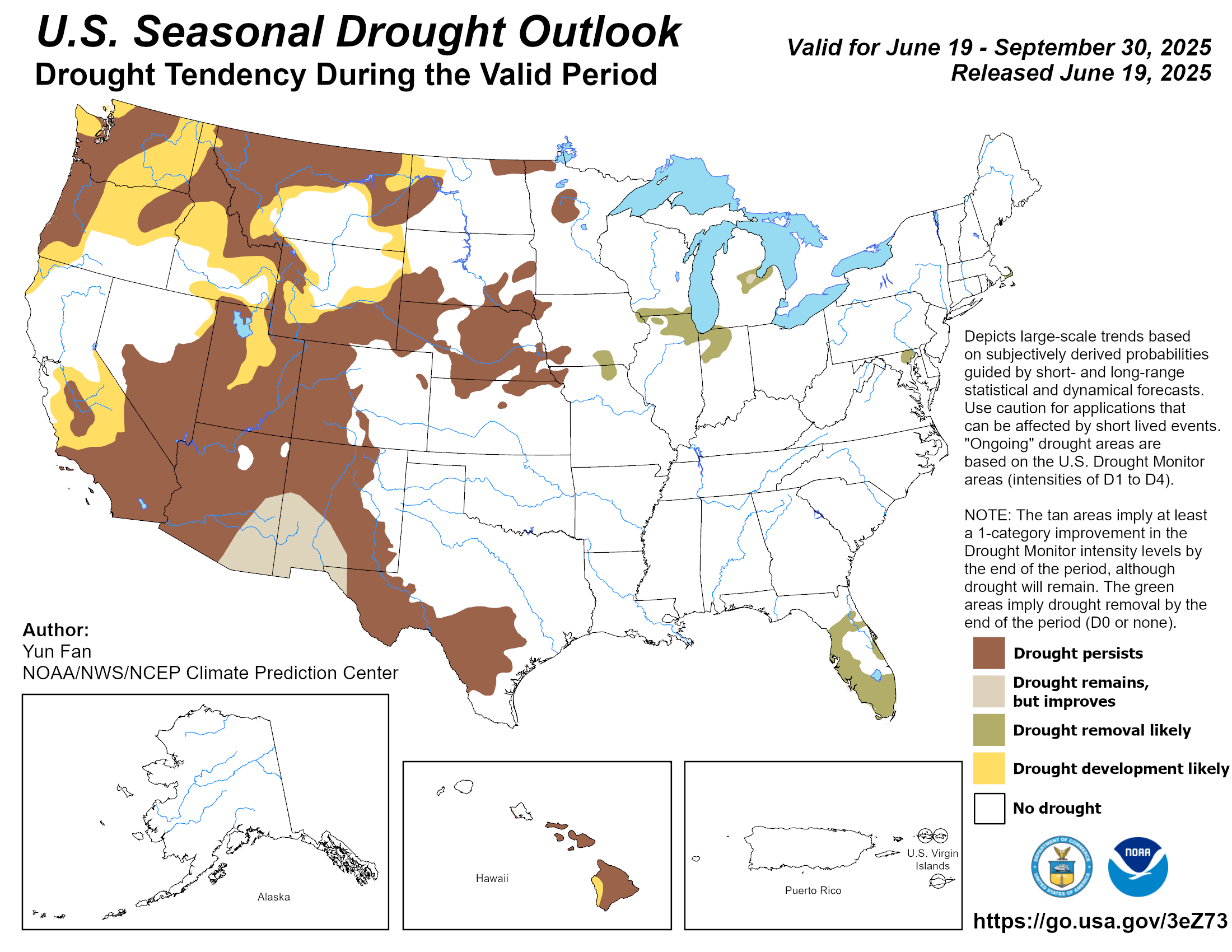
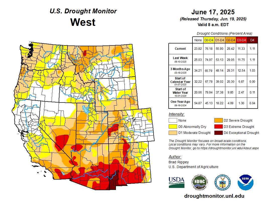
Former White River National Forest boss fears for future of public lands amid drastic budget, staffing cuts: Scott Fitzwilliams says itโ€™s time to pay attention — Elizabeth Stewart-Severy (AspenJournalism.org)

Scott Fitzwilliams at White River National Forest supervisorโ€™s office in Glenwood Springs. Fitzwilliams left his job on March 21 after accepting the Trump administrationโ€™s deferred resignation offer. Credit: Courtesy photo

Click the link to read the article on the Aspen Journalism website (Elizabeth Stewart-Severy):

April 13, 2025

Since his early retirement just over three weeks ago, former White River National Forest Supervisor Scott Fitzwilliams has been soaking up his favorite activities on public lands. 

โ€œThe public lands are my life,โ€ Fitzwilliams said. โ€œNot just because I worked there. Thatโ€™s where I get my sense of wellbeing and quality of life.โ€

Fitzwilliams, who led the 2.3 million acre White River National Forest for 15 years, left his position in late March as part of the Trump administrationโ€™s deferred resignation program. He said when he left, the White River was down 27 or 28 positions since Jan. 1, 2025, and just over 50 fewer positions in the past 12 months. The cuts account for nearly a third of the forestโ€™s workforce, which by his count stood at 155 positions about a year ago. 

โ€œItโ€™s pretty bleak right now,โ€ Fitzwilliams said. 

The Forest Service announced last fall that it would not be hiring any non-fire, seasonal workers for summer 2025 and it saw an additional round of cuts involving thousands of positions nationwide on Feb. 14, led by the Department of Government Efficiency. Even more drastic cuts are expected as the Trump administration moves to consolidate operations. 

โ€œPretty much across the country, there will not be any of our normal seasonal workforce that cleans the bathrooms, that clears the trails, that maintains our recreational facilities, that enforces regulations. Across the country, we wonโ€™t have those people this year,โ€ Fitzwilliams said. 

While the current administrationโ€™s cuts have made exceptions for federal firefighters, Fitzwilliams is concerned that firefighting efforts will be hampered by the reduced workforce. 

Those Forest Service employees who work out in the field โ€œare also the people that often are the first to spot or respond to a fire,โ€ Fitzwilliams said.  

The organizational structure and support for fighting fires on the White River National Forest has been cut, too; drivers and those who buy supplies and food for firefighters are among the lost positions, Fitzwilliams said. 

Local White River National Forest officials declined to comment and requested any questions be sent in writing. Aspen Journalism received a response from an unnamed spokesperson at the U.S. Department of Agriculture.

โ€œWildland firefighting positions continue to be exempt from the hiring freeze a (sic) operational readiness is not impacted,โ€ the statement read. โ€œThe U.S. Forest Service, along with our other federal, state, tribal and local partners continue to prepare for and respond to wildfire incidents as needed.โ€

Fighting and preventing major wildfires is often top of mind for those living in the drought-prone, arid West, but itโ€™s far from the only job with which the Forest Service has been tasked. The agency is responsible for managing forests for multiple uses, including wilderness, wildlife, recreation, logging, grazing and clean water. 

โ€œOur public lands, when we live amongst them, we do tend to take them for granted,โ€ Fitzwilliams said. โ€œBut they cannot be anymore.โ€ย 

Public lands are where โ€œI get my sense of wellbeing and quality of life,โ€ says Scott Fitzwilliams, who took an early retirement offer and stepped down last month as supervisor of the White River National Forest after a 15-year tenure. But he fears that actions undertaken by the new administration may lead to neglect of treatured public lands. Credit: Courtesy Scott Fitzwilliams

โ€˜Part of the strength of Americaโ€™ at risk

The U.S. Forest Service oversees 193 million acres of land, including the 2.3 million acres of the White River National Forest, with its 11 ski resorts, eight wilderness areas and five ranger districts. And Fitzwilliams thinks the value of public lands far exceeds what can be tracked on paper. 

โ€œI believe public lands in America are part of the strength of America,โ€ he said. โ€œItโ€™s a uniquely American ideal.โ€ 

Fitzwilliams noted that this ideal is not one enshrined in the Constitution; it relies on public engagement. 

โ€œPublic lands provide so much to so many and itโ€™s not easy to manage them for all the different uses. National forest management is hard,โ€ Fitzwilliams said. โ€œYou have to manage for wilderness and logging and grazing and mining and recreation and all these things, and clean water and wildlife โ€” itโ€™s hard, and so people get frustrated. It may not align perfectly with everyoneโ€™s values. 

โ€œBut itโ€™s a system of public lands in the public trust that, thank god, we have the ability to argue over them. Iโ€™m worried that if theyโ€™re dismantled, what appears to be organizationally dismantled, we could lose this incredible part of America.โ€ 

While there are indications that the Trump administration may sell off public lands, Fitzwilliams said heโ€™s more concerned at this point that neglect and a lack of maintenance and staffing will effectively dissolve federal land management organizations. 

โ€œI just think itโ€™s a devastating thing to think of a future that we donโ€™t have this system,โ€ he said. 

The Forest Service was facing budget shortfalls prior to the current cuts. The budget for the White River National Forest for this fiscal year is โ€œabysmal,โ€ Fitzwilliams said.

There are 2,800 miles of roads across the forest. โ€œOur road maintenance budget this year, when I left three weeks ago, was a whopping zero. Zero.โ€ 

There is no funding to support the work that it takes to rebuild culverts when they are blown out by spring thaws, for example. Instead, Fitzwilliams said thereโ€™s a three-person crew with one piece of machinery that can try to address emergencies. 

The White River National Forest attracts about 18 million visitors every year; Fitzwilliams said the forest regularly collects more money than it spends through the appropriated budget. Nevertheless, the recreation budget is bare. 

โ€œOur recreation budget โ€” the most profitable, most efficient, most visited forest in the entire country โ€” I think the recreation budget was $150,000,โ€ Fitzwilliams said. โ€œThatโ€™s not enough money to pump the toilets this year.โ€

The Department of Agricultureโ€™s statement to Aspen Journalism โ€” received after we sent questions to local forest officials โ€” acknowledged that โ€œrecreation services and public access are vital to local economies.โ€

โ€œThe Forest Service remains committed to ensuring public health and safety while balancing access to recreation areas during this transitional time. โ€ฆ It is our intent to maintain access to recreation opportunities to the greatest degree possible,โ€ the statement said.

Such a response reflects what Fitwilliams described as an agency directive that requires all interactions with the media to be cleared by top officials in Washington D.C. 

โ€œThis is the biggest gag order anyone has ever seen,โ€ Fitzwilliams said. โ€œIn 35 years, Iโ€™ve never seen anything like it.โ€ 

Aspen Journalism also filed a request for information about budget and staff cuts through the Freedom of Information Act in early April and has not received a response. 

There are places, Fitzwilliams said, where the Forest Service could certainly improve efficiency and cut costs. He said he shares concerns about the federal debt and would welcome the opportunity to work on efficiency and cost savings.

โ€œIt should be a systematic, collaborative approach, by focusing on mission-critical work first,โ€ Fitzwilliams said.  

Instead, in the mass cuts on Valentineโ€™s Day, the White River National Forest fired 16 people, 15 of whom were permanent part-time workers whose job was in the field, out on the 2,500 miles of trails in the forest. They earned about $19,000 per season, Fitzwilliams said, and six of the positions were paid for by other agencies or governments, like Pitkin or Eagle counties. The rest were funded through fees collected by the White River National Forest. 

โ€œThe United States taxpayer saved zero dollars in the initial firings,โ€ Fitzwilliams said. 

Finding ways to reduce spending and become more efficient would involve detailed analysis and hard work, which Fitzwiliams said he would welcome. 

โ€œI donโ€™t think the hard work is sending out a note on Valentineโ€™s Day saying a bunch of people are fired, with no analysis whatsoever of who these people were. None. There was none. It was low hanging fruit and they took it,โ€ he said.  

Fitzwilliams had been planning to retire in about a year, but decided to take the buyout offered to federal employees under the deferred resignation program, and receive full pay and benefits through Sept. 30. He sent a letter to White River employees and partners announcing his resignation on Feb. 25. 

โ€œQuite frankly, I didnโ€™t have the energy to be part of what is looking more and more like the dismantling of the agency,โ€ Fitzwilliams said. โ€œThat last month or two at work was โ€” Iโ€™ve never been that stressed out ever. I was feeling hopelessness, having to fire people for no reason and trying to figure out how we would get the work done, serve the public and meet the agreements with our partners. It was stressful.โ€ 

Brian Glaspell, who previously was director of strategic planning for the Forest Serviceโ€™s Rocky Mountain region, is the acting supervisor of the White River National Forest.ย 

Scott Fitzwilliams at Hanging Lake. Partnerships with local communities developed under his tenure as White River National Forest supervisor include a reservation and shuttle system to access the popular hike to the lake in Glenwood Canyon. Credit: Courtesy Scott Fitzwilliams

Forest health depends on partnership, public involvement

The White River National Forest is the largest national forest in Colorado, spanning parts of nine counties and bordering communities including Aspen, Glenwood Springs, Vail, Breckenridge and Leadville. Much of the identity and economy of these communities is tied to the forest. 

โ€œAspen isnโ€™t Aspen without the forest around it,โ€ Fitzwilliams said. 

These communities rely on the forest in other ways, too, including for a healthy water supply and air quality. 

โ€œEvery single community on the West Slope gets its drinking water off of national forest,โ€ he said. โ€œWe ought to have people taking care of that.โ€ 

In his time with the White River National Forest, Fitzwilliams built partnerships with local governments, nonprofits and other agencies that helped to share stewardship of the forest as recreation numbers boomed in the past decade. For example, Pitkin County has provided funding for forest protection officers at North Star Nature Preserve and works in partnership with the agency on several other properties that share boundaries with the White River National Forest. 

โ€œThese partnerships were the epitome of efficiency,โ€ said Gary Tennenbaum, director of Pitkin County Open Space and Trails.

The Forest Service worked with Pitkin County, the city of Aspen and the Independence Pass Foundation to bring more rangers to heavily trafficked areas like Independence Pass, Wildwood, Richmond Ridge, Pearl Pass and the Castle Creek area. 

The countyโ€™s public works and open space and trails departments pay for two, full-time seasonal Forest Service employees; for now, those positions remain intact. A third position, paid for by a partnership between Pitkin County, the city of Aspen and the Independence Pass Foundation, has been cut by the Forest Service because the employee was in their probationary period. 

Fitzwilliams is proud of his legacy of cross-agency work. 

โ€œItโ€™s the part of the job Iโ€™m going to miss the most. We roll up our sleeves and figure out how to solve problems with only one objective: how do we serve the public?โ€ he said. โ€œItโ€™s a symbiotic, shared stewardship. Weโ€™re doing this work together. Weโ€™re leveraging in a very innovative, creative, efficient way.โ€

But heโ€™s concerned that the Forest Service now has less to bring to the table in terms of staffing and funding. 

โ€œI donโ€™t know how long we think that local governments can support this, and the scary part that keeps me up at night is then what happens afterwards,โ€ Fitzwilliams said. 

In many respects, the White River National Forest is fortunate and unique in the level of support it receives from surrounding communities. According to a 2019 economic analysis of national forests, the White River contributed more than 22,000 jobs, bringing in $960 million to local communities and workers. 

Local organizations, like the Independence Pass Foundation and Roaring Fork Transportation Authority, provide labor, funding and support that enhances public lands management of the White River National Forest as well. 

โ€œWeโ€™re fortunate around here, we have those organizations. Thatโ€™s not the case everywhere,โ€ Fitzwilliams said. โ€œThere is no one to step up and fill the gaps. Thatโ€™s worrisome.โ€ 

The health of the White River National Forest in the upcoming summer season will depend deeply on the partnerships that Fitzwilliams and his colleagues have built over the past decade. 

โ€œThis summer, weโ€™re going to need the public to care more than ever about their public lands,โ€ Tennenbaum said. โ€œPeople need to have an ethic this summer that is very respectful of the land. You come across a campsite, donโ€™t just walk by it. Make sure the campfire is out. Think about how you deal when you have to go to the bathroom. Thereโ€™s going to be some impacts; we have to recognize that and not make it worse.โ€

The White River National Forest is not alone in facing a summer season with large numbers of crowds and little ability to manage those crowds to prevent ecological damage. Fitzwilliams notes that public lands are deeply valuable to many Americans, and he retains hope in the publicโ€™s ability to speak up for a national treasure. 

โ€œI think the American public, not excluding anyone, theyโ€™re going to stand up for their public lands,โ€ Fitzwilliams said. โ€œUnfortunately weโ€™re going to see some hurt in the meantime.โ€

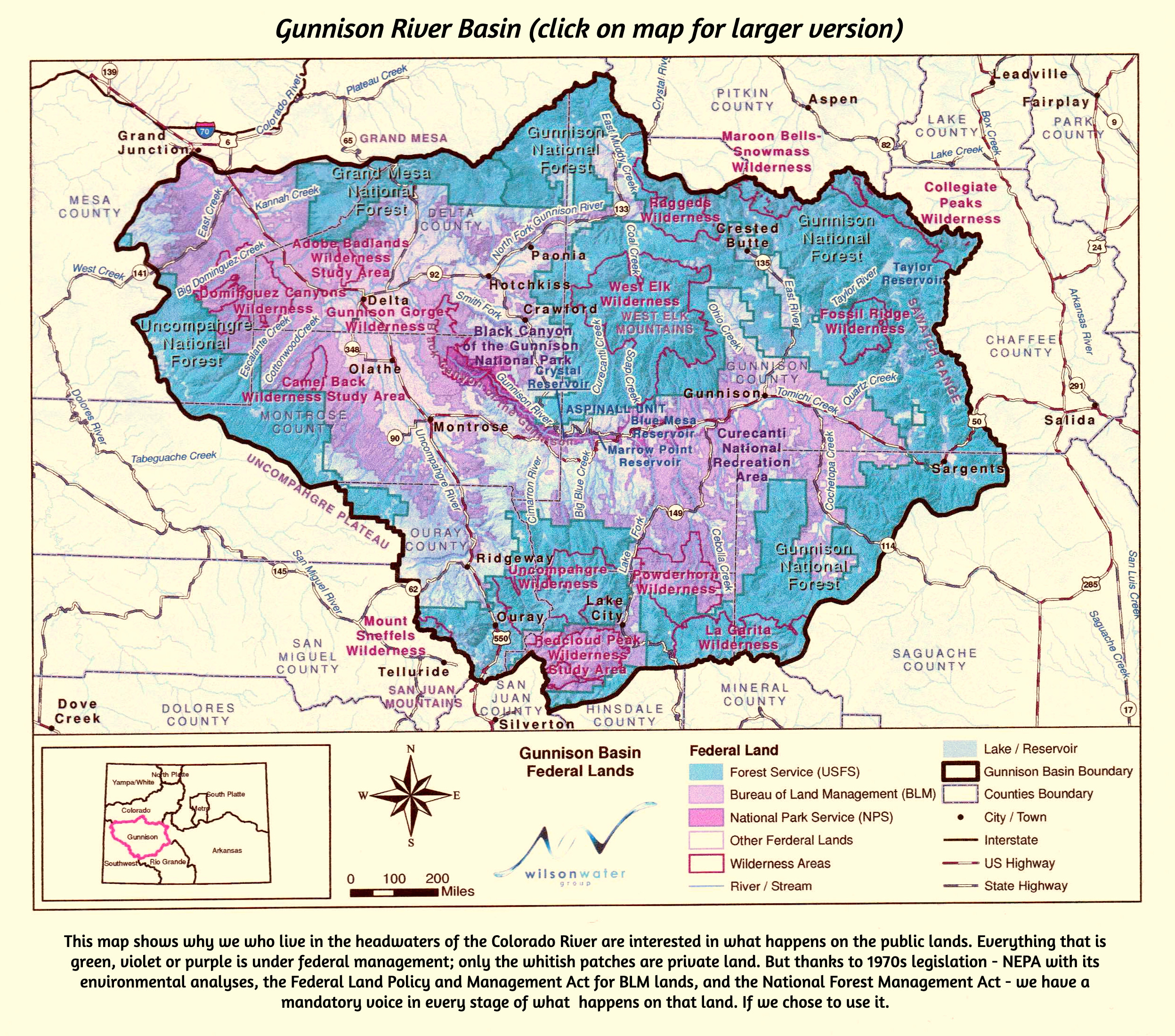
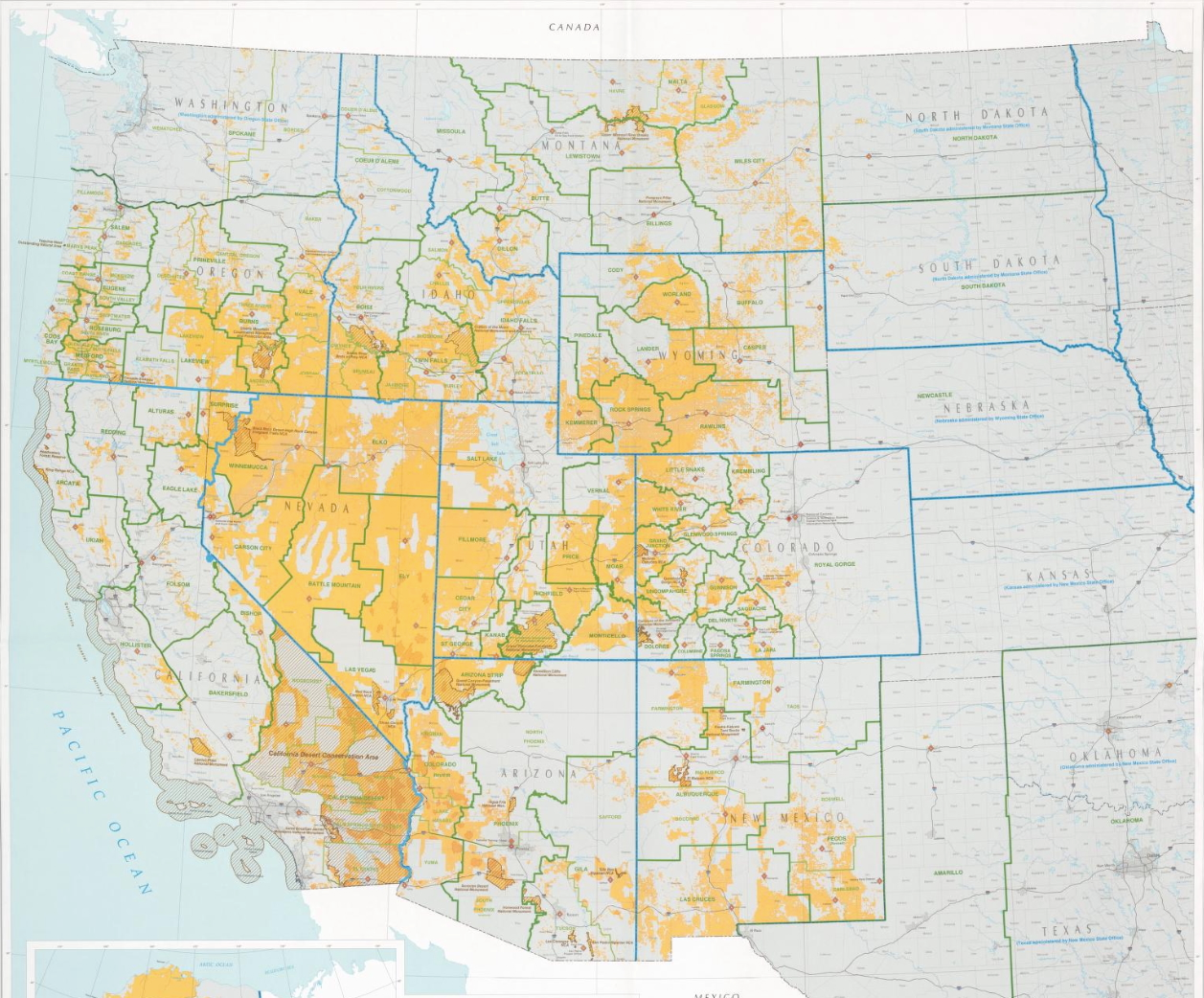
This map shows land owned by different federal government agencies. By National Atlas of the United States – http://nationalatlas.gov/printable/fedlands.html, “All Federal and Indian Lands”, Public Domain, https://commons.wikimedia.org/w/index.php?curid=32180954

A spring thaw in federal funding: Late March brought the spring thaw to Colorado and most of the federal funds for #ClimateChange-related work — Allen Best (BigPivots.com)

F Street in Salida February 2025. Photo credit: Allen Best/Big Pivots

Click the link to read the article on the Big Pivots website (Allen Best):

April 8, 2025

Federal funds for climate-change-related projects in Colorado have started arriving in almost perfect concert with the spring thaw.

Among the applications for the hundreds of millions of dollars will be:

  • energy efficiency work in southwestern Colorado communities,
  • curbing methane emissions from old coal mines west of Carbondale, and,
  • preparation of a climate action plan for the Yampa Valley.

Among the smaller grants, $187,605 went to Salida and Chaffee County. The money will fund a staff position shared by the two jurisdictions to create a greenhouse gas inventory, a climate action plan, and then the means to implement what the city and county decide to do.

That grant and seven others for rural Colorado jurisdictions from the U.S. Department of Energy totaling $1.865 million were announced in August 2024. The federal program had received key funding from the Infrastructure Investment and Jobs Act of 2021.

The awards were temporarily frozen by President Donald Trump.

The money is largely to be used for staffing for climate action planning but also for workforce training in communities where extraction and combustion of fossil fuels has been fading.

โ€œCapacity is an essential component of local climate action, and these new awards will play an important role in enabling this work in Coloradoโ€™s rural and mountain communities,โ€ Christine Berg, senior policy advisor for local governments in the Colorado Energy Office, said in the August 2024 announcement.

A far larger grant of $200 million to the Denver Regional Council of Governments, or DRCOG, had been announced in July 2024.

See more at โ€œA great transition 50 years from nowโ€

That money, a product of the Inflation Reduction Act of 2022, was to have been used for retrofits of buildings in the nine-county metropolitan area. DRCOG did not respond to repeated requests as to whether the money has been unthawed or is expected to be.

The Colorado Energy Office had been awarded $129 million. A spokesperson confirmed the money has arrived. It will be used:

  • To deploy advanced methane monitoring technology to produce data that will inform regulatory policy concerning methane emissions from landfills and coal mines, including those in the Redstone-Paonia area.
  • For energy efficiency and electrification upgrades in large commercial buildings that are otherwise hard to decarbonize.
  • To help local governments to implement projects that help reduce emissions from buildings, transportation, electric power, waste and other economic sectors. The money is to be administered through a new program, the Local Government Climate Action Accelerator.
Part of the $129 million received by the Colorado Energy Office will be used to work on large commercial buildings that are hard to decarbonize. Photo/Allen Best

What melted the ice?

The Trump administrationโ€™s budget office on Jan. 20 had ordered a pause on previously promised funds if they helped advance the โ€œgreen new deal,โ€ as the Congressional laws adopted when Joe Biden was president have been called. A federal court issued a temporary restraining order in late January, but the Trump administration seemed to ignore it.

Colorado in early February joined 21 other states and the District of Columbia in asking the court to require the federal agencies to release the money.

Will Toor, the executive director of the Colorado Energy Office, at the time declared that the federal government had signed contracts granting more than $500 million to Colorado through the 2021 and 2022 federal laws. โ€œBy not meeting these contractual obligations, the federal government is inflicting real harm on our state,โ€ he said in a statement posted on the CEO website.

The Trump administration seemed to ignore the legal requirement, and a federal court judge on March 6 ordered the administration to comply.

Judge John J. McConnell Jr., of the Federal District Court for the District of Rhode Island, said the case amounted to executive overreach. The directive from the White House budget office, he said in a New York Times story, โ€œfundamentally undermines the distinct constitutional roles of each branch of our government.โ€ Without his action, he said, โ€œthe funding that the states are due and owed creates an indefinite limbo.โ€ A federal appeals court on March 26 upheld that decision.

On March 28, Colorado Energy Office spokesman Ari Rosenblum reported that the $129 million in funding announced last summer for the state agency has been unfrozen.

โ€œWe are moving forward with work on all projects funded through this grant,โ€ he wrote in an e-mail in response to a query from Big Pivots. โ€œWe expect to launch the Local Government Climate Action Accelerator this summer.โ€

What melted the ice?

The Trump administrationโ€™s budget office on Jan. 20 had ordered a pause on previously promised funds if they helped advance the โ€œgreen new deal,โ€ as the Congressional laws adopted when Joe Biden was president have been called. A federal court issued a temporary restraining order in late January, but the Trump administration seemed to ignore it.

Colorado in early February joined 21 other states and the District of Columbia in asking the court to require the federal agencies to release the money.

Will Toor, the executive director of the Colorado Energy Office, at the time declared that the federal government had signed contracts granting more than $500 million to Colorado through the 2021 and 2022 federal laws. โ€œBy not meeting these contractual obligations, the federal government is inflicting real harm on our state,โ€ he said in a statement posted on the CEO website.

The Trump administration seemed to ignore the legal requirement, and a federal court judge on March 6 ordered the administration to comply.

Judge John J. McConnell Jr., of the Federal District Court for the District of Rhode Island, said the case amounted to executive overreach. The directive from the White House budget office, he said in a New York Times story, โ€œfundamentally undermines the distinct constitutional roles of each branch of our government.โ€ Without his action, he said, โ€œthe funding that the states are due and owed creates an indefinite limbo.โ€ A federal appeals court on March 26 upheld that decision.

On March 28, Colorado Energy Office spokesman Ari Rosenblum reported that the $129 million in funding announced last summer for the state agency has been unfrozen.

โ€œWe are moving forward with work on all projects funded through this grant,โ€ he wrote in an e-mail in response to a query from Big Pivots. โ€œWe expect to launch the Local Government Climate Action Accelerator this summer.โ€

Projects in rural Colorado

The $1.8 million grant โ€” this is in addition to the program for local assistance that the Colorado Energy Office created with its $129 million โ€” funded projects for Salida and Chaffee County and these additional rural communities:

  • $240,000 for Lake County to support a new position to lead development of the countyโ€™s first climate action plan and implement the countyโ€™s climate initiatives in and around Leadville. These and other similar positions are for three years.
  • $240,000 to the Colorado River Valley Economic Development Partnership, which has representatives of municipalities from New Castle and Silt on the east and Parachute and Battlement Mesa, as well as parts of unincorporated Garfield County. The project has a strong emphasis on workforce development and new job training in a county that formerly had a strong component of fossil fuel extraction.
  • $264,100 to the Routt County Climate Action Plan Collaborative. The money is to scale up electrification in Hayden, Oak Creek, Steamboat Springs and Yampa as well as other parts of Rout County. As with the Colorado River communities, there will be a workforce development and job training component as two coal-burning units at Hayden will close in the next several years. The coal for the plant comes from Twentymile Mine.
  • $240,000 to Pueblo and Pueblo County for a staff position for implementing city and county sustainability projects.
  • $240,000 to the City of Durango for a staff position to be housed within the Four Corners Office for Resource Efficiency to work with La Plata Electric Association and the city government to implement energy efficiency and so forth.
  • $191,100 to EcoAction Partners, a consortium of San Miguel and Ouray counties along with the towns of Telluride, Mountain Village, Ophir, and Norward. This money is to provide staffing to assist the 10 jurisdiction members with climate action plan projects and programming implementation.
  • $262,194 to Larimer County to help with staffing to develop a climate action plan for Estes Park and ensure alignment with Larimer County climate Smart Future Ready plan.
A $240,000 grant was awarded to the City of Durango to work with the a local non-profit group, the Four Corners Office for Resource Efficiency, and La Plata Electric Association on energy efficiency. Photo credit: Allen Best/Big Pivots

Salida tree grant

Salida will also receive another $250,000 to cover the costs of planting trees in a somewhat newer but lower-income neighborhood during the next five years.

The older part of Salida that can be seen along F Street, the townโ€™s older commercial corridor, has many tall shade trees. The townโ€™s southeast corner, though, is an area converted from light industrial and commercial into manufactured and other housing. It has a paucity of trees.

Sara Law, Salidaโ€™s sustainability coordinator and public information officer, explained that Salida expects to get hotter during summer months in coming decades because of accumulating greenhouse gases. The goal was to get medium- to low-tree covers to help provide cooling on those hot days of summer.

Awardees of that grant program, including Salida, are now able to work on their tree projects and submit for reimbursement.

Teddy Parker-Renga, associate director of communications and communities for the Colorado State Forest Service, reported on March 31 that awardees of that particular grant program, including Salida, had become eligible that day to submit reimbursements for their work. The money comes from the U.S. Forest Service and grants are administered by the Colorado State Forest Service.

At an elevation of 7,400 feet, Salida has a climate warm enough to accommodate rattlesnakes. They can be encountered on hiking trails of nearby Methodist Mountain, the northernmost peak in the Sangre de Cristo Range. Salidaโ€™s all-time high temperature record of 102 degrees was set in July 2019.

Aspinall Unit operations update April 13, 2025

Aspinall Unit dams

From email from Reclamation (Erik Knight):

Releases from the Aspinall Unit will be increased from 1200 cfs to 1500 cfs Monday, April 14th.  Releases are being increased to coincide with increasing diversions at the Gunnison Tunnel.

Flows in the lower Gunnison River are currently above the baseflow target of 1050 cfs. After this release change river flows are expected to remain above the baseflow target for the foreseeable future.

Pursuant to the Aspinall Unit Operations Record of Decision (ROD), the baseflow target in the lower Gunnison River, as measured at the Whitewater gage, is 1050 cfs for April through May.

Currently, Gunnison Tunnel diversions are 620 cfs and flows in the Gunnison River through the Black Canyon are around 590 cfs. After this release change Gunnison Tunnel diversions will be around 1050 cfs and flows in the Gunnison River through the Black Canyon will be around 450 cfs. Current flow information is obtained from provisional data that may undergo revision subsequent to review.

This scheduled release change is subject to changes in river flows and weather conditions. For questions or concerns regarding these operations contact:

Erik Knight at (970) 248-0629, e-mail eknight@usbr.gov

Map of the Gunnison River drainage basin in Colorado, USA. Made using public domain USGS data. By Shannon1 – Own work, CC BY-SA 4.0, https://commons.wikimedia.org/w/index.php?curid=69257550

Welcome to Bizarro World: President Trump embraces degrowth and anti-globalization; Messing with Maps; More — Jonathan P. Thompson (LandDesk.org)

A photoillustration of a horse. Just because. Jonathan P. Thompson photo.

Click the link to read the article on The Land Desk website (Jonathan P. Thompson):

April 8, 2025

๐Ÿคฏ Trump Ticker ๐Ÿ˜ฑ

In November 1999, as the World Trade Organization convened in Seattle, some 50,000 protesters flooded the cityโ€™s streets to push back against globalization and free trade, unfettered capitalism, corporate hegemony, and, well, Starbucks. It was dubbed the Battle of Seattle and is now considered the apex of the anti-globalization movement.

The protesters were a motley mix, from labor organizers to farmers to environmentalists, anarchists, and church leaders. They were opposed to the rising tide of free trade because, on the one hand, it encouraged U.S. corporations to offshore manufacturing, thereby harming U.S. workers, and it also was a form of economic imperialism that allowed the U.S. and other wealthy countries to exploit the workers and environment of developing countries. Outsourcing made things cheaper, feeding the beast of American consumerism, while allowing the U.S. to evade accountability by offshoring its pollution and collective carbon footprint. (Although they may not have been in Seattle, there was also a sort of mirror right-wing movement that also opposed globalism, but for different reasons and in different ways.)

The Battle for Seattle was followed by similar protests around the world. But globalization and all its benefits and ills continued, with the global economy becoming almost seamlessly integrated. The protests waned, Starbucks proliferated, and the movement faded and morphed into other forms. One of the offshoots, if you could call it that, was the degrowth movement โ€” based on the idea that capitalismโ€™s need for expansion is wrecking the world, and only by squelching the constant craving for more can we save the planet and ourselves.

Both the anti-globalization and degrowth movements have seemed fairly hopeless, given that they are pushing against the established world order. But in the last few weeks, President Donald Trump has โ€” it seems โ€” handed both movements victories of sorts: He managed to short-circuit globalization and the U.S. economy in one fell swoop. I mean, he probably didnโ€™t intend to do that, though Iโ€™m not sure anyone really knows what heโ€™s really trying to achieve, even him.

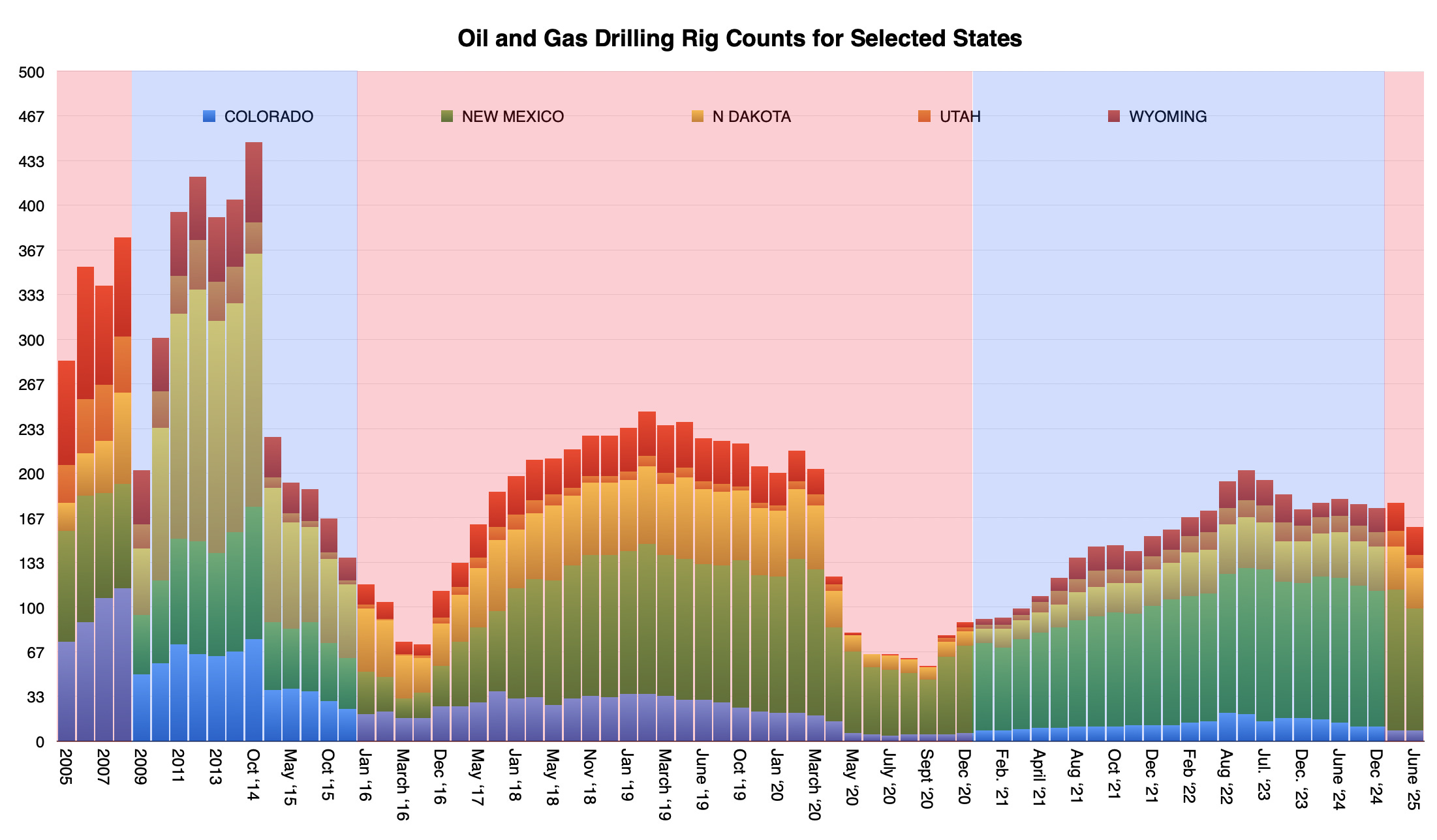
His chaotic tariffs have upended global trade and his administrationโ€™s hostility towards non-citizens has hampered international travel. These policies, if you can call them that, have also injected uncertainty and fear into the markets, causing stocks around the globe to plummet. That, combined with mass federal employee firings, threats to detain and deport millions of workers, and freezing Inflation Reduction and Infrastructure Act funding for clean energy development, manufacturing, and research, will likely โ€œde-growโ€ the U.S. economy in ways that only pandemics and global financial crises have done in the past. The turmoil has already brought oil prices below $60 per barrel for the first time since the days of COVID, which will almost certainly dampen the oil and gas drilling frenzy (in fact, the U.S. rig count is already dropping). That is, unless Trump goes to war with Iran, which will certainly shoot oil prices right back up again.

Itโ€™s difficult to know what to think about all of this, except that it feels as if we are in Bizarro world. I mean, a Manhattan real estate developer with gold-plated toilets has seemingly adopted the anarchistsโ€™ anti-globalization agenda and become the Degrowth president; Democrats and leftists are reflexively railing against old-school protectionism; Republicans are bashing free markets and free trade and driving the economy into the ditch while looking to push the federal budget deficit higher; the Chinese embassy is posting videos of Ronald Reagan condemning tariffs and praising free trade; and the president of the U.S. Oil & Gas Association is planning to buy an electric vehicle to protest against protesters. Whatโ€™s next? Is Exxonโ€™s CEO gonna start burning down gas stations?

A wise friend put it this way: โ€œSpinozaโ€™s wheel is out of true and the arrow is going backwards.โ€ Okay, I admit I donโ€™t know Spinoza well enough to totally get that, but I know wheels, and this sounds right to me.

What will become of this chaos is anyoneโ€™s guess. But Iโ€™m going to bet that it doesnโ€™t โ€œmake America wealthy againโ€ or restore manufacturing to the U.S. anytime soon or stop the flow of Fentanyl across borders or anything else that Trump thinks it might do. Itโ€™s more likely that the wobbly wheel will steer us all right off a cliff. There will be plenty of pain as people lose their jobs and their pensions lose their value. Nations that have rejiggered their economies to sate Americansโ€™ hunger for fast-fashion, electronic devices, and cheap plastic items will descend into a financial slump. Coffee, bananas, avocados, chocolate, imported wine, and tequila will become more expensive.

The best we can hope for is that the economic slowdown and higher prices will stifle American consumerism and slow the environmental destruction it wreaks.

Trump’s trade war falloutJonathan P. Thompson: Read full story


Itโ€™s tough to keep up with the Trump chaos. But a new initiative is making it somewhat easier to track the mayhem.

The Impact Project launched to provide โ€œobjective, transparent, and open-source data to help explain how federal policies, funding, and workforce changes affect our communities.โ€ Their first tool is the Impact Map, which uses publicly available data, media reports, and first-person testimonials to better understand the impacts of federal layoffs or spending cuts. It also shows how many federal employees are in each county and how many of them are probationary, meaning they were targeted by DOGEโ€™s first round of firings and are more vulnerable to future reductions in force.

You can explore interactive map here.

***

Map showing BLM lands within 10 miles of cities. Green denotes conservation areas, red is critical habitat, and yellow is โ€œundesignatedโ€ BLM land. Source: Center for Biological Diversity.

Last month, Interior Secretary Doug Burgum announced his plan to build housing on federal lands, and officials said they were targeting 400,000 acres within 10 miles of towns of 5,000 people or more. Now the Center for Biological Diversity has created a map showing all of the land fitting that description, as well as which parcels are in conservation areas, critical habitat, or sage grouse management areas.

While it can be a bit alarming to see where they might want houses, keep in mind that this is still only a vague proposal and the lands on the map are simply the ones that would be eligible for development if the plan were to come to fruition.

Check out the map here.

Freedom Cities are back!Jonathan P. Thompson: Read full story

***

๐Ÿ“ธ Parting Shot ๐ŸŽž๏ธ
Hey, who doesnโ€™t love a dog-cat-snuggle picture? Photo credit: Jonathan P. Thompson

Navajo Unit Coordination Meeting April 22, 2025

Why some storms brew up to extreme dimensions in the middle of America โ€“ and why itโ€™s happening moreย often

Shuang-Ye Wu, University of Dayton

A powerful storm system that stalled over states from Texas to Ohio for several days in early April 2025 wreaked havoc across the region, with deadly tornadoes, mudslides and flooding as rivers rose. More than a foot of rain fell in several areas.

As a climate scientist who studies the water cycle, I often get questions about how extreme storms like these form and what climate change has to do with it. Thereโ€™s a recipe for extreme storms, with two key ingredients.

Recipe for a storm

The essential conditions for storms to form with heavy downpours are moisture and atmospheric instability.

First, in order for a storm to develop, the air needs to contain enough moisture. That moisture comes from water evaporating off oceans, lakes and land, and from trees and other plants.

The amount of moisture the air can hold depends on its temperature. The higher the temperature, the more moisture air can hold, and the greater potential for heavy downpours. This is because at higher temperatures water molecules have more kinetic energy and therefore are more likely to exist in the vapor phase. The maximum amount of moisture possible in the air increases at about 7% per degree Celsius.

Rescuers with an inflated boat walk in waist-deep water toward older brick houses.
Search and rescue firefighters check on residents in a neighborhood in Frankfort, Ky., on April 6. Floodwater filled streets downtown and in several neighborhoods in the state capital. AP Photo/Jon Cherry

Warm air also supplies storm systems with more energy. When that vapor starts to condense into water or ice as it cools, it releases large amount of energy, known as latent heat. This additional energy fuels the storm system, leading to stronger winds and greater atmospheric instability.

That leads us to the second necessary condition for a storm: atmospheric instability.

Atmospheric instability has two components: rising air and wind shear, which is created as wind speed changes with height. The rising air, or updraft, is essential because air cools as it moves up, and as a result, water vapor condenses to form precipitation.

As the air cools at high altitudes, it starts to sink, forming a downdraft of cool and dry air on the edge of a storm system.

When there is little wind shear, the downdraft can suppress the updraft, and the storm system quickly dissipates as it exhausts the local moisture in the air. However, strong wind shear can tilt the storm system, so that the downdraft occurs at a different location, and the updraft of warm moist air can continue, supplying the storm with moisture and energy. This often leads to strong storm systems that can spawn tornadoes.

Extreme downpours hit the US

It is precisely a combination of these conditions that caused the prolonged, extensive precipitation that the Midwest and Southern states saw in early April.

The Midwest is prone to extreme storms, particularly during spring. Spring is a transition time when the cold and dry air mass from the Arctic, which dominates the region in winter, is gradually being pushed away by warm and moist air from the Gulf that dominates the region in summer.

This clash of air masses creates atmosphere instability at the boundary, where the warm and less dense air is pushed upward above the cold and denser air, creating precipitation.

A cold front forms when a cold air mass pushes away a warm air mass. A warm front forms when the warm air mass pushes to replace the cold air mass. A cold front usually moves faster than a warm front, but the speed is related to the temperature difference between the two air masses.

The warm conditions before the April storm system reduced the temperature difference between these cold and warm air masses, greatly reducing the speed of the frontal movement and allowing it to stall over states from Texas to Ohio.

The result was prolonged precipitation and repeated storms. The warm temperatures also led to high moisture content in the air masses, leading to more precipitation. In addition, strong wind shear led to a continuous supply of moisture into the storm systems, causing strong thunderstorms and dozens of tornadoes to form.

What global warming has to do with storms

As global temperatures rise, the warming air creates conditions that are more conducive to extreme precipitation.

The warmer air can mean more moisture, leading to wetter and stronger storms. And since most significant warming occurs near the surface, while the upper atmosphere is cooling, this can increase wind shear and the atmospheric instability that sets the stage for strong storms.

Polar regions are also warming two to three times as fast as the global average, reducing the temperature gradient between the poles and equator. That can weaken the global winds. Most of the weather systems in the continental U.S. are modulated by the polar jet stream, so a weaker jet stream can slow the movement of storms, creating conditions for prolonged precipitation events.

All of these create conditions that make extreme storms and flooding much more likely in the future.

Shuang-Ye Wu, Professor of Geology and Environmental Geosciences, University of Dayton

This article is republished from The Conversation under a Creative Commons license. Read the original article.

Hereโ€™s why 3 decent winters in a row still isnโ€™t enough to fill Lake Powell: This week is when snowpack typically peaks across the #ColoradoRiver Basin — The Salt Lake Tribune

Click the link to read the article on The Salt Lake Tribune website (Anastasia Hufham). Here’s an excerpt:

April 9, 2025

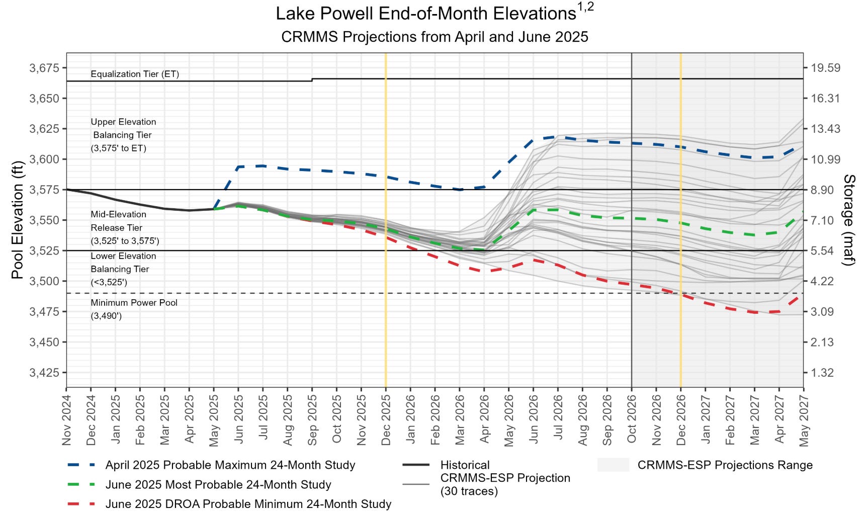
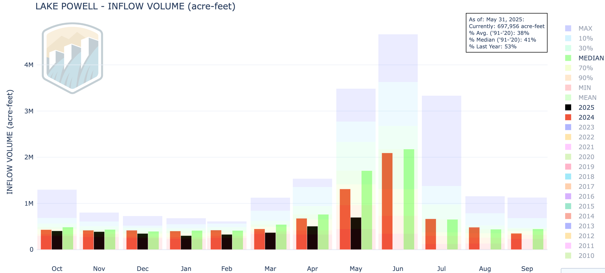
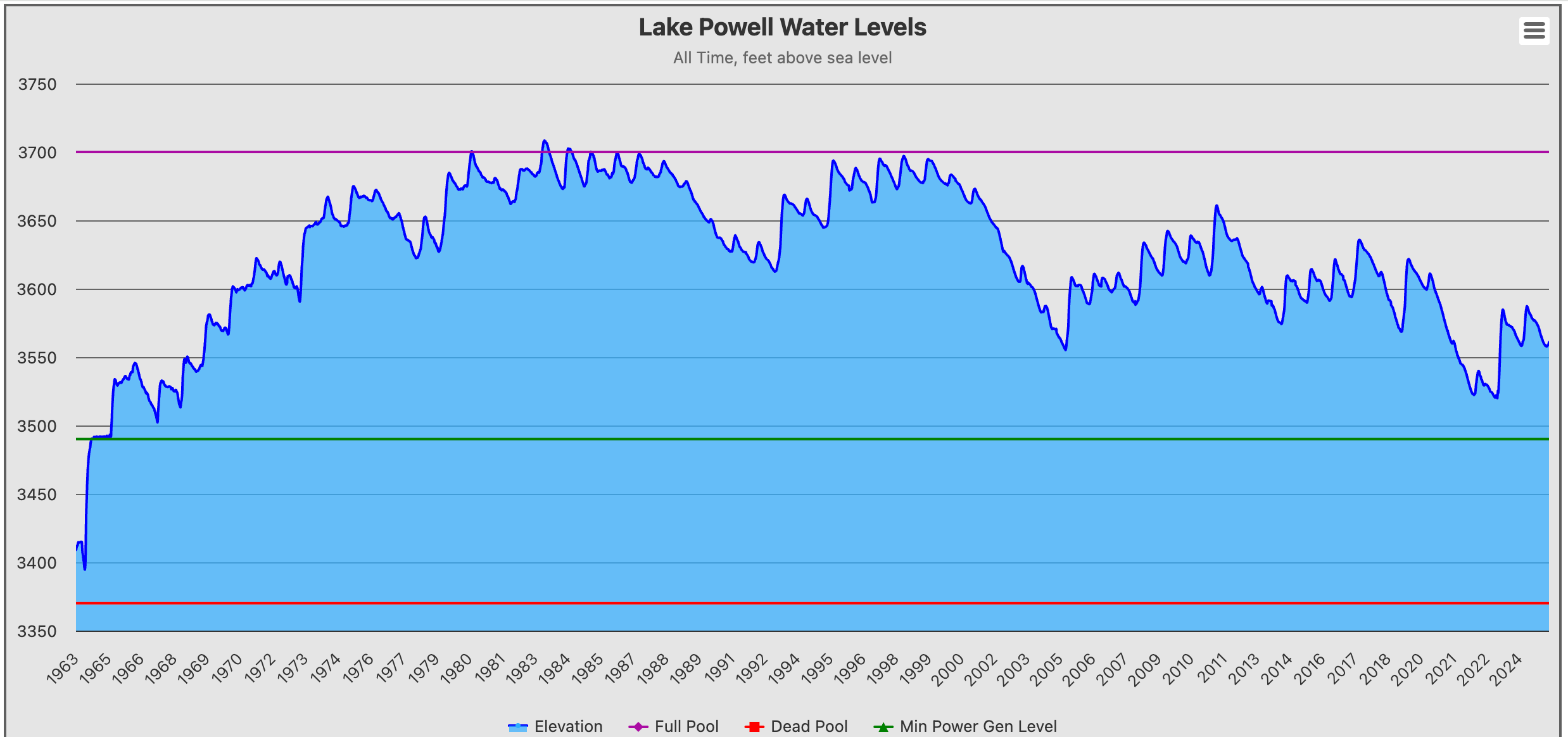
Over the last three years, the Colorado River Basin has experienced three relatively healthy winters. But that decent snowpack, after melting, hasnโ€™t filled reservoirs like Lake Mead and Lake Powell as much as water users across the West might like, due to years of drought and overuse. Recent forecasts show Lake Mead and Lake Powell will remain roughly one-third full after snow melts down from the mountains across the West into the Colorado River and its tributaries this year…

April 1, 2025 seasonal water supply forecast summary. Credit: Colorado Basin River Forecast Center

Winter of 2023 brought substantial snow to the parched region,ย with snowpack levels reaching over 150% of the 30-year median. The banner snowpack led toย 10.6 million acre-feet of waterย flowing into Lake Powell over the spring and summer โ€” a whopping 166% of the average runoff seen between 1991 and 2020. That helped bring Lake Powell up to 38% in July 2023 after the reservoir hit a record low of 22% in February of that year. That was followed by another good snow year for the basin basin, with levels hittingย 113% of the medianย in 2024. But that above-average snowpack translated to a below-average runoff of 83%, or about 5.3 million acre-feet of water reaching Lake Powell. That wasย lower than what forecasters had predictedย earlier in 2024, and the reservoir saw a smaller bump โ€” reaching 42% full in July.

The discrepancy between snowpack and runoff was largely because soil across the Colorado River Basin was so dry, [Jack] Schmidt said. Dry soil absorbs melting snow, so less water ends up in reservoirs. And this year, soil across most of the Colorado River Basin is drier than normal โ€” and even drier than it was this time last year.

Insects are growing threat to #Colorado forests, Colorado State Forest Service report finds

Douglas-fir beetles killed these trees in southern Gunnison County. The Colorado State Forest Service will conduct treatments in this forest in 2025 to slow the outbreak. Photo by Dylan Eimer, CSFS

Click the link to read the release on the Colorado State University website:

Bark beetles and other insects are spreading through Coloradoโ€™s forests, leaving dead and dying trees in their wake โ€“ a cycle that could fuel future wildfires, according to an annual Colorado State Forest Service report released March 26.  

Following a wet and cool year in 2023, the shift back to near-record temperatures and below-average precipitation in Colorado last year exacerbated the proliferation of forest pests and weakened treesโ€™ defenses against them. 

โ€œTrees in Colorado canโ€™t catch a break as our climate becomes warmer and dryer,โ€ said Matt McCombs, state forester and director of the Colorado State Forest Service. โ€œThis ongoing trend toward persistent drought and higher temperatures not only makes trees easier prey for insects but increases the risk of large and severe wildfires. 

โ€œCouple that with more people living in areas prone to burn, and the state faces enormous challenges,โ€ McCombs added. โ€œThe good news is we know Colorado is on the right path to address these challenges and foster forests and communities that are resilient to wildfire and forest pests.โ€ 

The 2024 forest health assessment details which insects and diseases are the biggest threats to the stateโ€™s forests and where outbreaks are expanding. The report also describes the state forest serviceโ€™s science-based management practices that are promoting wildfire-resilient forests and healthy watersheds. 

The CSFS updates the Colorado General Assembly and residents annually on the health of the stateโ€™s forests based on an annual aerial survey, field inspections and information from forest landowners. 

Read the 2024 Report on the Health of Coloradoโ€™s Forests and view a story map with additional data here. 

Adapted from a CSFS press release. 

Research Article — Thirstwaves: Prolonged Periods of Agricultural Exposure to Extreme Atmospheric Evaporative Demand for Water — M. S. Kukal,ย M. Hobbins (AGU publication)

Click the link to read the research article on the AGU website (M. S. Kukal,ย M. Hobbins):

Abstract

Global atmospheric evaporative demand has increased, impacting agricultural productivity and water use. Traditionally, trend assessments have been limited to total evaporative demand, overlooking shifts in daily extremes, which are meaningful for agrohydrological outcomes yet largely unknown. Here, using a fully physical metric of evaporative demand, that is, standardized short crop reference evapotranspiration, we introduce the concept of thirstwavesโ€”prolonged periods of extremely high evaporative demandโ€”and analyze their characteristics during 1981โ€“2021 growing seasons for the conterminous US. Findings show that long-term mean spatial patterns demonstrated by thirstwave characteristics do not follow that of total or mean evaporative demand. Weighted for cropland area harvested, thirstwave intensity, duration, and frequency have increased by 0.06 mm dโˆ’1 decadeโˆ’1, 0.10 days decadeโˆ’1, and 0.39 events decadeโˆ’1, respectively during 1981โ€“2021. Statistically significant trends appear across 17%, 7%, and 23% of cropland area for intensity, frequency, and duration. Not only have thirstwaves increased in severity, but the likelihood of no thirstwaves occurring during the growing season has significantly decreased. Our work proposes a novel metric to describe periods of extremely elevated evaporative demand and presents a systematic analysis of such conditions historically for US croplands.

Key Points

  • Regional hotspots of thirstwaves do not necessarily align with areas of high overall evaporative demand
  • Intensity, duration, and frequency of thirstwaves have increased significantly (pย <ย 0.05) over 17%, 7%, and 23% of US cropland area, respectively
  • The likelihood of no thirstwaves occurring during the growing season has significantly decreased

Plain Language Summary

The atmosphere is getting more demanding for water around the world, and this affects water use and farming outcomes. Previously, studies mainly looked at the overall atmospheric demand for water, but little is known about changes in occurrence of very high atmospheric demand for water over consecutive days. In this study, we use introduce the idea of โ€œthirstwaves,โ€ which are long periods of very high atmospheric demand for water. We looked at these thirstwaves that have occurred during 1981โ€“2021 in the US and analyzed them for how intense and how frequent they were and how many days they lasted. We found that the worst thirstwaves happened in places that do not see the highest demand. Over time, all aspects of these thirstwaves have gotten worse. It has also become much less likely that a growing season will pass without any thirstwaves. These findings suggest that in addition to monitoring overall atmospheric demand for water, it’s important to track, measure, and report thirstwaves to those managing agriculture and water resources.

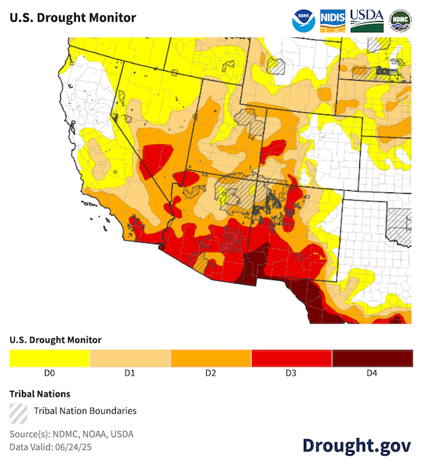
#Drought news April 10, 2025: Deep seasonal #snowpack deficits remain across the ranges of southwestern #Colorado, #NewMexico, northern #Arizona, and southwestern #Utah

Click on a thumbnail graphic to view a gallery of drought data from the US Drought Monitor website.

Click the link to go to the US Drought Monitor website. Here’s an excerpt:

This Week’s Drought Summary

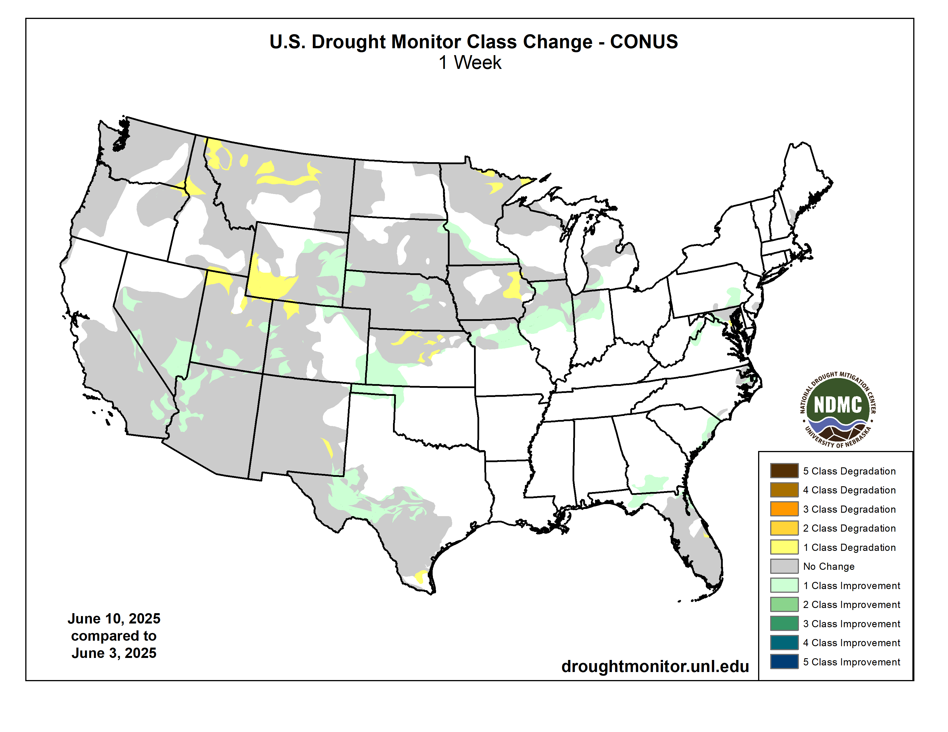
.This U.S. Drought Monitor (USDM) week saw widespread improvement in drought-related conditions across areas of the South, Southeast, and Midwest, where a series of strong storms delivered heavy rainfall, damaging winds, and severe flooding. The multi-day storm event saturated soils leading to inundation of rivers, and severe flooding in low-lying areas from Arkansas to Ohio. Storm totals from the multi-day event ranged from 4 to 18+ inches, with the highest accumulations observed across central Arkansas, southeastern Missouri, and western portions of both Tennessee and Kentucky. In addition to heavy rainfall, the storm system sparked dozens of tornadoes as well as strong gusty winds in other areas, causing widespread power outages. Elsewhere, improving conditions over the past 30 to 60 days, led to reduction in areas of drought in the Northeast, from New York to Maine, as well as in areas further south including New Jersey and Virginia. In the Midwest, this weekโ€™s rainfall event pushed rainfall totals well above normal levels for the past 30-day period, leading to improvements across the Midwest in Missouri, Illinois, Indiana, and Michigan. In the Upper Midwest and portions of the Plains, drought-related conditions improved on the map across areas of Minnesota, Wisconsin, and South Dakota, where precipitation has been above normal for the past 30-90-day period and soil moisture monitoring products are showing normal to above-normal levels. In the West, above-normal springtime temperatures are causing a rapid melting of high-elevation snowpacks across the entire region. Looking at the current snowpack conditions out West, deep seasonal snowpack deficits remain across the ranges of southwestern Colorado, New Mexico, northern Arizona, and southwestern Utah. Elsewhere in the region, areas of the Great Basin and Intermountain West saw improvements on the map including parts of northeastern Nevada, Wyoming, and northwestern Colorado. In terms of reservoir storage in the West, Californiaโ€™s reservoirs continue to be at or above historical averages for the date (April 8), with the stateโ€™s two largest reservoirs, Lake Shasta and Lake Oroville, at 116% and 120% of average, respectively. In the Southwest, the U.S. Bureau of Reclamation is reporting (April 6) Lake Powell at 33% full, Lake Mead at 34% full, and the total Colorado system at 41% full (compared to 42% full at the same time last year)…

High Plains

On this weekโ€™s map, improvements were made in the region, namely in northern Kansas, northern Nebraska, and South Dakota, where shorter-term precipitation (past 30-60 days) is normal to above normal. Additionally, these areas were showing improvements in other drought indicators including soil moisture, streamflow activity, and satellite-based vegetation health. In western North Dakota, areas of Extreme (D3), Severe (D2), and Moderate (D1) drought expanded on the map in response to a combination of factors, including numerous recent impact reports from the agricultural sector, below-normal precipitation (past 30 days), and low streamflow and soil moisture levels. For the week, generally dry conditions prevailed across western portions of the region, while eastern portions received modest accumulations of <1.5 inches (liquid). In terms of temperatures, below-normal average temperatures (ranging from 2 to 10+ degrees F) were logged across the entire region…

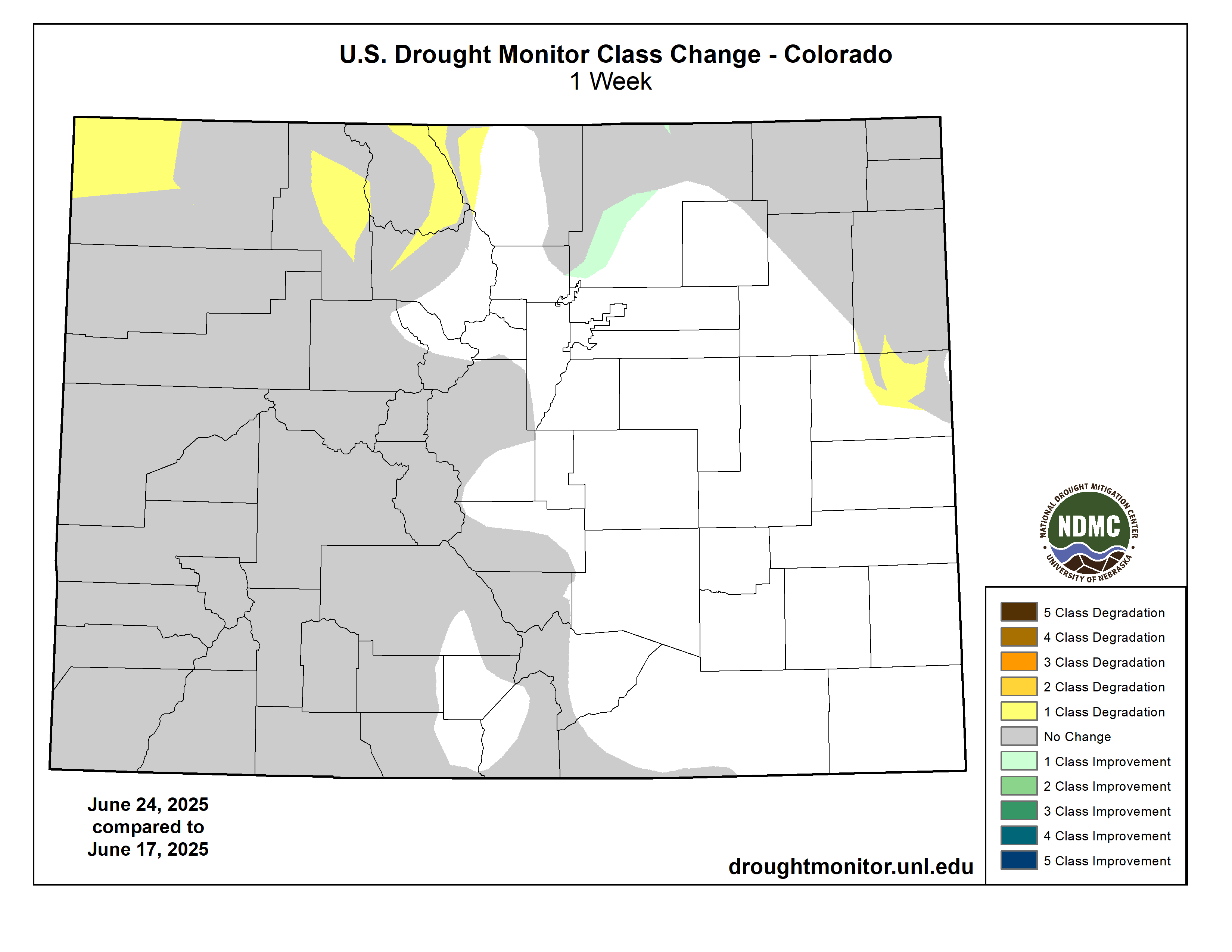
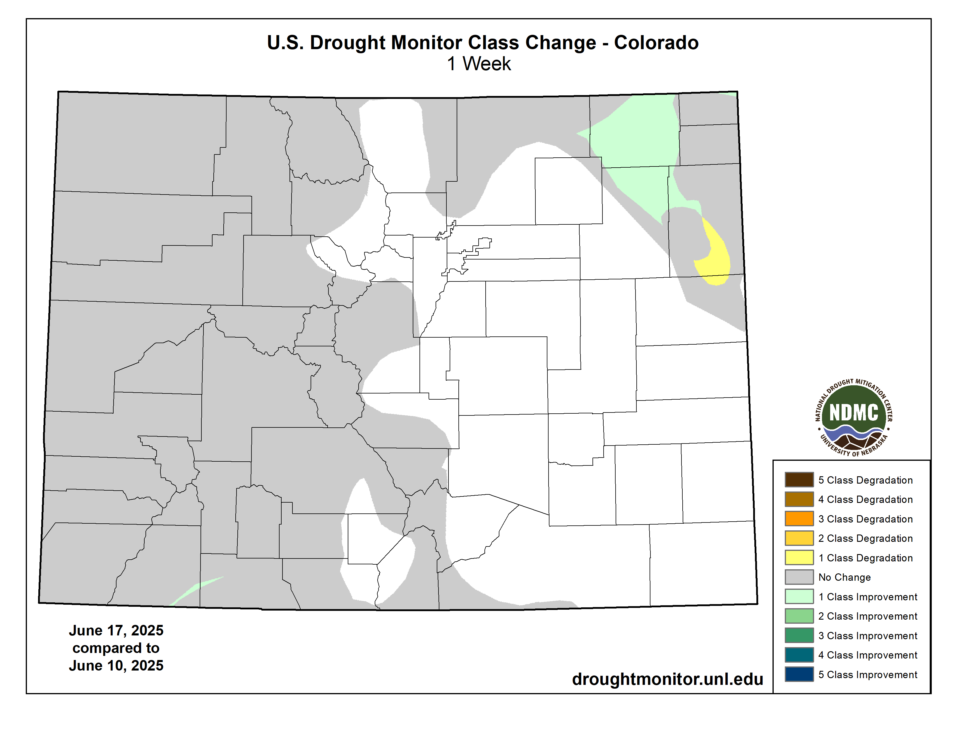
Colorado Drought Monitor one week change map ending April 8, 2025.

West

Out West, generally dry conditions prevailed over much of the region, including areas of California, the Great Basin, the Intermountain West, and the Desert Southwest (southern Arizona and southwestern New Mexico). However, some mountain locations in the Pacific Northwest and the Rocky Mountains received light-to-moderate precipitation accumulations. On the map, areas of Extreme (D3) drought were introduced in southeastern Arizona, where precipitation deficits existed at both short- and longer-term time scales. Similarly, ongoing below-normal snowpack conditions (snow water equivalent at NRCS SNOTEL stations ranging from 6 to 55% of median) in the Nacimiento, San Juan, and Sangre de Cristo ranges of New Mexico, led to the introduction of areas of Extreme (D3) drought. Elsewhere, some improvements were made on the map in drought-affected areas of northeastern Nevada, northeastern Utah, northwestern Colorado, and Wyoming. Looking at the regional snowpack, the NRCS SNOTEL network is reporting (April 8) the following region-level (2-digit HUC) SWE levels: Pacific Northwest 102%, Missouri 97%, Upper Colorado 89%, Great Basin 104%, Lower Colorado 69%, and Rio Grande 46%…

South

On this weekโ€™s map, widespread improvements were made in response to very heavy rainfall accumulations observed across parts of the region, with the highest totals (ranging from 5 to 15+ inches) observed in northeastern Texas, eastern Oklahoma, Arkansas, western Tennessee, and southern Mississippi. The multi-day storm event led to catastrophic flooding in parts of the region as well as tornadic activity, widespread power outages, and loss of life. However, the deluge of rains also led to significant improvements in drought-related conditions, with multiple category improvements made on the map. For the week, average temperatures were above normal in eastern areas, with anomalies ranging from 3 to 12 degrees F. Conversely, the western extent of the region, including much of Texas, Oklahoma, and Arkansas, experienced temperatures ranging from 3 to 12 degrees F below normal. Looking at Texas reservoir conditions, statewide reservoirs are reported to be 75.7% full, with many reservoirs in the eastern part of the state in good condition (over 90% full), while numerous reservoirs in the western portion of the state continue to experience below-normal levels, according to Water Data for Texas (April 9). In terms of streamflow activity (April 9), the U.S. Geological Survey is reporting well above normals streamflows (>90th percentile) across northeastern Texas, southeastern Oklahoma, Arkansas, Mississippi, and western Tennessee, while areas of central and southern Texas are experiencing below normal levels (1st to 24th percentile range)…

Looking Ahead

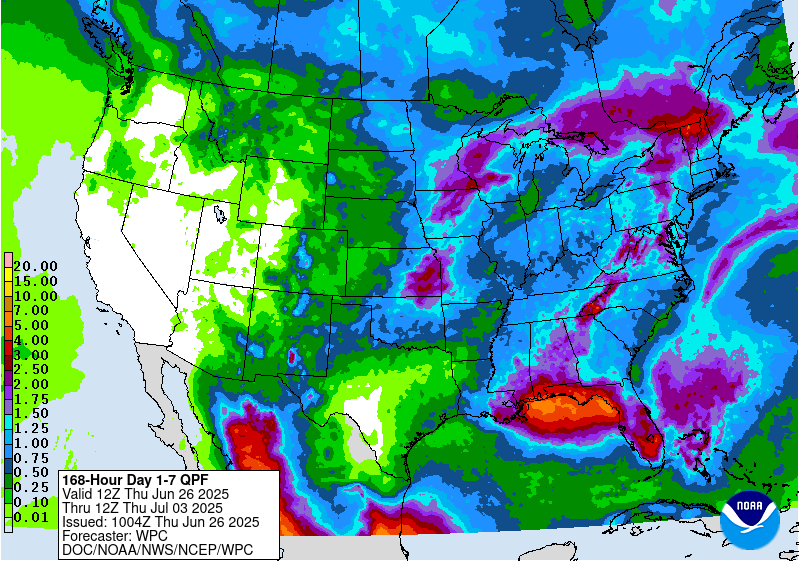
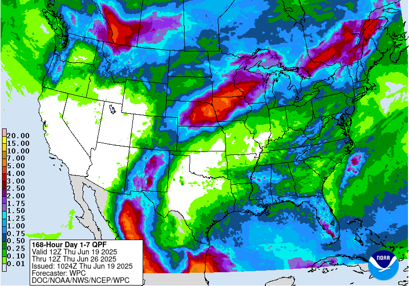
The NWS Weather Prediction Center (WPC) 7-Day Quantitative Precipitation Forecast (QPF) calls for relatively dry conditions across the conterminous U.S., except for light-to-moderate accumulations across areas of the Pacific Northwest, northern Plains, Lower Midwest, Mid-Atlantic, and the Northeast. The Climate Prediction Center (CPC) 6-10-day Outlook calls for a moderate-to-high probability of above-normal temperatures across the Western U.S., Plains, and areas of the South, while below-normal temperatures are expected across eastern portions of the Midwest and portions of the Northeast. Elsewhere, near-normal temperatures are favored. In terms of precipitation, there is a low-to-moderate probability of above-normal precipitation across New Mexico, Texas, and Oklahoma as well as areas of the Upper Midwest. Elsewhere, below-normal precipitation is expected across most of the West, Southeast, and Mid-Atlantic.

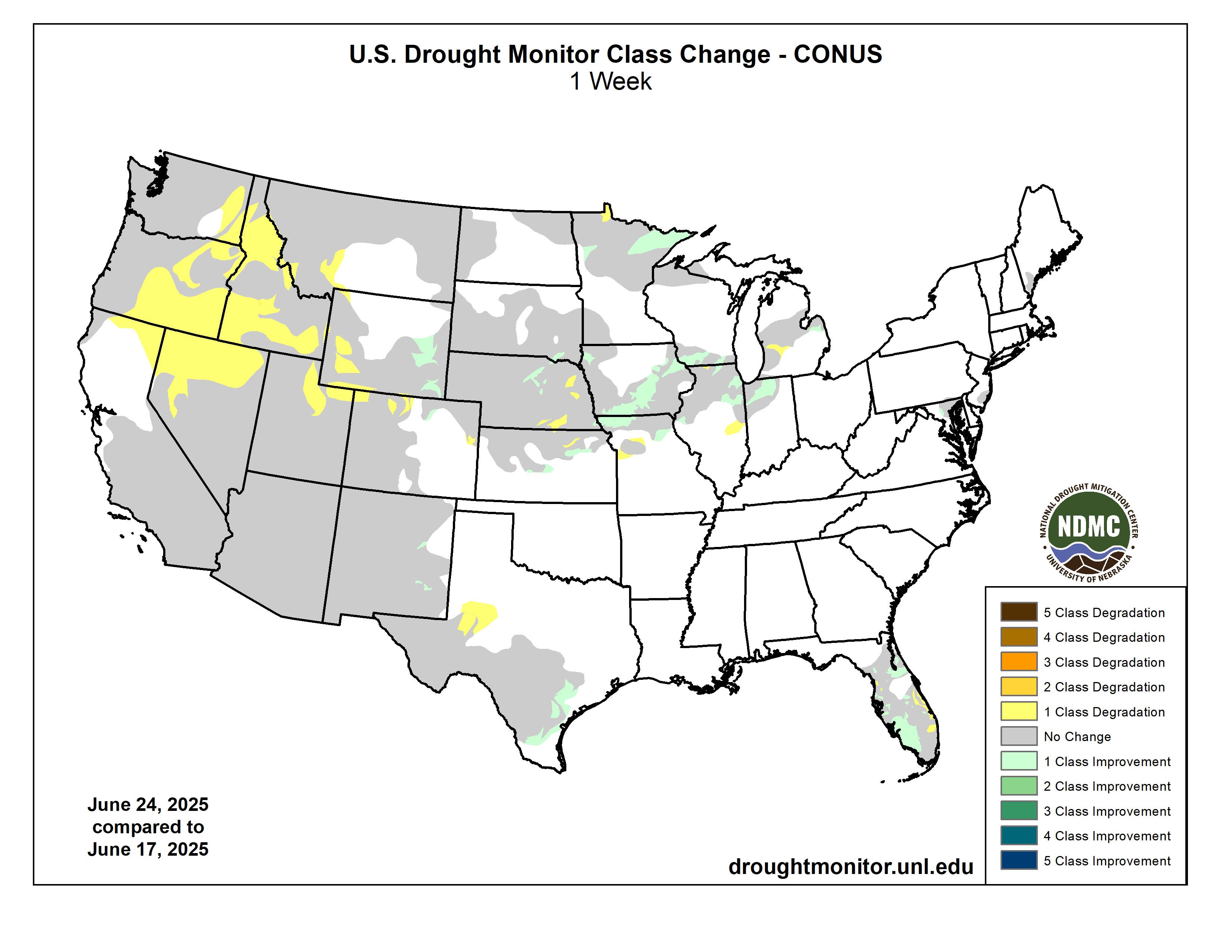
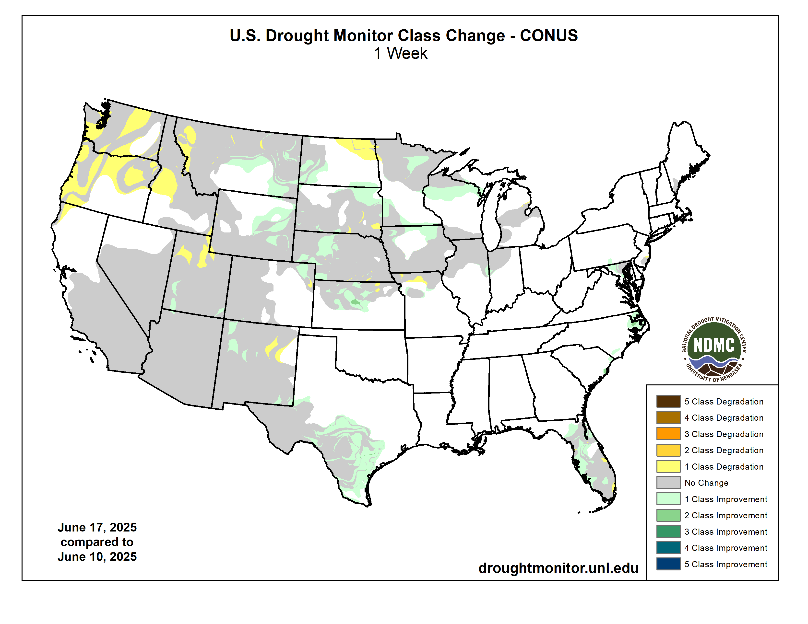
US Drought Monitor one week change map ending April 8, 2025.

The latest briefing (April 8, 2025 #Colorado #Utah #Wyoming) is hot off the presses from Western Resource Advocates

Click the link to read the briefing on the Western Resource Advocates website:

With the snow accumulation portion of the 2025 water year drawing to a close, snowpack in much of the region was near average, except for southern Colorado, southern Utah and northeastern Wyoming where snowpack ranged from 50-80% of average. Above average precipitation in northern Utah and much of Wyoming added to snowpack during March and caused the removal of drought conditions from the Wasatch Front and northern and central Wyoming. A late-March rain/snow event produced record precipitation along the northern Front Range and Eastern Plains and alleviated drought. Seasonal streamflow volume forecasts vary from much below average in southern Utah and southwestern Colorado to near average forecasts for more northerly river basins such as the Colorado headwaters, Yampa, North Platte and Bighorn River Basins. The streamflow volume for Lake Powellโ€™s inflow is forecasted at 67% of average.

March precipitation was near-to-above average in Wyoming and much of Utah. Below average March precipitation fell across much of Colorado and southeastern Utah. In northern Utah, March precipitation was 130-200% of average and large areas of Wyoming received 130-300% of average March precipitation. Parts of southern Colorado and southeastern Utah received less than 50% of average March precipitation, further worsening drought conditions. Six long-term weather monitoring sites in eastern Colorado received record-low March precipitation.

March temperatures were mostly above average. In Utah and southwestern Colorado, March temperatures were within two degrees of average. March temperatures in other parts of Colorado and Wyoming were two to six degrees above average.

April 1 snow water equivalent (SWE) was near average for much of Wyoming, northern Colorado and northern Utah, ranging from 90% in the Lower Green to 110% in the Upper Snake River Basins. In southern Colorado and southern Utah, April 1 SWE was below to much below average, ranging from 44% in the Virgin to 80% in the Gunnison River Basins. On a statewide basis, SWE was near average in Utah (92%) and Wyoming (100%), but below average in Colorado (84%). In southwestern Utah, eight Snotel sites at elevations ranging from 6,000-8,900 feet have completely melted, which is 14 to 34 days earlier than average.

Spatial estimates of SWE on March 31, provided by INSTAAR at the University of Colorado, show lower estimates of SWE relative to average for all river basins except Wyomingโ€™s Bighorn, Snake and Yellowstone Basins. The lower percent average SWE from spatial SWE estimates compared to Snotel-derived SWE is largely due to the inclusion of low elevation snowpack in the spatial SWE estimates which is not well-represented in the Snotel network. Snowpack at elevations below Snotel sites was generally low in 2025 due to higher snow levels and periods of warm sunny weather in March. The entire Spatial SWE report for 3/31/25 can be downloadedย here.

April 1 seasonal (April-July) streamflow volume forecasts were near-to-below average across the region. In general, seasonal streamflow volume forecasts were near average in the North and below or much below average in the South. In the Upper Colorado River Basin, near average streamflow volumes are forecasted for the Colorado Headwaters (90%) and the Yampa (94%); below average streamflow volumes for the Upper Green (80%), Lower Green (80%) and Gunnison (85%); and much below average streamflow volume for the Dolores (55%) and San Juan (48%). Seasonal streamflow is forecasted at 67% of average for Lake Powell. In the Missouri River Basin, near average seasonal streamflow volumes are forecasted for the Bighorn and North Platte River Basins, and below average streamflow is forecasted for the Arkansas, Cheyenne, Powder, South Platte and Tongue River Basins. Note: both NRCS and the Colorado Basin River Forecast Center (CBRFC) provide seasonal streamflow forecasts for the Upper Colorado River Basin and these forecasts occasionally differ due to differences in streamflow forecasting models. For example, the April 1, 2025 seasonal streamflow forecast for the Upper Green River at Flaming Gorge is 80% from the CBRFC and 94% from the NRCS.

On April 1, drought conditions covered 54% of the region, a 2% regional decline from February 25. Significant expansion of drought in Colorado during March was offset by the removal of drought conditions along the Wasatch Front in northern Utah and in northern and central Wyoming. Extreme drought conditions were removed from the Snake and Powder River Basins and the area of severe drought contracted during March. Drought conditions expanded and became more severe in western Colorado and drought conditions emerged in both central and southeastern Colorado during March.

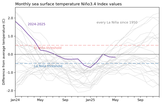
Pacific Ocean temperatures were near average in March, ENSO is currently in a neutral phase, and there is a greater than 50% probability of ENSO-neutral conditions continuing through early fall. The NOAA monthly outlook for April suggests an increased probability of below average precipitation and above average temperatures across most of Colorado and Utah. The NOAA Seasonal Precipitation Outlook (April-June) indicates an increased probability of below average precipitation for the entire region, especially in Utah and western Colorado. There is also an increased probability of above average temperatures for Colorado, Utah and southwestern Wyoming during April-June.

Significant weather event: Record Front Range precipitation.ย After a dry January-March, record precipitation fell across the northern Front Range and Eastern Plains of Colorado on March 29-30. Rain fell for most of the event at lower elevations with wet snow accumulating in the foothills. Daily precipitation records were set on March 29 in Boulder (1.41โ€), Brighton (0.46โ€), Eastonville (0.70โ€), Greeley (0.60โ€), Longmont (0.66โ€) and Winter Park (0.76โ€) and two-day precipitation records were set on March 29-30 at 11 locations with more than 50 years of data. Notably, more rain fell on March 29-30 than in all of 2025 at 18 locations. The late March rain and snow event caused a one-category improvement in drought conditions, including the removal of all drought and abnormally dry conditions across a large swath of northeastern Colorado. An area of extreme drought was also removed from Larimer County.

#Colorado #Snowpack Approaches Seasonal Peak — NRCS

Click the link to read the release on the NRCS website:

April 8, 2025

As Colorado approaches the seasonal peak of its snowpack, data as of April 1 show statewide snow water equivalent at 85 percent of median, down from 112 percent this time last year. March delivered 105 percent of median precipitation across the state, improving snowpack totals in many basins.

As of April 1st Coloradoโ€™s snow water equivalent (SWE) is at 85 percent of median, compared to 112 percent on this date last year. Statewide monthly precipitation for March reached 105 percent, while water year to date (WYTD) is at 92 percent of median. March brought increased storm activity, bolstering precipitation and snowpack values, especially across western, northern and central basins. The southern half of the state remains below average, reflecting the extended period of below average precipitation from December through February. However, 30-day precipitation totals through March show improvements. The Gunnison, Arkansas, Upper Rio Grande (URG) and combined San Miguel-Dolores-Animas-San Juan (SMDASJ) basins each record above to near average precipitation for the month, with values reaching 108, 77, 86 and 117 percent, respectively. Even with the recent increase in March precipitation, snowpack remains below median in the Gunnison, Arkansas, Upper Rio Grande and combined SMDASJ basins which are at 81, 74, 56 and 63 percent of median, respectively. 

Throughout the final week of March, all basins in the state experienced snowmelt, most notably in the southern half of the state where accelerated melt occurred at many sites. In the Upper Rio Grande basin snowmelt is particularly pronounced with several sites showing both lower than average peak SWE and faster than normal melt rates. Statewide median peak SWE typically occurs April 8th, although actual timing varies basin to basin. The Headwaters of the Rio Grande sub-basin are days away from peak with the median date around April 11th. Following a storm over the first weekend of April the Headwaters of the Rio Grande sub-basin records a modest boost in SWE, now holding 73 percent of median and ranking in the 17th percentile.

Coloradoโ€™s northern river basins all have near to above median snowpack ranging from 93 to 103 percent. As of April 1st, the South Platte is at 98 percent of median snowpack, the Laramie and North Platte at 103 percent, Colorado Headwaters is at 96 percent and the Yampa-White-Little Snake at 93 percent. Each of these basins have reached approximately 84 to 91 percent of median peak SWE, with room to grow before their median peak dates in mid to late April. 

While April has the potential to deliver meaningful snowpack accumulation, itโ€™s worth noting that many sites in southern basins have likely already passed their seasonal peak. Median peak SWE dates in these basins range from April 2nd to April 8th. To date, the Arkansas, URG and SMDASJ reached their highest SWE around March 23-24. Current SWE as a percent of median ranges from 47 to 71 percent in southern basins. These values reflect a notably below average snowpack and while not all sites are record breaking, there are some sites among the lowest on record or near record at several locations. Of the 198 SNOTEL and snow course sites in Colorado, 40 sites (20% percent) currently fall withing the lowest 15th percentile for their respective period of records. โ€œThese values reflect how far off some sites are from their typical accumulation and highlight the larger picture of below normal snowpack in the southern basins,โ€ says Nagam Gill, NRCS hydrologist. SNOTEL records in this group span 9 to 47 years, while manual snow course surveys extend from 42 to 88 years of data. 

Statewide reservoir storage is at 92 percent of median and 58 percent of total capacity. While this is slightly below last yearโ€™s 100 percent of median at this time, most major reservoir across the state observe near 30 year medians. Dillon Reservoir is at 97 percent of median and 80 percent capacity and Lake Granby holds 101 percent of median at 58 percent capacity. Pueblo Reservoir is at 109 percent of median and 71 percent of capacity. The streamflow forecast at Pueblo Reservoir Inflow project 370,000 acre-feet for the April โ€“ September period or 94 percent of median and has stayed consistent from last months projections. Blue Mesa is at 96 percent of median and 60 percent of capacity. Notably below average is McPhee Reservoir at 76 percent of median and 56 percent of capacity. 

April 1ย volumetric streamflow forecasts reflect snowpack and precipitation conditions across Colorado at 86 percent of median. Forecasts are near to above average for northern basins and below to much below average for the southern half of the state. Statewide, 40 percent of forecast points are at 75 or less of median and 27 percent of those points fall in the lower 25thย percentile. Navajo Reservoir Inflow forecasts a 325 kaf median departure from the period of record (POR) median. McPhee Reservoir Inflow is at 64 percent of median with a 91 kaf departure. Forecast volumes in the Colorado Headwaters, Yampa-White-Little Snake, Laramie and North Platte, and South Platte are at 96, 95, 102 and 93 percent of median seasonal streamflow volumes, respectively. In contrast, the Gunnison, Arkansas, URG and combined SMDASJ basins are forecast at 86, 87, 63 and 60 percent of median, respectively. These outlooks reflect the considerable differences in peak SWE and melt out trends already underway in the southern portion of the state. Compared toย March 1ย outlooks, forecast volumes decline by roughly 12 to 15 percentage points in the URG and SMDASJ basins, driven by accelerated snowmelt during late March. The variability of forecasted volumes means that relying solely on the 50% exceedance forecast may not fully capture the uncertainty in future weather. A critical consideration when reviewing these forecasts is theย full suiteย of exceedance probabilities.

The April 1, 2025 #Colorado Water Supply Outlook is hot off the presses from the NRCS

Click the link to read the outlook on the NRCS website. Here’s an excerpt:

State of the #snowpack: Explaining runoff predictions for the summer — #Denver7.com

Westwide SNOTEL basin-filled map April 8, 2025 via the NRCS.

Click the link to read the article on the Denver7.com website (Colette Bordelon). Here’s an excerpt:

April 7, 2025

“The problem is becoming tougher to deal with and more acute,” one Western water lawyer told Denver7.

…this time of year has water experts wondering what the snowpack levels will mean for runoff into the Colorado River, a critical resource.

“Right now is exactly when we start being concerned about what our runoff is going to look like,” said James Eklund, who is a Western water lawyer. “It’s starting to get warmer, and so all that snow that everybody skied on and snowboarded on over the winter is going to start melting off and go into our rivers and our reservoirs.”

“Right now, we’re showing about 67% of average runoff, and that’s really remarkable, because our snowpack is right around 100% of average,” Eklund explained. “Even though we’ve got pretty good precipitation, and we did have really good skiing conditions in many parts of the state over much of the ski season, it’s not translating to as much runoff as we had hoped.”

Sixty-seven percent of average runoff is “not where you want to be,” according to Eklund, who considers this to be a “below average year.”

Judge allows Denver Water two more weeks of Gross Dam construction before court-ordered halt — The #Denver Post

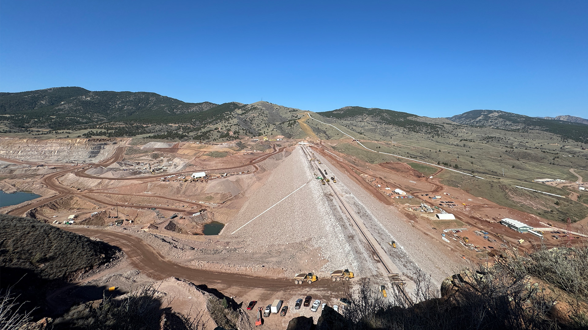
The construction site at the bottom of Gross Dam with equipment used to place concrete and build the new steps. Photo credit: Denver Water.

Click the link to read the article on The Denver Post website (Elise Schmelzer). Here’s an excerpt:

April 7, 2025

The stateโ€™s largest water utility will have two weeks to complete any necessary work on its $531 million dam expansion project before a court-ordered construction halt takes effect, a federal judge ruled Sunday. The granting of a temporary window for construction followsย an order late Thursdayย by U.S. District Court Judge Christine Arguello blocking Denver Waterโ€™s expansion of Gross Reservoir outside Nederland and barring further construction work to raise the height of the dam…In response to the order, Denver Water asked the judge to allow dam construction to continue while the utility appealed her decision.

โ€œDenver Water faces enormous irreparable harm from the order stopping ongoing project construction, which may threaten the safety of the half-constructed dam; require Denver Water to quickly lay off hundreds of construction workers; impose millions in additional materials and equipment costs on Denver Water and its ratepayers; and increase the risk of water shortages,โ€ lawyers for the utility wrote in their request.

Arguello denied the utilityโ€™s request to allow construction to continue during the appeal but granted the 14-day stay on her order blocking all construction. After a yet-to-be-scheduled hearing, she will decide exactly how much more construction to allow to make the existing dam structurally sound…Arguello in her Sunday order reiterated herย criticism of Denver Waterโ€™s decision to start constructionย even though it faced challenges to the legality of the project.

โ€œThe financial concerns argued by Denver Water do not outweigh the irreparable injury of environmental harm,โ€ the judge wrote. โ€œDenver Water took a calculated risk when it decided to move forward with construction despite the lawsuit.โ€

Report: Can water reuse save the #ColoradoRiver?An analysis of wastewater recycling in the Colorado River Basin states — University of California Los Angeles

Click the link to read the report on the UCLA website (Noah Garrison, Lauren Stack, Jessica McKay, and Mark Gold). Here’s the executive summary:

The impacts of climate change and prolonged drought on water scarcity in the Western United States have accelerated since the end of the 20th century. The Colorado River has been strained by a history of excessive withdrawals and long-term drought. Increasingly less water is available across the seven Colorado River Basin statesโ€”Arizona, California, Colorado, Nevada, New Mexico, Utah, and Wyomingโ€”for natural ecosystems and the 40 million people that rely, in part or in whole, on its diverted flows to cities and farms. Faced with this challenge, the importance of recycled water at a large scale has never been greater. Water recycling of treated municipal wastewater is a cost-effective source of reliable, sustainable water supply; people shower, flush toilets, and wash clothes and dishes on a regular basis even in times of fluctuating water availability, and these waste flows go to publicly owned treatment works (POTWs) in urban areas.

To assess the current state of water recycling across the Colorado River Basin and its affected states, UCLA Institute of the Environment and Sustainability, in partnership with Natural Resources Defense Council, has investigated water recycling progress and policy development across the seven states in the basin. We analyzed the amount of water entering municipal wastewater treatment plants treating an average of greater than 1 million gallons per day across the 2022 calendar year, the amount these plants reclaim or reuse, and the amount they discharge back into the environment. Our analysis demonstrates that while individual treatment facilities, cities, or even regions may be making substantial progress toward water sustainability, most basin states are falling well short of their potential to reuse wastewater. Overall, the Colorado River Basin states are missing opportunities to ensure a safe, sustainable, climate-resilient supply of water in a hotter, drier future.

While across the Colorado River Basin, an average of 26% of municipal wastewater from POTWs was recycled, there are striking differences between states that are prioritizing reuse and those that are falling behind. Arizona (reusing 52% of treated wastewater) and Nevada (as much as 85%) deserve accolades for their efforts to develop the recycled water supply. California, which produces by far the largest volume of wastewater, only recycled 22% of its treated wastewater in 2022. Of the remaining four states, New Mexico recycles a similarly modest 18%, and Colorado (3.6%), Utah (less than 1%), and Wyoming (3.4%), for a variety of state-specific reasons, have made little to no progress to date on reusing meaningful volumes of treated wastewater. Further and distinct breaks appear to exist between efforts and progress made by states in the lower Colorado River Basin (Arizona, California, and Nevada) and those of the upper basin (Colorado, New Mexico, Utah, and Wyoming). In 2022, the upper basin states as a whole recycled less than 5% of their assessed influent, as compared to more than 30% for the lower basin. (See Figure EX-1 for state-by-state results of our analysis.)

Figure EX-1. Volume of municipal wastewater effluent vs. current reuse by state across the Colorado River Basin for 2022. Totals include figures for the whole state, not only for wastewater generated in the Colorado River watershed. Credit: UCLA

In addition to the lack of progress on wastewater reuse, the overall lack of data on wastewater recycling, including volume, level of treatment, and end use of the recycled water is also glaring. California maintains the most comprehensive database of recycled water, including its end uses, through the California Open Data Portal (see SWRCB, 2022). While we were able to gather data directly from individual wastewater treatment facilities in other states, determining how much water is being recycled was a significant challenge, and determining how much recycled water is ultimately directed to municipal, agricultural, or industrial users was often limited to qualitative description, if information was available at all.

All of the state results have been achieved in the absence of strong federal recycled water policy or any federal regulation. The lack of federal support for or consistency among state programs has hampered efforts and stands as a significant impediment to further growth of recycled water use. Promoting consistent and growing national water reuse will require action at both the federal and state level.

To this end, through our investigation we have developed a set of recommendations for the U.S. Environmental Protection Agency (EPA) and other federal and state partners and stakeholders. Additional detail and guidance for these recommendations is presented in the main report body and conclusions. These recommendations include the following:

Within two years, EPA, working with state partners, water agencies, and nongovernmental organizations, should develop a model state program and ordinance for recycling of municipal wastewater with minimum elements.

  • EPA should improve data acquisition and management, including developing guidance for standardized facility-level reporting and state data sharing, to ensure availability of information and comparability of data between states.
  • EPA should further develop and disseminate the latest science and technical information on treatment processes and pathogen risk assessment for different sources of water and reuse applications.
  • In partnership with the states, EPA should develop wastewater reuse goals and timelines.
  • EPAโ€”working with other federal agencies including the Bureau of Reclamation and the Departments of Agriculture, Energy, and Defenseโ€”should develop and implement funding strategies beyond those already in existence, including furthering the Pilot Program for Alternative Water Source grants.

In addition, our analysis uncovered that, across the Colorado Basin states, inconsistency between programs and overall lack of state-level oversight or even awareness of wastewater recycling efforts in several states is alarming. Recommended improvements needed at the state level for those states without these programs include:

  • Work with local water reclamation or reuse agencies to develop funding strategies to meet targets for 30%, 40%, or 50% goals.
  • Work with EPA to establish numeric targets for wastewater reuse for each state, with timelines and interim goals. Figure EX-2 provides a breakdown of the total water supply that would be made available for each state with targeted goals of 30%, 40% or 50% reuse by 2040, a number already exceeded by two of the basin states.
  • Improve data acquisition and management, as well as reporting requirements where applicable, for wastewater treatment facilities and wastewater reuse operations.
  • Conduct assessments of current state legal and regulatory requirements to identify barriers to wastewater reuse and develop formal state policies for overcoming those barriers.

Overall, substantial action needs to be taken to achieve sustainable water management across the Colorado River Basin. Better use of climate modeling, water pricing that does not encourage waste and unreasonable use, stronger water conservation and efficiency programs and requirements for agricultural and urban users, enhanced stormwater capture, greater and longer-term cutbacks in Colorado River water withdrawals, and, critically, a substantial increase in water reuse all must be embraced as climate resiliency solutions.

Figure EX-2. Recycled water volume created for each state at targeted reuse percentage of 30%, 40%, and 50%of the stateโ€™s total wastewater influent, with net increase in overall potential available water supply. Credit: UCLA

As shown in Figure EX-2, if the Colorado Basin states other than Arizona and Nevada were to increase wastewater reuse to even 40% of treated influent it could increase current recycled water availability by nearly 900,000 acre-feet per year (AFY) over current efforts. Reuse of 50% of influent would increase water availability by nearly 1.3 million AFY. This represent a significant percentage of the projected shortfall on the Colorado River, and a rsolution that should be pursued aggressively to ensure sustainable management of the river.

Map of the Colorado River drainage basin, created using USGS data. By Shannon1 Creative Commons Attribution-Share Alike 4.0

Improving #GunnisonRiver basin water resources one project at a time — The Gunnison Country Times

Milkweed, sweet peas, and a plethora of other flora billow from Farmerโ€™s Ditch in the North Fork Valley of western Colorado. Jonathan P. Thompson photo.

Click the link to read the article on the Gunnison Country Times website (Beverly Richards). Here’s an excerpt:

April 2, 2025

โ€œI was standing there looking at a trickle running down a very large ditch thinking, โ€˜Man, itโ€™s going to be hard to irrigate with that,โ€™โ€ said Jesse Kruthaupt of Trout Unlimited. โ€œIt was the summer of 2012, and I was visiting with a ranch manager about options to improve his irrigation system and water delivery, while also improving flows in Ohio Creek. As many remember, the snowpack that winter was pretty lean, and by the middle of June, there wasnโ€™t much water left in many streams or ditches in western Colorado.โ€ 

It is situations like the one above that are at the core of the Upper Gunnison River Water Conservancy Districtโ€™s grant program. Since 2009, the program has provided funds to address many of the issues facing basin water users, including drought resiliency.  The districtโ€™s board of directors initiated the program in 2009 with a budget of $100,000. That year, only two grant applications were awarded for a total of $45,000.  Since it was brand new and many of our constituents didnโ€™t have a good grasp of what the program was all about, we were pretty excited to see the two applications then and happy to fund a pond lining project and ditch rehabilitation project.   Since then, thanks to the success of many projects we have funded, the great outreach efforts of Jesse Kruthaupt and other consultants and the districtโ€™s education efforts, triple the amount of funding is available. The grant program continues to be hugely supportive of a variety of water projects. I am pleased to see that a number of projects have been dipping into available technology to achieve the best possible results and better water management. The number of applications and the requested funding amounts have grown steadily over the past 15 years. In 2025, we received 14 applications with a whopping  $470,420 in requests, and $1.94 million in total project costs (applicants are required to contribute matching funds).  

Map of the Gunnison River drainage basin in Colorado, USA. Made using public domain USGS data. By Shannon1 – Own work, CC BY-SA 4.0, https://commons.wikimedia.org/w/index.php?curid=69257550

Comment period open for proposed $2 billion pumped-hydro energy project southeast of #Craig — Steamboat Pilot & Today #YampaRiver

The $2 billion pumped hydroelectric project proposed on private land located some 7 miles southeast of Craig would include an upper reservoir at Buck Peak. This view from the peak shows Craig Station visible in the distance. rPlus Hydro/Courtesy photo

Click the link to read the article on the Steamboat Pilot & Today website (Suzie Romig). Here’s an excerpt:

April 3, 2025

Agency leaders and stakeholders have until May 26 to submit comments to the Federal Energy Regulatory Commission, or FERC, regarding the โ€œpre-application documentโ€ for a proposed $2 billion pumped-hydro-storage clean energy project that could be built southeast of Craig.

On March 27, around 40 people attended or listened remotely to a meeting hosted at Colorado Northwestern Community College that provided updated information on the project proposed by Salt Lake City-based rPlus Hydro. The presentation at the joint agency meeting included an overview of the project and operations and a review of information in the FERC pre-application document. The meeting outlined proposed studies to be conducted by rPlus Hydro for the FERC licensing process and provided agency representatives and stakeholders the opportunity to give feedback. A smaller group attended an afternoon tour at the proposed site…

Shapiro said water use from the Yampa River would not be extensive at 4,000 acre-feet of initial fill for the projectโ€™s lower reservoir, plus some 600 acre-feet of water annually to account for evaporation and seepage from two new reservoirs on 170 acres. The goal would be to use a portion of the water rights already owned by the coal-fired power plants, Shapiro said…

The majority of the pumped-hydro system would be located underground, including a below-ground powerhouse with three pump-turbine units with generation capacity of 200 megawatts each. The project would consist of one upper and one lower reservoir joined by 2.5 miles of underground water tunnels, an above-ground switchyard, access tunnel, tailrace surge chamber and accessary facilities.

An electric transmission line from the project would run either 11 miles to Craig or less than 2 miles to a Western Area Power Administration line, Shapiro said. Target completion of the licensing process is estimated for 2028, with construction from 2029 to 2033, Shapiro said.

$100 million settlement allows #Colorado reservoir projects to move forward, ending decades of dispute — The #Denver Post #NISP

The Northern Integrated Supply Project, currently estimated at $2 billion, would create two new reservoirs and a system of pipelines to capture more drinking water for 15 community water suppliers. Credit: Northern Water project pages

Click the link to read the article on The Denver Post website (Elise Schmelzer). Here’s an excerpt:

March 5, 2025

Two new bodies of water in northern Front Range will boost water supplies for 15 communities

Plans for a $2 billion water supply project in northern Colorado will move forward after the communities supporting it agreed to pump $100 million into improving the health of the Cache la Poudre River โ€” a settlement ending decades of dispute over the water infrastructure plans. Leaders from theย Northern Integrated Supply Projectย and the nonprofit environmental groupย Save the Poudreย finalized the settlement on Friday, clearing the way for two new reservoirs. The deal will funnel $100 million over 20 years into a fund to sustain 50 miles of the river from the mouth of the Poudre Canyon, northwest of Fort Collins, to the riverโ€™s confluence with the South Platte. The Poudre River Improvement Fund will pay for projects to enhance the riverโ€™s flows, water quality, ecosystem and recreational opportunities. The settlementย ends Save the Poudreโ€™s 2024 lawsuit alleging the Army Corps of Engineers did not adequately consider the environmental impacts of the Northern Integrated Supply Project when itย issued a Clean Water Act permit for its construction. Environmentalists with the group have opposed the project for decades because it would drain the river and damage its ecosystems…

Northern Water, the utility thatโ€™s spearheading the project, and other water suppliers haveย pursued the water infrastructure improvements since 1980,ย stating they are critical to meeting the needs of the growing region. When complete, the Northern Integrated Supply Project will include Glade Reservoir northwest of Fort Collins, Galeton Reservoir northeast of Greeley, 50 miles of buried water pipelines and five pump plants. The project will send more than 40,000 acre-feet of water annually to the participating water suppliers in Boulder, Weld and Larimer counties โ€” enough water for about 80,000 households.

โ€œThis is a milestone day for the communities participating in the project,โ€ Northern Water General Manager Brad Wind said in a news release. โ€œThe settlement agreement will close the permitting process for the project, open the door to constructing a project that will deliver much-needed water supplies to vibrant communities, and allow for dozens of large-scale riverine investments in and along the Poudre River.โ€

Construction of Glade Reservoir is expected to begin in 2026. It will hold about 170,000 acre-feet of water from the Poudre River โ€” a capacity slightly larger than that of Horsetooth Reservoir, according to Northern Waterโ€™s release. Construction of 45,600-acre-foot Galeton Reservoir will begin after the first reservoir is complete, and it will store water from the South Platte. An acre-foot of water is enough to support two Colorado households for a year. The project will support water supplies for 15 towns and water districts in northern Colorado, including the Fort Collins-Loveland Water District, the Left Hand Water District, Fort Morgan and Erie.

Do you have an overused river in your #Colorado town? Help is on the way — Jerd Smith (Fresh Water News)

A bridge over St. Vrain Creek in Lyons, July 31, 2023. (Shannon Tyler/ Colorado Newsline)

Click the link to read the article on the Water Education Coloado website (Jerd Smith):

April 2, 2025

If a river running through your town is overused and underloved, it might be in line for a first-of-its-kind statewide restoration program, designed to assess and improve a riverโ€™s health, its recreational assets, and its safety.

In March, Great Outdoors Colorado and the Colorado Water Conservation Board approved a combined $417,000 in seed money to launch the program, according to Emily Olsen, regional vice president of Trout Unlimited. The fish advocacy group is helping lead the initiative, known as Colorado Rivermap, along with the U.S. Bureau of Land Management.

The project will launch this year with the selection of a technical team to identify the river segments that are most in need of help, according to Doug Vilsack, Colorado state director for the BLM.

โ€œThis is getting the big thinkers together and using the seed funding to see which reaches of rivers need our attention and how much funding we will need,โ€ Vilsack said.

Theyโ€™ll be looking for parks and river access points that are rundown and in need of repair and restoration. Theyโ€™re on the hunt for stretches of river that have no access points, and those that have been used so heavily that streambanks are eroding.

Once the inventory is complete, the mapping group will turn to advocacy groups and agencies like Great Outdoors Colorado to ask for funding to make the improvements.

Colorado Rivermap has received letters of support from several local governments and counties, including Chaffee and Grand counties. And Olsen said local communities that want to be involved will be key to making sure there is main-street involvement in the work.

โ€œWe are going to think hard about where we can add value and find things local communities can support,โ€ she said.

Other backers that will provide funding for the initiative include the Foundation for Americaโ€™s Public Lands, Colorado Parks and Wildlife, and American Whitewater, Olsen said.

Colorado has eight major river basins. The waterways are a backbone of the stateโ€™s thriving tourist economy. (Colorado Water Conservation Board)

Colorado is known for its scenic waterways and is home to eight major river basins, from the South Platte on the Front Range, to the Yampa River Basin in the northwestern corner of the state, to the headwaters of the Colorado River, in Grand County.

The rivers help lure millions of tourists to the state, intent on rafting and fishing in their waters and camping along their shores.

In 2023 the state saw record-high visits, with tourist numbers hitting 93.3 million and visitors spending $28.3 billion, according to reports by visitor research firm Longwoods International.

But the stateโ€™s soaring popularity has also begun to wear on its iconic streams. The waterways, Vilsack said, โ€œwill be in tougher shape if we donโ€™t do this.โ€

The initial survey of the rivers comes as Colorado launches a statewide recreation strategy, said Chris Yuan-Farrell, programs director for Great Outdoors Colorado.

โ€œWe are planning what we need for outdoor recreation, habitat and natural resources health. Rivers are obviously a big component of this,โ€ Yuan-Ferrell said.

Initial steps include formation of the technical and mapping team. Olsen said they also plan to dramatically expand the team to include state and federal governments and private businesses with a stake in Coloradoโ€™s recreation economy. Vilsack said they expect this work to be completed within two years.

Anyone interested in the project can contact Olsen at emily.olsen@tu.org.

More by Jerd Smith

Colorado Rivers. Credit: Geology.com

Freedom Cities are back!: And they’ve been spiffed up for increased political palatability — Jonathan P. Thompson (LandDesk.org)

American Enterprise Instituteโ€™s proposed Freedom City sites on BLM land near Grand Junction, Colorado.

Click the link to read the article on The Land Desk website (Jonathan P. Thompson):

April 4, 2025

Last August, I wrote an incredulous and somewhat tongue-in-cheek story about then-candidate Donald Trumpโ€™s plan, as outlined a year and a half earlier on his Agenda 47 website, to build 10 โ€œFreedom Citiesโ€ on โ€œemptyโ€ public lands in the West.

I didnโ€™t take it seriously. Maybe I should have. Trump hasnโ€™t said much about Freedom Cities since being elected, but other people have taken the idea, spiffed it up a bit, and run with it. One enigmatic group, for example, wants to convert the Presidio Trust in San Francisco into a Freedom City. And the American Enterprise Institute has incorporated Freedom Cities into its audacious Homestead 2.0 plan to โ€œmake housing affordable again.โ€

Indeed, the cities and similar efforts to hand over federal land to housing developers may be the very tool Western right-wing activists have been looking for to finally transfer public land out of the American publicโ€™s hands.

Efforts to privatize the public domain have flared up for over a century. In the early part of the 20th century, Sen. Albert Bacon Fall, of New Mexico, urged his colleagues to turn over forest reserves to states and private interests. In the 1940s, Western lawmakers and the livestock lobby attempted to transfer all Bureau of Land Management lands to private ownership. And in the late 1970s, the Sagebrush Rebellionโ€™s legal arm, the League for the Advancement of States Equal Rights, endeavored to convey federal lands to the respective states, at which point they could be sold off to the highest bidder.

These movements were echoed in the 1990s, the 2000s, and in the 2010s. But each conflagration was ultimately doused. Proponents realized that mining, grazing, and drilling federal lands was much cheaper than doing so on state or private lands, and that they had no support outside of a handful of Western counties.

Over the last few years, the embers have been rekindled in the form of lawsuits, state-level legislation, and far-out campaign proposals. While I certainly have taken note of and written about these bids, I also havenโ€™t taken them all that seriously: They, too, would collapse as it became clear that their flimsy legal grounding couldnโ€™t stand up to public opposition.

More recently, however, Iโ€™ve begun to have my doubts.

No, I donโ€™t think Utah will ever win its land grab lawsuit, nor will the Wyoming Freedom Caucusโ€™s bid to seize control of all federal land within its borders โ€” even national parks โ€” succeed, even in the state legislature. But the growing number of proposals from both Democrats and Republicans to use federal land for housing and for siting data centers and associated power generating facilities โ€” while also using proceeds of land sales to offset tax cuts for the wealthy โ€” seem set to come together and make the Sagebrush Rebellion fantasy a reality.

The thing that got me thinking about all of this was a video of a recent AEI conference, in which the right-leaning*, free-market think tank introduced its Homesteading 2.0 plan. In a nutshell, the plan โ€” which is broken up into the Home Sweet Home and Freedom Cities phases โ€” looks like this:

  • The Bureau of Land Management would sell off 850 square miles, or about 544,000 acres, of developable public land in or near existing metro areas. About 250 of those square miles would fall under the Home Sweet Home phase, with the remaining 600 square miles devoted to 20 Freedom Cities around the West. They say this would generate $100 billion for the U.S. Treasury, which would mean the land would sell for an average of about $183,000 per acre.
  • Under the Home Sweet Home phase, a total of 1.5 million new homes would be built on that newly privatized land within existing metro areas on the current urban fringe.
  • Another 1.5 million homes would be built in Freedom Cities, which would lie outside โ€” but not far from โ€” existing metro areasโ€™ peripheries.
Screenshot from the AEI video showing developable BLM land north of Bend, Oregon.

After getting this far, I was ready to shut off the video and go back to watching reels of mountain biking wipeouts. Thereโ€™s no way that such a grandiose plan could garner the necessary support to actually occur, even if it had been stripped of Trumpโ€™s nuttiest embellishments. No matter how these folks spin it, 544,000 acres is a lot of public land to transfer, especially given the fact that high profile Republicans such as Sen. Steve Daines and Rep. Ryan Zinke have come out strongly against large-scale public land transfers.

But under our current bizarro political regime, anything is possible, especially the zany and grandiose. I wouldnโ€™t be surprised if the AEI folks threw in the Freedom Cities just to spice up their Home Sweet Home plan and to grab Trumpโ€™s attention. Because if you get Trumpโ€™s support, you automatically gain the backing of 95% of the Republicans in Congress. Get Elon Musk on board and itโ€™s a slam dunk, especially if it raises $100 billion to offset tax cuts to the wealthy. (Zinke and Daines will back down from their stances instantly if bullied by Trump to do so).

Screenshot from AEIโ€™s Homesteading 2.0 video.

AEI senior fellow Ed Pinto said the initiative would gain access to the land via the existing authority of the Interior Secretary to dispose of public lands, plus the congressional reconciliation bill, and โ€œemergencyโ€ presidential powers. โ€œWeโ€™re talking basically undesignated BLM areas,โ€ Pinto said, โ€œsome of it may be designated as conservation areas, some of it may be ranch land โ€ฆโ€ (So much for the โ€œundesignatedโ€ part).

One thing that struck me was the similarity between these right wing policy folksโ€™ arguments and those made by YIMBY progressive housing advocates. Both blame the housing affordability crisis on a lack of supply, both say the solution is to build more housing, and both agree that the best way to do that is to reduce bureaucratic red tape and to up-zone land. Thatโ€™s when state and local governments encourage density and multiple use by getting rid of or reducing minimum lot sizes and abolishing sprawl-friendly single-family-only zoning laws. โ€œZoning gets in the way of the highest and best use of land,โ€ said Pinto.

This could help get Democrats and progressives on board with the plan, even if it means transferring public lands. After all, while almost anyone on the left eagerly pushes back against Big Oil or Big Beef land grabs, they may be far less enthusiastic about fighting Big Housing.

While progressive housing advocates are more likely to combine up-zoning with government subsidies and support, AEI is adamant about letting the market do its thing. โ€œWeโ€™re gonna add supply, not with subsidies,โ€ said AEI senior fellow Ed Pinto in the video. โ€œThis land is going to be sold at market rate โ€ฆ Weโ€™re making it more affordable the old fashioned way: build smaller houses on smaller lots and the price goes down.โ€ Pinto added that he is not necessarily on board with Interior Secretary Doug Burgumโ€™s similar plan to use public lands for affordable housing, because Burgumโ€™s very vague plan is not laissez faire enough.

AEI is shooting for 13 houses per-acre, which is about twice as dense as Las Vegas currently. Yet itโ€™s not clear how the plan would ensure that developers built the small homes AEI is looking for. Also a big question mark is who the hell is going to pay for the infrastructure for these developments, especially in Freedom Cities, which are mostly way out beyond the existing utilities and roads.

BLM lands around Las Vegas targeted for AEIโ€™s Home Sweet Home (the multicolored parcels) and Freedom Cities initiatives (the dark green blobs).

Pinto indicated that the Freedom Cities wouldnโ€™t be as much of a reach as they might sound. He pointed to giant master-planned communities as models, including Columbia, Maryland; Reston, Virginia; Villages, Florida; and Sun City/Georgetown, Texas. But his main example was Teravalis, a planned new city on nearly 60 square miles of land in Buckeye, about an hourโ€™s drive outside of Phoenix, where Howard Hughes Holdings hopes to build 100,000 homes and over 50 million square feet of commercial development.

That brings up an important point that the AEI folks barely touched upon before brushing it off: water, and the increasing lack thereof. Teravalis has received its land-use approvals for the whole project. But the state has issued the required 100-year assured water supply certification for just 8,500 of the developmentโ€™s homes. In 2023, Arizona halted new certifications for groundwater-reliant areas on Phoenixโ€™s fringe, throwing the future of Teravalisโ€™s remaining 91,500 planned homes into doubt. A new Freedom City in the same region would run up against similar limits. And the 1.27 million new homes these guys are planning for Southern Nevada? Umm โ€ฆ hello! They donโ€™t have any more water, folks.

But that seems to be of no concern to the AEI folks or, for that matter, various Nevada leaders who are pushing similar, if less ambitious, plans.

U.S. Rep. Susie Lee, a Nevada Democrat, recently introduced legislation that would make 25,000 acres of BLM land in Clark County, i.e. the Las Vegas area, available for housing over the next 50 years, while also setting aside other public land as wilderness, following the model of similar legislation Congress passed in 1998. It mirrors Democratic Sen. Catherine Cortez Mastoโ€™s bill introduced last year. Nevada Republican Rep. Mark Amodei forwarded a similar bill for the northern part of the state. And last year Sen. Mike Lee, a Utah Republican introduced his Helping Open Underutilized Space to Ensure Shelter โ€” or HOUSES Act โ€” that would allow state and local governments to nominate tracts of โ€œunderutilizedโ€ (meaning not actively being drilled or grazed to death) public land for purchase.

These bills and Burgumโ€™s plan lack details. The AEI plan, on the other hand, is more than just an abstract concept. The think tank has actually mapped out specific BLM parcels that would be targeted for development. Itโ€™s worth checking out the map to see for yourself, but some of the sites that stand out include:

  • Three potential Freedom City sites north of Grand Junction, stretching from Clifton to the Utah border;
  • Another one that would cover Mormon Mesa near Mesquite, Nevada, not far from the iconic land art, Double Negative;
  • And yet another at Fredonia, Arizona.

This whole Homesteading 2.0 thing, and especially the Freedom Cities part, is a long-shot, maybe even a pipe dream. But these days, anythingโ€™s possible.

This map shows land owned by different federal government agencies. By National Atlas of the United States – http://nationalatlas.gov/printable/fedlands.html, “All Federal and Indian Lands”, Public Domain, https://commons.wikimedia.org/w/index.php?curid=32180954

Wildfire mitigation grants announced — The #PagosaSprings Sun

West Fork Fire June 20, 2013 photo the Pike Hot Shots Wildfire Today

Click the link to read the article on the Pagosa Springs Sun website (Kristy Burnett):

On April 1, Gov. Jared Polis and the Colorado State Forest Service (CSFS) announced $7.04 million in wildfire mitigation grants. 

In total, the CSFS will award the $7.04 million to 37 projects in 26 counties across Colorado.

Included in the funding is Wildfire Adapted Partnership for community fuels reduction in Southwest Colorado 

Coloradoโ€™s diverse forests cover more than 24 million acres, and they provide crucial benefits, including clean air and water, habitat for wildlife, outdoor recreation and more. 

All of these values that Coloradoโ€™s forests provide are at risk of wildfire. Since 2018, the state of Colorado has provided funding to assist communities and groups across Colorado to reduce their wildfire risk and promote forest health through the Forest Restoration and Wildfire Risk Mitigation (FRWRM) grant program, administered by the CSFS. 

โ€œPreventing wildfires is an all-hands-on-deck effort in Colorado. Wildfires continue to be a serious threat to Colorado communities, and investing in fire mitigation initiatives and helping communities create defensible spaces helps all Coloradans and firefighters to be better prepared in the event of a fire emergency. This $7.04 million in wildfire grants will provide the essential resources that are crucial to continue building resilience to wildfires across Colorado,โ€ Polis said. 

The FRWRM grant program has a matching requirement, either through cash or in-kind contributions. 

Award recipients in areas with fewer economic resources, as defined by the social vulnerability index layer within the Colorado Forest Atlas, must match 25 percent of the project total, and all other award recipients must match 50 percent of the total project cost, amounting to nearly $9 million in match. 

With these matching funds included, communities and groups across Colorado will invest about $16 million in efforts dedicated to forest restoration and wildfire mitigation. The projects awarded in this funding cycle will also build capacity for wildfire mitigation projects through staffing and equipment purchases. 

The funding for this round of FRWRM awards will help Coloradans complete the following activities:

  • Build community capacity to address wildfire.
  • Reduce the risk of wildfire to people, property and infrastructure.
  • Promote forest health and restoration.
  • Encourage the use of wood from forest health and fuels reduction projects.

โ€œAddressing forest health and wildfire mitigation at the local level is the most efficient and effective way to make Coloradoโ€™s forests more resilient,โ€ said Matt McCombs, state forester and director of the CSFS. โ€œThis funding is crucial each year to protect our homes, critical infrastructure and our way of life.โ€

For the 2024-2025 round of FRWRM grants, the CSFS received 95 eligible applications requesting nearly $25 million. Since $7.04 million was available for this round of grants, 58 projects totaling nearly $15.4 million could not be funded. In addition, of the 37 awarded projects, the CSFS could only partially fund six of them, leaving about $2.5 million of their original requests unfunded.

โ€œThe Colorado State Forest Services FRWRM grant is a critical element in our overall state efforts to improve forest health and reduce the risk of wildfires on our landscapes, and creating fire-adapted communities,โ€ said Dan Gibbs, executive director of the Colorado Department of Natural Resources. โ€œColorado is one lightning strike and one unattended campfire away from our next wildfire. With about half of all Coloradans living in the wildland-urban interface, these grants provide important capacity for locally and regionally driven wildfire prevention efforts.โ€

The CSFS will announce the next round of funding assistance through the FRWRM grant program in the fall. For information about the program, visit the CSFS website. 

Measuring the value of the #SanLuisValleyโ€™s water: New report puts a dollar amount on water in various sectors of the economy โ€“ and itโ€™s billions — AlamosaCitizen.com #RioGrande

The Rio Grande ties together generations of people and communities across the San Luis Valley. Credit: Chris Lopez

Click the link to read the article on the Alamosa Citizen website:

April 4, 2025

The next time a water exportation project is pitched to move water from the San Luis Valley โ€“ and there will be a next time โ€“ the speculator will learn the value of that water to the six-county region measures into the billions of dollars.

A new report by American Rivers and senior economist Claire Sheridan of One Water Econ captures for the first time the economic value of the water that runs through the San Luis Valley. It was a study prompted in 2022 by the threat of water exportation from the Upper Rio Grande Basin by Renewable Water Resources

As part of its proposal to export and sell 20,000 acre-feet of water every year from the Valley, RWR offered to establish a $50 million community fund that it argued would fairly compensate the Valley for its water. The study, โ€œThe Economic Value of Water Resources in Coloradoโ€™s San Luis Valley,โ€ pegs fair compensation of the RWR proposal at around $1.3 billion per year. (More on that figure below)

โ€œItโ€™s a really complex question to answer. What is the value of water in the San Luis Valley?โ€ said Heather Dutton, manager of the San Luis Valley Water Conservancy District. โ€œThe value of water in the San Luis Valley is so much greater than a one-time payment of $50 million.โ€ 

Dutton, Sheridan from One Water Econ, and American Riversโ€™ Emily Wolf presented the findings of the report at the annual Rio Grande State of the Basin Symposium held March 29 at Adams State.

The study goes beyond putting a dollar value to water for the Valleyโ€™s agricultural purposes. It also examines the value of water as it relates to the Valleyโ€™s outdoor recreation industry and wildlife and natural habitat surroundings. 

Boat ramp on the Rio Grande. Credit: The City of Alamosa
Sandhill crane watching March 11, 2025. Photo credit: Owen Woods/Alamosa Citizen

And it looks at โ€œwater-dependentโ€ industries that are key to the Valleyโ€™s economy and their reliance on water for their customers and sanitation services. Those โ€œwater-dependentโ€ industries like San Luis Valley Regional Medical Center and Adams State University account for approximately 21 percent of total direct economic output and 23 percent of employment in the Valley, according to the study.

โ€œCapturing the value of water as it is used in homes, businesses, and for environmental purposes can add important information to conversations about the future of the Valley and its water resources,โ€ noted the studyโ€™s authors.

The study puts into perspective how valuable water in the Upper Rio Grande Basin is when you apply it to the Valleyโ€™s economy and livelihood. According to the report, the San Luis Valley economy generates $4.5 billion in total annual economic output, largely driven by hospitals, electric power companies, insurance, crop farming and cattle ranching. Alamosa and Rio Grande Counties account for 60 percent of the population and 67 percent of total economic output in the region.

Sandhill Cranes

Other insights from the report:

  • Agriculture in the San Luis Valley, including cattle ranching, generates 10 percent of all output in the region (although this varies significantly by county) and makes up 39 percent of Coloradoโ€™s total agricultural output.
  • Agriculture is the single largest private employer in the SLV, and irrigated agriculture employs 8 percent of the total workforce (an estimated 2,322 jobs per year). Approximately 64 percent of these jobs are in the category of all other crop farming (which represents alfalfa and grass hay) and 34 percent are in vegetable farming (mostly potatoes).ย 
  • The agriculture, forestry, fishing, and hunting sector generate over 4,000 jobs each year. This sector also leads in economic output, generating $566 million annually.ย 
  • The value of clean drinking water in the San Luis Valley is estimated to be over $3,600,000 per day.

The analysis also found that water-related habitat in the Valley is valued at more than $49 million annually and the annual Crane Festival generates $4 million in direct revenue from visitor spending.

โ€œItโ€™s just apparent that just as water flows through this community, so do the dollars that are generated from that water,โ€ said economist Claire Sheridan.

Sheridan did the math for the audience at the Rio Grande Symposium in explaining how far under value RWRโ€™s $50 million community fund pitch was when considering the value of water to residents of the Valley.

She used a model FEMA goes by in its emergency management work that factors in two components in creating a value for water to a community: One component is a willingness to pay for clean and safe drinking water. โ€œIf you go to your tap and turn on your water, what are you willing to pay to make sure that you can drink that water? What is that worth to you?โ€ The other component is โ€œavoided replacement costโ€ that factors in costs if a resident has to go buy water.

For the San Luis Valley and its estimated population of 46,600, those two components combined come out to about $77.23 per person, per day, said Sheridan. When you apply $77.23 to the Valleyโ€™s population, the value for clean drinking water in the San Luis Valley is about $3.6 million per day or $1.3 billion annually.

1869 Map of San Luis Parc of Colorado and Northern New Mexico. “Sawatch Lake” at the east of the San Luis Valley is in the closed basin. The Blanca Wetlands are at the south end of the lake.

President The Trump’s Administration Issues Its Next Assault on the Nationโ€™s Public Forests — Georgina Gustin (InsideClimateNews)

Old growth forest. Photo credit: Wild Earth Guardians

Click the link to read the article on the Inside Climate News website (Georgina Gustin):

April 4, 2025

The Department of Agriculture issued an โ€œEmergency Situation Determinationโ€ that environmental groups say will speed the cutting of old-growth trees.

The Trump administration announced Friday that it plans to remove protections on tens of millions of acres of public forest by declaring a wildfire-related emergency, a move that critics believe will lead to the destruction of massive swaths of older trees that are actually more resilient to fire.

In a memo released internally Thursday, Agriculture Secretary Brooke Rollins issued an โ€œEmergency Situation Determinationโ€ covering more than 110 million acres of land in the National Forest System. The memo comes on the heels of an executive order issued by President Donald Trump to expand timber production in the country by 25 percent. 

The agency says the declaration will authorize emergency operations to โ€œreduce wildfire risk and save American lives and communities.โ€

Environmental groups say the move is the administrationโ€™s next step toward achieving its goal of increasing timber production under the guise of wildfire protection.  

โ€œNobody should be fooled into thinking that this secretarial order or Trumpโ€™s executive order are anything more than a handout to the industry to basically log-baby-log on our public lands,โ€ said Randi Spivak, the public lands policy director for the Center for Biological Diversity. โ€œNobody should be fooled that this has anything to do with wildfires.โ€

The most destructive and notable fires in recent yearsโ€”in Lahaina, Hawaii, in 2023, and in Los Angeles earlier this yearโ€”were in urban areas, far from U.S. Forest Service land covered by the new order.  

โ€œThose werenโ€™t forest fires,โ€ said Anna Medema, who works on forest and public land issues for the Sierra Club. โ€œNo amount of forest management would have changed those tragedies.โ€

The move comes amid massive staffing cuts at the Forest Service, including of many employees certified to fight wildfires, and funding freezes that have halted projects aimed at reducing wildfire risk.

โ€œThere are a lot of shovel-ready projects ready to go, but they donโ€™t have the staff now to do them,โ€ Medema said. โ€œTheyโ€™re using fear and the moment, saying we need to get into the forests and log, but theyโ€™re removing the resources to fight wildfires.โ€

The declaration covers roughly 60 percent of the lands in the national forest system, much of it home to older trees, which are more resilient to wildfires because of their thicker bark and extensive root systems. These trees are targeted by industrial logging because of their size.

โ€œScience shows that harvesting mature and old-growth trees can actually make wildfires worse,โ€ Medema said.

Trumpโ€™s executive order, issued last month, demands that agency leaders โ€œstreamlineโ€ the Endangered Species Act and the National Environmental Policy Act to expedite logging operations. Environmental groups believe the administration will likely issue additional emergency orders under the ESA that would allow logging companies to bypass more rigorous review processes. The 2001 โ€œroadless ruleโ€ that prohibits the construction of roads on Forest Service landโ€”a rule designed to limit accessโ€”is also likely in the administrationโ€™s crosshairs.

โ€œI donโ€™t think this is the end of it,โ€ Spivak said. โ€œTrump is saying, in a nutshell: Any regulations or protections that get in the way of timber production, get them out of the way.โ€

The USDA did not respond to a request for comment Friday.

This map shows land owned by different federal government agencies. By National Atlas of the United States – http://nationalatlas.gov/printable/fedlands.html, “All Federal and Indian Lands”, Public Domain, https://commons.wikimedia.org/w/index.php?curid=32180954

Dancing with Deadpool on #NewMexicoโ€™s Middle #RioGrande — John Fleck (InkStain.net)

Dancing with Deadpool.

Click the link to read the article on the InkStain website (John Fleck):

April 4, 2025

We are heading into a remarkable year on New Mexicoโ€™s Middle Rio Grande. Here are some critical factors:

  1. The preliminary April 1 forecast from the NRCS is for 27 percent of median April โ€“ July runoff at Otowi, the key measurement gage for New Mexicoโ€™s Middle Rio Grande.
  2. Current reservoir storage above us is basically nothing.
  3. Reclamationโ€™s most recent forecast model runs suggest flow through Albuquerque peaked in February. It usually peaks in May.

We will learn a great deal this year.

What Iโ€™m Watching

New Mexico water projects map via Reclamation

City Water

At last nightโ€™s meeting of the Albuquerque Bernalillo County Water Utility Authorityโ€™s Technical Customer Advisory Committee, water rights manager Diane Agnew said the utility is planning to shut down its river diversions, shifting system operations to groundwater, by the end of April. Albuquerque invested ~half a billion dollars in its river diversion system, in order to make direct use of our San Juan-Chama Project water, to relieve pressure on the aquifer. This will be the fifth year in a row that Rio Grande flows have been so low that we canโ€™t use the new system for a substantial part of the year.

(For the nerds, Dianeโ€™s incredibly useful slides from last nightโ€™s TCAC meeting are here, the 4/3/2025 agenda packet.)

We have groundwater. My taps will still run, and Iโ€™ll be able to water my yard. But weโ€™ll once again be putting stress on the aquifer that weโ€™ve been trying to rest, to set aside as a safety reserve for the future. Is that future already here?

Reclamation operates pumps to move water from the Low Flow Conveyance Channel into the Rio Grande. The LFCC acts as a drain for the lower part of the Middle Rio Grande.

Irrigation

Middle Rio Grande Conservancy District irrigators who depend on ditch water are going to have a tough year, with supplies running short very early. The impacts here are a little weird.

Most of the relatively small number of the non-Indian full-on commercial farmers have supplemental wells. Smaller operators, who farm as a second income, will have to rely on their first income, whatever that is, and hope for some monsoon rains to get more cuttings of hay. Lots of hobby farmers will just run their domestic wells, or buy hay for their horses from out of state.

Native American farming is a more complicated story that I donโ€™t fully understand. State and federal law recognize the fact that they were here first โ€“ we really do kinda comply with the doctrine of prior appropriation here. Their priority rights โ€“ โ€œprior and paramountโ€ โ€“ were enshrined in federal law in the 1928 act of Congress that kicked in federal money through the predecessor of the Bureau of Indian Affairs โ€“ crucial money to get construction of the Middle Rio Grande Conservancy District started when no one else โ€“ neither the rest of the federal government, nor the bond market โ€“ was willing to pony up the money. (Buy our new book Ribbons of Green, as soon as UNM Press publishes it! It includes a deep dive into the critical role of the Pueblos in supporting the formation and early funding of the MRGCD, without which there likely would be no MRGCD.)

Is there a way to set aside some prior and paramount water for Pueblo farmers this year to keep their fields green?

Side channels were excavated by the Bureau of Reclamation along the Rio Grande where it passes through the Rhodesโ€™ property to provide habitat for the endangered silvery minnow. (Dustin Armstrong/U.S. Bureau Of Reclamation)

River Drying

The Rio Grande through Albuquerque will go dry, or nearly so, in a way we havenโ€™t seen since the early 1980s. That means a very tough year for the endangered Rio Grande silvery minnow. Weโ€™re testing the boundaries of the definition of โ€œextinctionโ€. (To understand the minnow story, I again commend you to my Utton Center colleague Rin Taraโ€™s terrific look at the minnow past and future.)

Do people care, either about the minnow or the river itself? Weโ€™ll find out!

Birds and water at Bosque de Apache New Mexico November 9, 2022. Photo credit: Abby Burk

Bosque

Our riverside woods, a ribbon of cottonwood gallery forest that took root in the mid-20th century between the levees built by the Bureau of Reclamation, will likely stay relatively green. The trees dip their roots into the shallow aquifer. As weโ€™ve seen with the more routine river drying that happens every year to the south, the bosque muddles through.

New Mexico Lakes, Rivers and Water Resources via Geology.com.

Restoring Flows in Urban #Colorado: A new frontier for Colorado Water Trust? — Josh Boissevain (ColoradoWaterTrust.org)

Photo credit: Colorado Water Trust

Click the link to read the release on the Colorado Water Trust website (Josh Boissevain):

March 31, 2025

At Colorado Water Trust, weโ€™ve spent more than two decades working to restore the health of Coloradoโ€™s rivers, primarily in rural and agricultural areas. But as Coloradoโ€™s population grows, as our urban spaces expand, and as our climate gets hotter and drier, our rivers and streams face new sets of challenges. These new challenges are surfacing at the same time that cities and towns across the state are reevaluating and rediscovering their relationships with their local waterways.

As part of our Strategic Plan, Colorado Water Trust is embarking on an exciting new initiative to see how we can help protect and restore river flows in more urban settings than we have historically operated in. As part of this initiative, we are thrilled to announce that weโ€™re partnering with the University of Coloradoโ€™s Master of the Environment (MENV) capstone program to help us get a better understanding of how to do just that.

This partnership brings together a team of three talented MENV capstone students, who will work alongside Colorado Water Trust staff to help us better understand how cities and towns across the state relate to the streams and rivers that run right through their communities. Whether thatโ€™s recreation, water quality, wildlife or something else, Colorado Water Trust wants to know what residents care about most when it comes their local waterway.

Historic Arkansas Riverwalk of Pueblo, credit: Jeffrey Beall

Throughout 2025, the MENV students will be systematically analyzing the needs, opportunities, and challenges for urban river flow restoration around the state. Through their collaboration with Colorado Water Trust, these students will gain invaluable experience in water law, environmental policy, and community mapping and engagementโ€”all while contributing to the future of urban water management in Colorado. To learn more about the MENV capstone program, check out their website. And stay tuned here, as we will also be featuring blog posts by the MENV students throughout their project to give you an inside look at who they are and what they are learning.

Why Urban River Flow Restoration Matters

In Colorado, the conversation about river health has historically centered on rural rivers and agricultural uses of water. While those concerns remain critical, urban rivers face their own set of unique challenges. With climate change, rapid urbanization, population growth, and competing demands on water resources, cities (and towns) need innovative solutions to ensure their waterways remain healthy, vibrant, and accessible to local communities. And by urban, we donโ€™t just mean Denver and Colorado Springs, we mean towns of all sizes that have natural waterways running through their population centers.

Urban rivers provide a host of ecological, recreational, and social benefits. They help mitigate urban heat islands, improve water quality, provide green spaces for recreation, and offer an opportunity to connect with nature. Unfortunately, many of Coloradoโ€™s urban rivers are struggling with degraded water quality, reduced flows, and lack of public access. These problems are compounded by infrastructure demands, development pressures, competition from other water uses, and the complexities of managing water in urban settings.

Restoring water to urban rivers is crucial for sustaining these benefits. But to make meaningful progress, we need to develop strategies that reflect the unique needs and perspectives of urban communities. And to do that, we need to better understand the lay of the land. Thatโ€™s where our community mapping approach with the MENV students comes in.

Pueblo River Walk at Night, credit: John Wark
The Power of Community Mapping

Community mapping doesnโ€™t mean literal mapping of cities and their water ways, rather it is a process that involves identifying a communityโ€™s assets, resources, and challenges (in this case related to how residents of towns and cities interact with their local streams). Through conversations with water managers, municipal staff, residents, organizations, and local businesses, the MENV capstone students will gather insights into how these communities use and value their rivers, as well as any challenges or barriers they face in accessing or engaging with these waterways.

This participatory process will allow us to create a flow-restoration strategy that is tailored to the unique needs of each community. For example, understanding whether a river is used primarily for recreation, as a wildlife corridor, or as a local water source can help us develop solutions that not only improve river health but also meet the needs of the people who live and work alongside these rivers.

BNSF Train at The Arkansas River in Pueblo
Whatโ€™s Next

With Colorado Water Trust staff support, the MENV capstone students will play the lead role in this mapping process. By conducting interviews and surveys, collecting data, and analyzing community needs, theyโ€™ll provide valuable insights that will inform the ways Colorado Water Trust supports these communities to implement their visions.

Our collaboration with the MENV capstone program offers several benefits for the students involved. The capstone project is designed to be a hands-on, real-world experience where students can apply the knowledge and skills theyโ€™ve gained throughout their academic careers to tackle complex and pressing environmental issues like urban river restoration.

Additionally, Colorado Water Trust will continue to emphasize equity and inclusion in all aspects of this project. Ensuring that the voices of historically marginalized communities are heard and incorporated into the process is critical to creating a water management strategy that works for everyone.

In the coming months keep an eye out for more blog posts as weโ€™ll be introducing the MENV team and sharing more updates on our progress. If you are interested in being involved in this process and would be open to sharing thoughts about your local urban stream, please reach out to Josh Boissevain at jboissevain@coloradowatertrust.org.

American Farmers and the USDA Had Finally Embraced Their Role in the #Climate Crisis. Then Came the Federal Funding Freeze — Georgina Gustin (InsideClimateNews.org)

Tractor at Chatfield Farms. Photo credit: Denver Botanic Gardens

Click the link to read the article on the Inside Climate News website (Georgina Gustin):

April 4, 2025

Critics say the Trump administrationโ€™s halt to billions in conservation spending could cause long-term damage and slow hard-won progress.

For two decades, farmer John Burk has been working to improve the soil on his farm in Michigan, taking a few extra steps to make it more resilient and productive. His efforts have paid off.

โ€œWhen we have the dry, hot summers or lack of rainfall, our crops can sustain the dry spells better. We donโ€™t have huge yield decreases,โ€ Burk said. โ€œAnd when it rains and we have the freak storms, like it seems to do so much now, we donโ€™t have the ponding and all the runoff.โ€

An added bonus: He needs less fertilizer, a major operating expense.

But Burk, and tens of thousands of farmers across the country like him, have learned that the Trump administration now considers these stepsโ€”which include limiting tillage, planting soil-enriching cover crops or installing water chutes to control erosionโ€”โ€œfar left climateโ€ activities. The administration has frozen billions of dollars in funding that pay for these activities while the U.S. Department of Agriculture (USDA) and White House conduct ongoing reviews.

The funding freeze, along with layoffs, threatened cutbacks and orders from the administration to remove climate information from the USDAโ€™s website, have had a destabilizing effect on farmers and the agency alike. The agency, which under the Biden administration had more seriously embraced a role in addressing the climate crisis, is in chaos, former staffers say. Frustration from farmers is growing.

โ€œI hear a lot of anger,โ€ said Mike Lavender, policy director at the National Sustainable Agriculture Coalition.

The freeze has stoked uncertainty across farming communities at a particularly bad time. The Trump administrationโ€™s tariffs on imports from China, Canada and Mexico have sparked retaliatory tariffs that are expected to hurt American farmers already struggling with low crop prices and high fertilizer costs. Most farmers make decisions about the year ahead in the spring, but without knowing how much funding they can count on, those decisions are especially fraught this year. As extreme weather becomes the norm, the uncertainty mounts. Last year alone, farmers lost more than $20 billion to weather disasters, prompting Congress to approve  $31 billion in disaster assistance.

โ€œWeโ€™ve got an ag economy where prices are down and youโ€™ve got increasing pressure because of Trumpโ€™s trade warโ€”and now youโ€™re taking away a source of income,โ€ said Robert Bonnie, the under secretary for farm production and conservation at USDA under Biden. โ€œYou can put payments on hold. You canโ€™t put spring on hold.โ€

The agency did not respond to specific questions or a request for comment for this story. 

For decades, the agency has funneled support and funding for conservation projects through hugely popular programs that are so in demand each year, the agency turns away applicants. These farm practices make the soil healthier and more productive. They also help it store more carbon and are seen as significant tools for controlling climate-warming greenhouse gas emissions. 

โ€œEveryone thinks these conservation programs are about farmers,โ€ Burk said. โ€œBut itโ€™s way bigger than just the farmer. These donโ€™t just help with yield. Itโ€™s helping every single person on the planet.โ€

The USDA oversees 20 conservation programs that are funded through the Farm Bill, the massive legislation covering farm and nutrition programs thatโ€™s negotiated every five years. Under the Biden administration these conservation and energy programs got a huge boost: $19.5 billion from the Inflation Reduction Act, Bidenโ€™s signature climate legislation. 

But amid the Trump administrationโ€™s broader attacks on climate action, most of the unspent dollars remain frozen, despite the popularity of these programs and their benefits beyond addressing climate change.

One analysis, by former USDA employees, says the agency currently owes nearly $2 billion in promised grants and unpaid funds for conservation and energy efficiency programs to more than 22,000 farmers. Another, by an agricultural economist at the University of Illinois Urbana-Champaign, finds that farmers stand to lose $12.5 billion from the agencyโ€™s most popular and widely used programs. Congressional Republicans have signalled that they would shift the funds to other programs covered by the Farm Bill. 

While the agency and its new secretary, Brooke Rollins, announced in February that $20 million in IRA funding will be released, itโ€™s not clear when and how. Rollins said in a statement that the agency was concerned the dollars were being spent on programs โ€œthat had nothing to do with agriculture,โ€ but went on to say the review was being conducted โ€œto ensure that programs are focused on supporting farmers and ranchers, not DEIA programs or far-left climate programs.โ€

On March 26, the agency said it would release funding for the Rural Energy for America Program, which gives grants for farmers to install energy-efficient projects, like solar panels. In order to receive the funds, recipients of the grants will have to revise their applications to ensure that they โ€œremove harmful DEIA and far-left climate features,โ€ the agency said.

โ€œThe Biden administration didnโ€™t go out and make up new practices,โ€ Bonnie said. โ€œThese are things farmers have been doing for a long time.โ€

Advocacy groups sued the agency earlier in March to make it honor its contracts. 

Cuts or freezes to funding arenโ€™t the only potential challenges to climate action within the agency. The administration cut as many as 1,200 jobs from the agencyโ€™s Natural Resources Conservation Service (NRCS) and threatened to relocate offices, terminating dozens of leases. It has directed staff to remove mentions of climate change from the agencyโ€™s website (an action over which it was subsequently sued) and has threatened to defund or derail climate research, which would also impact work at universities that partner with the agency. 

โ€œEven conservative estimates have been that ag research returns $20 for every dollar spent,โ€ said Karen Perry Stillerman, a deputy director at the Union of Concerned Scientists. โ€œA major retrenchment would be a big deal for farms and for climate adaptation and resilience.โ€

For decades, environmental and farm groups pushed Congress, the USDA and farmers to adopt new conservation programs, but progress came in incremental steps. With each Farm Bill, some lawmakers threaten to whittle down conservation programs, but they have essentially managed to survive and even expand.

The countryโ€™s largest farm lobby, the American Farm Bureau Federation, had long denied the realities of climate change, fighting against climate action and adopting official policy positions that question the scientific consensus that climate change is human-caused. Its membersโ€”the bulk of American farmersโ€”largely adhered to the same mindset.

But as the realities of climate change have started to hit American farmers on the ground in the form of more extreme weather, and as funding opportunities have expanded through conservation and climate-focused programs, that mindset has started to shift.

โ€œThey were concerned about what climate policy meant for their operations,โ€ Bonnie said. โ€œThey felt judged. But we said: Letโ€™s partner up.โ€

The Trump administrationโ€™s rollbacks and freezes threaten to stall or undo that progress, advocacy groups and former USDA employees say. 

โ€œWe created this enormous infrastructure. Weโ€™ve solved huge problems,โ€ Bonnie added, โ€œand theyโ€™re undermining all of it.โ€

โ€œIt took so long,โ€ Stillerman said. โ€œThe idea that climate change was happening and that farmers could be part of the solution, and could build more resilient farming and food systems against that threatโ€”the IRA really put dollars behind that. All of that is at risk now.โ€

Burk says he plans to continue with conservation and carbon-storing practices on his Michigan farm, even without conservation dollars from the USDA. 

But, he says, many of his neighboring farmers likely will stop conservation measures without the certainty of government support. 

โ€œSo many people are struggling, just trying to figure out how to pay their bills, to get the fuel to run their tractors, to plant,โ€ he said. โ€œThe last thing they want to be doing is sitting down with someone from NRCS who says, โ€˜If I do these things, maybe Iโ€™ll get paid in a year.โ€™ Thatโ€™s not going to happen.โ€

Longs Peak

Denver Water statement regarding the April 3, 2025, court remedy order on Gross Reservoir Expansion Project #ColoradoRiver #SouthPlatteRiver

Roller-compacted concrete will be placed on top of the existing dam to raise it to a new height of 471 feet. A total of 118 new steps will make up the new dam. Image credit: Denver Water.

From email from Denver Water:

April 4, 2025

Denver Water is gravely concerned about this ruling and its ramifications for the future of metro Denver and its water supply. We plan to appeal and seek an immediate stay of this order that leaves a critical project that is 60% complete on hold and puts at risk our ability to efficiently provide a safe, secure and reliable water supply to 1.5 million people. Denver Water will do everything in its power to see this project through to completion.

Itโ€™s impossible to reconcile the judgeโ€™s order with what is clearly in the broader public interest.

โ€ฏWe view this decision as a radical remedy that should raise alarm bells with the public, not only because of its impacts to water security in an era of longer, deeper droughts, catastrophic wildfire and extreme weather, but because it serves as an egregious example of how difficult it has become to build critical infrastructure in the face of relentless litigation and a broken permitting process. In this case, the order is even more appalling with the project so deep into construction.ย 

Denver Water will abide by the judgeโ€™s order and temporarily halt construction on the dam pending a hearing with the judge and will rapidly appeal the decision. Work for the spring season was scheduled to begin April 10, and the final part of the dam raise was to be completed this year. Leaving the project incomplete creates ongoing safety and water supply issues, as Denver Water cannot fill the reservoir to capacity during construction and, as we have testified to the judge, the original gravity dam has been deconstructed and its foundation excavated, exposing steep rock slopes that depend on bolts to temporarily shore them up. These are among the issues that we will address with the judge in an upcoming hearing.  

This order is also exacting a significant human cost, as it comes just as Denver Water and its contractors were preparing for spring construction season. With an extended freeze on construction, hundreds of men and women will be thrown out of work, many with specific skillsets who relocated to the region to work on this specific project. It also required enormous effort over years from Denver Water and its contractors to build the workforce for this complex project. All of that now stands in jeopardy, causing immediate harm to our valued workers, their families, the dozens of business partners, and our local economy. 
Itโ€™s crucial to understand that Denver Water was granted all required local, state and federal permits to move ahead with the project after a regulatory oversight process stretching over nearly two decades, dating to 2002. Further, Denver Water has committed more than $30 million to over 60 environmental mitigation and enhancement projects on the Front Range and West Slope. The utility proceeded with construction on the expansion in 2022, under an order from the Federal Energy Regulatory Commission to complete the project by 2027.

On top of that legally binding FERC order, Denver Water has an enormous sense of urgency surrounding the project, considering increasingly variable weather and water supply patterns, how close we have come to falling short of water on the north side of our system in years past, our harrowing experiences with the threats and impacts of wildfire in our collection area and the need for system flexibility to ensure we can provide a critical public resource under crisis conditions. 

To be clear, these are not theoretical matters. Denver has seen the impact of drought and catastrophic wildfire before. The starkest example came in 2002, when extended drought and fast-moving wildfire struck the region in dramatic fashion. Denver Water came very close to being unable to provide our northern customers with safe, clean drinking water โ€“ an absolute human health and safety priority, and the responsibility of this utility, as the regionโ€™s water provider.  

Denver Water is also missing opportunities to store additional, critical water supplies. Had the expansion been complete in 2013, for example, Denver Water could have easily filled Gross Reservoir, including storing additional storm water during the catastrophic flooding that year. In 2015, water flowed out of state because existing Denver Water reservoirs were full and there was no place to capture and store it. In the hot, dry 2018 summer, we would have been able to provide extra water to the Fraser River or Williams Fork River basin to help enhance the conditions of these dry rivers. 

The expansion of Gross Reservoir is intended to protect the people who rely on us, now and in the future. The Gross Reservoir expansion reduces the significant pressure on our southern system, which delivers 80% of our water supply, depends heavily on the South Platte River and has seen a series of wildfires that threaten water delivery, water quality and water treatment. In both 1996 and 2002, sediment loads from deluges following the Buffalo Creek and Hayman fires created impacts to our southern system that challenged our ability to ensure water supply to our customers; we are still addressing these impacts to this very day. 

Denver Water is responsible for providing a safe and secure water supply for 1.5 million people in Denver and portions of the surrounding metro area and has understood the urgency of the Gross Reservoir expansion since the 1990s, when the environmental community recommended expansion of the reservoir as part of a plan to address future supply and water security. 

To repeat: The utility began working on permitting for this project in 2002, more than 20 years ago. The project has been analyzed and permitted in various forms by no fewer than seven state and federal environmental agencies, and Denver Water has consulted extensively with environmental organizations, nonprofits, the public and other stakeholders to identify efforts to enhance and reasonably restore resources on both the West Slope and Front Range. Denver Water is operating under a legally mandated deadline for project completion in 2027 from the Federal Energy Regulatory Commission, which is not part of this current lawsuit. 

Throughout the permitting process, Denver Water has been driven by these values: the need to do this expansion the right way and the safe way, by involving the community; upholding the highest environmental standards; providing a sustainable, high-quality water supply to our customers; and protecting and managing the water and natural environment that define Colorado. In keeping with these values, Denver Water designed and implemented the project to provide a net environmental benefit to impacted local watersheds. 

Denver Water looks forward to working with the agencies and the courts to move this critical project toward completion.

Back to Romancing the River: Whatโ€™s Your Reality? — George Sibley (SibleysRiver.com) #ColoradoRiver #COriver #aridification

Credit: USGS

Click the link to read the article on the Sibleys Rivers website (George Sibley):

April 2, 2025

Iย was chastised by a couple readers after theย last post: youโ€™re just giving the Trumpty-Mumpty dynamic duo what it wants by focusing on whatย itย is doing. Whatย weย want to know is what this is going to mean for us out here in the arid lands, and thoughts on what we should be doing about that. What does it mean here in the Colorado River region?

This led me to wonder: is focusing too much on what nasty people are doing just another form of surrendering to them? In chess, and probably all other competitive sports, thereโ€™s the matter of the โ€˜impetusโ€™: one player or team of players will achieve the point in a game where they are โ€˜calling the shots,โ€™ forcing the other player(s) to react to their strategies rather than pursuing the othersโ€™ own game plan. Players with that impetus will usually win, so long as they donโ€™t lose that impetus through some misplay of their own.

The Trumpty-Mumpties have certainly seized the impetus in Americaโ€™s 250-year โ€˜gameโ€™ of trying to work out a collaborative governance for the American nation-state; and our response so far has been railing editorially at them, or suing them, or just kind of watching in shocked silence as they break things. โ€˜Roll over and play dead,โ€™ was the recommendation of one prominent Democrat for his party; let the Repugnicans dig themselves into a hole they canโ€™t get out of, then get up and kick the debris in on top of them. The trouble with that is the fact that the debris will be our dismantled constitutional government, and as was the case when Humpty-Dumpty had his great fall, all of us (and our horsepower) may not be able to put it back together again. When one of Mumptyโ€™s โ€˜Space Xโ€™ rockets blew up shortly after blastoff a few weeks ago, his company described it as a โ€˜rapid unplanned disassembly,โ€™ a wonderful bit of euphemistic language. What we are watching happen in our government is a โ€˜rapid barely planned disassembly,โ€™ giving a little credit to the โ€˜Project 2025โ€™ planners who knew their Repugnican wet dreams only stood a chance if they hit the ground running and โ€˜flooded the zone.โ€™

So what can we do besides watch it happen, and express our dismay and horror? While we still can?

One thing we ought to do is to confront our own complicity in what is happening to us. American historian and philosopher Heather Cox Richardson started one of her daily columns (3/21/25) with the recollection of a really interesting commentary on our times reported twenty years ago by journalist Ron Suskind. A commentary that many of us may have encountered before, but it is really worth revisiting in the murky light of whatโ€™s happening today โ€“ hereโ€™s the paragraph from her column:

This is something for us to โ€˜study,โ€™ the 35-40 million of us who depend to some extent on the water of the Colorado River โ€“ First River of the Anthropocene Epoch. Suskindโ€™s unnamed presidential advisor basically articulated the attitude that drove the first century of the Early American Anthropocene โ€“ and the development of the Colorado River, one of several places where the imperial business of โ€˜creating a new realityโ€™ overriding the existing โ€˜discernible realityโ€™ began. (The Panama Canal and the Columbia River being two other sites for the โ€˜Early American Anthropocene.โ€™)

The history of the development of the Colorado River in the first two-thirds of the 20th century is the story of how we began to โ€˜create our own reality,โ€™ and that story is told in the evolution of the Bureau of Reclamation. The Bureau came into being as the โ€˜Reclamation Serviceโ€™ as part of  the โ€˜Newlands Actโ€™ of 1902. The Service had a modest mission, working with communities of desert homesteaders to develop the irrigation systems that would make their land arable.

The Reclamation Service came into being as part of the United States Geological Survey โ€“ very much what Bushโ€™s advisor called a โ€˜reality-basedโ€™ organization, grounded in the scientific belief that โ€˜people could find solutions based on their observations and careful study of discernible reality.โ€™ The USGS had essentially been given its operating ethos by John Wesley Powell, a consummate scientist whose observations and careful study of the arid lands led him to make policy recommendations as director of the USGS that fell afoul of the Westโ€™s industrial movers and shakers, and got him fired from that agency.

The scientists who had escaped the Powell purge, however, continued the โ€˜reality-basedโ€™ scientific discipline Powell had established for the USGS, and that was the science-based agency into which the Reclamation Service was placed in 1902. But the mission of the Reclamation Service was to help farming communities develop irrigation systems โ€“ essentially an engineering assignment.

The challenge in the Lower Colorado River deserts, for both the scientists and the engineers in the USGS, was learning to live with a water supply that ran in a flood for two or three months of the late spring and early summer, then became a comparative trickle the rest of year. The scientists and the engineers responded to that challenge in different ways. For the scientist, it was a challenge of adapting crops and plantings to what would grow in flood-mud, and spreading the muddy flood out accordingly. For the engineer, the challenge was to change the water supply, storing it to release it in more manageable full-season flows for growing whatever the farmers wanted to grow.

In short, the challenge was perceived to be either using science to adapt the human culture to whatever nature provided (however erratically), or using engineering and other related skill sets to adapt nature to provide whatever the culture needed or wanted. And in the early 20th century, with America just really learning how to use fossil fuels to construct an industrial civilization like the world had never seenโ€ฆ.  We are an empire now, and when we act, we create our own realityโ€ฆ.

Perceiving that choice, the Bureau quickly grew impatient with trying to adapt local community irrigation systems to the wild Colorado River. By 1905 they and their emerging technology were ready to spread their wings, take on the imperial challenge of changing the river. In 1905 they stretched their legislated local charge by taking on three projects with a regional scale: a large (for its day) masonry dam on the Salt River to control flooding and store irrigation water for growth in the Phoenix area; an irrigation weir almost a mile wide across the Colorado mainstem above Yuma, Arizona, to keep water levels up for late-season irrigation water; and a five-mile transbasin tunnel in the upper reaches of the river, carrying water from the Gunnison River to the Uncompahgre River valley.

In 1907, halfway through those larger, more regional projects, the Reclamation Service left the Geological Survey, and became the Bureau of Reclamation, an independent agency in the Interior Department. Basically, the engineers left the scientists to their methodological study of โ€˜discernible realityโ€™; they were ready to roll their own realities. They dreamed of the structures that would break the Colorado River to harness, and the other really big projects that would put the river to work making the desert bloom.

Eugene Clyde LaRue measuring the flow in Nankoweap Creek, 1923. Photo credit: USGS

This never really became a declared war between the scientists and the engineers, but there was a distinct tension. When the seven Colorado River Basin states sat down in 1922 to divide the use of the riverโ€™s waters among themselves, they found conflicting opinions on how much water actually flowed in the river on average. Bureau engineers, including Reclamation Commissioner Arthur Powell Davis, were a frequent presence at the Compact Commission meetings; they had a 25-year record of flows at Yuma going back to 1896, showing an average annual flow of just under 18 million acre-feet for that short period. Meanwhile, E.C. LaRue, a USGS hydrologist and geologist, had been working on that flow problem for years, and had done some early work on tree rings and desert evaporation, leading him to believe that flows between 12 and 14 million acre-feet ofย usable water were a reasonable long range expectation for the river.

LaRue volunteered his assistance to the Compact Commission, but Commission Chair Herbert Hoover (the federal representative on the Commission, and himself an engineer) thought that would be unnecessary, and the Colorado River Compact used Bureau numbers โ€“ and within a decade, certainly within the century, the willful river had demonstrated that scientist LaRueโ€™s stodgy old researched numbers were much closer to the real river we have contended with down to the present. River โ€˜elderโ€™ Eric Kuhn and journalist-historian John Fleck wrote a book,ย Science Be Dammed,ย exploring this tension between the scientists and the engineers in creating the Compact, for those interested in a more detailed account of that.

But for my story here โ€“ the Bureau did go on to โ€˜create its new reality.โ€™ The 1928 Boulder Canyon Act, as it unfolded, became a lamp in the darkness of the Great Depression. Private capitalism โ€“ probably ourย leastย democratic economic engine โ€“ had failed utterly to deal with the Depression, but federal funding coupled with private initiative under the direction of the Bureau put thousands of people to work, building not one but three big structures on the Colorado River mainstem: Hoover Dam capable of storing two yearโ€™s flow of the river, Parker Dam to provide water for a huge aqueduct to the Los Angeles-San Diego metropolis, and the Imperial Weir Dam and All-American Canal to carry water to the vast reaches of the Imperial Valley โ€“ and every drop of water through the dams generating electric power for the Southwest. The desert reality was transformed for โ€“ well, maybe not forever, but for the life of the dams, ultimately proscribed by the inflow of mud as the busy river continuedย itsย mindlesstask of reducing the Southern Rockies and the Colorado Plateau to sea level peneplains.

But the Bureau did not stop there. After the second World War, under the aegis of the Colorado River Storage Project, the Bureau continued to build big storage dams with canals to carry water out into the high orographic deserts above the canyons and the hot subtropical deserts below the canyons, remaking most of the river โ€“ mountain tributaries collected the melted snowpack into rivers, as with all rivers โ€“ but then it went into desert โ€˜distributariesโ€™ distributing the water to vast farms and rapidly growing cities in regions called โ€˜Death Marchesโ€™ by early explorers. That very little freshwater was left to โ€˜wasteโ€™ into the salty ocean was regarded as a victory โ€“ until it wasnโ€™t. Another story there.

What we have to confront today, in the Colorado River region (natural basin plus out-of-basin areas served), is the extent to which the engineered new reality is ultimately dragged down and even stalled by the scientistโ€™s dour desert realities the engineers thought could be transcended. It is unfair to blame the Bureau for the apparently unlimited growth of people moving into the riverโ€™s region, but the engineerโ€™s โ€˜Can Do!โ€™ attitude toward that growth has done little until very recently to bring us to confronting the unavoidable collision of unlimited demand on a limited resource โ€“ and now, a shrinking resource, given new concerns raised by those relentlessly reality-based scientists.

The Grand Canyon survey party at Lees Ferry. Left to right: Leigh Lint, boatman; H.E. Blake, boatman; Frank Word, cook; C.H. Birdseye, expedition leader; R.C. Moore, geologist; R.W. Burchard, topographer; E.C. LaRue, hydraulic engineer; Lewis Freeman, boatman, and Emery Kolb, head boatman. Boatman Leigh Lint, “a beefy athlete who could tear the rowlocks off a boat…absolutely fearless,” later went to college and became an engineer for the USGS. The Grand Canyon survey party at Lees Ferry in 1923. (Public domain.)

E.C. LaRue of the USGS warned us back in 1922 that storing the riverโ€™s water in big open reservoirs would reduce the supply of available water due to evaporation and bank-storage losses, but that seemed like a reasonable trade for water availability year-round over a river whose three-month flood was mostly lost to the sea anyway. The loss could be written off as โ€˜surplusโ€™ โ€“ until the relentless demand ate up the fictional โ€˜surplus.โ€™ Now it is suddenly necessary for the Lower Basin to count the ~800,000 acre-feet of evaporation from the Lower Basin reservoirs, canals and fields, as well as their half of the Mexican decree, against their Compact decreed 7.5 million acre-feet. Which they have reluctantly agreed to do โ€“ so long as the federal government pays them for not using what was not theirs to use anyway. (money that may be threatened by Mumptyโ€™s DOGE).

And on top of that, there is gradual, general, reluctant acceptance of the fact that the burning of fossil fuels that powers nearly all of our civilization, plus the vast tonnage of cooling concrete that has gone into our great works, plus the gases from an increasingly vicious cycle of expanding wildfires and melting permafrost, are adding gases and heat to our atmosphere that are raising temperatures around the planet and causing changes in the global climate โ€“ oops.

I forgot; โ€˜climate changeโ€™ and โ€˜global warmingโ€™ have been officially eradicated from the public discourse. We are  creating another new reality to pile on top of the old new realities weโ€™ve created over the past century plus: We have grown so accustomed to thinking like George Bushโ€™s advisors that we donโ€™t really notice that our newest new reality is just the childโ€™s belief that putting our hands over our eyes will make the real world go away.

So I think thatโ€™s what we can do, at least in the Colorado River region: uncover our eyes, and start adjusting our new realities (which are not entirely bad) with the natural realities that still constrain the engineers โ€“ as even most of the engineers seem willing to acknowledge. We need to acknowledge that Becky Mitchellโ€™s advice is now counterrevolutionary โ€“ โ€˜We must learn to plan for the river we have, not the river we wish we had.โ€™ To the Trumpty-Mumpties, thatโ€™s almost Unamerican, saints be praised.

Whatever we do along those lines, however, it seems necessary that the scientists and engineers work together on it: both acknowledging the wisdom in the scientist looking carefully before the engineers leap โ€“ but both also acknowledging that some leaps will be neededโ€ฆ.

***

Margaret Chase Smith in 1950:

#Colorado Basin River Forecast Center Water Supply Forecast Discussion April 1, 2025 #ColoradoRiver #COriver #aridification

Click the link to read the discussion on the Colorado Basin River Forecast Center website:

The Colorado Basin River Forecast Center (CBRFC) geographic forecast area includes the Upper Colorado River Basin (UCRB), Lower Colorado River Basin (LCRB), and Eastern Great Basin (GB).

Water Supply Forecasts

April 1 water supply forecasts across the CRB and GB are generally below to well below normal and summarized in the figure and table below. Snowpack, soil moisture, and future weather are the primary hydrologic conditions that impact the water supply outlook.

April 1, 2025 seasonal water supply forecast summary. Credit: Colorado Basin River Forecast Center

March Weather

March brought stretches of both active and quiet weather for the CBRFC area. Overall, conditions were neither extremely wet nor extremely dry, and most of the significant runoff areas ended the month within 30% of average March precipitation. Generally, the storm track benefitted the western side of the CBRFC area (mountains of UT and central/western AZ) more than the eastern side. Most of the systems were cold in nature with precipitation falling as snow over the high terrain.

In the LCRB, March featured this seasonโ€™s wettest period of weather to-date. For context, Flagstaff, AZ experienced its 16th snowiest March on record (out of 126 years) with 35.6 inches of snow. However, if the season were to end today, it would also rank as the 22nd least snowy water year on record. A similar story can be applied to much of the rest of the LCRB โ€” while March was beneficially wet, the season as a whole remains historically dry.

Toward the end of the month, a strong ridge of high pressure resulted in well above normal temperatures for the region. Numerous record high maximum and minimum temperatures were observed. This period of warm, sunny weather led to snowmelt in many lower and middle elevation locations. A cold storm system arrived during the final days of the month that reduced snowmelt rates and brought additional snow to higher elevations.

Snowpack Conditions

Snow water equivalent (SWE) conditions as a percent of normal remained relatively steady during the past month due to near normal March precipitation. UCRB April 1 SWE conditions range between 60-110% of normal and are most favorable across northern areas including the Upper Green, White/Yampa, and Colorado River headwaters. SWE conditions across southern basins including the Dolores and San Juan are well below normal, with April 1 SWE at several SNOTEL stations ranked in the driest three on record. UCRB April 1 snow covered area is around 103% of the 2001-2024 median <superscript>1</superscript> LCRB SWE conditions this season have been at or near record low across southwest UT, central AZ, and west-central NM as a result of near record dry winter weather. GB April 1 SWE conditions range between 45-105% of normal and generally improve from south to north.

SWE is near normal across most of the GB, with the least favorable snowpack conditions in the Sevier River Basin, where April 1 SWE ranks in the driest three on record at several SNOTEL stations. UT snow covered area is around 125% of the 2001-2024 median. <superscript>1</superscript> SWE conditions are summarized in the figure and table below.

Left: April 1, 2025 SWE – NRCS SNOTEL observed (squares) and CBRFC hydrologic model. Right: CBRFC hydrologic model SWE conditions summary.

Soil Moisture

CBRFC hydrologic model fall (antecedent) soil moisture conditions impact water supply forecasts and the efficiency of spring runoff. Basins with above average soil moisture conditions can be expected to experience more efficient runoff from rainfall or snowmelt while basins with below average soil moisture conditions can be expected to have lower runoff efficiency until soil moisture deficits are fulfilled. The timing and magnitude of spring runoff is impacted by snowpack conditions, spring weather, and soil moisture conditions.

A very dry June-October 2024 across southwest WY and UT resulted in soil moisture conditions that are below normal and worse compared to a year ago. NW CO soil moisture conditions are near to below normal and similar compared to a year ago. SW CO soil moisture conditions are closer to average and improved from a year ago due to a wetter than normal monsoon (mid-June through September). Monsoon precipitation was near/below normal across the LCRB, where soil moisture conditions are below average and similar compared to last year. CBRFC hydrologic model soil moisture conditions are shown in the figures below.

November 2024 CBRFC hydrologic model soil moisture conditions – as a percent of the 1991-2020 average (left) and compared to November 2023 (right).

Upcoming Weather

The next two days (April 4-5) will continue to bring cool and unsettled weather across much of the region before a warming and drying trend takes hold at the beginning of next week. Precipitation amounts through Sunday, April 6, will be highest along the Continental Divide and into eastern portions of the Mogollon Rim in AZ, however, maximum precipitation totals will likely be less than an inch. Temperatures across the region are expected to warm to around 10 degrees above normal by the middle of next week, with mostly dry conditions. The only exception to this will be the far northern portions of the GB and UCRB, where a passing disturbance will bring a chance of light precipitation to higher terrain. Above average temperatures and drier than normal conditions are expected to persist into mid-April.

7-day precipitation forecast for April 4 – 11, 2025.
Climate Prediction Center precipitation probability forecast for April 12โ€“18, 2025.
Climate Prediction Center temperature probability forecast for April 12โ€“18, 2025.

Judge orders Denver Water to halt expansion of Gross Reservoir over flawed environmental permitting: Water providerโ€™s $531 million project has been underway in Boulder County since 2022 — The #Denver Post #ColoradoRiver #SouthPlatteRiver

Workers from Denver Water and contractor Kiewit Barnard stand in front of Gross Dam in May 2024 to mark the start of the dam raise process. Photo credit: Denver Water.

Click the link to read the article on The Denver Post website (Elise Schmelzer). Here’s an excerpt:

April 4, 2025

Coloradoโ€™s largest water provider must stop construction on a $531 million dam expansion already underway in Boulder County after a federal judge found that assessments of how the project would impact the environment were flawed. U.S. District Court Judge Christine Arguello in an order late Thursday blocked Denver Water fromย enlarging Gross Reservoirย east of Nederland until major federal environmental permitting processes are redone. The judge found that allowing the reservoir expansion to continue without redoing the permits would cause irreparable environmental damage that cannot be compensated for by monetary payments. That harm would outweigh any financial costs Denver Water would incur from halting construction, she wrote.

โ€œEnvironmental injury is often the very definition of irreparable harm โ€” often permanent or at least of long duration,โ€ Arguello wrote. โ€œAll parties agree that there will be environmental harm resulting from completion of the Moffat Collection System Project, including the destruction of 500,000 trees, water diversion from several creeks, and impacts to wildlife by the sudden loss of land.โ€

She issued a preliminary injunction ordering Denver Water to halt construction on the dam until a further hearing when engineers can explain how much further construction is needed to make the partially built dam safe and structurally sound.ย Denver Water planned to raise the height of the dam by 131 feet, allowing the utility to store more water. She will then issue a permanent injunction on how much more construction will be allowed. The order is a huge victory for environmental groups that for years have opposed the controversial project. A coalition of environmental groups first filed suit in 2018 to stop the expansion of the reservoir, which they say would harm the health of the Colorado River system โ€” where the reservoirโ€™s water is sourced.

#Drought news April 3, 2025: In areas of southwestern and south-central #Colorado, degradations were made on the map where snowpack conditions at numerous NRCS SNOTEL stations are reporting well below-normal SWE levels.

Click on a thumbnail graphic to view a gallery of drought data from the US Drought Monitor website.

Click the link to go to the US Drought Monitor website. Here’s an excerpt:

This Week’s Drought Summary

This U.S. Drought Monitor (USDM) week saw improvement in drought-related conditions across areas of the Intermountain West, High Plains, South, Upper Midwest, and Southeast. Meanwhile, conditions degraded on the map in the Southwest, Lower Midwest, and the Mid-Atlantic. Out West, a series of Pacific storms delivered significant rainfall to the lower elevation coastal areas and heavy mountain snow in the Klamath Mountains, Cascades, and Sierra Nevada ranges, as well as to the higher elevations of the Great Basin and the central and northern Rocky Mountains. In the coast ranges of Northern California, 7-day rainfall totals exceeded 10+ inches in some areas, according to preliminary data from the National Weather Service (NWS) California-Nevada River Forecast Center. The series of storms provided a late-season boost to mountain snowpack levels including in California, where the statewide snowpack (April 1) was 96% of normal, according to the California Department of Water Resources. In the Southwest, drought expanded and intensified across areas of southeastern and northeastern Arizona, northeastern New Mexico, and southwestern Colorado, where snowpack levels are below normal in the San Juan and Sangre de Cristo ranges. In the South, southern Texas received record-breaking rainfall (12+ inches) leading to widespread improvements in drought-related conditions. In the Upper Midwest, an ice storm impacted northeastern Wisconsin and northern Michigan, leading to widespread power outages. Precipitation from the storm event led to improvements on the map in those areas. In parts of the Northeast, some improvements occurred in response to a combination of factors, including normal to above-normal precipitation (past 30-60 days), increased streamflows, and some recovery in groundwater levels. In the Southeast, short-term dryness expanded areas of drought from North Carolina to Georgia, while Florida saw some minor improvement in drought conditions in response to recent rainfall events.

In terms of reservoir storage in areas of the West, Californiaโ€™s reservoirs continue to be at or above historical averages for the date (April 1), with the stateโ€™s two largest reservoirs, Lake Shasta and Lake Oroville, at 113% and 121% of average, respectively. In the Southwest, as of March 31, Lake Powell is 32% full (55% of typical storage level), Lake Mead is 34% full (54% of average), and the total Lower Colorado system is 41% full (compared to 42% full at the same time last year), according to the U.S. Bureau of Reclamation. In Arizona, the Salt River Project is reporting the Salt River system reservoirs 72% full, the Verde River system 53% full, and the total reservoir system 70% full (compared to 89% full one year ago). In New Mexico, the stateโ€™s largest reservoir along the Rio Grande is currently 14% full (30% of average). In the Pacific Northwest, Washingtonโ€™s Franklin D. Roosevelt Lake is 81% full (148% of average for the date), Idahoโ€™s American Falls Reservoir on the Snake River is 96% full (108% of average), and Hungry Horse Reservoir in northwestern Montana is 72% full (108% of average)…

High Plains

On this weekโ€™s map, only minor changes were made in the region, namely in western Nebraska and areas of Kansas. In the Sand Hills of Nebraska, precipitation during the past 7-day period (1 to 2 inches) led to 1-category improvements in areas of Severe (D2) and Extreme (D3) drought. In Kansas, short-term dry conditions (past 30-60 days) led to the expansion of isolated areas of drought in the southwestern and northeastern parts of the state. Generally dry conditions prevailed across much of the region for the week, with some small accumulations (0.5 to 1 inch liquid) observed in southern and eastern South Dakota, northern Nebraska, and southeastern Kansas. In terms of temperatures, near-normal average temperatures were logged across the region…

Colorado Drought Monitor one week change map ending April 1, 2025.

West

Out West, a series of Pacific storms delivered heavy rain to the lower elevations and snow to the higher elevations of the Pacific Northwest and Northern California. In the Lake Tahoe area, 7-day snowfall totals ranged from 1 to 2+ feet, while areas of the Klamath Mountains of northwestern California received totals up to 3 feet. Other mountain regions, including the Cascades of Oregon, the Wasatch and Uintas of Utah, and the northern Rockies, received accumulations ranging from 6 to 24 inches. Looking at the regional snowpack, the NRCS SNOTEL network is reporting (April 1) the following region-level (2-digit HUC) SWE levels: Pacific Northwest 104%, Missouri 98%, Upper Colorado 89%, Great Basin 103%, Lower Colorado 49%, and Rio Grande 49%. In the Desert Southwest, areas of Extreme Drought (D3) expanded in northeastern and southeastern Arizona in response to very low streamflows and below-normal precipitation since the beginning of the Water Year (Oct 1). In areas of southwestern and south-central Colorado, degradations were made on the map where snowpack conditions at numerous NRCS SNOTEL stations are reporting well below-normal SWE levels. Likewise, poor snowpack conditions have been observed in the mountain ranges of southern Utah, northern Arizona, and northern New Mexico…

South

Generally dry conditions prevailed across areas of the region including Oklahoma, western Texas, Arkansas, and southern Mississippi. Conversely, the Gulf Coast regions of Texas and Louisiana received very heavy rainfall in some areas (5 to 15 inches based on radar estimates), with the highest accumulations observed along the southern Gulf Coast region of Texas and the South Texas Plains. The deluge of rainfall led to life-threatening flooding and loss of lives. The rains also led to significant improvements in drought-related conditions, with multiple category improvements made on the map. In contrast, short-term dry conditions continued in Arkansas, although heavy rains are expected to impact the state over the next week. For the week, average temperatures were well above normal, with anomalies ranging from 4 to 10+ degrees F. Looking at reservoir conditions in Texas, statewide reservoirs are reported to be 75.3% full, with many reservoirs in the eastern part of the state in good condition, while numerous reservoirs in the western portion of the state continue to experience below-normal levels, according to Water for Texas (April 2)…

Looking Ahead

The NWS Weather Prediction Center (WPC) 7-Day Quantitative Precipitation Forecast (QPF) calls for moderate-to-heavy precipitation accumulations ranging from 3 to 10+ inches (liquid) across areas of the South, Lower Midwest, and the Pacific Northwest (Washington), with the heaviest accumulations expected in the Middle Mississippi Valley and Ohio River Valley regions. Light-to-moderate accumulations are expected in areas of the Southeast, Mid-Atlantic, Upper Midwest, and central and southern Plains. In the central and southern Rocky Mountains, mountain snowfall is expected. The Climate Prediction Center (CPC) 6-10-day Outlook calls for a moderate-to-high probability of above-normal temperatures across the Western U.S. and Plains, while below-normal temperatures are expected across the Midwest and Eastern Tier. In terms of precipitation, there is a moderate-to-high probability of below-normal precipitation across most of the West, Plains, South, and the Midwest. Elsewhere, above-normal precipitation is expected across the Eastern Seaboard and in the Pacific Northwest (Washington).

US Drought Monitor one week change map ending April 1, 2025.

A federal funding freeze is causing delays on a #BlueRiver habitat restoration project in Silverthorne — Summit Daily

Map of the Blue River drainage basin in Colorado, USA. Made using USGS data. By Shannon1 – Own work, CC BY-SA 4.0, https://commons.wikimedia.org/w/index.php?curid=69327693

Click the link to read the article on the Summit Daily website (Ryan Spencer). Here’s an excerpt:

March 29, 2025

While a federal judge has ordered the Trump Administration to unfreeze federal funds, the National Council of Nonprofits says its continues to receive reports of nonprofits struggling to access federal grant money

Aย habitat restoration projectย aimed at restoring Gold Medal fishing status along a stretch of the Blue River that flows through Silverthorne is being impacted byย a federal funding freeze. The Blue River Watershed Group โ€” a local nonprofit that receivedย $1.8 million in grant federal fundingย for the restoration project in December 2023 โ€” told the Silverthorne Town Council earlier this month that the federal government has paused disbursement of those funds.

โ€œGrant funding for this project through the Bureau of Reclamationโ€™s WaterSMART Aquatic Ecosystem Project grant is affected by the recent pauses in federal grant funding,โ€ Blue River Watershed Group executive director Vanessa Logsdon said in a statement Thursday, March 28.

The Blue River Watershed Group has partnered with Trout Unlimited and the town of Silverthorne, which has provided $150,000, on the project. The $1.8 million federal grant is to complete the engineering and design for the habitat restoration project, which focuses on the stretch of the Blue River from the Dillon Reservoir to the Columbine Campground north of Silverthorne. Studies have shown that that stretch of river is impacted by unnatural temperatures from dam releases that can be too warm in the winter and too cold in the summer, disrupting the life cycles of aquatic organisms such as trout. The project aims to get the Blue River back to a more natural cycle and restore the Gold Medal fishing status that stretch of river lost in 2016.

Predictions for 2025 river flows, reservoir levels slightly below last year — Steamboat Pilot & Today #snowpack #runoff

Click the link to read the article on the Steamboat Pilot & Today website (Suzie Romig). Here’s an excerpt:

March 27, 2025

State officials at the Division of Water Resources office in Steamboat Springs are predicting river flows and reservoir levels โ€” which are key for agricultural, municipal and recreational uses โ€” to land this year slightly below conditions of 2024. That means, based on current snowpack and water supply forecasts, the water season for 2025 should land about in the middle, or at median, of the past 34 years of record keeping of water flows down the Yampa River, said William Summers, water resources assistant division engineer in Steamboat…

Last year, Stillwater, Yamcolo, Stagecoach, Fish Creek and Elkhead reservoirs all filled to capacity. However this year, Stillwater, Yamcolo and Stagecoach reservoirs in southern Routt County โ€œare a little uncertain, probably pretty close,โ€ Summers said. The engineer noted Fish Creek Reservoir east of Steamboat Springs and Elkhead Reservoir on the border of Routt and Moffat counties โ€œpretty much fill every year.โ€

[…]

SNOTEL stations for snow telemetry information record snow water equivalent amounts in the area for March 23, 2025. Credit: NRCS

The Yampa-White-Little Snake River basins currently sit at 101% of median snowpack water equivalent based on Natural Resources Conservation Service data from 1991 to 2020. The data is collected by eight area snow telemetry stations, or SNOTEL, that help forecast water supply and drought conditions. Looking more closely at individual SNOTEL stations on March 23, Dry Lake SNOTEL near Buffalo Pass registered 120% of median, while on the lower end Bear River SNOTEL by Stillwater Reservoir was at 95% of median.

Yampa River Basin via Wikimedia.

On President Trump & tirades; April 1 #snowpack update; Also, Oil executives blast White House econ policies — Jonathan P. Thompson (LandDesk.org)

Horse near Aneth. Photo illustration by Jonathan P. Thompson

Click the link to read the article on the Land Desk website (Jonathan P. Thompson):

April 1, 2025

๐Ÿคฏ Trump Ticker ๐Ÿ˜ฑ

Last week, one of the Land Deskโ€™s more conservative readers cancelled his paid subscription. He wrote that he appreciated my passion for public lands, but was no longer interested in reading what he called a โ€œtirade against Trump.โ€

This type of thing happens all the time in this business, and, unlike Elon Musk, Iโ€™m not looking for your pity. But I was a bit saddened, given that this person had been a paid subscriber since the Land Desk was launched, and because I really do appreciate having readers and commenters from across the political spectrum.

Besides, while Iโ€™m prone to a rant now and then, I do think โ€œtiradeโ€ is taking it a little too far. Anyway, my point in telling yโ€™all this is to let you know that writing about Trumpโ€™s shenanigans every dispatch is just about the last thing I want to be doing with my time. Iโ€™d much rather be delving into old maps, getting into the nuances of Western water, exploring the history of floods and droughts and wildfires, taking contrarian views on the housing crisis, or dissecting the contradictions of oil and gas markets. And I will continue to do all of that.

At the same time, itโ€™s impossible for me to ignore the barrage of destruction, corruption, chaos, authoritarianism, and incompetence emanating from the White House. My passion for public lands โ€” and for justice, truth, reason, morality, decency, intelligence, and kindness โ€” demands that I document these egregious acts, and do my part to resist them, even if it is just by informing my readership about whatโ€™s happening.

I am not impartial, not by any means. I am partial to the planet and its survival, toward my fellow human beings, toward peace and justice and compassion and truth. [ed. emphasis mine] I am not, however, partisan: I will scrutinize Democrats and Republicans equally, fact-check the left and the right, and give credit where credit is due โ€” even to Donald Trump.

***

Hopi tribal members cross Havasu Creek. Photo credit: From the Earth Studio

And on that note: The Trump administration appears to have unfrozen nearly $4.2 million in federal funding to help the Hopi Tribe build a solar-powered microgrid to run two remote wells and associated infrastructure that will provide water to Upper and Lower Moenkopi. The funding was approved by the Biden Energy Department, Trump froze it as part of a larger stop on Infrastructure and Inflation Reduction law money, but now it has been released. So good on you, Donny!

Now, how about you direct your Environmental Protection Agency to release funding for the Walker River Paiute Tribe to expand access to clean water and electric power infrastructure, and for Navajo Powerโ€™s program to bring solar to off-grid homes.

***

Though it may be inadvertent, Trumpโ€™s economic policies may ultimately benefit the environment in some ways. The haphazard, on-again, off-again tariffs, for example, along with the gutting of the federal governmentโ€™s workforce, have sent the stock market into a tailspin. Meanwhile, the tariffs โ€” along with reciprocal tariffs levied by the U.S.โ€™s trading partners โ€” will increase prices on most consumer goods. People will buy less, travel less, which will mean less pollution and environmental impacts.

***

And yet more kudos for Trump! Seriously. Despite all of his bluster, Trump has managed to really piss off oil and gas executives โ€” the same ones that were throwing money at his campaign just a few months ago โ€” and possibly dampen drilling on public lands.

See, the thing about tariffs is that they very well may raise the price you pay for gasoline (depending on where your local refinery gets its crude oil), but the economy-dampening part of tariffs actually brings down the price of oil, while also raising the cost of steel pipes and other supplies. Thatโ€™s no bueno for petroleum companies, whose profit margins are directly proportional to the price of crude.

Many of these folks wonโ€™t criticize Trump in public, given his vindictive and authoritarian leanings, but give them the cover of anonymity, as a Dallas Federal Reserve survey did, and they go off on the White Houseโ€™s herky-jerky non-policies. Hereโ€™s a sampling:

There was only one mention of regulations getting in the way of the oil business, and that wasnโ€™t federal rules, but state ones:

Well, there you have it, folks.

***

Oh, and these oil companies might also be angry that the MAGAs are all buying Teslas โ€” or at least pretending to โ€” in order to โ€œown the libs.โ€ Which is pretty funny, given the amount of gibberish Trump devoted to dissing electric vehicles during his campaign rallies. Tesla also stands to benefit the most from Trumpโ€™s tariffs, another dig at the internal combustion fans.

***

Maybe the national parks will be a bit less crowded this summer, as well, as international travel ebbs.

Anyone whoโ€™s traveled the Western national park service knows that they are popular with overseas visitors. On a single grocery run at the Page, Arizona, Safeway recently, I heard no fewer than three different languages spoken, in addition to Navajo and English, and that was in the off-season. In 2018 (the last year that data is available), more than 14 million international travelers visited U.S. national parks and monuments. About 14% of the Grand Canyon National Parksโ€™ visitors were from overseas, with about 6% of Zionโ€™s visitation from overseas.

Tourism Economics is predicting that international travel to the U.S. will be down significantly this year, thanks not only to the administrationโ€™s hostile economic moves, but also โ€œpolarizing Trump administration policies and rhetoric.โ€ Also, thereโ€™s that thing where travelers have been detained at the border, even thrown in jail, simply for trying to get a visa. This decline undoubtedly will impact Western U.S. tourism and national park and monument visitation numbers. Not good for the tourism economy, but it might give the parks a much needed rest.

๐Ÿฅต Aridification Watch ๐Ÿซ

Itโ€™s first-of-the-month snowpack update time again, and this will likely be the last of the season barring some freak climatic shift over the next several weeks. Snowpack levels typically peak in mid-elevation areas in mid- to late-March, and in the high country in mid- to late-April, meaning we are now headed into spring runoff season.
Generally speaking, itโ€™s looking like runoff will be average to paltry, depending on which side of the snow-divide your watershed falls. It is a very jagged line, by the way, with places in the west and north having average to above average snowpack, while the southern-Interior West generally had a super dry winter. But even within those areas there are sort of outliers: The Grand Traverse ski race between Aspen and Crested Butte was canceled due to lack of snow for the first time in its 26-year history.

And thereโ€™s big variations over short distances. Red Mountain Pass is still just below median, for example, while the southern San Juan Mountains, just a few dozen miles away, are experiencing a severely dry winter.

Before I get to the graphics, however, a quick note. The snowpack and precipitation plots I run here come from the USDAโ€™s Natural Resources Conservation Service. Itโ€™s just one of the valuable services they provide. I havenโ€™t found any stats on whether DOGE has gone after NRCSโ€™s staff, yet. But the DOGE website says it has or will cancel the leases for the following NRCS offices. Whether they and their staffs will simply go away, be absorbed into another facility, or what, isnโ€™t disclosed.

  • Natural Resource Conservation Service offices slated for lease cancellations: Missoula, Montana; Wasilla and Fairbanks, Alaska; Logan, Utah; Gallup and Raton, New Mexico; Yuma, Arizona; Dayton, Puyallup, and Renton, Washington; Portland, Oregon; and Woodland, Yreka, Salinas, Oxnard, and Blythe, California.

Hopefully the staff of these offices and services they provide will endure.

Now to the snowpack plots. I included the plots for 2021 and 2023 because those were the most recent big and crappy years for snowpack.

The watersheds that feed Lake Powell are not in terrible shape, sitting at 88% of the median just six days before the typical peak. However, levels are lower than they were in 2021 at this time, and 2021 was not a good year for the Colorado River. Source: NRCS.
The North Fork of the Gunnison has followed a snow accumulation pattern similar to the Upper Colorado Riverโ€™s.
Red Mountain Pass is one of the few bright spots in the Four Corners region. Snow levels have tracked right around normal for most of the winter. Though itโ€™s now down to 90% of median, there are potentially still over three weeks left in the snow accumulation season, meaning an above-average season is still possible; snow is forecast for much of this week there.
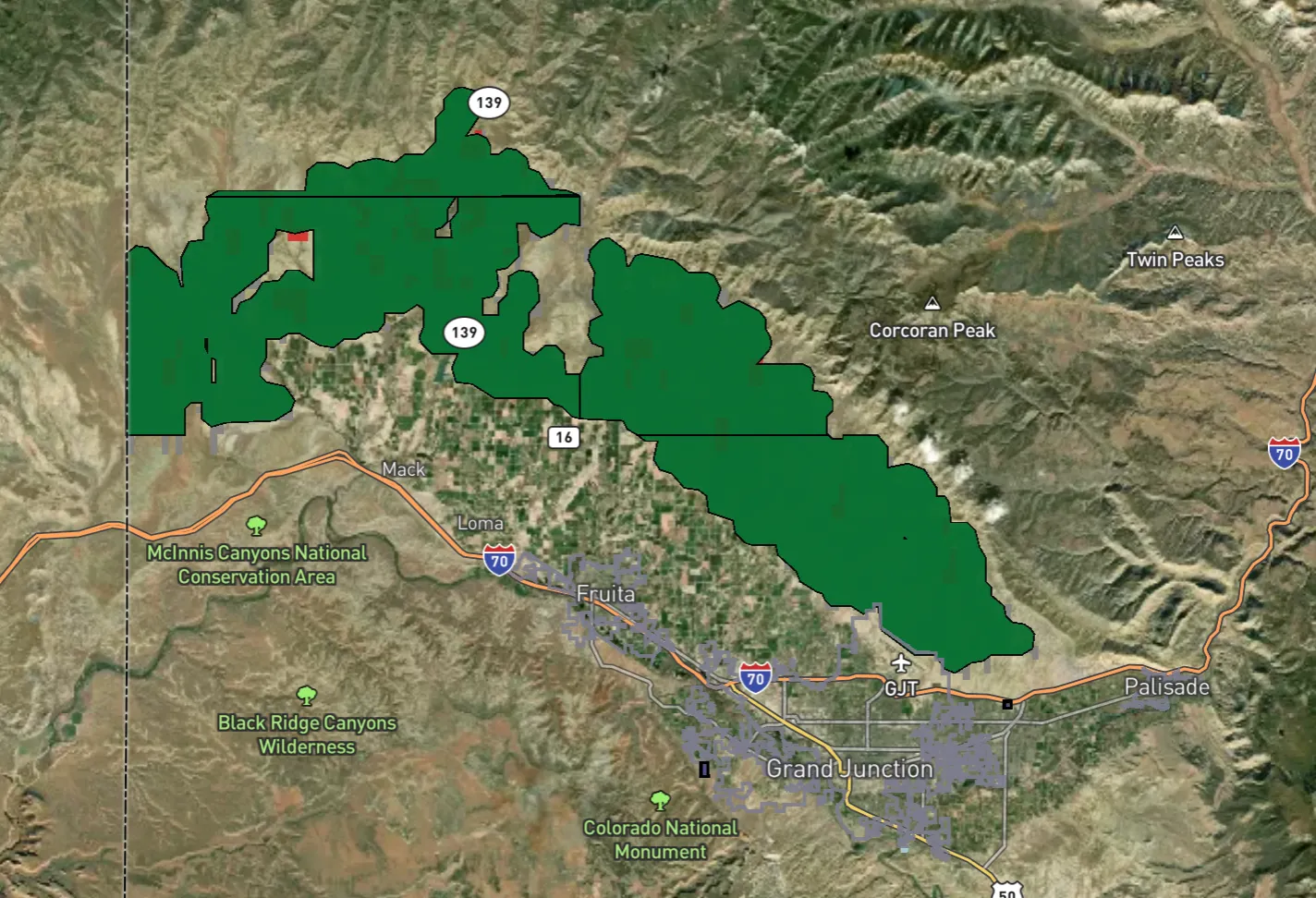
This SNOTEL site, in the San Francisco Peaks north of Flagstaff, is the comeback story of the year, rebounding from ultra-dry to average over the course of several weeks. Itโ€™s one of the only sites in Arizona that received measurable snow accumulation this season.
The drought has spread and intensified over the last year.
And it doesnโ€™t look like it will get better anytime soon โ€ฆ

If you want to know more about the drought and the Colorado River basin, Iโ€™d suggest checking out theย Wright-Ingraham Instituteโ€™s interactive Drought Interfaces app. Itโ€™s super cool and informative.

Dwindling water supply, legal questions push #ColoradoRiver into โ€˜wildly uncharted territoryโ€™: Threat of compact call hangs over seven-state talks — Heather Sackett (AspenJournalism.org) #COriver #aridification

Lake Powell at Wahweap Marina as seen in December 2021. Dwindling streamflows and falling reservoir levels have made it more likely that what some experts call a Colorado River Compact โ€œtripwireโ€ will be hit in 2027. Credit: Heather Sackett/Aspen Journalism

Click the link to read the article on the Aspen Journalism website (Heather Sackett):

April 1, 2025

Time is ticking for states that share the shrinking Colorado River to negotiate a new set of governing rules. One major sticking point, which has the potential to thrust the parties into a protracted legal battle, hinges on differing interpretations of a few sentences in a century-old agreement. 

In a recent letter, the riverโ€™s Lower Basin states โ€“ California, Nevada and Arizona โ€“ asked federal officials to analyze the effects of a hypothetical legal concept known as a โ€œcompact call.โ€ 

The problem? The 1922 Colorado River Compact says nothing about a compact call. And although the phrase often looms like a threat over Colorado River discussions, there is no agreed-upon definition of the term, what would trigger a compact call nor how one would play out. In fact, the Upper Basin states โ€“ Colorado, New Mexico, Utah and Wyoming โ€“ donโ€™t believe the laws governing the river even contemplate it.

The February letter comes as water managers from all seven Colorado River Basin states are in the midst of deciding how Lake Powell and Lake Mead will be operated and cuts will be shared after 2026 when the current guidelines expire. In March 2024, each basin submitted competing proposals to the U.S. Bureau of Reclamation. In January, federal officials with the outgoing Biden administration released their analysis of five different potential ways forward and did not include either basinโ€™s proposal, but a โ€œbasin hybridโ€ that incorporated elements from both. 

In essence, the Lower Basin states have identified a potential opening with the Trump administration, and asked new leaders at the Interior Department to adopt the Lower Basinโ€™s view on some of the most contentious and disagreed-about parts of Colorado River management.

โ€œI believe that under the law, the compact requires delivery of 7.5 million acre-feet of water on a 10-year rolling average, plus one-half of the Mexico Treaty obligation to the Lower Basin,โ€ said Tom Buschatzke, director of Arizonaโ€™s Department of Water Resources. โ€œSo we want to see Reclamation, as our request indicated, incorporate that outcome into the modeling for any alternative to look at. That includes how reductions in the Upper Basin states might have to occur.โ€

Members of the Colorado River Commission, in Santa Fe in 1922, after signing the Colorado River Compact. From left, W. S. Norviel (Arizona), Delph E. Carpenter (Colorado), Herbert Hoover (Secretary of Commerce and Chairman of Commission), R. E. Caldwell (Utah), Clarence C. Stetson (Executive Secretary of Commission), Stephen B. Davis, Jr. (New Mexico), Frank C. Emerson (Wyoming), W. F. McClure (California), and James G. Scrugham (Nevada) CREDIT: COLORADO STATE UNIVERSITY WATER RESOURCES ARCHIVE via Aspen Journalism

Over a century ago, the compact split the riverโ€™s water evenly, with half (7.5 million acre-feet a year) going to the Upper Basin and half to the Lower Basin. Another 1.5 million acre-feet a year was later allocated to Mexico.  
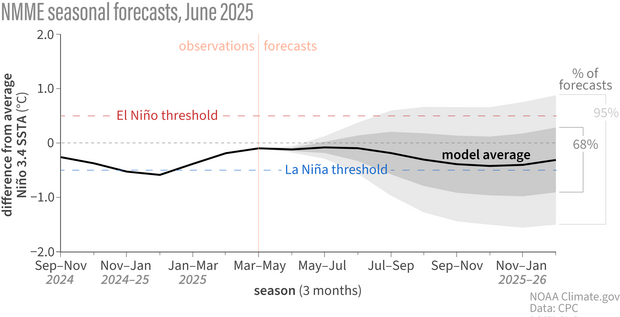
The crux of the dispute comes from how the Upper Basin states and the Lower Basin states each interpret a key phrase in the compact: โ€œThe States of the Upper Division will not cause the flow of the river at Lee Ferry to be depleted below an aggregate of 75,000,000 acre-feet for any period of ten consecutive yearsโ€ฆโ€

To the Upper Basin states, โ€œwill not causeโ€ means that their use wonโ€™t be the reason the Lower Basin doesnโ€™t get its allocation. They see it as a โ€œnon-depletionโ€ obligation. 

According to Colorado officials, theyโ€™re not delivering water downstream, but rather  theyโ€™re not causing the flows to be depleted. 

โ€œWhat this means is that if the flows were to drop below 75 million acre-feet over a ten-year period, there would be an inquiry into what caused that to occur,โ€ Michael Elizabeth Sakas, Colorado River communications specialist with the Colorado Water Conservation Board said in a written response to questions from Aspen Journalism.  

On the other hand, the Lower Basin states say theyโ€™re owed the water, with the Upper Basin states required to send the 75 million acre-feet over 10 years, plus half of the Mexico Treaty obligation (which works out to 82.5 million acre-feet every 10 years) downstream to the Lower Basin. 

Compact โ€œtripwireโ€ threatens to complicate

Colorado River expert Eric Kuhn says that the latest report from the U.S. Bureau of Reclamation is a major caution sign for the basin. An anemic snowpack this past winter could be setting the basin on the road to a compact call (as defined by the Lower Basin). The most recent federal forecast predicts that in 2027, the 10-year cumulative flow at Lee Ferry could drop below 82.5 million acre-feet, a threshold Kuhn calls the first โ€œtripwireโ€ for a compact call. 

โ€œIf flows were to go below 82.5 million, then thatโ€™s the first time, in theory, the lower division states could point to the Upper Basin and say, โ€˜Youโ€™re not complying with your compact obligations,โ€™โ€ Kuhn said. โ€œThis is not going to sneak up on us. I think most of the modeling shows that itโ€™s almost inevitable we will drop below 82.5 in the next three or four years.โ€ 

But Upper Basin officials disagree. In their interpretation, this tripwire doesnโ€™t exist. A compact call is a concept recognized only by the Lower Basin. 

They also point out that calls for water apply to situations where there is a senior rights holder and a junior rights holder. Under the prior appropriation system, the oldest water rights get first use of the river, and senior rights can force junior rights to stop using water so seniors can get the full amount they are entitled to. But Upper Basin officials say there is no priority between the two basins; they are on equal standing. [ed. emphasis mine]

That may be true, but the three Lower Basin states are also home to the basinโ€™s biggest water users and cities, with more political power than the sparsely populated Upper Basin states.

Navajo Bridge spans the Colorado River downstream from Lake Powell near Lee Ferry, the dividing line between the upper and lower basin. Some federal forecasts predict that in 2027, the flow at Lee Ferry could drop below a critical threshold that some experts call a โ€œcompact tripwire.โ€

River headed for โ€œwildly uncharted territoryโ€

So what would happen if and when the river shrinks enough to trigger the first compact tripwire?

In practice, a compact call could mean the Lower Basin states would sue the federal government to get them to send more water downstream from Lake Powell. (The U.S. Bureau of Reclamation is responsible for making releases from Lake Powell and Lake Mead.) The Lower Basin states could also demand that the Upper Basin states implement cuts to get more water into Lake Powell. But the Upper Basin states will almost certainly argue they are in compliance with the compact and donโ€™t need to make cuts. The Supreme Court could then decide whether the Upper Basin states are in compliance with the compact.

โ€œItโ€™s wildly uncharted territory,โ€ said Chuck Cullom, the executive director of the Upper Colorado River Commision. โ€œItโ€™s not a straightforward path to say: โ€˜We need you to release more water out of Glen Canyon Dam and curtail uses.โ€™โ€

Udall/Overpeck 4-panel Figure Colorado River temperature/precipitation/natural flows with trend. Lake Mead and Lake Powell storage. Updated through Water Year 2024. Credit: Brad Udall

The Upper Basinโ€™s argument hinges on what is causing the flows at Lee Ferry to drop. The four states say itโ€™s not their fault, because they only use between 3.5 and 4.5 million acre-feet a year, far less than their allocation of 7.5 million acre-feet. The culprit, they say, is climate change, which according to scientists has contributed to a 20% decline in flows from the 20th century average. They have also shown that every 1 degree Celsius of warming results in a 9% reduction in flows. 

With a fixed number for how the river is shared, and a slowly dwindling amount of water available, the Upper Basin has been bearing the brunt of the effects of climate change, a phenomenon that Kuhn calls the โ€œUpper Basin squeeze.โ€ But the climate change argument could open a can of worms.

โ€œThere are numerous other water compacts between states,โ€ Kuhn said. โ€œAre we reopening every one of those? It could mean that other states do not have to comply with their compact obligations.That would be a precedent decision that would affect every compact in the western United States.โ€

How would cuts work?

Water users on Coloradoโ€™s Western Slope are eager to know how cuts could play out and over the past few years they have asked state officials repeatedly for more clarity on this issue. One reason is because most of the big transmountain diversions that take water from the mountainous headwaters of the Colorado to Front Range cities date to after the 1922 compact, meaning they would likely be cut first. But as the population centers and economic engines of the state, itโ€™s unlikely a plan to cut water use would include turning off the taps to Denver.  

In a crisis situation where cuts are mandatory, the strict prior appropriation system would probably not hold.

โ€œTheyโ€™re going to have to make hard decisions, and they are going to primarily meet the human health and safety needs of people first,โ€ Kuhn said. โ€œItโ€™s an open secret that the priority system works under normal conditions; it doesnโ€™t work in emergencies.โ€

Western Slope water users also want to know the stateโ€™s plan for cuts, because some areas may be more at risk of forced cutbacks than others. The Yampa/White/Green River basin in the northwest corner of the state, for example, developed later than other places, with lots of more junior water rights. Would they be first on the chopping block? 

โ€œWe believe that regardless of where things stand on the river, clarity canโ€™t hurt water users,โ€ said Peter Fleming, general counsel with the Colorado River Water Conservation District. โ€œIn the long run, clarity will help people to plan better.โ€

But state officials have been reluctant to provide clarity about how cuts could be implemented, saying now is not the time to plan for it and that the Upper Basin states have always been in compliance with the compact.

โ€œColorado is not at risk of any compact curtailment scenario in the near future,โ€ Sakas said in a written response to Aspen Journalism. โ€œFor the last 20 years, the Upper Basin has been using half of what we are allowed to use under the 1922 Compact while our downstream neighbors use significantly more than their apportionment.โ€

Figuring out who would be the first to take cuts and tracking that water to the state line would not be an easy task, said Colorado River expert Jennifer Gimbel. Gimbel is the senior water policy scholar at the Colorado State University Water Center and is the former director of the Colorado Water Conservation Board. 

โ€œIt would be a tremendous headache and a huge undertaking,โ€ she said. โ€œBut I donโ€™t know if that means we shouldnโ€™t be doing it.โ€

The Colorado Division of Water Resources, in a first step, has been developing measurement rules and requiring measurement devices for water users across the Western Slope. According to state officials, the goal of this effort is to accurately measure diversions so that if necessary, Colorado sends downstream only the water that is required to maintain compact compliance and not a drop more. 

From left, J.B. Hamby, chair of the Colorado River Board of California, Tom Buschatzke, Arizona Department of Water Resources; Becky Mitchell, Colorado representative to the Upper Colorado River Commission at the Colorado River Water Users Association Conference in 2023. Water managers from all seven Colorado River Basin states are in the midst of deciding how Lake Powell and Lake Mead will be operated and cuts will be shared after 2026Credit:ย Tom Yulsman/Water Desk, University of Colorado, Boulder

Trying to stay out of court

One thing most water managers agree on is that finding a seven-state consensus is better than the potentially protracted litigation possible under some kind of compact call scenario. Some are hoping for the best but preparing for the worst. The Arizona Department of Water Resources requested about $1 million last year for Colorado River litigation from the state budget. Buschatzke said the Upper Basin states might fare worse under a compact call than they would by adopting the Lower Basin proposal.

โ€œBecause there are a lot of moving parts, litigation โ€” a compact call โ€” is a possibility,โ€ he said. โ€œItโ€™s not a possibility I want to see occur. But Iโ€™ll have to do what I have to do to protect the state of Arizona.โ€

If the states can come up with new guidelines that fairly share the river, the threat of a compact call, which has long hung over Colorado River management discussions, could evaporate like water from the surface of Lake Mead. Cullom said that in 2007 when the seven states implemented the soon-to-expire guidelines that are currently in place, they agreed that if the two basins made good on their commitments outlined in those guidelines, they would set aside the issue of compact compliance โ€” at least until after 2026.

โ€œIf they can figure out a way to live within the means of the river in such a manner that both the Upper Basin and Lower Basin agree, hopefully addressing a compact call again wonโ€™t be needed because itโ€™s been addressed,โ€ Gimbel said. 

This story was produced by Aspen Journalism, in partnership with The Water Desk at the University of Coloradoโ€™s Center for Environmental Journalism. 

Map of the Colorado River drainage basin, created using USGS data. By Shannon1 Creative Commons Attribution-Share Alike 4.0

Polluted discharge from the Moffat Tunnel continues to be released into the #FraserRiver — Sky-Hi Daily News

The pipeline, at the base of the Winter Park ski area, that moves water as part of the existing Moffat Collection System Project. The portal of the railroad tunnel is behind the pipeline, in this view. Photo credit: Brent Gardner-Smith/Aspen Journalism

Click the link to read the article on the Sky-Hi Daily News website (Meg Soyars Van Hauen). Here’s an excerpt:

March 25, 2025

According to Grand County Water Quality Manager Katherine Morris, polluted discharge from the Moffat Tunnel has adversely impacted the Fraser River. The Grand County water quality team recently wrote two letters to the Colorado Department of Public Health & Environment, outlining its concerns with violations by Union Pacific Railroad, which manages the tunnel. During a Grand County Board of Commissioners meeting March 11, 2025 Morris explained that polluted water from the tunnel enters the nearby Fraser River, which is a main tributary of the Colorado River. Thisย ongoing problemย began after the tunnel was completed, and Grand County government began advocating to fix the problem nearly two decades ago…

James Peak via ColoradoWildAreas.com

In the early 2000s, residents and governmental officials raised alarm about pollutants and increased turbidity (or clarity issues) in the Fraser River when water was discharged from the tunnel. The tunnel bores through James Peak. Groundwater from cracks in the mountain rock seeps into the tunnel, and that water needs a way out. Coal dust, heavy metals andย other particulate matterย can travel into the Fraser River through the runoff. At the time, a water treatment plant existed on the east portal of the tunnel but not on the west portal at Winter Park. People questioned why there was no treatment plant toย protect Grand County, home to the headwaters of the Colorado River. Over the years, Union Pacific receivedย finesย and a cease-and-desist order. The railroad finally built a treatment plant in 2017, but issues have continued โ€” even worsened in some cases, Morris said. A water centrifugeย at the plant is designed to separate solids from the water, creating a sludge-like โ€œcentrifuge cakeโ€ that is put in a drum and disposed of in Utah. (Thisย disposalย has raised its own concerns.) The remaining water is discharged into the river.

Tourism increases pressure on wastewater plant: Biological processes at city wastewater treatment plant impacted by tourism swings — Steamboat Pilot & Today #YampaRiver

Wastewater Treatment Process

Click the link to read the article on the Steamboat Pilot & Today website (Suzie Romig). Here’s an excerpt:

March 13, 2025

When the flow of visitors in Steamboat Springs rises during heavy tourism times, so too does the waste, making management of the Steamboat Springs Wastewater Treatment Plant a challenging and often smelly job.

โ€œItโ€™s significantly harder to run a wastewater treatment plant in a resort town that sees a big influx of visitors than in a city where your population is static,โ€ said Jon Snyder, the public works director for Steamboat Springs. โ€œConsistent population makes a biological process easier to manage.โ€

The plantโ€™s operational status averages 60% capacity, but utilization can range from 26% during โ€œmud seasonโ€ when Steamboat sees fewer people in town to a record high of 72% in January 2022, explained Gilbert Anderson, plant superintendent. The maximum 24-hour flow into the plant can fluctuate widely during the year; for example, the flow in 2024 peaked at 7.14 million gallons per day on April 5 and was the lowest at 1.87 million gallons per day on Oct. 16, Anderson reported. During specific atmospheric conditions such as on cold mornings with temperature inversions โ€” especially during the busy holiday times of Christmas, New Yearโ€™s and Presidentsโ€™ Day โ€” the waste smells may be most noticeable to nearby homeowners, Snyder said. The vintage 1980 plant maintains aย six-step processย inside buildings to try to contain as much odor as possible, Snyder said. Yet, residents say the wastewater smells can be noticed at homes downwind and in nearby neighborhoods

Aspinall Unit operations / #GunnisonRiver flow change — Erik Knight (USBR) #UncompahgreRiver

Grand opening of the Gunnison Tunnel in Colorado 1909. Photo credit USBR.

From email from Reclamation (Erik Knight):

March 17, 2025

Releases from the Aspinall Unit will be increased from 700 cfs to 1200 cfs Tuesday, March 18th. ย Releases are being increased to coincide with the start of diversions at the Gunnison Tunnel.

Flows in the lower Gunnison River are currently above the baseflow target of 1050 cfs. After this release change river flows are expected to remain above the baseflow target for the foreseeable future.

Pursuant to the Aspinall Unit Operations Record of Decision (ROD), the baseflow target in the lower Gunnison River, as measured at the Whitewater gage, is 1050 cfs for March through May.

Currently, Gunnison Tunnel diversions are 0 cfs and flows in the Gunnison River through the Black Canyon are around 650 cfs. After this release change Gunnison Tunnel diversions will be 450 cfs and flows in the Gunnison River through the Black Canyon will be around 700 cfs. Current flow information is obtained from provisional data that may undergo revision subsequent to review.

This scheduled release change is subject to changes in river flows and weather conditions. For questions or concerns regarding these operations contact:

Erik Knight at (970) 248-0629, e-mail eknight@usbr.gov

U.S. Representative Jeff Hurd working โ€˜behind the scenesโ€™ to unfreeze funds for critical water rights purchase — #Colorado Public Radio #ColoradoRiver #COriver #aridification

This historical photo shows the penstocks of the Shoshone power plant above the Colorado River. A coalition led by the Colorado River District is seeking to purchase the water rights associated with the plant. Credit: Library of Congress photo

Click the link to read the article on the Colorado Public Radio website (Tom Hesse). Here’s an excerpt:

March 16, 2025

Western Slope water leaders hope bipartisan support can thaw $40 million in frozen federal money aimed at securing some of the Colorado Riverโ€™s oldest water rights. The Colorado River District is spearheading anย effortย to purchase senior rights from Xcel Energy used at the Shoshone hydroelectric plant in Glenwood Canyon. Theย waterย allocated by the rights passes through the facility and back into the river, making them โ€œnonconsumptiveโ€ rights, but by purchasing them for $99 million Western Slope leaders hope to ensure that water can continue to flow downstream and avoid the possibility it could be rerouted to Front Range users. The effort to buy the rights raised more than $50 million between the state of Colorado, the River District and more than two dozen entities on the Western Slope. In January, the federal governmentย announcedย $40 million worth of support to the project. Just days later, the Trump administration took over, and that money was put on hold.ย 

โ€œI think that has been frozen,โ€ Republican Congressman Jeff Hurd, who represents Coloradoโ€™s 3rd Congressional District, said in response to a question about the grant during a tele-town hall event on March 11. โ€œJust know that we are working hard behind the scenes to see what we can do to make sure that that funding is allocated and completed.โ€

Andy Mueller, general manager for the Colorado River District, said the group anticipated delays in the funding from the start on account of the changing administrations. But, because the group has been working on pooling the money in advance, theyโ€™re not being left high-and-dry by the funding freeze just yet. 

โ€œWe’re one of the fortunate grantees, if you will, in that situation. I know there are a lot of grantees who were actually engaged in digging dirt and had hired staff in anticipation of grants,โ€ Mueller said. He noted the deal is still pending a water court change case, giving the Shoshone purchase deal extra runway to haggle over the federal contribution.

Grant boosts the Ruth Powell Hutchins Water Center’s education, outreach efforts — The #GrandJunction Daily Sentinel

Ruth Powell Hutchins. Photo credit: Colorado Mesa University

Click the link to read the article on the Grand Junction Daily Sentinel website (Dennis Webb). Here’s an excerpt:

March 14, 2025

A $110,000 state grant is enabling Colorado Mesa Universityโ€™s Ruth Powell Hutchins Water Center to expand its education and outreach program, including through a spring speaker series co-organized with CMUโ€™s Environmental Science program. The center received the money from the Colorado Water Conservation Board last fall for two years of programs. According to a news release, Freddy Witarsa, the programโ€™s interim director, will use the funds to facilitate programs to prepare students to join the water workforce and provide a platform for Western Colorado stakeholders to address the regionโ€™s water challenges…The water center facilitates research, education, outreach and dialogue to address the water issues in the region. The center has been led in recent years by interim directors. Witarsa also is an assistant professor of environmental science and technology at CMU. In January, the Colorado River District awarded the center $300,000 to support its efforts to grow over the next three years, including by hiring an executive director. That grant is being matched by a $300,000 grant from CMU.

Earthโ€™s Land Masses Are Drying Out Fast, Scientists Warn — Bob Berwyn (InsideClimateNews.org)

Click the link to read the article on the Inside Climate News website (Bob Berwyn):

March 27, 2025

Researchers comparing satellite measurements of the planetโ€™s water with the wobble in its rotation identified a steady loss of global soil moisture.

Earth has lost enough soil moisture in the last 40 years to change the planetโ€™s spin and shift the location of the North Pole, according to a new study published today in Science that tracks how human activities have disrupted the global water cycle. The persistent loss of water from land to oceans has dried out huge portions of every continent and may be irreversible, scientists describing the new research said this week.

โ€œLarge regions in East and Central Asia, Central Africa, and North and South America show pronounced depletion,โ€ between 2003 and 2007, the authors wrote. When they extended the timeframe to 2021, the depletion of soil moisture grew large enough to cover those areas and also included Europe and the Eastern U.S.

โ€œThis study provides robust evidence of an irreversible shift in terrestrial water sources under the present changes in climate,โ€ said Luis Samaniego, a hydrology researcher at the UFZ Helmholtz Centre for Environmental Research in Leipzig, Germany. 

โ€œThe continents are drying out over time,โ€ said Samaniego, who was not involved in the new study but wrote a related Perspective article in Science. 

In some regions, there would have to be well above average rainfall for 10 consecutive years to recover from extended periods of drought, he said.

โ€œYou can forget it. Itโ€™s not going to be like that. This is permanent, at least for our time scale,โ€ he said.

โ€œOn a longer timescale, over millions of yearsโ€ฆEarth could become as dry as Mars,โ€ he added. โ€œEarth could become a desert without atmosphere, but I donโ€™t think that is where we want to live.โ€

The new study describes the โ€œmagnitude of the changes that we are causing,โ€ he said. โ€œBecause at the end, what is creating this change in moisture is this minute molecule of CO2 that we keep pumping and pumping and pumping and pumping, and thatโ€™s creating an instability in the atmosphere.โ€

When the researchers combined satellite data about water in soils, sea level measurements and observations of precipitation, they found a โ€œdramatic depletion in soil moisture.โ€ Soils lost about 1,614 gigatons of water between 2000 and 2002โ€”a big downward step in global soil moisture from which there has been no recovery. Instead, the depletion continued, with soils losing an additional 1,009 gigatons of water from 2003 to 2016. In comparison, the Greenland Ice Sheet lost about 900 gigatons of water from melting ice between 2002 and 2006. 

The findings suggest that this decline is primarily driven by shifts in precipitation patterns and increasing evaporative demand due to rising temperatures. As of 2021, soil moisture had made no recovery, the authors noted, adding that they saw little likelihood of recovery under current climate conditions. 

Co-author Dongryeol Ryu, an environmental hydrologist at the University of Melbourne, said that as the researchers examined the data, they saw a step-change in sea level rise in the early 2000s that looked unnatural.

โ€œWhen something looks too strange or too new, naturally, scientists suspect there were some errors,โ€ he said. โ€œSo we tried to replicate that using different measurements.โ€

When they removed all the possible contributing factors other than soil moisture from their calculations, the big jump in global mean sea level in the early 2000s remained, and matched the loss of soil moisture, with roughly 1 millimeter global mean sea level rise for every 360 gigatons of water lost from land, he said.

At some point, โ€œWe may see a drying of lakes and drying streams,โ€ he said, although where the drying trend will lead isnโ€™t clear. โ€œEven if you have sufficient rainfall, they may continue to dry.โ€

He noted that, globally, funding for ground monitoring has been decreasing and the number of gauge stations declining.

โ€œWe need a community effort for that, not just one or two groups, because there are so many different types of monitoring stations,โ€ he said. โ€I hope we could put all these isolated data together to see if they are pointing in the same direction.โ€

Polar Motion

The redistribution of water can change the way Earth wobbles as it spins on its axis, so the team compared the โ€œpolar motionโ€ that shows that teetering to their comprehensive soil moisture database, Ryu said. The changes in the Earthโ€™s spin correlated with the changed distribution of water on the planet, with the wobble behaving as expected with less moisture in soil and more water in the oceans.

The research team included geoscientist Clark Wilson, professor emeritus with the Department of Earth and Planetary Sciences at the University of Texas, who has been studying Earthโ€™s rotation for 50 years, starting with his 1976 dissertation.

โ€œIn the early โ€˜70s, polar motion was just an oddity,โ€ he said, โ€œBut now, everybody has a GPS receiver in their cell phone, and the whole GPS system and satellite navigation systems all require very, very accurate knowledge of polar motion.โ€

Thatโ€™s led to a big increase in the number of people studying the Earthโ€™s wobble, he said.

In the last 100 years, post-glacial rebound of land and loss of ice masses have shifted the exact location of the rotational axis by about 20 meters, he said. 

Knowing where the exact point of rotation is relative to other fixed points in space is the basis for all modern GPS navigation, including missile guidance systems, but scientists also realized early on that the Earthโ€™s wobble also provided insights about global climate change.

โ€œGlobal sea level tells you about total water volumes, but it doesnโ€™t say where it came from,โ€ he said. โ€œPolar motion, on the other hand, is sensitive to geographical distribution of mass.โ€

The Gravity Recovery and Climate Experiment (GRACE) satellite mission launched in 2002 allowed for the observations of how the distribution of mass on the planet was changing, particularly through its ability to monitor terrestrial water storage by measuring changes in gravity.

โ€œItโ€™s a wonderful measurement because in the past, water storage in the soil was done by drilling a well and measuring the level of the water,โ€ he said.

Those isolated measurements didnโ€™t help to define a global water budget that included factors like evaporation and runoff, making it impossible to model planet-wide water cycles, he said. โ€œGRACE has changed all that.โ€ 

Global Drought?

Ryu, the University of Melbourne researcher, said itโ€™s important to go back to the 1980s, when the average global temperature started increasing sharply, to understand the changes they measured in the new study.

Initially, scientists were puzzled that the vapor pressure deficitโ€”a measure of how much moisture is in the air compared to what it could hold at a given temperatureโ€”did not immediately increase to match the rising temperatures, he said. 

โ€œBut starting in about 2000, the vapor pressure deficit started increasing very steeply, coinciding with our analysis period,โ€ he said. 

Satellite measurements that can track how Earthโ€™s gravitational field changes in space and time show accumulating groundwater depletion from 2003 to 2009 in Australia, the Central Valley of California and the Middle East. A new study building on that data shows there is a global trend of terrestrial moisture loss. Credit: NASA

That coincided with an โ€œunusualโ€ three-year decline of global precipitation from 2000 to 2003, leading to the decline in soil moisture that persisted through at least 2021. The two big declines were in the early 2000s and in 2015 and 2016, the second associated with a strong El Niรฑo, a warm phase of a tropical Pacific Ocean cycle that shifts global rainfall patterns. Another strong El Niรฑo could result in another big step down of global soil moisture, he said.

Regional impacts continue to be concerning, he said, highlighting a highly unusual and ongoing dry period in the Amazon.โ€œIf you look at the GRACE data over the Amazon, thatโ€™s really scary,โ€ he said.

Drought, in many cases, is a slow-onset impact of global warming, he said.

โ€œNot visible doesnโ€™t mean that itโ€™s not important,โ€ he said. โ€œWe are very, very cautious about floods, earthquakes and wildfires, because they happen in the timescale of our life. The impacts are very visible, but drought is a creeping disaster.โ€

Most conventional drought measurements are based on precipitation and potential evaporative transpiration, which can suggest short-term recovery from drought conditions, but only have limited capability to detect the slow, long-term depletion of soil moisture. But their measurements of terrestrial water around the world found persistent declines, sometimes in steep steps.

โ€œAfter a shock of rainfall deficits for a year or two, we used to be able to see recovery, but not anymore,โ€ he said. โ€œThat is a very serious concern.โ€ 

Southwest Hit Especially Hard

The global pattern identified in the new study has been emerging since the GRACE data has become available, said water researcher and co-author Jay Famiglietti, global futures professor at Arizona State Universityโ€™s School of Sustainability. 

โ€œItโ€™s what the Intergovernmental Panel on Climate Change has been predicting, which is wet areas getting wetter and the tropics and mid-latitudes getting drier,โ€ he said.

The rate of drying in middle latitudes is higher, he noted, because of a positive feedback loop in which people use more groundwater as lands become more arid.

Sensitive satellite-based instruments enable scientists to measure relative variations of Earthโ€™s gravitational field. Data gathered by NASAโ€™s Gravity Recovery and Climate Experiment (GRACE) is used in a new study to show that many continental regions are experiencing long-term aridification. Credit: NASA/JPL/University of Texas Center for Space Research

The implications of the research are especially profound in the Southwest, he said, where it shows the Four Corners region has been drying out for 30 or 40 years. 

โ€œThat really puts our food security at risk, and it also puts the economy of the Southwest at risk,โ€ he said, noting the growing importance of the water-intensive computer chip and data center industries.

With most rain that falls in the Southwest already evaporating rapidly, and that rate increasing as temperatures climb, staunching the hemorrhaging of groundwater there is critical to the regionโ€™s survival.

โ€œWith a wet winter, you get a little recovery of groundwater, but then you get a big drop, and then maybe you get another little recovery and another big drop,โ€ he said. โ€œI liken it to a tennis ball bouncing down the stairs.

โ€œItโ€™s pretty much one way. We need to put the brakes on, understanding that weโ€™re not going to get more [water],โ€ he said. 

Take your children out into these landscapes” — Kevin Fedarko

My friend Joe’s son and the Orr kids at the top of the Crack in the Wall trail to Coyote Gulch with Stevens Arch in the Background. Photo credit: Joe Ruffert

Kevin Fedarko was the keynote speaker at the symposium and he is as inspirational a speaker as you could ask for. It doesn’t hurt that the landscape that he spoke about is the Grand Canyon. He urged the attendees to, “Take your children out into these landscapes so that they can learn to love them.” He is advocating for the protection of the Grand Canyon in particular but really he is advocating for the protection all public lands.

Kevin Fedarko and Coyote Gulch at the Rio Grande State of the Basin Symposium hosted by the Salazar Rio Grande del Norte Center at Adams State University in Alamosa March 29, 2024.

What an inspirational talk from Kevin. I know what he is saying when he speaks about the time after dinner on the trail where the sunset lights up the canyon in different hues and where, he and Pete McBride, his partner on the Grand Canyon through hike, could hear the Colorado River hundreds of feet below them, continuing its work cutting and molding the rocks, because the silence in that landscape is so complete. He and I share the allure of the Colorado Plateau. Kevin was introduced to it through Collin Flectcher’s book The Man Who Walked Through Time, after he received a dog-eared copy from his father. They lived in Pittsburgh in a landscape that was industrialized but the book enabled Kevin to imagine places that were unspoiled.

My introduction to the Colorado Plateau came from an article in Outside magazine that included a panoramic photo of the Escalante River taken from the ledges above the river. Readers in the know can put 2 and 2 together from the name of this blog — Coyote Gulch — my homage to the canyons tributary to Glen Canyon and Lake Foul.

Stevens Arch viewed from Coyote Gulch. Photo via Joe Ruffert

Kevin’s keynote came at the end of the day on March 29th after a jam-packed schedule.

Early in the day Ken Salazar spoke about the future of the San Luis Valley saying, “Where is the sustainability of the valley going to come from.” Without agriculture this place would wither and die.” He is right, American Rivers and other organizations introduced a paper, The Economic Value of Water Resources in the San Luis Valley which was a response to yet another plan to export water out of the valley to the Front Range. (Currently on hold as Renewable Water Resources does not have a willing buyer. Thank you Colorado water law.)

Claire Sheridan informed attendees that their report sought to quantify all the economic benefits from each drop of water in the valley. “When you buy a bottle of water you know exactly what it costs. But what is the value of having the Sandhill cranes come here every year?”

Sandhill Cranes Dancing. Photo by: Arrow Myers courtesy Monte Vista Crane Festival

Russ Schumacher detailed the current state of the climate (snowpack at 63%) and folks from the Division of Water Resources expounded on the current state of aquifer recovery and obligations under the Rio Grande Compact.

The session about the Colorado Airborne Snow Measurement Program was fascinating. Nathan Coombs talked about the combination of SNOTEL, manual snow courses, Lidar, radar, and machine learning used to articulate a more complete picture of snowpack. “You can’t have enough tools in your toolbox,” he said.

Coombs detailed the difficulty of meeting the obligations under the Rio Grande Compact with insufficient knowledge of snowpack and therefore runoff volumes. Inaccurate information can lead to operational decisions that overestimate those volumes and then require severe curtailments in July and August just when farmers are finishing their crops. “When you make an error the correction is what kills you,” he said.

If you are going to learn about agriculture in the valley it is informative to understand the advances in soil health knowledge and the current state of adoption. That was the theme of the session “Building Healthy Soils”. John Rizza’s enthusiasm for the subject was obvious and had me thinking about what I can do for my city landscape.

Amber Pacheco described how the Rio Grande Basin Roundtable and other organizations reach out to as many folks in the valley as possible. Inclusivity is the engine driving collaboration.

Many thanks to Salazar Rio Grande del Norte Center director Paul Formisano for reaching out to me about the symposium. I loved the program. You can scroll through my posts on BlueSky here

Orr kids, Escalante River June 2007

2025 #RioGrande State of the Basin Symposium

I’m in Alamosa to attend the symposium. There is a great program planned for today chock full of information about Colorado’s “South Slope”. Click the link to view the agenda. Of course snowpack will be a large part of the discussion today, as it is every April 1st in Colorado. Also, I’m looking forward to the session featuring a new study from American Rivers with Heather Dutton and Emily Wolf.

Russ Schumacher will be discussing snowpack and precipitation.

layer cakes over the Sangre de Cristos (which could really use some more snow) #cowx

Russ Schumacher (@rschumacher.cloud) 2025-03-29T02:49:25.319Z

Live-posting will be on my BlueSky feed at: https://bsky.app/profile/coyotegulch.bsky.social

President Trump hands public lands to the mining industry: Plus: Using public lands for housing — againย — Jonathan P. Thompson (LandDesk.org)

Click the link to read the article on The Land Desk website (Jonathan P. Thompson):

March 25, 2025

โ›๏ธMining Monitor โ›๏ธ

Satellite image of a portion of the Morenci Mine in Arizona. Source: Google Earth.

Last week, President Trump signed an executive order โ€” his 150th so far this term, by my rough count โ€” invoking the Defense Production Act to expedite mining on federal lands. The wording of the order suggests that the aim is not just to cut through some of the red tape hindering proposed projects, but to incite the industry to mine areas that it may not have been considering previously.

The order has understandably alarmed public lands advocates, but it has also spawned some misconceptions, particularly concerning the 1872 General Mining Law.

Green River Basin oil shale deposits via the Bureau of Land Management

While Trumpโ€™s attacks on the nation and public lands have been of unprecedented scope and scale so far, his use of the Cold War-era DPA is not unprecedented or even all that unusual. The Carter administration used it to justify pouring billions of dollars of subsidies into โ€œsynfuelโ€ production as part of its quest for โ€œenergy independence.โ€ This sparked massive oil shale operations in western Colorado (which crashed spectacularly). And Biden used the Act to encourage mining for so called โ€œgreen metals,โ€ such as lithium, boron, and manganese. He also streamlined permitting for the proposed Hermosa manganese mine in southern Arizona, and loaned the contested Thacker Pass lithium mine in Nevada $2.6 billion.

But Trumpโ€™s order goes much further than Bidenโ€™s. He is expanding the list of target minerals to just about everything, including โ€œcritical minerals, uranium, copper, potash, gold, and any other element, compound or material as determined by the Chair of the National Energy Dominance Council, such as coal.โ€ While Biden wanted a survey of the nationโ€™s mineral production capacity, and promised to adhere to all existing environmental laws and consult with tribal nations, Trump is ordering his agencies to:

  • Compile a list of all proposed mining projects โ€œin order to expedite the review of those projects in coordination with the National Energy Dominance Council.โ€
  • Amend or revise land use plans under the Federal Land Policy and Management Act as necessary to โ€œsupport the intent of this order.โ€
  • โ€œIdentify as many sites as possible that might be suitable for mineral production activities that can be permitted as soon as possible.โ€
  • Prioritize mineral production activities over other types of activities on federal lands.
  • Provide financing, loans, and investment for new mines, including from a โ€œdedicated critical minerals fund established through the U.S. International Development Finance Corporation.โ€
  • โ€œNew recommendations will be provided to Congress regarding treatment of waste rock, tailings, and mine waste disposal under the Mining Act of 1872.โ€

Instead of adhering to environmental laws, Trump would simply alter them to support mining. He not only wants to help out proposed projects with regulatory and financial subsidies, but also wants to spur on new projects on โ€œas many sites as possible.โ€ And he is prioritizing mineral extraction over all other activities on federal lands, a blatant violation of the Federal Land Policy Management Actโ€™s multiple-use mandate.

That would mean not only that mining would take precedence over conservation and recreation, but also livestock grazing and other extractive uses. The OHV crowd thatโ€™s worried about the BLM closing a few roads to motorized vehicles around Moab might just find themselves ousted from a lot more areas by potash ponds, uranium mines, or lithium operations.

Trumpโ€™s recommendations to Congress likely will be to tweak the 1872 Mining Law to ensure that mining companies can store waste on public land mining claims that arenโ€™t valid, meaning that they have not proven that the parcels contain valuable minerals. This was actually the norm for decades until 2022, when a federal judge ruled that the proposed Rosemont copper mine in Arizona could not store its tailings and waste rock on public land. That ruling was followed by a similar one in 2023, leading mining state politicians from both parties to try to restore the pre-Rosemont Decision rules.

Itโ€™s around the General Mining Law that misconceptions have arisen. The folks at More Than Just Parks say the new order โ€œdoesnโ€™t create a new legal framework. It exhumes an old one โ€” a fossil from the 19th century โ€ฆ Itโ€™s the Mining Act of 1872, back from the dead, and now wearing body armor.โ€ Which is a nice way to put it, but the Mining Act never died, so this order canโ€™t revive it.

The other misconception appeared in Lands Lost, another great Substack focusing on public lands, which wrote: โ€œโ€ฆ there are no meaningful environmental safeguards in place because public land mining is a free-for-all governed only by an 1872 law thatโ€™s never been modernized.โ€

Itโ€™s true that the 1872 Mining Law is inadequate, allows mining companies or individuals to stake a claim to any public land without public input or environmental review, conduct exploratory work with a minimum of review, and pay no royalties on hardrock minerals they extract. However, the federal agencies do have additional regulations governing mining. Before a company can do any actual mining, it must get an operating permit from the Bureau of Land Management, U.S. Forest Service, or Department of Energy (depending on the landโ€™s jurisdiction), which includes an environmental review (either an EA or a more extensive EIS, depending on the scope of the project). A mine may also need a Clean Water Act permit for any water discharges, including draining adits, and many states require additional permits as well.

By ordering the agencies to alter the FLPMA land-use plans to accommodate mining, Trump is essentially doing away with these additional safeguards, which really is scary. That would take us back to a time when the 1872 Mining Law was the only federal regulatory framework, which would give mining companies a free rein to trash public lands. However, Trump canโ€™t do much about state requirements, except to try to bully them out of existence. [ed. emphasis mine]

The order applies only to federal lands, so mining projects that are on patented mining claims โ€” which are entirely on private โ€” would not be affected (although they might be eligible for the government handouts). 

Proposed projects this fast-tracking could affect include:

  • Resolution Copperโ€™sย proposed massive copper mineย at Chiโ€™chil Biล‚dagoteel, aka Oak Flat, in central Arizona.
  • Copper World Complexย nรฉe Rosemont Mine in the Santa Rita Mountains south of Tucson, Arizona. After a judge kiboshed Canada-based Hudbayโ€™s plan to dump mine waste on U.S. Forest Service land, the firm decided to base the initial phase on patented, i.e. private, mining claims and later expand to public lands.
  • South32โ€™s proposedย Hermosa Mineย in the Patagonia Mountains of southern Arizona. Biden already fast-tracked permitting for this battery-grade manganese mine, but Trumpโ€™s order could speed it along even more.
  • Energy Fuelsโ€™ Roca Honda uranium mine and Laramide Resourcesโ€™ La Jara Mesa uranium project, both onย Forest Service landย near Grants, New Mexico.
  • Anson/A1โ€™sย proposed lithium extractionย projects and American Potashโ€™s lithium and potash projects on BLM land east and north of Moab and south of Green River, Utah.
  • Lithium, copper, and uranium projects on BLM land inย the Lisbon Valleyย in southeastern Utah.
  • Numerous proposed uranium mining projects on Energy Department leases and BLM land in the Uravan Mineral Belt in western Colorado.
  • Atomic Mineralsโ€™ uranium prospects onย Harts Point, just outside the boundaries of Bears Ears National Monument.
  • Metallic Minerals is only doingย exploratory drillingย on its mining claims in the La Plata Mountains of southwestern Colorado, and have yet to make any mining plans public, so itโ€™s not clear whether Trumpโ€™s order would affect this contested project.
  • Learn more about these and other projects with theย Land Deskโ€™s Mining Monitor Map.

Those links up ^^ there? A lot of them are to paywalled Land Desk archives. Break down the paywall and support oligarch-free journalism by becoming a paid subscriber now.


Satellite image of Phoenix-area sprawl and adjacent BLM land. Source: Google Earth.
๐ŸŒต Public Lands ๐ŸŒฒ

Also last week, in a short-on-details Wall Street Journal opinion piece, Interior Secretary Doug Burgum and Housing and Urban Development Secretary Scott Turner unveiled a plan to transfer or lease โ€œunderusedโ€ public lands to states or localities for affordable housing. An Interior official then told Bloomberg Lawโ€™s Bobby Magill that the Bureau of Land Management is considering selling about 400,000 acres of federal land within 10 miles of cities and towns with more than 5,000 people for housing development.

This isnโ€™t surprising: Republicans and Democrats have both been itching to grab some public land for housing for a while. And the stated intent, to add affordable housing to increasingly unaffordable public lands-gateway communities, is noble.

And yet, the plan โ€” as scant in particulars as it is โ€” is still riddled with problems.

Burgum has made it clear that he distinguishes between โ€œspecialโ€ and โ€œour most beautifulโ€ public lands, i.e. those that are in national parks or national monuments, and the remaining โ€œunderused,โ€ โ€œinhospitable or unoccupiedโ€ lands. The lands on the urban fringes he intends to take out of the American publicโ€™s hands belong to the latter category, apparently.

But those same lands are valuable, especially to the nearby communities. They provide an easy-to-access refuge โ€” for humans and wildlife โ€” from the urban din, as well as recreational opportunities. In fact, the close proximity of these public lands makes the communities more desirable and therefore more expensive: think Animas Mountain in Durango, the Slickrock Trail in Moab, Jumbo Mountain in Paonia, the Lunch Loop trails in Grand Junction, the Buckeye Hills near Phoenix, or the Juniper Woodlands trails outside Bend. Now imagine them covered in houses.

Because BLM lands are almost always outside the urban boundaries, developing them will lead directly to sprawl and all of its impacts, including more traffic and associated pollution and safety issues.

So far, the Interior Department hasnโ€™t given any indication that it would require the land to be used for affordable housing. And, as Center for Western Priorities points out in a statement on the plan, the administration hardly seems interested in fixing the housing crisis, given that it is planning to eviscerate HUD and has frozen some $60 million in funding for affordable housing. 

Which leads me to think they are using Sen. Mike Leeโ€™s stalled HOUSES Act, which also calls for putting houses on โ€œunderutilizedโ€ federal land, as a model. But that legislation has no affordability restrictions and its density requirement โ€” a mere four houses per acre โ€” is just more sprawl.

Thatโ€™s because Lee and company are going with the supply side theory, which posits that simply building more houses will lower costs enough to make them affordable. While this theory does hold in certain cases, it does not apply to most Western public lands-gateway, amenities communities, where seemingly unlimited demand is always bound to outpace supply. And that means this plan is just another scheme to take public lands out of Americansโ€™ hands and give them to the private sector.

On the housing supply-side theory JONATHAN P. THOMPSON SEPTEMBER 19, 2023: https://www.landdesk.org/p/on-the-housing-supply-side-theory


๐Ÿ“ธย Parting Shotย ๐ŸŽž๏ธ

LOVE windmill. Near Leupp, Arizona. Jonathan P. Thompson photo.

March snowfall in Northwest #Colorado shifts region away from possible #drought development in spring — Steamboat Pilot & Today #snowpack

Click the link to read the article on the Steamboat Pilot & Today website (Ali Longwell). Here’s an excerpt:

March 24, 2025

Snowfall in March has helped decrease the likelihood of drought developing this spring in Coloradoโ€™s northwest mountains. However, a warm and dry spring could still change the tide heading into summer.ย  The National Weather Service, a division of the National Oceanic and Atmospheric Administration, released itsย latest seasonal drought outlook on Thursday, March 20. It showed that drought conditions are unlikely to develop in most of northwest Colorado through June…Brad Pugh, a forecaster with the National Oceanic and Atmospheric Administrationโ€™s climate prediction center, said these outlooks predominantly take into account the current conditions, climatology temperature and precipitation outlooks over the next three months.ย 

โ€œIn northwestern Colorado at this time of year, you know going into the springtime, mountain snowpack is a critical factor,โ€ Pugh said.

As ofย March 18,ย much of northwest Colorado was in line with, or just above, normal snowpack. This has continued to improve in the stateโ€™s north-central mountains since January.ย According toย OpenSnow, as of Monday the snow totals and percentage of normal on the season so far were as follows:ย ย 

  • Winter Park โ€“ 315 inches (117%)ย 
  • Copper Mountain Resort โ€“ 303 inches (113%)ย 
  • Vail Mountain โ€“ 292 inches (101%)ย 
  • Breckenridge Ski Resort โ€“ 284 inches (107%)ย 
  • Steamboat Resort โ€“ 279 inches (108%)ย 
  • Aspen Highlands โ€” 267 inches (88%)ย 
  • Loveland Ski Area โ€“ 261 inches (108%)
  • Snowmass โ€“ 243 inches (83%)ย 
  • Keystone Resort โ€“ 239 inches (107%)ย 
  • Beaver Creek โ€“ 227 inches (108%)
  • Arapahoe Basin Ski Area โ€“ 225 inches (112%)
  • Aspen Mountain โ€“ 210 inches (92%)ย 
  • Ski Cooper โ€“ 206 inches (106%)
  • Buttermilk โ€“ 147 inches (89%)
Colorado Drought Monitor map March 25, 2025.

The latestย U.S. Drought Monitor for Colorado reported no drought in many of the northwest counties including Summit, Grand, Routt and Jackson counties as well as the eastern reaches of Eagle and Moffat counties. Heading west, the monitor shows abnormally dry conditions in Pitkin County and the eastern portions of Garfield and Rio Blanco counties. Conditions continue to get progressively drier the further west toward the border.

Water powers the heart of life in the #SanLuisValley: New study details the economic benefits of key sectors and services that depend on water — Heather Dutton and Emily Wolf (AlamosaCitizen.com) #ActOnClimate

A view of one of the Valley’s major agriculture resources, cattle. Credit: Owen Woods

Click the link to read the article on the Alamosa Citizen website (Heather Dutton and Emily Wolf):

March 27, 2025

Here in the San Luis Valley, water is deeply connected to our way of life. The Rio Grande, its tributaries and connected groundwater support local heritage, agriculture, recreation and the natural environment. Like all of the regionโ€™s streams and rivers, the Rio Grande is critical to the livelihood and economies of the communities of the SLV and is a growing recreational and economic asset to communities outside of the Valley as well.

Photo credit: Sinjin Eberle/American Rivers

To help illustrate the critical value water plays across all sectors in the Valley, American Rivers and One Water Econ released a new study this week, The Economic Value of Water Resources in Coloradoโ€™s San Luis Valley, which presents the economic benefits of key sectors and services that depend on water in the Valley. The analysis looks at irrigated agriculture, municipal and industrial uses, tourism and recreation, and environmental values like wildlife habitat.

While we all know and understand the intrinsic value of water in the Valley, economic data will further elevate not only the social importance of water, but also the economic contributions the Rio Grande and Conejos River, other streams, and connected groundwater provide to the San Luis Valley. Our community can use this economic data to tell the story of ongoing collaborative water management projects, help fight future threats, including groundwater export schemes, and make the case for multi-benefit river restoration efforts that are a win-win-win for agriculture, communities, and the environment.

San Luis People’s Ditch March 17, 2018. Photo credit: Greg Hobbs

Irrigated agriculture, a key economic driver in the SLV, is reliant on the surface water flowing through the Valley along with the vast number of groundwater wells and is deeply connected to the history of the Valley. The study found that crops supported by surface and groundwater make up 39 percent of Coloradoโ€™s total agricultural output, despite the population of the Valley being less than 1 percent of Coloradoโ€™s population. Additionally, irrigated agriculture was found to contribute more than $480 million annually in economic output. For every $1 that is spent on local inputs for agriculture production, an additional $1.56 is generated in the regional economy. Potatoes and vegetables are the largest economic generators in the agricultural space, with an annual economic output of $184 million. Not only does irrigated agriculture provide critical economic benefits, but the irrigated fields and wet meadows also support critical migratory bird habitat.

Sandhill cranes stop and gather in a field near the Monte Vista National Wildlife Refuge during their yearly trek.

Recreation, a growing economic sector for the Valley, is heavily reliant on water flowing from the surrounding mountains into the Valley and provides significant economic value. The Great Sand Dunes National Park and Preserve attracts national and international travelers, as do the world-class birding and wildlife viewing opportunities at the nine state and national wildlife refuges that are made up of wetland, riparian, and open water ecosystems, and support numerous species of resident and migratory birds, including sandhill cranes. Additionally, the Rio Grande and Conejos River draw many visitors for both whitewater boating and world class fishing. The recent economic analysis found water-related recreation provides $213.7 million in benefits annually in the San Luis Valley, and for every $1 spent on recreation, $1.91 is generated through ripple effects within the local economy. The Valleyโ€™s riverside lands, wetlands, and wet meadows are a critical part of the natural infrastructure supporting recreation and many species of wildlife. The analysis found that water-related habitat in the Valley is valued at more than $49 million annually and the annual Crane Festival generates $4 million in direct revenue from visitor spending.

Many other industries beyond recreation and agriculture also rely on water โ€“ local breweries, distilleries, bakeries, greenhouses, hospitals, and hotels among others โ€“ all rely on water. These โ€œwater-dependentโ€ industries (WDIs) generally rely on the services of water utilities to support and grow their businesses. Water-dependent industries in the Valley support nearly $1.3 billion annually in total economic output. Water is undeniably a critical resource for the Valley, providing not only economic benefits but other ecosystem services, and intrinsic and cultural values. The economic data from this new analysis provides San Luis Valley communities with information to help protect the Valley from export schemes, further support water projects that conserve the Valleyโ€™s precious resources, and illustrate to those outside the Valley why water is so critical to the livelihoods of every person in the SLV.

Partners involved in the creation of the study from American Rivers, One Water Econ, and the San Luis Valley Water Conservancy District will present information about the study at the Rio Grande State of the Basin Symposium at Adams State University on March 29. The event is open to the public and all are encouraged to attend. The analysis is also available on American Riverโ€™s website at www.americanrivers.org/SLVEconomicReport.

#Drought news March 28, 2025: Warm weather prevailed in many areas east of the Rockies, significant increases of all drought categories were introduced in #NewMexico

Click on a thumbnail graphic to view a gallery of drought data from the US Drought Monitor website.

Click the link to go to the US Drought Monitor website. Here’s an excerpt:

This Week’s Drought Summary

On March 18โ€”for the second time in 5 daysโ€”a ferocious dust storm across the southern High Plains and neighboring regions led to sharp visibility reductions and increasingly stressful conditions for rangeland, pastures, and winter grains. The dust, lofted by high winds, was drawn into a storm system crossing the central Plains and upper Midwest, leading to widespread reports of โ€œdirtyโ€ rain and snow. On March 19-20, significant accumulations of wind-driven snow occurred from parts of Kansas and Nebraska into northern Michigan, while locally severe thunderstorms erupted across the Midwest. More than a dozen tornadoes were spotted on March 19 across Illinois and Indiana. Farther east, however, parts of the Carolinas experienced a rash of spring wildfires, with the Black Cove and Deep Woods Fires near Saluda, North Carolina, collectively charring some 6,000 acres of vegetation and destroying at least 20 structures. Some of the fuel for fires in the Carolinas was provided by trees downed by Hurricane Helene about 6 months ago. Elsewhere, dry weather dominated the southern Plains and the Southwest, while late-season precipitation fell in northern and central California and the Northwest. According to the California Department of Water Resources, the average water equivalency of the high-elevation Sierra Nevada snowpack climbed nearly to 25 inches, essentially ensuring a normal seasonal accumulation. For the second week in a row, near- or below-normal temperatures dominated the West, although warmer weather arrived late in the drought-monitoring period. Conversely, warm weather prevailed in many areas east of the Rockies, with consistently chilly conditions limited to portions of the nationโ€™s northern tier…

High Plains

Major storm systems continued to โ€œundercutโ€ the Dakotas and portions of neighboring states. Notably, severe drought (D2) was broadly expanded in South Dakota, where season-to-date snowfall totals were broadly at least 1 to 2 feet below average. With the northern Plainsโ€™ drought occurring at multiple time scales, current impacts include poor conditions for rangeland, pastures, and winter wheat. In contrast, late-season storminess across the northern Intermountain West, including much of northern and western Wyoming, led to improved mountain snowpack, more favorable spring and summer runoff prospects, and reductions in drought coverage and intensity…

Colorado Drought Monitor one week change map ending March 25, 2025.

West

Occasional precipitation continued to fall across roughly the northern half of the region, further improving high-elevation snowpack, as well as spring and summer runoff prospects. Drought improvements of up to one category were introduced from the northern Great Basin to the northern Rockies. Meanwhile, dry weather returned across the Southwest, following some late-season precipitation that was heaviest in parts of southern California but did not reach the southern Rockies. In fact, significant increases of all drought categories were introduced in New Mexico, parts of which have been affected by the same windy, dusty weather that has been plaguing the southern Plains…

South

Drought-related impacts further spread and intensified across parts of Texas and Oklahoma, amid March winds, dust, and dryness. In fact, two previously separate areas of drought were connected across Texas and Oklahoma. Meanwhile, little rain has fallen since mid-February across Arkansas and portions of neighboring states. While the short-term dryness has been favorable for spring fieldwork, rain will soon be needed across the mid-South for pastures, fall-sown small grains, and recently planted summer crops. By March 23, nearly one-half (46%) of the intended rice acreage had been planted in Louisiana, along with 36% in Texas. In Arkansas, 10% of the corn and 2% of the rice had been planted by March 23, while 7% of the winter wheat had headed. Pastures in Arkansasโ€”rated 27% very poor to poor on March 23โ€”were just starting to exhibit some stress from short-term dryness. On that date, rangeland and pastures in Texas were in much worse shape (71% very poor to poor), reflecting drought at multiple time scales and the impact of recent blowing dust…

Looking Ahead

Drought-easing rain across southern Texas will gradually shift eastward along the Gulf Coast. Five-day rainfall totals could reach 2 to 8 inches or more across the western half of the Gulf Coast region, with higher totals leading to flooding in southern and coastal Texas. Meanwhile, active weather will also prevail in the vicinity of a nearly stationary front draped across the northern United States. The front will separate cold air to the north from warmth farther south, with accumulating snow expected during the weekend from parts of the northern Plains eastward into northern New England. Meanwhile, Midwestern 5-day rainfall could total 1 to 2 inches, accomdpanied at times by locally severe thunderstorms. Elsewhere, persistent low pressure near the northern Pacific Coast will maintain showery, unsettled conditions from the Northwest to the northern Rockies, while mostly dry weather will persist in the Southwest, despite a cooling trend.

The NWS 6- to 10-day outlook for April 1-5 calls for above-normal precipitation nearly nationwide, with northern and central California and the western Great Basin having the greatest likelihood of experiencing wet conditions.  Elevated odds of near- or below-normal precipitation should be limited to southern Texas.  Meanwhile, warmer-than-normal weather from the southern half of the Plains to the middle and southern Atlantic Coast should contrast with below-normal temperatures in the Far West and across the nationโ€™s northern tier.

US Drought Monitor one week change map ending March 25, 2025.

#Snowpack news March 28, 2025 — Shannon Mullane (Fresh Water News)

Blanca Wetlands, Colorado BLM-managed ACEC Blanca Wetlands is a network of lakes, ponds, marshes and wet meadows designated for its recreation and wetland values. The BLM Colorado and its partners have made strides in preserving, restoring and managing the area to provide rich and diverse habitats for wildlife and the public. To visit or get more information, see: http://www.blm.gov/co/st/en/fo/slvfo/blanca_wetlands.html. By Bureau of Land Management – Blanca Wetlands Area of Critical Environmental Concern, Colorado, Public Domain, https://commons.wikimedia.org/w/index.php?curid=42089248

Click the link to read the article on the Water Education Colorado website (Shannon Mullane):

March 27, 2025

The pressure is on: Coloradoโ€™s average snowpack statewide masks worrisome water conditions in the south, where water providers are banking on more storms to boost water supplies before snowmelt begins in April.

Much of Coloradoโ€™s annual water supply is stored in its winter snowpack, which builds up until early April when it melts and flows into soils, streams and reservoirs. Statewide, Colorado is headed toward that April 8 peak with 92% of its normal snowpack for this time of year. But conditions vary widely from north to south and within individual river basins, leaving some water experts concerned about drought, wildfires and reservoir levels, officials said during a Water Conditions Monitoring Committee meeting Tuesday.

One of those experts is Pat McDermott, who is based in the Upper Rio Grande River Basin in south-central Colorado, where the snowpack is 69% of the norm from 1991 to 2020.

โ€œWe need to keep having snow. This has been a dismal year for snowpack accumulation,โ€ McDermott, a staff engineer for the Colorado Division of Water Resources, said Tuesday. โ€œWe had a whole month and a half โ€” from Dec. 1 to Jan. 15 โ€” when it hardly snowed a speck.โ€

In the northern half of the state, the snowpack is normal, according to the Natural Resources Conservation Service.

The Colorado Headwaters Basin, where the Colorado River begins; the Yampa-White-Little Snake combined basin, which supplies Western Slope communities in the northwestern corner of the state; and the South Platte Basin, which feeds rivers on the Front Range, are all in good condition.

The Laramie and North Platte combined basin was the only region with a higher-than-average snowpack, measuring about 103% of the median compared to the 30-year period as of Tuesday. There is a storm in the forecast this week โ€” both small positive notes for an area dealing with persistent drought conditions after a dry summer in 2024.

The snowpack in these regions typically peaks between April 8 and April 26.

With these conditions heading into spring runoff, officials have an eye out for flooding. Flood risk from snow runoff might be suppressed in areas where the snowpack is lower than average, said Kevin Houck, chief of watershed and flood protection at the Colorado Water Conservation Board, which hosts the monthly water conditions meeting.

Westwide SNOTEL basin-filled map March 27, 2025 via the NRCS.

Some of these northern basins, like the Yampa-White-Little Snake basin, are heading into the summer with little drought and average reservoir levels in addition to the normal snowpack.

In southern parts of the state, itโ€™s the opposite.

Experts are scouring the data. Theyโ€™re gauging moisture in the soil, pre-runoff reservoir conditions and weather forecasts for the next three months.

Their goal is to assess whether regions are being dealt a bad hand.

A poor snowpack can mean less water flowing into rivers and streams. Some of that subpar runoff can get sucked up by dry soils. That leaves even less water flowing into reservoirs that are already low. Sparse storms in the forecast, and warm or dry conditions can just make matters worse.

These compounding factors elevate concerns about wildfire risk and raise the odds that farmers will have to reduce their crop output because they wonโ€™t have enough irrigation water.

Thatโ€™s what happening in southern Colorado with more warm and dry weather on the horizon.

โ€œThat is not the kind of outlook that we like to see at this point either,โ€ said Russ Schumacher, the state climatologist, in a presentation during Tuesdayโ€™s water conditions meeting.

Spotlight on the Upper Rio Grande

Down in the south-central region of the state, McDermott is worried.

At the summit of Wolf Creek Pass, the snowpack is 66% of normal. But down the pass toward Pagosa Springs and the rest of the San Juan River Basin, the snowpack is 45% of average.

โ€œItโ€™s worse this year at Wolf Creek than it was on the same date in 2018, so weโ€™re using 2018 as a potential forecast point here in the Upper Rio Grande Basin this year,โ€ McDermott said. โ€œOf course, 2018 was a terrible year.โ€

That year, the snowpack peaked March 30 with 6.9 inches of liquid water in the snow. It normally peaks on April 3 with 14.4 inches, according to federal data. Runoff plummeted and ended a month early.

This year, the basin had 7.9 inches of liquid water in the snow as of Tuesday.

In the Upper Rio Grande River Basin, there are two positives to consider: The region had good precipitation heading into the winter, which locked more moisture into the frozen soils, and some of the smaller basins have a better snowpack than others.

On the east side of the San Luis Valley, the snowpack in the Sangre de Cristo mountains varies from 30% to 96% of normal in basins that are mere miles from each other. The snowpack near Great Sand Dunes National Park is at 6%.

โ€œIt looks like itโ€™s going to be below normal over there on the Sangre de Cristos, but depending on which little basin youโ€™re in, you may have a little better year than others,โ€ McDermott said.

March, normally the regionโ€™s snowiest month, has not served up enough snow to make up for the dry winter. Itโ€™ll need more snow just to hold onto that before spring runoff starts, he said. The regionโ€™s snowpack typically reaches its peak accumulation April 3.

Climate models indicate less than the normal amount of precipitation across southern Colorado for the next week.

McDermott predicted that it will be one of the top 10 worst runoff seasons basinwide since 1900, during the water meeting Tuesday. The basin is heading into a subpar spring runoff with reservoirs that are already low, holding just 20% to 60% of their full capacity.

Sanchez Reservoir stored about 5,000 acre-feet of its 100,000-acre-foot capacity as of Tuesday. One acre-foot of water equals about 325,850 gallons of water and can supply roughly two to four households for one year.

โ€œWeโ€™re a little hamstrung,โ€ McDermott said. โ€œWeโ€™re running what appears to be a dry year.โ€

The future outlook does not offer much relief to the basin or other regions of southern Colorado.

The two-week forecast shows higher temperatures across the state, and less-than-average precipitation in the southeastern region, Schumacher said.

Colorado Drought Monitor March 25, 2025.

Drought conditions are already creeping into the Western Slope, although drought conditions have improved along the Front Range, north-central Colorado and the Eastern Plains. By June, the wildfire risk is expected to be above normal for the southwestern corner of the state, Schumacher said.

โ€œThe news is probably tilted towards the bad side in terms of drought,โ€ he said.

More by Shannon Mullane