The construction site at the bottom of Gross Dam with equipment used to place concrete and build the new steps. Photo credit: Denver Water.
Click the link to read the article on The Denver Post website (Elise Schmelzer). Here’s an excerpt:
April 7, 2025
The state’s largest water utility will have two weeks to complete any necessary work on its $531 million dam expansion project before a court-ordered construction halt takes effect, a federal judge ruled Sunday. The granting of a temporary window for construction follows an order late Thursday by U.S. District Court Judge Christine Arguello blocking Denver Water’s expansion of Gross Reservoir outside Nederland and barring further construction work to raise the height of the dam…In response to the order, Denver Water asked the judge to allow dam construction to continue while the utility appealed her decision.
“Denver Water faces enormous irreparable harm from the order stopping ongoing project construction, which may threaten the safety of the half-constructed dam; require Denver Water to quickly lay off hundreds of construction workers; impose millions in additional materials and equipment costs on Denver Water and its ratepayers; and increase the risk of water shortages,” lawyers for the utility wrote in their request.
Arguello denied the utility’s request to allow construction to continue during the appeal but granted the 14-day stay on her order blocking all construction. After a yet-to-be-scheduled hearing, she will decide exactly how much more construction to allow to make the existing dam structurally sound…Arguello in her Sunday order reiterated her criticism of Denver Water’s decision to start construction even though it faced challenges to the legality of the project.
“The financial concerns argued by Denver Water do not outweigh the irreparable injury of environmental harm,” the judge wrote. “Denver Water took a calculated risk when it decided to move forward with construction despite the lawsuit.”
Click the link to read the report on the UCLA website (Noah Garrison, Lauren Stack, Jessica McKay, and Mark Gold). Here’s the executive summary:
The impacts of climate change and prolonged drought on water scarcity in the Western United States have accelerated since the end of the 20th century. The Colorado River has been strained by a history of excessive withdrawals and long-term drought. Increasingly less water is available across the seven Colorado River Basin states—Arizona, California, Colorado, Nevada, New Mexico, Utah, and Wyoming—for natural ecosystems and the 40 million people that rely, in part or in whole, on its diverted flows to cities and farms. Faced with this challenge, the importance of recycled water at a large scale has never been greater. Water recycling of treated municipal wastewater is a cost-effective source of reliable, sustainable water supply; people shower, flush toilets, and wash clothes and dishes on a regular basis even in times of fluctuating water availability, and these waste flows go to publicly owned treatment works (POTWs) in urban areas.
To assess the current state of water recycling across the Colorado River Basin and its affected states, UCLA Institute of the Environment and Sustainability, in partnership with Natural Resources Defense Council, has investigated water recycling progress and policy development across the seven states in the basin. We analyzed the amount of water entering municipal wastewater treatment plants treating an average of greater than 1 million gallons per day across the 2022 calendar year, the amount these plants reclaim or reuse, and the amount they discharge back into the environment. Our analysis demonstrates that while individual treatment facilities, cities, or even regions may be making substantial progress toward water sustainability, most basin states are falling well short of their potential to reuse wastewater. Overall, the Colorado River Basin states are missing opportunities to ensure a safe, sustainable, climate-resilient supply of water in a hotter, drier future.
While across the Colorado River Basin, an average of 26% of municipal wastewater from POTWs was recycled, there are striking differences between states that are prioritizing reuse and those that are falling behind. Arizona (reusing 52% of treated wastewater) and Nevada (as much as 85%) deserve accolades for their efforts to develop the recycled water supply. California, which produces by far the largest volume of wastewater, only recycled 22% of its treated wastewater in 2022. Of the remaining four states, New Mexico recycles a similarly modest 18%, and Colorado (3.6%), Utah (less than 1%), and Wyoming (3.4%), for a variety of state-specific reasons, have made little to no progress to date on reusing meaningful volumes of treated wastewater. Further and distinct breaks appear to exist between efforts and progress made by states in the lower Colorado River Basin (Arizona, California, and Nevada) and those of the upper basin (Colorado, New Mexico, Utah, and Wyoming). In 2022, the upper basin states as a whole recycled less than 5% of their assessed influent, as compared to more than 30% for the lower basin. (See Figure EX-1 for state-by-state results of our analysis.)
Figure EX-1. Volume of municipal wastewater effluent vs. current reuse by state across the Colorado River Basin for 2022. Totals include figures for the whole state, not only for wastewater generated in the Colorado River watershed. Credit: UCLA
In addition to the lack of progress on wastewater reuse, the overall lack of data on wastewater recycling, including volume, level of treatment, and end use of the recycled water is also glaring. California maintains the most comprehensive database of recycled water, including its end uses, through the California Open Data Portal (see SWRCB, 2022). While we were able to gather data directly from individual wastewater treatment facilities in other states, determining how much water is being recycled was a significant challenge, and determining how much recycled water is ultimately directed to municipal, agricultural, or industrial users was often limited to qualitative description, if information was available at all.
All of the state results have been achieved in the absence of strong federal recycled water policy or any federal regulation. The lack of federal support for or consistency among state programs has hampered efforts and stands as a significant impediment to further growth of recycled water use. Promoting consistent and growing national water reuse will require action at both the federal and state level.
To this end, through our investigation we have developed a set of recommendations for the U.S. Environmental Protection Agency (EPA) and other federal and state partners and stakeholders. Additional detail and guidance for these recommendations is presented in the main report body and conclusions. These recommendations include the following:
Within two years, EPA, working with state partners, water agencies, and nongovernmental organizations, should develop a model state program and ordinance for recycling of municipal wastewater with minimum elements.
EPA should improve data acquisition and management, including developing guidance for standardized facility-level reporting and state data sharing, to ensure availability of information and comparability of data between states.
EPA should further develop and disseminate the latest science and technical information on treatment processes and pathogen risk assessment for different sources of water and reuse applications.
In partnership with the states, EPA should develop wastewater reuse goals and timelines.
EPA—working with other federal agencies including the Bureau of Reclamation and the Departments of Agriculture, Energy, and Defense—should develop and implement funding strategies beyond those already in existence, including furthering the Pilot Program for Alternative Water Source grants.
In addition, our analysis uncovered that, across the Colorado Basin states, inconsistency between programs and overall lack of state-level oversight or even awareness of wastewater recycling efforts in several states is alarming. Recommended improvements needed at the state level for those states without these programs include:
Work with local water reclamation or reuse agencies to develop funding strategies to meet targets for 30%, 40%, or 50% goals.
Work with EPA to establish numeric targets for wastewater reuse for each state, with timelines and interim goals. Figure EX-2 provides a breakdown of the total water supply that would be made available for each state with targeted goals of 30%, 40% or 50% reuse by 2040, a number already exceeded by two of the basin states.
Improve data acquisition and management, as well as reporting requirements where applicable, for wastewater treatment facilities and wastewater reuse operations.
Conduct assessments of current state legal and regulatory requirements to identify barriers to wastewater reuse and develop formal state policies for overcoming those barriers.
Overall, substantial action needs to be taken to achieve sustainable water management across the Colorado River Basin. Better use of climate modeling, water pricing that does not encourage waste and unreasonable use, stronger water conservation and efficiency programs and requirements for agricultural and urban users, enhanced stormwater capture, greater and longer-term cutbacks in Colorado River water withdrawals, and, critically, a substantial increase in water reuse all must be embraced as climate resiliency solutions.
Figure EX-2. Recycled water volume created for each state at targeted reuse percentage of 30%, 40%, and 50%of the state’s total wastewater influent, with net increase in overall potential available water supply. Credit: UCLA
As shown in Figure EX-2, if the Colorado Basin states other than Arizona and Nevada were to increase wastewater reuse to even 40% of treated influent it could increase current recycled water availability by nearly 900,000 acre-feet per year (AFY) over current efforts. Reuse of 50% of influent would increase water availability by nearly 1.3 million AFY. This represent a significant percentage of the projected shortfall on the Colorado River, and a rsolution that should be pursued aggressively to ensure sustainable management of the river.
Map of the Colorado River drainage basin, created using USGS data. By Shannon1 Creative Commons Attribution-Share Alike 4.0
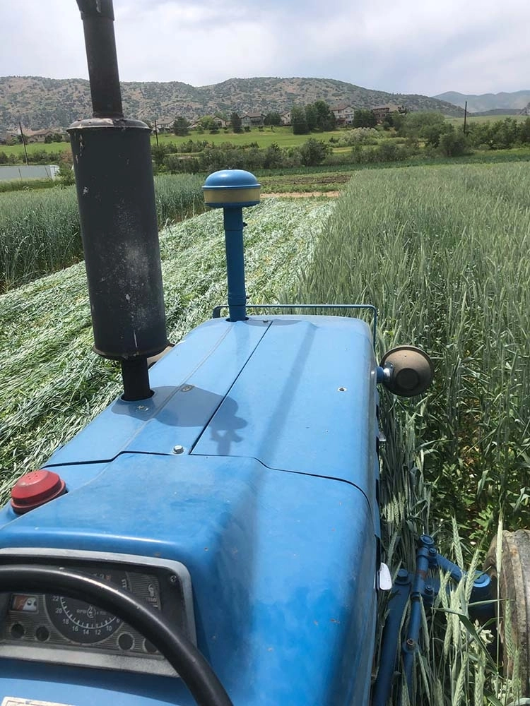
Milkweed, sweet peas, and a plethora of other flora billow from Farmer’s Ditch in the North Fork Valley of western Colorado. Jonathan P. Thompson photo.
“I was standing there looking at a trickle running down a very large ditch thinking, ‘Man, it’s going to be hard to irrigate with that,’” said Jesse Kruthaupt of Trout Unlimited. “It was the summer of 2012, and I was visiting with a ranch manager about options to improve his irrigation system and water delivery, while also improving flows in Ohio Creek. As many remember, the snowpack that winter was pretty lean, and by the middle of June, there wasn’t much water left in many streams or ditches in western Colorado.”
It is situations like the one above that are at the core of the Upper Gunnison River Water Conservancy District’s grant program. Since 2009, the program has provided funds to address many of the issues facing basin water users, including drought resiliency. The district’s board of directors initiated the program in 2009 with a budget of $100,000. That year, only two grant applications were awarded for a total of $45,000. Since it was brand new and many of our constituents didn’t have a good grasp of what the program was all about, we were pretty excited to see the two applications then and happy to fund a pond lining project and ditch rehabilitation project. Since then, thanks to the success of many projects we have funded, the great outreach efforts of Jesse Kruthaupt and other consultants and the district’s education efforts, triple the amount of funding is available. The grant program continues to be hugely supportive of a variety of water projects. I am pleased to see that a number of projects have been dipping into available technology to achieve the best possible results and better water management. The number of applications and the requested funding amounts have grown steadily over the past 15 years. In 2025, we received 14 applications with a whopping $470,420 in requests, and $1.94 million in total project costs (applicants are required to contribute matching funds).
The $2 billion pumped hydroelectric project proposed on private land located some 7 miles southeast of Craig would include an upper reservoir at Buck Peak. This view from the peak shows Craig Station visible in the distance. rPlus Hydro/Courtesy photo
Agency leaders and stakeholders have until May 26 to submit comments to the Federal Energy Regulatory Commission, or FERC, regarding the “pre-application document” for a proposed $2 billion pumped-hydro-storage clean energy project that could be built southeast of Craig.
On March 27, around 40 people attended or listened remotely to a meeting hosted at Colorado Northwestern Community College that provided updated information on the project proposed by Salt Lake City-based rPlus Hydro. The presentation at the joint agency meeting included an overview of the project and operations and a review of information in the FERC pre-application document. The meeting outlined proposed studies to be conducted by rPlus Hydro for the FERC licensing process and provided agency representatives and stakeholders the opportunity to give feedback. A smaller group attended an afternoon tour at the proposed site…
Shapiro said water use from the Yampa River would not be extensive at 4,000 acre-feet of initial fill for the project’s lower reservoir, plus some 600 acre-feet of water annually to account for evaporation and seepage from two new reservoirs on 170 acres. The goal would be to use a portion of the water rights already owned by the coal-fired power plants, Shapiro said…
The majority of the pumped-hydro system would be located underground, including a below-ground powerhouse with three pump-turbine units with generation capacity of 200 megawatts each. The project would consist of one upper and one lower reservoir joined by 2.5 miles of underground water tunnels, an above-ground switchyard, access tunnel, tailrace surge chamber and accessary facilities.
An electric transmission line from the project would run either 11 miles to Craig or less than 2 miles to a Western Area Power Administration line, Shapiro said. Target completion of the licensing process is estimated for 2028, with construction from 2029 to 2033, Shapiro said.
The Northern Integrated Supply Project, currently estimated at $2 billion, would create two new reservoirs and a system of pipelines to capture more drinking water for 15 community water suppliers. Credit: Northern Water project pages
Click the link to read the article on The Denver Post website (Elise Schmelzer). Here’s an excerpt:
March 5, 2025
Two new bodies of water in northern Front Range will boost water supplies for 15 communities
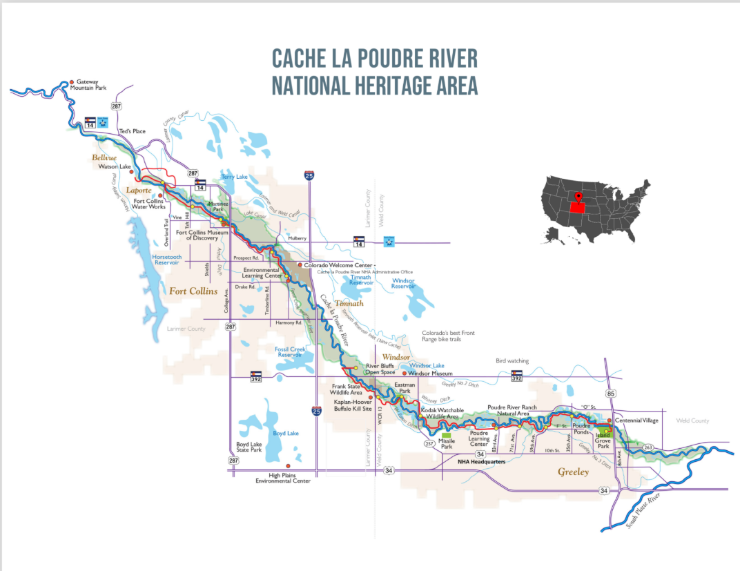
Plans for a $2 billion water supply project in northern Colorado will move forward after the communities supporting it agreed to pump $100 million into improving the health of the Cache la Poudre River — a settlement ending decades of dispute over the water infrastructure plans. Leaders from the Northern Integrated Supply Project and the nonprofit environmental group Save the Poudre finalized the settlement on Friday, clearing the way for two new reservoirs. The deal will funnel $100 million over 20 years into a fund to sustain 50 miles of the river from the mouth of the Poudre Canyon, northwest of Fort Collins, to the river’s confluence with the South Platte. The Poudre River Improvement Fund will pay for projects to enhance the river’s flows, water quality, ecosystem and recreational opportunities. The settlement ends Save the Poudre’s 2024 lawsuit alleging the Army Corps of Engineers did not adequately consider the environmental impacts of the Northern Integrated Supply Project when it issued a Clean Water Act permit for its construction. Environmentalists with the group have opposed the project for decades because it would drain the river and damage its ecosystems…
Northern Water, the utility that’s spearheading the project, and other water suppliers have pursued the water infrastructure improvements since 1980, stating they are critical to meeting the needs of the growing region. When complete, the Northern Integrated Supply Project will include Glade Reservoir northwest of Fort Collins, Galeton Reservoir northeast of Greeley, 50 miles of buried water pipelines and five pump plants. The project will send more than 40,000 acre-feet of water annually to the participating water suppliers in Boulder, Weld and Larimer counties — enough water for about 80,000 households.
“This is a milestone day for the communities participating in the project,” Northern Water General Manager Brad Wind said in a news release. “The settlement agreement will close the permitting process for the project, open the door to constructing a project that will deliver much-needed water supplies to vibrant communities, and allow for dozens of large-scale riverine investments in and along the Poudre River.”
Construction of Glade Reservoir is expected to begin in 2026. It will hold about 170,000 acre-feet of water from the Poudre River — a capacity slightly larger than that of Horsetooth Reservoir, according to Northern Water’s release. Construction of 45,600-acre-foot Galeton Reservoir will begin after the first reservoir is complete, and it will store water from the South Platte. An acre-foot of water is enough to support two Colorado households for a year. The project will support water supplies for 15 towns and water districts in northern Colorado, including the Fort Collins-Loveland Water District, the Left Hand Water District, Fort Morgan and Erie.
If a river running through your town is overused and underloved, it might be in line for a first-of-its-kind statewide restoration program, designed to assess and improve a river’s health, its recreational assets, and its safety.
In March, Great Outdoors Colorado and the Colorado Water Conservation Board approved a combined $417,000 in seed money to launch the program, according to Emily Olsen, regional vice president of Trout Unlimited. The fish advocacy group is helping lead the initiative, known as Colorado Rivermap, along with the U.S. Bureau of Land Management.
The project will launch this year with the selection of a technical team to identify the river segments that are most in need of help, according to Doug Vilsack, Colorado state director for the BLM.
“This is getting the big thinkers together and using the seed funding to see which reaches of rivers need our attention and how much funding we will need,” Vilsack said.
They’ll be looking for parks and river access points that are rundown and in need of repair and restoration. They’re on the hunt for stretches of river that have no access points, and those that have been used so heavily that streambanks are eroding.
Once the inventory is complete, the mapping group will turn to advocacy groups and agencies like Great Outdoors Colorado to ask for funding to make the improvements.
Colorado Rivermap has received letters of support from several local governments and counties, including Chaffee and Grand counties. And Olsen said local communities that want to be involved will be key to making sure there is main-street involvement in the work.
“We are going to think hard about where we can add value and find things local communities can support,” she said.
Other backers that will provide funding for the initiative include the Foundation for America’s Public Lands, Colorado Parks and Wildlife, and American Whitewater, Olsen said.
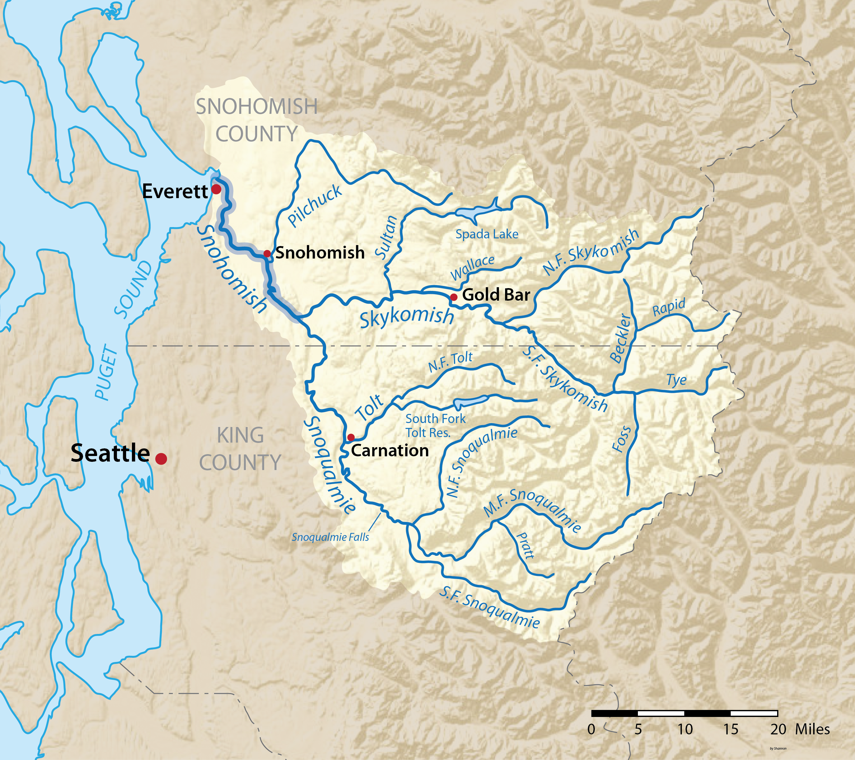
Colorado has eight major river basins. The waterways are a backbone of the state’s thriving tourist economy. (Colorado Water Conservation Board)
Colorado is known for its scenic waterways and is home to eight major river basins, from the South Platte on the Front Range, to the Yampa River Basin in the northwestern corner of the state, to the headwaters of the Colorado River, in Grand County.
The rivers help lure millions of tourists to the state, intent on rafting and fishing in their waters and camping along their shores.
In 2023 the state saw record-high visits, with tourist numbers hitting 93.3 million and visitors spending $28.3 billion, according to reports by visitor research firm Longwoods International.
But the state’s soaring popularity has also begun to wear on its iconic streams. The waterways, Vilsack said, “will be in tougher shape if we don’t do this.”
The initial survey of the rivers comes as Colorado launches a statewide recreation strategy, said Chris Yuan-Farrell, programs director for Great Outdoors Colorado.
“We are planning what we need for outdoor recreation, habitat and natural resources health. Rivers are obviously a big component of this,” Yuan-Ferrell said.
Initial steps include formation of the technical and mapping team. Olsen said they also plan to dramatically expand the team to include state and federal governments and private businesses with a stake in Colorado’s recreation economy. Vilsack said they expect this work to be completed within two years.
Anyone interested in the project can contact Olsen at emily.olsen@tu.org.
The next time a water exportation project is pitched to move water from the San Luis Valley – and there will be a next time – the speculator will learn the value of that water to the six-county region measures into the billions of dollars.
A new report by American Rivers and senior economist Claire Sheridan of One Water Econ captures for the first time the economic value of the water that runs through the San Luis Valley. It was a study prompted in 2022 by the threat of water exportation from the Upper Rio Grande Basin by Renewable Water Resources.
As part of its proposal to export and sell 20,000 acre-feet of water every year from the Valley, RWR offered to establish a $50 million community fund that it argued would fairly compensate the Valley for its water. The study, “The Economic Value of Water Resources in Colorado’s San Luis Valley,” pegs fair compensation of the RWR proposal at around $1.3 billion per year. (More on that figure below)
“It’s a really complex question to answer. What is the value of water in the San Luis Valley?” said Heather Dutton, manager of the San Luis Valley Water Conservancy District. “The value of water in the San Luis Valley is so much greater than a one-time payment of $50 million.”
Dutton, Sheridan from One Water Econ, and American Rivers’ Emily Wolf presented the findings of the report at the annual Rio Grande State of the Basin Symposium held March 29 at Adams State.
The study goes beyond putting a dollar value to water for the Valley’s agricultural purposes. It also examines the value of water as it relates to the Valley’s outdoor recreation industry and wildlife and natural habitat surroundings.
Boat ramp on the Rio Grande. Credit: The City of Alamosa
And it looks at “water-dependent” industries that are key to the Valley’s economy and their reliance on water for their customers and sanitation services. Those “water-dependent” industries like San Luis Valley Regional Medical Center and Adams State University account for approximately 21 percent of total direct economic output and 23 percent of employment in the Valley, according to the study.
“Capturing the value of water as it is used in homes, businesses, and for environmental purposes can add important information to conversations about the future of the Valley and its water resources,” noted the study’s authors.
The study puts into perspective how valuable water in the Upper Rio Grande Basin is when you apply it to the Valley’s economy and livelihood. According to the report, the San Luis Valley economy generates $4.5 billion in total annual economic output, largely driven by hospitals, electric power companies, insurance, crop farming and cattle ranching. Alamosa and Rio Grande Counties account for 60 percent of the population and 67 percent of total economic output in the region.
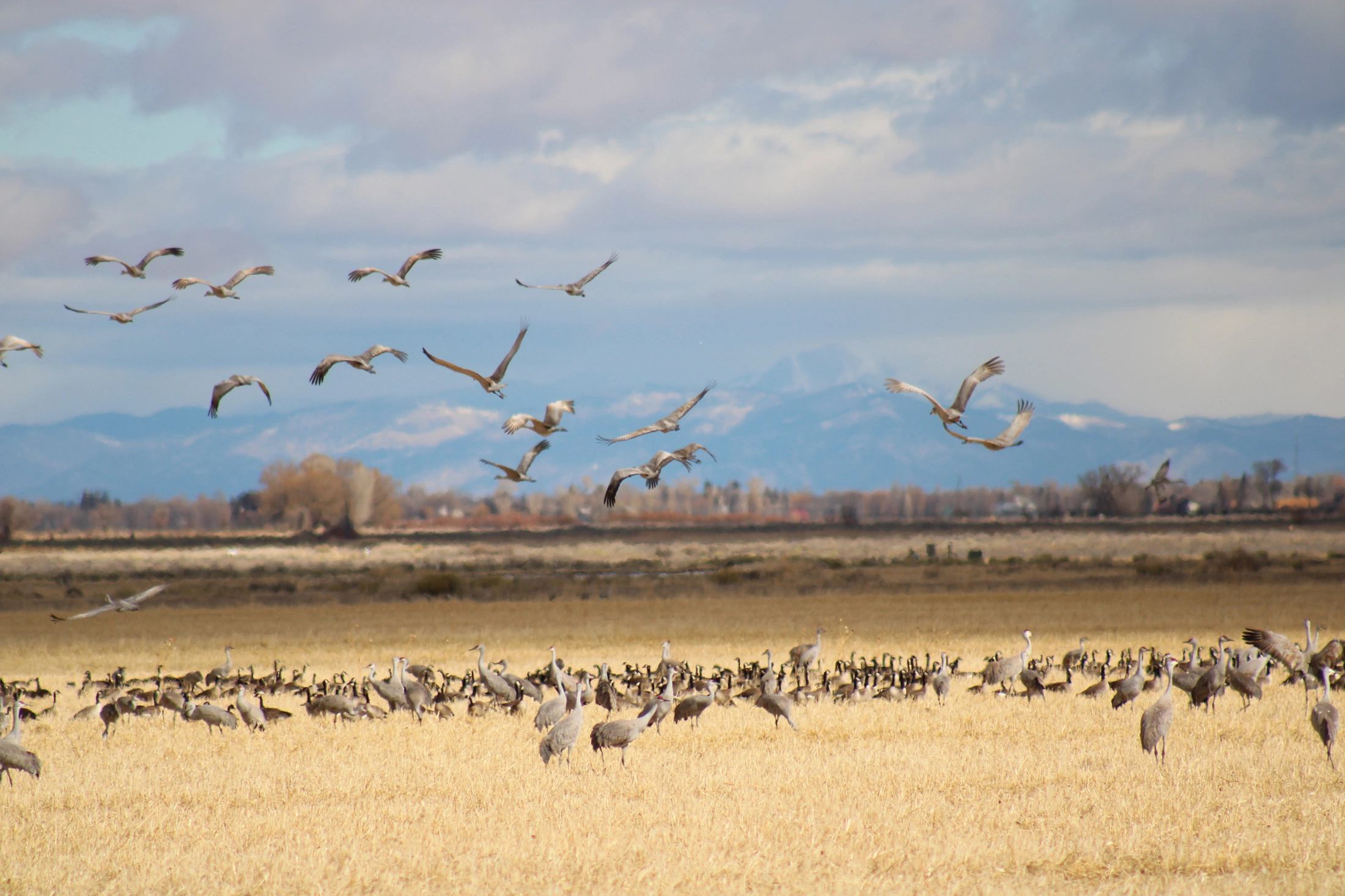
Sandhill Cranes
Other insights from the report:
Agriculture in the San Luis Valley, including cattle ranching, generates 10 percent of all output in the region (although this varies significantly by county) and makes up 39 percent of Colorado’s total agricultural output.
Agriculture is the single largest private employer in the SLV, and irrigated agriculture employs 8 percent of the total workforce (an estimated 2,322 jobs per year). Approximately 64 percent of these jobs are in the category of all other crop farming (which represents alfalfa and grass hay) and 34 percent are in vegetable farming (mostly potatoes).
The agriculture, forestry, fishing, and hunting sector generate over 4,000 jobs each year. This sector also leads in economic output, generating $566 million annually.
The value of clean drinking water in the San Luis Valley is estimated to be over $3,600,000 per day.
The analysis also found that water-related habitat in the Valley is valued at more than $49 million annually and the annual Crane Festival generates $4 million in direct revenue from visitor spending.
“It’s just apparent that just as water flows through this community, so do the dollars that are generated from that water,” said economist Claire Sheridan.
Sheridan did the math for the audience at the Rio Grande Symposium in explaining how far under value RWR’s $50 million community fund pitch was when considering the value of water to residents of the Valley.
She used a model FEMA goes by in its emergency management work that factors in two components in creating a value for water to a community: One component is a willingness to pay for clean and safe drinking water. “If you go to your tap and turn on your water, what are you willing to pay to make sure that you can drink that water? What is that worth to you?” The other component is “avoided replacement cost” that factors in costs if a resident has to go buy water.
For the San Luis Valley and its estimated population of 46,600, those two components combined come out to about $77.23 per person, per day, said Sheridan. When you apply $77.23 to the Valley’s population, the value for clean drinking water in the San Luis Valley is about $3.6 million per day or $1.3 billion annually.
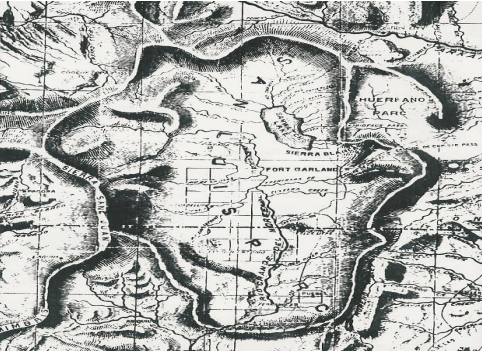
1869 Map of San Luis Parc of Colorado and Northern New Mexico. “Sawatch Lake” at the east of the San Luis Valley is in the closed basin. The Blanca Wetlands are at the south end of the lake.
Click the link to read the article on the InkStain website (John Fleck):
April 4, 2025
We are heading into a remarkable year on New Mexico’s Middle Rio Grande. Here are some critical factors:
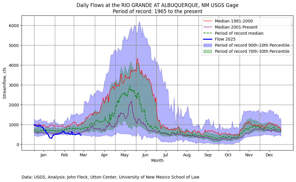
The preliminary April 1 forecast from the NRCS is for 27 percent of median April – July runoff at Otowi, the key measurement gage for New Mexico’s Middle Rio Grande.
Current reservoir storage above us is basically nothing.
Reclamation’s most recent forecast model runs suggest flow through Albuquerque peaked in February. It usually peaks in May.
We will learn a great deal this year.
What I’m Watching
New Mexico water projects map via Reclamation
City Water
At last night’s meeting of the Albuquerque Bernalillo County Water Utility Authority’s Technical Customer Advisory Committee, water rights manager Diane Agnew said the utility is planning to shut down its river diversions, shifting system operations to groundwater, by the end of April. Albuquerque invested ~half a billion dollars in its river diversion system, in order to make direct use of our San Juan-Chama Project water, to relieve pressure on the aquifer. This will be the fifth year in a row that Rio Grande flows have been so low that we can’t use the new system for a substantial part of the year.
(For the nerds, Diane’s incredibly useful slides from last night’s TCAC meeting are here, the 4/3/2025 agenda packet.)
We have groundwater. My taps will still run, and I’ll be able to water my yard. But we’ll once again be putting stress on the aquifer that we’ve been trying to rest, to set aside as a safety reserve for the future. Is that future already here?
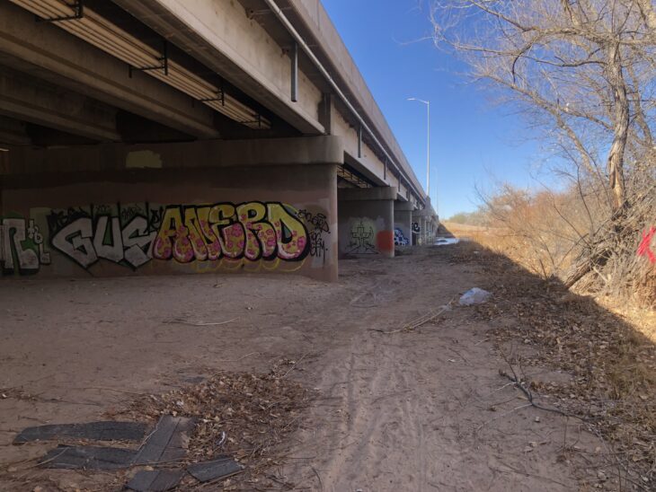
Reclamation operates pumps to move water from the Low Flow Conveyance Channel into the Rio Grande. The LFCC acts as a drain for the lower part of the Middle Rio Grande.
Irrigation
Middle Rio Grande Conservancy District irrigators who depend on ditch water are going to have a tough year, with supplies running short very early. The impacts here are a little weird.
Most of the relatively small number of the non-Indian full-on commercial farmers have supplemental wells. Smaller operators, who farm as a second income, will have to rely on their first income, whatever that is, and hope for some monsoon rains to get more cuttings of hay. Lots of hobby farmers will just run their domestic wells, or buy hay for their horses from out of state.
Native American farming is a more complicated story that I don’t fully understand. State and federal law recognize the fact that they were here first – we really do kinda comply with the doctrine of prior appropriation here. Their priority rights – “prior and paramount” – were enshrined in federal law in the 1928 act of Congress that kicked in federal money through the predecessor of the Bureau of Indian Affairs – crucial money to get construction of the Middle Rio Grande Conservancy District started when no one else – neither the rest of the federal government, nor the bond market – was willing to pony up the money. (Buy our new book Ribbons of Green, as soon as UNM Press publishes it! It includes a deep dive into the critical role of the Pueblos in supporting the formation and early funding of the MRGCD, without which there likely would be no MRGCD.)
Is there a way to set aside some prior and paramount water for Pueblo farmers this year to keep their fields green?
Side channels were excavated by the Bureau of Reclamation along the Rio Grande where it passes through the Rhodes’ property to provide habitat for the endangered silvery minnow. (Dustin Armstrong/U.S. Bureau Of Reclamation)
River Drying
The Rio Grande through Albuquerque will go dry, or nearly so, in a way we haven’t seen since the early 1980s. That means a very tough year for the endangered Rio Grande silvery minnow. We’re testing the boundaries of the definition of “extinction”. (To understand the minnow story, I again commend you to my Utton Center colleague Rin Tara’s terrific look at the minnow past and future.)
Do people care, either about the minnow or the river itself? We’ll find out!
Birds and water at Bosque de Apache New Mexico November 9, 2022. Photo credit: Abby Burk
Bosque
Our riverside woods, a ribbon of cottonwood gallery forest that took root in the mid-20th century between the levees built by the Bureau of Reclamation, will likely stay relatively green. The trees dip their roots into the shallow aquifer. As we’ve seen with the more routine river drying that happens every year to the south, the bosque muddles through.
New Mexico Lakes, Rivers and Water Resources via Geology.com.
At Colorado Water Trust, we’ve spent more than two decades working to restore the health of Colorado’s rivers, primarily in rural and agricultural areas. But as Colorado’s population grows, as our urban spaces expand, and as our climate gets hotter and drier, our rivers and streams face new sets of challenges. These new challenges are surfacing at the same time that cities and towns across the state are reevaluating and rediscovering their relationships with their local waterways.
As part of our Strategic Plan, Colorado Water Trust is embarking on an exciting new initiative to see how we can help protect and restore river flows in more urban settings than we have historically operated in. As part of this initiative, we are thrilled to announce that we’re partnering with the University of Colorado’s Master of the Environment (MENV) capstone program to help us get a better understanding of how to do just that.
This partnership brings together a team of three talented MENV capstone students, who will work alongside Colorado Water Trust staff to help us better understand how cities and towns across the state relate to the streams and rivers that run right through their communities. Whether that’s recreation, water quality, wildlife or something else, Colorado Water Trust wants to know what residents care about most when it comes their local waterway.
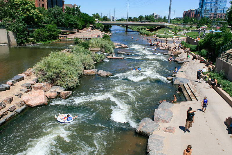
Historic Arkansas Riverwalk of Pueblo, credit: Jeffrey Beall
Throughout 2025, the MENV students will be systematically analyzing the needs, opportunities, and challenges for urban river flow restoration around the state. Through their collaboration with Colorado Water Trust, these students will gain invaluable experience in water law, environmental policy, and community mapping and engagement—all while contributing to the future of urban water management in Colorado. To learn more about the MENV capstone program, check out their website. And stay tuned here, as we will also be featuring blog posts by the MENV students throughout their project to give you an inside look at who they are and what they are learning.
Why Urban River Flow Restoration Matters
In Colorado, the conversation about river health has historically centered on rural rivers and agricultural uses of water. While those concerns remain critical, urban rivers face their own set of unique challenges. With climate change, rapid urbanization, population growth, and competing demands on water resources, cities (and towns) need innovative solutions to ensure their waterways remain healthy, vibrant, and accessible to local communities. And by urban, we don’t just mean Denver and Colorado Springs, we mean towns of all sizes that have natural waterways running through their population centers.
Urban rivers provide a host of ecological, recreational, and social benefits. They help mitigate urban heat islands, improve water quality, provide green spaces for recreation, and offer an opportunity to connect with nature. Unfortunately, many of Colorado’s urban rivers are struggling with degraded water quality, reduced flows, and lack of public access. These problems are compounded by infrastructure demands, development pressures, competition from other water uses, and the complexities of managing water in urban settings.
Restoring water to urban rivers is crucial for sustaining these benefits. But to make meaningful progress, we need to develop strategies that reflect the unique needs and perspectives of urban communities. And to do that, we need to better understand the lay of the land. That’s where our community mapping approach with the MENV students comes in.
Pueblo River Walk at Night, credit: John Wark
The Power of Community Mapping
Community mapping doesn’t mean literal mapping of cities and their water ways, rather it is a process that involves identifying a community’s assets, resources, and challenges (in this case related to how residents of towns and cities interact with their local streams). Through conversations with water managers, municipal staff, residents, organizations, and local businesses, the MENV capstone students will gather insights into how these communities use and value their rivers, as well as any challenges or barriers they face in accessing or engaging with these waterways.
This participatory process will allow us to create a flow-restoration strategy that is tailored to the unique needs of each community. For example, understanding whether a river is used primarily for recreation, as a wildlife corridor, or as a local water source can help us develop solutions that not only improve river health but also meet the needs of the people who live and work alongside these rivers.
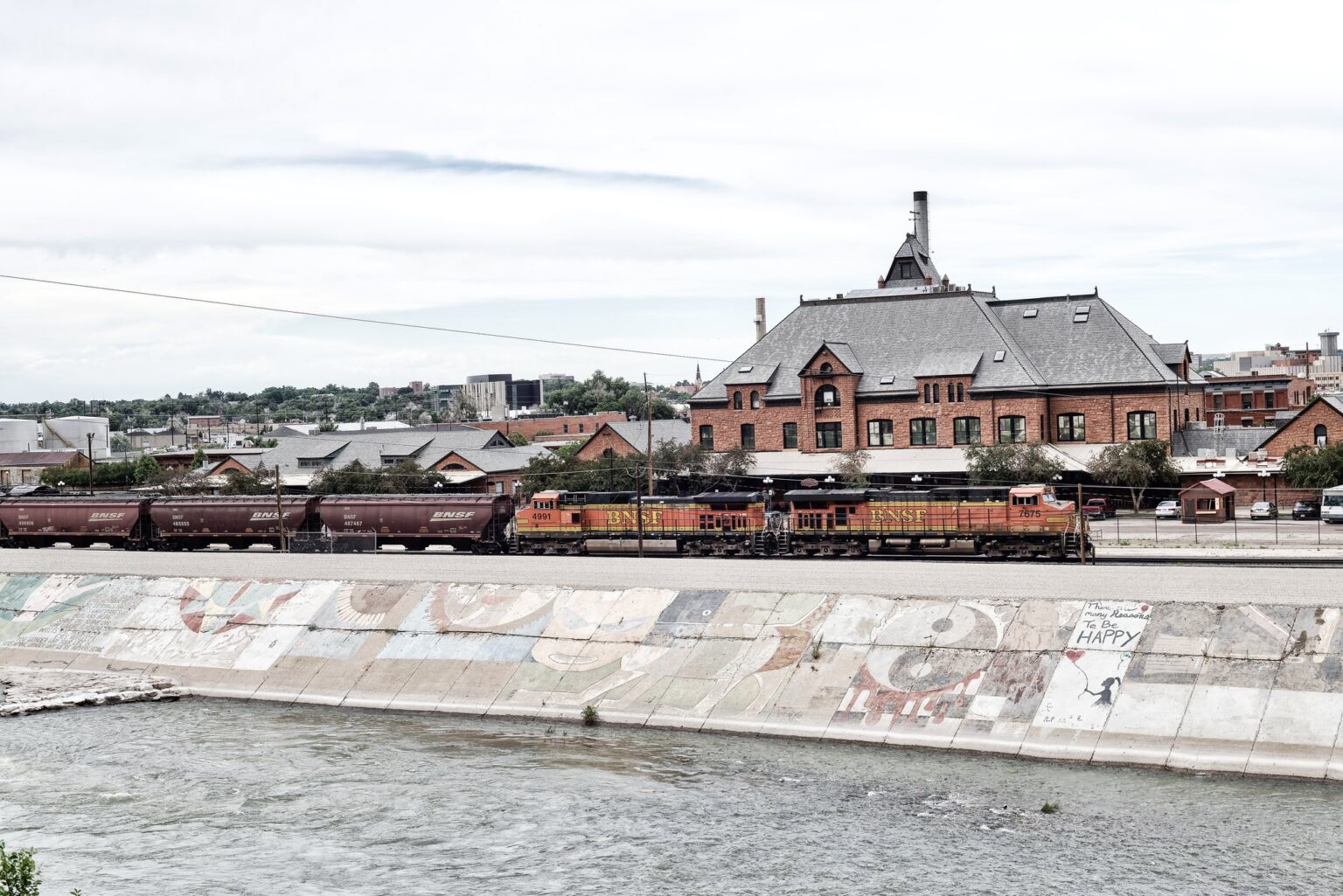
BNSF Train at The Arkansas River in Pueblo
What’s Next
With Colorado Water Trust staff support, the MENV capstone students will play the lead role in this mapping process. By conducting interviews and surveys, collecting data, and analyzing community needs, they’ll provide valuable insights that will inform the ways Colorado Water Trust supports these communities to implement their visions.
Our collaboration with the MENV capstone program offers several benefits for the students involved. The capstone project is designed to be a hands-on, real-world experience where students can apply the knowledge and skills they’ve gained throughout their academic careers to tackle complex and pressing environmental issues like urban river restoration.
Additionally, Colorado Water Trust will continue to emphasize equity and inclusion in all aspects of this project. Ensuring that the voices of historically marginalized communities are heard and incorporated into the process is critical to creating a water management strategy that works for everyone.
In the coming months keep an eye out for more blog posts as we’ll be introducing the MENV team and sharing more updates on our progress. If you are interested in being involved in this process and would be open to sharing thoughts about your local urban stream, please reach out to Josh Boissevain at jboissevain@coloradowatertrust.org.
Critics say the Trump administration’s halt to billions in conservation spending could cause long-term damage and slow hard-won progress.
For two decades, farmer John Burk has been working to improve the soil on his farm in Michigan, taking a few extra steps to make it more resilient and productive. His efforts have paid off.
“When we have the dry, hot summers or lack of rainfall, our crops can sustain the dry spells better. We don’t have huge yield decreases,” Burk said. “And when it rains and we have the freak storms, like it seems to do so much now, we don’t have the ponding and all the runoff.”
An added bonus: He needs less fertilizer, a major operating expense.
But Burk, and tens of thousands of farmers across the country like him, have learned that the Trump administration now considers these steps—which include limiting tillage, planting soil-enriching cover crops or installing water chutes to control erosion—“far left climate” activities. The administration has frozen billions of dollars in funding that pay for these activities while the U.S. Department of Agriculture (USDA) and White House conduct ongoing reviews.
The funding freeze, along with layoffs, threatened cutbacks and orders from the administration to remove climate information from the USDA’s website, have had a destabilizing effect on farmers and the agency alike. The agency, which under the Biden administration had more seriously embraced a role in addressing the climate crisis, is in chaos, former staffers say. Frustration from farmers is growing.
“I hear a lot of anger,” said Mike Lavender, policy director at the National Sustainable Agriculture Coalition.
The freeze has stoked uncertainty across farming communities at a particularly bad time. The Trump administration’s tariffs on imports from China, Canada and Mexico have sparked retaliatory tariffs that are expected to hurt American farmers already struggling with low crop prices and high fertilizer costs. Most farmers make decisions about the year ahead in the spring, but without knowing how much funding they can count on, those decisions are especially fraught this year. As extreme weather becomes the norm, the uncertainty mounts. Last year alone, farmers lost more than $20 billion to weather disasters, prompting Congress to approve $31 billion in disaster assistance.
“We’ve got an ag economy where prices are down and you’ve got increasing pressure because of Trump’s trade war—and now you’re taking away a source of income,” said Robert Bonnie, the under secretary for farm production and conservation at USDA under Biden. “You can put payments on hold. You can’t put spring on hold.”
The agency did not respond to specific questions or a request for comment for this story.
For decades, the agency has funneled support and funding for conservation projects through hugely popular programs that are so in demand each year, the agency turns away applicants. These farm practices make the soil healthier and more productive. They also help it store more carbon and are seen as significant tools for controlling climate-warming greenhouse gas emissions.
“Everyone thinks these conservation programs are about farmers,” Burk said. “But it’s way bigger than just the farmer. These don’t just help with yield. It’s helping every single person on the planet.”
The USDA oversees 20 conservation programs that are funded through the Farm Bill, the massive legislation covering farm and nutrition programs that’s negotiated every five years. Under the Biden administration these conservation and energy programs got a huge boost: $19.5 billion from the Inflation Reduction Act, Biden’s signature climate legislation.
But amid the Trump administration’s broader attacks on climate action, most of the unspent dollars remain frozen, despite the popularity of these programs and their benefits beyond addressing climate change.
One analysis, by former USDA employees, says the agency currently owes nearly $2 billion in promised grants and unpaid funds for conservation and energy efficiency programs to more than 22,000 farmers. Another, by an agricultural economist at the University of Illinois Urbana-Champaign, finds that farmers stand to lose $12.5 billion from the agency’s most popular and widely used programs. Congressional Republicans have signalled that they would shift the funds to other programs covered by the Farm Bill.
While the agency and its new secretary, Brooke Rollins, announced in February that $20 million in IRA funding will be released, it’s not clear when and how. Rollins said in a statement that the agency was concerned the dollars were being spent on programs “that had nothing to do with agriculture,” but went on to say the review was being conducted “to ensure that programs are focused on supporting farmers and ranchers, not DEIA programs or far-left climate programs.”
On March 26, the agency said it would release funding for the Rural Energy for America Program, which gives grants for farmers to install energy-efficient projects, like solar panels. In order to receive the funds, recipients of the grants will have to revise their applications to ensure that they “remove harmful DEIA and far-left climate features,” the agency said.
“The Biden administration didn’t go out and make up new practices,” Bonnie said. “These are things farmers have been doing for a long time.”
Cuts or freezes to funding aren’t the only potential challenges to climate action within the agency. The administration cut as many as 1,200 jobs from the agency’s Natural Resources Conservation Service (NRCS) and threatened to relocate offices, terminating dozens of leases. It has directed staff to remove mentions of climate change from the agency’s website (an action over which it was subsequently sued) and has threatened to defund or derail climate research, which would also impact work at universities that partner with the agency.
“Even conservative estimates have been that ag research returns $20 for every dollar spent,” said Karen Perry Stillerman, a deputy director at the Union of Concerned Scientists. “A major retrenchment would be a big deal for farms and for climate adaptation and resilience.”
For decades, environmental and farm groups pushed Congress, the USDA and farmers to adopt new conservation programs, but progress came in incremental steps. With each Farm Bill, some lawmakers threaten to whittle down conservation programs, but they have essentially managed to survive and even expand.
The country’s largest farm lobby, the American Farm Bureau Federation, had long denied the realities of climate change, fighting against climate action and adopting official policy positions that question the scientific consensus that climate change is human-caused. Its members—the bulk of American farmers—largely adhered to the same mindset.
But as the realities of climate change have started to hit American farmers on the ground in the form of more extreme weather, and as funding opportunities have expanded through conservation and climate-focused programs, that mindset has started to shift.
“They were concerned about what climate policy meant for their operations,” Bonnie said. “They felt judged. But we said: Let’s partner up.”
The Trump administration’s rollbacks and freezes threaten to stall or undo that progress, advocacy groups and former USDA employees say.
“We created this enormous infrastructure. We’ve solved huge problems,” Bonnie added, “and they’re undermining all of it.”
“It took so long,” Stillerman said. “The idea that climate change was happening and that farmers could be part of the solution, and could build more resilient farming and food systems against that threat—the IRA really put dollars behind that. All of that is at risk now.”
Burk says he plans to continue with conservation and carbon-storing practices on his Michigan farm, even without conservation dollars from the USDA.
But, he says, many of his neighboring farmers likely will stop conservation measures without the certainty of government support.
“So many people are struggling, just trying to figure out how to pay their bills, to get the fuel to run their tractors, to plant,” he said. “The last thing they want to be doing is sitting down with someone from NRCS who says, ‘If I do these things, maybe I’ll get paid in a year.’ That’s not going to happen.”
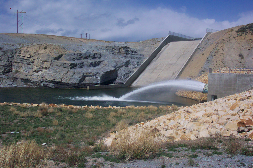
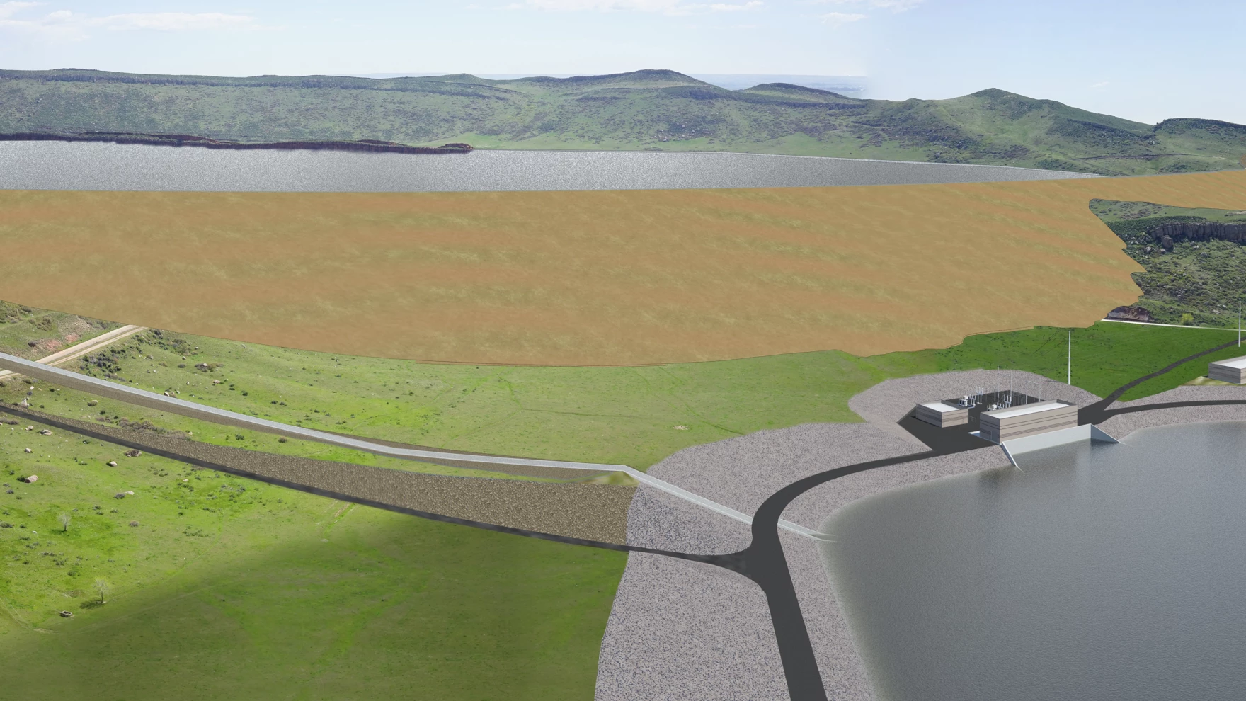
Roller-compacted concrete will be placed on top of the existing dam to raise it to a new height of 471 feet. A total of 118 new steps will make up the new dam. Image credit: Denver Water.
From email from Denver Water:
April 4, 2025
Denver Water is gravely concerned about this ruling and its ramifications for the future of metro Denver and its water supply. We plan to appeal and seek an immediate stay of this order that leaves a critical project that is 60% complete on hold and puts at risk our ability to efficiently provide a safe, secure and reliable water supply to 1.5 million people. Denver Water will do everything in its power to see this project through to completion.
It’s impossible to reconcile the judge’s order with what is clearly in the broader public interest.
We view this decision as a radical remedy that should raise alarm bells with the public, not only because of its impacts to water security in an era of longer, deeper droughts, catastrophic wildfire and extreme weather, but because it serves as an egregious example of how difficult it has become to build critical infrastructure in the face of relentless litigation and a broken permitting process. In this case, the order is even more appalling with the project so deep into construction.
Denver Water will abide by the judge’s order and temporarily halt construction on the dam pending a hearing with the judge and will rapidly appeal the decision. Work for the spring season was scheduled to begin April 10, and the final part of the dam raise was to be completed this year. Leaving the project incomplete creates ongoing safety and water supply issues, as Denver Water cannot fill the reservoir to capacity during construction and, as we have testified to the judge, the original gravity dam has been deconstructed and its foundation excavated, exposing steep rock slopes that depend on bolts to temporarily shore them up. These are among the issues that we will address with the judge in an upcoming hearing.
This order is also exacting a significant human cost, as it comes just as Denver Water and its contractors were preparing for spring construction season. With an extended freeze on construction, hundreds of men and women will be thrown out of work, many with specific skillsets who relocated to the region to work on this specific project. It also required enormous effort over years from Denver Water and its contractors to build the workforce for this complex project. All of that now stands in jeopardy, causing immediate harm to our valued workers, their families, the dozens of business partners, and our local economy.
It’s crucial to understand that Denver Water was granted all required local, state and federal permits to move ahead with the project after a regulatory oversight process stretching over nearly two decades, dating to 2002. Further, Denver Water has committed more than $30 million to over 60 environmental mitigation and enhancement projects on the Front Range and West Slope. The utility proceeded with construction on the expansion in 2022, under an order from the Federal Energy Regulatory Commission to complete the project by 2027.
On top of that legally binding FERC order, Denver Water has an enormous sense of urgency surrounding the project, considering increasingly variable weather and water supply patterns, how close we have come to falling short of water on the north side of our system in years past, our harrowing experiences with the threats and impacts of wildfire in our collection area and the need for system flexibility to ensure we can provide a critical public resource under crisis conditions.
To be clear, these are not theoretical matters. Denver has seen the impact of drought and catastrophic wildfire before. The starkest example came in 2002, when extended drought and fast-moving wildfire struck the region in dramatic fashion. Denver Water came very close to being unable to provide our northern customers with safe, clean drinking water – an absolute human health and safety priority, and the responsibility of this utility, as the region’s water provider.
Denver Water is also missing opportunities to store additional, critical water supplies. Had the expansion been complete in 2013, for example, Denver Water could have easily filled Gross Reservoir, including storing additional storm water during the catastrophic flooding that year. In 2015, water flowed out of state because existing Denver Water reservoirs were full and there was no place to capture and store it. In the hot, dry 2018 summer, we would have been able to provide extra water to the Fraser River or Williams Fork River basin to help enhance the conditions of these dry rivers.
The expansion of Gross Reservoir is intended to protect the people who rely on us, now and in the future. The Gross Reservoir expansion reduces the significant pressure on our southern system, which delivers 80% of our water supply, depends heavily on the South Platte River and has seen a series of wildfires that threaten water delivery, water quality and water treatment. In both 1996 and 2002, sediment loads from deluges following the Buffalo Creek and Hayman fires created impacts to our southern system that challenged our ability to ensure water supply to our customers; we are still addressing these impacts to this very day.
Denver Water is responsible for providing a safe and secure water supply for 1.5 million people in Denver and portions of the surrounding metro area and has understood the urgency of the Gross Reservoir expansion since the 1990s, when the environmental community recommended expansion of the reservoir as part of a plan to address future supply and water security.
To repeat: The utility began working on permitting for this project in 2002, more than 20 years ago. The project has been analyzed and permitted in various forms by no fewer than seven state and federal environmental agencies, and Denver Water has consulted extensively with environmental organizations, nonprofits, the public and other stakeholders to identify efforts to enhance and reasonably restore resources on both the West Slope and Front Range. Denver Water is operating under a legally mandated deadline for project completion in 2027 from the Federal Energy Regulatory Commission, which is not part of this current lawsuit.
Throughout the permitting process, Denver Water has been driven by these values: the need to do this expansion the right way and the safe way, by involving the community; upholding the highest environmental standards; providing a sustainable, high-quality water supply to our customers; and protecting and managing the water and natural environment that define Colorado. In keeping with these values, Denver Water designed and implemented the project to provide a net environmental benefit to impacted local watersheds.
Denver Water looks forward to working with the agencies and the courts to move this critical project toward completion.
I was chastised by a couple readers after the last post: you’re just giving the Trumpty-Mumpty dynamic duo what it wants by focusing on what it is doing. What we want to know is what this is going to mean for us out here in the arid lands, and thoughts on what we should be doing about that. What does it mean here in the Colorado River region?
This led me to wonder: is focusing too much on what nasty people are doing just another form of surrendering to them? In chess, and probably all other competitive sports, there’s the matter of the ‘impetus’: one player or team of players will achieve the point in a game where they are ‘calling the shots,’ forcing the other player(s) to react to their strategies rather than pursuing the others’ own game plan. Players with that impetus will usually win, so long as they don’t lose that impetus through some misplay of their own.
The Trumpty-Mumpties have certainly seized the impetus in America’s 250-year ‘game’ of trying to work out a collaborative governance for the American nation-state; and our response so far has been railing editorially at them, or suing them, or just kind of watching in shocked silence as they break things. ‘Roll over and play dead,’ was the recommendation of one prominent Democrat for his party; let the Repugnicans dig themselves into a hole they can’t get out of, then get up and kick the debris in on top of them. The trouble with that is the fact that the debris will be our dismantled constitutional government, and as was the case when Humpty-Dumpty had his great fall, all of us (and our horsepower) may not be able to put it back together again. When one of Mumpty’s ‘Space X’ rockets blew up shortly after blastoff a few weeks ago, his company described it as a ‘rapid unplanned disassembly,’ a wonderful bit of euphemistic language. What we are watching happen in our government is a ‘rapid barely planned disassembly,’ giving a little credit to the ‘Project 2025’ planners who knew their Repugnican wet dreams only stood a chance if they hit the ground running and ‘flooded the zone.’
So what can we do besides watch it happen, and express our dismay and horror? While we still can?
One thing we ought to do is to confront our own complicity in what is happening to us. American historian and philosopher Heather Cox Richardson started one of her daily columns (3/21/25) with the recollection of a really interesting commentary on our times reported twenty years ago by journalist Ron Suskind. A commentary that many of us may have encountered before, but it is really worth revisiting in the murky light of what’s happening today – here’s the paragraph from her column:
This is something for us to ‘study,’ the 35-40 million of us who depend to some extent on the water of the Colorado River – First River of the Anthropocene Epoch. Suskind’s unnamed presidential advisor basically articulated the attitude that drove the first century of the Early American Anthropocene – and the development of the Colorado River, one of several places where the imperial business of ‘creating a new reality’ overriding the existing ‘discernible reality’ began. (The Panama Canal and the Columbia River being two other sites for the ‘Early American Anthropocene.’)
The history of the development of the Colorado River in the first two-thirds of the 20th century is the story of how we began to ‘create our own reality,’ and that story is told in the evolution of the Bureau of Reclamation. The Bureau came into being as the ‘Reclamation Service’ as part of the ‘Newlands Act’ of 1902. The Service had a modest mission, working with communities of desert homesteaders to develop the irrigation systems that would make their land arable.
The Reclamation Service came into being as part of the United States Geological Survey – very much what Bush’s advisor called a ‘reality-based’ organization, grounded in the scientific belief that ‘people could find solutions based on their observations and careful study of discernible reality.’ The USGS had essentially been given its operating ethos by John Wesley Powell, a consummate scientist whose observations and careful study of the arid lands led him to make policy recommendations as director of the USGS that fell afoul of the West’s industrial movers and shakers, and got him fired from that agency.
The scientists who had escaped the Powell purge, however, continued the ‘reality-based’ scientific discipline Powell had established for the USGS, and that was the science-based agency into which the Reclamation Service was placed in 1902. But the mission of the Reclamation Service was to help farming communities develop irrigation systems – essentially an engineering assignment.
The challenge in the Lower Colorado River deserts, for both the scientists and the engineers in the USGS, was learning to live with a water supply that ran in a flood for two or three months of the late spring and early summer, then became a comparative trickle the rest of year. The scientists and the engineers responded to that challenge in different ways. For the scientist, it was a challenge of adapting crops and plantings to what would grow in flood-mud, and spreading the muddy flood out accordingly. For the engineer, the challenge was to change the water supply, storing it to release it in more manageable full-season flows for growing whatever the farmers wanted to grow.
In short, the challenge was perceived to be either using science to adapt the human culture to whatever nature provided (however erratically), or using engineering and other related skill sets to adapt nature to provide whatever the culture needed or wanted. And in the early 20th century, with America just really learning how to use fossil fuels to construct an industrial civilization like the world had never seen…. We are an empire now, and when we act, we create our own reality….
Perceiving that choice, the Bureau quickly grew impatient with trying to adapt local community irrigation systems to the wild Colorado River. By 1905 they and their emerging technology were ready to spread their wings, take on the imperial challenge of changing the river. In 1905 they stretched their legislated local charge by taking on three projects with a regional scale: a large (for its day) masonry dam on the Salt River to control flooding and store irrigation water for growth in the Phoenix area; an irrigation weir almost a mile wide across the Colorado mainstem above Yuma, Arizona, to keep water levels up for late-season irrigation water; and a five-mile transbasin tunnel in the upper reaches of the river, carrying water from the Gunnison River to the Uncompahgre River valley.
In 1907, halfway through those larger, more regional projects, the Reclamation Service left the Geological Survey, and became the Bureau of Reclamation, an independent agency in the Interior Department. Basically, the engineers left the scientists to their methodological study of ‘discernible reality’; they were ready to roll their own realities. They dreamed of the structures that would break the Colorado River to harness, and the other really big projects that would put the river to work making the desert bloom.
Eugene Clyde LaRue measuring the flow in Nankoweap Creek, 1923. Photo credit: USGS
This never really became a declared war between the scientists and the engineers, but there was a distinct tension. When the seven Colorado River Basin states sat down in 1922 to divide the use of the river’s waters among themselves, they found conflicting opinions on how much water actually flowed in the river on average. Bureau engineers, including Reclamation Commissioner Arthur Powell Davis, were a frequent presence at the Compact Commission meetings; they had a 25-year record of flows at Yuma going back to 1896, showing an average annual flow of just under 18 million acre-feet for that short period. Meanwhile, E.C. LaRue, a USGS hydrologist and geologist, had been working on that flow problem for years, and had done some early work on tree rings and desert evaporation, leading him to believe that flows between 12 and 14 million acre-feet of usable water were a reasonable long range expectation for the river.
LaRue volunteered his assistance to the Compact Commission, but Commission Chair Herbert Hoover (the federal representative on the Commission, and himself an engineer) thought that would be unnecessary, and the Colorado River Compact used Bureau numbers – and within a decade, certainly within the century, the willful river had demonstrated that scientist LaRue’s stodgy old researched numbers were much closer to the real river we have contended with down to the present. River ‘elder’ Eric Kuhn and journalist-historian John Fleck wrote a book, Science Be Dammed, exploring this tension between the scientists and the engineers in creating the Compact, for those interested in a more detailed account of that.
But for my story here – the Bureau did go on to ‘create its new reality.’ The 1928 Boulder Canyon Act, as it unfolded, became a lamp in the darkness of the Great Depression. Private capitalism – probably our least democratic economic engine – had failed utterly to deal with the Depression, but federal funding coupled with private initiative under the direction of the Bureau put thousands of people to work, building not one but three big structures on the Colorado River mainstem: Hoover Dam capable of storing two year’s flow of the river, Parker Dam to provide water for a huge aqueduct to the Los Angeles-San Diego metropolis, and the Imperial Weir Dam and All-American Canal to carry water to the vast reaches of the Imperial Valley – and every drop of water through the dams generating electric power for the Southwest. The desert reality was transformed for – well, maybe not forever, but for the life of the dams, ultimately proscribed by the inflow of mud as the busy river continued its mindlesstask of reducing the Southern Rockies and the Colorado Plateau to sea level peneplains.
But the Bureau did not stop there. After the second World War, under the aegis of the Colorado River Storage Project, the Bureau continued to build big storage dams with canals to carry water out into the high orographic deserts above the canyons and the hot subtropical deserts below the canyons, remaking most of the river – mountain tributaries collected the melted snowpack into rivers, as with all rivers – but then it went into desert ‘distributaries’ distributing the water to vast farms and rapidly growing cities in regions called ‘Death Marches’ by early explorers. That very little freshwater was left to ‘waste’ into the salty ocean was regarded as a victory – until it wasn’t. Another story there.
What we have to confront today, in the Colorado River region (natural basin plus out-of-basin areas served), is the extent to which the engineered new reality is ultimately dragged down and even stalled by the scientist’s dour desert realities the engineers thought could be transcended. It is unfair to blame the Bureau for the apparently unlimited growth of people moving into the river’s region, but the engineer’s ‘Can Do!’ attitude toward that growth has done little until very recently to bring us to confronting the unavoidable collision of unlimited demand on a limited resource – and now, a shrinking resource, given new concerns raised by those relentlessly reality-based scientists.
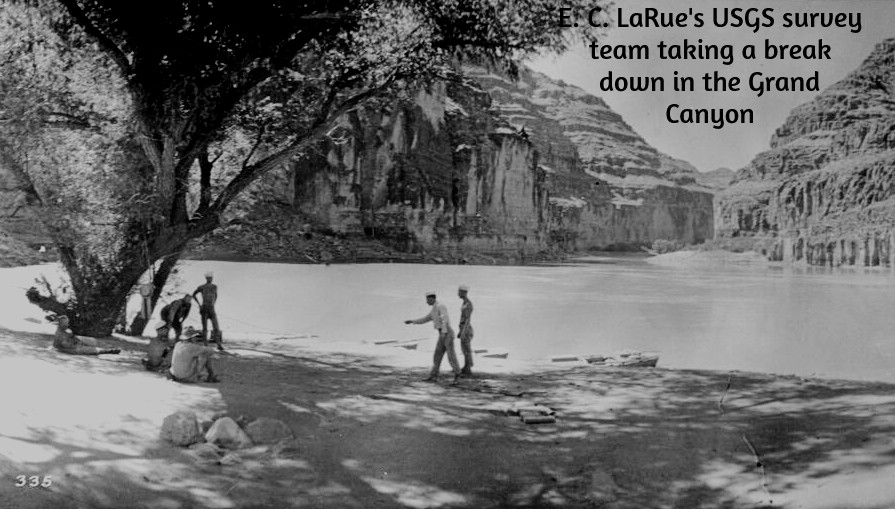
The Grand Canyon survey party at Lees Ferry. Left to right: Leigh Lint, boatman; H.E. Blake, boatman; Frank Word, cook; C.H. Birdseye, expedition leader; R.C. Moore, geologist; R.W. Burchard, topographer; E.C. LaRue, hydraulic engineer; Lewis Freeman, boatman, and Emery Kolb, head boatman. Boatman Leigh Lint, “a beefy athlete who could tear the rowlocks off a boat…absolutely fearless,” later went to college and became an engineer for the USGS. The Grand Canyon survey party at Lees Ferry in 1923. (Public domain.)
E.C. LaRue of the USGS warned us back in 1922 that storing the river’s water in big open reservoirs would reduce the supply of available water due to evaporation and bank-storage losses, but that seemed like a reasonable trade for water availability year-round over a river whose three-month flood was mostly lost to the sea anyway. The loss could be written off as ‘surplus’ – until the relentless demand ate up the fictional ‘surplus.’ Now it is suddenly necessary for the Lower Basin to count the ~800,000 acre-feet of evaporation from the Lower Basin reservoirs, canals and fields, as well as their half of the Mexican decree, against their Compact decreed 7.5 million acre-feet. Which they have reluctantly agreed to do – so long as the federal government pays them for not using what was not theirs to use anyway. (money that may be threatened by Mumpty’s DOGE).
And on top of that, there is gradual, general, reluctant acceptance of the fact that the burning of fossil fuels that powers nearly all of our civilization, plus the vast tonnage of cooling concrete that has gone into our great works, plus the gases from an increasingly vicious cycle of expanding wildfires and melting permafrost, are adding gases and heat to our atmosphere that are raising temperatures around the planet and causing changes in the global climate – oops.
I forgot; ‘climate change’ and ‘global warming’ have been officially eradicated from the public discourse. We are creating another new reality to pile on top of the old new realities we’ve created over the past century plus: We have grown so accustomed to thinking like George Bush’s advisors that we don’t really notice that our newest new reality is just the child’s belief that putting our hands over our eyes will make the real world go away.
So I think that’s what we can do, at least in the Colorado River region: uncover our eyes, and start adjusting our new realities (which are not entirely bad) with the natural realities that still constrain the engineers – as even most of the engineers seem willing to acknowledge. We need to acknowledge that Becky Mitchell’s advice is now counterrevolutionary – ‘We must learn to plan for the river we have, not the river we wish we had.’ To the Trumpty-Mumpties, that’s almost Unamerican, saints be praised.
Whatever we do along those lines, however, it seems necessary that the scientists and engineers work together on it: both acknowledging the wisdom in the scientist looking carefully before the engineers leap – but both also acknowledging that some leaps will be needed….
Workers from Denver Water and contractor Kiewit Barnard stand in front of Gross Dam in May 2024 to mark the start of the dam raise process. Photo credit: Denver Water.
Click the link to read the article on The Denver Post website (Elise Schmelzer). Here’s an excerpt:
April 4, 2025
Colorado’s largest water provider must stop construction on a $531 million dam expansion already underway in Boulder County after a federal judge found that assessments of how the project would impact the environment were flawed. U.S. District Court Judge Christine Arguello in an order late Thursday blocked Denver Water from enlarging Gross Reservoir east of Nederland until major federal environmental permitting processes are redone. The judge found that allowing the reservoir expansion to continue without redoing the permits would cause irreparable environmental damage that cannot be compensated for by monetary payments. That harm would outweigh any financial costs Denver Water would incur from halting construction, she wrote.
“Environmental injury is often the very definition of irreparable harm — often permanent or at least of long duration,” Arguello wrote. “All parties agree that there will be environmental harm resulting from completion of the Moffat Collection System Project, including the destruction of 500,000 trees, water diversion from several creeks, and impacts to wildlife by the sudden loss of land.”
She issued a preliminary injunction ordering Denver Water to halt construction on the dam until a further hearing when engineers can explain how much further construction is needed to make the partially built dam safe and structurally sound. Denver Water planned to raise the height of the dam by 131 feet, allowing the utility to store more water. She will then issue a permanent injunction on how much more construction will be allowed. The order is a huge victory for environmental groups that for years have opposed the controversial project. A coalition of environmental groups first filed suit in 2018 to stop the expansion of the reservoir, which they say would harm the health of the Colorado River system — where the reservoir’s water is sourced.
Last week, one of the Land Desk’s more conservative readers cancelled his paid subscription. He wrote that he appreciated my passion for public lands, but was no longer interested in reading what he called a “tirade against Trump.”
This type of thing happens all the time in this business, and, unlike Elon Musk, I’m not looking for your pity. But I was a bit saddened, given that this person had been a paid subscriber since the Land Desk was launched, and because I really do appreciate having readers and commenters from across the political spectrum.
Besides, while I’m prone to a rant now and then, I do think “tirade” is taking it a little too far. Anyway, my point in telling y’all this is to let you know that writing about Trump’s shenanigans every dispatch is just about the last thing I want to be doing with my time. I’d much rather be delving into old maps, getting into the nuances of Western water, exploring the history of floods and droughts and wildfires, taking contrarian views on the housing crisis, or dissecting the contradictions of oil and gas markets. And I will continue to do all of that.
At the same time, it’s impossible for me to ignore the barrage of destruction, corruption, chaos, authoritarianism, and incompetence emanating from the White House. My passion for public lands — and for justice, truth, reason, morality, decency, intelligence, and kindness — demands that I document these egregious acts, and do my part to resist them, even if it is just by informing my readership about what’s happening.
I am not impartial, not by any means. I am partial to the planet and its survival, toward my fellow human beings, toward peace and justice and compassion and truth. [ed. emphasis mine] I am not, however, partisan: I will scrutinize Democrats and Republicans equally, fact-check the left and the right, and give credit where credit is due — even to Donald Trump.
***
Hopi tribal members cross Havasu Creek. Photo credit: From the Earth Studio
And on that note: The Trump administration appears to have unfrozen nearly $4.2 million in federal funding to help the Hopi Tribe build a solar-powered microgrid to run two remote wells and associated infrastructure that will provide water to Upper and Lower Moenkopi. The funding was approved by the Biden Energy Department, Trump froze it as part of a larger stop on Infrastructure and Inflation Reduction law money, but now it has been released. So good on you, Donny!
Though it may be inadvertent, Trump’s economic policies may ultimately benefit the environment in some ways. The haphazard, on-again, off-again tariffs, for example, along with the gutting of the federal government’s workforce, have sent the stock market into a tailspin. Meanwhile, the tariffs — along with reciprocal tariffs levied by the U.S.’s trading partners — will increase prices on most consumer goods. People will buy less, travel less, which will mean less pollution and environmental impacts.
***
And yet more kudos for Trump! Seriously. Despite all of his bluster, Trump has managed to really piss off oil and gas executives — the same ones that were throwing money at his campaign just a few months ago — and possibly dampen drilling on public lands.
See, the thing about tariffs is that they very well may raise the price you pay for gasoline (depending on where your local refinery gets its crude oil), but the economy-dampening part of tariffs actually brings down the price of oil, while also raising the cost of steel pipes and other supplies. That’s no bueno for petroleum companies, whose profit margins are directly proportional to the price of crude.
Many of these folks won’t criticize Trump in public, given his vindictive and authoritarian leanings, but give them the cover of anonymity, as a Dallas Federal Reserve survey did, and they go off on the White House’s herky-jerky non-policies. Here’s a sampling:
There was only one mention of regulations getting in the way of the oil business, and that wasn’t federal rules, but state ones:
Well, there you have it, folks.
***
Oh, and these oil companies might also be angry that the MAGAs are all buying Teslas — or at least pretending to — in order to “own the libs.” Which is pretty funny, given the amount of gibberish Trump devoted to dissing electric vehicles during his campaign rallies. Tesla also stands to benefit the most from Trump’s tariffs, another dig at the internal combustion fans.
***
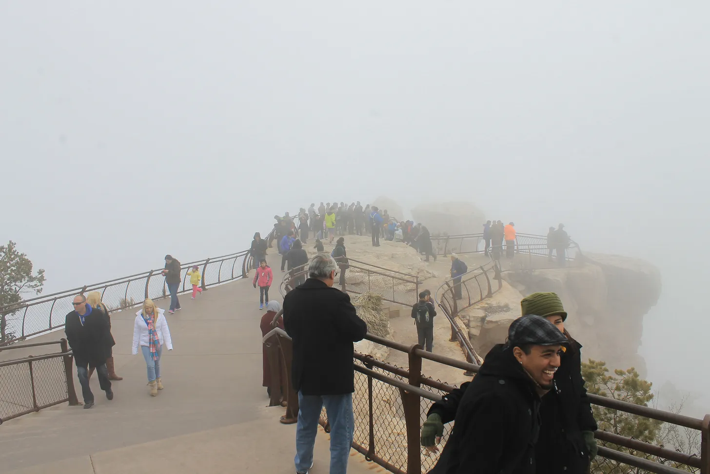
Maybe the national parks will be a bit less crowded this summer, as well, as international travel ebbs.
Anyone who’s traveled the Western national park service knows that they are popular with overseas visitors. On a single grocery run at the Page, Arizona, Safeway recently, I heard no fewer than three different languages spoken, in addition to Navajo and English, and that was in the off-season. In 2018 (the last year that data is available), more than 14 million international travelers visited U.S. national parks and monuments. About 14% of the Grand Canyon National Parks’ visitors were from overseas, with about 6% of Zion’s visitation from overseas.
Tourism Economics is predicting that international travel to the U.S. will be down significantly this year, thanks not only to the administration’s hostile economic moves, but also “polarizing Trump administration policies and rhetoric.” Also, there’s that thing where travelers have been detained at the border, even thrown in jail, simply for trying to get a visa. This decline undoubtedly will impact Western U.S. tourism and national park and monument visitation numbers. Not good for the tourism economy, but it might give the parks a much needed rest.
🥵 Aridification Watch 🐫
It’s first-of-the-month snowpack update time again, and this will likely be the last of the season barring some freak climatic shift over the next several weeks. Snowpack levels typically peak in mid-elevation areas in mid- to late-March, and in the high country in mid- to late-April, meaning we are now headed into spring runoff season.
Generally speaking, it’s looking like runoff will be average to paltry, depending on which side of the snow-divide your watershed falls. It is a very jagged line, by the way, with places in the west and north having average to above average snowpack, while the southern-Interior West generally had a super dry winter. But even within those areas there are sort of outliers: The Grand Traverse ski race between Aspen and Crested Butte was canceled due to lack of snow for the first time in its 26-year history.
And there’s big variations over short distances. Red Mountain Pass is still just below median, for example, while the southern San Juan Mountains, just a few dozen miles away, are experiencing a severely dry winter.
Before I get to the graphics, however, a quick note. The snowpack and precipitation plots I run here come from the USDA’s Natural Resources Conservation Service. It’s just one of the valuable services they provide. I haven’t found any stats on whether DOGE has gone after NRCS’s staff, yet. But the DOGE website says it has or will cancel the leases for the following NRCS offices. Whether they and their staffs will simply go away, be absorbed into another facility, or what, isn’t disclosed.
Natural Resource Conservation Service offices slated for lease cancellations: Missoula, Montana; Wasilla and Fairbanks, Alaska; Logan, Utah; Gallup and Raton, New Mexico; Yuma, Arizona; Dayton, Puyallup, and Renton, Washington; Portland, Oregon; and Woodland, Yreka, Salinas, Oxnard, and Blythe, California.
Hopefully the staff of these offices and services they provide will endure.
Now to the snowpack plots. I included the plots for 2021 and 2023 because those were the most recent big and crappy years for snowpack.
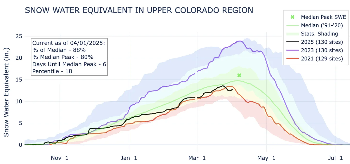
The watersheds that feed Lake Powell are not in terrible shape, sitting at 88% of the median just six days before the typical peak. However, levels are lower than they were in 2021 at this time, and 2021 was not a good year for the Colorado River. Source: NRCS.
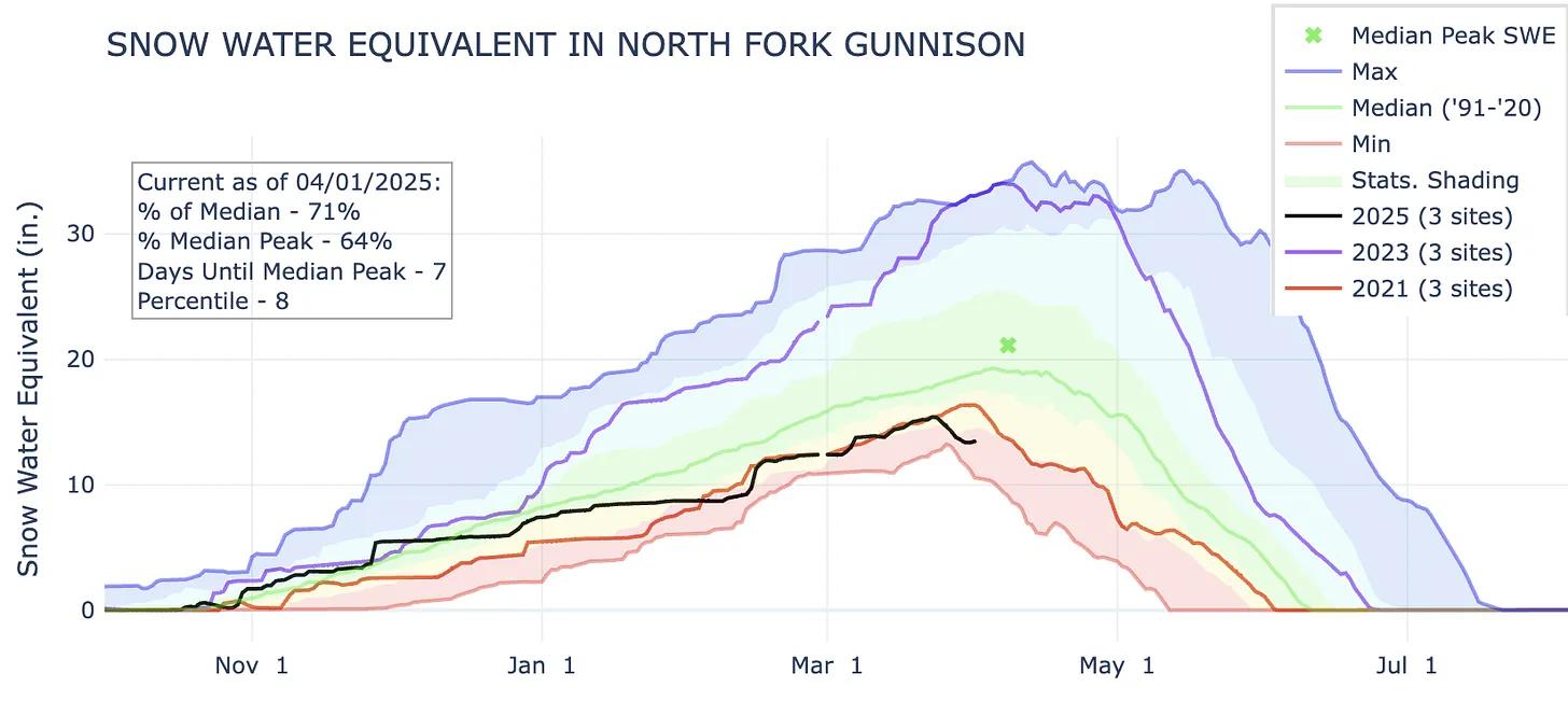
The North Fork of the Gunnison has followed a snow accumulation pattern similar to the Upper Colorado River’s.
Red Mountain Pass is one of the few bright spots in the Four Corners region. Snow levels have tracked right around normal for most of the winter. Though it’s now down to 90% of median, there are potentially still over three weeks left in the snow accumulation season, meaning an above-average season is still possible; snow is forecast for much of this week there.
This SNOTEL site, in the San Francisco Peaks north of Flagstaff, is the comeback story of the year, rebounding from ultra-dry to average over the course of several weeks. It’s one of the only sites in Arizona that received measurable snow accumulation this season.
The drought has spread and intensified over the last year.
And it doesn’t look like it will get better anytime soon …
The pipeline, at the base of the Winter Park ski area, that moves water as part of the existing Moffat Collection System Project. The portal of the railroad tunnel is behind the pipeline, in this view. Photo credit: Brent Gardner-Smith/Aspen Journalism
According to Grand County Water Quality Manager Katherine Morris, polluted discharge from the Moffat Tunnel has adversely impacted the Fraser River. The Grand County water quality team recently wrote two letters to the Colorado Department of Public Health & Environment, outlining its concerns with violations by Union Pacific Railroad, which manages the tunnel. During a Grand County Board of Commissioners meeting March 11, 2025 Morris explained that polluted water from the tunnel enters the nearby Fraser River, which is a main tributary of the Colorado River. This ongoing problem began after the tunnel was completed, and Grand County government began advocating to fix the problem nearly two decades ago…
James Peak via ColoradoWildAreas.com
In the early 2000s, residents and governmental officials raised alarm about pollutants and increased turbidity (or clarity issues) in the Fraser River when water was discharged from the tunnel. The tunnel bores through James Peak. Groundwater from cracks in the mountain rock seeps into the tunnel, and that water needs a way out. Coal dust, heavy metals and other particulate matter can travel into the Fraser River through the runoff. At the time, a water treatment plant existed on the east portal of the tunnel but not on the west portal at Winter Park. People questioned why there was no treatment plant to protect Grand County, home to the headwaters of the Colorado River. Over the years, Union Pacific received fines and a cease-and-desist order. The railroad finally built a treatment plant in 2017, but issues have continued — even worsened in some cases, Morris said. A water centrifuge at the plant is designed to separate solids from the water, creating a sludge-like “centrifuge cake” that is put in a drum and disposed of in Utah. (This disposal has raised its own concerns.) The remaining water is discharged into the river.
This historical photo shows the penstocks of the Shoshone power plant above the Colorado River. A coalition led by the Colorado River District is seeking to purchase the water rights associated with the plant. Credit: Library of Congress photo
Western Slope water leaders hope bipartisan support can thaw $40 million in frozen federal money aimed at securing some of the Colorado River’s oldest water rights. The Colorado River District is spearheading an effort to purchase senior rights from Xcel Energy used at the Shoshone hydroelectric plant in Glenwood Canyon. The water allocated by the rights passes through the facility and back into the river, making them “nonconsumptive” rights, but by purchasing them for $99 million Western Slope leaders hope to ensure that water can continue to flow downstream and avoid the possibility it could be rerouted to Front Range users. The effort to buy the rights raised more than $50 million between the state of Colorado, the River District and more than two dozen entities on the Western Slope. In January, the federal government announced $40 million worth of support to the project. Just days later, the Trump administration took over, and that money was put on hold.
“I think that has been frozen,” Republican Congressman Jeff Hurd, who represents Colorado’s 3rd Congressional District, said in response to a question about the grant during a tele-town hall event on March 11. “Just know that we are working hard behind the scenes to see what we can do to make sure that that funding is allocated and completed.”
Andy Mueller, general manager for the Colorado River District, said the group anticipated delays in the funding from the start on account of the changing administrations. But, because the group has been working on pooling the money in advance, they’re not being left high-and-dry by the funding freeze just yet.
“We’re one of the fortunate grantees, if you will, in that situation. I know there are a lot of grantees who were actually engaged in digging dirt and had hired staff in anticipation of grants,” Mueller said. He noted the deal is still pending a water court change case, giving the Shoshone purchase deal extra runway to haggle over the federal contribution.
A $110,000 state grant is enabling Colorado Mesa University’s Ruth Powell Hutchins Water Center to expand its education and outreach program, including through a spring speaker series co-organized with CMU’s Environmental Science program. The center received the money from the Colorado Water Conservation Board last fall for two years of programs. According to a news release, Freddy Witarsa, the program’s interim director, will use the funds to facilitate programs to prepare students to join the water workforce and provide a platform for Western Colorado stakeholders to address the region’s water challenges…The water center facilitates research, education, outreach and dialogue to address the water issues in the region. The center has been led in recent years by interim directors. Witarsa also is an assistant professor of environmental science and technology at CMU. In January, the Colorado River District awarded the center $300,000 to support its efforts to grow over the next three years, including by hiring an executive director. That grant is being matched by a $300,000 grant from CMU.
My friend Joe’s son and the Orr kids at the top of the Crack in the Wall trail to Coyote Gulch with Stevens Arch in the Background. Photo credit: Joe Ruffert
Kevin Fedarko was the keynote speaker at the symposium and he is as inspirational a speaker as you could ask for. It doesn’t hurt that the landscape that he spoke about is the Grand Canyon. He urged the attendees to, “Take your children out into these landscapes so that they can learn to love them.” He is advocating for the protection of the Grand Canyon in particular but really he is advocating for the protection all public lands.
Kevin Fedarko and Coyote Gulch at the Rio Grande State of the Basin Symposium hosted by the Salazar Rio Grande del Norte Center at Adams State University in Alamosa March 29, 2024.
What an inspirational talk from Kevin. I know what he is saying when he speaks about the time after dinner on the trail where the sunset lights up the canyon in different hues and where, he and Pete McBride, his partner on the Grand Canyon through hike, could hear the Colorado River hundreds of feet below them, continuing its work cutting and molding the rocks, because the silence in that landscape is so complete. He and I share the allure of the Colorado Plateau. Kevin was introduced to it through Collin Flectcher’s book The Man Who Walked Through Time, after he received a dog-eared copy from his father. They lived in Pittsburgh in a landscape that was industrialized but the book enabled Kevin to imagine places that were unspoiled.
My introduction to the Colorado Plateau came from an article in Outside magazine that included a panoramic photo of the Escalante River taken from the ledges above the river. Readers in the know can put 2 and 2 together from the name of this blog — Coyote Gulch — my homage to the canyons tributary to Glen Canyon and Lake Foul.
Stevens Arch viewed from Coyote Gulch. Photo via Joe Ruffert
Kevin’s keynote came at the end of the day on March 29th after a jam-packed schedule.
Early in the day Ken Salazar spoke about the future of the San Luis Valley saying, “Where is the sustainability of the valley going to come from.” Without agriculture this place would wither and die.” He is right, American Rivers and other organizations introduced a paper, The Economic Value of Water Resources in the San Luis Valley which was a response to yet another plan to export water out of the valley to the Front Range. (Currently on hold as Renewable Water Resources does not have a willing buyer. Thank you Colorado water law.)
Claire Sheridan informed attendees that their report sought to quantify all the economic benefits from each drop of water in the valley. “When you buy a bottle of water you know exactly what it costs. But what is the value of having the Sandhill cranes come here every year?”
Sandhill Cranes Dancing. Photo by: Arrow Myers courtesy Monte Vista Crane Festival
Russ Schumacher detailed the current state of the climate (snowpack at 63%) and folks from the Division of Water Resources expounded on the current state of aquifer recovery and obligations under the Rio Grande Compact.
The session about the Colorado Airborne Snow Measurement Program was fascinating. Nathan Coombs talked about the combination of SNOTEL, manual snow courses, Lidar, radar, and machine learning used to articulate a more complete picture of snowpack. “You can’t have enough tools in your toolbox,” he said.
Coombs detailed the difficulty of meeting the obligations under the Rio Grande Compact with insufficient knowledge of snowpack and therefore runoff volumes. Inaccurate information can lead to operational decisions that overestimate those volumes and then require severe curtailments in July and August just when farmers are finishing their crops. “When you make an error the correction is what kills you,” he said.
If you are going to learn about agriculture in the valley it is informative to understand the advances in soil health knowledge and the current state of adoption. That was the theme of the session “Building Healthy Soils”. John Rizza’s enthusiasm for the subject was obvious and had me thinking about what I can do for my city landscape.
Amber Pacheco described how the Rio Grande Basin Roundtable and other organizations reach out to as many folks in the valley as possible. Inclusivity is the engine driving collaboration.
I’m in Alamosa to attend the symposium. There is a great program planned for today chock full of information about Colorado’s “South Slope”. Click the link to view the agenda. Of course snowpack will be a large part of the discussion today, as it is every April 1st in Colorado. Also, I’m looking forward to the session featuring a new study from American Rivers with Heather Dutton and Emily Wolf.
Russ Schumacher will be discussing snowpack and precipitation.
layer cakes over the Sangre de Cristos (which could really use some more snow) #cowx
Satellite image of a portion of the Morenci Mine in Arizona. Source: Google Earth.
Last week, President Trump signed an executive order — his 150th so far this term, by my rough count — invoking the Defense Production Act to expedite mining on federal lands. The wording of the order suggests that the aim is not just to cut through some of the red tape hindering proposed projects, but to incite the industry to mine areas that it may not have been considering previously.
The order has understandably alarmed public lands advocates, but it has also spawned some misconceptions, particularly concerning the 1872 General Mining Law.
Green River Basin oil shale deposits via the Bureau of Land Management
While Trump’s attacks on the nation and public lands have been of unprecedented scope and scale so far, his use of the Cold War-era DPA is not unprecedented or even all that unusual. The Carter administration used it to justify pouring billions of dollars of subsidies into “synfuel” production as part of its quest for “energy independence.” This sparked massive oil shale operations in western Colorado (which crashed spectacularly). And Biden used the Act to encourage mining for so called “green metals,” such as lithium, boron, and manganese. He also streamlined permitting for the proposed Hermosa manganese mine in southern Arizona, and loaned the contested Thacker Pass lithium mine in Nevada $2.6 billion.
But Trump’s order goes much further than Biden’s. He is expanding the list of target minerals to just about everything, including “critical minerals, uranium, copper, potash, gold, and any other element, compound or material as determined by the Chair of the National Energy Dominance Council, such as coal.” While Biden wanted a survey of the nation’s mineral production capacity, and promised to adhere to all existing environmental laws and consult with tribal nations, Trump is ordering his agencies to:
Compile a list of all proposed mining projects “in order to expedite the review of those projects in coordination with the National Energy Dominance Council.”
Amend or revise land use plans under the Federal Land Policy and Management Act as necessary to “support the intent of this order.”
“Identify as many sites as possible that might be suitable for mineral production activities that can be permitted as soon as possible.”
Prioritize mineral production activities over other types of activities on federal lands.
Provide financing, loans, and investment for new mines, including from a “dedicated critical minerals fund established through the U.S. International Development Finance Corporation.”
“New recommendations will be provided to Congress regarding treatment of waste rock, tailings, and mine waste disposal under the Mining Act of 1872.”
Instead of adhering to environmental laws, Trump would simply alter them to support mining. He not only wants to help out proposed projects with regulatory and financial subsidies, but also wants to spur on new projects on “as many sites as possible.” And he is prioritizing mineral extraction over all other activities on federal lands, a blatant violation of the Federal Land Policy Management Act’s multiple-use mandate.
That would mean not only that mining would take precedence over conservation and recreation, but also livestock grazing and other extractive uses. The OHV crowd that’s worried about the BLM closing a few roads to motorized vehicles around Moab might just find themselves ousted from a lot more areas by potash ponds, uranium mines, or lithium operations.
Trump’s recommendations to Congress likely will be to tweak the 1872 Mining Law to ensure that mining companies can store waste on public land mining claims that aren’t valid, meaning that they have not proven that the parcels contain valuable minerals. This was actually the norm for decades until 2022, when a federal judge ruled that the proposed Rosemont copper mine in Arizona could not store its tailings and waste rock on public land. That ruling was followed by a similar one in 2023, leading mining state politicians from both parties to try to restore the pre-Rosemont Decision rules.
It’s around the General Mining Law that misconceptions have arisen. The folks at More Than Just Parks say the new order “doesn’t create a new legal framework. It exhumes an old one — a fossil from the 19th century … It’s the Mining Act of 1872, back from the dead, and now wearing body armor.” Which is a nice way to put it, but the Mining Act never died, so this order can’t revive it.
The other misconception appeared in Lands Lost, another great Substack focusing on public lands, which wrote: “… there are no meaningful environmental safeguards in place because public land mining is a free-for-all governed only by an 1872 law that’s never been modernized.”
It’s true that the 1872 Mining Law is inadequate, allows mining companies or individuals to stake a claim to any public land without public input or environmental review, conduct exploratory work with a minimum of review, and pay no royalties on hardrock minerals they extract. However, the federal agencies do have additional regulations governing mining. Before a company can do any actual mining, it must get an operating permit from the Bureau of Land Management, U.S. Forest Service, or Department of Energy (depending on the land’s jurisdiction), which includes an environmental review (either an EA or a more extensive EIS, depending on the scope of the project). A mine may also need a Clean Water Act permit for any water discharges, including draining adits, and many states require additional permits as well.
By ordering the agencies to alter the FLPMA land-use plans to accommodate mining, Trump is essentially doing away with these additional safeguards, which really is scary. That would take us back to a time when the 1872 Mining Law was the only federal regulatory framework, which would give mining companies a free rein to trash public lands. However, Trump can’t do much about state requirements, except to try to bully them out of existence. [ed. emphasis mine]
The order applies only to federal lands, so mining projects that are on patented mining claims — which are entirely on private — would not be affected (although they might be eligible for the government handouts).
Proposed projects this fast-tracking could affect include:
Copper World Complex née Rosemont Mine in the Santa Rita Mountains south of Tucson, Arizona. After a judge kiboshed Canada-based Hudbay’s plan to dump mine waste on U.S. Forest Service land, the firm decided to base the initial phase on patented, i.e. private, mining claims and later expand to public lands.
South32’s proposed Hermosa Mine in the Patagonia Mountains of southern Arizona. Biden already fast-tracked permitting for this battery-grade manganese mine, but Trump’s order could speed it along even more.
Energy Fuels’ Roca Honda uranium mine and Laramide Resources’ La Jara Mesa uranium project, both on Forest Service land near Grants, New Mexico.
Anson/A1’s proposed lithium extraction projects and American Potash’s lithium and potash projects on BLM land east and north of Moab and south of Green River, Utah.
Lithium, copper, and uranium projects on BLM land in the Lisbon Valley in southeastern Utah.
Numerous proposed uranium mining projects on Energy Department leases and BLM land in the Uravan Mineral Belt in western Colorado.
Atomic Minerals’ uranium prospects on Harts Point, just outside the boundaries of Bears Ears National Monument.
Metallic Minerals is only doing exploratory drilling on its mining claims in the La Plata Mountains of southwestern Colorado, and have yet to make any mining plans public, so it’s not clear whether Trump’s order would affect this contested project.
Those links up ^^ there? A lot of them are to paywalled Land Desk archives. Break down the paywall and support oligarch-free journalism by becoming a paid subscriber now.
Satellite image of Phoenix-area sprawl and adjacent BLM land. Source: Google Earth.
🌵 Public Lands 🌲
Also last week, in a short-on-details Wall Street Journal opinion piece, Interior Secretary Doug Burgum and Housing and Urban Development Secretary Scott Turner unveiled a plan to transfer or lease “underused” public lands to states or localities for affordable housing. An Interior official then told Bloomberg Law’s Bobby Magill that the Bureau of Land Management is considering selling about 400,000 acres of federal land within 10 miles of cities and towns with more than 5,000 people for housing development.
This isn’t surprising: Republicans and Democrats have both been itching to grab some public land for housing for a while. And the stated intent, to add affordable housing to increasingly unaffordable public lands-gateway communities, is noble.
And yet, the plan — as scant in particulars as it is — is still riddled with problems.
Burgum has made it clear that he distinguishes between “special” and “our most beautiful” public lands, i.e. those that are in national parks or national monuments, and the remaining “underused,” “inhospitable or unoccupied” lands. The lands on the urban fringes he intends to take out of the American public’s hands belong to the latter category, apparently.
But those same lands are valuable, especially to the nearby communities. They provide an easy-to-access refuge — for humans and wildlife — from the urban din, as well as recreational opportunities. In fact, the close proximity of these public lands makes the communities more desirable and therefore more expensive: think Animas Mountain in Durango, the Slickrock Trail in Moab, Jumbo Mountain in Paonia, the Lunch Loop trails in Grand Junction, the Buckeye Hills near Phoenix, or the Juniper Woodlands trails outside Bend. Now imagine them covered in houses.
Because BLM lands are almost always outside the urban boundaries, developing them will lead directly to sprawl and all of its impacts, including more traffic and associated pollution and safety issues.
So far, the Interior Department hasn’t given any indication that it would require the land to be used for affordable housing. And, as Center for Western Priorities points out in a statement on the plan, the administration hardly seems interested in fixing the housing crisis, given that it is planning to eviscerate HUD and has frozen some $60 million in funding for affordable housing.
Which leads me to think they are using Sen. Mike Lee’s stalled HOUSES Act, which also calls for putting houses on “underutilized” federal land, as a model. But that legislation has no affordability restrictions and its density requirement — a mere four houses per acre — is just more sprawl.
That’s because Lee and company are going with the supply side theory, which posits that simply building more houses will lower costs enough to make them affordable. While this theory does hold in certain cases, it does not apply to most Western public lands-gateway, amenities communities, where seemingly unlimited demand is always bound to outpace supply. And that means this plan is just another scheme to take public lands out of Americans’ hands and give them to the private sector.
A view of one of the Valley’s major agriculture resources, cattle. Credit: Owen Woods
Click the link to read the article on the Alamosa Citizen website (Heather Dutton and Emily Wolf):
March 27, 2025
Here in the San Luis Valley, water is deeply connected to our way of life. The Rio Grande, its tributaries and connected groundwater support local heritage, agriculture, recreation and the natural environment. Like all of the region’s streams and rivers, the Rio Grande is critical to the livelihood and economies of the communities of the SLV and is a growing recreational and economic asset to communities outside of the Valley as well.
Photo credit: Sinjin Eberle/American Rivers
To help illustrate the critical value water plays across all sectors in the Valley, American Rivers and One Water Econ released a new study this week, The Economic Value of Water Resources in Colorado’s San Luis Valley, which presents the economic benefits of key sectors and services that depend on water in the Valley. The analysis looks at irrigated agriculture, municipal and industrial uses, tourism and recreation, and environmental values like wildlife habitat.
While we all know and understand the intrinsic value of water in the Valley, economic data will further elevate not only the social importance of water, but also the economic contributions the Rio Grande and Conejos River, other streams, and connected groundwater provide to the San Luis Valley. Our community can use this economic data to tell the story of ongoing collaborative water management projects, help fight future threats, including groundwater export schemes, and make the case for multi-benefit river restoration efforts that are a win-win-win for agriculture, communities, and the environment.
San Luis People’s Ditch March 17, 2018. Photo credit: Greg Hobbs
Irrigated agriculture, a key economic driver in the SLV, is reliant on the surface water flowing through the Valley along with the vast number of groundwater wells and is deeply connected to the history of the Valley. The study found that crops supported by surface and groundwater make up 39 percent of Colorado’s total agricultural output, despite the population of the Valley being less than 1 percent of Colorado’s population. Additionally, irrigated agriculture was found to contribute more than $480 million annually in economic output. For every $1 that is spent on local inputs for agriculture production, an additional $1.56 is generated in the regional economy. Potatoes and vegetables are the largest economic generators in the agricultural space, with an annual economic output of $184 million. Not only does irrigated agriculture provide critical economic benefits, but the irrigated fields and wet meadows also support critical migratory bird habitat.
Sandhill cranes stop and gather in a field near the Monte Vista National Wildlife Refuge during their yearly trek.
Recreation, a growing economic sector for the Valley, is heavily reliant on water flowing from the surrounding mountains into the Valley and provides significant economic value. The Great Sand Dunes National Park and Preserve attracts national and international travelers, as do the world-class birding and wildlife viewing opportunities at the nine state and national wildlife refuges that are made up of wetland, riparian, and open water ecosystems, and support numerous species of resident and migratory birds, including sandhill cranes. Additionally, the Rio Grande and Conejos River draw many visitors for both whitewater boating and world class fishing. The recent economic analysis found water-related recreation provides $213.7 million in benefits annually in the San Luis Valley, and for every $1 spent on recreation, $1.91 is generated through ripple effects within the local economy. The Valley’s riverside lands, wetlands, and wet meadows are a critical part of the natural infrastructure supporting recreation and many species of wildlife. The analysis found that water-related habitat in the Valley is valued at more than $49 million annually and the annual Crane Festival generates $4 million in direct revenue from visitor spending.
Many other industries beyond recreation and agriculture also rely on water – local breweries, distilleries, bakeries, greenhouses, hospitals, and hotels among others – all rely on water. These “water-dependent” industries (WDIs) generally rely on the services of water utilities to support and grow their businesses. Water-dependent industries in the Valley support nearly $1.3 billion annually in total economic output. Water is undeniably a critical resource for the Valley, providing not only economic benefits but other ecosystem services, and intrinsic and cultural values. The economic data from this new analysis provides San Luis Valley communities with information to help protect the Valley from export schemes, further support water projects that conserve the Valley’s precious resources, and illustrate to those outside the Valley why water is so critical to the livelihoods of every person in the SLV.
Partners involved in the creation of the study from American Rivers, One Water Econ, and the San Luis Valley Water Conservancy District will present information about the study at the Rio Grande State of the Basin Symposium at Adams State University on March 29. The event is open to the public and all are encouraged to attend. The analysis is also available on American River’s website at www.americanrivers.org/SLVEconomicReport.
The Bessemer Ditch is an irrigation canal that serves agricultural areas in Pueblo County. In 2009 and 2010, the Pueblo Board of Water Works acquired nearly one-third of water rights to the ditch to supply the city of Pueblo with water. While necessary to support the city, it simultaneously threatens producers’ livelihoods.
Since 2015, Palmer Land Conservancy, a nonprofit based in Colorado Springs, has been working with the county to help preserve the area’s agricultural identity while allocating water wisely.
As part of these efforts, a “substitution of dry-up” provision was developed and later incorporated into Pueblo Water’s decree. This keeps the most fertile agricultural land in production by enabling voluntary, market-based transactions where less productive farmland is substituted to be dried-up.
Palmer was invited to work with the Pueblo County agricultural community to identify ideal dry-up candidate areas (DCAs) through the Bessemer Farmland Conservation Project. The DCA farms, which are often located along riparian corridors, would be revegetated once dried up, according to the plan—bolstering local ecology.
The project is funded by the Colorado Water Conservation Board of the Colorado Department of Natural Resources and partners.
Created by Imgur user Fejetlenfej , a geographer and GIS analyst with a ‘lifelong passion for beautiful maps.’ It highlights the massive expanse of river basins across the country – in particular, those which feed the Mississippi River, in pink.
In a historic and consequential move, the United States has officially denied Mexico’s request for a special water delivery from the Colorado River to Tijuana. The Bureau of Western Hemisphere Affairs, a U.S. Department of State division, addressed this matter on March 20, 2025, via their official social media channels. It marks the first time since the signing of the 1944 Water Treaty that such a request has been rejected — signaling deepening tensions over water management and compliance between the neighboring nations. The 1944 treaty, a longstanding bilateral agreement, regulates water distribution between the U.S. and Mexico between the Rio Grande and Colorado Rivers. According to the treaty, Mexico must deliver 1.75 million acre-feet of water to the U.S. over five-year cycles, averaging 350,000 acre-feet annually. However, by late 2024, Mexico had fallen over one million acre-feet behind its commitments. Officials attribute this shortfall to a combination of prolonged drought, increased agricultural demands, and aging infrastructure on the Mexican side of the border. The U.S. Department of State defended its decision by citing the severe impact that Mexico’s ongoing shortfalls have had on American agriculture — particularly in the Rio Grande Valley of Texas, where water scarcity is crippling the livelihoods of thousands of farmers. Crops such as citrus, cotton, and vegetables have suffered from reduced irrigation, leading to lower yields and economic instability in the region…
Tijuana, which sources approximately 90% of its water from the Colorado River, faces intensifying shortages. The city’s aging infrastructure, combined with the broader regional drought, means the denial of emergency water deliveries from the U.S. could further strain Baja California’s already fragile water supply systems. The water crisis is also reshaping the agricultural landscape in South Texas — most notably in Santa Rosa. The Rio Grande Valley Sugar Growers, Inc. (RGVSG), a cooperative of over 100 family-owned farms and the last remaining sugar mill in Texas, was forced to shut its doors after over five decades of operation. The closure followed a dramatic decline in sugarcane acreage, which dropped from 34,000 acres in early 2023 to just 10,000 by early 2024. Without reliable irrigation water — much of it linked to Mexico’s unmet deliveries — sugarcane farming became economically unsustainable.
On Tuesday, February 25th, Tommy Beaudreau, former Deputy Secretary of the Interior, delivered the Schultz Lecture, offering a sobering analysis of the structural, legal, economic, and political hurdles to the energy transition on public lands. His talk, “The Lords of Yesterday and the Imperatives of Now,” constituted a tribute to the late Charles Wilkinson’s coined phrase. Harkening back to Wilkinson’s work, Beaudreau traced these contemporary challenges to the legacy of westward expansion and Indigenous displacement, illustrating how outdated laws and entrenched interests continue to shape today’s energy policies.
American Progress (1872) by John Gast is an allegorical representation of the modernization of the new west. Columbia, a personification of the United States, is shown leading civilization westward with the American settlers. She is shown bringing light from east to west, stringing telegraph wire, holding a book, and highlighting different stages of economic activity and evolving forms of transportation. By John Gast – This image is available from the United States Library of Congress’s Prints and Photographs division under the digital ID 09855.This tag does not indicate the copyright status of the attached work. A normal copyright tag is still required. See Commons:Licensing for more information., Public Domain, https://commons.wikimedia.org/w/index.php?curid=373152
Beaudreau framed public lands as a political flashpoint in the energy transition. While state and private lands—particularly in North Dakota and the Southwest—have played significant roles in the oil and gas boom, debates over renewables, permitting, and leasing disproportionately focus on federal lands. Ironically, legal tools once used to block fossil fuel projects are now being turned against renewables, complicating efforts to decarbonize.
Beyond regulatory hurdles, fossil fuel revenues remain deeply embedded in state economies, funding schools, public safety, and infrastructure. Many Tribal nations, too, rely on fossil fuel revenues, balancing economic interests with environmental concerns. Beaudreau stressed that a “just transition” must provide financial alternatives before communities can fully embrace renewables.
Outdated laws, like the 1872 Mining Law, remain a major obstacle to energy reform. Beaudreau highlighted the Inflation Reduction Act (IRA) as a key step in shifting energy policy, but legal battles persist over leasing rights, mineral access, and state-federal control. He pointed to Louisiana’s lawsuit over the Biden administration’s oil and gas lease moratorium, which raised critical questions about governmental statutory and commercial contractual rights in energy development.
Economic arguments also dominate the debate. Critics claim renewables are too costly for federal subsidies, mirroring past fights over offshore oil incentives. Meanwhile, global competition—especially China’s control of solar panel and battery supply chains—adds geopolitical complexity to the transition.
Despite these challenges, Beaudreau offered a measured note of optimism. He pointed to Western landowners and ranchers, historically conservation advocates, as potential allies in sustainable land management. Their interest in wildlife migration corridors and outdoor access could foster new conservation coalitions.
Ultimately, Beaudreau underscored that energy transition requires modernizing laws, addressing economic realities, and building broad political consensus. As attendees left Wittemyer Courtroom, they carried with them a clear message: the road ahead is uncertain, but public lands remain central to shaping America’s energy future and, as Wilkinson’s “lords of yesterday” remain, the imperatives of change have arrived.
The recording of the 16th annual Schultz Lecture can be found here.
Native land loss 1776 to 1930. Credit: Alvin Chang/Ranjani Chakraborty
From email from the Getches-Wilkinson Center (Annie Carlozzi):
Thank you for joining the Getches-Wilkinson Center and the Center of the American West for the Schultz Lecture in Energy on February 25th! We are so grateful to Tommy Beaudreau for making time in his schedule to spend lunch with our law students and the evening with all of our attendees in person and online.
We have a few things to share with you:
Conference Photos
Barb Colombo of 11:11 Productions Photography has provided us with wonderful images of the lecture with Tommy Beaudreau. We’ve added them to a Flickr album for easy viewing here.
Conference Recordings
The Law School IT Team has released the recording from the lecture.
GWC Blog Current Colorado Law students Victoria Matson and Oliver Skelly shared their reflections on Tommy Beaudreau’s visit to the Colorado Law School on the GWC blog. You can read their piece here.
Upcoming Event
We hope you will consider joining us for the annual Colorado River Conference co-convened by GWC and the Water & Tribes Initiative. You can find more information on our website regarding this year’s theme: Turning Hindsight into Foresight: The Colorado River at a Crossroads.
In December 2023, the Colorado River District and Xcel Energy agreed on a deal for the district to buy Xcel’s historic water rights associated with the Shoshone hydroelectric power plant in Glenwood Canyon for $99 million. The Bureau of Reclamation was supposed to pitch in $40 million toward that purchase, but the money is stalled by the Trump administration’s pause on federal spending. Jeff Hurd, the 3rd Congressional District representative, penned a letter to Interior Department Secretary Doug Burgum urging the department to fully fund the Bureau of Reclamation’s $40 million award. Photo credit: Brent Gardner-Smith/Aspen Journalism
With the fate of a federal grant funding toward Shoshone Water Rights up in the air, western Colorado congressman Jeff Hurd is throwing his political weight behind the grant’s preservation…In January, the Biden Administration included $40 million through the Inflation Reduction Act to go toward the Colorado River District’s efforts to acquire the nearly $100 million Shoshone Water Rights from Xcel. However, Hurd said during a recent phone town hall that he believed the Trump administration had frozen the grant. The Grand Junction Republican representing Colorado’s 3rd Congressional District in the U.S. House penned a letter to Interior Department Secretary Doug Burgum on March 18 urging the department to fully fund the Bureau of Reclamation’s $40 million award.
“For more than a century, the senior water rights associated with the Shoshone Hydropower Plant in Glenwood Canyon have played a pivotal role in sustaining reliable flows in the Upper Colorado River,” Hurd wrote. “These flows are essential to the health and vitality of our region, enabling everything from high-value crop production and oil and gas production to recreational tourism and rural municipal water supplies.”
Hurd wrote about the project’s economic benefits, citing BBC Research and Consulting data that concluded that preserving Shoshone’s flows would provide a net present value of as much as $609 million.
“These benefits include stabilizing flows during periods of drought, supporting continued water development and power production through the Upper Colorado River Endangered Fish Recovery Program, and maintaining water quality that supports salt-sensitive crops and drinking water infrastructure,” Hurd wrote.
Udall/Overpeck 4-panel Figure Colorado River temperature/precipitation/natural flows with trend. Lake Mead and Lake Powell storage. Updated through Water Year 2024. Credit: Brad Udall
Click the link to read the article on the InkStain website (Eric Kuhn):
March 19, 2025
The Bureau of Reclamation released its March 24-Month study last Friday and just like last month, the forecast is for big trouble in the Colorado River Basin. Under the “Most Probable” scenario, the ten-year cumulative flow at Lee Ferry will drop below 82.5 million acre-feet (the “tripwire”) by the end of Water Year 2027. If this happens, the odds are high that the Lower Division states will trigger what they referred to in their February 13, 2025, letter to Secretary Burgum as a “compact call.” The nuance, however, is that the Colorado River Compact has no specific provision for a compact call. Under the compact, a call is just another word for interstate litigation.
Although the letter is now over a month old, it just recently received attention from two of the region’s most respected water reporters, Ian James of the Los Angeles Times, and Tony Davis of the Tucson Daily Star. In his piece, (link: Three states urge Trump administration to fix Colorado River dam – Los Angeles Times: ) James pointed out that in their letter, the Lower Division states used the term “compact call” 23 times. The term “river call” is commonly used in prior appropriation states that actively administer water rights. For example, the Shoshone Hydroelectric Power Plant, located on the Colorado River a few miles upriver from Glenwood Springs, has a senior water right for 1250 cfs with a priority date of 1902. When the flow at the plant’s diversion dam drops below 1250 cfs, its owner places a “call” on the river. Under Colorado law the Division Engineer, an employee of the Colorado State Engineer, then shuts off sufficient upstream junior uses to bring the flow back to 1250 cfs. A “Shoshone call” is almost an annual occurrence.
The Colorado River Compact places two specific flow obligations on the Upper Division states at Lee Ferry. Article III (d) requires these states to not cause the ten-year cumulative flow to be depleted below seventy-five million acre-feet. Additionally, under Article III (c), if there is not sufficient surplus water available, then each basin is responsible for one-half of the deficiency (the difference the annual treaty delivery and the available surplus water). Assuming there is no surplus water and the 1944 Treaty delivery to Mexico is 1.5 maf per year, the Upper Division states would have to deliver to Lee Ferry, an additional 750,000 af per year.
Thus, using the Shoshone analogy, the Lower Division states claim they have a 1922 Compact water right for up to 82.5 maf every ten years. Note, we say “up to” because in the last few years, pursuant to Minute 323, annual deliveries to Mexico have been slightly less than 1.5 maf. For many reasons, the Upper Division states do not agree that their 1922 Compact obligation is 82.5 maf every ten years, see: “On the Colorado River, there are no Simple Disputes,” (link: On the Colorado River, there are no Simple Disputes – jfleck at inkstain: ).
If (or more likely when) the ten-year flow at Lee Ferry were to drop below ~ 82.5 maf, and there is no consensus agreement among the basin states in place, it is clear that the Lower Division will then attempt to place a compact call on the Upper Division states (and perhaps legally challenge the Secretary’s operation of Lake Powell) to increase deliveries at Lee Ferry. Where the Shoshone Plant analogy breaks down is what happens once a call is placed. Colorado law directs the State Engineer/Division Engineer how to administer a Shoshone call, but intentionally, there is no equivalent of the Colorado State Engineer in the Colorado River Compact. The Colorado River Compact negotiators debated and rejected a compact commission with enforcement powers. Arizona’s Winfield Norviel suggested such a commission, but led by Colorado’s Delph Carpenter, it was rejected. Carpenter abhorred the idea of creating what he referred to as a “super agency.”
Except for Article V which provides for the Directors of the Reclamation Service and USGS to cooperate, on an ex-officio basis, with the basin State Engineers to collect and publish data on Colorado River flows and uses, the 1922 Compact provides no role for the federal government. The Secretary of the Interior is not even mentioned. Instead, the compact negotiators provided two mechanisms for resolving disputes and enforcing the provisions of the compact. Article VI is a dispute resolution provision which has never been used. The somewhat cumbersome provision provides that when a dispute arises, upon the request of one governor, the resolution process can be triggered. If this happens, each state governor then appoints a commissioner to formally negotiate a resolution with the other states. If the commissioners reach an agreement, it must be ratified by the affected state legislatures, most likely all seven. If a resolution is reached under Article VI, the compact does not require it to be approved by Congress.
The second mechanism is litigation. Article IX states: “Nothing in this compact shall be construed to limit or prevent any State from instituting or maintaining any action or proceeding, legal or equitable, for the protection of any right under this compact or the enforcement of any of its provisions.” Thus, if Lee Ferry ten-year flows drop below 82.5 maf, the compact vehicle to implement a “compact call” is for one or more of the Lower Division states to initiate litigation under Article IX and convince the U.S. Supreme Court, or its appointed Special Master, that the Upper Division states are not complying with the compact.
Assuming no agreement among the states to avoid compact litigation, a compact call scenario might occur as follows: The ten-year flow at Lee Ferry is forecast to drop below 82.5 maf tripwire (it might be a little less if corrected for actual deliveries to Mexico). The Lower Division then states demand that the Secretary increase releases from Lake Powell or, alternatively, the UCRC implement a curtailment to bring the flow up to 82.5 maf by the end of the water year. Via the UCRC, the Upper Division states respond that they are in full compliance with the 1922 Compact and insist that the Secretary not increase releases from Lake Powell. Lacking a consensus agreement among the states, the Secretary makes no change to the prescribed annual release forcing the Lower Division states to initiate litigation. Assuming the Supreme Court accepts the case, it would now be up to the court or its Special Master to decide if the Upper Division states are in compliance with the compact. If they are not, a remedy could be the imposition of a compact call by ordering the UCRC to implement a curtailment pursuant to the 1948 Upper Basin Compact. How long might litigation take? It could be decades, or the Lower Division states might succeed with a request for immediate relief. No one knows.
While the 1922 Compact does not give the Secretary of the Interior any special power or authority, under subsequent federal legislation and the 1963 decision in Arizona v. California the Secretary has considerable power and authority. For example, under Section 602 of the 1968 Colorado River Basin Project Act, Congress directed the Secretary to promulgate criteria for the coordinated long-range operation of the federal reservoirs. It also set priorities for the annual release of water from Lake Powell. The first priority is “releases to supply one-half the deficiency described in Article III (c) of the Colorado River Compact, if any such deficiency exists and is chargeable to the States of the Upper Division.”
The legislation, however, is silent on who or what entity decides if any such deficiency exists and is chargeable to the States of the Upper Division. According to Tony Davis (link: Arizona water officials, others blast feds for not protecting dam – Our Community Now), a spokesman for the Arizona Department of Water Resources suggested that the Secretary has this responsibility. But even if the Secretary does ultimately decide how much water must be released from Lake Powell to satisfy the obligation of the Upper Division states to Mexico under the 1922 Compact, if the Lower Division states believe the Upper Division states are violating the 1922 Compact, it could result in litigation. In fact, a decision by the Secretary to interpret the compact could be the trigger for litigation. After the Secretary signed the 1970 Long-range Operating Criteria which set a minimum objective release of 8.23 maf per year from Glen Canyon Dam, the Upper Division states seriously considered litigation. They decided against it because they concluded they could not show any actual injury. The impact of climate change on the flow of the river has now fundamentally changed that dynamic.
The Lower Division State’s letter was directed to Secretary Burgum, but it is a message to the entire basin. The March 24-Month study confirms what we already know. The basin has two basic choices: litigation or a basin-wide agreement implementing fundamental change. Let’s hope it’s the latter.
Map of the Colorado River drainage basin, created using USGS data. By Shannon1 Creative Commons Attribution-Share Alike 4.0
Click the link to read the article on the Utah State University website (Jack Schmidt, John Fleck, Kathryn Sorensen, Eric Kuhn, Katherine Tara):
March 21, 2025
In Short:
Since the onset of the Millenium Drought 25 years ago, water agencies in the Colorado River Basin have been challenged by the overwhelming, yet essential, tasks of balancing total water use with a reduced supply and recovering some of the reservoir storage lost since the last time the system was relatively full in summer 1999. By monitoring long-term changes in basin-wide reservoir storage, we can readily judge the success of these efforts.
In mid-March 2025, total storage in 46 reservoirs tracked by Reclamation was the third lowest in the 21st century for this time of year. The total amount of storage was the same as it was in late July 2021 when water managers described the situation as “serious” and declared a shortage in Lower Basin water supply. Between late July 2021 and mid-March 2023, water storage further plunged to an unprecedented low, but the exceptional runoff of 2023 provided modest recovery. However, basin storage in mid-March was 2.79 million acre feet, or 9%, less than the summer 2023 peak. In mid-March, 33% of the basin’s storage was in Lake Mead, 29% was in Lake Powell, 29% in 42 federal and non-federal reservoirs upstream from Lake Powell, and 9% in Lake Mohave and Lake Havasu. Water has been accumulating in Flaming Gorge Reservoir since early February and throughout the winter in a few smaller Upper Basin facilities but has been withdrawn from other large federal Upper Basin facilities and from Lake Powell. Lake Mead has been going down since late February. It is likely to be that total basin reservoir storage will decline until the beginning of the 2025 snowmelt runoff season and will only modestly recover, because inflow this year is forecast to be below average and less than in 2024.
System conservation and Assigned Water development by the Lower Division states and Mexico have prevented storage in Lake Mead from being even lower than what it is today. However, recent Reclamation projections indicate that consumptive use in the Lower Basin in 2025 will be larger than in 2024, suggesting that basin reservoir storage at this time next year will be even less than it is today. Projections of Upper Basin consumptive use are not available at this time. The continued decline and lack of recovery of water in reservoir storage conveys the clear message that our efforts to balance use with supply and to recover storage have not succeeded. The Colorado River water crisis endures.
In Detail:
On 15 March, active storage in 46 reservoirs in the Colorado River watershed that are tracked by Reclamation in the Bureau’s Hydrodatabase[1] was 26.9 million af (acre feet), the same amount as on 21 July 2021 (Fig. 1). That amount was the third lowest total basin storage on 15 March of any year of the 21st century[2] and is approximately 45% of the total stored in these reservoirs the last time the basin’s reservoirs were relatively full in late July 1999[3]. On 15 March, 33% of the basin’s storage was in Lake Mead, 29% in Lake Powell, 29% in 42 reservoirs upstream from Lake Powell, and 9% in Lake Mohave and Lake Havasu[4]. These data remind us of the challenge in providing a secure and reliable water supply to the Southwest, southern California, and northwestern Mexico.
Figure 1. Graph showing total reservoir storage in 46 reservoirs reported by Reclamation in its Hydrodatabase (blue line), as well as the contents of Lake Mead and Lake Powell (orange line), 42 reservoirs upstream from Lake Powell (green line), and in Lake Mohave and Lake Havasu (red line). Data are between 1 January 1999 and 15 March 2025. Total basin reservoir storage today is the same as in late July 2021. Credit: Center for Colorado River Studies
It is instructive to remember how today’s small amount of reservoir storage was viewed when it occurred in summer 2021. On 27 July 2021, The New York Times posted the headline, “Two of America’s largest reservoirs reach record lows amid lasting drought.” That story led with these words, “The water level in Lake Powell has dropped to the lowest level since the U.S. government started filling the enormous reservoir on the Colorado River in the 1960s — another sign of the ravages of the Western drought.”[5] In the article, Wayne Pullan, Reclamation’s Upper Colorado Basin Regional Director, said, “This is a serious situation,” and Brad Udall said, “I’m struggling to come up with words to describe what we’re seeing here.” In mid-August 2021, Interior formally announced a water shortage in Lake Mead, triggering cuts on water deliveries, especially to Arizona farmers.
But today, there is less discussion about whether this small amount of reservoir storage represents a crisis. In part that may be because the season of snowmelt is ahead of us rather than behind us, as was the case in late July 2021. We hope that inflow this coming spring will recover some storage, but, this winter’s snowpack is merely average[6], and the basin’s soils are very dry. The Bureau of Reclamation’s “most probable” forecast of unregulated inflow to Lake Powell in 2025 is only 6.77 million af[7], 70% of the 30-year average and less than in 2024. Additionally, there may be little sense of concern, because we survived these conditions between July 2021 and March 2023. In fact, total basin storage plunged to only 21.3 million af in mid-March 2023. Perhaps, we are distracted by the engineering, legal, and political intricacies of the negotiations concerning post-2026 consumptive use and the seeming dysfunction of those negotiations. Perhaps, we are resigned to low reservoir storage as the new normal. Perhaps, we are the frog in the pot of water whose temperature is gradually rising, and we do not realize the water is about to boil.
Although significant strides have been made to conserve water, further reductions in water use throughout the basin are necessary, should we experience a succession of very dry years such as occurred between 2002 and 2004 and between 2020 and 2022. The post-2026 negotiations primarily have focused on strategies to reduce basin consumptive uses to match the 21st century’s declining supply, but today’s small amount of storage reminds us that it is critically important to also develop policies to recover reservoir storage to ensure security and reliability of the system.
To date, it has been exceptionally hard to recover storage. Despite the Lower Colorado River Basin System Conservation and Efficiency Program, the Upper Basin System Conservation Pilot Program, the Drought Response Operations Plan, Assigned Water development programs and large expenditures to reduce consumptive use using the Inflation Reduction Act, the Basin’s water managers have made no progress in rebuilding storage except that provided by the unusually large inflows of 2023. Between mid-July 2023 and mid-April 2024 (immediately prior to the onset of spring snowmelt inflows), the basin’s reservoirs were only drawn down by 2.2 million af, the smallest drawdown of total basin storage of the last 15 years[8]. However, the winter 2023/2024 snowpack yielded below average inflow to Lake Powell, and the basin only gained 2.5 million af of storage (Fig. 2). As of 15 March, the 46 reservoirs of the basin have been drawn down by 3.1 million af since the peak storage of those reservoirs in mid-July 2024. During the remainder of March and part of April, reservoir drawdown will continue to deplete storage originally accumulated in 2023.
Figure 2. Graph showing reservoir storage in different parts of the Colorado River basin between 1 January 2021 and 15 March 2025, summarizing periods of increase and decrease in total storage. Lake Mead, Lake Powell, and the 42 reservoirs upstream from Lake Powell each store approximately 30% of basin’s total storage. Credit: Center for Colorado River Studies
Low storage in Lake Mead persists despite 3.94 million af of water savings by the Lower Colorado River Basin System Conservation and Efficiency Program since 2006 (Fig. 3) and despite approximately 3.7 million af of Assigned Water development. Although additional savings are needed in 2025, the prospects of significant savings are not encouraging. Water users in the Lower Basin and Reclamation measure actual use and forecast trends in real time, and we anticipate 6.5 million af of main stem consumptive use by the three Lower Basin states. Commendably, this is less than the states’ nominal 7.5 million af/yr allocation under the Supreme Court defined allocation. Arizona is expected to take the largest share of those cuts, with projected main stem use of 2.1 million af, 74% of its nominal allocation. Nevada is projected to use 68% of its 300,000 af allocation, and California is projected to take 96% of its 4.4 million af allocation.[9] However, the Lower Basin’s projected 6.5 million af use is more than last year’s 6 million af of use. It is unclear the extent to which use in 2025 might fluctuate based on the available of federal funding to compensate water users for their conservation efforts, given the uncertainty enveloping federal policies under the new administration. We have no comparable set of numbers that allow evaluation of anticipated Upper Basin use and actual savings of wet water. [ed. emphasis mine]
Figure 3. Graph showing water conserved in Lake Mead resulting from the Lower Colorado River Basin System Conservation and Efficiency Program and conservation efforts in Mexico. Credit: Center for Colorado River Studies
Deficit spending is likely to continue between now and mid-April and will primarily be from Lake Mead and Lake Powell, because the total storage in the 42 reservoirs upstream from Lake Powell is no longer being depleted[10]. The basin-wide spatial pattern of reservoir operations in late winter and early spring 2025 has been storage of water in small upstream reservoirs and continued withdrawal of water from some CRSP facilities including Lake Powell, and recently from Lake Mead. Draw down continues at Granby (the primary storage facility of the trans-basin Colorado-Big Thompson Project), Blue Mesa, Navajo, Fontenelle, and several smaller reservoirs[11]. These Upper Basin depletions have been somewhat offset by small amounts of accumulation at other reservoirs[12]. Flaming Gorge Reservoir, the largest facility upstream from Lake Powell, was at its lowest at the very end of January and increased 41,100 af of storage in February and the first half of March. In contrast, the total contents of Lake Powell and Lake Mead continue to be drawn down. Lake Powell was at its highest on 1 January 2025, has lost 803,000 af of storage since that time, and will probably continue to decline for another month, based on projections by Reclamation[13]. Lake Mead increased in storage after 1 January, peaked in late February, and subsequently lost 74,000 af. Last year, storage in Lake Mead continued to be lost until early August, and the same pattern is likely this year. The total loss of storage in Lake Powell and Lake Mead between 1 January and 15 March was 476,000 af. The rate of loss from the Mead-Powell system for the next few weeks will be determined by the balance between inflows to Lake Powell and releases from Lake Mead.
[2] Total active storage in the same 46 reservoirs on 15 March 2025 was less than on the same date in 2022 (23.5 million af) and in 2023 (21.3 million af).
[3] On 21 July 1999, total active storage in the same 46 reservoirs was 59.5 million af.
[4] Lake Mead stored 9.01 million af, Lake Powell stored 7.85 million af, the 42 reservoirs upstream from Lake Powell stored 7.74 million af, and 2.30 million af were in Lake Mohave and Lake Havasu on 15 March.
[5] On 27 July 2021, active storage in Lake Powell was 7.90 million af, approximately the same as today.
[6] On 20 March 2025, snow water equivalent (SWE) in the Upper Colorado Region was 97% of median with 18 days remaining until the annual peak SWE typically occurs.
[8] This comparison is for the reservoir drawdown between the mid-summer peak and the following spring’s minimum storage prior to the next year’s runoff. The smallest draw down of total basin reservoir storage in the recent 15 years was between 13 July 2023 and 17 April 2024 (2.15 million af). The second smallest drawdown was 2.61 million af between 6 July 2014 and 4 May 2015. Drawdown was 2.56 million af between 4 August 2011 and 30 April 2012 and was 2.82 million af between 28 July 2019 and 29 April 2020.
[10] Maximum draw down of these Upper Basin reservoirs was 1.49 million af on 26 February 2025.
[11] Net drawdown exceeding 1,000 af between early January and mid-March occurred at Granby (69,600 af), Williams Fork (6,570 af), Dillon (4,520 af), Green Mountain (8,940 af), Ruedi (5,310 af), Taylor Park (1,790 af), Blue Mesa (17,200 af), Fontenelle (54,100 af), Upper Stillwater (1,230 af), and Navajo (28,400 af) Reservoirs.
[12] Reservoirs accumulating more than 1,000 af storage between January and mid-March were Willow Creek (1,300 af), Rifle Gap (2,600 af), Vega (1,400 af), Crawford (1,750 af), Big Sandy (1,670 af), Eden (1,150 af), Meeks Cabin (2,290 af), Red Fleet (1,030 af), Steinaker (2,910 af), Strawberry (7,050 maf), Starvation (15,200 af), Moon Lake (3,180 af), Scofield (4,950 af), and Vallecito (6,060 af) Reservoirs.
In rural Colorado, U.S. Department of Agriculture funding has long provided not only a safety net against disasters and shifting commodity prices but also the seed money for projects ranging from irrigation ditches to broadband expansion. President Donald Trump’s efforts to remake and slim down the federal government are putting that support in question.
“We lost an NRCS (Natural Resources Conservation Service) grant that totaled about $640,000 or $630,000,” said Michael Nolan, president of the Mancos Conservation District and a farmer himself. “We had spent down about 25 percent of that already implementing programs, paying staff time, and to have that rug just pulled out from underneath us means … potential furloughs, potential layoffs. It’s a big hit to our conservation district.”
[…]
One Western Slope ag producer said right now there’s no certainty over what will or will not be funded. Like many farmers and ranchers, this producer has used USDA grant programs and is really worried about how this could impact farm infrastructure projects, “where federal funding is really critical, in particular water projects.” CPR News is granting him anonymity because he fears he could lose funding for speaking out. When the producer reached out to his USDA representative on the ground, “there’s no definitive answer that we won’t receive (the funding). But there’s also no definitive answer that we will.”
[…]
It’s not just individual producers that have been impacted by the USDA cuts. Six rural electric cooperatives in the state that received USDA grants funded through Biden’s signature climate and health bill have had their funding frozen
The Vinton stretch of the Rio Grande just north of El Paso at Vinton Road and Doniphan Drive on May 23, 2022. The river below Elephant Butte Reservoir in Southern New Mexico through Far West Texas is dry most months of the year, only running during irrigation season. (Photo by Diana Cervantes for Source NM)
Click the link to read the article on the USDA website:
McALLEN, Texas, March 19, 2025 – U.S. Secretary of Agriculture Brooke Rollins today announced a $280 million grant agreement between the U.S. Department of Agriculture (USDA) and the Texas Department of Agriculture (TDA) to provide critical economic relief to eligible Rio Grande Valley farmers and producers suffering from Mexico’s ongoing failure to meet its water delivery obligations under the 1944 Water Treaty. Secretary Rollins announced this grant agreement today in McAllen, Texas alongside U.S. Senator Ted Cruz and U.S. Representative Monica De La Cruz (TX-15).
“Farmers and ranchers in the Rio Grande Valley have worked for generations to feed communities across Texas, the U.S., and beyond,” said Secretary Rollins. “A lack of water has already ended sugarcane production in the Valley and is putting the future of citrus, cotton, and other crops at risk. Through this grant, USDA is expediting much-needed economic relief while we continue working with federal, state, and local leadership to push for long-term solutions that protect Texas producers.”
“The Texas agriculture community helps feed, clothe, and fuel our entire country, and it is critical that they have the help and resources they need to keep their industry thriving,” said Senator Cornyn. “Today’s announcement of more than $280 million in emergency assistance is great news for South Texans, many of whom have been greatly impacted by Mexico’s failure to deliver water under the 1944 Water Treaty. I was proud to help lead the fight to secure this important funding alongside Senator Cruz, Congresswoman De La Cruz, and Senate Ag Committee Chairman Boozman, who joined me in the Rio Grande Valley last year to hear firsthand from farmers about the challenges they are facing. I will continue advocating for the needs of Texas farmers and ranchers in Washington, and with the help of the Trump administration, I look forward to seeing this industry continue to grow.”
“I was proud to lead the effort in the U.S. Senate to secure this $280 million block grant, which is critical for Texas producers in the Rio Grande Valley, and to work with Secretary Rollins and President Trump in getting it across the finish line. Secretary Rollins is a champion of agriculture, and we are working together on the crisis facing Texas agriculture across the board, including holding Mexico accountable for its obligations under the 1944 Water Treaty,” said Senator Cruz.
“Farmers and ranchers are the backbone of our South Texas communities and economy. The funding deployment announced by Secretary Rollins today will provide critical relief for the South Texas agricultural industry after suffering tremendous losses due to drought conditions and the Government of Mexico’s refusal to comply with the 1944 Water Treaty. I am proud to work alongside the Administration to deploy this critical aid and deliver solutions for the families, businesses, and communities across the nation that rely on Texas agriculture to thrive,” said Representative De La Cruz.
“I’m proud to partner with the Trump administration and USDA to get this critical funding out the door and into the hands of our South Texas farmers and ranchers,” said Texas Agriculture Commissioner Sid Miller. “The rollout of the 1944 Water Treaty Grant Agreement is exactly the kind of action we need to help our agriculture producers in the valley weather this prolonged drought.”
Under the 1944 Water Treaty, Mexico is obligated to deliver an annual minimum of 350,000 acre-feet of water measured in five-year cycles or 1.75 acre-feet over five years to the United States from the Rio Grande River. The United States in turn delivers 1.5 million acre-feet of water to Mexico from the Colorado River. Mexico’s persistent noncompliance with this treaty agreement has led to severe water shortages for Rio Grande Valley farmers and ranchers, devastating crops, costing jobs and threatening the local economy.
As outlined in the grant agreement, TDA will oversee the implementation of these grant funds, including managing the sign-up process and distributing payments. Payments through this grant agreement will be issued to eligible producers who suffered eligible loss of water deliveries in calendar years 2023 and 2024.
An eligible producer is one who was in the business of production agriculture and had a Texas Commission of Environmental Quality Division certificate authorizing the diversion of water in calendar years 2023 and/or 2024 in the Lower Rio Grande River Valley Water District in Texas.
Producers who are likely to benefit from this grant funding will receive additional details through TDA.
At the March 4 Grand County Board of Commissioners meeting, the Colorado River District shared good news: the dam’s settling was no longer cause for alarm. At the meeting, river district staff presented its 2024 Comprehensive Dam Safety Evaluation, which showed the likelihood of Ritschard Dam’s failure is “within industry-accepted tolerable risk guidelines.” This means that although there’s always a risk of failure for any dam, there is no need to rehabilitate or repair the dam. Andy Mueller, the river district’s general manager, told commissioners that the district has partnered with “experts from around the world” to complete the evaluation and is confident in its results…
A view of the upstream side of the dam that forms Wolford Reservoir, on Muddy Creek, a tributary of the Colorado River, above Kremmling. A recent dam safety evaluation found that the dam is at greater risk of cracking and internal erosion than previously thought.
CREDIT: BRENT GARDNER-SMITH / ASPEN JOURNALISM
The Ritschard Dam is owned and operated by the Colorado River District. D.H. Blattner and Sons of Minnesota constructed the 122-foot-tall dam between 1993 and 1995. It is composed of a clay core, covered by rockfill with a sand filter. According to the river district, the clay core provides a barrier that prevents water from passing through the dam. If the settling were to cause cracks in the core, water could enter and eventually lead to the dam’s failure if nothing was done. Since construction, the dam has shifted down 2.6 feet. The top of the dam has also moved sideways about 8 inches. This is possibly due to poor rockfill compaction. However, the district hasn’t pinned down an exact reason for the settling. Hunter Causey, the district’s director of asset management and chief engineer, told commissioners that he and other staff members “have been keeping a really close eye” on the dam. Contractors have added additional feet to the top of the dam because of the settling. After using monitoring devices to study the dam every day, the river district conducted comprehensive safety evaluations in 2016 and 2020. The 2020 evaluation found that risk had increased…the settling has abated in recent years, although it is expected to continue at a slower pace.
The United States on Thursday said it denied an urgent request made by Mexico for water to be delivered to Tijuana under a 1944 water-sharing treaty between the two nations, with the United States blaming Mexico for “decimating American agriculture – particularly in the Rio Grande Valley.”
The move highlights the complicated and stressful relationship the two nations have through water-sharing agreements with the Colorado River and Rio Grande Basin, and how the effects of climate change are playing into water disputes.
Mexico made a request for a special delivery of water from the Colorado River to be delivered to Tijuana, the U.S. State Department’s Bureau of Western Hemisphere Affairs said in a post on X. The Treaty of February 3, 1944 calls for Mexico to deliver water from rivers that form the Rio Grande Basin to the United States, which in turn sends Mexico water from the Colorado River.
In recent years as surface and groundwater supplies shrink from warming southern regions, Mexico has fallen behind in its water obligations under the treaty. Last year the Rio Grande Valley Sugar Growers, Texas’s only sugar mill, closed and blamed a lack of water that came through Mexico’s compliance with the 1944 water treaty for halting operations after 51 years.
“Mexico’s continued shortfalls in its water deliveries under the 1944 water-sharing treaty are decimating American agriculture – particularly farmers in the Rio Grande Valley,” the State Department’s Bureau of Western Hemisphere Affairs said in its X post. “As a result, today for the first, the U.S. will deny Mexico’s non-treaty request.”
Mexican President Claudia Sheinbaum told reporters in Mexico, “there’s been less water. That’s part of the problem.”
Water Commission. The little-known agency handles any disputes involving the water compacts and controls the flow of water through the management of water gates.
In November of 2024, the United States and Mexico reached an agreement on how to improve delivery of water under the 1944 water treaty to address Mexico’s problems. It took 18 months of negotiations to reach a deal.
Talk Given to Business for Water Stewardship on March 10, 2025
In Colorado, we confront challenges as opportunities. As Wallace Stegner, the famed Western writer, once put it—it’s impossible to be pessimistic in the West; it’s the native land of hope. How we manage our water is a test of that ethos.
There are no two ways to put this: we face significant water scarcity challenges in Colorado and the West. That scarcity is driven, in part, by increasing demands as population booms. And it’s also driven by our changing climate, which is reducing snowpack, changing runoff patterns, increasing evaporation, and drying soils.
While we know that climate change significantly impacts Colorado’s water, its extent and exact impact is presently unknown. That uncertainty, coupled with the unpredictability in rainfall and snowpack, is destabilizing—making it difficult for farmers, ranchers, and even cities to know what to expect each year or how to plan for the future. Unfortunately, the variable weather patterns we are seeing are very likely to be our new normal, creating considerable pressure for us to create more adaptive and resilient systems for water management.
Increased uncertainty and unpredictability in water make planning more important than ever, with an imperative of developing new and innovative strategies for water management. It is no exaggeration to say that the future success of Colorado will depend, in considerable part, on our ability to adapt to scarcity and reduce the uncertainty and unpredictability that come with it. The best and most durable solutions will go beyond individual success and will collaborate with other interests to find win-win solutions.
I know this is important to Business for Water Stewardship, and I’m excited to talk with you about it today. I also want to speak about how our management of water must remain intertwined with respect for the rule of law, as the solutions we craft are only as good as the laws they are built upon and the institutions charged with implementing and upholding them.
I. Moving Toward a Resilient and Adaptive System of Water Management
Adapting to scarcity and creating more certainty will require us to develop innovative and collaborative strategies for water management. It will also require collective action. We cannot focus on individual successes and ignore the community in which these projects occur. I appreciate how you captured this point on your website:
We believe businesses have an opportunity—and a responsibility— to ensure that their operations and investments improve communities and ecosystems where they do business. And in water-stressed regions, that responsibility is deeply rooted in how we value, use, and protect water. That’s why we help businesses work collaboratively with community and policy stakeholders to advance solutions that ensure people, economies, and ecosystems have enough clean water to flourish.[1]
I couldn’t agree more. Each of us, whether as businesses or individuals, has a responsibility to ensure that, wherever we can, we work to improve communities and ecosystems where we live and work. Let me begin by focusing on a few projects that have done that. And I want to contrast those with projects that do not.
The Maybell Diversion Project is a wonderful example of a project that has multiple benefits. Updating and modernizing the Maybell Diversion Project improved efficiency for irrigation, increases resiliency to drought, and benefitted threatened and endangered species.[2]
Before the project was completed in 2024, irrigators from Maybell Irrigation District had to trudge two hours through steep, rugged sagebrush country to manually open and close the rusted and broken metal headgate.[3] It was an arduous, yet crucial task because Maybell is one of the largest irrigation diversions on the Yampa.[4]
The Nature Conservancy worked with numerous partners to help fund the $6.8M project. Funding partners include: the Bureau of Reclamation’s WaterSMART program; the National Fish and Wildlife Foundation; the Upper Colorado River Endangered Fish Recovery Program,[5] and the Colorado Water Conservation Board.[6]
Today, the opening and closing of the Maybell headgate can be controlled remotely and is determined by a combination of water user needs and available flows into the Maybell Ditch. The Maybell Irrigation District also coordinates with the Upper Colorado River Endangered Fish Recovery Program and the Division of Water Resources to guide water use in the Lower Yampa.[7]
As I said previously, this project promises mutual benefits. It allows continued irrigation of historical lands, which supports local farmers and the economy. At the same time, it also improves fish habitat and removes barriers to boat passage, supporting the environment and secondary economic benefits like river recreation.
In 2021, I spoke to the Colorado Water Congress about “The Imperative of Investing in Water Infrastructure.”[8] In that speech, I highlighted important water infrastructure projects around the state, including a plan to replace the aging Grand Valley Hydroelectric facility with a new more efficient plant capable of producing 1.5 times as much power. Like the Maybell Diversion Project, that plan brought multiple benefits. In addition to producing more clean electricity, their continued use of the water right will ensure that water flows into the 15-mile Reach, a critical stretch of river for four species of endangered fish. Many local irrigators will also benefit from increased diversions at an upstream diversion point supplying the plant.
In that speech, I also emphasized the importance of developing funding sources and investment opportunities in water infrastructure. I mentioned a few success stories, like Proposition DD, HB 21-1260, which provides $20 million in funding for implementation of the Colorado Water Plan, and HB 21-240, which provides $30 million for watershed restoration in response to wildfires, including funding for flood prevention and mitigation. But those are not enough. With continued growth on the horizon, our commitment to fund projects laid out in the Colorado Water Plan is imperative. That plan is the roadmap for investing in our future and fulfilling the Plan’s vision will take billions of dollars.
Photo credit: Rye Resurgence Project
B. Rye Resurgence Project
The Rye Resurgence Project in the San Luis Valley supports continued farming, while reducing water use, improving soil health, and helping the community flourish.
During this time of drought, it is critical that we find ways to use less water without sacrificing economic opportunities. This can help build resilience in the face of shrinking water supplies. Crops, like rye, can use far less water—up to 40%—than other similar crops like barley or oats.[9] This difference is huge in a region that is trying to conserve water in order to balance Rio Grande water use with supply. Data in 2024 shows the San Luis aquifer at its lowest recorded level in history.[10]
An important element of the Rye Resurgence Project is that it recognizes that switching to crops that require less water will only succeed if there is a market where farmers can sell those new crops at a profit. The project helps build a market for Colorado rye by investing significant effort and resources in marketing, branding materials, and personnel to develop relationships between the growers and the end users of rye such as brewers, distillers, millers, bakers, and consumers.[11] Building the market for San Luis Valley Resurgence Rye gives farmers an option to reduce their impact, earn a living wage, and support the local community. By keeping farmers farming, the future health of the community will be sustained.
II. Two Cautionary Tales to Avoid in the Future
The above two projects reflect effective strategies for managing water during this challenging time. There are, however, examples that have proven to be ineffective that are important to learn from. I will discuss two such cautionary case studies, highlighting some pitfalls of mismanaging water.
A. Alfalfa for Saudia Arabia
The growing of alfalfa in Arizona to ship to Saudi Arabia is perhaps the most glaring example of a project whose success comes at the expense of the community in which it occurs.[12] The short story of this project is that Saudi firms bought up 9 square miles of land in Arizona for irrigating and growing alfalfa grass.[13] The firms grew alfalfa in Arizona to export to Saudi Arabia and the United Arab Emirates because they had already drained their own aquifers.[14]
Alfalfa is an incredibly water-intensive crop. Growing it in a desert climate drastically impacts the surrounding communities. The Saudis were using the same amount of water to grow hay just for export as what a million people in the state use for water every year.[15] The Saudis invested a huge amount of water into the crop which they couldn’t grow at home because they don’t have the water. Essentially, this is exporting Arizona’s water.
By transporting the alfalfa overseas instead of selling it domestically, this also eliminated all future economic returns on that water. If that alfalfa stayed in Arizona, for example, it could have been sold to domestic cattle producers and benefited local communities and businesses. None of those domestic gains were achieved once the alfalfa left our shores.
Potential Water Delivery Routes. Since this water will be exported from the San Luis Valley, the water will be fully reusable. In addition to being a renewable water supply, this is an important component of the RWR water supply and delivery plan. Reuse allows first-use water to be used to extinction, which means that this water, after first use, can be reused multiple times. Graphic credit: Renewable Water Resources
B. Buy and Dry Schemes
In Colorado, we have seen before what is now labelled a “buy and dry” scheme. This scheme involves the sale of relatively all the water from a community, shipping it to a thirsty urban community and destroying a local agricultural economy. That is, in short, the tale of what happened in Crowley County.[16] As captured in Colorado’s Water Plan, it is an approach that we are committed to avoiding in the future.[17]
For an example of a buy and dry project now on the table, consider the case of the (improperly named) Renewable Water Resources. That project would buy out wells that are currently used to irrigate lands in the San Luis Valley and, rather than using that water for irrigation and farming, it would be piped to the front range for new suburban houses.[18] This has several direct and indirect negative economic impacts as well as cultural impacts on the San Luis Valley. This project makes one rural community suffer while a suburban community prospers.
In contrast to the Rye Resurgence Project, which invests in farmers to help them adapt to new markets, this project disregards farmers and eliminates the economic driver for their community. Proponents say the water is necessary to ensure other communities have enough water supply to secure their future. But we can’t let ourselves be tricked into believing that economic prosperity or managing our water resources is a zero-sum game.
Perkins County Canal Project Area. Credit: Nebraska Department of Natural Resources
C. Perkins County Canal
For another example of approaching our water management challenges as a zero-sum game, take the case of Nebraska’s proposed Perkins County Canal project. In a zero-sum game, there can be some winners, but at a high cost to others. In this case in particular, there will be many more losers and lots of wasted time and money. Rather than pursue such a costly path, we can find shared goals and interests and build solutions to help achieve those.
Under Nebraska’s plans, it will invest the time, money, and effort to build a canal to divert water in Colorado for use in Nebraska under the 1923 South Platte River Compact. If Nebraska does that, then Colorado water users will likely build countermeasures to offset impacts of the canal. Under this scenario, both Nebraska and Colorado would end up investing hundreds of millions of dollars, but almost all water users in each state would end up in a position that is no better than they were before Nebraska proposed the canal.
A better approach to the issue is one that recognizes that the agricultural economy and the communities it supports doesn’t observe state boundaries. The economy is regional. Farmers own land in both states. An individual farmer might buy supplies in Nebraska and farm in Colorado. And the reverse is likely true. Durable solutions need to benefit the region and not make the success contingent on the failure of the other. I will continue to do all I can to work towards such a solution.
See Article 7.
III. The Importance of the Rule of Law in Water Management
As we adapt to changing hydrology and look for flexible and collaborative solutions, it will also be important to stand firm on certain principles. Our success not only relies on our adaptability, but also on a solid foundation of laws that are consistently enforced with predictable results.
Colorado’s framework for managing water is based on state-level oversight and ultimate responsibility. This is bolstered by significant reliance on regional and local partnerships to facilitate solutions that are tailored to the water supply needs of local communities. The Colorado model prioritizes respect for and collaboration with regional bodies, such as water conservancy and conservation districts, with a norm of deferring to local expertise and solutions whenever possible. Nonetheless, the ultimate responsibility of managing Colorado’s water and ensuring compliance with compacts, laws, and regulations falls to the State. This is especially true when we talk about compliance with interstate water compacts.
Governor Clarence J. Morley signing Colorado River compact and South Platte River compact bills, Delph Carpenter standing center. Unidentified photographer. Date 1925. Print from Denver Post. From the CSU Water Archives
A. Interstate Compact Compliance
Compliance with Colorado’s nine interstate water compacts, two international treaties, and three equitable apportionment decrees is exclusively the responsibility of the State. This authority is established by the compact clause of the U.S Constitution that allows States, as sovereigns, to enter into agreements to apportion water between them to avoid conflicts over water.
Once ratified by Congress, interstate compacts become federal law. That does not mean, however, that the federal government controls state water resources. The power to control uses of water is an essential attribute of State sovereignty.[19] When states compact with each other to apportion the waters of interstate streams, those compacts also bind the federal government.[20] As we negotiate or litigate over our interstate compacts, I am dedicated to defending Colorado from federal overreach and protecting Colorado’s compact apportionments.
To the extent a state fails to comply with its interstate compact obligations, the State—and not individual water users, conservation or conservancy districts, or local governments—is held solely liable and responsible for complying or possibly paying damages out of the State’s General Fund.[21] In 2006, for example, the State was required to pay nearly $35 million in damages and legal costs to Kansas for violating the Arkansas River Compact.[22] When there is a challenge to State actions under the terms of these agreements, it is the State that is on the hook and local and regional entities are precluded from participating as parties to help defend the State in such litigation.[23] That is because interstate water disputes, reserved to the “original and exclusive jurisdiction” of the Supreme Court,[24] necessarily invoke States’ sovereignty, with each representing “the interests and rights of all of her people in a controversy with the other.”[25]
Elected officials in charge of managing Colorado’s water are accountable to taxpayers who, as noted above, will ultimately bear the cost of any failure to comply with interstate compacts. If the State manages water in a way in which constituents do not approve, they are able express their views directly to their elected officials or engage in the election process to have their voices heard. It is critical for the State to retain full authority to administer and distribute the waters of the State arising there to comply with interstate compacts as the sovereign with the exclusive authority to do so.
For a cautionary tale of how a state mismanaged its water consider what happened in Nebraska, when it faced an issue of how to manage its groundwater. In short, Nebraska delegated its regulatory authority over groundwater to local Natural Resource Districts instead of the state’s Department of Natural Resources.[26] Those local districts represented only the interests of their own water users, and they faced no direct liability for falling out of compact compliance. As a result, the districts failed to make the difficult policy and enforcement decisions necessary for Nebraska to comply with the compact, and Nebraska was forced to pay nearly $6 million in damages to Kansas after the U.S. Supreme Court found that Nebraska had violated the Republican River Compact.[27]
B. Developing Adaptable and Resilient Strategies for Colorado
Projects like the Maybell Diversion and Rye Resurgence are important to help individuals and communities adapt to variable water supplies. We will also need statewide strategies—and legal institutions—to allow those types of water users to occur while ensuring compliance with our interstate compact obligations. Together, we are well positioned to start a broader conversation on what adaptability and resilient strategies—and what legal tools—can help us achieve this critical goal.
Stakeholders have started to suggest different possible tools that can enable Colorado to better manage our water in an adaptive and resilient manner. One suggested strategy is to create a statewide conservation program that compensates people who forego use of their water rights, particularly at times of great demands on a particular system. The Rio Grande Conservation District is implementing such a system to protect its groundwater resources, for example.[28]
A second concept that some have suggested is to create a strategic reserve of water that Colorado could release to protect its water users from mandatory curtailments that might otherwise result from a shortage of water to downstream states. Under this model, the state would acquire and manage “slack capacity,” putting the state in position to navigate shortages and times when there is more demand for water than available.
Whatever strategies are ultimately developed, they are sure to be more successful if they can be built and tested before we need them. Given the pressures we are seeing on multiple fronts, the time to develop and test such ideas is now. As we know from lessons from other countries, the stakes are high and adopting an imperfect system can give rise to most unfortunate consequences.[29]
* * *
Our ability to adapt to the scarcity of water in Colorado and reduce uncertainty and unpredictability is critical to ensuring a promising future for our state. As I have explained, the best and most durable solutions will go beyond individual success and will collaborate with other interests to find win-win solutions like the Maybell Diversion and Rye Resurgence Projects. As we adapt to changing hydrology and look for flexible and collaborative solutions, it is also imperative to ground solutions in the rule of law and an admirable system. This is a formidable challenge, but one we can undoubtedly meet in the native land of hope.
[19] Tarrant Regional Water Dist. v. Herrmann, 569 U.S. 614, 631 (2013).
[20] Texas v. New Mexico, 602 U.S. 943, 962 (2024).
[21] Kansas v. Nebraska, 574 U.S. 445, 459 (2015) (finding local district boards bore no responsibility for complying with compact and assumed no share of the penalties Nebraska would pay for violations).
[22] Kansas v. Colorado, 533 U.S. 1, 20 (2001) (remanding the case to the Special Master for a determination of damages); Fifth and Final Report of Arthur L. Littleworth, Special Master, at 3, Kansas v. Colorado, No. 105 Orig., vol. II (Jan. 31, 2008).
[23] Texas v. New Mexico, 583 U.S. 913 (2017) (denying motions to intervene by local water districts in compact dispute between states).
[25] Wyoming v. Colorado, 286 U.S. 494, 508-09 (1932); New Jersey v. New York, 345 U.S. 369, 372 (1953); see also South Carolina v. North Carolina, 558 U.S. 256, 267 (1953) (“In its sovereign capacity, a State represents the interests of its citizens in an original action, the disposition of which binds the citizens.”); Nebraska v. Wyoming, 515 U.S. 1, 21 (1995) (“A State is presumed to speak in the best interests of [its] citizens. . . .”).
[26] Neb. Rev. Stat. Ann. § 46-702 (“The Legislature also finds that natural resources districts have the legal authority to regulate certain activities and, except as otherwise specifically provided by statute, as local entities are the preferred regulators of activities which may contribute to ground water depletion.”).
Westwide SNOTEL basin-filled map March 20, 2025 via the NRCS.
Click the link to read the article on The Denver Post website (Elise Schmelzer). Here’s an excerpt:
March 20, 2025
Snowpack across the entire Upper Colorado River Basin sits at 95% of median as the winter draws to a close, according to a report released this week by the Colorado Basin River Forecast Center. But only about 4.5 million acre-feet of water are expected to flow into Lake Powell as snow melts across the Upper Basin — 70% of the median amount recorded between 1991 and 2020. That means there is little hope that spring runoff into the crucial river that makes modern life possible across the Southwest will significantly raise water levels in the region’s two major reservoirs: Lake Powell and Lake Mead…
March 1, 2025 seasonal water supply forecast summary. Map | List
Below-normal runoff is becoming a norm that must be dealt with, Miller said. Research shows that warmer temperatures, drier soils that suck up water and more variable precipitation — all fueled by climate change — have significantly reduced runoff in the Colorado River Basin. Those are among factors that contribute to the discrepancy between normal snowpack and below-normal inflow to Lake Powell, Miller said.
“As a basin, we’re having to face the fact that there is more demand for water than the river can provide,” he said.
Udall/Overpeck 4-panel Figure Colorado River temperature/precipitation/natural flows with trend. Lake Mead and Lake Powell storage. Updated through Water Year 2024. Credit: Brad Udall
Fort Morgan has never fully owned its water supplies. The small farm town on the Eastern Plains has always leased its water from whomever had some to spare.
But with the late February settlement of a lawsuit that will allow construction of the $2 billion Northern Integrated Supply Project, or NISP, to move forward, Fort Morgan’s 10,564 residents will rest easier, knowing that for the first time, they will own the water that flows from their taps, according to City Manager Brent Nation.
“It has been our intention all along to own our water,” Nation said. “With this settlement, we can finally move forward. It’s a good thing for us.”
Fifteen water districts and cities in northern Colorado have banded together to build the massive project, which will take water from the Cache la Poudre River and create two dams and reservoirs and a sprawling pipeline system.
Participants include Fort Collins-Loveland Water District, Erie, Fort Morgan, Left Hand Water District, Central Weld County Water District, Windsor, Frederick, Lafayette, Morgan County Quality Water District, Firestone, Dacono, Evans, Fort Lupton, Severance and Eaton.
The Northern Integrated Supply Project, currently estimated at $2 billion, would create two new reservoirs and a system of pipelines to capture more drinking water for 15 community water suppliers. Credit: Northern Water
When completed, sometime after 2030, according to Northern Water, which is NISP’s sponsor, it will deliver 40,000 acre-feet of water annually to some 80,000 families. One acre-foot equals nearly 326,000 gallons, enough to serve two to four urban households each year.
But before then, and for years to come, the settlement will begin reshaping and restoring the Poudre.
Why the fuss?
Concern over the river has been rising for years.
According to Save the Poudre, nearly 400,000 acre-feet of water flow out of Poudre Canyon, but some 300,000 acre-feet are taken out by farmers and others almost immediately, leaving the river shallow, stressed and over heated as it flows more than 100 miles to its confluence with the South Platte River east of Greeley.
According to the settlement agreement, the $100 million will pay to move water diversion points farther downstream, leaving more water in the river as it flows east, rather than taking the water out higher up and reducing its flows.
Water-sharing arrangements between cities and farmers will be written to enhance recreation and stream improvements. New fish and boat passages will be installed around existing dams on the river. A new network to track the health of the river, its temperature and water quality, will also be added…
New dams and reservoirs must go through extensive permitting and environmental reviews to win approval from federal and state regulators. It took NISP about 15 years to win its final permit. That permit already includes requirements that will help the river, according to Northern spokesperson Jeff Stahla.
Under the federal permit, for instance, one-third of the total water delivered by the project must be delivered at specific volumes to boost stream flows in the winter and in the summer to aid fish and cool water temperatures, Stahla said.
Help delivered through the new settlement will come in addition to the federal and state requirements.
“It’s going to make a significant difference to the Poudre,” Northern Water General Manager Brad Wind said.
The settlement has also taken a lot of the heat out of the rooms where water planners and environmentalists…fought for more than a decade…
Dan Luecke is a well-known hydrologist and environmentalist who led the successful fight to stop Two Forks dam southwest of Denver in the 1980s. That too was a long, tortured battle, which largely ended when the U.S. Environmental Protection Agency, with backing from the White House, rejected the proposal in 1990. There was no financial settlement then, Luecke said. But the $100 million Poudre agreement, though not as large as others in the American West, such as the $450 million Klamath River settlement, is noteworthy.
“$100 million is a pretty substantial number. It’s impressive in my mind,” Luecke said. “And the complexity of it, that they have to pump water in these reservoirs and use long pipelines to get the water back out to the urban areas. … It’s monumental.” (Luecke is a board member of Water Education Colorado, which founded Fresh Water News.)
The Fort Collins-Loveland Water District, which serves parts of both cities, is the largest participant in the NISP project, and will pay hundreds of millions of dollars for its share of the project and the settlement. And that’s OK with Stephen Smith, a member of the district’s board.
The Fort Collins-Loveland Water District, which serves parts of both cities, is the largest participant in the NISP project, and will pay hundreds of millions of dollars for its share of the project and the settlement. And that’s OK with Stephen Smith, a member of the district’s board.
“I feel comfortable with that,” Smith said, adding that he was speaking as a private individual, not a board member. “This money is going to go into the Poudre. If the money were going to buy off Save The Poudre, that would be a negative to me, but to have this six-member committee and to have an opportunity to put $100 million into the river, I consider that to be outstanding, I couldn’t be happier.”
Early March is usually when I emerge from my wintry water nerd slumber and begin tracking the rise in my beloved hometown river, Albuquerque’s Rio Grande.
Yesterday morning the core family unit packed sandwiches and went down to the Rio Bravo Bridge, on Albuquerque’s south side. It’s a favorite spot because of the graffiti – the engineers built a lot of canvas for the artists to work with.
Bridge, with art. Photo credit: John Fleck/Inkstain.net
The county crews had recently painted over the graffiti on the bridge abutments, which always means a fun new canvas and a bunch of new art.
The river’s low – at around the 10th percentile on the dry side at the Central Avenue gage, the nearest measurement point upstream of here. I dashed off Tuesday’s post in a hurry because news, but what’s about to happen deserves more attention.
One of the deep/fierce discussion underway I’m having with some smart colleagues is the question of how much our community values a flowing river. One of the reasons we’re arguing, umm, I mean discussing, is that evidence about public attitudes is thin.
We’re about to have a Rio Grande through Albuquerque substantially drier than we’ve seen since the early 1980s. Before that time, summer drying was common because of community water management choices: larger supplies were diverted into irrigation ditches, leaving the Rio Grande to go dry. The river essentially dried through Albuquerque in eight out of ten years during the 1970s. That began shifting in the 1980s because of wetter climate, but more importantly because of water management choices that reflected a shift in community values.
Rio Grande Silvery Minnow via Wikipedia
Beginning in the 1990s, the federal Endangered Species Act became the water policy driver, keeping water in the river’s main channel to keep the Rio Grande silvery minnow alive. “This little fish, that human efforts keep alive,” my Utton Center colleague Rin Tara has written, “is a powerhouse for dictating river flows in the Middle Rio Grande.”
For those who care about the Rio Grande (you wouldn’t have read this far if that didn’t include you), the whole paper is worth a read. It is the first time anyone has pulled together in a single narrative the history of the role of the silvery minnow in the last three decades of water management on New Mexico’s Middle Rio Grande. Rin’s legal scholarship also sheds new light on the way the Endangered Species act functions in practice in a situation like ours – an effort to keep a species alive in a river far removed from the ecosystem in which the species evolved. This disconnect is at the heart of the challenge posted by the ESA in the third decade of the 21st century. As I said, terrific new paper.
Given the current context – a river at risk of drying in 2025 – the challenge to community values around the Rio Grande is something I’ll be watching closely. Here’s Rin (“2028 BiOp” is a new minnow management plan now in development – read the whole paper, Rin explains):
Rio Grande, March 12, 2025. Photo credit: John Fleck/InkStain.net
Big Dog
I rode back out to the river for this morning’s bike ride.(I am trying to ride and picnic more and work less, with mixed results.) The ride took me through downtown and across what used to be swampland to the Rio Grande. What we think of today as “the river,” the narrow channel snaking through the valley between levees, is a tiny fraction of what the Rio Grande used to be before we decided to build a city here. Even as I acknowledge the loss of the expansive wetlands that used to spread across the valley floor, I also love my city. Both of those things can be true, as is often the case with the most interesting moral tensions.
I stopped at one of my favorite river views to snap a picture for a friend I’d been texting with who loves the Rio Grande, but has moved to a city on a different (also beloved!) river.
It’s just above Central Avenue/Route 66. There’s a bike trail bridge over the Middle Rio Grande Conservancy District’s Central Avenue Wasteway, and when there’s water you feel like you’re out in the river. The wasteway delivers water from the irrigation system back to the main river channel, and when I was riding by this morning it was flowing at ~40 cubic feet per second. It’s a popular fishing spot, for both humans and cormorants, though I saw neither this morning taking advantage of the flows.
The journalist in me can’t resist small talk in a place like that. A woman was walking by with a big, beefy, happy dog. I asked if it was OK to pet, and did, though she had to restrain the friendly animal from jumping up on me with his wet, muddy paws. They’d walked down from their neighborhood just up the valley, so the pooch could play in the river. One of the weird things about low flow is that it actually makes the river more accessible for picnics and dog play. As it drops, you’ll see people out on the sandbars.
Until, of course, there’s no water left for frolicking. I assume there were silvery minnows out there in the channel. They cannot know what is coming, nor, frankly, can we.
Rio Grande and Pecos River basins. Map credit: By Kmusser – Own work, Elevation data from SRTM, drainage basin from GTOPO [1], U.S. stream from the National Atlas [2], all other features from Vector Map., CC BY-SA 3.0, https://commons.wikimedia.org/w/index.php?curid=11218868
It just keeps getting weirder. Last week, the National Park Service finalized visitor numbers for 2024, finding that nearly 332 million people visited the nation’s national parks, monuments, recreation areas, and historic sites, a new record. Yet instead of trumpeting the burgeoning popularity of “America’s best idea,” the Trump administration urged NPS units and their employees to keep it quiet.
A March 5 communications guidance tells the staff that there will be “no external communications rollout for 2024 visitation data” and individual park units should not issue press releases or other “proactive communications, including social media posts.” They are also given a template to follow if any reporters ask questions.
I reckon this has something to do with the fact that even as visitor numbers — and their impacts — rise, the number of staff tasked with mitigating those impacts is decreasing. The service’s full-time equivalent staffing fell by 15% between 2010 and 2024, even as visitation numbers soared, and that was before DOGE’s mass-termination event, which reduced staffing by as much as another 5%.
The Utah parks the Land Desk regularly tracks did not record record numbers last year, though visitation was still high. Most parks hit all-time highs in 2019, then had a serious drop in 2020 (because the parks were closed during the first wave of COVID), before seeing a huge COVID bump in 2021. Since then things have mellowed out a bit, but Utah’s Mighty Five are still teeming with mighty crowds.
Not that they’re going to listen to me, but I really think it’s time the Blue Ribbon Coalition acknowledged the impacts motorized vehicles have on the public lands and those who rely on them, and learn to compromise just a bit. Yes, the motorized vehicle lobby is once again suing the Bureau of Land Management over a travel plan, this time for the San Rafael Swell in Utah.
The BLM released its decision on the plan in December, following years of analysis and public input. The Environmental Impact Statement presented four alternatives, all of which favored motorized use over quiet recreation and environmental protection, albeit to differing degrees. In the end, the agency chose a plan that opened 1,355 miles of roads and trails to all motorized vehicles year-round, left 141 miles open with limits, and kept 665 miles of routes closed to OHVs.
It was a clear victory for the motorized crowd, and a disappointment to environmentalists. Southern Utah Wilderness Alliance attorney Laura Peterson criticized the BLM for once again prioritizing motorized recreation over natural and cultural resource protection, adding that the Swell should “be known for its spectacular views, cultural sites, and opportunities for solitude, not off-road vehicle damage.”
And yet, it was not SUWA that challenged the plan in court, but the Blue Ribbon Coalition, which filed a lawsuit this month spuriously claiming the plan represents a de facto wilderness expansion and denies access to historical sites and state land.
In fact, it doesn’t deny access to anything. Nor does it create a wilderness area or even a “buffer” zone around one. It merely prohibits motorized travel in a relatively small fraction of the planning area.
A little over a year ago I wrote about the BRC’s lawsuit challenging a similar compromise at the Labyrinth Canyon-Gemini Bridges area. The same thoughts apply to this latest move:
Headgate for the North Farmington Ditch. Jonathan P. Thompson photo.
The snowpack in the Colorado River watershed typically peaks in early April, and the big melt begins. That date’s coming up, and snowpacks in the Southwest are still lagging way behind normal, almost ensuring that stream runoff will also be below normal this spring, and that could mean a dire year for some irrigators.
Down in Farmington, New Mexico, for example, the Farmers Irrigation District is already expecting to face water restrictions this year, according to a TriCity Recordreport.
The district fills its ditches with Animas River water, where the watershed’s snowpack levels are at about 72% of normal for this date, and are even weaker than in 2021, when many ditches were shut down altogether. Officials indicated that ditches might be put on a two-days-on, two-days-off schedule. One of the main canals, the Farmer’s Ditch, also feeds Farmington Lake, which is the city’s water supply, so if the ditch gets less water, so will the reservoir, forcing Farmington to pump directly from the Animas River. That uses a lot of electricity and lowers the river’s water levels further, taking it away from downstream ditches.
Lake Nighthorse and Durango March 2016 photo via Greg Hobbs.
Officials also said they could boost streamflows by calling for a release of Farmington’s water from Lake Nighthorse, near Durango. This has only happened on rare occasions: A test release in 2021 saw about 11% of the water lost to seepage and evaporation before it even reached the Animas River, and another 5% lost on its way to Farmington.
***
Glen Canyon Dam’s river outlet tubes in their full glory during a high-flow event. Jonathan P. Thompson photo.
Meanwhile, things are getting even testier on the Colorado River, where the watersheds that feed Lake Powell also are recording a below normal snowpack. Representatives from the Lower Basin states (California, Arizona, and Nevada) sent what Great Basin Water Network called an “eye-opening” letter to Interior Secretary Doug Burgum. In it they bash the Biden administration’s proposed alternatives for operating Glen Canyon Dam, and asks Burgum to retract the plan and issue a new one that includes their proposals.
The back of Glen Canyon Dam circa 1964, not long after the reservoir had begun filling up. Here the water level is above dead pool, meaning water can be released via the river outlets, but it is below minimum power pool, so water cannot yet enter the penstocks to generate electricity. Bureau of Reclamation photo. Annotations: Jonathan P. Thompson
The big issue with the dam is that the river outlet tubes, which are below the penstocks (or the openings that send water through the hydropower-generating turbines) are structurally unsound, and therefore may not stand up to continuous use. This is a problem because if the lake level were to drop below the minimum power pool — or below the level at which water can be released via the penstocks — then it would leave only the river outlet tubes for downstream releases.
The Biden administration wanted to avoid this by doing everything possible to keep lake levels above the minimum power pool, including reducing downstream releases — even if it might violate the Colorado River Compact — so they can avoid having to rely on the lower river outlets. That means less water running into Lake Mead, which means less water for the Lower Basin states.
The Lower Basin wants the Bureau of Reclamation to try to maintain Lake Powell levels in other ways, such as reducing Upper Colorado River consumption or changing operations at upstream reservoirs, while also repairing the lower river outlets so they can be functional if needed. The letter’s authors state:
One can’t help feeling that the letter is seeking to play on the new administration’s animosity towards Biden in order to get the feds on the Lower Basin’s side of their long-running tussle with the Upper Basin.
You want the real deep dive into Glen Canyon Dam’s infrastructure problems? Then become a paid subscriber and break down the paywall on “The Challenge at Glen Canyon” and all of the rest of the Land Desk archives.
Challenge at Glen Canyon: What’s at stake in a shrinking Lake Powell — Jonathan P. Thompson:
This is just kinda cool and interesting: The San Juan Basin is well known for the fossil fuel extraction that happens there, but it’s also slightly less famous for the actual fossils uncovered from its shales and sandstones. The latest such find is a the most complete skeleton yet recovered of Mixodectes pungens, a large-for-its-time tree-climbing mammal that roamed these parts some 62 million years ago following the Cretaceous-Paleogene mass extinction.
Click the link to read the report on the Pacific Institute website (Shannon McNeeley, Morgan Shimabuku, Rebecca Anderson, Rachel Will, Jessica Dery). Here’s and excerpt from the summary:
As climate change intensifies and causes more frequent extreme storms and catastrophic floods, raises sea level, intensifies heat waves and droughts, and sparks more intense wildfires, frontline communities in the US will be at greater risk of losing access to safe, reliable drinking water and functional plumbing (Pacific Institute and DigDeep 2024). However, frontline communities are resilient, and they are finding ways to overcome the myriad barriers and challenges they face from climate change to create equitable, climate-resilient water and sanitation access and systems. This report aims to identify documented strategies and approaches for achieving equitable, climate-resilient water and sanitation for frontline communities in the US. To do this, we first asked: What is equitable, climate-resilient water and sanitation? What are its characteristics or attributes? And what are communities, organizations, and government agencies doing to achieve it? We developed an eight-part framework to organize, categorize, and communicate the attributes, and then we identified documented strategies and approaches for achieving this goal. In doing this we reviewed academic publications, government and NGO reports, and online resources and tools. In addition, we solicited input from experts in the field at convening events and through online meetings and discussions. We primarily focused on literature, resources, and case examples from the US but drew on literature from non-US contexts when relevant.
Note: The figure depicts the eight categories of climate-resilient and equitable water and sanitation, which serves as the organizing framework for the attributes and corresponding strategies in the report. The visualization incorporates themes and colors from the Pacific Institute’s logo, using wave imagery to emphasize the eight framework categories and their interconnections in building equitable, climate-resilient water and sanitation systems. Figure designed by Pacific Institute and DigDeep, graphic design by Max Olson, DigDeep
While the framework includes the law and policy category, this report does not include this section. We will address this topic in a future report that focuses on law and policy attributes and criteria for identifying laws and policies necessary for achieving equitable, climate-resilient water and sanitation in frontline communities. We also covered law and policies in part 2 of this series titled Law and Policies that Address Equitable, Climate-Resilient Water and Sanitation: Water, Sanitation, and Climate Change in the United States Series, Part 2.
Last fall, Everett,Washington, became the first city in the Western United States to pass a ballot measure recognizing the rights of a river’s watershed — that of the Snohomish River, which curves north and east around the city before emptying into Puget Sound. The municipal law protects the river’s “rights to exist, regenerate and flourish” and is designed to be a tool for residents seeking to prevent or repair harm to the river’s watershed.
“These ecosystems have inherent rights. We are just acknowledging them by giving them legal standing in a court of law,” said Abi Ludwig, co-founder of Standing for Washington, a political action committee that supported the initiative.
The law is the latest attempt in two decades of concerted efforts at the tribal, city and international level to codify a different legal relationship between people and their environment — one in which water, wildlife and land are not just resources to be used and abused by humans. In the U.S., several similar “rights of nature” laws have failed legal challenges, and Everett’s law could meet the same fate: In late January, a group of local developers and business owners filed suit against it. But according to Ludwig, the campaign learned from past experience, and the new ordinance is designed to survive. “Even though it’s this emergent strategy,” she added, “I think people are ready to embrace something new, and to try something new.”
In our current legal system, in order to sue over harm to a river or a species, a plaintiff must prove that they have “standing” — that they’ve been personally injured by the decline of that river or species. Rights of nature laws eliminate this requirement by giving legal standing to nonhuman entities. The strategy is relatively new, but the concept of reciprocity between ecosystems and human beings is much older and found in Indigenous knowledge, said Britt Gondolfi, rights of nature project coordinator with the nonprofit network Bioneers and a descendant of the Houma Nation.
In the U.S., tribal nations including the Yurok Tribe and White Earth Nation have used their sovereignty to adopt resolutions or amend their constitutions to enact rights of nature laws. In 2021, two town councils in Colorado passed non-binding resolutions recognizing the rights of local rivers. Other initiatives have met with more pushback; a ballot measure passed in Toledo, Ohio, that recognized the legal rights of Lake Erie was struck down in 2020 by a federal court, and in 2024, the Utah Legislature preemptively banned similar laws after author Terry Tempest Williams made a public case for the legal personhood of the Great Salt Lake.
Map of the Snohomish River watershed in Washington, USA with the Snohomish River highlighted. Made using USGS National Map data. Replacement for File:Snohomishrivermap.jpg. By Shannon1 – Own work, CC BY-SA 4.0, https://commons.wikimedia.org/w/index.php?curid=47085604
In Everett, organizers deliberately restricted the law’s reach to city limits, since the potential for conflicts of jurisdiction doomed Toledo’s attempt to protect Lake Erie. The Snohomish River has long suffered from industrial pollution and agricultural runoff, and Everett residents’ interest in restoring the watershed helped the measure pass with 57% of the vote.
The Tulalip Tribes, whose reservation is just north of Everett, did not endorse the initiative, but Tribal Chairwoman Teri Gobin said in a statement that the tribe looks forward to seeing it translated into action: “We see value in using all tools available in the pursuit of sustainability and co-existence for the people, plants, animals, lands, and waters of our world.”
Under the new law, any Everett resident can bring a case, and any money from successful lawsuits will fund the city’s watershed restoration efforts. “We now think of it as a community stewardship model,” Ludwig said. Despite the opposition, “we have to try,” Gondolfi said. “We have to try every legal argument available to us for the preservation of what little natural world is left, in comparison to what we’ve destroyed.”
This story is part of High Country News’ Conservation Beyond Boundaries project, which is supported by the BAND Foundation.
Republican House members recite the Pledge of Allegiance as Colorado lawmakers returned to the Capitol January 8, 23025, for opening day at the General Assembly. Photo credit: Fresh Water News
Colorado lawmakers, worried that a key source of money for water projects is too easily tapped for other programs, want to create a special task force to examine ways to stabilize and boost funding for things like new water pipelines and conservation programs.
Under Senate Bill 40, a nine-member panel would examine new options to replace severance tax money that is collected on nonrenewable resources, such as oil and gas and some minerals, and is highly variable. A portion of the revenue is used to help Colorado address looming water shortages.
According to state forecasts, by 2050 those shortages could be as high as 740,000 acre-feet of water, under a worst-case planning scenario, or much lower if growth slows and climate change impacts are less than expected. One acre-foot of water equals nearly 326,000 gallons, enough water to serve at least two urban homes for one year.
Like other Western states, Colorado is racing to shore up aging water systems and make existing supplies stretch further as drought and rising temperatures shrink water supplies.
The bill comes as lawmakers wrestle with how to cut $1.2 billion from a state purse hurt by slowing growth and revenue caps.
The measure, sponsored by Sen. Dylan Roberts, D-Frisco, Sen. Cleave Simpson, R-Alamosa, Rep. Karen McCormick, D-Longmont, and Rep. Matthew Martinez, D-Monte Vista, is stalled in the Senate appropriations committee until the legislature completes its budget work, Roberts said.
Roberts said the current budget crisis and previous fiscal storms have resulted in severance tax revenue being tapped to help resolve budget shortfalls in nonwater programs, a situation that hits hard at the state’s ongoing efforts to ensure there is enough water to go around.
“The joint budget committee has swept severance taxes in the past. Not too often, but I worry that it will become a common practice. I and my cosponsors want to get the best minds together on how we better plan for the future,” he said.
Lawmakers plan a new tax force to find ways to replace the state’s reliance on severance taxes. Credit: Colorado Legislative Council
The Colorado Water Conservation Board is the state’s primary water planning agency, and helps fund an array of water projects and planning initiatives. Its revenues come from interest on loans, money from the state’s general operating fund, sports betting tax revenues, and severance tax revenues, among other sources.
Late last year, Gov. Jared Polis proposed a budget that largely shielded water programs from major cuts, but it is lawmakers who will make the final decision on how the state’s budget will be balanced this year.
The severance tax has generated $412 million for the CWCB over the past 10 years, according to Kirk Russell, the CWCB’s finance section chief. Most of that goes into a revolving loan fund that helps finance such things as irrigation ditch repairs and pipelines. It isn’t typically used to finance the water agency’s operating budget.
But he said the severance tax fund experiences “a great deal of variability” from year to year.
A bright spot in the funding picture, according to Roberts, is the growth in revenue collected from gambling on sports. According to the Colorado Division of Gaming, sports betting has generated $98 million in revenue since May 2020, when sports betting became legal in Colorado. The majority of that money is now used to help fund the Colorado Water Plan.
Roberts said lawmakers are open to considering a range of options to stabilize water funding, and he said there may be potential to expand the revenue generated by sports betting. In January, the program hit a new high, generating $4.4 million. The previous high occurred in January 2024, when $4.1 million was generated, according to the Division of Gaming.
If the bipartisan task force measure is approved, members would be selected this summer and a final report would be due back to lawmakers by July 15, 2026.
Freshwater use in oil and gas drilling has come under scrutiny in Colorado as the state faces a historic drought. On Wednesday, March 12, state regulators announced new rules that will require drillers to use more recycled water in their operations and, hopefully, relieve pressure on scarce freshwater resources.
As Colorado continues to produce fossil fuels at record pace, the Centennial State has become awash in a caustic, brackish and chemically-laden fluid known as produced water, a byproduct of the drilling and fracking process.
This water can have high levels of salts, metals and other contaminants, making it more difficult and expensive to treat for reuse than for disposal. Oil and gas companies in Colorado typically dispose of produced water by pumping it back into old, out-of-service wells and other geological formations using injection wells, permanently severing it from the hydrological cycle. Meanwhile, freshwater demand for oil and gas production in Colorado is forecasted to rise in the coming decade as the industry drills deeper vertically and farther horizontally.
The oil and gas industry, whose activity in Colorado accounts for almost 4 percent of U.S. total crude oil output, uses about 11 billion gallons of fresh water annually in Colorado, according to data collected by the Colorado Energy and Carbon Management Commission (ECMC). That’s comparable to the amount of water stored behind a small dam, but accounts for less than one percent of all fresh water used in the state.
“Things are changing quickly” for Colorado as climate change intensifies, said Harmony Cummings, a director of the Green House Connection Center, an environmental nonprofit party to the rulemaking. “How low the reservoirs are is terrifying to me.”
Turning Waste Into a Resource
In 2023, the Colorado state legislature passed HB23-1242 (Water Conservation In Oil And Gas Operations: Concerning water used in oil and gas operations, and, in connection therewith, making an appropriation), which required the ECMC to adopt rules “requiring a statewide reduction in usage of fresh water and a corresponding increase in usage of recycled or reused water in oil and gas operations.”
The bill also created Colorado’s Produced Water Consortium, a body of 31 people including regulators, industry representatives, environmentalists and scientists. The group is studying how produced water that comes to the surface during drilling can be reused in other oil and gas operations to reduce freshwater consumption, and its reports served as the basis for its recommendations to the ECMC.
“The consortium started out with everyone coming in with an agenda,” said Hope Dalton, the consortium’s director. “Then they began to learn from each other and trust each other and really work to create these data-informed recommendations…I think the recommendations are very solid.”
Produced water is a catch-all term for water that flows out of oil and gas wells after conventional drilling or hydraulic fracturing, or fracking. This liquid waste can contain drilling chemicals injected into wells, toxic hydrocarbons like benzene, a known carcinogen, and water dislodged from deep underground that carries sediments, salts, metals like barium, manganese and strontium, and Naturally Occurring Radioactive Materials (NORM).
Oil and gas evaporation pond
The Produced Water Consortium compiled data on existing water practices in Colorado’s oil and gas industry to inform the rule-making. It found that water diverted for fracking in Colorado totals about 26,000 acre feet a year, or 0.17 percent of the state’s total water use. One acre-foot is 325,851 gallons of water, meaning the oil and gas industry holds rights to about 8.5 billion gallons of freshwater annually.
Between July 2023 and March 2024, according to the consortium’s findings, operators reported to the state that they disposed of 87 percent of their produced water and recycled the remaining 13 percent. Companies reported that 93.2 percent of produced water disposal was into underground injection wells. Much smaller volumes of water are disposed of in pits or discharged into state surface water bodies. The initial data on recycling rates is self-reported by the companies and only reflects the short period of time that reporting has been required.
The Denver-Julesburg basin, or DJ Basin for short, along Colorado’s Front Range is home to a vast majority of the industry’s development and water demand. It is also home to the vast majority of the state’s population, including the metro areas of Denver, Boulder and Fort Collins. From 2019 to 2024, an average of two new fracking wells were completed daily in the DJ Basin, five-and-a-half times the industry’s rate in other basins in the state, according to ECMC data.
Niobrara Shale Denver Julesberg Basin
Companies in the DJ Basin account for almost three quarters of the industry’s total water use, according to ECMC data from 2022. In the DJ Basin, only 0.4 percent of that water is recycled. The Western Slope, which is more rural, has fewer drilling companies but a much higher rate of recycling produced water for operations, sometimes as high as 100 percent.
Under Colorado’s new regulations, by the beginning of 2026, oil companies must use at least 4 percent recycled produced water across their operations in the state. In 2030, that requirement increases to a minimum of 10 percent.
The ECMC will convene again in 2028 to draft new benchmarks beyond 2030. If a consensus fails to emerge, minimum averages of 20 percent recycled water in 2034 and 35 percent in 2038, as recommended by the Consortium, will become law.
If an operator is unable to meet these thresholds, they would be allowed to purchase “credits” for excess produced water recycled by other operators, but only if those credits would be used in the same basin.
“Increasing recycling doesn’t necessarily equate to a decrease in freshwater” use, said Cummings. If the rate of fracking in Colorado rises faster than the produced water recycling thresholds, it’s possible that produced water reuse and freshwater use could both go up, she said.
Other new rules require oil and gas companies to make quarterly reports on what freshwater is used for, the total amount of water and produced water used in each basin, and figures on emissions from truck traffic, among other statistics. Operators will also be required to report how they would meet produced water reuse thresholds. The ECMC could issue penalties to companies that don’t comply with the new rules.
But Cummings worried those penalties aren’t onerous enough. There are “no real teeth” in the enforcement mechanisms, said Cummings, who spent eight years working in the oil and gas industry. If given the proper combination of regulation and incentives, she is confident companies could recycle produced water at greater rates than Colorado is requiring.
“I’ve seen them do incredible projects when profits are on the other side of that,” she said.
Ryan Bundy speaks at the 2014 Recapture rally to protest federal land management, which took place just days after armed insurrectionists threatened federal officers who had tried to detain Cliven Bundy’s cattle, which had long been grazing on public lands illegally. Karen Budd-Falen — reportedly appointed to be the number three at Interior — represented Bundy years before the standoff, but later condemned his response. Nevertheless, her writings and court cases provided an ideological underpinning for the Bundys and their fellow insurrectionists. Jonathan P. Thompson photo.
Interior Secretary Doug Burgum has given another indication of how he plans to oversee public lands with the reported appointment of Karen Budd-Falen, a Wyoming property rights lawyer and rancher, as associate deputy Interior secretary, the department’s third in command. This will be Budd-Falen’s third stint at Interior: She worked under James Watt, Ronald Reagan’s notorious Interior secretary, and served as deputy Interior solicitor for wildlife and parks under the first Trump administration. Budd-Falen revealed the appointment to Cowboy State Dailythis week, though the administration has yet to announce it.
Budd-Falen has spent much of her five-decade-long career fighting against federal oversight and environmental protections — she has been called an “architect of the modern Sagebrush Rebellion” — and is a private property rights extremist (except when they get in the way of public lands grazing).
In 2011, Budd-Falen divulged her core philosophy — and her distorted view of the U.S. Constitution — in a keynote speech to a meeting of Oregon and California county sheriffs, many of who adhered to the “constitutional sheriff” creed. She told them that “the foundation for every single right in this country, our freedom of speech, our freedom to vote, our freedom to petition, is all based on the right of ownership of private property.”
While this is obviously a messed up interpretation, it is an honest reflection of her worldview, and she has often stuck with it even if it meant going after extractive interests. In the 1990s, for example, Budd-Falen represented the legendary, stalwart Republican-turned-anti-oil-and-gas activist Tweeti Blancett in her attempt to get the Bureau of Land Management to clean up the mess its industry-friendly ways had facilitated on and around her northwest New Mexico ranch. And Budd-Falen’s law firm often worked with landowners to get the best possible deal from energy companies that developed their property.
But more often than not, Budd-Falen’s vision of private property rights extends beyond a landowner’s property lines and onto the public lands and resources — at the expense of the land itself, the wildlife that live there, and the people who rely upon it for other uses.
In a telling article in the Idaho Law Review in 1993, Budd-Falen and her husband, Frank Falen, argued that grazing livestock on public lands was actually a “private property right” protected by the Constitution. If you were to extend this flawed logic to oil and gas and other energy leases and unpatented mining claims, then corporations and individuals would have private property rights on hundreds of millions of acres of public lands. This may sound alarmist, but the fact is, the federal land management agencies often adhere to this belief. Once an oil and gas lease is issued, for example, a BLM field office is unlikely to deny a drilling permit for the lease, since doing so would be violating the company’s private property rights. Who needs public land transfers when this sort of de facto privatization is commonplace?
Many of Budd-Falen’s cases relied on a similar argument: That private property rights can apply to public resources. She defended Andrew VanDenBerg, for example, who bulldozed a road across the Whitehead Gulch Wilderness Study Area in Colorado’s San Juan Mountains to access his mining claim — just one of many times she wielded RS-2477, the 160-year-old statute, to try to keep roads across public lands open to motorized travel and bulldozers. She represented big landowners who felt that they had the right to kill more big game — a public resource — than the law allowed, because they owned more acreage.
Budd-Falen was instrumental in crafting a slew of ordinances for Catron County, New Mexico, declaring county authority over federally managed lands and, specifically, grazing allotments. While the ordinances and resolutions focused on land use, they also contained language influenced by the teachings of W. Cleon Skousen, an extreme right-wing author, Mormon theologian, and founder of the National Center for Constitutional Studies, née the Freeman Institute, known for its bestselling pocket-size versions of the US Constitution.
The ordinances were “about the legal authority of county governments and the legal rights of local citizens as regards the use of federal and state lands.” They were intended to preserve the “customs and culture” of the rural West, which apparently included livestock operations, mining, logging, and riding motorized vehicles across public lands. And the Catron County commissioners were ready to turn to violence and even civil war to stop, in the words of the ordinance, “federal and state agents” that “threaten the life, liberty, and happiness of the people of Catron County … and present danger to the land and livelihood of every man, woman, and child.” The National Federal Lands Conference, a Utah-based organization launched in the late 1980s by Sagebrush Rebel Bert Smith, a contemporary and philosophical collaborator of Skousen’s, peddled similar ordinances to other counties around the West.
Budd-Falen has been especially antagonistic toward the Endangered Species Act, often representing clients hoping to reduce the law’s scope or to water down its enforcement or applicability. In 2013, for instance, she filed an amicus brief in support of People for the Ethical Treatment of Property Owners’ claim that the ESA should not apply to Utah prairie dogs because the species’ range was confined to one state. The property owners lost and the U.S. Supreme Court declined to hear the case.
Occasionally Budd-Falen has veered away from defending property rights, however, if it means keeping cows on public lands. After Bill Clinton designated Grand Staircase-Escalante National Monument in 1996, the Grand Canyon Trust bought out grazing allotments in the monument from willing sellers with the intention of retiring the permits for good. It was a win-win situation, one that allowed ranchers to bring in a pile of cash and maybe retire or move operations to a more cattle-appropriate area, and it protected sensitive areas from the ravages of grazing.
Nevertheless, Kane and Garfield County commissioners didn’t like the deal, mostly because they didn’t like the monument. So they sued to block the permit retirements, in an attempt to undercut the transactions, and Budd-Falen stepped in to represent them. She said she was trying to ensure the survival of the “cowboy’s Western way of life,” apparently even if it was against the cowboys’ own wishes. “I think it’s important to keep ranchers on the land,” she told the Deseret News. She definitely will not do anything to reform public lands grazing during her tenure, but then that’s no different from any other administration so far, Republican or Democrat.
In the early 1990s Budd-Falen represented a number of southern Nevada ranchers —including Cliven Bundy — in their beef with the feds over grazing in endangered desert tortoise habitat. Budd-Falen was quick to condemn the Bundys’ armed insurrection against the federal government when BLM rangers tried to remove their cows from public lands, where they had been grazing illegally for years. And she also spoke out against the Bundy-led armed takeover of the Malheur National Wildlife Refuge.
Still, one can’t deny that her work and words — often hostile and aimed at environmentalists and federal land agencies — provide an intellectual underpinning for the Bundy worldview. She is an alumni of the Mountain West Legal Foundation, the breeding ground for the Sagebrush Rebellion and Wise Use movement that helped launch the careers of Watt and Gale Norton, the Interior secretary under W. Bush. And in 2007 Budd-Falen toldHigh Country News’s Ray Ring that her most important case was when she used RICO, and anti-racketeering law, to go after BLM agents who had cited her client for violating grazing regulations.
Her rhetoric outside the courtroom not only inflames, but also provides justification for those who may be inclined to take up arms against their purported oppressors. She has referred to federal land management agencies as “a dictatorship” wielding its “bureaucratic power … to take private property and private property rights.” She once made the spurious claim that “the federal government pays environmental groups to sue the federal government to stop your use of your property.”
Seems pretty crazy to put someone like that near the top of a federal land management agency, but then, that’s par for the course for Trump and company.
The tally at Interior now includes, in addition to Budd-Falen:
Deputy Interior Secretary Katharine McGregor, who served the same position during the final year of Trump’s first term, and was most recently the VP of Environmental Services at NextEra Energy in Florida.
⛏️Mining Monitor ⛏️
It appears that Trump’s executive orders are beginning to change the way regional public lands offices operate. Patrick Lohmann with Source NMreports, for example, that Cibola National Forest Service employees — at least the ones that weren’t fired by DOGE — were ordered to prioritize “mission critical” activities, including reviews of proposed uranium mines, to comply with Trump’s energy orders.
There are currently two proposed uranium mines on the forest, which includes Mount Taylor and surrounding areas near Grants, New Mexico. Energy Fuels — the owner of the Pinyon Plain uranium mine and the White Mesa uranium mill — is looking to develop the Roca Honda mine on about 183 acres. And Laramide Resources wants to build the La Jara Mesa mine. Both projects would be underground, not surface mines, and were originally proposed over a decade ago, but stalled out when uranium prices crashed. Now that prices have increased, the firms have expressed renewed interest.
The dots show abandoned uranium mining and milling sites.
The Grants and Mount Taylor area was ravaged by Cold War-era uranium mining and the wounds from the previous boom continue to fester. That include the remnants of Anaconda Minerals Company’s Jackpile-Paguate Mine on Laguna Pueblo land, which was once the world’s largest open-pit uranium mine, producing some 24 million tons of ore.
Miners were exposed to radioactive and toxic heavy metals daily, even spending their lunch breaks sitting on piles of uranium ore. Blasting sent tremors through the pueblo’s adobe homes, and a cloud of poisonous dust drifted into the village of Paguate, just 2,000 feet from the mine, coating fruit trees, gardens, corn, and meat that was set out to dry. A toxic plume continued to spread through groundwater aquifers, and the Rio Paguate, a Rio Grande tributary, remains contaminated more than a decade after the facility became a Superfund site, despite millions of dollars in cleanup work. Laguna residents and former mine workers still suffer lingering health problems — cancer, respiratory illnesses and kidney disease — from the mine and its pollution.
Now the feds are saying approving new uranium mines in the same area is “mission critical.”
***
In December, the Biden administration began the process of halting new mining claims and mineral leasing for the next 20 years on 165,000 acres in the upper Pecos River watershed west of Santa Fe, New Mexico. This included holding meetings to gather public input on the plan. But the BLM canceled the first such meeting, scheduled for late February, and has not announced a new date, sparking fears that the new administration may be withdrawing plans for a mineral withdrawal.
Rio Grande and Pecos River basins. Map credit: By Kmusser – Own work, Elevation data from SRTM, drainage basin from GTOPO [1], U.S. stream from the National Atlas [2], all other features from Vector Map., CC BY-SA 3.0, https://commons.wikimedia.org/w/index.php?curid=11218868
Included within the acreage are more than 200 active mining claims held by Comexico LLC, a subsidiary of Australia-based New World Resources. For the past several years, Comexico has been working its way through the permitting process to do exploratory drilling at what it calls its Tererro mining project. It has met with stiff resistance from locals and regional advocacy groups, partly because mining has a dark history in the Pecos River watershed. In 1991, a big spring runoff washed contaminated mine and mill waste from a long-defunct mine into the upper Pecos River, killing as many as 100,000 trout. That prompted a multi-year cleanup of various mining sites.
***
📸 Parting Shot 🎞️
And now for a special treat, or maybe torture, but either way it might help take your mind off the dismantling of Democracy for a few moments. It’s my blow-by-blow analysis of the 1978 movie Avalanche, starring Rock Hudson and Mia Farrow. Normally this would be behind a paywall, like all of the other Land Desk archives. But I’m opening up to everyone for a limited time only in honor of the snowslide-triggering storm that is pounding the San Juans as I write. Enjoy. And, while you’re at it, check out our interactive map of long-lost ski hills in southwest Colorado.
AVALANCHE: A blow-by-blow analysis of the 1978 disaster flick — Jonathan P. Thompson, February 9, 2022
March 7, 2025 — The Colorado State Engineer officially designated the White River Basin above the Taylor Draw Power Conduit at Taylor Draw Reservoir, in northwest Colorado, as over-appropriated. A stream system is considered over-appropriated when at some or all times of the year, there isn’t enough water available to satisfy all the water rights within the system. The change will be effective May 1, 2025.
Water rights owners in the White River, which is part of the Colorado River basin and flows through Division 6 (Yampa, White, Green, and North Platte River Basins), have expressed in multiple years that they were not receiving their decreed amount and requested that the Colorado Division of Water Resources (DWR) staff to curtail water usage, which is known as a “call.” In December 2022, there was a call on the White River upstream of Taylor Draw Power Conduit, and another in July 2023. These events led Erin Light, DWR Division 6 Engineer, along with her team, to evaluate the situation and formally recommend that the Colorado State Engineer and Director of the Colorado Division of Water Resources designate the basin as over-appropriated.
“Calls in the past few years have made it clear to me that the White River does not supply enough water to meet demands during part of the year, leading me to request this designation that will protect senior appropriators from future unreplaced well depletions,” said Light.
This designation means new, non-exempt well permits above the Taylor Draw Power Conduit will require an augmentation plan. An augmentation plan is a court-approved plan that would allow the water user to pump groundwater by replacing that water with an equivalent amount from another source.
“This designation is part of the unfortunate story we’re seeing play out across the Upper Colorado River Basin,” said Jason Ullmann, Colorado State Engineer and Director of the Colorado Division of Water Resources. “Extended drought and hotter temperatures, made worse by climate change, means there’s less water to go around. Even very senior water rights holders aren’t getting their full supply. Designating the White River as over-appropriated will help ensure senior water rights are protected and not harmed by additional groundwater pumping, which can impact surface water supplies.”
As the basin continues to develop, future water rights holders will develop water with an understanding that those rights will be administered in many or most years, depending on hydrology.
A link to the memo can be found here(opens in new window). The map below shows the newly designated areas as over-appropriated in yellow:
Audubon Rockies is committed to advocating for smart, science-driven, and collaborative water policies that sustain healthy rivers and resilient ecosystems—because protecting water means protecting the birds, communities, and economies that depend on it. As the 2025 legislative session unfolds, water remains a foundational topic. By collaborating with both Republicans and Democrats, we have successfully driven meaningful change over the years.
Key decisions at the Colorado State Capitol shape how we manage this vital resource in the face of climate change-influenced supplies and changing demands. From securing funding for water conservation efforts to advancing nature-based solutions and ensuring equitable water management, this year’s legislative discussions will have ripple effects across our landscapes, wildlife, and people. Stay tuned as we break down the important areas of water legislation work moving through the State Capitol this session.
Funding for Water
Colorado’s budget plays a critical role in protecting and sustaining our water resources, yet ongoing fiscal challenges, a deficit of more than one-billion dollars, and federal funding fluctuations put pressure on funding water, habitat conservation, and more. Colorado is facing a budget crisis due to a combination of factors, including declining tax revenues, rising costs, and constitutional constraints like the Taxpayer’s Bill of Rights (TABOR), which limits the state’s ability to generate and allocate funds. Increased demands on essential services such as education, healthcare, transportation, and water infrastructure, coupled with inflation and economic uncertainty, have strained available resources. As demands on our water supply grow and climate change intensifies pressures on our rivers, wetlands, and watersheds, it is essential to advocate for sustainable financial solutions that support Colorado’s long-term resilience. Audubon is working to ensure that state water funding remains strong and dedicated to conservation, restoration, and resilience-building efforts.
Healthy mountain meadows and wetlands are characteristic of healthy headwater systems and provide a variety of ecosystem services, or benefits that humans, wildlife, rivers and surrounding ecosystems rely on. The complex of wetlands and connected floodplains found in intact headwater systems can slow runoff and attenuate flood flows, creating better downstream conditions, trapping sediment to improve downstream water quality, and allowing groundwater recharge. These systems can also serve as a fire break and refuge during wildfire, can sequester carbon in the floodplain, and provide essential habitat for wildlife. Graphic by Restoration Design Group, courtesy of American Rivers
Wetlands Rulemaking
In 2025, Audubon Rockies remains actively engaged in the HB24-1379 rulemaking process. In collaboration with state agencies and conservation partners, Audubon is advocating for science-based policies to ensure that permitting prioritizes avoiding and minimizing impacts to vital ephemeral streams and wetlands, and that any key ecological functions lost due to permitted activities in these waters are compensated for through restoration activities. These objectives align with the legislative intent of HB24-1379 and are vital to protecting the fragile wetland ecosystems birds rely on. By providing expert input, supporting transparent decision-making, and championing nature-based solutions, Audubon works to secure strong, practicable, lasting protections for freshwater habitats and the birds and communities that depend on them.
Protecting Land and Rivers
Audubon works closely with the State of Colorado to ensure that public lands and healthy watersheds are protected and sustainably managed for both people and wildlife through federal administration changes. Through outreach, collaboration, and on-the-ground conservation efforts, Audubon supports management and policies that enhance watershed resilience, improve habitat connectivity, and safeguard the vital water resources that flow through our public lands.
As Colorado River negotiations continue, Audubon remains committed to supporting collaborative, science-based solutions that balance the needs of people, wildlife, and ecosystems. With increasing pressures from drought, climate change, and growing water demands, finding equitable and lasting agreements among basin states is critical. Audubon advocates for water management strategies across the Colorado River basin that prioritize healthy ecosystems and sustainable water use while ensuring that birds and communities reliant on the Colorado River have a secure future. By working with policymakers, water leaders, and conservation partners, Audubon advocates for consensus-based solutions that promote the river’s ecological integrity and support a sustainable water future for all.
An artist’s rendering shows what Glade Reservoir, a key component of the Northern Integrated Supply Project would look like after construction. The project is going ahead after Northern Water agreed to settle a lawsuit by Save the Poudre for $100 million.
Click the link to read the article on the KUNC website (Alex Hager):
March 5, 2025
This story is part of ongoing coverage of water in the West, produced by KUNC in Colorado and supported by the Walton Family Foundation. KUNC is solely responsible for its editorial coverage.
A massive new reservoir project in Northern Colorado is closer to reality after its architects settled a lawsuit with an environmental group seeking to block construction. The Northern Integrated Supply Project, or NISP, will go ahead sooner than expected after a lawsuit settlement. Northern Water will pay $100 million into a trust after Save the Poudre, a nonprofit, agreed to drop its lawsuit. That money will fund river improvement projects.
The controversial water project, which will cost around $2 billion to build, has been tied up in planning and permitting for more than two decades. Advocates for the new reservoirs say it’s an important way to make sure fast-growing communities in Larimer and Weld counties have enough water for new homes and residents. Opponents worry it will take water out of a Cache la Poudre River that is already taxed by diversions for cities and farms.
…the settlement money will go into a new “Poudre River Improvement Fund.”
[…]
The fund can be used for “ecological, habitat, and recreational improvements,” including the potential creation of a “Poudre River Water Trail” from Gateway Park in Poudre Canyon to Eastman Park in Windsor. The fund will be managed by a six-person committee, three of whom will be appointed by Save the Poudre, and three by the NISP enterprise…
Proponents of the Northern Integrated Supply Project say it will help fast-growing communities along the northern Front Range keep pace with the volume of new residents. (From Northern Water project pages)
NISP would supply 15 different water providers along the northern Front Range through two reservoirs and a system of pipelines and pumps. Northern Water, the agency that would build and operate NISP, projects that it will provide water to nearly 500,000 people by 2050.
Water from the system would flow to a diverse group of towns and cities north of Denver. Small, fast-growing towns such as Erie and Windsor stand to receive some of the largest water allocations from NISP. The list also includes the Fort Collins Loveland Water District, the Left Hand Water District, which is just north of Boulder, and Fort Morgan on the eastern plains.
“These are communities that have identified the need for housing as something that will increase the quality of life,” said Jeff Stahla, a spokesman for Northern Water. “So this is an important time for us as residents to realize that we can help to solve some of the problems and some of the the challenges that we’re seeing out there on the horizon as more people choose to live here.”
Stahla said construction is expected to take off in 2026, with some pipes being laid in the summer and fall of this year. If Save the Poudre’s lawsuit was still in place, he said, construction would have begun in “2027 or even beyond.” Glade Reservoir, the centerpiece of NISP’s water storage system, would flood a valley northwest of Fort Collins that is currently home to a stretch of U.S. Highway 287 connecting Fort Collins and Laramie, Wyo. That section of road would be rebuilt further East.
Kids play in the Poudre River Whitewater Park near downtown Fort Collins on Oct. 20, 2023. The Cache la Poudre is often referred to as a “working river” because it carries a large volume of water from manmade reservoirs to cities and farms far from its banks. Photo credit: Alex Hager/KUNC
Stahla said Northern Water’s permit includes requirements to mitigate environmental impacts caused by the new reservoirs. He alluded to the fact that the river is already connected to a number of large reservoirs and its water is piped and pumped far away from its original course.
“The Poudre River has really been a working river for 150 years now,” he said. “What NISP is planning to do certainly is not the only impacts to the river that have been occurring or will occur.”
…Stahla…suggested work on diversion structures, which redirect the river’s water towards farms and water treatment plants. Stahla suggested they could be modernized… and moved further downstream to allow more water to flow through certain sections of the river.
The South Platte River Basin is shaded in yellow. Source: Tom Cech, One World One Water Center, Metropolitan State University of Denver.
Rio Grande, looking south near Cole Park. The Alamosa Riverfront Project is among several that received funding last week under the 2022 Inflation Reduction Act. Credit: The Citizen
I’m obsessed with this quote from the poet and essayist Hanif Abdurraqib in a New Yorker piece last month. He somehow packed doom, hope, and obligation into those twelve words.
Abdurraqib is riffing on Octavia Butler’s Parable of the Sower, which eerily presaged this year’s L.A. fires, and the deep reality of owning our fates:
I used the quote as a repeated riff in a talk I gave a few weeks ago in Las Cruces about how people have to engage in the small-d democratic work to decide, together, what we want our communities to look like as we adapt to climate change. I meant to just use the quote once, but the scrap of paper on which I’d written it poked up above the rest of my notes, and I kept returning to it, a preacher’s call.
We’ve long ago moved past the option of not having to adapt to climate change, of not facing a village, town, city, farm, or river that has less water than we would prefer. It’s on us now to make good choices, or less bad choices, and doing that requires finding ways to come together in community to wrestle our way through the competing and conflicting values.
This is hard.
This is at the heart of water management even without climate change, and we can do it well or poorly, in ways that respect shared values or trample them. The book Bob Berrens and I are writing (have written? book time is weird) about Albuquerque’ relationship with the Rio Grande is really an attempt to untangle the history of precisely this, a century of messy community conversations about how we want our river and our community to look, to interact with one another. Before we had to wrestle with apocalypse we had to wrestle with what kind of community we wanted to have. The results were messy, but in the process we built the sort of institutional framework we must now call on to help us with the next step.
By “institutional framework” I am not talking about government agencies, or not only talking about government agencies. I’m talking about a way of being in the world.
I’ve had reason of late to return to some intellectual roots, John Dewey’s 1927 The Public and Its Problems. I read Dewey as a youngster, assimilated the basic pragmatist framework, and charged out in the world to use it. Philosophy! Now I’m back 45 years later to reflect on how that went.
Dewey’s 1927 book lays out an argument that I find appealing in this fraught moment: that what we mean by “democracy” is not a structure of government, with voting and stuff, but rather a way of being in community:
A decade later, in a talk entitled “Creative Democracy—The Task Before Us,” Dewey said this:
This seems like pretty weighty stuff when I just want better regulations around domestic groundwater wells, or the simplification of the regulatory hurdles faced by water agencies that want to do aquifer storage and recovery, or a way to meet our Rio Grande Compact obligations to those folks down in Las Cruces I was talking to last month. But Dewey’s point is that we can’t just hand off the governing thing to a handful of elected officials in Santa Fe or Washington, D.C., and expect them to manage the apocalypse for us.
It’s on us to engage in the big, messy conversations about what we want that apocalypse to look like.
Going back to look at Abdurraqib’s essay as I put together a talk for this week’s Land and Water Summit in Albuquerque, I realized that the version I’d been using for my glossy pull quote elides something really important.
I’m the optimist, right! It’s why y’all bought that book (and thanks for reading!). I love the Land and Water Summit crowd, people with the sort of care for engagement with their community in search of a better future, the kind of action Dewey was talking about.
Map of the Colorado River drainage basin, created using USGS data. By Shannon1 Creative Commons Attribution-Share Alike 4.0
Click the link to read the editorial on the Las Vegas Sun website. Here’s an excerpt:
February 28, 2025
The Colorado River is drying up, and now, thanks to President Donald Trump’s unprecedented freeze on federal funding, efforts to save it are drying up too. On his first day back in office, Trump signed an executive order halting the disbursement of funds from the Inflation Reduction Act (IRA). Trump claimed the order was intended to attack far-left “Green New Deal” initiatives — an inexplicable claim given that almost no Green New Deal policies have ever been implemented at the federal level. In reality, the order gutted nearly all federal environmental initiatives and anything the president simply didn’t like or considered too “woke” — a term Trump has refused to define.
Among Trump’s victims was $4 billion earmarked to protect the flow of the Colorado River. Those funds were set aside to pay farmers to use less water, increase the efficiency of Western water usage and upgrade critical infrastructure and water capture technology. Now, with the West already parched by a historic megadrought, Trump’s freeze is making a dire situation even worse…The IRA funding was designed to prevent catastrophe. Much of the money was being used to pay farmers and Native American tribes to leave more water in the river, helping to stabilize reservoir levels while putting money in the pockets of rural Americans. In California’s Palo Verde Irrigation District alone, landowners received $40 million to cut back on water use. Without those funds, conservation efforts will grind to a halt. Farmers want to be part of the solution, but they can’t afford to reduce water use and thus reduce crop yield, or move to crops that aren’t as water intensive, without compensation. This freeze leaves them in limbo just as they plan for the next growing season.
The funding freeze also jeopardizes projects meant to support new water-sharing agreements. Arizona lawmakers spent the past 16 months securing $86 million in Bureau of Reclamation funding to build a recycled water plant in Tucson, Ariz., allowing the city to rely less on the Colorado River. But with federal funds in limbo, those plans, and others like them, may be dead in the water. According to Pima County Wastewater Reclamation, the Tucson project alone would have saved an estimated 56,000 acre-feet of Colorado River water over the next 10 years. That’s roughly equivalent to the combined annual water usage for 100,000 homes…Other projects that are now in jeopardy include local conservation projects designed to restore watershed habitat that helps store and filter water that flows to the river and to underground aquifers. These are projects that ensure clean and reliable long-term water supplies in the West…Here in Nevada, lawmakers have been working to retire overdrawn water rights, allowing groundwater to replenish — but those projects rely on federal funding. Similarly, in Arizona and California, farmers depend on federal funds to balance their water budgets. Without these programs, aquifers will continue to shrink, wells will go dry and agricultural output will decline even further. That means higher food prices nationwide and economic devastation for rural communities. If Trump refuses to be a president for all Americans, he should at least recognize that many of his own supporters are among those who stand to lose the most…
Beyond the immediate impact on water supplies, Trump’s funding freeze threatens delicate negotiations over the future of the Colorado River. The current Colorado River Compact expires in 2026. Seven states, 30 Native American tribes and representatives of both the U.S. and Mexican federal governments have spent years locked in tense negotiations over how to allocate the river’s dwindling supply.
In December, the U.S. Bureau of Reclamation announced the largest ever federal investment in the Great Salt Lake, awarding Utah $50 million to go toward habitat restoration and securing more water to flow to the lake.
It was widely celebrated among Utah’s leaders. But state officials now say that funding has been paused.
“We’re still working with our partners in the U.S. Bureau of Reclamation, and trying to figure things out from a federal level on what goes, what stops. Right now, as they figure that out, we’re on a temporary pause,” said Brian Steed, the state’s Great Salt Lake commissioner.
Steed is confident that the state will see that money eventually — he doesn’t think the funding is in jeopardy.
“This too shall pass and we’ll get the money out the door as soon as we can,” he said.
When those funds will be unlocked is unclear. Officials with the U.S. Bureau of Reclamation declined to comment on Thursday.
When asked about the pause on Thursday, House Speaker Mike Schultz, R-Hooper, said the state will continue to make its case for why it needs the $50 million.
“I think they paused pretty much everything. So it wasn’t just specific to that,” he said. “I think that’s fair, right? … The new administration comes in, and pushes pause on it.”
The Trump administration has slashed budgets for a number of federal programs and agencies, while announcing widespread layoffs of federal workers. Whether the pause in that $50 million investment was part of a larger federal directive was not immediately clear on Thursday.
The bureau manages federal water systems and infrastructure in the West, including the Colorado River, the Glen Canyon Dam and Flaming Gorge Reservoir. Trump has yet to announce his pick for commissioner.
Utah Department of Natural Resources Director Joel Ferry (left) and U.S. Bureau of Reclamation Commissioner Camille Calimlim Touton (right) watch as Great Salt Lake Commissioner Brian Steed speaks to reporters about new federal funds coming to Utah to help the Great Salt Lake, at the Utah State Capitol Building on Monday, Dec. 2, 2024. (Kyle Dunphey/Utah News Dispatch)
The agency’s commissioner and Biden appointee Camille Calimlim Touton stood alongside Steed and other state officials on Dec. 2 to announce the $50 million package, which stems from the Inflation Reduction Act. The law passed along party lines in 2022 and included hundreds of billions of dollars for various reforms, program expansions, subsidies and more — Affordable Care Act subsidies, expanding the Internal Revenue Service, investments in green energy and drought infrastructure are included in the bill.
The state often gets help from federal agencies for conservation projects around the lake and its tributaries — but except for a $3 million investment from Reclamation and the U.S. Geological Survey in November, federal funds to help the Great Salt Lake are rare.
The funding is intended to be split two ways. Most is intended for ecosystem restoration along the lake, helping agencies like the Utah Division of Water Resources, the Utah Division of Wildlife Resources, or the Utah Division of Forestry, Fire and State Lands fight invasive plants, and improve the wetlands and waterfowl management areas.
The rest will be used to secure seasonal water rights leases from farmers, business and other water rights holders in the Great Salt Lake Basin.
“In truth, it’s given us some time to figure out how to best approach this,” Steed said about the pause. “We’ve put the time to good use.”
The Great Salt Lake hit a historic low in November 2022. It’s rebounded since then, with two above-average winters, but it’s still below what the state considers healthy. On Thursday, the south arm of the lake was at 4,193 feet, while the north arm was at about 4,192 feet.
Exposed shoreline of the Great Salt Lake in Utah (USA). The lake’s level has dropped 14 feet (4.2 meters) over the past three decades, creating an enormous public health threat from windblown dust, placing global seafood production at risk, and disrupting a continental migratory flyway. Photo by Brian Richter
The Northern Integrated Supply Project, currently estimated at $2 billion, would create two new reservoirs and a system of pipelines to capture more drinking water for 15 community water suppliers. Credit: Northern Water
Here’s the release from email from Jeff Stahla at Northern Water:
February 28, 2025
BERTHOUD, Colorado – Northern Water, on behalf of the Northern Integrated Supply Project (NISP) Water Activity Enterprise, and the nonprofit group Save the Poudre have reached a settlement to the lawsuit challenging the federal permit issued for NISP, clearing the way for the construction of the vital water supply project in Northeastern Colorado.
The agreement, signed late on Friday, Feb. 28, by the Northern Water Board of Directors, outlines the creation of a new and long-term funding source for additional investments to benefit the reach of the Poudre River from the mouth of the Poudre Canyon to the river’s confluence with the South Platte River near Greeley. Throughout the next two decades, $100 million will be contributed by project participants to create a fund likely at the NoCo Foundation, or similar type foundation, with the intention of the money to be made available for projects and initiatives that improve the river for recreational uses, wildlife, water quality and more.
The agreement includes dismissal of the legal challenge to the federal Section 404 Clean Water Act permit issued by the U.S. Army Corps of Engineers in January 2023. Northern Water received the permit after two decades of work showing the need for the project. The mitigation requirements in the permit will remain, with the settlement funding adding projects beyond those outlined in the various permit documents issued for the project.
“This is a milestone day for the communities participating in the project,” said Northern Water General Manager Brad Wind. “The settlement agreement will close the permitting process for the project, open the door to constructing a project that will deliver much-needed water supplies to vibrant communities, and allow for dozens of large-scale riverine investments in and along the Poudre River.”
NISP’s Program Manager, Carl Brouwer, added, “This added investment to the river will complement the mitigation and enhancements identified by the involved permitting agencies.”
When complete, the project will include Glade Reservoir northwest of Fort Collins, a forebay and pump plant below the Glade Reservoir dam, Galeton Reservoir northeast of Greeley, 50 miles of buried pipelines to convey water to project participants, four additional pump plants, improved diversions on the Poudre River to allow fish passage and a requirement to convey 30 percent of the NISP water downstream for added benefit to the Poudre River. A section of U.S. Highway 287 will be rerouted around Glade Reservoir at the expense of project participants. Engineers estimate the project will cost $2 billion, with full buildout producing an annual yield of 40,000 acre-feet.
Construction of a fish passage at Watson Lake northwest of Fort Collins and a wetlands area at Eastman Park in Windsor has already occurred. Work on the remaining pipeline segments, the relocation of U.S. Highway 287 and the Glade Reservoir dam is projected to begin in 2026, with construction at Galeton Reservoir occurring after the completion of Glade Reservoir.
NISP includes participating communities and water providers large and small. The 15 participants include Fort Collins-Loveland Water District, Erie, Fort Morgan, Left Hand Water District, Central Weld County Water District, Windsor, Frederick, Lafayette, Morgan County Quality Water District, Firestone, Dacono, Evans, Fort Lupton, Severance and Eaton.
Water storage such as NISP is identified in the Colorado Water Plan as a necessary component for Colorado’s long-term water future. It joins water conservation, land use planning and other solutions to meet future water needs in Colorado.
About Northern Water
Northern Water, a public agency created in 1937, provides water for food production and municipal, domestic and industrial uses for more than 1 million people in Northeastern Colorado via the Colorado-Big Thompson Project, Pleasant Valley Pipeline and Southern Water Supply Project. Northern Water also generates hydropower at two sites and provides water quality services throughout the region. Its Municipal Subdistrict delivers water through the Windy Gap Project.
Through the building of two new reservoirs in Northern Colorado, the Northern Integrated Supply Project will supply 15 Northern Front Range water providers with 40,000 acre-feet of new, reliable water supplies. Aside from needed water storage, the project will incorporate an array of environmental and wildlife mitigation aspects and bring additional recreation opportunities to the region. Learn more at www.NISPwater.org.
Palisade Town Manager Janet Hawkinson points out the aerators in the town’s wastewater lagoons. The Town plans to pipe its wastewater to Clifton’s treatment plant and reclaim the nine-acre area as wetlands using a $3 million federal grant — funding which has now been paused by the Trump administration. Credit: HEATHER SACKETT/Aspen Journalism
In the Grand Valley south of Highway 50, Orchard Mesa Canal No. 1 winds through 18 miles of rural agricultural farmland and residential backyards.
In January, the Orchard Mesa Irrigation District was promised $10.5 million from the U.S. Bureau of Reclamation to pipe the open canal — which has crumbling chunks of concrete and rebar poking out along its sides — and install more-efficient valves instead of headgates. In addition to delivering water more easily to the 6,700 users in the district, a goal of the project is to improve the irrigation system’s efficiency so more water could be left for endangered fish in a critical 15-mile stretch of the Colorado River.
But the future of the project is uncertain because about $151 million in funding for projects aimed at conservation and drought resilience on the Western Slope has been frozen by the Trump administration.
“We are on hold ourselves because we don’t have the revenue to move forward,” said Jackie Fisher, manager of the Orchard Mesa Irrigation District.
On Jan. 17, during the final days of the Biden administration, the U.S. Bureau of Reclamation announced it had awarded $388 million in funding through the Inflation Reduction Act for projects throughout the Colorado River’s Upper Basin (Colorado, New Mexico, Utah and Wyoming). The money was allocated through what the bureau called “Bucket 2, Environmental Drought Mitigation,” or B2E, which is earmarked for projects that provide environmental benefits and address issues caused by drought.
But just three days later, the Trump administration issued an executive order, “Unleashing American Energy,” which said “all agencies shall immediately pause the disbursement of funds appropriated through the Inflation Reduction Act of 2022.”
Water managers say they are waiting on information from the bureau and have not heard anything about the status of funding since the Jan. 17 announcement. Most are operating under the assumption funding is still paused and, with it, their projects. The Trump administration has yet to appoint a new Bureau of Reclamation commissioner.
“Officially, from Reclamation we have not heard a thing,” said Steve Wolff, general manager of the Durango-based Southwestern Water Conservation District, which was awarded $26 million for drought mitigation. “We’re very happy we were successful, but now we are in a no-man’s land.”
Officials from the bureau did not respond to questions from Aspen Journalism about the status of the funding.
Seventeen of the 42 Upper Basin projects are in western Colorado and include things such as almost $3 million for dam removal and wetlands restoration at Fruita Reservoir; $1.9 million for studying the effectiveness of beaver dam analogs in the headwaters of the Roaring Fork River; and $4.6 million for drought resiliency on conserved lands. The funding pause also affects six tribal water projects in the Upper Basin, including $16 million for the Southern Ute Indian Tribe for drought mitigation on the Pine River.
Abby Burk, a senior manager with Audubon Rockies’ Western Rivers Program, said everyone awarded the funding is in limbo now. Burk is involved with two of the projects awarded B2E money in the Grand Valley: the Fruita Reservoir dam removal and restoration, and a project in Palisade that would convert wastewater lagoons into wetlands.
“We’ve got some great projects that are just hanging in the air waiting for a decision,” Burk said. “We in the environmental community are trying to support our project partners; we are just at a momentary loss. There’s just quite a bit of uncertainty.”
Manager of the Orchard Mesa Irrigation District Jackie Fisher points out the crumbling concrete in the lining of the district’s canal No. 1. OMID was awarded a $10.5 million federal grant for infrastructure upgrades, but that funding has been paused by the Trump administration. Credit: HEATHER SACKETT/Aspen Journalism
The uncertainty surrounding B2E funding comes at a crucial time for the Colorado River basin, which has been plagued by drought and dwindling streamflows due to climate change for more than the past two decades. Representatives from the seven Colorado River basin states (California, Arizona and Nevada, which comprise the Lower Basin) are in the midst of tense negotiations about how the nation’s two largest reservoirs — Lake Powell and Lake Mead — will be operated and how water-supply shortages will be shared in the future.
Some water managers said that without this once-in-a-lifetime federal funding they were promised, many of these projects probably won’t happen. Southwestern Water Conservation District was awarded the grant, but the district plans to distribute the money to smaller local entities for a variety of projects, including invasive plant control through the Mancos Conservation District; to the Ute Mountain Ute Tribe for erosion control and restoration; and to Mountain Studies Institute for restoration of fens.
“For these projects to happen, we absolutely need this funding,” Wolff said. “I certainly hope it does shake loose.”
The $10.5 million awarded to the Orchard Mesa Irrigation District would cover the entire cost of the canal piping project, and without federal money, the district would struggle to pay for it, Fisher said.
“We already run on a shoestring budget, so a $10.5 million project is nearly impossible,” Fisher said. “We’re pinching pennies all the way around.”
The Glenwood Springs-based Colorado River Water Conservation District is the recipient of the biggest B2E award in Colorado: $40 million toward the purchase of the Shoshone water rights. The River District is in the midst of a campaign to buy the water rights associated with Xcel Energy’s hydropower plant in Glenwood Canyon for $99 million. These water rights are some of the oldest nonconsumptive rights on the Western Slope and help keep water flowing to downstream ecosystems, cities, agricultural and recreational water users.
In a prepared statement, the River District’s general manager, Andy Mueller, struck a slightly more optimistic tone.
“While the timing of federal funding to secure the Shoshone water rights remains uncertain, the River District is encouraged by key appointments within the Department of the Interior,” Mueller said. “We are prepared to work closely with the next Bureau of Reclamation commissioner to advance this critical effort and other essential water projects that protect agriculture and the communities that rely on it — both in Colorado and across the basin.”
The last thing I want to do is devote every dispatch to the madness and inanity flooding out of the White House. Seriously. Nevertheless, today I feel the need to devote some words to responding to Land Desk reader and frequent commenter Dennis Pierce’s comment on Tuesday’s dispatch, which read:
I’m glad Pierce brought that up, because I think it’s an important and valid point and one worthy of discussion — especially considering that Trump recently announced that he wants Keystone XL built “NOW!” Pierce’s comment was similar — though more accurate than — a post widely shared on Facebook that said:
I’ll get to the factual problems here in a minute, but first let’s just clarify what these folks are trying to say, which is a little bit of what-about-ism, but also: If you’re so worried about jobs, how could you celebrate the Keystone XL’s cancellation or, for that matter, the closure of a coal power plant or mine? After all, that hurts real people, too.
It’s a valid point.
But DOGE’s rampage is very, very different than Biden’s Keystone XL cancellation.
First off, Biden didn’t fire anyone. He cancelled a permit for the Keystone XL pipeline, which led the developer, TC Energy, to abandon the project and lay off about 1,000 temporary construction workers. While DOGE is slashing jobs as an end in itself, Biden cancelled the permit because:
When the Trump administration approved the permit in 2019, it was defying a court order to take a “hard look” at the pipeline and the effects of current oil prices (they were super low at that point), potential increases in greenhouse gas emissions (the oil carried by the pipeline would emit 178 million tons of carbon dioxide annually when burned), new data on oil spills (the XL’s sister pipeline, the Keystone, had already experienced nearly 1,500 spills during its first seven years of operation), and potential effects on cultural resources (the diluted bitumen carried by the pipe is harder to clean up than conventional crude).
The line would cross huge swaths of tribal and private lands. Many of those tribal nations and landowners didn’t want the line on their lands, and Indigenous advocates and the Rosebud Sioux Tribe and the Fort Belknap Indian Community had sued the administration to stop the line.
The line would have cut through sage grouse habitat and the 378 miles of new power lines needed to run pumping stations would have crossed whooping crane habitat, thereby imperiling the endangered birds.
The line was being built by a Canadian company to carry Canadian crude from the tar sands to U.S. refineries. That oil wasn’t needed — the market was glutted in early 2021 — and it would have competed against U.S. producers, damaging the oilfield-reliant economies in the Permian Basin and elsewhere.
Had TC Energy gone forward with the project, it would have created about 6,000 jobs over the three-year development phase. Those jobs, of course, never came to be. While that’s a lot, its nothing near the 14,000 that social media posters are throwing around. Nor is it even close to the job toll DOGE has racked up so far. The Keystone jobs were temporary; after the three years they would all go away, leaving just 20 to 35 permanent, full-time workers to operate the line. So comparing the Keystone cancellation to the current chainsaw-butchering of the federal workforce is way off.
But the larger point stands: When Biden cancelled Keystone XL, he also put a lot of folks out of well-paying jobs that, even though they were only temporary, could not easily be replaced. That hurt real people. And it was naive, even a bit callous, for Keystone XL opponents to suggest that the laid off workers could get jobs in the clean energy industry, or that fossil fuel workers in general could simply learn to code — as Biden said in 2019. A few years before, Hillary Clinton was skewered for telling an Ohio audience that “we’re going to put a lot of coal miners and coal companies out of business.”
It’s almost as bad as Musk. Right? Not quite. Clinton followed up that statement with this: “We’re going to make it clear that we don’t want to forget those people. Those people labored in those mines for generations, losing their health, often losing their lives to turn on our lights and power our factories. Now we’ve got to move away from coal and all the other fossil fuels, but I don’t want to move away from the people who did the best they could to produce the energy that we relied on.”
Policies aimed at reducing fossil fuel use and cutting climate-altering and human health-harming pollutants will and do have an economic impact. Closing a coal mine or power plant can be devastating, both economically and culturally, for the communities that rely on them, even if it does improve the lives of people who live nearby by cleaning up the air and water.
While some environmental groups and the politicians that support them don’t care about those job losses — their goal is to protect the environment, human costs be damned — these days most green groups not only care, but fight just as forcibly for a just transition as they have to make facilities clean up their acts. For example:
After the Mohave coal plant and its associated mine on Black Mesa shut down at the end of 2005, the Grand Canyon Trust helped spearhead the creation of a Just Transition Coalition that then pushed regulators to require Southern California Edison to invest revenues from the sale of sulfur credits into economic and clean energy development benefitting the Navajo Nation and Hopi Tribe. The plant had sullied the air for years, and the coal mine was rapidly depleting the Navajo aquifer by using huge volumes of water to slurry the coal across Arizona to the plant.
Tó Nizhóní Ání is leading the effort to push Arizona utilities to help fund a just transition for the communities most affected by the December 2019 closure of the Navajo Generating Station and the Kayenta coal mine on Black Mesa, as well as the imminent shutdown of the Four Corners power plant.
When Public Service Company of New Mexico announced it would shut down the San Juan Generating Station in 2022, environmental groups and Democratic state lawmakers passed the Energy Transition Act, which allows PNM to issue bonds to fund the power plant’s abandonment, which included about $40 million for local economic development and displaced worker assistance and another $30 million for coal mine reclamation, which kept some workers employed. The Act also required PNM to build some of the replacement power facilities in the same area. The San Juan solar installation employed hundreds of workers during its construction and helped replace property tax revenues for the Central Consolidated School District.
And while Biden may have been a little oblivious about the ease of switching careers, he not only showed empathy toward those who are losing their jobs in the energy transition (he never brandished a chainsaw or insulted the folks who lost their jobs), but also pushed through legislation — i.e. the Infrastructure and Jobs and the Inflation Reduction acts — which poured billions of dollars into clean energy development and manufacturing and abandoned mine and oil and gas well cleanup programs, creating hundreds of thousands of jobs in the process.
That’s in contrast to the Trump administration, which is not only slashing jobs at a frenzied rate, but has also frozen and even tried to claw back funding from those job-creating laws, which is not only illegal, but also jeopardizes thousands of jobs in the private sector.
I suppose Trump believes that if he can convince some company to come back and build Keystone XL, perhaps by promising them a blank check to tear up the environment and private and tribal lands, then it will replace a fraction of those lost jobs. At least for a little while.
That may be a little more difficult than he thinks, however. The pipeline’s original developer is no longer interested in the project. And anyone else looking to build it would run up against another one of Trump’s harebrained policies. On the same day that he posted about reviving Keystone XL, Trump also announced that he was going ahead with tariffs against imports from Mexico and Canada, including on the oil that a future Keystone XL would carry. That diminishes if not destroys the economic case for anyone who might be considering building the pipeline. It’s typically oblivious behavior from the oligarchs running our country.
***
When reports started coming in that the Trump administration was unfreezing its hold on seasonal National Park Service employees or rehiring some federal workers it had fired only days earlier, I began to think — or at least hope — that the bloodshed was almost over. Mmmm … nope. Two days ago Russel Vought, the Director of the Office of Management and Budget, sent a memo to all federal agencies ordering them to “promptly undertake preparations to initiate large-scale reductions in force.”
Here’s the way he introduced the memo:
Which is a long way of saying that Russell Vought is an a&%hole. He’s also an architect of Project 2025. It’s funny, because I remember a few months ago when a certain commenter chiding me for predicting that Trump would follow Project 2025 if elected. Well, guess what: The Trump administration is following Project 2025 to the letter. That includes eviscerating public agencies, like the National Oceanic and Atmospheric Administration, where 800 employees were fired yesterday and more may lose their jobs today. This is bad. Very bad.
***
If you’re in the Durango area and you’d like to support public employees, you’ve got options! On March 3, at 3 p.m., there will be a peaceful demonstration to support public lands employees, many of whom were illegally fired under the Trump administration’s cuts to federal agencies, outside the San Juan National Forest Headquarters at 15 Burnett Ct in Durango. There will be concurrent events in Bayfield and Dolores (see flier below). Attendees are invited to bring thank-you cards and small gifts for remaining staff and participate in sign-waving to show solidarity. This event will support both the San Juan National Forest Headquarters and the local Bureau of Land Management (BLM) office, which have each lost employees in these cuts.
And beer! Ska Brewing in Durango is rolling out a special stout today to support forest service workers — or help them drown their sorrows (20% alcohol … holy cow). Check out the logo: