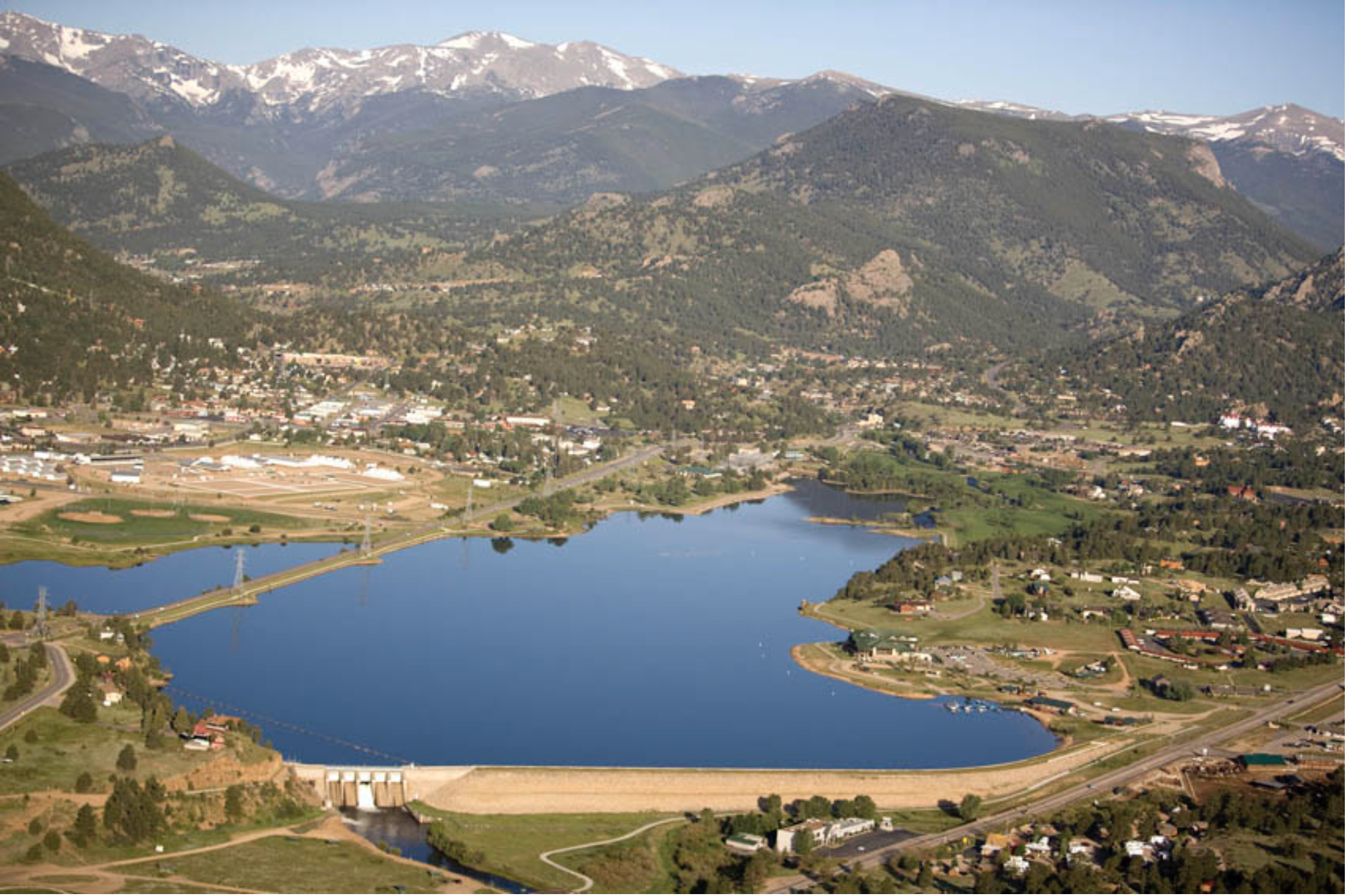
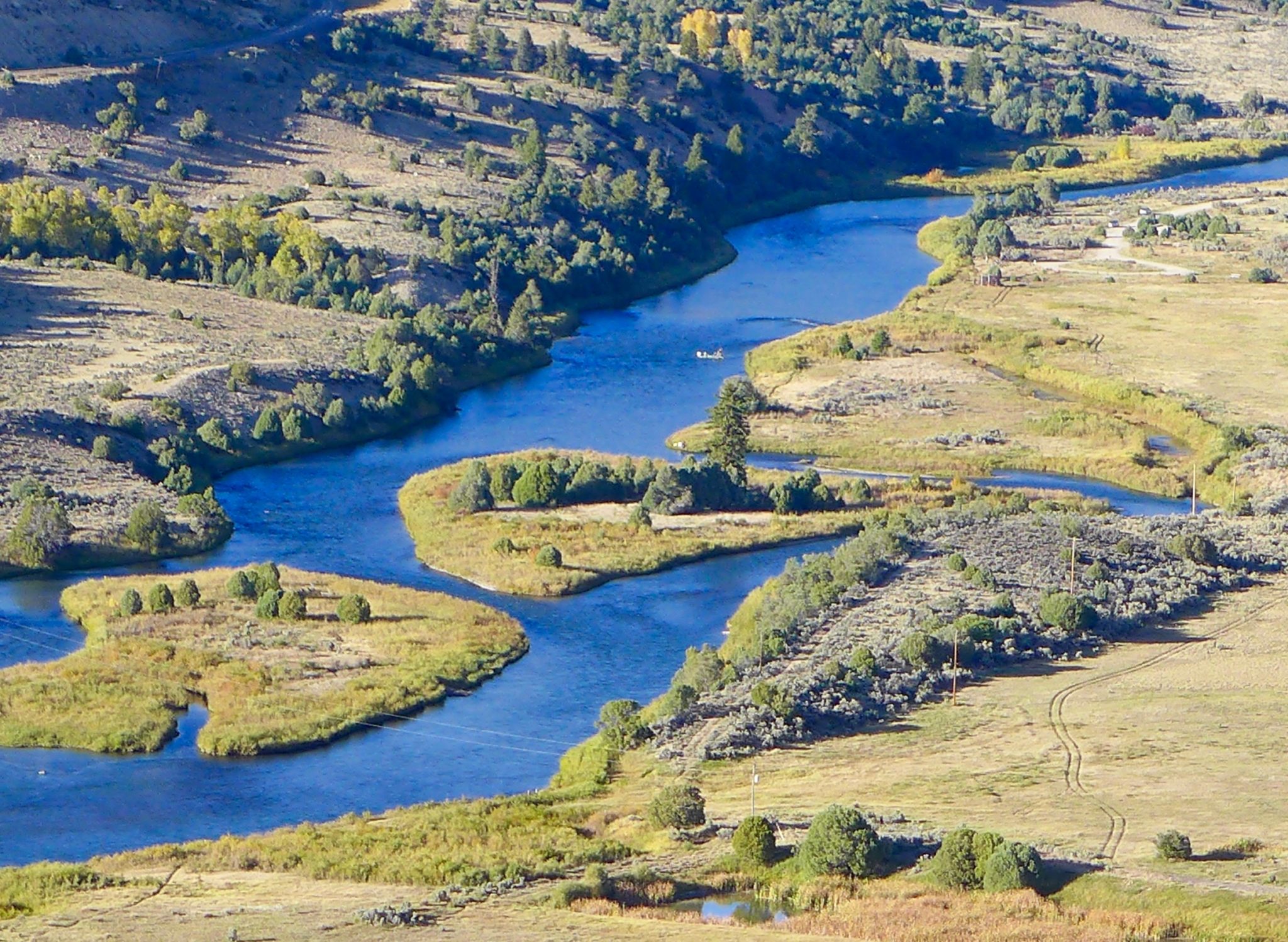
Aerial view of Lake Estes and Olympus Dam looking west. Photo credit Northern Water.
From email from Northern Water (Jeff Stahla):
May 9, 2025
The Northern Water Board of Directors allocated 23,000 acre-feet of Regional Pool Program (RPP) water during its May 8, 2025, Board meeting. RPP water is available for lease by eligible Northern Colorado water users, with sealed bids due 2 p.m. May 22, 2025. Bid prices per-acre-foot must be greater than or equal to $33.80, a floor price the Board selected based on the 2025 agricultural assessment rate. Late bids will not be considered.
The allocation will be available to bidders from two subpools of 11,500 acre-feet each; one that delivers water from Horsetooth Reservoir, and a second that delivers to water users south of Horsetooth Reservoir, including the Big Thompson River, St Vrain Creek and Boulder Creek.
The following forms are required to submit a bid:
Pre-Approval Form – To confirm eligibility, interested bidders must email or mail the Pre-Approval Form to Northern Water. A new Pre-Approval Form is required each year.
Carrier Consent Form – If the RPP water will be delivered by a carrier, such as a ditch or reservoir company, bidders and their carriers must complete the Carrier Consent Form or provide a signed agreement stating that the carrier will deliver the RPP water to the bidder. This form must also be emailed or mailed to Northern Water.
Bid Form – Sealed bids will be accepted at Northern Water’s headquarters through a “self-serve” process. Bidders will sign in at a kiosk in the Building A lobby at Northern Water, 220 Water Ave., Berthoud, and print a bid label for their sealed bid envelope. The label will identify the bidder name, date and time stamp, and bid number. Bidders are then asked to secure the label to the bid envelope and place it in the drop box. Sealed bids may also be mailed to Northern Water, but bids must be received before the deadline.
Sealed bids are due by 2 p.m. Thursday, May 22, at Northern Water’s headquarters, 220 Water Ave., Berthoud, CO 80513. As described above, sealed bids can be mailed or hand delivered; email and fax bid forms will not be accepted. RPP leases within each subpool will be awarded based on highest bids per acre-foot. Sealed bids will be opened at 2:10 p.m. Thursday, May 22, in the Grand Lake Conference Room of Building A at Northern Water.
Questions regarding the Regional Pool Program and bid submittal can be emailed to regionalpool@northernwater.org or by calling Sarah Smith at 970-622-2295 or Water Scheduling at 970-292-2500.
Denver Water is helping ensure its future water security with the Gross Reservoir Expansion Project. When the project is complete, it will nearly triple the Boulder County reservoir’s capacity to 119,000 acre-feet. CREDIT: HEATHER SACKETT/ASPEN JOURNALISM
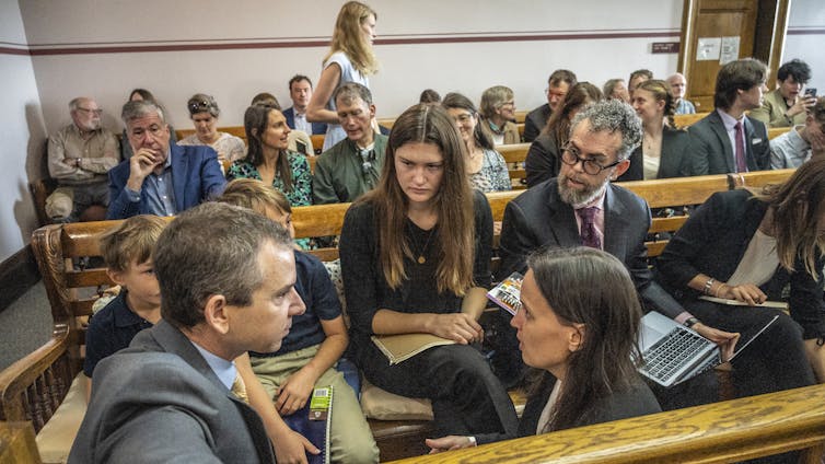
Adam engineer who designed a major expansion of Gross Reservoir Dam in Boulder County told a federal judge Tuesday that the raising of the dam, facing a potential halt due to an April federal court ruling, needs to proceed to protect public safety.
Mike Rogers, the civil engineer who designed the $531 million expansion of the dam, said bad weather could create flood conditions that would lead to a catastrophic failure similar to what occurred with the Oroville Dam failure in California in 2017.
But Stephen Rigbey, a Canadian dam safety expert testifying for Save The Colorado, said any issues with putting the construction project on hold, even in its partially-complete state, could be addressed, and that the risk of a catastrophic failure was “negligible.”
Workers from Denver Water and contractor Kiewit Barnard stand in front of Gross Dam in May 2024 to mark the start of the dam raise process. Photo credit: Denver Water.
Rogers’ and Rigbey’s testimony Tuesday came during a federal hearing in Denver, after which U.S. District Court Judge Christine Arguello will determine whether to allow construction to move forward on the Denver Water project or whether the construction will be paused until new federal reviews she has ordered are completed and legal questions are answered.
But at the end of Tuesday’s hearing, Arguello said the parties to the case had not provided enough information for her to make a decision and ordered them to submit more data later this month.
The massive construction project has raised fierce opposition in Boulder County and prompted several legal challenges from Save The Colorado, a group that advocates on behalf of rivers. Though its early lawsuits failed, in 2022 the river defenders won an appeal that put the legal battle back in play. Despite months of settlement talks, no agreement was reached.
Boulder County Commissioner Ashley Stolzmann was unmoved by Rogers’ testimony, saying she hopes the judge halts the work to prevent further environmental damage in Boulder County and to protect the Fraser River, a tributary to the Upper Colorado River. The Fraser has served as the source of water for Gross Reservoir since the 1950s, when it was built.
“It’s incredibly disappointing that Denver has chosen to move forward,” Stolzmann said. “With climate change, it really is a time for different entities to work together to repair the climate. I want to see Denver seek alternative solutions.”
Denver Water first moved to raise Gross Dam more than 20 years ago when the water provider began designing the expansion and seeking the necessary federal and state permits. Denver Water has said raising the dam and expanding the reservoir is necessary to ensure it has enough water throughout its delivery system and to help with future water supplies as climate change continues to reduce streamflows.
The Gross Reservoir Expansion Project involves raising the height of the existing dam by 131 feet. The dam will be built out and will have “steps” made of roller-compacted concrete to reach the new height. Image credit: Denver Water
After years of engineering, environmental studies and federal and state analyses, Denver received a permit from the U.S. Army Corps of Engineers and construction began in 2022. It has involved taking apart a portion of the original dam and raising its height by 131 feet to nearly triple the reservoir’s storage capacity to 119,000 acre-feet from 42,000 acre-feet.
The case took center stage again April 3, when Judge Arguello put a temporary halt to construction of the higher dam, at Save The Colorado’s request.
In that high-profile ruling, Arguello said, in part, that the Army Corps should have considered whether ongoing climate change and drought would leave the Colorado River and Western Slope waterways too depleted to safely allow transfer of Denver Water’s rights into a larger Gross Reservoir for Front Range water users.
At the same time, she ordered a permanent injunction prohibiting enlargement of the reservoir, including tree removal and water diversion, and impacts to wildlife.
Almost immediately, Denver Water filed for temporary relief from the order, saying, in part, that it would be unsafe to stop work as the incomplete concrete walls towered above Gross Reservoir.
Arguello granted that request, too, allowing Denver to continue work on the dam considered necessary for safety.
Denver Water has also filed an appeal with the U.S. 10th Circuit Court of appeals, seeking to permanently protect its right to continue building the dam. The appeals court is expected to wait for the lower court to rule, before considering Denver Water’s request.
Udall/Overpeck 4-panel Figure Colorado River temperature/precipitation/natural flows with trend. Lake Mead and Lake Powell storage. Updated through Water Year 2024. Credit: Brad Udall
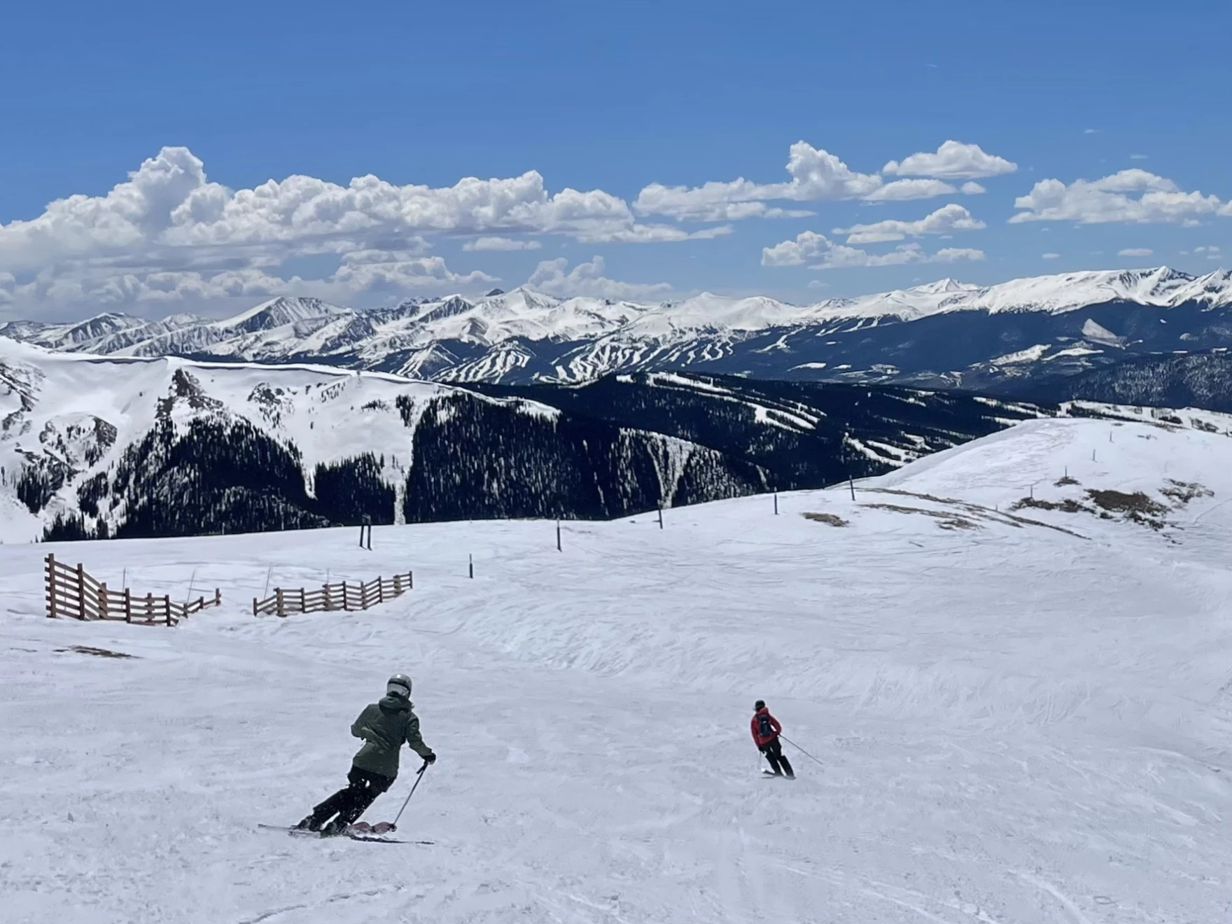
Skiers descend Arapahoe Basin Ski Area in Colorado on May 4, 2025. Snowpack across the mountains that supply the Colorado River is far below normal for this time of year. Forecasts call for 55% of average runoff into Lake Powell, the nation’s second-largest reservoir. Alex Hager/KUNC
Click the link to read the article on the KUNC website (Alex Hager):
May 8, 2025
This story is part of ongoing coverage of the Colorado River, produced by KUNC and supported by the Walton Family Foundation. KUNC is solely responsible for its editorial coverage.
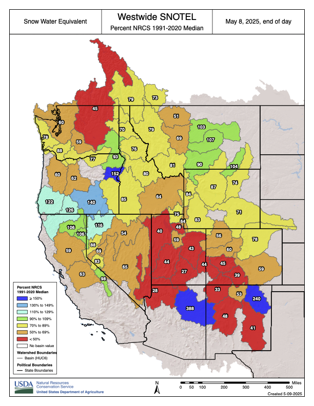
If you took a look at a map of Rocky Mountain snow right now you would see a lot of red.
The mountains that feed the Colorado River with snowmelt are strikingly dry, with many ranges holding less than 50% of their average snow for this time of year. The low totals could spell trouble for the nation’s largest reservoirs, but those dry conditions don’t seem to be ringing alarm bells for Colorado River policymakers.
Inflows to Lake Powell, the nation’s second largest reservoir, are expected to be 55% of average this year, according to federal data released this week. If forecasts hold true, 2025 would see the third-lowest amount of water added to Lake Powell in the past decade.
Westwide SNOTEL basin-filled map May 8, 2025 via the NRCS.
“It’s looking like a pretty poor water supply and spring runoff season,” said Cody Moser, a hydrologist with the Colorado River Basin Forecast Center.
If Lake Powell drops too low, the reservoir would lose the ability to generate hydropower for about five million people across seven states. Much lower, and it could lose the ability to pass enough water downstream, where tens of millions of people depend on it.
Eric Balken, who watches Lake Powell closely as director of the nonprofit Glen Canyon Institute, said this year’s snow data is concerning, but it isn’t driving the same level of concern from policymakers and media outlets that emerged in previous dry years.
Balken said that may be happening for two reasons.
First, it’s because negative outcomes might not be felt immediately. Lake Powell is unlikely to drop low enough to lose hydropower capabilities this summer, but the dry spring is making that more likely to happen in 2026.
Second, it’s because water managers simply have bigger fish to fry.
The federal offices that manage Western water are in disarray amid layoffs and restructuring since Donald Trump returned to the White House. The Bureau of Reclamation, the top federal agency for Colorado River dams and reservoirs, is without a permanent commissioner.
All the while, state and federal policymakers are spending most of their time and attention on drawing up new water-sharing rules. The current rules expire in 2026. Talks between states have reached a standstill, and negotiators say they’re working toward a compromise.
“That chaos within the agencies, the broader negotiations happening on the Colorado River, all of these other factors, I think, are sort of drowning out the severity of the drought situation right now,” said Balken.
Glen Canyon Dam creates water storage on the Colorado River in Lake Powell. Low water levels in Lake Powell could jeopardize the dam’s ability to produce hydropower or pass water downstream. Credit: U.S. Bureau of Reclamation
This year got off to a strong start for mountain snow, but took a dip during a dry spell that lasted from December through February. Snowmelt from Colorado accounts for about two-thirds of the water in Lake Powell. A portion of Western Colorado saw less than 15% of normal precipitation from December through April.
Scientists say these low snow years are the result of climate change, which is causing less snow to fall, and more of it to be soaked up by dry, thirsty soil before it has a chance to reach rivers and reservoirs. That has left the Colorado River in a dry trend going back more than two decades.
Balken said the climate reality is here to stay, and should spur the region’s leaders to rein in demand accordingly.
“Just because we’ve gotten used to it doesn’t mean that it’s not a problem,” he said. “We have to stay laser focused on what’s happening on the Colorado River, because there are some very big problems that need to be addressed.”
The area around Yuma, Ariz., and California’s Imperial Valley provide roughly 95% of the vegetables available at grocery stores in the United States during winter months. February 2017 photo/Allen Best
From the sprawling alfalfa fields of the Imperial Valley to the lush, water-guzzling grass of cities like Phoenix, the definition of what the feds consider “beneficial use” along the Colorado River needs an update, according to a coalition of nonprofits. In a legal petition filed Tuesday, the Natural Resources Defense Council and a group of river advocates urged the federal Bureau of Reclamation to use its power to better dictate how water can be used in the Lower Basin states of Nevada, California and Arizona. Its authors acknowledge that’s a bold request…As states remain deadlocked on which ones should take cuts in how much water they can use, the agency emphasized in a statement its commitment to “long-term operational agreement for the river after 2026…The petition hinges on Part 417 of federal regulations — a section of code that gives the Bureau of Reclamation the authority over water deliveries to the Lower Basin states, with an obligation to ensure that water use is reasonable. Some worry that if the Bureau of Reclamation took the actions outlined in the petition, it could open the door to even more legal challenges from states and water users, kicking progress on conservation even further down the line when time is a luxury that water managers no longer have…
Gold’s petition specifically calls out the inefficiency of the agricultural sector, where more than half of the river’s water is used every year — far more than city use. The petition says exporting water-intensive crops is “akin to exporting water itself.” California’s Imperial Valley, where farming is a multibillion-dollar industry, receives more water than Los Angeles, Phoenix and Las Vegas combined to grow crops like alfalfa, carrots and lettuce. Gold hopes the feds will use better discretion in choosing which contractors are able to divert water from the river, prioritizing conservation. Some practices, like using flood agriculture to cover fields in water, are not practical, especially on days that break 100 degrees, he said.
Yampa River May 3, 2025. Yampa River on Saturday evening was flowing strongly through Steamboat Springs, but the snowpack in the the Yampa-White drainage area of northwest Colorado was still less than two-thirds of average. Photo credit: Allen Best
Click the link to read the article on the Big Pivots website (Allen Best):
May 6, 2025
Colorado’s southern mountains had another miserable snowpack. This is not good for the Colorado or Rio Grande rivers. It fits in with a theme.
Louis Meyer awoke on Monday morning at his farm about 10 miles north of Durango to see Engineer and Red mountains wearing fresh blankets of snow. The two mountains had been scantily clad for much of the winter.
The spring snow was welcome news, he said, but unlikely to change the story of southwest Colorado. Runoff will be abysmal.
A resident of southwest Colorado for about eight years, Meyer has conferred with others with deeper local knowledge. Right now, it appears that those farmers and ranchers who might normally expect to get three or four cuttings of hay will get no more than two. And in La Plata County, they will be lucky to get one cutting of hay.
Snow contributing water to the Animas, San Juan and other rivers of southwestern Colorado have only 28% of median of snow-water equivalent, according to maps released on Monday by the Natural Resources Conservation Service, a federal agency.
East of Wolf Creek Pass, in the upper Rio Grande drainage, numbers were worse yet, 21% of median. Last week, before the fresh snow, they had been even less.
Water managers in the San Luis Valley warned in a May 1 posting on Facebook that they expect early runoff, low rivers flows, and a short boating season. Heather Dutton, manager of the San Luis Valley Water Conservancy District, said there had been high hopes several times of 16- to 18-inch snow dumps, even 36 inches. “It just never materialized for us.”
Snowpack in Colorado’s southern mountains always has been uneven. Some years are better, other years worse. But a trend has emerged of earlier springs and less moisture in the San Juan Mountains and Sangre de Cristo Range of Colorado, and this year’s snowpack and weather fits in with it.
Russ Schumacher, the Colorado state climatologist, and associates at the Colorado Climate Center have analyzed data from the Snotel stations in Colorado going back to at least 1979. Their studies have focused on the volumes of peak snow-water equivalent in the snow and the dates of those readings.
Snotel stands for SNOwpack TELemetry, an automated system.
“In Colorado’s northern mountains, trends over the last 45 years are fairly modest overall, with some mixed signals,” he wrote in in an April 14 posting at Colorado Climate Center.
Many stations in the San Juans and Sangre de Cristo mountains showed levels below the 10th percentile of records, he said.
“But in the southern mountains, the data make a very clear statement: snowpack is declining, and the peak is happening earlier. At many of the stations in the San Juan and Sangre de Cristo mountains, the peak snow-water-equivalent has declined by 3% to 5% per decade, and the peak has shifted two to four weeks earlier.”
The 1980s were unusually wet, which makes the recent declines look even worse. Contributing to the declines have been dust-on-snow events and the rising temperatures.
During the 21st century, Colorado has had just one year of below-average annual temperatures when compared to the 1971-2000 average, according to a study commissioned by the state government. Seven of the top 10 hottest years on record have occurred since 2010.
Colorado’s northern mountains looked somewhat below average as of early April. But unseasonably warm temperatures caused the snowpack to sag as the month went on.
“It was clear by early April that it was going to be a bad year in southern Colorado,” Schumacher wrote to Big Pivots in an e -mail on April 29. “But with very little snow and a lot of sunshine in the last couple weeks, snowpack in the northern mountains has started declining early as well.”
The Natural Resources Conservation Service Snotel readings on Monday morning showed improvement after an overnight snowfall but remained far below average.
Snow was notably absent in Colorado’s southern mountains this winter. It started out OK, then got warm and dry. By late January, the odds were for a very poor runoff.
A Snotel station near Wolf Creek Pass had the second lowest peak snow-water equivalent since the station was established in 1979. The lowest reading was in 2002. This was even less than in 2018, a year plagued by wildfires in southern Colorado.
At his farm along the Animas River, Meyer first noticed a problem in February. The well that taps water for domestic purposes went dry. The water table had dropped 35 feet. He persuaded others on the ditch to begin diverting water from the Animas River through the ditch. This caused the groundwater level to rise. It worked, although he was out of water for a week to 10 days.
Meyer is relatively new to southwest Colorado but not to Colorado water issues. An engineer by training, he operated a Glenwood Springs-based water consulting business for 35 years before he retired. He then bought ranch property in southwest Colorado near the community of Mancos. After a drought in 2021, he resolved to get a property with better access to water.
The property north of Durango is where the San Juan Mountains begin to pinch the Animas River Valley. The farm he and his children tend has plentiful orchards: peaches, apples, and pears. They also grow cherries and plums along with raspberries, strawberries and blackberries.
Family members also like to raft, but on Sunday found too little water to do so.
At his office in Cortez, Ken Curtis, director of the Dolores Water Conservancy District, has been monitoring the snowpack numbers. In late April they suggested a runoff of 30% of average. Because his district owns more senior water rights, the farmers of alfalfa, pinto beans and other crops in his district will probably do better than that might suggest.
“It’s been a weird year,” he said. “We are definitely going to have a shortage.”
The good news he reported was the relative absence of dust-on-snow, a phenomenon that warms the snow more rapidly and causes faster melting.
This was the eighth or ninth year out of the last 15 that the runoff from the winter snowpack has been on the low side.
Cortez lies amid the remains of the Ancestral Pueblo, known colloquially as the Anasazi. Because of a multi-decade drought about 1200, they abandoned their cliff dwellings and took up homes along the Rio Grande to the east.
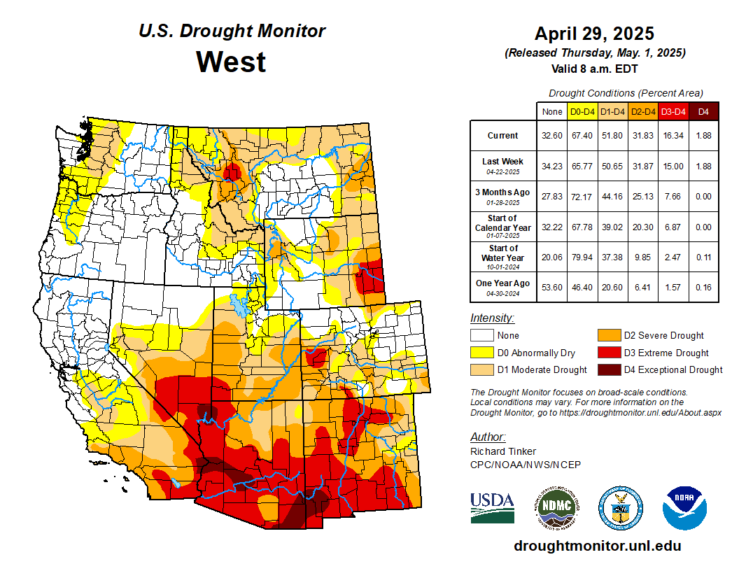
West Drought Monitor map April 29, 2025.
At least part of this drought is something different, the result of rising temperatures created by accumulating greenhouse gases. The process is called aridification, and scientists since about 2017 have conducted studies that convincingly demonstrate that it is responsible for roughly half of declined flows. Drought may go away, but human-caused aridification will not any time soon.
The Colorado River during the last 25 years has yielded significantly less water than the 20th century average — and even less than delegates from the seven basin states assumed when they drew up the Colorado River Compact in 1922.
The states, divided into the upper and lower basins, have been trying to come to grips with the new realities of the 21st century for most of the century. Results have been uneven.
First California and then Arizona gulped waters from the river with giant diversion projects. Colorado but especially other basin states were slower to put straws into the river and they have also been smaller straws.
Who should cut back given the clear evidence for need? At his farm near Durango, Meyer thinks that Colorado must recognize it needs to cut back somewhat in line with what Arizona and California have agreed to do.
Runoff into Lake Powell during March 2as 61% of average. The reservoir is 31.4% full, far better than in 2022, when capacity dipped to below 23% of capacity. Runoff in the last couple of years has been at least okay. This year’s runoff will be a stern reminder that new agreements must be hammered out.
On April 25, water journalist and author John Fleck and four collaborators – including Anne Castle and Eric Kuhn of Colorado – issued a short paper that outlined what they said are the seven essential pillars for post-2026 management of the Colorado River. The first calls for enforceable reductions in water use in both the Upper and Lower Basin.
The compact assumed far more water than occurred in the 20th century, but that faulty assumption was tolerable until the 1990s, when the Central Arizona Project withdrawals began. Then came the drought and aridification of the 21st century. The river that delivered 14.5 million acre-feet (unlike the 20 million acre-feet that was assumed) was in trouble.
Colorado, to a small extent, but Wyoming and Utah especially, had not been using the amount of water that was assumed by the compacts. California and Arizona had been – and then some.
In recent years, California and Arizona have cut back their use of the Colorado River dramatically. The argument made by Castle and Kuhn as well as the others is that there must be shared pain in reduced wager use. That runs counter to the official stance of Colorado and other basin states that it’s a lower-basin problem.
“Shared pain is also critical to inducing the various states not to litigate over the interpretation of the 1922 Compact,” they wrote. “Shared does not mean equal, either in amount, triggers or duration,” they added.
They also say that reductions in water use cannot be predicated on federal compensation, as was important in enabling Arizona and California to reduce their flows during the last few years.
Kuhn was the long-time general manager of the Colorado River Water Conservation District in Glenwood Springs, and Castle, an attorney who specialized in water, was undersecretary for Water and Science in the Interior Department during the Obama administration. She is now with the Getches-Wilkinson Center at the University of Colorado Law School.
Udall/Overpeck 4-panel Figure Colorado River temperature/precipitation/natural flows with trend. Lake Mead and Lake Powell storage. Updated through Water Year 2024. Credit: Brad Udall
From email from the Upper Gunnison River Water Conservancy District (Sue Uerling):
Please see the attached notice for the May Upper Gunnison River Water Conservancy District and Lake San Cristobal Water Activity Enterprise Meetings in Lake City, Colorado on Tuesday, May 20th, 2025 with lunch beginning at noon. If you would like to join the meeting via Zoom, please use the following link to pre-register for the meeting:
Click the link to read the article on the Alamosa Citizen website (Heather Dutton and Daniel Boyes):
May 2, 2025
San Luis Valley water managers have reviewed streamflow forecasts, available water stored in reservoirs, and anticipated reservoir operations for the 2025 spring, summer, and fall seasons, and determined that 2025 will likely be a year with early runoff, low flows in streams and rivers, and a short boating season.
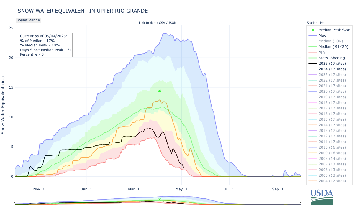
The Colorado Division of Water Resources Division 3 Engineer’s March 31 10-day report forecasted the total annual flow at the Del Norte gage will be 390,000 acre-feet. For reference, the flows in 2020 totaled 377,000 acre-feet. The National Weather Service is forecasting hot and dry conditions into July, with chances of a normal monsoon season in late summer. The snow water equivalent for the Upper Rio Grande Basin was 25 percent of the median for the 1991-2020 time period on April 28, 2025. The irrigation season began on April 1 on the Rio Grande. As such, on-stream reservoirs are required to pass all inflows to satisfy the needs of downstream senior water rights holders.
Given the low amount of snow remaining in the mountains and the anticipated summer drought conditions, it is likely that local rivers and streams will reach their peak runoff in May. The reservoir operators at Rio Grande, Santa Maria, and Continental Reservoirs will begin releasing stored irrigation water to downstream farmers after the river peaks. The San Luis Valley Irrigation District (SLVID) will release water from Rio Grande Reservoir to the Farmers Union Canal as soon as their first direct flow priorities come into priority on the Rio Grande at anticipated rates of 150-400 cubic feet per second for up to 15 days.
Rio Grande. Photo Credit: The Citizen
This schedule will be updated through May as river conditions change.
The Santa Maria Reservoir Company anticipates beginning releases from Santa Maria and Continental Reservoirs to the Rio Grande Canal and Monte Vista Canal in late May or early June. The timing of the releases of water will depend on flow rates in the canals and when farmers order water. The natural river flows and releases of irrigation water will provide the highest rates of flow during the summer season. As such, boatable flows on the Rio Grande may diminish as early as mid to late June.
Entities including Colorado Parks and Wildlife (CPW), the San Luis Valley Water Conservancy District (SLVWCD), and the Rio Grande Water Conservation District (RGWCD) store water in reservoirs in the Upper Rio Grande Basin and call for releases for their operations in accordance with their water rights decrees. Where possible, releases by these organizations will be prioritized during hot periods to supplement the natural flow of the Rio Grande helping to reduce high water temperatures and low river flows, thereby protecting the health of fish. Generally, when water temperatures reach 68 degrees, fish become very stressed and voluntary fishing restrictions are enacted at 72 degrees. Stakeholders will watch temperatures on the Rio Grande and the South Fork of the Rio Grande carefully and take action to release water where possible.
The water managers and reservoir operators in the Rio Grande Basin are working in partnership to manage water in order to meet multiple needs. These efforts build off of many years of collaboration amongst water users on the Rio Grande. In order to better inform the local communities of water management operations, additional information will be compiled and shared via news outlets, social media, and email as reservoir releases are planned and executed.
Dusk falls on Lake Powell near Bullfrog Marina on July 15, 2024. A new letter from water policy experts gives negotiators some recommendations on how to sustainably manage the Colorado River in the future. Alex Hager/KUNC
Click the link to read the article on the KUNC website (Alex Hager):
May 3, 2025
This story is part of ongoing coverage of the Colorado River, produced by KUNC in Colorado and supported by the Walton Family Foundation. KUNC is solely responsible for its editorial coverage.
The seven states that use the Colorado River are deadlocked about how to share it in the future. The current rules for dividing its shrinking supplies expire in 2026. State leaders are under pressure to propose a new sharing agreement urgently, so they can finish environmental paperwork before that deadline.
Right now, they don’t appear close to an agreement, so a group of prominent Colorado River experts co-signed a letter outlining seven things they want to see in the next set of rules.
The letter gives a clear, concise list of recommendations for ways to keep taps flowing while protecting tribes and the environment. Whether the states will listen is another matter entirely.
‘Shared pain’
The letter, written by a group of academics and retired policymakers, makes no bones about it: states need to find a collective solution to their collective problem. And some of them might not be happy.
State leaders have been reluctant to volunteer cutbacks, and have largely stayed divided along a decades-old fault line. On one side, the Upper Basin – which consists of Colorado, Utah, Wyoming and New Mexico. The other side, the Lower Basin, is made up of California, Arizona and Nevada.
The recent letter is interesting in part because it’s co-authored by people from both sides of the Colorado River debate. Eric Kuhn led an agency that defends Western Colorado’s water. Kathryn Sorensen led Phoenix’s water department.
The letter was also written by Anne Castle, who has worked in federal water policy positions, and Jack Schmidt, a water researcher at Utah State University. Co-authors John Fleck and Katherine Tara research water policy at the University of New Mexico.
The authors write that states need to engage in some level of “shared pain,” meaning cutbacks to the amount of water that flows to farms, homes, and businesses.
“‘Shared’,” the letter writes, “Does not mean equal, either in amount, triggers, or duration.”
Water from the Colorado River flows through the East Highline Canal on its way to farms in the Imperial Valley on June 20, 2023. The Colorado River’s single largest user has taken federal money through incentive programs to cut back on water use. Alex Hager/KUNC
The Lower Basin states have already proposed relatively modest cutbacks, and the Upper Basin seems to be digging in its heels on the idea that they should not have to give up any water at all.
This letter pushes back on that stance.
“There’s lots of wonderful legal arguments about why it shouldn’t be me that needs to use less water,” Anne Castle, one of the letter’s authors, told KUNC. “But in order to have a viable and politically viable agreement, everybody has to do a share.”
Other recommendations
In addition to calling for states to put their heads together, the authors also warned against leaning too hard on federal checks as a way to conserve water. Money from the federal government has been a key part of avoiding catastrophe on the Colorado River in recent years. Hundreds of millions of dollars have gone to big water users, often farmers, as an incentive to use less water.
Those funds have come under threat during President Donald Trump’s second term. The letter says new rules for the Colorado River “cannot assume that federal taxpayers will reimburse Western water users over the long term to forgo the use of water that does not exist.”
The letter goes on to advocate for groups that can sometimes be an afterthought in Western water policy. It essentially re-ups an earlier call from a group of tribes in the Colorado River basin, which are asking for a bigger seat at the table after more than a century of exclusion. It also pushes for new rules to be more flexible, which would make it easier to protect river ecosystems. That mirrors similar comments from a group of nonprofits.
The shortest and final recommendation in the letter says that any new Colorado River rules have to make sure there’s enough water to keep people safe and healthy.
“There must be absolute protection of domestic water deliveries for public health and safety,” it reads.
In short, it’s asking to make sure that a worst-case-scenario doesn’t see drinking water reserves go dry, while agriculture and other industries keep their faucets flowing.
“I don’t think that would happen,” Castle said. “I think the market would intervene and take care of this situation.”
The reaction
KUNC reached out to top water negotiators in Arizona and Colorado for this story. Their answers fell in line with oft-repeated talking points from each basin.
A spokesman for the Arizona Department of Water Resources wrote that its director, Tom Buschatzke, “agreed with the authors that ‘every state and sector of the economy must contribute to the solution to this imbalance.’”
Water policymakers from (left to right) Utah, New Mexico, Colorado and Wyoming speak on a panel at the Colorado River Water Users Association conference in Las Vegas on December 5, 2024. The Upper Basin states have been reluctant to volunteer cutbacks ahead of the next set of river-sharing rules. Alex Hager/KUNC
Colorado’s top water official, Becky Mitchell, wrote that the recommendations overlooked climate change’s impact on Upper Basin water supplies, and that states already take “mandatory and uncompensated” cuts.
“Colorado water users do not enjoy a guaranteed delivery of the full amount of their water rights each year,” she wrote.
Jennifer Gimbel, Colorado’s former top water official, did not contribute to the letter and also took issue with the suggestion that both basins could afford to make cutbacks.
“Are the authors of the paper thinking that federal law should be enacted to override state law?” Gimbel wrote to KUNC in an email. “Are they thinking that users in the Upper Basin, who they say should not rely on federal compensation, should just give up their livelihoods voluntarily or be compensated by the state legislatures? I don’t know because they don’t say.”
Udall/Overpeck 4-panel Figure Colorado River temperature/precipitation/natural flows with trend. Lake Mead and Lake Powell storage. Updated through Water Year 2024. Credit: Brad Udall
Click the link to read the article on the InkStain website (John Fleck):
April 25, 2025
A group* of my Colorado River collaborators has put together what we hope can be a useful set of foundational principles as the basin states and federal leadership search for a path toward a negotiated agreement for post-2026 Colorado River management. They’re based on a number of key premises:
The Colorado River Compact will remain the foundation of the river’s management, but we have to find a way past the deep disagreement between Upper and Lower basin states on what the Compact actually says.
Colorado River Basin tribes must be essential partners in crafting the next set of guidelines, including through compensation for foregone water use.
Shared pain is essential. The path toward a sustainable river system requires everyone to contribute to the solution to the problem of the river we all share.
Clarence King; Camp near Salt Lake City, Utah. The exploration of the Survey of the Fortieth Parallel. Photo by Timothy H. O’Sullivan, October 1868. By Timothy H. O’Sullivan – Davis, Keith F., Timothy H. O'Sullivan, Jane Lee Aspinwall, François Brunet, John P. Herron, Mark Klett, and Julián Zugazagoitia. Timothy H. O'Sullivan: The King Survey Photographs. Yale University Press Mass. Published:2011., Public Domain, https://commons.wikimedia.org/w/index.php?curid=56679730
For several years I served on the board of a rural school district, and every year, when our draft budget was presented at our monthly public meeting, the audience would fill with people concerned about higher taxes. Seniors on fixed incomes spoke about the precarity of their budgets, while people of significantly greater means railed against “irresponsible” spending. As a board, we were trying to keep class sizes small enough for good learning outcomes and to avoid having to cut art and music and Spanish classes. I typically let the more senior board members handle the tough questions, but one year, as a young mom, I felt compelled to speak on behalf of the intergenerational social contract: the idea that when we were in school, we benefited from the investment of the generations before us, and it is therefore our moral obligation as adults today to invest in schools for the generations coming after us.
The intergenerational social contract is an old idea, far older than the U.S. government, Social Security and Medicare. It is not about entitlement. It’s about intergenerational caretaking — the recognition that there are no isolated moments of history, that we are obliged to pass on a world of hope and possibility to future generations. Indigenous communities have always understood this, which is why traditional ecological knowledge is increasingly being looked to for ways of managing the land for long-term health and sustainability. It’s a line of thinking that respects, and assumes a responsibility to, future inhabitants of Earth.
The intergenerational social contract also applies to public lands. Land-management agencies in the U.S., including the Bureau of Land Management, Department of the Interior and the Forest Service, have a legal responsibility to manage lands and resources with the future in mind. The words “to the benefit of present and future generations” are all over the charters and laws governing these agencies. Current proposals to sell off public land are not only a blatant violation of the social contract, but a violation of the very idea of public land. Transferring a public good into private hands is a crime against future generations.
The reckless actions of the Department of Government Efficiency (DOGE), as charted by Jonathan Thompson in this issue, are another blatant assault on the public good, slashing budgets for public land and firing its caretakers. Cutting funds for cancer and climate research is an assault on present and future generations, as is defanging the Endangered Species Act and the National Environmental Policy Act. This activity should be considered un-American: enriching the wealthiest while stealing from the everyday Americans of today, tomorrow and as long as our republic shall stand.
Young Montanans, including Rikki Held, center, sued their state government and won a key ruling forcing the state government to consider greenhouse gas emissions when reviewing proposed development projects. William Campbell/Getty Images
An ancient legal principle has become a key strategy of American children seeking to reduce the effects of climate change in the 21st century. A defeat at the U.S. Supreme Court in March 2025 has not stopped the effort, which has several legal actions continuing in the courts.
The legal basis for these cases is called the “public trust doctrine,” the principle that certain natural resources – historically, navigable waters such as lakes, rivers and streams and the lands under them – must be maintained in government ownership and held in trust for present and future generations of the public.
For the past decade, a nonprofit called Our Children’s Trust has argued for a 21st-century interpretation of the public trust doctrine to support lawsuits against state and federal agencies and officials, seeking to force them to take specific actions to fight climate change. Our Children’s Trust has focused on children, saying they are particularly vulnerable to the effects of climate change because their futures, which the public trust doctrine protects, will be lived in an unsafe and unhealthy climate unless governments take action. Children around the world have filed similar lawsuits against their governments on alternate legal grounds, including claims of constitutional and human rights violations.
Initial uses of the public trust doctrine in the US
The U.S. Supreme Court first endorsed the public trust doctrine in 1892, when it ruled that the doctrine prevented the Illinois legislature from selling virtually the entire Chicago harbor in Lake Michigan to a private railroad company. In the 20th century, state courts have ruled that the doctrine bars states and local governments from selling off lakefront property or harbors to private owners and protects public access to beaches, lakes and oceans.
The public trust doctrine had little to do with environmental protection until the 1970s, however, after law professor Joseph Sax wrote an influential article arguing that the doctrine could form the basis for lawsuits to protect water and other natural resources from pollution, destruction and other threats.
Over the past five decades, some states’ courts have expanded the public trust doctrine’s application beyond access to water-based resources, ruling it can also require governments to protect parks and wildlife from development. And Montana, Minnesota and several other states followed Sax’s recommendation to pass laws or amend their state constitutions to impose broader obligations on states to protect natural resources.
In 2011, Our Children’s Trust argued for the first time that governments had a legal obligation to protect the atmosphere as a public trust resource. The group filed lawsuits in all 50 states on behalf of children. Most state courts dismissed the lawsuits quickly, holding that there were no court decisions in their states that supported extending the public trust doctrine to claims involving the climate or the atmosphere.
In 2015 the group filed a similar lawsuit in federal court in Oregon, this time against the federal government. That lawsuit, Juliana v. United States, alleged that the federal government’s inaction to address climate change violated the public trust doctrine as well as the 21 young plaintiffs’ rights to life, liberty and property under the U.S. Constitution.
The plaintiffs asked the court to order the federal government to prepare an inventory of U.S. carbon dioxide emissions and to implement a national plan to phase out fossil fuels to “stabilize the climate system and protect the vital resources on which Plaintiffs now and in the future will depend.”
Since the initial wave of litigation, Our Children’s Trust has continued to file lawsuits to force governments to address climate change. These newer ones are more narrowly tailored to state-specific constitutional and statutory provisions that protect environmental and public trust resources. And, so far, they have been more successful.
The plaintiffs won at trial, and in a landmark opinion in 2024 the Montana Supreme Court upheld the trial court’s finding that greenhouse gases were harmful to the state’s “climate, rivers, lakes, groundwater, atmospheric waters, forests, glaciers, fish, wildlife, air quality, and ecosystem.” The court similarly found that “a stable climate system … is clearly within the object and true principles” of the state’s constitution.
Children in Hawaii filed a similar lawsuit in 2022 against the state Department of Transportation, alleging that its failure to reduce transportation emissions in the state violated the state public trust doctrine and the state’s constitution. The lawsuit relied on Hawaii courts’ previous rulings that the state’s public trust doctrine and state constitution broadly protect natural resources for present and future generations. In 2024, days before trial was to begin, the parties reached a landmark settlement in which the state agreed to take concrete actions to significantly reduce greenhouse gas emissions from the transportation sector. https://www.youtube.com/embed/VjHqeNB89L0?wmode=transparent&start=0 In the Montana lawsuit, a U.S. court ruled that the government had failed to protect the rights of children by failing to take action to reduce or prevent climate change.
The road ahead
Looking back, it was perhaps not surprising that a one-size-fits-all nationwide legal strategy based on a doctrine that varies widely state by state would face long odds. But the public trust doctrine itself has been historically incremental, expanding and contracting as society and the needs of its citizens change over time. And Our Children’s Trust has several cases still pending, including in Alaska and Utah state courts, and in a federal court in California.
The campaign’s successes broke new legal ground: Montana courts held the first trial in the United States that examined evidence of the effects of climate change and states’ obligations to address them. The Hawaii settlement set concrete benchmarks and included provisions for continued feedback on state policies by the youth plaintiffs.
More broadly, Our Children’s Trust’s campaign demonstrates that a combination of legal advocacy and nationwide publicity over the plight of young people in a rapidly changing climate have the potential to result in real change, both in the law and in public perception of the importance of addressing climate change.
The “Bonita Peak Mining District” superfund site. Map via the Environmental Protection Agency
Click the link to read the article on The Durango Herald website (Reuben M. Schafir) Here’s an excerpt:
April 29, 2025
The Bureau of Land Management is restoring up to 11 cubic feet per second of water previously diverted to the Uncompahgre River Basin back to the headwaters of the Animas River north of Silverton. That’s a win for fish, other aquatic wildlife and mining remediation, said Trout Unlimited’s Mining Coordinator Ty Churchwell, because the water will dilute heavy metals to less toxic concentrations. Both the national organization of Trout Unlimited and the local Five Rivers chapter provided financial assistance with the acquisition. The 11-cubic-foot diversion is about 10% of the river’s total current flows in Silverton before the confluence with Cement Creek…
The previous owner held the rights to divert the water through the Mineral Point Ditch – before it entered Burrows Creek – over into the Uncompahgre Basin for agricultural use. This resulted in a 100% depletion of that water from the Animas River…The BLM paid $297,000 – fair market value – to buy the water right from a willing seller, agency spokeswoman Katie Palubicki said in an email to The Durango Herald, using funding from the Land and Water Conservation Fund and the agency’s Abandoned Mine Lands program to acquire the right.
Click the link to read the article on the KVNF website (Brody Wilson):
April 29, 2025
The Colorado River is the lifeblood of the American Southwest. Forty million people depend on it — not just here in Colorado, but in cities like Phoenix, Las Vegas, and Los Angeles.
Here on the Western Slope, we don’t always feel directly connected to the Colorado River. After all, we live in the Gunnison Basin — a different watershed, right?
Not quite. The Gunnison River contributes about 17% of the Colorado River’s total annual flow. So any decision made about the Colorado River’s future directly affects us — how much water we can use, when, and for what purpose. For decades, the river has been in a slow-moving crisis. Climate change, explosive population growth, and overallocation have pushed the system to the brink. In 2022, the river’s two main reservoirs — Lake Powell and Lake Mead — reached such low levels that hydropower turbines at Glen Canyon Dam were nearly shut down and dam operators were near “dead-pool” where water would no longer be able to pass through the dam. But today, nearly three years later, the system isn’t bouncing back. Andy Mueller, General Manager of the Colorado River District, has a blunt message: the Colorado River is carrying less water than it used to, and if we don’t change course, the future of agriculture, recreation, and the our way of life across the Western Slope could be at risk.
“The average temperature in March has gone up 4.2 degrees Fahrenheit,” Mueller told the crowd in Ridgway. “And for every 1 degree of warming, streamflow drops by 3 to 5 percent. We’re looking at a 20% decline right here in the Uncompahgre Valley over the last 125 years.”
These trends are part of a long-term warming and drying pattern. Less snow is falling, and what does fall melts earlier. That means less water reaches our rivers — and more of it is lost to evaporation or absorbed by plants growing in longer, hotter seasons.
In 1922, Federal and State representatives met for the Colorado River Compact Commission in Santa Fe, New Mexico. Among the attendees were Arthur P. Davis, Director of Reclamation Service, and Herbert Hoover, who at the time, was the Secretary of Commerce. Photo taken November 24, 1922. USBR photo.
To understand what’s happening now, you have to go back to 1922. That’s when the seven states in the Colorado River Basin signed a compact to divide the river’s water. Colorado, New Mexico, Utah, and Wyoming became the “Upper Basin.” California, Arizona, and Nevada formed the “Lower Basin.” Each side was promised 7.5 million acre-feet of water per year. But there was a problem: the river wasn’t carrying that much water — and certainly doesn’t now. For decades, this over-allocation was masked by big reservoirs like Lake Powell and Lake Mead. But as the drought continues, those buffers have disappeared. In 2007, the states and federal government adopted a temporary fix: interim guidelines to manage the system during dry years. Those guidelines are set to expire in 2026. New rules must be negotiated now — and the clock is ticking.
“There’s a lot of confusion out there,” Mueller said. “People talk about renegotiating the Compact — but that’s not what’s happening. The Compact isn’t being touched. What’s being negotiated are the guidelines for how Powell and Mead are operated — especially in times of shortage.”
Udall/Overpeck 4-panel Figure Colorado River temperature/precipitation/natural flows with trend. Lake Mead and Lake Powell storage. Updated through Water Year 2024. Credit: Brad Udall
It’s easy to take for granted the accounting innovations in the Colorado River governance regime’s 2007 guidelines, which have governed river management and the upstream-downstream relationships between the upper and lower basins. “Intentionally Created Surplus” (ICS) is now part of the lexicon, and the idea behind it shows enough promise that it’s at the heart of the current negotiations over the post-’07 guidelines management of the river.
But we need to be careful about the lessons that we learn, and the details of how we implement the successor to ICS. How should the successor to ICS related to action levels for reservoir management? How do we ensure that water in ICS-like accounting pools is really conserved water, part of a sincere effort to reduce basin consumptive use?
Those questions are at the heart of the argument in Floating Pools & Grand Bargains, a new white paper by Kathryn Sorensen from Arizona State University and a group of colleagues, including Eric Kuhn:
As Save the Colorado and Denver Water prepare to face off in a federal courtroom Tuesday, water officials across the state are watching the Gross Dam expansion case closely for its environmental impact and its affect on water projects across the West.
Kirk Klancke, a long-time Grand County environmentalist and president of the Colorado River Headwaters Chapter of Trout Unlimited, said a decision that shuts down the $531 million water project, could also shut down 12 years of work on the Fraser River and its tributaries.
Denver Water is one of 18 partners who signed the Colorado River Cooperative Agreement in 2013, ushering in a new era of cooperation between the utility and West Slope stakeholders, all with the vested interest in protecting watersheds in the Colorado River Basin. As part of that agreement, a process called “Learning by Doing” was created, which has helped the utility stay better connected on river conditions in Grand County. The partnership is a collection of East and West Slope water stakeholders who help identify and find solutions to water issues in Grand County. “Denver Water has been part of Grand County for over 100 years, and we understand the impact our diversions have on the rivers and streams,” said Rachel Badger, environmental planning manager at Denver Water. “Our goal is to manage our water resources as efficiently as possible and be good stewards of the water — and Learning By Doing helps us do that.”
Here’s why: Denver Water owns much of the Fraser with water rights dating back more than 100 years. And it is that water that has historically been piped through the Moffat Tunnel near Rollinsville to fill the existing Gross Reservoir. The new water for the expanded reservoir will come largely from that river as well.
After what’s known as the 2013 Colorado River Cooperative Agreement was signed, Denver Water agreed to conduct extensive restoration work on the river in exchange for being able to raise Gross Dam and bring more water from the Fraser River over to the Front Range.
Klancke said the heavily diverted, scenic waterway would suffer if the deal falls apart. “To dissolve that partnership will be the death of the Fraser River,” he said.
Under the terms of the Colorado River Cooperative Agreement, the work on the Fraser River can only be finalized if the Gross Dam expansion proceeds.
On the upside though, Klancke said, if a new environmental settlement were reached, it could mean more money and more work to restore South Boulder Creek on the other side of the Continental Divide. The creek carries that Fraser River water from the reservoir to Denver Water’s northern storage system.
“I would love to see Denver put a whole bunch of money into South Boulder Creek,” Klancke said.
Gary Wockner, the head of Save The Colorado, disputes the notion that the case could harm environmental work already underway in Grand County.
“We are not causing environmental damage,” he said. “If Denver Water chooses to stop, that’s their choice. That’s on their shoulders. Not ours.”
For its part, Denver says it hopes to continue the Grand County work, but that the terms of the Fraser River agreement are all based on the successful completion of the Gross Dam expansion.
The agency also says it has already set aside $30 million to help offset any environmental harm caused by the massive construction project, including providing 5,000 acre-feet of water to improve streamflows along a 17-mile stretch of South Boulder Creek. An acre-foot of water equals nearly 326,000 gallons, enough water to serve two to four urban households for one year.
Roller-compacted concrete will be placed on top of the existing dam to raise it to a new height of 471 feet. A total of 118 new steps will make up the new dam. Image credit: Denver Water.
Denver Water first moved to raise Gross Dam more than 20 years ago when it began designing the expansion and seeking the necessary federal and state permits.
After years of engineering, studies and federal and state analyses, construction began in 2022. It has involved taking apart a portion of the original dam, built in the 1950s, and raising its height by 131 feet to nearly triple the reservoir’s storage capacity to 119,000 acre-feet from 42,000 acre-feet.
Save The Colorado has launched several unsuccessful challenges to the project, but in 2022 it won an appeal that put the legal battle back in play. Despite months of settlement talks, no agreement was reached.
Then the case took center stage again April 3, when Senior U.S. District Court Judge Christine Arguello put a temporary halt to construction of the higher dam, at Save The Colorado’s request.
Almost immediately, Denver Water filed for temporary relief from the order, saying, in part, that it would be unsafe to stop work as the incomplete concrete walls towered above Gross Reservoir.
Arguello granted that request, too, allowing Denver to continue working on the dam.
Gross Dam case spurred $100 million settlement in a different lawsuit
What happens next is anyone’s guess. Jennifer Gimbel, a water policy scholar at Colorado State University who also serves on Northern Water’s board of directors, said the case has already had an impact on a $2 billion water project to deliver water to residents of fast-growing northern Colorado. The Northern Integrated Supply Project, as it is known, also faced a legal challenge from Save The Colorado, and ultimately the water agency opted to settle the case for $100 million. The cash will help restore the Cache la Poudre River with new diversion agreements and improved streamflows, among other benefits.
Gimbel said the Gross Reservoir case was a key factor in that settlement. “Because of Denver’s troubles with Save the Colorado, Northern Water decided to resolve their lawsuit because they were worried about their own permit getting stale and because as you delay construction costs increase.”
The Gross Dam case is also noteworthy because it has stopped a major construction project already underway and may significantly change it. Judge Arguello has ordered the U.S. Corps of Engineers, the major permitting agency, to redo its original permitting work.
Denver Water General Manager Alan Salazar has said his agency would take the case to the U.S. Supreme Court, if they lose in the lower courts.
As both sides prepare for Tuesday’s hearing, the 10th Circuit Court of Appeals panel has said it will wait to see what information emerges from the Tuesday hearing before it rules on Denver Water’s appeal before the 10th Circuit, according to Denver Water General Counsel Jessica Brody. That action seeks to permanently protect what Denver believes is its right to raise Gross Dam.
Denver Water has also raised national security concerns in the case because Save The Colorado has asked and been granted the right to review construction documents on the dam project, documents that would normally be kept from public view.
In response, the judge has told participants to expect the court to be closed periodically during the hearing to address those security concerns.
What’s 4-feet deep, 6-feet wide and 26-miles long? The original City Ditch — one of Colorado’s earliest and most influential irrigation canals, constructed between 1864 and 1867 by the Capitol Hydraulic Company to bring much-needed water to the dry, dusty lands of the Denver metropolitan area. This hand-dug canal, also known as Smith’s Ditch, was engineered by Richard S. Little and financed by businessman John W. Smith, according to local historian Larry Borger. It stretched from its headgate near present-day Chatfield Reservoir, above Littleton, and ran roughly 26-to-27 miles northeast to Capitol Hill in Denver, relying solely on a 100-foot drop in elevation to move water without pumps. When it opened in 1867, the ditch enabled the growth of trees, sugar beet crops and neighborhoods, providing Denver with its primary irrigation source for more than 25 years. The ditch also supported a network of more than 1,000 lateral ditches, greening up city parks and supplying water to offshoots that irrigated cropland and street trees. Its construction and operation were so significant that the ditch is often called the “oldest working thing” in Denver, predating paved streets and railroads. Today, the City Ditch is mostly hidden from view. About 2.5 miles of the ditch remain open-channel, while the rest is mostly piped and buried. In Littleton, the portion of the ditch that runs along Santa Fe Drive from Slaughterhouse Gulch Park to the C-470 highway is owned by the City of Englewood. Englewood plans to convert the remaining open channel between Chatfield Reservoir and the Charles Allen Water Treatment Plant into a buried pipe, a move that would end the historic open flow through the area.
The City of Englewood’s City Ditch Piping Project map. Courtesy of the City of Englewood.
Englewood is giving Littleton a chance to save the historic flume structures — man-made, open channels designed to carry water, usually sloping downward and with raised sides above the surrounding ground — at Lee Gulch and Slaughterhouse Gulch Park. Ryan Germeroth and Brent Soderlin, deputy director and director of Public Works & Utilities presented Littleton City Council with options for the Slaughterhouse Gulch Flume — which Englewood would start construction on first this summer — at the study session on April 22.
Rio Grande and Pecos River basins. Map credit: By Kmusser – Own work, Elevation data from SRTM, drainage basin from GTOPO [1], U.S. stream from the National Atlas [2], all other features from Vector Map., CC BY-SA 3.0, https://commons.wikimedia.org/w/index.php?curid=11218868
Mexico and the United States said Monday they had reached an agreement that involves Mexico immediately sending more water from their shared Rio Grande basin to Texas farmers after U.S. President Donald Trump threatened tariffs and sanctions earlier this month.
“Mexico has committed to make an immediate transfer of water from international reservoirs and increase the U.S. share of the flow in six of Mexico’s Rio Grande tributaries through the end of the current five-year water cycle,” U.S. State Department spokesperson Tammy Bruce said in a statement.
Bruce thanked Mexico President Claudia Sheinbaum for her involvement in facilitating cross-border cooperation…The countries’ joint statement Monday, while lacking specific details of the agreement, said both countries had agreed that the 1944 treaty regulating how the water is shared was still beneficial for both countries and not in need of renegotiation. Under the treaty, Mexico must deliver 1,750,000 acre-feet of water to the U.S. from six tributaries every five years, or an average of 350,000 every year. An acre-foot is the amount of water needed to cover 1 acre of land to a depth of 1 foot.
The Town of Kiowa has good news to report, including a new Main Street Board and progress towards funding the Water Well Redundancy Project…After some starts and stops, the Kiowa Water and Wastewater Authority is making headway on its Water Well Redundancy Project, thanks in part to Congresswoman Lauren Boebert. On March 20, Boebert visited with Town of Kiowa staff and town trustees…Boebert pledged to write letters supporting road improvement and parks projects, and also agreed to write Kiowa Water and Wastewater Authority a congressional letter of support for the Well Redundancy Project, [Kim] Boyd said. Boyd further explained that the Town of Kiowa currently relies on a single 66-foot alluvial groundwater well to meet the community’s water needs.
“This infrastructure is insufficient for current demands and poses a significant risk in the event of mechanical failure or environmental stress,” she shared. “It limits the town’s ability to grow and sustain essential services, including domestic water supply and fire protection.”
The Colorado Department of Public Health and Environment (CDPHE) mandates that municipal water systems maintain at least two wells to ensure redundancy and protect public health.
The Shoshone hydro plant in Glenwood Canyon, captured here in June 2018, uses water diverted from the Colorado River to make power, and it controls a key water right on the Western Slope. Photo credit: Brent Gardner-Smith/Aspen Journalism
James Heath, division engineer for the Colorado River Basin for the Colorado Division of Water Resources, says [Avi] Stopper most likely witnessed a roughly two-mile stretch where up to 1,400 cubic feet per second of water takes the scenic route through Xcel Energy’s Shoshone Hydro Electric Generating Plant. If that diversion is happening during high-water months like May, passersby would probably miss it entirely. But in the dead of winter, when river flows can be below 1,000 CFS, the difference can be seen by drivers heading east.
“At certain times of the year, the power plant can divert every single drop of water that’s in the Colorado River and other times a year the stream flow is significant and it’s hardly noticeable what the power plant’s actually diverting off the stream system,” Heath said.
The water rights are considered “nonconsumptive,” which means there’s no water lost in the process. That’s also why the river disappeared and reappeared a short time later on Avi’s drive. Water leaves the river at a diversion dam near the Hanging Lake Tunnel and then reenters the river at the Shoshone plant. Heath said it’s about a 2-mile stretch and there’s little entering the stream during that period.
“There’s a little bit of gate leakage there at the diversion dam. There are a couple small minor tributaries that come in between the diversion dam and the returns from the powerhouse, but it’s a small trickle at times during the year,” Heath said.
View of Shoshone Hydroelectric Plant construction in Glenwood Canyon (Garfield County) Colorado; shows the Colorado River, the dam, sheds, a footbridge, and the workmen’s camp. Creator: McClure, Louis Charles, 1867-1957. Credit: Denver Public Library Digital Collections
The town of New Castle has agreed to contribute $100,000 to the Western Slope’s efforts to buy the historic Shoshone hydroelectric power plant water rights, while the towns of Parachute and De Beque also have agreed to kick in smaller amounts…Parachute will be contributing $25,000 and De Beque, $5,000. The De Beque Plateau Valley Soil Conservation District also is kicking in $5,000…Combined, more than 30 Western Slope local governments, water entities and regional partners have committed over $17 million toward the $99 million purchase. The river district and state of Colorado also have committed $20 million apiece, and the federal Bureau of Reclamation committed $40 million in the final days of the Biden administration. That funding has been frozen by the Trump administration but the river district remains hopeful of eventually receiving it.
From email from the Arkansas River Compact Administration (Kevin Salter):
April 28, 2025
The Arkansas River Compact Administration (“ARCA”) Administration & Legal Committee will meet at the time noted above via virtual and phone conference call to consider a modified Joint Funding Agreement (JFA) between ARCA and United States Geological Survey (USGS) that will cover the Operations and Maintenance (O&M) for cameras to be installed on the Arkansas River at Las Animas, CO USGS gage. USGS will cover the installation costs and the O&M for the remainder of the year in which they are installed. O&M costs beyond the installation year will be ARCA’s responsibility. The O&M costs would have been $4000 for the current year. Attached are three documents from USGS related to modifying the JFA.
ADMINISTRATIVE & LEGAL COMMITTEE AGENDA
1. Approval of agenda………………………………………… Lauren Ris
2. Modified ARCA-USGS JFA…………………………….. Kevin Salter
3. ARCA budget considerations………………………. Andrew Rickert
4. Recommendation on modified ARCA-USGS JFA….. Lauren Ris
5. Adjournment…………………………………………………. Lauren Ris
Following the Administration & Legal Committee meeting, the Arkansas River Compact Administration will have a Special Meeting to consider the same matter.
ARCA SPECIAL MEETING AGENDA
1. Call to order & roll call …………………………………… Jim Rizzuto
2. Approval of agenda……………………………………….. Jim Rizzuto
Meetings of the Administration are open to the public and operated in compliance with the Federal Americans with Disabilities Act. If you wish to participate in the Special Meeting you may do so by using the link and/or one of the phone numbers listed below:
1. Use Zoom information below to access both meetings, online via this link (ARCA Special Meeting will be recorded):
For the past three months and change, the Trump administration, in a series of executive orders, has been working to dismantle the administrative state, or the framework of agencies, rules, and regulations designed to protect the nation and its citizens. For the most part, however, the Interior Department — the sprawling agency that oversees much of the nation’s public lands — has been relatively (and suspiciously) quiet, refraining from big actions beyond merely repeating some of Trump’s orders.
That has rapidly changed in recent days as Interior Secretary Doug Burgum — or perhaps Tyler Hassan, the DOGE minion Elon Musk appointed to reorganize Interior — set off a figurative bomb that could demolish protections for public lands.
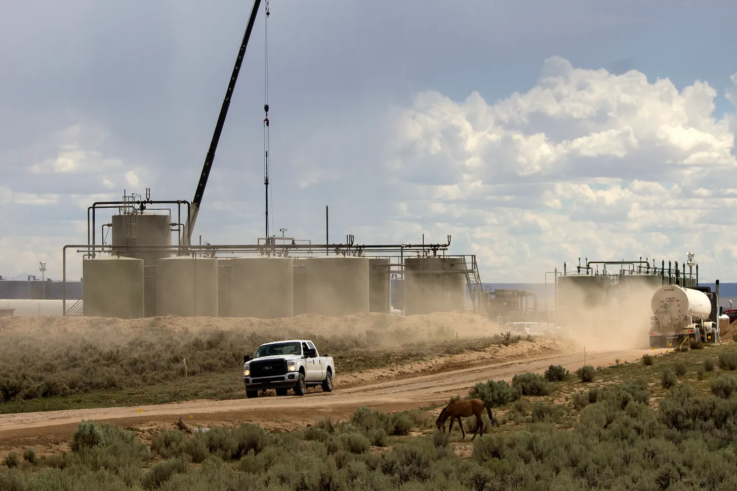
The most alarming move, so far, is the department’s implementation of “emergency permitting procedures” for oil and gas, uranium, coal, biofuels, and critical mineral projects on federal lands. Under this order, the department will compress the entire environmental review for these projects down to 28 days or less — even for a full environmental impact statement.
“By reducing a multi-year permitting process down to just 28 days,” Burgum said in a press release, “the Department will lead with urgency, resolve, and a clear focus on strengthening the nation’s energy independence.”
If you’ve ever skimmed through an EIS, you know how insane this concept is.
The Bureau of Land Management will be packing the entire process mandated by the National Environmental Policy Act, Endangered Species Act, National Historic Preservation Act, and other rules and regulations into an impossibly short timeframe.
By impossibly short, I mean that it is virtually impossible to comply with these laws and requirements — which include tribal consultation, archaeological surveys and mitigation, environmental and endangered species reviews, socioeconomic impact analyses, and public comment periods — in four weeks or less. So by radically compressing the timeline, Burgum is essentially telling his staff to skirt the requirements, i.e. violate the law.
Burgum uses President Trump’s claim that the U.S. is experiencing an “energy emergency,” to justify the destructive rubber-stamping, and says fast-tracking project approvals is necessary to address that emergency.
I’ve said it many times, but I will say it again: There is no energy emergency. The U.S. is pumping more crude oil than ever before from the Permian Basin and other fields, it is the largest petroleum producer in the world, it is a net exporter of petroleum products, and liquefied natural gas exports are at an all-time high. The U.S. market is glutted with natural gas and the coal supply has been outpacing demand for nearly two decades. Lithium — for electric vehicle batteries and grid-scale energy storage — is so plentiful that prices have plummeted nearly 90% since 2022. Uranium shortage? Nope.
One could certainly argue that the power grid in the West is outdated, its operation balkanized, and that it is not up to the challenges posed by growing data center electricity demand. But aside from geothermal and hydropower (solar, wind, and transmission projects are not included), none of the categories of projects on the fast-track list would do anything to fix the grid. Even if they were, it would not justify truncating environmental reviews so severely — or at all.
Environmental reviews can take a maddeningly long time, especially for big projects. But the way to speed things up is not to throw the laws and protections in the the trash bin. That will only lead to lawsuits, which likely will delay the projects even more. The only way to truly streamline permitting, while still safeguarding human health and the environment, is to beef up staffing, resources, and expertise. And that’s exactly the opposite of what Trump and Musk and Burgum are doing.
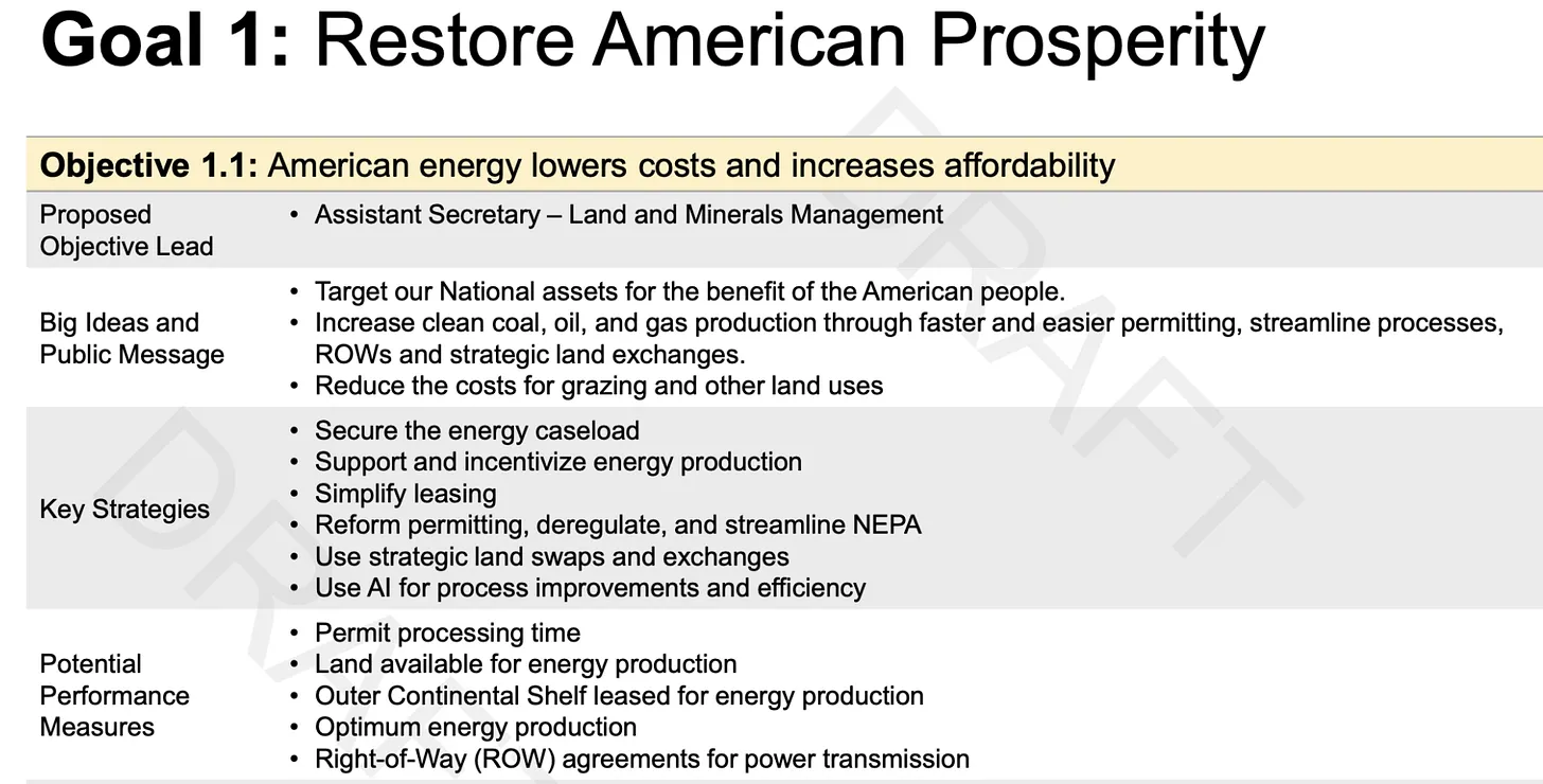
Pages from the Interior Department’s 2026-2030 Strategic Plan Draft Framework acquired and published by Public Domain. Note that one objective is to “release federal holdings” for housing. And that in the top one they want to “reduce the costs for grazing” on public land (can it go any lower?), while in the bottom one they want to “increase revenues from grazing … .” Uh … okay?
But wait. It gets worse.
We might take some comfort in the fact that national monuments are off-limits to the extractive industries and Trump’s energy dominance agenda, right? Maybe not for long.
Earlier this week, the folks at Public Domain acquired a copy of the Interior Department’s 2026-2030 Strategic Plan Draft Framework. The plan aims to, among other things: “restore American prosperity,” “assess and right-size monuments,” and “return heritage lands and sites to the states.”
The Washington Post, however, is reporting that Burgum is not necessarily waiting until next year to “right-size,” or shrink, national monuments. From the Post:
If they go through with the shrinkage of any or all of these national monuments, it would open up additional lands to oil and gas leasing and new mining claims, which would then be subject to the fast-tracked permitting.
Baaj Nwaavjo I’tah Kukveni-Ancestral Footprints of the Grand Canyon is especially rich in high-grade uranium deposits, and the White Canyon area in Bears Ears might also be targeted for uranium if the monument were shrunk. Grand Staircase-Escalante includes a large coal deposit on the Kaipairowitz Plateau, but it’s exceedingly unlikely that anyone would be interested in mining it given the faulty economics of coal.
One thing you can be sure of is that none of this will go unchallenged. The tribal nations that proposed the designation of Bears Ears and other national monuments will sue to keep them intact, and advocacy groups and land and water protectors will support them and take the administration to court over its flouting of environmental laws.
A look across Glen Canyon National Recreation Area and into Bears Ears National Monument from the Little Rockies. Jonathan P. Thompson photo.
🌵 Public Lands 🌲
For many people, the mention of Glen Canyon National Recreation Area evokes images of Lake Powell and all that entails: boats plying the blue-sky-reflecting waters and the sandstone cliffs and formations that rise up from the murky depths. That makes sense, given that the national park unit was established because the reservoir was there in 1972.
Yet the reservoir makes up just 13% of the 1.25 million-acre recreation area. The remaining 87% contains some of the more remote and spectacular country in the lower 48, shares borders with a half-dozen other national parks and monuments, and makes up the core of the Moab to Mojave Conservation Corridor.
So, the manner in which the area is managed matters — a lot. And for five decades after the recreation area’s establishment, off-road vehicle travel went virtually unmanaged, allowing for a destructive free-for-all along shorelines and in remote parts of the recreation area. In 2018, the Park Service released a plan that more or less codified the pre-plan anarchy. Environmentalists sued and forced the Park Service back to the drawing board.
This January the Park Service finally issued an amended rule celebrated by conservationists for adding protections to some of GCNRA’s more sensitive areas from motorized vehicle travel (this does not affect boating, by the way). It bars OHV-riding yahoos from roaring around the lake’s shore unheeded, and restricts motorized travel in the Orange Cliffs area on the north end of the recreation area adjacent to the Maze in Canyonlands.
The off-road vehicle lobby, however, was unhappy with the added restrictions, and they took their victim-complex grievances to the Utah congressional delegation, all of whom appear to have a fetish for fossil-fueled combustion-engines. Now the plan and the recreation area are being put in jeopardy by — you guessed it — those same Utah politicians. Sens. John Curtis and Mike Lee, along with Rep. Celeste Maloy, are asking Congress to revoke the rule under the Congressional Review Act and to prohibit the Park Service from implementing similar protections in the future.
🗺️ Messing with Maps 🧭
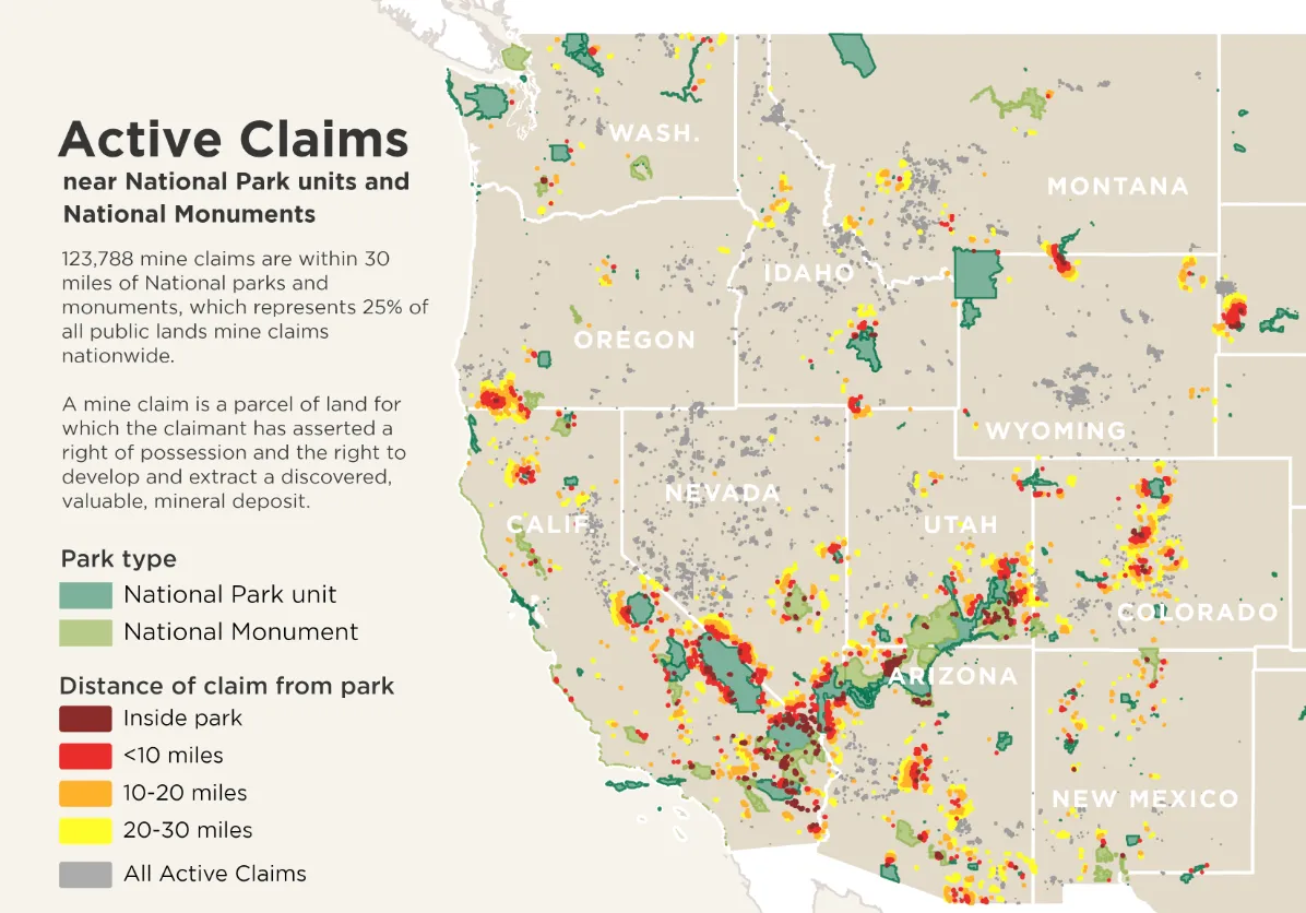
The National Parks Conservation Association created a nifty map showing active mining claims and mines near national parks and national monuments. It gives a good sense of how vulnerable some areas might be to new mining claims and projects if the Trump administration goes ahead with shrinking the aforementioned national monuments. You can look at the interactive version here.
One note of caution: An active mining claim ≠ a valid mining claim. An active claim simply means it has been located and filed, and that the claimant has paid their annual maintenance fee. The validity of a claim, on the other hand, depends on the discovery of a valuable mineral deposit there, which must be demonstrated. Rights to mine are only attached to valid claims.
Parting Poem
Here’s another one from Richard Shelton’s Selected Poems, 1969-1981.
The agreements propping up Lake Mead and Lake Powell expire in 2026, and negotiations for new agreements have stalled.
The Trump administration’s lack of clear direction and delay in appointing a Reclamation commissioner are exacerbating the crisis.
Arizona will face significant water cuts, potentially deeper than any previous shortages. It needs time to process them.
Many of us have seen this train wreck coming for years, the slow buildup of chronic overuse, coupled with a river that no longer produces as much water as it used to, that is draining Lake Mead and Lake Powell, the nation’s two largest water savings accounts. And if things don’t change soon, 40 million people who rely on this river are about to suddenly realize that decisionmakers squandered every dollar spent on buying time to fix this fundamental problem…The mismatch between supply and demand began emerging around 2000, and by 2007, the feds had created the first set of shortage guidelines, hoping those mandatory cuts would be enough to stave off crisis. But we now know that they weren’t nearly enough to reduce the drag on the lakes. Deeper cuts were made. Billions of dollars were set aside to pay people to temporarily not use water. And we’ve stabilized Lake Mead and Lake Powell, for now.
But those rules and agreements expire at the end of 2026…The Trump administration hasn’t said anything about those alternatives. And after dropping an executive order to nix a longstanding review process, it’s unclear how the feds will evaluate or collect public input, presuming that said alternatives are still on the table…It’s telling that while state negotiators continue to meet (and make no real progress), no one from the Bureau of Reclamation — the federal agency tasked with operating Lake Mead and Lake Powell — has attended those negotiation sessions since the Trump administration took office. In fact, Reclamation still doesn’t even have a commissioner. The administration has been dragging its feet on getting the leadership in place to finally break this logjam…Now is not the time to be hands-off. The Trump administration must prioritize naming a Reclamation director who can offer firm, clear and fair direction — and who isn’t afraid to bust a few heads if state negotiators refuse to budge.
Colorado River “Beginnings”. Photo: Brent Gardner-Smith/Aspen Journalism
Lake Powell at Wahweap Marina as seen in December 2021. Dwindling streamflows and falling reservoir levels have made it more likely that what some experts call a Colorado River Compact “tripwire” will be hit in 2027. Credit: Heather Sackett/Aspen Journalism
When Colorado convened a working group on water speculation, its members shared stories of times in which they’d seen or thought they might have seen investment water speculation occurring — when water rights are purchased with a primary purpose of profiting from the future sale or lease of that water as demand drives up its price. On the list was the notion that buyers with no real interest in agriculture would buy agricultural land and water rights with the primary intention of enrolling in a program that pays water rights holders not to use that water.
The concern, essentially, was that programs that compensate farmers for fallowing fields like the Upper Colorado River Basin’s System Conservation Pilot Program, and nonprofits that fundraise to keep water in streams weren’t sufficiently guarded against abuse, particularly when it comes to an increasingly constrained Colorado River system.
“The impacts of drought and the risks that drought causes in the Colorado River Basin, just by way of example, attract money to the concept that money can be made from taking water out of production — conservation,” says Peter Fleming, general counsel for the Colorado River District.
“Where do you draw the line in that?” Fleming asks. “Which one is a good, socially recognized benefit that the state as a whole should support versus which one is bad because it encourages speculation in water resources, and it makes things more difficult for others, and it has adverse secondary impacts in the local economies when you take water out of production?”
A few guardrails exist to make real conservation efforts — those that serve the common good — clear. But questions remain on whether those protections can really stop investment water speculation before speculation occurs.
Little Cimarron Ranch, where a first-of-its-kind agreement allows water rights to go to irrigation in the spring and summer, and to instream flows to support river health in the summer and fall. Photo courtesy of Mirr Ranch Group
Streamflows for the Public Good
In 1973, Colorado lawmakers legally recognized instream flows, in which water is allocated to the river to maintain flows and habitat as a “beneficial use” in parallel with industries, cities and agriculture. That 1973 legislation tried to prevent speculators from prospectively appropriating instream flows and locking up the state’s water by taking measures like limiting who can operate instream flows to a single state agency, the Colorado Water Conservation Board.
“There is government oversight for specifically this reason — to prevent speculation,” says Josh Boissevain, staff attorney with the Colorado Water Trust, a nonprofit that works to secure water for streams. “Instream flow is a decreed use, so using that water for instream flow is not speculation at all, even though it’s left in the river.”
When water rights owners work with the water trust to use their water to restore flows, it takes a lot of paperwork and a close look at the web of other users affected. The process can be tedious and time-consuming, and the profits marginal.
“Nobody is doing that for the money,” Boissevain says. “They do it because they care.”
Some loopholes have been closed. For example, a 1994 change to Colorado’s water law prevents conditional water rights holders, who hold onto water rights for unbuilt projects or potential future uses, from transferring those rights to instream flows. That law blocks speculators from selling conditional water rights to the CWCB for a profit.
Shoshone Hydroelectric Plant back in the days before I-70 via Aspen Journalism
Having a perfected water right — one that is fully established and has been put to beneficial use — converted to instream flows is fine, Fleming says. The Colorado River District participates in those programs and is working to buy a water right currently used to generate 15 megawatts at Xcel Energy’s aging Shoshone hydroelectric power plant. The River District aims to convert that hydropower right to an instream flow right to ensure that this water continues to flow from the headwaters down through boating hotspots in Glenwood Canyon, regardless of the 115-year-old power plant’s future.
But Fleming, who worked on a 2021 report that reviewed Colorado’s legal sideboards on speculation, remains concerned that the lines are not clearly enough drawn between those recognizable benefits to the state and local economies, and the place where speculators could start counting on those efforts and “conserving” to make a profit. At a certain scale, the effects of taking water off farm fields could ripple out beyond bare fields to farm supply stores and gas stations, as well as the local job market in rural communities.
Perhaps the most frightening possibility that could result from profiteering is that water rights bought and steered from use in Colorado will somehow be sold to thirsty fields or towns in Arizona or Nevada. But even if both buyer and seller are willing, specific language in interstate compacts and existing law complicates the likelihood of selling water from one state to a buyer in a different state.
Meanwhile, conservation groups are also concerned about speculators cornering them out of the increasingly expensive water rights market, Boissevain says. To adapt to the current water market, the Colorado Water Trust is exploring a new acquisition model with Qualified Ventures, a consulting company based in Washington, D.C. Through this new approach, the water trust would buy land with water rights through financing from lenders. A conservation easement would protect the land as agricultural, and the tax rebate from that status would partially repay the loan. The water trust would reassess how to profitably farm that land while sharing the water rights between agriculture and environmental flows. Then the land could be sold, potentially at a reduced price, perhaps to a first-generation farmer.
“It’s another way to keep ag in production and keep water on the land,” Boissevain says. “It’s another step up in the competition against people that might try and buy [irrigated farms] for speculation or maybe even development.”
Confluence of the Cimmaron and Gunnison rivers. Photo: Brent Gardner-Smith/Aspen Journalism
The results might resemble a project on the Little Cimmaron River near Gunnison, where the Colorado Water Trust purchased 5.8 cubic feet per second of flow in the McKinley Ditch to return water to a river that was nearly dry in late summer months. The water trust partnered with a land trust to buy the water rights and land, put a conservation easement on the land, then sell the land and water rights to a private landowner. In a first-of-its-kind agreement, the water rights can go to irrigation in the spring and summer, and to the CWCB for instream flow in the late summer and fall when the river needs it most. In a very dry year, all of the water can be left in the stream protected, and in a wet year, all of it can be diverted for agriculture.
This map shows the 15-mile reach of the Colorado River near Grand Junction, home to four species of endangered fish. Map credit: CWCB
Environmental groups contend that for the environment to thrive, the entire river system needs this kind of adaptability, particularly as Colorado River Basin states renegotiate operations for Lake Powell and Lake Mead ahead of the current guidelines’ expiration in 2026.
“We want to see better, more realistic management of the Colorado River that accounts for climate change and … drastic shifts in hydrology,” says Matt Rice, Southwest regional director with American Rivers. “It’s all about creating, from our perspective, more flexibility in the system to avoid emergency action after emergency action because we’re collectively afraid to make hard decisions when we need to.”
With an eye on the prospect of a compact call or other crisis, WaterCard, a Colorado-based company, aims to leverage private market dynamics to promote water conservation in the Colorado River system. It also provides an avenue for companies and individuals to offset their water footprint.
It works like this: A person can buy a WaterCard, which gives them conservation credits linked to a quantifiable amount of water conserved on a Colorado farm or ranch. It’s like an offset. The WaterCard buyer also receives an NFT digital token as proof of purchase.
In the field, WaterCard funds are used to compensate farmers and ranchers who sign up for the program and voluntarily reduce water usage by fallowing fields for a season, decreasing irrigation, or transitioning to drought-resistant crops.
To demonstrate the concept, WaterCard founder James Eklund, who is also a working water attorney and rancher, is fallowing 66 acres of grass-alfalfa hay at his family ranch in western Colorado’s Plateau Valley. Introducing a market-based mechanism for water conservation in a headwaters state does not equate to speculation, Eklund says, because buyers are only purchasing credits tied to conserved water, not the underlying water rights themselves.
“This approach aligns fully with the anti-speculation doctrine, which I strongly support. That doctrine prohibits buying a water right, leaving it unused, and flipping it for profit — that’s speculation,” he says.
WaterCard’s model is designed to work within the Upper Colorado River Commission’s System Conservation Pilot Program (SCPP) and, Eklund hopes, eventually within a demand management framework. SCPP was designed to explore solutions to low flows in the Upper Colorado River Basin by granting funding to irrigators who voluntarily apply to conserve water for the season. If a demand management program is developed, conserved water could serve as a “savings account” in Lake Powell, helping Colorado meet future obligations to send water to downstream states under the Colorado River Compact.
By piggybacking off of the SCPP, WaterCard benefits from the SCPP’s efforts to verify conservation efforts. Therefore, producers enrolled in WaterCard must also have a project enrolled in the SCPP. WaterCard will simply boost the amount of funding those irrigators receive for conservation efforts, making SCPP participation more appealing. As of early 2025, however, it’s unclear whether the SCPP will continue. Eklund argues that this model allows private entities and individuals to play a meaningful role in preventing water crises, one $3.50 WaterCard — representing 500 gallons of water saved — at a time.
Farmers and ranchers who participate can diversify revenue sources while continuing to farm and ranch. Eklund contends that current SCPP payments are insufficient and rejects the notion that fair compensation would cause agricultural producers to abandon their livelihoods.
“That idea is insulting,” he says. However, if farmers and ranchers can derive a higher dollar value for conserved water through a market-based system, he says, that’s not speculation, that’s “market-based capitalism.”
Independent journalist Elizabeth Miller has written about environmental issues around the American West for publications including The Washington Post, Scientific American, Outside, Backpacker and The Drake.
Map of the Colorado River drainage basin, created using USGS data. By Shannon1 Creative Commons Attribution-Share Alike 4.0
The discussion will focus on the Juchem Ditch and the Farmers Highline Canal and review how early settlers dug ditches by hand to support mining and agriculture. The event is free to the public and is scheduled for 10:30 a.m. to noon on May 17 at the Arvada Elks Lodge in Olde Town, at 5700 Yukon St. Panelists will include local historians Ed Rothschild, Tom Fletcher and Bob Krugmire. The event will be moderated by Arvada City Councilmember Sharon Davis. Arvada Historical Society President Judith Denham said the idea for the first History Speaks lecture — which will potentially be part of a larger series of talks — came when the organization was planning last year’s Cemetery Tour, which centered on the early pioneers who built the city’s ditches.
“We thought it would be a great idea to expand on this story and find a way to talk more about this crucial part of Arvada’s history,” Denham said. “I think people are going to really enjoy hearing about this large piece of Arvada’s history. It’s a panel and we’ve invited water experts and ditch company representatives to talk about how water influenced Arvada’s early history.
“They’re going to tell us the fascinating stories about how early settlers Wadsworth, Swadley and Jochem dug ditches with hand tools and mules so they could provide water for their farms,” Denham continued. “And add in the stories about the early conflicts over water usage and how that whole complicated system of water rights and water law started.”
Registration for the event can be completed at historyarvada.org. The Arvada Press and Colorado Community Media are partnering with the Arvada Historical Society for this project.
Farmers Highline Canal near the Tuck Ditch Headgate April 30, 2019. Day 30 of the #30daysofbiking challenge.
Workers from Denver Water and contractor Kiewit Barnard stand in front of Gross Dam in May 2024 to mark the start of the dam raise process. Photo credit: Denver Water.
A federal judge on Tuesday ordered Denver Water to share information with the environmental groups who successfully challenged a reservoir expansion project in Boulder County, as both sides prepare for a hearing to determine how much additional construction is necessary to stabilize the structure…Days later, Arguello allowed for necessary construction to temporarily resume, and the U.S. Court of Appeals for the 10th Circuit has since extended that window while it reviews Arguello’s order. However, last Wednesday, the groups that challenged the project’s legality asked Arguello to intervene on another issue related to the upcoming hearing about how much stabilizing work is warranted…In response to the groups’ questions about risk management plans, spillway capacity and failure modes — plus a request for project documents — Denver Water told the petitioners that disclosure “poses Dam security risks.”
“The fact remains that Denver Water is the only party that currently has available to it extensive documentation that bears directly on the specific safety issues that this Court ordered all parties to address at the hearing,” the environmental groups added in their court filing.
The Shoshone hydro plant in Glenwood Canyon. The River District has made a deal with Xcel Energy to buy the water rights associated with the plant to keep water flowing on the Western Slope. Credit: Heather Sackett/Aspen Journalism
Pitkin County on Wednesday joined 29 other Western Slope counties, cities and towns, irrigation districts and water providers in financially backing a plan to buy a critical Colorado River water right.
Pitkin County commissioners unanimously approved a resolution supporting the Shoshone Permanency Project and pledging $1 million toward the campaign to keep the water rights associated with the Shoshone hydropower plant in Glenwood Canyon on the Western Slope. Pitkin County’s Healthy Rivers Board recommended the $1 million contribution from its fund at its regular meeting April 17.
The Colorado River Water Conservation District plans to purchase the water rights from Xcel Energy for nearly $100 million. The water rights are some of the biggest and oldest non-consumptive water rights on the mainstem of the Colorado River, and ensure water keeps flowing west to the benefit of downstream cities, farms, recreation and the environment.
“From our perspective we view this as an opportunity to really create and enhance a partnership that should be incredibly functional in the future,” River District General Manager Andy Mueller told commissioners on Wednesday. “We’re committed to working with you to keep the upper Roaring Fork healthy and figuring out creating solutions to bring water into the watershed at the right times of year.”
About 40% of the headwaters of the Roaring Fork River is diverted across the Continental Divide for use in the Arkansas River basin. It’s long been Pitkin County’s goal to mitigate the effects this has on the health of the Roaring Fork.
In exchange for support of the Shoshone project, Pitkin County will be able to use some water from Grizzly Reservoir, owned by the city of Aspen and the River District, to boost flows in the upper Roaring Fork River.
“One of the most productive things to come out of this, in addition to the benefits you’ve already discussed with the Shoshone project itself … is going to be that the River District has agreed that Pitkin County can now have a voice in working with Aspen and the River District on that Grizzly water,” said Jennifer DiLalla, an attorney with Moses, Wittemyer, Harrison and Woodruff. DiLalla is the county’s outside counsel who works on water issues. “That is one of the only sources of water available upstream of you. It’s not going to be there all that often, but when it is, it’s a really great benefit for the upper Fork.”
The $1 million pledge may help the county and the River District repair their rocky relationship after years of being at odds over certain water issues. Pitkin County didn’t initially support the Shoshone campaign because of the complex interaction of the water rights with another big set of downstream irrigation water rights in the Grand Valley known as the Cameo call.
“We’ve come a long way because it used to be not too long ago that we were just going to oppose this, period,” said Pitkin County Commissioner and River District representative Francie Jacober. “I would say that we are on the road to a new era of cooperation with the River District.”
Pitkin County’s concern was that with Shoshone under new ownership — and the proposed addition of an instream flow use for the water along with hydropower — the call for the water through Glenwood Canyon might delay or reduce the need for the Cameo call. Aspenites like to see the Cameo call come on because it forces the Twin Lakes diversion to shut off, which means more water flowing down the Roaring Fork, typically during a time of year in late summer and early fall when streamflows are running low and river health is suffering.
North Star Nature Preserve on the Roaring Fork River just upstream of Aspen experienced high water in June of 2023. Pitkin County is supporting the River District’s campaign to buy the Shoshone water rights in exchange for help boosting flows in the upper Roaring Fork. Credit: Heather Sackett/Aspen Journalism
Some of the mistrust between the two local governments can be traced to water rights owned by the River District that would have kept alive huge reservoirs on the Crystal River near Redstone. The district eventually abandoned those rights, but not without first being challenged in water court by Pitkin County. Pitkin County also opposed the widely supported River District 2020 tax increase — ballot measure 7a — which funds water projects across the district’s 15-county area.
To secure the Shoshone water rights — which comprise a 1902 right for 1,250 cubic feet per second and another from 1929 for 158 cfs — the River District must add an instream flow use to the water rights in addition to their current use for hydropower. That requires working with the Colorado Water Conservation Board, which is the only entity in the state allowed to hold instream flow rights which preserve the environment, as well as getting a new water court decree to allow the change in use.
Despite the support and $1 million pledge, Pitkin County still may oppose the change case in water court. The county hired Golden-based engineering firm Martin and Wood Water Consultants to do an analysis of the Shoshone and Cameo call interaction to see if the Roaring Fork could be harmed. According to Tara Meininger, an engineer with Martin and Wood, there could potentially be an annual impact of 26 acre-feet on average to the upper Roaring Fork.
But a final report is still not complete, said Pitkin County Attorney Richard Neiley, which is why the county reserved the right to oppose the River District in water court.
“It’s an important goal to make sure that change does not result in injury to the Roaring Fork forever,” Neiley said. “We haven’t given anything away with respect to being able to argue or oppose the change case on that basis.”
With Pitkin County’s $1 million contribution, the River District has now raised $57 million from local and regional partners. In addition, the project was awarded $40 million in the final days of the Biden administration, but that funding has since been frozen, though River District officials are hopeful that the federal funding will still be realized.
The River District plans to present an agreement on the instream flow water rights to the Colorado Water Conservation Board at its regular meeting in May.
“We’re about to enter into a process with the Colorado Water Conservation Board where your support will be essential to a successful experience there and then on into water court,” Mueller told commissioners. “So we just want to say thank you very much.”
Colorado transmountain diversions via the State Engineer’s office
GLENWOOD SPRINGS, Colo. — The effort to permanently protect the Shoshone Hydroelectric Power Plant’s water rights gained additional momentum this week as Pitkin County committed $1 million toward the Colorado River District’s $99 million purchase agreement with Xcel Energy. This contribution is bolstered by additional funding from middle Colorado River communities, including the Town of New Castle ($100,000), Town of Parachute ($25,000), Town of De Beque ($5,000), and the De Beque Plateau Valley Soil Conservation District ($5,000), which are committed to safeguarding flows vital to the region’s economy and way of life. Reliable flows in the Colorado River are essential to the health and future of these interconnected communities. By supporting Shoshone, they join a broader coalition of Western Slope entities committed to long-term water security for the region.
“The Shoshone water rights are essential to the health of our rivers, ecosystems, and communities across the Western Slope,” said Francie Jacober, Pitkin County Commissioner and Colorado River District Board Member. “This isn’t just a smart investment, it’s a legacy decision. Pitkin County proudly stands with our neighbors to protect this lifeline for future generations.”
“The Town of New Castle recognizes the critical importance of protecting Colorado River water rights on the Western Slope and proudly supports the long-term preservation of non-consumptive flows,” said New Castle Town Administrator David Reynolds. “These rights are vital to a strong recreational economy, improved water quality, sustainable agriculture, and consistent stream flows in the upper Colorado River Wild and Scenic Management areas. New Castle fully supports the work of the Colorado River District and the Shoshone Water Rights Preservation Coalition to safeguard the river’s health and sustainability.”
The Shoshone Water Rights Preservation Project, led by the Colorado River District, now includes 30 local governments, water entities, and regional partners across the Western Slope. Together, they have committed over $17 million toward the $99 million purchase price. Along with the $20 million pledged by the State of Colorado through the CWCB Projects Bill (HB24-1435) and $20 million from the River District’s Community Funding Partnership, more than $57 million has been committed to date.
“From headwaters counties like Pitkin to towns along the Colorado River, the West Slope is demonstrating what true collaboration looks like,” said Andy Mueller, General Manager of the Colorado River District. “The momentum behind Shoshone Permanency reflects a powerful and unified vision where agricultural producers, recreation economies, and rural communities stand shoulder to shoulder to protect the water resource that sustains us all. This is a once-in-a-generation opportunity, and our region is rising to meet it.”
The Shoshone hydroelectric plant, located in Glenwood Canyon, holds nonconsumptive senior water rights that date back to 1902. These rights are essential for supporting flows in the Colorado River, benefiting agriculture, recreation, rural economies, and water users across the West Slope.
In December 2023, the Colorado River District entered a purchase and sale agreement with Xcel Energy to acquire and permanently protect the water rights, with plans to negotiate an instream flow agreement with the Colorado Water Conservation Board. This agreement would safeguard the flows into the future, regardless of the operational status of the Shoshone plant itself.
In January 2025, the Bureau of Reclamation awarded $40 million in federal funding through a program authorized by the Inflation Reduction Act. The River District continues to work with the Bureau of Reclamation and remains optimistic that the project’s broad support and clear public benefit will secure the federal dollars needed to complete this once-in-a-generation investment.
Learn more about the Shoshone Water Rights Preservation Project & Coalition at KeepShoshoneFlowing.org.
The dam raise process begins at the bottom of the dam using roller-compacted concrete to build the new steps that will go up the face of the dam. Photo credit: Denver Water.
Denver Water vowed this week to take the high-stakes battle over a partially built dam in Boulder County to the U.S. Supreme Court if necessary to defend what it sees as its well-established right to continue construction and deliver water to its 1.5 million metro-area customers.
“It would be irresponsible not to do that,” Denver Water’s General Manager Alan Salazar said in an interview Tuesday as a tense month of legal maneuvering continued.
Senior U.S. District Court Judge Christine Arguello on April 3 put a halt to construction of the $531 million Gross Reservoir Dam raise nearly four months after Denver Water and the river-defending nonprofit Save the Colorado failed to negotiate a settlement that would add new environmental protections to the project. When settlement talks stalled, Save the Colorado asked for and was granted an injunction.
Almost immediately, Denver Water filed for temporary relief from the injunction, saying, in part, that it would be unsafe to stop work as the incomplete concrete walls towered above Gross Reservoir in western Boulder County.
Arguello granted that request, too.
Now the water agency, the largest utility in the Intermountain West, has filed an emergency request with the federal appeals court, seeking to permanently protect its right to continue construction as the legal battle continues.
A decision could come as early as this week as a 10th Circuit Court of Appeals panel considers Denver Water’s emergency request, according to environmental advocate Gary Wockner. Wockner leads Save The Colorado, a group that has financed and led litigation against Denver Water and many other agencies seeking new dams or river diversions. Wockner said he is ready to continue the fight as well.
“We are prepared to defend the district court’s decision,” Wockner said, referring to the construction halt.
Alan Salazar, who became Denver Water CEO/Manager in August 2023 Photo credit: Denver Water
The high-profile dispute erupted in Denver just weeks after Northern Water agreed to a $100 million settlement with Save The Colorado and its sister group, Save The Poudre, to allow construction of the Northern Integrated Supply Project, or NISP, to proceed.
The money will be used to help restore the Cache la Poudre River, including moving diversion points and crafting new agreements with diverters that will ultimately leave more water in the river. Northern Water, which operates the federally owned Colorado-Big Thompson Project for the U.S. Bureau of Reclamation, is overseeing the permitting and construction of NISP.
But two years of talks and negotiations between Save The Colorado and Denver Water failed to yield a similar environmental settlement over the Gross Reservoir Dam expansion project. It was after the talks failed that Federal District Court Judge Arguello agreed to halt construction on the dam.
Whether a new environmental deal will be forthcoming now isn’t clear. Both sides declined to comment on whether settlement talks had resumed.
Salazar also declined to discuss whether a deal similar to the $100 million NISP settlement would emerge over the Gross Reservoir lawsuit.
“I don’t want to get into the cost of a settlement,” Salazar said. “But the impact on ratepayers would be significant.”
Case sets the stage for future water projects in Colorado
Across the state, water officials are closely watching the case play out.
For fast-growing Parker Water and Sanitation, the preliminary injunction to stop construction, though temporary, is worrisome.
Its general manager, Ron Redd, said he wasn’t sure how his small district, which is planning a major new water project in northeastern Colorado, would cope with a similar injunction or a U.S. Supreme Court battle.
“In everything permitting-wise you need consistency in how you move projects forward,” Redd said. “To have that disrupted causes concern. Is this going to be the new normal going forward? That bothers me.”
Denver Water first moved to raise Gross Dam more than 20 years ago when it began designing the expansion and seeking the federal and state permits required by most water projects.
After years of engineering, studies and federal and state analyses, construction began in 2022. It has involved taking part of the original dam, built in the 1950s, and raising its height by 131 feet to nearly triple the reservoir’s storage capacity to 119,000 acre-feet from 42,000 acre-feet. An acre-foot of water equals 326,000 gallons, enough to serve up to four urban households each year.
The giant utility has said it needs the additional storage to secure future water supplies as climate change threatens stream flows in its water system, a key part of which lies in the Fraser River, a tributary to the Upper Colorado River in Grand County. The expansion was also necessary to strengthen its ability to distribute water from the northern end of its system, especially if problems emerged elsewhere in the southern part of its distribution area, as occurred during the 2002 drought.
And the judge agreed climate change is a factor but she said it’s not clear the water would ever even materialize as flows shrink. She overturned Denver Water’s permits because she said the Army Corps had not factored in Colorado River flow losses from climate change, and whether Denver would ever actually see the water it plans to store in an expanded Gross. Arguello also ruled the Army Corps had not spent enough time analyzing alternatives to the Gross Reservoir expansion.
Wockner said forcing Denver Water and the U.S. Army Corps of Engineers to re-analyze water projections under new climate change scenarios, as his group has asked, is critical to helping protect the broader Colorado River and stopping destructive dam projects.
Whether the questions the case raises about permitting and environmental protections ultimately make their way to the U.S. Supreme Court isn’t clear yet.
But James Eklund, a water attorney and former director of the Colorado Water Conservation Board, the state’s lead agency on water planning and funding, said Denver Water has the expertise and financial muscle to take it there.
“They have really sharp people over there,” he said. “I would say they are not only willing, they would have the facts to present a case they believe would be successful.”
The Gross Reservoir Expansion Project involves raising the height of the existing dam by 131 feet. The dam will be built out and will have “steps” made of roller-compacted concrete to reach the new height. Image credit: Denver Water
U.S. Sen. John Hickenlooper, D-Colo. stopped in Glenwood Springs on the bank of the Colorado River on April 15 for a roundtable with Western Slope water users. Many who spoke were promised federal funding for projects to address environmental and drought issues, which has now been frozen by the Trump administration. Credit: Heather Sackett/Aspen Journalism
During a tour of the Western Slope last week, U.S. Sen. John Hickenlooper, D-Colo., said he was frustrated with the pace of negotiations that could determine how the Colorado River is shared in the future and that the Upper Basin states may be pushing back too hard.
A deal should have been reached last summer, he said.
“Colorado should have a right to keep the water that we have been using the way we’ve been using it, and I don’t think we should compromise that,” Hickenlooper said. “But there are a lot of things we could do to give a little to be part of the solution to the Lower Basin and get to a collaborative solution. Again, I’m frustrated by our lack of progress.”
The remarks came during a Q&A with reporters April 15 after a roundtable in Glenwood Springs with Western Slope water managers, many of whom spoke about their projects that were promised funding through the Inflation Reduction Act, which was earmarked for environmental and drought issues. That funding has since been frozen by the Trump administration.
Hickenlooper added that Colorado River management decisions should not be coming from Washington and that the only path forward is an agreement among the seven states that comprise the two basins. Hickenlooper has supported conservation efforts in the Upper Basin (Colorado, New Mexico, Utah and Wyoming), including the System Conservation Pilot Program, which paid water users to cut back in 2023 and 2024.
The seven states that use water from the Colorado River – Arizona, California and Nevada comprise the Lower Basin – have just over a month left to agree on how the nation’s two largest reservoirs would be operated and cuts shared in the future before the federal government may decide for them.
“It’s our understanding from Reclamation that they are going to start the impacts analysis in early June, so they are seeking a consensus alternative by the end of May,” said Chuck Cullom, executive director of the Upper Colorado River Commission.
The current guidelines for the management of the Colorado River expire at the end of 2026, and new ones need to be in place by that August, when reservoir operations for the next water year are set. That means the clock is ticking on the National Environmental Policy Act (NEPA) process that will develop and adopt new guidelines. Without an agreement between the basins, the U.S. Bureau of Reclamation will move forward with its own management plan.
“[Reclamation] is targeting a record of decision in the summer of 2026 so that it is implementable on Oct. 1, 2026, when the next new water year starts,” Cullom said.
From left, J.B. Hamby, chair of the Colorado River Board of California, Tom Buschatzke, Arizona Department of Water Resources; Becky Mitchell, Colorado representative to the Upper Colorado River Commission. From left, Colorado River negotiator for California JB Hamby, Arizona’s Tom Buschatzke and Colorado’s Becky Mitchell. Water managers from all seven Colorado River Basin states have just over a month left to reach a consensus on how the river will be shared in the future.Credit: Tom Yulsman/The Water Desk
Although water managers say coming to an agreement that all seven states can live with is better than the federal government imposing its own rules, the Upper Basin and the Lower Basin remain divided. Talks ground to a halt at the end of last year, but they have since resumed, according to Colorado officials.
Lead negotiator for Colorado Becky Mitchell said in a written statement that Colorado is focused on working with the basin states towards a consensus approach for the post-2026 operations of Lake Powell and Lake Mead that would fit within Reclamation’s timeline for the NEPA process.
“The basin states share common goals: we want to avoid litigation, and we want a sustainable solution for reservoir operations,” Mitchell said. “In light of these goals, I see the basin states working towards sustainable, supply-driven operations of Lakes Powell and Mead that are resilient across a range of hydrologic conditions experienced in the basin.”
In March 2024, each basin submitted competing proposals to federal officials. In January, the bureau released an alternatives analysis, which outlined five potential paths forward. It did not include either basin’s proposal as an option and instead looked at a “basin hybrid” option, with elements from each basin’s proposal.
A major sticking point that has not yet been resolved is that Lower Basin water managers say the Upper Basin states must share cuts under the driest conditions. Upper Basin officials maintain they already suffer annual shortages of about 1.3 million acre-feet because they are squeezed by climate change and shouldn’t have to share additional cuts because their states have never used the entire 7.5 million-acre-foot apportionment given to them by the Colorado River Compact. Upper Basin officials, however, have offered to voluntarily conserve up to 200,000 acre-feet of water a year.
“A lot of the difference in the two proposals is that the Lower Basin seems much more comfortable running the system at a lower volume of water in the reservoirs, and we view that as leading to crisis management,” Andy Mueller, general manager of the Glenwood Springs-based Colorado River Water Conservation District, said at the district’s regular board meeting April 15. “So if you keep the system in a constant state of crisis, then it’s one emergency after another, which should feel familiar to anybody who’s been following the Colorado River for the last 20 years, because that’s what has been happening.”
This 2023 diagram shows the tubes through which Lake Powell’s fish can pass through to the section of the Colorado River that flows through the Grand Canyon. Credit: USGS and Reclamation 2023
Of the five potential options in the bureau’s analysis, the “federal authorities” alternative may be the most likely way forward if a consensus between the two basins is not reached. That alternative includes up to 3.5 million acre-feet of cuts in the Lower Basin, no Upper Basin conservation and a focus on upstream reservoir releases to keep Lake Powell full enough to make hydropower at Glen Canyon Dam.
“We have to remember that creating your own solution for the consensus is always better than allowing somebody else to create it for you, so we are hopeful that will happen,” Mueller said.
Adding to the urgency of finding agreement on future river operations is a rapidly diminishing snowpack and spring-runoff forecast that could once again drive reservoirs to crisis levels. Hot and dry conditions have pushed snowpack across the Upper Basin down to 74% of average — a 27% loss in the past two weeks. Conditions may be beginning to resemble 2021 and 2022, when Lake Powell fell to its lowest point ever, threatening the ability to make hydropower and triggering emergency upstream reservoir releases and calls from federal officials for 2 million to 4 million acre-feet in conservation from the states.
“It’s the opposite of good,” Cullom said of this year’s runoff forecast. “Now through the first week of May, either we’ll get some replenishment or the snowpack will collapse. My money’s on collapsing, unfortunately, similar to 2021.”
Map of the Colorado River drainage basin, created using USGS data. By Shannon1 Creative Commons Attribution-Share Alike 4.0
With a critical source of funding for Colorado’s water projects facing an uncertain future, lawmakers want to task a group of experts with providing recommendations for solutions. Severance taxes, which are imposed on nonrenewable energy extraction like oil drilling and coal mining, have long served as a key source of revenue for water-related initiatives. The funding stream, however, is also one of the state’s most volatile due to extreme swings in the energy market. Over the past two decades, tax revenue has gone from skyrocketing one year to plummeting the next. The issue has compounded in recent years due to state budget writers siphoning some of the money to help balance the state’s spending plan. In response, a bipartisan group of lawmakers is advancing legislation that would commission a study on the future of severance tax revenue and ways the state can better fund its water needs. Senate Bill 40 [SB25-040] would create a nine-member task force within the Department of Natural Resources to find answers to the question. The measure is sponsored by Sens. Dylan Roberts, D-Frisco, and Cleave Simpson, R-Alamosa, as well as Reps. Karen McCormick, D-Longmont, and Matthew Martinez, D-Monte Vista. Roberts said the group will consider any and all ideas, not just around severance taxes, for how to make Colorado’s water funding more stable. The task force would then submit a final report in July 2026 to help create potential bills or recommendations for the Joint Budget Committee in future legislative sessions.
The April board meeting of the Upper Arkansas River Water Conservancy District featured a presentation highlighting losses of irrigated farmland in Colorado and the Arkansas River Basin. Colorado Department of Agriculture Water Policy Advisor Robert Sakata presented the information and engaged Conservancy District staff and board members in a discussion about water and local agriculture…
He shared key facts about agriculture in Colorado, which relies heavily on irrigation water. The ag sector:
Contributes $47 billion per year to the state economy.
Stewards 30 million acres of land.
Manages more than 80% of the state’s water.
Employs 195,000 people.
From 1997 to 2022, Sakata said, Colorado saw a 32.2% decrease in irrigated acreage, a 1,085,000-acre reduction. Arkansas Basin statistics reveal a 39% loss from 1998 to 2020 (Given drought conditions in 2020, an increase in water availability may have resulted in an increase in irrigated lands in more recent years.). Sakata said drought has contributed to some of the losses of irrigated land but acknowledged that cities purchasing irrigation water rights and converting them to municipal use is the biggest factor…
“We don’t want a repeat of Crowley County,” he said, referring to Colorado’s poster child for the damage caused by removing water from irrigated farmland, also known as “buy and dry.”
Crowley County borders Pueblo County to the east and once boasted more than 50,000 acres of irrigated farmland that produced alfalfa, barley, tomatoes, strawberries, cantaloupes, corn and enough beets to support a sugar factory in Sugar City. Orchards once covered more than 4,000 acres between Olney Springs and the town of Crowley. Local agriculture flourished, irrigated with local water and West Slope water paid for by Crowley County farmers and supplied by the Twin Lakes Reservoir and Canal Company, headquartered in Crowley County (Ordway). In the 1970s, bad weather, bad luck, technology, farm consolidation, and economics created a perfect storm that irreversibly transformed the county for the worse. Front Range cities ended up with 95 percent ownership of the Twin Lakes Canal and Reservoir Co., “the heart of the system” that brought agriculture-based prosperity to Crowley County. Sakata’s presentation showed that, by 2022, Crowley County’s irrigated farmland had dropped to 2,000 acres. Once-fertile farmland is now dusty and grows little more than tumbleweeds, which are known to shut down a local stretch of highway on occasion.
From email from the Salazar Rio Grande del Norte Center (Paul Formisano):
Join Colorado attorneys Bill Paddock and David Robbins as they present “Elephant Butte Reservoir, the Rio Grande Compact, and Water Administration in the San Luis Valley” on Thursday, April 24, 2025, from 3:00 p.m. to 5:00 p.m. in McDaniel Hall 101 at Adams State University.
Paddock and Robbins have worked for many decades protecting water interests in the San Luis Valley and throughout Colorado. Their perspectives will provide timely insights into the 1938 Rio Grande Compact, how it shapes current river management in the San Luis Valley and the broader river basin, and last year’s Supreme Court ruling on Texas v. New Mexico and Colorado.
These events will be held in conjunction with the Rio Grande Compact Commission meeting on Friday, April 25, 2025 starting at 9:00 a.m. at the Rio Grande Water Conservation District office in Alamosa. This annual meeting brings together officials from Colorado, New Mexico, and Texas to discuss river policy and management. The meeting is free and open to the public.
For more information about the April 24th events, please contact Salazar Center director Paul Formisano, Ph.D., at pformisano@adams.edu.
Rio Grande and Pecos River basins. Map credit: By Kmusser – Own work, Elevation data from SRTM, drainage basin from GTOPO [1], U.S. stream from the National Atlas [2], all other features from Vector Map., CC BY-SA 3.0, https://commons.wikimedia.org/w/index.php?curid=11218868
Colorado River officials are debating six options for how to manage the overstressed river after 2026 with the goal of reaching a seven-state agreement by May. Under this year’s ultra dry water conditions, all of the proposed plans would call for mandatory cuts in the three Lower Basin states with reductions ranging from 1.3 million to 3.2 million acre-feet. The basin’s legal share of the river is 7.5 million acre-feet, although estimates say its actual use is higher.
Under most of the different management options, Colorado and its sister states in the Upper Basin would be asked to voluntarily conserve up to 500,000 acre-feet of water. One acre-foot roughly equals the annual water use of two to three households.
In Arizona, the state that would be hardest-hit, cities, farms and tribes are already making alternative plans, Tom Buschatzke, Arizona’s Colorado River negotiator, said.
“The impacts are going to be meaningful,” Buschatzke, who is also director of the Arizona Department of Water Resources, said. “They are going to have some pain attached to them.”
It’s been a tough water year for parts of Colorado and the Colorado River Basin. In Colorado, the snowpack on the Western Slope — where the Colorado River starts — ended up with a below average peak this winter.
Across the basin, more than 20 major reservoirs and tributaries can expect a lower-than-usual water supply between April and July, according to the Colorado Basin River Forecast Center.
Lake Powell, one of the immense reservoirs that provides storage for millions of water users in the basin, will likely receive less than 70% of its normal inflows from the Upper Basin region of Colorado, New Mexico, Wyoming and Utah.
It’s the kind of water year that starts to worry officials about late-summer irrigation supplies and wildfire risks, according to fire officials, irrigators and water providers.
With this year’s conditions, Colorado River states would be conserving or cutting back on their water use under any of the six plans dominating current planning discussions: two competing proposals from basin states — one from the Upper Basin and one from the Lower Basin — and four options from the federal government.
The fifth federal option, called the “no action” alternative, is theoretical and a required part of the federal planning process. It would not sustainably manage the river, officials say.
The final management plan won’t be decided until later this year or early in 2026.
Colorado snowpack basin-filled map April 20, 2025 via the NRCS.
How would the Upper Basin manage the river?
If the Upper Basin’s proposal were being used to manage the river basin, the Lower Basin states would be reducing their use by 1.5 million acre-feet this year.
The proposal calculates cuts by taking a snapshot every Oct. 1 of the water level at Lake Powell and the amount of water stored in Lake Powell and Lake Mead. This year, Powell’s surface was 3,577 feet above sea level and the combined storage in both reservoirs was 17.8 million acre-feet on Oct. 1, about 36% of their combined capacity, according to Colorado’s Colorado River team.
Colorado and the other Upper Basin states would take more voluntary action, like conserving water or releasing water from reservoirs further upstream if needed.
Sticking to voluntary conservation would be a win for the Upper Basin, where officials have said they should not be required to cut their use because their water supply is already unpredictable and limited by each year’s precipitation.
The Upper Basin, located upstream of the basin’s biggest reservoirs, lakes Mead and Powell, relies on smaller reservoirs to try to pace the flow of water from year to year. The Lower Basin depends on the vast storage in lakes Powell and Mead to pace its water supply, which offers more predictability over a longer time span.
What would cuts look like under the Lower Basin’s plan?
Arizona, California, Nevada and Mexico would also cut their use by a total of 1.5 million acre-feet this year if their own proposal were to manage the river basin.
Arizona would cut its use by 760,000 acre-feet; California, by 440,000; and Nevada, 50,000. Lower Basin officials estimated Mexico would have to cut its use by 250,000 acre-feet, but those reductions are being decided in separate negotiations between Mexico and the U.S.
The Upper Basin would not be required to cut its use at all this year under the Lower Basin proposal, Buschatzke said. (If the basin’s water supply was even worse, the Upper Basin would be required to share in the water cuts instead of voluntarily conserving.)
In Arizona, one water project, the Central Arizona Project, would take the brunt of the hit, Buschatzke said.
Central Arizona Project map via Mountain Town News
The 336-mile water delivery system serves cities, like Phoenix and Tucson, and several tribes, including one of the project’s largest users, the Gila River Indian Community.
Other cities and farms along the Colorado River, like Bullhead City, Lake Havasu City, Kingman and the Cibola Valley Irrigation District, could also take a hit. That’s dependent on how Arizona decides to distribute cuts inside the state, Buschatzke said.
“We will be able to continue to live sustainably within the CAP service area, but it’s going to cost more money,” he said.
It will mean that creative things, like treating wastewater so it can be used to drink, will have to be developed and deployed, which also means significant infrastructure costs of hundreds of millions of dollars, Buschatzke said.
The state will face tough decisions about how to use water, like choosing between restoring ecosystems along rivers or diverting that water to support other uses.
“We’ve been talking about these things for many, many years, but it’s coming to the fore now where some policy decisions are going to have to be made,” Buschatzke said.
What would water cuts look like under the federal plans?
The Lower Basin states are ready to face 1.5 million acre-feet in cuts, but some of the federal plans would call for cuts up to 3.2 million acre-feet in a year like 2025, according to an analysis by the Upper Colorado River Commission.
The commission used a federal study of reservoir levels and projected inflows from February to gauge the minimum, maximum and probable water cuts in the Lower Basin. The Lower Basin’s outlook hasn’t changed much since February, Chuck Cullom, the commission’s executive director, said in early April.
Under water sharing agreements, California can use 4.4 million acre-feet of Colorado River water; Arizona, 2.8 million acre-feet; and Nevada 300,000 acre-feet.
For Colorado and other Upper Basin states, cuts will not be mandatory under the federal plans. Instead, the states would commit to other actions, like voluntary conservation.
There’s not enough detail at this point in the negotiations to say exactly how much the Upper Basin would try to conserve based on this winter’s water conditions, Cullom said.
Under a former water conservation pilot project — the System Conservation Pilot Program — the Upper Basin has been able to cut its use by a maximum of 37,800 acre-feet. That was in 2023, a very wet year with a much higher snowpack across the Western Slope than in 2025.
“What we’ve observed is that there’s greater participation in voluntary programs when there’s more water in the system. So that’s what the modeling reflects,” Cullom said. “The commitment is that we would develop conservation programs. They’re voluntary, so they would be targets to achieve, not requirements.”
Udall/Overpeck 4-panel Figure Colorado River temperature/precipitation/natural flows with trend. Lake Mead and Lake Powell storage. Updated through Water Year 2024. Credit: Brad Udall
September 2013 flooding via AWRA Colorado Section Symposium
Click the link to read the release on Governor Polis’ website (Olga Robak and Shelby Wieman):
April 21, 2025
Broomfield, Colo. — Today, Governor Polis and the Colorado Department of Agriculture’s Agricultural Drought and Climate Resilience Office (ADCRO) announced new grant opportunities to support climate resilience projects within the state’s agricultural sector.
“In Colorado we are committed to mitigating the risk associated with climate change, by investing in innovative clean energy technologies, and providing economic avenues for our farmers and ranchers to continue to provide healthy and fresh produce to all Coloradans for generations to come,” said Governor Polis.
Climate resilience is the ability to anticipate, prepare for, respond to, and recover from hazardous events, trends, or disturbances related to climate. The Climate Resilience Grants are designed to provide crucial financial assistance to farmers and ranchers who have experienced adverse effects due to climate change-induced disasters and are seeking to enhance their resilience against future climate-related challenges.
“Dealing with extreme weather, resulting from climate change, and an increasingly dry environment is an everyday challenge for Colorado’s farmers and ranchers,” said Colorado Commissioner of Agriculture Kate Greenberg. “This funding will help producers who have experienced these challenges or are at risk for worsening climate disasters to be better prepared to withstand these events now and into the future.”
This is the first grant opportunity at CDA focused on helping producers who have experienced a disaster. Specifically, this funding addresses a critical need producers have to ensure their operations are resilient and can better withstand future climate pressures.
Climate change affects all sectors of agriculture, from workforce and the supply chain, to livestock and farm and ranch profitability. This funding will help tackle issues throughout the supply chain and invest in leaders around the state, who can later serve as positive examples or resources for their neighbors. Climate-related disasters are only increasing, and this funding can create demonstrations on what it means to recover in a resilient way. CDA will select a few priority climate impacts to focus on each funding cycle, based on needs around the state. This year, priority projects will be those that address impacts of drought, snow events, and wildfire. In future years, CDA will work with partners to determine priorities based on needs. Other disasters that are exacerbated by climate change include flooding, extreme heat, and severe storms.
Farmers and ranchers are eligible, as are producer-facing organizations, tribes, and local governments. Grant applications must demonstrate how producers will benefit, how the grant deliverables will address future climate disasters, and feasibility of the project. Matching funding is not required, though applicants will receive more points if they use matching funds. The maximum grant award is $30,000.
The online application is available on the ADCRO website. Grant applications are due on May 29.
The ADCRO team will hold an informational webinar on Wednesday, May 7, at 2:00 p.m., and interested participants can register via Zoom or find the registration link on the ADCRO website. The informational session staff will present an overview of the eligibility criteria and application process and answer producer questions.
This initiative represents a significant step forward in supporting Colorado’s agricultural sector in adapting to and mitigating the impacts of climate change and fostering a more resilient and sustainable agricultural landscape for the future. These grants also align with CDA’s strategic priorities, especially Direction Three: Environmental Stewardship and Climate Resilience. These grants will work with other CDA programs to create healthy and resilient farms, ranches, and food supply chains.
The Rio Grande at Isleta Blvd. and Interstate 25 on Sept. 7, 2023. (Photo by Anna Padilla for Source New Mexico)
Click the link to read the article on the Source NM website (Danielle Prokop):
April 16, 2025
The federal judge overseeing the lawsuit between New Mexico, Texas and Colorado over Rio Grande water has ordered a 10-day trial in Philadelphia starting June 9 at the request of all the parties, who are also pursuing mediation talks to resolve the lawsuit in the meantime.
The case, officially called Original No. 141 Texas v. New Mexico and Colorado, began more than a decade ago, sparked by escalating legal disputes around Rio Grande water below Elephant Butte between Texas and New Mexico.
The U.S. Supreme Court allowed the federal government — which operates a network of dams, and nearly 140 miles of irrigation canals to deliver water to two irrigation districts in the region and Mexico — to enter as a party to the case in 2018.
In the February status hearings, the federal mediator and attorneys for all three parties told United States Court of Appeals for the Third Circuit Chief Judge D. Brooke Smith, who is overseeing the case, that they were still seeking a resolution to the 12-year old case.
Jeffrey Wechsler, the lead attorney representing New Mexico, said setting a trial date would help mediation talks.
“Deadlines help negotiations rather than hinder them,” Wechsler said, according to transcripts of the hearing.
The New Mexico Department of Justice and other parties’ attorneys confirmed to Source NM that mediation talks are ongoing as of April, with another mediation session scheduled for April 22, according to NMDOJ Chief of Staff Lauren Rodriguez. “Meanwhile, the trial—focused on determining liability and establishing a baseline for apportionment under the compact—remains on schedule,” she wrote in a statement, “if an agreement is not reached by then.”
Any potential settlement or recommendation from Smith based on a trial would still need approval from the U.S. Supreme Court, the only court that handles interstate waters disputes.
Last year, U.S. Supreme Court justices struck down a deal proposed by New Mexico, Colorado and Texas to end the litigation in a close 5-4 decision. They sided with objections from the federal government that the states’ deal unfairly excluded the “unique federal interests,” and sent the case back to the negotiation table and potentially trial.
The alliances between the state and federal government in the case have dramatically shifted since 2022 as the nature of the dispute changed. Initially, Texas and the federal government agreed that New Mexico pumping below Elephant Butte threatened Rio Grande water for both Texas irrigation and treaty obligations to Mexico.
However, since Colorado, New Mexico and Texas proposed a deal to measure Texas’ water at the state line and include transfers of water between New Mexico and Texas irrigation districts to balance out shortfalls, the federal government is going to have to build its own case.
“Texas and the United States are no longer aligned,” federal attorney Thomas Snodgrass told Smith in February. He said the federal government was still preparing a case that New Mexico should be held liable for groundwater pumping impacts on the Rio Grande since 1938.
The court already held one part of a two-part trial in October 2021, but the proposed settlement delayed the second part indefinitely.
Weschler told Smith in February that if the case does proceed to trial in June, it will be shorter than the three-months set aside for trial in 2021.
“The case is prepared for trial. In fact, it’s halfway through trial,” Weschler said. “We’ve completed our discovery, we’ve completed disclosures — there’s really not much more to do other than to begin.”
Rio Grande and Pecos River basins. Map credit: By Kmusser – Own work, Elevation data from SRTM, drainage basin from GTOPO [1], U.S. stream from the National Atlas [2], all other features from Vector Map., CC BY-SA 3.0, https://commons.wikimedia.org/w/index.php?curid=11218868
Army Corps expedites permit process for Line 5 oil tunnel that crosses beneath the Great Lakes.
White House fast-tracks 10 mining projects in its quest for domestically produced minerals.
FEMA cancels grant program meant to prepare communities for weather hazards, while USDA overhauls climate-smart agriculture grant program.
Federal agencies intend to shrink wildlife habitat protections under the Endangered Species Act.
Judge sets a trial date for Rio Grande lawsuit between New Mexico and Texas.
EPA extends public comment period for health risk assessment of PFAS in sewage sludge.
And lastly, the Justice Department seeks to end an agreement to improve sewage infrastructure in Alabama.
“The DOJ will no longer push ‘environmental justice’ as viewed through a distorting, DEI lens. President Trump made it clear: Americans deserve a government committed to serving every individual with dignity and respect, and to expending taxpayer resources in accordance with the national interest, not arbitrary criteria.” – Assistant Attorney General Harmeet K. Dhillon of the Justice Department’s Civil Rights Division, as reported by Inside Climate News.
Dhillon is referring to a Biden-era civil rights agreement with the state of Alabama that sought to improve sewage infrastructure in the state’s poorest counties, which are also majority Black. The Justice Department is trying to end that agreement.
The agreement directed Alabama agencies to take a number of actions, such as halting referral of home wastewater violations to law enforcement and expanding a public health campaign about the dangers of raw sewage. It included a sewage system assessment and an infrastructure plan for at-risk areas.
By the Numbers
$882 Million: Funding that FEMA is rescinding from the Building Resilient Infrastructure and Communities program, which was meant to prepare towns for floods, sea level rise, hurricanes, and heat. FEMA is canceling the grant program, Engineering News Record reports.
$3 Billion: Biden-era funding for the Partnership for Climate-Smart Commodities that is being retooled by the Trump administration. The U.S. Department of Agriculture said it will reevaluate the program it has rebranded as Advancing Markets for Producers to ensure that less money is spent on administrative costs. Expenditures under the previous grants that were incurred through April 13 will be paid out.
Great Lakes satellite photo via Wikipedia.
News Briefs
Line 5 Tunnel Expedited The Army Corps of Engineers determined that the Line 5 tunnel, a proposal to drill an oil pipeline tunnel beneath the strait that separates lakes Michigan and Huron, is being put on the permitting fast track.
The determination is in response to President Donald Trump’s declaration of a national energy emergency in order to speed up the permitting and construction of fossil fuel infrastructure.
Carrie Fox, an Army Corps spokesperson, told Circle of Blue that the new permit review procedures and timeline are not known right now.
“We are coordinating with the applicant, who is Enbridge, and also coordinating with the Council on Environmental Quality, who will assist in establishing the review timeline,” Fox said. “So until those steps take place, we don’t have a timeline. And so we won’t know how exactly it’ll change yet. We just know right now that the permit has been placed under emergency procedures, but the timeline is to be determined.”
Enbridge proposes drilling a 3.6-mile tunnel beneath the Straits of Mackinac. The existing seven-decade-old pipeline sits exposed on the lakebed. It has been hit by ship anchors and a rupture would be calamitous for Great Lakes ecology, tourism, and water supplies.
Six Great Lakes tribes, after learning in March that the project permitting would likely be expedited, withdrew from the federal review process in protest, the Milwaukee Journal Sentinel reports.
Mining Projects Fast-Tracked The White House put 10 mining projects on the fast-track for regulatory approval, continuing the administration’s desire for more domestically produced minerals.
Oak Flat, Arizona features groves of Emory oak trees, canyons, and springs. This is sacred land for the San Carlos Apache tribe. Resolution Copper (Rio Tinto subsidiary) lobbied politicians to deliver this National Forest land to the company with the intent to build a destructive copper mine. By SinaguaWiki – Own work, CC BY-SA 4.0, https://commons.wikimedia.org/w/index.php?curid=98967960
The list includes the Resolution Copper mine, in Arizona, which would be located on land that is sacred to the Apache people. Tribe members have petitioned the U.S. Supreme Court to halt the project, the Arizona Republic reports.
The U.S. Department of Agriculture, the lead permitting agency for the Resolution project, will update the timeline by May 2.
The other mining projects would produce gold, phosphate, copper, lithium, and other critical minerals.
Redefining the Endangered Species Act Two federal agencies that oversee the Endangered Species Act intend to eliminate the definition of “harm” because it does not fit with the new administration’s interpretation of a recent Supreme Court ruling.
The National Marine Fisheries Service and the U.S. Fish and Wildlife Service had considered harm to mean habitat destruction. No longer, after the Loper Bright decision that the administration reads as curtailing agency authority in this matter.
The only wrongful actions under the ESA would be those that “take” an animal, meaning to capture, injure, or kill it.
The proposed change would apply only to new permits and would not affect existing actions. Public comments are being accepted through May 19 via www.regulations.gov using docket number FWS-HQ-ES-2025-0034.
Studies and Reports
Army Corps Water Storage Agreements The Army Corps could improve its communication with utilities about the fees it charges them for water storage space in its reservoirs, according to a Government Accountability Office report.
The fees are a portion of the cost to operate and maintain the reservoirs. The Corps had 438 water storage agreements nationwide, as of 2023.
Tile Drainage and Transportation The U.S. Geological Survey published a report describing how drainage from farm fields affects downstream flows.
The only wrongful actions under the ESA would be those that “take” an animal, meaning to capture, injure, or kill it.
The proposed change would apply only to new permits and would not affect existing actions. Public comments are being accepted through May 19 via www.regulations.gov using docket number FWS-HQ-ES-2025-0034.
Studies and Reports
Army Corps Water Storage Agreements The Army Corps could improve its communication with utilities about the fees it charges them for water storage space in its reservoirs, according to a Government Accountability Office report.
The fees are a portion of the cost to operate and maintain the reservoirs. The Corps had 438 water storage agreements nationwide, as of 2023.
View of runoff, also called nonpoint source pollution, from a farm field in Iowa during a rain storm. Topsoil as well as farm fertilizers and other potential pollutants run off unprotected farm fields when heavy rains occur. (Credit: Lynn Betts/U.S. Department of Agriculture, Natural Resources Conservation Service/Wikimedia Commons)
Tile Drainage and Transportation The U.S. Geological Survey published a report describing how drainage from farm fields affects downstream flows.
Tile drains, common in the Midwest, move water from beneath fields into ditches.
The report was supported by state transportation departments, which want to build roads, bridges, and culverts that can withstand high water flows.
On the Radar
Future Army Corps Projects The Army Corps is seeking proposals from states, tribes, and regional bodies for projects to be considered for future feasibility studies or improvements.
Proposals are due August 15.
PFAS in Sewage Sludge The EPA is extending the public comment period for its draft risk assessment of two PFAS in sewage sludge, also known as biosolids.
Comments are now due August 14. Submit them via http://www.regulations.gov using docket number EPA-HQ-OW-2024-0504.
In the assessment, the agency evaluated risks to people living on or near lands where these biosolids are applied. The analysis, which looked at PFOA and PFOS, also considered risks for people whose primary consumption of water and food comes from these lands. It is not intended to assess risk for the general public.
Rio Grande and Pecos River basins. Map credit: By Kmusser – Own work, Elevation data from SRTM, drainage basin from GTOPO [1], U.S. stream from the National Atlas [2], all other features from Vector Map., CC BY-SA 3.0, https://commons.wikimedia.org/w/index.php?curid=11218868
Rio Grande Lawsuit The lawsuit between Texas and New Mexico over water supply from the Rio Grande will have a 10-day trial starting June 9, Source NM reports.
The parties to the case, which include Colorado and the federal government, are continuing to seek a mediated solution before the trial begins.
Federal Water Tap is a weekly digest spotting trends in U.S. government water policy. To get more water news, follow Circle of Blue on Twitter and sign up for our newsletter.
The USGS helps Department of the Interior partners explore possible management decisions to prevent invasive fish from spreading into the Grand Canyon.
Sources/Usage: Public Domain. View Media Details Learn about how USGS scientists work with the U.S. Fish and Wildlife Service and Bureau of Reclamation to protect Grand Canyon ecosystems from invasive smallmouth bass. From modeling fish population growth to forecasting the effects of future dam operations, the USGS’s unbiased, high-quality science helps on-the-ground managers rise to new challenges brought on by climate change. (Click to view the video)
Part 1: The River
The Colorado River is not a naturally flowing river, not anymore. With Glen Canyon Dam upstream and Hoover Dam downstream, the Colorado River in Grand Canyon is one of the most highly regulated water systems in the world. Its flow generates hydroelectricity, irrigates crops and provides water to nearly 40 million people across seven U.S. states, 30 Tribal Nations and two Mexican states.
Graphic via Holly McClelland/High Country News.
Managing the Colorado River Basin is complicated. Federal, state and Tribal agencies balance the needs of many user groups, from anglers to farmers to city municipalities. They also care for the river as an ecosystem, home to rare fish and the foundation of Grand Canyon, one of the Nation’s natural treasures. In an era of heat waves and drought, when there is less water than ever to go around, managers increasingly need high-quality science to respond to emerging challenges.
The USGS provides critical science to resource managers in the Colorado River and Grand Canyon. Our stream gages monitor water quality and flows, our researchers track fish populations and our modelers forecast how resources may respond to future conditions. We help managers anticipate new threats and consider potential outcomes of management decisions.
And on a scorching day in June 2022, the summer Lake Powell reached its lowest water level in five decades, we sprang into action when one of our predictions became suddenly real.
Did you hear what they caught in Lees Ferry?
For the first time, National Park Service staff caught baby smallmouth bass in the lower Colorado River, south of the Glen Canyon Dam holding back Lake Powell. While this voracious, predatory fish had previously been caught in very low numbers in the relatively pristine Grand Canyon ecosystem, such captures had been rare, and they had never been observed reproducing.
The finding raised fresh concerns about the future of native fish of the Grand Canyon.
Part 2: The Fish
Smallmouth bass were originally stocked in Lake Powell as a valued catch for anglers and have since established healthy populations throughout the lake. But with low lake levels in recent years, smallmouth bass can be sucked through the dam and spat into the Colorado River. Worse, extended drought means river temperatures are warmer than usual, creating especially hospitable conditions for the warm-water fish to proliferate.
To slow the spread, Eppehimer and USGS research statistician Charles Yackulic worked with academic, state and federal cooperators to develop models predicting when and where the fish might invade, based on projected temperatures and Lake Powell water levels. These models help the National Park Service prioritize locations for smallmouth bass monitoring and eradication.
Adding extra urgency: Smallmouth bass threaten to erase years of conservation gains for the threatened and endangered species of Grand Canyon. Most of the fish in the park today are native species, a hard-fought accomplishment in an era of constant non-native species invasions. And the humpback chub was recently downlisted from “endangered” to “threatened” after successful conservation efforts from park staff.
But smallmouth bass are a particularly lethal threat. Laboratory predation trials by the USGS and U.S. Fish and Wildlife Service (USFWS) show that smallmouth bass eat native fish at all life stages, from small babies to grown adults.
“Most of the sport fish species have big mouths and big teeth and they like to eat native fish,” says David Ward, fish biologist and assistant project leader for USFWS Conservation Office in Flagstaff, AZ. “When you get all those species preying on the chubs at all different life stages, they just don’t get a break.”
Part 3: The Dam
If managers want to prevent smallmouth bass from becoming a permanent addition to Grand Canyon, they need to act fast. Once a species becomes established, it becomes virtually impossible to eradicate completely.
Smallmouth bass management is a high priority for the Glen Canyon Dam Adaptive Management Program (GCDAMP) and the Adaptive Management Work Group (AMWG), a Federal Advisory Committee in the Colorado River Basin. Led by the Bureau of Reclamation (BOR), this group brings together twenty-five stakeholder and rightsholder groups representing different interests, including states, Tribal Nations, economic sectors, non-profit environmental organizations and hobby groups. Together, they provide recommendations to the U.S. Secretary of the Interior for how to manage flows from Glen Canyon Dam.
The USGS’s Grand Canyon Monitoring and Research Group (GCMRC) is a fixture of these quarterly meetings, tasked with providing science to help members understand environmental change happening on the landscape and how different management alternatives may perform under future conditions.
A major discussion point for the advisory committee is how water should flow out of the dam – how often water should be released, how much water at a time, which part of the dam it should be released from, etc. These questions are important, impacting everything from hydroelectricity production to downstream rafting conditions.
Eppehimer, Yackulic and other USGS researchers created models to predict how changes to Glen Canyon Dam flows may affect different systems, including energy production, river hydrology and sandbar formation. Of particular interest: they explored how pumping cold water from the dam’s deep bypass jet tubes could impact smallmouth bass viability below the dam. They identified ideal water temperatures for bass to grow and reproduce and modeled how cooling river temperatures using dam flows could impact overall population growth.
Using one of the USGS-modeled alternatives, the Bureau of Reclamation has begun modifying Glen Canyon Dam flows to try to prevent smallmouth bass spawning. When river temperatures reach 60°F (15.5°C) in the Colorado River at the confluence with the Little Colorado River tributary (76 miles downstream from the dam), the BOR releases deeper, cooler flows from Glen Canyon Dam to create less favorable conditions for smallmouth bass growth and reproduction. They began these releases on July 9, 2024, and are now working with the USGS and other DOI agencies to actively monitor the effects on river conditions and smallmouth bass populations.
This work was funded by USGS’s Southwest Climate Adaptation Science Center (Southwest CASC), Ecosystems Mission Area, Water Mission Area, and the U.S. Bureau of Reclamation. The project embodies the USGS’s actionable science model, which prioritizes applied research designed to meet on-the-ground needs.
“It is an excellent example of partnership-based science,” says Sarah LeRoy, Research Coordinator with the Southwest CASC. “From the very beginning, managers asked a question about what’s going to happen to fish, native and invasive, in the Colorado River Basin, and the scientists answered their questions in a way that helps them better care for the river in the future.”
In the past an inland sea covered the area of the North Fork of the Gunnison River. Screenshot from The Creation of the Night Owl Forest
A heartwarming story about a love of place and mimicking natural processes to create new life on a small uplands farm outside Paonia, Colorado. Using agroforestry, hugelkultur, and careful observation this short film shows how one woman’s inspiration becomes the Night Owl Food Forest. Thanks to LOR Foundation for making this film possible.
The recently opened PUR Water facility in Oceanside turns blackwater into potable water, or toilet to tap as it was once called, by pumping it into the ground then filtering it through a warehouse full of white filtration tubes. The colored pipes represent the different types of water at different stages. his facility in Oceanside, California turns recycled water into potable water by running it through filtration tubes. TED WOOD
Click the link to read the article on the Grist website (Matt Simon):
April 11, 2025
If you were to drink improperly recycled toilet water, it could really hurt you — but probably not in the way you’re thinking. Advanced purification technology so thoroughly cleans wastewater of feces and other contaminants that it also strips out natural minerals, which the treatment facility then has to add back in. If it didn’t, that purified water would imperil you by sucking those minerals out of your body as it moves through your internal plumbing.
So if it’s perfectly safe to consume recycled toilet water, why aren’t Americans living in parched western states drinking more of it? A new report from researchers at the University of California, Los Angeles, and the Natural Resources Defense Council finds that seven western states that rely on the Colorado River are on average recycling just a quarter of their water, even as they fight each other and Indigenous tribes for access to the river amid worsening droughts. Populations are also booming in the Southwest, meaning there’s less water for more people.
The report finds that states are recycling wildly different proportions of their water. On the high end, Nevada reuses 85 percent, followed by Arizona at 52 percent. But other states lag far behind, including California (22 percent) and New Mexico (18 percent), with Colorado and Wyoming at less than 4 percent and Utah recycling next to nothing.
“Overall, we are not doing nearly enough to develop wastewater recycling in the seven states that are part of the Colorado River Basin,” said Noah Garrison, a water researcher at UCLA and co-author of the report. “We’re going to have a 2 million to 4 million acre-foot per year shortage in the amount of water that we’ve promised to be delivered from the Colorado River.” (An acre-foot is what it would take to cover an acre of land in a foot of water, equal to 326,000 gallons.)
The report found that if the states other than high-achieving Nevada and Arizona increased their wastewater reuse to 50 percent, they’d boost water availability by 1.3 million acre-feet every year. Experts think that it’s not a question of whether states need to reuse more toilet water but how quickly they can build the infrastructure as droughts worsen and populations swell.
At the same time, states need to redouble efforts to reduce their demand for water, experts say. The Southern Nevada Water Authority, for example, provides cash rebates for homeowners to replace their water-demanding lawns with natural landscaping, stocking them with native plants that flourish without sprinklers. Between conserving water and recycling more of it, western states have to renegotiate their relationship with the increasingly precious resource.
“It’s unbelievable to me that people don’t recognize that the answer is: You’re not going to get more water,” said John Helly, a researcher at the Scripps Institution of Oceanography who wasn’t involved in the report. “We’ve lulled ourselves into this sense of complacency about the criticality of water and it’s just starting to dawn on people that this is a serious problem.”
Yet the report notes that states vary significantly in their development and regulation of water recycling. For one, they treat wastewater to varying levels of purity. To get it ultra pure for drinking, human waste and other solids are removed before the water is treated with ozone to kill bacteria and viruses. Next the water is forced through fine membranes to catch other particles. A facility then hits the liquid with UV light, killing off any microbes that might remain, and adds back those missing minerals.
That process is expensive, however, as building a wastewater-treatment facility itself is costly, and it takes a lot of electricity to pump the water hard enough to get it through the filters. Alternatively, some water agencies will treat wastewater and pump the liquid underground into aquifers, where the earth filters it further. To use the water for golf courses and nonedible crops, they treat wastewater less extensively.
Absent guidance from the federal government, every state goes about this differently, with their own regulations for how clean water needs to be for potable or nonpotable use. Nevada, which receives an average of just 10 inches of rainfall a year, has an environmental division that issues permits for water reuse and oversees quality standards, along with a state fund that bankrolls projects. “It is a costly enterprise, and we really do need to see states and the federal government developing new funding streams or revenue streams in order to develop wastewater treatment,” Garrison said. “This is a readily available, permanent supply of water.”
Wastewater recycling can happen at a much smaller scale, too. A company called Epic Cleantec, based in San Francisco, makes a miniature treatment facility that fits inside high-rises. It pumps recycled water back into the units for non-potable use like filling toilets. While it takes many years to build a large treatment facility, these smaller systems come online in a matter of months and can reuse up to 95 percent of a building’s water.
Epic Cleantec says its systems and municipal plants can work in tandem as a sort of distributed network of wastewater recycling. “In the same way that we do with energy, where it’s not just on-site rooftop solar and large energy plants, it’s both of them together creating a more resilient system,” said Aaron Tartakovsky, Epic Cleantec’s CEO and co-founder. “To use a water pun, I think there’s a lot of untapped potential here.”
View of Denver and Rio Grande (Silverton Branch) Railroad tracks and the Animas River in San Juan County, Colorado; shows the Needle Mountains. Summer, 1911. Denver Public Library Special Collections
Water and environmental groups in southwestern Colorado have not heard a peep from the federal government since their $25.6 million grant got caught up in a widespread funding freeze, officials say.
Southwestern Water Conservation District pulled together a unique collection of partners in 2024 to tap into an immense stack of federal cash for environmental projects in the Colorado River Basin. The partners were “ecstatic” Jan. 17 when they found out their application to fund 17 projects was accepted, Steve Wolff, district manager, said.
Three days later, President Donald Trump paused spending, and the district’s partnership has been in limbo ever since. Other Colorado groups are in the same boat with millions of dollars of awarded grant funding on the line.
“Everybody had heard that they were going to be looking at the funding … so it was no big surprise,” Wolff said March 26. “The confusion was nobody knew what was in or out of all these freezes, or pulled back, at all. We still have not heard officially anything.”
The Bureau of Reclamation, which awarded the grant, declined to comment and referred questions to its parent agency, the Department of the Interior. Interior did not respond to questions from The Colorado Sun about the funding’s status.
“Under President Donald J. Trump’s leadership, the Department is working to cut bureaucratic waste and ensure taxpayer dollars are spent efficiently,” an unnamed Interior spokesperson said in an emailed response from the Bureau of Reclamation. “Projects are being individually assessed by period of performance, criticality and other criteria.”
The uncertainty has impacted a slew of environmental projects across the Upper Colorado River Basin — Colorado, New Mexico, Utah and Wyoming.
Under the Biden administration, the Bureau of Reclamation awarded $388.5 million for water and drought-related projects across the Upper Basin on Jan. 17. Of that, Coloradans secured $177 million.
Coloradans wanted to use that money to help fish find shelter when the state’s rivers are at their lowest. They wanted to help farmers and ranchers have a more reliable water supply by fixing decades-old irrigation ditches. Some projects planned to remove dams or turn wastewater lagoons into wetlands.
Shoshone Hydroelectric Plant back in the days before I-70 via Aspen Journalism
One award for $40 million to help a Western Slope water district buy an old and powerful Colorado River water right tied to the Shoshone Power Plant.
In southwestern Colorado, the organizations that were awarded funding were wondering if they should try to wait it out to see what happens or seek funding elsewhere.
“It’s incredibly stressful,” said Danyelle Leentjes with the Upper San Juan Watershed Enhancement Partnership. “It’s really hard to move forward in this landscape. It’s super, super hard.”
A new collaboration
Southwestern Water Conservation District started pulling together partners in 2023. Staff knew a load of federal funding was coming down the pike, and they wanted to build collaborations so local groups could access it, Wolff said.
“I don’t think the district’s ever been involved in anything like this before,” he said.
Water districts, ditch companies, environmental organizations and others often have small staffs in the rural district, which spans nine counties. The groups have little extra time to take on the application or little experience with federal grants. They might not have extra funding to hire a grant writer. Some, like nonprofits, weren’t eligible to apply for the funding without a governmental agency — like Southwestern — to manage the money as a fiscal agency.
Southwestern Water Conservation District and its partners identified 17 projects in their federal funding application in fall 2024. The projects aimed to remove blockages from rivers and irrigation ditches to help fish and farmers; stabilize river banks; turn waste lagoons into wetlands and more. (Southwestern Water Conservation District, Contributed)
“We’d repeatedly seen places where individuals or small groups didn’t have the capacity to work on federal funding or even state funding,” Wolff said.
So the conservation district stepped in: It asked organizations to add ready-to-go water projects to a centralized list, dubbed the “pipeline.” About 30 entities joined the effort. The district got grants from the state of Colorado and the Theodore Roosevelt Conservation Partnership to hire people to organize the process and write the grant application.
Without the grants, the application never would have gotten off the ground, Wolff said.
“There’s two of us here. Our plates are full,” he said, referring to the district’s full-time staff. “We could’ve never done it.”
And when the federal funding application finally opened in fall 2024, the partnership could whip together a successful 17-project application for $25.6 million in weeks.
Wolff didn’t think any of the partnering organizations had applied for a grant that size, he said.
“I was ecstatic we got the full award,” Wolff said. “It seemed like the previous 18 months of effort had just paid off.”
Funding uncertainty
The uncertainty for Southwestern, however, is tied to the funding source for their grant: the $740 billion Inflation Reduction Act.
The law included $4 billion to mitigate drought and prioritized the Colorado River Basin, the water supply for 40 million people. Of that total, $500 million was for projects that would address drought impacts or cut water use in the Upper Basin.
One executive order, called Unleashing American Energy, paused spending to give federal agencies 90 days to review whether funded projects aligned with the administration’s energy policies.
Past regulations have been burdensome and impeded the development of the country’s energy resources, according to the executive order.
That 90-day period ends April 20, but it was unclear Friday whether that deadline is still in effect or applies to the funding awarded to Colorado. Interior and Reclamation did not respond to clarifying questions from The Colorado Sun.
U.S. Rep. Jeff Hurd, a Colorado Republican, has generally supported the efforts to cut spending at the federal level, according to news reports. He did not respond to a request for comment Friday, but he has called for freeing up funding to purchase the historic Shoshone water rights on the Colorado River.
U.S. Sens. John Hickenlooper and Michael Bennet, both Colorado Democrats, have advocated for federal funds meant for Colorado to be released.
“Sen. Bennet believes President Trump’s shortsighted cuts to commonsense Colorado projects jeopardize rural communities, agricultural producers, and businesses across the state,” Bennet’s staff said in a prepared statement. “Grantees should receive the resources that were appropriated by Congress and promised by the Administration to complete their work.”
In early March, Southwestern and its partners had an open conversation about what to do with the regional director of Bennet’s office, John Whitney.
The strategy at the time, given the bipartisan support for the funding, was to have quiet conversations with Reclamation and Interior, Whitney told the gathering at the Southwestern Water Conservation District’s office in Durango.
“There may come a time when we have to stand up and raise our hand to be the squeaky wheel, to demand the money be released,” he said. “We don’t think that’s where we stand right now. We think an approach of quiet advocacy and outreach is the best.”
Mancos and the Mesa Verde area from the La Plata Mountains.
Impacts in southwestern Colorado
Members of the Southwestern partnership have stuck to that strategy so far, but the uncertainty has been hard to bear.
The Bureau of Reclamation awarded $2.2 million to the Upper San Juan Watershed Enhancement Partnership for a project that would clear concrete slabs and steel out of an irrigation ditch to help the agricultural community; fix damage to the Upper San Juan River from a landslide; and plant willows and reshape the river channel to help aquatic ecosystems.
“You can’t really proceed on anything. You can just hope that it goes,” Leentjes said.
Leentjes is paid to keep these projects moving forward — and without funding to make that happen, she spent a month wondering if she needed to look for jobs.
San Juan River Basin. Graphic credit Wikipedia.
It is also one of the first big projects for the Upper San Juan partnership after months of working with community members to identify which priorities should come first.
Their reputation is on the line, she said.
The Webber Ditch Company asked for $2.1 million to finally repair a 113-year-old diversion that sends water from the Mancos River to about 75 farmers and ranchers. The ditch company has been doing quick fixes on the rickety headgate for decades, Mike Nolan, company vice president, said.
“It could fail us in a season. That’s always been our biggest fear. Say we get wild monsoon rains and the river picks up, we could potentially lose that structure,” Nolan said. “That could happen at a critical time for our water users. We could Band-Aid it, but that’s not something we want to happen.”
The Mancos Conservation District had several projects in mind. Staff wanted to cut back thirsty invasive plants, like Russian olive trees, and improve a river put-in next to a local school in Mancos. They had projects to help with fish passage when the river is low, district executive director Danny Margoles said.
“It’s been a complicated number of months for us,” he said. The district had to lay off an employee and halt work on a project after the Trump administration canceled a different federal grant that was already contracted, confirmed and paying out.
The organizations were concerned about rippling impacts to state grants. Local organizations often use federal grants to cover their funding “match” for state grants. Now those federal grants are uncertain, and they’re not sure what the impact will be.
Margoles said he can sense the feelings of stress and uncertainty among his staff.
“Everyone’s hanging in there,” Margoles said. “Everyone does believe in the work they’re doing, so that’s what is keeping everyone going right now too. But there’s a lot of uncertainty.”
To save a dying aquifer – or at least their piece of it – a group of roughly 60 farmers in northwest Kansas decided on a self-imposed diet.
The move a dozen years ago to voluntarily restrict the water they pumped from the Ogallala Aquifer, the lifeblood of the High Plains, was seen by some as a risky proposition. In the semi-arid region, farmers might have gone bankrupt without water drawn from deep underground. But they were skilled and savvy land managers, and thought they could survive a 20 percent water cut.
Years of scholarship and economic analysis have proved them correct – in more ways than one.
The farmers in northwest Kansas not only remain profitable. They are practicing irrigated agriculture with a significantly lighter environmental footprint. Fewer carbon emissions, less fossil energy use. Annual groundwater declines of 1.5 to 2 feet before the restrictions are now a half foot or less. In some years, the groundwater level has inched up. Their part of the Ogallala is not quite stable, but a balance between recharge and extraction is closer than it has been in generations.
In light of these successes, the experiment in little Sheridan County is instructive, illustrating a plan of attack for other areas of the planet where agriculture – the biggest consumer of water – is exceeding the limits of a finite resource. Northern India, California’s Central Valley, Iran, and the North China Plain – all are arid and semi-arid farming hot spots and epicenters of groundwater depletion that could learn from Kansas, where four additional groundwater management areas with varying conservation targets have been established following the Sheridan model. For an ag industry that can be leery of untested practices and new methods, the undisputed achievement on the High Plains is a compelling proof of concept.
“I think it’s been pretty transformational, particularly in the area of Kansas water policy and management, but certainly in adjacent states as well, because I think it helped to allay fears of the producers of trying to tackle change,” said Jean Steiner, an adjunct professor of agronomy at Kansas State University.
McGuire, V.L., and Strauch, K.R., 2022. Data from U.S. Geological Survey.
The importance of the Ogallala Aquifer to the economy of the High Plains is difficult to understate. Spanning eight states from South Dakota in the north to Texas in the south, the Ogallala is North America’s largest source of underground fresh water. In a region with few flowing rivers and sporadic rain, its groundwater nurtures vast harvests of cotton, corn, soybeans, and wheat, in addition to some of the nation’s biggest cattle feedlots. All told, the Ogallala supports an agriculture industry worth $35 billion.
Because of limited precipitation, the Ogallala as it has been managed is essentially a finite resource, a bank account slowly being drawn down to produce immense quantities of grain. Some areas on the aquifer’s fringe are already too depleted for irrigation.
Seeing the trend lines and wanting to delay or avoid that fate, farmers in Sheridan County said enough. In 2013, they became the first group in the state to adopt a new conservation tool, called a Local Enhanced Management Area.
The LEMA was locally designed but came with the force of law. It bound farmers in the 99-square-mile management area to a 20 percent cut in groundwater pumping. To help farmers cope, the volume restrictions were paired with more flexible rules for water use. If they did not need a portion of their water allocation one year – because of sufficient rain or a different crop mix – farmers could carry it over to the next. The change allowed them to take advantage of a wet year by saving their pumping for a drier period in the future.
What benefits did this bring? Previous studies found that pumping restrictions did not hurt farm profitability. Farmers cut their operational costs – less money spent on seeds, fertilizer, energy – or shifted from corn to less water-intensive crops, and were less wasteful with the water they had, producing yields that were a bit smaller than before but not drastically so. The dollars and cents penciled out.
“We can safely say it’s not economically detrimental to reduce water use,” said Bill Golden, a Kansas State University agricultural economics professor who conducted the research.
The Ogallala Aquifer crosses eight states and is North America’s largest underground source of fresh water. Map: Erin Aigner for Circle of Blue
To the economic gains, now add ecological benefits.
Steiner is a co-author on a new study that is the first to assess the LEMA’s effect on the environment. The study, using computer models that simulated resource inputs and crop outputs, found a host of co-benefits to reducing water use.
Compared to nearby farmland that had no water limits, the Sheridan LEMA came out ahead. Fossil energy use – natural gas is the most common fuel source for the groundwater pumps – was 22 percent lower. Greenhouse gas emissions were 20 percent lower. Losses of reactive nitrogen, linked to fertilizer use, were down 1.4 percent.
Because yields were smaller in the LEMA, the numbers were slightly less impressive when measured per unit of grain produced. Reactive nitrogen losses were even a touch higher than the control group without water limits. Still, the benefits were impressive overall, Steiner said.
“Replicating LEMA-type policies more widely across the region can be a viable solution (environmental and economic) to stabilize the Ogallala Aquifer water levels for the next few decades, as demonstrated by this and previous research,” the study concluded.
Stabilizing the aquifer is a main reason the Sheridan farmers went on their water diet. They wanted to preserve the aquifer for their children and grandchildren. That outcome appears to be happening.
Before the LEMA went into effect in 2013, annual water level declines in the area averaged 1.5 feet, sometimes as much as 3 feet, said Brownie Wilson of the Kansas Geological Survey, which conducts annual groundwater monitoring. Now the declines are roughly a half foot, and some years the water level has increased.
“You can definitely see a shift in water use and a shift in water level,” Wilson said.
Shifting behaviors are another measurement of the LEMA’s success. The concept is spreading through the state. Sheridan County farmers have twice extended their LEMA agreement, which now runs through 2027. Four other LEMAs have been established, including all of Groundwater Management District 4, which is the district that contains Sheridan County.
Golden is working on an economic analysis for Wichita County, which established a LEMA in 2021. He is finding similar results as in Sheridan County: no decrease in net revenue.
State officials are also looking for ways to reward this locally driven conservation. Last year representatives from the office of Gov. Laura Kelly and the Kansas Water Authority held public meetings to gather suggestions for a state water infrastructure funding program. The blueprint, published in December, recommends that farmers participating in a LEMA should have top priority for irrigation funding.
Straight line diagram of the Lower Arkansas Valley ditches via Headwaters Magazine
Click the link to read the article on The Denver Post website (Elise Schmelzer). Here’s an excerpt:
April 6, 2025
Colorado Springs’ latest annexations, now under challenge, have left Arkansas River communities wary
As a worker maneuvered a massive leveler in the fields behind their house, Alan and Peggy Frantz pondered the future of their Rocky Ford farm — and their larger agricultural community strung along the Lower Arkansas River east of Pueblo. The collapse of it all doesn’t feel too far out, too improbable, Alan Frantz said. Maybe not in their lifetimes, the couple said, but they’ve made sure to send their kids to college in case it all goes away.
“At some point, the cities just have to stop growing,” Alan Frantz said. “If you want a Dust Bowl like the ’30s, go ahead and take all the water, dry this all up.”
Flood irrigation in the Arkansas Valley via Greg Hobbs
Colorado Springs is one of the cities Frantz and many of his neighbors worry most about — and now they fear a proposed 6,500-home annexation to that city will increase pressure on its utilities to source more water from the Arkansas. The farmers use the river to irrigate more than 220,000 acres of farmland, the economic backbone of the region. Already, Colorado Springs Utilities estimates it will need 34,000 more acre-feet of water — or 11 billion gallons — annually to meet population growth for when the city fully develops inside its current boundaries, estimated to occur around 2070. Every annexation of land into the state’s second-largest city adds to that future gap. Without water, there is no farming. And without farming, Frantz said, there would be no towns along the Lower Arkansas as it stretches from Pueblo to the Kansas border…
The controversy around the Colorado Springs annexation is the most recent flashpoint illustrating one of the central tensions in the state: Colorado’s cities do not have enough water to meet projected growth and climate change is shrinking the finite amount of water available. Where should the cities go for more supply? Who will give up their water? The decades-old battle plays out across the state as growing Front Range communities seek new water sources. Communities on the Western Slope fear more of their water will be routed east across the Continental Divide, especially as the region’s largest river shrinks. Farmers and ranchers in the San Luis Valley successfully fought off an attempt by a company to pipe water from the valley’s depleting aquifer to ever-growing Douglas County. Aurora’s $80-million purchase of Otero County water rights last year rankled water leaders in southeastern Colorado, prompting threats of litigation.
Colorado transmountain diversions via the State Engineer’s office
From email from the Upper Gunnison Water Conservancy District (Sue Uerling):
The Colorado River District and the Upper Gunnison River Water Conservancy District are sponsoring the State of the Upper Gunnison River dinner and presentation. This event will be held on April 17, 2025, beginning at 6:00 p.m. at the Fred Field Center. The Colorado River District requires that you pre-register for the event using this link https://form.jotform.com/250417068418154. Hope to see you there.
Perkins County Canal Project Area. Credit: Nebraska Department of Natural Resources
Click the link to read the article on the Colorado Politics website (Marianne Goodland). Here’s an excerpt:
April 7, 2025
On or around April 17, six landowners in Sedgwick County will face a decision: whether to sell their land to the state of Nebraska for a canal that will be at least partially constructed in Colorado, or face what is likely to be an unprecedented land grab…The history of the proposed canal dates back more than 100 years, to the compact between Colorado and Nebraska regarding water from the South Platte River. Article VI of the compact states that Nebraska can divert 500 cubic feet per second during the non-irrigation season, as well as any additional available flows, into the canal. That non-irrigation season runs from Oct. 15 to April 1…
However, Nebraska claims that Colorado has increased its own diversions and related water uses during the non-irrigation season, leaving Nebraska with no choice but to construct the canal and claim its non-irrigation season water. The canal would start just east of Ovid, in Sedgwick County, and continue into Perkins County, just across the state line in Nebraska. The 1923 compact allows Nebraska to build the canal, using eminent domain, and to seek it in federal court if necessary.
People work on the Perkins County Canal in the 1890s. The project eventually was abandoned due to financial troubles. But remnants are still visible near Julesburg.
Perkins County Historical Society
For one state to grab the land of another is unprecedented, Attorney General Phil Weiser told Colorado Politics earlier this year. While Colorado agreed to the canal in 1923, that’s not how Weiser sees it now. Weiser sent a letter to the Sedgwick County commissioners in January, stating that he is opposed to Nebraska’s potential action. He wrote that he had advised Nebraska’s attorney general that the project would provide little to no benefit to the state of Nebraska. However, if Nebraska moves forward, Colorado will defend its rights, he added.
Perkins canal drawing showing the Colorado portion, courtesy Nebraska Department of Natural Resources.
White House moves to cut funding for keystone federal climate change report and targets “unlawful” regulations.
President Trump signs an order to relax showerhead water efficiency standards.
Another order opposes state laws that impede his “energy dominance” vision and seeks to invalidate them.
Yet another order requires agencies to put maximum 5-year expiration dates into existing energy and environmental laws.
EPA says it will review new studies of health outcomes from fluoridated drinking water.
Mexico says it will immediately release some water in the Rio Grande basin.
April 1, 2025 seasonal water supply forecast summary. Credit: Colorado Basin River Forecast Center
And lastly, federal forecasts indicate a down year for Colorado River runoff and the river’s already depleted reservoirs.
“These State laws and policies are fundamentally irreconcilable with my Administration’s objective to unleash American energy. They should not stand.” – Executive order from President Donald Trump that takes aim at state climate change laws that limit carbon-emitting energy production. The order instructs the attorney general to identify state laws and policies that the Justice Department believes illegally impede energy projects, and then attempt to halt implementation of the laws. The order mentions nearly every type of energy source except solar and wind.
“The attorney general will prioritize investigating state laws that mention one of the administration’s many ideological bugbears: climate change; environmental, social, and governance initiatives; environmental justice; greenhouse gas emissions; and carbon taxes.:
Any merit to all this? No, says Ted Lamm of UC Berkeley School of Law. Accusations of state overreach in this arena are a “mirage.”
By the Numbers
67 Percent of Average: Most probable runoff into Lake Powell this year from the Colorado River, according to a federal forecast. The report covers the April-July period. The down year is not good news for Lake Powell (33 percent full) or Lake Mead (34 percent).
4.1 Million Barrels Per Day: U.S. crude oil exports in 2024, a new annual record. Europe is now the biggest export market, after its decision in 2022 to ban Russian imports.
News Briefs
Rio Grande Water Negotiations President Claudia Sheinbaum said Mexico would carry out “immediate delivery” of some water to the Rio Grande basin, an instance of trade politics influencing water policy, The Hill reports.
Under a 1944 treaty, Mexico is required over five years to deliver 1.75 million acre-feet from its side of the basin. It is far behind in the current cycle, even as deliveries have picked up this year in response to political pressure.
As of April 5, Mexico had delivered 512,604 acre-feet in this cycle.
Eliminating “Unlawful” Regulations Recent Supreme Court decisions – Sackett (wetlands), Ohio (air emissions), Loper Bright Enterprises (deference to agency expertise), among others – have curtailed the executive branch’s regulatory powers. The White House now wants to institutionalize those rulings.
It will be action by subtraction, quickly.
Trump signed an executive order giving agencies 60 days to draw up a list of current “unlawful and potentially unlawful” regulations and devise a plan to repeal them.
The order directs agencies to repeal these rules without public notice and comment periods, which are generally required by law. The order claims that because these unnamed rules are unlawful, getting rid of them merits an exemption from notice and comment.
Pressure Politics Ticking a favored topic, Trump also signed an order to rescind Biden-era water conservation regulations for certain high-end showerheads.
The rule restricted multi-nozzle showerheads to a total flow rate of 2.5 gallons per minute, which has been the federal standard for showerheads since 1992. The flow rate could not apply to each nozzle individually, which would multiply water use.
The Trump administration’s previous attempt to allow multi-nozzle showerheads to flow at higher rates was criticized by the plumbing industry. IAPMO, a trade group, argued that plumbing systems in new buildings, which are built for conservation, could be undersized if higher water volumes are allowed.
Sunset Provisions Another order seeks to cut existing and future regulations in a different way: by adding “sunset provisions” that set an expiration date.
The order directs agencies to insert sunset provisions into bedrock environmental and energy laws such as the Energy Policy Act, Mining Act, Federal Power Act, and Endangered Species Act. The sunset dates are to be between one and five years after the provision is finalized. Regulations can be renewed “as many times as is appropriate, but never to a date more than 5 years in the future” if they are deemed worthy.
Studies and Reports
Cutting Climate Research Funding The Trump administration is cutting funding for the federal government’s keystone report on climate change in the United States and its impacts, Politico reports.
The White House is cancelling a contract with the firm that oversees the U.S. Global Change Research Program, which conducts the National Climate Assessment. Ending the contract “forever severed” interagency climate change work, one senior official told Politico.
The National Climate Assessment is mandated by Congress, written by hundreds of academic and federal researchers, and summarizes the most recent science on climate change and its consequences for the country.
Coal Executive Order To assist the dying U.S. coal industry, Trump signed a proclamation that gives coal-fired power plants a two-year reprieve from stricter air pollution standards.
U.S. coal production has fallen off a cliff, down more than half from its peak in 2008, according to government data. The reasons are structural and interrelated: higher production costs, stricter environmental controls, and cheaper competitors.
On the Radar
Fluoride Lee Zeldin, the EPA administrator, said the agency will review scientific information about the health effects of fluoride as it considers potential regulatory action under the Safe Drinking Water Act.
The agency will produce “an updated health effects assessment for fluoride.”
A federal judge ruled last year that the agency must update its fluoride regulations due to new research into health risks.
Cybersecurity Drill The EPA will host a nationwide drill next month to prepare drinking water utilities for a cyberattack.
Federal Water Tap is a weekly digest spotting trends in U.S. government water policy. To get more water news, follow Circle of Blue on Twitter and sign up for our newsletter.
Releases from the Aspinall Unit will be increased from 1200 cfs to 1500 cfs Monday, April 14th. Releases are being increased to coincide with increasing diversions at the Gunnison Tunnel.
Flows in the lower Gunnison River are currently above the baseflow target of 1050 cfs. After this release change river flows are expected to remain above the baseflow target for the foreseeable future.
Pursuant to the Aspinall Unit Operations Record of Decision (ROD), the baseflow target in the lower Gunnison River, as measured at the Whitewater gage, is 1050 cfs for April through May.
Currently, Gunnison Tunnel diversions are 620 cfs and flows in the Gunnison River through the Black Canyon are around 590 cfs. After this release change Gunnison Tunnel diversions will be around 1050 cfs and flows in the Gunnison River through the Black Canyon will be around 450 cfs. Current flow information is obtained from provisional data that may undergo revision subsequent to review.
This scheduled release change is subject to changes in river flows and weather conditions. For questions or concerns regarding these operations contact:
The construction site at the bottom of Gross Dam with equipment used to place concrete and build the new steps. Photo credit: Denver Water.
Click the link to read the article on The Denver Post website (Elise Schmelzer). Here’s an excerpt:
April 7, 2025
The state’s largest water utility will have two weeks to complete any necessary work on its $531 million dam expansion project before a court-ordered construction halt takes effect, a federal judge ruled Sunday. The granting of a temporary window for construction follows an order late Thursday by U.S. District Court Judge Christine Arguello blocking Denver Water’s expansion of Gross Reservoir outside Nederland and barring further construction work to raise the height of the dam…In response to the order, Denver Water asked the judge to allow dam construction to continue while the utility appealed her decision.
“Denver Water faces enormous irreparable harm from the order stopping ongoing project construction, which may threaten the safety of the half-constructed dam; require Denver Water to quickly lay off hundreds of construction workers; impose millions in additional materials and equipment costs on Denver Water and its ratepayers; and increase the risk of water shortages,” lawyers for the utility wrote in their request.
Arguello denied the utility’s request to allow construction to continue during the appeal but granted the 14-day stay on her order blocking all construction. After a yet-to-be-scheduled hearing, she will decide exactly how much more construction to allow to make the existing dam structurally sound…Arguello in her Sunday order reiterated her criticism of Denver Water’s decision to start construction even though it faced challenges to the legality of the project.
“The financial concerns argued by Denver Water do not outweigh the irreparable injury of environmental harm,” the judge wrote. “Denver Water took a calculated risk when it decided to move forward with construction despite the lawsuit.”
Click the link to read the report on the UCLA website (Noah Garrison, Lauren Stack, Jessica McKay, and Mark Gold). Here’s the executive summary:
The impacts of climate change and prolonged drought on water scarcity in the Western United States have accelerated since the end of the 20th century. The Colorado River has been strained by a history of excessive withdrawals and long-term drought. Increasingly less water is available across the seven Colorado River Basin states—Arizona, California, Colorado, Nevada, New Mexico, Utah, and Wyoming—for natural ecosystems and the 40 million people that rely, in part or in whole, on its diverted flows to cities and farms. Faced with this challenge, the importance of recycled water at a large scale has never been greater. Water recycling of treated municipal wastewater is a cost-effective source of reliable, sustainable water supply; people shower, flush toilets, and wash clothes and dishes on a regular basis even in times of fluctuating water availability, and these waste flows go to publicly owned treatment works (POTWs) in urban areas.
To assess the current state of water recycling across the Colorado River Basin and its affected states, UCLA Institute of the Environment and Sustainability, in partnership with Natural Resources Defense Council, has investigated water recycling progress and policy development across the seven states in the basin. We analyzed the amount of water entering municipal wastewater treatment plants treating an average of greater than 1 million gallons per day across the 2022 calendar year, the amount these plants reclaim or reuse, and the amount they discharge back into the environment. Our analysis demonstrates that while individual treatment facilities, cities, or even regions may be making substantial progress toward water sustainability, most basin states are falling well short of their potential to reuse wastewater. Overall, the Colorado River Basin states are missing opportunities to ensure a safe, sustainable, climate-resilient supply of water in a hotter, drier future.
While across the Colorado River Basin, an average of 26% of municipal wastewater from POTWs was recycled, there are striking differences between states that are prioritizing reuse and those that are falling behind. Arizona (reusing 52% of treated wastewater) and Nevada (as much as 85%) deserve accolades for their efforts to develop the recycled water supply. California, which produces by far the largest volume of wastewater, only recycled 22% of its treated wastewater in 2022. Of the remaining four states, New Mexico recycles a similarly modest 18%, and Colorado (3.6%), Utah (less than 1%), and Wyoming (3.4%), for a variety of state-specific reasons, have made little to no progress to date on reusing meaningful volumes of treated wastewater. Further and distinct breaks appear to exist between efforts and progress made by states in the lower Colorado River Basin (Arizona, California, and Nevada) and those of the upper basin (Colorado, New Mexico, Utah, and Wyoming). In 2022, the upper basin states as a whole recycled less than 5% of their assessed influent, as compared to more than 30% for the lower basin. (See Figure EX-1 for state-by-state results of our analysis.)
Figure EX-1. Volume of municipal wastewater effluent vs. current reuse by state across the Colorado River Basin for 2022. Totals include figures for the whole state, not only for wastewater generated in the Colorado River watershed. Credit: UCLA
In addition to the lack of progress on wastewater reuse, the overall lack of data on wastewater recycling, including volume, level of treatment, and end use of the recycled water is also glaring. California maintains the most comprehensive database of recycled water, including its end uses, through the California Open Data Portal (see SWRCB, 2022). While we were able to gather data directly from individual wastewater treatment facilities in other states, determining how much water is being recycled was a significant challenge, and determining how much recycled water is ultimately directed to municipal, agricultural, or industrial users was often limited to qualitative description, if information was available at all.
All of the state results have been achieved in the absence of strong federal recycled water policy or any federal regulation. The lack of federal support for or consistency among state programs has hampered efforts and stands as a significant impediment to further growth of recycled water use. Promoting consistent and growing national water reuse will require action at both the federal and state level.
To this end, through our investigation we have developed a set of recommendations for the U.S. Environmental Protection Agency (EPA) and other federal and state partners and stakeholders. Additional detail and guidance for these recommendations is presented in the main report body and conclusions. These recommendations include the following:
Within two years, EPA, working with state partners, water agencies, and nongovernmental organizations, should develop a model state program and ordinance for recycling of municipal wastewater with minimum elements.
EPA should improve data acquisition and management, including developing guidance for standardized facility-level reporting and state data sharing, to ensure availability of information and comparability of data between states.
EPA should further develop and disseminate the latest science and technical information on treatment processes and pathogen risk assessment for different sources of water and reuse applications.
In partnership with the states, EPA should develop wastewater reuse goals and timelines.
EPA—working with other federal agencies including the Bureau of Reclamation and the Departments of Agriculture, Energy, and Defense—should develop and implement funding strategies beyond those already in existence, including furthering the Pilot Program for Alternative Water Source grants.
In addition, our analysis uncovered that, across the Colorado Basin states, inconsistency between programs and overall lack of state-level oversight or even awareness of wastewater recycling efforts in several states is alarming. Recommended improvements needed at the state level for those states without these programs include:
Work with local water reclamation or reuse agencies to develop funding strategies to meet targets for 30%, 40%, or 50% goals.
Work with EPA to establish numeric targets for wastewater reuse for each state, with timelines and interim goals. Figure EX-2 provides a breakdown of the total water supply that would be made available for each state with targeted goals of 30%, 40% or 50% reuse by 2040, a number already exceeded by two of the basin states.
Improve data acquisition and management, as well as reporting requirements where applicable, for wastewater treatment facilities and wastewater reuse operations.
Conduct assessments of current state legal and regulatory requirements to identify barriers to wastewater reuse and develop formal state policies for overcoming those barriers.
Overall, substantial action needs to be taken to achieve sustainable water management across the Colorado River Basin. Better use of climate modeling, water pricing that does not encourage waste and unreasonable use, stronger water conservation and efficiency programs and requirements for agricultural and urban users, enhanced stormwater capture, greater and longer-term cutbacks in Colorado River water withdrawals, and, critically, a substantial increase in water reuse all must be embraced as climate resiliency solutions.
Figure EX-2. Recycled water volume created for each state at targeted reuse percentage of 30%, 40%, and 50%of the state’s total wastewater influent, with net increase in overall potential available water supply. Credit: UCLA
As shown in Figure EX-2, if the Colorado Basin states other than Arizona and Nevada were to increase wastewater reuse to even 40% of treated influent it could increase current recycled water availability by nearly 900,000 acre-feet per year (AFY) over current efforts. Reuse of 50% of influent would increase water availability by nearly 1.3 million AFY. This represent a significant percentage of the projected shortfall on the Colorado River, and a rsolution that should be pursued aggressively to ensure sustainable management of the river.
Map of the Colorado River drainage basin, created using USGS data. By Shannon1 Creative Commons Attribution-Share Alike 4.0