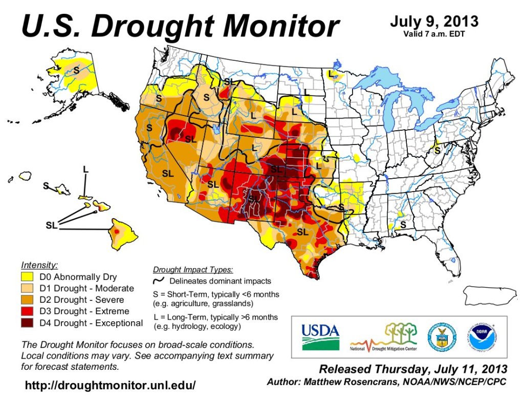
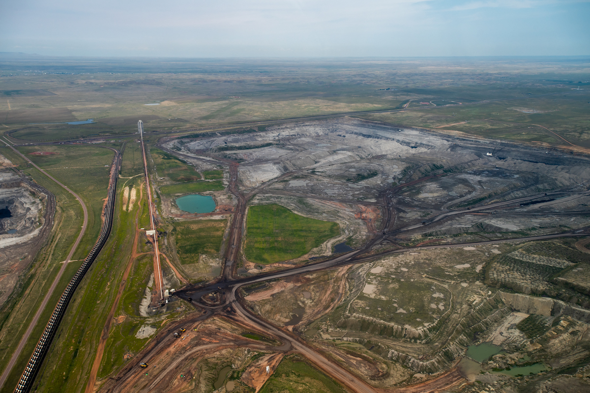
A Wyoming Senate panel is demanding that Congress give the state all federal lands and mineral rights in the Equality State, except Yellowstone National Park.
The Agriculture, State and Public Lands and Water Resources committee voted 4-1 for a resolution that demands Congress confirm by Oct. 1 its intent to turn over the property. Senate Joint Resolution 2, “Resolution demanding equal footing,” covers some 30 million acres “that derive from former federal territory.”
That amounts to about 47% of the state’s land area, the resolution’s lead sponsor Sen. Bob Ide, R-Casper, told the committee. The property in question includes Grand Teton National Park, Devils Tower National Monument, the Bridger-Teton, Shoshone, Targhee, Black Hills, Bighorn and Medicine Bow-Routt national forests, plus the Thunder Basin National Grassland and Bureau of Land Management acreage.
In addition to seeking property belonging to all Americans, the resolution demands federal mineral rights in Wyoming, which amount to 69% of the rights in the state.
Citing the Constitution, Ide said “Congress shall have the power to dispose,” of the land. He interpreted what that means.
“It’s a mandate to dispose,” he said. “They don’t have the authority not to dispose.
“You can’t do the opposite of something that’s specifically directed in the U.S. Constitution,” Ide said.
He agreed with Scott Brown, who told the committee during public testimony that, “by virtue of your oath [to uphold the Constitution] you are required to vote in favor of this resolution.”
Sens. Tim French, R-Powell; Troy McKeown, R-Gillette and Laura Pearson, R-Kemmerer, backed the resolution. Sen. Barry Crago, R-Buffalo, voted against it.
Misreading
The resolution claims two violations of the U.S. Constitution, including that federal ownership puts Wyoming on an unequal footing compared to other states and that federal control of land in Wyoming violates the Bill of Rights.
Those arguments have been part of the foundation of a revived Sagebrush Rebellion that most recently culminated in the U.S. Supreme Court’s rejection of a petition by the state of Utah. The Beehive State sought 18.5 million acres of Bureau of Land Management property.
But Utah’s arguments are based on “wrong-headed assumptions,” made by an advocate who misreads and misinterprets the Constitution and cherry picks definitions, according to a widely cited article by John D. Leshy, a professor at UC Law in San Francisco.
Alec Underwood, program director for the Wyoming Outdoor Council, agreed. The Supreme Court’s rejection “is based on over 100 years of case laws showing that this is impossible legally,” he said.
Squaretop Mountain in the Bridger Wilderness stands over the Green River as the moon shines through smoke from the Pack Trail Fire on Oct. 12, 2024. (Angus M. Thuermer Jr./WyoFile)
Ide saw the Supreme Court rejection differently. “They sent it back to district court and told them to kind of work their way up the ladder,” he said of the court’s 12-word order that reads only: “The motion for leave to file a bill of complaint is denied.”
If Congress acquiesces to the resolution’s demands, Wyoming would be willing to negotiate turning some property back to the federal government, Ide said. The resolution states that Wyoming would create a new designation — state public lands — that’s different from school trust lands where camping, fires and other activities are restricted.
Aside from constitutional questions, the Senate committee heard worries about the fate of mineral rights, the cost of managing the lands, the prospect of Wyoming selling the acreage, the cost of grazing, potential loss of access, response to wildfires, the loss of $30 million in annual federal payments in lieu of taxes and more.
100 years of lawsuits
Ide couldn’t say whether mineral rights would belong to Wyoming or overlying landowners should the panel get its wishes. “How do we figure out where that goes without creating 100 years’ worth of litigation,” Crago asked him.
Ide, who said he was formerly “a mineral title land man,” agreed the proposal “could get very messy on the mineral estate.
“I’ve had a 40-acre parcel,” he said, “that had 200 different mineral owners on it, and you try to track them all down and you can spend a month of work … and still not find half of the mineral owners.”
Crago also warned that grazing costs could increase if the state comes to own federal lands. Outdoor council representative Underwood said grazing leases on state land cost $5.52 an animal-unit month versus $1.35 on federal property.
Crago said Wyoming is restricted by its own constitution on how little it can charge for grazing, and “we’re probably at the bottom of that number right now.”
Noting that outdoor recreation accounts for $2.2 billion and 15,000 jobs annually in Wyoming, Underwood posed an overarching question.
In 2024, the City of Fort Collins applied for a 1041 permit from Larimer County. As a part of the permit process, two public hearings will take place with the county’s Planning Commission and the Board of County Commissioners.
The meetings are scheduled at the Larimer County offices at 200 W. Oak St. in Fort Collins at the following times:
Planning Commission: February 19, 2025 at 6 p.m.
Board of County Commissioners: March 24, 2025 at 6:30 p.m.
The Planning Commission holds its hearing to provide a permit recommendation to the County Commissioners. The County Commissioners hold a hearing to make a final decision on the permit application.
The Halligan Project requires a 1041 permit from Larimer County because it includes the enlargement of a reservoir resulting in a surface area at high water line in excess of 50 acres. The permit process looks at all aspects of the project. To view the application, visit the county’s portal by clicking the button below.
Information Session on Larimer County Permit Application
As someone who is interested in the Halligan Water Supply Project, we are reaching out to inform you about recent developments. In 2024, the City of Fort Collins submitted an application for a 1041 permit from Larimer County. The City, acting through Fort Collins Utilities, is proceeding with this permitting process now as the project is moving through phases of design and closer to construction. The permit process looks at all aspects of the project. To view the application, visit the county’s website by clicking this link.
To increase awareness, the City is hosting an Information Sessionon Feb. 12, 2025 from 6-7:30 p.m. at the Livermore Community Hall. City staff will be on hand to highlight elements of the application and answer questions. While this won’t be part of the official public comment process with Larimer County, we encourage you to engage directly with us. To RSVP, click the button below. Light refreshments will be provided.
It’s time for an agreement in the Colorado River Basin, Colorado water and climate experts say.
Colorado River officials are at odds over how to store and release water in the basin’s reservoirs when the current rules lapse in 2026. Publicly, state negotiators stick close to their original, competing proposals, released early in 2024. Colorado experts watching the process understand the difficulty — it’s painful to talk about cutting water use — but time is of the essence.
Jennifer Pitt, the National Audubon Society’s Colorado River program director, paddles a kayak through a restoration site. (Source: Jesus Salazar, Raise the River)
“I have no idea what’s going to get them to agreement,” said Jennifer Pitt, the Colorado River program director for the National Audubon Society. “To me, the biggest pressure seems like time is running out.”
But there seems to be a lack of trust between the state negotiators, said Jennifer Gimbel, senior water policy scholar at the Colorado Water Center at Colorado State University.
“Not only is there this lack of trust, but there almost seems to be this effort to promote your own proposals by denigrating other proposals,” Gimbel said. “That frustrated me to no end. It’s like they have these political rallies.” [ed. emphasis mine]
If states are going to propose a united plan, then they need to do it by the end of 2025, preferably sooner, experts said.
“We continue to stand firmly behind the Upper Division States’ Alternative, which performs best according to Reclamation’s own modeling and directly meets the purpose and need of this federal action,” Colorado’s negotiating team said in a prepared statement Tuesday.
The basin is also about to see new leadership at the federal level. Colorado water experts are waiting to know who President Donald Trump will appoint to key positions, like the commissioner of Reclamation and the assistant secretary for water and science.
“They’re in a really tough spot. I would understand that,” said John Berggren with the environmental group Western Resource Advocates. “I hope they’re continuing to negotiate and have productive conversations, and I hope they’re open to some more creative options.”
Planning for the extremes
So what options are they considering? In the absence of a seven-state agreement on how to manage the basin’s water supply, the Bureau of Reclamation outlined five possible plans in November:
No action: Included as a formality and shows the risk of doing nothing
Federal authorities: Includes maximum Lower Basin cuts of 3.5 million acre-feet in extremely dry years
Federal authorities hybrid: Includes maximum cuts of 3.5 million acre-feet in the Lower Basin and conserving up to 200,000 acre-feet in the Upper Basin
Cooperative conservation: Includes maximum cuts of 4 million acre-feet in the Lower Basin and conserving up to 200,000 acre-feet in the Upper Basin
Basin hybrid: Includes maximum cuts of 2.1 million acre-feet in the Lower Basin and conserving up to 100,000 acre-feet in the Upper Basin
Colorado experts want to make sure the federal planning process is broad enough to include the worst possible conditions.
Udall/Overpeck 4-panel Figure Colorado River temperature/precipitation/natural flows with trend. Lake Mead and Lake Powell storage. Updated through Water Year 2024. Credit: Brad Udall
The Colorado River Basin’s flows are about 20% lower now than in the 20th century, said Brad Udall, senior water and climate research scientist at the Colorado Water Center at Colorado State University. That’s a drop from about 15.2 million acre-feet per year to about 12.4 million acre-feet, he said.
That’s not enough for the 15 million acre-feet allotted to the seven U.S. states, much less the additional water owed to Mexico and tribal nations.
Udall wants to make sure officials are planning for scenarios in which the river’s flow drops by an additional 10%, or down to 11 million acre-feet.
“The question is … who takes the pain? Is it all Lower Basin? Is Upper Basin sharing that?” he said.
One new detail for the Colorado experts who reviewed the report was the duration of the next management plan: Reclamation wants it to last for at least 20 years after 2026. It is unlikely to be a short-term, interim plan to give negotiators more time to reach a unified agreement.
The revised proposal submitted by the Upper Basin states — Colorado, New Mexico, Utah and Wyoming — also highlighted conserving up to 200,000 acre-feet of water (depending on river conditions), which seemed to move the states closer to alignment with Reclamation, experts said…
The Upper Basin’s revised proposal, and the federal options, include different “pools” in Lake Powell on the Utah-Arizona border, which would function like savings accounts and could store water conserved by Upper Basin states. Colorado water experts are keeping a close eye on how these accounts might work.
“Putting water in Powell is a good thing, but nobody in the Upper Basin wants to send water to protect Powell that ultimately just runs downstream,” said Steve Wolff, general manager of the Southwestern Water Conservation District based in Durango.
The experts wanted to know more about how conservation pools would function; how federal authorities in the basin might expand; which reservoirs will be included in the plan; what the impacts to the Grand Canyon would be under the different plans; and ultimately, what plan will stabilize the system.
They’ll have to wait to find out: The bureau is expected to release a deeper analysis of how each alternative could impact water management in different conditions later this year.
The Bureau of Reclamation’s final selection will likely mix and match elements of the different alternatives, said Carly Jerla, senior water resource program manager with the Bureau of Reclamation in a December presentation in Las Vegas.
“It’s a shame we don’t have a combined Upper Basin and Lower Basin plan right now,” Udall said. “Once Reclamation does its modeling, we’ll learn a lot. But we need a combined plan.”
In an effort to reduce water use in Fort Collins and keep landscapes looking good in the face of drought, City Council is requiring developers to mostly give up using grasses like Kentucky bluegrass and turf-type tall fescue. Council members voted Tuesday to change landscaping standards for future development and redevelopment, but the new rules won’t apply to single-family homes, duplexes or accessory dwelling units. They will apply to everything else: businesses, multifamily residential, dedicated irrigation, streetscapes and parkways…
City Council is making the change, in part, to comply with a new Colorado law that restricts high-water grass to “functional” areas like playgrounds, sports fields, picnic grounds, amphitheaters, active areas of parks and golf course playing areas…
In addition to putting limits on high-water grasses, moderate-water grasses will also not be allowed except for in functional areas. So this rules out many of the grasses typically used for lawns in Colorado: Kentucky bluegrass, turf-type tall fescue and ryegrass.
The changes require 50% of a landscape to consist of living plants (at maturity) to avoid full rock hardscapes.
Areas of less than 75 square feet may not use irrigated grass at all.
The changes will also reduce the water budget for a project to 11 gallons per square foot annually, from 15 gallons per square foot now.
● Researchers used NASA satellite data to analyze the growth rates of over 60,000 fires in the contiguous U.S. from 2001-2020
● Results show fast-growing fires caused 88 percent of fire-related damages in the U.S. between 2001-2020 despite representing less than 3 percent of fires on record during that time.
Fast-growing fires were relatively rare in the United States between 2001-2020, yet they were responsible for nearly 90 percent of fire-related damages, according to a new study published in Science and featured in a new episode of PBS Weathered. These wind events with fire in them send embers far ahead of advancing flames, jump over rivers and highways and rapidly ignite homes. These fast fires overwhelm suppression response. The groundbreaking research relied on new remote sensing tools and shows these fires are getting faster in the Western U.S., increasing the risk for millions of people, and highlighting the actions we need to take before fire comes. “We hear a lot about megafires because of their size, but if we want to protect our homes and communities, we really need to appreciate and prepare for how fast fires move,” said Jennifer Balch, fire scientist and the lead author of the study. “Speed matters not only for understanding how fires evolve but also for keeping people safe.” NASA worked with Navteca to create scientifically accurate, time-based animations of several fast fires, including:
The East Troublesome fire, which destroyed hundreds of homes in and around Grand Lake in the Colorado Rockies, raced over 18 miles in a single day and jumped the barren Continental Divide,
The 2020 Labor Day fires in Oregon and Washington, where a statewide 2,000 foot deep river of wind flowed down from the interior of North America, knocking down power lines and fanning existing fires into rapidly growing fires that burned communities across Oregon,
The Marshall Fire, which destroyed more than 1,000 homes in Boulder County, Colorado, in December 2021. The fire burned less than 6,100 acres but grew quickly due to a combination of dry conditions and high winds. Less than an hour after the fire was reported, it had spread to a town 3 miles away, forcing tens of thousands of people to evacuate, and
The Lahaina Fire which burned 2,170 acres, destroyed 2,285 structures (mostly residential) and killed 98 people. The fire was driven by sustained winds of 30 mph with gusts doubling that.
Fast fires grew more than 4,000 acres (more than 6 square miles) in a single day. The analysis revealed a staggering 250 percent increase in the average maximum growth rate of the fastest fires over the last two decades in the Western U.S. U.S. Fire Administrator Dr. Lori Moore-Merrell reflected: “This research helps us focus our attention on what causes the most loss and what we can do to prepare before fire comes to make us savable.” Fast fires accounted for 88 percent of the homes destroyed between 2001 and 2020 despite only representing 2.7 percent of fires in the record. Fires that damaged or destroyed more than 100 structures exhibited peak fire growth rates of more than 21,000 acres (more than 32 square miles) in a single day. The work also highlights a critical risk assessment gap. At the national level, wildfire risk models include parameters for area burned, intensity, severity, and probability of occurrence, but they do not incorporate growth rate or other measures of fire speed. Government agencies and insurance companies that use these models are therefore missing vital information about how fires spread, which homeowners could use to better protect themselves and their communities. “When it comes to safeguarding infrastructure and orchestrating efficient evacuations, our satellites and earth observations are telling us that the speed of a fire’s growth is a dominant factor in home and community loss.” Dr. Falkowski, Director of NASA’s wildland fire program said.
The East Troublesome fire as it tore through the Trail Creek Estates subdivision on Oct. 21, 2020. (Brian White, Grand Fire Protection District)
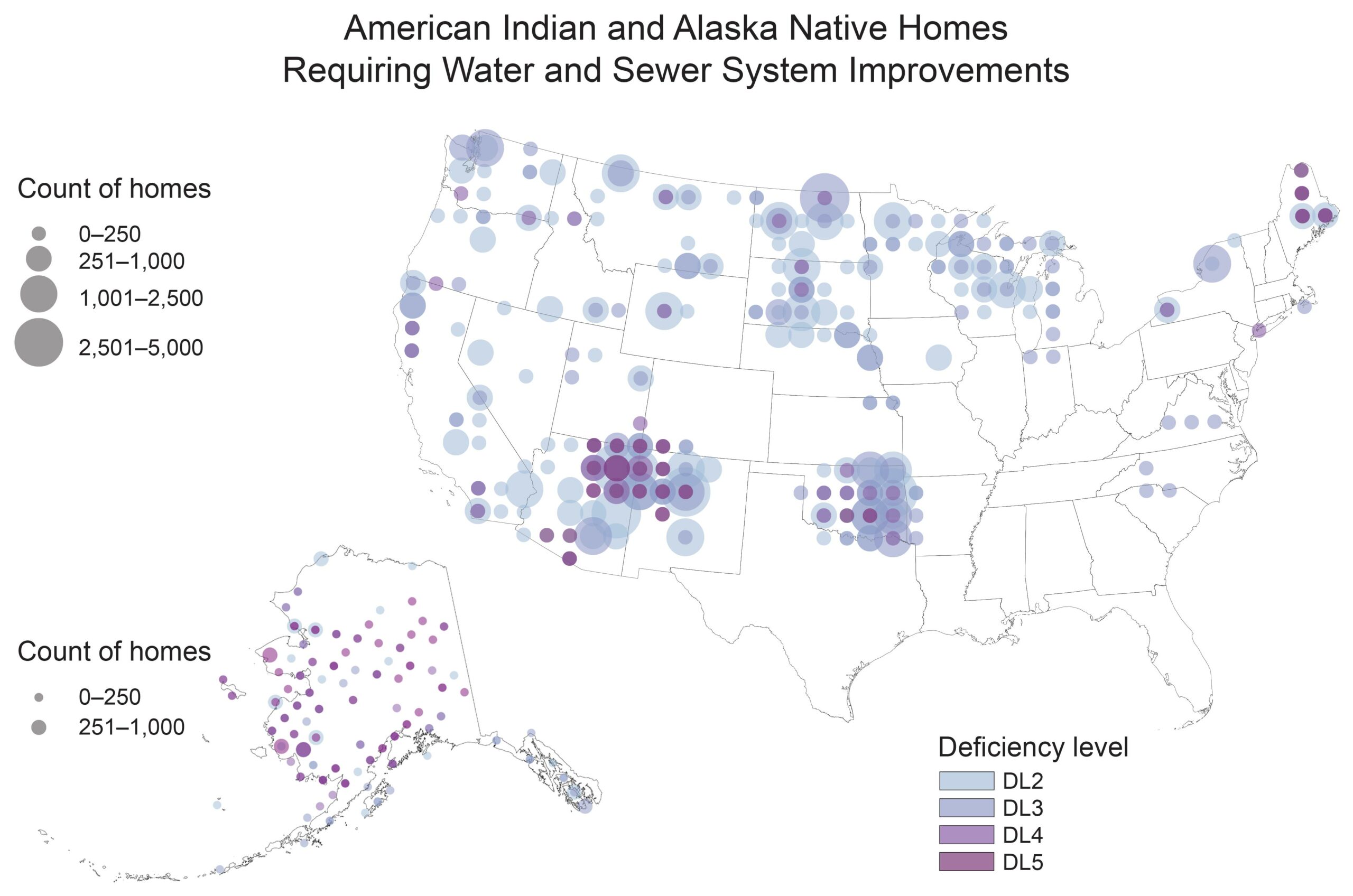
Much of the irrigation infrastructure and technology on the Southern Ute Reservation in Colorado is antiquated. The channel on the right looks much as it did in the 1950s photo on the left. Source: Tribal Water Study Basic projects, like expanding a water treatment plant or installing a new drinking water pipeline, can advance at a glacial pace, as tribes must deal with a variety of different federal agencies to get them approved. Even when funding is available, it can be difficult to launch projects as tribes often lack the resources to navigate the various regulations, fees and environmental reviews. Credit: Water Education Foundation
The federal government awarded $4.25 million to the Colorado-based Southern Ute Indian Tribe this week to defend tribal water resources from climate-related challenges. The Bureau of Indian Affairs Tribal Community Resilience branch distributed grants to 124 projects nationwide, with funding pooled from the Bipartisan Infrastructure Law, the Inflation Reduction Act and the 2024 federal budget…
Across the state, warming fueled by climate change is ratcheting up average temperatures, which can lead to drought conditions. Southcentral and southwestern Colorado – where the Southern Ute Indian Reservation is located – have seen the largest temperature increases statewide, according to Colorado State University’s 2024 State of the Climate report. Spring rain in southwest Colorado has also decreased by over 20 percent compared to 1951-2000, according to the report.
The federal funding will support two projects to restore the ecology of waterways on the reservation and fortify irrigation systems.
A $250,000 grant will support the tribe’s environmental programs department to assess, and eventually restore, the Pine River watershed, which is facing impacts from drought and sediment pollution. The funding will allow the tribe to undertake a detailed assessment and devise a treatment plan for several waterways. Another $4 million grant to the tribe’s water resources division will shore up an irrigation system that delivers water to around 4,000 acres. The funding will allow the tribe to replace old infrastructure and construct new weirs — or low barriers built across waterways — on seven sites on the Pine River canal. The goal is to help the tribe maintain consistent water levels for irrigation, even as a lack of rain and increased evaporation dip into water supplies.
Animas River. Photo credit: The Southern Ute Indian Tribe
Cold Mountain Rancher Bill Fales turns the headgate of the Lowline Ditch. Fales is participating in a non-diversion agreement with the Colorado Water Trust to keep more water in the Crystal River. CREDIT: HEATHER SACKETT/ASPEN JOURNALISM
Irrigation is a major source of water waste in Snowmass, a critical issue as the town draws entirely from local streams. Once diverted, much of the water never follows its natural course to the Colorado River, according to Water Resource Manager Darrell Smith, who presented to the Environmental Advisory Board earlier this week.
“Water is a scarce resource on the Western Slope and in the Colorado Basin as a whole,” Smith told The Aspen Times on Thursday. “So it’s part of doing our part to not use the water we have available to excess.”
Many second homeowners expect their lawn is green, and plants are watered by the time they arrive for the summer months, Smith said. The top 10% of Snowmass irrigators triple the average rate of water use…The Roaring Fork Valley watershed provides 10% of the total water volume to the Colorado River Basin, according to the Roaring Fork Conservancy. But the river no longer reaches the Pacific Ocean. It dries up in Northwestern Mexico due to human water usage, according to USGS. The Colorado River is predicted to drop 29% by 2050 in the Upper Colorado River Basin due to a hotter and drier climate, according to a 2021 USGS study...When temperatures increase, plants need more water, and people irrigate more, drawing more from the watershed, according to him…
As it stands, 35% of annual water usage in single family Snowmass residences comes from irrigation, primarily between June and September, he said. The top 10% of irrigators use 2,100 gallons per day — three times the 700 gallons used by the average Snowmass irrigator. While 95% of indoor water use returns to streams, only 20% of irrigated water returns, according to Smith.
Visitors trek the Sand to Snow National Monument in Southern California, a popular area for camping, hiking, hunting and other activities. Bob Wick, BLM/Flickr
The Department of the Interior was created in 1849 as the United States was rapidly expanding and acquiring territory. It became known as “the department of everything else” for its enormous portfolio of missions, which ranged from western expansion to oversight of the District of Columbia jail.
Interior handles natural resources and domestic affairs – primarily managing 480 million acres (200 million hectares) of federal lands and developing the assets that they hold. Many of these lands are officially open for multiple uses, including energy development, mining, logging, livestock grazing and recreation. Those activities have numerous constituencies, whose interests can clash.
The Interior secretary oversees many types of activities on and beneath lands that represent about 21% of the total surface area of the United States. U.S. Department of the Interior
The Interior secretary’s main job is to promote thoughtful planning that balances resource development and conservation. One strategic role has been expanding energy production, including oil, natural gas, wind and solar power, on federal lands.
Under Republican administrations, the focus often swings toward resource development. Democratic administrations often put greater emphasis on conservation and nonextractive land uses, such as recreation. The secretary’s actions can play a big role in setting direction for the agency.
Interior has about 70,000 employees whose missions fall largely into three buckets: managing public lands and wildlife; meeting U.S. trust responsibilities to Native American communities; and regulating energy, water and mining resources on federal lands and in federal waters offshore.
Many of Interior’s offices have changed dramatically over time in response to evolving environmental and cultural values. For example, the Bureau of Land Management was widely known for years as the “Bureau of Livestock and Mining” because its decisions closely reflected the interests of those industries.
However, today the bureau also manages land for conservation – including a 35 million-acre (14 million-hectare) system of National Conservation Lands. In 2024, the agency adopted a public lands rule that explicitly recognizes the importance of protecting clean water, managing for land health and restoring degraded lands.
Filling up the West
When Congress created the Interior Department, the young United States was in the process of nearly doubling its size after the U.S.-Mexican War. Gold had just been discovered in California, triggering a huge migration west. The scramble to occupy these lands and convert them into stable revenue sources drove Interior’s early activities.
But not all lands met settlers’ needs, especially in dry zones. As a result, much of the arid West remained under federal control. Given this legacy, it is not surprising that most senior officials at Interior have come from western states.
U.S. national parks, monuments, wildlife refuges and other Interior lands have become economic engines for many western towns, attracting private ranches, hotels, restaurants and businesses. In this way, federal lands return tremendous wealth to adjacent communities, particularly with the growth of the outdoor recreation industry.
Nonetheless, many western states resent federal control over broad swaths of territory within their borders and periodically make claims to these lands. Since states don’t have the financial resources to manage roads or fight fires on such large expanses, it is likely that they would sell off large portions of these lands, privatizing them.
Over the past half-century, there has been ongoing debate about whether the royalties and fees the agency charges for federal land use return fair value to taxpayers, or if the agency has been “captured” by extractive industries such as mining, ranching, logging, and oil and gas production. The secretary can send important signals about which way an administration tilts.
Indian Affairs and trust responsibilities
Another central Interior role is managing U.S. government relations with American Indian and Alaska native tribes. The department’s Bureau of Indian Affairs, created in 1824, works with 574 federally recognized tribes with more than 2 million enrolled members.
Interior manages 55 million acres of land and 57 million acres of subsurface mineral rights in trust for the tribes. This essentially means that Interior agencies earn revenue and disperse funds to tribal members, in part to make up for depriving Native Americans of their rightfully held resources over 150 years of displacement.
Even after federal policy became more supportive of Tribal governance and self-determination in the 1970s, Interior did a poor job of fulfilling its key trust responsibilities. In 2009 the agency settled a US$3.4 billion class-action lawsuit, acknowledging that for decades the federal government had mismanaged tribal resources and failed to pay revenues to Indian landowners for resources produced from their lands.
Starting in 2021, under Secretary Deb Haaland – the first Native American to lead the Interior Department – the agency launched an initiative to document and interpret the experiences of survivors and the intergenerational effects of this policy on Native Americans whose ancestors were sent to the schools. https://www.youtube.com/embed/Ui9jCp1yuws?wmode=transparent&start=0 In a 2022 report, the U.S. government acknowledged for the first time its role in carrying out forced assimilation of Native American children at government-run boarding schools.
This land is your land
Interior’s reach is vast, but the resources that it controls and the investments it makes in keeping large landscapes connected provide tremendous services. Debate about the merits of public versus private management of these lands is likely to continue.
Growing interest in outdoor recreation and the rise of remote work are putting new pressure on public lands. Finding solutions will require many different land users, as well as state governments and gateway towns, to collaborate. The Interior secretary can play an important role in helping strike those balances.
This story is part of a series of profiles of Cabinet and high-level administration positions.
According to data captured at the Durango-La Plata County Airport, the Durango area received 14.14 inches of precipitation this year compared to 2023 moisture and precipitation that totaled 10.34 inches. Phillips said June 2024 rains bolstered the total precipitation the city received this year, accumulating 7 inches of rain through June, which is considered above normal for the months of June, July and August. He said 2023 started out with slightly above-normal levels of precipitation, but moisture gave way to a warm and dry summer. That dryness carried into 2024 and was followed up by a strong monsoon season. November storms briefly pushed snowpack above normal, but that momentum flattened again in December, he said.
“Even though it seems dry, our snowpack is actually doing better than it was last year,” he said.
According to Snoflo, a North American climate, hydrology and forecast database, the Upper San Juans had a snowpack level of 32 inches on Saturday, 68% of normal, low for the month of December.
Westwide SNOTEL basin-filled map December 31, 2024 via the NRCS.
In the heart of Northern Minnesota lies a place that inspired the powerful film Saving Silence. Join POW Creative Alliance Captain, Emily Tidwell as she returns to the Boundary Waters Canoe Area, reflecting on how this wild landscape saved her life. ‘Saving Silence’ dives deep into mental health, the critical importance of public lands, and the unsettling presence of microplastics in some of the world’s most remote places. Emily reconnects with Arctic explorer Lonnie Dupre and Clare Shirley, owner of Sawbill Canoe Outfitters, to discuss why protecting this pristine wilderness is more crucial than ever. Thank you to Fat Tire and Visit County Cook for making this possible! Written and produced by Emily Tidwell. Cinematography and editing by Beau Larson. Additional cinematography Spencer Duclos. Audio Design Keith White. Color Design by Jonny Siroteck and Logan Pehota.
The Brooklyn Mine, northwest of Silverton, is among the worst polluters in the Animas River watershed. An innovative restoration project successfully planted 900 trees on a mine waste rock pile to help repair the landscape./ Courtesy of U.S. Forest Service
The U.S. House on Tuesday approved the Good Samaritan Remediation of Abandoned Hardrock Mines Act, via voice vote. The bill passed the Senate in July and now goes to President Joe Biden’s desk. The bill sets up a pilot program under the Environmental Protection Agency to allow “good Samaritans” to clean up and improve water quality around abandoned hard rock mine sites without being subject to liability for pre-existing pollution…
Colorado Sens. John Hickenlooper and Michael Bennet are original co-sponsors of the Senate bill, while Colorado Reps. Brittany Pettersen, Joe Neguse, Lauren Boebert, Jason Crow and Yadira Caraveo co-sponsored the House version. Hickenlooper said the bill is important for all Mountain West states because current liability rules make clean up work too risky.
“If someone, a good Samaritan, comes along and wants to help try to fix [an old mine leaking pollution] and they’ve got a great idea … they can’t do it because the moment they touch anything to do with that pollution, they own it. In other words, they can be sued.” Hickenlooper said. “This is all about trying to let people clean up the mess that people made a century ago without being liable for it.”
[…]
It’s estimated there are as many as 140,000 abandoned hardrock mines in the U.S., with about 23,000 in Colorado. The legislation sets up 15 pilot projects over seven years. Ty Churchwell, mining coordinator for Trout Unlimited, said passage of this bill is “a big, big deal.” The non-profit is one of only a few that do this kind of work, with much of it done by state mine remediation agencies.
Las Vegas has reduced its water consumption even as its population has increased. (Source: Southern Nevada Water Authority)
Click the link to read the article on The Denver Post website (Elise Schmelzer). Here’s an excerpt:
December 6, 2024
Policymakers, academics, irrigators and water attorneys gathered in the Nevada desert this week to discuss the future of the highly contentious river that makes modern life possible for so many people across a vast swath of the American Southwest. The current guidelines that dictate how water is shared among the seven Colorado River basin states are set to expire at the end of 2026, and government leaders must create a new plan before then.
Udall/Overpeck 4-panel Figure Colorado River temperature/precipitation/natural flows with trend. Lake Mead and Lake Powell storage. Updated through Water Year 2024. Credit: Brad Udall
To do so, they must decide who will get less water — and when — as climate change shrinks the river’s flows.
“The tensions are extremely high this year,” said Tanya Trujillo, water policy advisor and deputy state engineer for New Mexico. “Of the 20 years I’ve been coming to this conference, this is the one with the least-good relations among the states.”
[…]
Carly Jerla speaking at the Colorado River Water User’s Association Conference December 5, 2024. Photo credit: USBR
The U.S. Bureau of Reclamation, which operates Lakes Mead and Powell, must create a new operating plan for the reservoirs before current guidelines expire at the end of 2026. The bureau is halfway through the process, said Carly Jerla, senior program manager at the agency. The bureau must complete environmental analyses of potential operating guidelines, take public comment and make a final decision by August 2026, she said.
“We need to be moving, as a basin, a lot faster in this second half than we did in our first half” of the process, Jerla said…
Upper Basin negotiators believe their basin should be exempt from mandatory water-use cuts imposed by the federal government because water use in the basin is already restricted by the amount of precipitation. While the Lower Basin can use water stored in Mead and Powell in dry years, Upper Basin states do not have large upstream reservoirs and must instead rely on snowpack and rainfall. Historically, the Upper Basin has never been able to use its full allocation of water, negotiators from the basin said. Water users in Colorado have their water cut off every year because there is not enough, Mitchell said. The Lower Basin must acknowledge those losses and recognize that the Upper Basin has been living with the impacts of climate change for years, she said.
The bottom of Deep Creek is a unique area of Eagle County. A large group of stakeholders has been working for years to obtain federal Wild and Scenic Rivers designation for a roughly 15-mile stretch of the creek between Deep Lake and the Colorado River. Photo credit: BLM
Click the link to read the article on the Vail Daily website (Scott N. Miller). Here’s an excerpt:
November 29, 2024
Deep Creek is one of Eagle County’s most remarkable places. Years-long efforts continue to preserve that western Eagle County landscape. A 15-mile stretch of Deep Creek nearly a decade ago was found suitable for preservation under the 1968 Wild and Scenic Rivers Act. That act aims to preserve streams that are free-flowing and have “outstanding, remarkable values.” Part of the criteria also includes lack of dams or reservoirs along the stream. Deep Creek would seem to meet those criteria, especially given that it has unique geological features in its canyon and unique plant life in some stretches…
But like any federal status, there’s a long to-do list to accomplish, and designation takes an act of Congress. The Deep Creek designation also has a lot of interested parties. The creek is in two counties — Garfield and Eagle. The portion of the creek eligible for designation is all on federal land, but authority for that land is split between the Bureau of Land Management and the U.S. Forest Service. The creek also sits in two congressional districts, Colorado’s 2nd and 3rd. The 3rd will be represented in January by Grand Junction Republican Jeff Hurd. Boulder Democrat Joe Neguse represents the 2nd. Smith is the Bureau’s liaison to a large stakeholder group named Deep Creek Wild and Scenic Stakeholder Group, which began meeting in 2017. The Colorado River District is part of that group, in part because the district hopes to augment the creek’s flow in the spring runoff season…
While many of us see Deep Creek from the overlook along Coffee Pot Road on the way to Deep Lake, the headwaters of the creek, there are trails to the canyon’s bottom. Smith has hiked in and noted Deep Creek has “completely natural” hydrology, with a “globally rare ecosystem.” In addition, there are caves among the canyon walls and other features for those willing to put in the work.
Deep Creek, which flows from Hahns Peak down into Steamboat Lake in North Routt County, is being considered for an instream flow water right by the Colorado Water Conservation Board. Colorado Water Conservation Board/Courtesy photo
President Donald Trump’s first term was a disaster for America’s public lands. While the prospects for his second term are even more bleak, Westerners across the political spectrum—even those who voted for Trump—stand ready to oppose attempts to sell off America’s public lands to the highest bidder.
As for Trump’s pick for Interior Secretary, North Dakota Governor Doug Burgum: If Burgum tries to turn America’s public lands into an even bigger cash cow for the oil and gas industry, or tries to shrink America’s parks and national monuments, he’ll quickly discover he’s on the wrong side of history.
Public lands have strong bipartisan support in the West. The annual Conservation in the West Poll, last released by the Colorado College State of the Rockies Project in February 2024, found that nearly three-quarters of voters—including Republicans—want to protect clean water, air quality and wildlife habitats, while providing opportunities to visit and recreate on public lands.
That’s compared to just one-quarter of voters who prefer maximizing the use of public lands available for drilling and mining. According to the poll, which surveyed voters in Arizona, Colorado, Idaho, Montana, Nevada, New Mexico, Utah, and Wyoming—80 % of Westerners support the national goal of conserving 30 % of land and waters in America by the year 2030.
Bipartisan support for more conservation and balanced energy development has been a cornerstone of the poll’s findings since it began in 2011. Under the leadership of President Joe Biden and Interior Secretary Deb Haaland, the current administration has made progress over the past four years in bringing public land management in line with the preferences of Western voters. That includes better protecting the Grand Canyon, increasing accountability for oil and gas companies that operate on public land, and putting conservation—at last—on par with drilling and mining on public land.
The President-elect may find it hard to immediately block what Westerners want. After Trump took office in 2017 promising to transform public land management, his team was unprepared and used its power to benefit its own interests, ignoring the wishes of the American people.
Trump’s first Interior secretary, Ryan Zinke, misused his position to advance his dream of owning a microbrewery in Montana. Trump’s second Interior secretary, oil and gas industry lobbyist David Bernhardt, put his finger on the scale in the interest of a former client. Trump’s choice to run the Bureau of Land Management, William Perry Pendley, served illegally without being confirmed by Congress.
We worked hard to shed light on this corruption and defend public lands from Trump’s attacks. Still, Trump’s Interior department allowed oil and gas companies to lock up millions of acres for bargain basement prices.
In his second term, Donald Trump will attempt to shrink national monuments like Bears Ears in Utah and permit drilling and mining in inappropriate areas. The president-elect has already committed to undoing President Joe Biden’s energy and environmental policies.
Project 2025, the policy handbook written by former Trump officials, clearly lays out a plan to gut the Interior Department and remove environmental safeguards that ensure the health of our public lands.
Project 2025 would give extractive industries nearly unfettered access to public lands, severely restrict the power of the Endangered Species Act, open millions of acres of Alaska wilderness to drilling, mining and logging and roll back protections for spectacular landscapes like Bears Ears and Grand Staircase-Escalante national monuments. It would also remove protections for iconic Western species such as gray wolves and grizzly bears.
What can we do about this assault? The law and public opinion are on our side. Public land protections are stronger today than ever, thanks in large part to the grassroots efforts of Tribes, local community leaders and conservation organizations.
We know much of what’s in Trump’s public lands playbook, and we will fight back. We’ll continue to shine a light on corruption within the Trump administration and hold it accountable.
Our partners will work in Congress to stop bad policies and projects from going forward. We are ready to take action in the courts and in the streets. And we’re not waiting until Inauguration Day to start.
Jennifer Rokala is a contributor to Writers on the Range, writersontherange.org, an independent nonprofit dedicated to spurring lively conversation about Western issues. She is executive director of Center for Western Priorities, a nonpartisan public lands advocacy group.
Click the link to read the article on the Water Education Foundation website (Trevor Birt, Fernando Castro-Alvarez, Dennis Davis, Clarence Fullard, Alexander Funk, Daniel Galindo, Marnie Kremer, Dylan Mohamed, Annalise Porter, Noe Santos, Cora Tso, Rachel von Gnechten):
November 14, 2024
The 2024 Colorado River Water Leaders cohort completed its seven-month program with policy recommendations involving ”augmentation” – projects that increase the availability and supply of water – as the Colorado River Basin grows hotter and drier.
The cohort of 12 up-and-coming leaders included engineers, lawyers, resource specialists and others working for public, private and non-governmental organizations from across the river’s basin. The cohort had full editorial control to choose its recommendations.
Their reportprovides a roadmap to promote a purposeful, continuing dialogue around the deployment of water augmentation projects, such as seawater and brackish desalination, water recycling and cloud seeding. The report outlines ways to reduce barriers to implementation through strategies that enable consensus around goals, information sharing and funding support.
The report recommends the formation of an inclusive Water Augmentation Community of Practice that would:
Commit to continuous formal discussions on the future of augmentation in the Colorado River Basin.
Create a system to identify and prioritize the most promising augmentation projects.
Endorse a comprehensive, durable funding structure, supported by a wide group of contributors, to finance the launch of augmentation projects.
Cohort members presented their recommendations in September at the Water Education Foundation’s biennial Colorado River Symposium, an invitation-only event in Santa Fe, N.M., whose audience included key water managers, state and federal officials, tribal leaders and other interested groups throughout the Colorado River Basin.
Our biennial Colorado River Water Leaders program is modeled after our California Water Leaders program, which deepens the participants’ knowledge of water, enhances their leadership skills and prepares them to take an active, cooperative approach to decision-making on water issues. Leading experts and policymakers served as mentors to cohort members.
The next Colorado River Water Leaders cohort will be in 2026.
2024 Colorado River Water Leaders cohort in front of Hoover Dam during the Foundation’s Lower Colorado River Tour in March 2024.
It was the summer of 2015 when the Animas River in southern Colorado turned such a garish orange-gold that it made national news.
This image was taken during the peak outflow from the Gold King Mine spill at 10:57 a.m. Aug. 5, 2015. The waste-rock dump can be seen eroding on the right. Federal investigators placed blame for the blowout squarely on engineering errors made by the Environmental Protection Agency’s-contracted company in a 132-page report released Thursday [October 22, 2015]
The metallic color came from the Gold King Mine, near the town of Silverton in the San Juan Range. The abandoned mine had been plugged by an earthen and rock dam known as a bulkhead, behind which orange, highly acidic drainage water accumulated. But after a federal Environmental Protection Agency employee accidentally breached the plug during an unauthorized excavation, 3.5 million gallons of additional runoff rushed downstream.
The worker and the EPA came in for a slew of outrage and blame. Alarmed Tribal Nations and towns halted drinking water and irrigation operations; tourists fled the region during the height of tourist season.
The “Bonita Peak Mining District” superfund site. Map via the Environmental Protection Agency
But here’s the surprising opinion of Ty Churchwell, the mining coordinator for Trout Unlimited: “Looking back, this can be taken as a positive thing because of what happened afterward.” He sits on a community advisory group for the Bonita Peak Mining District, a Superfund site that contains the Gold King mine.
“We’ve got federal Superfund designation, and it’s the only tool at our disposal to fix this problem,” he said. The “problem” is unregulated hard-rock mining that began 160 years ago.
“I know this isn’t conventional wisdom,” Churchwell said, “but no fish were killed in Durango (30 miles downstream) because of the spill. It was ugly and shocking, but a lot of that orange was rust, and the acidic water was diluted by the time it hit Durango and downstream.”
Cement Creek aerial photo — Jonathan Thompson via Twitter
EPA’s website points out that over 5.4 million gallons of acid mine runoff enters the Animas River daily.
The way Churchwell tells it, water quality and numbers of fish had been declining in the Upper Animas River since the early 2000s. That’s when the last mining operation ended and closed its water treatment plant.
Six months after the news-making spill almost a decade ago, EPA geared up to make sure untreated mine waste would not head for the river again.
Reid Christopher, a 62-year-old former electrician and mountain guide, became the Gold King Mine’s restoration whiz, taking over an old wastewater treatment plant in the area in 2019. Now, he said, only treated water leaves the 11,439-foot elevation mine.
This July, Christopher took me on a tour of the wastewater plant. In a nutshell, cleanup begins when the constantly flowing wastewater gets shuttled into settling ponds.
Christopher then pumps hydrated lime into the water, boosting its pH to 9.25. The high pH unlocks the heavy metals from suspension, and an added flocculant causes the heavy metals to clump together inside football field-sized textile filtration bags.
Clear—surprisingly clean—water streams from the bags into Cement Creek, Christopher said, and the process is so effective he said he’d like to treat the drainage from other major mineshafts in Bonita Peak.
Meanwhile, the Environmental Protection Agency remains gun-shy about talking to the press. It was deluged with bad publicity following the 2015 blowout, though as Churchwell points out, “it wasn’t the EPA that mined the San Juan Mountains and left their mess behind.”
Bonita Mine acid mine drainage. Photo via the Animas River Stakeholders Group.
The messes from abandoned mines, at Gold King and around the entire West, have never received much attention from Congress. Until the Biden administration passed the Inflation Reduction Act, the EPA depended on annual appropriations. That meant for almost four decades, the agency never got enough money to thoroughly clean up the heavy-metal mine waste flowing out of hard rock mines like Gold King.
And because the mess was buried deep in the mountains at elevations from 10,500 feet to over 12,500 feet, the agency couldn’t compete for federal dollars until it grabbed all the environmental disaster headlines of summer 2015.
Even now, said Churchill, and despite available funding, “The EPA has 48 mine-impacted locations in the Upper Animas River and only so many dollars to work with. They have to get the most bang for their buck.”
David Marston. Photo credit: Writers on the Range
Commercial use of metals in the sludge might possibly make some money for the EPA. The Colorado School of Mines has taken water samples to see what—if anything—can be retrieved from the mine waste.
But even if mine sludge is worthless, cleaning acidic water at the top of the watershed is worthwhile for every living thing downstream.
For now, Christopher is always looking to hire locals for dirt work and hauling. He said the jobs could last a lifetime.
Dave Marston is publisher of Writers on the Range, Writersontherange.org, the independent nonprofit dedicated to spurring lively debate about Western issues. He lives in Durango.
Prior to mining, snowmelt and rain seep into natural cracks and fractures, eventually emerging as a freshwater spring (usually). Graphic credit: Jonathan Thompson
Phil Lesh, whose expansive approach to the bass as a charter member of the Grateful Dead made him one of the first performers on that instrument in a rock band to play a lead role rather than a supporting one, died on Friday. He was 84. His death was announced on his Instagram account. No further information was provided. In addition to providing explorative bass work, Mr. Lesh sang high harmonies for the band and provided the occasional lead vocal. He also co-wrote some of the band’s most noteworthy songs, including ones that inspired adventurous jams, like “St. Stephen” and “Dark Star,” as well as more conventional pieces, like “Cumberland Blues,”“Truckin’” and “Box of Rain.”…
The Grateful Dead in 1970, in a rural setting – Bill Kreutzmann, Ron “Pigpen” McKernan, Jerry Garcia, Bob Weir, Mickey Hart, and Phil Lesh By Herb Greene – Billboard, page 9, 5 December 1970, Public Domain, https://commons.wikimedia.org/w/index.php?curid=27041998
Mr. Lesh’s bass work could be thundering or tender, focused or abstract. On the Grateful Dead’s studio albums, his lines held so much melody that one could listen to a song for his playing alone. At the same time, he shared his bandmates’ love for unusual chord structures and uncommon time signatures. In constructing his bass parts, he drew from many sources, including free jazz, classical music and the avant-garde…He had formal training in those last two areas, having played both classical violin and trumpet, composed music for orchestras and studied with the avant-garde composer Luciano Berio, all before taking up the bass and joining the Dead. His work with the band held such value for a significant portion of its massive following that devotees at concerts would position themselves in the “Phil Zone,” an area named for “the proximity to Lesh’s position onstage,” according to the 1994 Grateful Dead guidebook “Skeleton Key: A Dictionary for Deadheads.”
Grateful Dead – Truckin’ (Tivoli Concert Hall 4/17/72) | Meet Up At The Movies 2022. The sixth show on the Grateful Dead’s famous Europe ’72 tour was a return engagement to the Tivoli Concert Hall in Copenhagen, Denmark, on April 17, 1972.
Lake Nighthorse, near Durango, Colorado on May 26, 2023. Both of Colorado’s tribes, the Southern Ute Indian Tribe and the Ute Mountain Utes have water in Lake Nighthorse they haven’t been able to access. CREDIT: MITCH TOBIN/THE WATER DESK
Tribes in the upper Colorado River basin are still struggling to get compensated for water to which they are entitled but aren’t using.
Tribes had hoped to be included in a new round of federal funding through the U.S. Bureau of Reclamation aimed at conservation programs in the Upper Basin and possibly get paid for their water that they aren’t using. But it appears that will not be the case, Lorelei Cloud, vice chair of the Southern Ute Indian Tribe, said on Sept. 20.
“Reclamation agreed to include tribal forbearance programs under the B2W program where we were looking forward to announcing and working on a proposal,” Cloud said. “On Sept. 18, the state of Colorado informed the Southern Ute Indian Tribe that Reclamation has reconsidered its position and will no longer include tribal programs in the B2W program. This decision needs to be reversed.”
The comments came during a panel discussion at the Colorado River Water Conservation District’s annual seminar in Grand Junction. Cloud put out a call to action for attendees to help them plead their case to federal officials. She noted that the title of the panel was “Does History Repeat Itself?”
“We haven’t changed anything,” she said. “No matter how tribes are trying, we haven’t changed anything.”
Becky Mitchell, Colorado’s representative to the Upper Colorado River Commission and the state’s lead negotiator on Colorado River issues, has advocated for more tribal inclusion. She said Colorado officials were notified by phone that Reclamation would not fund forbearance with B2W money.
“Both the tribes and the states thought that this was an option for the use of that funding,” Mitchell said. “There are commitments that have been made, not just in this last year, but in the last 200 years, and it’s time to make good. … We’re going to continue to work with the tribes to pursue federal funding in an effort to correct these historic injustices.”
Native America in the Colorado River Basin. Credit: USBR
Although Vice President Kamala Harris touts clean energy and Donald Trump makes misleading assertionsand false claims about it, neither candidate has set forth a comprehensive energy plan. Even if they do, a gridlocked Congress would be unlikely to pass it.
Instead, the next president’s greatest influence on clean energy will come through their handling of legislation and regulations put in place since 2021 under the Biden-Harris administration. As an environmental engineer who studies energy and climate change, I expect that Harris, who has strongly supported these policies, would follow through on them, while Trump’s record as president suggests that he would try to roll them back. Trade policies toward China, the leading producer of clean energy technologies, will also be key. https://www.youtube.com/embed/hoycdE1G0C0?wmode=transparent&start=0 Donald Trump and Kamala Harris discuss clean energy policy during their presidential campaign debate on Sept. 10, 2024.
Legislation and regulations
Three bills passed by Congress under Biden and Harris – the Infrastructure Investment and Jobs Act, the Inflation Reduction Act and the CHIPS and Science Act – have transformed U.S. energy policy. The three bills allocated hundreds of billions of dollars for building infrastructure, providing incentives for clean energy manufacturing and purchases, and funding clean energy research.
None of these measures is likely to be completely overturned, since each funds numerous projects in red states. But implementation by the next administration will determine how effectively they stimulate clean energy growth.
The Environmental Protection Agency will also play a crucial role. Under the Biden-Harris administration, the EPA issued its most stringent regulations ever for controlling emissions from fossil fuel power plants and motor vehicles. Those rules could accelerate the transition to clean electricity and electric cars.
Currently, the U.S. has a backlog of nearly 2,600 gigawatts of projects waiting to be added to the nation’s electricity grids. That’s roughly eight times the amount of wind and solar generating capacity on U.S. grids today.
However, Congress is deadlocked over competing proposals for streamlining permitting rules. State and local governments and regional grid operators also play key roles and are not easily swayed by federal action.
Still, the next president can influence policy through his or her selection of commissioners to the Federal Energy Regulatory Commission, which regulates interstate transmission of oil, gas and electricity. Presidents also can push Congress to pass permitting reforms.
Trade policy
As fast as U.S. clean energy manufacturing and deployments have grown under the Biden-Harris administration, that increase is dwarfed by China’s output. Chinese companies manufacture over three-quarters of the world’s solar cells and modules, more the half of the world’s wind turbines and three-quarters of the advanced batteries needed for electricity storage and electric cars. China also sells more electric cars than the rest of the world combined. https://www.youtube.com/embed/rkxMdmipYqM?wmode=transparent&start=0 China’s dominance in clean energy manufacturing poses challenges for nations wary of relying on Chinese components.
Like it or not, America’s ability to rapidly deploy clean energy and electric cars will require importing at least some materials from China. After falling behind for decades, there’s simply no way to scale up U.S. manufacturing fast enough to meet national climate goals. Even if solar panels, batteries or electric cars are assembled here, they’ll depend upon critical minerals that are mostly refined in China.
Biden and Harris have also tried to tilt the playing field to favor U.S. companies. The administration is offering loans and incentives for domestic manufacturing, and has also imposed a 100% tariff on electric vehicles and a 50% tariff on solar cells from China.
Such policies may shelter domestic manufacturers for a while, but are unlikely to make them competitive on global markets that are pivoting to electric cars and solar energy.
U.S. standing under the 2015 Paris climate agreement, a legally binding treaty that sets targets for curbing climate change, will also be key. Countries around the world have pledged to shift to clean energy to reduce emissions. The European Union is enacting carbon border tariffs that will penalize imports from high-emitting producers.
If Trump were to withdraw the U.S. from the Paris Agreement again, as he did in 2017, and roll back emissions rules, U.S. manufacturers could face new hurdles in exporting their products overseas. For her part, Harris has supported the Paris accord and criticized Trump’s decision to withdraw the U.S. from it.
No reversing the revolution
Markets worldwide are rapidly transitioning to renewable energy and electric cars, which are becoming cheaper, cleaner and more appealing than their fossil-fueled alternatives. Popular subsidies for clean energy would be difficult to claw back. China’s dominance in clean energy technologies will not soon be shaken, whatever trade policies the next administration adopts.
Based on their records, Harris could be expected to build on the legislation and regulations passed under the current administration, while Trump would be likely to roll back some but not all of its advances. Neither candidate is proposing policies as transformative as the ones enacted in the past several years. Whoever is elected will govern within a clean energy landscape that has been reshaped by those policies, and by market forces that are beyond the control of any president.
The U.S. House of Representatives passed a bill sponsored by Utah Republican Rep. John Curtis on Tuesday that includes the Great Salt Lake in the federal government’s Colorado River water conservation plan, possibly freeing up federal funds to help the Beehive State’s beleaguered saline lake.
The Great Salt Lake Stewardship Act tweaks the Central Utah Project Completion Act, which takes water from the Colorado River basin in eastern Utah, and through a system of reservoirs, rivers and pipelines, diverts it to the Wasatch Front where it’s used for municipal and industrial use. The project is described by the Department of Interior as Utah’s “largest and most comprehensive federal water resource development project.”
Now, the secretary of the department can use their budget authority to take water conservation measures “within the Great Salt Lake basin,” according to the bill text.
Curtis says this will give water managers greater flexibility when making conservation decisions regarding the Great Salt Lake, allowing them to take steps to protect “Utah and the West from the economic and public health risks of an ecological disaster.”
“Utahns have worked tirelessly to protect the Great Salt Lake, but persistent drought conditions now threaten its long-term viability. Recognizing the urgency of this issue, the Great Salt Lake Stewardship Act would expand the Colorado River water conservation program to include the lake,” Curtis said in a statement.
The bill was co-sponsored by members of the Utah Delegation, including Republican Reps. Celeste Maloy, Blake Moore and Burgess Owens.
Utah’s Great Salt Lake Commissioner Brian Steed said the bill could have “a huge impact on the lake and its future.”
“It is great to have partners in Congress who recognize these issues and are willing to collaborate to create innovative and effective solutions,” Steed said in a statement.
Water levels at the Great Salt Lake have been in steady decline since peaking in May — currently the south arm of the lake sits at about 4,192.5 feet, with the north arm, separated by a railroad causeway, at about 4,191.8 feet.
That’s a far rosier outlook than years prior, when the lake hit a historic low of 4,188.5 feet in November 2022.
Still, according to the Great Salt Lake Strategic Plan released earlier this year, the lake needs between 471,000 and 1,055,000 acre-feet of additional water delivered each year for it to reach 4,198 feet in elevation, which is considered the “low end” of the healthy range. An acre-foot is almost 326,000 gallons.
Curtis, who has represented Utah’s 3rd Congressional District since 2017, is not running for reelection, instead vying to replace outgoing Utah GOP Sen. Mitt Romney.
Four years after a high-profile dam restoration project was completed in the scenic headwaters of the Rio Grande, promises to deliver water for fish during the winter and other recreational benefits have not been met, environmental groups charge.
The Rio Grande Reservoir Project was funded by state loans and public grants provided by the Colorado Water Conservation Board, which often bases financing approvals, in part, on a project’s ability to serve multiple purposes, including water for fish, habitat and kayakers.
“The Colorado Water Conservation Board … provided $30 million in the form of loans and grants to complete the project,” the CWCB said In a project update posted on its website. “Benefits include: instream flow enhancement; channel maintenance; outdoor recreation opportunities; terrestrial and aquatic wildlife habitat; irrigation, augmentation; and storage to comply with the Rio Grande Compact between Colorado, New Mexico, and Texas.”
The public-private project was completed in 2020.
The CWCB declined an interview request for this story, but said in an email that there were no specific conditions in the loans and grants tied to providing environmental benefits.
“CWCB does not have the ability to impose extra terms on the recipients of funds that are not articulated in the funding agreements. In the case of the Rio Grande Reservoir Rehabilitation, the final deliverable was completion of the project,” a spokesperson said.
Still Kevin Terry, southwest program director for Trout Unlimited, said the project would likely never have been funded without assurances that the dam would be operated differently to help the river, including releasing water in the winter to aid the fish and changing the time water is released throughout the summer to keep the river cooler and healthier during prime fishing and kayaking season.
“There were lots of environmental benefits touted before the Colorado Water Conservation Board and the roundtable,” Terry said, referring to the Rio Grande Basin Roundtable. The roundtable is one of nine public groups across the state’s major river basins that help address local water issues and funnel state grants to projects they approve.
The San Luis Valley Irrigation District, which owns and operates the dam, serves farms around Center and has delivered water from the dam since 1912, according to its website. Neither District President Randall Palmgren nor Superintendent Robert Phillips responded to numerous requests for comment.
The district uses the reservoir to store water for irrigators. Trout Unlimited and others aren’t asking for any water, they say, just that existing water that would be released anyway be sent downstream at times that are beneficial to the river.
Screenshot from Google Maps
Among key complaints by environmentalists is that the irrigation company is not allowing water to flow out of the rehabilitated dam during the winter, something that would benefit young fish and allow them to grow larger for the next fishing season.
Terry said the irrigation district has said it can’t deliver that winter water because it is difficult to operate the new equipment in freezing winter weather. But Terry said he doesn’t understand how the project could have been built without the ability to deliver in cold weather, something that occurs routinely in other reservoirs in the valley.
Jim Loud, a Creede resident and avid angler who lives on the river, said he and others are tired of waiting for the river to receive the benefits many believed would have been delivered by now.
“All we want is to get them to do what they said they were going to do,” said Loud, citing numerous CWCB documents dating back several years outlining the environmental benefits of the project. Loud is part of the Committee for a Healthy Rio Grande.
Rio Grande and Pecos River basins. Map credit: By Kmusser – Own work, Elevation data from SRTM, drainage basin from GTOPO [1], U.S. stream from the National Atlas [2], all other features from Vector Map., CC BY-SA 3.0, https://commons.wikimedia.org/w/index.php?curid=11218868
The old days weren’t fun
The conflict comes as the Rio Grande Basin, which begins high above Creede and flows south to the Gulf of Mexico, continues to struggle with declining aquifer levels due to heavy agricultural use and low stream flows due to drought and climate change. In Colorado, the Rio Grande waters a potato industry that is one of the largest in the nation.
The last days of the potato harvest. Photo credit: The Alamaosa Citizen
Creede local Dale Pizel, who owns a ranch on the river and caters to the fishing community, said river conditions have improved some since the dam was rebuilt. Prior to the project, the irrigation company would routinely dry up the river for weeks during the high summer tourist season to make repairs to the dam.
“That doesn’t happen anymore,” Pizel said. He too serves on the Rio Grande Basin Roundtable, which also approved some grants for the project.
“I voted for that project knowing it would have environmental benefits, and it did,” Pizel said, because there is no need for the irrigators to dry up the river to repair a failing dam anymore.
Still, he said, if environmental promises are being made publicly, the state needs a better way to make sure they are kept.
Trout Unlimited’s Terry said for years he was hopeful that the rehabilitated dam would serve as another multiuse storage project in the water-short valley helping farmers and the environment.
“We are so disappointed in the delivery of what was promised and the lack of the CWCB holding the irrigation district accountable in any way,” he said.
Altering the dam’s new equipment so that winter releases can occur will likely require spending about $5 million, according to Terry.
Pizel and others hope a resolution between the farmers and the environmentalists can occur without legal action.
“We don’t want to start thumping each other in the chest,” Pizel said. “That’s the way it was in the old days. It was not fun.”
Click here to access the report on the EPA website:
The fifth edition of Climate Change Indicators in the United States documents how climate change is impacting the United States today, the significance of these changes, and their possible consequences for people, the environment, and society.
Using EPA’s climate change indicators and relevant scientific literature, the report groups indicators into eight themes that help to show interconnections, cause-and-effect relationships, and how physical changes in the atmosphere affect people and the environment. Indicators related to human health and societal impacts of climate change cut across chapter themes and are integrated throughout the report. Each theme includes information on why the changes matter, as well as examples and discussion of the unequal impacts of climate change. The report also provides examples of what people and communities can do to address climate change, and what actions are already underway.
Subscribe to The Y’all — a weekly dispatch about the people, places and policies defining Texas, produced by Texas Tribune journalists living in communities across the state.
EDINBURG — The Rio Grande is no longer a reliable source of water for South Texas.
That’s the sobering conclusion Rio Grande Valley officials are facing as water levels at the international reservoirs that feed into the river remain dangerously low — and a hurricane that could have quenched the area’s thirst turned away from the region as it neared the Texas coast.
Although a high number of storms are forecast this hurricane season, relief is far from guaranteed and as the drought drags on.
For now, the state’s most southern cities have enough drinking water for residents. However, the region’s agricultural roots created a system that could jeopardize that supply. Cities here are set up to depend on irrigation districts, which supply untreated waters to farmers, to deliver water that will eventually go to residents. This setup has meant that as river water for farmers has been cut off, the supply of municipal water faces an uncertain future.
This risk has prompted a growing interest among water districts, water corporations and public utilities that supply water to residents across the Valley to look elsewhere for their water needs. But for several small, rural communities that make up a large portion of the Valley, investing millions into upgrading their water treatment methods may still be out of reach.
A new water treatment facility for Edinburg will undoubtedly cost millions of dollars but Tom Reyna, assistant city manager, believes the high initial investment will be worth it in the long run.
“We see the future and we’ve got to find different water alternatives, sources,” Reyna said. “You know how they used to say water is gold? Now it’s platinum.”
For Edinburg, one of the fastest growing cities in the Valley, the need for water will only grow as their population does. While the city hasn’t faced a water supply issue yet, the ongoing water shortage in South Texas combined with the growing population has put local officials on alert for the future of their water supply.
The Falcon and Amistad International reservoirs feed water directly into the Rio Grande. And while water levels have been low, cities and public utilities have instituted water restrictions that limit when residents can use sprinkler systems and prohibits the washing of paved areas.
Cities have priority over agriculture when it comes to water in the reservoirs. Currently, the reservoirs have about 750,000 acre feet of which 225,000 acre feet are reserved for cities.
A former channel of the Rio Grande, or resaca, winds through agriculture fields near Los Fresnos, on Wednesday. The Rio Grande Valley is facing a drought, greatly affecting farmers in the region. Credit: Eddie Gaspar/The Texas Tribune
Of those 225,000 acre feet, each city or public utility or water supply corporation can purchase what are known as “water rights” which grants them permission from the state to use that water.
But without water for farming, more and more of the water that they own is being lost just in transporting the water to their facilities and that’s directly due to the loss of water for farmers.
This relationship with the agriculture industry arose because irrigation districts were created here first. Cities came after and because they used less water, they were set up to depend on irrigation districts.
Water meant for residential use rides atop irrigation water to water treatment plants. Without irrigation water, cities start to use water they already own to push the rest of their water from the river to a water treatment facility. It’s referred to as “push water.” Much of that water is lost for this purpose.
When water levels at the reservoirs got dangerously low in in the late 1990s, the average city would only get about 68% of the water it owns because the rest would be used as push water, according to Jim Darling, board member of the Rio Grande Regional Water Authority and chair of the local water planning group, a subset of the Texas Water Development Board.
The board is tasked with managing the state’s water supply.
Darling, a former McAllen mayor, has been trying to get cities to think of ways to increase their water supply.
As cities try to temper water demand by issuing restrictions on water usage, Darling said public utilities need to think about the drought not just from the standpoint of managing demand but also by increasing supply.
Jim Darling, chair of the Rio Grande Regional Water Planning Group and former McAllen mayor, points at rivers and tributaries shown on a map at the South McAllen Water Plant, in McAllen, on Monday. Credit: Eddie Gaspar/The Texas Tribune
Darling has been floating the idea of creating a water bank of push water so that water districts can get by without having to go through the process of obtaining approval from the state for more water.
These discussions have been ongoing with the watermaster from the Texas Commission on Environmental Quality, who ensures compliance with water rights. The talks are still preliminary, but a conversation with the watermaster’s office in early July revealed that three or four of the Valley’s 27 irrigation districts were out of water.
“Something needs to be done,” Darling said.
Edinburg’s proposed water plant is still in the early planning stages, but the goal is to stave off water woes by turning their attention to water sources underground.
Their plan is to dig up water from the underground aquifers as well as reuse wastewater. The two sources of water would be blended and treated through reverse osmosis.
Reserve osmosis consists of pushing water through membranes, large cylinders that filter the water. This is done several times until the water is pure and meets drinking water standards set by the Texas Commission on Environmental Quality.
This method isn’t new.
By implementing this practice, Edinburg is following in the footsteps of the North Alamo Water Supply Corporation, a utility that supplies water to eastern Hidalgo County, Willacy County, and northwestern Cameron County.
Filtered groundwater is desalinated through reverse osmosis at the Southmost Regional Water Authority brackish groundwater treatment facility in Brownsville on Monday. The facility treats water to distribute to its five partners, including the Brownsville Public Utilities Board, its main customer and is seeking funding to expand the facility in order to address the region’s drought and water shortage. Credit: Eddie Gaspar/The Texas Tribune
After the drought in 1998, North Alamo turned to reverse osmosis in the early 2000s.
Their facilities currently treat about 10 million gallons of water per day through reverse osmosis which represents one-third of all the water they treat. The rest is surface water from the river but they aim to switch that split, treating two-thirds through reverse osmosis and have a third of surface water.
“We’ve got that mindset that we have to get away from the river,” said Steven P. Sanchez, general manager of North Alamo. “We have to start going to reverse osmosis.”
Hidalgo County officials are trying to take a more “innovative” approach to the area’s water problems.
In April, county officials touted a proposed regional water supply project, dubbed the Delta Water Reclamation Project, that would capture and treat stormwater to be used as drinking water.
The project, expected to cost $60-70 million, started off as a project to mitigate flooding by drawing water away from a regional drainage system. But now, plans include a water plant that would take daily runoff and treat it through reverse osmosis.
“We are the first drainage district to do something like this and of course that’s an exciting thing for us, to be able to do something that’s so innovative and green,” said Hidalgo County Commissioner David Fuentes who sits on the drainage district board. “But it comes with a lot of obstacles and a lot of unknowns.”
One challenge will be financing the water plant. Drainage districts are limited on the bonds they can issue in exchange for a loan. Obtaining funds from the Texas Water Development Board would also be an uphill battle since a drainage district doesn’t fit the usual metrics that a water supply corporation does.
County leaders made the case for their project before a Texas Senate committee hearing in May on water and agriculture, requesting that legislative leaders direct the water development board to give a higher consideration to projects like theirs or to provide a grant program their project would qualify for.
The county drainage district already completed a pilot test of the project and those results are now under TCEQ for review. They expect TCEQ will give them the green light as well as instructions on how to design the plant and steps they need to take to ensure water quality.
Fuentes said they expect that review to be completed early in the legislative session, which would give them a better idea of what they need to ask legislators for.
If the project becomes a reality, the county would sell to water corporations like North Alamo.
Members of the public listen to Cameron County Judge Eddie Treviño Jr. as he begins to lead a water conservation meeting with various stakeholders across the Rio Grande Valley at the county courthouse on Tuesday in Brownsville. Credit: Eddie Gaspar/The Texas Tribune
In Cameron County, located on the east end of the Valley, the Brownsville Public Utilities Board was also motivated by drought conditions to reduce their dependence on the river. With help from their partners in the Southmost Regional Water Authority, the public utilities board spearheaded the construction of a desalination facility that also employs reverse osmosis.
Despite its growing popularity in the Valley, desalination has its drawbacks. The process has faced pushback from environmentalists over the disposal of the concentrated salts and because the process requires a lot of energy.
Southmost and North Alamo hold permits from TCEQ to discharge the concentrate, or reject water, into the Brownsville Ship Channel and a drainage ditch that flows to the Laguna Madre, respectively.
Representatives for both entities said the salinity of the concentrate is less than the salinity of the bodies of water that are receiving that discharge.
“All the aquatic life that’s there, the plant life and everything that feeds off that water is not being harmed at all,” Sanchez said. “We monitor that.”
Sanchez said other solutions would be drying beds, a process of evaporating the water into sludge, and injecting the water about 20,000 feet back into the ground.
North Alamo has also made improvements to their energy consumption. In May, the water corporation upgraded their 16-year-old water filtering equipment, reducing the amount of energy used to create the pressure to push the water through their filtration system.
Sanchez said reverse osmosis has also been more efficient for North Alamo.
North Alamo Water Supply Corporation General Manager Steven P. Sanchez at the NAWSC water treatment facility in Edinburg, on Tuesday. Credit: Eddie Gaspar/The Texas Tribune
Their surface water treatment plant treats about 2.7 million gallons of water daily while the reverse osmosis plant treats 3 million gallons. It’s also become cheaper in the last few years. Treatment of surface water costs them $1.21 per thousand gallons while reverse osmosis costs $0.65 per thousand gallons, according to Sanchez who said RO would still be cheaper even with depreciation.
This wasn’t always the case, he said, but the high cost of chemicals is driven up the cost in treating surface water. But where surface water treatment is cheaper is in the initial cost to establish it.
Sanchez estimated that the initial capital investment for reverse osmosis treatment capable of treating a million gallons per day would conservatively cost about $6-7 million while a surface treatment facility of the same capacity would cost $3-4 million.
Southmost’s plans to double their plant’s capacity would cost an estimated $213 million.
Reyna, the Edinburg assistant city manager, agreed that the initial investment would be the biggest cost for the city but believes it will end up paying for itself.
Not all cities have that as a viable option, though. That initial cost can be an insurmountable hurdle for smaller, rural communities that leaves them unable to invest in solutions. The state could possibly alleviate some of that cost.
During the last legislative session, lawmakers established the Texas Water Fund with a billion dollar investment that will go to a number of financial assistance programs at the Texas Water Development including one that has never had funding before called the Rural Water Assistance Fund.
This will be additional state funding to help rural communities with technical assistance on how to decide what kind of design and what kind of assistance is best for their community. This will help them navigate the process of applying for funding.
Rigoberto Ortañes looks at a rising pool of water, flooding the excavation site, as a crew works on upgrading pipes and valves at a North Alamo Water Supply Corporation water plant in Donna on Thursday. The utility company supplies water to eastern Hidalgo County, Willacy County, and northwestern Cameron County. Credit: Eddie Gaspar/The Texas Tribune
Plans for how the water development board will allocate funds to these new financial assistance programs will be released in late July.
Sarah Kirkle, the director of policy and legislative affairs at the Texas Water Conservation Association expects the state will provide interest rate reductions for loans that will be used on expensive projects.
However, the $1 billion allocated to the Texas Water Fund will not get very far.
“The needs for implementing this state water plan are something like $80 billion and those are outdated numbers that we’re looking to update in the new water planning cycle,” Kirkle said, adding that the plan doesn’t include the cost of wastewater or flood infrastructure.
She noted that the cost of water infrastructure is about two or three times what it was before the COVID-19 pandemic because of disruptions in the supply chain and additional federal requirements for federally-funded projects.
Many small communities also don’t have the resources to plan for their needs, Kirkle said, so many of them don’t participate in the water planning process, leaving no one to speak up for them.
“We really need to make sure that as we see additional water scarcity around the state, that our communities are engaged in planning for their needs and understand where they might have risks and where their water might not be reliable,” Kirkle said.
Reporting in the Rio Grande Valley is supported in part by the Methodist Healthcare Ministries of South Texas, Inc.
Big news: director and screenwriter Richard Linklater; NPR President and CEO Katherine Maher; U.S. Rep. Pete Aguilar, D-California; and Luci Baines Johnson will take the stage at The Texas Tribune Festival, Sept. 5–7 in downtown Austin. Buy tickets today!
The Texas Tribune is a member-supported, nonpartisan newsroom informing and engaging Texans on state politics and policy. Learn more at texastribune.org.
Colorado Parks and Wildlife isn’t wasting any time since the detection of zebra mussel veligers (larva stage) in the Colorado River and Government Highline Canal in Mesa County in getting the word out to boaters to clean, drain and dry their boats after being in the river. A mobile waterless boat cleaning station made by the company CD3 is now parked in Palisade’s Riverbend Park near Harky’s Launch Boat Ramp. CPW also has a stationary cleaning station at the Loma Boat Ramp.
“We started rolling out our education plan for zebra mussels and this is on top of all the sampling and things we’re doing as well,” said Northwest Region Public Information Officer Rachael Gonzales. “We are, throughout the Grand Valley, taking out our CD3, which is our waterless (boat cleaning station).”
The waterless cleaning stations have compressed air and a vacuum to help people clean smaller watercraft like kayaks and paddleboards, Gonzales said. There is a more elaborate system at Highline Lake State Park that uses hot water, but is intended for larger craft with motors. This year, Highline Lake is only allowing non-motorized craft. CPW shut down Highline to boaters after the decision was made to drain down the lake to attempt to eradicate its mussels infestation. Previous efforts using chemicals were unsuccessful after mussels were first discovered in Highline Lake in the fall of 2022. In addition to the new watercraft cleaning stations, Gonzales said CPW will have people out around the valley talking one-on-one with boaters and people using the river to explain the importance of cleaning everything from boats to fishing gear that go into the Colorado River.
Click the link to read the release on the NRCS website:
June 11, 2024
USDA also signs agreement with Western Governors to strengthen shared efforts to protect communities and resources
During a meeting of the Western Governors Association today, Deputy Secretary of Agriculture Xochitl Torres Small announced that USDA is investing nearly $66 million for projects to reduce wildfire risk, protect water quality and improve forest health across the nation as part of President Biden’s Investing in America agenda.
Deputy Secretary Torres Small also signed a Memorandum of Understanding (MOU) with the Western Governors’ Association, reestablishing the framework for cooperatively responding to the many challenges faced across western landscapes. The MOU, signed on behalf of the USDA alongside Governors Brad Little of Idaho, Joe Lombardo of Nevada, Michelle Lujan Grisham of New Mexico, Doug Burgum of North Dakota, and Mark Gordon of Wyoming, amplifies the scale of shared stewardship work between participating states and the USDA. It also fosters better integration of forest and rangeland health and wildfire risk reduction projects across different land ownerships.
“People across rural America face growing wildfire threats to their homes, business, infrastructure, and resources,” said Deputy Secretary Torres Small. “Through the investments announced today, President Biden is investing in state and local governments, Tribal partners, and private landowners to ensure our landscapes are healthy, our infrastructure is strong, and our communities stay safe.”
Of the total investment announced, $12 million is being provided through the USDA Forest Service’s Good Neighbor Authority, allowing the agency to collaborate with state forestry agencies, Tribes and counties to mitigate wildfire risk and enhance forest, rangeland and watershed health. This funding will support 22 projects across 13 states, thanks to funding from President Biden’s Bipartisan Infrastructure Law. Nearly $9 million of the total funding will be allocated to support projects in several states that are part of the Western Governors Association member states, including Arizona, California, Idaho, Montana, Oregon, Utah, Washington and Wyoming.
The Department is also investing nearly $55 million of the total funding to reduce wildfire risk, and improve water quality and forest health through the Joint Chiefs’ Landscape Restoration Partnership. This collaborative effort between USDA’s Natural Resources Conservation Service (NRCS) and Forest Service aims to work with private, state, and Tribal landowners to conserve forests and agricultural lands alongside federally managed lands while safeguarding communities. The $55 million investment will support 41 projects — including 10 new projects — across 11 states.
This program advances President Biden’s Justice40 Initiative, which sets a goal that 40% of the overall benefits of certain federal climate, clean energy, and other investments flow to disadvantaged communities that are marginalized by underinvestment and overburdened by pollution.
The NRCS and Forest Service are also now accepting proposals for Joint Chiefs’ Landscape Restoration Partnership projects for fiscal year 2025 projects. Applications are due on September 13, 2024.
“These projects are indicative of a growing movement of cooperation around natural resource issues for the betterment of us all,” said Forest Service Chief Randy Moore. “A keystone of the Joint Chiefs’ projects is the people and the understanding that the healthier our forests, the healthier our nation.”
“The Joint Chiefs’ Landscape Restoration Partnership enables NRCS and the Forest Service to collaborate with agricultural producers and forest landowners to invest in conservation and restoration at a big enough scale to make a difference in their communities,” said NRCS Chief Terry Cosby. “Working with federal, state and local agencies at this scale, helps reduce wildfire threats, protect water quality and supply, improve wildlife habitat for at-risk species, and ultimately combat climate change.”
Since 2014, USDA has invested more than $423 million in 134 projects in 42 states as well as Guam and Puerto Rico through the Joint Chiefs’ Landscape Restoration Partnership. This program focuses on areas where national forests and grasslands intersect with privately-owned lands.
Good Neighbor Authority
Established by Congress in 2014, Good Neighbor Authority provides the Forest Service a straightforward way to enter into management agreements with states, Tribes and counties. The Good Neighbor Authority pools federal, state, Tribal, and county resources to complete more forest, rangeland, and watershed restoration work on national forests and grasslands. President Biden’s Bipartisan Infrastructure Law authorizes $160 million over five years for states and Tribes to implement restoration projects on federally managed lands through the Good Neighbor Authority and the Tribal Forest Protection Act.
USDA touches the lives of all Americans each day in so many positive ways. In the Biden-Harris administration, USDA is transforming America’s food system with a greater focus on more resilient local and regional food production, fairer markets for all producers, ensuring access to safe, healthy and nutritious food in all communities, building new markets and streams of income for farmers and producers using climate smart food and forestry practices, making historic investments in infrastructure and clean energy capabilities in rural America and committing to equity across the department by removing systemic barriers and building a workforce more representative of America. To learn more, visit usda.gov.
FPV system sited on a non-powered reservoir Illustration by Besiki Kazaishvili, NREL
Click the link to access the report on the NREL website (Aaron Levine, Taylor L. Curtis, Ligia E.P. Smith, and Katie DeRose). Here’s the executive summary:
June 2024
Executive Summary
To meet the nation’s decarbonization goals, the U.S. Department of Energy’s Solar Futures study forecasts that installed solar photovoltaic (PV) capacity must increase nearly tenfold, from 80 gigawatts (GW) in 2020 to approximately 760 GW cumulative installed capacity by 2035 (DOE 2021). Ground-mounted PV is expected to dominate future solar deployment and will require more than 3.5 million acres of land to meet annual demand projections (of nearly 45 GW) by 2030 (DOE 2021). However, various competing demands for land (e.g., agricultural production, conservation) and high land acquisition costs in specific locations could be challenges to meeting future PV demand solely with ground-mounted PV deployment (Wood MacKenzie 2023; DOE 2021; Oliveira-Pinto and Stokkermans 2020). Floating photovoltaics (FPV) may be an alternative in locations where ground-mounted PV is not feasible and aid in reaching the nation’s PV deployment and decarbonization goals (DOE 2021; Oliveira-Pinto and Stokkermans 2020; Hooper, Armstrong, and Vlaswinkel 2020; Gallucci 2019).
FPV is a newer siting approach in which a PV array is affixed to a floating apparatus and sited on a water body like a reservoir behind a dam. FPV systems may be stand-alone or co-located a new or existing hydroelectric facilities or pumped storage hydropower (PSH) facility reservoirs. Co-located FPV systems may or may not be operationally paired and work in tandem with the hydroelectric or PSH facility (Gadzanku and Lee 2022; Gadzanku et al. 2021a, 2021b; Lee et al. 2020; Oliveira-Pinto and Stokkermans 2020; Spencer et al. 2018).
Although FPV deployment in the United States is nascent with less than 30 projects installed, significant potential has been identified at existing U.S. reservoirs (Chopra and Garasa Sagardoy 2022). A 2018 National Renewable Energy Laboratory (NREL) study identified more than 24,000 manmade reservoirs (with a total surface area of more than 2 million hectares) in the United States with technical FPV potential; the largest opportunities were found at reservoirs owned by the U.S. Army Corps of Engineers (USACE) and the Bureau of Reclamation (Reclamation). The NREL study estimated that, if fully realized, FPV systems on U.S. water bodies could have produce almost 10% of the nation’s electricity generation in 2018 (approximately 786 terawatt-hours) (Spencer et al. 2018). A follow-on study completed by NREL in 2024 identified between 861 GW and 1,042 GW (corresponding to 1,221 terawatt- hours and 1,476 terawatt-hours) of technical resource potential across USACE, Reclamation, and Federal Energy Regulatory Commission (FERC)-licensed reservoirs.
Current U.S. domestic FPV development is mostly limited to small-scale projects of less than 1 megawatt (MW) sited on closed-loop water bodies such as wastewater treatment plants, drinking water ponds, and irrigation water storage ponds (Chopra and Garasa Sagardoy 2022). Nevertheless, the versatility, potential benefits, and resource potential of FPV have led to growing investment in recent years, which is expected to continue as PV developers look to alternatives like FPV to meet growing demand (Wood MacKenzie 2023; Chopra and Garasa Sagardoy 2022).
This report provides novel analysis to understand the opportunities and challenges associated with developing stand-alone and co-located FPV projects on Reclamation reservoirs, USACE reservoirs, and FERC-licensed reservoirs in the United States. Specifically, the report explores potential environmental and energy benefits and environmental impacts associated with the siting, construction, and operation of FPV projects. The report also identifies and analyzes U.S. federal- and state-issued permits and authorizations required by federal laws to understand the licensing pathways and regulatory requirements for FPV projects sited on FERC-licensed reservoirs, Reclamation-powered and non-powered reservoirs, and USACE powered and non- powered reservoirs.
Of note, this report only analyzes the addition of FPV to reservoirs and does not consider FPV development on or above canal systems.
Palisade peaches ripening on the vine on June 5, 2024. Photo credit: Allen Best/Big Pivots
Click the link to read the article on the Big Pivots website (Allen Best):
July 8, 2024
June was a hot month in Colorado, among the two or three hottest Junes ever recorded.
Temperatures for the state didn’t top those of June 2012, a very notable one with attendant repercussions for river flows on the Western Slope. But on July 1, with records still being tabulated, Russ Schumacher, the state climatologist, said that June ranked either second or third among records that go back to the 1880s. He expects to have the definitive report filed soon.
The heat of June came after a comparatively cool May. It was close to the long-term average across much of Colorado, but cooler than average across northwestern Colorado.
The 10 months prior to May, however, had all been warmer than the 20th century average.
You can study the precise temperature rankings for each month in Colorado (and every other state) at this website maintained by the National Oceanic and Atmospheric Administration and the National Centers for Environmental Information.
Colorado’s coolish May and barn-burner June come even as NASA warns of a climate crisis after an unprecedented 12 months of record highs. Each of the 12 months had a global high.
The last 10 consecutive years have been the warmest 10 since record-keeping began in the late 19th century.
“We’re experiencing more hot days, more hot months, more hot years,” said Kate Calvin, NASA’s chief scientist and senior climate advisor. “We know that these increases in temperature are driven by our greenhouse gas emissions and are impacting people and ecosystems around the world.”
Schumacher, a professor at Colorado State University, said the really extreme warmth during the last year or so has been over the oceans.
“Colorado and the western US have been warmer than average over the last year or so but not breaking records like the globe as a whole,” he told Big Pivots.
NASA has put together a visualization of the rise in global temperatures that might fascinate you – or leave you unsettled. See that visualization here.
Morrow Point Dam, on the Gunnison River, Aspinall Unit. Photo: Brent Gardner-Smith/Aspen Journalism
From email from Reclamation (Erik Knight):
Releases from the Aspinall Unit will be increased from 1600 cfs to 1900 cfs between Wednesday, July 10th and Thursday, July 11th. Releases are being increased in response to declining river flows on the lower Gunnison River.
Flows in the lower Gunnison River have been dropping quickly towards the baseflow target of 1500 cfs. River flows are expected to continue to decline over the next couple weeks.
Pursuant to the Aspinall Unit Operations Record of Decision (ROD), the baseflow target in the lower Gunnison River, as measured at the Whitewater gage, is 1500 cfs for July and then drops to 1050 cfs in August.
Currently, Gunnison Tunnel diversions are 1050 cfs and flows in the Gunnison River through the Black Canyon are around 600 cfs. After this release change Gunnison Tunnel diversions will still be 1050 cfs and flows in the Gunnison River through the Black Canyon will be near 900 cfs. Current flow information is obtained from provisional data that may undergo revision subsequent to review.
East of the Rocky Mountains, there was a mixture of worsening and improving drought conditions this week. With the passage of a couple of frontal boundaries across the eastern contiguous U.S. (CONUS), in addition to a steady moisture flow from the southwestern CONUS into parts of the Central Plains, several areas across the eastern two-thirds of the U.S. received heavy precipitation. However, heavier amounts varied greatly from region to region and were highly localized east of the Mississippi River. Rates of evaporation of moisture from land and vegetation (known as evapotranspiration) are high across the eastern CONUS, due in large part to several days of excessive heat. Therefore, targeted improvements are depicted in regions picking up above normal precipitation (at least 1 inch above normal rainfall for the week) and where improvements to soil moisture and stream flows were apparent. Given the very dry and hot antecedent conditions leading up to this week, drought degradation is merely halted in most other areas receiving above normal rainfall, as indicators did not show marked improvements. Conversely, for locations receiving below normal rainfall, another week of degradation is warranted. In the West, the Four Corners region was the beneficiary of yet another wet week, aided by a couple of low pressure systems bringing an influx of moisture into the region. Elsewhere in the West, conditions worsened, with several pockets of abnormal dryness (D0) popping up and the expansion of drought conditions, particularly across the northern Rockies. A slight westward expansion of abnormal dryness and moderate drought (D1) in the Alaska Mainland and the introduction of abnormal dryness near the Kenai Peninsula is warranted, supported by short-term derived drought indicators and precipitation deficits. A status-quo drought depiction is depicted in Hawaii this week, but stream flows are slowly falling as the trade winds continue to lack meaningful moisture. Puerto Rico continues to remain drought-free…
The High Plains region experienced a mixture of both deteriorating and improving drought conditions this week, which has also predominantly been the case over at least the last month. A couple of troughs of low pressure moved across the western and central U.S. this week, helping to tap into some moisture from the Pacific Ocean and draw it into the region. This resulted in heavy rainfall across parts of the Four Corners and extending eastward into the Central and Eastern Plains. Parts of Kansas and eastern Nebraska received well in excess of 3 inches of rainfall. Unfortunately, several locations across the western High Plains region were not so lucky and received below normal weekly rainfall. Temperatures were also unseasonably warm, running anywhere from 4°F to 8°F above average for the week in many areas, helping to exacerbate worsening conditions…
Colorado Drought Monitor one week change map ending July 2, 2024.
In the Western U.S., drought improvements were limited to southern parts of the region, where a couple of troughs of low pressure were able to bring some moisture from the Pacific Ocean northward into the Desert Southwest and Four Corners. Elsewhere across the West, conditions have slowly dried out in recent weeks. With another week of below normal precipitation and above normal temperatures, with much of the Great Basin running 4°F to 8°F above average for the week, conditions worsened…
Expansion of drought and abnormal dryness is warranted this week in the South, as much of the region experienced another week of hot and dry conditions, and this has been the case since the start of June for many locations. The only areas where improving conditions were observed is across northern Oklahoma, extending into Kansas, where another week of heavy rain fell (locally more than 3 inches in north-central Oklahoma). After a very wet May, precipitation has been lacking entirely across large parts of central and eastern Texas, extending eastward into Louisiana. Indicators have shown a drying trend and topsoil moisture has really started to dry out. These areas will bear watching in the coming weeks…
Looking Ahead
During the next five days (July 3 – July 7), High pressure is likely to build over the western U.S., leading to hot, potentially record-breaking temperatures and below normal precipitation. Farther eastward, East of the Rockies, temperatures are forecast to become more seasonal for the most part. In addition, parts of the Middle and Upper Mississippi Valley are likely to experience a couple of rounds of heavy rainfall. Rainfall in excess of 1 inch is favored across parts of the Ohio Valley, Mid-Atlantic, and Southeast.
The Climate Prediction Center’s 6-10 day outlook (valid July 8 – 12), favors enhanced chances of above average, potentially record-breaking, temperatures across parts of the Intermountain West, with above normal temperatures changes extending into the Western Plains, along the Gulf Coast, and into the eastern U.S. Below normal temperatures are favored in the interior central U.S. Near and below normal precipitation is likeliest across the western and north-central U.S., with above normal precipitation favored elsewhere. Eyes will be on the tropics over the next 6 to 10 days, with enhanced chances for above normal precipitation across southern Texas and the western Gulf Coast. Near to below normal temperatures and above normal precipitation is favored in Alaska and Hawaii.
US Drought Monitor one week change map ending July 2, 2024.
Just for grins here’s a slideshow of early July US Drought Monitor map for the past few years.
Click the link to read the article on the Craig Press website (Ashley Dishman). Here’s an excerpt:
In a move to combat the drought crisis affecting the Colorado River Basin, the Bureau of Land Management (BLM) announced on Thursday an $11.1 million cooperative agreement with the Foundation for America’s Public Lands. The partnership aims to enhance drought resilience in the region, which is vital for the millions of Americans who depend on the river for their livelihoods. The funding, made available through the Inflation Reduction Act under the Biden Administration, is set to bolster efforts to ensure the sustainability of the Colorado River Basin…The BLM, which manages more public land in the Colorado River Basin than any other federal agency, recognizes drought as the most critical threat to the region. The drought impacts various sectors, including agriculture, grazing, wildlife and fisheries, recreation, cultural resource uses, and power generation and distribution.
The Foundation for America’s Public Lands, officially formed in 2022 and chartered by Congress in 2017, serves as the BLM’s charitable partner. The Foundation operates to raise private funds and awareness, increasing access to and stewardship of over 245 million acres of U.S. public lands and waters. The cooperative agreement between the BLM and the Foundation spans five years and aims to undertake restoration projects on a landscape scale. This approach will cover multiple states and invest in local communities that depend on and manage the land. The agreement also allows the Foundation to collaborate with other partner organizations, bringing in technical experts to enhance the effectiveness of the projects.
Fast-growing northern Colorado won approval for two major water loans from the state this month that will help finance a new dam outside Loveland and a major regional water project northwest of Fort Collins.
Vetted by the Colorado Water Conservation Board and approved by a bipartisan group of lawmakers May 1, the $155 million for Chimney Hollow Reservoir and the $100 million for the Northern Integrated Supply Project, or NISP, are among the largest financing packages the state has approved in recent years, according to the board.
“Is it a lot, yes,” said Jeff Stahla, a spokesperson for Northern Water, the agency that is sponsoring the projects for a group of cities that includes Loveland, Broomfield, Erie, and Greeley.
“We know that these were big asks, and we are grateful for the support. We also recognize that these projects are going to benefit hundreds of thousands of people in the fastest-growing part of the state right now,” Stahla said.
The full costs of the water projects, $561 million for Chimney Hollow and roughly $2 billion for NISP, are being financed by water users, as well as the state, Stahla said.
The Northern Integrated Supply Project, currently estimated at $2 billion, would create two new reservoirs and a system of pipelines to capture more drinking water for 15 community water suppliers. An environmental group is now suing the Army Corps of Engineers over a key permit for Northern Water’s proposal. (Save the Poudre lawsuit, from Northern Water project pages)
The loans come as forecasts show the state’s streams shrinking as much as 30% due to the warming climate while the area’s population continues to grow.
Kirk Russell, the board’s finance section chief, said the two loans combined make up 20% of the agency’s $1.1 billion revolving loan fund. The program operates by providing cash to borrowers below market rates. The interest that is generated, in turn, helps finance loans for new borrowers as these are repaid.
The mega loans mean the state will have somewhat less to lend next year, Russell said, for the state’s 2025 fiscal year, which begins July 1.
“I estimate we will have about $50 million to $60 million in loan funds available next fiscal year. That’s about our average annual total [in available loan funds] for the last few years,” Russell said via email.
The loan program is funded with cash generated by interest and loan payments, as well as federal mineral lease payments and severance taxes collected from oil and gas production, Russell said.
Among its other major loans in recent years is the Arkansas Valley Conduit in southeastern Colorado, which received a $90 million loan, and Aurora’s Prairie Waters Project, which received a $60 million loan, according to Russell.
Rep. Karen McCormick, D-Longmont, said she and her fellow lawmakers are pleased the state has been able to provide the financial help. McCormick was one of the bipartisan group of lawmakers who sponsored House Bill 1435, the legislation authorizing the loans.
“These projects are super important, especially to my area of Colorado,” McCormick said. “To have these new reservoirs completed is critical. A lot of different water providers are depending on this.”
The projects are not without controversy, however. Federal permitting for both began 20 years ago, according to Stahla, and each has been delayed numerous times after environmentalists sued over concerns about the impact on the drought-strapped Colorado River, the supply that will eventually fill Chimney Hollow, and the equally stressed Cache la Poudre River, whose flows will be used by NISP.
In fact, the Chimney Hollow loan grew from its original $90 million to $155 million in part due to the cost of litigation and increases in construction costs, Stahla said.
Though Chimney Hollow is under construction, NISP continues to face delays due partially to a lawsuit by Save the Poudre against the federal agencies that approved the deal. It was filed in January.
And it will also have to eventually win an OK from the City of Fort Collins, which has historically opposed the project. Mayor Jeni Arndt declined to comment on the state funding, but said the project would still have to undergo review by the city.
How quickly that might occur isn’t clear…
More by Jerd SmithJerd Smith is editor of Fresh Water News. She can be reached at 720-398-6474, via email at jerd@wateredco.org or @jerd_smith.
Ridgway’s Rail. Photo: Robert Groos/Audubon Photography Awards
Click the link to read the release on the Audubon website (Jennifer Pitt):
May 21, 2024
The Colorado River is flowing again in its delta. While this is welcome news for birds and people, the long-term progress to keep the Colorado River alive in Mexico with habitat restoration and water deliveries depends on high stakes negotiations currently underway.
For the third time since 2021, the United States and Mexico are collaborating to deliver water to improve conditions in the long-desiccated delta. Environmental water deliveries began mid-March and will continue into October, ensuring the river flows through the summer’s heat, making restored riverside forests and wetlands more hospitable to birds like Abert’s Towhees and Crissal Thrashers and other wildlife including beavers and lynxes. We know that birds rely on water in the Delta as they migrate to locations all over the United States.
Restoration in the Colorado River Delta is implemented by Raise the River, a coalition of NGOs including Audubon, in partnership with U.S. and Mexican federal agencies. Funds, water, and collaboration for this work were committed first in Minute 319 and again in Minute 323, the United States–Mexico treaty agreements that have been widely hailed for modernizing Colorado River management with a host of benefits to water users in both countries including rules for sharing water shortages, as well as work to use relatively small volumes of water to revive the delta for wildlife and people. The terms of Minute 323 sunset in 2026, but delta restoration efforts remain a work in progress.
The good news: the United States and Mexico are poised to negotiate a successor agreement to Minute 323 in parallel with new federal rulemaking in the United States for Colorado River management. Domestic Colorado River rules, like the binational agreements, have for decades been the result of consensus-based negotiations, in this setting between the seven Colorado River Basin States with concurrence of the U.S. Bureau of Reclamation. This domestic rulemaking also has a 2026 deadline.
The bad news: at the moment, the Colorado River Basin states appear to be nowhere near consensus, with disagreements about which states, and which water users, will cut back when there’s not enough to satisfy all. These are difficult and high stakes negotiations. Failure to reach agreement increases the risk of water supply crises and could even throw the dispute in front of the U.S. Supreme Court.
That brings me back to the Abert’s Towhees and Crissal Thrashers, the beavers and lynxes in the Delta. If the Colorado River Basin states fail to reach consensus, there’s considerable risk that the work of restoring the Colorado River in its delta comes to a halt. Delta restoration depends on binational consensus, and binational consensus depends on a U.S. domestic consensus. It’s an extraordinarily complex decision-making framework for governance of water supply for 40 million people. The failure to reach consensus may create problems for some people who use Colorado River water, but it is certain to create collateral damage in Colorado River ecosystems including the Delta.
Click the link to read the article on the AZCentral.com website (Brandon Loomis). Here’s an excerpt:
May 16, 2024
A dry April around the Colorado River Basin melted hopes for a second-straight banner year of big runoff to swell Lake Powell’s reservoir storage, government hydrologists say. The result is a likely holding pattern for drought responses over the next two years, according to the U.S. Bureau of Reclamation. Water levels in Lake Powell and Lake Mead are unlikely to rise as they did after the strong snowpack that accumulated over the 2022-2023 winter, but are also unlikely to tip the Southwest into a new tier of water austerity measures. The mountain snow season started out dry, came on strong in the middle, and came to an abrupt standstill in April.
With the exception of the Colorado headwaters and Arizona’s Verde River, most areas of the seven-state watershed experienced below-average April snow and rain, according to the Colorado Basin River Forecast Center. What had generally been above-average snowpack water content throughout the region in late-winter turned toward normal or below average as meltwater started flowing toward Lake Powell.
Snowpack numbers drop during a drier April
For the water year that began in October, total precipitation in areas flowing toward Lake Powell stood at about 97% of the 30-year average this month, he said. A relatively dry month above the big reservoir had reduced an April 1 snow-water equivalent reading that was 113% of the median to just 89% by May 1. Snow-water equivalent describes the amount of water that would result from melting snow.
Reclamation, which manages Powell’s releases past Glen Canyon Dam, now predicts the water flowing toward the reservoir through the end of runoff season in July will come in at 81% of average, totaling 7.9 million acre-feet. With the agency set to release 7.48 million acre-feet toward Lake Mead this year, Powell’s storage capacity is not expected to change much. It is currently 34% full and most likely will end the year at 37%, according to the agency’s calculations…
Within Arizona, the Salt River Project’s outlook for water supplies is strong for the second year in a row. The metro Phoenix supplier said its Salt and Verde watershed reservoirs entered May at 93% of capacity.
Manager of the Conejos Water Conservancy District and fourth-generation farmer and will lead the nine-member board
Conejos County’s Nathan Coombs was elected new chair of the Colorado Water Conservation Board this week. It’s a major role for the fourth-generation farmer who will lead the 15-member board for the next year.
The Colorado Water Conservation Board includes nine representatives from each major Colorado river basin as well as the Denver area.
“I’m honored to serve as chair of the CWCB, to bring in my experience working in the challenging landscape of the San Luis Valley, and lean on the experiences of the rest of the board,” said Coombs.” We face so many water challenges in Colorado, so it’s critical we all come together to find creative solutions.”
The Rio Grande cutthroat is the only trout native to the San Luis Valley. Evidence suggests it was a native fish to Lake Alamosa 700,000 years ago. Photo credit: Ryan Michelle Scavo
Coombs serves as the representative of the Rio Grande Basin and is manager of the Conejos Water Conservancy District. In recent years, Coombs has partnered with biologists at Trout Unlimited to improve habitat for fish in the region’s rivers and streams. Coombs takes over as CWCB board chair from Greg Felt, representative of the Arkansas River basin and chair from 2023 to 2024.
Lorelei Cloud, Vice-chair of the Southern Ute Tribal Council, and Southwest Colorado’s representative of the Colorado Water Conservation Board, which addresses most water issues in Colorado. Photo via Sibley’s Rivers
Lorelei Cloud was elected as vice chair. Cloud serves as the representative of the San Miguel-Dolores-San Juan drainage basin, and also serves as vice chair of the Southern Ute Indian Tribe. Cloud is the first tribal council member to join the board and is a leader in Colorado, bringing critical tribal voices to the table.
In March 2023, Colorado Governor Jared Polis appointed Coombs and Cloud to the CWCB to represent their basins.
“Directors Coombs and Cloud joined as board members last March, and have made valuable contributions over the last year,” said CWCB Director Lauren Ris. “We are excited to see what they do in the next year in these leadership roles – from navigating tough conversations to leading productive brainstorming to listening to viewpoints from across the state.”
Click the link to read the article on The Buzz website (Floyd Ciruli):
May 2, 2024
Colorado voters may be asked to direct more sports gaming revenue to water conservation projects.
Jerd Smith of Fresh Water News reports on new legislation with bipartisan support including House speaker Julie McCluskie that will refer a ballot issue to voters in November. It will shift any gaming revenue over a $29 million cap in the original ballot proposition to water projects.
I said the measure should pass with leadership support and that voters are likely to be supportive.
Voters are concerned about water conservation
The measure would not expand gaming or increase taxes
Gaming interests (Fan Duel or DraftKings) are not opposed
Environmental interests appear supportive
“While the original sports betting ballot measure received tepid support, the tax question, if it makes the ballot, may win broader support due to ongoing voter concerns about water conservation and protection and the high-profile crisis on the drought- stressed Colorado River, veteran pollster and political analyst Floyd Ciruli said.
“I have not seen any polls that negate what we knew strongly back then, that water conservation and water protection are environmental issues that Coloradans care strongly about,” he said.”
Climate experts fear Donald Trump will follow a blueprint created by his allies to gut the National Oceanic and Atmospheric Administration (Noaa), disbanding its work on climate science and tailoring its operations to business interests…The plan to “break up Noaa is laid out in the Project 2025 document written by more than 350 rightwingers and helmed by the Heritage Foundation. Called the Mandate for Leadership: The Conservative Promise, it is meant to guide the first 180 days of presidency for an incoming Republican president. The document bears the fingerprints of Trump allies, including Johnny McEntee, who was one of Trump’s closest aides and is a senior adviser to Project 2025. “The National Oceanographic [sic] and Atmospheric Administration (Noaa) should be dismantled and many of its functions eliminated, sent to other agencies, privatized, or placed under the control of states and territories,” the proposal says…
That’s a sign that the far right has “no interest in climate truth”, said Chris Gloninger, who last year left his job as a meteorologist in Iowa after receiving death threats over his spotlighting of global warming…The guidebook chapter detailing the strategy, which was recently spotlighted by E&E News, describes Noaa as a “colossal operation that has become one of the main drivers of the climate change alarm industry and, as such, is harmful to future US prosperity”. It was written by Thomas Gilman, a former Chrysler executive who during Trump’s presidency was chief financial officer for Noaa’s parent body, the commerce department…
Gilman writes that one of Noaa’s six main offices, the Office of Oceanic and Atmospheric Research, should be “disbanded” because it issues “theoretical” science and is “the source of much of Noaa’s climate alarmism”. Though he admits it serves “important public safety and business functions as well as academic functions”, Gilman says data from the National Hurricane Center must be “presented neutrally, without adjustments intended to support any one side in the climate debate”. But Noaa’s research and data are “largely neutral right now”, said Andrew Rosenberg, a former Noaa official who is now a fellow at the University of New Hampshire. “It in fact basically reports the science as the scientific evidence accumulates and has been quite cautious about reporting climate effects,” he said. “It’s not pushing some agenda.”
[…]
Noaa also houses the National Weather Service (NWS), which provides weather and climate forecasts and warnings. Gilman calls for the service to “fully commercialize its forecasting operations”. He goes on to say that Americans are already reliant on private weather forecasters, specifically naming AccuWeather and citing a PR release issued by the company to claim that “studies have found that the forecasts and warnings provided by the private companies are more reliable” than the public sector’s. (The mention is noteworthy as Trump once tapped the former CEO of AccuWeather to lead Noaa, though his nomination was soon withdrawn.) The claims come amid years of attempts from US conservatives to help private companies enter the forecasting arena – proposals that are “nonsense”, said Rosenberg. Right now, all people can access high-quality forecasts for free through the NWS. But if forecasts were conducted only by private companies that have a profit motive, crucial programming might no longer be available to those in whom business executives don’t see value, said Rosenberg.
Specially designed hurricane-proof building constructed to house joint offices of the Houston-Galveston National Weather Service Forecast Office and the Galveston County Emergency Management Office. By Nsaum75 at en.wikipedia, CC BY-SA 3.0, https://commons.wikimedia.org/w/index.php?curid=8895755
The Upper Gunnison River Water Conservancy District awarded $260,000 to organizations and individuals across the basin during its 2024 grant cycle. This year marked the water district’s 15th annual grant program, which uses tax revenue to support diverse water projects in the basin. Grant funds will be used for projects that improve irrigation water management and efficiency, restore degraded stream channels and aquatic habitat, support engineering and design and carry out basin water education. The district received requests for more than $315,000. All applicants were required to provide a 50% cost match…
The 16 projects funded this year include maintenance on the boardwalk bog bridge along the Rec Path in Crested Butte, as well as the installation of educational signage about the wetlands in the area. The district gave $25,000 to support the ongoing harmful algal bloom study at Blue Mesa Reservoir with the U.S. Geological Survey. Two Western Colorado University students will work with the National Park Service to explore the effects of toxic algal blooms on the foraging patterns of kokanee salmon. An Arch Ditch automation project will allow the diversion to fully operate remotely. This is the first one of its kind in the Gunnison Basin. The upgrade will reduce the labor needed to manage the diversion and conserve water. In Gunnison, $50,000 will help address irrigation issues at the Dos Rios Golf Club and reduce water use. The existing system is 40 years old, and uses roughly 65 million gallons of water per year. With the new system, the managers expect to cut water use almost in half.
WASHINGTON – The Bureau of Reclamation’s Desalination and Water Purification Research program awarded eight projects funding totaling more than $1.9 million. Reclamation selected the projects from 80 eligible applications all submitting pioneering solutions to desalination and water treatment technologies.
“These awards allow us to tackle the climate crisis by investing in development and application of advanced water treatment technologies that expand access to otherwise unusable water resources,” said Research and Development Program Manager Ken Nowak. “These efforts increase water supply flexibility under the risks of long-term climate change and shorter-term drought.”
The Desalination and Water Purification Research Program provides financial assistance for advanced water treatment research and development, leading to improved technologies for developing water supply from non-traditional waters, including seawater, brackish groundwater, and municipal wastewater, among others.
Recipients of the project funding have provided an additional $1.4 million of non-federal cost share to further support these research efforts.
ARIZONA
Arizona State University: Funds awarded ($209,708 federal funding, $424,479 total project cost) for Nanobubbles as a Chemical-Free Fouling and Scale Control Strategy for Reverse Osmosis Project. This project proposes a chemical-free solution during water desalination.
COLORADO
Mickley & Associates LLC: Funds awarded ($117,700 federal funding, $235.400 total project cost) for the Updated Survey of U.S. Municipal Desalination Plants Project. This project aims to identify an estimated 50 to 70 facilities and gather detailed information about U.S. municipal desalination facilities that have been built since 2017 and will be built through 2024. The project will also determine that status of facilities included in past surveys as several older facilities are no longer operating.
University of Colorado: Funds awarded ($250,000 federal funding, $339,133 total project cost) for the Advancing Water Reuse Through Improved Diagnostic Tools for Corrosion Control Project. This project will develop a new method for proactively assessing the presence of toxic metal release in water systems and the susceptibility of release due to changing water conditions. Current methods are limited, because they do not link the presence of a toxic metal to the likelihood of release into potable water.
MASSACHUSETTS
Harmony Desalination Corporation: Funds awarded ($390,871 federal funding, $781,742 total project cost) for the Field Pilot Testing a Batch RO Process Using Electrically Conducting Reverse Osmosis Membranes Project. This project proposes extended field testing of a high recovery batch reverse osmosis process using innovative anti-scaling and antifouling electrically conducting membranes in comparison with conventional reverse osmosis membranes.
NEW JERSEY
New Jersey Institute of Technology: Funds awarded ($249,940 federal funding, $396,971 total project cost) for the Enhanced Coagulation for the Removal of Per- and Polyfluoroalkyl Substances using Hydrophobic Ion Pairing Approach Project. This project proposes to utilize hydrophobic ion-pairing as a pretreatment to enhance the removal of both short-chain and long-chain per-/polyfluoroalkyl substances during coagulation/flocculation process.
New Jersey Institute of Technology: Funds awarded ($250,000 federal funding, $500,334 total project cost) for the Field-Effect Transistor Nanosensors for Testing Per- and polyfluoroalkyl Substances Impacted Water and Air Project. This project will fabricate novel field-effect transistor sensors, systematically examine the sensing performance, device stability, and reusability when probing per-/polyfluoroalkyl in synthetic water and air samples and conduct a field demonstration of the sensors.
NEW MEXICO
New Mexico State University: Funds awarded ($250,000 federal funding, $312,514 total project cost) for the Brine 2030: Enhanced Water Recovery with Mineral Valorization for Sustainable Cement Production Project. This project seeks to address two seemingly different problems: brine management and greenhouse gas emissions from cement manufacturing.
TEXAS
Texas State University: Funds awarded ($250,000 federal funding, $399,234 total project cost) for the Pilot Photobioreactor Development for Scalant Removal and Enhanced Water Recovery from Brackish Reverse Osmosis Concentrate Project. This project seeks to demonstrate continuous pilot photobioreactor operation using sunlight and reduction of the reactor footprint.
Bennet Secured Nearly $91.5 Million for 78 Colorado Projects
Washington, D.C. — Colorado U.S. Senator Michael Bennet announced that he secured nearly $91.5 million for 78 Colorado projects through the congressionally directed spending (CDS) in the first round of Fiscal Year 2024 (FY24) Senate appropriations bills. In total, the six bills included nearly $130 million in funding for projects across Colorado. The Senate is currently working to pass another six FY24 appropriations bills which could include additional funding for Colorado projects.
“Throughout this process, I’ve sat down with municipalities, nonprofits, and leaders across the state to hear directly about the challenges their communities face and how Washington can be a better partner,” said Bennet. “I’m glad we were able to support nearly eighty projects across thirty Colorado counties in this round of funding. From funding water infrastructure in Lamar to a business park in Craig and a housing affordability project in Fort Collins, these investments will help Coloradans meet the changing needs of their communities.”
Colorado projects secured by Bennet in FY24 Senate appropriations bills:
PROJECT TITLE
RECIPIENT
FUNDING AMOUNT
LOCATION
ALSO REQUESTED BY
211 Colorado Upgrade
Mile High United Way
$500,000
Denver
Hickenlooper, Crow
3rd and Knox Affordable Housing Project
Habitat for Humanity of Metro Denver, Inc.
$750,000
Denver
Hickenlooper, DeGette
Auraria Early Learning Center and Mixed-Use Development
Auraria Higher Education Center
$2,000,000
Denver
Hickenlooper
Breakthrough Program Expansion
Breakthrough
$353,000
Denver
Hickenlooper
Central Corridor
RTD
$850,000
Denver
Hickenlooper, DeGette
Central Public Library—Renovation
City of Aurora, CO
$3,000,000
Aurora
Hickenlooper, Crow
Chambers Avenue Widening
Colorado Department of Transportation
$4,116,279
Commerce City
Hickenlooper, Caraveo
City of Aurora for Pressure Regulating Valve Relocation
City of Aurora
$900,000
Aurora
Hickenlooper, Crow
City of Aurora for Water System Improvements
City of Aurora
$2,000,000
Aurora
Hickenlooper
City of Evans for Waterline Replacement Project
City of Evans
$677,000
Evans
Hickenlooper, Caraveo
City of Gunnison for Water Treatment Plant Project
City of Gunnison
$1,750,000
Gunnison
Hickenlooper, Boebert
City of Lamar for Wastewater Treatment Plant Improvements
City of Lamar
$1,800,000
Lamar
Hickenlooper
City of Longmont Micro Transit System
City of Longmont
$1,000,000
Longmont
Hickenlooper, Neguse
City of Westminster for New Water Treatment Facility
City of Westminster
$959,752
Westminster
Hickenlooper, Pettersen
Clear Creek Schools Foundation Childcare Center
Clear Creek Schools Foundation
$1,616,279
Idaho Springs
Neguse
Colorado Rural Impact Programs
County Sheriffs of Colorado
$917,000
Statewide
Colorado State University Multiuse UAS Airfield Project
Colorado State University
$500,000
Fort Collins
Hickenlooper, Neguse
Compactor/Roller Attachments for Road Safety
Colorado Department of Transportation
$396,000
Golden
Hickenlooper
Cottonwood Pass Blue Hill Project
Colorado Department of Transportation
$1,500,000
Eagle County
Hickenlooper, Boebert
Deer Creek Water District for Water Meter Upgrades
Deer Creek Water District
$80,000
Parker
Hickenlooper
Denver Fire Station 40
City and County of Denver
$850,000
Denver
Hickenlooper, DeGette
Denver International Airport Electrification Plan
City and County of Denver – Mayor’s office
$300,000
Denver
Hickenlooper, DeGette
DigitalBridge Colorado – Phase 2
WRC – Connected Communities
$270,000
Grand County
Douglas County for Wildfire Mitigation
Douglas County
$800,000
Douglas County
Eagle County Regional Airport Federal Inspection Station
Eagle County Regional Airport
$500,000
Gypsum
Hickenlooper, Neguse
Ecological Prediction Lab: Airborne Coverage to Inform Water and Forest Health Management
The U.S. Department of Agriculture has released updated methods to help farmers, ranchers and forest landowners estimate greenhouse gas emissions on their land. Three of the federal report’s six chapters were authored by Colorado State University scientist Stephen Ogle, one of the world’s top experts in greenhouse gas inventories.
The report provides the best available science-based methods for estimating greenhouse gas emissions from land management decisions, updating a 2014 USDA report. Methods outlined in the report will be used to evaluate government conservation and climate-smart agriculture programs that encourage practices such as soil carbon sequestration.
“We, as a group of authors, pulled the latest science and best information that’s available into these methods so that farmers will have a good tool for estimation and to know the benefit of what they’re doing on their farms,” said Ogle, lead technical compiler for the national greenhouse gas inventory and professor of ecosystem science and sustainability in the Warner College of Natural Resources.
Landowners can use these methods to gauge potential benefits from land management changes. The methods are incorporated into COMET-Farm, an online tool developed by CSU and USDA that farmers and ranchers can use to estimate soil carbon changes and greenhouse gas emissions on their land based on various management practices.
“With growing importance of reducing emissions in agriculture through the new climate-smart agriculture program that’s been funded through the Inflation Reduction Act, this tool is likely going to be very important for farmers to estimate the benefit and for reporting,” Ogle said. “The $19.5 billion climate-smart ag program is a significant investment by the U.S. government to reduce greenhouse gas emissions in agricultural systems, and these methods are pivotal in that policy.”
Ogle added that the new report includes details on how to implement quantification methods that haven’t been released in previous reports.
Ogle served as lead author for the croplands and grazing land systems, managed wetland systems and land-use change chapters and co-authored a fourth chapter, uncertainty quantification, with CSU Professor Emeritus Jay Breidt, who is now at the University of Chicago. Shawn Archibeque, professor of animal sciences, and Crystal Toureene, an agronomist and researcher in the Department of Soil and Crop Sciences, co-authored the animal production systems chapter.
The 2024 update is the result of four years of work by a team of more than 60 authors, including USDA scientists, university researchers and experts from non-governmental organizations and research institutions, who have developed consistent metrics for estimating changes in greenhouse gas emissions and carbon sequestration for farm, ranch and forest operations. The updates to the report were reviewed by more than two dozen scientists, other federal agencies, the public and a panel of interdisciplinary experts.
“USDA’s updated greenhouse gas methods report represents a critical scientific consensus which ensures confidence in the benefits from climate-smart agriculture and forestry,” Agriculture Secretary Tom Vilsack said in a USDA press release. “This report will help guide conservation efforts, improve our greenhouse gas estimation on U.S. farms, and support markets for carbon and climate-smart products nationwide.”
Kayakers, bird watchers, trail hikers and parents with energetic toddlers were some of the first to visit Lake Nighthorse on opening day of the spring season Friday. The waters of Lake Nighthorse reflected pleasant, blue skies, although the reflection was elusive because there was hardly a trace of clouds above. Lake Operations Supervisor Sean Willis said six or seven vehicles were lined up at the entrance when the lake opened at 9 a.m. By 10:30 a.m., between 30 and 35 people had crossed the entrance.
Amanda White, co-vice president of Durango Bird Club, stood by a pier near the designated swim beach with her weighted tripod and spotting scope. She looked over the lake through the lenses with narrowed eyes with her dog Josie by her side.
She said the lake is a “spectacular” resource for migratory birds.
The inlet works to fill Lake Nighthorse under construction along the Animas River March 2014. Water is pumped to the reservoir from the Animas River. Photo credit: Greg Hobbs
The latest National Climate Assessment warns of a shrinking snowpack and serious downstream consequences
A recent federal synthesis of climate change research paints a grim portrait of snow’s future in the American West and warns that the fast-growing region’s water supply is vulnerable.
“Climate change will continue to cause profound changes in the water cycle, increasing the risk of flooding, drought, and degraded water supplies for both people and ecosystems,” according to the Fifth National Climate Assessment (NCA5) released in November.
The congressionally mandated report concludes there is “widespread consensus” that warming will “decrease the proportion of US precipitation that falls as snow, decrease snow extents, advance the timing of snowmelt rates and pulses, increase the prevalence of rain-on-snow events,” and transform the runoff that is vital for farms, cities and ecosystems.
Climate change has already diminished the West’s snowpack, with warming global temperatures leading to earlier peaks and shorter seasons, especially at lower elevations and in areas closer to the coast.
In areas where snow is the dominant source of runoff, the volume of water stored in the snowpack may decrease by more than 24% by 2050 under some emissions scenarios, with “persistent low-snow conditions emerging within the next 60 years,” the report said.
“When we have less snow in the West, it can strain our water supplies,” said report co-author Steph McAfee, regional administrator of the U.S. Geological Survey’s Southwest Climate Adaptation Science Center. “We’ve tended to rely on the snowpack as a reservoir that didn’t need to be built and it doesn’t need to be maintained, so it’s been a key place for storing water. Having less snow directly means less water stored for use in the summer.”
NCA5 stresses that climate change’s reshaping of the water cycle and other impacts will exacerbate inequalities in U.S. society and pose a special threat to some marginalized communities.
“All communities will be affected,” the report said, “but in particular those on the frontline of climate change—including many Black, Hispanic, Tribal, Indigenous, and socioeconomically disadvantaged communities—face growing risks from changes to water quantity and quality due to the proximity of their homes and workplaces to hazards and limited access to resources and infrastructure.”
NCA5 describes itself as the federal government’s “preeminent report on climate change impacts, risks, and responses,” though it is required to steer clear of policy prescriptions.
The report is based on the latest science, but it is produced for decision-makers and the general public, so it is written in relatively accessible language, and data visualizations play a leading role in communicating the findings.
Below I use 10 visuals from NCA5—mostly maps but also charts, an infographic and a photo—to help summarize the report’s conclusions about climate, snow and water in the West, focusing on the more arid parts of the region.
Climate, snow and water
At one level, the story of snow and climate change is simple: in order for snow to fall and stick around, it has to be cold enough, so the warming of the planet is generally bad news for snow.
“I think the changes to snow and snowpack are changes that we have more confidence in than just about any other water parameter because of the direct effect of warming on snowpack and snow precipitation,” said Elizabeth Payton, NCA5’s Water Chapter Lead and a water resources specialist at the Western Water Assessment at the University of Colorado Boulder.
Co-author Ben Harding, senior water resources engineer at Lynker, summed up the report’s findings on snow this way:
“We’re going to see shorter periods of time with snow on the ground, the snow will start to accumulate later and it’ll start to melt earlier,” he said.
A smaller snowpack, a curtailed snow season and a new runoff regime will test the region’s complex water infrastructure of dams, aqueducts and canals, many of which were built in the early to mid-20th century, before climate change was recognized as a peril. The altered snowpack will also strain the West’s water laws and policies, many of which emerged in the 19th century, before some Western states were even admitted to the union.
But while climate change has already shrunk the snowpack in most parts of the world and will continue to take a toll as temperatures climb, there are exceptions that buck the trend. Total global precipitation is expected to increase due to warming, including in places where the snowpack shrivels. NCA5 predicts there will be worse droughts and floods.
For example, atmospheric rivers, which are pivotal for the West’s snowpack and water supply, are expected to strengthen in the years ahead. But beyond a certain point, warming makes it more likely that rain will fall instead of snow, even high in the mountains, raising the risk of flooding and a subpar snowpack.
As temperatures keep rising, increasing rates of melting and evaporation will play a key role. Another critical factor is how much moisture gets sucked up by plants and then transpired into the atmosphere. Some snow never becomes snowmelt and is “lost” to the atmosphere through sublimation, moving directly from the solid to the gaseous phase. Soil moisture is yet another essential element of the water cycle, impacting drought, flooding, agriculture and ecosystems.
But that’s not all. In Colorado, for example, dust-on-snow events are a big deal because the darker material reduces the snow’s reflectivity and causes it to absorb more heat, accelerating the meltout. Climate change threatens to worsen the dust problem as it continues to aridify parts of the West.
Warming is adjusting the dials on all of these factors, and the magnitude of these changes matter, but there’s yet another crucial dimension: timing. In spring, farmers, water managers and dam operators not only care deeply about the volume of the snowpack that will fill reservoirs, canals, ditches and pipes, but also are keenly interested in when that water will be entering the system.
“Having a pulse of snowmelt at the beginning of the growing season has been helpful to farmers and ranchers, and the timing of the snowmelt has been something that ecosystems have evolved to adapt to,” Payton said. “The timing is going to be shifting dramatically.”
Warming has already taken a toll on the West’s snowpack
While much of NCA5 focuses on the future, the report also looks back at how climate change has already transformed the nation. The graphic below depicts how the West’s snowpack has shifted in recent decades, with red circles indicating declines, blue circles showing increases and the circle scaled to the size of the change.
The figure’s title says it all: “Western snowpack is declining, peak snowpack is occurring earlier, and the snowpack season is shortening in length.”
Map “a” shows changes in the volume of the snowpack on April 1, a key date for water managers as they plan for the runoff season. About 93% of sites have experienced a decrease in April 1 snowpack since the 1950s, with the decline averaging about 23%. Map “b” concerns the timing of the snowpack’s peak, which has come nearly eight days earlier on average since 1982. Map “c” presents data on the length of the snow season, which has decreased by 18 days on average over the last four decades. (For more on these maps, including the underlying data, see this page from the Environmental Protection Agency.)
While the vast majority of circles in the figure are red, there are also some blue locations, such as in north-central Colorado. When I asked NCA5 co-authors about those sites, several noted that many of them lie at higher elevations—like those along the Continental Divide in Colorado—and the naturally colder conditions there can help preserve their snowpack in a warming world, up to a point.
“There are some parts of Alaska or some very high elevations that might have more snow when the snowpack is at its largest,” McAfee said. “They’re starting out really cold, so if it warms up some, it’s still cold enough to snow. If it warms up enough, then there’s the possibility for snow melting earlier or more of those storms bringing rain than snow.”
While some high-elevation locations may see their snowpack increase in coming years, it’s “by and large definitely not enough to compensate or offset the widespread losses in snow that are occurring everywhere else,” said co-author Justin Pflug, a scientist at the University of Maryland and NASA Goddard Space Flight Center.
How much warmer it gets will be crucial for the snowpack (and much else)
One of the challenges in producing a report like NCA5 is the uncertainty surrounding future greenhouse gas emissions. Innovation, geopolitics, consumer preferences and more make it hard to predict how rapidly the economy will decarbonize. As a result, scientists must use varying emissions scenarios, and it remains to be seen just how much temperatures will rise at a global level.
While the rate of future warming is uncertain, one thing that’s clear is that some parts of the planet will warm more than others and have already experienced much steeper temperature increases.
The graphic below, which maps the projected change in temperatures at various levels of global warming, shows that the effects are expected to be uneven across the United States. For example, at 2°C of global warming, parts of the Interior West would be more than 5°C warmer. Across the globe, researchers have found “growing evidence that the rate of warming is amplified with elevation,” according to a 2015 paper in Nature Climate Change.
Locations in Alaska would be even hotter than that, mirroring a global trend of much more rapid warming in the Arctic. A 2022 study in Communications Earth & Environment is titled “The Arctic has warmed nearly four times faster than the globe since 1979.”
“One of the key messages for us in the water chapter is that temperature really matters for water,” McAfee said. “Temperature influences whether or not we get rain or snow. It influences when the snowpack melts. It influences how big a sip the atmosphere takes from the water and all of that. So we can’t think about precipitation and we can’t think about our water systems separate from temperature.”
When people hear about droughts and water shortages, they naturally think of a lack of precipitation, which remains the primary driver of such dry times. But as NCA5 notes, “higher temperatures can cause drought to develop or become more intense than would be expected from precipitation deficits alone.”
In a “hot drought,” the atmosphere demands more moisture and desiccates the landscape. Warmer temperatures also contribute to “snow droughts” (discussed below), “flash droughts” that develop in a matter of weeks and “megadroughts” that can extend over decades.
NCA5 also emphasizes two other messages related to temperature: the degree of change matters greatly, and how hot the planet gets depends on the choices society makes now. [ed. emphasis mine]
“The more the planet warms, the greater the impacts—and the greater the risk of unforeseen consequences,” according to the report. “While there are still uncertainties about how the planet will react to rapid warming and catastrophic future scenarios that cannot be ruled out, the future is largely in human hands.”
Climate change is projected to increase global precipitation, but not necessarily in the Southwest
Scientists and their models can paint a much clearer picture of how temperatures will change compared to the projections for precipitation. That said, global warming is expected to increase overall precipitation on the planet because there will be higher evaporation rates and warmer air can hold more moisture.
The figure below shows projected changes in annual precipitation according to four different levels of warming, with greens indicating increases and browns depicting decreases. The hatching shows areas where 80% or more of the models agree on whether precipitation will increase or decrease.
Most of the country is expected to see more precipitation overall, with higher levels of warming generally leading to wetter conditions and more certainty about those changes. But in all of the maps, precipitation is expected to decrease in Southern California, much of Arizona, New Mexico and Texas, plus portions of Colorado.
“Precipitation changes also scale with global warming, but these projections vary by location and are less certain than temperature changes,” according to NCA5.
Payton said “there’s not a very strong signal” for total precipitation changes for the Southwest. “The atmosphere can hold more moisture when it’s warmer,” she said, “but that moisture has to come from somewhere, so over the Southwest, where it’s already dry, is it going to be able to suck up that additional amount of moisture that it can hold?”
While precipitation projections are cloudier, Westerners should expect a shift from snowflakes toward raindrops in many parts of the region: “it is virtually certain that less precipitation will fall as snow, leading to large reductions in mountain snowpack and decreases in spring runoff in the mountain West,” according to NCA5.
Overall, NCA5 concludes that “changes in future precipitation and temperature are expected to exacerbate drought across large portions of the US,” with projections showing “the strongest drying signal occurring in the Southwest.”
While drought and water scarcity are dominant themes in more arid parts of the West, these areas also contend with floods that can turn dry washes into raging torrents in a flash and threaten both lives and property.
“Warmer air is thirstier air, and that really raises the risk of higher-severity precipitation events,” Pflug said.
Flooding can also be caused by snowmelt, especially in years with a big snowpack, rapid thawing in spring or when it rains on top of snow.
“Due to climate change, snowmelt-driven flooding is expected to occur earlier in the year due to earlier runoff,” the report said. “Moreover, atmospheric rivers, which have driven much of historical flooding in the region, are expected to intensify under a warming climate.”
The graphic below shows the importance of atmospheric rivers to extreme precipitation in the Pacific Northwest, especially in winter (see my previous post for more on climate change and atmospheric rivers).
The West’s snowpack will store less water and runoff will change
The maps below depict how warming temperatures and changing precipitation patterns are expected to influence three crucial variables in the Southwest’s water cycle, with the top row of maps showing projections for 2036-2065 and the bottom row showing 2070 to 2099, both relative to the 1991-2020 period.
The leftmost maps show projected changes in soil moisture, a critical factor for agriculture and a host of ecological processes. While drier soils are expected in many parts of the Southwest, and especially in portions of the Four Corners states, other areas are expected to see increases in soil moisture.
The center maps depict projected changes in the maximum volume of snow water equivalent, a measure of the snowpack’s water content. Whereas the soil moisture picture is somewhat muddled, the story for snow is crystal clear: steep declines throughout the region, and especially in California’s mountains.
The rightmost maps show expected changes to runoff—the water that reaches streams, rivers, lakes, reservoirs and taps. As with soil moisture, the projections vary by location but many of the highest-elevation areas, such as the Sierra Nevada, the Southern Rockies and Utah’s Wasatch Range, are expected to see decreases in runoff.
The report’s co-authors stressed that the interactions between soil moisture, snowpack and runoff are complicated, and there is still considerable uncertainty about future precipitation patterns. With soil moisture, for instance, earlier snowmelt may lead to wetter conditions in spring but drier conditions later in the summer.
Because the changes will vary across the country, people should “look at results and data and projections for their own region and not necessarily take a message from elsewhere and assume that’s what’s happening where they live,” McAfee said. “Climate change will have different impacts in different places. So the fact that we might be concerned about reduced water supplies in the Colorado River doesn’t necessarily mean we have the same concerns in every river basin.”
In the Colorado River Basin, research has shown that “less snow means more evaporation, and this is because snow is really reflective,” McAfee said. “Anyone who’s ever been out skiing knows this: you can get that reflection up and the nose and chin sunburn, and if the snowpack melts early, the land gets more energy, which makes it possible to evaporate more water from the soils and streams and for the plants to get going earlier.”
One challenge for scientists and water managers is that it’s tough to calculate how much snow is out there. Snow accumulation can vary dramatically on a single run at a ski resort, not only from top to bottom due to thousands of feet of elevation difference, but even from one side of the run to the other due to trees, shading, rocks and wind.
Another vexing problem is tracing what happens to all those H20 molecules after they’ve fallen to earth.
“There’s still some uncertainties about where the snow is going hydrologically,” Pflug said.
In recent years, peak snowpack levels in the Rockies that were around normal have translated into below-average streamflows. Some scientists have pointed to deficits in soil moisture as the culprit for the disparity. Others are researching how warming temperatures are impacting sublimation, when snow converts directly into water vapor. A 2023 paper from Colorado State University scientists argued that spring and summer precipitation was important for explaining the discrepancy between snowpack levels and subsequent runoff.
Here’s how NCA5 sums up the situation for the Colorado River, which supplies some 40 million people in seven U.S. states and Mexico while also irrigating millions of acres of crops:
“Colorado River streamflow over the period 2000–2014 was 19% lower than the 20th-century average, largely due to a reduction in snowfall, less reflected sunlight, and increased evaporation. The period 2000–2021 in the Southwest had the driest soil moisture of any period of the same length in at least the past 1,200 years. While this drought is partially linked to natural climate variability, there is evidence that climate change exacerbated it, because warmer temperatures increase atmospheric ‘thirst’ and dry the soil. Droughts in the region are lasting longer and reflect not a temporary extreme event but a long-term aridification trend—a drier ‘new normal’ occasionally punctuated by periods of extreme wetness consistent with expected increases in precipitation volatility in a warming world.”
Some rural and Indigenous communities are especially vulnerable to the changing water cycle
The consequences of a thinner, less reliable snowpack and changing runoff patterns will be far-reaching, but they will be especially problematic for some rural communities dependent on farming and snow-related recreation.
The infographic below illustrates some of the downstream effects on agriculture, with snow droughts contributing to the stresses facing the sector and its workers. Reduced snowmelt for irrigation may cause farmers to lose money, generate more dust that harms both farmworkers and the snowpack, and lead to increasing use of dwindling underground aquifers as agriculture shifts from surface water to groundwater.
While the graphic above focuses on agriculture, climate change will also affect the water supply for cities, suburbs and businesses, plus the innumerable species that have evolved to depend on the snowpack and snowmelt.
Farmers who rely on direct flows from the river may have very senior water rights, but often they lack reservoirs to store the water, so as climate change shifts precipitation from snow to rain and starts the runoff season earlier, these water users—plus fish and other wildlife—face a growing risk of shortages later in the year.
“For communities that have storage rights, they’re less sensitive to the loss of snowpack if you still are getting precipitation in some form or another,” Payton said. “There are a lot of people and communities in the West who are just living on the edge, and they don’t have the storage, they don’t have the infrastructure to take advantage of when it’s there and are very much dependent on the regime that they’ve been used to.”
NCA5 highlights that “community-based snow-fed irrigation systems in high-elevation watersheds of New Mexico and Colorado, known as acequias, are particularly exposed to the shortfalls in annual snowpack.”
While building more reservoir storage is a potential solution, that strategy has three problems, Harding said. “One is people don’t like reservoirs, except for the people that are going to benefit and use the water. Two is they’re really expensive. And three is we’ve used up most of the really good reservoir sites, so that seems unlikely,” he said.
Even without the influence of climate change, many Indigenous communities in the West confront major hurdles in securing safe and adequate water supplies (see this 2021 paper for more on incomplete plumbing and poor water quality in U.S. homes).
The map below shows that many American Indian and Alaska Native homes already face serious problems with their water and sewer systems. At deficiency level 2, a water and sanitation system is in place but it needs upgrades or maintenance, while at level 5, the worst category, “there’s absolutely no water supply, no sanitation system in at all,” said co-author Heather Tanana, a visiting professor of law at the University of California-Irvine, in a webinar.
“As we’re experiencing increased changes in the water cycle, the water quality and quantity impacts are further being exacerbated in part because of aging infrastructure,” Tanana said. “So who is being the most affected? Again, it’s our under-resourced frontline communities.”
There are two types of snow drought to worry about: dry and warm
The report highlights two kinds of “snow drought” that can afflict the West (this page offers updates on the current status of snow droughts). In a “dry” snow drought, a lack of precipitation diminishes the snowpack. That’s what happened in California’s Sierra Nevada in the 2014/2015 winter, “resulting in the shallowest snow volume ever recorded there,” according to NCA5.
That same winter, but farther north in Oregon and Washington, there was another snow drought, but this one was a “warm” one. Winter precipitation was 77% to 113% of normal, yet because of higher temperatures, the precipitation shifted from snow to rain, leading to a reduction in the snowpack and higher winter snowmelt, but below-normal flows from April to August.
The graphic below illustrates the streamflow for two locations: Washington’s Ahtanum Creek and California’s Merced River. In each chart, the black line indicates flows during the 2015 water year (which began October 1, 2014), the gray lines show data from 1952 to 2021 and the dashed line plots the median for that period. The top chart shows that runoff spiked in February and again in March but was then mostly below average during the subsequent warmer months. By contrast, the Merced River’s flow was below normal for nearly the entire runoff season.
“In Oregon and Washington, irrigated crops—including valuable orchard crops—that depend on direct streamflow diversion water rights failed, but municipal water supplies that relied on storage rights that allow reservoirs to capture winter runoff were sufficient,” according to NCA5. “In California, total water supply was limited, resulting in severe or complete cutbacks to junior water rights and contract holders.”
The September 2015 photo below from NCA5 shows an apple orchard in the Roza Irrigation District, near Yakima, Washington, suffering the effects of the warm snow drought and reduced irrigation.
Warming will make the landscape “thirstier” in many locations
NCA5’s water chapter discusses a measure known as the “annual climatic water deficit.” In simple language, this metric describes the thirstiness of the landscape.
“This is a measure that I advocated for because I think it integrates the effects of everything,” said Harding, who defined the deficit as “how much water we’d have to add to the system to fully satisfy the needs of the plants.”
As shown in the maps below, the climatic water deficit is expected to increase by midcentury across much of the nation—and especially in the Southwest. Map “a” shows the average of the projections, while maps “b” and “c” report the average of the wettest and driest 20% of projections.
The region’s increasing dryness threatens to reinforce snow loss by increasing the amount of dust that lands on the snowpack, thereby accelerating its melting. As a result, NCA5 cautions that “under increasing aridity, agricultural practices such as fallowing and grazing on rangelands will need careful management to avoid increased wind erosion and dust production from exposed soils.”
Adding insult to injury, NCA5 warns that those soils will be more susceptible to blowing around because hotter summers will “degrade protective desert soil crusts formed by communities of algae, bacteria, lichens, fungi, or mosses.”
The Water Desk’s mission is to increase the volume, depth and power of journalism connected to Western water issues. We’re an editorially independent initiative of the Center for Environmental Journalism at the University of Colorado Boulder.
From left, J.B. Hamby, chair of the Colorado River Board of California, Tom Buschatzke, Arizona Department of Water Resources; Becky Mitchell, Colorado representative to the Upper Colorado River Commission. Hamby and Buschatzke acknowledged during this panel at the Colorado River Water Users Association annual conference that the lower basin must own the structural deficit, something the upper basin has been pushing for for years. CREDIT: TOM YULSMAN/WATER DESK, UNIVERSITY OF COLORADO, BOULDER
Colorado’s water and reservoirs are in the thick of disagreements over Colorado River management in a drier future.
All seven Western states in the Colorado River Basin agree that climate change is exacerbating conditions in the basin, and water users need sustainable, predictable water management. They agree that the current rules, which expire in 2026, didn’t do enough to keep reservoirs from dropping to critically low levels. They even agree that water cuts need to happen.
But they’re at loggerheads over how to share the pain — and have been for years. Now, the Lower Basin officials have proposed a plan calling on all basin users, including Coloradans, to make sacrifices.
“This is not a problem that is caused by one sector, by one state, by one basin. It is a basinwide problem, and it requires a basinwide solution,” John Entsminger, Nevada’s top negotiator, said during a news conference March 6.
Basin officials are negotiating Colorado River management in order to create new interstate water sharing rules that will replace the current agreements, which were created in 2007. The overburdened river system provides water to seven Western states, two Mexican states and 30 Native American tribes.
Basin states released competing proposals March 6, outlining their ideas for releasing, storing and cutting back on water use.
The Upper Basin proposal — put forward by Colorado, New Mexico, Utah and Wyoming — only includes cuts to the Lower Basin’s water use, although the four states would continue developing voluntary conservation programs.
The Lower Basin alternative — from Arizona, California and Nevada — looks at the amount of water stored in seven federal reservoirs. When that storage falls below 38% of total reservoir capacity, all seven states would conserve water to cut their collective use by 3.9 million acre-feet. One acre-foot roughly equals the annual water use of two to three households.
That’s a no-go for Upper Basin states, where water supply fluctuates yearly because it primarily relies on mountain snowpack. In 2020, a particularly dry year, the Upper Basin used 4.5 million acre-feet — much less than its legal allotment of 7.5 million acre-feet. In 2021, another drought year, the states had to cut back further.
That’s without any additional water cuts, like those proposed by the Lower Basin.
“When we’re looking at those years, like 2021 when our uses in the Upper Basin were at 3.5 million acre-feet, that represents almost a25% cut,” Commissioner Becky Mitchell, Colorado’s top negotiator, said. “To cut further in a year like that could wreck communities and economies.”
Colorado’s role in the Upper Basin plan
The Upper Basin proposal calls for few changes in the upstream states.
The Upper Basin would keep taking steps to ensure Lake Powell, located on the Utah-Arizona border, could make its required releases downstream, and to reduce Upper Basin water use through voluntary, temporary and compensated cuts, like the system conservation pilot program.
The rest of the proposal is meant to offer guidance to the Lower Basin, Mitchell said.
In the past, officials have changed how water is stored and released at lakes Mead and Powell based on the reservoirs’ elevations. The Upper Basin plan links operations more closely to each year’s available water storage, a high priority for Colorado officials.
In years when Lake Powell is less than 20% full, the Upper Basin states suggested releasing as little as 6 million acre-feet of water downstream. Upper Basin states are legally obligated to let at least 7.5 million acre-feet flow to Lower Basin states (plus some for Mexico) annually, as averaged over a rolling 10-year period.
If reservoir storage dropped to certain trigger levels, Lower Basin states would also cut up to 3.9 million acre-feet in a year.
The approach is designed to replenish depleted water storage in reservoirs, like Mead and Powell. These two enormous reservoirs — which function like savings banks for water users — drained to a third of their volume in the early 2020s, prompting a crisis response among officials and ramping up concerns about water availability in the future.
It would also protect Lake Powell’s ability to release water downstream according to water law, Mitchell said.
“That protects Colorado users. That protects all the Upper Basin states’ users,” Mitchell said. “The rebuilt storage protects all 40 million people — that’s the way that we protect all 40 million is to have a safety net.”
A call for widespread cuts
The Lower Basin officials say that the entire Colorado River Basin — including Colorado and the other Upper Basin states — must cut water use.
In their proposal, Lower Basin officials said they would take responsibility for the structural deficit, which refers to water losses from factors like evaporation, by cutting back on their water use by 1.5 million acre-feet in some years.
Credit: Upper Colorado River Commisstion
In years when the total storage in the system drops below 38%, the Lower Basin says the Upper Basin states need to help out so the basin as a whole can cut 3.9 million acre-feet.
If this plan had been in place since 1971, the states would have started taking cuts around 2000. For most of the past 24 years, the Lower Basin would have taken annual cuts of 1.5 million acre-feet. The Upper Basin would only have faced shortages in 2020 and 2021, according to Lower Basin officials.
“It’s very easy to craft an alternative that doesn’t require any sacrifice, but that’s not what the Lower Basin alternative does,” said JB Hamby, California’s top negotiator, during a March 6 news conference. “The Lower Basin is home to three-quarters of the Colorado River Basin’s population, most of the basin’s tribes, and the most productive farmland in the country. Our proposal requires adaptation and sacrifice by water users across the region.”
What would the Lower Basin option mean for Colorado?
Officials have released written plans, but it will take modeling out many different water supply scenarios to understand the impacts of each proposal, according to water experts.
But under the Lower Basin plan, Colorado could be on the hook for cutting its use by hundreds of thousands of acre-feet, said Colorado water expert Eric Kuhn.
In one hypothetical low-storage scenario, the Lower Basin would cut its use by 1.5 million acre-feet, then the two basins would each conserve an additional 1.2 million acre-feet, Kuhn said.
If Colorado took on a third of the Upper Basin’s obligation — and this is a big “if” — it would mean cutting water use by nearly 400,000 acre-feet.
“If Colorado ever agreed to absorb a certain percentage of the final … cuts, it’ll have a big impact on the state,” Kuhn said. “It’s not theoretical; it would be quite significant.”
For reference, all of the cities, towns and industries in Colorado use a combined total of about 380,000 acre-feet per year from multiple water sources, including the Colorado River, according to the 2023 Colorado Water Plan.
Mandated cuts could even send states into litigation, which is the worst outcome, said one Colorado official. Once the issue moves to the courts, state officials can’t talk to each other, and their future could be in the hands of U.S. Supreme Court justices who may not have expertise in the complex realm of Western water law.
“We’ll talk 1-to-1 cuts when they’re down to 4.5 million acre-feet,” said Steve Wolff, general manager of the Durango-based Southwestern Water Conservation District, referring to the average amount of water used by Upper Basin states. “When you’re still using twice as much as us, why should we agree to a 1-to-1 cut?”
Peter Ortego, general counsel for the Ute Mountain Ute Indian Tribe, said basin tribes that have made agreements to share in future shortages could be impacted. Most tribal nations have senior water rights, which get water first in dry years and should be protected from most water cuts, he said.
Environmental groups say more needs to be done to protect rivers and freshwater resources, which provide vital habitat for wildlife in the arid West.
In recent, very dry years, Colorado trout fisheries, like the Yampa River, have been shut down because of low flows and warmer water temperatures in mid-to-late summer. If modeling shows that federal or state plans would leave less water in the rivers, that would be concerning, said Jennifer Pitt, Colorado River Program director for the National Audubon Society.
Going forward, Pitt and other water experts will be watching for updates from the Bureau of Reclamation’s analysis. That’s when they’ll know more about possible impacts to Colorado.
Until then, Coloradans need to keep one thing in mind, Pitt said.
“This is not Colorado against the rest of the West. This is Colorado, part of a river basin that is shared,” she said. “All those parties need each other to get through some challenging conditions in the future.”
Click the link to read the article on the Carbon Brief website (Zeke Hausfather):
Electric vehicles (EVs) are an important part of meeting global goals on climate change. They feature prominently in mitigation pathways that limit warming to well-below 2C or 1.5C, which would be inline with the Paris Agreement’s targets.
However, while no greenhouse gas emissions directly come from EVs, they run on electricity that is, in large part, still produced from fossil fuels in many parts of the world. Energy is also used to manufacture the vehicle – and, in particular, the battery.
Here, in response to recent misleading media reports on the topic, Carbon Brief provides a detailed look at the climate impacts of EVs. In this analysis, Carbon Brief finds:
EVs are responsible for considerably lower emissions over their lifetime than conventional (internal combustion engine) vehicles across Europe as a whole.
In countries with coal-intensive electricity generation, the benefits of EVs are smaller and they can have similar lifetime emissions to the most efficient conventional vehicles – such as hybrid-electric models.
However, as countries decarbonise electricity generation to meet their climate targets, driving emissions will fall for existing EVs and manufacturing emissions will fall for new EVs.
In the UK in 2019, the lifetime emissions per kilometre of driving a Nissan Leaf EV were about three times lower than for the average conventional car, even before accounting for the falling carbon intensity of electricity generation during the car’s lifetime.
Comparisons between electric vehicles and conventional vehicles are complex. They depend on the size of the vehicles, the accuracy of the fuel-economy estimates used, how electricity emissions are calculated, what driving patterns are assumed, and even the weather in regions where the vehicles are used. There is no single estimate that applies everywhere.
There are also large uncertainties around the emissions associated with electric vehicle battery production, with different studies producing widely differing numbers. As battery prices fall and vehicle manufacturers start including larger batteries with longer driving ranges, battery production emissions can have a larger impact on the climate benefits of electric vehicles.
Around half of the emissions from battery production come from the electricity used in manufacturing and assembling the batteries. Producing batteries in regions with relatively low-carbon electricity or in factories powered by renewable energy, as will be the case for the batteries used in the best-selling Tesla Model 3, can substantially reduce battery emissions.
Different studies find different results
A recent working paper from a group of German researchers at the thinktank Institute for Economic Research (ifo) found that “electric vehicles will barely help cut CO2 emissions in Germany over the coming years”. It suggests that, in Germany, “the CO2 emissions of battery-electric vehicles are, in the best case, slightly higher than those of a diesel engine”.
This study was pickedup in the international media, with the Wall Street Journal running an editorial titled, “Germany’s dirty green cars”. It also engendered pushback from electric vehicle advocates, with articles in Jalopnik and Autoblog, as well as individual researchers rebutting the claim.
There are also large uncertainties around the emissions associated with electric vehicle battery production, with different studies producing widely differing numbers. As battery prices fall and vehicle manufacturers start including larger batteries with longer driving ranges, battery production emissions can have a larger impact on the climate benefits of electric vehicles.
Around half of the emissions from battery production come from the electricity used in manufacturing and assembling the batteries. Producing batteries in regions with relatively low-carbon electricity or in factories powered by renewable energy, as will be the case for the batteries used in the best-selling Tesla Model 3, can substantially reduce battery emissions.
A federal appeals court has overturned an Obama-era moratorium for new coal mine leasing on public lands — an “unequivocal win” for Wyoming’s coal industry, according to Gov. Mark Gordon. Yet the decision, which the 9th Circuit Court of Appeals handed down on Wednesday, likely will not result in a rush on new federal coal leases in Wyoming.
The three-judge panel even noted an apparent “de facto moratorium” dictated by markets that has all but erased demand for major new federal coal tracts — a trend that particularly applies to Wyoming coal, which has lost nearly half its market among coal-burning electric power producers in the U.S over the past 15 years.
Nonetheless, the court’s ruling does away with “duplicative” environmental analysis introduced by the Obama moratorium and is a clear charge to the Department of Interior that it must be responsive to federal coal lease requests, according to Gordon.
“The Department of Interior now has one less excuse to thwart its federal coal leasing responsibilities,” he said in a prepared statement Wednesday.
Volley among administrations
In 2016, then-President Barack Obama directed the Interior and Bureau of Land Management to issue a moratorium on federal coal leasing and conduct a review of the program to better account for a fair rate of return to taxpayers, as well as coal’s impact on human health and the environment.
A coal train rolls out of Gillette in 2016. (Andrew Graham/WyoFile)
But then the Trump administration rescinded the order before the federal agencies completed the work. The conflicting administrative policies set off a series of legal volleys and prompted Wyoming to join the battle in support of the Trump administration’s actions on the matter.
The appellate court ruling this week nullifies a 2022 federal district court ruling that temporarily reinstated the original moratorium.
“With this ruling, important projects can once again advance and support the production of affordable, reliable power to the grid, while creating jobs and economic development across the country, helping federal, state and localities with necessary funding by contributing hundreds of millions each year in revenues to state and local governments,” National Mining Association President and CEO Rich Nolan said in a prepared statement.
However, the Northern Cheyenne Tribe and several conservation groups that brought the lawsuit say the Biden administration can still take meaningful action regarding federal coal reserves.
A coal haul truck at Peabody Energy’s North Antelope Rochelle mine heads to the pit for another load in July 2019. (Alan Nash/WyoFile)
“Almost 10 years ago under President Obama, we were promised there would be an honest conversation with the American people about the real costs of the federal coal program on our public lands and public health. We’re still waiting for that conversation,” Wyoming Sierra Club Acting Director Rob Joyce said. “Now we have less than a decade to make significant cuts to climate pollution to avoid the worst impacts of climate change. Instead of leasing coal to the highest corporate bidder, BLM needs to focus on helping coal communities transition to clean energy jobs and setting a conservation-minded course that preserves public lands for future generations.”
Dwindling demand
Wyoming became the nation’s largest coal producer in the 1980s, and at its peak, in 2008, produced 466 million tons. The annual volume of coal that’s shipped out of state has fallen by nearly half since then.
Powder River Basin mines, which account for the bulk of Wyoming’s coal production, shipped about 230.4 million tons in 2023 — a decline of 7 million tons compared to 2022, according to the Gillette News-Record.
Demand for new federal coal tracts has followed suit.
The most recent large federal coal leases sold in the Powder River Basin went to Peabody Energy and Arch Coal (now Arch Resources) in 2012. Peabody paid $1.24 billion for the rights to mine 1.12 billion tons of coal to extend operations at its North Antelope Rochelle mine, according to the BLM. Arch paid more than $300 million for 222.67 million tons of federal coal for its flagship Black Thunder mine.
All told, some 2.5 billion tons of federal coal reserves were leased in the Powder River Basin during the first seven years of the Obama administration prior to the coal leasing moratorium in 2016.
Since then, coal producers in Wyoming — responding to softening market demand — have pulled back on earlier plans to acquire large tracts of federal coal to last them decades into the future. Aside from leasing small “maintenance” coal tracts at existing mining operations — which was allowed to continue under the Obama moratorium — there are just two pending lease applications for major new federal coal tracts in Wyoming, according to the BLM.
Cloud Peak Energy applied for a 441 million-ton federal coal lease in 2015, but the company filed for bankruptcy in 2019. Its Powder River Basin mines were acquired by Navajo Transitional Energy Company LLC, which still maintains the lease application. NTEC, however, has scaled back production at the mines.
A subsidiary of Arch applied for a 468 million-ton federal coal tract in 2005, a request that was not subject to the moratorium. However, Arch has also scaled back its mining operations in Wyoming and plans to sell or close its mines in the state.
Mauna Loa is WMO Global Atmosphere Watch benchmark station and monitors rising CO2 levels Week of 23 April 2023: 424.40 parts per million Weekly value one year ago: 420.19 ppm Weekly value 10 years ago: 399.32 ppm 📷 http://CO2.Earthhttps://co2.earth/daily-co2. Credit: World Meteorological Organization
Scientific data from ground observations, satellites, and climate models have not agreed on whether climate change is consistently chipping away at the snowpacks that accumulate in high-elevation mountains and provide water when they melt in spring. This complicates efforts to manage the water scarcity that would result for many population centers.
A new Dartmouth study cuts through the uncertainty in these observations and provides evidence that seasonal snowpacks throughout most of the Northern Hemisphere have indeed shrunk significantly over the past 40 years due to human-driven climate change. The sharpest global warming-related reductions in snowpack—between 10% to 20% per decade—are in the Southwestern and Northeastern United States, as well as in Central and Eastern Europe. The study was funded in part by NIDISthrough the NOAA Climate Program Office Modeling, Analysis, Predictions, & Projections (MAPP) program.
The Southwest and Northeast saw the greatest loss in spring snowpack between 1981 and 2020, raising concerns about water scarcity and economies reliant on winter recreation. The numbers at bottom correspond to the percentage of spring snowpack lost (red) or gained (blue) per decade, with losses concentrated in populated regions. Image by Justin Mankin and Alexander Gottlieb.
Dartmouth researchers Alexander Gottlieb and Justin Mankin report in the journalNaturethat the extent and speed of this loss potentially puts the hundreds of millions of people in North America, Europe, and Asia who depend on snow for their water on the precipice of a crisis that continued warming will amplify.
“We were most concerned with how warming is affecting the amount of water stored in snow. The loss of that reservoir is the most immediate and potent risk that climate change poses to society in terms of diminishing snowfall and accumulation,” said Gottlieb.
“Our work identifies the watersheds that have experienced historical snow loss and those that will be most vulnerable to rapid snowpack declines with further warming,” Gottlieb said. “The train has left the station for regions such as the Southwestern and Northeastern United States. By the end of the 21st century, we expect these places to be close to snow-free by the end of March. We’re on that path and not particularly well adapted when it comes to water scarcity.”
Water security is only one dimension of snow loss, said Mankin, an associate professor of geography and the paper’s senior author.
The Hudson, Susquehanna, Delaware, Connecticut, and Merrimack watersheds in the Northeastern U.S., where water scarcity is not as dire, experienced among the steepest declines in snowpack. But these heavy losses threaten economies in states such as Vermont, New York, and New Hampshire that depend on winter recreation, Mankin syid—even machine-made snow has a temperature threshold, one that many areas are fast approaching.
“The recreational implications are emblematic of the ways in which global warming disproportionately affects the most vulnerable communities,” he said. “Ski resorts at lower elevations and latitudes have already been contending with year-on-year snow loss. This will just accelerate, making the business model inviable.”
“We’ll likely see further consolidation of skiing into large, well-resourced resorts at the expense of small and medium-sized ski areas that have such crucial local economic and cultural values. It will be a loss that will ripple through communities,” Mankin said.
In the study, Gottlieb and Mankin focused on how global warming’s influence on temperature and precipitation drove changes in snowpack in 169 river basins across the Northern Hemisphere from 1981 through 2020. The loss of snowpacks potentially means less meltwater in spring for rivers, streams, and soils downstream when ecosystems and people demand water.
Gottlieb and Mankin programmed a machine learning model to examine thousands of observations and climate-model experiments that captured snowpack, temperature, precipitation, and runoff data for Northern Hemisphere watersheds.
The researchers identified the uncertainties that the models and observations shared so they could hone in on what scientists previously missed when gauging the effect of climate change on snow. A 2021 study by Gottlieb and Mankin similarly leveraged uncertainties in how scientists measure snow depth and define snow drought to improve predictions of water availability.
“Snow observations are tricky at the regional scales most relevant for assessing water security,” Mankin said. “Snow is very sensitive to within-winter variations in temperature and precipitation, and the risks from snow loss are not the same in New England as in the Southwest, or for a village in the Alps as in high-mountain Asia.”
Gottlieb and Mankin found that 80% of the Northern Hemisphere’s snowpacks—which are in its far-northern and high-elevation reaches—experienced minimal losses. Snowpacks actually expanded in vast swaths of Alaska, Canada, and Central Asia as climate change increased the precipitation that falls as snow in these frigid regions.
But it is the remaining 20% of the snowpack that exists around—and provides water for—many of the hemisphere’s major population centers that has diminished. Since 1981, documented declines in snowpack for these regions have been largely inconsistent due to the uncertainty in observations and naturally occurring variations in climate.
But Gottlieb and Mankin found that a steady pattern of annual declines in snow accumulation emerge quickly—and leave population centers suddenly and chronically short on new supplies of water from snowmelt.
Many snow-dependent watersheds now find themselves dangerously near a temperature threshold Gottlieb and Mankin call a “snow-loss cliff.” This means that as average winter temperatures in a watershed increase beyond 17 degrees Fahrenheit (minus 8 degrees Celsius), snow loss accelerates even with only modest increases in local average temperatures.
Many highly populated watersheds that rely on snow for water supply are going to see accelerating losses over the next few decades, Mankin said.
“It means that water managers who rely on snowmelt can’t wait for all the observations to agree on snow loss before they prepare for permanent changes to water supplies. By then, it’s too late,” he said. “Once a basin has fallen off that cliff, it’s no longer about managing a short-term emergency until the next big snow. Instead, they will be adapting to permanent changes to water availability.”
Screenshot from the 2024 Climate Change in Colorado report
a, b Box-whiskers plots of cumulative change in precipitation regime over a 120-year period across GCMs for selected countries with higher agreement and affected populations. c, d Selected countries ranked by drying and wetting multi-model agreement (vertical lines denote intra-country variability showing the 10th and 90th spatial percentiles). e, f Spatial distribution of drying and wetting multi-model agreement for states. Rectangles on f very high emissions panel focusing on regions with strong intra-country variability are shown in detail on panels for g South America, h North America, i Africa, and Europe. White regions indicate no substantial agreement for drying and wetting. Refer to Figs. S1 and S2 and Supplementary Data for seasonal agreement across all countries and states globally.
Future projections of precipitation are uncertain, hampering effective climate adaptation strategies globally. Our understanding of changes across multiple climate model simulations under a warmer climate is limited by this lack of coherence across models. Here, we address this challenge introducing an approach that detects agreement in drier and wetter conditions by evaluating continuous 120-year time-series with trends, across 146 Global Climate Model (GCM) runs and two elevated greenhouse gas (GHG) emissions scenarios. We show the hotspots of future drier and wetter conditions, including regions already experiencing water scarcity or excess. These patterns are projected to impact a significant portion of the global population, with approximately 3 billion people (38% of the world’s current population) affected under an intermediate emissions scenario and 5 billion people (66% of the world population) under a high emissions scenario by the century’s end (or 35-61% using projections of future population). We undertake a country- and state-level analysis quantifying the population exposed to significant changes in precipitation regimes, offering a robust framework for assessing multiple climate projections.


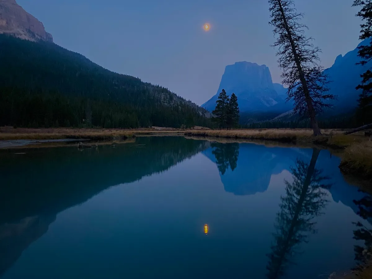


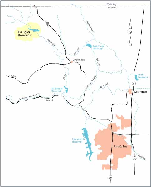


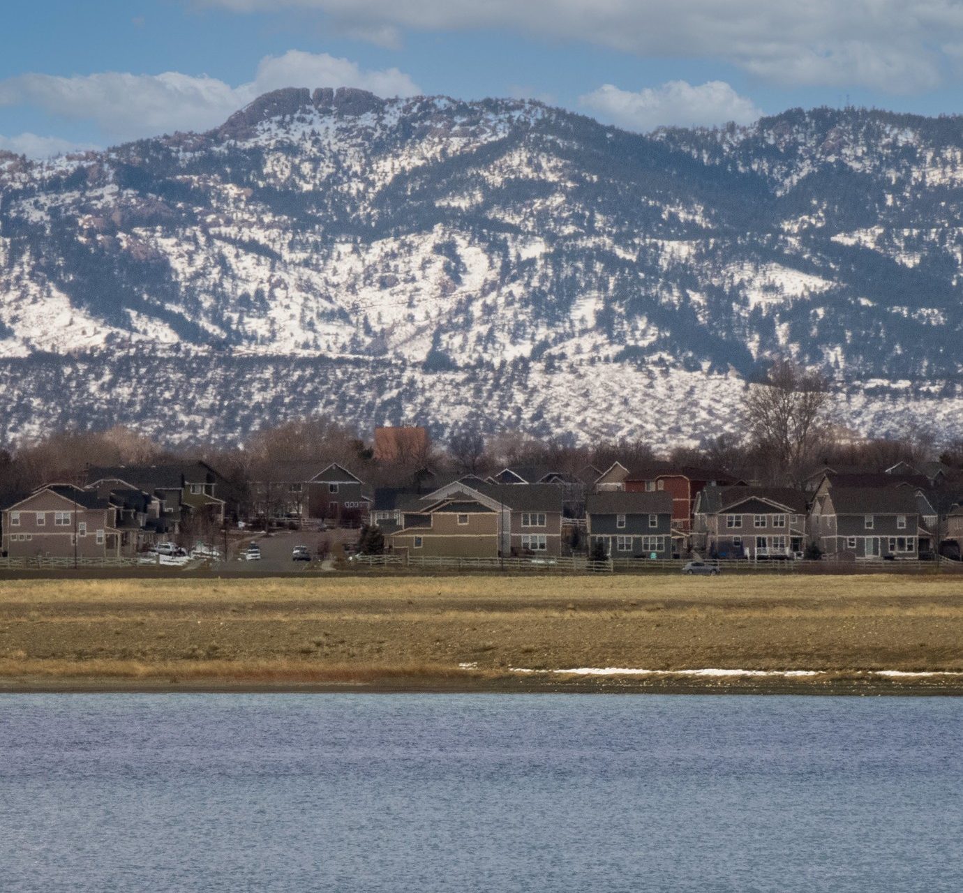
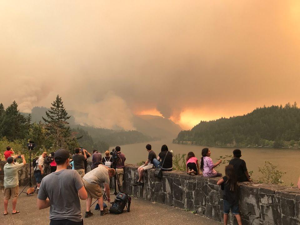


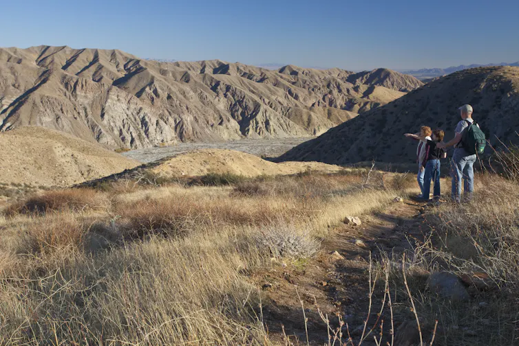


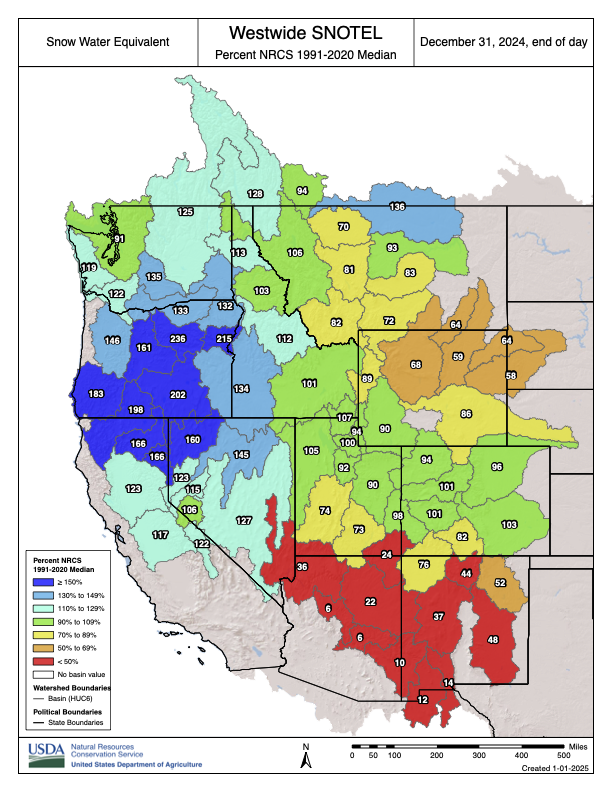


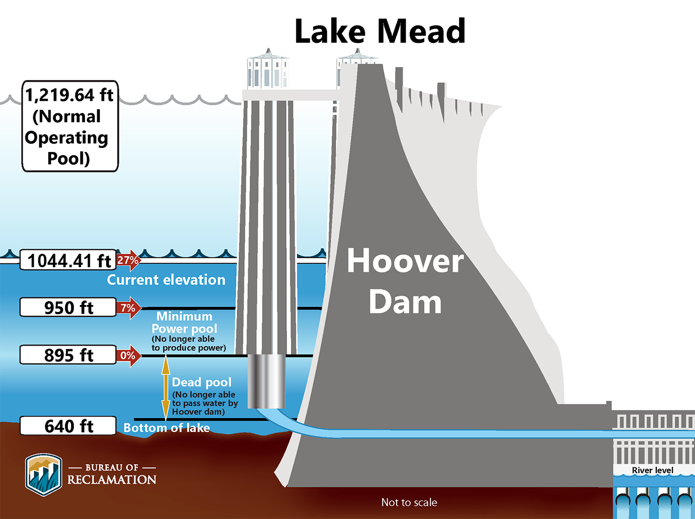
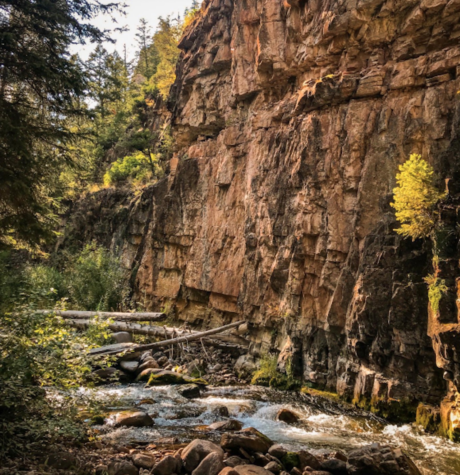


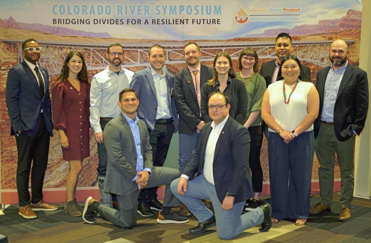


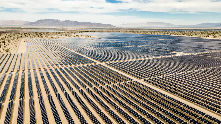


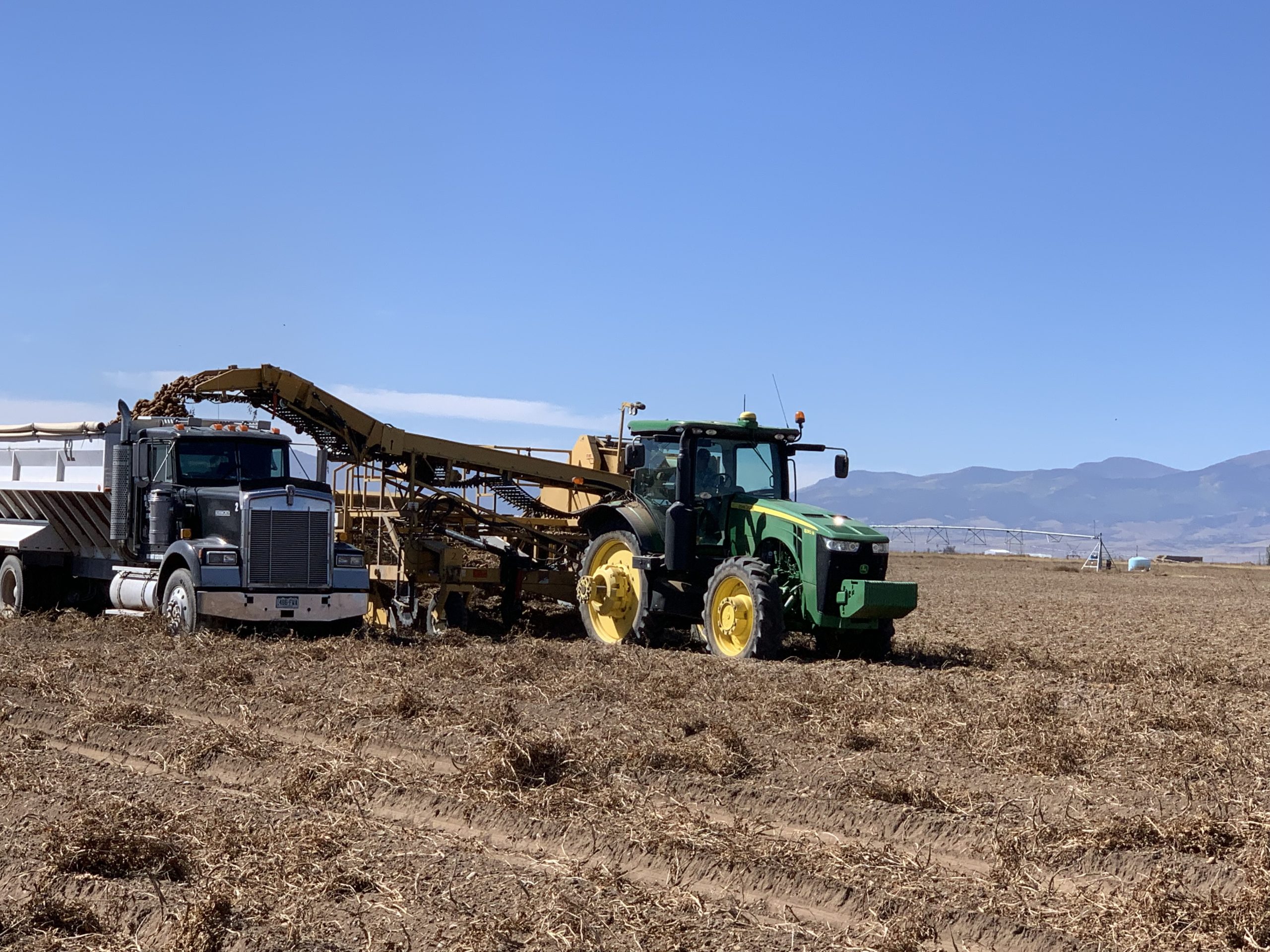
/https://static.texastribune.org/media/files/2858325190c1d789562f2c50d320432b/0717%20RGV%20Water%20-%20Fields%20EG%20%2003.jpg)
/https://static.texastribune.org/media/files/7cfa074c50de95165fe0592f18440fee/0715%20RGV%20Water%20-%20Darling%20EG%2006.jpg)
/https://static.texastribune.org/media/files/ae1fff168fa077164a53e5c72d0fcf0b/0715%20RGV%20Water%20-%20SWRA%20EG%2017.jpg)
/https://static.texastribune.org/media/files/574cb34b24dea723698b5c71fda7766a/0716%20RGV%20Water%20-%20Trevino%20EG%2004.jpg)
/https://static.texastribune.org/media/files/9b717668a41338190969078c76d8983d/Re-edit2%200716%20RGV%20Water%20-%20N%20Alamo%20EG%2011.jpg)
/https://static.texastribune.org/media/files/81b4b861f566647fc17183cd1f705458/0717%20RGV%20Water%20-%20NASWC%20EG%2041.jpg)