Will #nuclear energy arrive on time and at cost? — @BigPivots #COleg

Craig Station is the No. 2 source of greenhouse gas emissions in Colorado, behind Comanche station at Pueblo. Photo/Allen Best

Click the link to read the article on the Big Pivots website (Allen Best):

No doubt, nuclear energy has key advantages. So why isnโ€™t it likely to be the silver bullet to replace coal plants in Craig, Pueblo and other places?

Oliver Stone has a new movie, โ€œNuclear Now,โ€ that made its Colorado debut in Boulder on May 1. In it Stone argues that the grave risks posed by climate change require we embrace nuclear energy.

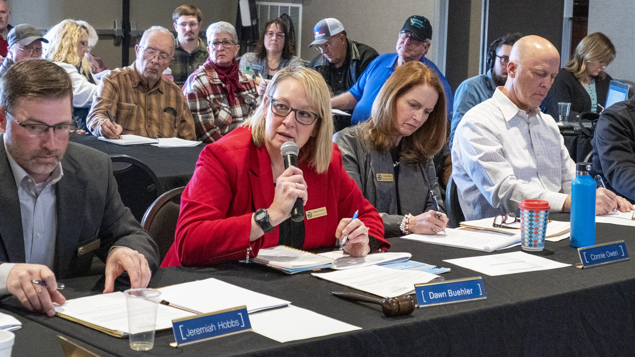
A few hours before, at a hearing in Denver, state legislators heard an even more urgent equation. โ€œAnybody who opposes nuclear I believe is a climate denier,โ€ an individual testified before the Senate Transportation and Energy Committee.

And in Pueblo that evening, city council members heard about a committee formed by Xcel Energy to study options to replace tax base, jobs, and electrical generation once the last coal plant there closes. The group will hear about nuclear.

In the background is the federal government, offering gambling money on all sorts of decarbonization solutions, including nuclear.

Mauna Loa is WMO Global Atmosphere Watch benchmark station and monitors rising CO2 levels Week of 23 April 2023: 424.40 parts per million Weekly value one year ago: 420.19 ppm Weekly value 10 years ago: 399.32 ppm ๐Ÿ“ท http://CO2.Earthhttps://co2.earth/daily-co2. Credit: World Meteorological Organization

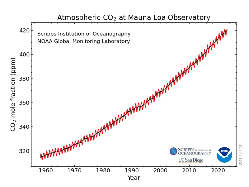
People on the left and right find common ground in support of nuclear energy, but their motivations differ. Some, like Stone, the movie-maker, are driven by the existential danger posed by climate change. Even the pleasant days of spring are spoiled by news that the carbon dioxide detector atop Mauna Loa has recently rolling past 425 parts per million. Weโ€™re still barreling toward a much rockier climate road. Climate scientists have long talked about tipping points. Itโ€™s like your head turning gray, one hair at a time โ€” until suddenly, it all goes gray or white.

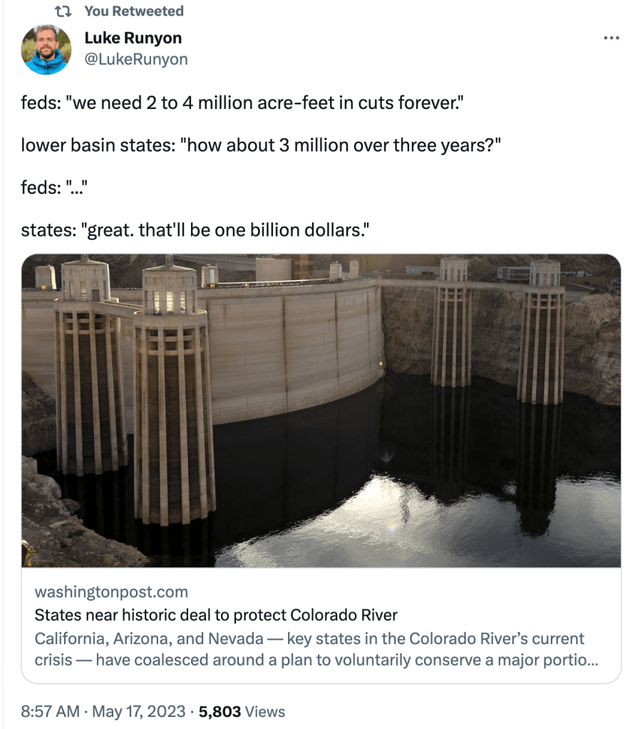
Some in Colorado see nuclear energy replacing coal plants. The last coal unit at Pueblo will close no later than 2031. Xcel has guaranteed property tax revenues through 2040, but not to 2070, the original retirement date. Craig also faces giant uncertainties. Increased tourism? โ€œWe donโ€™t want to become sheet-changers,โ€ one Moffat County landowner told me.

Manhattan Project 1944, Uravan. Photo credit: Uravan.com

Western Montrose County, where a uranium boom occurred during the 1950s โ€”and which lost a small coal plant in 2019, is also interested in nuclear.

HB23-1247, titled โ€œAssess Advanced Energy Solutions in Colorado,โ€ now awaiting the governorโ€™s signature, will direct study of nuclear energy but also other options. All have upsides but questions marks. Green hydrogen, made from renewables and water, can store energy for use when renewables are unavailable. However, the technology remains costly. Too, some scientists question whether accidental release of hydrogen into the atmosphere will create as many problems as it solves.

Nuclear can also backup intermittent renewables. Nuclear does provide 20% of U.S. electricity. We have a fleet of nuclear-powered submarines. They seem to operate without problems. But some questions remain about nuclear safety. Would you want a large-scale reactor in your town or city? I have to also wonder about nuclear technology falling into the wrong hands.

St. Vrain, Coloradoโ€™s only nuclear power plant, operated only a decade before its owner, Public Service Co. of Colorado, pulled the plug on it and, in the early 1990s, converted it into a natural gas plant. Spent fuel is stored on site. Photo: Allen Best/Big Pivots

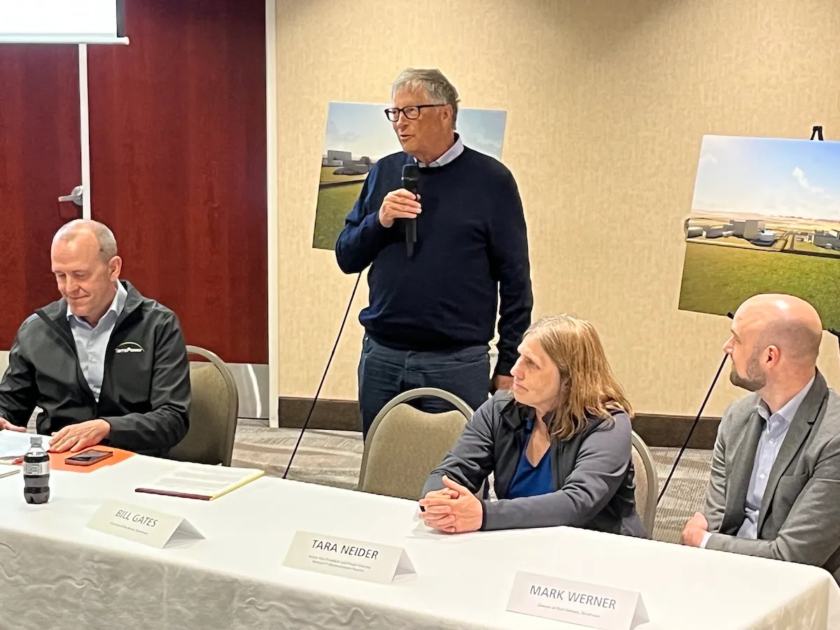
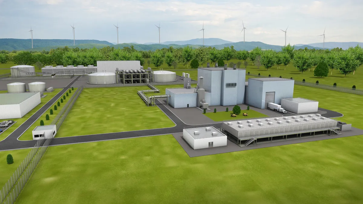
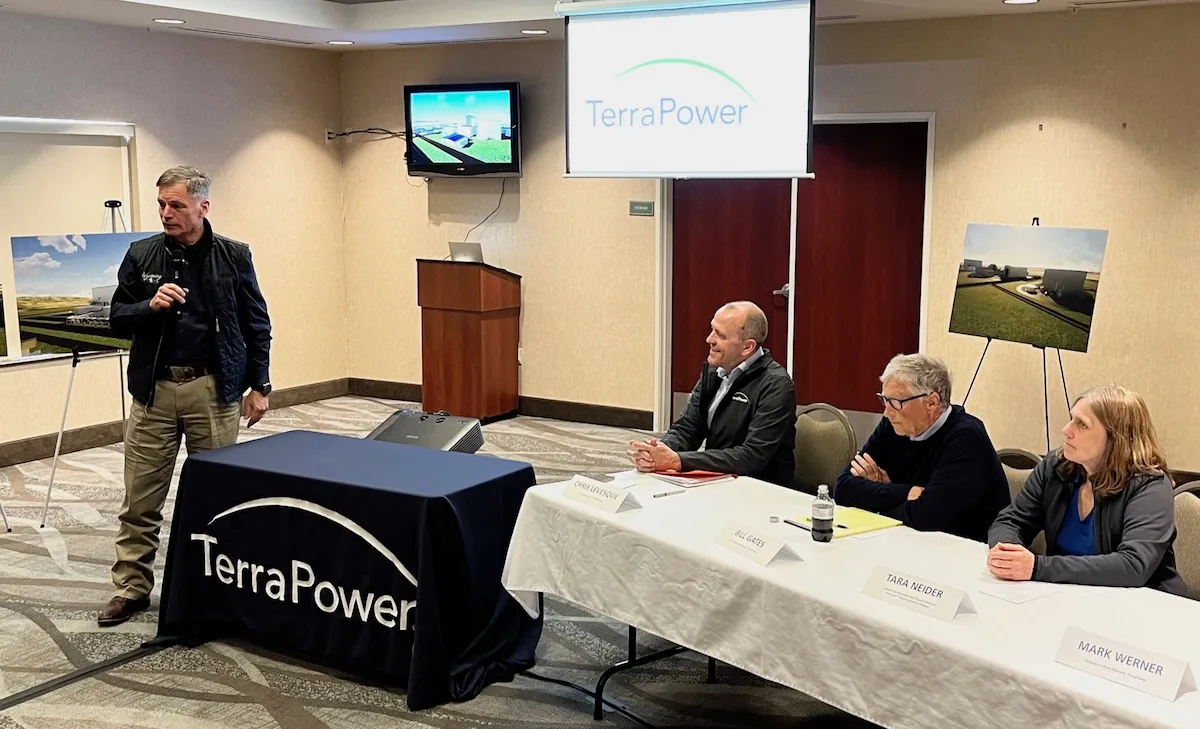
Many have been closely following the progress in Wyoming of a nuclear plant planned next to a coal plant at Kemmerer. TerraPower,  the company founded by Bill Gates in 2008, says it will require less water and produce less nuclear fuel waste while plugging nicely into old coal plants. It projects cost of $4 billion for this plant that will use Natrium technology.

WyoFile reported that while in Kemmerer during early May, Gates called it a โ€œpioneering move,โ€ key to the global energy future. This project is projected to be ready in in 2030. PacifiCorp, a major regional power provider,  has said it could add five more such Natrium reactors at existing coal-fired plants in Wyoming and Utah.

Another potential model is assembly-line-style production of small modular reactors, lowering costs. That sounds appealing, but by definition that model will not replace the big coal plants at Pueblo and Craig. For that matter, it does not yet exist.

Here in Colorado, I hear people with degrees in nuclear engineering express doubts about nuclear. State Sen. Chris Hansen, at the recent legislative hearing, objected to how a witness had characterized his skepticism about nuclear. โ€œIt has nothing to do with science or technology,โ€ said Hansen, who has a degree in nuclear engineering. โ€œItโ€™s the cost profile.โ€ He cited a recent Georgia reactor that came in at $33 billion, three times the projected cost. Itโ€™s not the only example.

Chuck Kutscher got his masterโ€™s degree in nuclear engineering and worked in the nuclear sector California before turning his attention to solar in 1978 and moving to Colorado. โ€œNew  nuclear power plants, including new U.S. reactor technologies currently under development, will likely be too expensive and take too long to build to make a significant contribution to climate change mitigation,โ€ he says.

In Boulder, Oliver Stoneโ€™s movie talked little of costs. But in Pueblo, a representative of Idaho National Laboratory, speaking to a municipal energy study group, openly conceded that cost remains the million dollar question.

She misplaced a comma or two in that string of zeroes, though. Itโ€™s the billion dollar question. Many billions.

Allen Best is a Colorado-based journalist who publishes an e-magazine called Big Pivots. Reach him at allen.best@comcast.net or 720.415.9308.

Coyote Gulchโ€™s excellent EV adventure โ€” #ColoradoRiver Day 2

We headed over to Glenwood Springs from Kremmling on Day 2 going over Gore Pass to Toponas and Yampa then along CO-131 S. to the Colorado River Road where we joined the Colorado River. The route winds along the river to Dotsero where we picked up I-70 to Glenwood Springs through Glenwood Canyon. The river was runinng bank to bank. We were treated to beautiful cool and wet weather for most of the drive.

Colorado River along the Colorado River Road from CO-131 to Dotsero.

Charging was near Penny’s Diner in Yampa — a ChargePoint fast charger (CHAdeMO connector) installed by the Yampa Valley Electric Association.

#Water saved through upper-basin program unlikely to move needle in #LakePowell: Western Slope projects are small and involve agriculture — @AspenJournalism #ColoradoRiver #COriver #aridification

The Grand River Diversion Dam, also known as the โ€œRoller Damโ€, was built in 1913 to divert water from the Colorado River to the Government Highline Canal, which farmers use to irrigate their lands in the Grand Valley. GVWUA is not participating the rebooted System Conservation Program after water managers couldnโ€™t agree on how much farmers should be paid to cut back their water use. Photo credit: Bethany Blitz/Aspen Journalism

Click the link to read the article on the Aspen Journalism website (Heather Sackett);

Three of western Coloradoโ€™s biggest irrigation districts are not participating on a large scale in a federally funded program to conserve water, and the amount of water saved by the program overall wonโ€™t be enough to rescue depleted reservoirs.

The rebooted System Conservation Program was one of the legs of the Upper Colorado River Commissionโ€™s 5-Point Plan, announced in July and aimed at protecting critical elevations in Lake Powell and Lake Mead, which have fallen to record-low levels in recent years because of overuse, drought and climate change. System conservation will take place in the four upper Colorado River basin states โ€” Colorado, New Mexico, Wyoming and Utah โ€” and will pay water users to cut back. Itโ€™s being funded by $125 million from the federal Inflation Reduction Act.

The total water estimated to be saved across the upper basin for this year of the restarted, temporary and voluntary System Conservation Program is nearly 39,000 acre-feet. By comparison, Lake Powell when full holds more than 23 million acre-feet; Ruedi Reservoir, on the Fryingpan River, can hold about 100,000 acre-feet. (An acre-foot is the amount of water needed to cover an acre of land to a depth of 1 foot and can supply one to two households a year.)

Becky Mitchell, Colorado commissioner to the UCRC, said in a UCRC meeting last month that although the upper basin will do its part in response to last summerโ€™s calls from the federal government that the seven Colorado River basin states needed to conserve 2 million to 4 million acre-feet of water, the majority of that needs to come from cuts in the lower basin (California, Arizona and Nevada).

โ€œ(System conservation) will not resolve the crisis in the reservoirs,โ€ she said.

Last month the UCRC approved moving forward with executing agreements with program participants, which are still being finalized.

Although a goal of the program was to get participation across all water sectors โ€” agricultural, municipal and industrial โ€” all of the projects proposed in Colorado involve Western Slope agriculture. None of the stateโ€™s Front Range water providers, which collectively take about 500,000 acre-feet per year of the Colorado Riverโ€™s headwaters across the Continental Divide to thirsty cities and farms, are participating.

Paying water users to irrigate less has long been controversial on the Western Slope, with fears that these temporary and voluntary programs could lead to a permanent โ€œbuy and dryโ€ situation that would negatively impact rural farming and ranching communities.

Of the four upper basin states, Colorado has the largest number of projects (29) but the least amount of saved water (3,532 acre-feet). This is an indication that most of Coloradoโ€™s participants are proposing small projects. UCRC Executive Director Chuck Cullom said if the program is undertaken again, officials may consider a minimum size requirement because doing very small projects may not be worth it.

โ€œFrom a practical standpoint of the cost of monitoring and administering a verification program for that (small number of) acres may not pencil out relative to the amount of water conserved,โ€ Cullom said.

Of the 29 Colorado projects, most involve reducing water use for forage crops, according to information provided by UCRC. Eight involve fallowing grass hay as part of a cow-calf operation, saving 1,163 acre-feet of water; seven plan to fallow alfalfa and save 1,029 acre-feet; and eight propose switching to less-thirsty crops, saving 791 acre-feet.

The UCRC received 88 proposals across the four states, 72 of which met the qualifying criteria. Utah has 20 projects that meet preliminary criteria; Wyoming has 22 and New Mexico has one. The UCRCโ€™s opening offer was $150 per acre-foot of saved water, but the average compensation will probably end up being higher โ€” $434 per acre-foot, according to information provided by UCRC.

Grand Valley Water Users Association not participating

Although some water users in the Grand Valley Water Users Association participated in the original system conservation pilot program, which ran from 2015 to 2018 and conserved 47,000 acre-feet of water at a cost of about $8.6 million, they wonโ€™t be taking part this time around.

The Government Highline Canal flows past Highline State Park in the Grand Valley. CREDIT: BETHANY BLITZ/ASPEN JOURNALISM

GVWUA, whose Highline Canal delivers water to roughly 24,000 acres of farmland on the north side of the valley between Grand Junction and Mack, withdrew its application from the process after manager Tina Bergonzini said she couldnโ€™t come to an agreement on the price with the UCRC. GVWUA had rejected the concept of paying farmers based on an amount of unused water, instead proposing to pay farmers for each acre of land they took out of production.

Individual farmers would have had to apply to the program through the association, which proposed to cap total member participation at 1,000 acres and 3,000 acre-feet of water.

GVWUA was asking for between $686 and $1,306 per each acre fallowed, depending on whether farmers reduced water use during the entire irrigation season or just part of it.

Bergonzini said the price represents what it would cost to administer the program in a way that provides equity and protection; at any lower price, the funding from system conservation would not be enough to cover the extra staff and engineering costs. Cullom said his organization was unlikely to approve those costs, so GVWUA withdrew its application.

โ€œThey were not wanting to pay per acre what we had requested,โ€ Bergonzini said. โ€œThey had a line drawn in the sand and so did I.โ€

The Grand Valley Irrigation Company, which serves about 40,000 acres of farmland between Palisade and Mack, has four projects proposed within its service area, covering a total of 120 acres and 285 acre-feet of water savings.

โ€œItโ€™s not a very big amount,โ€ said GVIC Assistant Superintendent Charlie Guenther. โ€œI did hear from a handful of ag people that they didnโ€™t want to be part of this because it sounded very technical and it was government involvement. Thatโ€™s something that came up.โ€

Unlike GVWUA, individual water users within GVIC did not have to apply to the program through the irrigation company, and the companyโ€™s board did not take a stance on whether or not to support system conservation, according to Guenther.

There is just one conservation project proposed in the boundaries of the Uncompahgre Valley Water Users Association, the largest irrigation district in Western Colorado, at more than 83,000 acres of farmland in Delta and Montrose counties. The project would enroll about 33 acres in the program and would result in about 46 acre-feet of water savings.

UVWUA manager Steve Pope said the system conservation program didnโ€™t get much interest from his water users because of the timing. Bergonzini agreed.

โ€œThey didnโ€™t want to do a last-minute thing,โ€ Pope said. โ€œBy the time this thing was rolled out, these guys had already made their decisions and they were already committed for the next season.โ€

Cullom has acknowledged that there were shortcomings with the programโ€™s rollout. The UCRC unveiled details of the program in December, with an original application deadline of Feb. 1, which was later pushed to March 1 for this summerโ€™s irrigation season.

โ€œWe need to do much better when we think about how to do this in the future, if we do this in the future,โ€ he said. โ€œWe need more clarity on the data requirements, what we expect from a proposal. We need to give people more time to engage in understanding what the opportunity is and we need to start sooner. Start in the fall for an irrigation season instead of January.โ€

Conservation district concerns

The Western Slopeโ€™s two largest conservation districts โ€” the Colorado River Water Conservation District and Southwestern Water Conservation District โ€” submitted letters to the UCRC stating their concerns with the program. Mitchell had promised the districts that they could participate in the review and approval process for applications, thereby securing a measure of local control. But in March, she walked back that commitment, saying the UCRC had sole authority in the approval process.

The UCRC has released few details so far on project proposal specifics, and publicly available applications have been heavily redacted. In addition to redacting the applicantsโ€™ personal identifying information, nearly everything else has been blacked out: the precise location of projects; which streams and ditches are involved; details of the water rights involved; and how much the applicants are asking to be paid for their water.

The districts say this makes it impossible to meaningfully review them to determine whether the projects would cause injury to other water users. Their letters to the UCRC say the lack of transparency raises questions about whether public funds are being used wisely.

โ€œIn short, SWCD is very disappointed and concerned about the process that has been undertaken by the UCRC and the state of Colorado,โ€ reads the letter from Southwestern General manager Steve Wolff.

In response, Amy Ostdiek, CWCB section chief for interstate, federal and water information, said that the review process respected project proponentsโ€™ privacy and that striking a balance between transparency and privacy is an ongoing effort.

โ€œThe Colorado State Engineerโ€™s Office has been directly involved as implementation agreements and verification plans are developed to ensure no injury results from SCPP participation,โ€ Ostdiek said in an email.

She said additional information will be available when the UCRC finalizes agreements with project participants, which should happen late this month, according to Cullom.

The 39,000 acre-feet of water across the four upper-basin states will do little to boost Lake Powell. Itโ€™s the proverbial drop in the bucket. But the political value of 39,000 acre-feet may be far greater than any benefit to the nationโ€™s second-largest reservoir. The effort shows that upper-basin water managers are willing to do their part to prevent the system from crashing, but that part is small compared with the cuts they say are needed in the lower basin.

โ€œItโ€™s unlikely any system conservation stood up in the upper basin is going to move the needle,โ€ Cullom said. โ€œBut itโ€™s important for the upper basin to participate and contribute within the resources and the tools we have available, and what we are demonstrating in this process is that we do have tools, we do have resources. They are narrow in scope and small in volume.โ€

Aspen Journalism is a nonprofit, investigative news organization covering water, the environment and social justice. This story ran in the May 12 edition ofย The Aspen Times, the May 13 edition of theย Glenwood Springs Post-Independent, the May 14 edition of theย Summit Daily,ย Steamboat Pilot & Today, theย Vail Daily, the May 15 edition of theย Craig Pressย and the May 16 edition of theย Grand Junction Sentinel.

Colorado River Allocations: Credit: The Congressional Research Service

Record #snowpack and saturated soils lead to landslides โ€” lots of them: #Utah Geological Survey documents at least 100 known landslides, and thereโ€™s many, many more out there — The Deseret News

Types of landslide movement.

Click the link to read the article on The Deseret News website (Amy Joi O’Donoghue). Here’s an excerpt:

So far this year, staff at the Utah Geological Survey have taken 1,000 photos, spent 400 hours on landslides in the last six weeks and had 20 emergency responses.

Two homes have collapsed and one had to be razed by the city, Keach said.

Keach said there are many types of causes of landslides that include:

  • Soil type.
  • Too much water/moisture.
  • The โ€œtoeโ€ of the affected land has been cut out.
  • Overly steep slopes and burn scars.

Not all landslides are the same. There are rock formations or slope failure, bedrock failure, loose sediment and more.

What is Hydrology? — USGS

Sources/Usage: Public Domain. Research Hydrologist Martin Briggs (USGS) collects ground-penetrating radar (GPR) data. He is wearing special ice cleats on his shoes to have better traction walking on the ice. (April 2017)

Click the link to read the article on the USGS website:

What is Hydrology?

Water is one of our most precious natural resources. Without it, there would be no life on earth. Hydrology has evolved as a science in response to the need to understand the complex water system of the earth and help solve water problems. This hydrology primer gives you information about water on Earth and humans’ involvement and use of water.

Introduction

Hydrology is the study of water

Water is one of our most important natural resources. Without it, there would be no life on earth. The supply of water available for our use is limited by nature. Although there is plenty of water on earth, it is not always in the right place, at the right time and of the right quality. Adding to the problem is the increasing evidence that chemical wastes improperly discarded yesterday are showing up in our water supplies today. Hydrology has evolved as a science in response to the need to understand the complex water systems of the Earth and help solve water problems. Hydrologists play a vital role in finding solutions to water problems, and interesting and challenging careers are available to those who choose to study hydrology.

Water and People

Estimates ofย water useย in the United States indicate that about 355 billion gallons per day (one thousand million gallons per day, abbreviated Bgal/d) were withdrawn for all uses during 2010. This total has declined about 17 percent since 1980. Fresh groundwater withdrawals (76.0 Bgal/d) during 2010 were 8 percent less than during 1980.ย Fresh surface-waterย withdrawals for 2010 were 230 Bgal/d, 18 percent less than in 1980.

Much of our water use is hidden. Think about what you had for lunch. A hamburger, for example, requires water to raise wheat for the bun, to grow hay and corn to feed the cattle and to process the bread and beef. Together with french fries and a soft drink, this all-American meal uses about 1,500 gallons of water โ€” enough to fill a small swimming pool. How about your clothes? To grow cotton for a pair of jeans takes about 400 gallons. A shirt requires about 400 gallons. How do you get to school or to the store? To produce the amount of finished steel in a car has in the past required about 32,000 gallons of water. Similarly, the steel in a 30-pound bicycle required 480 gallons. This shows that industry must continue to strive to reduce water use through manufacturing processes that use less water, and through recycling of water.

What is Hydrology?

Hydrology is the science that encompasses the occurrence, distribution, movement and properties of the waters of the earth and their relationship with the environment within each phase of the hydrologic cycle. The water cycle, or hydrologic cycle, is a continuous process by which water is purified by evaporation and transported from the earth’s surface (including the oceans) to the atmosphere and back to the land and oceans. All of the physical, chemical and biological processes involving water as it travels its various paths in the atmosphere, over and beneath the earth’s surface and through growing plants, are of interest to those who study the hydrologic cycle.

There are many pathways the water may take in its continuous cycle of falling as rainfall or snowfall and returning to the atmosphere. It may be captured for millions of years in polar ice caps. It may flow to rivers and finally to the sea. It may soak into the soil to be evaporated directly from the soil surface as it dries or beย transpired by growing plants. It mayย percolate through the soilย to ground water reservoirs (aquifers) to be stored or it may flow toย wellsย or springs or back to streams byย seepage. The cycle for water may be short, or it may take millions of years.

People tap the water cycle for their own uses. Water is diverted temporarily from one part of the cycle by pumping it from the ground or drawing it from a river or lake. It is used for a variety of activities such as households, businesses and industries; for irrigation of farms and parklands; and for production of electric power. After use, water is returned to another part of the cycle: perhaps discharged downstream or allowed to soak into the ground. Used water normally is lower in quality, even after treatment, which often poses a problem for downstream users.

The hydrologist studies the fundamental transport processes to be able to describe the quantity and quality of water as it moves through the cycle (evaporationprecipitationstreamflowinfiltrationgroundwater flow, and other components). The engineering hydrologist, or water resources engineer, is involved in the planning, analysis, design, construction and operation of projects for the control, utilization, and management of water resources. Water resources problems are also the concern of meteorologists, oceanographers, geologists, chemists, physicists, biologists, economists, political scientists, specialists in applied mathematics and computer science, and engineers in several fields.

What Hydrologists Do?

Hydrologists apply scientific knowledge and mathematical principles to solve water-related problems in society: problems of quantityquality and availability. They may be concerned with finding water supplies for cities or irrigated farms, or controlling river flooding or soil erosion. Or, they may work in environmental protection: preventing or cleaning up pollution or locating sites for safe disposal of hazardous wastes.

Persons trained in hydrology may have a wide variety of job titles. Scientists and engineers in hydrology may be involved in both field investigations and office work. In the field, they may collect basic data, oversee testing of water quality, direct field crews and work with equipment. Many jobs require travel, some abroad. A hydrologist may spend considerable time doing field work in remote and rugged terrain. In the office, hydrologists do many things such as interpreting hydrologic data and performing analyses for determining possible water supplies. Much of their work relies on computers for organizing, summarizing and analyzing masses of data, and for modeling studies such as the prediction of flooding and the consequences of reservoir releases or the effect of leaking underground oil storage tanks.

The work of hydrologists is as varied as the uses of water and may range from planning multimillion dollar interstate water projects to advising homeowners about backyard drainage problems.

San Luis Valley. Photo credit: The Alamosa Citizen

Surface Water

Most cities meet their needs for water by withdrawing it from the nearest river, lake or reservoir. Hydrologists help cities by collecting and analyzing the data needed to predict how much water is available from local supplies and whether it will be sufficient to meet the city’s projected future needs. To do this, hydrologists study records of rainfallsnowpack depths and river flows that are collected and compiled by hydrologists in various government agencies. They inventory the extent river flow already is being used by others.

Managing reservoirs can be quite complex, because they generally serve many purposes. Reservoirs increase the reliability of local water supplies. Hydrologists use topographic maps and aerial photographs to determine where the reservoir shorelines will be and to calculate reservoir depths and storage capacity. This work ensures that, even at maximum capacity, no highways, railroads or homes would be flooded.

Deciding how much water to release and how much to store depends upon the time of year, flow predictions for the next several months, and the needs of irrigators and cities as well as downstream water-users that rely on the reservoir. If the reservoir also is used for recreation or for generation of hydroelectric power, those requirements must be considered. Decisions must be coordinated with other reservoir managers along the river. Hydrologists collect the necessary information, enter it into a computer, and run computer models to predict the results under various operating strategies. On the basis of these studies, reservoir managers can make the best decision for those involved.

The availability of surface water for swimming, drinking, industrial or other uses sometimes is restricted because of pollution. Pollution can be merely an unsightly and inconvenient nuisance, or it can be an invisible, but deadly, threat to the health of people, plants and animals.

Hydrologists assist public health officials in monitoring public water supplies to ensure that health standards are met. When pollution is discovered, environmental engineers work with hydrologists in devising the necessary sampling program. Water quality in estuaries, streams, rivers and lakes must be monitored, and the health of fish, plants and wildlife along their stretches surveyed. Related work concerns acid rain and its effects on aquatic life, and the behavior of toxic metals and organic chemicals in aquatic environments. Hydrologic and water quality mathematical models are developed and used by hydrologists for planning and management and predicting water quality effects of changed conditions. Simple analyses such asย pH,ย turbidity, andย oxygen contentย may be done by hydrologists in the field. Other chemical analyses require more sophisticated laboratory equipment. In the past, municipal and industrialย sewageย was a major source of pollution for streams and lakes. Such wastes often received only minimal treatment, or raw wastes were dumped into rivers. Today, we are more aware of the consequences of such actions, and billions of dollars must be invested in pollution-control equipment to protect the waters of the earth. Other sources of pollution are more difficult to identify and control. These include road deicing salts, storm runoff from urban areas and farmland, and erosion from construction sites.

Researchers with the University of Nebraska-Lincoln take groundwater samples from the Loup River in the Sandhills of Nebraska in September 2018. By sampling groundwater and determining its age, they hope to determine whether predictions for groundwater discharge rates and contamination removal in watersheds are accurate. Photo credit: Troy Gilmore

Groundwater

Groundwater, pumped from beneath the earth’s surface, is often cheaper, more convenient and less vulnerable to pollution than surface water. Therefore, it is commonly used for public water supplies. Groundwater provides the largest source of usable water storage in the United States. Underground reservoirs contain far more water than the capacity of all surface reservoirs and lakes, including the Great Lakes. In some areas, ground water may be the only option. Some municipalities survive solely on groundwater.

Hydrologists estimate the volume of water stored underground by measuring water levels in local wells and by examining geologic records from well-drilling to determine the extent, depth and thickness of water-bearing sediments and rocks. Before an investment is made in full-sized wells, hydrologists may supervise the drilling of test wells. They note the depths at which water is encountered and collect samples of soils, rock and water for laboratory analyses. They may run a variety of geophysical tests on the completed hole, keeping and accurate log of their observations and test results. Hydrologists determine the most efficient pumping rate by monitoring the extent that water levels drop in the pumped well and in its nearest neighbors. Pumping the well too fast could cause it to go dry or could interfere with neighboring wells. Along the coast, overpumping can cause saltwater intrusion. By plotting and analyzing these data, hydrologists can estimate the maximum and optimum yields of the well.

Polluted groundwater is less visible, but more insidious and difficult to clean up, than pollution in rivers and lakes. Ground water pollution most often results from improper disposal of wastes on land. Major sources include industrial and household chemicals and garbage landfills, industrial waste lagoons, tailings and process wastewater from mines, oil field brine pits, leaking underground oil storage tanks and pipelines, sewage sludge and septic systems. Hydrologists provide guidance in the location of monitoring wells around waste disposal sites and sample them at regular intervals to determine if undesirable leachate โ€” contaminated water containing toxic or hazardous chemicals โ€” is reaching the ground water.

In polluted areas, hydrologists may collect soil and water samples to identify the type and extent of contamination. The chemical data then are plotted on a map to show the size and direction of waste movement. In complex situations, computer modeling of water flow and waste migration provides guidance for a clean-up program. In extreme cases, remedial actions may require excavation of the polluted soil. Today, most people and industries realize that the amount of money invested in prevention is far less than that of cleanup. Hydrologists often are consulted for selection of proper sites for new waste disposal facilities. The danger of pollution is minimized by locating wells in areas of deep ground water and impermeable soils. Other practices include lining the bottom of a landfill with watertight materials, collecting any leachate with drains, and keeping the landfill surface covered as much as possible. Careful monitoring is always necessary.

Careers in Hydrology

Students who plan to become hydrologists need a strong emphasis in mathematics, statistics, geology, physics, computer science, chemistry and biology. In addition, sufficient background in other subjects โ€” economics, public finance, environmental law, government policy โ€” is needed to communicate with experts in these fields and to understand the implications of their work on hydrology. Communicating clearly in writing and speech is a basic requirement essential for any professional person. Hydrologists should be able to work well with people, not only as part of a team with other scientists and engineers, but also in public relations, whether it be advising governmental leaders or informing the general public on water issues. Hydrology offers a variety of interesting and challenging career choices for today and tomorrow. It’s a field worth considering.

Source: Hydrology: The Study of Water and Water Problems A Challenge for Today and Tomorrow, a publication of the Universities Council on Water Resources

Double trouble? #Colorado primed for flooding between torrential rains, spring snowmelt: Changing climate, changing #water dynamics: โ€œThe risk of flooding is out thereโ€ — The #Denver Post #runoff

Click the link to read the article on The Denver Post website (Bruce Finley). Here’s an excerpt:

Coloradoโ€™s mountain snowpack is starting to melt faster, potentially bringing more high water after recent heavy rain turned some of the stateโ€™s typically feeble creeks into torrents. Big water rose to levels up to 80 times higher than the norm during rain bursts in Colorado Front Range cities this week, forcing police in Denver to warn creekside campers who lack housing to clear out, and scrambling 30ย firefightersย in Colorado Springs whoย recovered the bodyย of a person swept away. More rain was falling Friday โ€” and National Weather Service meteorologists forecast thunderstorms nearly every day next week โ€” saturating soils to the point that water more easily gains momentum…

โ€œCertainly on the Western Slope, all of our gauge readings will increase as the snow melts over the next few weeks,โ€ Forbes said. โ€œWe are preparing for high flows on Coloradoโ€™s Western Slope over the next two weeks to a month. For flooding risk, the slower it melts the better. That all depends on the weather.โ€

[…]

The mountain snowpack in watersheds feeding the Dolores, Animas, Gunnison,ย Yampa,ย Coloradoย and other rivers in the farthest western parts of Colorado this year measured exceptionally high and promise the biggest runoff. Mountains east of the Continental Divide received relatively less snow. The South Platte watershed had snowpack near average, and snowpack in the Arkansas River Basin lagged, peaking at around 74% of the 1999-2020 norm. Meanwhile, heavy rain โ€” falling in scattered bursts around Colorado since May 9 โ€” has led to unusually high flows in creeks and rivers. On Thursday, the Arkansas River overflowed its banks in southeastern Colorado near La Junta, inundatingย  U.S. 50. Coal Creek west of metro Denver last week overflowed banks, forcing closures along Colorado 52…

Water levels in the South Platte River northeast of Denver at Fort Morgan, averaging over 36 years around 300 cfs, hit a high flow on May 14 of 5,930 cfs, data show. And on the Arkansas River a mile east of Pueblo, flows exceeded the norm of 900 cfs fivefold at 4,780 cfs on May 12…

On Friday morning as rain fell faintly amid fog and smoke spreading from Canadian forest fires, USGS measuring station data showed the following relatively high flows around Colorado from both rain and melting mountain snow runoff:

  • The Cache La Poudre River at Fort Collins: 1,330 cfs, above the norm of 575 cfs,
  • South Platte River in Commerce City: 1,160 cfs, above the norm of 649 cfs,
  • Sand Creek where it meets the South Platte: 178 cfs, above the norm of 121 cfs,
  • Bear Creek southwest of Denver near Morrison: 289 cfs, above the norm of 121 cfs,
  • Big Thompson River below Moraine Park near Estes Park: 288 cfs, above the norm of 153 cfs,
  • The Colorado River at the Utah borders: 35,400 cfs, above the norm of 14,499 cfs,
  • Colorado River at Windy Gap (near Granby): 1,800 cfs, above the norm of 632 cfs,
  • Colorado River at Kremmling: 2,600 cfs, above the norm of 1,930 cfs,
  • Gunnison River (near Gunnison): 4,060 cfs, above the norm of 1,690 cfs, and
  • Dolores River at Bedrock: 4,120 cfs, above the norm of 820 cfs.

Indigenous tribes were pushed away from the #ColoradoRiver. A new generation is fighting to save it — #Colorado Public Radio #COriver #aridification

Colorado River from Lee’s Ferry. Photo credit. Gonzo fan2007 – Own work, CC BY-SA 4.0, https://commons.wikimedia.org/w/index.php?curid=3631180

Click the link to read the article on the Colorado Public Radio website (Michael Elizabeth Sakasย andย Sarah Bures). Here’s an excerpt:

Here at Leeโ€™s Ferry,ย seven southwestern American states divided up the Colorado River with the 1922 river compact. Every single drop was spoken for, between Wyoming, Colorado, New Mexico, Utah, Nevada, Arizona, California, and later Mexico. The water was destined for colonized farmland and cities. But crucially, that 1922 compact deniedย 30 different Indigenous tribesย any share of the water that they needed to survive in the hot and dry southwest. While the federal government helped states build pipes, dams and reservoirs to access the water they were allocated,ย it didnโ€™t do the same for Indigenous reservations, and many people living on those reservations didnโ€™t know what water they could use.

From the 2018 Tribal Water Study, this graphic shows the location of the 29 federally-recognized tribes in the Colorado River Basin. Map credit: USBR

This was an abrupt departure from the way tribes had lived before white colonizers arrived in the West and forced the tribes onto reservations. For thousands of years, many Indigenous people moved with the river; they adapted to it and responded to it. This is how Daryl Vigilโ€™s ancestors lived in communion with the river.ย 

โ€œThat’s the level of reverence you give that stream or that river,โ€ Vigil, a member of the Jicarilla Apache Nation and of Jemez and Zia Pueblo descent, said. โ€œThe dances all revolved around this cyclical nature of the environment and most importantly, rain and snow in terms of what it meant to our existence.โ€

But as the colonizers built gigantic dams and carved up the river, filling Lake Mead and Lake Powell, the Jicarilla Apache and dozens of other tribes that rely on the Colorado Riverย no longer had the same access to the water as they once did. This was the West that Vigil was born into and where he grew up on three different reservations โ€“ at times without indoor plumbing. He now lives on the Jicarilla Apache Reservation north of Santa Fe, New Mexico, and until recently was the tribeโ€™s water administrator. He is among the most recent generation of leaders in a decades-long fight for tribes to regain rights to the water they had access to for thousands of years.

โ€œPart of the need to build economies is also based in an ability to build a basic infrastructure that everybody else in this country is supposed to be entitled to: water, wastewater,โ€ he said. โ€œNative American communities [are] 19 times more likely to not have indoor plumbing.โ€

When the Colorado River Compact was written in 1922, tribes were left without a legal say in how the river should be shared and managed across the west. But slowly,ย over the last 100 years, they have pushed for legislation, court cases and settlementsย โ€” some of which dragged on for decades โ€” to take back their rights to the river…

Updated Colorado River 4-Panel plot thru Water Year 2022 showing reservoirs, flows, temperatures and precipitation. All trends are in the wrong direction. Since original 2017 plot, conditions have deteriorated significantly. Brad Udall via Twitter: https://twitter.com/bradudall/status/1593316262041436160

As tribes were fighting for their rights to the water, and a seat at the bargaining table, the total amount of water to go around was evaporating. Climate change was working hand-in-hand with exponential population growth in the West to deplete the supply of water in the river.

โ€œMy message for 20 years now has been: watch out,โ€ said Brad Udall from his home near Boulder, Colorado. โ€œWe’ve overdone it, we need to cut back and this is going to get worse. And that’s not a message that, for years, anybody wanted to hear.โ€

Udall is senior water and climate research scientist and scholar at Colorado State Universityโ€™s Colorado Water Center โ€” a โ€œdelightful title,โ€ he said. Udall studies the Colorado River and the climate change thatโ€™s impacting water levels. As part of his work, he often points out thatย the countryโ€™s largest dams, reservoirs and water projects will go dry if we continue using water as we are today

Remember the Colorado River water rights that took 20 years for the Jicarilla Apache Nation to win? They and other tribes have collectively secured rights to use 25 percent of the water in the river. Thatโ€™s more than Arizona has rights to. But hereโ€™s the catch:ย reservoirs and canals the reservations need to access their full supplies of water donโ€™t exist yet. Without that infrastructure, the water is still going to states, rather than the tribes. This is why many people, including Vigil and Udall, want tribes to have an equal say in how we save the Colorado River in the face of climate change.

Article: Quantifying the contribution of major carbon producers to increases in vapor pressure deficit and burned area in western US and southwestern Canadian forests — Environmental Research Letters #ActOnClimate

Lands in Northern Water’s collection system scarred by East Troublesome Fire. October 2020. Credit: Northern Water

Click the link to read the article on the Environmental Research Letters website (Kristina A Dahl, John T Abatzoglou, Carly A Phillips, J Pablo Ortiz-Partida, Rachel Licker, L Delta Merner, and Brenda Ekwurzel). Here’s the abstract:

Increases in burned forest area across the western United States and southwestern Canada over the last several decades have been partially driven by a rise in vapor pressure deficit (VPD), a measure of the atmosphereโ€™s drying power that is significantly influenced by human-caused climate change. Previous research has quantified the contribution of carbon emissions traced back to a set of 88 major fossil fuel producers and cement manufacturers to historical global mean temperature rise. In this study, we extend that research into the domain of forest fires. We use a global energy balance carbon-cycle model, a suite of climate models, and a burned area (BA) model to determine the contribution of emissions traced to the major carbon producers to the long-term increase in VPD during 1901โ€“2021 and to cumulative forest fire area during 1986โ€“2021 in the western US and southwestern Canada. Based on climate model data, we find that emissions traced to these carbon producers contributed 48% (interquartile range (IQR) 38%โ€“63%) of the long-term rise in VPD between 1901 and 2021. BA modeling indicates that these emissions also contributed 37% (IQR 26%โ€“47%) of the cumulative area burned by forest fires between 1986 and 2021 in the western US
and southwestern Canada. The increase in VPD in this region is linked to both increased fire activity and the regionโ€™s current and prolonged megadrought. As loss and damage from these hazards mounts, this research can inform public and legal dialogues regarding the responsibility carbon producers bear for addressing past, present, and future climate risks associated with fires
and drought in the western US and southwestern Canada.

โ€˜Itโ€™s time to deal with thisโ€™: #Kansas #Water Authority wants to save #OgallalaAquifer: State water officials said Kansas has had a โ€˜de factoโ€™ policy to eventually drain the aquifer — Kansas Reflector

Dawn Buehler, chairwoman of the Kansas Water Authority, presides over a meeting Wednesday in Colby. The authority voted to adopt language saying Kansas should not deplete the Ogallala Aquifer. (Allison Kite/Kansas Reflector)

Click the link to read the article on the Kansas Reflector website (Allison Kite):

COLBY [December 15, 2022] โ€” Kansas should scrap its de facto policy ofย draining the Ogallala Aquifer, a state board decided Wednesday.

Instead, the board said, the Kansas government should take steps to stop the decline of the aquifer and save it for future generations.

โ€œIt has taken decades for this to be said formally in writing by an official state body,โ€ said Connie Owen, director of the Kansas Water Office. โ€œโ€ฆ This is nothing less than historic.โ€

Saving the water source that supports Western Kansasโ€™ economy and communities may seem like an obvious stance to take, but for about 70 years, the stateโ€™s policies and management decisions have reflected the idea that eventually, the Ogallala would dry up, said Earl Lewis, Kansasโ€™ chief engineer. 

The Kansas Water Authority, which is made up of agricultural and industrial water users and utilities, wants to chart a new course. It voted almost unanimously Wednesday to recommend that the state scrap the policy of โ€œplanned depletion.โ€

โ€œItโ€™s time to deal with this while we still have some choices,โ€ said John Bailey, a member of the Kansas Water Authority from Pittsburg. โ€œIf we donโ€™t, weโ€™re going to find ourselves in a very bad situation.โ€

Ogallala Aquifer. Credit: Big Pivots

The Ogallala Aquifer, one of the worldโ€™s largest underground sources of fresh water, stretches across parts of eight states from South Dakota to Texas. After World War II farmers started pumping water from it to irrigate crops in arid western Kansas, establishing the region as a booming farming economy. For decades, the water was used with little thought of ensuring enough remained for future generations. 

But now, the water is running out. Some parts of the aquifer have half the water they had before irrigation on the aquifer began. Parts of western Kansas have an estimated 10 years of water left. Thereโ€™s little surface water since streams that reliably flowed through the area in 1961 all but disappeared, according to the Kansas Geological Survey.

Draining the aquifer would fundamentally change life in western Kansas. Farm properties would lose their value if thereโ€™s no water to grow a crop. Families could lose their livelihoods and communities could disappear.

But while itโ€™s widely accepted that the Ogallala is essential to western Kansas, Kansas Water Authority chairwoman Dawn Buehler said many farmers have been waiting on the government to tell them itโ€™s time to do something. 

โ€œWeโ€™ve heard that over and over from people โ€”ย that, โ€˜Well, you know, weโ€™re not at a dangerous zone yet because theyโ€™ll let us know when itโ€™s time,โ€™โ€‰โ€ Buehler said.

She continued: โ€œI think the importance of today was saying, โ€˜Itโ€™s time.โ€™โ€‰โ€

Kansas Geological Survey at the University of Kansas is embarking on a two-year study of playas that hold water during wet periods in Scott County and elsewhere to better understand their role in recharge of the underground Ogallala aquifer. (Bill Johnson/Kansas Geological Survey)

A vote to change course 

The Kansas Water Authority, which meets roughly every two months in different locations around the state, voted Wednesday to place language in the bodyโ€™s annual report to the governor and legislature saying the โ€œpolicy of planned depletion of the Ogallala Aquifer is no longer in the best interest of the state of Kansas.โ€

The report will also recommend the state create a formal process to establish goals and actions to โ€œhalt the decline of the Ogallala Aquifer while promoting flexible and innovative management within a timeframe that achieves agricultural productivity, thriving economies and vibrant communities โ€” now and for future generations of Kansans.โ€ 

It had wide support among the authority members. 

โ€œMy opinion of this is that it should have been done 15 years ago or 20,โ€ said Lynn Goossen, a farmer from Colby who serves on the Kansas Water Authority and the board of the groundwater management district in northwest Kansas. 

Goossen said there are parts of Kansas where the aquifer still has abundant water left but that people are โ€œsticking their heads in the sandโ€ rather than saving it.ย 

Kansas Aqueduct route via Circle of Blue

Some water users have pursued a longshot idea to draw water from the Missouri River via an aqueduct to southwest Kansas. They trucked 6,000 gallons of water from northeast Kansas across the state as a โ€œproof of concept.โ€ 

The goal to โ€œhaltโ€ the decline of the aquifer gave pause to one member of the authority who asked that the statement instead say officials should โ€œaddressโ€ the decline of the aquifer. 

Randy Hayzlett, a farmer and rancher from Lakin who serves on the authority, was the lone vote against the language, though the subsequent vote to send the full annual report to policymakers was unanimous. 

Hayzlett said he couldnโ€™t support establishing the goal without details about what it would mean to โ€œhaltโ€ the decline of the aquifer. 

โ€œThatโ€™s a pretty strong word, and itโ€™s going to affect a lot of people,โ€ he said.

Hayzlett said he wanted to do everything possible to remedy the decline of the Ogallala but didnโ€™t want to throw a word out there without a plan to achieve it.

โ€œIs it going to halt declining the aquifer? Is it going to halt the economy of western Kansas?โ€ he said. โ€œJust whatโ€™s it going to put a cap on and then how are we going to get there?โ€

Lewis said Kansas has talked about the issue of the Ogallala Aquifer for 50 years. If authority members wait for a plan, he said, theyโ€™ll get bogged down in the details. 

โ€œWhat youโ€™re doing is really setting a course,โ€ Lewis said. โ€œYouโ€™re saying, โ€˜I want to go in that direction. โ€ฆ I donโ€™t know how Iโ€™m going to get there and itโ€™s going to take a lot of us working together to get there.โ€™โ€‰โ€

Rivers of Kansas map via Geology.com

2020 #COleg: Western Slope lawmakers tout #ColoradoRiver #Drought Task Force bill — The #Montrose Press

Map of the Gunnison River drainage basin in Colorado, USA. Made using public domain USGS data. By Shannon1 – Own work, CC BY-SA 4.0, https://commons.wikimedia.org/w/index.php?curid=69257550

Click the link to read the article on The Montrose Press website (Katharhynn Heidelberg). Here’s an excerpt:

Saying the state will fare best if it stands together when it comes to protecting Colorado River water rights, Western Slope legislators are hailing a bill that creates a drought task force.

โ€œItโ€™s to get Colorado to come to the table and start talking about what we can do, rather than somebody on the eastern side of the state, or the governor, talking,โ€ Rep. Marc Catlin, R-Montrose, who was House sponsor of Senate Bill 295, with Rep. Julie McCluskie, D-Dillon, House speaker. โ€œWeโ€™re trying to get people from the Western Slope, particularly since the Western Slope is going to have to deal with it.โ€

Senate Bill 295 passed 63-2, with Sens. Perry Will, R-Newcastle, and Dylan Robert, D-Eagle, carrying it in the Senate. The bill creates a Colorado River Drought Task Force, with subcommittees, to guide the development of water legislation. It is to include the Ute Mountain Ute and Southern Ute tribes, regional water conservation districts, local government, farmers, ranchers, environmental nonprofits and the Colorado Department of Natural Resources. Members are charged with developing steps and tools the legislature can use to address drought in the Colorado River Basin and commitments under the Colorado River Compact through conservation of the river and its tributaries, such as the Gunnison River and the Uncompahgre. If the bill creating the task force is signed into law, its members have a short window to act: between July and Dec. 15, they are to furnish their recommendations and a summary of their work to the legislative water resources and agricultural review committee…

The bill says recommendations need to be for programs that can be reasonably implemented in a way that does not harm economic or environmental concerns in any sub-basin or region in the state. The recommendations must also fall in line with the 2019 Colorado River Drought Contingency Plan. The recommendations must further ensure any program related to acquiring water rights is voluntary, temporary and compensated, while also looking at revenue sources for the acquisition of program water. [Perry] Will and [Marc] Catlin worry about entities that are purchasing farm land, as well as buying or leasing water, especially if they are not providing adequate compensation…

โ€œThe Uncompahgre (River), weโ€™ve got the oldest, biggest water right on the Western Slope of Colorado. Certainly, there are people looking at us,โ€ Catlin said. He said speculators need to understand that when they buy water, they are affecting the entire ag community, not just individual farmers โ€” and that reality needs to be part of the conversation.

WAM bought this 57-acre parcel as part of a $6 million deal in January 2020, leading some to suspect the company was engaging in investment water speculation. WAMโ€™s activity in the Grand Valley helped prompt state legislators to propose a bill aimed at curbing speculation. CREDIT: BETHANY BLITZ/ASPEN JOURNALISM

Navajo Dam operations update May 17, 2023

San Juan River Basin. Graphic credit Wikipedia.

From email from Reclamation (Susan Novak Behery):

High snowpack in the San Juan River Basin this year has led to an above-average inflow forecast into the Navajo Reservoir.  The latest most probable inflow forecast from the Colorado Basin River Forecast Center has increased to 160% of average inflows due to snowmelt runoff from April through July.  

The forecast now allows for a spring peak release as recommended by the San Juan River Basin Recovery Implementation Program (SJRIP).  The release will ramp up slowly, peaking at 5,000 cfs for approximately 21 days before ramping back down.

As this operation is entirely dependent on weather, inflows, and on-the-ground conditions, this schedule may change.

The next changes are shown hourly below. The full daily schedule is posted on our website and is updated as needed.https://www.usbr.gov/uc/wcao/water/rsvrs/notice/nav_rel.html

This operation is subject to changes in river flows and weather conditions and will be coordinated daily with local, state, and federal agencies to ensure objectives are met in a safe manner.

Areas in the immediate vicinity of the river channel may be unstable and dangerous. River crossing may change and be impassable as flows increase. Please use extra caution near the river channel and protect or remove any valuable property in these areas.

5/19/2023Fri
TIMERELEASE (CFS)
6:00 AM2000
8:00 AM2200
10:00 AM2400
12:00 PM2600
2:00 PM2800
4:00 PM3000
5/22/2023Mon
TIMERELEASE (CFS)
6:00 AM3000
8:00 AM3200
10:00 AM3500
12:00 PM3800
2:00 PM4000
5/23/2023Tues
TIMERELEASE (CFS)
8:00 AM4000
10:00 AM4300
12:00 PM4600
  

For more information, please see the following resources below:

Bureau of Reclamation:

ยท       Navajo Dam website: https://www.usbr.gov/uc/water/crsp/cs/nvd.html

ยท       Navajo Dam Release Notices: https://www.usbr.gov/uc/wcao/water/rsvrs/notice/nav_rel.html

ยท       Colorado River Basin Facebook Page: https://www.facebook.com/coloradoriverbasin

San Juan County, New Mexico, Office of Emergency Management: 

ยท       Website:  https://www.sjcoem.net

ยท       SJOEM River Page: https://www.sjcounty.net/river

ยท       Facebook Page: https://www.facebook.com/oemsjc

San Juan County, Utah, Office of Emergency Management:

ยท       Website: https://sanjuancounty.org/emergency-management

ยท       San Juan County Facebook Page: https://www.facebook.com/SanJuanUtah/

Navajo Nation Department of Emergency Management:

ยท       Website: https://ndem.navajo-nsn.gov/

ยท       Facebook Page: https://www.facebook.com/nndem2020/

Coyote Gulchโ€™s excellent EV adventure โ€” #ColoradoRiver Day 1

Colorado River Kawuneeche Valley May 19, 2023.

We headed up to the west entrance to Rocky Mountain National Park over Berthoud Pass on Day 1 and drove into the park up the Kawuneeche Valley as far as we could for the official start to our jaunt along the Colorado River. It was cloudy (and smoky?) and rained off an on. Cold and wet is pretty much my favorite weather so things were near perfect.

It was great to see the river bank to bank on the way to Kremmling. It was roiling in Byers Canyon and there is a lot of the snowpack left at higher elevations to feed the runoff in the weeks ahead.

First road charge for Coyote Gulch’s Leaf in Kremmling May 19, 2023. Note the Colorado Energy Office’s logo below the connectors on the unused charger.

After driving my 2017 Leaf for six years the range of the new Leaf, greater than 200 miles, helps immensely with range anxiety. The first road charge for the new Leaf was in Granby on the way to Rocky Mountain National Park although we could have easily waited until after the excursion in the park. I always charged the old Leaf in Granby on the way to Steamboat Springs and old habits die hard. Also, the chargers at the Kum & Go have CHAdeMO connectors which the Leaf requires for fast charging. All of the ChargePoint chargers I’ve used in western Colorado have those connectors. The free chargers provided by the Town of Kremmling were working when I tested them.

The charging infrastructure along US 40 has improved greatly since my first EV adventure to Steamboat Springs in 2017 so you can concentrate on the scenery. Much of this is due to the Colorado Energy Office’s efforts.

Moose heading down to the wetlands and the Colorado River in Rocky Mountain National Park May 19, 2023.

2023 #COleg: Agrivoltaics & aquavoltaics, too — @BigPivots #SanLuisValley #ActOnClimate #RioGrande

Canal in the San Luis Valley. Photo credit: Allen Best/Big Pivots

Click the link to read the article on the Big Pivots website (Allen Best):

Colorado will probe the pairing of solar panels with canals and reservoirs. Can solar integrated into agriculture help solve the San Luis Valleyโ€™s water woes?

Agrivoltaicsโ€”the marriage of solar photovoltaics and agriculture productionโ€” has been filtering into public consciousness, if still more as an abstraction than as a reality. In Colorado, other than Jackโ€™s Solar Garden near Longmont, thereโ€™s little to see.

Aquavoltics? The idea of putting solar panels above water? Similarly thin. You have to travel to North Park to see the solar panels above the small water-treatment pond for Walden.

SB23-092,ย a bill passed on the final day of Coloradoโ€™s 2023 legislative session, [ed. Signed by Governor Polis May 18, 2023] orders study of both concepts. In the case of aquavoltaics, the bill headed toward the desk of Gov. Jared Polis authorizes the Colorado Water Conservation Board to study the feasibility of using solar panels over or floating on, irrigation canals or reservoirs. The bill also authorizes the stateโ€™s Department of Agriculture to award grants for new or ongoing agrivoltaics demonstration projects.

Still another section requires the Colorado Department of Agriculture, in consultation with related state agencies, to begin examining how farmers and ranchers can be integrated into carbon markets. The specific assignment is to โ€œexamine greenhouse gas sequestration opportunities in the agricultural sector, including the use of dry digesters, and the potential for creating and offering a certified greenhouse gas offset program and credit instruments.โ€

While Democrats and Republicans got angry with each other in some cases, in this case there was broad comity. The primary Democratic sponsors were from Denver and Boulder County, and the Republicans from the San Luis Valley and Delta. Votes were lopsided in favor.

The agrivoltaics idea was originally included in the 2022 session in a big suitcase of ideas sponsored by Sen. Chris Hansen, a Democrat from Denver. It fell just short of getting across the finish line.

This past summer, Sen. Cleve Simpson, a Republican from the San Luis Valley whose district now sprawls across southwestern Colorado, took keen interestโ€”and for very good reason. A fourth-generation native of the San Luis Valley, his day job there is general manager of the Rio Grande Water Conservation District, whose farming members must cut back water use so that Colorado can comply with the Rio Grande Compact with New Mexico and Texas. It will be a tough challengeโ€”and heโ€™s trying to figure out how to leave his communities as economically whole as might be possible.

This canal in the South Platte Valley east of Firestone, north of Denver, could conceivably also be a place to erect solar panels without loss of agricultural productivity. Photo/Allen Best

The aquavoltaics idea is new to this yearโ€™s bill, though.

Hansen, who grew up along the edge of the declining Ogallala Aquifer in Kansas, said his study of water conservation efforts around the world found that aquavoltaics was one of the most advantageous ways to reduce evaporation from canals and reservoirs. Doing so with solar panels, he said in an April interview, produces a โ€œhuge number of compounded value streams.โ€

Covering the water can reduce evaporation by 5% to 10%, he explained, while the cooler water can cause solar panels to produce electricity more efficiently, with a gain of 5% to 10%. Electricity can in turn be used to defray pumping costs.

Solar panels in cooler climates can actually produce electricity more efficiently, which is why solar developers have looked eagerly at potential of Coloradoโ€™s San Luis Valley. At more than 7,000 feet in elevation, the valley is high enough to be far cooler than the Arizona deserts but with almost as much sunshine.

Walden became Coloradoโ€™s first location for aquavoltaics when solar panels were placed atop the pond at the water-treatment plant in 2018. Christmas 2020 photo/Allen Best

Colorado already has limited deployment of aquavoltaics. Walden in 2018 became the stateโ€™s first location to deploy solar panels above a small pond used in conjunction water treatment. The 208 panels provide roughly half the electricity needed to operate the plant. The town of 600 people, which is located at an elevation of 8,100 feet in North Park, paid for half the $400,000 cost, with a state grant covering the other.

Other water and sewage treatment plants, including Fort Collins, Boulder and Steamboat Springs, also employ renewable generation, but not necessarily on top of water, as is done with aquavoltaics.

Hansen said he believes Colorado has significant potential for deploying floating solar panels on reservoirs or panels installed above irrigation canals. โ€œThere is significant opportunity in just the Denver Water reservoirs,โ€ he said. โ€œPlus you add some of the canals in the state, and there are hundreds of megawatts of opportunity here.โ€

Bighorn, Coloradoโ€™s largest solar project, has a 300-megawatt generating capacity on land in Pueblo adjacent to the Rocky Mountain Steel plant  Comancheโ€™s two remaining units have a combined capacity of 1,250 megawatts, although both are scheduled to be retired by 2031.

Why now and not a decade ago for aquavoltaics? Because, says Hansen, most of the best sites for solar were still available. Because aquavoltaics has an incremental cost, land-based solar was the low-hanging fruit.

Now, as land sites are taken, the economics look better, says Hansen, who has a degree in economics. Plus, with solar prices dropping 10% annually, the economics look even better. The Inflation Reduction Act passed by Congress in August 2022 delivers even more incentives. โ€œI think there will be more and more aquavoltaic projects that will pencil out,โ€ he said.

Arizona water providers have resisted aquavoltaics but are now taking a second look. The Gila River Indian Community announced last year that it is building a canal-covering pilot project south of Phoenix with aid of the U.S. Army Corps of Engineers. โ€œThis project will provide an example of new technology that can help the Southwest address the worst drought in over 1,200 years,โ€ said Stephen Roe Lewis, governor of the tribe.

When completed, the canal-covered solar project will be the first in the United States. But both the Gila and a $20 million pilot project launched this year by Californiaโ€™s Turklock Irrigation District are preceded by examples in India.

Officials with the Central Arizona Project, the largest consumer of electricity in Arizona, responsible for delivering Colorado River water through 336 miles of canals to Phoenix and Tucson, will be following closely the new projects in Arizona and California, according to a report in the Arizona Republic.

Byron Kominek on a February afternoon at the site of his late grandfatherโ€™s farm, which he calls Jackโ€™s Solar Garden. Photo/Allen Best

In its final legislative committee hearing in late April, the bill got robust support. Both the Colorado Farm Bureau and the Rocky Mountain Farmers Union voiced support.

So did a Nature Conservancy representative. โ€œIf we want to solve the climate crisis while at the same time not exacerbating biodiversity and farmland loss, we have to think creatively,โ€ testified Duncan Gilchrist.

โ€œThis bill has nothing but winners,โ€ said Jan Rose, representing the Colorado Coalition for a Livable Climate.

The most probing questions were directed to Byron Kominek, the owner and manager of Jackโ€™s Solar Garden. There for the last several summers, vegetable row crops have been grown in conjunction with dozens of solar arrays assembled on a portion of the 24-acre farm. He readily receives reporters and all others, casting the seeds of this idea across Colorado and beyond.

The questions were directed by State Sen. Rod Pelton, whose one district covers close to a quarter of all of Coloradoโ€™s landscape, the thinly populated southeast quadrant. A farmer and rancher from the Cheyenne Wells area, Pelton wondered how high off the ground the panels were and what kind of racking system was high enough to address the issue of cattle rubbing against them?

The question, though, jibes with what Mike Kruger, chief executive of the Colorado Solar and Storage Association, sees for agrivoltaics. โ€œI donโ€™t think it will ever be โ€˜amber waves of grainโ€™ under panels,โ€ he said in April. โ€œIt will more likely be cattle and sheep grazing.โ€

Hansen, in his wrap-up comments before the committee in April, talked about different places needing different approaches depending upon climate zones, topography, growing conditions and other factors. That, he said, was the intent of the studies: to figure out how to maximize potential, to get it right.

NREL researcher Jordan Macknick and Michael Lehan discuss solar panel orientation and spacing. The project is seeking to improve the environmental compatibility and mutual benefits of solar development with agriculture and native landscapes. Photo by Dennis Schroeder, NREL

The U.S. Lakes That Could Disappear — Newsweek

Click the link to read the article on the Newsweek website (Robyn White). Here’s an excerpt:

  • Some of the U.S’. most famous lakes could disappear as climate change worsens.
  • The Great Salt Lake in Utah could disappear in 10 years if nothing is done, an expert told Newsweek.
  • Lake Mead could reach “dead pool” in just a few years, which would plunge the Southwest into a severe water crisis.
  • Lake Powell hit its lowest levels ever this year.

Climate change is causing extremely long periods of drought, particularly in the western U.Sโ€”a region that has suffered extreme drought for over two decades. Rising water temperatures caused by climate change are enhancing evaporation, which in turn dries out the soil…

PHOTO CREDIT: McKenzie Skiles via USGS LandSat The Great Salt Lake has been shrinking as more people use water upstream.

The Great Salt Lake

Utah’s Great Salt Lakeโ€” the largest saltwater lake in the Western Hemisphereโ€”has reached historic lows in recent months. The lake has now lost 73 percent of its water. Ben Abbott, plant and wildlife sciences professor at Brigham Young University in Utah, toldย Newsweekย that it could be gone within just ten years.

“Irrigated agriculture has diverted too much of the river flow that Great Salt Lake depends on. If we don’t increase the amount of water getting to the lake, it could be gone within a decade,” Abbott said. “Even those who live far from Utah will be affected if we lose the lake. Industry and agriculture across the country and beyond depend on magnesium and fertilizer from Great Salt Lake, and it is the most important inland wetland in the western US.”

The lake reached its lowest level in recorded history in November 2022, at 4,188.2 feet, 17 feet below the level it should be…

Ringside seats to the decline of Lake Mead. Credit: InkStain

Lake Mead

Lake Mead, the largest man made reservoir in the U.S., lies on the border between Nevada and Arizona, and is formed by the Hoover Dam on the Colorado River. It is a popular recreational spot, but is now most famous for its rapidly declining water levels. Being located in an area seeing severe drought and water shortages, Lake Mead’s waterโ€”which provides for 25 million peopleโ€”is being used too quickly, with no means to replenish itself. In summer last year, the lake reached its lowest level yet recorded at around 1,040 feet. This was the lowest it had been since it was constructed in the 1930s. As of May 10, the lake’s water levels stood at 1,051.07 feet. The slight rise was due to wet weather that descended on the U.S. throughout winter, but again, it provides only a short-term solution. The reservoir is inching closer to “dead pool” level, around 895 feet, which would have dire consequences for the surrounding areasโ€”it would plunge the Southwest into a major water crisis. And experts predict that this could happen in just a few years…

“Ultimately, the only way to save the Colorado River and other major waterways in the West is to use less water. This means prioritizing system stability over maximizing all water deliveries. Our current rules, policies, and funding are not currently sufficient to protect the West for the medium or long-term,” [Karyn] Stockdale said…

Lake Powell has been about a quarter-full. The snowpack looks strong now, but itโ€™s anybodyโ€™s guess whether there will be enough runoff come April and May to substantially augment the reservoir. May 2022 photo/Allen Best

Lake Powell

Lake Powell is another Colorado River reservoir that faces the very real threat of drying up in the near future…In February this year, Lake Powell’s water levels reachedย a historic low of 3,521.77 feet. The water levels has since risen to 3,532.90 feet as of May 9, but this is still dangerously low…

While the Great Salt Lake, Lake Mead and Lake Powell are of the most concern as climate change worsens, there are many others in the U.S. that face a dire future if nothing is done.

Aspinall Unit operations update May 18, 2023: Black Canyon peak flow target is equal to 6,400 cfs for a duration of 24 hours #GunnisonRiver #ColoradoRiver #COriver #aridification

Black Canyon July 2020. Photo credit: Cari Bischoff

From email from Reclamation (Erik Knight):

The May 15th forecast for the April โ€“ July unregulated inflow volume to Blue Mesa Reservoir is 830,000 acre-feet. This is 131% of the 30 year average. Blue Mesa Reservoir current content is 468,000 acre-feet which is 57% of full. Current elevation is 7475.3 ft. Maximum content at Blue Mesa Reservoir is 828,000 acre-feet at an elevation of 7519.4 ft. 

Based on the May forecasts, the Black Canyon Water Right and Aspinall Unit ROD peak flow targets are listed below: 

Black Canyon Water Right 

The peak flow target is equal to 6,400 cfs for a duration of 24 hours.  

The shoulder flow target is 810 cfs, for the period between May 1 and July 25.  

Aspinall Unit Operations ROD 

The year type is currently classified as Average Wet. 

The peak flow target will be 14,300 cfs and the duration target at this flow will be 2 days. 

The half bankfull target will be 8,070 cfs and the duration target at this flow will be 20 days. 

The ramp up for the spring peak operation has been paused as flows on the Gunnison River at Whitewater are already above the spring peak target flow. Flows on the Gunnison River at Delta are close to the flow level that could impact the Delta Wastewater Treatment Plant. Currently Crystal Reservoir is spilling with a total release of 5,300 cfs. Flows in the Gunnison River through the Black Canyon are 4,600 cfs.  

With the projected increase in flows on the North Fork of the Gunnison River, releases at Morrow Pt Dam (which is now controlling the spill at Crystal Dam), will be reduced by a total of 1,400 cfs by tomorrow, May 19th. This should bring flows in the Gunnison River through the Black Canyon down to around 3,200 cfs. This release rate will be maintained through the weekend and may possibly continue well into next week.  

This adjustment to the release plan is based on the latest forecast for river flows in the Gunnison Basin. Adjustments in Aspinall Unit release rates may be made in either direction to achieve downstream target flows or if water gets too high at points along the Gunnison River through Delta.

US winter wheat abandonment at 32.6% this year is pegged to be the highest since 1917 and 2nd highest on record — @DroughtDenise

There were clearly great difficulties during the 1930s &1950s in growing winter wheat, produced mainly on the central and southern Plains. H/T Brad Rippey @usda_oce

West #Granby residents seek explanation for #water rate increase — The Sky-Hi News

Photo credit: Sun Outdoors Rocky Mountains

Click the link to read the article on the Sky-Hi News website (Kyle McCabe). Here’s an excerpt:

Smith Creek Crossing and Sun Outdoors residents started making public comments at Granby Board of Trustees meetings in April expressing concerns about their water rates increasing from $10 per thousand gallons to $50 per thousand gallons.ย At the second meeting with public comments dominated by residents of the Sun Outdoorsโ€™ properties, the trustees decided to hold a workshop session during their May 9 meeting to discuss the West Service Area water system, which serves Sun Outdoors and its residents.

Town Manager Ted Cherry included a memo in the boardโ€™sย meeting packetย that outlines the history of the West Service Area and its water rates. When Sunย bought its propertyย from the town in 2018, it agreed to make necessary improvements, including to the water system, Cherry said…Cherryโ€™s memo states the agreement also requires Sun to cover all the costs involved with operating the West Service Area system…In February 2021,ย SGM, the townโ€™s engineers, completed a draft rate study for the West Service Area. It used estimates for water usage and total cost of operation provided by Sun, according to Cherry. Those figures came in at 69,562,125 gallons and $527,900 for 2023, respectively. SGM used the number to estimate that 2023 potable water rates in the West Service Area would be $7.59 per thousand gallons. When Sun later applied for initial acceptance of its water system improvements, it prompted a final rate study, which SGM completed in August 2022. Cherry wrote in his memo that the study used updated figures for water usage and total cost of operation based on data collected by the town.ย 

Coyote Gulch’s excellent EV adventure — #ColoradoRiver

Coyote Gulch’s shiny new Leaf May 13, 2023

I’m heading up to the Colorado River headwaters with Mrs. Gulch this morning for the start of a few days of touring next to the river. Posting may be intermittent if I’m too awestruck to doomscroll on the Web. There’s also a chance we may find ourselves driving some of the tribs.

Map of the Colorado River drainage basin, created using USGS data. By Shannon1 Creative Commons Attribution-Share Alike 4.0

#Drought news May 18, 2023: Phenomenal rainfall totals led to significant reductions in drought coverage, especially from eastern #Colorado and northwestern #Kansas

Click on a thumbnail graphic to view a gallery of drought data from the US Drought Monitor website.

Click the link to go to the US Drought Monitor website. Here’s an excerpt:

This Week’s Drought Summary

A complex, slow-moving storm system delivered heavy rain across much of the nationโ€™s mid-section, but largely bypassed some of the countryโ€™s driest areas in southwestern Kansas and western Oklahoma, as well as neighboring areas. Still, the rain broadly provided much-needed moisture for rangeland and pastures, immature winter grains, and emerging summer crops. Significant rain spread into other areas, including the southern and western Corn Belt and the mid-South, generally benefiting crops but slowing fieldwork and leaving pockets of standing water. Excessive rainfall (locally 4 to 8 inches or more) sparked flooding in a few areas, including portions of the western Gulf Coast region. Little or no rain fell across much of the remainder of the country, including southern Florida, the Northeast, the Great Lakes region, and an area stretching from California to the southern Rockies. Warmth in advance of the storm system temporarily boosted temperatures considerably above normal across parts of east-central Plains, western Corn Belt, and upper Great Lakes region. Meanwhile, record-setting heat developed in the Pacific Northwest, setting several May temperature records…

High Plains

Phenomenal rainfall totals led to significant reductions in drought coverage, especially from eastern Colorado and northwestern Kansas into western North Dakota. Goodland, Kansas, received consecutive daily-record totals of 1.50 and 1.12 inches, respectively, on May 10 and 11. Daily-record totals topped 3 inches on the 11th in Imperial, Nebraska (3.56 inches), and Colorado Springs, Colorado (3.18 inches). That marked the wettest May day on record in Colorado Springs, toppling 2.34 inches on May 30, 1935. In Denver, Colorado, where 2.92 inches fell on the 11th, it was the wettest calendar day since May 6, 1973, when 3.27 inches fell. Denverโ€™s storm total (4.40 inches from May 10-12) represented more than 30 percent of its normal annual precipitation. During the week ending May 14, the U.S. Department of Agriculture reported double-digit improvements in topsoil moisture rated very short to short in several states, including Nebraska (from 66 to 46%), South Dakota (from 38 to 19%), and Colorado (from 45 to 35%). The rain also helped to revive winter wheat and benefited emerging summer crops. Still, even with the rain, Kansas led the nation on May 14 with 68% of its winter wheat rated in very poor to poor condition. In addition, the rampant storminess largely bypassed some of the extreme to exceptional drought (D3 to D4) areas in a strip extending from southwestern Kansas into eastern Nebraska…

Colorado Drought Monitor one week change map ending May 16, 2023.

West

Aside from some heavy precipitation in the central Rockies and environs, much of the West experienced warm, mostly dry weather. As a result, there were only minor Western changes to the drought-depiction, some due to further assessment of the impact of cold-season precipitation as the snow-melt pace accelerated. Indeed, a Northwestern heat waveโ€”rare for this time of yearโ€”resulted in multiple monthly record highs, starting on May 14. On that date in Oregon, both Astoria and Seaside attained 93ยฐF. Astoria tied a monthly record, originally set on May 16, 2008, while Seaside toppled its monthly mark of 86ยฐF, attained most recently on May 19, 1978. Notably, Portland, Oregon, achieved highs of 90ยฐF or greater on 4 consecutive days, from May 12-15. Prior to this year, Portlandโ€™s May record of three 90-degree readings occurred in 1947 and 1987, with only the latter being observed on 3 consecutive days (May 6-8, 1987). Meanwhile in Washington, Hoquiam (91ยฐF on the 14th) posted a monthly record high, shattering the standard of 87ยฐF originally set on May 29, 2007. With a high of 92ยฐF on the 14th, Quillayute, Washington, tied a monthly record first achieved on May 7, 1987. Elsewhere, Western reservoir storage as a percent of average for the date reflected varying degrees of drought recovery. As May began, Californiaโ€™s 154 primary intrastate reservoirs held 28.6 million acre-feet of water, 104 percent of average. However, storage on that date in the Colorado River basin was 15.5 million acre-feet, just 48 percent of average. Still, the surface elevation of Lake Mead has risen nearly 9 feet since setting an end-of month record low of 1,040.92 feet in July 2022…

South

Most of the region remained free of drought, but moderate to exceptional drought (D1 to D4) persisted in parts of central and western Texas and across the northwestern half of Oklahoma. During the drought-monitoring period, ending on the morning of May 16, extremely heavy rain drenched the western Gulf Coast region, especially near the central Texas coast. On May 10, Palacios, Texas, measured 6.21 inches of rainโ€”part of a very wet stretch that included an additional 3.93 inches on May 13-14. Heavy showers extended northeastward into southeastern Oklahoma, northern Louisiana, Arkansas, and western Tennessee. By May 14, the U.S. Department of Agriculture reported that topsoil moisture was rated 30% surplus in Arkansas, along with 29% in Louisiana. Farther west, however, serious drought impacts persisted, despite spotty showers. Statewide in Texas, rangeland and pastures were rated 51% very poor to poor on May 14. Any rain was generally too late for the southern Plainsโ€™ winter wheat, which is quickly maturing. More than half of the wheatโ€”52 and 51%, respectively, in Texas and Oklahomaโ€”was rated very poor to poor by mid-May. A recent estimate by the U.S. Department of Agriculture indicated that 32.6% of the nationโ€™s winter wheat will be abandonedโ€”highest since 1917โ€”including 70.1% of the Texas crop…

Looking Ahead

Showers and thunderstorms will linger for the next couple of days across the lower Southeast, in the vicinity of a weakening cold front, with an additional 1 to 3 inches of rain possible in some areas. Meanwhile, another cold front will race eastward across the northern U.S., generating showers before reaching the Atlantic Coast on Saturday. Rainfall associated with the Northern cold front will be short-lived, with most locations receiving less than an inch. However, late-week thunderstorms may become heavy along the tail of the cold front, with 1 to 3 inches of rain possible in central and southern sections of the Rockies and Plains. Elsewhere, little or no precipitation will fall during the next 5 days along and near the Pacific Coast. The NWS 6- to 10-day outlook for May 23 โ€“ 27 calls for the likelihood of near- or above-normal temperatures and precipitation across most of the country. Cooler-than-normal conditions will be confined to parts of the South, while drier-than-normal weather should be limited to the Pacific Northwest and an area stretching from the mid-South and lower Midwest into the Northeast.

US Drought Monitor one week change map ending May 16, 2023.

States near historic deal to protect #ColoradoRiver: States and Interior Department are still wrestling over process, compensation for conserving a river that sustains millions — The Washington Post #COriver #aridification

Colorado River “Beginnings”. Photo: Brent Gardner-Smith/Aspen Journalism

Click the link to read the article on The Washington Post website (Joshua Partlow). Here’s an excerpt:

After nearly a year wrestling over the fate of their water supply, California, Arizona and Nevada โ€” the three key states in theย Colorado Riverโ€™s current crisisย โ€” have coalesced around a plan to voluntarily conserve a major portion of their river water in exchange for more than $1 billion in federal funds, according to people familiar with the negotiations. The consensus emerging among these states and the Biden administration aims to conserveabout 13 percent of their allocation of river water over the next three years and protect the nationโ€™s largest reservoirs…But thorny issues remain that could complicate a deal. The parties are trying to work through them before a key deadline at the end of the month, according to several current and former state and federal officials familiar with the situation…

State officials have suggested they could make a deal on their own and are resisting a May 30 deadline to comment on the alternatives the federal government has laid out in that process, according to people familiar with the talks. The review process is intended to define Interior Secretary Deb Haalandโ€™s authority to make emergency cuts in statesโ€™ water use, even if those cuts contradict existing water rights. These developments represent a new phase in the long-runningtalks about the future of the river. For much of the past year, negotiations have pittedย California against Arizona, as they are the states that suck the most from Lake Mead and will have to bear the greatest burden of the historic cuts that the Biden administration has been calling for to protect the river. But these states now appear more united than ever and are closing their differences with the federal government, even as significant issues remain unresolved…

Some water authorities in the West want to ensure that any deal that emerges would entail binding commitments among the Lower Basin states, which draw from Lake Mead and consume more of the river each year than the states of the Upper Basin: Colorado, New Mexico, Utah and Wyoming.

โ€œWe want to support the Lower Basin if they have significant additional reductions, verifiable, binding and enforceable,โ€ said Becky Mitchell, Coloradoโ€™s commissioner for the negotiations. โ€œAre we going to make a choice to do better? If we donโ€™t want the secretary to manage us, can we show we can manage ourselves?โ€

[…]

But the bleak reservoir levels outlined in that review date back to September and the weather has improved markedly since then. Abundant snow cloaked the Rocky Mountains over the winter andย atmospheric riversย dousedย Californiaโ€™s drought. Water levels in the big reservoirs haveย started to rise. Colorado River experts have grown increasingly confident that theย most draconian cutsย in fact wouldnโ€™t be needed, at least this year. And the $4 billion in federal funding from the Inflation Reduction Act pledged to this problem meant that those that voluntarily gave up their rights to water would be well-compensated for it. Those conditions helped the Lower Basin negotiators come up with a plan to volunteer about 3 million acre-feet of cuts total until 2026, when a major renegotiation of the rules of the river is scheduled to begin. This scale of cuts is smaller than some of the most dire scenarios outlined in the environmental review if reservoirs had continued to plummet.

Map credit: AGU

Click the link to read “Western states and feds are closing in on a landmark deal to prevent Lake Mead from plummeting further” on the CNN webslite (Ella Nilsen). Here’s an excerpt:

Top water negotiators from California, Arizona and Nevada have discussed leaving 3 million acre-feet of water in Lake Mead over the next four years, the sources said โ€“ while cautioning negotiations with the US Interior Department were fluid and could change. The tentative amount would be around 10% of the statesโ€™ normal water allocation and would be in addition to previously agreed-to cuts that were negotiated in 2019 and 2007. The federal funding being offered for water cuts was part of $4 billion inย drought relief fundingย passed in the Inflation Reduction Act. States and the US government are trying to clinch a framework agreement ahead of May 30, the end of the comment period for a dramaticย environmental analysisย released by federal officials last month. That analysis could force the three states to cut nearly 2.1 million additional acre-feet of their Colorado River usage in 2024 alone. At the time, top federal officials said publicly they hoped their proposal would spur discussion among states who have spent the past year sparring over cuts. Even though the states have struck an agreement among themselves, finalizing the details with the federal government could prove tricky. Outstanding issues include a proposal that some of the water cuts go uncompensated by the feds, and whether the Upper Basin states of Colorado, Utah, New Mexico and Wyoming will go along with the agreement…

Western water officials say a key goal this year is to build water elevation at Lake Mead. Some of that will be refilled naturally from the good winter runoff, but state officials said more should come from farmers, cities and tribes reducing their water use in exchange for federal dollars.

โ€œWhat Iโ€™m hoping happens is people who were considering putting their water into the (federal water cut) program still do,โ€ Arizonaโ€™s top water official Tom Buschatzke told CNN in April. โ€œItโ€™s a bit easier to do the conservation when you can be compensated and when itโ€™s really wet, versus when itโ€™s really dry and youโ€™re looking at forced cuts โ€“ a lot more uncertainty about how far down Lake Mead could go and how big those cuts might get.โ€

[…]

Before this monthโ€™s breakthrough, California, Arizona and Nevada struck an agreement among themselves, which was unveiled to Deputy Interior Sec. Tommy Beaudreau and Touton at an April 21 meeting in Nevada, one source told CNN. But some new tensions between the states and feds have cropped up over theย analysis producedย by the Interior Department last month. States were hoping their plan for voluntary, compensated cuts could essentially happen in the place of federal action on the river, an idea federal officials pushed back on, according to one source familiar with the meeting. And there has also been haggling over what level Lake Mead would have to drop to in order for the federal government to be able to step in and make additional unilateral cuts.

Updated Colorado River 4-Panel plot thru Water Year 2022 showing reservoirs, flows, temperatures and precipitation. All trends are in the wrong direction. Since original 2017 plot, conditions have deteriorated significantly. Brad Udall via Twitter: https://twitter.com/bradudall/status/1593316262041436160

2023 #COleg: Protecting #Coloradoโ€™s #Water Resources & Pollinators: Governor Polis to Sign Bills into Law

This home is part of the City of Auroraโ€™s water-wise landscape rebate program. Aurora City Council last month passed an ordinance that prohibits turf for aesthetic purposes in all new development and redevelopment, and front yards. Photo credit: The City of Aurora

Click the link to read the release on Governor Polis’ website:

BOULDER – Today [May 17, 2023], Governor Polis is signing bills into law today to protect Coloradoโ€™s water resources and pollinators.ย 

โ€œWith these exciting new laws, Coloradans will now have the opportunity to save water at their home, while also saving money, doing their part to be stewards of our environment with composting and recycling, and protect our pollinators,โ€ said Gov. Polis. โ€œWe are also continuing to boost Coloradoโ€™s role as a national leader in the advanced industries sector, providing bold support to companies that find cures to deadly diseases, innovative solutions to the climate crisis, and keep Colorado at the epicenter of the aerospace industry.โ€

This morning in Boulder at Harlequin’s Gardens, Governor Polis was joined by First Gentleman Marlon Reis, state lawmakers and advocates as he signed the bipartisanย SB23-178ย Water-wise Landscaping In Homeowners’ Association Communities sponsored by Senators Sonya Jaquez Lewis and Perry Will, Representatives Karen McCormick and Mandy Lindsay to remove HOA barriers to water-wise landscaping, and giving Coloradans opportunities to save water with the way they plan their yards.ย 

Native solitary bee. Photo: The Xerces Society / Rich Hatfield

Also this morning, at Long’s Gardens, Governor Polis was joined by First Gentleman Reis, legislators, and advocates as he signed into law SB23-266 Neonic Pesticides As Limited-use Pesticides sponsored by Senators Kevin Priola and Sonya Jaquez Lewis, Representatives Kyle Brown and Cathy Kipp to protect pollinators from harmful toxins. Taking action to save consumers and local governments money and making it easier for consumers to understand what are and are not compostable products, Governor Polis signed into law SB23-253 Standards For Products Represented As Compostable sponsored by Senator Lisa Cutter, Representatives Meg Froelich and Karen McCormick. He also signed SB23-191 Colorado Department Of Public Health And Environment Organics Diversion Study, which directs the agency to examine how to improve the diversion of organic materials away from landfills. That bill was sponsored by Representatives Junie Joseph and Cathy Kipp, and Senator Lisa Cutter. 

Later this afternoon at MSU Denverโ€™s Advanced Manufacturing Sciences Institute, Governor Polis will sign the bipartisan SB23-066 Advanced Industry Acceleration Programs sponsored by Senators Cleave Simpson and Chris Hansen, Representatives Shannon Bird, and Mike Lynch to ensure Colorado continues to lead the advanced industry sector, extending the successful Advanced Industry Acceleration programs for a decade. This high-impact initiative provides critical support to advanced industry companies in Colorado so that they can innovate and develop new products and services.

#Colorado Supreme Court considers historic case that could broaden public access to rivers and upset years of #water law — Water Education Colorado #ArkansasRiver

Photo credit: Colorado Parks & Wildlife

Click the link to read the article on the Water Education website (Caitlin Coleman):

The Colorado Supreme Court heard this month the case, years in the making, of an angler seeking river access that could have wide-reaching implications for public access to wade and fish certain river stretches in Colorado.

Beyond expanding or restricting fishing access, the courtโ€™s decision could also have โ€œmonumental consequences for water rights in Colorado,โ€ according to an April 2022 brief from Colorado Attorney General Phil Weiser. The state argues that the case could open the door to whatโ€™s known as the public trust doctrine, a move that could upset years of water law and impact how water rights are administered.

The lawsuit pits the State of Colorado and water users against the recreation industry and thousands of people in Colorado who believe that the public should have access to streams, even through segments on private lands.

The case, The State of Colorado v. Roger Hill, was initiated more than a decade ago, after Hill waded into the Arkansas River to fish. But private landowner Mark Warsewa, who, with Linda Joseph, owns the land adjacent to that stretch of river, pelted Hill with small stones, shooing him away from fishing on their land. Upon return to his car, Hill found a note threatening that if he returned to the stream, he would be arrested for trespassing on the property.

In 2018, Hill sued Warsewa and Joseph in federal court for Arkansas River access where the river flows past their property, arguing that the state owns the riverbed, and the public has a right to wade, walk, stand and fish there. The case moved to Colorado district court, where it was initially dismissed. But it was heard by the Colorado Court of Appeals in January 2022, and that court agreed that Roger Hill does have standing and sent the case back to the lower court.

Concerned, Weiser weighed in, asking the stateโ€™s Supreme Court to intervene in the suit. According to Weiserโ€™s memo, if the stateโ€™s high court upholds the Court of Appealsโ€™ decision, it could โ€œdisrupt settled agreements for the use of state rivers,โ€ โ€œthreaten statewide collaborative efforts providing public fishing access,โ€ upset the โ€œsettled expectationsโ€ of landowners and water right holders, and โ€œencourage dangerous behavior.โ€

In December 2022, the Colorado Supreme Court agreed to hear the case, and to look at one question only: Whether Roger Hill has the right to even bring the lawsuit, a principal known as standing. The court heard oral arguments on May 2[, 2023].

The Colorado Supreme Court hears arguments May 2, 2023 in a case that could help introduce a public trust doctrine in Colorado. Credit: Caitlin Coleman/Water Education Colorado

โ€œWeโ€™ve been focusing on standing for five years now,โ€ said Hillโ€™s attorney Mark Squillace, a University of Colorado law professor, last month during a talk at the University of Denver Water Law Reviewโ€™s 2023 Symposium. โ€œThe argument weโ€™re making is that Roger Hill has the right to stand on the bed of the river which is held by the state in trust for the people if the court is able to determine, which we think it will, that the Arkansas River at this particular location is navigable for title.โ€

This is the federal โ€œequal footing doctrine,โ€ which says that upon entering the union, a state gains title to the beds of streams that are navigable. For Colorado that means looking at navigability in 1876.

To be considered โ€œnavigable for title,โ€ a river must have been used for commerce at the time of statehood using the type of boat or watercraft that would have been used at that time, Squillace said. This โ€œtrustโ€ idea comes in if, indeed, the river was navigable in 1876, in which case, the state should be holding the riverbed โ€œin trustโ€ for the people.

During oral arguments, Supreme Court justices focused much of their questioning not on navigability but on the public trust doctrine.

The doctrine is a common law principle which provides that a state hold โ€œin trustโ€ for the public, the public right to navigable waters and the lands beneath them โ€” it must be adopted at the state level.

โ€œThe Colorado Supreme Court has held, multiple times, that there is no public trust doctrine,โ€ said Eric Olson, who represented the state on May 2 for the Colorado Attorney Generalโ€™s Office. Olson has since left the AGโ€™s office.

Establishing a public trust doctrine would require either an amendment to the state constitution or a change in how the Supreme Court interprets the constitution. This case could introduce a public trust doctrine in Colorado.

The Colorado Water Congress, a group that represents water interests in Colorado, opposes any move toward establishing a public trust doctrine because it could undo the way in which the state constitution has been interpreted and interfere with the stateโ€™s prior appropriation system of water rights. ย The state constitution says that water is the property of the public and is subject to appropriation โ€” currently, Coloradans also have a private property right to put water to beneficial use.

According to a fact sheet by the Colorado Water Congress, establishing a public trust doctrine would threaten the stateโ€™s โ€œfirst in time, first in rightโ€ prior appropriation system, placing more emphasis on the publicโ€™s ownership of water rather than the rights of private water users. The Colorado Water Congress also argues that a public trust doctrine could prohibit or limit the consumptive use of water, alter the timing of diversions, and could invalidate or interfere with existing water rights.

If the court sides with Hill,  it would be โ€œdestabilizingโ€ said Steve Leonhart, an attorney with the firm Burns, Figa and Will who represents Colorado Water Congress.

โ€œCommon law public trust is problematic in itself. If standing is allowed [in State of Colorado v. Hill], what kind of a can of worms could it open for other litigation?โ€ Leonhart asked. โ€œIt would just be the beginning of potential litigation up and down the Arkansas River, potential litigation on other streams, potential litigation on land rights but also on water rights,โ€ he said.

But Squillace said other states have public trust doctrines that allow more public access to streams.

โ€œIn virtually every other state in the country, the state enjoys broad access rights,โ€ Squillace said during oral arguments. โ€œWeโ€™re worse than any other state. One of the things the state is doing in this case is protecting wealthy private landowners. If the public is entitled to have access to those waterways, thatโ€™s something the court should protect.โ€

Groups who filed briefs in support of Hill include American Whitewater, Backcountry Hunters and Anglers, and Colorado River Outfitters Association. Those who filed briefs in support of the stateโ€™s arguments include Colorado Water Congress, the landowners, the Colorado Farm Bureau, and the Pacific Legal Foundation.

When Coloradoโ€™s high court will rule on the case isnโ€™t clear yet, but attorneys said a decision could come by the end of the year.

Caitlin Coleman is a contributor to Fresh Water News and is editor of Water Education Coloradoโ€™s Headwaters Magazine. She can be reached at caitlin@wateredco.org.

Map of the Arkansas River drainage basin. Created using USGS National Map and NASA SRTM data. By Shannon1 – Own work, CC BY-SA 4.0, https://commons.wikimedia.org/w/index.php?curid=79039596

#FortCollins City Council votes to implement 1041 regulations for #water, highway projects — The Fort Collins Coloradoan

Fort Collins back in the day via Larimer County

Click the link to read the article on the Fort Collins Coloradoan website (Sady Swanson). Here’s an excerpt:

Council members voted 6-1 to approve the proposed “1041 regulations” during their meeting on May 2. Council member Shirley Peel voted against adopting the regulations, which must pass a vote on Tuesday, May 16, to be implemented. Adopting these 1041 regulations gives โ€œthe city a tool in our toolbox to have a binding review of a certain set of major infrastructure projects,โ€ Community Development and Neighborhood Services Director Paul Sizemore said during a City Council meeting in February. These projects include major new water or wastewater systems and new highway or interchange projects….Council placed a moratorium on these projects through June 30. The Northern Integrated Supply water delivery project is an example of a project that would be impacted by 1041 rules.

The cityโ€™s stated goals for the regulations include:

  • Address deficiencies with the cityโ€™s Site Plan Advisory Review (SPAR) process, which is the current tool used for such projects.
  • Establish predictability for applicants.
  • Establish a meaningful public process.
  • Incentivize project designs that avoid impacts to critical natural habitats and cultural resources.

Water providers and leadership from surrounding communities criticized the 1041 regulations for hindering regional collaboration on current and future water projects, while representatives from environmental groups asked council to adopt the regulations and continue to look at ways to further protect the city’s natural areas and resources.

Wet Winter Brings #Arizonaโ€™s #SaltRiver to Life — @Audubon #GilaRiver #ColoradoRiver #COriver #aridification

Green Heron. Photo: Dennis Widman/Audubon Photography Awards

Click the link to read the article on the Audubon website (Sam Draper, Arizona Policy Manager, Audubon Southwest):

**Este artรญculo se puede encontrar enย espaรฑol.**

Throughout the Colorado River Basin, itโ€™s been a wet winter. There is great snowpack in the Rocky Mountains, where the Colorado River and many of its tributaries begin. And in Arizona, the Salt and Verde Rivers benefited from the above average winter precipitation. This spring, Phoenix Valley residents received a beautiful reminder that there is a river running through the heart of the regionโ€”the Salt River, or Rio Salado.

Map of the Salt River watershed, Arizona, USA. By Shannon1 – Shaded relief from DEMIS Mapserver (which is PD), rest by me, CC BY-SA 4.0, https://commons.wikimedia.org/w/index.php?curid=14995781

The river, which is typically dry due to damming and water demands in the Valley, has been flowing through the Salt River Pima-Maricopa Indian Community and the cities of Mesa, Tempe, and Phoenix since late March. The Nina Mason Pulliam Rio Salado Audubon Center sits on the south bank of the river, just two miles south of downtown Phoenix.

Spring flooding used to be a regular occurrence before dams were built in the 1900s on the Verde and Salt Rivers. Indigenous communities have thrived in the region for millennia thanks to these rivers. Spring floods benefit the ecosystem by hydrating the soil, germinating riverside plant seeds, replenishing groundwater, and attracting birds like Great Egrets and Green Herons.

Here are some questions asked and answered about the Salt River/Rio Salado: 

  • Why is the Salt River flowing now?
    • The Salt River Project (SRP) manages the Salt and Verde reservoir systems that bring water into the Phoenix region. This winter created an impressive snowpack that resulted in a special occurrenceโ€”the SRP reservoirs filled up to near-capacity. In early March, to prepare for springโ€™s rising temperatures and increasing snowmelt, SRP began releasing waterโ€”from the Verde River through Bartlett Dam and on the Salt River through Roosevelt Damโ€”to create additional storage capacity within the reservoirs to safely capture the upcoming snowmelt and river runoff.
  • How much water has flowed down the river so far?
    • According to SRP, more than 700,000 acre-feet of water from the Salt and Verde Rivers has been released from their reservoirs downstream. This has meant there is enough water to flow to the Gila River, and the Gila River has rejoined with the Colorado River near Yuma. One acre-foot of water can provide for approximately 3.5 Arizona households per year. 
       
  • Will the Salt River flow like this every time we have a wet winter?
    • It depends. When there is more water than the reservoir systems can hold, SRP has to release water into the riverbed (yay!). SRP is also planning infrastructure projects to raise the height of Bartlett Dam to increase the water storage capacity in Barlett Reservoir. This will capture and store more water on the Verde River, for delivery to water users. This could also mean less water released downstream into the Salt River, depending on rain and snowfall amounts. 
       
  • Will this wet winter bring us out of drought?
    • While this winter provided relief to our short-term drought conditions in Arizona and throughout much of the Colorado River Basin, it would take many years of greater-than-average snow and rainfall to recover from the record-breaking megadrought we are experiencing. To stabilize Lake Mead and Lake Powell, we need to use less water.
       
  • What can we do to support birds, people, habitat, and rivers?
    • We can turn towards our waterwaysโ€”by reinvesting and revitalizing key stretches of rivers with habitat restoration projects to bring back the trees and plants that once thrived, creating not only habitat, but green spaces, bike paths, and community amenities as well.
    • We can also manage groundwater throughout all of Arizona. Right now, in more than 80% of the state (outside of the “Active Management Areasโ€), a landowner can drill a well and pump unlimited amounts of groundwater, even if it causes declines in or dries up neighboring wells; even if it leads to the depletion of a nearby communityโ€™s water supplies; and even if the pumping depletes the water flowing in connected rivers.
       
  • Where can I enjoy the Salt River near downtown Phoenix?
    • You can visit the Rio Salado Audubon Center at no cost. Located along the Rio Salado Habitat Restoration Area, you can use the accessible trails. Come experience native plants and wildflowers, wildlife like racoons and beavers, and of course, birdsโ€”more than 200 species of birds have been sighted along the area. Blue-gray Gnatcatchers and Abertโ€™s Towhees are frequent visitors to the Rio Salado Audubon Center.

We are grateful for years like this one when we see the Salt River come back to life. And while we donโ€™t expect years like this all that often, it reminds us of the importance of rivers, lakes, and steamsโ€”for people and birds.

Watch the recent local news coverage of the flowing Salt River / Rio Salado near the Nina Mason Pulliam Rio Salado Audubon Center:

2023 #COleg: How well did the #Colorado legislature protect Mother Nature in 2023? Environmentalists saw some missed opportunities but enough victories to be encouraged — The #Denver Post #ActOnClimate

Coyote Gulch’s shiny new Leaf May 13, 2023

Click the link to read the article on The Denver Post website (Noelle Phillips). Here’s an excerpt:

Environmental advocates said the Democrat-controlled General Assembly created some new policies that should help chip away at air pollution, but the legislators missed out when making changes that could have a sweeping, long-term impact. The successes included a push toward expanded use of electric-powered cars and trucks, lawn equipment and home appliances that should eliminate some greenhouse gas emissions as the state weans itself from a reliance on fossil fuels. But the failures, environmentalists said, hurt the stateโ€™s overall goal to get into compliance with the federal Clean Air Act by reducing ozone pollution. The Front Range is listed by the Environmental Protection Agency as being in โ€œsevere non-attainmentโ€ for failing for years to meet federal clean air standards. On that front,ย HB23-1294, a bill that would have closed loopholes for new oil and gas permits, was gutted in order to win over Gov. Jared Polisโ€™ support. And a massive land-use bill, which would have benefitted the environment by building more dense housing projects and encouraging people to drive less, failed…

The land-use bill, which would have reshaped how the state plans housing development, was mostly discussed as an answer to Coloradoโ€™s affordable housing issues. Butย SB23-213ย was backed by environmentalists, who believed it would reduce sprawl and eliminate peopleโ€™s reliance on cars by building more dense housing around places where people live, work and play. Denser development also means buildings use less energy and water, said Matt Frommer, senior transportation associate at Southwest Energy Efficiency Project. Frommer said he was so disappointed inย the billโ€™s failureย that he had to step away from talking about it for a few days after the session ended…

Kirsten Schatz, a clean air advocate for the Colorado Public Interest Research Group, was pleased that the legislature approved tax credits of up to 30% for Coloradans who buy electric-powered lawn and garden equipment…

Mauna Loa is WMO Global Atmosphere Watch benchmark station and monitors rising CO2 levels Week of 23 April 2023: 424.40 parts per million Weekly value one year ago: 420.19 ppm Weekly value 10 years ago: 399.32 ppm ๐Ÿ“ท http://CO2.Earthhttps://co2.earth/daily-co2. Credit: World Meteorological Organization

SB23-016: Greenhouse gas emissions reduction measures

This lengthy bill created multiple measures aimed at reducing greenhouse gas emissions and changes the goals for how fast the state must meet certain benchmarks between 2035 and 2045. The bill created a 30% tax credit for electric lawn and garden equipment and added regulations to how the Colorado Oil and Gas Conservation Commission regulates greenhouse emissions from fracking. Polis signed the bill on Thursday.

Hydrocarbon processing in the Wattenberg Field east of Fort Lupton, Colo., on July 2, 2020. Photo/Allen Best

HB23-1294: Pollution protection measures

This bill requires the Colorado Oil and Gas Conservation Commission to conduct a rulemaking to define, evaluate, and address the cumulative impacts of oil and gas drilling by April 2024. It also updates the complaint process by requiring the commission to respond to public complaints within 30 days, requiring the commission to consider credible evidence of pollution violations.

The bill eliminates a statute of limitations loophole as well as whatโ€™s known as the โ€œstart-up, shutdown and malfunctionโ€ loophole. It also establishes an interim legislative committee to craft more comprehensive legislation tackling these air pollution problems.

The bill is awaiting the governorโ€™s signature and proponents believe he will do so.

Air-source heat pumps at the home of Joe Smyth and Kristen Taddonio in Fraser, Colo. Photo/Joe Smyth

HB23-1272: Decarbonization tax credits

The bill creates a package of tax credits for consumers who buy climate-friendly technology such as electric cars and trucks, electric bicycles and heat pumps. Polis signed the bill on Thursday.

Top view of an induction cooktop. By Erik1980, CC BY-SA 3.0, https://commons.wikimedia.org/w/index.php?curid=1835324

HB23-1161: Environmental standards for appliances

The bill sets tougher emissions standards for new gas furnaces and water heaters sold in Colorado, phases out the sale of fluorescent light bulbs that contain mercury and sets new energy- and water-saving standards for appliances. The bill is on the governorโ€™s desk but has not been signed.

Leaf charging in Frisco September 30, 2021.

HB23-1233: Electric vehicle charging and parking requirements

This bill accelerates the implementation of new electric vehicle charging requirements for new buildings, increasing the availability of charging stations at apartment buildings and condominiums. It also created a standard definition of disproportionately impacted communities to guide the state in establishing environmental programs in the areas that need them the most. The bill has not been signed.

Xcel truck at Shoshone plant. Photo credit: Brent Gardner-Smith/Aspen Journalism

SB23-291: Utility regulation

The billโ€™s goal was to lower utility bills for Coloradans but environmentalists liked it because it pushes the state further away from a reliance on natural gas. It prohibits utility companies from charging their customers to subsidize natural gas service for new construction projects and requires the Public Utilities Commission to stop charging customers who choose to stop using natural gas. Polis signed the bill on Thursday.

HB23-1134: Electric options in home warranties

A homeowner with a warranty contract can opt for electric alternatives to gas-fueled equipment such as heat pumps. The governor signed the bill on March 31.

Volunteers help to construct the solar system at a low-income, rental-housing subdivision in La Plata County. Photo/LPEA

HB23-1234: Solar permitting

The bill streamlined solar permitting and cut red tape to accelerate the use of solar energy. Polis signed the bill on Thursday.

Graphic credit: City and County of Denver

SB23-253: Compost labeling

The bill creates a standard for labels on products that can be composted, such as trash bags, paper plates, disposable cups and utensils. The bill has not been signed by the governor.

Pesticides sprayed on agricultural fields and on urban landscaping can run off into nearby streams and rivers. Here, pesticides are being sprayed on a soybean field in Iowa. (Credit: Eric Hawbaker, Blue Collar Ag, Riceville, IA)

SB23-266: Pesticide restrictions

This bill limits the sale of neonic pesticides, which are harmful to bees and other pollinators. The bill is awaiting the governorโ€™s signature.

Geothermal Electrical Generation concept — via the British Geological Survey

HB23-1252: Thermal energy

The bill advanced the adoption of clean geothermal energy heating and cooling systems. Polis signed it on Thursday.

#SouthPlatteRiver still handling runoff from last weekโ€™s rains: River levels already dropping above #Sterling — The Sterling Journal-Advocate #runoff

Graphic courtesy NOAA

Click the link to read the article on the Sterling Journal-Advocate website (Jeff Rice). Here’s an excerpt:

According to a statement issued by Logan County Emergency Management Officer Jerry Casebolt Monday afternoon, the river level at the Atwood Gauge had peaked at 7.45 feet, nearly two feet below any level requiring action.

Casebolt said the high water had made it to the Crook bridge on County Road 55 early Monday, with river flow rising from 323 cubic feet per second on Sunday to 2,180 cfs on Monday. He said the Fort Morgan gauge was reporting 12.11 feet on Monday afternoon, down from 13.72 ft yesterday at this time. Meanwhile, the gauge at Kersey also had leveled off at 5.45 ft, which is down from its peak of 8.41 ft on Saturday morning. The high water was caused by nearly two days of continuous rain along the Front Range, The hardest rainfall seemed to occur in the central metro area, with Aurora recording 5.1 inches of rain between May 9 and May 12. In that same time period Denver reported 5 inches, Boulder 2.5 inches, Longmont 2.3 inches, Broomfield 3.5 inches, Loveland 2.4 inches, Fort Collins 2.25 inches and Greeley 4 inches.

While the runoff will subside over the next day or so, it will be followed by snowmelt as temperatures become warmer in the coming week. Daily highs along the Front Range should be in the upper 60s and upper 70s the rest of the week, with periods of possible thunderstorms at the end of the week.

The South Platte River Basin is shaded in yellow. Source: Tom Cech, One World One Water Center, Metropolitan State University of Denver.

Fires, Snowslides, and Floods — Oh my! And a variety of other news tidbits — @Land_Desk #runoff #SanJuanRiver

Click the link to read the article on The Land Desk website (Jonathan P. Thompson):

Itโ€™s avalanche season! Itโ€™s flood season! Itโ€™s fire season! And itโ€™s happening all at the same time in a relatively small geographical area. I mean, so far there arenโ€™t fires setting off avalanches, or avalanches dousing fires, at least not that Iโ€™ve heard of, but still.

Big Water: We filled you in on some of the flooding and its consequences last week. Parachute, Colorado, was partially inundated at around the same time. The Yampa River in northwestern Colorado cranked up to nearly 20,000 cubic feet per second, which isnโ€™t a record or anything but is still impressive. The San Juan River near Bluff got up to 5,800 cfs and is likely to go significantly higher in the second half of the month, as Navajo Dam operators start releasing 5,000 cfs โ€” yeehaw! โ€” beginning May 15. That will combine with high-elevation snowmelt to make for some fast and fun rafting, I reckon. Inflows into Lake Powell (from the San Juan, Colorado, Dirty Devil, and Escalante Rivers) have totaled more than 56,000 cfs at one time during the last couple of weeks, causing the reservoirโ€™s surface level to shoot up about 12 feet since itโ€™s mid-April low-point. And flows in the Virgin River in southwestern Utah are hovering above 1,000 cfs, making it likely that the popular Narrows area in Zion National Park may not be open for a while.

Thereโ€™s more water on its way. While the snow has completely melted from most low- and mid-elevation areas, the mountains still hold a substantial amount of frozen water. In fact, itโ€™s enough to form harmful or deadly โ€ฆ

โ€ฆ Avalanches: Twenty-five people have been killed by sliding snow in the U.S. so far this season, with 12 of the fatalities coming in March, April, and May. Eleven of the fatalities were in Colorado, making this season among the stateโ€™s deadliest since 1951. While the big snow may have contributed to the high numbers, it should be noted that the deadliest avalanche year was 2020-21, when the snowpack was generally pathetic. The number of fatalities in any given year are more likely a function of the number of people in the backcountry combined with the snowpackโ€™s stability, no matter how much of it there is.

Source: Colorado Avalanche Information Center

One of the more dramatic accounts of an avalanche doesnโ€™t end with a fatality, thankfully, although it sounds like it was darned close. It occurred on King Solomon Mountain near Silverton, Colorado, earlier this month, when a group was getting in some spring skiing. First one skier set off a slide, escaping relatively unscathed. Then another did the same, with graver consequences. Connor Ryan, the first skier, described the harrowing events in an Instagram post:

“I was caught & carried a few hundred feet and left in an exposed place with tremendous overhead hazard and additional avalanche risk. My friend Ryan (@rymcc199) was caught and carried over 1600 feet and suffered a severe compound fracture of his femur, which separated his leg almost entirely at the knee.”

Ouch. Thanks to the efforts of Connor and their companions along with the Silverton search and rescue folks, all ended as well as one could hope, given the circumstances. Read about it in Connorโ€™s Instagram post by clicking below. Be sure to watch his videos, too โ€” if you want to be eternally terrified of skiing, that is:

A post shared by Connor Ryan (@sacredstoke)

But hanging out up high in the snow probably will keep you safe from โ€ฆ Fires: Yes, it seems that even with the big winter snows and the wet spring and all the water in the rivers the landscape in some places remains flammable. The Las Tusas Fire in San Miguel County, New Mexico, reportedly was sparked around mid-day on May 10 and reported that afternoon. By that evening it had blown up to 1,000 acres and burned several structures with zero containment. The fire is near the burn scar of last yearโ€™s massive Hermit Peak-Calf Canyon blaze.


Random Real Estate Room

Last week I wrote about Bluff, Utah, getting gentrified. What I failed to mention is the effort to mitigate some of that gentrification. So letโ€™s re-up this one, since these folks still need to raise more funds for this important purchase:

The Wildlands Conservancy has launched an effort to acquire a 320-acre private parcel at the lower end of Cottonwood Wash near Bluff, Utah, and at the far southeastern edge of Bears Ears National Monument. Why bother with 320 acres when youโ€™ve got a 1.3 acre national monument right next to it? Because if it remains in private hands, the parcel โ€” through which Lower Cottonwood Wash is accessed โ€” could be developed, disturbing cultural sites in that stretch of canyon, and/or closed off to passers-through, potentially putting an important chunk of public land off-limits to the public. The effort needs a lot of cash to buy this valuable parcel. To learn more about the project and to donate, check out the Cottonwood Wash Acquisition site.

Tidbits
  • Remember the Land Desk dispatch about Rico and the land-sale there? If so, you might also remember the mention of Atlantic Richfield, the mining company doing reclamation there, suing the corporate descendants of other mining companies to get them to foot a bit of the hefty ($63 million or more) cleanup tab. The court finally handed down a decision and itโ€™s not so good for Atlantic Richfield: Quite simply, they waited too long to sue, so the only relief theyโ€™ll get is reimbursement of a $400,000 payment to the EPA. I gotta say, that kind of sucks. I mean, itโ€™s true that Atlantic Richfield knowingly took on liability for the site when it purchased it back in the 1970s. But they never actually mined it; most of the mess was made by their predecessors. So shouldnโ€™t the predecessors have to help out a bit? Probably so. But I guess the law doesnโ€™t agree.
  • Last October, at the same time that President Biden designated Camp Hale National Monument, he also announced a proposal to ban new oil and gas development or mining on 220,704 acres along Western Coloradoโ€™s Thompson Divide. Bidenโ€™s proclamation was all that was needed for the national monument to become official, thanks to the Antiquities Act. But the Thompson Divide mineral withdrawal requires a more lengthy process, which got under way earlier this month. The Forest Service will be accepting public comments until June 16.
  • Enchant Energy just wonโ€™t give up on its quest to keep Four Corners area coal plants cranking out juice and polluting indefinitely. Enchant is the startup that emerged in 2019 for the sole purpose of taking over the San Juan Generating Station in northwest New Mexico and spending $1.6 billion to install carbon capture and keep operating the plant for years into the future. That effort fell through and the San Juan plant stopped mucking up the air last September. So now Enchant has just shifted its plans about a dozen miles to the south, to the Four Corners coal plant on the Navajo Nation. The U.S. Energy Department has selected the Navajo Transitional Energy Company โ€” which owns a small percentage of the power plant โ€” โ€œto begin award negotiationsโ€ to vie for federal subsidies for its carbon capture proposal. This project would have all of the same drawbacks as the San Juan proposal. So โ€ฆ
Foto Friday

Satellite photos, that is, along with some snowpack charts that show:

  1. How much more snow there still is in the high country to feed runoff;
  2. How much more show there is now than there was one or two years ago;
  3. What a snowpack chart looks like on the ground, if you will.

Letโ€™s start with the summit of Wolf Creek Pass and surrounding areas. Hereโ€™s the snowpack chart. You can see that they in late-March/early-April the snowpack was reaching the highest levels on record. But it started to melt off very quickly โ€” possibly in part due to dust on the snow โ€” and it looks like a few warm days could bring it down to median levels or even below. Still, significantly more snow remains than at this same time in 2022, boding well for the San Juan River and the Rio Grande.

In early May 2022 snow remained only at the highest elevations. And even then it was all covered with a thick layer of dust, decreasing albedo and speeding up snowmelt and evaporation. Source: Sentinel Hub
This year thereโ€™s still snow almost everywhere but on the valley floors and south facing slopes. And while thereโ€™s also dust on the snow, possibly contributing to the relatively rapid melt off, itโ€™s still not nearly as bad as in 2022.

Now we fly our satellite to the west, and zoom in on the La Plata Mountains and the surrounding lowlands. This time the comparison is between this year and 2021, which was especially dismal in the La Platas, snow-wise, leading to one of the driest summers for farmers in recent memory. Itโ€™s probably safe to say the ditches wonโ€™t run dry this year. While snow levels didnโ€™t get into record-breaking territory, they were substantial (poking into the 90th percentile), and the snowmelt seems to be a bit slower than usual, thanks to cooling and a bit of new snow in the last couple of days.

In 2021, melt-off was almost complete by May 11.
This year thereโ€™s even still snow on lower-elevation north-facing slopes. And there was enough moisture to allow officials to conduct a controlled burn on Animas Mountain just outside Durango.

The Land Desk is a reader supported publication. You know what that means, right? Upgrade or sign up for a paid subscription now and get access to all of the archives, unlock premium content and feel darned good about yourself.

Take action to protect Cottonwood Wash — The Wildlands Conservancy

Click the link to go to the Cottonwood Wash Acquisition Project website (The Wildlands Conservancy):

Your donation today directly supports The Wildlands Conservancy’s acquisition and stewardship of a 320-acre private property at the mouth of Cottonwood Wash. Its location at the southern boundary of Bears Ears National Monument controls access to tens of thousands of acres and dozens of miles of Cottonwood Wash and its tributaries. This important inholding is a crucial piece of the puzzle for protecting the larger landscape.

If the property is not acquired for conservation, it could be developed for private use, locking tribal members, researchers, scientists, and the public out of a critical portion of Bears Ears National Monument. Such a disastrous loss of access would prevent cultural site stewardship and ceremony, archaeological research, outdoor education, ecological restoration, spiritual refreshment, and world-class recreation.

Successful acquisition of Cottonwood Wash will result in the conveyance to each of the five Tribes in the Bears Ears Inter-Tribal Coalition a conservation and cultural use easement, ensuring that the property is never developed and that the Tribes will have access to the propertyโ€™s unique cultural resources in perpetuity.

Together, we can protect this beautiful section of Cottonwood Wash, leveraging a small conservation acquisition into greater protections for and access to the third largest national monument in the lower 48 states.

One hundred percent of your donation supports the acquisition and stewardship of Cottonwood Wash.

Donate Now.

Bill Gates: #Nuclear power project key to global energy future: Microsoft billionaire says #Wyoming is well suited to launch the worldโ€™s next generation of nuclear power reactors — @WyoFile #ActOnClimate #KeepItInTheGround

Bill Gates addresses a crowd of local leaders in Kemmerer May 5, 2023, joined by Chris Levesque, Tara Neider and Mark Werner of TerraPower. (Dustin Bleizeffer/WyoFile)

Click the link to read the article on the Wyofile website (Dustin Bleizeffer):

KEMMERERโ€”Despite the engineering, finance and permitting challenges that have dogged the U.S. nuclear power industry for decades, Wyoming can count on the successful launch of the Natrium nuclear power plant here, according to TerraPower officials and the companyโ€™s owner, Microsoft billionaire Bill Gates. The plant is slated to begin operation in 2030.

โ€œI look forward to coming and seeing this plant as it becomes reality,โ€ Gates told a packed room of local and state leaders at the Best Western Plus Fossil Country Inn & Suites on Friday. โ€œWeโ€™ll have lots of challenges building this in real life, but weโ€™ve put a lot of innovation in it to keep it simple and to make sure that we donโ€™t run into any surprises as we move along.โ€

A schematic of TerraPowerโ€™s proposed Natrium nuclear power plant. Credit: TerraPower

Gates and a team of TerraPower leaders held several meetings with state and local officials to provide an update on the project touted as an economic boon that will help Kemmerer, Diamondville and other regional communities shift to a lower-carbon energy economy.

The $4 billion Natrium demonstration project is part of Gatesโ€™ vision for an โ€œadvancedโ€ nuclear energy design that can be replicated throughout Wyoming and the world โ€” a vital investment desperately needed to meet the global challenges of climate change and growing demand for electricity, according to Gates.

The Natrium nuclear power facility outside Kemmerer will be co-located with the Naughton coal-fired power plant, pictured May 5, 2023. (Dustin Bleizeffer/WyoFile)

โ€œThis is a design 12 years in the making,โ€ Gates said. โ€œThis is a pioneering move that would be a big part of how we keep electricity reliable and keep the United States at the forefront of providing energy technology.โ€

Natrium project 

The promise of TerraPowerโ€™s Natrium design is its small industrial footprint combined with a liquid-sodium cooled โ€œfast reactor,โ€ according to the company. The Natrium plant will generate 345 megawatts of steady electric generation and includes a power storage component that allows it to โ€œflexโ€ up to 500 megawatts for short periods.

The design requires less water and produces less nuclear fuel waste, according to TerraPower. The company says the reactors are ideal for plugging into existing coal-fired power plant infrastructure โ€” a critical solution for communities reliant on coal plants that are slated for retirement.

Thatโ€™s why TerraPower chose to site its first Natrium reactor near the Naughton power plant outside Kemmerer. One of three coal-burning units at Naughton has already been converted to natural gas, and PacifiCorp plans to convert the other two units to natural gas in 2026.

Once the Natrium reactor is in operation, PacifiCorp plans to include the plant in its power generation fleet. TerraPower and PacifiCorp are considering adding five more Natrium reactors at existing coal-fired power plants in Wyoming and Utah.

โ€˜This is realโ€™

TerraPowerโ€™s selection of Kemmerer to launch its Natrium fleet has created a lot of anticipation for a region of the state thatโ€™sย sufferedย from the decline in coal power. Financing and licensing new nuclear reactors is a notoriously difficult feat. Although TerraPower promises to clear those hurdles, the company already has had to push back its planned in-service date by two years due to a fuel supply snag.

Gov. Mark Gordon addresses an audience in Kemmerer May 5, 2023, joined by Microsoft billionaire Bill Gates, along with Chris Levesque, Tara Neider and Mark Werner of TerraPower. (Dustin Bleizeffer/WyoFile)

The Natrium design requires high-assay, low-enriched uranium fuel. TerraPower cut ties with the Russian state-owned Tenex โ€” the only facility in the world with the capacity to supply commercial volumes of HALEU โ€” after Russia invaded Ukraine.

Although TerraPower was already working with Congress and the Department of Energy to expand the U.S. commercial HALEU supply chain, the Natrium project may now depend on how quickly the federal government can โ€œdownblendโ€ enough weapons-grade uranium, according to the company.

Despite the challenge, TerraPower expects to begin to receive its first HALEU fuel deliveries in 2025. Construction on the non-nuclear portions of the plant will begin in 2024.

โ€œWeโ€™re going to start that activity as soon as we get the environmental permits because we really want to show you all that this is real,โ€ TerraPower President and CEO Chris Levesque said…

Dustin Bleizeffer is a Report for America Corps member covering energy and climate at WyoFile. He has worked as a coal miner, an oilfield mechanic, and for 25 years as a statewide reporter and editor primarily…ย More by Dustin Bleizeffer

Pagosa Area Water and Sanitation District ordered to check for #lead pipes — The #PagosaSprings Sun

Denver Water crews dug up old lead service lines from customersโ€™ homes for years of study that led to the utilityโ€™s Lead Reduction Program. Photo credit: Denver Water.

Click the link to read the article on the Pagosa Springs Sun website (Monica Nigon). Here’s an excerpt:

The Environmental Protection Agency (EPA) recently made re- visions to its Lead and Copper Rule, which will require the Pagosa Area Water and Sanitation District (PAWSD) to take steps to verify that water pipes of homes, businesses, schools and child care facilities arenโ€™t made of lead. District Engineer/Manager Justin Ramsey explained this could include inspecting meter pits or questioning homeowners…

Ramsey added that PAWSD has been taking 120 samples per year for the last five to six years and has never found a detectable amount of lead in any homeownerโ€™s or businessโ€™ water. Yet the new update requires the pipes in every home and business to be verified to be lead-free. PAWSD can do this by visual inspections or asking the homeowner, Ramsey explained…

He added that to verify the mate- rial of pipes, PAWSD can look at the meter pit or a crawl space. If it is still unable to verify the material or the structure owner is unsure of the material of their pipes, PAWSD may have to dig up lines to verify that they are made from a material other than lead. Under the update, Ramsey ex- plained, PAWSD will be required to test schools and child care facilities, which was not mandated before.

High #Water: The #SanJuanRiver running at above average levels, area lakes full — The #PagosaSprings Sun #runoff (May 14, 2023)

Click the link to read the article on the Pagosa Springs Website (Monica Nigon). Here’s an excerpt:

As of 2 a.m. on May 10, the San Juan River at Pagosa Springs was flowing at 238 percent of normal at 2,940 cubic feet per second (cfs), measured at 9 feet at the gage, according to the San Juan River Basin SNOTEL site, which measures snowpack and river flows and is operated by the Natural Resources Conservation Service (NRCS).

A graph from the U.S. Department of Agriculture (USDA) clocks the snow water equivalent (SWE) on Wolf Creek Pass at 135.5 percent of normal as of May 10.

The inflow of water into [Navajo Lake] was 5,791 cfs, as opposed to May 9, 2022, when the inflow was 2,575 cfs…Furthermore, the Navajo River near Chromo sits much higher than average, running at 239 percent of normal as of May 10.

โ€œThe reservoirs are full,โ€ said District Manager Justin Ramsey of the Pagosa AreaWater and Sanitation District (PAWSD), โ€œand thereโ€™s still a lot of snow up there. I think it will probably be a good year.โ€

San Juan River Basin. Graphic credit Wikipedia.

Growing eggplants & electricity to benefit both? — @BigPivots #ActOnClimate

Entrance to Mark Waltermire’s 16-acre Thistle Whistle Farm on Coloradoโ€™s Western Slope. ย Photo credit: Allen Best/Big Pivots

Click the link to read the article on the Big Pivots website (Allen Best):

On Coloradoโ€™s North Fork Valley, Mark Waltermire can grow hundreds of varieties of vegetables. He hopes to soon add electricity to his community offering.

At his 16-acre Thistle Whistle Farm on Coloradoโ€™s Western Slope, Mark Waltermire has become skilled at converting sunshine into useful products.

He grows several varieties of sweet corn and potatoes, 100 types of hot peppers, close to 50 varieties of sweet peppers, and more than 150 varieties of heirloom tomatoes on his farm near Hotchkiss, in the North Fork Valley. For good measure he also grows ground cherries, bitter melons and long beans. His is a museum of agricultural productivity and possibilities.

By May of 2024, he also hopes to be producing a half-megawatt of electricity in synergy called agrivoltaics.

Thistle Whistle is part of an agrivoltaics project that has been awarded a $50,000 grant from the U.S. Department of Energy, one of 25 grants handed out as part of the National Community Solar Partnership. The program was launched in January in an attempt to further community-based solar projects.

Denver-based SunShare LLC also won a $50,000 award for expansion of a project in New Mexico. It has community solar gardens in Colorado and several other states.

The two Colorado-based programs will be eligible to win grants of up to $200,000 in the next round of the competition. Yet a third stage will offer grants of up to $150,000. The program altogether has $10 million in funding.

In the North Fork Valley project, another small farm is yet to be incorporated. The rules require projects of a megawatt of generation or more and preferably in more than one location. Total production capacity is capped at five megawatts, still well short of the 20 megawatts that defines the lower limit of utility-scale solar.

Waltermire had community goals in mind when he began talking about inserting solar panels amid his rows of vegetables and fruits. He believes in the idea of locally generated electricity and at modest scales.

Personal frustration also drove his quest to pursue agrivoltaics. Sunshine, his benefactor, can be an abuser.

โ€œThere are several things I would like to grow but donโ€™t because of the intensity of the sunlight and the heat,โ€ he says. โ€œAgrivoltaics, if set up properly, will enable me to grow things that I love to grow but shy away from in the middle of summer, especially.โ€

Greens, such as for salads, have been difficult during summer in a valley where mid-summer temperatures often exceed 90 degrees. As for sweet peppers, they grow well but tend to blister when ripening. Waltermire thinks a bit of shade might create what he calls โ€œmore gentleโ€ growing conditions.

What does survive the blistering summer sun gets offered at farmersโ€™ markets from Telluride to Aspen and beyond to the Front Range.

Pete Kolbernschlag, director of the Paonia-based Colorado Farm & Food Alliance, the lead in the application, said he hopes to create a model in Delta County for rural climate action.

This is from Big Pivots 74. Please consider subscribing or passing this story along

In growing plants and harvesting electricity, there can be tradeoffs, he says, but the goal here is to figure out where exactly those tradeoffs are maximizing production but also maximizing production of electricity.

โ€œThose are the types of questions we are interested in examining. What are the benefits to bothโ€”and where are the tradeoffs, and how do you manage the systems to try to get the best returns from either of those systems?โ€ explains Kolbernschlag.

Water ranks high among the questions that team members hope their project can answer. Specifically, how much can the shade of solar panels aid in retention of soil moisture? And how can soil moisture help cool panels and make them more productive?

Rogers Mesa

Brad Tonnesson, a research scientist at the Rogers Mesa Research Station, has agreed to conduct research into these questions about agrivoltaics.

Whether this project goes forward, though, still remains in doubt. It all comes down to costs and revenue. Can Waltermire and other small farmers create enough revenue to offset their investments? The local electrical cooperative, Delta-Montrose Electric, will accept the electricity, but still to be determined is how much it will pay.

Waltermire says he also needs to get funding before he can realistically start planning what he will grow next year.

This project must be seen as a decidedly small-scale venture with an emphasis on local and community. Larger projects have provoked animosity.

For example, an October 2022 story in the Guardian (โ€˜It got nastyโ€™: the battle to build the USโ€™s biggest solar power farm) told a story from Indiana where 13,000 acres of prime farmland have been targeted for solar panels. A wealthy landowner has set out to defeat the proposal, andโ€”well, the headline sums it up.

โ€œThe ongoing fight is a sobering reminder of how (President Joe) Bidenโ€™s ambitions for a mass transition to renewables, aimed at averting the worst ravages of the climate crisis, will in significant part be decided by the vagaries and veto points of thousands of local officials, county boards and (organized) opposition (by wealthy landowners) across the U.S,โ€ the Guardian says.

That same article points to both sources of tensions and irony amid these fields of primarily corn.

One of the farmers who wants to lease 1,750 acres of his land for the solar project sees โ€œsolar is an evolution of farming rather than a betrayal of it. He already harvests the sunlight for his crops, he reasons. He considers fears of food shortages taking land out of production overblow given that 40% of all U.S. corn is already mashed up for another form of energyโ€”ethanol, which is added to gasoline. Farmers are also routinely paid by the federal government to keep tracts of land free from crops, in order to bolster the price of corn.โ€

As for local economic benefits, that same farmer In Indiana says he will make five times more from leasing his land for harvesting and converting sunlight into electricity than he gets for growing corn.

Steve Ela grows apples and other fruit in his orchards near Hotchkiss for sale at farmersโ€™ markets along the Front Range. 2017 photo/Allen Best

Colorado has no large-scale plans at the same stage for solar. NextEra Energy and a corporate farmer, Crossroads Agriculture, recently announced their plans for one gigabyte of energy, although on dryland and not irrigated farmland. See: โ€œA gigawatt of solar in Coloradoโ€™s wheat country.โ€

Xcel Energy has been taking bids and very likely has some other interesting and ambitious proposals for solar farms along its 550- to 600-mile (and $1.7 to $2 billion) high-voltage transmission line looping around eastern Colorado.

In Delta County, a far, far smaller proposal ignited controversy. That 80-megawatt project on Garnett Mesa was vetoed by county commissioners in response to opposition from neighbors who objected to industrial power production in an agricultural setting. Guzman Energy and others, agreed to run sheep amid the panels, and the commissioners approved it.

The North Fork team envisions something much smaller a megawatt or two instead of 80 or 8,000.

โ€œIt will take a lot of different approaches to get the energy we need from renewables, and where we locate them and how we can co-locate them with other uses will be super important questions,โ€ says Kolbernschlag.

This is not the only model, he explains, but rather one that is community scale and with direct community benefits.

โ€œInnovative solar projects involving agrivoltaics and community ownership models promise significant benefits for rural agricultural communities, and there isnโ€™t a better place than the Western Slope to demonstrate that potential and to provide a model that can be replicated,โ€ says team member Alex Jahp, who works at Paonia-based Solar Energy International, which trains solar installers.

Jahp also points to Delta Countyโ€™s warming climate. โ€œDelta County is one of the places facing the worst effects of climate change in terms of temperature rise,โ€ he points out.

At his farm, which he has been working for 18 years, Waltermire says he hasnโ€™t necessarily detected warming and aridification trends. What he is confident he has sene is greater variability. โ€œJust crazy weather events seem to be more common,โ€ he says.

What drew him to farming? โ€œIt does seem like I have found my passion, and the challenge is to make it work. I would be unhappy if I didnโ€™t have a challenge in life,โ€ he says. He also has found that being part of a community and playing a supportive role in that community is crucial to his happiness.

In that, making electricity just might complement growing eggplants.

Allen Best is a Colorado-based journalist who publishes an e-magazine called Big Pivots. Reach him atย allen.best@comcast.netย or 720.415.9308.

Map of the Gunnison River drainage basin in Colorado, USA. Made using public domain USGS data. By Shannon1 – Own work, CC BY-SA 4.0, https://commons.wikimedia.org/w/index.php?curid=69257550

In case you were looking for a sign to lock your car doors – this is it — #Colorado Parks & Wildlife

โ€˜It is a lot of balls in the air that we are jugglingโ€™: #Utah reservoir operators bracing for high #runoff, making room for #snowpack — The Deseret News

Click the link to read the article on The Deseret News website (Amy Joi O’Donoghue). Here’s an excerpt:

After years of drought, Mother Nature came through this year, and came through big, delivering record snowpack, and with that comes record runoff in many locations.

โ€œWe never quite thought we would see this,โ€ Hess added. โ€œIt is crazy to think about how much snow is piled up in the mountains.โ€

[…]

[Darren] Hess said Pineview Reservoir has already been sending water to the Ogden River, which meets up with the Weber River around 12th Street in Ogden. Any flooding that has happened downstream has been the result of controlled releases, he added, as operators are jockeying to make room for more water. The basin is trying to keep Pineview as empty as possible, although that is difficult with an over-the-brim Causey Reservoir upstream that is at capacity. It empties into Pineview…

And Quick emphasized strongly this is not a guessing game for any of the water associations, system operators or anyone else involved in the intricate game of managing water that many people donโ€™t understand โ€” in times of drought and times like this year.

โ€œThey are not doing this willy-nilly. Just about every scenario has been analyzed.โ€

But consider this reality that keeps reservoir operators up at night, with a bottle of antacids at their side:

What to know about the #ColoradoRiver — #Colorado Public Radio #COriver #aridification

Houseboats on Lake Powell on Dec. 13, 2021, near Wahweap Marina, where the quarter-mile-long boat ramp is unusable due to low water levels. The Bureau of Reclamation Commissioner has said 2 to 4 million more acre-feet of conservation is needed to protect the system, leaving water managers wondering what authority the feds have over upper basin water projects. CREDIT: HEATHER SACKETT/ASPEN JOURNALISM

Click the link to read the article on the Colorado Public Radio website (Michael Elizabeth Sakas and Rachel Estabrook). Here’s an excerpt:

Over the past year, CPR news worked on โ€œParched,โ€ a podcast about the Colorado River and some of the brightest and boldest ideas to save it. We looked at the history of the river, the 1922 compact, and how the rover has allowed millions of people to live in the West…

Colorado River “Beginnings”. Photo: Brent Gardner-Smith/Aspen Journalism

How long is the Colorado River and where does it start?

The river is 1,450 miles long and originates near Grand Lake, Colorado, in Rocky Mountain National Park…

Map credit: AGU

How many people depend on the Colorado River?

The Colorado River system supplies tens of millions of people across the West with water to drink, shower, and work, and it irrigates around 5 million acres of farmland…

Updated Colorado River 4-Panel plot thru Water Year 2022 showing reservoirs, flows, temperatures and precipitation. All trends are in the wrong direction. Since original 2017 plot, conditions have deteriorated significantly. Brad Udall via Twitter: https://twitter.com/bradudall/status/1593316262041436160

Is the Colorado River drying up?

In short, yes…

#LakePowell is rising more than a foot a day. But #megadroughtโ€™s effects will still be felt — The Washington Post #runoff #ColoradoRiver #COriver #aridification

West Monitor map May 9, 2023.

Click the link to read the article on The Washington Post website (Scott Dance). Here’s an excerpt:

A wet and snowy weather pattern for much of the West brought at least a brief reprieve this winter. In the upper river basin, snowpack peaked at more than 150 percent of normal. While that was not as dramatic asย what accumulated in Californiaโ€™s Sierra Nevadaย after a winter of repeated storms, snowfallย set recordsย in some parts of southwestern Colorado. The snow was slow to melt in early spring, with colder-than-normal temperatures and periods of mountain snow extending into late April. But early May warmth has triggered a surge of snowmelt. Temperatures rose into the 70s for several days early in the month in the mountains of western Colorado and eastern Utah…

After Lake Powellโ€™s surface dropped to about 3,520 feet above sea level in mid-April, it has been largely rising. That accelerated to an increase of more than a foot per day over the past week, according to data from the federal Bureau of Reclamation, which owns and operates Glen Canyon Dam. The lakeโ€™s height reached about 3,533 feet above sea level on Tuesday. And the lake is forecast to rise 70 to 71 feet, in all, by the fall. That allowed the bureau in late April to release torrents of water from Lake Powell downstream as part of an experiment exploring potential rehabilitation of river wildlife and ecosystems along the Grand Canyon…

The water flows into Lake Powell are substantial, but in context, are not reason for celebration, Leeflang said. The forecasted 70-foot rise translates to the lakeโ€™s stores of water increasing from about 20 percent of its capacity to 30 percent, he said. [ed. Luke Runyon says that this

Aspinall Unit Spring operations May 12, 2023: Forecasted April โ€“ July unregulated inflow volume to #BlueMesa Reservoir is 830,000 acre-feet #GunnisonRiver #ColoradoRiver #COriver #aridification

Blue Mesa Reservoir. MichaelKirsh / CC BY-SA (https://creativecommons.org/licenses/by-sa/4.0)

From email from Reclamation (Erik Knight):

May 12, 2023

The May 1st forecast for the April โ€“ July unregulated inflow volume to Blue Mesa Reservoir is 830,000 acre-feet. This is 131% of the 30 year average. Snowpack in the Upper Gunnison Basin peaked at 138% of average. Blue Mesa Reservoir current content is 434,000 acre-feet which is 52% of full. Current elevation is 7470.4 ft. Maximum content at Blue Mesa Reservoir is 828,00 acre-feet at an elevation of 7519.4 ft.

Based on the May forecasts, the Black Canyon Water Right and Aspinall Unit ROD peak flow targets are listed below:

Black Canyon Water Right

The peak flow target is equal to 6,400 cfs for a duration of 24 hours.

The shoulder flow target is 810 cfs, for the period between May 1 and July 25.

Aspinall Unit Operations ROD

The year type is currently classified as Average Wet.

The peak flow target is currently 14,300 cfs and the duration target at this flow is currently 2 days.

The half bankfull target is currently 8,070 cfs and the duration target at this flow is currently 20 days.

Pursuant to the Aspinall Unit Operations ROD, releases from the Aspinall Unit will be made in an attempt to match the peak flow of the North Fork of the Gunnison River to maximize the potential of meeting the desired peak at the Whitewater gage, while simultaneously meeting the Black Canyon Water Right peak flow amount. The latest forecast for flows on the North Fork of the Gunnison River shows a high peak flow occurring near the middle of next week. Flows in the tributaries downstream of the North Fork confluence are also very high, which will help with meeting the flow targets on the lower Gunnison River at the Whitewater gage.

Therefore ramp up for the spring peak operation will begin on Friday, May 12th, with the intent of timing releases with this potential higher flow period on the North Fork of the Gunnison River. Releases from Crystal Dam will be ramped up according to the guidelines specified in the EIS, with 2 release changes per day, until Crystal begins to spill. The release schedule for Crystal Dam is:ย 

The current projection for spring peak operations shows flows in the Gunnison River through the Black Canyon peaking at 6400 cfs in order to achieve the desired peak flow and duration at Whitewater. Actual flows will be dependent on the downstream contribution of the North Fork of the Gunnison River and other tributaries. Higher tributary flows will lead to lower releases from the Aspinall Unit and vice versa.

Deadpool Diaries: #ColoradoRiver Report Card, May 2023 โ€“ please tell us your plan — John Fleck (InkStain) #COriver #aridification

Graph showing increased flow this year on the Colorado River at Lees Ferry gauge. Credit: John Fleck: Utton Center University of New Mexico

Click the link to read the article on the InkStain website (John Fleck):

The Bureau of Reclamation is currently blasting water out the bottom of Glen Canyon Dam as Lake Powell rises with this yearโ€™s big snowmelt.

(The big spike is an experimental flow pulse.)

Lake Mead, as a result, is rising for the first time in a while, with the wrecked speedboats disappearing โ€“ and with it, the apparent sense of urgency about cutting our water use.

Downstream the big ag districts and municipalities are taking advantage of the wet year to put off decisions about how, in the long term, to bring water use into balance with available supply.

THE LOWER BASIN STRUCTURAL DEFICIT, CIRCA 2023

The classic Reclamation โ€œstructural deficitโ€ slide put the gap between available water and use when the Upper Basin meets its legal delivery requirement, and folks in the Lower Basin take their full allotment, at 1.2 million acre feet per year.

Under the latest official Reclamation forecast, the Lower Basin states are reducing their use by 756,000 acre feet below their nominal 7.5 million acre foot allotments. Yay for using less water! But it still falls short of the 1.2 million acre feet needed to close the structural deficit, and is far less than the amount that might be needed to refill a bit, to provide a safety cushion against a run of bad years. The only reason Lake Mead is projected to rise this year is thanks to a big snowpack and a bunch of resulting bonus water from the Upper Basin.

Here are the numbers, with officially forecast 2023 use in millions of acre feet as of May 10, 2023

2023       pct
California4.19695.4%
Arizona2.33483.4%
Nevada0.21471.3%

In other words, the pattern of Lower Basin water users putting off hard decisions about reducing their use, depending instead on Upper Basin bonus water, continues. (See โ€œHookers and Blow on the Lower Colorado Riverโ€ โ€“ this has been going on a while.)

It is possible that Lower Basin use is gonna drop more this year than the official forecast suggests, that the current talking now underway will yield more water use reductions. I keep hearing that. I keep not seeing it in the official numbers.

UPPER BASIN WATER USE REDUCTION EFFORTS

According to the Denver Postโ€™s Conrad Swanson, quoting the Upper Basinโ€™s Chuck Cullom, the Upper Basinโ€™s system conservation program hasnโ€™t come up with much water either

PLEASE TELL US YOUR PLAN

Thatโ€™s it. Thatโ€™s my ask of the Colorado River Basin leadership community.

Tell us your plan.

Inkstain will always be free, and is reader supported.

Can we engineer our way out of #drought? The Low Flow Conveyance Channel suggests the answer is “no” — The Land Desk @Land_Desk #RioGrande

The lower end of the Low Flow Conveyance Channel as it fades away miles above its intended destination of Elephant Butte Reservoir. Source: Google Earth.

Click the link to read the article on The Land Desk website (Jonathan P. Thompson):

A few months ago a reader and Western water expert clued me in on recent developments related to the Low Flow Conveyance Channel. Had she told me this in person I probably would have blushed and fumbled around for an intelligent response before finally resigning and asking: 

Say, what?! 

Because, well, I had no frigginโ€™ idea what she was talking about. 

And yet, I should have known, because the Low Flow Conveyance Channel โ€” or LFCC โ€” is a classic example of how folks in the West try to engineer their way out of the regionโ€™s aridity and, ultimately, fail. 

The LFCC might be considered the infrastructure love-child from the coupling of the Rio Grande Compact and, well, silt โ€” a lot of it. The compact, signed in 1938, divided the waters of the Rio Grande between Colorado, New Mexico, and Texas. Whereas the Colorado River Compact allocates a set amount of water to each group of states, the Rio Grande Compact uses a more complicated distribution formula based on flows at specific river gages. 

Among other things, it requires New Mexico to deliver a certain percentage of the Rio Grandeโ€™s flow to Elephant Butte Reservoir, where it is stored for Texas. This is strange, I know, because the reservoir is in New Mexico, not Texas, and not even that close to the latter state. But these water compacts can be like that. New Mexico can accrue up to 200,000 acre feet of water debt to Texas and still be in compact compliance, giving the upstreamers some breathing room during dry years. 

The Compact went into effect in 1939, a dry year on the Rio Grande; 1940 was similarly meagre, with a peak streamflow under 3,000 cfs at the Otowi Bridge gage. But the Rio flooded, big time, in 1941 and 1942, peaking above 22,000 cfs at Otowi. That kind of big water tends to pick up big silt โ€” especially from the Rio Puerco, a Rio Grande tributary โ€” and when the river started losing energy at the slackwater above Elephant Butte Reservoir, the sediment fell out of the flow, accumulating on the river bed. If youโ€™ve ever rafted the lower San Juan River, youโ€™ve experienced a similarly silty phenomenon below Slickhorn Canyon.

This shows peak streamflows on the Rio Grande way upstream of the Low Flow Conveyance Channel. But it illustrates how gargantuan the 1941-42 floods that led to the channelโ€™s construction were. USGS.

The silt filled in and plugged the existing river channel, sending the water out across a much wider, shallower plain, and forced the railroad to raise its tracks repeatedly along a section that crosses the river. During ensuing low-water years, the river was so spread out that most of it evaporated or seeped into the silt or was sucked up by encroaching tamarisk before reaching the reservoir. Before long, New Mexico was deep in water-debt to Texas, and in 1951 owed the downstream state 325,000 acre-feet, putting New Mexico out of compliance with the compact. 

This is where the engineers come in. In order to get the river to Texas they would divert it around the river bed, kind of like providing fish passage around dams for salmon. And they would do this by building a deep, narrow, 75-mile long ditch from San Acacia to the reservoir that would carry water and silt more efficiently and result in less evaporation. It would be called the Low Flow Conveyance Channel because it would convey the river during low flow. Construction began in 1951 and the LFCC went into operation in 1959. 

For the next two decades, the LFCC did what it was supposed to do: Carry up to 2,000 cfs of the riverโ€™s flow around the river, itself, and deposit it in Elephant Butte Reservoir, where it was stored for Texas. New Mexicoโ€™s substantial water debt slowly shrank, finally disappearing in 1972. Despite the channelโ€™s name, during this time it carried most of the riverโ€™s water during high flows and low, thus depriving the riparian zone of its life-giving river and altering the ecosystem. 

1983 – Color photo of Glen Canyon Dam spillway failure from cavitation, via OnTheColorado.com

The 1980s were notoriously wet years for most of the Southwest and somewhat perilous times for the infrastructure built to help states comply with water compacts. Glen Canyon Dam, constructed primarily to allow Upper Colorado River Basin states to deliver the obligated amount of water to the Lower Basin, was pushed to the brink by massive snowmelt in 1983 and, to a lesser extent, in 1984. 

The Rio Grande ran large during those years, too. Elephant Butte Reservoir filled up completely, inundating the lower reaches of the LFCC. Silt happens, it turns out. When the reservoir levels declined several years later, the last 15 miles of the channel had essentially disappeared under a thick layer of sediment. No longer able to carry water to the reservoir, the LFCC was shut down in 1985 and hasnโ€™t been used to convey the Rio Grande since. 

But the first 60 miles or so of the LFCC remains, running alongside the Rio Grande like its more linear twin, separated by an earthen levee built to keep a flooding river from inundating and wrecking the canal. Bizarrely, the river channel is about 10 feet or more above the canal, due to all of that sedimentation over the years, making flooding more likely. And that means more engineering, and maintenance dollars, are required to protect the engineered canal. In a weird Anthropocene-esque twist, the canal now serves an environmental purpose: It catches  and conveys irrigation runoff and groundwater to the Bosque del Apache National Wildlife Refuge, keeping the wetlands there wet.

The Rio Grande at the key Otowi Bridge gage is looking pretty darned healthy this year โ€ฆ so far. But the snowโ€™s melting fast.

As Rio Grande flows continue to decline and New Mexico piles up water debts to Texas, the possibility of reopening the LFCC grows. The Middle Rio Grande Conservancy District, which acquired the northern end of the channel from the feds, has talked about using it again to get more river water downstream to Texas (thereby freeing up more Rio Grande water for New Mexico irrigators). And the state engineerโ€™s office asked lawmakers to budget $30 million for the LFCC. 

But it would take far more than that to clean out, rehabilitate, and extend the lower section so it could reach the shrinking reservoir. And even then, it could only be used on a limited basis, since diverting the entire flow of the river would run up against endangered species laws and other environmental concerns. Elizabeth Miller wrote a strong piece for NM In Depth about efforts to reopen the channel and environmentalistsโ€™ concerns. Itโ€™s well worth a read. 

For now, however, the Low Flow Conveyance Channel will stand as a reminder that while engineering our way out of a short-term drought may be somewhat effective, it usually doesnโ€™t work in the long-term. To survive ongoing aridification we must dispense with dams and canals and rethink our relationship to this landscape and overhaul the way we use diminishing amounts of water. 

Elephant Butte Reservoir back in the day nearly full

“We are forecasting that #LakePowell will receive almost two times the normal amount of April-July inflow” — @nwscbrfc #ColoradoRiver #COriver #aridification

This forecast has evolved over the past few months. Notice the huge jump in the April forecast due to a historically wet March

State of #Colorado approves settlement with the federal government for natural resources damages at Bonita Peak Mining District Superfund Site #GoldKingMine #AnimasRiver #SanJuanRiver

This image was taken during the peak outflow from the Gold King Mine spill at 10:57 a.m. Aug. 5, 2015. The waste-rock dump can be seen eroding on the right. Federal investigators placed blame for the blowout squarely on engineering errors made by the Environmental Protection Agencyโ€™s-contracted company in a 132-page report released Thursday [October 22, 2015]

Click the link to read the release on Colorado Attorney General Phil Weiser’s website (Lawrence Pacheco):

May 11, 2023 (DENVER) โ€” The Colorado Natural Resources Trustees today approved a $5 million settlement with the federal government to resolve natural resource damages claims at the Bonita Peak Mining District Superfund Site, including damages from the 2015 Gold King Mine blowout.

The United Statesโ€™ alleged liability stems from two different sources. The U.S. Forest Service and the U.S. Bureau of Land Management manage federal lands within the Bonita Peak Mining District where mining activity historically occurred. Federal law imposes liability for natural resources injuries on owners of sites where they occur. In addition, the trustees alleged the U.S. Environmental Protection Agency was partly liable for the Gold King Mine release.

The Colorado Division of Reclamation, Mining and Safety began reclamation efforts at the Gold King Mine in 2008. Beginning in 2014, EPA initiated Superfund response activities focused on assessing a blockage in an adit at the Gold King Mine. On August 5, 2015, while EPA contractors were scraping away material from above the blockage, acidic pressurized water began leaking from the mine. The flow quickly increased in volume and released three million gallons of acid mine-impacted water that had been impounded behind the blockage. The contamination then released into downstream waters including the Animas and San Juan Rivers. EPA immediately conducted an emergency response to address the discharging Gold King mine with an interim water treatment plant.

The EPA listed the Bonita Peak Mining District Superfund Site encompassing several dozen abandoned mines on the National Priorities List in September of 2016 and is currently taking response actions to assess and respond to releases of hazardous substances into surface water from historic mining activities within the site. To date, the EPA has spent over $75 million on response efforts at the site.

The $5 million settlement with the federal government announced today will enable the trustees to fund projects to restore damaged natural resources from the spill and other releases of hazardous substances within the Bonita Peak Mining District Superfund Site. The trustees will consult with regional stakeholdersโ€”including local governments, not-for-profit groups, and community membersโ€”to solicit proposals, and allocate the money for environmental restoration projects.

โ€œThe damage to Southwestern Colorado natural resources remains a matter of great concern. In this action, we are securing valuable funds to address these damages and invest in the restoration of natural resources in this part of our state,โ€ stated Attorney General Phil Weiser, chair of the Colorado Natural Resources Trustees. โ€œWe have vigilantly pursued claims for natural resource damages and will work hard to invest the funds we have recovered to best serve the affected communities.โ€

โ€œInactive and abandoned mines that operated before Colorado had mining laws continue to have unfortunate and ongoing impacts to Coloradoโ€™s waters and landscape. The issues surrounding Bonita Peak Mining District Superfund site remain challenging and I appreciate the cooperation among the trustees and the federal government in settling our Stateโ€™s natural resource damage claims,โ€ said Dan Gibbs, a trustee and the executive director of the Colorado Department of Natural Resources. โ€œThe Department of Natural Resources and our Division of Reclamation Mining and Safety will continue to work with our federal partners and other entities to reduce the impacts of legacy mining in our state.โ€

โ€œPreserving our natural resources so we can protect the environmental and public health of Colorado communities is a top priority for our department,โ€ said Jill Hunsaker Ryan, a trustee and the executive director of the Colorado Department of Public Health & Environment. โ€œThese funds will support the restoration of natural resources impacted by these damages, help Southwestern Colorado recover, and help us build a healthier state for all. We will continue to take necessary action to protect Coloradoโ€™s rivers, lakes, and groundwater from harmful pollutants.โ€

Coloradoโ€™s Natural Resources Trustees have recovered natural resources damages for the site several times in the past.

  • In December of 2021, the trustees approved a $1.6 million settlement agreement with Sunnyside Gold Corporation (SGC) to resolve claims that the company caused or contributed to releases of acidic, metals-laden mine wastewater into the Upper Animas River watershed. SGC operated the Sunnyside Mine from 1986 until 1991.
  • The trustees received approximately $230,000 in natural resource damages from a 2011 claim against the Standard Metals company regarding its operations at the mining district.
  • The State settled with the Blue Tee Corporation in 2018 for $468,000, which can go toward the Superfund cleanup within the mining district or to restoring injured natural resources.

These damages will likely be pooled with the recent settlement money as the trustees solicit proposals for projects from local stakeholders.

For more information about the trustees and the work they do on behalf of Colorado, please visit:ย coag.gov/office-sections/natural-resources-environment/trustees/.

Willard Bay releases water to help the #GreatSaltLake this spring: 71.6 billion gallons of water will come from upstream reservoirs — The Deseret News

Willard Bay, town of Willard, Promontory Mountains, Box Elder County, Utah. By GreenGlass1972 – Own work, Public Domain, https://commons.wikimedia.org/w/index.php?curid=8266623

Click the link to read the article on The Deseret News website (Amy Joi Oโ€™Donoghue). Here’s an excerpt:

With the turn of a wheel, 650 milliongallons of water a day will eventually travel from Willard Bay to the ailing Great Salt Lake. Although the lake has risen four feet since its historic low reached in November of last year, four feet is not nearly enough to make the Northern Hemisphereโ€™s largest saline lake recover from years of drought and over diversion from its tributaries…The Weber Basin Water Conservancy District is using its โ€œflood rightsโ€ over the course of the next two to four weeks, and in total will deliver 71.6 billion gallons of those water rights to the lake. This is part of theย 2.5ย billion gallons of water per day flowing past the Willard Canal into the Great Salt Lake.

At the same time, the move will relieve pressure on the Weber River, help to stave off flooding in some areas and give a boost to the lakeโ€™s struggling ecosystem which is home to thousands upon thousands of birds…Marcelle Shoop, director of the saline lakes program for the National Audubon Society and executive director of the Great Salt Lake Enhancement Trust, said this is an important step to help connect the bays along the lake, including Bear River, Ogden and Gilbert.

โ€œAll these flows are going to the Great Salt Lake to help raise the lake level,โ€ she said, adding that is a good thing for the wildlife that depends on its briny water for sustenance.

Scott Paxman, general manager of the Weber Basin Water Conservancy District, said this release happens every 10 years or so and serves a dual purpose as flood control and to help the lake.

PHOTO CREDIT: McKenzie Skiles via USGS LandSat The Great Salt Lake has been shrinking as more people use water upstream.

A shortage of native seeds is slowing land restoration across the US, which is crucial for tackling climate change andย extinctions

Planting native plant seeds on sand dunes at Westward Beach in Malibu, Calif., to stabilize the dunes. Al Seib / Los Angeles Times via Getty Images

Julia Kuzovkina, University of Connecticut and John Campanelli, University of Connecticut

Spring is planting time for home gardeners, landscapers and public works agencies across the U.S. And thereโ€™s rising demand for native plants โ€“ species that are genetically adapted to the specific regions where they are used.

Native plants have evolved with local climates and soil conditions. As a result, they generally require less maintenance, such as watering and fertilizing, after they become established, and they are hardier than non-native species.

Many federal, state and city agencies rank native plants as a first choice for restoring areas that have been disturbed by natural disasters or human activities like mining and development. Repairing damaged landscapes is a critical strategy for slowing climate change and species loss.

But thereโ€™s one big problem: There arenโ€™t enough native seeds. This issue is so serious that it was the subject of a recent report from the National Academies of Sciences, Engineering and Medicine. The study found an urgent need to build a native seed supply.

As plant scientists who have worked on ecological restoration projects, weโ€™re familiar with this challenge. Hereโ€™s how we are working to promote the use of native plants for roadside restoration in New England, including by building up a seed supply network. https://www.youtube.com/embed/S98HAyDfOwY?wmode=transparent&start=0 Landscapers and land managers explain the benefits of planting native plants.

The need for native plants

Many stressors can damage and degrade land. They include natural disasters, such as wildfires and flooding, and human actions, such as urbanization, energy production, ranching and development.

Invasive plants often move into disturbed areas, causing further harm. They may drift there on the wind, be excreted by birds and animals that consume fruit, or be introduced by humans, unintentionally or deliberately.

Ecological restoration aims to bring back degraded landsโ€™ native biological diversity and the ecological functions that these areas provided, such as sheltering wildlife and soaking up floodwater. In 2021, the United Nations launched the U.N. Decade on Ecosystem Restoration to promote such efforts worldwide.

Native plants have many features that make them an essential part of healthy ecosystems. For example, they provide long-term defense against invasive and noxious weeds; shelter local pollinators and wildlife; and have roots that stabilize soil, which helps reduce erosion.

Restoration projects require vast quantities of native seeds โ€“ but commercial supplies fall far short of whatโ€™s needed. Developing a batch of seeds for a specific species takes skill and several years of lead time to either collect native seeds in the wild or grow plants to produce them. Suppliers say one of their biggest obstacles is unpredictable demand from large-scale customers, such as government and tribal agencies, that donโ€™t plan far enough ahead for producers to have stocks ready.

Dozens of small potted seedlings sprouting in large trays.
Wyoming Big Sage seedlings growing in a greenhouse. The U.S. Bureau of Land Management and the Shoshone-Paiute Tribe are working together to produce native seedlings to restore public lands in Idaho that have been damaged by wildfires. Bureau of Land Management Idaho/Flickr, CC BY

Restoring roadsides in New England

Most drivers give little thought to what grows next to highways, but the wrong plants in these areas can cause serious problems. Roadsides that arenโ€™t replanted using ecological restoration methods may erode and be taken over by invasive weeds. Ecological restoration provides effective erosion control and better habitat habitats for wildlife and pollinators. Itโ€™s also more attractive.

For decades, state transportation departments across the U.S. used non-native cool-season turfgrasses, such as fescue and ryegrass, to restore roadsides. The main benefits of using these species, which grow well during the cooler months of spring and fall, were that they grew fast and provided a quick cover.

Then in 2013 the New England Transportation Consortium โ€“ a research cooperative funded by state transportation agencies โ€“ commissioned our research team to help the states transition to native warm-season grasses instead. These grasses grow well in hot, dry weather and need less moisture than cool-season grasses. One of us, John Campanelli, developed the framework for selecting plant species based on conservation practices and identified methods for establishing native plant communities for the region.

We recommended using warm-season grasses that are native to the region, such as little bluestem, purple lovegrass, switchgrass and purpletop. These species required less long-term maintenance and less-frequent mowing than the cool-season species that agencies had previously used.

Dense tall switchgrass plot with some leaves turning red.
Switchgrass is native to the U.S. Northeast. It grows very upright, can tolerate dry soil and drought, and produces seeds that are a good winter food source for birds. Peganum via University of New Hampshire Extension, CC BY-SA

To ensure sound conservation practices, we wanted to use seeds produced locally. Seeds sourced from other locations would produce grasses that would interbreed with local ecotypes โ€“ grasses adapted to New England โ€“ and disrupt the local grassesโ€™ gene complexes.

At that time, however, there was no reliable seed supply for local ecotypes in New England. Only a few sources offered an incomplete selection of small quantities of local seeds, at prices that were too expensive for large-scale restoration projects. Most organizations carrying out ecological restoration projects purchased their bulk seeds mainly from large wholesale producers in the Midwest, which introduced non-local genetic material to the restoration sites.

Improving native seed supply chains

Many agencies are concerned that lack of a local seed supply could limit restoration efforts in New England. To tackle this problem, our team launched a project in 2022 with funding from the New England Transportation Consortium. Our goals are to increase native plantings and pollinator habitats with seeds from local ecotypes, and to make our previous recommendations for roadside restoration with native grasses more feasible.

As we were analyzing ways to obtain affordable native seeds for these roadside projects, we learned about work by Eve Allen, a masterโ€™s degree student in city planning at the Massachusetts Institute of Technology. For her thesis, Allen used supply chain management and social network analysis to identify the best methods to strengthen the native seed supply chain network.

Her research showed that developing native seed supplies would require cooperative partnerships that included federal, state and local government agencies and the private and nonprofit sectors. Allen reached out to many of these organizationsโ€™ stakeholders and established a broad network. This led to the launch of the regional Northeast Seed Network, which will be hosted by the Massachusetts-based Native Plant Trust, a nonprofit that works to conserve New Englandโ€™s native plants.

We expect this network will promote all aspects of native seed production in the region, from collecting seeds in the wild to cultivating plants for seed production, developing regional seed markets and carrying out related research. In the meantime, we are developing a road map for new revegetation practices in New England.

We aim to build greater coordination between these agencies and seed producers to promote expanded selections of affordable native seeds and make demand more predictable. Our ultimate goal is to help native plants, bees and butterflies thrive along roads throughout New England.

Julia Kuzovkina, Professor of Horticulture, University of Connecticut and John Campanelli, PhD Student in Plant Science and Landscape Architecture, University of Connecticut

This article is republished from The Conversation under a Creative Commons license. Read the original article.

Aspinall Unit operations update May 11, 2023: May 1stย forecast for the April โ€“ July unregulated inflow volume to Blue Mesa Reservoir is 830,000 acre-feet. This is 131%of the 30-year average — Reclamation

From email from Reclamation (Erik Knight):

The May 1st forecast for the April โ€“ July unregulated inflow volume to Blue Mesa Reservoir is 830,000 acre-feet. This is 131% of the 30 year average. Snowpack in the Upper Gunnison Basin peaked at 138% of average. Blue Mesa Reservoir current content is 434,000 acre-feet which is 52% of full. Current elevation is 7470.4 ft. Maximum content at Blue Mesa Reservoir is 828,00 acre-feet at an elevation of 7519.4 ft.

Based on the May forecasts, the Black Canyon Water Right and Aspinall Unit ROD peak flow targets are listed below:

Black Canyon Water Right

The peak flow target is equal to 6,400 cfs for a duration of 24 hours.

The shoulder flow target is 810 cfs, for the period between May 1 and July 25.

Aspinall Unit Operations ROD

The year type is currently classified as Average Wet.

The peak flow target is currently 14,300 cfs and the duration target at this flow is currently 2 days.

The half bankfull target is currently 8,070 cfs and the duration target at this flow is currently 20 days.

Pursuant to the Aspinall Unit Operations ROD, releases from the Aspinall Unit will be made in an attempt to match the peak flow of the North Fork of the Gunnison River to maximize the potential of meeting the desired peak at the Whitewater gage, while simultaneously meeting the Black Canyon Water Right peak flow amount. The latest forecast for flows on the North Fork of the Gunnison River shows a high peak flow occurring near the middle of next week. Flows in the tributaries downstream of the North Fork confluence are also very high, which will help with meeting the flow targets on the lower Gunnison River at the Whitewater gage.

Therefore ramp up for the spring peak operation will begin on Friday, May 12th, with the intent of timing releases with this potential higher flow period on the North Fork of the Gunnison River. Releases from Crystal Dam will be ramped up according to the guidelines specified in the EIS, with 2 release changes per day, until Crystal begins to spill. The release schedule for Crystal Dam is:ย 

Crystal Dam will be at full powerplant and bypass release on May 15th. Crystal Reservoir will begin spilling by May 16th and the peak release from Crystal Dam should be reached on May 18th. The flows in the Gunnison River after that date will be dependent on the timing of the spill and the level of tributary flow contribution. Estimates of those numbers will be determined in the upcoming days.

The current projection for spring peak operations shows flows in the Gunnison River through the Black Canyon peaking at 6400 cfs in order to achieve the desired peak flow and duration at Whitewater. Actual flows will be dependent on the downstream contribution of the North Fork of the Gunnison River and other tributaries. Higher tributary flows will lead to lower releases from the Aspinall Unit and vice versa.

Photo credit: Colorado Parks & Wildlife

Stars At Noon — Anke Summerhill

A bend in Glen Canyon of the Colorado River, Grand Canyon, c. 1898. By George Wharton James, 1858โ€”1923 – http://digitallibrary.usc.edu/cdm/ref/collection/p15799coll65/id/17037, Public Domain, https://commons.wikimedia.org/w/index.php?curid=30894893

Stars At Noon

Words and music by Anke Summerhill

Quiet beauty surrounds you
So does the wind the whole year, too
Your red rock canyons are a shelter
From many storms that I’ve been through
Canyons so deep
You can see the stars at noon

It’s a paradise I’m thinking of
Dreaming comes easy
As I’m held within these walls
And the river gently sings her lullaby

Sometimes the silence overwhelms me
Perhaps it’s something in the air
I wish that I could go more often
For I find peace and comfort there
Canyons so deep
You can see the stars at noon

It’s a paradise I’m thinking of
Dreaming comes easy
As I’m held within these walls
And the river gently sings her lullaby

Tiny flowers in the springtime
Where cold water swirls around late frost
This canyon serves as a reminder
Of so much wilderness that’s lost
Canyons so deep
You can see the stars at noon

It’s a paradise I’m thinking of
Dreaming comes easy
As I’m held within these walls
And the river gently sings her lullaby

Dreaming comes easy
As I’m held within these walls
And the river gently sings her lullaby

Assessing the U.S. Climate in April 2023 — NOAA

The cherry blossom trees, a gift from Japan to the United States in 1812, line the Tidal Basin and surround landmarks such as the Jefferson Memorial, Martin Luther King Jr. Memorial and the Franklin Delano Roosevelt Memorial. Photo credit: Capital Bikeshare

Click the link to read the article on the NOAA website:

Extreme weather strikes: Seven billion-dollar disasters so far in 2023

Key Points:

  • As of May 8, seven billion-dollar weather and climate disasters were confirmed this year. These disasters consisted of five severe storm events, one winter storm and one flooding event.
  • Much of the eastern U.S. had a warm start to 2023. For the Januaryโ€“April period, seven states were record warmest with 21 additional states experiencing a top-10 warmest event for this period.
  • The average temperature of the contiguous U.S. in April was 51.4ยฐF, which is 0.3ยฐF above average, ranking in the middle third of the 129-year record. 
  • April precipitation for the contiguous U.S. was 2.40 inches, 0.12 inch below average, ranking in the middle third of the historical record. 
A map of the United States plotted with significant climate events that occurred during April 2023. Please see the story below as well as the full climate report highlights at http://bit.ly/USClimate202304offsite link. (Image credit: NOAA/NCEI)

Other Highlights:

Temperatureย 

Generally, temperatures were below average from the Northwest to the central Rockies and northern Plains and parts of the southern Plains. Temperatures were above average from the central Plains to the Great Lakes, along the East and Gulf coasts and in parts of the Southwest and southern Plains. Maryland and Delaware ranked second warmest on record for April while New Jersey ranked third, with nine additional states ranking among their top-10 warmest April on record. Conversely, North Dakota ranked 10th coldest on record for the month. 

The Alaska statewide April temperature was 16.3ยฐF, 7.0ยฐF below the long-term average. This ranked as the fourth-coldest April in the 99-year period of record for the state. Temperatures were below average across almost the entire state with near-normal temperatures in parts of the Southeast and Aleutians during the month.

For the Januaryโ€“April period, the average contiguous U.S. temperature was 40.9ยฐF, 1.8ยฐF above average, ranking in the warmest third of the record. Temperatures were above average across much of the eastern U.S. with near- to below-average temperatures from the northern Plains to the West Coast. Pennsylvania, New Jersey, Maryland, Delaware, Virginia, North Carolina and Florida each had their warmest Januaryโ€“April period on record. New Hampshire, Massachusetts, Rhode Island, Connecticut, New York, West Virginia and South Carolina each had their second warmest, while 14 additional states ranked among their warmest 10 year-to-date periods on record. Nevada and California both ranked 17th coldest on record for this four-month period. 

The Alaska Januaryโ€“April temperature was 11.7ยฐF, 1.4ยฐF above the long-term average, ranking in the middle third of the record for the state. Much of the state was near-normal for the four-month period while temperatures were above-average across much of the North Slope and in parts of the southeast and Aleutians.

Precipitationย 

Precipitation was above average across portions of the Northwest, along the Gulf and East coasts and Upper Midwest and below average from California to the Ohio River Valley and in parts of the northern Rockies and Maine. Arizona, Missouri, Nebraska and New Mexico ranked third to sixth driest on record, respectively. Conversely, Delaware ranked seventh wettest, North Carolina ranked eighth wettest and New Jersey had its 10th-wettest April on record.

Across the state of Alaska, the average monthly precipitation was 2.01 inches, ranking in the middle third of the 99-year record. Conditions were wetter than average across much of the North Slope, eastern Interior and in parts of the Panhandle. Much of the central Interior to the West Coast and parts of the Southeast were near average, while parts of the Aleutians and Northwest Gulf experienced below-average precipitation for the month.

The Januaryโ€“April precipitation total for the contiguous U.S. was 10.22 inches, 0.74 inch above average, ranking in the wettest third of the 129-year record. Precipitation was above average across much of the Southwest and Great Lakes, and in parts of the southern Mississippi Valley, Southeast and Northeast. Wisconsin ranked wettest on record while Michigan ranked fourth and Utah ranked seventh wettest on record, respectively. On the dry side, precipitation was below average across parts of the Northwest, central and northern Plains, Mid-Atlantic and Florida during the Januaryโ€“April period. Maryland ranked 13th driest on record for this four-month period.

The Januaryโ€“April precipitation ranked in the wettest third of the 99-year record for Alaska, with above-average precipitation observed across much of the eastern Interior, North Slope and in parts of the Panhandle while the West Coast was much wetter than average. The central Interior and parts of the Southwest and Southeast were near average while south central Alaska and parts of the Aleutians experienced below-average precipitation during this period.

Billion-Dollar Disasters

There have beenย seven confirmedย weather and climate disaster events, each with losses exceeding $1 billion this year. These disasters consisted of five severe storm events, one winter storm and one flooding event. The total cost of these events exceeds $19 billion, and they have resulted in 97 direct and indirect fatalities. The number of disasters so far this year is the second-highest number recorded during the first four months of a year. Only 2017 and 2020 had more, with eight separate disasters recorded in January-April. The first four months of 2023 places the total, direct costs of the confirmed billion-dollar events ($19.0 billion) in second place behind the first four months of 2021 ($36.1 billion mostly driven by the historical Feb. 2021 winter storm and/ cold wave that crippled the Texas energy grid).ย 

The U.S. has sustained 355 separate weather and climate disasters since 1980 where overall damages/costs reached or exceeded $1 billion (including CPI adjustment to 2023). The total cost of these 355 events exceeds $2.540 trillion.

Other Notable Events

In less than a 24-hour period, more than 25 inches of rain fell at the Fort Lauderdale Airport on April 13. The event, deemed a 1000-year event by the National Weather Service, smashed the previous one-day record of 14.59 inches of rain set on April 25, 1979.

Several notable weather systems produced severe thunderstorms and a number of tornadoes that impacted portions of the U.S. in April.

  • On April 1, a 700-yard-wide EF-3 tornado touched down in Delaware, becoming the widest tornado in the state’s history and tying as its strongest.
  • A tornado outbreak occurred across areas of the southern and central Plains on April 19. A total of 29 tornadoes, including two EF-3 tornadoes, was confirmed by the National Weather Service, causing heavy damage and loss of life.
  • On April 30, a state of emergency was declared after a rare EF-3 tornado touched down in Virginia Beach, destroying more than 100 structures.

Portions of the Upper Midwest and parts of the mountainous West received additional snowfall in April, adding to an already record- to near-record snowfall season.

  • Duluth, Minnesota had its snowiest season on record with 140.1 inches of snow, besting 1995-96 by nearly 5 inches.
  • Alta Ski Area in Utah surpassed 900 inches of snowfall on April 25โ€”the most snowfall ever recorded at this ski resort.
  • Jackson Hole Mountain Resort in Wyoming set a new snowfall record with 595 inches this season.

During late April, record winter snowfall across the northern Plains and Upper Midwest quickly melted due to a warm spell, causing the Mississippi River to crest and flood towns in the Upper Mississippi Valley.

According to the National Interagency Fire Center situation report released on April 28, more than 8,000 wildfires have burned more than 250,000 acres across the Southern U.S. this year. This is nearly two-thirds of all fires and acres consumed across the U.S. to date in 2023.

US Drought Monitor map May 2, 2023.

Drought

Monthly Outlook

According to the April 30 One-Month Outlook from the Climate Prediction Center, areas from the Northwest to central Rockies, New England, Florida Peninsula and northern Alaska favor above-normal monthly mean temperatures in May, with the greatest odds likely to occur along eastern Washington to western Montana and southern Florida. The best chances for below-normal temperatures are forecast from California to southwestern New Mexico, Ohio and Tennessee River valleys and parts of the Southeast as well as across southeast Alaska. California to southern Idaho and states along the Gulf Coast, as well as parts of western Alaska, are favored to see above-normal monthly total precipitation. Below-normal precipitation is most likely to occur from the northern Plains to the Great Lakes. Drought improvement or removal is forecast across portions of the southern Plains, Mid-Atlantic and Florida, while persistence is more likely in portions of the West, the Northern to Central Plains and western Puerto Rico. Drought development is likely across the central parts of the Plains and Mississippi River Valley regions and in northwest Puerto Rico.  

According to the One-Month Outlook issued on May 1 from the National Interagency Fire Center, portions of western Texas have above-normal significant wildland fire potential during May, while portions of the Southwest and northern Plains are expected to have below-normal potential for the month.


This monthly summary from NOAAโ€™s National Centers for Environmental Information is part of the suite of climate services NOAA provides to government, business, academia and the public to support informed decision-making. For more detailed climate information, check out our comprehensive April 2023 U.S. Climate Report scheduled for release on May 11, 2023. For additional information on the statistics provided here, visit the Climate at a Glance and National Maps webpages.

#Drought news May 11, 2023: Abnormal dryness (D0) was expanded westward near and along the #dColorado Rockies based on SPIs at various time scales

Click on a thumbnail graphic to view a gallery of drought data from the US Drought Monitor website.

Click the link to go to the US Drought Monitor website. Here’s an excerpt:

This Week’s Drought Summary

A strong area of mid-level low pressure, near the West Coast, resulted in anomalously wet weather during the first week of May throughout the Pacific Northwest, Northern Rockies, Great Basin, and California. Scattered thunderstorms brought pockets of heavy rainfall (more than 2 inches), from May 2 to 8, to parts of Texas, central Nebraska, and the Midwest. However, much of Kansas, Missouri, and southern Nebraska missed out on this beneficial rainfall. Following a wet end to April across the East, drier weather prevailed this past week from the Mid-Atlantic south to Florida. 7-day temperatures, ending on May 8, averaged below-normal across most of the East along with California, the Great Basin, and Desert Southwest. Weekly temperatures averaged above-normal across the Great Plains…

High Plains

Convective rainfall, typical for early May, occurred this past week across parts of Kansas and Nebraska. In areas such as central Nebraska, that received more than 2 inches of rainfall and there was a lack of support from SPI at various time scales and NDMCโ€™s objective drought blends, a 1-category improvement was made. However, in areas that missed out on this rainfall, a 1-category degradation was necessary for parts of southern Nebraska and central to eastern Kansas. According to the U.S. Department of Agriculture, 64 and 68 percent of the pastures and ranges for Kansas and Nebraska, respectively, are rated poor to very poor. Abnormal dryness (D0) was expanded westward near and along the Colorado Rockies based on SPIs at various time scales, while an increase in severe drought (D2) coverage was justified for parts of the High Plains of eastern Colorado that missed out on the recent heavier precipitation. Based on multiple indicators including Condition Monitoring Observer Reports, abnormal dryness (D0) was reduced across northern parts of North Dakota…

Colorado Drought Monitor one week change map ending May 9, 2023.

West

Anomalously wet, cool weather prevailed across the West at the beginning of May. A 1-category improvement was made to parts of northern California after the wet start to the month and this improvement was also consistent with 24-month SPI, NDMC’s long-term drought blend, and NASA’s GRACE groundwater. It should be noted that Trinity reservoir in northern California remains at half of its historical average. A 1-category improvement was also warranted for parts of Oregon based on 24-month SPI, GRACE 1-meter soil moisture, and the wet first week of May. A decrease in abnormal dryness (D0) across parts of Washington was supported by SPI at multiple time scales, 28-day streamflow, and GRACE soil moisture. Based on 60-day SPI and longer time scales, moderate drought (D1) was reduced in coverage across southwestern Wyoming. D1 was changed to long-term abnormal dryness (D0) in northeast Montana based on SPI at multiple time scales and a favorable soil moisture response this spring down to 20 inches. Severe drought (D2) was removed from central Utah due to a lack of support from long-term indicators…

South

A mix of degradations and improvements were made this past week to the Southern Great Plains, western Gulf Coast, Lower Mississippi Valley, and Tennessee Valley. Severe drought (D2) was slightly expanded in southeast New Mexico, based on 90-day SPI and USGS 28-day average streamflows falling below the 10th percentile along parts of the Black River. Based on declining soil moisture indicators, extreme drought (D3) was expanded westward across the Edwards Plateau. More than 1.5 inches of rainfall this past week resulted in a 1-category improvement to parts of central and northwest Texas, the Texas Panhandle, and central Oklahoma. According to NDMCโ€™s long-term objective drought blend, there remains a sharp gradient between extreme to exceptional drought (D3-D4) in northwest Oklahoma to anomalously wet conditions in southeast Oklahoma. An increase in abnormal dryness (D0) was warranted for parts of northwest Arkansas based on increasing 30-day precipitation deficits and 28-day average streamflows below the 30th percentile. The D0 coverage was modified across Tennessee after central parts of the state received more than 1.5 inches of rainfall. However, D0 was expanded to include more of western and northeastern Tennessee, based on 30 to 60-day SPI and 28-day average streamflows. Recent heavy rainfall and 120-day SPI supported elimination of D0 in coastal Mississippi and a slight D0 decrease in southeastern LA. Also, the coverage of moderate drought (D1) decreased across southeastern Louisiana. A small area of D0 was added to central Louisiana where 30 to 60-day precipitation deficits are increasing…

Looking Ahead

During the next five days (May 11 – 15, 2023), widespread moderate to heavy rainfall (1 to 5 inches, locally more) is forecast across the Great Plains with the heaviest amounts expected to occur from southwestern Oklahoma south to the Middle Rio Grande Valley. Lighter amounts are predicted for southeastern Nebraska, northeastern Kansas, and the Middle Mississippi Valley. Rainfall amounts are expected to vary throughout the Midwest and Southeast, while the Northeast remains mostly dry. Compared to the start of May, much drier weather is forecast for the West.

The Climate Prediction Centerโ€™s 6-10 day outlook (valid May 16-20) depicts a highly amplified pattern with anomalous mid-level high pressure over the Northwest. Therefore, large probabilities for above-normal temperatures are forecast throughout the West. Associated with a wetter pattern likely for the south-central U.S. during mid-May, below-normal temperatures are favored for the Southern Great Plains and Lower Mississippi Valley. Below-normal temperatures are also favored across the Great Lakes, Eastern Corn Belt, and Northeast, while above-normal temperatures are more likely across the Southeast. Above-normal precipitation is favored across the southern tier of the U.S. with the largest probabilities forecast for the Southwest which is typically dry during this time of year. Elevated probabilities for below-normal precipitation are forecast across the Northern to Central Great Plains, Upper to Middle Mississippi Valley, and Corn Belt.

US Drought Monitor one week change map ending May 9, 2023.

Everyone got the memo that we’re supposed to reduce our emissions by half in 7 years, right? — David Ho @_david_ho_ #ActOnClimate #KeepItInTheGround

Navajo Dam operations update May 11, 2023 #runoff #SanJuanRiver #ColoradoRiver #COriver #aridification

The San Juan River, below Navajo Reservoir. Photo: Brent Gardner-Smith/Aspen Journalism

From email from Reclamation (Susan Novak Behery):

May 10th, 2023

In order to begin moving sediment in advance of the spring peak release, and to slow the reservoir rise, the Bureau of Reclamation has scheduled in the release from Navajo Dam from 500 cubic feet per second (cfs) to 1200 cfs for the evening of Friday, May 12th , and from 1200 cfs to 2000 cfs on Monday, May 15th, where it will remain for much of the week. The release changes will occur as per the following schedule:5/12 (Friday)

10:00 PM: Increase from 500 to 700 cfs

5/13 (Saturday)

12:00 AM: Increase from 700 to 900 cfs

2:00 AM: Increase from 900 to 1100 cfs

4:00 AM: Increase from 1100 to 1200 cfs

5/15 (Monday)

8:00 AM: 1200 to 1400 cfs

10:00 AM: 1400 to 1600 cfs

12:00 PM: 1600 to 1800 cfs

2:00 PM: 1800 to 2000 cfs

This increase is being made in advance of the ramp up to the spring peak release, which is still scheduled to begin at the end of next week.  PLEASE STAY TUNED FOR UPDATES AS THIS OPERATION IS DEPENDANT ON ON-THE-GROUND CONDITIONS AND WEATHER.If you have any questions, please contact Susan Behery (sbehery@usbr.gov or 970-385-6560), or visit Reclamationโ€™s Navajo Dam website at https://www.usbr.gov/uc/water/crsp/cs/nvd.html