Mt. Emmons Mine NEPA review may begin soon

mountemmons.jpg

From The Crested Butte News (Aimee Brown):

“Theoretically, scoping could be initiated sometime this year,” added USFS district ranger John Murphy. “It will be an EIS, I can guarantee you that.”

Though US Energy’s MPO has not yet been made public, a statement released by the company cites a proposal for an underground molybdenum mine with a 33-year operational life that would produce up to 12,600 tons of ore per day using a vertical blast hole cut and fill method of mining. In addition to the mine, the MPO also calls for a cement mixing plant to be constructed at the mine site to prepare backfill materials; three fresh water reservoirs; and a state-of-the-art lined tailings storage facility.

Companies have been attempting to mine molybdenum deposits on Mt. Emmons since the 1970s, but have faced many economic, political, environmental and social setbacks, and rights to mining claims on the mountain have been repeatedly sold.

Currently US Energy owns 25 patented mining claims consisting of approximately 365 acres of fee land ((define: privately owned?)) and mineral rights within the Gunnison National Forest, as well as an additional 160 acres of fee land. It also holds approximately 1,353 unpatented mining and millsite claims associated with the Mt. Emmons project for approximately 15 square miles of holdings.

More Gunnison River Basin coverage here and here.

Colorado-Big Thompson shares commanding a steep price as farmers deal with shortages and oil and gas demand #COdrought

coloradobigthompsonin2007

From the Northern Colorado Business Report (Steve Lynn):

The Northern Colorado Water Conservancy District, which operates the Colorado-Big Thompson Project, doesn’t officially track water prices, but spokesman Brian Werner said water sales this year are registering at as much as $17,000 per share, or more than $28,300 per acre foot. Three years ago, prices were about $7,000 an acre foot. At Water Colorado in Fort Collins, a water brokerage, one client wants to sell 150 C-BT shares for $20,000 apiece, water broker Hannah Kleinhans said. The last C-BT transaction at Water Colorado involved shares sold for almost $16,000 recently…

Still another measure of water prices is how much cities charge developers. Greeley, for instance, requires developers to pay cash for water if developers can’t provide their own can’t provide their own supplies. This year, according to Greeley Water and Sewer Director Jon Monson, the city is charging $16,800 an acre foot, up from $9,300 in May 2010, an 81 percent increase…

In addition to high sale prices, Northern Water has seen rental prices of $400 per acre foot this year, said Dennis Miller, Northern Water operations manager. Rental prices still remain below the $650 per acre foot charged in 2003, another drought period.

Water experts say producers’ demand for water for oil and natural-gas drilling has led to higher rental and sale prices. “Those are the only people that can afford to pay that,” Miller said. “That’s what they’re willing to pay for it so that it doesn’t go to somebody else.”

Tom Cech, director of Metropolitan State University’s One World One Water Institute and former manager of Greeley’s Central Colorado Water Conservancy District, concurs with Miller’s view. “I think it’s going to be a challenge for many years, because the oil and gas industry is going to be placing demands on local water supplies for quite a while as they continue drilling and fracking,” he said. “So that will keep the price high for rental water.”

Governor Hickenlooper orders work to begin on Colorado Water Plan — draft due December 2014

waterfromtap.jpg

From The Pueblo Chieftain (Chris Woodka):

Gov. John Hickenlooper’s charge to the Colorado Water Conservation Board to develop a state water plan could have the same sort of impact as the 1969 overhaul of state water law. “It is major, and truly significant,” said Alan Hamel, the Arkansas River basin representative on the CWCB. “There is the need to not only look out for growth, but to deal with climate change and the validity of our water systems.”

Hickenlooper unveiled an executive order last week at the board’s meeting in Grand Junction that directs the CWCB to deliver a draft plan to him no later than Dec. 10, 2014. It will be completed by Dec. 31, 2015. “Throughout our state’s history, other water plans have been created by federal agencies or for the purpose of obtaining federal dollars,” Hickenlooper said in his written order. “We embark on Colorado’s first water plan written by Coloradans, for Coloradans.”

While the order is no surprise — Hickenlooper has talked about having a plan in place by 2016 for months — it clearly defines the CWCB as the lead agency in developing the plan. Hickenlooper also incorporated other state agencies into the planning process, including the Department of Natural Resources, which includes Parks and Wildlife; the Department of Public Health and Environment, which includes the Water Quality Control Commission; the Water Resources and Power Development Authority, which like the CWCB can make water project loans; the Department of Agriculture; and the Colorado Energy Office, which will incorporate the water-energy nexus. The plan also directs the CWCB to include input from the Interbasin Compact Committee and basin roundtables, because they have developed a grassroots approach and a framework for discussing water issues.

However, the plan suggests a more top-down approach to coordinate, streamline and align existing state processes with input from state water groups — much the same way the CWCB used to create the Statewide Water Supply Initiative reports.

It also comes during a shakeup in CWCB leadership. Executive Director Jennifer Gimbel will leave in June and the selection process for her replacement has already begun.

The biggest major change in state water law came in 1969, when the state Legislature revamped the law to combine tributary groundwater and surface rights. Changes since then have been influenced by court decisions more than decisions by the executive branch.

Other sweeping changes came in 1937, when the CWCB was created in response to the Colorado-Big Thompson Project, and through sweeping federal programs like the Clean Water Act in 1972.

From The Pueblo Chieftain (Chris Woodka):

Storage must be a key part of any statewide water plan, because other goals such as conservation, more efficient supply and water quality cannot occur without it. “There is an underlying understanding that storage is needed and it will be a vital component of a state water plan,” said Alan Hamel, who represents the Arkansas River Basin on the Colorado Water Conservation Board.

The state has been looking at water strategies that include conservation, completing existing and proposed projects and sharing water. Those things can’t happen unless the state has enough places to keep water until it’s needed, Hamel said.

Hamel is just one vote on the board that Gov. John Hickenlooper has charged with developing a state water plan by 2016. But he has been a consistent voice for increasing storage since he led the push for the Preferred Storage Options Plan as president of the Southeastern Colorado Water Conservancy District in the late 1990s.

He mentioned a new idea for the Arkansas River basin during an interview this week: A summer storage program. In the 1970s, after Pueblo Dam was built as part of the Fryingpan-Arkansas Project the Southeastern district crafted a winter storage program that allows farmers to store flows from Nov. 15 to March 15. The same concept could be used during extremely wet summers to capture and save water for both municipal and agricultural use, Hamel said.

The major difficulty in developing a plan is the state’s prior appropriation system, which allocates water according to its first historic use. Large storage projects like Lake Pueblo provide flood control by capturing excess water, but also decrease the peak flow of rivers, which can hurt junior rights. The key is to develop an accounting system, as the winter storage program did, that would protect junior rights, Hamel explained.

Hamel also pointed out that the CWCB already is working toward other aspects that eventually will be in the plan. One of those efforts is developing water-sharing arrangements, such as the Arkansas Valley Super Ditch, through demonstration projects under HB1248, already signed into law by Hickenlooper.

From The Grand Junction Daily Sentinel (Gary Harmon):

Colorado water officials are to draft a state water plan by December 2014 under an executive order issued on Wednesday by Gov. John Hickenlooper. The plan calls on the Colorado Water Conservation Board to head the planning process, working with other state agencies, river basin roundtables and other organizations to preserve agriculture in rural Colorado and while accommodating population growth.

The water conservation board met Wednesday in Grand Junction.

“Colorado deserves a plan for its water future use that aligns the state’s many and varied water efforts and streamlines the regulatory processes,” Hickenlooper said in a statement. “We started this effort more than two years ago and are pleased to see another major step forward. We look forward to continuing to tap Colorado’s collaborative and innovative spirit to address our water challenges.”

Ute Water Conservation District General Manager Larry Clever said the response to the governor’s call was guarded. “The devil’s in the details,” Clever said.

According to the Statewide Water Supply Initiative, the gap between water supply and demand could exceed 500,000 acre feet by 2050.

The report is to be complete by 2015.

More CWCB coverage here.

‘Trouble on the Colorado River’ — Fort Collins Coloradoan #ColoradoRiver

coloradoriverbasin2012doiviatheaspentimes.jpg

Bobby Magill is a terrific writer. Click here to read his in-depth report on the current state of the Colorado River, running in the Fort Collins Coloradoan. Here’s an excerpt:

The Colorado River — the carver of the Grand Canyon and the chaotic stage for river runners in Glenwood, Westwater, Cataract and numerous other canyons — is bridled by urban growth from its headwaters at La Poudre Pass at the Larimer-Grand county border all the way to its dry delta in Mexico…

Top to bottom, the story of the Colorado River is one of a plumbing system for the west’s cities, farms and backyards — a story that is both national in scope and intensely local to Northern Colorado even though the course of the river itself never touches Front Range cities.

The first drops are stolen from the Colorado River by the Grand Ditch, which girdles the Never Summer Mountains near La Poudre Pass, diverting spring snowmelt into the Poudre River for the benefit of farmers far below on the plains.

A few miles south, Colorado River water filling Lake Granby and Grand Lake is piped beneath Rocky Mountain National Park to provide water to Fort Collins, Loveland, Boulder and other cities via the Colorado-Big Thompson Project. That project supplements the water Fort Collins takes from the Poudre River — a lifeline for the city after the High Park Fire dirtied Fort Collins’ Poudre River water.

Denver diverts even more water from the Colorado River, and as ongoing drought leaves the mountain slopes bare of snow, those who rely on the Colorado River farther downstream worry about what the river’s future means for them…

Nearly all Colorado River water managers agree that the river’s headwaters are likely to become hotter and drier as the climate changes, making flows more erratic and less predictable from year to year. So, the problem is this: Because 90 percent of the people who rely on the Colorado River for water live in the Southwest, but 90 percent of its water comes from Colorado and Wyoming’s mountains, the laws of supply and demand on the Colorado River don’t benefit Coloradans.

Sometime down the line — maybe 20 years, maybe 30 or more — Colorado residents may be forced to cut back how much of the river’s water they use if there isn’t enough water in the river basin to give Front Range cities the water they need while sending Colorado’s legal quota of water down the river to Arizona and California, said Eric Kuhn, general manager of the Colorado River District.

More Colorado River Basin coverage here and here.

Drought/runoff news: April and May moisture has helped but drought is still statewide #COdrought

usdroughtmonitor05142013

seasonaldroughtoutlookcpc0516to08312013

From the Leadville Herald-Democrat:

Heavy snow in April and May have helped alleviate drought conditions in the Arkansas River basin and Colorado. However, that doesn’t mean the drought is over. That was the main message expressed by the four speakers at the Water Where? workshop on May 8. The workshop was sponsored by the Lake County Watershed Advisory Committee and Board of Commissioners.

Through April 1, the snowpack levels for the Arkansas Basin were looking dangerously low, said state climatologist Nolan Doesken. In fact, for most of the winter, snowpack levels were below last year’s levels. However, Doesken said, the heavy snows that started in mid-April and have continued into May helped boost the snowpack and put it near average levels. Doesken noted that the climate in the Arkansas Basin is highly variable and can change greatly over the course of a year or two.

For example, he said, above- average snowpack in 2011 pushed most reservoirs to above-average levels, but low snow pack in 2012 then greatly reduced those levels to below average. Right now, Doesken said, most forecasts indicate that drought indicators will persist in most areas of the state.

Parkville Water Manager Greg Teter echoed a similar sentiment. “The drought really isn’t over by any means,” he said. Like Doesken, Teter noted that variability of the snow pack in the area. “Every year has been so different for our water supply,” he said.

Teter spent some time explaining the Canterbury Tunnel, which the district brought into operation in November. Throughout its history, the district has had some issues with water supply around late winter, he said. Putting the tunnel online has helped alleviate some of those issues. “We’re so thankful to have that water,” Teter said.
Several speakers also touched on the state of local reservoirs. Kara Lamb, public involvement specialist for the Bureau of Reclamation, said that projections show that both Turquoise Lake and Twin Lakes should be just below their high-water marks sometime in May. Those reservoirs should stay around those levels throughout the summer, she added.

Lyle Whitney, water conservation specialist for Aurora Water, said that Aurora Water’s supply reservoirs are higher than last year, but still lower than average. The best-case scenario, he said, is that Aurora’s Water’s supply reservoirs, including Turquoise Lake, will be around 75 percent of normal at the end of the summer. “No matter where we are, it’s going to take several years to get back to normal,” he said.

From the Leadville Herald-Democrat:

Unseasonably cool and wet weather throughout April allowed Colorado’s snowpack to increase to near-normal accumulation totals. After an entire month of favorable storm tracks, May 1 snow surveys showed that the statewide snowpack percentage climbed to 83 percent of median from 74 percent of median measured on April 1, according to the USDA-Natural Resources Conservation Service.

“Those wet storms really improved our water supplies, especially along the Front Range and Upper Colorado River basin,” said Phyllis Ann Phillips, state conservationist with the NRCS. April is typically the month in which the snowpack in Colorado begins to melt and the runoff season begins. This season, peak snowpack totals for the state were not reached until April 24, more than two weeks later than the long-term average date of peak accumulation. Statewide maximum accumulation totals for 2013 ended up being 80 percent of the normal seasonal maximum.

The moisture-laden storm systems that moved through in April were mainly focused on northern Colorado, while completely missing the southwest portion of the state.

From the Valley Courier (Ruth Heide):

Colorado Division of Water Resources Division 3 Division Engineer Craig Cotten reported to the Valley-wide water group, the Rio Grande Roundtable, yesterday that predicted annual flows on the Rio Grande and Conejos River systems are even lower this month than they were in April. If those predictions hold true, he added, that would make this the fourth lowest year in recorded history on both the Rio Grande and Conejos Rivers.

The Natural Resources Conservation Service (NRCS) decreased its May 1 annual forecast for the Rio Grande by 40,000 acre feet from what it had predicted on April 1, “a very big drop, and we were pretty low already,” Cotten said.

The new forecast from NRCS on May 1 for the Rio Grande was 295,000 acre feet, which is 45 percent of the long-term average, Cotten reported. The delivery obligation to downstream states based on the new forecast would be 74,000 acre feet. To meet that obligation the Valley is currently delivering 4 percent of the flow on the Rio Grande to New Mexico.

The current delivery obligation on the Conejos River system, however, is zero. As with the Rio Grande, NRCS on May 1 decreased its forecast for the Conejos River by 40,000 acre feet, down to 145,000 acre feet, which is 44 percent of the long-term average. If that prediction holds true, the Conejos will share with the Rio Grande in the fourth lowest year on record.

The obligation under the Rio Grande Compact for the 145,000-acre-foot forecast on the Conejos River system is 18,000 acre feet, which Cotten said will not be difficult to make, considering what has already gone downriver and what will be delivered during the winter months after the irrigation season is over.

“We are not currently delivering water off the Conejos,” he said. “It’s pretty much dry at Los Sauces.”

From the Cortez Journal (Luke Groskopf):

Early in 2013, the weather outlook for Southwest Colorado looked promising. Storms swept through Cortez at a steady clip. Snowpack levels in the San Juan mountains were the best in state. The parched Front Range, by comparison, was struggling. Conditions grew so bad that a 1,300-acre wildfire broke out near Fort Collins in the middle of March. While human-caused, the blaze was a grim reminder of how much destruction a careless human decision or isolated lightning strike can wreak during dry years.

But then relief came.

Late-season storms through April, and into May, have taken the edge off the drought in northern Colorado. As of May 3, the four northernmost river basins – Yampa/White, North Platte, South Platte and Colorado – were at or near 100 percent of average snowpack.

Temperatures have been kind to Colorado. Except in the very southwest corner and the San Luis Valley, temperatures were up to eight degrees below normal in April, according to the High Plains Regional Climate Center. The cooler air helped snow stick in the high country instead of melting quickly.

Agonizingly, the storms bypassed most of southern Colorado. From Cortez to Trinidad and into the Eastern Plains, towns have been left out to dry.

The Gunnison and Arkansas river basins sit at 75 percent of average snowpack, while the San Juan/Dolores basin is a meager 41 percent. The Upper Rio Grande is faring the worst, at 37 percent.

Local meteorologist Jim Andrus recorded only 0.22 inches of precipitation in April, about 25 percent of normal…

As of May 1, McPhee Reservoir’s active storage was only 49,000 acre-feet. Mike Preston, general manager for the Dolores Water Conservancy District, gave some context for how much projected inflow (runoff) has dropped. On Feb. 1, DWCD hoped for 205,000 acre-feet; at that level full-service irrigators would have, just barely, received their full water allocations, Preston said. By May 1, projected inflow plunged to 107,000 acre-feet, meaning only a 30 percent allocation supply.

“A month ago we were telling people not to count on any irrigation water in September. Now we’ll see how far we get into August,” he said. “It’ll depend how heavily farmers draw from their allocations early in the season, which is influenced on rainfall and other factors.”

From the Delta County Independent (Hank Lohmeyer):

The Cedaredge Town Board, acting on April 18, opted to move its water management regimen into official “Stage I” drought conditions. The move was expected following a very low 2011-12 water year that left reservoirs and springs that draw water from them in a low carryover condition into the current water year. Trustee Ray Hanson said, “We need to be pro-active on this.”

Uppermost in the town board’s consideration of drought conditions during an April 11 discussion of the subject was an abnormally low water equivalent content in the current Grand Mesa snowpack. Trustees noted the low water content at that time and low reservoir carryover during their April 11 work session. Also, the town public works supervisor recommended that the Stage I drought conditions be recognized now.

The trustees’ action took place just as a series of storm systems passed through the area raising hopes that water content might increase.

None of the proposed actions aimed at water consumers would be mandatory under the Stage I declaration, board members said. “It’s really just a voluntary kind of thing,” said Mayor Pat Means.

From The Norwood Post (Patrick Alan Coleman):

“It’s not looking so good in southwestern Colorado right now,” said CCC Research Associate Wendy Ryan. She explained that the CCC had considered recommending that the drought status for the region, currently categorized as severe, be downgraded to exceptional. However, due to a slight precipitation increase and below-average temperatures in late April, the CCC held off on recommending the change.

While the Front Range saw enough snow in April to boost the statewide average snowpack to over 90 percent of normal, the San Jauns saw little benefit from the weather systems that blanketed the eastern slope.

The most recent wet weather events in the region, which appeared the first full week of May, did deposit snow on the Uncompaghre Plateau and higher elevations. Unfortunately, the presence of dust layers from late-April storms, combined with a warming trend, will likely undo any benefits rather fast, Ryan said…

Recent data suggests that a predicted warming trend combined with dust will see the snowpack dwindling at a pace similar to that seen in 2012. With the snowpack only reaching 75 percent of normal in the region this year, the melt could go quickly. Compounding water woes is thefact that the region is seeing its second year of remarkable drought conditions. Melt from run-off will generally bolster the water supply in reservoirs and increase stream flow in average years. Due to last year’s dryness, the spring runoff isn’t reaching streams or storage…

While the snowpack and runoff has been poor, Ryan suggested that there was hope in the mid-to-late summer monsoonal flow. The three month precipitation outlook from the National Weather Service’s Climate Prediction Center suggests that the region has a high probability for precipitation being below normal for the region through July. For the same period, temperatures had a high probability of being above normal.

Q&A with State Climatologist Nolan Doesken

bigthompsonflood073176

The Fence Post is running a Q&A with Nolan Doesken. Click through and read the whole thing. Here’s an excerpt:

Q: You’ve been Colorado’s state climatologist for a number of years. Have the last couple years — with the 2011 record snowpack, the 2012 drought and the rapid bounce back in snowpack seen last month — represented the most extreme changes you’ve seen? How have other years compared to the volatility we’ve seen recently?

A: The flip flop from very, very wet (winter and spring 2011 and the high waters on the Yampa, Colorado, N. Platte and South Platte) to very, very dry (statewide in 2012) was definitely impressive.

The warmth of the 2012 spring followed by the cold this spring is surely attention grabbing.

In terms of back-to-back, year-to-year change, the high water of 2011 followed by low water in 2012 was the largest change in surface water supplies I’ve seen in such a short time (meanwhile both years were very dry in southern Colorado).

2013 Colorado legislation: Governor Hickenlooper signs SB13-019 (Promote Water Conservation) #COleg

dripirrigation.jpg

From email from Governor Hickenlooper’s office:

Saturday, May 18, 2013 — Gov. John Hickenlooper signed 13 bills into law today and yesterday…

SB13-019, Promote Water Conservation, Schwartz / Fischer Concerning the promotion of water conservation measures.

More 2013 Colorado legislation coverage here.

Rocky Mountain National Park hopes to have Trail Ridge Road open by May 24

plowingsnowtrailridge.jpg

From the Loveland Reporter-Herald (Tom Hacker):

Plows working their way westward along the road bordered by tundra have topped the 12,183-foot summit and made it to Alpine Visitors Center, just west of the high point. Park officials say that barring high-altitude weather that can derail plans, the road should open May 24 when road crews from the Eastern Slope and Western Slope meet on the cleared road.

Memorial Day is the traditional opening date of the road.

Vote Today in the 2013 Union of Concerned Scientists Editorial Cartoon Contest

itscalledsciencesenator.jpg

Click here to vote. Great cartoons but the underlying message is not funny.

More education coverage here.

CoCoRaHS: A look back at April 2013

Middle Colorado Watershed Council: May 29 tour of the Rifle and Harvey Gap Reservoir irrigation systems #ColoradoRiver

riflegap.jpg

From email from the Middle Colorado Watershed Council:

You are invited to join the MCWC for its May tour of the Rifle and Harvey Gap Reservoir irrigation systems. Learn about the history of the system, as well as how water is stored, measured, delivered and generally managed for the benefit of its many irrigation users within the watershed.

When: Wednesday, May 29th, 2013

Time: 8:45 AM to noonish

Who: Our Tour Guides will include Dan Crabtree, head of the Water Management Group of the Western Colorado Area Office of the Bureau of Reclamation; Scot Dodero, a Director with the Silt Water Conservancy District; and George Wear of George Wear Consulting.

Where: Meet at the NEW Colorado River Valley Field Office of the BLM at 2300 River Frontage Road, Silt, CO 81652. Exit I-70 at the Silt interchange (Exit #97) and head east on River Frontage Road along the south side of the interstate. The BLM office will be on the south side of the road.

How: We will congregate in the parking lot at 8:45 AM and leave promptly at 9:00 via carpool.

RSVP: Required. Send an e-mail to midcoriver@gmail.com.

This tour is free and open to the public. Please forward this notice on to others who might be interested in joining us.

More Colorado River coverage here and here.

Arkansas River: ‘We’ll supply 10,000 acre-feet for rafting and the fishery’ — Roy Vaughan

kayaker.jpg

From The Mountain Mail (Casey Kelly):

Arkansas River boaters can expect to see flows bolstered this summer by 10,000 acre-feet of water from the Voluntary Flow Management Program. Roy Vaughan, facility manager for the Bureau of Reclamation’s Pueblo Field Office, confirmed Monday that water will be available for the Voluntary Flow Management Program. “We’ll supply 10,000 acre-feet for rafting and the fishery,” Vaughan said.

The program will supply enough water to keep flows at the Wellsville station at 700 cubic feet per second from July 1 through Aug. 15 this year, according to Vaughan.

He said the bureau’s April 1 forecast called for bringing more than 24,700 acre-feet of water over from the Western Slope. Its May 1 forecast called for 47,230 acre-feet. “That’s almost double what we were forecasting,” Vaughan said. He said recent moisture “changed the outlook for us.”

Rob White, Arkansas Headwaters Recreation Area park manager, told a May 7 Salida City Council work session that outfitters were worried about another low water season and had been told a few months ago that water may not be available this summer for the Voluntary Flow Management Program. “Luckily we were saved by the late-season storms in both March and April,” White said. “As a matter of fact, I got a call from the Bureau of Reclamation (May 6), and they believe they’ll be able to deliver the full 10,000 acre-feet of water for us for the summer flow program.”

Rafting outfitter Mark Hammer, owner of The Adventure Company in Johnson Village, said he does about 75 percent of his summer business during the 6 weeks that augmentation flows will be available. “(The Voluntary Flow Management Program) is extremely helpful,” Hammer said. “The bell curve of river flows doesn’t necessarily coincide with our peak tourism, so this ensures we have enough water in the Arkansas during the later period of our season.”

He said a more average water flow season this year will help outfitters predict when river flows will peak, how high they will be and how long they will last. “We certainly appreciate the collaborative effort of the flow program,” Hammer said. “It’s a benefit to the public, outfitting companies and the whole area’s economy which relies on the river.”

Greg Felt, co-owner of ArkAnglers, said this year is shaping up to be a good year for the fishery. “We’ve been able to see some good hatches and good aquatic insect activity,” Felt said. “Looking ahead, it’s great to see snowpack improve as it has.”

Kara Lamb, Bureau of Reclamation spokeswoman, said, “What makes this program possible is the cooperation, understanding and willingness of those involved to work together. Their cooperation helps the diverse groups reach the mutual goals of the water owners, operators and users, municipalities and government agencies. The Flow Program has created a model for all rivers in the West, and one Coloradans can be proud of.”

More Fryingpan-Arkansas Project coverage here.

Searching for Colorado’s Water Future: Q&A with professor Mark Eiswerth

suburbs.jpg

From Northern Vision from the University of Northern Colorado the introduction:

Colorado’s population is expected to reach 10 million residents by 2050. The projected increase, double what it was in 2008, along with competing water needs and periods of drought will present a challenge. “Even if water providers are completely successful in implementing [planned] projects, state water experts predict that we will meet only about 80 percent of the forecasted needs in the municipal and industrial sectors by 2050,” says UNC Economics professor and water expert Mark Eiswerth, who moderated a conversation on Colorado’s water future during a campus forum. Eiswerth elaborates on the topic, including solutions being discussed, in a Q&A at northernvision.unco.edu

NV: How does winter precipitation affect Colorado’s water resources in the summer?

Dr. Eiswerth: Our winter precipitation and snowpack levels play key roles in determining how much water will be available for use during upcoming summer seasons, as well as throughout the year. In Colorado, about 80 percent of surface water supplies originate from melting snowpack.

NV: What can the four main water stakeholders—agricultural, industrial, municipal and recreational users—do when confronted with an especially dry year?

Dr. Eiswerth: Generally, there are three alternatives to employ during the course of a dry year. First, agricultural, municipal and industrial users will rely to a greater extent on water storage supplies that we have accumulated in prior years, for example, in reservoirs and aquifers. However, this depends on the specific water rights of individual users—that is, exactly where they get their water. The second alternative is to use less water in a dry year (conservation). The third alternative is to transfer water from one sector to another. We have seen this in recent years in Colorado when water is transferred, in some fashion, from agricultural uses to municipal uses, either temporarily or permanently. None of these short-term options works for recreational water users who rely upon water flows in rivers and streams and who depend on current-year precipitation.

NV: Is Colorado in a drought? If so, can scientists predict how long it will last?

Dr. Eiswerth: Most scientists who follow these matters agree that Colorado is currently in its third consecutive year of drought—the worst since 1977—and its fifth year of below-average snowpack levels. Scientists have improved their ability to predict some types of trends but it still remains a very tricky business laden with a lot of uncertainty.

NV: What long-term solutions could help ease the effects of drought?

Dr. Eiswerth: In Colorado, institutions and processes have been developed to bring together different water stakeholders to discuss approaches that could reduce projected gaps between water supply and demand. At the level of river basins, there are Basin Roundtables and, at the state level, we have the Interbasin Compact Committee. These groups, with the support of the Colorado Water Conservation Board, are developing ways to better evaluate future uncertainties about water supply and demand. With these tools, they can examine how particular combinations of new water supply projects, conservation, and agricultural transfers might work to reduce water shortfalls in various scenarios, such as climate change and population growth. Although many people are working on these challenges, projected supply and demand gaps are still substantial. Even if we find a partial solution that would decrease the gap significantly, it is almost certain that not everyone would be happy with the approach.

NV: At the Community Conversation, more and bigger water storage reservoirs were discussed as a possible solution. Is this a promising and viable answer?

Dr. Eiswerth: Many who study the issue believe that, to sustain the projected levels of population growth along Colorado’s Front Range and, at the same time, minimize the dry-up of agricultural lands, it will be necessary to invest in more and bigger water storage reservoirs. In addition, building extra storage capacity helps keep more of Colorado’s water in Colorado in wet years, rather than allowing it to leave the state. Lastly, new reservoirs would offer new locations for recreation. At the same time, many citizens have concerns that new water storage projects could have adverse impacts on the rivers that would feed new reservoirs, including reduced streamflows and negative consequences for species, ecosystems, and the quality of river-based recreation. Some who oppose either new water storage or new water supply development may also have concerns that it would simply enable more population growth in Colorado, which some people oppose. Some observers are asking, “What is the maximum population that can or should be sustained in Colorado?”

NV: What does the future hold for Colorado’s water? Can we “run out?”

Dr. Eiswerth: The population of Colorado passed five million in 2008, and experts expect it to double to 10 million by 2050. This growth will be a major determinant of the need for additional water.

To address increasing demands, many water providers have developed Identified Projects and Processes (IPPs). Some of these fall into the categories I mentioned earlier—new water supply projects, conservation, and agricultural transfers—but other projects involve things such as the reuse of consumable water supplies or growth into existing supplies.

However, even if water providers are completely successful in implementing all of these projects, state water experts predict that we will meet only about 80 percent of the forecasted needs in the municipal and industrial sectors by 2050. If some of the IPPs are not implemented or are not successful, then the 20 percent municipal and industrial water supply and demand gap will be even larger and will be encountered sooner. It is, or should be, the job of policymakers to strive to balance the different, and sometimes competing, wants and needs of different citizens and stakeholders.

Wildland Restoration Volunteers High Park Post-Fire Restoration, May 23

strawdroppedbyhelicoptersoldiercanyonhighparkfire.jpg

From Wildland Restoration Volunteers:

WRV is working with our partners to address the long-term restoration needs caused by the High Park Fire. Our goals are to protect downstream water quality, prevent erosion, and stabilize slopes. To achieve this, we distribute native grass seeds, lay out mulch and install erosion control structures We believe this will help rivers, roads, water infrastructure, and communities.

For this project, we will be finishing the installation of wattles on a hill slope to stabilize the slope. We would love to have your help!

More restoration/reclamation coverage here.

Lake Powell: Quaggas in the pipes? #ColoradoRiver

lakepowell.jpg

From the Summit County Citizens Voice (Bob Berwyn):

The National Park Service recently identified 14 adult quagga mussels attached to moored vessels and dock structures at the Wahweap Marina in Lake Powell. None of the adult mussels were close enough together to mate for successful reproduction. All of the mussels were physically removed from the lake. The first four mussels were found when a local marine service business noticed the small shells on a boat that had been pulled for maintenance and then notified the park service. “We really appreciate the report of this finding since it will help in the removal of the adult mussels before they can reproduce,” said Mark Anderson, a Glen Canyon ecologist. “It’s likely that the mussels were introduced via ballast or bilge water from a boat that was not cleaned, drained, or dried.”

Boats, docks, and cables in Wahweap Bay will continue to be assessed by the NPS dive team. The Antelope Point area was inspected beginning in December of 2012 with no mussels discovered.

Click here to read the March 27, 2013 Mussel Monitoring Update for Lake Powell from the National Park Service:

Mussel Monitoring Update for Lake Powell

1. What was found?
Fourteen widely dispersed adult quagga mussels were found attached to moored houseboats and dock structures. The mussels were alive, but too far apart to successfully reproduce.

2. Where were they found?
The adult mussels were found at the Waheap Marina. Surveys were conducted in the Antelope Point area beginning in December, 2012 and no mussels were detected.

3. How were they found?
Employees of a local marine services business discovered the first four mussels on a single houseboat that had been removed from moorage for annual cleaning and maintenance. They contacted Glen Canyon National Recreation Area staff on March 18th to identify the organisms. NPS staff confirmed they were quagga mussels. Divers discovered the additional mussels as they searched nearby.

4. Why is this important?
No adult mussels have been found in Lake Powell prior to last week. The mussels appear to have attached and grown on the boats and structures while they were in the lake. The mussels were too far apart, however, to reproduce.

5. What are the next steps?
Diver surveys will continue in the coming weeks to determine the extent of the number of mussels. When found, mussels are physically removed from the lake to prevent reproduction. The NPS will continue all of our mussel prevention activities including inspections of boats. Preventing the spread of Quagga mussels and other aquatic invasive species is more important than ever.

6. If control strategies are not effective, how soon could Lake Powell start experiencing mussel impacts?
Should a mussel population get established and spread, it could be several years before their presence would be obvious. Spreading lake-wide could take considerably longer.

7. What can the public do to help?
Clean, drain, and dry! The spread of mussels and other aquatic invasive species is preventable. Cooperate with prevention program efforts at Lake Powell and other places where people are trying to protect their waters. Always make sure your vessels and equipment are not causing the problem. Spread the message, not the mussels.
rch 27, 2013

8. Are boat inspections still required at Lake Powell? Yes.

9. Can boats leaving Lake Powell spread mussels to other waters now?
Not if boaters practice “Clean, Drain, and Dry” and treat their boats and equipment to prevent spreading aquatic species.

10. What effect will this have on the Colorado River below the dam in Glen and Grand canyons? These detections are so low that no effect will occur. If a large infestation of Quagga mussels existed in Lake Powell, large numbers of mussel larvae might travel through the dam. The larvae that survived would seek to attach in low flow areas. It is not known if they could reach high numbers. The Arizona Canal has not yet developed large populations of mussels despite larvae being delivered from the Lower Colorado River.

11. What has the NPS done to stop mussels at Lake Powell?
The NPS has operated a mussel prevention program at Lake Powell since 2000. Over a decade ago, scientists predicted that Lake Powell would be the first lake in the western U.S. to get mussels. The number of high-risk boats coming to the park has increased exponentially in that time. Prior to 2007 and the discovery of mussels in the west, Lake Powell was threatened by about 50 high-risk boats per year from eastern states. In 2011 alone, that number was 17,000. 38 boats with mussels were stopped from launching in 2012, over twice the number in 2011. The increased pressure has required the park to screen boats to determine the highest risks and focus our limited capability where it was needed most. At busy times, as few as 15% of boats may actually get inspected.

12. How does NPS monitoring at Lake Powell compare to other mussel monitoring programs?
No other lake on earth is as intensely monitored for mussels as Lake Powell. The NPS processes hundreds of samples each year. The NPS uses 4 early detection methods, including microscopic analysis, automated particle analysis (FlowCAM), Polymerase Chain Reaction (the DNA test), and deployment of artificial substrates to detect early colonization. Sampling occurs lake-wide at routine sites like marinas and the dam; computers are also used to determine random sampling locations throughout the lake. More samples collected are from areas where there are the most boats. Using both routine and random sampling as well as multiple early detection methodologies is expected to increase the chances of very early detection. Control of any invasive species is easiest when caught early. If these current findings represent a population, the best chances have been created for successful control.

More invasive species coverage here.

2013 Colorado legislation: Governor Hickenlooper signs HB13-1044 (Authorize Graywater Use) #COleg

graywatersystem.jpg

From the Northern Colorado Business Report (Steve Lynn):

Rep. Randy Fischer, D-Fort Collins, and Sen. Gail Schwartz, D-Snowmass Village, introduced House Bill 1044. Hickenlooper signed the bill at Colorado State University on Wednesday. The bill directs the Colorado Water Control Commission to create statewide standards for gray water systems. It defines graywater as water coming from bathroom and laundry room sinks, bathtubs, showers and laundry machines. “Graywater does not include the wastewater from toilets, urinals, kitchen sinks, dishwashers or non-laundry utility sinks,” the bill states…

The new law lets cities, towns and counties decide whether to approve graywater use in residential and commercial settings.

More HB13-1044 coverage here. More 2013 Colorado legislation coverage here.

Drought/runoff news: The NOAA Monthly Climate Update is hot off the press #COdrought

usdroughtmonitor05142013

seasonaldroughtoutlookcpc0516to08312013

tempandprecipforeccastforjune2013noaa.jpg

Click here to view the briefing. Spoiler: 47.7% of the U.S. is experiencing drought conditions

From the Summit County Citizens Voice (Bob Berwyn):

California has reported its driest year to-date on record, with only 27 percent of normal precipitation for January through April. That doesn’t bode well for the state’s water supplies, although at least reservoir storage is close to normal in California. New Mexico and Nevada are in bad shape when it comes to reservoir storage and there’s little relief in sight at the end of the snow season. Forecasters with the National Oceanic and Atmospheric Administration said dry soil conditions in the southwest could contribute to higher than average temperatures this summer. During the monthly climate briefing from the National Climatic Data Center, the experts said they expect drought conditions to persist and perhaps worsen stretching westward from West Texas through New Mexico, Arizona, Nevada and California. Drought persistence is also expected in southeastern Colorado, Oklahoma, Kansas and Nebraska. More moderate drought conditions prevail across South Dakota westward through Wyoming, southern Idaho and parts of Oregon.

From The Pueblo Chieftain (Chris Woodka):

The good news: Snow has begun to melt.

The bad news: The snow has begun to melt.

The spring runoff is not bringing much relief to the parched Arkansas Valley, as reservoir levels continue to drop and streamflow projections show little improvement. “More junior water rights will come into priority next week,” Water Division 2 Engineer Steve Witte told the Southeastern Colorado Water Conservancy District board Thursday.

That said, there was little good news for farmers. He could not say how long the rights would hold up, even though snowpacks have built up from mountain storms during the past month. The Bessemer, Oxford and High Line canals are running the last of their winter water stored over a record-low winter. Holbrook, Fort Lyon and Catlin have used all of theirs.

Running stored water has been problematic as well. The Buffalo Ditch, near the Kansas border, lost 56 percent of the water released from John Martin Dam, while Fort Lyon’s transit loss for water from Pueblo Dam was 35 percent.

The vast majority of wells in the valley remain curtailed, while ditches aren’t expecting much water.

“At this rate, we’ll be done by July 1,” said Dan Henrichs, superintendent of the High Line Canal. “There will be some water, but not enough to farm with.” Even with statewide snowpack near normal, and 83 percent in the Arkansas River basin, streamflow is expected to be just two-thirds of normal throughout the summer. Reservoir storage is half of normal in the basin, compared with 74 percent statewide.

David Mau, head of the local U.S. Geological Survey office, said the outlook for the next three months is for higher than normal temperatures and lower precipitation. “Fire conditions have eased, but the next 30 days will determine if that holds,” Mau said. “Soil moisture has shown a slight improvement, but it’s very bad right now.”

From The Pueblo Chieftain (Chris Woodka):

Every drop counts.

Mountain snowstorms in April doubled the expected yield of the Fryingpan-Arkansas Project and have turned a bleak year for imports into a merely sub-par one. “I think that we’re very fortunate that we wound up with some extra water,” said Bill Long, president of the Southeastern Colorado Water Conservancy District.

The Bureau of Reclamation estimated on May 1 that 47,000 acre-feet of water will be brought over, meaning more than 37,000 acre-feet will be available for allocations. About 20,000 acre-feet will go to cities, and 17,000 to farms, a 54-46 split that has been shaped by years of complicated decisions.

But the Southeastern district will hold back 20 percent of that amount until mid-July just in case the yield falls short. And that’s a big concern in what has so far been a roller-coaster water year largely headed downhill. “I am concerned about a number of things,” said Jim Broderick, executive director of the district. “If the runoff comes too quickly, can we capture it? What are the limits to the Boustead Tunnel? Will we have the return flows for augmentation? . . . But, 37,000 is better than 12,000 acrefeet.”

Last year was the second-worst allocation in history, and this year was shaping up to be equally dismal. However, storms in April brought snowpack back to normal in the central and northern parts of the state — including the Fryingpan-Hunter watershed that the Southeastern district draws water from in the Upper Colorado River basin. The physical limitations of the Boustead Tunnel, coupled with legal obligations to leave water on the Western Slope, could reduce the yield of the Fry-Ark Project if runoff occurs rapidly. All indications are that it will melt fast as the weather is expected to be hotter and drier than usual through the end of July.

That’s not all of the story, said Roy Vaughan, manager of the Fry-Ark Project for the Bureau of Reclamation. “I’ve seen a good monsoon keep the tunnel full for three days,” he said, adding that much of the snowpack is at higher elevations not recorded by official measurements.

From the Sky-Hi Daily News (Reid Tulley):

The ice melt is a week or so behind when ice normally melts off of the area’s reservoirs due to colder temperatures during the beginning of May and late April, according to Noble Underbrink, Northern’s collection systems manager at the Farr Pump Plant on Lake Granby. The historical average date that ice is off of the area’s lakes and reservoirs is April 30, according to Underbrink. Willow Creek Reservoir and Lake Granby currently have no ice on them and the ice on Grand Lake and Shadow Mountain Reservoir is quickly depleting. In 2012, the lakes and reservoirs in the area were free of ice by April 9, and in 2011, ice was gone by May 8.

Say hello to the Ouray County Water Users Association

ouray.jpg

From The Watch (Samantha Wright):

Irrigators and other upper Uncompahgre River water users took preliminary steps last week to form a new organization which can act as a unified voice for various Ouray County water users in local, regional and statewide water use negotiations.

Ridgway attorney Andy Mueller, a senior partner at the Tisdel Law Firm in Ouray, led the discussion, which occurred last Thursday, May 9 at the Ouray County Land Use building, with about 30 water users and other interested parties in attendance.

Mueller is a member of the Colorado River District Board of Directors representing Ouray County, and has extensive water law experience. He expressed growing concern that as water becomes ever scarcer throughout the West, Ouray County water users still do not have an organized entity through which to assert their collective interest.

This puts them at a distinct disadvantage compared to entities such as the Uncompahgre Valley Water Users Association, Tri-County Water and the Upper Gunnison Water Conservancy District, “all of whom are very organized and very well versed in water administration and protecting their own rights and how they can best be served,” Mueller observed. “I wouldn’t suggest by any means that these folks are enemies, but just like anybody else, they are not necessarily there to look out for us. I think that’s our job as water users.”[…]

The association would take the form of a nonprofit corporation whose members use water from the Upper Uncompahgre River for any number of beneficial uses that are recognized by the state constitution. The entity would be self-governed and independent of county government. And, Mueller stressed, the organization first and foremost would respect the ownership and control of water rights as utilized within Colorado’s prior appropriation system – the “first in time, first in right” doctrine which in times of water shortage, permits a senior right to place a “call” on a stream to obtain a full supply. “This is not an effort to subvert water appropriation,” Mueller said. “It’s more to understand it and work within that system to the benefit of the water users.”[…]

The group could also focus on flushing out the “big picture” of water usage in the county, studying when and where shortages occur, and focusing on various solutions to address those shortages. Ultimately, the association could propose the formation of a new Water Conservancy District, the formation and funding of which would need to be put to a vote in Ouray County. Such an entity would have the authority to construct and acquire upstream reservoirs for county-wide water rights augmentation purposes that could be operated for the benefit of the county’s municipalities and irrigators alike, as well as for other water users, Mueller said…

A stakeholders group comprised of local ranchers Daris Jutten, Ken Lipton, Jack Flowers and Ken Orvis, and representatives from the Town of Ridgway and the City of Ouray, agreed to meet again in the near future to further explore the concept of forming a Ouray County Water Users Association. The next community-wide meeting on the topic is tentatively scheduled for Thursday, June 13 at 7 p.m. at the County Land Use building north of Ridgway.

More Uncompahgre River Watershed coverage here.

2013 Colorado legislation: Governor Hickenlooper signs HB13-1044 (Authorize Graywater Use) #COleg

graywatersystem.jpg

From email from Governor Hickenlooper’s office:

Gov. John Hickenlooper signed 12 bills into law today and yesterday…

HB13-1044, Authorize Graywater Use, Fischer/Schwartz, Concerning the authorization of the use of graywater.

More HB13-1044 coverage here. More 2013 Colorado legislation coverage here.

‘A stunning landscape is saved after a decade-long war over its water’ — Nature Conservancy Magazine

smithreservoir.jpg

Here’s an in-depth look at how water served as the catalyst to unite San Luis Valley residents in opposition to plans to ship water to the Denver Metro area back in the 1980s and 1990s, from Nature Conservancy Magazine (Frederick Reimers). Click through and read the whole article. Here’s an excerpt:

In the early light of a spring morning in 1989 a fellow barged into the Crestone, Colorado, bakery where Christine Canaly worked, hungry for breakfast. The man, it turned out, was vice president of a company that planned to spend $150 million to drill 100 wells and pipe water from the rural San Luis Valley to the Denver suburbs, more than 100 miles away. Those suburbs, he said, would pay top dollar for the water, and the project would be a financial bonanza for everyone in the San Luis Valley…

…[Rancher Greg Gosar] had been chewing over a conversation that he’d had a year earlier. The principal owner of the sprawling, 97,000-acre Baca Ranch, a Canadian oilman named Maurice Strong, had been applying for extensive water rights in the valley. Gosar had asked Strong what he planned to do with the water. “Maurice told me, ‘We’re going to put in some potatoes, and we’re gonna plant quinoa,’” he recalls.

But Gosar didn’t quite believe it. And now, talking with [Christine Canaly], all the pieces began to fit together. Strong was the head of the same company that Canaly’s hungry visitor worked for. And if the massive water-export plan went through, there was a very good chance that the project would suck the valley’s farms and streams dry. Gosar was angry.

“Let’s go get these guys,” he told Canaly.

davidrobbins2012aspinallawardwithpastrecipeints.jpg

That was all she needed to hear. Within a few weeks, she and Gosar had formed a group called Citizens for San Luis Valley Water. Then, by happenstance, she met David Robbins, an attorney for the district that supplies water to local farmers.

“He’s this imposing, brilliant guy with a huge handlebar mustache,” says Canaly. “He told me they were already planning a lawsuit to stop the project. I asked him how he felt about citizens’ groups. He looked at me and said, ‘I love citizens’ groups.’”

More Rio Grande River Basin coverage here.

Sand Creek spill: The South Platte is still testing positive for Benzene downstream of the spill

oilwatermap11292011suncorsandcreekwesternresourceadvocates.jpg

From The Denver Post (Bruce Finley):

Dealing with the Suncor spill north of Denver, detected in November 2011, still ranks among the toughest environmental challenges in the region. Another oil and gas industry spill this year tainted Parachute Creek in western Colorado with benzene. Spills from industry pipelines and storage facilities at 12 other locations have contaminated groundwater with benzene, prompting state health department orders for corrective action. About 20 percent of the 300-400 oil and gas spills reported annually to state commissioners reach groundwater.

The Colorado Department of Public Health and Environment is pressing companies responsible for the big spills to quickly remove all benzene from soil, water and air. But a review of Suncor case documents and interviews show that, even though benzene technically is easier than other toxic chemicals to remove, full cleanup can be complicated and slow…

CDPHE officials have identified a broken “dead-leg” pipe beneath a storage tank as the source of the Suncor spill. It was capped in February 2011, yet liquids that flowed from that pipe into an underground toxic plume continue to foul surface water in Sand Creek, which flows into the South Platte. Benzene-laced groundwater also has spread in other directions: along the concrete-lined Burlington irrigation ditch, beneath the adjacent Metro Wastewater Plant and under the bed of Sand Creek. The plume does not reach the river directly. The overall size is said to be stable or shrinking. But the levels of benzene — a widely-used a chemical contained in petroleum, known to cause blood cancer — this month remained around 33 parts per billion in the South Platte, state data show. The federal safe drinking water standard is 5 ppb. The river concentrations are down from 45 ppb in April and about 240 ppb a year ago. One mile downriver, the benzene dissipates to around 4 ppb, and 3 miles downriver the level is negligible. In Sand Creek, however, benzene remains significantly elevated, according to the data that comes from tests done by Suncor contractors…

Since 2011, he and other CDPHE officials have issued Suncor at least 10 formal orders to complete about 200 actions, including repairs near another storage tank. Today, underground walls of clay have been built around nearly half the known perimeter of the plume. Suncor crews have removed more than 1.2 million gallons of liquid hydrocarbons from trenches that crews dug after the spill was revealed. “The footprint of the contamination continues to shrink. The extensive remediation systems Suncor has designed and installed … are working effectively to reduce the contamination,” company vice president John Gallagher said in an e-mailed response to queries. “It is unlikely that there are other underground sources of contamination of a size that would reverse the positive trend we are seeing.”[…]

CDPHE officials in recent months have ordered the installation of more walls, monitoring wells to track toxic plumes, and aeration systems that suck benzene vapors from soil. More than 100 aeration wells have been placed between the refinery and Metro Wastewater, where required construction projects are in progress. Extracting benzene from soil is tricky because this transfers toxic material into the air. State air officials recently ordered Suncor to install emission controls, including charcoal filters, to minimize air pollution. They’ve directed Suncor to apply for an air pollution permit.

The CDPHE team also is demanding documentation of when and how broken pipes near storage tanks were repaired, including work orders. And CDPHE has ordered Suncor to hire an independent auditor to review its system for maintaining and inspecting storage tanks.

More oil and gas coverage here and here.

Runoff news: The Eagle River jumps 1,000 cfs since the weekend #COdrought

eisenhowerfishing.jpg

From The Denver Post (Scott Willoughby):

After winter’s late run put spring on ice into May, temperatures in the high country have suddenly spiked, triggering a rise in river levels as a massive meltdown gets underway. The Eagle River below Beaver Creek Resort, for example, rose roughly 1,000 cubic feet per second since the weekend. Below the Eagle’s Confluence with the Colorado, the increase in water flow was more than 1,500 cfs. Similar spikes can be seen on the Yampa, White, Roaring Fork and other freestone rivers across the state…

Although the upper Arkansas River is rising steadily, the promised recreational rafting releases of 700-plus cfs have yet to arrive for the summer and the river has been fishing well. As the snowmelt pushes into late May, however, members of the Arkansas River Outfitter Association say they expect runoff to crank up soon and linger a little longer.

“A key factor that plays out in May just about every year is the changing of the sun angle on the high elevation snowfields,” said Bob Hamel, owner of Arkansas River Tours. “This brings down whatever snow is there, no matter the amount of snow that is present. Of course other factors contribute like wind, dust in the snowpack, etc. Front Range weather is not always indicative of what is occurring up high. That is why we are keenly observant of the high elevation and monitor headwater Snotel sites.”

The Senate Agriculture Committee approves five-year farm bill

longspeak.jpg

From the Associated Press (Mary Clare Jalonick) via The Denver Post:

The legislation, approved 15-5, includes concessions to Southern rice and peanut farmers, thanks to a new top Republican on the committee, Mississippi Sen. Thad Cochran. The bill eliminates $5 billion in annual subsidies, called direct payments, that are important to those Southern farmers but makes it easier for them to receive alternate subsidies if prices dip.
T
he Senate bill calls for a total of roughly $2.4 billion a year in cuts, while a House version to be considered Wednesday would save $4 billion out of almost $100 billion annually. Those cuts include more than $600 million in yearly savings from across-the-board cuts that took effect earlier this year.

Much of the savings in the House and Senate bills comes from eliminating the direct payments, which are frequently criticized because they aren’t tied to production or crop prices.

Republican Sen. Pat Roberts of Kansas, the top Republican on the committee in the last session of Congress, criticized the higher subsidies for Southern farmers. “I simply don’t know how to justify a program that pays producers more than the cost of production and essentially becomes nothing more than another income-transfer program, not a risk-management tool,” Roberts said.

Governor Hickenlooper orders work to begin on Colorado Water Plan — draft due December 2014

waterdrop.jpg

Here’s the release from Governor Hickenlooper’s office:

Gov. John Hickenlooper today directed the Colorado Water Conservation Board (CWCB) to begin work on a draft Colorado Water Plan that will support agriculture in rural Colorado and align state policy to the state’s water values.

“Colorado deserves a plan for its water future use that aligns the state’s many and varied water efforts and streamlines the regulatory processes,” Hickenlooper said. “We started this effort more than two years ago and are pleased to see another major step forward. We look forward to continuing to tap Colorado’s collaborative and innovative spirit to address our water challenges.”

An executive order signed by Hickenlooper directs the CWCB to utilize the work of the state’s grassroots water process, the Basin Roundtables and Interbasin Compact Committee, in developing a draft report by December 2014. A final report should be completed one year later.

The Colorado Water Plan is necessary to address a variety of issues, including:

  • The gap between water supply and water demand. The Statewide Water Supply Initiative forecasts that this gap could exceed 500,000 acre feet by 2050. Moreover, the largest regional gap is set to occur in the South Platte Basin, the most populous as well as the largest agriculture-producing basin.
  • Colorado’s drought conditions threaten to hasten the impact of the water supply gap. Indeed, the past two decades have been Colorado’s warmest on record, dating back to the 1890s.
  • Colorado’s water quantity and quality questions can no longer be thought of separately. Each impacts the other and state water policy should address them conjunctively.
  • Interstate water concerns are as pressing as ever and require Colorado to be vigilant in protecting its interstate water rights pursuant to its nine interstate compacts and two equitable apportionment decrees.
  • The Executive Order directs the CWCB to work with its sister agencies within the Colorado Department of Natural Resources as well as the Colorado Department of Public Health and Environment, the Colorado Water Resources and Power Development Authority, the Colorado Department of Agriculture, the Colorado Energy Office, and other relevant state agencies as needed. Each of these agencies is directed to cooperate with the CWCB as needed on the Colorado Water Plan.

    “Throughout our state’s history, other water plans have been created by federal agencies or for the purpose of obtaining federal dollars,” the order says. “We embark on Colorado’s first water plan written by Coloradans, for Coloradans. Nevertheless, our past and current data and studies will aid in developing a plan for the future.”

    A signed copy of the complete Executive Order ca be found here.

    From the Summit County Citizens Voice (Bob Berwyn):

    Colorado water experts will try to figure out how to manage the state’s most precious resource in an era when all signs points to increasing shortages and the potential for growing conflicts within the state and the region over its allocation.

    Under an executive order issued this week by Gov. John Hickenlooper, the Colorado Water Conservation Board will lead the effort to address the growing gap between supply and demand. Especially worrisome is the gap in the South Platte Basin, the state’s most populous and at the same time, the most productive agricultural basin.

    From KDVR ( Eli Stokols):

    Hickenlooper also issued an executive order directing the Colorado Water Conservation Board to begin work on a draft Colorado Water Plan to address a water gap and streamline regulations across the state…

    Environmentalists, who’ve been firing off sharp-tongued releases criticizing Hickenlooper after a series of legislative battles at the Capitol, lavished praise on the administration Wednesday.

    “We are pleased to see that Gov. Hickenlooper highlights the need for smart, efficient water conservation as a key element of the State’s first ever water plan,” said Bart Miller, Water Program Director for Western Resource Advocates. “Conservation is faster, cheaper, and less controversial than building costly structural projects.”

    “We congratulate Gov. Hickenlooper and our legislative champions for moving Colorado forward on transportation and water today,” said Conservation Colorado’s Pete Maysmith.

    From The Denver Business Journal (Cathy Proctor):

    A 2010 report from the Statewide Water Supply Initiative forecast that the gap between water supplies and demand in the state would be bigger than 500,000 acre feet by 2050. That’s enough water to supply more than 1 million households for a year.

    Among Colorado’s river basins, the South Platte Basin — which supplies half the water used by Denver Water and supports agriculture operations downstream of Denver — had the biggest supply-demand gap, according to the governor’s office…

    Craig Mackey —co-director of Protect the Flows, which represents 850 businesses that depend on the Colorado River — said Hickenlooper’s order was timely, given that parts of the state may might face water shortages this summer due to dismal snowpacks during the last two years.

    “The governor understands that water drives Colorado’s economy and our quality of life, including 200,000 sustainable jobs in our tourism and recreation economy,” Mackey said.

    Douglas County Water Resource Authority video: Saving Water in Your Yard? It’s So Easy A Kid Can Do It

    From email from the Douglas County Water Resource Authority:

    As spring snow and rain showers give way to warmer days, your thoughts may be turning to enjoying your yard this summer. If you’re over watering your lawn, you may want to consider taking a few minutes this weekend to install rotary sprinkler nozzles. These nozzles reduce the amount of water applied to your lawn by up to 30% over traditional designs. A simple change-out of nozzles can Save Water, and Save Money. It’s so easy, a kid can do it!

    More conservation coverage here.

    Parachute Creek spill: Testing shows ‘consistent’ drop in benzene levels recently #ColoradoRiver

    parachutecreekspillmarch2013

    From The Grand Junction Daily Sentinel (Dennis Webb):

    Benzene levels in Parachute Creek have shown consistent reductions in recent days, according to test results. The reductions come as Williams continues to work with state regulators to strip the carcinogen from groundwater before it reaches the creek, and to also remove benzene from the creek. The work follows the leaking this winter of what Williams estimates was about 10,000 gallons of natural gas liquids into soil and groundwater from a pipeline leaving its gas processing plant northwest of Parachute.

    The leak resulted in high benzene levels in groundwater, and benzene in the creek that at one point barely topped the state drinking water standard of 5 parts per billion, although that standard doesn’t apply to the creek. The Colorado Department of Public Health and Environment said Tuesday the high daily measurement in the creek had fallen from 4.4 ppb on Thursday to 2.6 ppb on Sunday. Williams said it was 2.2 ppb on Monday.

    That measurement site is about 1,300 linear feet downstream of the approximate spill location. Starting on Friday, a test site 2,158 feet downstream has no longer shown the presence of the substance, after having consistently tested positive. Likewise, Williams reported on Monday a site 1,643 feet downstream also tested negative.

    Williams has been using aeration and pumping hydrocarbons from wells to help remove benzene and other contaminants. Newly installed vertical air sparge wells to treat groundwater benzene near the benzene’s point of entry into the creek went into operation Friday.

    CDPHE said the domestic well of Howard Orona, who lives near the creek downstream of the leak site, again has tested negative for benzene.

    More oil and gas coverage here and here.

    Drought news: ‘The ground is so hard, so dry, that the water runs right off’ — Cindy Schleining #COdrought

    seasondroughtforecastcpc90daymay22013

    usdroughtmonitor05072013

    From The Pueblo Chieftain (Chris Woodka):

    The agency Cindy Schleining works for was formed in response to the disastrous drought of the 1930s. But even the Natural Resources Conservation Service might be running out of options as the Arkansas Valley enters its third year of drought. “The ground is so hard, so dry, that the water runs right off,” Mrs. Schleining said. “Last year, it was so hot and windy.”

    She knows the problems too well. She and her husband Jim — who works in the same building for the Farm Service Agency — started farming between McClave and Wiley 32 years ago, getting into the game when farmers faced a different problem — the financial storm of exorbitant interest rates.

    But without water, either from the sky or the canals, these times are even more desperate. Like most of their neighbors, the Schleinings have sold off some cattle, keeping a few heifers to rebuild the herd when the time is right. They have a strategy to survive and hang on through tough times and are waiting for the drought to break. “What really concerns me is our young farmers. They’ve come in and put in irrigation systems and are carrying loans. I wonder how they will make it. . . . The older farmers have been through droughts, but not at this extreme,” Mrs. Schleining said.

    She tells a story of one neighbor who found a job in town, just so he would not have to lay off his hired men. “He basically had to fire himself,” she said.

    Most farmers carry insurance, but the payments are at best 60 percent of what they could make growing a crop. And the number is based on a five-year rolling average, Jim Schleining said. In 2011, many had already planted crops, so losses may have been higher than in 2012, when farmers could see the drought coming. But every year that pops up zero hurts the average.

    Usually, either the price of cattle or feed is up, while the other is down. But for the past few years, both are high. Faced with more cost to feed cattle and fewer resources to grow crops, farmers are selling off herds or shipping them out of state to graze. “We’ve never been in a position like we are this year,” Schleining said.

    From The Pueblo Chieftain (Chris Woodka):

    On the road to Wesley Eck’s farm, there were no farmers riding tractors, even though it was a dry, partly sunny May day.

    Clouds swirled around, but once again, they failed to deliver.

    “I think a year ago, we were optimistic,” said Eck, who is president of the Fort Lyon Canal Co. “Here it is planting time, and some of the optimism is gone from the equation.”

    Eck has lived in the area since 1958, and counts himself lucky for the opportunities he’s had as a farmer. He still has the equipment he used to raise vegetables for his roadside produce stand, as well as the equipment he still uses to grow hay, corn and wheat. He still owns land and water rights. “There are still farms, but fewer people. One guy can farm 10 times as much,” Eck said. “But there’s no alternative to water.”

    He sold off all of his cattle this year because it was becoming too expensive to feed them. The wells he relies on to irrigate some of the land he farms, augmented by his Fort Lyon shares, have all been curtailed. Usually they would produce 90-120 acre-feet of water, but this year it will only be 18 acre-feet. “There’s hardly enough to know what to do with; hardly enough to pay the electric costs,” Eck said.

    Farmers who flood-irrigate on the Fort Lyon are in no better shape. There have been only three runs this year, after a horrible season in 2012, when the water quit coming in mid-June. “It’s a big, long ditch,” Eck said of the 113-mile canal. “We lose 37 percent of the water in transit.”

    Eck isn’t quite ready to give up on optimism, or maybe appeals to a higher power. “The other day, I was saying what we need is a good hard rain, and my 5-year-old granddaughter told me, ‘Only God can make it rain.’”

    From The Pueblo Chieftain (Chris Woodka):

    The cottonwoods along the Purgatoire River are dying, and John Davidson’s cattle are running out of grass. “It’s the worst it’s ever been. Two or three years of every 10 are bad, but there’s never been anything like this,” the 71-yearold rancher said last week over lunch in Las Animas. “We’ve had less than an inch of rain on the Picketwire (Purgatoire River) and the wind has taken that.”

    Some areas along the Purgatoire where tamarisk were removed actually have more water than in past years, proof that removing invasive species increases water supply. Otherwise, the river is drying up. “There are 10 to 12 miles of the Picketwire that have dried up since Nov. 1,” Davidson said. “The cottonwoods are dying. The water table is dropping.”

    During the 2000-02 drought, Davidson shipped some cattle to Oklahoma. He also ships some of the herd to Monte Vista, where it’s been at least as dry. His herd is down to about 900 head, from an average of 1,500. “If we go any lower, all of them will have to go,” Davidson said. “Next fall, it could be a situation of no feed, with winter looking you in the eye.”

    One of the things that has kept Bent County landowners going this year are oil and gas leases. Some, like Davidson, own the mineral rights to land and have benefited from the boom in exploration. “You can’t bank on them, however. You don’t know what’s going to happen,” he said.

    From The Pueblo Chieftain (Chris Woodka):

    Recently, Glen Brown saw dirt blowing off grasslands near where he ranches in southern Bent County. “I’ve seen a few places where it’s blowing on native grass that I’ve never seen in my lifetime. It’s kind of scary,” Brown said.

    His family has ranched in the area for more than 100 years. He also farms some ground under the Las Animas Consolidated Ditch.

    After losing 35 percent of his calves in the 2007 blizzard, Brown was just getting back to normal in his operations when the drought started three years ago. This year, the herd is down to 230 mother cows, from the normal level of about 300. “We reduced the herd by 25 percent, and kept 25 percent fewer replacement heifers,” Brown said. “Last Tuesday, we sold all of the replacement heifers we did keep. If this continues, we will start thinning the herd.”

    The Colorado River District board news summary for April is hot off the press #ColoradoRiver

    coloradoriverbasincgs.jpg

    Click here to read the summary. Here’s an excerpt:

    April’s snowstorms improved the water supply prospects in the Colorado River Basin, but the effects were uneven across the 15 counties of the Colorado River District.

    Receiving the biggest boosts were the Colorado, White and Yampa Basins. The Gunnison Basin was not as fortunate and will likely experience water supply problems this summer, according to General Manager Eric Kuhn, reporting to the Colorado River District Board at its April 16 meeting.

    For most of the winter, Western Colorado was track- ing even with the abysmal snow year of 2012, the fourth worst on record. But where it had stopped snowing in March of 2012, this past March experienced a wave of storms, a pattern that accelerated in April.

    In fact, the April 14-15 storm forced the Colorado River District to abbreviate its agenda and defer a number of discussions until its July meeting.

    “This time last year, 90 percent had run off and we about 10 to 20 percent of normal snowpack,” Kuhn said. “This April, the curve was still going up. Still, district wide it is not an above average year. We will have some problems down the road but they will not be as severe as it seemed earlier in the year.”

    More Colorado River Basin coverage here and here.

    Runoff news: May 1 streamflow forecast for the Cache la Poudre River is 89% of avg #COdrought

    gorecreekaboveredsandstonecreek05152013

    Click on the thumbnail graphic for the hydrograph for Gore Creek above Red Sandstone Creek from earlier today. You’ll be able to see how streamflow has increased with the onset of warmer weather.

    From the Fort Collins Coloradoan (Robert Allen):

    At the mouth of the Poudre Canyon, flows are at 577 cubic feet per second. They remain below the 130-year average of about 675 cfs, but the increase the past three days has narrowed the gap. Brian Werner with the Northern Water Conservancy District said the Poudre River is forecast to flow about 89 percent of normal this year. That’s up from the forecast April 1, which said it would be 65 percent of normal.

    Whitewater boaters were already riding the river down Poudre Canyon on Tuesday, and fishers were reeling in trout. The vegetation is more lush, and the river looks bigger.

    From email from the USGS this morning:

    Streamflow of 444 cfs exceeds subscriber threshold of 250 at 2013-05-15 04:15:00 MDT 06752260 00060 CACHE LA POUDRE RIVER AT FORT COLLINS, CO

    From email from the USGS this morning:

    Streamflow of 302 cfs exceeds subscriber threshold of 200 at 2013-05-15 02:45:00 MDT 06719505 00060 CLEAR CREEK AT GOLDEN, CO

    Meanwhile the Eagle River Water and Sanitation District has bookmarked the gages that they watch this time of year:

    The District monitors streamflow levels using data from United States Geological Survey (USGS) gauges in specific locations below, which are pertinent to District operations. Streamflow data is used for a variety of reasons including operational strategies, water quality purposes, historical comparison, and water rights administration, among others.

    Weekly Climate, Water and Drought Assessment of the Upper Colorado River Region #ColoradoRiver #CODrought

    wyutcoprecipitationmay1to122013

    Click on the thumbnail graphic for the May 1 through 12 precipitation summary. Click here for all the summaries from the Colorado Climate Center.

    More Colorado River Basin coverage here and here.

    Drought news: Governor Hickenlooper activates the CWCB Municipal Impact Task Force #COdrought

    superhick.jpg

    Here’s the Governor’s Memorandum of Potential Drought Emergency from Governor Hickenlooper’s office

    Drought news: ‘A couple of good rains would green up the grass and we’d forget all about this’ — John Davidson #COdrought

    seasondroughtforecastcpc90daymay22013

    usdroughtmonitor05072013

    Here’s Part I of Chris Woodka’s drought special report running in The Pueblo Chieftain:

    In the catalog of what can go wrong in farming, drought occupies a spot near the top. Farmers can borrow money, shoulder more expensive production costs and weather low prices. They can diversify their crops to prevent disease or hail from wiping them out. They can find cattle to rebuild herds after a disastrous sudden blizzard. Even in a down economy, they can usually find jobs in town to supplement their income. Through everything, the tools they use the most are resiliency and optimism.

    But without water, nothing grows. And the current drought is among the worst on record for the Lower Arkansas Valley. “This country is remarkable,” said John Davidson, who ranches on the Purgatoire River south of Las Animas. “A couple of good rains would green up the grass and we’d forget all about this.”

    For the last three years, it’s been hard to forget the drought, and this summer is shaping up to be a make-or-break year for the valley. “I think we’re headed for problems,” said Chad Hart, Bent County executive for the Farm Service Agency. “This will be a tell-tale year. Even the good farmers who did everything right . . . if they don’t have a crop, how are they going to pay?”

    Las Animas, already reeling from the closure of the prison at Fort Lyon last year and decades of tough economic hits, is the heart of the coming storm. People in the area are selling all or part of their cattle herds, cutting back on farm-related purchases and leaving most of their farm ground fallow. Hart estimated that more than half of Bent County’s cattle have been sold.

    Dryland farmers are bracing for the third year of drought, and likely no crops. Ranchers are running out of grass. Irrigated farms benefitted from a big snowfall in 2011 and held on last year, but this year nearly all of the agricultural wells in the Arkansas Valley are curtailed. Ditch companies have nearly exhausted stored water and can’t find any more to lease — they expect the runs to be the same or worse than last year.

    Problems also are felt in town. Las Animas, already rocked by years of economic downturn, has lost two restaurants as well as a feed and fuel distributor. “Several businesses have closed, and part of that is Fort Lyon and part the drought. We don’t see the farmworkers like we have in the past,” said Bill Long, a Bent County commissioner who owns the Dairy Queen in Las Animas. “There’s just not any work for them to do.”

    From The Greeley Tribune (Eric Brown):

    This year’s first hay cutting can’t come soon enough for buyers who are dealing with the tightest supplies on record and still paying all-time high prices. Unfortunately, those dairymen, cattle feeders and horse owners will be waiting longer than normal to get their hands on hay this year, local farmers and agronomists said, and prices aren’t expected to drop anytime soon.

    The abundance of moisture in northeast Colorado during April was much needed after months of drought, but the freezing temperatures that came with those snowstorms weren’t ideal for most crops. Alfalfa and hay cutting in most years kicks off around Memorial Day weekend — often following an April and May that feature temperatures in the 70s, which are ideal for growth. However, farmers said it could be well into June before they can finally cut this year.

    This spring has so far included an April that saw low-temperature records broken on nine different days in Greeley, and a May that’s expected see temperatures this week near 90 degrees. As a result of the extreme conditions, hay and alfalfa in some area fields is only about one-third the height it should be at this time of the year, said Bruce Bosley, a cropping systems specialist for Colorado State University Extension. Alfalfa and hay growers like to do four cuttings per year, but Bosley said not getting a first cutting done until well into June could put a “crimp” in having time for a fourth cutting before the end of this year’s growing season. “We take what we can get, and we’ll take the recent moisture,” Bosley said, referring to the barrage of snow in April that’s left the Greeley area more than 40 percent ahead of normal this year for precipitation. “But these temperatures haven’t helped anything. It seems like we in agriculture can always find something to complain about,” he added with a slight laugh.

    The local issues, limited supplies nationally and continued drought in other parts of the U.S. — including southern Colorado — leave experts questioning how much the hay situation in northeast Colorado and elsewhere will improve this year.

    In February 2011, prior to the historic Texas drought and the widespread U.S. drought of 2012, prices for high-quality alfalfa in northeast Colorado sat at about $140-$150 per ton, according to U.S. Department of Agriculture statistics. For the past two years, though, prices have been nearly double that and remained at $250-$300 per ton last week, according to USDA numbers. With hay prices high and supplies limited, there were 15 reports of hay theft in 2012 in Weld County — more than double what it had been the year before.

    A recent USDA report showed that hay stocks on May 1 were at a record low — 14.2 million tons. The USDA began its May 1 report in 1960, and the prior low for U.S. hay stocks on that date was 15 million tons in 2007. On Dec. 1, 2012, U.S. hay stocks were 76.5 million tons — also the smallest since USDA began its annual Dec. 1 report.

    According to a report from the Livestock Marketing Information Center in Denver, record-high costs rationed hay use this winter as producers searched-out alternative feedstuffs and reduced their livestock numbers. Between Dec. 1, 2012, and May 1, hay usage totaled 62.4 million tons, the smallest since 1976-77 — another major drought period.

    Mike Veeman, whose family has dairies and farms in Weld, Morgan and Logan counties, said hay prices forced him to change his feed rations for his cows, depending less on high-quality alfalfa. He expressed optimism on Monday, though, that the abundance of precipitation will continue throughout the growing season, improving production and helping lower all prices for livestock feed — corn included. Others weren’t as optimistic.

    “I’m just not sure the situation is going to improve greatly any time soon,” said Floss Blackburn with Denkai Animal Sanctuary, whose organization has had to limit the number of horses it has rescued for the past several months because of feed shortages. Earlier this year, Denkai had to go as far as Vancouver, Canada, to find an affordable source of hay.

    “There’s still a long way to go,” said Blackburn.

    From The Grand Junction Daily Sentinel (Gary Harmon):

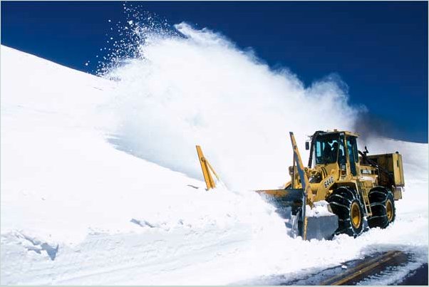
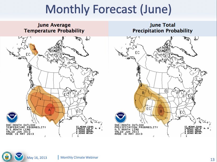
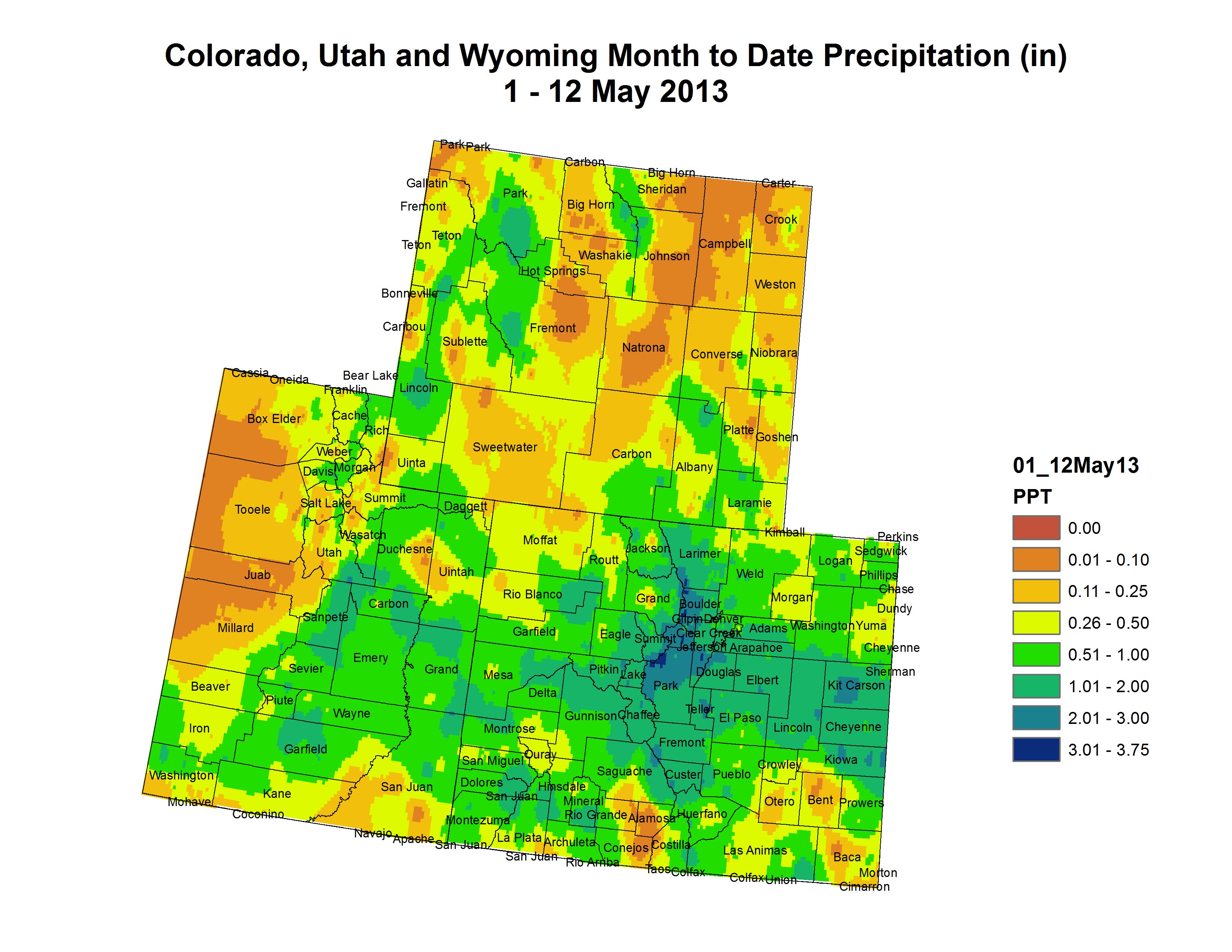
    April snowshowers brought some relief to the parched Colorado high country, but they look more like an aberration than a trend, speakers said at the State of the Rivers meeting on Monday. “I guess we can be really thankful for April of this year because if it hadn’t been for April, we would have been in a real bad spot,” Aldis Strautins, a hydrologist with the National Weather Service said to about 60 people at the meeting in the Colorado Mesa University Center.

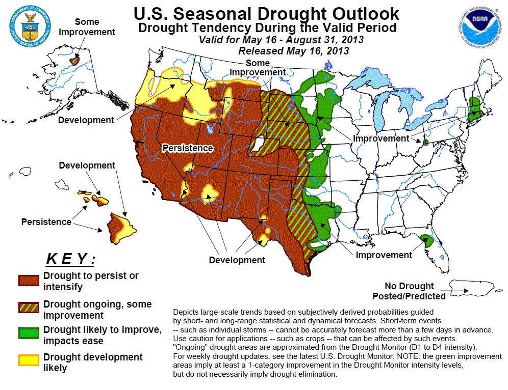
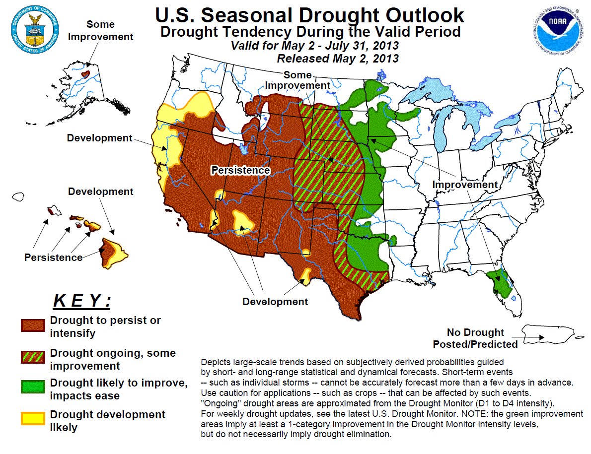
    The immediate and longer-term outlook, however, is less like April and more like a continuation of the drought. Forecasts for the May-June-July period are for greater probabilities for higher-than-normal temperatures and less precipitation, Strautins said. The probabilities run as well toward higher-than-normal temperatures for the June-July-August period.

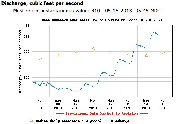
    Even with the April snowfall, the likelihood of major reservoirs filling is remote, said Erik Knight, hydrologist with the U.S. Bureau of Reclamation. Runoff this spring also will be muted, Knight said. Green Mountain Reservoir, which is frequently used to supplement summer flows through the Grand Valley, is likely to reach the 89 percent full mark based on current estimates, Knight said.

    On the Gunnison River side of the Grand Valley, Paonia Reservoir is likely to fill, but Taylor and Blue Mesa reservoirs are not. The Aspinall Unit, a series of reservoirs on the Gunnison, including Blue Mesa, is a major storehouse of water for the state and is managed in part to ensure that Colorado releases enough water to meet its obligations under the 1922 Compact under which the Colorado River is managed. It was 41 percent full on Monday.

    Low snowfalls overall will contribute to about 3 million acre feet of water flowing down the Colorado River system into Lake Powell. That’s about 42 percent of the long-term average, Knight said.

    From The Pueblo Chieftain (Chris Woodka):

    For smaller farms, the cuts come harder. Anita Pointon and her husband Chuck grew up on farms under the Fort Lyon Canal, and have had their own farming operation near Las Animas since 1990. They weathered the 2002 drought. But the current drought has been much harder. “In 2002, we had seven runs of water, and were able to grow a partial crop. It wasn’t pretty, but it was something,” Mrs. Pointon said.

    This year, only one-fifth of their ground, about 50 acres of established alfalfa, will be irrigated. “We probably won’t have a cash income this year,” she said. While the Pointons receive crop insurance, the payments go down every year there is no crop, or if there is a reduced yield. “It’s on a five-year average, and we did not have a good yield in 2011 or 2012,” Mrs. Pointon said.

    In a normal year, they would grow corn, wheat and sorghum as well as hay. The yield for alfalfa will be down this year. “Four cuttings of alfalfa is normal, and this year we’ll be lucky to get one and a half,” she said.

    So far, they have not made deep cuts in their herd of about 50 cow-calf pairs. “We’ll have to cull those down if we don’t get rain,” she said. “If we get water, we would plant cane.”

    The long-term downturn in the farm economy already has hit the Las Animas area hard. “If you need tractor parts, you have to drive to Rocky Ford or Lamar. Either way, it’s an 80-mile trip for a $10 part.”

    Last year was a difficult one for most farmers, but this year is shaping up to be worse. “Last year, the people with wells were able to get a crop, but it wasn’t a big crop. Our last run was June 20,” Mrs. Pointon said. “Our neighbors are in the same situation and won’t be planting this year. But we’re all optimists, or we wouldn’t be in this business.”

    From The Pueblo Chieftain (Chris Woodka):

    The farmers who started the Fort Lyon Canal Co. knew they were pushing water onto land in an arid climate. Irrigation made farming possible despite spells of drought that could last for months or even years. But the drought of 2011-12 already is exceptional among those recorded since the Fort Lyon began keeping records at Las Animas in 1868.

    The rainfall is measured for the water year, which runs Nov. 1-Oct. 31. Both years recorded only half of the average 12.4 inches of precipitation, something that has not happened since 1893-94.

    If 2013 is as dry, it would mark the driest period since that time. It would be worse for farmers because irrigation water is more scarce even as natural conditions deteriorate.

    The drought of the 1890s was arguably worse than the Dust Bowl of the 1930s, when blowing dirt pelted the buildings in and around Las Animas. There was substandard rainfall from 1888-94, with the average for that entire span less than 8 inches, compared with 10 inches average annual rainfall in the 1930s. The driest years of the 1930s were 1937, with 6.35 inches, and 1934, with 6.35 inches. In 2002, 4.10 inches of rain fell at Las Animas, the second-lowest total on record — there were only 2.14 inches in 1894. But 2002 was surrounded by mostly average or above average years, making it more tolerable.

    In fact, up until 2010, Las Animas enjoyed a run of seven above-average rainfall years. Since November 2010, the yearly rainfall has only been 6.5 inches and has been clustered so that only a couple of months — June 2011 and April 2012 — were at average.

    So far in 2013, rainfall is again far below average, with some snowfall in April. But the storms that moved through the state last week largely missed Bent County.

    From The Trinidad Times Independent (Steve Block):

    The U.S. Department of Agriculture (USDA) recently announced a drought designation for Las Animas, Huerfano, Alamosa, Conejos and Costilla counties that enables producers to qualify for financial assistance to compensate for some of the impacts of the drought.

    Bernie Barela, executive director of the county Farm Services Agency (FSA) office, said producers who want to apply for assistance should call the Pueblo FSA office at (719) 543-8386, ext. 2, for more information. Barela said her local office doesn’t handle the assistance applications. She said she certainly understands why some producers might need some help, given the drought conditions in the county…

    The May 8 announcement from U.S. Secretary of Agriculture Tom Vilsack to Colorado Gov. John Hickenlooper said that Costilla County had been named as a primary natural disaster area because of the recent exceptional drought. Las Animas and Huerfano Counties each share a contiguous border with Costilla County, qualifying them for federal assistance through the Consolidated Farm and Redevelopment Act as contiguous disaster counties under the act’s provisions.

    NWS Science Briefing: Lifting Mechanisms for Precipitation

    Waldo Canyon burn scar: Colorado Springs Utilities repurposes two drinking water reservoirs to flood mitigation

    waldocanyonfirejuly2012

    From KRDO.com (Rachael Plath)

    The burnt ground left in the wake of the Waldo Canyon Fire has increased the likelihood of flash flooding and mudslides. This threat directly impacted two Colorado Springs reservoirs: the Nichols and the Northfield reservoirs.

    “When we have rainstorms, it really churns everything up; brings out that vegetation and debris down into the streams and tributaries. It just makes it a little more challenging to treat,” said Andy Funchess, field operations manager for water systems with Colorado Springs Utilities.

    According to Funchess, the area surrounding the two reservoirs was badly burned. The runoff and erosion around the reservoirs was affecting the water’s quality.

    Funchess said CSU has the ability to treat the water, but the cost would outweigh the benefit. For this reason, CSU drained the two reservoirs. The empty basins will now help with flood mitigation, as in their empty state, the reservoirs will catch debris and water before it rushes down the mountainside.

    From the Colorado Springs Independent (J. Adrian Stanley):

    For months now, local leaders have breathlessly awaited [Dave] Rosgen’s Watershed Assessment of River Stability and Sediment Supply (WARSSS) study, a detailed explanation of how water will move off the Waldo Canyon burn scar and, more importantly, what we can do to stop it.

    But as the study’s finally presented, it becomes clear that Rosgen can’t save us from the powers of nature.

    His plan — thousands of pages long — represents a to-do list that likely will cost tens of millions. It’s currently largely unfunded, and will take years to complete regardless. And then there’s the biggest dose of reality: Even if the region does everything recommended, a five- or 10-year storm will still cause mass destruction and may claim many lives. “The increase in flow is going to be with us,” Rosgen tells the crowd. “It’s not going to change a lot. Flood peaks are a reality for the future.”

    What the WARSSS can do is ease our suffering. The restoration work it recommends can hold back well over a million tons of mud in a normal monsoon season, ensuring that a two-year rain event doesn’t take out a neighborhood. Plus, it will help the burn scar heal more quickly.

    More Colorado Spring Utilities coverage here.

    Restoration: CSU Researchers Identify Environmental Risks and Opportunities for Conservation of Native Colorado Trout Populations

    cutthroattrouthistoricranges.jpg

    Here’s the release from Colorado State University (Jennifer Dimas):

    With only 14 percent of their original habitat remaining, native Colorado River cutthroat trout have been forced into isolation by habitat loss and invading non-native trout in relatively short reaches of high-altitude headwater streams. A new research paper by scientists at Colorado State University’s Warner College of Natural Resources has found that 63 percent of the remaining populations will be at some risk of decline or extinction by 2080.

    There are 309 individual fragments of rivers and streams where pure Colorado River cutthroat trout still persist in the Colorado River Basin. The CSU researchers developed models to assess the probabilities for a variety of risks to trout in these populations, including those from a warming climate as well as increases in drought that causes stream drying and wildfire that can produce erosion of sediment into streams.

    Researcher and lead author on the paper James Roberts first developed a sophisticated model to predict future stream temperatures from the latest predictions of future air temperatures and stream flow under climate change, as well as a range of other important variables such as latitude, slope, and elevation. The researcher team then analyzed the impacts of potential environmental disturbance events, such as fire, erosion and drought. What they found was a surprising paradox, and an opportunity for conservation.

    The scientists report that none of the populations of cutthroat trout are expected to be at risk of acute mortality from increasing temperatures as the climate warms, even 70 years in the future. This is because these native fish have already been forced into refuges in short high-altitude streams, above barriers that prevent invasion by non-native brook, rainbow, and brown trout. As a result, the surviving populations are less susceptible to extreme temperature changes such as those that will occur at lower elevations. However, these isolated havens of cool-water habitat are also at the crux of what is jeopardizing the Colorado River cutthroat trout population.

    The study reported that the fish living in these short stream reaches are highly vulnerable to potential effects of drought, fire, sediment deposition and freezing because they lack the habitat that would shelter them from these events that longer stream segments would afford. In addition, the isolated populations are also compromised by genetic risks that occur in small populations.
    Because Roberts’ models looked at each risk factor for each stream where the native trout still occur, the researchers are able to identify in which of the 309 fragments restoration to expand the native trout’s habitat can be most effective. Furthermore, they are able to determine approximately how many kilometers long a stream fragment needs to be in order to provide adequate habitat for enhanced persistence rates.

    “The complexity and depth of this study has allowed us to sharpen our focus and help managers create sustainable solutions for this iconic native fish species,” said Roberts. “Our hope is that this research will empower land managers with the tools and information needed to make a significant impact on the conservation of native Colorado River cutthroat trout for generations to come.”

    The paper, Fragmentation and thermal risks from climate change interact to affect persistence of native trout in the Colorado River basin, is published in the May 2013 issue of Global Change Biology. The study was conducted using data from the upper Colorado River Basin, which includes all tributaries above Glen Canyon Dam and Lake Powell.

    Roberts, now working with the U.S. Geological Survey, conducted the research over three years while he was a post-doctoral researcher with CSU’s Warner College. CSU scientist Kurt Fausch served as Roberts’ research advisor and co-author, and is a professor in the Department of Fish, Wildlife, and Conservation Biology and a world-renowned expert in the ecology and management of trout and other stream fishes. Other co-authors of the study are Mevin Hooten with the USGS Colorado Cooperative Fish and Wildlife Research Unit and CSU alumnus Doug Peterson with the U.S. Fish and Wildlife Service.

    “The exciting outcome of this research is that we now have a targeted tool to help land managers plan efficient and strategic habitat restoration to reduce these risks,” said Fausch. “In many other cases, managers may be able to do little for native trout as the climate changes and makes streams too warm for their survival.”

    From the Summit Daily News (Breeana Laughlin):

    Rising water temperatures, the Colorado State University study concludes, aren’t impacting the indigenous fish like some of its non-native brothers.

    Results of the study, which included six streams in Summit County, indicate that the hardy fish may be less susceptible to increases in water temperature than other trout.

    Researchers James Roberts and Kurt Fausch are suggesting this may be because cutthroat trout have already sought refuge in short, high-altitude streams, above the barriers that keep out non-native brook, rainbow and brown trout.

    Although isolated havens of cool-water habitat could help native trout survive future temperature increases, they still face peril in the event of a drought, fire or hard freeze because they don’t have the expansive habitat larger fish populations rely on to survive.

    More restoration/reclamation coverage here and here.

    Bennet, Tipton Reintroduce Companion Bills to Preserve Hermosa Creek Watershed

    hermosapark.jpg

    Here’s the release from US Representative Scott Tipton’s office:

    Colorado U.S. Senator Michael Bennet and Representative Scott Tipton are introducing a bill to protect more than 100,000 acres of the Hermosa Creek Watershed, an area in the San Juan National Forest north of Durango. The bill would establish management for the Hermosa Creek Watershed based on recommendations from the Hermosa Creek River Protection Workgroup, which included local water officials, conservationists, sportsmen, mountain bikers, off-road-vehicle users, outfitters, property owners, grazing permit holders and other interested citizens. Bennet’s bill was introduced today, while Tipton will introduce his bill in the House as early as tomorrow.

    “We are lucky in Colorado to be able to enjoy many of the country’s most beautiful landscapes in our backyards. The Hermosa Creek Watershed represents some of the best Colorado has to offer,” Bennet said. “This bill will protect this land for our outdoor recreation economy and for future generations of Coloradans and Americans to enjoy. It is the result of a local effort that took into account the varied interests of the community, and that cooperation helped us put together a strong bill with the community’s input.”

    “As one of Colorado’s most scenic areas, Hermosa Creek has long been treasured by the local community and by countless visitors who have explored all that the region has to offer,” Tipton said. “Local stakeholders including snowmobilers, anglers, hunters, other outdoor enthusiasts, elected officials, miners and Southwest Colorado residents have voiced their support to preserve the Hermosa Creek watershed and the multiple use recreation opportunities it provides. In response to this locally driven effort, Senator Bennet and I have joined together to put forward legislation to, without any additional cost to taxpayers, protect and preserve this special place, and ensure that Coloradans as well as visitors to our great state have the opportunity to experience Hermosa Creek’s abundant natural beauty for generations to come.”

    “On behalf of the La Plata County Commissioners, I thank Senator Bennet and Congressman Tipton for their great work for the interests of La Plata County citizens,” said Julie Westendorff, La Plata County Commissioner. “This bill protects the clean waters of our Hermosa Creek and promotes the responsible use of federal lands for the recreation that supports our economy and sustains our quality of life.”

    “We are very excited about this bill. We are hopeful that all the hard work and cooperative partnership that went into the Hermosa Creek Watershed Protection Act will lead to the swift passage of this bill for the benefit of Southwest Colorado and all the visitors to our area.” said Pete McKay, San Juan County Commissioner.

    “The Hermosa Creek Wilderness bill rests on a foundation of broadly-based stakeholder input,” said Dick White, mayor of Durango. “It will protect the watershed while preserving historical and recreational values. In addition, it provides protection for iconic scenic and recreational areas near the City of Durango. The bill will contribute both to the natural amenities that attract residents and tourists to Southwest Colorado and to the economic benefits that they bring.”

    “It was my privilege to represent the interests of the Southwestern Water Conservation District and San Juan County, Colorado during this process. Interests of the Southwestern Water Conservation District included protecting existing water rights and uses; and, the potential for future water development. The interests of San Juan County included protecting existing water quality, county road access, mineral development potential, forest product harvesting, and recreational uses,” wrote Stephen Fearn, President, Jo Grant Mining Company, Inc. “Both the District and San Juan County have voted to support the proposed legislation.”

    The bill, which is cosponsored by Senator Mark Udall, would designate roughly 108,000 acres of San Juan National Forest land as the Hermosa Creek Watershed Protection Area. Much of the land would remain open to all historic uses of the forest under the bill, including mountain biking, motorized recreation, and selective timber harvesting. Grazing will continue to be allowed in the entire watershed.

    In accordance with the consensus recommendations of the Hermosa Creek Workgroup, roughly 38,000 acres of the watershed would be set aside as wilderness, to be managed in accordance with The Wilderness Act of 1964. No roads or mineral development are permitted in wilderness areas; while hunting, fishing, horseback riding and non-mechanized recreation are allowed.

    Per the community recommendations the following trails all remain open to mountain biking: Hermosa Creek, Dutch Creek, Elbert Creek, Corral Draw, the Colorado Trail, Little Elk Creek, Jones Creek, Pinkerton-Flagstaff and Goulding Creek. Also, in keeping with the community recommendations, the following trails will remain open to motorized use: Hermosa Creek, Jones Creek, Pinkerton Flagstaff, Dutch Creek and Corral Draw. In addition the bill will allow areas in the Hermosa Creek watershed currently used by snowmobiling to remain open to that use. Also, at the request of Silverton and San Juan County, the bill ensures areas currently open to snowmobiling on Molas Pass will remain open for that use.

    The bill contains several provisions to provide for active land management in areas designated by the bill as necessary to control wildfires, insect infestations and disease outbreaks. Finally, per the request of the Durango City Council and La Plata County Commission, the bill would prohibit future federal mineral leasing on Animas Mountain, Perins Peak, Ridges Basin and Horse Gulch.

    Supporters of the bill include the City of Durango, the La Plata County Commission, the San Juan County Commission, the Wilderness Society, Trails 2000, Four Corners Back County Horsemen, Jo Grant Mining Company, Inc., in addition to numerous business and sportsmen groups, among others.

    More Hermosa Creek Watershed coverage here and here.

    Restoration: Mary Murphy Mine project set to start mid-summer

    Mary Murphy Mine

    From The Mountain Mail (Maisie Ramsay):

    High on Chrysolite Mountain south of St. Elmo sits the Mary Murphy Mine, one of many nearly abandoned mining sites dotting the landscape of Chaffee County. The mine, a once-rich source of gold and silver, is now a pollutant. “It’s discharging metals into Chalk Creek. It makes it difficult for fish to survive,” said Jeff Graves, senior project manager for the Colorado Division of Reclamation, Mining and Safety.

    Work is now under way to permanently stop the mine’s discharge of zinc-laden water toxic to fish – runoff linked to a 1986 fish kill. “The goal is to reduce the amount of discharge significantly and by that hopefully improve water quality within Chalk Creek,” Graves said.

    The reclamation agency is seeking bids on the first phase of a two-stage project to end contaminated seepage from the site, described in a 2009 state report as the “single greatest contributor of heavy metals” in Chalk Creek. The first phase of the estimated $500,000 project is set to begin mid-summer, Graves said.

    The project will reinforce the mine’s Golf Tunnel to prevent it from collapsing on workers during the second phase of the project, when a long-term barrier will be put in place. The tunnel will be stabilized, the floor cleaned of muck, ventilation put into place and basic utilities installed such as electricity and telephone. The Golf Tunnel is 2,200 feet below the surface, the lowest level of the Mary Murphy Mine.

    Companies interested in the project must attend a mandatory pre-bid meeting at 10 a.m. May 7 in the U.S. Forest Service parking lot near St. Elmo. Bids must be submitted by May 23.

    Following the stabilization of the Golf Tunnel, workers will install concrete plugs designed to stop mining discharge during the second phase of the project. “It’ll be like putting a cork in it,” Graves said. The “cork” phase has not yet been scheduled. Graves could not provide a specific cost estimate, but said the installation of the concrete plugs is expected to cost more than reinforcing the tunnel.

    There are still claims on the Mary Murphy Mine, though the site is largely abandoned. The latest remediation work follows prior efforts to reduce pollution at the site through consolidation, capping and revegetation of mine tailings.

    The work is being funded by the state and federal government after it was determined that “existing landowners are nonviable … for insufficient funds,” Graves said.

    More restoration/reclamation coverage here.

    Boulder County ‘Water Tour 2013’ is Saturday, June 8

    Grand Junction: Next CWCB board meeting May 14-15

    historicdowntowngrandjunction.jpg

    From email from the Colorado Water Conservation Board:

    The meeting will be held in Grand Junction at the Ute Water Conservancy District offices located at 2190 H 1/4 Road, Grand Junction, CO, 81505.

    More CWCB coverage here.

    El Paso County Commissioners approve a regional stormwater approach for mitigation and management

    arkansasfountainconverge.jpg

    From the Colorado Springs Independent (J. Adrian Stanley):

    On Tuesday, the soon-to-be-overhauled City Council approved a resolution to support a regional approach to stormwater management on a 6-2 vote. In the past, such a move may have been considered little more than ceremonial — most experts have long agreed that stormwater is best approached regionally. But Mayor Steve Bach has lately turned the issue into a political football…

    Many believe the mayor is afraid that a regional approach will suggest a new tax to solve the area’s dangerous backlog of needed infrastructure projects, estimated to exceed $900 million. The mayor signed a pledge saying he would oppose any new tax, no matter how vital. But Bach’s long reach may not be able to control this process. With assistance from El Paso County, a Regional Stormwater Steering Committee, made up of dozens of citizen volunteers, is already studying how best to approach the problem.

    More Fountain Creek coverage here and here.

    POWELL to POWELL Episode 3 in the Colorado River series #ColoradoRiver

    Las Vegas: ABA 31st Annual Water Law Conference June 5-7

    CFWE watershed tours are coming up later this month, June and July

    Click here for the 2013 tours page from the Colorado Foundation for Water Education. Watch their showcase video above to learn about the mission.

    More Colorado Foundation for Water Education coverage here and here.

    WWA Intermountain West Climate Dashboard: New Briefing Available #COdrought

    swepercentofnormalwesternusmay122013wwa.jpg

    From email from the Western Water Assessment:

    Our latest Monthly Briefing was updated today on the Intermountain West Climate Dashboard. The briefing reviews April’s precipitation and temperature conditions; current drought, snowpack, and streamflow conditions; May 1 spring-summer streamflow forecasts; and the latest seasonal climate and ENSO forecasts.

    New this month: Thumbnail images embedded in the text allow you to bring up the full-sized climate graphics while reading the briefing. [ed. very cool feature, click through, it’s worth it for you graphics junkies]

    Highlights:

  • Recent snows have improved the runoff picture, but most of the Intermountain West is still facing low or very low 2013 spring-summer runoff with reservoirs already at low levels.
  • April precipitation was mixed for the region, with northern and central Colorado, portions of Wyoming, and eastern Utah being wetter than average, and northern Utah, southwestern Wyoming, and southern Colorado being mainly drier than average.
  • Snowpacks in eastern Utah, much of Wyoming, and northern and central Colorado saw large gains in April, reaching near-normal peak levels.
  • Southern Colorado and southern Utah did not see these gains and meltout began early, from well-below-normal peaks.
  • May 1 forecasts for spring-summer streamflow for the region are still below average or well below average, but are generally improved from the April 1 forecasted flows across Wyoming, northern and eastern Utah, and northern and central Colorado.
  • The NOAA CPC seasonal climate outlooks show a dry “tilt” for spring and summer precipitation for most of our region. In contrast, the “SWcast” for April-June shows a wet tilt over much of Colorado.
  • To view the Intermountain West Climate Dashboard, please click here.

    The latest ENSO Discussion is hot off the press: ENSO neutral conditions forecast to continue #COdrought

    iricpcplumeofmodelensopredictionsmidapril2013

    Click here to read the discussion and see all their graphics. Here’s an excerpt:

    Synopsis: ENSO-neutral is favored into the late Northern Hemisphere summer 2013.

    During April 2013, ENSO-neutral continued, with near-average sea surface temperatures (SSTs) observed across most of the equatorial Pacific Ocean, and below average SSTs confined to the far eastern equatorial Pacific. The Niño indices were near zero throughout the month, except for the Niño1+2 region which was between -1.2°C and -0.5°. The oceanic heat content (average temperature in the upper 300m of the ocean) remained near average during April, reflecting near- average subsurface temperatures at depth across most of the central and eastern equatorial Pacific. The tropical low-level easterly winds remained slightly enhanced over the western half of the Pacific basin, and anomalous upper-level westerly winds prevailed across much of the equatorial Pacific. Tropical convection was enhanced over Indonesia and the western Pacific and suppressed over the central Pacific. Collectively, these conditions indicate the continuation of ENSO-neutral.

    Most models forecast Niño-3.4 SSTs to remain ENSO-neutral into the Northern Hemisphere winter, with dynamical models tending to predict warmer conditions (-0.3°C to 0.4°C) than the statistical models (-0.7°C to 0°C). There is still low confidence in the forecasts for the latter half of the year, partly because of the so-called “spring barrier,” which historically leads to lower model skill for forecasts made between March and May. Forecast confidence will increase over the next few months. The current forecast indicates that ENSO-neutral will likely continue into the second half of the Northern Hemisphere summer 2013 (see CPC/IRI consensus forecast).

    This discussion is a consolidated effort of the National Oceanic and Atmospheric Administration (NOAA), NOAA’s National Weather Service, and their funded institutions. Oceanic and atmospheric conditions are updated weekly on the Climate Prediction Center web site (El Niño/La Niña Current Conditions and Expert Discussions). Forecasts for the evolution of El Niño/La Niña are updated monthly in the Forecast Forum section of CPC’s Climate Diagnostics Bulletin. The next ENSO Diagnostics Discussion is scheduled for 6 June 2013. To receive an e-mail notification when the monthly ENSO Diagnostic Discussions are released, please send an e-mail message to: ncep.list.enso-update@noaa.gov.

    Bureau of Reclamation Releases Updated Climate Data for Water Managers

    arcticseaicerecord962011nationalsnowicedatacenter.jpg

    From email from the Bureau of Reclamation (Peter Soeth):

    The Bureau of Reclamation and collaborators developed new downscaled climate projections that allow water managers to incorporate the new Coupled Model Inter-comparison Project Phase 5 data from the World Climate Research Program into their water management planning. The data, representing 234 contemporary climate projections for the contiguous United States, was downscaled to a 12 kilometer resolution in order to be more useful to water managers.

    “CMIP5 projections represent a new source of information about how a changing climate may impact water supplies in the United States,” Reclamation Commissioner Michael L. Connor said. “Reclamation and its partners are taking leading roles to develop an understanding on how this new information complements previous climate projections made available through CMIP3, and on how CMIP5 projections should be considered in water planning and management.”

    The World Climate Research Program develops global climate projections through its CMIP roughly every five to seven years. Results from CMIP3 were released in 2007 and later used in Reclamation research and assessments including the 2011 SECURE Water Act Report and WaterSMART Basin Studies completed in the Colorado, Yakima and St Mary River – Milk River Basins.

    “CMIP5 includes more comprehensive global climate models, updated greenhouse gas emissions scenarios and a broader set of experiments to address a wider variety of science questions,” Acting Science Adviser Levi Brekke said. “Through the West-Wide Climate Risk Assessment Implementation Team, Reclamation will consider best approaches for using CMIP5 projections in the future.”

    Reclamation, Lawrence Livermore National Laboratory, Santa Clara University, Climate Central, Climate Analytics Group, Scripps Institution of Oceanography, the U.S. Geological Survey and U.S. Army Corps of Engineers developed the new downscaled data collaboratively supported by funding from a WaterSMART Climate Analysis Tools Grant and Reclamation’s Science and Technology Program.

    The new downscaled climate projections are available at: http://gdo-dcp.ucllnl.org/downscaled_cmip_projections/.

    More Bureau of Reclamation coverage here.