
Today’s It All Starts with Science blog post–EPA’s Hydraulic Fracturing Drinking Water Study: What’s the latest? 1.usa.gov/ZBOwjI
— US EPA Research (@EPAresearch) May 6, 2013
Month: May 2013
2013 Colorado legislation: ‘Each one of these things was epic’ — Senate Majority Leader Morgan Carrol #COleg

Joe Hanel sums up this year’s legislative session in his article running in The Durango Herald. Click through and read the whole thing. Here’s an excerpt:
During the last 120 days, Democrats used their majorities in the House and Senate to push through a progressive agenda that’s been pent up for a decade.
Election Day voter registration. Background checks for guns. Renewable-energy mandates. More health care for the poor. A $100 million tax break for low-wage workers. Civil unions for same-sex couples, and in-state tuition for students in the country illegally. Democrats in many other states can only daydream about the goals that Colorado Democrats achieved during the 2013 legislative session, which ended Wednesday.
For good or ill, Capitol veterans called it the most consequential session in memory.
“Each one of these things was epic,” said Senate Majority Leader Morgan Carroll, D-Aurora. “We were (able) to do public-safety measures with commonsense background checks that Congress couldn’t get done. Any one of these things by themselves would have been historic and epic for a session, and we did one after another after another.”
More 2013 Colorado legislation coverage here.
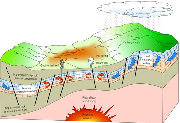
Chaffee County is still hammering away at 1041 regulations for geothermal exploration and production
From The Mountain Mail (James Redmond):
When developing Chaffee County’s draft geothermal 1041 regulations, the consultant aimed to support geothermal development while protecting property rights, as the county requested, officials said at a special work session Tuesday. The 1041 regulations, when passed by the commissioners, will govern the use of geothermal resources for commercial production of electricity.
The consultant who drafted the regulations, Barbra Green, partner at Sullivan Green Seavy LLC, said the draft contains flexible language that will give the county tools to handle all applications, from simple to controversial. “No one else in the state has geothermal regulations yet,” Green said. The process “is not easy and never perfect,” but she said she wants to talk through the draft with the county, hear feedback and get the regulations as close to the goals of the county as possible.
The county’s draft geothermal 1041 regulations create a “permit-driven” process, Mary Keyes, Sullivan Green Seavy LLC paralegal, said. Unless staff makes a “finding of no impact,” any use of geothermal for commercial electricity will require a 1041 permit, she said.
Chaffee County Commissioner Dave Potts asked when a project would get a finding of no impact. Green said she did not know how a geothermal project could actually get a finding of no impact. To do so, the project would have to cause no change on the site or surrounding properties in a number of areas. She said the draft has the no-impact language because in the future new technology or processes could possibly have no impact.
The draft regulations include a mandatory pre-application meeting, Green said. Such meetings help all parties involved, by getting everyone on the same page, clarifying and answering questions about the application process. The meeting lets applicants determine their responsibilities and how to ensure their applications have everything they need up front instead of dealing with it later, she said.
Once staff declares the application complete, the information goes to all reviewing agencies or consultants determined necessary, Keyes said. Then staff will compile all findings from the review agencies and consultants into a staff report prior to the public hearing for the application, she said.
After the walkthrough of the process, the commissioners, consultant, county staff and others attending the meeting addressed areas of the draft they thought had issues or conflicts, and discussed possible solutions.
The county will have to decide if it wants the drilling of exploration holes to fall into the definition of geothermal 1041 regulations, and therefore require a 1041 application, Green said. Hank Held and Fred Henderson, both of Mt. Princeton Geothermal LLC, spoke during public comments, saying the county should consider less regulation, not only on the drilling of exploration holes, but also on the entire geothermal 1041 regulations. Held said the county’s draft geothermal 1041 regulations duplicate both state and federal regulations. In cases such as drilling exploration holes, a company already must go through a regulatory process at the state level that could cover the need for regulation, he said.
Green said in some cases the county has different standards than the federal or state regulations, so it may appear the county has redundant regulations.
Paul Morgan, with the Colorado Geological Survey, warned commissioners that the west side of the Upper Arkansas River Valley has a large fault line running along it. He said, “I don’t think (county geothermal 1041 regulations) should have an option of a (finding of no impact). If an earthquake happens near geothermal development, “someone will sue the county,” he said.
The county will hold a public hearing to start the process of approving the draft geothermal 1041 regulations during the May 21 regular commissioners meeting in Buena Vista, Jenny Davis, Chaffee County attorney, said. While the public hearing will start the process, the commissioners do not have to make a decision then, she said. Green will take comments and recommendations from the commissioners after the public hearing to work any requested changes into the draft document, she said.
To develop geothermal 1041 regulations, Chaffee County partnered with Archuleta and Ouray counties and Pagosa Springs to hire the consultant for the process, Davis said previously. After the partners received a grant, Chaffee County’s portion of the contract for the consultant comes to $2,937.50, Don Reimer, Chaffee County development director, said previously.
The county will have the most current version of its geothermal 1041 draft regulations on its website, chaffeecounty.org
From The Mountail Mail (Joe Stone):
The 800-acre Mount Princeton geothermal lease was recently terminated for nonpayment of rent. The lease owner, 3E Geothermal LLC in Colorado Springs, is a wholly owned subsidiary of Young Life, which also owns the Frontier Ranch youth camp on the flanks of Mount Princeton. The Bureau of Land Management Colorado leased the parcel to 3E Geothermal during its November 2010 oil, gas and geothermal lease sale. The lease was issued Jan. 1, 2011. As reported at that time by The Mountain Mail, Young Life officials made clear their intention to use the lease to protect the camping experience at Frontier Ranch by preventing development that would affect the natural beauty of the area.
Denise Adamic, public affairs officer for the Bureau of Land Management Royal Gorge Field Office in Cañon City, said, “Rent needs to be received every year by the Office of Natural Resources Revenue by the anniversary date … the date the lease went into effect.”
Adamic said, when the rental amount of $2,400 was not received by Jan. 1, officials with the Office of Natural Resources Revenue issued a notice to 3E Geothermal giving the company 15 days to pay. When the company did not respond to that notice, Adamic said officials issued a second notice giving the company 45 days from the anniversary date to pay the rental amount plus a 10-percent late fee. When 3E Geothermal failed to pay within the 45-day period, Adamic said, the lease was terminated.Adamic said the company then had 30 days from the time they received the termination letter to appeal the termination to the Interior Board of Land Appeals. Terry Swanson, Young Life vice president of communications, said failure to pay the lease was “an administrative oversight” by Young Life that is “being corrected.”
Adamic said, if 3E Geothermal loses the appeal, the company would have to place the winning bid at another lease sale in order to retain the lease. BLM officials are “reviewing what, if anything, we will do with the area in question. We may or may not offer it for lease again,” Adamic said. She added that BLM officials are investigating whether or not a new lease-sale nomination would be required to offer the parcel for lease again.
Adamic said the BLM had not received a plan of development for the lease and that 3E Geothermal had not begun any ground-disturbing work on developing the lease.
This geothermal lease was the first sold in Colorado since the 1980s.
Whitewater sports brought in $52 million in business along the Arkansas River mainstem in 2012

From The Mountain Mail (Casey Kelly):
Commercial rafting activities brought more than $52 million into the Arkansas River Valley economy in 2012, Rob White, Arkansas Headwaters Recreation Area park manager, told Salida City Council during a work session Tuesday. White said the $52 million figure came from the Colorado River Outfitters Association’s 2012 year-end report on the economic impact of commercial rafting. In 2011, the impact on valley economy was a little more than $60 million. “You can see the effect that a low-water season has,” White said.
To calculate economic impact, the report uses total cash spent in the local area for rafting, food, lodging and souvenirs by one rafting customer in one day, taken from a 1991 survey conducted by the Bureau of Land Management. That figure is multiplied by the number of commercial user days and an economic multiplier of 2.56 (the number of times a dollar is spent in the local area before being spent outside that area, according to the Colorado Tourism Board). “I don’t think people realize the economic impact whitewater boating provides to the communities in the Upper Arkansas River Valley,” White said. “People are bringing a lot of people into the area and spending a lot of money.”
Other data White highlighted from the report included the Arkansas River recording a total of 169,486 commercial user days, the most of any river in the state in 2012. White said the Arkansas River saw “more than half the use of all other rivers in the state of Colorado. That’s including the Colorado River. So you can see basically how important the Arkansas River is in terms of drawing people from both the Front Range and out of state for whitewater boating and for rafting.”
Commercial use on the Arkansas River in 2012 was down from 2011, which saw 208,329 commercial user days. “2011 was obviously a much better water year. In some respects, almost too good of a water year. We had big, big flows and we had high water advisories on the river a couple of different times,” White said.
Upper Ark District board meeting recap: All district reservoirs are full, except DeWeese (89%) — Jord Gertson #COdrought

From The Mountain Mail (Joe Stone):
Recent weather patterns in the Upper Arkansas River Valley precipitated discussion of snowpack and water supplies during the Thursday meeting of the Upper Arkansas Water Conservancy District. District hydrologist Jord Gertson reported that all district reservoirs are full, except for DeWeese Reservoir in Custer County, which is at 89 percent of capacity.
Gertson presented Natural Resources Conservation Service data compiled May 1 that show Upper Arkansas River Basin snowpack at 93 percent of average and 287 percent of 2012 snowpack levels. Gertson said Snowpack Telemetry sites at Fremont Pass and Brumley show the snow water equivalent at 101 percent and 109 percent of median, respectively. The Fremont Pass SNOTEL site also reports precipitation at 106 percent of average for the current water year, which began Oct. 1. Gertson also showed snowpack charts indicating measurements at upper basin SNOTEL sites are “way better than last year,” including sites at Porphyry Creek, Independence Pass and St. Elmo.
District directors also reported good news about the Frying Pan-Arkansas Project, which is expected to import 47,000 acre-feet of water from the Western Slope this year, compared to 14,000 acre-feet in 2012. Diversions of Fry-Ark Project water into the Arkansas Basin average approximately 52,000 acre-feet of water per year. In 2011, the project imported 98,000 acre-feet of Western Slope water, the second highest amount in the project’s 50-year history of operations.
In other business, directors heard a legislative report from consultant Ken Baker. Baker’s report mainly focused on House Bill 1130, which, he said, targets Arkansas Basin water and is expected to be signed by the governor.
Baker said HB 1130 would create a “selective application” of a 130-year-old Colorado water law. The bill would create the potential for 30 years of interruptible-supply agreements that are currently limited to a maximum of 10 years. The state engineer would have authority to approve these agreements, changing the use of the water and bypassing Water Court proceedings that are currently required to change the use of a water right. Baker said the bill mainly benefits Aurora, allowing the city to take Arkansas Basin water without having to pursue a change-of-use case in Water Court.
To gain the votes needed to pass the bill, Baker said a special exclusion was added that exempts Western Slope water.
In other business, Upper Ark directors:
Approved a modification to a Nestlé Waters North America augmentation agreement for 200 acre-feet of Fry-Ark Project water per year for 35 years. Agreed to stipulate out of Poncha Springs case 09CW138, subject to favorable review of the stipulations by district engineer Ivan Walter. Approved an agreement with law firm Wilderson, Lock and Hill to provide legal counsel for a flat fee of $2,000 per month. Received an update on an integrated water agreement with Buena Vista. Approved a cooperative water agreement with Colorado Parks and Wildlife. Learned that the gate wheel at O’Haver Lake has been replaced after the old one was damaged by a vehicle. Received an update on the Trout Creek Ditch exchange case, 08CW106, which is scheduled to go to trial June 11 if the Department of Corrections, division engineer and Colorado Water Conservation Board do not agree to proposed stipulations.
From The Mountain Mail (Joe Stone):
Upper Arkansas Water Conservancy District directors heard a report about the potential for underground water storage in Chaffee County during their Thursday meeting. Tammy Ivahnenko and Ken Watts with the U.S. Geological Survey said areas identified for further study include aquifers near Salida, Nathrop, Johnson Village, Buena Vista and north of Buena Vista.
Watts said the locations were identified based on slope (less than 3 percent), soil texture at a depth of 5 feet (loam, sandy loam or gravel preferred) and surface geology (alluvial or gravel deposits).
Another important factor, Watts said, is the “stream-accretion response time factor,” which provides an indication of how long water will stay in an aquifer before draining into a stream.
Ivahnenko described “water budgets” she developed for Cottonwood, Chalk and Browns creeks and the South Arkansas River.
The water budgets include irrigated acres, consumptive use by crops and amount of water diverted for irrigation, and help determine how much water may be available for storage at a given time.Watts said he conducted “slug tests” at 29 wells to determine hydraulic properties in the aquifers, including conductivity and permeability. He also reported on findings from Colorado State University monitoring wells. Hourly readings from the monitoring wells documented seasonal changes in water level and temperature, showing seasonal changes in groundwater levels and surface-water infiltration.
Some wells showed significant influence from surface irrigation while others indicated a more stable, natural water level.
Upper Arkansas Water Conservancy District officials are developing plans to increase water storage capacity in the Upper Arkansas River basin. An important component of those plans is underground storage in alluvial aquifers, which would eliminate evaporative water losses and provide augmentation water through natural recharge to surface waters.Conservancy district officials said they will rely on USGS findings to help determine possible locations for underground water storage projects.
More Upper Arkansas Water Conservancy District coverage here.
Parachute Creek spill: Regulatory authority over the pipeline at fault is still a fuzzy question #ColoradoRiver
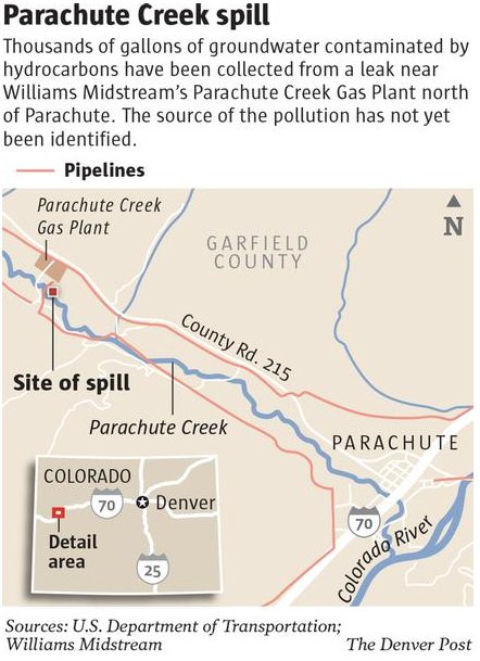
From The Grand Junction Daily Sentinel (Dennis Webb):
A state regulator recently acknowledged the lack of clarity over what agency, if any, regulates pipelines like the one that’s the source of a natural gas liquids leak in the Parachute Creek watershed northwest of Parachute. The comments by Jim Milne, environmental manager for the Colorado Oil and Gas Conservation Commission, came in response to a question by Commissioner DeAnn Craig at the commission’s meeting last week. Milne was providing an update on the investigation into the leak from a pipeline leaving Williams’ gas processing plant. “I’m just curious who writes the rules for pipeline integrity of this type of system?” Craig asked.
“I don’t have an answer to that,” Milne responded. “I think the agencies have all been looking at that question.” He said he knows the Occupational Safety and Health Administration (OSHA) has some level of involvement with the plant, but added, “I think the question you ask is a good one.” He said he and commission Director Matt Lepore have discussed the need to contact any agencies that could be involved and get a better understanding of who has responsibility over the line.
Williams believes a faulty gauge on the pipeline leaked about 10,000 gallons into the soil and groundwater. Carcinogenic benzene has contaminated groundwater and the creek. Williams has pointed to OSHA regulatory oversight of the pipeline. But OSHA has said it doesn’t regulate things such as what pipeline materials and welding should be used, and that its regulations are geared toward safety considerations such as protecting laborers working in pipeline trenches. The natural gas liquids pipeline runs from the plant and beneath the creek to tanks on the other side.
Williams says the federal Pipeline and Hazardous Materials Safety Administration regulates the pipeline running from the tanks to another plant in Rio Blanco County, from which the liquids are then shipped out of state. That agency covers aspects such as pipeline construction, testing, inspection and maintenance.
The question of jurisdiction over the Williams line takes on additional significance because the company wants to install a second natural gas liquids line in the same corridor going beneath the creek to accommodate an expansion of its plant. It recently announced a delay in the expansion for reasons it says relate to the local drilling slowdown and not the leak. That expansion plan went through a Garfield County review process, but a county planning staff report to county commissioners made no apparent mention of the new pipeline.
The oil and gas commission’s ability to regulate the existing or planned pipeline appears to be limited. It recently handed off lead authority over the leak investigation to the Colorado Department of Public Health and Environment because it determined it didn’t have primary jurisdiction over the matter.
Oil and Gas Commissioner Rich Alward of Grand Junction told Milne that despite the jurisdictional issues, he’d be interested in any recommendations about what the commission can do “to minimize the risk of this happening again.” Alward mentioned reporting requirements as one possible area to be addressed.
Williams didn’t initially report the leak because it thought it involved less than 25 gallons, far below the minimum five barrels (210 gallons) that trigger a reporting requirement. It also didn’t consider the spill to be a threat to surface waters, something that triggers a commission requirement of immediate reporting of a spill of any size.
A bill awaiting action by Gov. John Hickenlooper would require reporting within 24 hours of all waste spills of a barrel or more if they take place outside berms or secondary containment systems. But a barrel, or 42 gallons, is still more than what Williams initially thought had leaked.
In addition, the commission determined the liquids that leaked, as a product leaving a gas plant, don’t involve exploration and production waste, which is why it gave up jurisdictional authority.
Meanwhile, Williams reports that the highest benzene reading in the creek as of Thursday was 4.4 parts per billion. The level last week remained below the state drinking water standard of 5 ppb in the creek, after barely exceeding that standard the week before, although the standard doesn’t apply to the creek because it’s not considered a drinking water source. There continue to be no signs of benzene in the creek at the point downstream where the town of Parachute diverts irrigation water.
On Tuesday, a new well was installed to recover contaminants from the soil.
Also completed this week was installation of vertical air sparge wells designed to enhance the removal, through aeration, of benzene in groundwater once they are hooked up to a blower motor.
Those wells are part of a plan, newly approved by the health department and Environmental Protection Agency, under which Williams is upgrading its treatment system at the point where contaminated groundwater is entering the creek.
All containment booms in the creek were replaced Tueday with fresh ones. Work also began last week on sampling contaminated groundwater. The work is necessary to characterize the contamination before the water can be properly treated and disposed of, the health department said.
Williams said Friday that it so far has recovered about 6,300 gallons of natural gas liquids. It also plans to construct by month’s end a water treatment system to remove hydrocarbons from the aquifer and from recovered water that then can be returned to the aquifer. The water will be subject to continuous testing to assure it meets state and EPA requirements before being discharged back to the surface.
Meanwhile, the Clifton Water District is keeping an eye on the spill. They pull off the Colorado River downstream of the confluence of Parachute Creek. Here’s a recent release:
The Clifton Water District has continued to monitor the developments related to the contamination of Parachute Creek with Benzene. Parachute Creek is a very small tributary to the Colorado River which is the water supply for the Clifton Water District. No reports have indicated that Benzene has reached the Colorado River and the District’s monitoring efforts have not detected the presence of Benzene.
Even though there is no indication that Benzene has reached the Colorado River, the Clifton Water District has been proactively monitoring the Colorado River in multiple locations for the presence of 25 Volatile Organic Compounds (VOC’s), including Benzene. The Clifton Water District’s Certified Laboratory has not detected the presence of Benzene or any other Volatile Organic Compound in any of the samples. Monitoring of the Colorado River for Volatile Organic Compounds has been a regular and routine event since 1986 and is a fundamental commitment in providing safe drinking water for our customers.
In addition to being mindful of source water quality, the District has been diligent to implement advanced water treatment technology which is very effective in treating the Colorado River. The District has worked to improve its water treatment system to a “state-of-the-art” facility utilizing Enhanced Coagulation/sedimentation, Rapid Sand Filtration, Reverse Osmosis and Nanofiltration. These processes are instrumental to the success of a multi-barrier treatment approach. Continuation of the District’s effort the next generation of “state-of-the-art” water treatment technology, Micro/Ultra Filtration Treatment Facility, is currently in design and projected to be constructed by 2015.
It is not anticipated that Benzene will be present in the Colorado River because of its volatility characteristics. The District will continue to maintain routine monitoring procedures for Benzene and other Volatile Organic Compounds even after this situation has been resolved demonstrating our commitment to provide high quality water to our customers.
Here’s a report from Dennis Webb writing for The Grand Junction Daily Sentinel:
The Clifton Water District said Tuesday it has been monitoring the benzene contamination in Parachute Creek, but tests of the Colorado River continue to show no evidence of the carcinogen. A leak of natural gas liquids leaving the Williams gas processing plant has resulted in small amounts of benzene reaching the creek. However, samples farther down the creek show no sign of the substance, which readily dissipates in moving water.
Clifton Water said in a news release that it doesn’t anticipate benzene reaching the river because of its volatility.
The creek “is a very small tributary to the Colorado River, which is the water supply for the Clifton Water District,” the utility added.
It said it “has been proactively monitoring the Colorado River in multiple locations for 25 volatile organic compounds, including benzene. But its certified lab has found no VOCs in any of the samples.
The district has routinely tested the river for VOCs since 1986 and will continue doing so after the leak situation is resolved, it noted. It also has been installing advanced water treatment technology to better address sediment and other issues involving the river water.
Last week, benzene in Parachute Creek barely exceeded the state drinking water maximum of 5 parts per billion. However, the creek isn’t designated as a drinking water source by Colorado’s Water Quality Control Commission, and instead a 5,300-ppb standard applies to protect aquatic life. Williams reports that benzene readings at the highest point of contamination in the creek from Saturday through Monday were all above 4 but below 5 ppb, with Monday’s level at 4.7 ppb.
From the Associated Press (Alexandra Tilsley) via The Denver Post:
One of the main contaminants in the groundwater is benzene, according to Mark Salley, a spokesman for the Colorado Department of Public Health and Environment, which is currently overseeing the remediation efforts. Benzene, a known carcinogen, was also found earlier this month in Parachute Creek in concentrations above the state’s health standard, but levels have since dropped and officials insist there is no threat.
To remove the benzene from the creek, Williams injected air into the surface water to strip the hydrocarbons, a process known as air-sparging. The same technique is to remove surface hydrocarbons that are floating on top of the groundwater.
How to handle all the benzene-infected groundwater is the next question. The recovered water is currently being stored in tanks, and Williams said Friday it is planning to install a water treatment system that can separate the benzene from the water. “They’re working on the plans right now for a water treatment system,” said Tom Droege, a Williams spokesman. “It’s not in place yet, but once it’s up and running, then they’ll begin to treat the groundwater on a regular basis.”
The system will remove the benzene and any other hydrocarbons from the water through a multistep process. Contaminated water will first go through an oil and water separator. Then, it will move through an air stripper, which works like air-sparging. Finally, the water will be moved through activated carbon polishing tanks. The treated water will then return to a holding tank, where it will be tested to ensure it meets state health department and U.S. Environmental Protection Agency standards. Once officials have confirmed the water is safe, it will be returned to the aquifer. Any air emissions from the treatment system will be captured and treated according to the procedures approved by the Air Pollution Control Division of the state’s health department, Salley said.
The system is expected to be functional by the end of May.
Drought/snowpack news: ‘We definitely want to see that water stay in the system a little longer’ — Jon Monson #COdrought
It looks like the Northern Colorado Water Conservancy District wants to store some of the late season snowpack in Granby Reservoir. Here’s a report from Eric Brown writing for The Greeley Tribune:
Additional water won’t be released from northern Colorado’s largest system of reservoirs, the Northern Colorado Water Conservancy District’s board of directors decided on Friday. The quota for the Colorado-Big Thompson Project will stay at 60 percent, according to Northern Water spokesman Brian Werner.
The decision came as a disappointment to farmers, who are in the midst of spring planting and in search of more water for the growing season.
But it was applauded by city water officials, who want to keep as much water as possible in storage for the future.
The two river basins that collect snowmelt for the C-BT Project’s 12 reservoirs had seen huge improvements in snowpack since the Northern Water board set its water quota at a lower-than-average 60 percent last month. With the recent snowpack upswing, the Northern Water board considered increasing the water quota during its meeting Friday, but in the end, the board agreed the quota needed to stay where it is so less water is used this year and reservoirs can be refilled.
The C-BT Project’s reservoirs were depleted throughout 2012, as water users heavily relied on water in storage to get through an extreme drought.
Werner said the Northern Water board will continue evaluating the C-BT quota at its monthly meetings. If the board were to increase the C-BT water quota by 10 percent, for example, that would make available an additional 31,000 acre-feet of water — or about 10 billion gallons — to northern Colorado cities, industries, farmers and ranchers.
Since the C-BT project went into use in 1957, the Northern Water board has set a quota to balance how much water could be used through the growing seasons and how much water needed to stay in storage for future years. The historic average for the C-BT quota has been just above 70 percent, according to Werner.
Throughout the spring, water officials from cities — including Jon Monson, director of the city of Greeley’s water and sewer department — had generally pushed for a quota of about 50-60 percent, and were glad Friday to see that it was staying in that range. “We definitely want to see that water stay in the system a little longer,” Monson said of the C-BT Project, which supplies anywhere from 30-50 percent of Greeley’s water demand, and also provides water to users in eight northern Colorado counties.
Many farmers, on the other hand, have asked for a quota of about 70 percent. “We’d like to have more water, but we also understand the need to refill reservoirs,” said Frank Eckhardt, a LaSalle-area farmer and board member for various irrigation ditch companies and water districts.
Eckhardt said the recent snow and rain will help the spring planting of corn, sugar beets, onions and other crops get off to a good start, but he and others worry about running into water shortages down the road if precipitation is less frequent. “That’s when we really might need some extra water,” Eckhardt said, noting that he hopes the Northern Water board will look at increasing the C-BT quota this summer if the upcoming months are hot and dry.
From the Northern Colorado Business Report:
Despite plentiful spring snows and rain, the Northern Colorado Water Conservancy Board has opted not to boost the amount of water it will provide to its members this year, deciding instead to maintain the quota at 60 percent. “It came down to the over-riding concern that we have to build reserves back up in a year like this,” said Brian Werner, the district’s spokesman.
Werner said Northern’s reservoir storage levels are 30 percent below average, due to last year’s drought. “That’s a big hole,” Werner said.
From the National Weather Service Pueblo office:
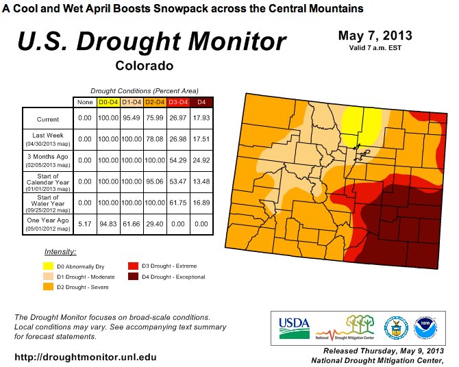
CENTRAL PORTIONS OF THE STATE HAVE RANGED FROM 125 TO 175 PERCENT OF NORMAL…DUE TO A COOL NORTHWEST FLOW WEATHER PATTERN. THISCOOL AND WET WEATHER PATTERN HAS ALLOWED FOR SOME IMPROVEMENTS IN THE DROUGHT ACROSS THE CENTRAL MOUNTAINS AND PORTIONS OF THE UPPER ARKANSAS RIVER VALLEY. HOWEVER…THIS WEATHER PATTERN DID NOT BRING MUCH PRECIPITATION TO WESTERN AND SOUTHEASTERN PORTIONS OF THE STATE…WITH PRECIPITATION TOTALS OVER THE PAST TWO MONTH RANGING FROM 25 TO 50 PERCENT OF NORMAL ACROSS MOST OF THE REST OF SOUTH CENTRAL AND SOUTHEAST COLORADO.
WITH THIS IN MIND…THE CURRENT US DROUGHT MONITOR CONTINUES TO INDICATE MOST OF SOUTHEASTERN COLORADO IN EXCEPTIONAL (D4) DROUGHT CONDITIONS. THIS INCLUDES SOUTHEASTERN PORTIONS OF EL PASO COUNTY…CENTRAL AND EASTERN PORTIONS OF PUEBLO COUNTY…CENTRAL AND EASTERN PORTIONS OF LAS ANIMAS COUNTY…AS WELL AS ALL OF CROWLEY…OTERO…KIOWA…BENT…PROWERS AND BACA COUNTIES.
EXTREME DROUGHT (D3) CONDITIONS CONTINUE TO BE INDICATED ACROSS NORTH CENTRAL THROUGH SOUTHEASTERN FREMONT COUNTY…SOUTHWESTERN THROUGH EAST CENTRAL TELLER COUNTY AND MOST OF THE REST OF PUEBLO AND EL PASO COUNTIES. EXTREME DROUGHT (D3) CONDITIONS ALSO REMAIN INDICATED ACROSS EASTERN HUERFANO COUNTY AND WESTERN LAS ANIMAS COUNTY.
SEVERE DROUGHT (D2) CONDITIONS CONTINUE TO BE DEPICTED ACROSS SOUTHWESTERN THROUGH EAST CENTRAL CHAFFEE COUNTY…NORTHWESTERN THROUGH SOUTHEASTERN FREMONT COUNTY…NORTHERN TELLER COUNTY…NORTHWESTERN EL PASO COUNTY…EXTREME WESTERN PUEBLO COUNTY…WESTERN HUERFANO COUNTY AND EXTREME NORTHWESTERN LAS ANIMAS COUNTY…AS WELL AS ALL OF CUSTER…SAGUACHE…RIO GRANDE…CONEJOS…ALAMOSA AND COSTILLA COUNTIES.
MODERATE DROUGHT (D1) CONDITIONS REMAIN ACROSS LAKE COUNTY AND NORTHERN AND WESTERN PORTIONS OF CHAFFEE COUNTY.
MORE INFORMATION ON THE US DROUGHT MONITOR CLASSIFICATION SCHEME CAN BE FOUND AT: WWW.DROUGHTMONITOR.UNL.EDU/CLASSIFY.HTM
SUMMARY OF IMPACTS…
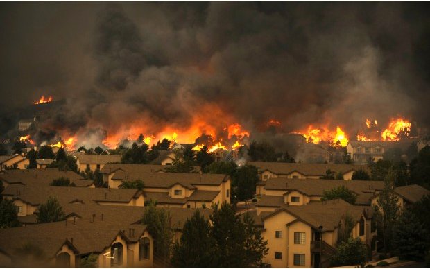
DROUGHT CONDITIONS EXPERIENCED OVER THE PAST TWO YEARS HAS IMPACTED SOUTH CENTRAL AND SOUTHEAST COLORADO IN MANY WAYS…INCLUDING INCREASED WILDFIRE ACTIVITY AND DANGER…FAILED AND POOR YIELD ON NON IRRIGATED CROPS…CATTLE LOSS AND ABANDONMENT…AS WELL AS QUESTIONS ON WATER AVAILABILITY AND WATER RIGHTS.
AS A RESULT OF THE PERSISTENT DRY CONDITIONS…GOVERNOR HICKENLOOPER HAS ACTIVATED THE STATES DROUGHT RESPONSE AND MITIGATION PLAN TO ENSURE THAT THE STATE IS DOING EVERYTHING POSSIBLE TO ADDRESS THESE DROUGHT RELATED IMPACTS. MANY LOCAL COMMUNITIES HAVE ALSO IMPLEMENTED DROUGHT RESPONSE MEASURES…INCLUDING MANDATORY WATERING RESTRICTIONS.
THE FOLLOWING WEBSITE HAS BEEN DEVELOPED TO HELP INDIVIDUALS DETERMINE WHAT THE RESTRICTIONS IN THEIR SPECIFIC COMMUNITY ARE: WWW.COH2O.CO
FIRE DANGER IMPACTS…
SOME BENEFICIAL MOISTURE HAS BEEN RECEIVED ACROSS PORTIONS OF SOUTH CENTRAL AND SOUTH COLORADO OVER THE PAST FEW MONTHS. HOWEVER…THIS HAS NOT BEEN ENOUGH TO ACCELERATE GREEN UP AND ALLEVIATE THE MODERATE TO HIGH FIRE DANGER ACROSS THE AREA…WITH SEVERAL SMALL WILD FIRE STARTS REPORTED ACROSS THE AREA OVER THE PAST FEW MONTHS.
A CONTINUED LACK OF MOISTURE…ALONG WITH INCREASING TEMPERATURES AND THE START OF THE CONVECTIVE SEASON…WILL LIKELY KEEP HIGH FIRE DANGER ACROSS THE AREA AND COULD LEAD TO MORE LOCAL GOVERNMENTS INSTITUTING FIRE RESTRICTIONS OVER THE NEXT SEVERAL MONTHS.
THE LATEST INFORMATION ON FIRE BANS AND RESTRICTIONS CAN BE FOUND AT:
WWW.COEMERGENCY.COM/P/FIRE-BANS-DANGER.HTML
AGRICULTURAL IMPACTS…
THE LATEST CPC AND VIC SOIL MOISTURE CALCULATIONS INDICATE SOME IMPROVEMENTS IN CONDITIONS ACROSS NORTHERN AND CENTRAL PORTIONS OF THE STATE. HOWEVER…DRIER TO MUCH DRIER THAN NORMAL SOIL MOISTURE CONDITIONS REMAIN DEPICTED ACROSS MOST OF SOUTH CENTRAL AND SOUTHEAST COLORADO…WITH THE LARGEST DEFICITS INDICATED ACROSS CENTRAL PORTIONS OF THE SOUTHEAST PLAINS.
THE LATEST USDA COLORADO CROP REPORT ALSO SUPPORTS THE DRY CONDITIONS ACROSS THE STATE…WITH 46 PERCENT OF TOP SOIL MOISTURE RATED AT SHORT OR VERY SHORT ACROSS THE STATE. THIS COMPARES TO 44 PERCENT OF TOP SOIL MOISTURE RATED AT SHORT OF VERY SHORT LAST WEEK AND TO ONLY 36 PERCENT AT THIS SAME TIME LAST YEAR. AS FOR SUBSOIL MOISTURE ACROSS THE STATE…74 PERCENT WAS RATED AT SHORT OF VERY SHORT THIS WEEK…COMPARED TO 80 PERCENT LAST WEEK AND TO ONLY 47 PERCENT AT THIS SAME TIME LAST YEAR.
THE LATEST PASTURE AND RANGE LAND CONDITIONS WERE RATED 73 PERCENT POOR TO VERY POOR…COMPARED TO THE FIVE YEAR AVERAGE OF ONLY 32 PERCENT RATED AS POOR TO VERY POOR.
THE COLORADO CROP REPORT ALSO INDICATES ONLY 13 PERCENT OF THE WINTER WHEAT CROP REACHING THE JOINTING STATE AT THIS TIME. THIS IS WELL BEHIND THE 65 PERCENT RECORDED LAST YEAR AND THE OVERALL AVERAGE OF 50 PERCENT FOR THIS TIME OF THE YEAR.
CLIMATE SUMMARY…
THE AVERAGE TEMPERATURE IN PUEBLO FOR THE PAST MONTH OF APRIL WAS 3.9 DEGREES BELOW NORMAL…MAKING APRIL OF 2013 TIED AS THE 11TH COLDEST ON RECORD. PUEBLO RECEIVED 0.30 INCHES OF PRECIPITATION ALONG WITH 3.4 INCHES OF SNOW THROUGH OUT THE MONTH…WHICH IS 1.10 INCHES AND 0.4 INCHES BELOW NORMAL…RESPECTIVELY.
THE AVERAGE TEMPERATURE IN COLORADO SPRINGS FOR THE PAST MONTH OF APRIL WAS 3.8 DEGREES BELOW NORMAL…MAKING IT THE 23RD COLDEST APRIL ON RECORD. COLORADO SPRINGS RECEIVED 0.33 INCHES OF PRECIPITATION THROUGH OUT THE MONTH…WHICH IS 1.09 INCHES BELOW NORMAL AND MAKES APRIL OF 2013 THE 14TH DRIEST ON RECORD. COLORADO SPRINGS ALSO RECEIVED 3.6 INCHES OF SNOW THROUGH OUT THE MONTH OF APRIL…WHICH IS 1.3 INCHES BELOW NORMAL.
THE AVERAGE TEMPERATURE IN ALAMOSA FOR THE PAST MONTH OF APRIL WAS 0.5 DEGREES BELOW NORMAL. ALAMOSA RECEIVED 0.32 INCHES OF PRECIPITATION AND 2.2 INCHES OF SNOW THROUGH OUT THE MONTH…WHICH IS 0.27 INCHES AND 1.3 INCHES BELOW NORMAL…RESPECTIVELY.
From the Fort Collins Coloradan (Bobby Magill):
Northern Colorado has been bone dry since the summer of 2011, and it takes more than a few weeks of wet weather to make up for that.
“We are still very much in deficit over the longer term,” said Colorado State Climatologist Nolan Doesken. “We are now above average for the current year by about an inch. It’s so much better than a year ago (that) it feels excessive.”
But the area has seen only 93 percent of normal wet precipitation during the past 365 days — 1.05 inches below normal, he said.
From May 10, 2012, to May 9, 2013, Fort Collins received 15.05 inches at the Colorado State University campus weather station, according to data compiled by Colorado Climate Center researcher Wendy Ryan. The normal precipitation for that period is 16.1 inches.
Though it’s early in the month, Fort Collins still hasn’t seen the full amount of precipitation it would normally get in a typical May despite all the rain and snow. The city normally receives about 2.5 inches of wet precipitation in May. So far, Fort Collins has officially received 2 inches…
The U.S. Drought Monitor, compiled by regional weather and climate scientists, considers how much precipitation has fallen in an area over the span of an entire year when determining whether a region is abnormally dry or significantly drought-stricken.
“If it was only short-term, we would be out of drought,” Doesken said.
![]()
From NASA Earth Observatory:
A round of late-spring snowstorms in 2013 offered a rare bit of positive news for reservoir watchers. Two of the three key river basins that feed Lake Powell—the Green River and the Upper Colorado River—saw much higher levels of precipitation in April than normal. The extra rain and snow provided critical relief for farmers, but hydrologists say that the precipitation was still too little to have much impact on the reservoir.
Snowpack peaked at 81 percent of average total accumulation in the Upper Colorado and Green, noted U.S. Bureau of Reclamation hydrologist Katrina Grantz. But the resulting runoff is likely to be only 45 percent of average because the parched soil is expected to absorb much of it. Some of the smaller reservoirs north of Lake Powell will get a boost, but Grantz expects Lake Powell to increase by only a few feet this spring and summer. Normal inflow from spring runoff, in comparison, would cause lake levels to rise by about 40 feet (12 meters).Randall Julander, a U.S. Department of Agriculture hydrologist, summed the situation up best. “Slight improvement in the Colorado basin water supply is like expecting a road-killed jackrabbit to feed a whole pack of hungry coyotes. It’s not nearly enough to go around,” he said.
Eagle River Watershed Council Waterwise Thursday May 16: Are you wiser than a sixth grader?

From email from the Eagle River Watershed Council:
Join us for a special Water Wise “Thursday” brought to you by the 6th Graders of Homestake Peak School of Expeditionary Learning. After an in-depth, multiple month study, these students are ready to teach you “the what, the so what, and the now what?” of the Eagle Mine Superfund Site.
The event will take place Thursday, May 16th at 5:30 at the Walking Mountains Science Center. The students will begin with a living history museum where you can chat with figures of the past and then, they take you in depth into the history, science and future of the Eagle River. Beverages and appetizers will be provided.
Denver Water: The May 2013 ‘WaterNews’ is hot off the press

Drought/snowpack/runoff news: Northern Colorado drought improves thanks to April/May moisture #COdrought
From The Denver Post:
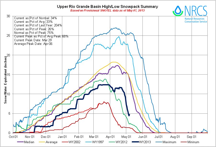
The storms hit northern Colorado hard, boosting snowpack in the South Platte River basin to 99 percent from 71 percent, and in the Colorado and the combined Yampa, White and North Platte basins to 98 percent from 78 and 79 percent respectively. The news is more grim in southwestern Colorado, where the Rio Grande and the combined San Miguel, Animas, Dolores and San Juan basins logged major declines. As of May 1, the Rio Grande reported at 41 percent of median, the other southwest basins were at 43 percent of median. Peak snowpack in those basins was reached in early March and melt began in April.
Though the snowpack is still high in the major northern basins, the reservoirs in the region still have not recovered from two years of drought. Statewide, reservoir storage is about 74 percent of average and 68 percent of 2012. Because the melt has not yet begun, the conservation service said, those numbers could improve in the northern basins. However, in the south, storage levels are still low and the chance of improvement is slim.
Horsetooth’s water level has reached an elevation of 5410 feet. That’s only 20 feet from full and just 4 feet… fb.me/2fIRmesgU
— karalamb (@klamb) May 9, 2013
From The Durango Herald (Jordyn Dahl):
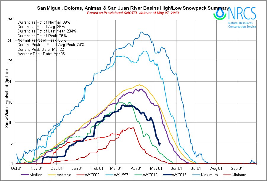
Despite the recent precipitation, the area still is in a severe drought with snowpack levels far below average. The San Miguel, Dolores, Animas and San Juan River basin is at 39 percent of average for snowpack, according to the Natural Resources Conservation Service. However, the basin is at 204 percent of last year’s snowpack.
Southwest Colorado never reached average snowpack levels during the winter, and what little snow the region did receive is melting quickly. The cooler temperatures will help slow the melting some, but it “will come off very quickly next week as we dry out,” Ramey said. “It will slow down the loss of snowpack, but we’re in a bad way,” he said. “It’s really the southwest corner of the state that is in the worst shape right now.”
From The Pueblo Chieftain (Chris Woodka):
Five Southern Colorado counties received federal drought designation Wednesday. Alamosa, Conejos, Costilla, Huerfano and Las Animas counties received the designation from Agriculture Secretary Tom Vilsack, according to a letter to Gov. John Hickenlooper. The counties will be added to other counties on the Eastern Plains that already have had drought declarations.
The designation allows farmers to apply for emergency loans and other assistance from the Farm Service Agency. Colorado’s U.S. senators hailed the decision. “Colorado and the West are experiencing one of the most severe droughts on record. This ongoing drought threatens farm jobs and our agricultural economy throughout the state,” said Sen. Mark Udall, D-Colo. “We need to act — and soon — on a new Farm Bill that strengthens farmers’ and ranchers’ hands as they confront this ongoing drought.”
“While areas of Colorado received late-season snow that brought some much-needed moisture to our state, the drought over the past several years has tortured crops and pastures around the state — and dry conditions continue to persist in many counties,” said Sen. Michael Bennet, D-Colo. “These disaster designations will provide critical assistance to farmers and ranchers to help offset their losses due to the recent drought.”
Snowpack in the Rio Grande and Arkansas River basins remains well below peak levels and irrigated farms typically use 85 percent of the water.
Drought conditions have improved in central & northern CO, still very dry elsewhere. #cowx #drought #coclimate twitter.com/ColoradoClimat…
— ColoClimateCenter (@ColoradoClimate) May 9, 2013
Tons of water fell on Colorado yesterday! South metro Denver saw well over an inch! #cowx #coclimate #cocorahs twitter.com/ColoradoClimat…
— ColoClimateCenter (@ColoradoClimate) May 9, 2013
From The Aspen Times (Scott Condon):
Aspen received its second-highest amount of snowfall for April since 1935 and the second-highest amount of total precipitation since 1951, according to the weather watchers at the Aspen Water Treatment Plant. The plant recorded nearly 38.5 inches of snow, second only to the whopping 56 inches that fell just two years ago, during the winter that wouldn’t end in April and May 2011. The average is just 15.7 inches. Total precipitation, including the snow-water equivalent from the snow, was about 4 inches in April. That compares with an average of 2.17 inches. It rained or snowed on 15 of the 30 days of the month, resurrecting the feeling of “mud season” from years gone by.
The rainy and snowy month created an oddity with the snowpack east of Aspen near the headwaters of the Roaring Fork River. The snowpack there peaked on April 18, nine days later than average. So when the snowpack is usually melting out, it was still building in the Roaring Fork basin.
The snowpack was 81 percent of the median east of Aspen on Wednesday and 100 percent of the median for the Roaring Fork basin overall, which includes the Fryingpan and Crystal river valleys, according to the Natural Resources Conservation Service…
The weather reversal has eased drought conditions in Colorado’s central and northern mountains, but the moisture isn’t spilling into the Eastern Plains. The U.S. Department of Agriculture’s Drought Monitor shows that the southeast quarter of Colorado remains rated in the worst level of drought at “exceptional.” Pitkin County, Eagle County and most of Garfield County have been reclassified to “moderate” drought, the second-lowest in the five-point intensity scale…
In the Roaring Fork Valley, the late snowfall will make for a great boating season on Ruedi Reservoir. The U.S. Bureau of Reclamation forecast about one month ago that the reservoir wouldn’t fill this year, based on snowpack totals. Now it appears that it will come close to filling, said Kara Lamb, spokeswoman for the agency. The reservoir is 62 percent full, with the flow of water coming in at 195 cubic feet per second and the release at 109 cfs.
From The Mountain Mail (Paul Goetz):
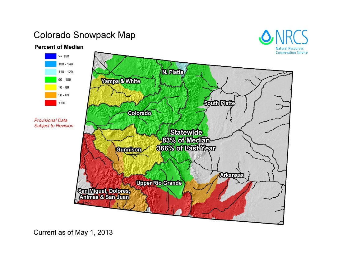
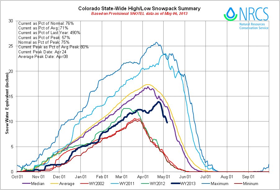
Statewide snowpack climbed to 83 percent of median as of May 1, up from 74 percent of median measured April 1. U.S. Department of Agriculture Natural Resources Conservation Service officials announced Monday that snowpack totals in the Arkansas River Basin increased to 82 percent of median, up from 74 percent April 1. The increase comes after an unseasonably cool and wet April, which allowed snowpack to increase to near normal accumulation totals. “Those wet storms really improved our water supplies, especially along the Front Range and Upper Colorado River Basin,” said Phyllis Ann Phillips, state conservationist with the NRCS.
Snowpack typically begins to melt, and the runoff season begins in April. Snowpack totals were not reached until April 24, 2 weeks later than the long-term average date of peak accumulation.
Statewide maximum accumulation totals for 2013 ended up being 80 percent of the normal seasonal maximum.
Storm systems that moved through the state in April focused on northern Colorado, completely missing the southwest portion of the state. In the north, snowpack totals in the South Platte River Basin increased from 71 percent of median on April 1 to 99 percent of median on May 1. Both the Colorado River Basin and the combined Yampa, White and North Platte basins were reported at 98 percent of median on May 1, up from 78 and 79 percent of median measured on April 1.
In contrast, further south the Rio Grande and combined San Miguel, Animas, Dolores and San Juan basins saw declines in their snowpack percentages over the past month. As of May 1 the Rio Grande reported snowpack totals at 41 percent of median and the southwest basins were at 43 percent of median; both basins reached their seasonal peak snowpack in early March and began melting out in April.
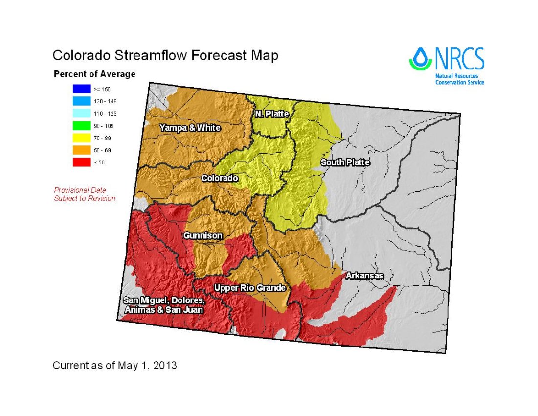
With the additional snowfall in April, the water supply outlook has improved for most of the state’s seven major river basins. All basins, except for those in the southwest portion of the state, saw improvements to their streamflow forecasts this month.
While most forecasts across the state still call for below-normal runoff volumes this season, some of the forecasts for the headwaters of the Colorado and South Platte basins are now near to slightly above average.
Statewide reservoir storage volumes are currently 74 percent of average and 68 percent of 2012’s volumes.
In the northern basins the recent snow accumulation has yet to run off and should help improve storage and extend water supplies further into the summer season.
In the southern basins, storage levels remain low, and the probability of vast improvement this season is slim.
S. 306 (small hydro) passes out of the Senate Energy and Natural Resources Committee

From The Grand Junction Daily Sentinel (Gary Harmon):
A measure that would allow for quicker construction of hydropower projects on canals, pipes and other U.S. Bureau of Reclamation conduits on Wednesday passed its first test in the Senate.
U.S. Sen. Mark Udall, D-Colo., who plans to sign on as a cosponsor of the measure, S. 306, voted for it in the Senate Energy and Natural Resources Committee, which approved the bill. The next step for the measure is a vote on the Senate floor.
The measure by U.S. Rep. Scott Tipton, R-Colo., already passed the House, 265-154, last month and Udall supported it Wednesday as S. 306 passed the Senate Energy and Natural Resources Committee.
The measure would eliminate unnecessary and duplicative administrative and regulatory costs, Udall said in a statement, noting that “hydro-electric power has an important role to play in helping the United States achieve true energy self-reliance.”
The measure is sponsored in the Senate by Sen. John Barasso, R-Wyo.
Once the measure becomes law, the water flowing through small Bureau of Reclamation-operated conduits could generate enough electricity to power 1 million homes, Tipton said in a statement.
Udall is a cosponsor of a separate measure sponsored by U.S. Rep Diana DeGette, D-Colo., that would ease construction of small hydropower projects on conduits operated under the auspices of the Federal Energy Regulatory Commission.
Colorado River Basin: Annual ‘State of the Rivers — Mesa County’ meeting May 13 #ColoradoRiver

From email from the Water Center at Colorado Mesa University:
State of the Rivers Meeting
The Water Center at CMU is pleased co-sponsor the annual “State of the Rivers – Mesa County” meeting with the Colorado River District on Monday, May 13 from 5:30 – 7:30pm in the Colorado Mesa University Ballroom.
This meeting will address our current & projected water supply situation, water banking to deal with shortages, and salinity control programs. Light refreshments will be provided.
Fountain Creek: Snow instead of rain helps with flash flooding potential at the Waldo Canyon burn scar
From the The Colorado Springs Gazette (Andrea Sinclair):
Heavy snowfall Thursday morning caused school delays, a power outage and a tough commute for Woodland Park residents, but weather analysts said it was a blessing in disguise. National Weather Service forecaster Patrick Cioffi said parts of Teller County county saw a foot of snow. If that had been rain, Cioffi said, flash flooding would have been a dangerous certainty. At 6 p.m., forecasters downgraded a flood watch in place for the Waldo Canyon burn scar to a flood advisory, a move that indicated the worst conditions had passed, for now.
The May 1 Colorado Basin Outlook Report is hot off the press, things are looking up north #COdrought
Click on the thumbnail graphic for the May 1 statewide snowpack map by sub-basin along with the May 1 streamflow forecast by basin from the Natural Resources Conservation Service. Click here to read the report. Here’s the introduction:
Summary
After three consecutive months of below average snow accumulation in Colorado, multiple storm systems in April finally brought the moisture we had been hoping for all season. The state received above average precipitation during April which primarily occurred as snow, and brought snowpack totals to near normal levels in the northern basins. Unfortunately the southern portion of the state did not benefit from these storm systems. Warm and dry conditions dominated the Upper Rio Grande basin, the combined San Juan, Dolores, Animas, & San Miguel basins and the southern tributaries of the Gunnison basins during April. Reservoir storage remains below average across most of the state but conditions should improve in the northern basins as the recent snow begins to runoff. The most recent streamflow forecasts mimic the snow and precipitation conditions across the state; big improvements in the northern basins and further decline in the southern basins. Overall though the water supply outlook this month is better than just a month ago, this just goes to show how big of a difference just a few snowy weeks can make.
Snowpack
The wet weather pattern that started in late March continued into May and brought impressive improvements to snowpack percentages. After four consecutive months of snowpack reports that hovered in the low 70 percent range, the state snowpack recorded a significant gain this past month. Snowpack measurements recorded by automated SNOTEL sites and manual snow surveys across the state showed an increase of 9 percentage points from last month’s report. As of May 1 the snowpack was at 83 percent of median. This was a very unusual April, in most years the snow accumulation season ends in early April, and the rest of the month is normally characterized as the beginning of runoff season. The watersheds in the northern part of the state saw the largest benefit from the snowy April, posting increases that ranged from 28 percentage points (in the South Platte basin) to 15 percentage points (in the Yampa and White basins). Unfortunately, basins to the south saw similar changes in their snowpack percentages, but in the opposite direction. The Upper Rio Grande and the combined San Juan, Dolores, Animas, and San Miguel basins saw decreases of 28 to 30 percentage points respectively.
Precipitation
Statewide precipitation, measured by the SNOTEL network, was 114 percent of average this April and 197 percent of last year’s April totals. April was only the second month to record above average statewide precipitation this water year, with the previous month being back in December. The relatively wet month increased the water year to date totals to 80 percent of average on May 1, and 103 percent of last year’s cumulative precipitation on the same date. Precipitation was quite variable throughout the state in April, it was really a story of the haves and the have not’s. The combined Yampa, White and North Platte basins recorded precipitation at146 percent of average for the month, the Colorado basin was at 140 percent of average and the South Platte was at 143 of average. The Gunnison basin ended up at 101 percent of average for the month as a result of half the basin receiving decent precipitation and the other half missing out on the storms. The lowest percent of average for the month was reported in the combined San Juan, Animas, Dolores and San Miguel basins with 48 percent of average.
Reservoir Storage
The cool, wet weather we experienced in April delayed the expected increase in reservoir storage volumes this month. Reservoir storage across the state is at 74 percent of average as of May 1, and 68 percent of last year’s May1 storage amounts. The late season snowfall provides an optimistic outlook for storage improvements in the northern basins this spring. The additional runoff in these basins should extend water supplies further into the summer season. In the southern basins, storage levels remain well below average and the probability of vast improvements this season are slim. All in all we are still feeling the effects of the previous bleak winter but some basins should be able to replenish their reservoirs this season.
Streamflow
Most major basins in Colorado saw improvements to their streamflow forecasts this month. The northern basins once again boasted the greatest changes compared to last month; on average April to July forecasts in the combined Yampa, White and North Platte basins, the Colorado basin and the South Platte basin increased by 20 percentage points from those issued last month. A few of the headwater streams in the Colorado and South Platte basins are now expected to see near average flows. Despite these improvements, the majority of the forecasts in these basins still call for below average runoff this spring and summer season. On the flip side, current forecasts for the combined San Miguel, Dolores, Animas, and San Juan basins and the Upper Rio Grande basin call for streamflow volumes in the 30 to 50 percent of average range.
Special Note on Interpreting Forecasts
According to the National Water and Climate Center (NWCC), “a water supply forecast is a prediction of streamflow volume that will flow past a point on a stream during a specified season, typically in the spring and summer. These forecasts are given not as a single number, but as a range of numbers to reflect risk and forecast uncertainty. Each month, five forecasts are issued for each forecast point and each forecast period. Unless otherwise specified, all forecasts are for streamflow volumes that would occur naturally without any upstream influences.”
The forecasts we typically emphasize in this report are the 50 percent exceedance probability forecasts because they are in the middle of the range of forecasts with 50 percent chance that actual volumes will be above or below the predicted volume. The 50 percent exceedance forecasts assume that typical weather patterns will prevail into the forecast season. In a water year such as this one, when conditions have been anything but typical, it is important to pay attention to the other forecasts provided. If cool, wet conditions prevail into the rest of this spring and summer it may be prudent to use the 50 or 30 percent exceedance forecasts for management purposes this season. If conditions get very hot and dry this spring, actual streamflow volumes may be more in line with the 50 or 70 percent exceedance forecasts.
Snowpack/drought news: Northern Water may kick up the C-BT quota Friday #COdrought
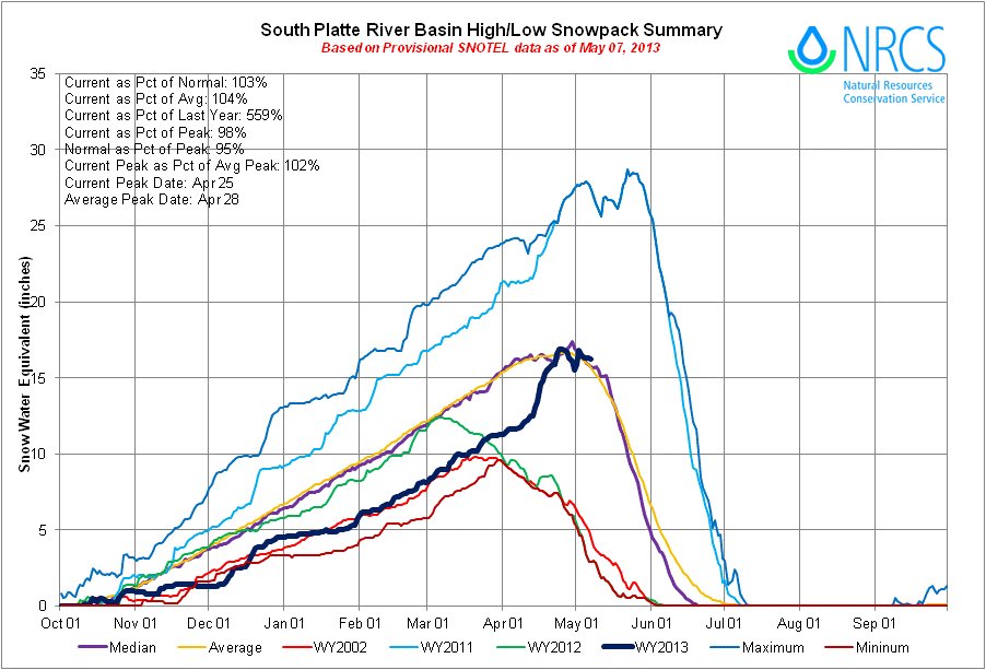
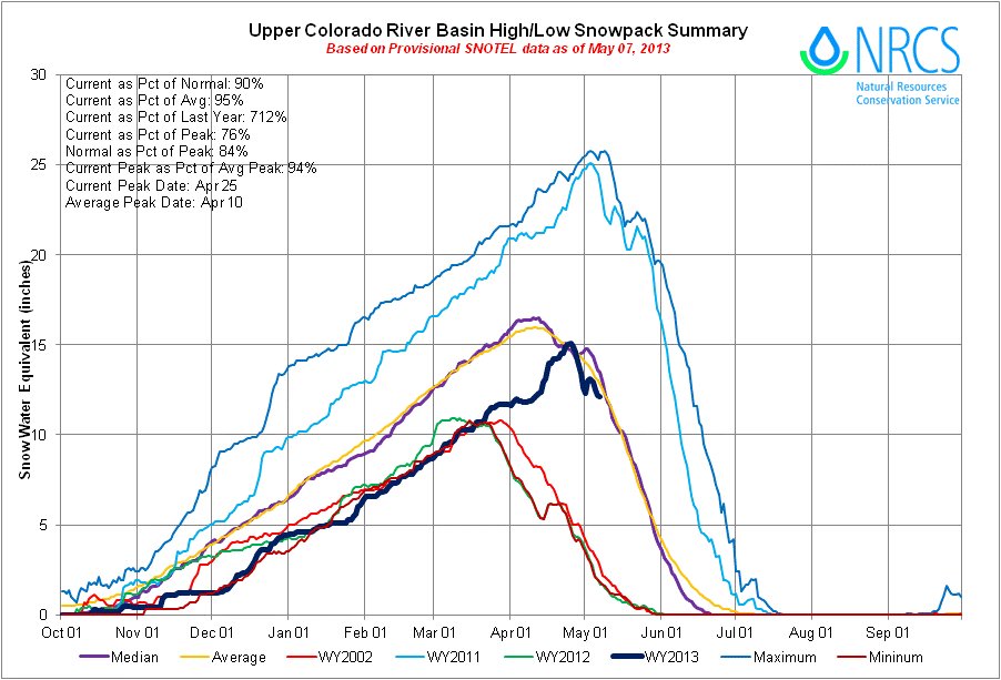

Click on the thumbnail graphics for the current statewide snowpack map along with the basin high/low graphs for the Upper Colorado River Basin and the South Platte River Basin.
From The Greeley Tribune (Eric Brown):
The two river basins that provide water to the northern Front Range saw the biggest snowpack upswings in the state during April, according to a report released this week by the Natural Resources Conservation Service. The Northern Colorado Water Conservancy District’s board of directors will take those improvements into account when it convenes for a meeting Friday, when board members will discuss increasing the water quota for the Colorado-Big Thompson Project — the largest water-supply project in northern Colorado.
According to the NRCS report, snowpack in the South Platte River basin stood at 99 percent of historic average on May 1, after sitting at just 69 percent of average on April 1. Snowpack in the Colorado River basin was 98 percent of average on May 1 — up from 74 percent of average on April 1.
Because snowpack numbers were low prior to April’s barrage of snow storms, Northern Water board members set a lower-than-average water quota of 60 percent at its meeting last month.
If the board were to increase the C-BT water quota by 10 percent, for example, that would make available an additional 31,000 acre-feet of water — or about 10 billion gallons — to northern Colorado cities, industries, farmers and ranchers. But Northern Water spokesman Brian Werner said this week there’s no guarantee that will happen.
“It’s still probably about 50/50,” Werner said. “We’ve seen some big improvements in snowpack, but we still have some big holes to fill.” Those “big holes” are the C-BT Project’s reservoirs, which were depleted throughout 2012, as water users heavily relied on water in storage to get through an extreme drought.
The reservoir levels listed in the NRCS’s recent report were a mixed bag for water users in northern Colorado. The South Platte River basin’s collective reservoir levels were at 87 percent of average on May 1, but the Colorado River basin’s reservoir levels were at just 67 percent of average. While the Colorado River flows in the opposite direction of the northern Front Range, some the C-BT Project’s 12 reservoirs are located in that river basin, with that water tunneled from the West Slope to East Slope users.
Since the C-BT project went into use in 1957, the Northern Water board has set a quota to balance how much water could be used through the upcoming growing season and how much water needed to stay in storage for future years. The historic average for the C-BT quota has been just above 70 percent, according to Werner.
Before setting its quota in April, the Northern Board listened to input from its water users. That meeting drew about 250 people — a record-high attendance for Northern Water’s April meeting, Werner said. At the meeting, officials from cities generally pushed for a quota of about 50-60 percent, wanting to keep it relatively low and save as much water as possible for the future. However, many farmers in attendance — those who are planting crops and need to know soon how much water they’ll have for the growing season — asked for a quota of about 70 percent.
Many area farmers are hopeful that April’s abundance of snow will convince the Northern Water board to increase the C-BT quota on Friday. Not only would releasing more water increase direct flows to the region’s rivers and irrigation ditches, it might convince cities to lease more water to agricultural users, some farmers and ranchers said. “It would make a substantial difference,” Randy Knutson, who farms in the Greeley area, said of an increase in the C-BT water quota. “Every little bit will help.”
Arkansas Basin Roundtable recap: State water plan development front and center at Wednesday’s meeting

From The Pueblo Chieftain (Chris Woodka):
Colorado is moving quickly to develop a state water plan by late 2015, culminating more than a decade of work. “I think it’s exciting for Colorado, when you look at all the work that’s been done,” said Alan Hamel, who represents the Arkansas River basin on the Colorado Water Conservation Board. He made his comments during a report to the Arkansas Basin Roundtable Wednesday.
The CWCB is going through changes, with executive director Jennifer Gimbel leaving in June and an ongoing search for a new chief.
Gov. John Hickenlooper has asked the CWCB and the Interbasin Compact Committee to speed up efforts to develop a plan for future water supply that meets the need for more urban growth while preserving water for the environment and agriculture.
“During my reign of terror as state engineer, at least one legislator every year would stand up and say, ‘We have to have a state water plan,’ ” said Jeris Danielson, who represents the basin on the IBCC. “We might actually get something done.”
Both Danielson and Hamel cautioned the roundtable that the state’s prior appropriation system, administered through water courts, needs to be preserved. But it can be tweaked to allow certain types of flexibility to share water for more than one purpose.
One example of that is House Bill 1248, which breezed through both legislative houses this year after it was altered to have a statewide focus. The bill allows rotational fallowing demonstration projects that would allow farmers to lease water to cities with the oversight of the CWCB. Originally, the bill just included the Arkansas River basin, which has received several CWCB grants designed to gauge the impact of water transfers related to the Arkansas Valley Super Ditch.
“We are ahead of the other roundtables in terms of planning,” Hamel said.
2013 Colorado legislation: HB13-1130 (Reapprove Interruptible Water Supply Agreements) is on its way to Governor Hickenlooper #COleg

From The Pueblo Chieftain (Chris Woodka):
Aurora prevailed in the final days of the state Legislature after a conference committee largely unraveled a Senate committee’s changes to a water transfer bill. A bill that would give the state engineer up to 30 years authority over water transfers was approved by the House Wednesday on the last day of the Colorado legislative session. The Senate approved the bill Tuesday. It now goes to Gov. John Hickenlooper for his signature.
“In general, it’s not too far from where we started,” said Gerry Knapp, who oversees Arkansas Valley and Colorado River operations for Aurora. House Bill 1130, backed by Aurora, was heavily amended in the Senate agriculture committee in April, but most of those changes were undone in conference committee Monday.
The bill makes changes in the interruptible water supply law, which allows cities to lease water from farms for three years in any 10-year period. The amended version of the bill allows two renewals by the state engineer, with certain conditions, although it expands the water court appeal period for renewals to four months.
More 2013 Colorado legislation coverage here.
CWCB: Next Water Availability Task Force Meeting May 16

From email from the Colorado Water Conservation Board (Ben Wade):
The next Water Availability Task Force meeting is scheduled for Thursday, May 16 from 9:30-11:30am & will be held at the Colorado Parks & Wildlife Headquarters, 6060 Broadway, Denver in the Bighorn Room.
The agenda has been posted at the CWCB website.
More CWCB coverage here.
Weekly Climate, Water and Drought Assessment of the Upper Colorado River Region #ColoradoRiver
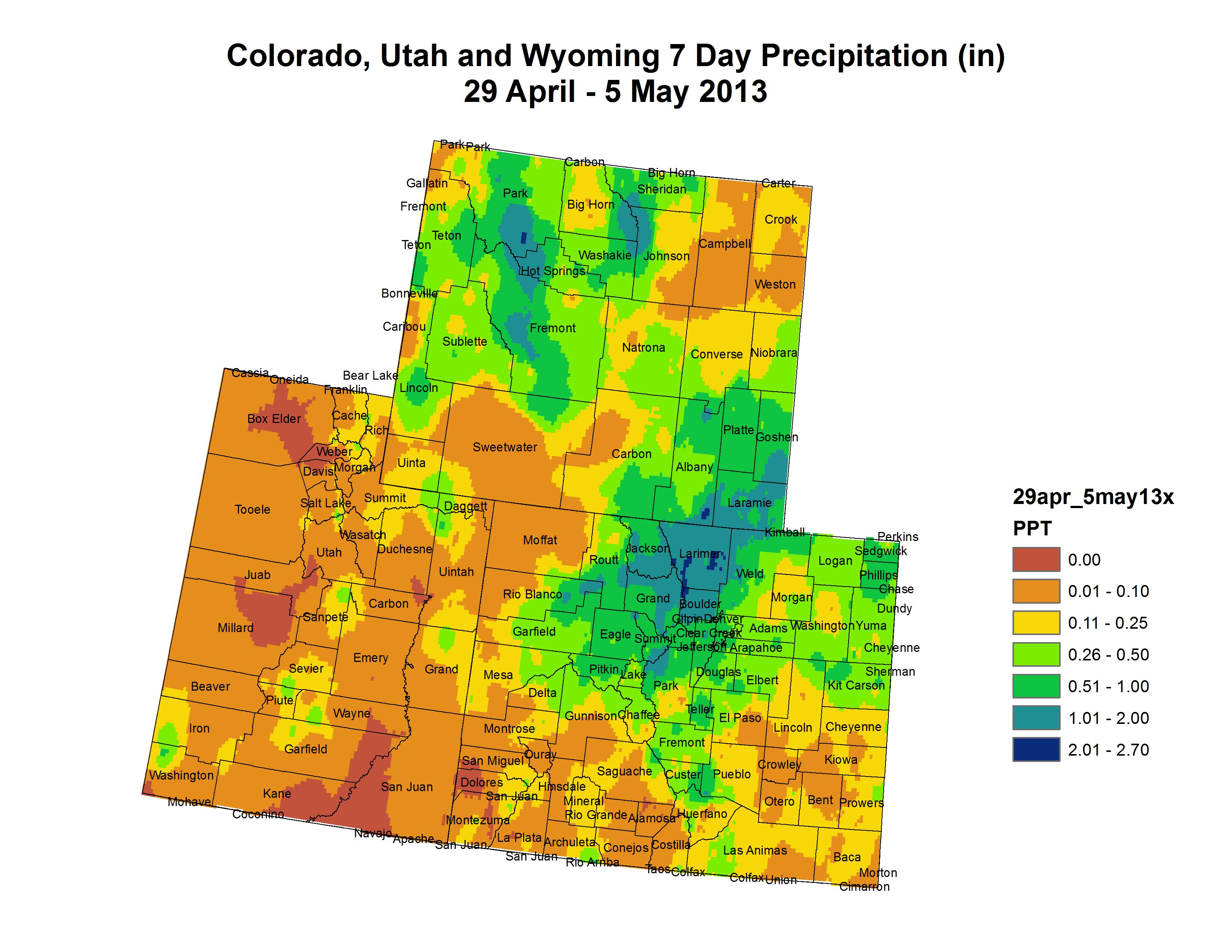
Click on the thumbnail graphic for the April 29 through May 5 precipitation summary map for the Upper Colorado River Regions. Click here for all the summaries.
Greeley’s Water Conservation Newsletter for May is hot off the press #COdrought
Check out Greeley’s May #WaterConservation e-newsletter: app.streamsend.com/s/1/pBJK/FKMF1… #WaterWednesday
— Greeley Water Dept. (@greeleywater) May 8, 2013
Drought/snowpack news: April snowfall softens drought in northern Colorado #COdrought
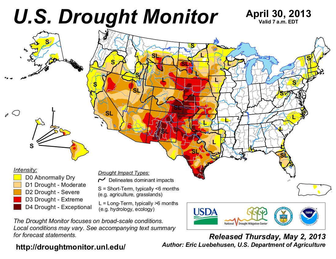
Click on the thumbnail graphics for the current US Drought Monitor and the current 3-month drought outlook from the Climate Prediction Center.
From the Fort Collins Coloradoan (Bobby Magill):
Northern Colorado’s drought appears to be headed into remission following dousing after dousing of heavy snow and rain since the middle of April.
At least that’s the case for a doughnut hole in the region’s drought — an area roughly surrounding Fort Collins, Greeley and Longmont.
Drought conditions in most of Larimer, Boulder and western Weld counties and southern Laramie County, Wyo., are being downgraded from “moderate” drought conditions to merely abnormally dry.
Wednesday’s Colorado Climate Center drought report shows that above-average precipitation in April and an additional 1 to 2 inches of moisture during the first week of May in Northern Colorado has turned the region soggy enough to pause drought for now…
Colorado outside of Larimer, Boulder and Weld counties remains under moderate to extreme drought conditions, particularly southern Colorado were conditions are worsening…
Snowpack in Northern Colorado’s mountains is above-normal for this time of year, with the snow in the South Platte River Basin, which includes the Poudre River, at 105 percent of normal. The Colorado River Basin is 104 percent of normal.
Southern Colorado’s quickly-melting snowpack is hurting badly, however. The Rio Grande Basin’s snow is only 31 percent of normal, and the San Juan River Basin is 40 percent of normal.
A look at the management of water in the San Luis Valley

From the Valley Courier (Virginia Simmons):
In the 1860s the legislative branch of the Territory of Colorado had already made provisions about water use in the relatively small ditches by appropriation. The first ones created in the early 1850s were soon followed in the 1860s and 1870s by ditches that diverted water from the main stem of the Rio Grande River itself. In 1876 the constitution of the State of Colorado established appropriation of water rights in the order of priority, the doctrine of prior appropriation, and by the 1880s Colorado was making considerable headway in organizing the state government. The filing of ditch rights began in 1881.
In 1881, the Judicial Branch of the State of Colorado was granted final authority over priority, amount, location, and use of water rights. The judicial branch of Colorado’s government still has the authority over water matters relating to water, from district courts up to the Colorado Supreme Court.
Much later, in 1969, seven judicial districts would be established, overlapping with the seven major river basins of Colorado. The Colorado Twelfth Judicial District is in the Third Water District, the same geographical area as the San Luis Valley. Besides being a water court, the district court deals with many other types of cases, of course, so district judges get assistance of water referees, attorneys who examine cases related to water and make recommendation to the district judge. In Colorado Judicial District 3, District Judge Pattie M. Swift is the water judge.
Since 1881 also, the state has had an Office of the Water Engineer, our Colorado water pooh bah. Beginning as a one-man office, it was responsible for such activities as records of surface and ground water rights, decrees, stream flow and water use, and dam safety. The state engineer also serves as Colorado’s commissioner on the Rio Grande Compact Commission. The Division of Water Resources (DWR) is currently headed by Director Dick Wolfe.
Division 3 of the Division of Water Resources (DWR) was established in 1969, whereby the state designated seven divisions, one for each of Colorado’s major water basins. Division 3 occupies the San Luis Valley, the drainage of the Rio Grande River in Colorado and the same geographical area that is served by the judicial District Court, District 3.
In the DWR’s Division 3, Rio Grande Basin Division, the division engineer is Craig Cotten, with his office at 301 Mullins, Alamosa. He oversees monitoring stream flow, water use, well permits, ditch repair, and dam repair, and files reports with the Denver office. Local water commissioners’ offices are located at present at Monte Vista (District 20), Antonito (22), and Saguache (25, 26, 27). Water commissioners measure stream flows at gaging stations, coordinate calls for users with senior and junior rights, and send reports to the division engineer. Ditch riders are hired by ditch companies to maintain ditches and headgates, open headgates, and other on-the-ground jobs, some of which may get touchy.
Municipalities must comply with DWR regulations, water quality policies of the Colorado Water Quality Commission, the Colorado Department of Health and Environment, the Colorado Water and Wastewater Facility Operators Board Certification, and the local code of ordinances, and federal laws. In a large town such as the City of Alamosa, the contact is the Director of Public Works, whereas smaller towns may have a water and sewer department. Residents of rural areas and small villages use domestic wells.
Not until 1957 and 1965 was legislation passed regarding wells, ground water, and augmentation. Permits for ground water wells were then required and are administered by DWR. Statutes also were passed that included tributary water in wells that were affecting surface water rights. Since 1972, DWR has administered domestic well permits on property of less than 35 acres. Restrictions on permits may differ from one county to another, but they still must comply with DWR’s state regulations.
Over all, then, administration of the Colorado Division of Water Resources (DWR) for the entire, diverse state is a large responsibility. And this is just one division within the present Colorado Department of Natural Resources (CDNR), where some other divisions are also related to water. Mike King is director of CDNR.
Snowpack news: ‘Mother Nature has been nothing but miserly to the Rio Grande basin’ — Matt Hildner #COdrought
Click on the thumbnail graphics for the current statewide snowpack map along with the basin high/low graphs for the Upper Rio Grande and the San Miguel,Dolores, Animas and San Juan basins.
From The Pueblo Chieftain (Matt Hildner):
While the northern part of the state and parts of the Arkansas River basin were given reprieves by a string of April snowstorms, Mother Nature has been nothing but miserly to the Rio Grande basin. The snowpack report from the Natural Resources Conservation Service lists the basin’s snowpack at 40 percent of its normal peak at the end of April. “It’s not a good year at all,” Division Engineer Craig Cotten said Tuesday.
The federal agency also is forecasting a flow of only 225,000 acre-feet on the Rio Grande River from April to September. Should those forecasts hold, Cotten said this year would mark the fourth lowest flows on record for the Rio Grande since the state began recording them in 1889.
Forecasts are just as bad on the Conejos River in the southwestern corner of the San Luis Valley, where only 113,000 acre-feet are predicted through September.
The dreary numbers are mitigated slightly by the fact that this year’s runoff did not come as early as last year, giving irrigators a better chance to take advantage of them, Cotten said.
The dry forecast also means the state will not have to send much water downstream to satisfy the Rio Grande Compact, which governs how Colorado, New Mexico and Texas share the river. Cotten’s office projects that only 4 percent of the flows on the Rio Grande will need to be sent downstream, and the Conejos, which also has obligations under the compact, will have no delivery requirement.
Craig Cotten division engineer Dry weather is likely to remain, according to the National Weather Service’s Climate Prediction Center, which predicts a likelihood of below-normal precipitation from May through July in South-Central Colorado. The rest of May may hold a brief respite as the center is predicting a likelihood of above-normal precipitation.
2013 Colorado legislation: House Joint Resolution 1026 (Protect Agricultural Water Supplies) passes the state House #COleg
From The Pueblo Chieftain (Chris Woodka):
The state House Tuesday passed a bipartisan resolution to protect Colorado’s water supply and recognize the benefits irrigated agriculture provides to Colorado. “We want to make sure we protect water, it’s a precious resource,” said Rep. Lori Saine, R-Dacono. “Water is the lifeblood of our state. I’m glad to see bipartisan support for this resolution.”
House Joint Resolution 1026 calls on the Legislature to work with Gov. John Hickenlooper and Colorado’s water community to continue addressing Colorado’s predicted water supply-demand imbalance. HJR1026 recognizes the importance of Colorado’s irrigated agriculture and encourages investment in outreach and education to increase Coloradans’ awareness of how beneficial irrigated agriculture is to Colorado.
The Colorado Water Conservation Board and Interbasin Compact Committee have been working on meeting future demand for more than a decade. Hickenlooper wants to have a state water plan in place by 2016. “Agriculture contributes about $40 billion to our state’s economy,” Saine said. “We have to make sure that water rights are protected.”
More than 85 percent of Colorado’s water use is for agriculture, but a growing amount is required for city and industrial uses.
“Our water demands will only increase going forward,” Saine added.
More 2013 Colorado legislation coverage here.
Snowpack/drought news: Statewide snowpack declines to 71% of avg, South Platte = 102% (best in state) #COdrought

Click on the thumbnail graphics for the current statewide snowpack map and the statewide basin high/low graph from the Natural Resources Conservation Service.
Here’s a look at expected runoff in the North Platte Basin from the Bureau of Reclamation:
The Bureau of Reclamation’s Wyoming Area Office has prepared snowmelt runoff forecasts for the North Platte River Basin. According to Wyoming Area Manager Coleman Smith, the May 1 forecast indicates below average spring snowmelt runoff for the North Platte Basin.
April through July runoff in the North Platte Basin above Glendo Dam is expected to be 518,000 acre feet (AF) or 55 percent of the 30-year average of 944,600 AF. Approximately 450,000 AF (60 percent of average) of runoff is expected to enter Seminoe Reservoir (of which 50,000 AF was received in April) with an additional 18,000 AF (30 percent of average) being provided to Pathfinder Reservoir from the Sweetwater River (of which 6,500 AF was received April), and the balance of 50,000 AF (37 percent of average) coming from the basin between Pathfinder Reservoir and Glendo Reservoir (of which 14,900 AF was received in April).
The water in storage for delivery to North Platte Contractors as of April 30, 2013 is 349,400 AF or 45 percent of average.
Smith said, “Reclamation is advising North Platte Project water users that an allocation is expected. With reservoir storage well below average and below average inflow forecasted for April through July, water users will need to take measures to conserve the available water supply.”
With the current forecast, river flows throughout the system are expected to be much less than average.
From the Leadville Herald Democrat (Carol Werckman):
A record accumulation of snowfall in one hour was measured by the Herald’s weather guru. Charles Kuster, during the storm early Sunday morning – 3.6 inches between 12:07 and 1:07 a.m. Before that storm, the greatest accumulation of snowfall he had measured during his 30 years or so in Lake County was recorded during a very late storm on June 8, 1984, when he measured 3.1 inches in one hour during a storm that dropped 11.6 heavy, wet inches.
From The Greeley Tribune (Whitney Phillips):
Wednesday’s barrage of heavy, wet snow — an unwelcome sight to some residents who spent the weekend basking in temperatures upward of 70 degrees — was not as uncommon as some might think.
Kari Bowen a meteorologist with the National Weather Service in Boulder, said data dating back to the 1800s shows that systems like the one that dumped about 3 to 5 inches in the Greeley area isn’t an anomaly. “Every few years we do tend to get these late, spring snowstorms,” she said.
Todd Dankers, another meteorologist with the weather service, said there’s about a 38 percent chance of snowfall in May, and most storms produce several inches. “This is kind of on the heavy side for May storms but not uncommon,” Dankers said.
Dankers said snowfall readings were higher in the Fort Collins and Boulder areas, with the more western parts of the Front Range receiving anywhere from 6 inches to a foot of snow.
From the Summit County Citizens Voice (Bob Berwyn):
Spring storms that repeatedly targeted the north-central mountains of Colorado in April help bring the snowpack to near normal in a few river basins. The May 1 snow survey showed the statewide snowpack climbing up to 83 percent of average for the date, the highest level of the year…
The storm systems that moved through in April were mainly focused on northern Colorado while completely missing the southwest portion of the state. Snowpack totals in the South Platte River basin increased from 71 percent of median on April 1 to 99 percent of median on May 1. Both the Colorado River basin and the combined Yampa, White and North Platte basins were reported to be at 98 percent of median on May 1 up from 78 and 79 percent of median measured on April 1. The Colorado and South Platte basins are crucial for Denver Water supplies and reservoir storage.
From KUNC (Erin O’Toole):
Last year at this time, Northern Colorado’s snowpack was only at 23 percent of average. Poudre River commissioner Mark Simpson says this year is a different story.
“We measured snow right at the end of April,” Simpson says. “We came up with a 94 percent average for the basin of the Poudre – and that was right before this last storm hit. So I think we’re pretty close to average, which is phenomenal compared to last year.”
With water levels so bad in 2012 rafting outfitters had a bad season. One Poudre Canyon operator, Mountain Whitewater Descents, cited a 60 percent drop in business.
Atmospheric carbon dioxide to pass 400 PPM sometime this month for the first time in 400 million years

From Ecology.com (Bob Petz):
Chances are that in the next few days, the concentration of carbon dioxide in Earth’s atmosphere will exceed 400 parts per million (ppm) for the first time in about 4 million years.
Recently, Mauna Loa Observatory on the big island of Hawaii has been regularly recording daily CO2 levels above 399 ppm, with several hours already exceeding 400.
Considering that carbon levels tend to peak in mid-May, one or more daily averages above 400 in the next few weeks is a near certainty. Yesterday’s reading, May 5, was 399.54 ppm.
While crossing the 400 ppm threshold is largely symbolic, the rate at which atmospheric carbon is increasing is anything but. When Mauna Loa began measuring CO2 in 1958, CO2 was running @ 317 ppm. Unless we begin to seriously slow the rate of greenhouse gas emissions now, we’re on track to surpass 450 ppm within 30 years.
Mauna Loa Observatory, operated by the US National Oceanic and Atmospheric Administration, not only has the longest continuous history of monitoring CO2 concentrations, but thanks in part to its location, its measurements are regarded as the baseline standard for atmospheric carbon.
At 11, 335 feet (3,397 m) above sea level, Mauna Loa’s sits above low-level, local pollution and temperature inversion layers. Its location in the mid-Pacific also isolates it from major sources of pollution.
The COGCC fines Antero $150,000 for produced-water pipeline leak near Rifle
From The Grand Junction Daily Sentinel (Dennis Webb):
The Colorado Oil and Gas Conservation Commission approved a $150,000 fine Monday against Antero Resources in connection with a leak from a produced-water pipeline that resulted in oily contamination of groundwater and soil near Rifle. The fine was part of a consent agreement reached with Antero. The commission says Antero violated rules on pollution and management of waste in the incident, discovered in July 2010.
The leak from a faulty weld in a plastic pipe resulted in seeps of a paraffin-like substance in a nearby gravel pit owned by Grant Brothers Construction, and caused high levels of benzene, a carcinogen, in the groundwater. The oil-laden water came from 36 wells on five well pads in the Colorado River floodplain, the commission said.
Before the commission acted Monday, Commissioner Richard Alward of Grand Junction expressed concern about how much time has lapsed since the leak’s discovery. “It’s now 2013, and we’re now finally resolving things,” he said.
Commission staff said the delay was because Antero tried several approaches to cleaning it up, finally settling on full excavation, which was completed last September. The state then allowed for another half-year of environmental monitoring.
Denver-based Antero no longer operates in Colorado, having sold its assets in the Piceance Basin to Ursa Resources in order to focus on drilling in the eastern U.S.
Arkansas Valley Conduit update: Federal budget slashes funding to $1 million

From The Pueblo Chieftain (Chris Woodka):
U.S. Sen. Michael Bennet, D-Colo., is asking the Senate energy appropriations subcommittee to provide additional funding for the Arkansas Valley Conduit. The conduit’s funding stream hit a snag in the 2014 budget request by President Barack Obama, which allocates $1 million. The Southeastern Colorado Water Conservancy District had asked the Bureau of Reclamation for $15 million to keep the project moving forward.
At April’s meeting, the Southeastern board learned that Reclamation projects across the board had been slashed, including some already under construction. “I don’t know what will happen,” said Southeastern Executive Director Jim Broderick. “We are going to Washington in a couple of weeks to try to learn more.”
In a letter to committee chairman Sen. Dianne Feinstein, D-Calif., and Sen. Lamar Alexander, R-Tenn., Bennet pointed out other long-term projects in California and Idaho that had received additional funding. “As the subcommittee prepares for the coming fiscal year, we must ensure that states and local communities have the resources to continue work on large-scale, multiyear projects,” Bennet said.
The conduit’s environmental impact statement is being prepared by Reclamation, and the conduit already has a built-in repayment mechanism through 2009 legislation that devotes Fryingpan-Arkansas contract revenue to conduit costs.
The cost of the project is estimated at $500 million. It would deliver fresh drinking water from Pueblo Dam to 40 communities as far east as Lamar. Many of those communities could face even higher treatment costs if the conduit is not completed.
Restoration: The Eagle River Watershed Council is planting willows along Red Dirt Creek May 17-18

From email from the Eagle River Watershed Council:
We are beginning a second project along the East Fork of Red Dirt Creek, a tributary of the Colorado River. The Watershed Council, along with a team of volunteers and help from the US Forest Service and Trout Unlimited, will plant willows and remove a dirt road that is adding sediment to the creek and harming the local cutthroat trout population.
Friday, May 17th and Saturday, May 18th we will be planting willows along the East Fork of Red Dirt Creek and we are looking for 10-15 volunteers. Call us at 970-827-5406 or email outreach@erwc.org to sign up for one or both days!
Colorado’s water supply benefits from late season storms
![]()
Click on the thumbnail graphic to view the snowpack and storage table from the Natural Resources Conservation Service. Here’s the release from the NRCS (Mage Skordahl):
Unseasonably cool and wet weather throughout April allowed Colorado’s snowpack to increase to near normal accumulation totals. After an entire month of favorable storm tracks, May 1 snow surveys showed that the statewide snowpack percentage climbed to 83 percent of median from 74 percent of median measured on April 1, according to the USDA-Natural Resources Conservation Service (NRCS). “Those wet storms really improved our water supplies, especially along the Front Range and Upper Colorado River basin”, said Phyllis Ann Phillips, State Conservationist with the NRCS. April is typically the month in which the snowpack in Colorado begins to melt and the runoff season begins. This season, peak snowpack totals for the state were not reached until April 24th, over two weeks later than the long term average date of peak accumulation. Statewide maximum accumulation totals for 2013 ended up being 80 percent of the normal seasonal maximum.
The moisture laden storm systems that moved through in April were mainly focused on northern Colorado while completely missing the southwest portion of the state. Snowpack totals in the South Platte River basin increased from 71 percent of median on April 1 to 99 percent of median on May 1. Both the Colorado River basin and the combined Yampa, White and North Platte basins were reported to be at 98 percent of median on May 1 up from 78 and 79 percent of median measured on April 1. In contrast to these success stories, the Rio Grande and combined San Miguel, Animas, Dolores and San Juan basins saw major declines in their snowpack percentages this past month. As of May 1 the Rio Grande reported snowpack totals at 41 percent of median and the southwest basins were at 43 percent of median; both basins reached their seasonal peak snowpack in early March and began melting out in April.
With the additional snowfall in April, the water supply outlook has improved for most of the state’s seven major river basins. All basins, except for those in the southwest portion of the state, saw improvements to their streamflow forecasts this month. While most forecasts across the state still call for below normal runoff volumes this season, some of the forecasts for the headwaters of the Colorado and South Platte basins are now near to slightly above average.
Statewide reservoir storage volumes are currently 74 percent of average, and 68 percent of 2012’s volumes. The good news is that in the northern basins the recent snow accumulation has yet to run off and should help improve storage and extend water supplies further into the summer season. In the southern basins, storage levels remain low and the probability of vast improvements this season are slim.
Forecast news: Stormy week ahead #COdrought #COwx
#WaldoCanyon flood potential will be rising if the forecast from #ECMWF is correct. 16 day rain potential 1-3″ #cowx twitter.com/BrianBledsoe/s…
— Brian Bledsoe (@BrianBledsoe) May 6, 2013
From The Denver Post (Joey Bunch):
The National Weather Service said Sunday, “The weakly organized and slow-moving upper level storm system will take most of the upcoming week to move across Colorado.” Denver has a 30 percent chance of afternoon showers Monday, with midweek offering the best opportunity for rain in the metro region, when chances are 50 percent both Wednesday and Wednesday night. The region should see cooler-than-average highs near 60 each day, forecasters said. Rain is expected to begin in the mountains Monday afternoon and spread across the plains by the end of the week. Areas above 8,500 could get snow at times, according to the forecast.
Moisture will continue to increase across the area in the southwest flow ahead of an area of low pressure situated twitpic.com/con1bk
— NWS Grand Junction (@NWSGJT) May 6, 2013
From the National Weather Service Grand Junction office:
Moisture will continue to increase across the area in the southwest flow ahead of an area of low pressure situated off the northern California coast. A disturbance ejecting out in front of the low pressure system will generate more widespread showers and thunderstorms among both mountains and valleys today. The area of low pressure will slowly move eastward across the Great Basin tomorrow and near the Four Corners region on Wednesday. More instability and forcing coupled with some surface heating from the sun will allow storms to be greater in coverage and intensity Wednesday into Thursday. This unsettled weather will linger through Saturday, before the low finally moves out of the area. Expect showers and storms each day this week with cooler temperatures near to a few degrees below normal.
Snowpack/drought news: Late season storms boost prospects for angling in South Park #COdrought
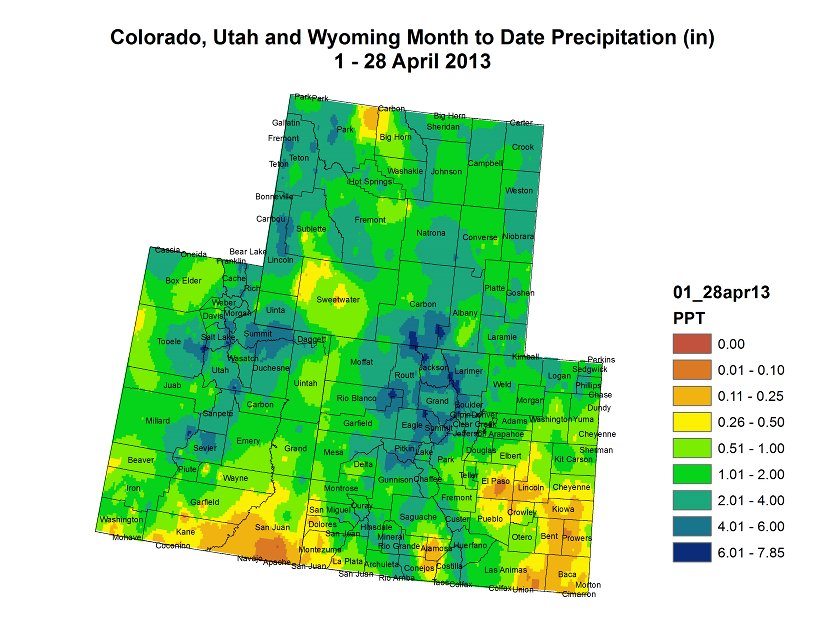
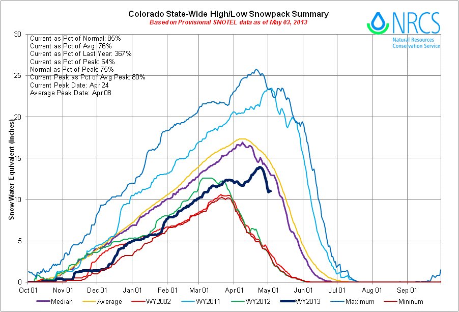

“What an April we had,” Don Ament said to me Friday evening. The former Colorado Secretary of Agriculture was smiling big when we talked about April precipitation in Colorado.
Click on the thumbnail graphics for the current statewide snowpack map and the current statewide basin high/low graph from the Natural Resources Conservation Service along with the April 1-28 precipitation map for the Upper Colorado Basin from the Colorado Climate Center. It’s apparent that the melt out has started. Percent of average snowpack is less meaningful once the snowpack starts melting out but nonetheless the April snowfall was welcome.
From The Denver Post (Scott Willoughby):
Not to say that Colorado is in the clear when it comes to drought conditions, but the bountiful snows of April have made a major impact on several drought-stricken drainages. And that makes for some sweet relief among anglers focused on Park County’s most popular fishing holes. Just more than a month after Denver Water announced it would be draining the fabled fishery of Antero Reservoir for drought mitigation beginning May 1, water managers pulled the plug on the plan and announced last week that the reservoir atop the South Platte River chain will remain open to recreational fishermen for the foreseeable future…
South Park fishermen had been facing a brutal one-two punch as the larger Spinney Mountain Reservoir near Hartsel, just downstream from Antero, also has fallen victim of drought to the point that water levels are not expected to reach boat ramps this spring. While Spinney Mountain State Park opened to shore fishermen and hand-launched boats last Monday, the outlook on ramp use for trailer launches remains grim for the time being. Even though snowpack within the South Platte River basin broached 100 percent of average late last week, park managers say it will take much more continued moisture to start filling the depleted Park County reservoir again…
The brightest star on the South Park map is nearby Eleven Mile Reservoir, which is near full water capacity and opened to boating after the ice disappeared last Tuesday. Dedicated fisherman Greg Sheldon offered evidence of Eleven Mile at its prime with a boast of three trout over 25 inches in a single day last week. The largest, Sheldon said, was estimated at 30 inches long and 12 pounds.
From the Fort Collins Coloradoan (Bobby Magill):
The snow was so good that the water levels in Larimer County’s snowpack piled up to normal last week for the first time since spring 2011. The moisture the region has received since the beginning of April will prevent many farmers from having to irrigate at the beginning of the growing season, and it’ll postpone many of the water shortage worries that preoccupied growers early this year when the notion that 2012’s devastating drought might persist in its most severe form for another year…
Everyone who’s anyone in Northern Colorado’s water community is hedging bets on what all the moisture the region has received lately really means for the growing season, the wildfire season and the lawn-watering season in Northern Colorado. Northern Water, the water district that oversees the water the city of Fort Collins receives from the Colorado River via Horsetooth Reservoir, decided Thursday to hold off on updating its April 12 decision to give its member cities only 60 percent of the Colorado River water they’re entitled to each year. The reason is simple: Even with all the snow we have right now, the reservoirs on the west side of Rocky Mountain National Park — think of them as buckets of water in a savings account — aren’t expected to fill up this spring as the snow melts. Northern Water has to make sure there’s enough water saved up in those buckets to ensure farmers, Fort Collins and other cities have enough water if severe drought returns again soon…
But the good news is that, unlike last year when the snow disappeared quickly in the March and April heat, the snowpack this year has taken its time to begin melting. The longer it remains, the longer the spring runoff period and the better the ability for reservoirs to fill naturally, Colorado State Climatologist Nolan Doesken said. “It’s just a great way to quiet the drought,” he said…
“Full recovery from a drought takes some time,” said Joe Duda, interim director of the Colorado State Forest Service. Time to moisten the soil. Time to fill the reservoirs. Time to replenish aquifers. Time to get long-dormant mountain springs flowing again. “After a longer extended drought, one year doesn’t recover you from that,” Duda said. “You need several years so you not only get surface structures fully recharged, but you get that ground moisture up where it’s appropriate and adequate.”
It has been only a few months since the weather turned cooler and wetter than 2012, and all the fruits of such meteorological avarice could evaporate with only a few weeks of hot, dry weather…
Here’s how the two years compare: March and April 2012 saw 32 days of temperatures 65 degrees or higher in the Larimer County foothills; 15 of those days were warmer than 70 degrees, Mathewson said. During March and April 2013, the same area saw only eight days that were 65 degrees or warmer, four of which were above 70.
S. Platte River Basin hits 100% of its average snowpack! ftp://ftp-fc.sc.egov.usda.gov/CO/Snow/snow/watershed/daily/co_update_snow.pdf
— United Water (@UnitedWaterCO) May 4, 2013
From the Albuquerque Journal (John Fleck):
The San Juan-Chama project, which imports water from the mountains of Colorado for use in New Mexico’s most populous cities, is likely to see shortfalls in one of every six years by the 2020s, and four out of every 10 years by the end of the century, according to researchers at Sandia National Laboratories and the U.S. Bureau of Reclamation.
The study comes as federal officials are warning that for the first time in the project’s 40-year history, the San Juan-Chama project may not deliver a full water supply in 2014. Whether the current shortage is a result of climate change or natural variability is uncertain, but this year’s shortfall could be “a harbinger of things to come,” the study’s authors wrote…
The federal project diverts water from the mountains of southern Colorado through a series of tunnels beneath the Continental Divide. It allows New Mexico’s populated central valley to use some of New Mexico’s share of the waters of the Colorado River Basin.
Total snowpack accumulations in CO #ColoradoRiver basins as of 5/3: facebook.com/media/set/?set… #CODrought
— Water Center at CMU (@WaterCenterCMU) May 3, 2013
NC basins currently 99% to 103% of their average May 3rd snowpack, and 95% to 100% of their average peak snowpack. twitter.com/NWSBoulder/sta…
— NWS Boulder (@NWSBoulder) May 3, 2013
#Drought in #SoutheastColorado is worst I’ve ever seen. Gray grass is no bueno on May 4th #cowx twitter.com/BrianBledsoe/s…
— Brian Bledsoe (@BrianBledsoe) May 5, 2013
From The Colorado Springs Gazette (Monica Mendoza):
One billion gallons of water is no drop in the bucket. That amount of water could fill 1,515 Olympic-style swimming pools. And it is the amount Colorado Springs residents saved in April compared to water use in April 2012. It’s double the amount Colorado Springs Utilities managers hoped would be saved after instituting lawn watering restrictions for the first time since 2005. No doubt Mother Nature helped launch the conservation effort. April brought some precipitation to the city, although it was below average. On average, temperatures were 43 degrees, according to the National Weather Service, compared to last April when temperatures were 59 degrees.
From the Associated Press via The Denver Post:
The drought that ravaged large sections of the Midwest and Great Plains is over, disappearing this spring in a dramatic weather reversal: heavy rains and floods swamping fields with mud in many areas. But some farmers and ranchers in parts of the West and the plains, including southwest Oklahoma, are pondering the prospect of another year of a desert-like landscape and a disappointing harvest.
Breckenridge moisture now above average for the year wp.me/pJ91e-eO5
— Bob Berwyn (@bberwyn) May 6, 2013
NASA Opens New Era in Measuring Western U.S. Snowpack
Here’s the release from the National Aeronautics and Space Administration (NASA):
A new NASA airborne mission has created the first maps of the entire snowpack of two major mountain watersheds in California and Colorado, producing the most accurate measurements to date of how much water they hold.
The data from NASA’s Airborne Snow Observatory mission will be used to estimate how much water will flow out of the basins when the snow melts. The data-gathering technology could improve water management for 1.5 billion people worldwide who rely on snowmelt for their water supply.
“The Airborne Snow Observatory is on the cutting edge of snow remote-sensing science,” said Jared Entin, a program manager in the Earth Science Division at NASA Headquarters in Washington. “Decision makers like power companies and water managers now are receiving these data, which may have immediate economic benefits.”
The mission is a collaboration between NASA’s Jet Propulsion Laboratory, Pasadena, Calif., and the California Department of Water Resources in Sacramento.
A Twin Otter aircraft carrying NASA’s Airborne Snow Observatory began a three-year demonstration mission in April that includes weekly flights over the Tuolumne River Basin in California’s Sierra Nevada and monthly flights over Colorado’s Uncompahgre River Basin. The flights will run through the end of the snowmelt season, which typically occurs in July. The Tuolumne watershed and its Hetch Hetchy Reservoir are the primary water supply for San Francisco. The Uncompahgre watershed is part of the Upper Colorado River Basin that supplies water to much of the western United States.
The mission’s principal investigator, Tom Painter of JPL, said the mission fills a critical need in an increasingly thirsty world, initially focusing on the western United States, where snowmelt provides more than 75 percent of the total freshwater supply.
“Changes in and pressure on snowmelt-dependent water systems are motivating water managers, governments and others to improve understanding of snow and its melt,” Painter said. “The western United States and other regions face significant water resource challenges because of population growth and faster melt and runoff of snowpacks caused by climate change. NASA’s Airborne Snow Observatory combines the best available technologies to provide precise, timely information for assessing snowpack volume and melt.”
The observatory’s two instruments measure two properties most critical to understanding snowmelt runoff and timing. Those two properties had been mostly unmeasured until now.
A scanning lidar system from the Canadian firm Optech Inc. of Vaughan, Ontario, measures snow depth with lasers to determine the first property, snow water equivalent. Snow water equivalent represents the amount of water in the snow on a mountain. It is used to calculate the amount of water that will run off.
An imaging spectrometer built by another Canadian concern, ITRES of Calgary, Alberta, measures the second property, snow albedo. Snow albedo represents the amount of sunlight reflected and absorbed by snow. Snow albedo controls the speed of snowmelt and timing of its runoff.
By combining these data, scientists can tell how changes in the absorption of sunlight cause snowmelt rates to increase.
The Airborne Snow Observatory flies at an altitude of 17,500 to 22,000 feet (5,334 to 6,705 meters) to produce frequent maps that scientists can use to monitor changes over time. It can calculate snow depth to within about 4 inches (10 centimeters) and snow water equivalent to within five percent. Data are processed on the ground and made available to participating water managers within 24 hours.
Before now, Sierra Nevada snow water equivalent estimates have been extrapolated from monthly manual ground snow surveys conducted from January through April. These survey sites are sparsely located, primarily in lower to middle elevations that melt free of snow each spring, while snow remains at higher elevations. Water managers use these survey data to forecast annual water supplies. The information affects decisions by local water districts, agricultural interests and others. The sparse sampling can lead to large errors. In contrast, the NASA observatory can map all the snow throughout the entire snowmelt season.
“The Airborne Snow Observatory is providing California water managers the first near-real-time, comprehensive determination of basin-wide snow water equivalent,” said Frank Gehrke, mission co-investigator and chief of the California Cooperative Snow Surveys Program for the California Department of Water Resources. “Integrated into models, these data will enhance the state’s reservoir operations, permitting more efficient flood control, water supply management and hydroelectric power generation.” Gehrke said the state will continue to conduct manual surveys while it incorporates the Airborne Snow Observatory data. “The snow surveys are relatively inexpensive, help validate observatory data and provide snow density measurements that are key to reducing errors in estimating snow water equivalent,” he said.
Painter plans to expand the airborne mapping program to the entire Upper Colorado River Basin and Sierra Nevada.
“We believe this is the future of water management in the western United States,” he said.
More coverage from The Denver Post.
The US House of Representatives is gearing up to work on the long-awaited farm bill

Here’s how US Representative Cory Gardner sees things (via email):
This week, I announced that the House will finally consider a long-term farm bill this summer. Our nation’s farmers and ranchers rely on the farm bill to set agricultural policy. It is very difficult to plan for the future and make business decisions without having a long-term bill in place. The House needs to take up this legislation without further delay, and give this community the certainty it needs to operate.
Last year, the House Agricultural Committee passed a farm bill, but the legislative session ended before it was ever voted on in the House. The bill would have saved $35 billion in mandatory spending, reformed the Commodity Title by eliminating Direct Payments, Countercyclical Payments, ACRE, and SURE and saved taxpayers $14 billion.
Fountain Creek: ‘What things are they doing to rein in the floodwaters that arrive in Pueblo County’ — Terry Hart
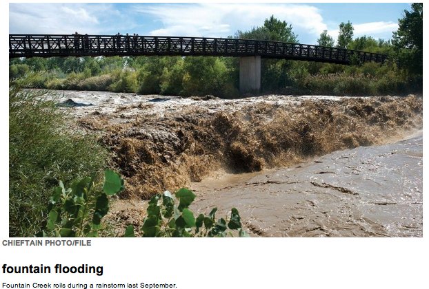
From The Pueblo Chieftain (Chris Woodka):
Less than $2 million of the $46 million in stormwater projects on Colorado Springs’ list meet the criteria set out by Pueblo County commissioners for a 1041 permit for the Southern Delivery System.
The commissioners instructed water attorney Ray Petros to review the list submitted this week to commissioners and Pueblo City Council and he determined that most projects related to either the Waldo Canyon Fire or internal Colorado Springs issues.
“As a starting point, what we’re looking for is a list of major projects that have a significant impact for Pueblo County,” said Commission Chairman Terry Hart. “What things are they doing to rein in the floodwaters that arrive in Pueblo County and to assure water quality?”
The county still wants an accounting of the scope of stormwater control that was envisioned prior to 2009. While Waldo Canyon creates a new set of problems, Colorado Springs had agreed to address past problems on Fountain Creek through the stormwater enterprise, Hart said. Commissioner Sal Pace shared those concerns, adding that Colorado Springs needs to provide evidence of long-term funding, rather than shortterm emergency funds.
“That’s one-time money. What they need to do is show how there will be a continuous supply,” Pace said.
From The Pueblo Chieftain (Chris Woodka):
In response to criticism of his city’s stormwater efforts, Colorado Springs Mayor Steve Bach visited with several Pueblo community leaders Friday to make the case that the city is working on a stormwater solution. Bach was accompanied by Colorado Springs Council President Keith King, Councilman Merv Bennett and City Attorney Chris Melcher. “What we’re working on are steps to develop a full and definite plan that we can take to voters,” Bach said. “We want to make sure that we’re taking the best approach.”
Bach stressed that the Waldo Canyon Fire, which destroyed 347 homes in Colorado Springs last summer, is the top priority. But the city also realizes its commitment to protect downstream users from disastrous floods. Bach has initiated an independent study after a regional study found nearly $700 million in stormwater needs for Colorado Springs and $900 million for El Paso County. He wants Colorado Springs, not a new regional authority, to confront the problem.
Bach acknowledged the fact that development in Colorado Springs, coupled with the burn scar from the Waldo Canyon Fire, has increased the risk of more dangerous floods on Fountain Creek.
Colorado Springs has to come up with a way to continue annual funding to address stormwater needs that had been identified before 2009, when Pueblo County issued a 1041 permit for the Southern Delivery System predicated on the idea that a stormwater enterprise was in place.
Melcher said the Colorado Springs City Council’s hands were tied by voters in November 2009 that effectively eliminated the stormwater enterprise approved by council in 2005.
Bennett said a sustainable funding source for stormwater projects is needed, and King, a former state legislator, suggested several ways that up-front funding could be leveraged.
Bach promised to share more specific information about what Colorado Springs intends to do by no later than this fall.
The WARSSS study on the Waldo Canyon burn scar made public on Thursday. #cowx ow.ly/kGuKp
— NWS Pueblo (@NWSPueblo) May 3, 2013
2013 Colorado legislation: HB13-1316 (Oil Gas Commn Uniform Groundwater Sample Rule) passes state House #COleg

From the Denver Business Journal (Cathy Proctor):
HB 1316, sponsored by Democratic Reps. Dickie Lee Hullinghorst of Gunbarrel and Joe Salazar of Thornton, would require the state to undertake the same stringency of groundwater testing in the oil-rich Wattenberg basin as it does across most of the state…
HB 1316 passed the House on its third and final reading in that chamber Wednesday morning and now goes to the Senate for consideration…
The Colorado Oil and Gas Conservation Commission (COGCC) in January changed its rules to require companies to conduct one groundwater test per quarter-section, the equivalent to four tests per square mile, in the Wattenberg area. Due to the number of wells drilled and planned in that area, the new standard will result in a database of 11,000 samples, according to the state. HB 1316 proposes to change the new rule and require companies working the Wattenberg to sample up to four groundwater sources within a half mile of the new well…
The Colorado Oil & Gas Association, an industry trade group, opposes the bill because it undermines the influence of the state regulatory agency charged with overseeing the oil and gas industry, spokesman Doug Flanders said. “A statewide ‘one size fits all’ water sampling rule does not fit Colorado, is unnecessary and fails to account for unique characteristics of specific areas of the state,” he said.
More coverage from Steve Lynn writing for the Northern Colorado Business Report. Here’s an excerpt:
House Bill 1316, sponsored by House Majority Leader Dickey Lee Hullinghorst, D-Boulder, and Rep. Joe Salazar, D-Thornton, would require the Colorado Oil and Gas Conservation Commission to adopt uniform groundwater sampling rules. It passed by a narrow 34-29 vote. Northern Colorado was partially exempted from the new rules in January, when they were adopted by the Colorado Oil and Gas Conservation Commission.
Coincindentally, the new rules also took effect Wednesday. The new rules require companies to sample as many as four water wells within one-half mile of a new oil and gas well before drilling. Two more samples of each well must be taken between six and 12 months and again between five and six years…
Neither oil industry representatives or environmental groups embraced the new monitoring rules. Stan Dempsey, president of the Colorado Petroleum Association, criticized HB-1316, saying that it disregards scientific data presented during the creation of groundwater testing rules and derails efforts to address the needs of local communities.
“There were parts of the COGCC’s water sampling rule we would have preferred to see enacted differently,” Dempsey said in a statement. “But we believe that the role of the executive branch should be respected and that the outcomes of extensive rule making ought to be much more carefully evaluated before being overturned.”
Environmentalists have criticized the exemption in the Northern Colorado oil field, calling it the “Anadarko-Noble loophole” after two major producers in the region, Anadarko Petroleum Corp. and Noble Energy Inc.
More 2013 Colorado legislation coverage here.
CWCB instream flow program scores water rights for the Upper Colorado River #ColoradoRiver

Here’s the release the Upper Colorado River Wild and Scenic Stakeholder Group and the Colorado Water Conservation Board (Rob Buirgy/Linda Bassi):
A broad-based stakeholder effort to protect the Colorado River received a boost last month when a state court granted water rights designed to keep flows in the river, creating three important instream flow water rights.
“The CWCB is very pleased that the stakeholder group worked through the state’s Instream Flow Program to protect this important reach of the Colorado River,” said Linda Bassi, Stream and Lake Protection Section Chief, Colorado Water Conservation Board. “This is a great example of how our Program can provide regulatory certainty to water users along with preservation of the natural environment.”
The year-round water rights range in flows from 500 to 900 cubic feet per second and will include about 70 miles of the Colorado River from the Blue River near Kremmling to the Eagle River. These rights were decreed to the Colorado Water Conservation Board, the only entity allowed to appropriate instream flow water rights for habitat benefits in Colorado. The decreed amounts reflect minimum flows necessary to “preserve the natural environment to a reasonable degree” – as provided by state law. In this case, the flows are designed to protect fish species, particularly trout.
“This is good news for a stretch of the river that is beloved by generations of anglers,” said Mely Whiting, counsel for Trout Unlimited. “It’s an example of what can be accomplished when working together.”
The 2011 priority date means these instream flow rights will have to be satisfied before water rights filed in later years can take their water.
The Colorado Water Conservation Board filed for the water rights in state water court at the request of the Upper Colorado River Wild and Scenic Stakeholder Group, a diverse group representing key interests, including Front Range water providers, Western Slope governments, affected landowners, conservation groups and recreation interests. The stakeholders have developed a local management plan designed to balance protection of the outstanding values within this segment of the Colorado River with water supply needs. The plan is awaiting approval by the Bureau of Land Management and the U.S. Forest Service.
Issuance of the water rights to protect river flows is a key component of the plan. “We are grateful for the support we receive from all our agency participants, especially the Colorado Water Conservation
Board, and for the concerted efforts of all our stakeholders who worked to bring this vision into reality,” said Rob Buirgy, Project Manager for the Upper CO River Wild & Scenic Alternative Stakeholder Group. “These decrees are an important new tool for us in maintaining the fishing and boating values on this stretch of the river.”
The Upper Colorado River Wild and Scenic Stakeholder Group is composed of American Whitewater, Aurora Water, Blue Valley Ranch, Colorado River Outfitters Association, Colorado River Water Conservation District, Colorado Springs Utilities, Denver Water, Eagle County, Eagle Park Reservoir Company, Eagle River Water and Sanitation District, Grand County, Middle Park Water Conservancy District, Municipal Subdistrict, Northern Colorado Water Conservancy District, Northwest Colorado Council of Governments, Summit County, The Wilderness Society, Trout Unlimited, Upper Eagle Regional Water Authority, Vail Associates, Inc.
More Colorado River Basin coverage here.
Colorado-Big Thompson Project update: Carter Lake is about 94.5% full

From email from Reclamation (Kara Lamb):
You might have already heard, but today [May 3] we turned off the pump to Carter Lake. Carter is now about 94.5% full. With the pump to Carter off, about 508 cfs is now flowing north to Horsetooth Reservoir. Horsetooth is about 75% full and will continue to rise through May.
More Colorado-Big Thompson Project coverage here.
The FDA, ‘…is planning to deliver a review this year of whether triclosan is safe’ — Denver Post

From the Associated Press (Matthew Perrone) via The Denver Post:
The U.S. Food and Drug Administration is planning to deliver a review this year of whether triclosan is safe. The ruling, which will determine whether triclosan continues to be used in household cleaners, could have implications for a $1 billion industry that includes hundreds of antibacterial products from toothpaste to toys. The agency’s review comes amid growing pressure from lawmakers, consumer advocates and others who are concerned about the safety of triclosan. Recent studies of triclosan in animals have led scientists to worry that it could increase the risk of infertility, early puberty and other hormone-related problems in humans. “To me it looks like the risks outweigh any benefit associated with these products right now,” said Allison Aiello, professor at the University of Michigan’s School of Public Health. “At this point, it’s just looking like a superfluous chemical.”[…]
The concerns over triclosan offer a sobering glimpse at a little-known fact: Many chemicals used in everyday household products have never been formally approved by U.S. health regulators. That’s because many germ-killing chemicals were developed decades ago before there were laws requiring scientific review of cleaning ingredients.
The controversy also highlights how long it can take the federal government to review the safety of such chemicals. It’s not uncommon for the process to drag on for years, since regulators must review volumes of research and take comments from the public on each draft…
Now, four decades after it was charged with reviewing triclosan, the FDA is planning to complete its review. FDA spokeswoman Stephanie Yao said evaluating triclosan and other antibacterial agents is “one of the highest priorities” for the agency, but did not offer an explanation for the delay.
Triclosan was initially used in hospitals in the 1970s as a scrub for surgeons preparing to perform an operation. It was also used to coat the surfaces of catheters, stitches and other surgical instruments. Beginning in the 1990s, triclosan began making its way into hundreds of antibacterial consumer goods, ranging from soap to socks to lunchboxes. The growth has in part been fueled by Americans who believe that antibacterial ingredients provide an added level of protection against germs.
As the use of triclosan has expanded, more scientists have questioned its effectiveness. In 2007, researchers at the University of Michigan and other universities compiled data from 30 studies looking at the use of antibacterial soaps. The results showed soaps with triclosan were no more effective at preventing illness or reducing bacteria on the hands than plain soap. Other studies have shown that longer hand-washing improves results far more than adding antibacterial ingredients. The Centers for Disease Control recommends washing hands at least 20 seconds. The CDC also recommends using hand sanitizer — most of which use alcohol or ethanol to kill germs, not chemicals like triclosan — if soap and water are not available…
A 2009 study by scientists at the Environmental Protection Agency showed that triclosan decreases levels of testosterone and sperm production in male rats. Female rats exposed to triclosan showed signs of early puberty and altered levels of estrogen and thyroid hormones.
And a 2010 study by University of Florida researchers found that triclosan interfered with the transfer of estrogen to growing fetuses in pregnant sheep. Estrogen is important in both male and female development because it promotes the growth of organs like the lungs and liver.
More water pollution coverage here.
Snowpack news: Colorado River outfitters are more upbeat about the start of the season

From The Mountain Mail (Calley McDermott):
Because of recent late-season snowfall, Colorado River Outfitters Association predicts a “normal start” to this year’s rafting season. The typical rafting season is mid-May to mid-September. David Costlow, CROA executive director, said, “The state’s weather patterns over the past 3 weeks give plenty of reason to think that more moisture will be in the forecast, thus adding to the snowpack and overall water levels. This puts outfitters on track to offer rafting throughout the typical rafting season.”
Rob White, Arkansas Headwaters Recreation Area parks manager, said, “I’m really pleased with the late-season snow. It’s really helping the recreational flows, as well as agricultural interests.” He said the summer flows will depend on how warm it gets and how quickly. “Either we’ll have full-on and steady flows like we did in 2011 when it came off nice and even, or it gets hot and stays hot and the runoff comes quickly with a higher peak,” White said. He said certainly the spring snow has enabled a “better whitewater season than last year.”
Mike Whittington, co-owner of Independent Whitewater rafting company, said, “I think we’ll have a good average season with what (snow) we got. We are reportedly at average.”
SNOTEL reported Monday that the Arkansas River Basin was at 73 percent of median and 61 percent of peak.
Whittington added that he would prefer the runoff to “trickle down and stay nice and steady.” Ideal flows in his opinion are 1,000-2,000 cubic feet per second, but he said if the flows can “hover around 1,000 cfs for the season, it would be a big step above last year. But I don’t know if that will happen. As long as flows are 700 cfs and above, it will still be great fun.”
According to Colorado River Outfitters Association’s 2012 Economic Impact Study, Colorado’s rafting industry had a more than $127 million economic impact on the state’s tourism industry in 2012 – and that was during a down year. Low water levels and wildfires plagued the industry. In 2011, Colorado’s rafting industry generated an economic impact of more than $151 million.
More whitewater coverage here.
Governor Hickenlooper proclaims Drinking Water Week May 5-11

Here’s the release from the Colorado Department of Public Health and Environment (Mark Salley):
The days of an American pioneer jumping from a horse to drink deeply from a stream remain as an image from Hollywood westerns. Today, thanks to many largely invisible experts Americans generally can turn on the tap and trust they are refreshing themselves with water that is safe to drink.
Many people are no more inclined to think about safe drinking water than they are to question where their electricity comes from. In Colorado there are approximately 2,030 public drinking water systems operated and maintained by local authorities, and overseen by the state’s Water Quality Control Division at the Colorado Department of Public Health and Environment.
From the source waters of the state (rivers, reservoirs and deep water wells) to the facilities that treat and disinfect the waters, to the pipes that deliver water to homes, it requires cooperation and the coordinated work of local utilities and state workers to ensure safe water.
Water is an essential but limited resource that can and does, on occasion, become contaminated by natural elements and by human activity. And on such occasions, it is the work of water system operators, laboratories and others to identify any contamination and restore drinking water to safe drinking water standards. These efforts go largely unnoticed.
In recognition of how fragile and precious water resources are, Gov. John Hickenlooper proclaimed Colorado’s recognition of National Drinking Water Week May 5-11. The Governor’s proclamation at http://www.colorado.gov/cdphe calls on all Coloradans to:
recognize the professionals who treat our drinking water to make it safe be aware of our role as stewards of nature’s water and the water infrastructure upon which future generations depend be diligent about protecting water from pollution and conserving water Safe drinking water is vital to public health and the economy. Some may recall the incident five years ago in Alamosa when disease control experts at the Colorado Department of Public Health and Environment identified an outbreak of salmonella in the community. Effective laboratory work matched the salmonella bacteria in the community’s drinking water system to the bacteria in infected patients. To protect more community members from becoming ill, the state issued a bottled water order. Ultimately, about 1,300 people served by the community’s drinking water system were sickened during this waterborne disease outbreak, including 20 hospitalizations and one death. According to a recent report published by researchers from CDC, 29 percent of all ill people reported experiencing one or more potential long-term health consequence with 2 percent reporting serious complications. About half of the businesses responding to the CDC survey reported losing money due to the outbreak. The total cost of the outbreak was estimated at $2.6 million.
At the time of the outbreak, Alamosa was operating under a waiver from disinfection requirements issued by the department in the late 1960s. Since the outbreak, the department has revised regulations and eliminated almost all disinfection waivers. The fewer than 15 water systems with disinfection waivers are subject to more stringent requirements and regular oversight to protect their water from contamination. There has not been another confirmed waterborne disease outbreak in Colorado associated with a public drinking water supply since March 2008.
Throughout the state, the 2,030 public drinking water systems regulated by the department perform regular water sampling and testing to ensure the water meets safe drinking water standards. When sampling shows a system’s water is not meeting the standards, department experts and local water utility operators work together to repair any issues so that systems once again are providing safe drinking water to their customers.
Parachute Creek spill: ‘We are trying to protect to drinking water standards’ — David Walker #ColoradoRiver
From The Grand Junction Daily Sentinel (Dennis Webb):
A state official says regulators are seeking to protect Parachute Creek according to drinking water standards even though they technically don’t apply. The comment by David Walker, with the Hazardous Materials and Waste Management Division of the Colorado Department of Public Health and Environment, came after a resident living near the creek downstream of a natural gas liquids leak questioned the standard applying to the creek.
A leak from a pressure gauge on a pipeline leaving Williams’ gas processing plant has resulting in carcinogenic benzene contaminating groundwater and the creek. While some groundwater benzene levels are high, measurements in the creek only once have exceeded the state drinking water standard of 5 parts per billion, reaching 5.3 ppb Wednesday.
While CDPHE regulators have accused Williams of breaking state rules with the groundwater contamination, it technically hasn’t violated any surface water standard because water isn’t pulled directly from the creek for drinking, Walker said. Instead, the state’s Water Quality Control Division’s maximum allowable benzene level in the creek is 5,300 ppb, to protect aquatic life.
Howard Orona has a domestic well about 20 feet from the creek and said it’s probably only 25 feet deep. A citizen representative on the Garfield County Energy Advisory Board, he expressed concern at the board’s meeting Thursday that benzene in surface water could migrate into his shallow well water. “For that creek to be pushing into the groundwater in my case, I would think that would be considered drinking water,” he said.
Walker said that despite the 5,300-ppb standard on the creek, “we are trying to protect to drinking water standards because it’s the correct thing to do.”
Williams tested Orona’s water a few weeks ago and it was benzene-free. On Friday, the company agreed to test it again and continue doing so on a regular basis, something Walker said he would have required had the company not volunteered to do it.
He said he agrees it’s possible for contaminated creek water to reach a nearby domestic well, and testing Orona’s well is the right thing to do. At the same time, he noted that Orona’s well is more than a mile from where benzene is entering the creek, and at least four creek sample points in between aren’t showing any benzene. The contaminated groundwater also is far upstream from his well and shouldn’t reach it underground, Walker said.
The creek also is the source for the town of Parachute’s irrigation supply, but no benzene has been detected at the diversion point.
Benzene in the creek Thursday fell to 4.7 ppb at the area of highest creek contamination.
Williams plans to seek state approval for upgrades to a treatment system to more quickly and thoroughly remove benzene in groundwater before the water enters the creek. CDPHE spokesman Mark Salley warned Friday the change could temporarily boost benzene levels in the creek “as residual groundwater contamination between the treatment systems and the creek is mobilized.” But it’s expected the benzene would continue to dissipate as it moves downstream, as it has been doing, he said in a news release.
From The Grand Junction Daily Sentinel (Dennis Webb):
Benzene in Parachute Creek has exceeded the drinking water standard for the first time since the discovery of a Williams natural gas liquids leak near the creek earlier this year. Colorado Department of Public Health and Environment spokesman Mark Salley said in an email to reporters Thursday that a sample on Wednesday contained a reading of 5.3 parts per billion, which compares to the drinking water standard of 5 ppb. But he noted that the creek is not considered a drinking water source, although it’s subject to a 5,300-ppb maximum benzene standard to protect aquatic life. “None of the surface water sampling results demonstrate the water is a risk to public health,” Salley said.
However, the CDPHE on Wednesday notified Williams that its leak constitutes disposal of hazardous waste without a permit. The agency has authority over the cleanup and could pursue fines against Williams.
Wednesday’s benzene reading occurred at the same location where benzene-tainted groundwater is believed to be entering the creek, and where previous readings generally have been in the 3 to 4 ppb range. The contamination is originating from where natural gas liquids leaked from a pipeline leaving Williams’ gas processing plant in the creek valley. Readings of 1.6 and 1.3 ppb were recorded Wednesday at two testing sites downstream, but no benzene showed up Wednesday at four more-distant sites, including the point where the town of Parachute diverts water for its irrigation system. Benzene dissipates rapidly in creek water and crews also are aerating the creek to speed dissipation. “Remediation actions continue and will be modified if appropriate to respond to sampling that indicates a significant change in the characterization of the site,” Salley said.
From The Denver Post:
Benzene levels continue to fluctuate in Parachute Creek near a hydrocarbon spill from a Williams energy gas pipeline.
The state Department of Public Health and Environment reported Friday that a surface water collected from a sampling spot closest to the well on Thursday contained 4.7 parts per billion, down from 5.3 ppb the day before. The federal safety limit for drinking water is 5 ppb.
The limit for benzene in Parachute Creek is 5,300 ppb, set by Colorado’s Water Quality Control Commission at a level deemed protective of aquatic life because the creek isn’t designated as a drinking water supply.
Downstream from the spill, the benzene contamination dissipates quickly. In Thursday sampling, the cancer-causing chemical was not detected 1.5 miles downstream, near the headgates where Parachute diverts water to an irrigation reservoir. The gates have not been open since the spill was publicly revealed on March 16.
Williams is expected to submit plans for improving groundwater treatment near the spill. Trenches to capture contaminated groundwater have been dug and equipment is being used to aerate the creek and soil near the spill to dissipate benzene.
CDPHE spokesman Mark Salley said in a written statement that benzene levels may temporarily increase in the creek after the treatment system upgrades occur “as residual groundwater contamination between the treatment systems and the creek is mobilized.
“But as the data above show, the expectation is that benzene would continue to dissipate as it moves downstream,” he wrote. “Williams will be closely monitoring the situation once the system is turned on, to look for changes that might warrant adjusting its operation, to enhance benzene removal rates and minimize temporary impacts to the creek.”
More Parachute Creek Spill coverage here. More oil and gas coverage here and here.
The USFS and the BLM are taking comments for proposed management plan for the La Garita Hills
From The Pueblo Chieftain (Matt Hildner):
The U.S. Forest Service and the Bureau of Land Management are seeking public comment on a string of proposed projects in a 188,000-acre area of La Garita Hills. “We feel this process will create multiple projects that complement each other and will more efficiently manage the greater La Garita Hills area,” said Jim Pitts, a district ranger for the Rio Grande National Forest.
The projects, which would take place anywhere from three to 15 years, include timber harvest on spruce-beetle infested forests; the removal of hazard trees near campgrounds and other developed sites; and the relocation of forest roads to reduce sedimentation in streams.
Thinning of conifers also would happen near riparian areas to improve habitat, while other treatments would reduce the threat of fire near private lands. All told, the proposals include 12 different actions for the area that borders the northwestern corner of the San Luis Valley.Comments can be mailed to LGH Project, Saguache Ranger District, 4625 Colorado 114, Saguache, CO 81149; or emailed to comments-rocky-mountain-rio-grande-saguache@fs.fed.us.
More information about the proposals can be found under the projects section of the Rio Grande National Forest website.
CFWE President’s Award Reception: ‘There are still things left to be done and goals to be set’ — Amy Beatie

In Colorado the water teaching heavy lifting falls to the Colorado Foundation for Water Education staff and board. Their work touches many in Colorado. Young and older, software experts, engineers, attorneys, water suppliers along with non-profit and public servants mirrored the Foundation’s diversity of outreach at yesterday’s President’s Award Reception.
Conversation ranged from travel plans for southern Africa to Open Source software for the water business to the monster wet April that we just saw in the northern part of the state.
Amy Beatie was honored as this year’s Emerging Leader.
She spoke about standing on the shoulders of many who had affected Colorado water in the past and how that allowed her the opportunity to do her work at the Colorado Water Trust. In particular she thanked former State Senator Fred Anderson for his foresight in marshalling Colorado’s instream flow law through the legislature.
Ms. Beatie told us that she believes that emerging means, “There are still things left to be done and goals to be set,” as she held her young son who decided to join her at the podium during her remarks.
She also mentioned that after listening to the arguments in Tarrant v. Herrmann she was struck by the difficulty the justices were having in understanding the concepts behind water law. Amy suggested that we should dispatch the Colorado Foundation for Water Education to D.C. to help them out a bit. The justices do not speak fluent water it seems.
The President’s Award for 2013 went to Jim Isgar, rancher from the dry-side of La Plata County.
During her introduction Joan Fitzgerald talked about their days in the legislature and said, “Jim never lied to anyone and if he told you he was with you he was with you to the end.”
Isgar got at the heart of the Foundation’s mission during his remarks saying, “When people buy a house they think it’s a guarantee that when they turn on the tap they have water.”
As Foundation Director Nicole Seltzer says in their short film introduction it is their job to help everyone speak fluent water so that they can make good decisions about it in the future.
Justice Greg Hobbs gave a special award to Jayla Poppleton the editor of the Foundation’s one of a kind water-centered publication Headwaters. Hobbs said that there is no publication like Headwaters, “anywhere else in the world.”
Click here to check out the CFWE website, join up or drop some cash in the tip jar. They’re also booking folks for their summer watershed tours right now.
More Colorado Foundation for Water Education coverage here and here.
Say hello to the new Colorado Water Congress website
![]()
Click here to go to the new website. From email from the Colorado Water Congress (Doug Kemper):
I’m excited to announce the launch of the new Water Congress website, designed to optimize communications to you and our committees, legislative contacts, partners and the public at large. You’ll find the new site at the same Water Congress web address: http://www.cowatercongress.org.
The Water Congress’s work becomes more vital every year and it’s important that we have a modern platform to communicate relevant information to our members and constituents in a timely, organized and easy-to-use fashion. The new site does just this—plus it brings an improved design aesthetic, accomplished through a clean look and attractive imagery of our water landscape.
Highlights
Newly refined content: The new site emphasizes the Water Congress’s role as the leading voice of Colorado’s water community and clearly describes the purpose, work and activities of the organization. Better organization: We’ve separated out sections that describe the ongoing work of the Congress from committee-specific activities, making it easier to find what you’re looking for. A new blog: The blog will bring regular news posts, giving readers quick access to our viewpoints on the latest water issues, activities and more. Special committee members-only sections: In the future, members of the various Water Congress committees will have new password protected access to specific information about issues and activities they are working on. Committee members should stay tuned for forthcoming communications about username and password access. We hope you enjoy the new site and look forward to your feedback.
Weekly Climate, Water and Drought Assessment of the Upper Colorado River Region #COdrought #ColoradoRiver
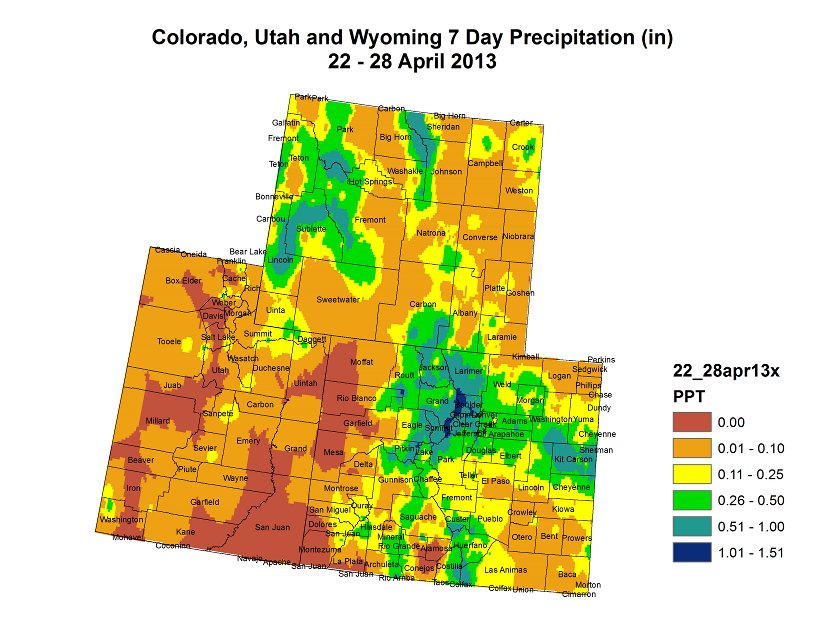

Click on the thumbnail graphics for the 7-day, month-to-date and water-year-to-date maps of the Upper Colorado River region for as of April 30, from the Colorado Climate Center.
Click here to read all the summaries.
Drought/snowpack/drought news: Things are looking up for runoff and transmountain diversions #COdrought
From the Loveland Reporter-Herald (Tom Hacker):
Carter Lake and Horsetooth Reservoir, the two largest Eastern Slope vessels of the C-BT system, likely will be close to brim-full soon after Memorial Day. Carter Lake on Thursday was 94 percent full. The level is high enough that the bureau’s water managers looked for lower spots to put all the water that’s coursing through the system…
That good news stands as a paradox for Glenn Werth, owner of Horsetooth’s Inlet Bay Marina. “We got 16 inches of snow here yesterday,” he said. “We’ve been shoveling docks instead of putting boats in. We can’t quite figure out if we’re coming or going.”
The spring runoff has already begun even as the mountain snowpack builds, with Thursday yet another snow day at high elevations…
Granby is the linchpin of the C-BT system, connected via a trans-Continental Divide tunnel to the Eastern Slope reservoirs. It also stood just one-third full on Thursday, awaiting the runoff from the west-slope snowpack that still remains a question mark.
But owners of the marinas at Horsetooth Reservoir and Carter Lake, two of the region’s most popular summer recreation destinations, know that no matter what happens west of the divide, their seasons have been saved by the late snow. “Don’t get me wrong. I’m not complaining,” Werth said Thursday as he was immersed in snow-clearing chores. “It’s not how we start the season. It’s how we finish it.”
Parachute Creek spill: Benzene levels in the creek exceed drinking water standards #ColoradoRiver
From The Denver Post (Bruce Finley):
Creek water tests found benzene reaching 5.3 parts per billion at the sampling spot closest to the spill from a pipeline at Williams’ gas-processing plant, according to the Colorado Department of Public Health and Environment. The limit for safe drinking water is 5 ppb. However, Colorado water quality overseers have set the limit for benzene in Parachute Creek at 5,300 ppb because the creek isn’t designated as a water source for people. Benzene dissipates at two sampling locations downstream. No benzene was detected in a test last week where the creek flows into the Colorado River…
Williams crews have been aerating the creek and pumping air underground into soil — to try to remove benzene into air. “While the one test site is showing a slight increase in benzene, other sites downstream remain static or show no detection,” Williams spokesman Tom Droege said in an e-mailed response. “We believe this indicates that our remediation efforts ….. are helping us make progress.”[…]
The creek normally feeds a Parachute town reservoir used for irrigation. But town officials have kept a headgate, 1.5 miles downstream from the gas plant, closed.
The latest tests did not detect benzene at the headgates.
From The Denver Post (Bruce Finley):
A CDPHE compliance advisory, dated April 30, formally notifies Williams, property owner WPX Energy and pipeline operator Bargath LLC that the spill constitutes disposal of hazardous waste without a permit…
The Colorado Oil and Gas Conservation Commission on March 20 issued notices of alleged violation to Williams and WPX. The advisory asks Williams to meet with state officials to discuss problems, schedule cleanup activities and show that laws were not broken. If state officials decide they need to order cleanup and remediation, CDPHE spokesman Mark Salley said in an e-mailed update, they can issue “compliance orders on consent” or a “unilateral compliance order.”
Williams spokesman Keith Isbell said the warning “was fully expected.” “It does not change the cleanup work that Williams has been doing,” he said. “Our next step is to formally present our current work plan to CDPHE and get their official approval as the new lead regulator.”
From The Grand Junction Daily Sentinel (Dennis Webb):
A natural gas liquids leak that contaminated Parachute Creek hasn’t affected public health and is unlikely to do so in the future, a state health official told local residents Monday. “We have technology to deal with any level of contamination from this site in groundwater and surface water,” said David Walker, with the Hazardous Materials and Waste Management Division of the Colorado Department of Public Health and Environment.
Despite such assurances, a number of the 100-plus members of the public attending an update on the situation Monday voiced concern about the contamination and skepticism about the response to it by the agencies and company involved.
Over the weekend, it was announced that lead jurisdiction over the investigation into the incident transferred to the Colorado Department of Public Health and Environment from the Colorado Oil and Gas Conservation Commission.
Roughly 10,000 gallons of natural gas liquids leaked into the ground from a pipeline leaving Williams’ gas processing plant, the company has estimated, although the commission “doesn’t take those numbers as gospel,” said its director Matt Lepore.
Dave Devanney, a Battlement Mesa resident, questioned the health department’s history of commitment to protecting the public from dangers related to oil and gas development, noting its opposition to some proposed health research related to such development. “We feel that CDPHE can do a better job than they’re doing right now,” he said.
Marion Wells of Rulison noted how the incident has continued to escalate. The leak went entirely unmonitored for two months, the pressure gauge it came from initially was said by Williams to have leaked just 24 gallons, and the incident eventually resulted in benzene reaching not just groundwater but the creek. “I just don’t trust. I don’t have it,” she said.
Walker said that compared to other remediation sites he deals with, the Parachute one is actually fairly small, although the potential repercussions are large because of the possible impact to surface water.
Benzene as high as about 4.5 parts per billion has been detected in the creek downstream of the pipeline. But that’s below the state drinking water standard of 5 ppb, and the state doesn’t consider the creek a drinking water source and applies a maximum 5,300-ppb aquatic standard to it. No benzene has been detected where the town of Parachute diverts irrigation water farther downstream. “There is not going to be any benzene that’s going to be in your irrigation water,” Walker said. He said aeration-related methods readily remove the carcinogen from surface water. In the worst case, installing a small dam a few feet high would aerate water enough to eliminate the benzene, he said.
Both state agencies and Williams also sought to assure that water tests are being conducted by objective, independent entities and labs, with the state having its own testing done to compare against Williams’ results.
From The Grand Junction Daily Sentinel (Dennis Webb):
The school district serving the Parachute and Battlement Mesa areas plans to begin using irrigation water from Parachute Creek after receiving assurances from state officials that doing so won’t endanger students. Ken Haptonstall, superintendent of Garfield County School District 16, said the district initially had been concerned about the benzene that has shown up in the creek as a result of the natural gas liquids leak from a pipeline leaving the Williams gas processing plant upstream. “We water the fields, that’s one thing. The fact that kids play on the fields, it’s a much bigger thing,” Haptonstall said.
The Colorado Department of Public Health and Environment and Colorado Oil and Gas Conservation Commission have been investigating the leak and overseeing cleanup. Haptonstall said state officials told the district benzene shouldn’t reach its irrigation water, but testing of the creek continues and it would be notified if any problem arises.
The district’s Center for Family Learning gets irrigation water from the town’s system, which draws from Parachute Creek and is scheduled to go into service May 8. Its Grand Valley High School fields get water from a ditch farther down the creek.
So far, no benzene has been detected at the town diversion point or farther downstream. On Tuesday, the CDPHE reported a detection within a mile of the town diversion point, the farthest downstream so far. But the measurement was just 1 part per billion, well below the state drinking water standard of 5 ppb. Benzene as high as 4.5 ppb has been reported at one point farther upstream.
Williams has been working with state officials to aerate creek water and treat adjacent groundwater to remove benzene. The state Health Department says such measures, and benzene’s propensity to dissipate in creek water quickly, make it relatively easy to remove the carcinogen from a creek.
Parachute Town Administrator Bob Knight said arrangements also have been made to let Williams shut off the town diversion point and other such points downstream should contamination threaten them.
Haptonstall said if the district had had to postpone watering for a month or so, it would have created some serious problems in terms of trying to keep fields from drying out. The town has been working to complete a pipeline from an existing reservoir to a second one it has decided to put into operation due to the Williams incident. That will provide it with some backup water in case the diversion point is shut down, as well as allowing for more dilution and treatment if any contamination occurs. Cool and wet weather this spring has allowed the town to delay when its irrigation system begins operating and do the additional reservoir work without having much effect on users of the water.
From The Grand Junction Daily Sentinel:
State health officials have issued a compliance advisory to Williams, alleging the company has violated state laws for the leak of thousands of gallons of natural gas liquids into groundwater and Parachute Creek near Parachute.
The Hazardous Materials and Waste Management Division of the Colorado Department of Public Health and Environment issued the advisory late Tuesday, an official notification to the owner of the property, WPX Energy, and the operator of the pipeline, Bargath LLC, that the state has determined the leak constitutes disposal of hazardous waste without a hazardous waste permit. Bargath LLC is a subsidiary of Williams.
The compliance advisory comes on the heels of the Colorado Oil and Gas Conservation Commission issued notices of alleged violation to Williams and WPX on March 20.
The compliance advisory encourages Williams officials to meet with the Hazardous Materials and Waste Management Division to develop a schedule for cleaning up the leak. The meeting, which is optional, also would be an opportunity for Williams officials to demonstrate that the spill isn’t a violation of state hazardous waste laws.
Violating those laws can result in an administrative penalty of up to $15,000 per violation, per day or a civil penalty of up to $25,000 per violation, per day.
Williams has estimated that roughly 10,000 gallons of natural gas liquids has leaked into the ground from a pipeline leaving Williams’ gas processing plant near Parachute. Benzene has been found in both groundwater and Parachute Creek, although the levels of benzene reported in the creek are below state’s drinking water standard.
From the Glenwood Springs Post Independent (John Colson):
The level of the toxic compound benzene in Parachute Creek on Wednesday exceeded Colorado’s safe drinking water standard for the first time in more than three weeks of testing, state health officials reported on Thursday…
Officials with the CDPHE and the U.S. Environmental Protection Agency have promised to monitor the creek until it is clear of contaminants from the natural gas activities located there.
In addition, the U.S. Occupational Safety and Health Administration (OSHA) is looking into complaints from workers at the plume site, who say they were forced to work without the proper protective gear and who fear they may have been poisoned while on the job.
Runoff news: Northern Water decides to wait see how the runoff shapes up regarding C-BT quota #COdrought #ColoradoRiver

From the Northern Colorado Business Report (Steve Lynn):
Northern Colorado Water Conservancy District board members met Thursday to discuss whether to raise the 60 percent quota that they issued last month. The quota means that farmers and cities will receive 60 percent of water units allotted to them under the project. The board members said they will wait at least until their next meeting before deciding whether to adjust the amount of water distributed from the project.
Northern Water employees told board members that although state snowpack levels had risen after recent storms, concerns remained about low water-storage levels.
Northern Water General Manager Eric Wilkinson cautioned that raising this year’s quota could limit the organization’s flexibility when it determines how much water to distribute next year. “I’m not willing to say that the drought is over,” Wilkinson said. “We’re still water short.”
More Colorado-Big Thompson Project coverage here.
2013 Colorado legislation: Graywater bill may make it to Governor Hickenlooper’s desk this session

From the Northern Colorado Business Report (Dallas Heltzell):
Co-sponsored by Rep. Randy Fischer, D-Fort Collins, and Sen. Gail Schwartz, D-Snowmass Village, it now heads to the Senate Appropriations Committee. Lawmakers there will consider a $110,000 appropriation to fund development of gray-water standards by the state Department of Public Health and Environment…
The bill directs the Colorado Water Quality Control Commission to develop minimum statewide standards for gray-water systems and lets cities and towns decide whether to approve them.
Fischer talked with the Business Report about why the bill is needed — and why it failed last year.
Q: What first made you aware that this was an issue in Colorado? Why did you decide to introduce this bill now?
Answer: Dr. Larry Roesner at Colorado State University’s Urban Water Center first contacted me about the need for legislation to authorize use of gray water in late autumn 2010. I was somewhat familiar with gray water systems and their potential to significantly reduce municipal and industrial water consumption. However, I was unaware that Colorado was the only arid western state whose statutes did not recognize or explicitly authorize the installation and operation of gray-water systems. Roesner and his colleague Sybil Sharvelle and I worked to draft legislation and meet with a broad stakeholder group to develop support for legislation. I introduced our bill in December 2011 for consideration during the 2012 legislative session. Regrettably, HB 1003 fell victim to political considerations early in the session. I committed to continuing to work on the bill and reintroduce it in 2013. HB 1044 is the result of literally 2 1/2 years of work on the part of Roesner, Sharvelle and me.
Q: If gray water is safe and beneficial to use, why are gray-water systems illegal in Colorado?
A: Gray water derived from a properly designed and functioning system is safe for indoor use to flush toilets and for outdoor drip irrigation systems. However, current Colorado statutes do not recognize or explicitly authorize its use. The Legislature has likewise never directed the applicable regulatory agency, the Colorado Department of Public Health and Environment (CDPHE), to promulgate rules or to set minimum statewide standards for its use. The absence of authorizing legislation, CDPHE rules and statewide standards has created regulatory uncertainty. This uncertainty prevents people from choosing to install gray-water systems because of the risk that their systems could be ruled illegal. When adopted, HB 1044 will direct CDPHE to promulgate rules and standards that will resolve the current regulatory uncertainty.
Q: What do Northern Colorado and the state have to gain by passing your bill, both environmentally and economically?
A: Gray water systems are capable of conserving 25 percent to 30 percent of the indoor water consumed in a typical residence. The water savings from new residential developments using gray water could be substantial and could be a cost-effective tool for helping to meet Colorado’s water needs for the 21st century. In addition, municipal water and wastewater service providers will realize energy and treatment cost savings in the operation of drinking water and wastewater treatment plants.
Q: This is the second time you’ve introduced a bill of this nature. Why did the first one get shot down, and what is different about this bill?
A: Bills dealing with water issues almost always are assigned to the House Agriculture and Natural Resources Committee. However, last year’s gray-water bill was assigned by then-Speaker Frank McNulty to the House State Affairs Committee for its first hearing. Regrettably, the speaker’s choice of the State Affairs Committee to hear the 2012 bill indicated that he was not going to let it advance for purely political reasons. This year, the political environment for water conservations bills such as HB-1044 is greatly improved, and Roesner and I have had an additional year to continue working with stakeholders to build support for the bill.
Q: If passed, what are the next steps to implementing gray-water systems? Do you foresee any other major hurdles?
A: Upon passage of HB 1044, the CDPHE will be required to promulgate rules and minimum statewide standards for installation of systems and use of gray water. The State Plumbing Board also needs to adopt a version of the International Plumbing Code that recognizes gray-water systems and provides guidance for installers. Finally, local governments will have the choice of authorizing the use of gray water within their jurisdictional boundaries. Local jurisdictions will have to adopt ordinances or resolutions authoring the use of gray water in consultation with local health departments and water and wastewater service providers. After passage of the bill, I hope that education, outreach and public acceptance will grow with time such that gray-water systems become a routine part of new residential development and that the potential for water conservation is realized.