‘This year, the river’s (#ColoradoRiver) massive reservoirs will be at their lowest levels since 1968’ — Anne Castle

colorado-river-gore-canyon

Anne Castle praises recent efforts to solve the supply problem in the Colorado River Basin in this guest column running in the Arizona Central. Here’s an excerpt:

We recently announced the “Next Steps” in the Colorado River Basin Study process — the steps that bridge the gap from identifying the problem to concrete, constructive solutions. Working in close partnership with the seven states that share the Colorado River, the U.S. Department of the Interior is convening the best experts in the water management business to assess options and strategies to ensure that the Colorado River is managed wisely so that it can meet the current and future needs in the basin. Farmers, cities, tribes, businesses, states, recreationalists and environmentalists will all be working together to better understand the Colorado’s limits and what can be done to conserve, stretch and manage its supplies.

We are also initiating a partnership with Native American tribes to undertake a comprehensive study of tribal water rights to ensure that the needs and capabilities of tribal nations can be fully factored into future strategies on the Colorado River. This effort supports the Obama administration’s commitment to building a better future for Indian country.

I am optimistic about this collaborative effort because its foundation is a multistate partnership that is unique in the United States. Over the past two decades, the seven Colorado River Basin states have formed a network of innovative problem solvers who have adopted proactive solutions that recognize their interdependence on the Colorado.

The Interior Department will also contribute to practical solutions on the Colorado River through its WaterSMART Program. With more than $200 million in federal investments since 2010, WaterSMART creates incentives and encourages innovative water conservation projects and has achieved real water savings benefiting millions of people.

The thread of the Colorado River is both fragile and resilient. Building upon recent successful efforts to improve water management in the basin, the Next Steps process will focus on enhancing the resiliency and sustainability of the resource we’ve been blessed with. After all, we’re all in this together.

More Colorado River Basin coverage here and here.

Colorado scores $20 million in federal wildfire disaster funds #COdrought

From The Denver Post (Jeremy P. Meyer):

The U.S. Department of Agriculture will direct $8.8 million to projects associated with the Waldo Canyon fire, $8.6 million for projects related to the High Park fire and $2.3 million for projects related to the North Fork and Weber fires.

“This is a huge deal,” Suzanne Bassinger, Larimer County’s recovery manager, said. “We have been waiting six months for this.”

Work will include aerial seeding to spur vegetation growth on burned-out hillsides, road protection, guarding homes from flooding, cleaning waterways of debris and building sediment basins in channels.

Around the High Park fire west of Fort Collins, the money will be split between Larimer County and water providers that serve more than 300,000 residents, Bassinger said.

Around the Waldo Canyon fire in El Paso County, work will be concentrated on protecting homes in the path of probable flooding, Langer said.

From The Durango Herald

The U.S. Department of Agriculture will direct $8.8 million to projects associated with the Waldo Canyon Fire, which burned into Colorado Springs; $8.6 million for projects related to the High Park Fire, which burned in Larimer County; and $2.3 million for projects related to the North Fork in Jefferson County and the Weber Canyon Fire near Mancos.

Denver Water blog: The trees can talk #COdrought

treeringsdouglasfirwesternwaterassessment.jpg

From the Denver Water Mile High Water Talk blog:

Reconstructing 400 years’ worth of streamflow data require a simple tool: tree rings.

For the past 10 years, Denver Water has worked with experts from the National Oceanic and Atmospheric Association and the University of Colorado to develop a model that details when our watersheds have been dry, wet and average since the early 1600s.

To do that, scientists study trees. During dry years, trees don’t grow much, and a narrow ring forms tight to the one that emerged the year before. During wet years, when trees go through a growth spurt, trunks develop a wide growth ring.

Ponderosa pine, pinyon pine and Douglas fir trees are more sensitive to moisture than other trees, making them a reliable record of past climate cycles. Scientists at the university take core samples from those trees (samples from the South Platte River watershed date back 400 years; samples from the Colorado River watershed date to the 1400s). Then planners compare tree ring data with 100 years’ worth of recorded streamflow gage measurements. When those two data sets are paired together in a graph, the points match almost spot-on – meaning the tree ring data correlate to past streamflow. And, because tree ring information extends back hundreds of years – much longer than Denver Water’s observed records – it helps planners analyze what would happen to our water supply if any of the pre-1900 droughts reoccurred. “This tells us what has happened in the past, but it doesn’t tell us what might happen in the future with climate change,” said Steve Schmitzer, manager of Water Resource Analysis. “It helps document variability, though. With anything in science, the more good data you have, the better.”[…]

Denver Water’s documented records show that the worst drought in our watersheds occurred in the mid-1950s, with a close second in the early 2000s. But tree rings point to a different period – the late-1840s. That’s a fact Denver Water has been able to confirm with a fair amount of certainty by studying government records from the 1840s. At that time, the government sent a host of expeditions led by Army engineers across the Great Plains. Military expeditions are often a reliable source because of their meticulous record-keeping, Schmitzer said. Their records of wet years and dry years correlated to the tree ring data scientists tracked for Denver Water.

AWWA Annual Conference: ‘Every conversation about water should begin with conservation’ — Governor Hickenlooper

denverciviccenterpark.jpg

From Drinks Media Wire:

Stressing that “every conversation about water should begin with conservation,” Colorado Gov. John Hickenlooper urged water professionals to foster collaboration among agricultural, recreational and urban water interests.

Hickenlooper spoke before more than 2,000 water experts in the opening session of the 132nd Annual Conference and Exposition (ACE13) of the American Water Works Association. The conference, the largest of its kind in the world, is expected to bring more than 11,000 water professionals to Denver June 9-13 for training and access to the world’s cutting-edge water technology.

Noting that much of the West – and especially Colorado – is in the grips of prolonged drought, Hickenlooper noted that “water is the key to everything out here.”

AWWA Executive Director David LaFrance began the session by reading a proclamation from Denver Mayor Michael Hancock that declared June 9-15 “Water Professionals’ Week” in Denver. The proclamation said in part that water “delivers public health protection, fire protection, support for our economy and the quality of life we enjoy” and that “we are all thankful for the hardworking water professionals who provide this service to us each day and are proud to welcome them to the City of Denver.”

AWWA President Charlie Anderson, a consultant with CDM Smith in Arlington, Texas, urged attendees to remember the legacy they will leave. “Legacies are generated when people unite around a challenge with a specific vision for solving it to make the world they live in better,” Anderson said. “That’s exactly what we’ll do over the next few days together – we come together, bringing all our unique expertise and talents, and we solve problems that are common to all of us.”

The AWWA conference continues Tuesday with hundreds of presentations on pressing water issues in North America and beyond. Among the day’s highlights is the 3 p.m. “Best of the Best Water Taste Test,” a competition for the best-tasting water in North America. Winners from approximately 21 regional taste contests will compete.

More infrastructure coverage here and here.

Roaring Fork: Nearly 130 people participated in a community river float Saturday and learned about the river along the way

Denver Water: The June 2013 issue of WaterNews is hot off the press #COdrought #ColoradoRiver

cheesmandam.jpg

Click here to read the current issue. Here’s an excerpt:

Spring snowstorms along the Front Range and in our mountain watersheds helped a lot with our dire water supply situation. But this is the second year in a row of below-average snowpack and drier- than-normal conditions in our watersheds. Denver Water’s reservoirs haven’t been full since July 2011, and our current projections show that reservoirs will still be below normal.

We never know what future weather is going to be like, so it’s always important to manage water supplies carefully. The snowpack in Denver Water’s watersheds ended up below the average peak. At this time, Denver Water and several other local water providers still expect to have the Stage 2 mandatory drought restrictions in place to save as much water as possible this summer. Area water utilities will know more about their water supply situations in July after the runoff.

More Denver Water coverage here.

Colorado State University Water Resources Archive Digitizes More Than 43,000 Water History Documents

delphcarpenter.jpg

Here’s the release from Colorado State University (Kate Hawthorne Jeracki):

Over 100 years of Colorado water history — more than 43,000 pages of primary source materials related to water use in the state — are now freely available online.
The Colorado State University Water Resources Archive recently scanned, digitized and posted the items that include reports, images, oral histories and data, thanks to a $50,000 grant from the Colorado Water Conservation Board (CWCB). This is the fourth such grant from the CWCB to the archive.

The unique project took just under a year to complete and added material from 15 previously undigitized collections and 24 total collections to the archive’s online offerings. Scanned materials relate to today’s water issues, and include groundwater research and administration, snow hydrology, agricultural water use, the 1976 Big Thompson flood and early water leaders. Digitization also preserved more than 200 rare glass-plate images of Colorado and several thousand slides of dams and waterways in the western United States.

Searchable free access

Patrons can browse documents or find specific items with simple keyword searches on the archive’s website, http://lib.colostate.edu/archives/water/. Online access to archival materials is intended to aid those who want to educate themselves about water but who don’t have the time or money to travel to Fort Collins to view these historic documents.

Some highlights from the recently digitized materials include 41 oral history interviews from survivors and emergency responders of the Big Thompson flood, USGS Civil Engineer Robert Glover’s diaries from 1923 to 1984, and data and reports from Colorado’s portion of the six-state High Plains-Ogallala Aquifer study conducted between 1979 and 1981. Those interested in Colorado history will also find 79 images of farms, towns and mountains in the 1890s from the Delph Carpenter collection particularly fascinating.

The Water Resources Archive, part of the University Libraries, is Colorado’s only repository dedicated specifically to preserving the history of water in the state and the American West. Most of the documents in the archive are unique and unavailable elsewhere. Holdings, contained in nearly 2,000 boxes, cover more than a century of water history and provide access to the studies, debates and legislative deals that have shaped Colorado’s water legacy.

More education coverage here.

Drought news: Dust storms in southeast Colorado reminiscent of 1930s Dust Bowl #COdrought

usdroughtmonitor06042013

seasonaldroughtoutlookjune62013

From The Denver Post (Colleen O’Connor):

Dirt is almost all that people can talk about these days in communities along U.S. 50 and 287. Photos of fierce dust storms rolling across the state’s Eastern Plains are showing up on Facebook and local TV news, harking to the Dust Bowl years that devastated southeastern Colorado in the 1930s. Farmers and ranchers are tolling their losses. People are praying for rain. It’s the inevitable result of three seasons of extreme drought in the area — D4 this year, the worst on the U.S. Drought Monitor scale, and no relief in sight, said state climatologist Nolan Doesken. “The first year, it was very dry, but there was still reasonable vegetative cover,” he said. “That started deteriorating last year, with more and more bare ground.”

For miles on either side of U.S. 287 between Kit Carson and Lamar, the earth is brown and bare during a season that should be bursting with green native grasses and wheat. Even weeds aren’t growing. Failed crops mean vast swaths of land with no roots to anchor parched topsoil. “(Farmers and ranchers) are watching the clouds gather, and then they get nothing but dust storms,” Doesken said. “It’s very depressing.”

The conditions are taxing the financial ledgers and the creativity of people who make their living from the land…

It’s like the silent spring, empty and eerie. Hardly a tractor in sight, as far as the eye can see. No one laboring to prepare for the wheat harvest. No cattle grazing, because the grasses have gone dormant and ranchers are selling off their herds or trucking them elsewhere…

At Stulp Farms, a few miles south of Hixson Farms, they’re down to their last bales of hay. “We’re about to run out,” said Jensen Stulp, a veterinarian who manages the family farm.

His father, John, is a former Colorado commissioner of agriculture who spends most of his time in Denver working as special policy adviser on water to Gov. John Hickenlooper. “We’re down to a fifth of a herd,” Stulp said. “I’m selling 20 pairs every two weeks until it rains, or we run out of cattle.”

San Miguel River watershed: Instream flow right granted in May should keep the river whole from stem to stern

sanmiguelriver.jpg

From The Colorado Springs Gazette (Ryan Handy):

One of the last free-flowing rivers in Colorado, the San Miguel will continue to course through the western slope unchecked by mankind, thanks to a May 20 Colorado Water Court ruling granting it protected status. Granted “in-stream flow protection,” the San Miguel will continue to be a natural habitat for three fish species, as well as fuel the down-stream rafting economy, said John Fielder, a landscape photographer and champion of natural resources preservation. “Like the Yampa (River), the San Miguel is one of the last undammed major rivers in the state,” Fielder said.

The in-stream water rights guarantee that no one can take water out of the river, said Rob Harris, a lawyer for Western Resources Advocates, a resources conservation non-profit. Instead, the San Miguel’s water will be preserved for three native fish: the Roundtail Chub, the Flannel Mouth Sucker, and the Bluehead Sucker, Harris said…

To preserve the fish natural habitat, the Colorado Water Conservation Board applied for in-stream flow protection for the San Miguel in 2011, at the urging of Colorado Parks and Wildlife and the Bureau of Land Management. The in-stream protection protects a 17-mile segment of the river, which runs west of Montrose near Naturita.

More San Miguel River watershed coverage here and here.

Arkansas River Basin: Two Rivers Water and Farming Co. is proposing to purchase shares of the Excelsior Ditch

arkbasinditchsystem.jpg

From The Pueblo Chieftain (Chris Woodka):

Shareholders in the Arkansas Groundwater Users Association will learn the details at meetings this week about a proposed purchase of Excelsior Ditch shares by Two Rivers Water and Farming Co. Last month, Two Rivers announced it would acquire majority interest in the ditch, located east of Pueblo, for a $3.5 million purchase price. Two Rivers also would provide storage to AGUA in a proposed reservoir that would be located on Southwest Farms property.

Meetings are scheduled for Tuesday. They will be at 10 a.m. at Cottonwood Links in Fowler; 12:30 p.m. at the AGUA offices, 212 36th Lane; and 3 p.m. at Coke’s Diner in Fountain. “These are educational meetings that will allow shareholders to ask questions,” said Scott Lorenz, AGUA manager.

AGUA’s board approved a tentative agreement to sell 53.77 percent of the Excelsior Ditch shares to Two Rivers in May, subject to approval by its 320 shareholders.

AGUA provides augmentation water for well pumping along the Arkansas River and Fountain Creek. It uses other sources of water in addition to the Excelsior Ditch.

Even after the proposed sale, the water would be available to AGUA.

Two Rivers CEO John McKowen sees a mutually beneficial relationship with AGUA, and has provided some water leased from the Pueblo Board of Water Works at cost to keep wells pumping this year.

McKowen’s company has purchased nearly all of the Huerfano-Cucharas Ditch system, including Cucharas Reservoir. He has also purchased other farms on the Bessemer Ditch and under Orlando Reservoir in Huerfano County. His goal is to farm high-value crops and create more opportunity for other farmers. Plans include fallowing some land to lease the water and working out cooperative agreements with cities. “Acquiring the Excelsior shares enables Two Rivers to provide muchneeded capital improvements and implement its storage program. The storage facilities will benefit all water users on the Arkansas River and further the plans of AGUA and other shareholders of the Excelsior Ditch,” McKowen said.

More Arkansas River Basin coverage here and here.

NM Acequias: Tradition & Adaptation presented by the New Mexico Acequia Association June 26

acequiadelcerro

From the New Mexico Acequia Association website:

The New Mexico Acequia Association will host a statewide acequia workshop on June 26th at the Santa Fe Community College. The theme of this conference is “Tradition and Adaptation” to recognize the importance of the traditional knowledge and customs that are vital to the management and care of the acequia. The theme also highlights the importance of acequia adaptation to new challenges. Acequia officials are now called upon to not only keep water flowing in the acequia for crops, gardens, and livestock, but they also must understand how to operate as local institutions of government.

We are also very pleased to present for the first time a screening of “The Art of Mayordomía” which honors the knowledge and wisdom of Mayordomos and highlights the importance of encouraging new Mayordomos to serve.

We will also provide a brief overview of the various areas in which your acequia can request assistance from the New Mexico Acequia Association including acequia bylaws, acequia easements, infrastructure planning, effective meetings, enforcement, and others. We will conclude the workshop with a session about Acequia Enforcement including a presentation by Tomás Trujillo, Office of the Eighth Judicial District Attorney, about legal tools and strategies to protect acequias from illegal uses of water, misuse of the acequia easement, and other common problems.

We hope you or someone from your acequia can attend this workshop. We will also encourage attendees to follow up with NMAA staff if you are interested in technical assistance on a specific topic. The NMAA is asking for a modest registration fee of $10 per person to cover the cost of food. Please register by calling the NMAA office at 505-995-9644.

More Rio Grande River Basin coverage here.

Colorado Mining Agency Orders Clean-Up of Four West Slope Uranium Mines

uranium

Click here to read the letter from the Colorado Mining Agency to Gold Eagle Mining, Inc.

From the Summit County Citizens Voice (Bob Berwyn):

A mining company with a long history on noncompliance with reclamation requirements has been ordered to clean up four semi-abandoned uranium mines in southwest Colorado.

An attempt by Gold Eagle Mining Inc, to delay closure of the mines for another five years was successfully challenged by a watchdog group. The mines, have been idle for three decades, despite a state law that requires uranium mines to be reclaimed and closed a maximum of 10 years after mining ceases.

Three of the mines are located in Slick Rock, directly adjacent to the Dolores River. A fourth mine is located on the slopes above the picturesque Paradox Valley. Multiple documents relating to the mines, including copies of inspection reports and warning letters from the state, are posted here.

More nuclear coverage here and here.

Lincoln Park/Cotter Mill superfund site update: The road map for decommissioning is moving along

cottermillcontaminationconcerndenverpost10232011

From the Cañon City Daily Record:

The Cotter/Lincoln Park Community Advisory Group monthly meeting was May 16 at the Fremont County Administration Building. CAG members were told about the agency’s idea of ending “The Pause” at the Cotter Superfund Site. Members present were in agreement with this decision.

Four other major aspects regarding the cleanup process also were talked about but not fully detailed in newspaper coverage. The CAG Outreach Committee would like the community to be aware of everything the CAG is doing.

The first major topic discussed implementation of a Road Map between Cotter, CDPHE, EPA and the CAG. This will expedite all information shared and decisions made in a timely manner and allow input into the various documents received by all parties, including the general public. This will allow everyone to know what is happening in a timely manner and to see exactly where everything is at relative to the Superfund Site.

More Lincoln Park/Cotter Mill coverage here and here.

CMU: Grant Workshop for Agricultural & Municipal Water Projects June 25

irrigation.jpg

Click here to read the flyer. Click here to RSVP.

More education coverage here.

Parachute Creek spill: No benzene detected in the creek for 17 consecutive days as of Thursday #ColoradoRiver

parachutecreekspillmarch2013

From The Grand Junction Daily Sentinel (Dennis Webb):

Staff members for state agencies will begin looking at whether the Williams natural gas liquids leak near Parachute damaged natural resources, and a positive finding could lead to the firm having to pay damages. Colorado Department of Law spokeswoman Carolyn Tyler said Friday that representatives of that department, the state Department of Natural Resources and the Colorado Department of Public Health and Environment “are going to begin initial scoping of potential injuries to natural resources” in the case, based on a decision made the previous day.

The Williams case was on this week’s agenda for the Colorado Natural Resources Trustees meeting. The agenda was to include a brief discussion of it as the subject of a potential investigation, and it also was included on the trustees’ executive-session (closed-door) agenda.

The little-known panel consists of state Attorney General John Suthers along with Martha Rudolph and Bob Randall, who respectively are high-level officials within the health and environment department and the Colorado Department of Natural Resources. They can seek compensation from responsible parties when oil or hazardous substances harm natural resources, with the money used for restoration and other measures to address the damage.

Williams estimates that about 10,000 gallons of natural gas liquids leaked into the ground and groundwater this winter from a faulty pressure gauge on a pipeline leaving its natural gas processing plant near Parachute Creek.

The health department’s Hazardous Materials and Waste Management Division has taken over investigation of the case, after the Colorado Oil and Gas Conservation Commission determined the incident didn’t fall within its jurisdiction. The health division has much higher potential daily fines for violations than does the oil and gas commission.

But the health and environment department has said the division and Williams have reached a consent order under which, if Williams complies with cleanup requirements, it won’t be fined for violating division regulations because the leak resulted from accidental equipment failure rather than negligence.

Under state law and oil and gas commission rules, absence of negligence doesn’t preclude that agency from issuing fines in enforcement matters it handles, commission Director Matt Lepore said this week when asked in an interview. He declined to comment about the handling of the Williams fine, saying the matter involves a different agency and he doesn’t have insight into the health department’s decision-making.

Dr. Chris Urbina, director of the state health department, and incidentally also a state oil and gas commissioner, has hastened to say that despite the terms of the consent order, it’s too early to say Williams won’t be fined in connection with the leak. In part, he has pointed to the possibility of action by the Natural Resource Damages Trustees.

Williams said Friday that it has recovered about 7,350 gallons of hydrocarbon fluids.

While benzene, a carcinogen, had appeared for a while in the creek in small concentrations, it hadn’t been detected in 17 consecutive days as of Thursday, indicating remediation measures have been effective, the company said.

More Parachute Creek spill coverage here.

AWWA Annual Conference kicks off today in Denver

cityparksunrise.jpg

Click here to go to their website for the conference.

Here’s a guest commentary written by Mike Italiano, founder of the U.S. Green Building Council and president and CEO of the Market Transformation to Sustainability, running in The Denver Post. Here’s an excerpt:

Local officials continue to struggle with ensuring there is enough water for all residents. Yet, just as important for decision makers is the quality of water and how it’s transported to homes, businesses, schools and hospitals.

That will be among the topics next week, as more than 10,000 water professionals gather in Denver at the annual American Water Works Association conference. Certain to be discussed is what types of pipes are best for local water systems nationwide, including Denver. And that’s important for residents who should demand that clean water be delivered to them through the highest quality pipes that protect the environment, the health of consumers and make the best economic sense for the city.

More infrastructure coverage here.

Colorado-Big Thompson Project update: 250 cfs in the river below Olympus Dam

coloradobigthompsonprojecteastslopesystemncwcd.jpg

From email from Reclamation (Kara Lamb):

Earlier this morning, we saw run-of inflows to Lake Estes jump up. As a result, the water level elevation at Lake Estes has come up a few feet and we are increasing releases from Olympus Dam to the Big Thompson Canyon. Flows in the Big T canyon are increasing from around 125 cubic feet per second to about 225 cfs. We might only need to keep the 225 cfs release for a few hours. It is possible we could cut the release back slightly before noon.

More Colorado-Big Thompson coverage here.

Fremont County: Tallahassee Area residents are now 1,000 strong in opposition to Black Range’s uranium operation

uraniumdrilling.jpg

From The Mountain Mail (Joe Stone):

When residents in the Tallahassee Creek drainage northeast of Cotopaxi learned about potential uranium mining in the area, they organized to oppose it. More than 1,000 property owners now make up the Tallahassee Area Community group, including more than 500 year-round and seasonal residents, said Cathe Meyrick, TAC president.

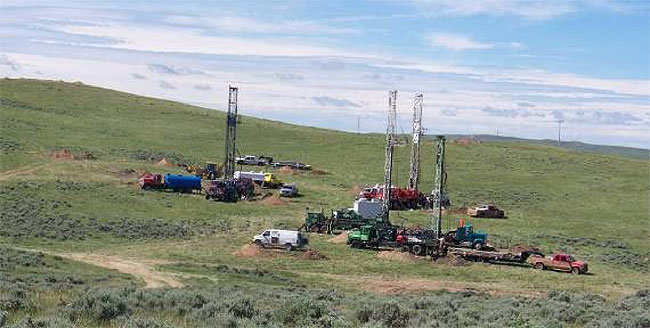
As previously reported in The Mountain Mail, Black Range Minerals Colorado plans to use a borehole mining process to extract uranium ore at the Hansen deposit, located within the South T Bar Ranch development along Tallahassee Creek. If the mining operation proceeds, 44 local property owners will become the first people in the world to live within 500 feet of active uranium mining, according to the TAC website.

Background

The history of uranium mining in western Fremont County dates to the 1954 discovery of uranium ore deposits.
Following the discovery, relatively small mining operations created 16 open pit mines in the Tallahassee Creek area. All of the mines were eventually abandoned but not restored to original conditions because of the absence of environmental and mining regulations.

In the 1970s, Cyprus Mines Corp. acquired the Taylor Ranch mineral and water rights. In 1981, after drilling thousands of exploratory wells, Cyprus received permits to mine uranium ore at the Hansen deposit and operate a nearby uranium mill. The project never advanced beyond the permitting stage because uranium prices collapsed in the wake of the Three Mile Island incident.

With the ensuing cancellation of nuclear power plant construction projects, demand for uranium remained low for decades, as did uranium prices.

While uranium prices remained too low to support local mining operations, Fremont County commissioners knew about the presence of uranium ore and failed to designate the area as a Mineral Resource Area. In 1974, HB 74-1041 amended the Colorado Land Use Act, encouraging counties to make such designations in order to prevent incompatible land uses, thereby preserving the ability to develop mineral resources.

Lee Alter, chairman of the TAC Government Affairs Committee, said the 1976 Comprehensive Plan for Fremont County recommended that county commissioners establish a more definitive zoning plan. Alter also cited a 1980 Fremont County Land Use Plan that makes similar recommendations in order to “avoid incompatible land uses.” But the designation never happened, and the county approved the subdivision of ranch land into large rural residential parcels, benefiting local developers and contractors. Alter said the 1990 Fremont County Master Plan designated the preferred nonagricultural land use in the area as residential.

The current version of the Fremont County Master Plan, adopted in 2002 and available on the county website, states, “The primary nonagricultural land use (in the Mountain District of Fremont County) will be residential” (page 97). The master plan also states, “Long-term industrial operations will not be encouraged in the (Mountain) District. … Industrial development should be discouraged along … Fremont County Road 2 (Tallahasee Road)” (page 98), which provides the only access to the area.

Given these master plan statements and a general lack of disclosure by local developers and real estate agents, Meyrick said residents who bought land and built homes in the area had no idea their investments could be threatened by uranium mining.

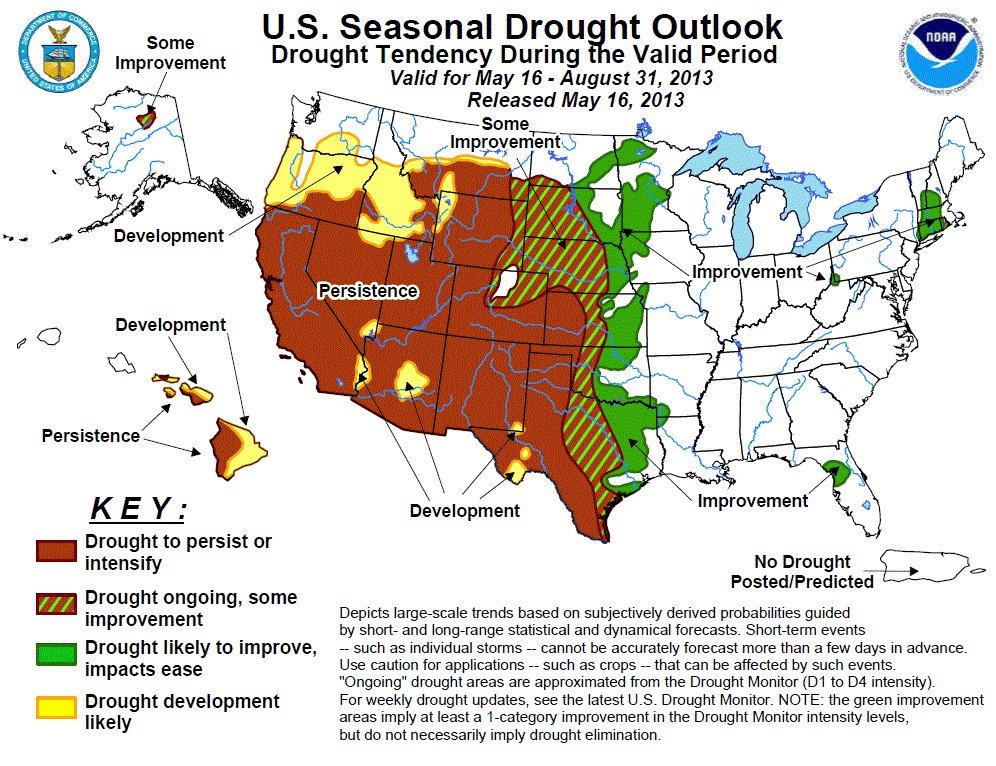
However, increasing use of nuclear fuel to generate electricity in recent years, particularly in Asia, has investment firms like JPMorgan forecasting uranium prices of $80 a pound by 2014.

Projections like these prompted Black Range Minerals’ interest in mining the Hansen deposit, and the company acquired the privately held mineral rights to 13,500 acres along Tallahassee Creek. Alter said local residents began seeing lights and hearing machinery on Taylor Ranch in 2007 and learned that Black Range was conducting unpermitted drilling for test wells. He said Black Range eventually obtained a permit but not until after drilling 70 test wells. By then, Meyrick said, it was too late to obtain baseline water samples, making it impossible for residents to prove whether or not contaminants in their well water resulted from Black Range exploratory drilling.

The lack of oversight and accountability demonstrated by the unpermitted wells prompted local residents to organize, Meyrick said. Land-use issues Local residents cite several issues they believe should prevent Black Range from mining the Tallahassee-area uranium, beginning with incompatible land uses.

Alter said the market value of undeveloped ranchland in the early 1980s, including land with known uranium resources, was less than $200 per acre. Unimproved, subdivided ranch parcels sold since the mid ’80s for $1,000-4,000 per acre and more, Alter said. “Many of the residences and small hobby ranches that have been constructed over the past 25 years are valued at $500,000 or more.”

Alter also pointed to the recently constructed Benedictine Fellowship of St. Laurence Retreat. Permitted by the county in 2008, the retreat sits on the banks of Tallahassee Creek approximately 2 miles downstream from the Hansen deposit. Alter said the current assessed valuation from local residential parcels is approximately $40 million, resulting in annual property-tax revenue to the county of more than $250,000.

Given the degree of residential development in the Tallahassee Creek area and the value of that development to the local economy, Alter said he believes uranium mining “would clearly be incompatible with the current rural residential and recreational land use.” Alter also said, “The county tax base and the local economy would suffer” as a result of uranium mining. “In addition, the stigma associated with this ‘dirty’ industrial activity would significantly impact tourism and recreation – a major economic driver of this scenic county.”

But more importantly than the economics, Alter said, human-health and environmental risks associated with uranium mining make it incompatible with current residential land use. Citing Fremont County land-use authority – established by the state Legislature and confirmed by the 2009 Colorado Supreme Court decision – he called on county commissioners to “disallow uranium mining and ore processing in Tallahassee.”

Water issues

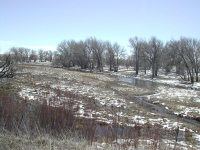
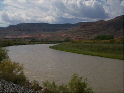
Members of TAC also cite water as a source of concern stemming from proposed mining activities. Residents of the Tallahassee Creek area rely entirely upon aquifers for drinking and household water. Tests show the uranium content in some local wells has increased since Black Range began exploratory drilling, Meyrick said, and water from some wells exceeds drinking water standards by large margins.

Water availability in the area highlights another facet of the water issue. Black Range ended up purchasing water from Cañon City for exploratory drilling after the state engineer’s office denied the company’s substitute water supply plan (SWSP) in 2012. The ruling states, “Due primarily to the lack of replacement water to accomplish the applicant’s proposal, the plan will not … prevent injury to other water rights.”

Alter noted that the mining processes proposed by Black Range – underground borehole mining and ablation ore-concentration technologies – would require much more water than exploratory drilling.

One point of interest cited in the state’s denial of the SWSP involves North Spring Ditch water rights:

“The North Spring Ditch water rights were changed in 1980, rendering any irrigation use since that date unusable for calculating historic consumptive use for a subsequent change of use.” Court documents show that the 1980 change of use involved the transfer of irrigation water rights from Taylor Ranch to Cyprus Mine, which changed the use of that water to mining. Alter said Cyprus Mines sold those water rights back to the Taylors in 1993, and in 2012 the Taylors filed a case in Division 2 Water Court, to “confirm” their rights.

Alter said TAC members believe the Taylors filed the case to determine how much water they can sell to Black Range Minerals for proposed mining operations, prompting TAC to enter the case as an objector.

Given: (1) the significance of historical consumptive use in determining the amount of water Black Range could acquire and
(2) the SWSP ruling rendering “irrigation use since (1980) unusable for calculating historic consumptive use,” Alter said he believes Black Range has insufficient water for mining for underground borehole mining.

He cited estimates that the mining process could require as much as 50,000 gallons of water per hour.

Technology questions

The third area of concern voiced by TAC members encompasses the relatively new mining processes that Black Range proposes to use. Underground borehole mining uses a high-pressure water jet to break apart ore and bring it to the surface in a slurry.

Alter expressed concern about the elevated levels of oxygen present in pressurized water. The increased oxygen levels, he contends, will create chemical reactions that increase the likelihood of uranium and heavy metals contaminating well water and other natural resources. “This water and the recovered water in the slurry,” Alter said, “will contain oxidized, solubilized uranium, other radioactive constituents and heavy metals that otherwise would remain underground and insoluble.”

Alter said he also objects to the ablation process that Black Range proposes to use to concentrate mined ore. The process employs two jets of ore slurry fired directly at one another from opposing sides of the ablation machine. The impact when the slurry jets meet would dislodge uranium ore from the sandstone to which it is attached. Black Range contends that this process is a component of mining, but TAC members believe it is a uranium processing activity that requires additional permitting.

Members of TAC also question whether or not the remaining water and sandstone could be returned to the subsurface, as proposed by Black Range, without contaminating the aquifers that supply local wells.

More nuclear coverage here and here.

Move water from west to east or dry up agriculture?

flaminggorgedrycoloradoestuary9billionbillboard.jpg

Hannah Holm recaps the Gunnison Roundtable discussion of the proposed Flaming Gorge Pipeline in this column running in the Glenwood Springs Post Independent. Here’s an excerpt:

One reliable way to rile up a room full of western Coloradans is to start talking about moving water from the Colorado River basin (“our water”) east across the Continental Divide for use by Front Range cities. You’ll hear lots of muttering, and someone will probably say something to the effect that not one more drop should go over while a blade of bluegrass remains in the Denver metro area.

It doesn’t even have to be water that resides in Colorado to get people’s backs up, as was demonstrated by the reaction to a proposal floated by entrepreneur Aaron Million to pump water from the Flaming Gorge reservoir in southwestern Wyoming east along the I-80 corridor and then south to a reservoir near Pueblo. In September 2011, billboards sprouted up along I-70 protesting providing funding to even study the idea. The billboards were funded by environmental organizations, but a host of resolutions approved by the City of Grand Junction, Mesa County and others roundly condemned the proposed project as well.

However, if Front Range cities can’t take water from our side of the hill, they have to look elsewhere — and that usually means “buying and drying” agricultural land. Since western Coloradans tend to like farms, even if they are east of the Divide, this creates a bit of a quandary. While some claim that ramped up conservation could preclude the need for more water transfers, it’s not easy to see how to push conservation far enough to close the 500,000-acre-foot gap between supply and demand that is forecast to afflict the state by 2050 if measures aren’t taken. Besides, if the Front Range has to dry up lawns, we might have to do the same — and that becomes a more complicated conversation.

Despite the billboards and resolutions, the state did fund a committee to study the potential benefits and impacts of the Flaming Gorge proposal. It included representatives from each of Colorado’s major river basins, including many highly skeptical of the proposal as well as potential beneficiaries, and it met once a month for a year. In short order, the committee broadened its mission and ended up developing a series of questions to be addressed for any proposed major movement of water across the Divide, as well as criteria for what would be a “good” project. This report was presented to the Gunnison Basin Roundtable and Gunnison “State of the River” meeting in Montrose June 3.

More Flaming Gorge Pipeline coverage here and here.

Drought/runoff news: Will the streamflow be there to finish crops this year? #COdrought

usdroughtmonitor06042013

seasonaldroughtoutlookjune62013

From The Greeley Tribune (Eric Brown):

On paper, northern Colorado’s recovery from months of drought appears to be nearly complete. The plethora of moisture in recent weeks has put precipitation and snowpack figures in the South Platte River basin above average and, collectively, reservoir levels are getting close to normal. According to the most recent U.S. Drought Monitor, northern Colorado is no longer in a “drought” — being labeled instead as “abnormally dry.”

However, that doesn’t mean everything’s quite peachy keen for the area’s farmers. “Things are greatly improved, but we’re not home yet,” said Gus Sidwell, who grows corn and alfalfa near Gill. “We’re probably only at first base at this point.”

Many northern Colorado farmers today have far more water to work with this year than they thought they would back in March and April. But, depending on how much water they own, they might not have enough to finish off their crops in August and September — late in the growing season, Sidwell said. He and others say they’ll still need rain, or cities to lease out some of their excess water — maybe both. “If we don’t get that, we’re looking at only partial production,” Sidwell said. “We’ll have to let some acres go.”

Greeley Water and Sewer Department Director Jon Monson, said leasing water to agriculture will be discussed at the next Greeley water board meeting, on June 19, but said there’s no guarantee they’ll decide to release more water to agricultural users. Cities own the majority of the region’s water, leaving a number of farmers and ranchers to depend on renting water from those municipal neighbors to grow what’s needed. In most years, they can do that. But cities this year have so far been holding on tight to their water supplies.

Until April, snowpack, precipitation and reservoir levels were far below average, and city officials at the time were wanting to use any snowpack there was to refill their high-mountains reservoirs — after having depleted them during the drought of 2012.

In recent weeks, though, snow and rain has arrived. As of Saturday, snowpack in the South Platte River basin was 153 percent of average, according to a report from the Natural Resources Conservation Service released Wednesday. That’s the fourth-highest mark for June 1 during the last 25 years.

The NRCS report also noted that, thanks to cooler than normal temperatures in the mountains, that snow is melting slowly — meaning the abundance of snowmelt will be flowing into farmers’ irrigation ditches later in the growing season. And reducing farmers’ dependency on irrigation water right now is the fact that the ground is moist.

In the Greeley area, for example, precipitation in 2013 was 9 percent above average through the end of May, according to numbers provided by the Colorado Climate Center in Fort Collins.

Doug Rademacher, a farmer near Platteville, said he had to start irrigating his crops last year in April, because of how dry it was at the time. In the first week of June this year, he still hasn’t had to irrigate his corn, sugar beets and others crops he planted this spring. The increase in snowpack, slow snowmelt and abundance of moisture in the ground are no doubt good. But, like Sidwell, Rademacher said rain or renting water from cities will be needed to fully finish off his crops.

A water meeting that will have large implications is that of the Northern Colorado Water Conservancy District, which oversees operations of the Colorado-Big Thompson Project, the largest water supply project in northern Colorado. Since the C-BT project went into use in 1957, the Northern Water board has set a quota every year in April to balance how much water could be used through the upcoming growing season and how much water needed to stay in storage for future years. The historic average for the C-BT quota has been just above 70 percent. This past April, the Northern Board set the C-BT quota at 60 percent, because of low reservoir levels and limited snowpack. As they often do, board members will consider increasing the quota at their June 14 meeting.

But, like Monson, Brian Werner, a spokesman for Northern Water, said there’s no guarantee they’ll be releasing more water to help agriculture. “Everyone is still watching things really close,” he said.

From The Mountain Mail (Peter J. Goetz):

Delayed snowpack peak, cool weather and continued wet weather patterns in the northern part of the state have contributed to a delay in snowmelt and eased some of the strain on water supplies in northern Colorado. However, it is unlikely that the southern part of the state will see much relief from drought conditions this year, Natural Resources Conservation Service officials said Thursday.

Snowpack reading as of June 1 is 93 percent of median statewide, Randy Randall, acting USDA Natural Resources Conservation Service state conservationist, said. “This respectable percentage is due mainly to the generous amount of snow that remains across northern Colorado. In contrast, the snowpack in the southern portion of the state is nearly depleted even at the higher elevations,” Randall said.

Current streamflow forecasts for the Upper Rio Grande and combined San Juan, Animas, Dolores and San Miguel basins call for well below average flows this summer.

Late-season snow accumulation in April and early May considerably improved the water supply outlook in the northern basins of the state. Forecasts for the Colorado and South Platte river basins still generally call for slightly below average flows this season but have improved considerably from predictions earlier this year.

At this stage in the melt season, high-elevation temperatures will play an important role in how rapidly snowmelt will occur in the northern basins, Randall said. Water managers can monitor these temperatures using data from the automated SNOTEL sites in their watersheds.

From the Associated Press (Nelson Harvey) via the Aspen Daily News:

Flows in the Roaring Fork River basin may have already peaked for the year, according to some hydrologists and forecasters with an eye on the watershed. Still, there’s a chance that warm weather in the coming weeks could bring a second peak, pushing levels slightly higher than they were on Thursday, May 27, when a gauge on the lower Roaring Fork River near Glenwood Springs recorded a flow of 3,394 cubic feet per second (cfs)…

If May 27 does turn out to be the date of peak flows on the Roaring Fork, it will be one of the earliest peaks since record keeping began on the river in 1907. In only three years — 1964, 1967 and 1992 — did the Roaring Fork River peak before that date…

Flows so far this year have been significantly higher than they were during the historic drought of 2012. That year, the river peaked in early June near Glenwood Springs at less than 2,000 cfs…

On the Fryingpan River, a tributary of the Roaring Fork, flows were averaging about 110 cfs on Monday. Engineers with the federal Bureau of Reclamation are required to release at least that much water from the Ruedi Dam at this time of year, to insure the health of fish and other organisms in the river.

Ruedi Reservoir is expected to get within “a few feet” of filling by around mid-July, according to Kara Lamb, a spokeswoman for the Bureau of Reclamation. As of Monday, the reservoir was about 75 percent full. It holds a maximum of just over 101,000 acre-feet of water.

Lamb said engineers typically divert about 48,000 acre feet of water each year to Colorado’s eastern slope, though a series of tunnels upstream of the reservoir known as the Frying Pan-Arkansas Project. So far this year, she said, engineers have diverted about 14,000 acre-feet.

From The Wall Street Journal (Mark Peters):

Some communities in Texas are down to 180 days or less of supply, while areas of rural New Mexico have been drilling deeper wells to keep taps running. Officials here in Wichita are looking at big-ticket items such as a pipeline and the reuse of wastewater because a reservoir that supplies nearly two-thirds of the city’s water was forecast until recently to run dry by fall 2015.

National data show a six-state region that also includes parts of Colorado, Nebraska and Oklahoma remains extremely dry, even as parts of the Midwest and Great Plains have come out of last summer’s historic drought, with states such as Iowa and Illinois dealing with floods this spring.

A three-month forecast released Thursday by the National Weather Service predicts the drought will persist, or even intensify, in many areas already facing extreme conditions, while the drought in more eastern sections of Kansas, Texas and Oklahoma will ease further.

And while the effects on agriculture—from crops withering to ranchers struggling to find grazing land—have garnered much of the attention, public water supplies in some areas of the country face increasing challenges as dry conditions drag on.

Stormwater: It turns out that Colorado Springs did need a stormwater enterprise after all

fountaincreekerosionpueblocountychieftain.jpg

From The Pueblo Chieftain (Chris Woodka):

Colorado Springs has spent about $24 million toward $88 million in critical stormwater projects that would reduce the impact of Fountain Creek floods — those that were identified in 2005. Had its City Council not eliminated the stormwater enterprise in 2009, the full amount would have been nearly covered by now, Pueblo County Commissioner Sal Pace said. Although the city’s priorities have shifted toward new projects, it will continue working on the stormwater needs previously identified, Mayor Steve Bach and City Council President Keith King told Pace in a letter this week.

“Colorado Springs and its enterprises will continue to make substantial progress in high priority stormwater projects in the coming years, and (are) working diligently to design and implement a sustainable funding source and stormwater management structure to complete all the appropriate work,” they wrote. The city is concerned because the sufficiency of stormwater efforts required under Pueblo County’s 1041 permit for Southern Delivery System that have been raised by Pace, along with Commissioners Terry Hart and Liane “Buffie” McFadyen.

Colorado Springs plans to spend $46 million on stormwater projects this year, but much of that is for mitigation of damage caused by the 2012 Waldo Canyon Fire, airport drainage and Pikes Peak Highway projects that were not anticipated in 2005. The stormwater enterprise would have spent $17.6 million annually over five years to address the $88 million in critical projects that would reduce the impacts of flooding on Fountain Creek. Two of the projects were completed and $24 million was spent before the stormwater enterprise was dismantled by Council in 2009. Colorado Springs is reviewing its critical needs, and plans to address them, Bach and King said.

Pace plans to meet Monday with Colorado Springs City Council, with eight of the nine members newly elected since council’s decision to discontinue the stormwater enterprise. “They have spent about half of what was intended. Had they not eliminated the stormwater enterprise, they would have spent more,” Pace said. “The letter is positive, because it shows they recognize their obligation.”

From The Colorado Springs Gazette (Monica Mendoza):

The Pikes Peak Regional Stormwater Task Force set out this year to find a way to pay for the $900 million in regional drainage projects detailed in a report released in December. The group of business leaders, city councilors, county commissioners, water district representatives and Colorado Springs Utilities representatives has shortened its list to two funding options: a voter-approved tax or property fees. The task force expects to bring a final recommendation to the Colorado Springs City Council and El Paso County Commissioners in July.

[John Cassiani], who headed up a committee that examined several funding models, is pushing an option modeled after a stormwater authority in Arapahoe County that was formed in 2006 and includes the city, county and area water districts. The group, Southeast Metro Stormwater Authority, sets and collects stormwater fees to pay for construction, operation and maintenance of drainage projects. “The authority is a one-stop shop and responsible for taking care of all the issues,” said Cassiani, owner of RealTech Development. “It manages the programs and hires and contracts.”

In El Paso County, any mention of fees or taxes is risky business. The task force members know the political climate and voters’ reluctance to approve new taxes. In 2009, the Colorado Springs City Council ended a stormwater enterprise fund after voters approved Issue 300, which required the city to phase out payments from city-owned enterprises. But Cassiani thinks it’s time to try again. “We can’t be afraid of certain people in this community,” Cassiani said.[…]

The other model is the Southeast Metro Stormwater Authority, which includes Centennial, Arapahoe County and three water districts. The authority sets and collects fees, has a staff and oversees the projects for the region. Under that model, El Paso County voters would be asked to approve the creation a stormwater authority that has permission to set and collect fees. It’s a model that has more liabilities than the PPRTA model, said County Commissioner Amy Lathen. It would put a great deal of power in the hands of the authority, which would issue permits and be responsible for water quality, development and program management. Attorneys still are reviewing the legal issues of such an organization, she said.

More stormwater coverage here and here.

Drought/runoff news: ‘We anticipate good flows [Arkansas River] for at least two to three weeks’ — Rob White #COdrought

clearcreekatgolden06042013

usdroughtmonitor06042013

seasonaldroughtoutlookjune62013

Click on the thumbnail graphics for the Clear Creek at Golden gage this morning along with the latest US Drought Monitor and the latest seasonal drought forecast from the Climate Prediction Center.

From The Pueblo Chieftain (Chris Woodka):

Water levels in the Arkansas River are reaching the highest point in two years as warmer temperatures increase snowmelt and runoff. “We saw a spike (Wednesday) night, and if we keep having warm, sunny days, I think we’ll reach peak runoff,” said Rick Sexton, Clear Creek Reservoir caretaker for the Pueblo Board of Water Works.

While Pueblo stayed under clouds Wednesday, blue skies never left the mountains. Up to 0.4 inches of rain fell in parts of Pueblo, but the rest of the region received only spotty precipitation.

Temperatures are expected to climb through the weekend.

That translates into bigger flows in the Arkansas River. On Thursday, the flows were climbing all along the river, with the highest levels in two years reached at Nathrop and Parkdale, west of Pueblo. At Avondale, the river hit its peak last week, aided by releases of water from Pueblo Dam to compensate for upstream exchanges by Colorado Springs and Aurora. Now, runoff has begun in earnest. “It’s looking like more of a traditional flow, later in the season and we anticipate good flows for at least two to three weeks,” said Rob White, manager of the Arkansas Headwaters Recreation Area.

White said the number of visitors to the park is up dramatically this week because of the flows, warmer temperatures and summer break for many students.

Imports for the Fryingpan-Arkansas Project are already at 40 percent of the projected total for the year. Water is brought across the Continental Divide through the Boustead Tunnel into Turquoise Lake near Leadville. “In the last 10 years, we’ve seen the runoff coming off earlier,” said Roy Vaughan, manager of the Fry-Ark Project for the Bureau of Reclamation.

Other indicators show Southern Colorado is in a drought. Pueblo has received less rain so far this year than in 2012, and remains less than half of average. Dry conditions east of Pueblo have resulted in frequent dust storms this spring.

From The Denver Post (Steve Raabe):

Ongoing drought and late-spring freezes are conspiring to produce one of southeastern Colorado’s poorest wheat crops in memory. “It’s the worst I’ve ever seen,” said Kiowa County farmer Chris Tallman. “We are at zero. We will have absolutely no wheat crop. The entire county is full of dead wheat fields.”

Drought has been a constant conundrum for much of the past decade. But wheat growers suffered an additional blow in April when a series of freezes damaged the already weakened wheat crop. “The freeze was just the death knell,” said farmer Burl Scherler, who grows wheat near the Kansas border. “I’ve never in my 40 years here had a wheat stand just die like this.”

With little or no wheat growth, parched fields are losing their topsoil and causing dust storms reminiscent of the 1930s Dust Bowl…

Darrell Hanavan, executive director of the Colorado Association of Wheat Growers, said one statistic is particularly telling: Already 20 percent of the wheat acreage planted in Colorado is a total loss, and the number could go as high as 30 percent by next month. “That’s an absolutely shocking number,” he said.

Overall, wheat farmers are reporting dismal conditions. A survey last week of Colorado growers by the U.S. Department of Agriculture’s National Agricultural Statistics Service showed 60 percent of wheat farmers reporting poor or very poor crop conditions. A year ago at this time, just 23 percent reported in at poor or very poor.

From email from the Woodmoor Water and Sanitation District No. 1:

The District will begin treating a blend of water from Lake Woodmoor and our deep wells this week in order to meet increasing water demands on the potable water distribution system.

The water in Lake Woodmoor is a renewable water supply that can have different characteristics than deep well water however most people will not notice any significant difference. The water is of a high quality and the treatment processes at our South Water Treatment Plant have the necessary compliance measures to insure that all State and Federal water quality standards are continually met. A low profile, solar-powered mixing unit is also being installed near the lake outlet to help minimize algae growth that can occur in the late summer months.

The use of Lake Woodmoor to provide potable water to our customers will cause the level in the lake to drop throughout the summer months. Drought conditions are expected to stress water resources for most communities throughout the State so your continued support of water conservation and wise water use is encouraged.

Please visit http://www.woodmoorwater.com for more information on water saving tips and for the latest District updates.

From The Mountain Mail (James Redmond):

While the Arkansas River may have had a peak in its flow in late May, officials said the river has not yet seen “the peak” of spring runoff, which could hit during FIBArk.

The river did see a small peak near 1,600 cubic feet per second May 27, Greg Felt, Upper Arkansas Water Conservancy District director and ArkAnglers co-owner, said Tuesday.
However, Felt said he thinks the river will have a second, larger peak near 2,200-2,300 cfs in the next 10 days or so. “It’s just a guess, but it’s a pretty informed one,” he said. A peak flow of about 2,000 cfs “is a little below average,” Felt said, but still more than the flows of summer 2012. Last summer almost did not have a peak – it just sort of went up around 650 cfs and went back down, he said.

Weather has a lot to do with how the spring runoff will hit the river. Forecasts for the next week or so call for warm weather, Felt said. High temperatures, coupled with clearer skies and a high angle of the sun, mean light and warmth will reach more areas of the mountains and therefore more of the snowpack, he said. Nighttime temperatures also play a large role in the size of the runoff, Rob White, Arkansas Headwaters Recreation Area park manager, said. Local weather had an early warm stretch and then cooled off. Cooling off for a while could potentially help recreation on the Arkansas River, White said. Historically the highest flows on the river hit during FIBArk, but in the past 10 or so years, they came before the festival. Because of the cool period, the peak flows may occur during FIBArk, he said. If the peak comes in mid-June and near the level that he guesses, Felt said he thinks the flow will stay strong through the month and start to naturally decrease near the beginning of July.

The river will probably need augmentation in July to keep it at good levels for recreation, he said.

From the Denver Water Blog:

It is now runoff season, and we are finally seeing the reservoir storage reach the levels that they were at during the 2002 drought. But watching the precipitation levels, we are reminded that in Colorado the weather can shift at any moment, and we must continue to manage this precious resource in case the April weather was only a blip on the radar, and the drought conditions continue into 2014 and beyond.

It is too soon to look into our crystal ball and predict whether or not we are out of this two-year drought. But, we’ll continue to monitor the weather and our runoff to see how our reservoirs will end up this summer, and we will remain flexible if our water supply situation prompts a change in response.

Click here for the final water supply forecasts for streams in the Upper Colorado River basin, from the NRCS.

CWCB: Next Water Availability Task Force meeting June 20 #COdrought

howardforkthetrustfolandrestoration.jpg

From email from the Colorado Water Conservation Board (Ben Wade):

The next Water Availability Task Force meeting is scheduled for Thursday, June 20 from 9:30-11:30am & will be held at the Colorado Parks & Wildlife Headquarters, 6060 Broadway, Denver in the Bighorn Room.

The agenda has been posted at the CWCB website.

More CWCB coverage here.

The latest ENSO diagnostic discussion is hot off the press — ENSO neutral conditions forecast through the summer

ensomodelforecastsmidmay2013

From the Climate Prediction Center:

Synopsis: ENSO-neutral is favored through the Northern Hemisphere summer 2013.

During May 2013, ENSO-neutral continued, as reflected by the persistence of near-average sea surface temperatures (SSTs) across much of the equatorial Pacific Ocean. However, below average SSTs in the eastern Pacific strengthened, with the weekly index values in the easternmost Niño-3 and Niño-1+2 regions near or less than -1.0°C by the end of month. The weekly Niño-3.4 and Niño-4 regions remained greater than -0.5°C through May. The oceanic heat content (average temperature in the upper 300m of the ocean) was near average, but decreased slightly due to the emergence of below-average sub-surface temperatures in the eastern Pacific. Across the Pacific, equatorial winds remained near average, except for weak low-level easterly anomalies in the western Pacific and weak upper-level westerly anomalies in the western and central Pacific. Tropical convection remained enhanced over Indonesia and suppressed over the central Pacific. Despite a tendency toward cooler conditions, the overall state of the tropical Pacific was consistent with ENSO-neutral.

The majority of the model forecasts favor the continuation of ENSO-neutral, with most models predicting Niño-3.4 index values below zero. A smaller number of models (mainly statistical) predict weak La Niña conditions (Niño-3.4 less than -0.5°C) as soon as the Northern Hemisphere summer. As a result, the forecast consensus indicates larger chances for La Niña relative to El Niño, but there still remains close to a 60% or greater chance of ENSO-neutral through the Northern Hemisphere summer 2013 (see CPC/IRI consensus forecast).

‘The idea of developing a statewide water plan by 2015 isn’t new’ — Hannah Holm #COdrought #ColoradoRiver

turquoiselake

From the Summit Daily News (Hannah Holm):

On May 14, Gov. Hickenlooper issued an executive order for the creation of a statewide water plan for Colorado to bridge the gap between developed water supplies and anticipated demands. He directed the Colorado Water Conservation Board (CWCB) to present him with a draft plan by December 10, 2014, which is to be finalized by December 10, 2015…

The idea of developing a statewide water plan by 2015 isn’t new — the governor called for one in a speech over a year ago, and the Basin Roundtables are already working with the CWCB towards that goal. The release of this Executive Order does, however, signal increasing urgency, and puts the process on a very ambitious timeline.

More CWCB coverage here.

Weekly Climate, Water and Drought Assessment of the Upper Colorado River Region #COdrought

precipmay2013coloradoclimatecenter

Click on the thumbnail graphic for the May precipitation map for the Upper Colorado Region from the Colorado Climate Center. Click here for all the summaries. Here’s an excerpt:

May Precipitation:

  • Spotty drier than average and wetter than average conditions scattered
    through the UCRB
  • Western WY near average, central UT slightly wetter than average,
    and central CO mountains near average
  • Most of western CO drier than average, Four corners mostly below
    70% of average, and northeast UT also drier than average
  • Mostly drier than average in northeast CO and southeast WY, with
    some spotty areas receiving less than 50% of average precipitation for
    the month
  • Southeast CO and the San Luis Valley much drier than average for
    May, with most areas less than 50% of average
  • Last Week Precipitation:

  • Most of the basin saw very little precipitation, with some spotty
    shower activity in the northern part of the basin
  • Spotty areas in northern UT, western WY, and northwest CO received
    between .5 and 1 inch of precipitation
  • Most of the basin received less than .25 inches of moisture, and some
    parts near the Four Corners received no precipitation for the week
  • Some parts of northeast CO and southeast WY received between .25
    and 1 inch of precipitation for the week
  • Southeast CO and San Luis Valley were much drier, receiving less
    than .10 inches and many areas receiving no precipitation
  • Snowpack/runoff news: NRCS Colorado Snow Survey and Water Supply News Release #COdrought

    nrcsjune12013snowpackstoragetable.jpg

    Click on the thumbnail graphic to view the snowpack/storage table from the Natural Resources Conservation Service. Here’s the June 1, 2013 release:

    Colorado’s latest snowpack data, compiled by the USDA- Natural Resources Conservation Service (NRCS), shows the profound impact that a cool and wet spring can have on the state’s water supplies, in terms of both timing and quantity. The state’s mountain snowpack typically reaches its seasonal maximum in early April; this year’s snowpack finally reached its peak on April 21st, about two weeks later than normal. Cool weather has helped further delay snowmelt across the higher elevations, and continued wet weather patterns in the northern part of the state have contributed to additional snow accumulation across the high country in this region. This year’s June 1 snowpack readings are at 92 percent of median statewide, according to Randy Randall, acting State Conservationist with the NRCS. “This respectable percentage is due mainly to the generous amount of snow that remains across northern Colorado. In contrast, the snowpack in the southern portion of the state is nearly depleted even at the higher elevations”, said Randall.

    With snowmelt nearly completed in the Upper Rio Grande and combined San Juan, Animas, Dolores, and San Miguel basins after reaching below average totals this season, the current streamflow forecasts for these basins call for well below average flows this summer. Late season snow accumulation in April and early May considerably improved the water supply outlook in the northern basins of the state. Streamflow forecasts for the Colorado and South Platte river basins still generally call for slightly below average flows this season but have improved considerably from predictions earlier this year.

    At this stage in the melt season, high elevation temperatures will play an important role in how rapidly snowmelt will occur in the northern basins. Water managers can monitor these temperatures using data from the automated SNOTEL sites located in their watersheds. The additional snow accumulation and relatively cool weather this spring has helped ease some of the strain on water supplies in the northern part of the state. On the flip side, it is unlikely that the southern part of the state will see much relief from drought conditions this year.

    From the Summit County Citizens Voice (Bob Berwyn):

    Springtime in the Rockies was a tale of two states in Colorado. The snowpack rebounded in the northern mountains, which benefited from a series of wet spring storms, but the southern half of the state was dry and warm, with serious drought conditions persisting in the Rio Grande, as as the San Miguel, Dolores, Animas and San Juan basins. This year’s statewide snowpack peaked April 21, several weeks later than the average date, and cool weather helped further delay snowmelt across the higher elevations, resulting in a statewide June 1 snowpack at 92 percent of median, according to Randy Randall, acting State Conservationist with the NRCS.

    State of the Rockies Project: Episode 5 — A New Way Downstream #ColoradoRiver

    Take the time to watch the video. Will and Zak do a great job telling the story of the Colorado River Basin in these times. Join them in navigating Lake Powell on a solar raft.

    More Colorado River Basin coverage here and here.

    Denver Water’s bypass flows enhance the Fraser River fishery #ColoradoRiver #COdrought

    coloradorivercooperativeagreementmap.jpg

    Here’s an opinion piece running in the Sky-Hi Daily News written by the Grand County Commissioners. They take on the execution of the Colorado River Cooperative Agreement. Here’s an excerpt:

    As your Commissioners, we believe it is important to let you know the status of the agreement and how the agreement is already benefitting the county.

    In the Colorado River Cooperative Agreement, Denver Water commits to providing environmental enhancements to address existing flow and temperature concerns throughout Grand County. It is important to note that the enhancements contained in the Cooperative Agreement are not a substitute for mitigation for the Gross Reservoir Enlargement Project (Moffat Project), as the agreement clearly states. Grand County continues to advocate in the federal permitting process for complete mitigation for all impacts caused by the Moffat Project.

    The Colorado River Cooperative Agreement has not yet been signed by all parties, awaiting federal agency sign-off on allied agreements. Final signatures and full execution is expected this summer. However, even though the Cooperative Agreement has not been fully executed and the Moffat Project is not yet permitted, let alone built, Denver Water voluntarily implemented fundamental and critical components of the agreement last year and again this spring providing more water for county streams than would have been present without the agreement.

    Denver Water contacted Grand County officials to determine how to maximize benefit to Grand County of bypassed water. In short, instead of the historical practice of significantly reducing the bypass flows at its diversion points during droughts, Denver Water is bypassing water for the benefit of the environment and Grand County water users. This benefit amounted to about 1,500 acre-feet of water that Denver Water gave back to the Fraser River when they legally could have diverted it to Denver in 2012. According to the municipal water and wastewater providers in the Fraser Valley, this additional water made a huge benefit last year to stream flow and stream temperatures, as well as operations of water and wastewater facilities.

    Again this year, Denver Water instituted drought restrictions in April, which meant they had the right to reduce the flows in the Fraser River. Despite grave concerns about their water supply — overall reservoir storage was below 2002 levels and early projections showed reservoirs may not fill this season — Denver Water contacted us to discuss the bypass flows and the best way to work with Grand County to maximize water available for the county in 2013.

    This example of cooperation and communication is what was envisioned when Grand County entered into the Colorado River Cooperative Agreement with Denver Water. The relationship forged through this agreement is bearing fruit for Grand County even though the agreement is not officially in place.

    More Colorado River Cooperative Agreement coverage here.

    Colorado River Basin: How will a water short West keep agriculture in business? #ColoradoRiver

    irrigatedagriculture.jpg

    From the Summit County Citizens Voice (Bob Berwyn):

    When it comes to water, cities have always been easy targets for environmental groups looking to make a point about conservation and growth. But in reality, agricultural stakeholders bring far more chips to the table. By some estimates, agriculture uses about 75 percent of the Colorado River’s allocated water, while municipal uses account for about 15 percent. Just California’s Imperial Valley, where most of the country’s winter produce is grown, uses about 3 million acre feet of water annually. Any solution to the projected 3.2 million acre-foot water gap in the Colorado River Basin will require buy-in from farmers and ranchers in the region…

    The big question that often remains unspoken is how much water will be transferred from agriculture to other uses, needed to sustain continued population growth in the West, as well as environmental needs for ecosystems and endangered fish, as well as recreational flows (rafting and fishing) that help sustain a fast-growing sector in the region…

    “We need to change the way we view water rights to allow partial transfers … Right now, the the incentives are for agriculture to use as much water as they can,” [Mark] Squillace said, adding that there’s no incentive to switch to crops that require less water. Adjusting the system so that a farmer who has been growing alfalfa for 10 years could grow barley or soy beans (requiring less water) and market the “extra” water could yield significant water savings, he explained. Another option could be to create incentives that would benefit farmers if they decide to fallow 20 percent of their fields each year, he said. “But right now, there’s no incentive for any farmer to do this … One of the things that frustrates me about this is, the focus seems to be with what the scientists, what the engineers are trying to do to save water.

    But water laws are a significant barrier — you’ve got to fix the law,” he said. “There’s not not enough recognition of the legal and policy changes that are needed,” he said. “Politically, you’re not going to solve this problem on the backs of the farmers. The best option might be to make it voluntary for farmers to redefine water rights.”

    More Colorado River Basin coverage here and here.

    San Luis Valley: Louis Bacon announces a 21,000 acre conservation easement in the southern Sangre de Cristos

    sanluisvalleyearlywinterriograndeinitiative.jpg

    From The Pueblo Chieftain (Matt Hildner):

    One of Southern Colorado’s largest landowners announced Tuesday that he’s putting 21,000 acres into a perpetual conservation easement. Louis Bacon, who has owned the Tercio Ranch since 1996, struck an agreement to put it under easement with Colorado Open Lands, which has held easements on 11 other properties in the southern Sangre de Cristo Mountains.

    Bacon, a billionaire hedge fund manager, put almost all of his Blanca and Trinchera ranches in neighboring Costilla County under easement last year, moves that protected more than 166,000 acres.

    As with those easements, Bacon pointed to the need to protect wildlife habitat in the southern Sangres, which, with the exception of a part of San Isabel National Forest, sits in private hands. “We are grateful to Louis Bacon as today’s announcement fills a critical gap between privately and publicly connected lands in this landscape of unparalleled beauty,” Dan Pike, president of Colorado Open Lands, said in a statement.

    Bacon also has worked to conserve lands in New York, North Carolina and the Bahamas.

    More coverage from Cathy Proctor writing for the Denver Business Journal. Here’s an excerpt:

    On Tuesday, Bacon announced he’d reached an agreement with Colorado Open Lands to put 21,000 acres of the Tercio Ranch, about 36 miles southwest of Trinidad, into a perpetual conservation easement. The Tercio Ranch is owned by the Red River Ranch Holdings LLC and Tercio Ranch Holdings LLC — both of which are owned by Louis Bacon.

    In September 2012, Bacon donated 77,000 acres of his 81,400-acre Trinchera Ranch to the U.S. Fish and Wildlife Service for a conservation easement to promote wildlife habitat. The Trinchera Ranch had been the site of a proposed power line backed by Xcel Energy Inc. and Westminster’s Tri-State Generation and Transmission Association.

    The latest agreement, involving the Tercia Ranch, creates nearly 800,000 acres of public and privately owned conservation lands stretching from southern Colorado to northern New Mexico.

    More conservation easement coverage here and here.

    Colorado River Basin: ‘We face tough, complicated issues’ — Jim Lochhead/David Nickum #ColoradoRiver

    coloradoriverbasin2012doiviatheaspentimes.jpg

    Here’s a guest commentary written by Jim Lochhead and David Nickum that ran in The Denver Post over the weekend. Here’s an excerpt:

    Conservation groups and water utilities don’t always see eye-to-eye on every water resource issue.

    A case in point: Trout Unlimited and Denver Water have yet to agree on what constitutes an adequate package of protections for the Fraser River, a Colorado River tributary and stellar trout fishery that is also an important source of water for metro Denver. We’re trying to find a package of protections that keeps the river healthy while ensuring that Denver Water’s need for system reliability are met through the Moffat Firming Project.

    We face tough, complicated issues. What we agree on, though, is the need to preserve the long-term health of the Fraser and Colorado Rivers, and the value of working toward collaborative solutions…

    Together, our goal is a more sustainable future for Colorado. The fact is, for Colorado to prosper, the Colorado River needs to serve multiple needs and interests, from Front Range businesses to Western Slope agriculture and recreation — and do it in a future challenged by growing demands on a limited water supply.

    Another truth: The only way to meet our future needs is through smart water planning and cooperation…

    As Coloradans, we all have a stake in the Colorado River’s future, and while we can’t control shortages of water, we can make sure that there is no shortage of people willing to work together, listen to each other, and take innovative action to protect the health of our state’s namesake river.

    More Colorado River Basin coverage here and here.

    Gunnison River Basin: The June Watershed News from the Coal Creek Watershed Coalition is hot off the press

    gunnisonriverbasin.jpg

    Click here to read the news.

    More Gunnison River Basin coverage here and here.

    Fort Collins’ May was 3rd snowiest on record #COdrought

    snowflakesbentley.jpg

    From the Fort Collins Coloradoan (Bobby Magill):

    Typical snowfall for May piles up to 0.7 inches. The total snowfall for this May was 12.9 inches — 12.2 inches more than normal, making May 2013 the third snowiest May in 125 years of recordkeeping here…The city received 2.83 inches of wet precipitation in May, including all the water in the rain and snow that fell here. That moisture was 117 percent of normal. That moisture is above normal, but it’s not extraordinary. Last month was the 48th wettest May on record.

    Denver Water is rehabilitating Ashland Reservoir

    ashlandreservoirroofconstruction2914denverwater.jpg

    Here’s the release from Denver Water:

    Denver Water plans to improve the safety and reliability of its Ashland Reservoir site by building two new underground water storage tanks. The design for the site is being developed and construction is scheduled to begin in early 2013. Neighbors will notice more activity at the site as Denver Water staff members and contractors visit the site as part of the design process.

    Western Summit has been hired by Denver Water as the construction manager for the project. As part of a phased project, Western Summit will demolish one of the two existing tanks and build a new tank in its place. Once that tank is in service, the second tank will be demolished and another tank built in its place. The two tanks cannot be demolished at the same time because the water stored at the site is needed for customers and for fire protection. The entire project is scheduled to run through 2017. The contractor for the project will be required to follow work hours, as set forth by the City of Wheat Ridge.

    Large portions of the berms on the west and east sides of the site will be kept in place to reduce noise from demolition and construction. Part of the south berm will be removed initially for access to the site off of 29th Avenue. Additional sections of the south berm may be removed for use as a storage area for the project.

    Soil removed from the Ashland site will be hauled to 20th and Quail Street for storage.

    Once completed, the site will appear different from the existing site. The new tanks will be circular and smaller than they are now. The new tanks will have a smaller footprint, which will create a larger landscaped area on the south side of the property. The existing chain link fence will be removed and will be replaced by a black, 8-foot-high ornamental steel fence.

    History of the site

    The Ashland site date back to the 1890s. At that time, open air reservoirs with earthen bottoms were located at the site.

    In the 1910s and early 1920s, concrete floors and wood roofs were added to the reservoirs.

    In the mid 1960s and early 1970s, the wood roof was replaced with a precast concrete roofing system.

    Despite routine maintenance and significant repairs, the existing tanks have experienced leaks, and some of the precast roof sections have cracked. The tanks at this site have reached beyond the end of their useful life and continued repair to the existing structure is impractical.

    Additionally, as improvements have been made to Denver Water’s delivery system, it has been determined the existing 41 million gallons of storage at the site can be reduced to 20 million gallons.

    When Ashland was constructed, it was one of a handful of storage sites for treated water. Denver Water now has many treated water storage tanks in its delivery system.

    From The Denver Post (Emilie Rusch):

    The Ashland Reservoir in Wheat Ridge is getting a $37 million upgrade over the next three years. Contractors for Denver Water began demolition earlier this month of the reservoir’s west underground storage tank. Once a new west tank is back in service, the east tank also will be torn out and replaced.

    More infrastructure coverage here.

    Conservation: Catch Cups – Water Smart Tips – 5 from the Douglas County Water Resource Authority

    From email from the Douglas County Water Resource Authority:

    Memorial Day usually announces the beginning of our summer season, and with all of this spring’s rain and snow, your lawn may be greening up nicely. This may be a good time to measure how much water your sprinkler system is actually putting on your grass. Use “catch cups” to find out how much water your sprinkler system is putting on your yard. If you’re not sure exactly how to do that, here’s the link to the two-minute “how-to” video: http://www.youtube.com/watch?v=MXHhwMZ2KO0. “It’s so easy, a kid can do it!”

    For more Water Smart Tips on outdoor watering practices, please see http://www.epa.gov/watersense/outdoor/index.html.

    Douglas County Water Resource Authority – Serious Conservation, Serious Results
    http://www.DCWater.org

    More conservation coverage here.

    Drought news: Storage required to benefit from conserved water from watering restrictions #COdrought

    usdroughtmonitor05302013

    seasonaldroughtoutlookcpc0516to08312013

    From the Fort Collins Coloradoan (Bobby Magill):

    Fort Collins simply lacks the storage space for mandatory water restrictions to benefit the city, said Fort Collins water resources manager Donnie Dustin.

    Denver Water has space to store about 550,000 acre-feet of water in its reservoirs, but Fort Collins owns only a small fraction of the water in Horsetooth Reservoir, which is controlled by the Northern Colorado Water Conservancy District, he said. When Denver Water imposes water restrictions, they have a large “bank” in which to store water, he said. “The city of Fort Collins just doesn’t have that,” Dustin said.

    Of all the major cities along the Front Range, Fort Collins and Loveland own the least amount of reservoir storage, relying mostly on Colorado-Big Thompson Project reservoirs, including Horsetooth, he said. Northern Water limits the amount of water cities can save for use in future years, and the city can’t store more there even if it wants to.

    Loveland is in a similar situation and did not ponder any water restrictions at all this year. The city, which hasn’t imposed water restrictions since 2003, doesn’t yet have a specific plan for how to respond to a drought, something the Loveland City Council is planning to consider Tuesday…

    Some cities keep some level of mandatory water restrictions in place all year, regardless of drought conditions.

    Both Aurora and Greeley limit lawn watering to specific days of the week all year.

    While Greeley has ample water supplies, Aurora’s complicated network of reservoirs and pipelines stretching all the way to Eagle County has been hit hard by the drought.

    The city’s reservoirs are at only 54 percent of capacity, and even with recent snowfall, it won’t be clear until late June if Aurora will need to change its water conservation measures, said Aurora Water spokeswoman Gabrielle Johnston…

    Because every city is vulnerable to drought in different ways because their water sources and water rights can be dramatically different, it’s difficult to compare cities’ drought responses, said Harold Evans, chairman of the Greeley Water and Sewer Board. Greeley, which has access to adequate water because it has senior rights to Poudre River water and water rights in three other river basins, imposed permanent water restrictions in 1906…

    Kiowa: The town is working on paying down debt incurred from water and sewer projects

    kiowacreek.jpg

    From The Denver Post (Carlos Illescas):

    The town is deep in debt after borrowing millions of dollars for water and sewer projects, with some locals worrying that the historic town — first settled in 1859 along the banks of Kiowa Creek — could have gone bankrupt. Kiowa joins the ranks of communities large and small that are struggling to get out of the downturn in the economy.

    Kiowa’s situation got so bad that a judge last year appointed an outside firm to take “receivership” of Kiowa’s water and sewer system, charged with helping the town pay back $5.5 million for a new water and sewer system the town had defaulted on with several banks…

    The town is moving toward a separate water and sanitation authority district. That move is expected to attract a new federal loan spread out over a longer period of time and featuring a lower interest rate…

    Kiowa’s downfall began in 2005, when the town board approved issuing bonds for $5.5 million. About 60 percent of that money paid for new water pipes and the water tower, and 40 percent went to a mechanical sewer plant. The town had previously used natural “lagoons” for disposing its waste. The upgrade was mandated by the state because Kiowa didn’t meet certain quality standards.

    The water tower was needed, the town council felt at the time, in part because a new residential subdivision was being planned there — and those folks would need water. It made sense for the town to do it, they rationalized, because homeowners would be charged tap fees, which would help pay for the tower and the water system…

    He suggested to the town council the creation of a separate water and sanitation authority that he will initially oversee. By doing so, [Rick Block] is expected to secure a new loan from the U.S. Department of Agriculture at an interest rate of 3.25 percent instead of the current 5 percent and pay off the current bond holders. Block said he expects to be done with his Kiowa involvement by year’s end. In the meantime, some bulk water is being sold to an intermediate outfit that is working to sell Kiowa’s water to energy companies for fracking, among other customers.

    More infrastructure coverage here.

    NWS: How Has the Climatological Average Changed over the Last 100 Years in Eastern Utah and Western Colorado?

    coloradorivergjwik.jpg

    Click here to read the document. Here’s an excerpt:

    Since 1911, the climate in eastern Utah and western Colorado has become warmer, especially the minimum temperatures. There is also some indication that the region has seen increased precipitation. After a cooling trend from the 1940s through the 1960s, the trend towards warmer and wetter conditions has occurred since the 1970s. These general trends in regional temperature and precipitation are matched in surrounding sites. Large decade-to-decade and site-to-site variability was noted in the temperature and precipitation data.

    Keep current with wildfire information from the USFS and Google Earth

    weberfiremancos.jpg

    Click here for the active fire maps from the USFS using Google Earth.

    Drought news: Eagle River streamflow expected to be below average #COdrought

    usdroughtmonitor05302013

    seasonaldroughtoutlookcpc0516to08312013

    From the Vail Daily News (Scott N. Miller):

    At a “State of the River” meeting Wednesday at Colorado Mountain College in Edwards, assistant state climatologist Wendy Ryan gave a full house in the college’s lecture hall an overview of past and current streamflows, with some predictions thrown in for the rest of the season…

    While Eagle River Water and Sanitation District general manager Linn Brooks said streamflows are expected to be “OK” moving into this summer, Ryan said those flows will remain below historic averages through the rest of this year.

    In the Eagle River basin, Ryan said snowpack peaked a couple of weeks later than usual this year — in late April — at about 88 percent of its historic averages. The snow is now coming off fairly quickly, though.

    That’s important because the valley depends on streamflow for most of its water supply. While a snow measurement site atop Fremont Pass still has good supply, Ryan said the snow is nearly melted off at the measurement site on Vail Mountain…

    Ryan said climate forecasts for the rest of this year indicate the drought will either linger or intensify. The good news, though, is that drought cycles don’t linger for extended periods.

    In her presentation, Brooks said the Eagle River is subject to “extreme” variations from year to year. Brooks added that last year’s drought, when local water managers developed “water emergency” plans before summer rains brought badly-needed relief, taught both water officials and users some important lessons.

    Aurora History Museum presentation: ‘Irrigating Aurora – The Importance of Water to Settling the West’ June 15

    highlinecanaldenver.jpg

    Here’s the release from the City of Aurora:

    Water played a significant role in the settling of Colorado. Farming and water go hand in hand and have been important to each other throughout Colorado’s history. The Aurora History Museum wants to show you just how water has shaped the state where we live.

    Come to DeLaney Farm, 170 S. Chambers, on Saturday, June 15, starting at 10 a.m., and enjoy a walking tour around this historic site. Learn about how Aurora’s food supply has used water in the past and how it will continue to use water in the future.

    The tour is free and open to the public, for ages 8 and up. Bring drinking water, a hat, light jacket, sunscreen, sturdy walking shoes and your curiosity.

    For more information, call Jim Bertolini, Historic Preservation Coordinator at 303-739-6661.

    More Aurora coverage here and here.

    Restoration: Pennsylvania Mine cleanup to start in earnest beginning this month

    pennsylvaniamineperucreekcotu.jpg

    From the Summit Daily News (Breeana Laughlin):

    Pennsylvania Mine bleeds heavy metals, or acid mine drainage, into Peru Creek and the Snake River. The Snake flows into Dillon Reservoir — a major water source for the Front Range.

    The mine operated from 1879 through the early 1900s. Like many mines in the area, it sits in a pristine alpine valley. Today the Peru Creek valley, eight miles to the east of Keystone, serves as a year-round destination for recreation.

    The mine is one of the largest contributors of human-caused heavy metal in the Snake River Watershed. Contaminants include aluminum, cadmium, copper, iron, lead, manganese and zinc. Exposure to these metals can cause irreversible and lifelong health problems in humans and wildlife.

    This summer, the EPA will prep infrastructure to allow heavy equipment into the mine site in hopes of cutting off pollution sources. Meanwhile, the Colorado Division of Reclamation and Mining Safety will continue underground investigations to pinpoint where the toxic metals are originating and decipher which techniques should be used to best clean up the site…

    EPA on-scene coordinator Paul Peronard expects the mine cleanup project to take place over three years, and cost about $3 million. Progress will be made in “finite, bite-size chunks,” he said…

    Workers drilled holes into the ground and used a borehole camera to inspect the inside of the mine. The state-of-the-art technology was combined with maps from the 1920s to create a blueprint of the mine site…

    Stakeholders then came up with a portal rehabilitation project. They dug and cut their way into the mine and installed very large culverts into two mine portals. The work required climbing through “hobbit holes” and dealing with 2 feet of muck, but it allowed researchers to get data about the amount of flow and level of contaminants coming through the F and C portals of the mine — where the bulk of the cleanup work will be done. The water found was “pretty nasty stuff.” The substance was a rusty orange color ­— very similar to the hue of the excavators on site. Geologists and engineers used dye to track water flows, created settlement ponds and revegetated disturbed areas…

    In June, workers will prepare the mine site and stabilize the portals so more detailed underground investigations can be made. Geological engineer Graves’ plan is to install inner and outer bulkheads at the mine. The problem workers have with sealing waterways is a lack of rock and other landmass on top of the mine to contain underground water pressure, he said…

    In addition to installing bulkheads in 2014 and 2015, stakeholders plan to cap waste and tailing piles in place with topsoil and vegetation to prevent erosion and contaminants from leaching. Any significant surface water pathways discovered during the underground investigations will also be sealed.

    From the Summit County Citizens Voice (Bob Berwyn):

    Nearly a century after miners finished digging millions of dollars worth of silver, lead and zinc out of the Pennsylvania Mine, heavy machinery will once again rumble through the high alpine Peru Creek Valley. But instead of burrowing deep into the ground to find precious metals, the workers this time will be trying to clean up the big mess left behind when the mine was abandoned. For decades, water coursing through the mine shafts has been dissolving minerals, resulting in acid mine drainage that pollutes Peru Creek and the Snake River. Concentrations of some metals, especially zinc, are high enough to kill trout…

    The cleanup is a partnership between the U.S. Environmental Protection Agency, the Colorado Division of Reclamation Mining and Safety, the U.S. Forest Service, the Colorado Department of Public Health and Environment, and Summit County. For more information about the project please visit: http://www.snakerivertaskforce.org.

    More Snake River Watershed coverage here and here.

    Runoff news: 10,000 acre-feet of water available for the Voluntary Flow Management Program this summer

    raftingarkriver.jpg

    From The Mountain Mail:

    Spring fishing has been “spectacular,” and “stellar flows for whitewater boating” are expected well into summer, Arkansas Headwaters Recreation Area Park Manager Rob White said May 23. “Thanks to late spring snowstorms, the Bureau of Reclamation and the Southeastern Colorado Water Conservancy District informed AHRA they will have 10,000 acre-feet of water available for the Voluntary Flow Management Program this summer,” White said. “This ensures the Upper Arkansas River good flows for rafting, kayaking and fishing.”

    The Voluntary Flow Management Program is a cooperative program crafted in the 1990s with help from Trout Unlimited and the Arkansas River Outfitters Association. The program provides water management guidelines that provide for whitewater flows in the Arkansas River for recreation users in the summer months. It also protects and enhances the fishery by establishing minimum flow guidelines throughout the rest of the year, White said.

    White advised rafting enthusiasts planning a whitewater trip on the Arkansas to use a trained, experienced guide. The Arkansas River Outfitters Association has information to help select a whitewater boating company, he said. For more information on AHRA, visit parks.state.co.us/Parks/ArkansasHeadwaters.

    Colorado River Basin: Moab tailings cleanup tally = 6 million tons so far #ColoradoRiver

    moabtailingscleanupsite.jpg

    From The Grand Junction Daily Sentinel (Gary Harmon):

    The cleanup of 16 million tons of uranium mill tailings on the Colorado River near Moab is approaching the 6-million-ton mark. Officials are pegging that milestone to occur about June 17, said Don Metzler, who manages the project for the U.S. Department of Energy.

    Work on the cleanup of the Cold War-era pile on the west bank of the Colorado River north of Moab resumed this spring after a three-month curtailment tied to the lack of federal funding, during which 27 people were laid off. All returned to their jobs, Metzler said.

    Project managers used the downtime to improve the containers that are filled at the pile and taken by rail 30 miles north to Crescent Junction, where the tailings are being deposited in a cell at the base of the Bookcliffs. Employees who remained on the job installed permanent rubberized liners in the containers, a job that required 65 steps per container, Metzler said. The linings cost $1.5 million, but they’ll easily last for the life of the project, Metzler said, eliminating expenditures of $400,000 a year for temporary liners that fell short of expectations. Tailings would frequently stick to the containers and would still be in the containers on the return trip from Crescent Junction and “I’d have to pay to ship it the second time,” Metzler said. Now the project has “zero carryback,” Metzler said. “It’s actually going to save a lot of money over the life of the project. This one was just so perfect in every regard.”

    Tailing shipments began in 2009 and the cleanup is scheduled to be complete by 2025. The disposal cell is designed to blend in with the surrounding sandstone. “We think that when it’s all done it’s going to blend in so well that you’re not going to notice anything,” Metzler said.

    More Moab uranium tailings coverage here and here.

    Colorado River Basin: Reclamation’s ‘Next Steps’ conference recap #ColoradoRiver

    coloradoriverbasin2012doiviatheaspentimes.jpg

    From The Grand Junction Daily Sentinel (Dennis Webb):

    The federal government is focusing on working with states to make the most efficient use of existing water supplies as a first effort to head off a projected future gap between supply and demand in the Colorado River watershed.

    Department of Interior and Bureau of Reclamation officials met in San Diego this week with parties from the seven basin states to talk about the next steps following release of a Reclamation-led study in December. It projected an annual shortfall of 3.2 million acre-feet a year by 2060 unless corrective actions are taken. The government is now forming working groups to look at municipal/industrial and agricultural uses, and also at the need to ensure healthy river flows for environmental and recreational needs.

    Terry Fulp, director of the Bureau of Reclamation’s Lower Colorado Region, said one goal is to better understand what effort to conserve water by users is occurring now, and what additional opportunities can be pursued in the future. These could cover everything from efficiencies in use, to reuse, to “banking” that allows agricultural water to be temporarily put to urban uses without the water rights being transferred. He said the healthy rivers work group will look at what is needed in terms of data and modeling in order to pursue opportunities to ensure adequate flows in certain reaches of the Colorado and tributaries at various times of year.

    The recently completed study also identified various means of augmenting the supply of water in the basin, such as transbasin pipelines and desalination of ocean water. But Fulp said those can be large-infrastructure investments with high environmental costs as well, and the Bureau of Reclamation decided it should focus on “more low-hanging fruit” involving measures such as conservation.

    Molly Mugglestone, co-director of Protect the Flows, a coalition of businesses, said in a statement that through approaches including conservation, reuse and improved agricultural efficiency, “we can meet the water needs of the Southwest, while protecting a healthy, flowing river and all the jobs that depend on it.”

    In a joint news release, several major municipal water suppliers in basin states vowed to build on the conservation measures they already have undertaken. Denver Water chief executive officer and manager Jim Lochhead noted that agriculture rather than municipalities uses most of the river’s water, and that a warmer, drier climate is the biggest driver in the projected future imbalance. But he added, “We have already made great strides in water efficiency, and our work will continue.”

    From the Associated Press via The Denver Post:

    Water managers from seven states, Indian tribes and conservation groups are pledging to find ways to wring more from every drop of water in the drought-stricken Colorado River.
    Officials ended a Tuesday meeting in San Diego promising an update by the end of the year on the work of panels representing municipal, agricultural, environmental and tribal interests.

    More Colorado River Basin coverage here and here.

    Colorado Water Congress Public Trust Special Project Fundraiser Alert

    justianifirstdodifierofriparianrights.jpg

    From email from the Colorado Water Congress (Doug Kemper):

    After failing to collect enough signatures to place Public Trust initiatives in front of Colorado voters in 2012, the sponsors announced that they are redoubling their efforts to bring the issue to Colorado voters as early as 2014. “We will stay at this until we win,” their leadership stated.

    The Colorado Water Congress has strongly opposed the Public Trust Doctrine becoming law for the last two decades. It is critical that we act now to prepare for the next round in the Public Trust battle. Failure to prepare will certainly leave us in a precarious position.

    The Water Congress Board established a new Public Trust Special Project to fervently challenge upcoming ballot initiatives and, as importantly, to engage our water community in positive public communication about Colorado’s water future. Our two-year budget is $325,000.

    The first phase of fund raising is the reason I am contacting you now. Please review the attached Public Trust Special Project overview, which provides a description of the issue, our position, and the very high stakes at hand. It also details the specific activities that your special fund contribution will support.

    Time is of the essence. For public entities, this appeal is your only opportunity to financially contribute toward action on upcoming Public Trust initiatives. If they become certified for the ballot, your activities are severely restricted by law. Because the Water Congress receives a portion of its funding from public entities, we face the same restrictions

    We hope that you will consider this issue a priority. If you wish to contribute to this project (in any amount), please click here. Thank you for your consideration.

    From The Pueblo Chieftain (Chris Woodka):

    It’s kind of like watching thunderheads build over mountain ranges.

    Colorado Water Congress is seeking to raise $325,000 to fight off the next attempt to apply the public trust doctrine to Colorado water law. The group took the lead role in 2012 to battle an initiative by Richard Hamilton of Fairplay that it claimed would have created legal turmoil over water rights. “We think this issue may be in front of us for some time,” said Doug Kemper, executive director of the CWC. “As the state is trying to develop a state water plan, this cuts the legs out from under it.”

    For his part, Hamilton said he plans to launch a campaign to place ballot questions “exactly the same” as he attempted to place on the 2012 ballot.

    In 2012, the ballot titles were challenged by the CWC, a process that cut four months off the six-month period to collect signatures, Hamilton said. In July, having collected only about 35,000 signatures of 86,000 needed to put the issues on the ballot, Hamilton withdrew the questions.

    “The use of the public’s water is for the public’s good,” Hamilton said, saying Colorado’s constitution clearly says the state’s water is owned by the public. “It’s interesting that the state’s water interests try to block the initiative and refuse to have a full, open discussion with the public.”

    Hamilton, a longtime lobbyist for water issues, has worked to place water issues on the ballot for the past 25 years. His concerns are rooted in the state’s priorities of placing development ahead of environmental and recreation concerns. “The water transfers that have happened in this state have benefitted real estate developers in Denver, Aurora, Colorado Springs and at times Pueblo,” Hamilton said.

    The Water Congress is concerned about protecting water rights that have been in place for as long as 150 years, property rights associated with stream access and costly water quality legal battles, Kemper said. The fundraising effort will provide money for legal fights, surveying public opinion, tracking ballot issues and distributing information, Kemper said. “As a water community, we need to be organized,” he said. “Once a campaign begins, deadlines can be extremely short and time is limited.”

    More 2014 Colorado November election coverage here.

    Aurora faces consumptive use challenge in water court for diverting unchanged agricultural shares

    buskivanhoesystemdiversionmap.jpg

    From The Aspen Times (Scott Condon):

    The Colorado River Water Conservation District, better known as the Colorado River District, contends that the city of Aurora has taken water improperly since acquiring a 50 percent interest in the Busk-Ivanhoe system water rights. The city accumulated shares between 1987 and 2001.

    The Glenwood Springs-based Colorado River District placed a call on junior, upstream water rights this year that challenged Aurora’s water use. The river district has the ability to call junior water rights when Ruedi Reservoir isn’t expect to fill, according to John Currier, chief engineer with the Colorado River District.

    “Honestly, it was to fire a shot across the bow of Aurora,” Currier said last week during the annual State of the River meeting, which brings water managers and conservation groups from the Roaring Fork River Basin together to discuss issues.

    The Colorado River District contends that the water Aurora diverts from the Upper Fryingpan Basin is decreed in water court for agricultural uses. Aurora is using it for municipal purposes, which are unpermitted, the river district claims.

    Aurora, through Busk-Ivanhoe Inc., responded with an application in state water court to change the use of the water. Numerous parties have joined one side or another in the case. The Pitkin and Eagle county commissioners have sided with the Colorado River District. They and other parties are known collectively as “Western Slope opposers” to Aurora’s attempt to change water uses.

    From The Pueblo Chieftain (Chris Woodka):

    Aurora could see limits placed on one of its water diversions from the Western Slope in a change of use case moving through Division 2 water court.

    Aurora’s use of water from the Busk-Ivanhoe system for the past 25 years is being challenged by the state Division of Water Resources and Colorado River groups, who maintain that Aurora used the water for municipal purposes under an agricultural decree. If Aurora loses on that claim, it would erase the credit for putting the water to beneficial use since 1987. The claim is part of its 2009 application to permanently change the use of Busk-Ivanhoe water to include municipal purposes. It amounts to about 2,500 acre-feet annually, which is just a fraction of the water that Aurora annually takes from other basins to meet the needs of more than 325,000 people.

    While trial is scheduled for July 23 in Pueblo, Aurora already has lost a skirmish in the battle.

    In April, Division 2 Water Judge Larry Schwartz ruled that Aurora cannot piggyback its claims of use on an earlier decree by the Pueblo Board of Water Works for the Busk-Ivanhoe system. The Pueblo water board purchased half of the Busk-Ivanhoe system from the High Line Canal Co. in 1971, and in 1993 was issued a decree that quantified the diversions and consumptive use over a 60-year period. Pueblo operates its portion of the ditch under 60-year volumetric limits as a result, and declines water in some years to avoid exceeding its limit.

    Aurora bought the other half of the ditch in 1987, and sought a blanket ruling that would enforce the same conditions. Schwartz rejected that argument, saying that the Pueblo ruling did not include the whole ditch. Aurora’s consumptive use and an analysis of non-decreed use of water still can be determined at trial, he said.

    The state, the Colorado River District and other Western Slope interests are arguing that Aurora should get no credit for its municipal use of water under the existing agricultural decree.

    Gerry Knapp, Aurora’s manager for Colorado River and Arkansas River operations, declined to discuss the city’s legal strategy prior to the trial.

    More Aurora coverage here and here.

    Lake Henry is being drawn down

    arkbasinditchsystem.jpg

    From The Pueblo Chieftain (Chris Woodka):

    A public fish salvage will begin today at Lake Henry, northeast of Ordway in Crowley County. The salvage was authorized by Colorado Parks and Wildlife because the lake is being drained and loss of fish is imminent. The public salvage will continue until the lake is dry or conditions are unsuitable for public access. The shoreline around the lake is soft and muddy so anglers should use extreme caution.

    Anglers must have a valid Colorado fishing license, except during the free fishing weekend today and Sunday.

    Fishing is restricted to daylight hours only.

    Fish may be taken by any method other than electricity, poisons, firearms or explosives.

    Bag and possession limits have been suspended.

    Signs will be posted at the entrance to the reservoir to alert the public during the time of emergency salvage.

    From The Colorado Springs Gazette (Jesse Byrnes):

    Kevin Lusk, a water resource engineer with Colorado Springs Utilities and president of the Lake Henry Reservoir Co., a group that provides storage and distributes irrigation water for shareholders, pointed to the drought conditions as well for Henry Lake’s draining.

    Lusk said that at the last meeting in the second week of May that Henry Lake shareholders agreed to drain the water down to Meredith Reservoir, directly south of Henry Lake, “rather than sit on it and watch it evaporate away.”

    In 1985, Colorado Springs purchased 56.4 percent in the Colorado Canal Co., 51.9 percent in Lake Meredith Reservoir Co. and 77.2 percent in Lake Henry Reservoir Co., a majority interest, as well as the water rights, rights-of-way and storage land for those areas, all east of Pueblo. The Colorado Canal diverts water from the Arkansas River and brings water to Henry Lake and Meredith Reservoir.

    More Arkansas River Basin coverage here and here.