Snowpack/runoff news #COdrought #COleg #ColoradoRiver

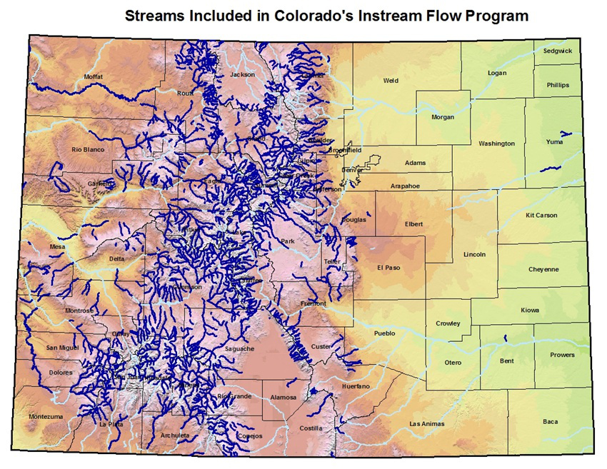
From TheDenverChannel.com:

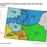
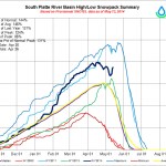
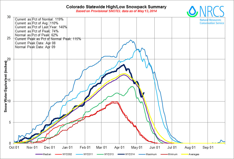
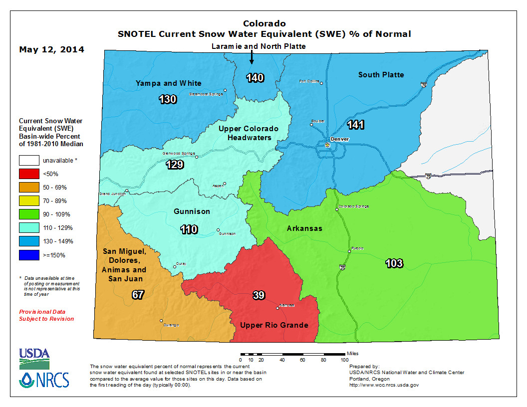
Colorado’s statewide snowpack is at 120 percent of average right now. Last year at this time, it was at 82 percent.

State and federal firefighting bosses say the current outlook for fire season in Colorado is expected to be normal, at least for the early part of the wildfire season.

Colorado Gov. John Hickenlooper said the “closer to average” prediction entails 3,000-3,500 fires, including about 300 of substantial size. All told, those fires could burn about 100,000 acres.

To help our state when fires happened, Hickenlooper signed three bills Monday related to wildfires:

  • HB14-1008: Allowing the Colorado Water Resources and Power Development Authority to make loans for forest health projects.
  • HB14-1010: Makes adjustments to the prescribed burning program under the Division of Fire Prevention and Control in the Department of Public Safety.
  • SB14-164: Creates an aerial firefighting fleet that will include four planes, four leased helicopters, and money for a center to study high-tech firefighting equipment like night vision goggles.
  • From the Sky-Hi Daily News (Leia Larsen):

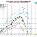
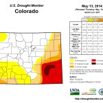
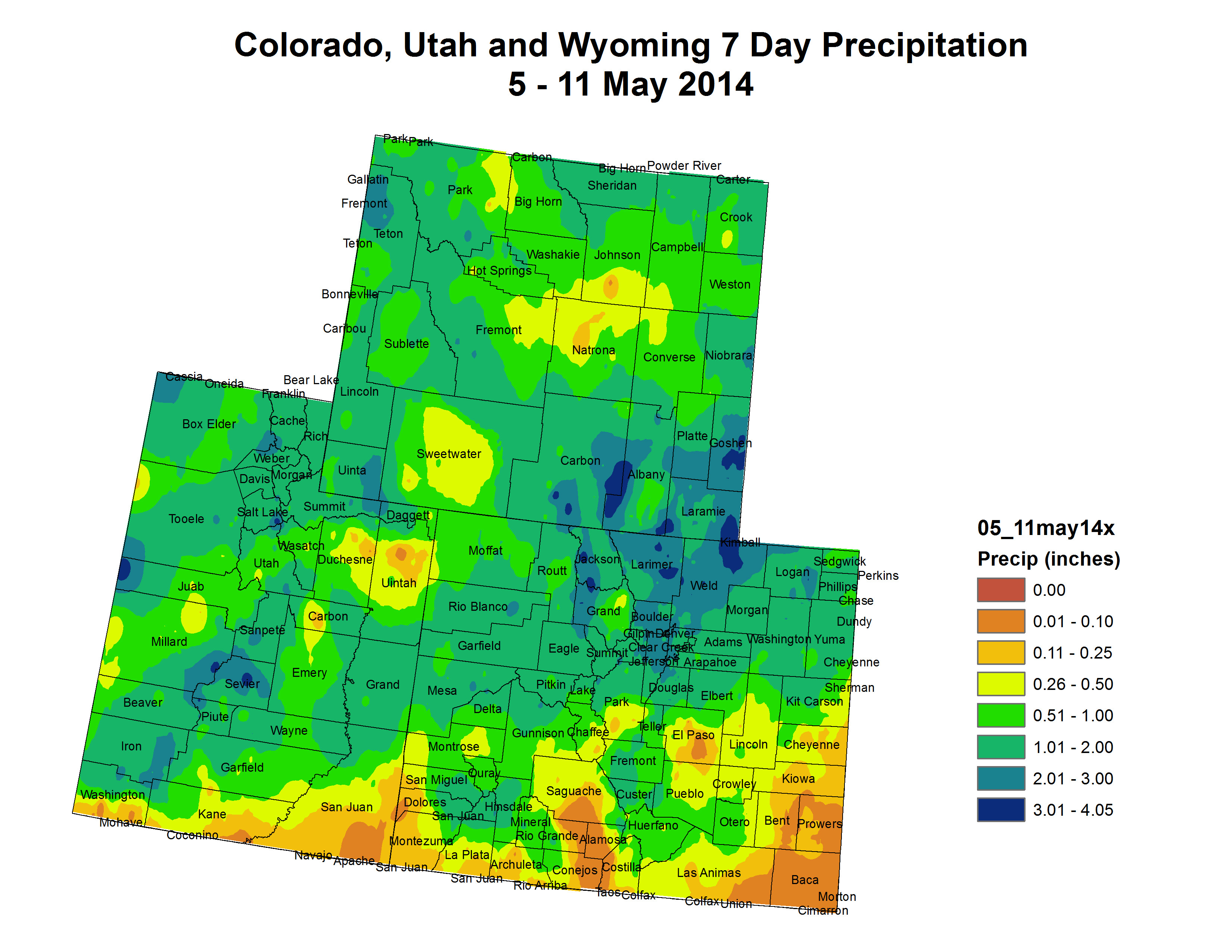
    Drought has been on the tongues of many water managers for the last few years, but 2014 brought some relief, at least to Grand County.

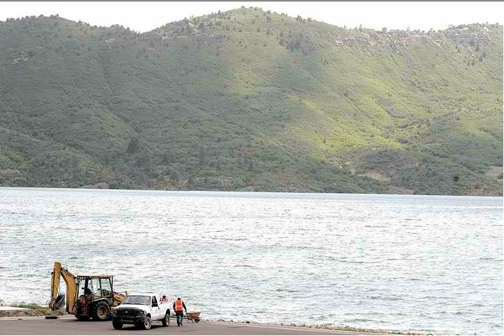
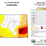
    That relief comes from a high snowpack, which last month was 44 percent above average according to information from the National Resource Conservation Office in Kremmling. According to officials who spoke at the Grand County State of the River meeting on Tuesday, May 13, that means Middle Park residents should expect to see reservoirs easily fill to capacity. It’s also likely less water will need to be piped to the Front Range. Farther downstream, however, drought still plagues the West.

    “If it’s north of Glenwood Springs and east, it’s going to fill and spill. If it’s south and west, it’s not,” said Eric Kuhn, general manager of the Colorado River District, at the meeting.

    According to Don Meyer, operator of Wolford Mountain Reservoir for the Colorado River District, that doesn’t mean locals should worry about flooding.

    “We’re not going to see a 2011 year in terms of runoff and flooding,” he said. “Instead, 1997 is more a comparable year to this year in terms of snow.”

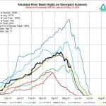
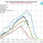
    The 2010 and 2011 winter season brought epic conditions for skiers and snowboarders, but its high snowpack also brought a lot of flooding fears. As the snow melted, the Colorado River near Kremmling ran several times above 9,000 cubic feet per second, Meyer said. The 1997 season, however, only peaked at around 8,000 cfs once during the runoff period…

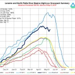
    With the Colorado-Big Thompson Project, Andrew Gilmore with the Bureau of Reclamation also expects plenty of runoff. His agency manages Lake Granby and Shadow Mountain Reservoir, pumping Colorado River water through Grand Lake to the Front Range.

    “We’re above average, but it’s nothing like 2011,” he said. “Cold weather will likely slow the runoff down.”

    Still, Gilmore noted recent snowstorms have likely built up the snowpack even more. While he expects Lake Granby to fill without spilling, he said a spill isn’t out of the question.

    Jeff Drager with Northern Colorado Water Conservancy District, which jointly operates the C-BT with the Bureau of Reclamation, agreed that it’s too early to predict how runoff will influence Lake Granby.

    “It’s a flip of a coin whether going to spill or not,” Drager said.

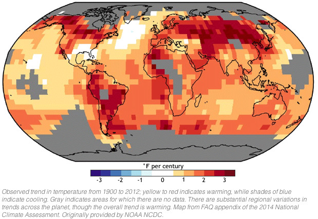
    Gilmore also noted the need for water managers to address runoff issues in a warming global climate.

    “Spring runoff is happening earlier in Colorado,” he said. “It’s one of the changes to our global climate season.”

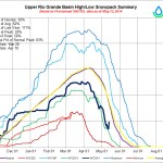
    Denver Water is predicting plenty of runoff on the East Slope as well. According to Bob Steger, a manager with Denver Water, they’ll be trying to fill Gross Reservoir with water from South Boulder Creek. That could mean supplements from the Moffat Collection System, which pipes water east from the Fraser River, will be minimal. About a fourth of Denver’s water comes from the Moffat Collection System in typical years.

    “We don’t know how much of the South Boulder Creek Water we’re going to get to store, but we’re optimistic we’ll be able to store a lot of it, because there is a lot of snow on the east side of the Divide,” he said.

    Denver Water will also be trying to store water from peak flows in Williams Fork Reservoir, which is used to supplement downstream water rights calls.

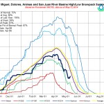
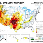
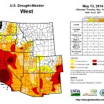
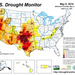
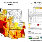
    Those downstream needs are likely to be significant, as drought still plagues much of the southwest. California is facing its worse drought on record, causing its governor to declare a state of emergency this winter. The Colorado River, which feeds six other states besides Colorado as well as Mexico, is becoming a symbol of dwindling water in the West. Water levels on the river’s two largest reservoirs, Lake Powell and Lake Mead, have dropped drastically to historic lows, threatening water and electricity supplies for millions. Even as Colorado breathes a sigh of relief with its plentiful snow, Kuhn with the Colorado River District stressed the need for continued conservation.

    Lake Powell power pool affected by drawdown and drought #ColoradoRiver

    Glen Canyon Dam -- Photo / Brad Udall
    Glen Canyon Dam — Photo / Brad Udall

    From the Cortez Journal (Jim Mimiaga) via The Dolores Star:

    The problem is a looming concern for reservoirs in the Colorado River basin upstream from Lake Powell. Those reservoir managers face the possibility of having to deliver water downstream to boost levels and avert a shutdown of the plant. Local reservoirs, including McPhee, Lake Nighthorse, Navajo, and Blue Mesa, could potentially be tapped for additional water under the “call” system if conditions don’t improve in the next one to two years, water officials report. Now is the time to have the discussion of how to deal with the situation unfolding at Lake Powell, said Mike Preston, general manager for the Dolores Water Conservancy District, which operates McPhee Reservoir at Dolores.

    “If Powell becomes too low to operate, it would trigger a crisis, so we need to decide early on how we would deal with that,” Preston said during a meeting about reservoir operations in Dolores last week.

    According to a February memorandum from the Colorado Water Conservation Board, Lake Powell (of the Upper Colorado Basin) and Lake Mead (of the Lower Colorado Basin) could soon become too low to operate their hydropower plants if conditions don’t improve…

    According to the simulation, as early as 2015, Lake Powell could drop to, or below, the minimum power-pool level required to operate the hydroelectric generators. If the pattern materializes, the level would stay below the power pool for years and by 2020 still not have recovered to power-producing levels.

    Allowing Lake Powell to fall below the minimum power pool has numerous dire consequences, according to the CWCB memo:

    It would result in dramatically higher electric costs for cities, towns and farms throughout much of Colorado, increasing rates two to four times. The Dolores Project relies on power generated from Glen Canyon sold at a discounted rate.

    Funding for irrigation projects derived from power-plant revenues would dry up.

    Reduced capacity to make releases from Glen Canyon Dam threatens compliance with Colorado River Compact obligations. The result could be litigation and curtailment of water use within the Upper Basin states, which includes Colorado.

    “In light of these real and immediate threats, the governor’s Colorado River representative directed a group of Colorado water advisers to engage six Colorado River Basin states in confidential brainstorming and system modeling for the purpose of developing an emergency response plan,” the memo states.

    Solutions to prevent a shutdown of power plants at Lake Mead and Lake Powell may involve delivering more water downstream, the memo states. That could impact storage yields from upstream reservoirs on the Green, Gunnison, San Juan, Animas and Dolores Rivers, among others. Implementing demand-management programs to bolster Lake Powell could also involve voluntary lease-fallowing or deficit irrigation.

    “The water-management world cannot be in denial about drought, and we have to be mindful and adaptable,” Preston said. “There is already talk about making contributions to bring Powell up. It could be sooner rather than later where we are forced to confront demands larger than our basin.”

    More Colorado River Basin coverage here.

    Animas-La Plata project: Sens. Udall and Bennet pen letter to Reclamation asking for quicker opening of Lake Nighthorse to recreation

    Lake Nighthorse first fill via The Durango Herald
    Lake Nighthorse first fill via The Durango Herald

    From The Durango Herald (Sarah Mueller):

    The frustration surrounding Lake Nighthorse found a fresh voice Thursday as Sens. Mark Udall and Michael Bennet wrote to the U.S. Bureau of Reclamation asking the agency to issue a plan for opening the reservoir for recreation soon. The letter says recreation on Lake Nighthorse could bring in up to $12 million each year to the local economy.

    “The completed Lake Nighthorse reservoir is conveniently located two miles from downtown Durango and presents a significant opportunity for a new public amenity,” the two Democrats wrote.

    The reservoir was filled in June 2011, but the parties involved, after years of talks, have yet to agree on major issues. However, bureau spokeswoman Justyn Hock said they seem to be close to finalizing the agreements. The agency plans a public meeting in June to update residents on negotiations.

    “We feel like the end is in sight,” Hock said. “We’re getting really close to having an agreement in place.”

    Lake Nighthorse is a reservoir with 1,500 surface acres created in Ridges Basin southwest of Durango by the U.S. Bureau of Reclamation to provide water for Native American tribes, cities and water districts in Colorado and New Mexico. Southwestern Water Conservation District owns the water rights. The water is allocated, but not owned, through project contracts to the Southern Ute Indian Tribe, the Ute Mountain Ute Tribe, the Navajo Nation, the Animas-La Plata Conservancy District, the state of Colorado, the San Juan Water Commission and the La Plata Conservancy District. The entities formed the Animas-La Plata Operation, Maintenance and Replacement Association in 2009, which fronted money in anticipation of water purchases by the city of Durango and the Animas-La Plata Water Conservancy.

    Calls to several Animas-La Plata Operation, Maintenance and Replacement Association stakeholders were not returned.

    There are three agreements under negotiation: an annexation agreement, a lease agreement and memorandum of understanding.

    The city of Durango has offered to operate the park but wants to annex the area to provide police protection. The Utes have said annexation is unacceptable. There’s been conflict about who should run the park and be involved in making decisions. The Utes also have said they must be able to exercise Brunot Treaty rights to hunt on ancestral land.

    In a statement, the Southern Utes said important issues need to be addressed, including tribal treaty rights, protection of historic cultural resources, and operation of the project for the specific purposes for which it was built.

    “We’re working with the tribes in particular to make sure that we’re protecting their cultural resources,” Hock said…

    “While use of the lake for recreational purposes was contemplated during the reservoir planning process, it is not a specific project purpose,” said a Southern Ute Tribal Council statement from last year.
    Irrigation was cut because of environmental problems. Southwestern Water Conservation District was awarded the water rights to the A-LP project in a 1966 State District Water Court decree that allowed irrigation and recreation as water uses.

    “Unfortunately, the need to comply with applicable laws is not always well understood by those unfamiliar with these laws,” the Tribal Council statement said.

    The reservoir was filled in June 2011 but stayed closed while those involved bickered and delayed. But Cathy Metz, parks and recreation director, also believes progress is being made. After the lease agreement is signed, an inspection station and decontamination area needs to be built. The Animas-La Plata Operation, Maintenance and Replacement Association received grant funding for the construction. The city also has received some grant funding from the state for some improvements to the park. The earliest it could open would be 2015.

    More Animas-La Plata Project coverage here and here.

    A brief history of Water in Colorado

    #COdrought news: Wet monsoon season?

    Click here to go to the US Drought Monitor website. Here’s an excerpt:

    The Plains

    Heavy rains fell across western, northern and eastern Nebraska last week, leading to significant improvements in the Panhandle, where D0-D2 have been pushed back to the east and from the north to the south. The biggest improvements, however, were seen in east-central Nebraska, where the storms dumped anywhere from 3 to 5 inches or more, leading to reduction of drought and a pocket that is now drought-free with short-term and lingering long-term dryness/drought concerns eased for now. The recent wet trend continued across southeastern South Dakota as well, bringing more improvements with the reduction of D0-D1 there and across the border into Minnesota as described above.

    Farther south, Kansas also saw a mixed bag this week with heavy but narrow bands of storms putting a small dent in the drought there, particularly in central Kansas where the D3 was trimmed, leaving D2 behind. Elsewhere in Kansas, though, the drought strengthened its grip and was accompanied last week by well above normal temperatures, leading to an expansion of D4 into the extreme southwestern reaches of the state to the Oklahoma border.

    Oklahoma also felt those hotter temperatures along with some below-freezing readings late in the period, leading to more damage to the winter wheat crop, which has felt the brunt of a cold winter and coinciding drought. However, heavy rains did fall across the southeast corner of the state, bringing some 1-category improvement there.

    In Texas, scattered totals of 2 to 4 inches fell across northeastern and eastern counties this past week, leading to some relative improvement with a push west and south of D0-D3 in these areas. In fact, the area of D3 located just off the coast in southern Texas has been removed this week. Some slight trimming of the D4 was also seen this week in south-central Texas. Deep south Texas also shared in the improvements with the elimination of D2 and trimming of D0-D1. The southeast coastal region continued to miss out on the rains (although rains were falling in this region just after the cutoff time for the USDM production), leading to a push of D2 eastward into southwest Louisiana on this week’s map…

    The West

    Most states in the West saw below-normal temperatures last week, helping preserve the precious liquid cargo contained in the upper elevations and reservoir systems. A mixed bag of improvements and deterioration is noted on this week’s map. In Colorado, storms continue to avoid the southeastern corner of the state, leading to an expansion of D3 westward along with D0-D2 south of the Sangre de Cristo Mountain range. Notable improvement in the moisture situation in northwestern Colorado also leads to a reduction of D0, which also pushed improvement west into east-central Utah.

    In Arizona, continued dryness leading up to the monsoon season means an expansion of D2 in the northwest, northeast and southern regions of the state.

    A very favorable precipitation pattern for the calendar year-to-date (10 to 50% above the average) continued this past week, which has led to gradual improvement in the Pacific Northwest region as a whole. In Washington, the remaining dryness and drought has been reclassified to long-term (given the larger-scale wetness on the year-to-date) as denoted by the “L” and a resultant shift in the “L” impact line area found in Washington, Oregon and Idaho, as these areas are now connected. Most of the Willamette Valley improves to D0 from D1 this week and more of northeastern and north-central Oregon has also improved to D0. The southern half of Oregon remains unchanged.

    All of California is now depicted as being in severe drought (D2) or worse this week, with the D3/D4 areas remaining unchanged. Attention this week turns to the heat wave settling in, which will only serve to exacerbate and accelerate drought impact concerns across the state. Increases on water demand and the increased risk of fire will ramp up as the heat does…

    Looking Ahead

    Over the next 5 days (May 14-19), the National Weather Service is calling for a strong system to bring widespread and locally heavy rains to much of the Southeast, Mid-Atlantic and Northeast. West of the Mississippi River looks to be pretty dry for the most part except for Arkansas, where an inch or so is expected across the eastern half of the state. As for temperatures, most of the West can expect temperatures to run 3 to 6 degrees (or more in the Great Basin) above normal. For just about everybody else east of the Rockies, temperatures are looking to stay cooler than normal at 3 to 10 degrees below normal.

    This week’s 6-10 day (May 20-24) day outlook from the Climate Prediction Center is showing a tilt in the odds toward above-normal temperatures in all but the interior of Alaska, the West Coast, Pacific Northwest, central Plains and Midwest, with below-normal temperatures expected in the Four Corner region and into the central Rockies as well as along the western Gulf Coast. As for precipitation during this period, above-normal precipitation is more likely in southeastern Alaska, most of the West Coast from central California up to Canada, southern New Mexico, the lower Mississippi Valley, the Southeast and the southern Mid-Atlantic region. Above-normal precipitation is looking favorable across the northern Great Lakes and Plains regions along with the Great Basin, central Rockies and western reaches of the southern Plains.

    Meanwhile the Climate Prediction Center is predicting a wet summer over Colorado.

    June, July, and August precipitation outlook via the Climate Prediction Center
    June, July, and August precipitation outlook via the Climate Prediction Center

    Weekly River Report – River flows throughout the Roaring Fork Watershed are significantly lower than normal for this time of year

    Many eyes are watching the #ColoradoRiver to see if it reconnects with the ocean today

    Photo via the National Geographic
    Photo via the National Geographic

    From the Las Vegas Review-Journal (Henry Brean @RefriedBrean):

    The blue of the river could spill into the brown of the Gulf of California’s tidewater channel during high tide Thursday, based on projections from conservationists and federal officials who are tracking the experimental flood unleashed in late March. It would mark the first time in 20 years that the Colorado has reached the sea, though such a re-connection was never guaranteed. It wasn’t even really the point of the so-called “pulse-flow,” said Jack Simes, spokesman for the U.S. Bureau of Reclamation.

    The goal of the two month, 34-million-gallon experiment was to send water down the river’s historic channel to five restoration sites in Mexico and one in Arizona where researchers are trying to bring back the flood-adapted willow and cottonwood forests that once lined the Colorado’s banks.

    “That’s been achieved,” Simes said. “The bonus I guess is if (the water) made it to the sea.”

    If that’s going to happen, it needs to happen soon. The pulse flow is scheduled to end Sunday, when Morelos Dam will close its gates and return to its usual role as the Colorado’s last stop…

    Simes said regular water flow to the Gulf of California ended in the 1960s with the construction of Glen Canyon Dam and the creation of Lake Powell on the Utah-Arizona border. The last significant release of water to the delta came in 1983, when record flooding on the Colorado caused Lake Mead to spill for the first time. The last time the river reached the sea was in 1993, during heavy flooding on the Gila River, a tributary of the Colorado in southern Arizona.

    The pulse flow was made possible by a 2012 amendment to a 70-year-old treaty between the United States and Mexico. Known as Minute 319, the amendment spells out how Mexico will share in shortages and surpluses on the river while allowing that nation to store water in Lake Mead for future use, just as Nevada, Arizona and California do.

    The initial pulse of water to the delta eventually will be followed by a small but steady stream of “base flows” totaling about half of the current flood and designed to keep the channel wet during the growing season as the riparian habitat struggles back to life.

    A coalition of nonprofit groups on both sides of the border will secure the water for the base flows by buying up temporary water rights from willing sellers in Mexico.

    Jennifer Pitt is Colorado River project manager for one of those nonprofits, the Environmental Defense Fund. She considers what man has done to the Colorado “a fundamental disruption of nature,” so seeing the river reach the sea again certainly has symbolic value, even if it wasn’t why the pulse flow experiment was undertaken.

    “We’ve been missing that connection for a long time,” Pitt said. “It does feel meaningful. What it will mean from an ecological perspective will be up to the researchers to figure out.”

    If the river does reach the gulf on Thursday, the connection will be fleeting. As soon as the flow through Morelos Dam is halted this weekend, there will be nothing left in the river downstream to keep the delta from drying up once more.

    More Colorado River Basin coverage here.

    7News finds polypropylene microbeads in samples from the South Platte River

    Polypropylene microbeads via CBS Chicago
    Polypropylene microbeads via CBS Chicago

    From TheDenverChannel.com (Theresa Marchetta, Catherine Shelley, Marianne McKiernan):

    In the first known test for the small plastic beads in the river, CALL7 Investigators hired experts to test water samples. The results confirmed that the plastic microbeads from toothpastes, face washes, body washes, shampoos, eyeliners, lip glosses and deodorants had indeed made it through the state’s filtration systems and into the river…

    Before our test, Greg Cronin, an aquatic ecologist and professor of integrated biology at CU Denver, told CALL7 Investigator Theresa Marchetta, “I’m sure if you went downstream of the Metro Wastewater Reclamation District, where basically the sewage system for Denver, where all these microbeads pass through…you would probably be able to find these microbeads.”

    He added, “People might not have just looked yet.”

    Cronin was correct. We found no one is testing for microbeads in Colorado. So we did our own test, sending water samples collected from the South Platte River to a specialized lab in Marietta, Ga., where they confirmed “polypropylene,” or plastic was floating in the water.

    Polyethylene and polypropylene are the same types of plastic used to make milk jugs, bottles and other common household containers.

    The Water Quality Control Division declined our request for an interview, but an email from Meghan Trubee, spokeswoman for Colorado Department of Public Health and Environment said,

    “Drinking water treatment would capture and remove microbeads during the treatment process eliminating them from drinking water supplies. At this time, our work has not focused on this emerging issue nor have microbeads been brought to our attention specifically. Our research regarding microbeads reveals that this is an emerging issue.”

    Some of the microbeads are easy to identify, like the ones found in face scrubs or toothpastes. Crest says the plastic is added to several of that brand’s toothpastes as “a safe, inactive ingredient used to provide color.”[…]

    “Plastics don’t degrade. They actually just break into smaller particles of plastics,” said Cronin, the aquatic ecologist and biology professor. “The particles can be as small as a micron, the size of a bacterial cell, so that you wouldn’t be able to see them with the naked eye.”

    According to Cronin, these plastics by nature attract toxic compounds like pesticides, and, ironically, are often used to remove harmful chemicals from water, which leads to other concerns.

    “That same property causes these plastics to absorb these same toxins in the environment, so when an animal ingests it they’re getting extremely high concentrations of these pesticides and other industrial chemicals,” said Cronin. Then humans consume the toxins when they eat the fish or animals who have ingested the plastics.

    Manufacturers using the microbeads in toothpaste readily admit the plastic serves no real purpose. There’s no flavor, nor any cleaning benefits. Lobbying efforts have created a greater awareness of this issue and some manufacturers set timelines to remove the plastics from their products.

    Procter and Gamble, the manufacturer of Crest, stated in an email to CALL7 Investigators, “We are discontinuing our limited use of micro plastic beads as scrub materials in personal care products as soon as alternatives are qualified.”

    Cronin says if you’re not thinking about microbeads, you should be.

    “Yes we should care,” said Cronin. “What we should do is stop using them in the products, especially products that get flushed down the sink, immediately.”

    More water pollution coverage here.

    Animas River: e.Coli is a culprit in water quality

    E.coli Bacterium
    E.coli Bacterium

    From The Durango Herald (Dale Rodebaugh):

    The main focus of the San Juan Watershed Group research is E. coli and nutrients – nitrogen and phosphorus. Certain strains of the former can cause nausea, fever and vomiting. The latter, in excess, robs water of oxygen needed by aquatic life.

    The group tested only for E. coli last year. This year, nutrients were added. So far this year, the E. coli level has been well within limits at the New Mexico line, May said.

    A Colorado partner, the Animas Watershed Partnership, which works on water-quality projects in New Mexico and with the Southern Ute Indian Tribe, also is following the work of May’s group, now in its second year, said Ann Oliver, coordinator of the Colorado project.

    Oliver said her group is searching for funding for similar research at two points upstream – on the Animas upstream of the Florida River and on the Florida before it reaches the Animas, she said…

    The hope is to get enough money to test for E. coli and nutrients at the Animas and Florida sites and pay for genetic testing at Bondad to determine the source of E. coli contamination, Oliver said. May’s volunteers measure the amount of E. coli and nutrients at the site here, but the organization can’t afford the cost of source analysis.

    Last year, May’s volunteers sampled water once a week from April through October on the Animas at the state line (Bondad), Aztec and Farmington and on the San Juan River at Farmington and Hogback Canal, the point where the San Juan enters the Navajo Nation…

    Laboratory tests can determine through DNA analysis if E. coli bacteria come from animals – and which animals – or from human sources. Tests last year in Colorado showed that E. coli met the state’s standards, indicating that contamination was originating downstream in New Mexico.

    In fact, all 40 samples collected at Hogback Canal tested positive for human bacteria found in feces, the report said. Nearly all 40 samples from Farmington and 26 from Aztec tested positive for the human bacteria.

    A story in the The Daily Times of Farmington quoted Mike Stark, the San Juan County operations officer, as saying that officials know that aging septic systems and illegal septic dumping are potential problems.

    David Tomko, retired from the New Mexico Environment Department, now the San Juan Watershed Group coordinator, is cautious. Tests for human fecal matter in the Cimarron and Rio Grande rivers found no human waste, so conclusions about the Animas and San Juan readings require confirmation, he said.

    The heavy metals leaching from shuttered hard-rock mines around Silverton present no problem at the state line because of dilution, Tomko said. The level of those metals never has exceeded the limit, he said.

    Peter Butler, former chairman of the Colorado Water Quality Control Board and a coordinator of the group looking for a solution to the toxic waste draining from Silverton mines, said heavy metals are diluted enough to be below limits by the time the Animas River reaches Durango.

    Even heavy-metal contributions from Lightner Creek don’t push Durango over the limit, Butler said.

    May’s group also tests water for turbidity, pH, optical brighteners (detergent additives that brighten colors) and total dissolved solids.

    On Monday, the Animas River water didn’t look as cloudy when May poured it from the dipper into sample bottles as it did flowing in the channel.

    Last year at about the same time – the spring runoff – the Animas water registered 13.5 turbidity units, May said. During the later monsoon season, she found upward of 600 units.

    Turbidity is measured by a nephelometer, an apparatus that records size and concentration of particles in a liquid by analyzing the refraction of light beamed into it.

    More Animas River coverage here and here.

    Snowpack news: Statewide snowpack above 100% of average, south dry, north wetter #COdrought

    Statewide Basin High/Low graph May 13, 2014
    Statewide Basin High/Low graph May 13, 2014

    From CBS Denver:

    The Mother’s Day snowstorm that hit Colorado put the state’s snowpack well over 100 percent of normal.
    Before the storm snowpack measured at 93 percent of normal on average across the state.

    “Statewide totals went from 94 percent of normal on Friday to 120 percent as of today,” said Snow Survey Assistant Supervisor Mage Hultstrand…

    “We had over an inch of water added to the state,” said Hultstrand.

    It’s that additional water that’s raising concerns of how it will impact this year’s flood risk.

    “The stage is set for potential flooding because we do have a high snowpack and because damage to stream channels from the flooding last September,” said meteorologist Chad Gimm.

    The recent storm may have been more helpful than hurtful.

    “We don’t want to continue adding to an already large snowpack but the cooler temperatures and the additional fresh snow does delay the melt,” said Hultstrand.

    2014 Colorado legislation: The recently concluded session had a big focus on water bills #COleg

    Colorado instream flow program map via the Colorado Water Conservation Board
    Colorado instream flow program map via the Colorado Water Conservation Board

    From the Glenwood Springs Post Independent (Hannah Holm):

    The Colorado legislative session that just wrapped up featured more significant water bills that the Colorado General Assembly has considered for several years. They ranged from a proposal to limit lawn sizes in new developments relying on agricultural water to technical tweaks to Colorado’s complex system of administering water rights.

    Promoting efficiency and flexibility were common themes in the introduced bills, along with programs to help repair infrastructure damaged by last fall’s floods. Some were passed and some weren’t, and the water gossip network is buzzing with rumors that Governor Hickenlooper is being lobbied to veto some of the measures that made it to his desk. Here’s a quick summary of some of the more high-profile bills that were considered and their fates.

    LAW LIMITS NOT REQUIRED — YET

    Senate Bill 14-017, in its original form, sought to limit the replacement of irrigated farmland with irrigated lawns. The bill would have prohibited approval of new subdivisions that buy agricultural water rights to serve their residents unless lawns are limited to 15 percent or less of the total area of the residential lots. The bill was passed after it was converted into a bill to require a study of ways to limit municipal outdoor water use.

    APPLYING AG SAVINGS TO BENEFIT STREAMS WINS SUPPORT, THOUGH CONTROVERSIAL

    Senate Bill 14-023 sought to remove “use it or lose it” disincentives for irrigation efficiency improvements that could benefit streams. The bill would allow irrigators west of the Continental Divide who reduce water diversions through increased efficiency to transfer or loan the rights to the “saved” water to the state to benefit streams. It would also ensure that those rights are not legally abandoned. This would only apply to water that was not consumed under pre-efficiency practices, but rather lost in transit, and would only be allowed if it wouldn’t damage someone else’s water right.

    Senate Bill 14-023 had a similar intent to a proposal that ran into trouble in the 2013 legislature. The 2014 measure won much broader support. It was crafted through an extensive process of stakeholder consultations between environmental and agricultural interests, and it was ultimately passed by both the House and Senate. The bill remains controversial, however, due to concerns that it could deprive upstream junior water users of access to water no longer needed by downstream senior users, as well as concern that it would increase the amount of time and money water users have to spend defending their interests in water court. As of this writing, the bill had not yet been signed by Governor Hickenlooper, and rumors were swirling that he was being lobbied to veto the measure.

    PHASE OUT OF INEFFICIENT PLUMBING FIXTURES PASSES, STILL OPPOSITION

    Senate Bill 14-103 would phase out the sale of plumbing fixtures that don’t meet the “WaterSense” standards for efficiency developed by the federal Environmental Protection Agency. It was passed by the General Assembly, but is still waiting for Governor Hickenlooper’s signature. Opponents of the measure say it inappropriately calls for a “one-size-fits-all” approach to conservation, wouldn’t be effective and would limit consumer choice.

    FLOOD RELIEF BILLS PASS

    Flood relief bills offered both funding and regulatory streamlining. HB 14-1002 sought to appropriate $12 million for a new grant program to repair water infrastructure damaged by a natural disaster. After bumping the amount up to $17 million, the General Assembly passed the bill. HB 14-1005 sought to reduce legal hurdles for rebuilding irrigation diversions in cases where flooding changed the stream in such a way that the original diversion point would no longer work. The bill allows water-right holders to relocate a ditch headgate without filing for a change in water court, as would normally be required, as long as the change won’t damage someone else’s water right. The General Assembly passed the bill.

    FLEXIBLE WATER MARKETS MEASURE GETS STUCK

    A bill seeking to make it easier for agricultural users to lease some of their water right to other users as an alternative to permanent “buy and dry” did not fare as well. HB 14-1026 would have allowed irrigators who free up water through fallowing some land, deficit irrigation (giving crops less water than they really want) or planting less thirsty crops to ask the state engineer for permission to change the use of that water without having to designate exactly what the new use will be. Water court wouldn’t have been involved unless there was an appeal. The bill passed the House, but got hung up in the Senate Committee on Agriculture, Natural Resources, & Energy.

    You can trace the history of bills through the legislature, and see whether the Governor has signed them yet, at http://www.leg.state.co.us.

    More 2014 Colorado legislation coverage here.

    Arkansas Basin Roundtable meeting recap #COWaterPlan

    Arkansas River Basin -- Graphic via the Colorado Geological Survey
    Arkansas River Basin — Graphic via the Colorado Geological Survey

    From The Pueblo Chieftain (Chris Woodka):

    A series of community meetings on the development of a state water plan appears to be raising some lingering water issues. The Arkansas Basin Roundtable is sponsoring the meetings throughout the area in an effort to encourage more people to participate in a statewide water planning process.

    Although the roundtable has met nearly every month since 2005, with ample opportunities to participate, there has been concern from the state Legislature that meetings have not been inclusive enough statewide. More than 20 non-members typically attend the Arkansas Basin Roundtable meetings.

    In March, the roundtable redoubled its efforts to reach out, and already has held a dozen meetings, including the Arkansas River Basin Water Forum in April. At least six more meetings are planned, including one in Pueblo — no date or place have been set. Information can be found at the website, http://arkansasbasin.com.

    Meetings so far have attracted anywhere from a handful to 60 people. The largest was at Primero during a snowstorm. Reactions have ranged from acceptance to resistance by some who believe the water plan will mean more regulations.

    In Lamar, the biggest issue seemed to be the impact of a dam on Fountain Creek on downstream water rights, said Henry Schnabel, Prowers County commissioner. The dam is favored by some in Pueblo to contain increased flood flows caused by development in Colorado Springs. Farmers in the eastern part of the state fear that would change the timing of flows that reach the Arkansas River and reduce the amount of water they receive from Fountain Creek storms.

    “A lot of times, we feel like we’re left out,” Schnabel said. “If you stop the water on Fountain Creek, we need to come up with a solution.”

    Roundtable members were grateful for the turnout witnessed so far.

    “It’s good to see the level of involvement, because we’ve reached out,” said Alan Hamel, former chairman of the roundtable and the basin’s representative on the Colorado Water Conservation Board.

    From The Pueblo Chieftain (Chris Woodka):

    Urban water conservation measures could be difficult to measure in the Arkansas River basin, where size and scope matter. The Arkansas Basin Roundtable confronted the issue Wednesday as it continues toward developing a basin implementation plan by July. The basin plan is part of a broader effort to develop a state water plan.

    Most roundtable members resisted a preliminary approach by consultant Mark Shively that sought to create a “point system” that would identify best practices to save water.

    The only part of the proposal that truly resonated was the statement: “One size does not fit all.”

    “The conservation plan does not take into account things like our wise use campaign or economic forces within communities,” said Terry Book, executive director of the Pueblo Board of Water Works. “Demographics make a difference. I believe each community has the obligation to define good, better or best.”

    Pueblo’s per capita water use has dropped as much as other Colorado communities with aggressive conservation campaigns since 2002. Some of that is because of the downturn in the economy, but a 2007 survey found customers’ habits have changed as well.

    In Crowley County, the per capita use is higher because domestic water supplies overlap with water for horses or other livestock, said Rick Kidd, who represents the county on the roundtable.

    Communities that already have lowered water use could be penalized under a point system, said Dave Taussig, who represents Lincoln County.

    The danger of voluntary guidelines is that they could, over time, become mandatory, said Joe Kelley, superintendent of La Junta water.

    “The first thing you know, everybody’s regulated,” Kelley said. “Then you have to spend money you don’t have to get money for grants.”

    Snowpack/runoff news: The Mother’s Day beautiful snow boosts snowpack across Colorado #COdrought

    Click on a thumbnail graphic to view a gallery of snowpack data from the NRCS. What a difference one storm can make. Pay closer attention to the current SWE as a percent of average since the melt-out had started.

    From 9News.com (Maya Rodriguez):

    Sunny skies, climbing temperatures and mountain snow: it’s a combination that could signal a coming thaw this weekend. For those who live near the rivers fed by spring runoff, it is now a time to be vigilant, according to meteorologist and Lyons resident Greg Berman…

    After this past weekend’s winter weather, the snowpack in Colorado is high. The National Weather Service said it is at 136 percent of normal for the Upper Colorado Headwaters, 143 percent for the North Platte and Laramie Basin and 145 percent for the South Platte.

    One of the tributaries of the South Platte River is the St. Vrain River, which runs right through Longmont. It is an area that is scarred when it comes to high water and officials are already taking precautions.

    “Our staff is periodically moving into a daily regimen where they are traveling up and down the river, looking at any signs of high water coming up, debris catching up on bridges and those kinds of things,” Longmont’s Director of Public Works and Natural Resources Dale Rademacher said…

    One of the other unknown factors in all this is the topography itself. It has changed since last year’s flooding, and that could also mean changes this year’s spring runoff, including what areas may see the most impact, something that may not be clear until it happens.

    From the Estes Park Trail-Gazette (David Persons):

    “It was extremely wet,” said John Gulliksen, who gathers information locally for the National Weather Service. “It’s as wet as I’ve ever seen (for this time of year). I couldn’t push the snow very far or lift it to throw it.”

    The numbers support Gulliksen.

    According to his instruments, this two-day snowstorm dumped just over a foot (12.4 inches; ) of snow on the town. The 22-year average for snowfall in May in Estes Park is 6.9 inches; .

    “This is pretty significant for May considering the amount,” Gulliksen added. “We do get snow in May but usually we get most of it in March and April. This year was an exception.”

    Of course a late, wet snow is not exactly what Front Range officials want to hear. They are already weary of a swift, sudden snowmelt that could bring flooding back to the Front Range area which is still recovering from last September’s record-setting event…

    Area snowfall totals from the National Weather Service for the May 11-12 snow event:

    Allenspark, 23.5 inches; Bailey, 9.5 inches; Bergen Park, 12 inches; Black Hawk, 16.8 inches; Breckenridge, 10.9 inches; Broomfield, 6.2 inches; Castle Pines, 6 inches; Cheesman Reservoir, 7 inches; Conifer, 16 inches; Eldorado Springs, 11 inches; Elizabeth, 7 inches; Evergreen, 13 inches; Federal Heights, 6 inches; Fort Collins, 6.9 inches; Four Corners, Larimer County, 29 inches; Genesee, 16.6 inches; Greeley, 2.8 inches; Green Mountain Reservoir, Summit County, 8 inches; Highlands Ranch, 7 inches; Hugo, 3.5 inches; Karval, 2 inches; Ken Caryl, 7.8 inches; Lafayette, 4.5 inches; Littleton, 5.2 inches; Nederland, 16.5 inches; Northglenn, 8.1 inches; Pinecliffe, 15.1 inches; Pingree Park, 28 inches; Silver Plume, 16.8 inches; Thornton, 4.3 inches; Thurman, 6 inches; Virginia Dale, 16 inches; Westminster, 6.7 inches; Wheat Ridge, 5.3 inches.

    It’s the 50th year of the Wilderness Act

    The latest briefing from Western Water Assessment is hot off the presses

    Click here to go to the Western Water Assessment Climate Dashboard. Here’s an excerpt:

    Highlights

  • April was generally drier than average across the region, with few mountain areas seeing above-average precipitation, in contrast with previous months. The second week of May brought heavy precipitation to many parts of the region.
  • As of May 13, snowpack conditions are similar to one month ago, with near-normal to above-normal SWE in Wyoming, northern and central Colorado, and northern Utah, and below-normal SWE in central and southern Utah and southern Colorado.
  • The May 1 spring-summer streamflow forecasts slipped a little from the April 1 forecasts, though still calling for most forecast points in Wyoming and northern and central Colorado to have above-average or much-above-average spring runoff. Most forecast points in south-central and southwestern Colorado, and in Utah south of the Wasatch Front, are expected to have below-average or much-below-average runoff.
  • Watersheds in the northern Front Range of Colorado most affected by the floods last September still have well-above-normal SWE. There is an elevated potential for snowmelt flooding given the large snowpacks and sediment-impacted stream channels.
  • The emergence of an El Niño event in the next several months looks increasingly likely, with atmospheric and oceanic conditions consistently moving in that direction.
  • Ogallala water rights are being tested in a Kansas county court

    More Ogallala aquifer coverage here.

    US Representative Tipton was stumping in northwest Colorado this week

    From the Craig Daily Press (Erin Fenner):

    “We’ve got an out-of-control regulatory environment,” Tipton said.

    It’s important for Western states to speak up because leaders in the east don’t fully comprehend the issues of water rights or what and endangered species listing can do to public and private land use, he said.

    “Gov. (John) Hickenlooper is fighting for the state’s rights on this,” he said. “This is not a partisan issue.”[…]

    Many residents were concerned about water usage and rights.

    “The headwaters of the Yampa need to be storing water right now,” Moffat County resident Dean Gent said.

    Other people shared their concern that the Environmental Protection Agency or other regulatory agencies would prevent them from storing water.

    Water in Colorado is private property and should be treated by the federal government as such, Tipton said.

    “This is a private property right that we got to be able to protect,” he said.

    Weekly Climate, Water and #CODrought Assessment of the Upper #ColoradoRiver Basin

    Upper Colorado River Basin precipitation May 5 to May 11, 2014
    Upper Colorado River Basin precipitation May 5 to May 11, 2014

    Click here to read the current assessment from NIDIS. Click here to go to the NIDIS website hosted by the Colorado Climate Center.

    2014 Colorado legislation: Colorado Water Congress SB14-023 webinar July 16 #COleg

    #ColoradoRiver Delta pulse flow should connect with the sea by Thursday, feds say

    From The Arizona Daily Star (Tony Davis):

    Based on aerial photos taken of the Colorado River Delta, the world-renowned delta pulse flow that started nearly two months ago is likely to connect with the Gulf of California on Thursday, a U.S. Bureau of Reclamation official said this morning.

    “Based on these more recent aerial images . . . with Thursday’s projected high tide event in the delta, the river should re-connect with the sea then,” said Jack Simes, the bureau’s area planning officer for Southern California and its spokesman for the delta pulse flow project.

    Here is one link to the aerial photos Simes was discussing — from a website run by the environmental coalition Raise the River. Here is another, from the Save the Colorado River Delta website.

    Having the river reach the gulf was not the purpose of the delta pulse flow, which ran from March 23 to May 8. Its purpose was mainly environmental restoration. That includes raising groundwater levels and bringing back the cottonwood-willow tree habitat that used to adorn the delta before Hoover, Glen Canyon and other dams choked off the river’s flow into Mexico.

    But this event — assuming it happens — will have symbolic importance, conservationists say.

    Jennifer Pitt, of the Environmental Defense Fund in Boulder, said she doesn’t know if the river reaching the gulf will have ecological significance, but there will be cultural significance in the river reaching its natural destination.

    “It’s deeply satisfying to see the river meet the upper gulf. We’ve been missing that connection for a long time,” said Pitt, director of the fund’s Colorado River Project.

    More Colorado River Basin coverage here.

    Snowpack/drought/runoff news #COdrought

    Snow water equivalent as a percent of normal May 12, 2014 via the NRCS
    Snow water equivalent as a percent of normal May 12, 2014 via the NRCS

    From the Associated Press via THOnline:

    A powerful spring storm that dumped more than 3 feet of snow in some parts of the Rockies closed a major national trucking route for more than 24 hours, snapped power lines and drew skiers to the slopes of Colorado’s only remaining open ski area.

    Just to the south, some Arizona communities are rationing water because of drought, and to the west, drought-parched California is bracing for another week of hot weather that could fuel more wildfires.

    Spring is normally the wettest time of year in the Rockies. While snowfall is common in the mountains in May, significant snowfall at lower elevations like Denver in May only occurs every five or 10 years, experts said.

    US Drought Monitor May 6, 2014
    US Drought Monitor May 6, 2014

    Much of the West remains in some stage of drought, with the worst conditions in Southern California and the Southern Plains and Texas Panhandle. Gusty Santa Ana winds are raising the fire danger in California, where temperatures are expected to top 100 degrees in drought-stricken inland areas this week.

    A wildfire on Sunday on the Panhandle’s dry, dusty plains destroyed 75 homes in a mobile home community.
    Conditions vary greatly within states. While Colorado’s overall amount of snow in the mountains — the state’s main water supply — is close to average this year, the snowpack in its southwestern corner is way below normal, and severe drought continues to afflict farms and ranches in the southeast. Fire officials are predicting a normal wildfire season for Colorado, which would be an improvement over recent years in which blazes have destroyed hundreds of houses.

    droughtmonitorcolorado

    From The Pueblo Chieftain (Chris Woodka):

    The Mother’s Day storm system boosted snowpack levels in most parts of the state, but will not have much impact on the long-term drought that continues to grip the Arkansas Valley.

    “One system moving through doesn’t do much for the long term,” said Makoto Moore, meteorologist with the National Weather Service in Pueblo. “It reduced the fire danger for a few days and provided some nice soaking moisture, and that’s good.”

    While Pueblo has enjoyed average precipitation this year, the Rocky Ford area and other farming communities on the Eastern Plains remain under severe or exceptional drought conditions, according to the National Drought Monitor.

    Snowpack levels, which declined when unseasonably high temperatures triggered early runoff in late April and early May, bounced back across the state Monday.

    The Arkansas River basin snowpack increased to 103 percent from 87 percent last week. Statewide, every basin except the Rio Grande improved. In the northern part of Colorado, precipitation is about 20 percent higher than normal, while Southern Colorado is just 80-95 percent of median since Oct. 1.

    The snow began as rain, but turned to snow as temperatures cooled Sunday afternoon. Snowfall continued into Monday morning in mountainous areas.

    The heaviest accumulation was in the Westcliffe area, where more than a foot of snow amounted to 2 inches of moisture, according to the Community Collaborative Rain, Hail & Snow network.

    Parts of Huerfano County and southern Pueblo County received nearly an inch of moisture, while Pueblo and Pueblo West got 0.1-0.4 inches of moisture.

    Out east, Otero and Crowley counties got 0.3-0.64 inches of rain.

    While the southwest corner of the state and the San Juan Mountains are expected to get more snowfall this week, the weather is expected to be drier and warmer through the weekend in Pueblo and the surrounding area.

    US Forest Service proposes new management practices for stewardship of water resources, webinar slated for May 20

    fens

    Here’s the release from the US Forest Service:

    May 2, 2014–The U.S. Forest Service today announced its intent to strengthen agency management direction for groundwater resources and the use of best management practices to improve and protect water quality on national forests and grasslands. This action is an integral component of watershed stewardship and land management.

    “Water from national forests contributes to the economic and ecological vitality of communities across the nation and plays a key role in supplying 66 million Americans with clean drinking water,” U.S. Forest Service Chief Tom Tidwell said. “The changes to our internal management practices that we are proposing today will strengthen and support the Forest Service’s ability to manage the National Forest System to protect water resources and support healthy and resilient ecosystems.”

    The Forest Service manages 193 million acres of national forests and grasslands in 44 states across the country. Over the past few years, the agency has taken a number of steps to protect and enhance water resources on National Forest System (NFS) land to support ecosystem health, water quality and water availability. These initiatives include creating the first national Watershed Condition Framework, publishing a new National Land Management Planning Rule that emphasizes water stewardship, implementing a National Climate Change Roadmap and Scorecard, and investing in national assessments like the Forests to Faucets project.

    Today’s actions are another step towards improving agency management to protect and enhance water resources. In the draft Directive on Groundwater Resource Management, the Forest Service is proposing to amend its internal directives for Watershed and Air Management to establish direction for management of groundwater resources on NFS land as an integral component of watershed management. Specifically, the proposed groundwater direction would:

  • provide for consideration of groundwater resources in agency activities,
  • encourage source water protection and water conservation,
  • establish procedures for reviewing new proposals for groundwater withdrawals on NFS land,
  • require the evaluation of potential impacts from groundwater withdrawals on NFS natural resources and
    provide for measurement and reporting to help build our understanding of groundwater resources on NFS land.
  • These changes would improve the Forest Service’s ability to manage and analyze potential uses of NFS land that could affect groundwater resources.

    The Forest Service is also proposing to amend the internal Manual for Water Quality Management and to establish a National Best Management Practices (BMP) Program Handbook. These proposed changes to agency directives would enhance the Forest Service’s ability to protect water quality on NFS land by:

  • formalizing the National BMP Program as the primary method for control of non-point sources of water pollution to achieve federal, state, tribal or local water quality requirements;
  • requiring implementation of the National BMP Program on all NFS land;
  • establishing monitoring for implementation and effectiveness of the national BMPs; and
  • adding definitions and direction to clarify and improve consistency in the agency’s use of the national BMPs.
  • The Forest Service welcomes input on both proposals, which will be published in the Federal Register next week. There will be a 90-day public comment period on the proposed groundwater directive and a 60-day public comment period on the best management practices directives starting on the day the notices are published. Instructions on how to comment are in the Federal Register notices.

    The Forest Service will host a national webinar at 1 p.m. EST May 20 to discuss the components of the proposed policy to manage groundwater resources on the country’s national forests and grasslands. Forest Service leaders and technical specialists will provide an overview on groundwater issues and information on the intent of the agency’s directives.

    Here’s a release from US Representative Scott Tipton’s office:

    Congressman Scott Tipton (R-CO) stressed that the Forest Service’s newly proposed Directive on Groundwater Resource Management includes overly broad language that will expand the agency’s regulatory reach over groundwater and jeopardize privately-held water rights. The directive is strikingly similar in function and tone to the recent Environmental Protection Agency (EPA) proposed rule to redefine waters of the United States to vastly expand that agency’s regulatory scope over surface water.

    “It seems like every week we uncover a new attempt by this Administration to encroach on private property rights. This latest instance would drastically expand the Forest Service’s regulatory reach to the point where if any private water rights holder so much as attempted to utilize groundwater to which they are legally entitled under long-held state water law, the Forest Service could insert itself and prevent access to that right. This bears an unsettling resemblance to the recent EPA proposed rule that would allow that agency to regulate virtually every form of surface water within the United States. These rules jeopardize every water user’s ability to freely access their water and maintain their livelihood,” said Tipton. “These backdoor attempts by the federal government to circumvent state law, take control of Western water, and trample private property rights are nefarious, coordinated and will not stand. I will continue to fight these blatant attempts to take and control our water and steadfastly defend private property rights at every turn.”

    The Forest Service’s proposed rule, which was released this month, expands the agency’s reach over groundwater, and seeks to establish new bureaucratic hurdles to interfere with private water users’ ability to access their water. View the full Forest Service Directive HERE.

    More groundwater coverage here.

    May 2014 CWCB Board packet is now online for review including several new draft chapters/sections of #COWaterPlan

    More Colorado Water Plan coverage here.

    Mead, Powell to end year at lowest storage since 1968 — John Fleck #ColoradoRiver

    Colorado River Basin including out of basin demands -- Graphic/USBR
    Colorado River Basin including out of basin demands — Graphic/USBR

    From Inkstain (John Fleck):

    The total combined storage in Lake Mead and Lake Powell at the end of September (the close of the “water year”) will be the lowest since 1968, when Powell was first being filled, according to the latest U.S. Bureau of Reclamation “24-Month Study” (pdf).

    The current forecast calls for Lake Mead’s elevation to be 1,077.93 feet above sea level on Dec. 31, 2015, which is less than three feet above the trigger level for a shortage in 2016. That’s a little less than last month’s number.

    More Colorado River Basin coverage here.

    Water treatment plant for Windsor?

    The water treatment process
    The water treatment process

    From the Fort Collins Coloradoan (Erin Udell):

    The town has always purchased its water from suppliers. Currently, it has three providers: Fort Collins-Loveland Water District, North Weld County Water District and the city of Greeley.

    But by purchasing its treated water and not having access to a water treatment facility of its own, Windsor loses something: control.

    “As long as people are going to build houses, we’re going to need water,” Windsor’s Director of Finance Dean Moyer said, referring to Windsor’s continued growth in recent years. “And, being that we don’t have our own plant, we’re always controlled by someone else.”

    Moyer said the town has always kicked around the idea of having its own water treatment facility.

    “It comes up every year and we talk about it, but up until now it seems to be getting more serious, you know?” Moyer said. “We really need to do something here.”

    Twenty-five years ago, when the town’s population was roughly 5,062, Windsor residents used a total of 335 million gallons annually, according to Windsor Director of Engineering Dennis Wagner.

    Now, with that population more than quadrupled, residents use about 650 million gallons of water per year…

    Windsor is currently one of 15 participants in Northern Water’s Northern Integrated Supply Project (NISP). The regional water supply project aims to provide its participants with 40,000 acre-feet of new water supply each year through the Glade Reservoir and Poudre Valley Canal.

    The town also has been involved in conversations with a handful of other Northern Colorado communities about the possibility of sharing a regional water treatment facility.

    Arnold said eight municipalities, including Windsor, Severance, Loveland, Eaton and Milliken, and water districts like Fort Collins-Loveland, Central Weld and Little Thompson are involved.

    A feasibility study for the possible treatment facility has been conducted, Arnold added, and it would cost Windsor anywhere from $11 million to $17 million to buy in at a certain capacity level.

    The next step for the possible project is the formation of an authority that would be responsible for building the regional plant, Arnold said, adding that the communities involved just initiated that discussion about a month ago.

    More water treatment coverage here.

    Environment: Feds release final study on Denver Water’s proposed new transmountain water diversions

    Dust on snow, earlier runoff? #COdrought

    Dust streaming across Four Corners April 29, 2009 via MODIS
    Dust streaming across Four Corners April 29, 2009 via MODIS

    Here’s a look at the problem of dust on snow affecting the timing of runoff, from John Peel writing for The Durango Herald. Here’s an excerpt:

    The issue is this: During the last two decades, an increasing amount of dust, mostly blown via storms from northeast Arizona and southeast Utah, has landed on Colorado during the winter and, more often, spring. This dust settles on the snowpack, causing the snow to lose much of its ability to reflect the sun…and escalating the rate of melt drastically.

    It’s a situation everyone from water managers to river runners, biologists, botanists and climate-change scientists is concerned about. The dust is speeding up the spring snowpack melt by days or weeks. As a result, hydroelectric dams can’t generate power as long. Rafting season ends early. Plants dry up or have shorter pollinating seasons…

    They want to learn just how badly the blown dust has sullied the snow surface. To do this, they measure albedo – the amount of solar radiation an object reflects. An albedo of 1.0 means that 100 percent of the sun’s radiation is reflected. If there were no dust, the albedo of spring snow would be about 0.8, Landry says. Last year, the albedo here reached an extremely low 0.35. At that number, snow can absorb double or triple the amount of solar energy as clean snow; it’s not unusual for melt rates to roughly double at low albedos, Landry says. The center’s 11 sites scattered around the Colorado mountains from Rabbit Ears to Wolf Creek all showed low albedos in 2013.

    “That’s a gigantic bonus of energy going into the snowpack,” Landry said. “What we’re measuring across Colorado is severe drops in albedo because of dust.”

    There’s a common misconception that snowmelt rate is based on air temperature. But it’s much more related to solar-energy absorption, making albedo a crucial factor, Landry emphasizes.

    “The conventional wisdom is hard to overcome,” he said.

    Senator Beck Basin is the “sentry” study area, the front line for the Colorado Plateau dust as it blows across Colorado…

    So much science and data. Who needs it? For starters, the Bureau of Reclamation, the cities of Grand Junction and Denver and water-conservation districts around the state. All are stakeholders that help fund the center. Researchers also take advantage of the data, much of which is accessible at http://www.codos.org.

    Ken Curtis, engineer with the Dolores Water Conservancy District, says that although dust has been blowing into Colorado for millennia (Great Sand Dunes is an obvious example), it’s become apparent that since drought years of the early 2000s, dust storms are getting worse. And the dust “does affect how the snow comes off during runoff.”

    The immediate data help in knowing how quickly snow will melt, but Curtis says that the bigger value may be in the long-term data. For water managers, big-picture questions loom: Is the dust, indeed, a result of drought? Is it human-caused? Is there a way to control it?[…]

    Although “climate change” isn’t a point of emphasis, it’s something that the data might show.

    “We know what we’re doing here will contribute to understanding global change,” Landry says.

    The Southern Delivery System has been a long time coming

    Southern Delivery System route map -- Graphic / Reclamation
    Southern Delivery System route map — Graphic / Reclamation

    Here’s part one of an in-depth look at the Southern Delivery System from John Hazlehurst writing for the Colorado Springs Business Journal. Click through and read the whole article. Here’s an excerpt:

    Contending that the denial [of Homestake II] had been arbitrary and capricious, the two cities [Aurora and Colorado Springs] appealed the decision to the courts. In a comprehensive description of the city’s water system and possible future sources of supply given to City Council in 1991, CSU managers said that “extensive litigation is expected to continue.”

    Denied by the Colorado Court of Appeals and the Colorado Supreme Court, the cities appealed to the U.S. Supreme Court, which declined to hear the case.

    City officials were stunned. They couldn’t believe that a coalition of Western Slope “enviros” and ski towns had prevented them from developing water to which the city had an undisputed right. They had believed the Environmental Protection Agency’s 1990 decision to scuttle Denver’s proposed Two Forks Dam near Deckers on the South Platte River was an outlier, not a sign of things to come…

    Slow to recognize that mountain communities now had the power to kill their water development plans, Utilities officials looked at another alternative. Instead of taking water directly from the wilderness area, the city proposed to build a dam on the mainstem of the Arkansas at Elephant Rock, a few miles upstream of Buena Vista.

    A grassroots rebellion against the project was soon evident, as hand-lettered signs appeared along U.S. Highway 24, which parallels the Arkansas. The signs carried a simple message: “Don’t Let Colorado Springs Dam this River!”

    It soon became clear that Chaffee County commissioners would not issue a construction permit for any such project, dooming it before the first planning documents were created…

    If trans-mountain diversions or dams on the Arkansas were no longer feasible, that left a single alternative for developing the city’s water rights. CSU would have to let its water flow down to Pueblo Reservoir, construct a diversion structure on the dam, and pump it uphill to Colorado Springs.

    It would be, water managers believed, the easiest project to build and permit.

    “It was just a pipeline,” said CSU water resources manager Gary Bostrom, who has worked 35 years for Utilities. “What could go wrong?”[…]

    “We didn’t really understand the importance of partnering with and involving the public in decision-making,” said [Gary Bostrom], “until the Southern Water Project.”[…]

    The plan for the Southern Delivery System was presented to City Council in 1992. Among the material submitted to councilmembers was a comprehensive description of the city’s existing water system. Water managers made sure Council was aware of the importance of the task before them.

    “The massive scope of this project,” CSU staff noted, “requires a very long lead time to allow for complexities of numerous permitting processes, land acquisition, litigation, design, financing and construction.”

    Of all the variables, CSU managers and elected officials gave the least weight to those that may have been the most significant…

    “We weren’t worried about hydrology,” said Bostrom. “The years between 1980 and 2000 were some of the wettest years on record. The water was there for the taking. Shortages on the Colorado weren’t part of the discussion.

    “We knew about the Colorado River Water Compact of 1922 (which allocated Colorado River water between Mexico and the upper and lower basin states), but it wasn’t something we worried about.”

    Then as now, 70 percent of the city’s water supply came from the Colorado River. SDS would tap the city’s rights on the Arkansas, diversifying the portfolio.

    “We have to plan for growth,” said Bostrom. “That’s what history tells us. We know that it will be expensive, but the cost of not building a system well in advance of need would be much greater. People complained about the cost of the Blue River (trans-mountain diversion) project in the 1950s, but we wouldn’t have a city without it — we wouldn’t have the Air Force Academy.”

    But even as the project moved slowly forward, the comfortable assumptions of a wet, prosperous future began to unravel.

    “Exactly 15 years ago today (April 29, 1999),” said Bostrom, “we were in the middle of a flood — remember? We didn’t know it, but that was the day the drought began.”

    More Southern Delivery System coverage here and here.

    The latest newsletter from the Western River Action Network is hot off the presses #ColoradoRiver

    Click here to read the newsletter. Here’s an excerpt:

    This summer, Audubon will be releasing FlightMap, an interactive Google Earth-based tool that enables users to take a virtual bird’s-eye-view fly-over of rivers in the Colorado River Basin.

    Along the flight, users will encounter interactive pop-up boxes with important information about each river—from birds and other wildlife to conservation stories, from on-the-ground volunteer opportunities to action alerts. Audubon’s FlightMap will enable users to see what is happening on our rivers and learn what they can do to help protect them.

    You embody the passion that drives the Western Rivers Action Network, and we want to share that passion to engage new activists and advocates. We invite you to share your stories about the rivers you care about for possible inclusion in FlightMap before May 16th.

    Whether it’s just one sentence or longer, we hope you will share your stories and information about our rivers, the wildlife and people that depend on them, the threats to our rivers’ futures, and the actions we can take to protect them.

    More education coverage here.

    Well augmentation enforced by the Colorado Division of Water Resources

    Typical water well
    Typical water well

    Domestic and irrigation well pumping both come with augmentation requirements under Colorado Water law. Here’s a story about augmentation education and enforcement in the Blue River watershed from Alli Langley writing for the Summit Daily News. Here’s an excerpt:

    As water commissioner for District 36 of the state Division of Water Resources, [Troy Wineland] manages water rights in the Blue River basin. This runoff season, he will focus on getting residents using “exempt wells” illegally to change their ways.

    “I’m just continually optimistic,” he said, that “if given the information people will make better choices, the right choices.”

    Of the county’s 2,500 wells, three-quarters are exempt, meaning the prior appropriation system that governs Colorado water rights doesn’t apply to them…

    Exempt wells aren’t shut off during shortages because they require special sewage systems that return used water to the ground. If done properly, the water loss is about 5 percent, which the law says isn’t enough to impact those with senior water rights.

    Permits for exempt wells say water must be used only inside the walls of a single-family housing unit and restrict the amount used per year. Owners can pay to use water in ways that violate their permit as long as they augment the water, or ensure that the used water won’t affect the surrounding watershed and senior water rights.

    Summit well owners can buy augmented water through the county or Vidler Water Co.

    In the next six weeks, Wineland will knock on hundreds of doors where people without the right permits are irrigating, filling hot tubs or using water in other illegal ways. If the well owners are home, he’ll talk with them about the rules and why they’re important.

    “You have to back out from the micro level. ‘Oh, this is my own little fiefdom, and what I do here is not going to affect anyone else,’” he said. Remember the long-term drought and projected shortages, he said. Think about the hundreds of nearby wells and cumulative impact on local streams and rivers. They feed the Colorado River, which supplies seven states.

    He’ll explain the options: Stop the illegal use or get an augmentation contract. Most people are responsive, he said. They just didn’t know or didn’t think it was important.

    In a couple of weeks, if well owners haven’t done anything, he’ll issue a courtesy warning and deadline. After that deadline, violators will receive an injunction and be fined for unpermitted uses: $500 a day.

    People who contact Wineland by July 1 with the necessary information will have until June 1, 2015, to get into compliance.

    “I’m going to put it in their hands and say, ‘Hey, you can do this on your own time line,’” he said, “‘or if I come and knock on your door, you can adhere to my time line,’ which is much tighter, more than likely 30 days.”

    Meanwhile groundwater sub-district 1 implementation rolls on, with state approval of their augmentation plan, in the San Luis Valley. Here’s a report from Ruth Heide writing for the Valley Courier:

    Colorado Division of Water Resources State Engineer Dick Wolfe approved the 2014 Annual Replacement Plan for Subdistrict No. 1 on Monday. The state decision will be submitted to the Division No. 3 Water Court today, April 29. Wolfe determined the plan adequately identified sources and amounts of replacement water and remedies the subdistrict would use to make up for injurious stream depletions this year.

    The sub-district plans to use up to 2,806 acre feet of transbasin water; up to 5,608 acre feet of Santa Maria Reservoir water; up to 2,500 acre feet of Closed Basin Project water; and up to 4,300 acre feet of forbearance water to meet its obligations this year.

    The forbearance agreements are with the Rio Grande Canal Water Users Association (up to 2,000 acre feet); San Luis Valley Irrigation District (up to 1,000 acre feet); San Luis Valley Canal Company (up to 400 acre feet); Prairie Ditch Company (up to 100 acre feet); Monte Vista Water Users Association (up to 300 acre feet); and Commonwealth Irrigation Company-Empire Canal (up to 500 acre feet.) Water currently in storage will be released from the Rio Grande, Santa Maria and Continental Reservoirs at the direction of the division engineer to replace injurious stream depletions in time, location and amounts that they occur, beginning May 1.

    Wolfe approved the annual replacement plan with about a dozen terms and conditions including daily replacement water accounting every month to the local division office and replacement water deliveries in a manner acceptable to the division engineer.

    The terms also excluded the use of “Big Ruby” water, water purchased from Navajo Development Company (John Parker II) in the last two years and held in Rio Grande Reservoir but previously stored in Big Ruby Reservoir. Wolfe stated his office had not yet received all of the information it required to approve a Substitute Water Supply Plan application so he was denying the use of Big Ruby water in the Annual Replace Plan.

    “The approval of this ARP is made with the understanding that if the ARP proves insufficient to remedy injurious stream depletions, the State Engineer has the authority to invoke the retained jurisdiction of the Division No. 3 Water Court,” Wolfe stated.

    Wolfe’s approval followed approval locally by the subdistrict board of managers and the board for the subdistrict’s sponsoring district, the Rio Grande Water Conservation District. The plan is required each year to show how the water management sub-district will replace injurious stream depletions caused by well pumping in the sub-district area. The sub-district encompasses more than 3,400 wells pumping about 230,000 acre feet annually on about 163,500 irrigated acres. The amount of pumping in the sub-district has decreased from nearly 308,000 acre feet in 2010 and nearly 325,000 acre feet in 2011 to about 259,000 acre feet in 2012 and approximately 228,500 acre feet last year.

    The Annual Replacement Plan anticipates well pumping this year to be about what it was last year.

    A groundwater model is used to calculate depletions the sub-district must remedy each year. The only river for which the groundwater model predicts depletions from Sub-district No. 1 is the Rio Grande. This year the estimated total depletions affecting the Rio Grande due to past and projected pumping is 3,971 acre feet. The total lag stream depletions from prior and projected pumping total more than 30,000 acre feet. The sub-district is required to make up those depletions over time in addition to the ongoing depletions.

    The state is holding the sponsoring water district financially responsible to make up those lag depletions if Sub-district No. 1 goes under. In previous years Subdistrict No. 1 has offered fallowing programs, with more than 8,200 irrigated acres fallowed to some extent last year. This year the sub-district is not offering that program but is relying on other measures such as the federal Conservation Reserve Enhancement Program (CREP) re-authorized in the new Farm Bill and administered through USDA Farm Service Agency offices. FSA offices have informed the sub-district that sign-up for the Rio Grande CREP would resume sometime in May.

    More groundwater coverage here.

    Priorities have changed in water management — Charles Wilkinson

    Landsat view of Colorado River pulse flow in Mexico April 2014
    Landsat view of Colorado River pulse flow in Mexico April 2014

    Here’s a guest column from Charles Wilkinson writing about water management in the West that’s running in the Albuquerque Journal:

    One of the best developments for the environment in the West has been the quiet but deep revolution in federal water policy. Over the course of the past quarter century, we have moved from a dam-and-reservoir, build-at-any-cost mentality to a multifaceted approach that respects all that we need from, and love about, rivers.

    Floyd Dominy, the charismatic long-serving U.S. Commissioner of Reclamation, epitomized the old approach. Dominy passionately supported the giant dams that created hydropower and stored water for irrigation and municipal use.

    Up to a point, he was right. In the arid West, the scant rainfall was too little for farming and the cities needed projects to reach distant rivers.

    In Dominy’s era, views on water were steadfastly utilitarian. Nature had to give way to progress.

    Rivers were engines of development; recreation, wildlife, and beauty were of no moment. After rafting down the Grand Canyon, Dominy exhorted, “It was boring! You can’t see out from the bottom of a canyon.”

    Westerners’ views began to change. Water projects were too expensive and the public chafed over sacrificing rivers and canyons.

    Dominy mostly got his way, but when he left office in 1969 his plans to dam the Grand Canyon and build other grandiose projects lay on the shelf.

    A fit embodiment of the change in the Bureau of Reclamation is Mike Connor, Reclamation Commissioner from 2009-2014. Earlier this year, he was elevated to Deputy Interior Secretary, the second highest position in the Interior Department. He will carry most of his water portfolio to his new job.

    Connor grew up in Las Cruces, graduated from New Mexico State University, and obtained a law degree at the University of Colorado, where he published an important article on Colorado River water flows.

    After serving as a lawyer in Interior, he spent several years on the Senate Energy Committee staff.

    A listener, he earned respect for his careful, fair work. Eventually, also known for grasping the big picture in the complex arena of Western water, Connor was named commissioner.

    Connor’s collaborative leadership at Reclamation was notable.

    In a time of low flows in the West, he emphasized conservation, rather than traditional projects, as a source of “new” water. Planning was needed to respond to climate change – extreme warming is predicted for the Colorado River basin.

    He was instrumental in securing a comprehensive package of water and energy conservation grants in Colorado and other basin states.

    Connor also was a leader in achieving a great initiative, “Minute 319,” a 2012 amendment to a U.S.-Mexico treaty on the Colorado River.

    The Colorado River Delta, the lower 100 miles of the river, has long been a metaphor for over-development of water in the Southwest.

    By the mid-20th century, the delta, once a wonderland of green lagoons lush with vegetation and rich with wildlife, had gone dry due to massive U.S. diversions. Minute 319 addresses many concerns on both sides of the border, including a return of flows to the delta.

    U.S. and Mexican scientists and policy makers worked feverishly to find a way to overcome legal and institutional obstructions.

    The effort to revive the delta, and perhaps even the Sea of Cortés beyond it, began last month when gates at Morelos Dam opened to release a “pulse” designed to mimic high spring flows.

    For days, the flow made slow progress as much of the water sank into the dry riverbed. Doubters worried that water would never reach the heart of the delta.

    Then, on April 9th, it did.

    To rousing cheers, sweet nourishment arrived at Laguna Grande, a key restoration site.

    Can water regularly reach the delta and the sea? We don’t know yet. But we do know that hardly anyone would have even thought to ask the question 20 years ago.

    April Montgomery elected chair of CWCB

    April Montgomery via Southwestern Water
    April Montgomery via Southwestern Water

    From The Telluride Daily Planet (Collin McRann):

    San Miguel County resident April Montgomery is the newest chair of the Colorado Water Conservation Board, a 77-year-old agency that provides policy direction on water in Colorado.

    Montgomery, a longtime Telluride and Norwood resident, was elected to the position in March. She will serve one term. She has served on the board since 2009, helping to protect the state’s water resources by working on watershed protection, stream restoration, drought planning and water project financing.

    Montgomery also served as the San Miguel County representative on the Southwestern Water Conservation District for more than 12 years before becoming the representative for the Southwest Basin Roundtable on the CWCB. Though the chair position will only last for one year, Montgomery’s board position is a three-year term, and she said there are many water issues that need to be addressed.

    “The Dolores River is something that I think is of interest to people in our region,” Montgomery said. “There’s a lot of work right now trying to figure out how to provide enough water to protect threatened species that are in the Dolores River, and we are looking at in-stream flows for that protection.”[…]

    Montgomery said a number of issues will be facing the board this year, including water distribution across the state and developing a draft Colorado Water Plan — part of the state’s effort to create its first-ever comprehensive water strategy.

    “The draft plan is due by the end of November, and the full plan will be completed in 2015,” Montgomery said. “This is an unprecedented effort and it requires a lot of effort, from the ground up, on what’s going to be incorporated in the plan with each of the basin roundtables.”

    She said everything from future water needs to where the state’s populations are expected to grow will all need to be studied for the plan.

    “The plan will provide a road map for Coloradans to use and protect limited water supplies, as well as balance Colorado’s water priorities, including healthy watersheds and the environment, recreation and tourism, municipal water supplies and drinking water, as well as productive agriculture,” she said.

    Montgomery was first appointed to the CWCB by former governor Bill Ritter, and later reappointed by Gov. John Hickenlooper. She currently lives on Wright’s Mesa and she has lived in the Telluride area for 23 years.

    Montgomery works as programs director for the Telluride Foundation. She has a bachelor’s degree in government from the University of Virginia and received her law degree from the University of Virginia in 1989, and she is currently a member of the Colorado Bar.

    More CWCB coverage here.

    I had never heard of Idaho Stop Law — John Fleck

    Estimated 6,500 gal of Niobrara oil spilled from train into S Platte — Josh Zaffos

    CWCB: The next Water Availability Task Force May 16 #COdrought

    droughtmonitorcolorado

    From email from the Colorado Water Conservation Board (Ben Wade):

    The next Water Availability Task Force meeting will be held on Friday, May 16, 2014 from 9:30-11:30a at the Colorado Parks & Wildlife Headquarters, 6060 Broadway, Denver in the Bighorn Room.

    More CWCB coverage here.

    Grand County “State of the Rivers” meeting May 13 #ColoradoRiver

    Historical Colorado River between Granby and Hot Sulphur Springs
    Historical Colorado River between Granby and Hot Sulphur Springs

    From the Sky-Hi Daily News:

    Many claim that we are now living in a “new normal.” In fact, there is no “normal” when it comes to our rivers. In the last 12 months we have gone from heavy autumn rains, enjoyed abundant late-season snow and are now faced with earlier record river flows.

    How are water managers reacting to this incredible variability? And what might we anticipate in the near future? There may seem to be plenty of water to satisfy for now, but how does this year’s supply affect longer-term needs? These questions will be the subject of a public outreach and education meeting sponsored by Grand County and the Colorado River District.

    The public can learn more about this season’s outlook for river flows, reservoir levels, overall water yields and the status of the longer-term drought at this annual “State of the River” meeting set for 6 p.m. on Tuesday, May 13, at Mountain Parks Electric, 321 W. Agate Ave., Granby.

    Water experts from the U.S. Bureau of Reclamation, Northern Water, Denver Water and the Colorado River District will present detailed information related to operations of area reservoirs and how they may affect river flows.

    Lastly, Eric Kuhn, General Manager of the Colorado River District, will talk about Colorado’s effort to create a statewide water plan and western Colorado’s perspective on the questions of supply versus demand, the future of the Colorado River basin and other regional river basin issues.

    More Colorado River Basin coverage here.

    2014 Colorado legislation: Sharp divisions over what the potential effects of SB14-023

    Colorado instream flow program map via the Colorado Water Conservation Board
    Colorado instream flow program map via the Colorado Water Conservation Board

    From The Grand Junction Daily Sentinel (Charles Ashby):

    Depending on who’s doing the talking, a bill that won final approval in the Colorado Legislature on Monday either could take away some people’s water rights or do nothing of the kind.

    The debate was over SB23, which was introduced by Sen. Gail Schwartz, a Snowmass Village Democrat whose district includes Delta County.

    The bill is designed to allow ranchers to implement water conservation measures on nonconsumptive water and donate that water for in-stream flow use without losing rights to the water they still own.

    Supporters of the measure, all Democrats, say it is entirely voluntary and is intended to increase stream flows to benefit aquatic life and the environment.

    Republicans, however, said it will have the unintended consequence of stealing junior water rights from people downstream from those ranchers who implement such water-saving measures as lining their ditches.

    They argued that the bill creates a new water right — a saved water right — and could lead to junior water users having no water in a stream, saying that once water is designated for in-stream flow, it can’t be used for anything else.

    As a result, those junior water rights owners will have to go to court to protect their water rights, Republicans said.

    “The argument that this has not created a new water right is just absolutely wrong,” said Rep. Jerry Sonnenberg, R-Sterling. “We’re creating a conserved water right, and the future of that conserved water right may be to absolutely eventually sell that conserved water right, which is somebody else’s water.”

    The House Democratic sponsor of the measure, Rep. KC Becker, D-Boulder, said opponents are completely wrong about what it will do.

    “There’s a lot that has been said about this bill that isn’t at all true,” Becker said. “This bill simply gives irrigators incentive to conserve water without running the risk of abandoning that water. It is a purely voluntary bill. It does not steal anyone’s water. It doesn’t do that.”

    Still, some lawmakers had hoped to persuade the House to kill the bill and send the measure back to draft because not everyone in the water community agrees it is the right thing to do.

    The Colorado Water Congress and the Colorado ranchers association, for example, supported the measure. Several other water users, such as Aurora Water and several water conservation groups, opposed it.

    The bill, however, passed on a narrow 35-30 vote, with only two Democrats joining Republicans opposing it. The measure cleared the Senate in March on a 25-9 vote.

    “The water community came to us and the environmental community also had their say, and they just didn’t agree,” said Rep. Bob Rankin, R-Glenwood Springs. “We tried to divert water 30 years ago and had these same problems of upstream juniors and downstream juniors and in-stream flow have been with us for a long time.”

    The bill heads to Gov. John Hickenlooper for his signature. It is unknown if he will sign or veto it.

    More 2014 Colorado legislation coverage here.

    #COWaterPlan: “We’ve gotten awfully good at taking water away from agriculture” — Eric Wilkinson #ColoradoRiver

    Flood irrigation in the Arkansas Valley via Greg Hobbs
    Flood irrigation in the Arkansas Valley via Greg Hobbs

    From The Greeley Tribune (Eric Brown):

    A northern Colorado water official expressed concern this week that talks of bringing more Western Slope water across the Continental Divide might take a backseat to other aspects of the long-term, comprehensive Colorado Water Plan.

    The statewide water plan — put in motion by Gov. John Hickenlooper and expected to be complete in 2015 — takes into account all aspects of water use in the state, such as further conservation efforts and new water-sharing arrangements between cities and agriculture, among many other efforts aimed at avoiding the large water shortages the state is forecast to face by 2050.

    A number of things have been agreed upon in the talks, but building new water-supply projects has long been a hot-button issue — particularly projects that would bring water from the Western Slope to Eastern Slope users.

    Discussions Tuesday and Wednesday between representatives of all of Colorado’s river basins made limited progress on the topic.

    During the meeting, Eric Wilkinson, general manager of the Northern Colorado Water Conservancy District in Berthoud, expressed concern Tuesday that, because of its controversial nature, trans-mountain water diversions seem to be taking a backseat to other aspects of the long-term water plan.

    Wilkinson stressed that without more water going to Eastern Slope users, agriculture in particular will suffer.

    “We’ve gotten awfully good at taking water away from agriculture,” said Wilkinson, referring to the ongoing buy-and-dry issue taking place in Colorado, particularly on the Eastern Slope.

    The purchasing of water rights from ag producers leaving the land is a comparatively inexpensive way for cities to acquire needed water.

    Because of that, however, Colorado is on pace to see as many as 500,000 to 700,000 acres of irrigated farmland dry up by 2050, according to the Statewide Water Supply Initiative study, released in 2010.

    With much of Colorado’s ag production taking place in northeast Colorado — particularly in Weld County, which ranks in eighth in the nation for its production — it’s the region that could be hit the hardest.

    “If we investigate the possibility of bringing more water over here from the West Slope, and we’re told ‘it can’t be done,’ that’s fine,” Wilkinson said in an interview after the meeting. “But we at least need to be looking into it … and putting as much effort into that as we are other things, like conservation, and every other leg of the stool in these water talks.”

    A commitment in the Colorado Water Plan to at least explore trans-mountain water diversions could help such projects, if feasible, get off the ground quicker, which is vital, Wilkinson said, considering that those projects — when factoring in planning, permitting and actual construction — take decades to complete.

    The disagreement over trans-mountain water diversions between Eastern Slope and Western Slope water officials and users goes way back.

    About 80 percent of the state’s population lives on the Eastern Slope but about 80 percent of the state’s water supplies — primarily snowmelt in the mountains — sits on the West Slope.

    To meet the needs of the growing Front Range and northeast Colorado’s robust ag industry, Eastern Slope water providers have long built projects that bring water across the Continental Divide.

    There are now more than 30 such projects bringing about 450,000 to 500,000 acre feet of water each year from the Western Slope to the Eastern Slope, Wilkinson noted.

    Many on the Western Slope have expressed concern and want the Eastern Slope to stop diverting more of its water.

    While only about 20 percent of the population lives on the Western Slope, the Western Slope has its own water demands to meet, mainly its legal obligation to make sure several states downstream from Colorado receive certain amounts of water.

    Meeting those needs, while also contributing to those of Colorado’s Eastern Slope, is stretching the Western Slope thin, water officials from that part of the state say.

    At the same time, though, many northeast Colorado water officials stress they’re set to face their own water crises, and more trans-mountain diversions, if feasible, would make a huge dent in solving the problem.

    From The Grand Junction Daily Sentinel (Dennis Webb):

    A representative of Front Range water providers told a Western Slope contingent Monday that Colorado can’t close its future supply gap through conservation alone, and other efforts need to include working on a potential new transmountain diversion project. But several participants at a meeting of the Colorado River Roundtable remained leery of any such idea, including what’s being called a breakthrough proposal that would limit such a project to diverting water only in wet years. The roundtable, covering the six-county mainstem of the Colorado River Basin, was meeting as it continues to prepare final recommendations for what it wants to see in a state water plan to meet future needs.

    Much of the debate in that planning process has centered on the potential for further Front Range diversions of Western Slope water. Early this month, the Front Range Water Council told the Colorado Water Conservation Board that plan needs to contain an assurance rather than just the hope that a new Colorado River diversion project would be part of the plan.

    Mark Pifher of Colorado Springs Utilities told those attending Monday’s meeting that the concern stemmed from an idea discussed by basin roundtable leaders that water supply might be put at the bottom of a sequential list starting first with conservation, then transfers of agricultural water, then completion of already-planned projects, with no assured pursuit of new supply. Instead, all four concepts should be worked at simultaneously so Front Range utilities can know that “there’s some certainty that new supply will be there when you need it, if you need it,” he said.

    He outlined a number of ways those utilities already are pursuing all four approaches to addressing water needs, including by having cut per-capita water use by 20 percent. But he said studies suggesting the Front Range can entirely meet future needs through conservation is wrong, and that it’s just a question of when more supply will be needed.

    “The world’s not going to stop in 2040 or 2050 or 2060. Demand is going to develop,” he said.

    While Front Range utilities want to be able to count on Western Slope water to help meet that demand, one of the themes the Colorado River Roundtable is settling on is that at least the mainstem six-county basin already has given up plenty of water to the Front Range and has no more left to develop.

    The state Interbasin Compact Committee is hoping a compromise might be reached through the idea of a new water project providing no firm yield of water, with diversions occurring only in years of above-average precipitation. The concept is receiving some Front Range support.

    Carlyle Currier, a Mesa County resident who sits on the committee, said many on the Western Slope long have said it needs protection from diversions in dry years.

    “I think this (new idea) offer certainly opened the door to that and went in the direction we’ve been talking” about, he said.

    But several who attended Monday’s session questioned whether the region can afford to give up water even in wet years. They pointed to low water levels at Lake Powell, which states in the Upper Colorado River Basin use to help meet compact obligations to states in the Lower Basin.

    “Shouldn’t high-water years be when we start to replenish Lake Powell?” asked Rachel Richards, a Pitkin County commissioner.

    She said wet years also provide the environmental benefit of variety in stream flows from year to year if the water isn’t being diverted. And if the Western Slope builds more storage of its own, it needs to make sure it has the ability in high-water years to fill those reservoirs, she said.

    Despite the widespread reservations within the roundtable about more transmountain diversions, they generally agreed Monday that they need to at least be willing to discuss the possible conditions of such diversions so decisions aren’t made without their involvement. Several suggested that one condition governing wet-year diversions should be the current water level at Lake Powell.

    More Colorado Water Plan coverage here.

    FEMA assistance in Weld tops $16 million — The Greeley Tribune #COflood

    Evans Colorado September 2013 via TheDenverChannel.com
    Evans Colorado September 2013 via TheDenverChannel.com

    From The Greeley Tribune:

    Weld County has so far received more than $16 million in national aid from the Federal Emergency Management Agency and the Small Business Administration since the September flood, those agencies announced last week.

    Those numbers include programs for individuals or households and business and home loans, according to FEMA.

    Colorado as a whole received $339.5 million in public assistance.

    Weld County is the third-highest recipient of FEMA and SBA money in the state. Larimer County has received $37.2 million and Boulder County has received $21.3 million.

    The count does not include assistance announced by the U.S. Department of Housing and Urban Development, which has yet to be doled out to communities and organizations. The two rounds announced for HUD funding total $199 million statewide.

    Flood victims can call FEMA at 800-621-3362 to check their application status or provide updates about their insurance claim or contact information.

    NOAA: Does “global warming” mean it’s warming everywhere?

    Observed trend in temperatures 1900 to 2012 via NOAA
    Observed trend in temperatures 1900 to 2012 via NOAA

    From NOAA:

    No, “global warming” means Earth’s average annual air temperature is rising, but not necessarily in every single location during all seasons across the globe. It’s like your grades. If one semester you get all Bs and Cs, and the next you get all As and Cs, your grade point average rises, even though you didn’t improve in every class.

    That’s the way it is with Earth’s near-surface temperature as atmospheric greenhouse gas levels climb. Temperature trends across the entire globe aren’t uniform because of the diverse geography on our planet—oceans versus continents, lowlands versus mountains, forests versus deserts versus ice sheets—as well as natural climate variability. When you’re zoomed in on a particular place, you may not be able to see the overall trend.

    It is only when scientists calculate the average of temperature changes from every place on Earth over the course of a year to produce a single number, and then look at how that number has changed over time that a very clear, global warming trend emerges. In other words, it’s only when we “zoom out” to the planet-wide scale that the trend is obvious: despite a few, rare areas experiencing an overall cooling trend, the vast majority of places across the globe are warming.

    The reason a “zoomed out” view makes the long-term trend so clear is that Earth’s annual average temperatures from year to year are found to be very stable when nothing is forcing it to change. Today, though, every decade since 1960 has been warmer than the last, and the last three decades each have been the warmest on record. Relative to geologic time, the warming that has occurred—1.5°F (0.85°C) over a span of 100 years—is an unusually large temperature change in a relatively short span of time.

    However, not all land masses and oceans have experienced or will experience a constant, identical rate of warming. Natural variations in our climate system cause temperatures to vary from region to region and from time to time, leaving sporadic fingerprints in the long-term temperature record. When you consider the global map above, you can see that in a few parts of the world temperature trends were basically ”flat” over the last century.

    One of those “warming holes,” as scientists have described them, appears in the U.S. Southeast. The latest National Climate Assessment describes how average annual temperature during the last century across the region cycled between warm and cool periods, with a warm peak occurring during the 1930s and 40s, followed by a cool period in the 60s and 70s, and warming again from 1970 to the present by an average of 2°F, with more warming on average during summer months. Some parts of the U.S. Southeast have experienced little net change or even a cooling trend since the early part of the 20th century, as seen in the map below. Other areas have warmed more than the average.

    The climate of the U.S. Southeast, like that of any region, is influenced by many factors, including latitude, topography, and proximity to large bodies of water like the Atlantic Ocean and the Gulf of Mexico. Its climate varies considerably over seasons, years, and decades, largely due to natural cycles like the El Niño-Southern Oscillation and North Atlantic and Arctic Oscillations, which can introduce cooler-than-usual conditions to the region during certain phases.

    Researchers have also connected the cooling trend in the southeastern United States to periods of thick clouds and unusually high soil moisture. Thick clouds can decrease the amount of sunlight reaching Earth’s surface, and damp soil allows for high evaporation rates, preventing daytime temperatures from getting as warm as they otherwise might.

    Despite cooling trends in some locations, temperatures across the U.S. Southeast are expected to increase over the next century, even as they fluctuate annually and decade-to-decade. This natural climate variability is the reason that, as the vast majority of the world warms, a few locations are cooling and many are warming even faster than the rest of the globe. It is also why every year, perhaps even every decade, won’t necessarily be warmer than the last.

    When you filter out all of the natural ‘noise’ by averaging over large areas and long periods of time, however, the global warming trend is loud and clear. And of course, warming is also evident in a suite of other climate indicators, including loss of sea ice, glaciers, and ice sheets; increasing ocean heat content; rising sea level; and geographic shifts in the ranges of plants and animals on land and in the ocean.

    Reclamation: WaterSMART Funding Opportunity Available to Establish or Expand Watershed Groups

    Clear Creek watershed map via the Clear Creek Watershed Foundation
    Clear Creek watershed map via the Clear Creek Watershed Foundation

    Here’s the release from the Bureau of Reclamation (Peter Soeth):

    The Bureau of Reclamation’s Cooperative Watershed Management Program is accepting applications from entities seeking to establish or expand watershed management groups. The funding opportunity announcement is available at http://www.grants.gov by searching for funding opportunity R14AS00038.

    Funding is available for states, Indian tribes, irrigation districts, water districts or other organizations with water or power delivery authority located in the western United States or United States Territories to establish a watershed group. Funding is also available for an existing watershed group to expand. Applications are due on June 6, 2014 at 3 p.m. Mountain Standard Time.

    Up to $100,000 in Federal funds may be awarded to an applicant with no more than $50,000 awarded in each year of the project. A non-federal cost share contribution is not required. Some awards for this program will be made in fiscal year 2015 once appropriations are approved by Congress.

    WaterSMART is the U.S. Department of the Interior’s sustainable water initiative that uses the best available science to improve water conservation and help water resource managers identify strategies to narrow the gap between supply and demand. Since its establishment in 2010, WaterSMART has provided more than $161 million in competitively-awarded funding to non-federal partners, including tribes, water districts, municipalities and universities through WaterSMART Grants and the Title XVI Program.

    The Cooperative Watershed Management Program provides funding for watershed groups to encourage diverse stakeholders to form local groups to address their water management needs. To learn more about the Cooperative Watershed Management Program please visit http://www.usbr.gov/watersmart/cwmp.

    More Reclamation coverage here.

    The latest NIDIS newsletter is hot off the presses #COdrought

    Desicated cotton field Texas March 2014 via NIDIS
    Desicated cotton field Texas March 2014 via NIDIS

    Click here to read the newsletter. Here’s an excerpt:

    In an ongoing two-year project, NIDIS is collaborating with NOAA’s Office of Hydrologic Development (OHD) to generate NOAA’s first operational, long-term reanalysis of reference evapotranspiration (ET0). This new dataset represents a new direction within the NOAA’s operational mission and will not only fulfill missions for both funding partners but is also generating multiple spin-off uses in the greater operational and scientific communities in agriculture and hydrology, and beyond.

    Northern Water Conservation Gardens Fair May 17

    Weather station at the Conservation Gardens at Northern Water
    Weather station at the Conservation Gardens at Northern Water

    From email from Northern Water:

    Everyone’s invited to attend the free, educational Northern Water Conservation Gardens Fair on Saturday, May 17 from 10 a.m. to 2 p.m. at Northern Water’s headquarters in Berthoud, CO.

    The fair will feature Conservation Gardens tours, how-to seminars and demonstrations of irrigation technologies.

    There will be garden tours starting every 30 minutes starting at 10 a.m. How-to seminars start at the top of the hour and will cover numerous topics from planning and renovating landscapes for low-water use to turfgrasses.

    Vendors will be selling plants, irrigation equipment and gardening supplies.

    Gardening and landscaping experts from Colorado State University, Larimer County Master Gardeners and several other organizations will provide information on gardening, landscape design and irrigation.

    The first 400 fair attendees will receive a free Plant Select perennial. A limited number of free sub sandwiches will be available from 11:30 a.m. to 1 p.m.

    Young gardeners will enjoy the children’s potting bench, the rain maker target shoot and other kids’ activities.

    For more information, see the Conservation Gardens Fair flyer.

    Get a preview of the numerous plants in the Conservation Gardens.

    Water Lines: Learn about Colorado and Gunnison rivers May 15 at Grand Junction City Hall #ColoradoWater

    On Thursday, May 15, the Colorado River District and the Water Center at Colorado Mesa University will co-sponsor the annual “State of the Rivers — Mesa County” meeting in the Grand Junction City Hall Auditorium at 250 N. Fifth St. There’s no charge to attend the meeting, and it will run from 6-8 p.m.

    This year’s meeting will provide an opportunity to learn about and discuss the present, past and future state of the Colorado and Gunnison rivers in Mesa County. Light refreshments will be provided.

    WHAT’S THE OUTLOOK FOR WATER USERS THIS YEAR?

    The meeting will open with a presentation by Erik Knight of the U.S. Bureau of Reclamation on what this year’s snowpack will mean for reservoir operations and flows in the rivers. This winter, the headwaters of the Colorado and Gunnison rivers enjoyed above-average snowfall for the first time since 2011.

    Following Erik Knight’s presentation, Grand Valley Water Users Association Manager Mark Harris will present a slide show of historical photographs depicting the building of the Grand Valley Project, including the roller dam in DeBeque Canyon and the Government Highline Canal. This project, which began supplying irrigation water in 1915, greatly increased the amount of land under cultivation in the Grand Valley.

    The meeting will conclude with an update on water planning efforts in the Colorado and Gunnison River Basins, which meet in Grand Junction. Mark Hermundstad — a water attorney with Williams, Turner & Holmes, PC and a member of the Colorado Basin Roundtable — and Frank Kugel — manager of the Upper Gunnison Water Conservancy District and a member of the Gunnison Basin Roundtable — will provide the updates and take comments from the public.

    These basin plans will feed into a statewide plan that Governor Hickenlooper has ordered to be drafted by the end of this year. The plan is intended to show the way towards filling a projected gap between water needs and developed supplies as the state’s population grows.

    For more information, visit http://www.coloradomesa.edu/watercenter.

    More Gunnison River Basin coverage here. More Colorado River Basin coverage here.

    Drilling down on issue of water, agriculture & conservation — Allen Best #ColoradoRiver

    Crop circles -- irrigated agriculture
    Crop circles — irrigated agriculture

    State vs. local mandates is the subject of this report from Allen Best writing for The Mountain Town News. Click through and read the whole article. Here’s an excerpt:

    A lawyer now based in Durango, [Ellen Roberts] spent the early 1980s living in Grand Lake and running lifts at Winter Park. Pipelines from both towns divert enormous amounts of water, roughly 60 percent of water in eastern Grand County, to farms and cities from Denver to Fort Collins and eastward to Julesberg.

    “I’m not trying to undo that—and never in a million years could we,” says Roberts. “But there’s concern on the Western Slope—legitimately—whether people on the Front Range understand that water doesn’t come from the tap. It comes from someplace else. My bill, S.B. 17, was an effort to begin that conversation about what is the best use of precious water. Because we live in high-desert like conditions, maybe we should be rethinking how we use our water.”

    The idea was pitched to Roberts by Steve Harris, president of a water engineering company in Durango and a delegate to the statewide Interbasin Compact Committee. The IBCC, as the committee is called, has been meeting monthly in an effort to shape the state-wide water plan ordered by Gov. John Hickenlooper…

    “We appreciate that admonishment,” says Chris Treese, director of external affairs for the Colorado River Water Conservation District, who helped Roberts draft the proposal.

    “I think we need to have more of a state-wide discussion about water conservation—and not just what we have done in the past, but rather the next step, the next frontier in conservation,” says Treese.

    “We need to move beyond turning off your tap while brushing your teeth. While helpful, that’s very marginal in its benefit. If you’re going to make a difference, you have to go outdoors. That’s where the consumptive use is.”

    More 2014 Colorado legislation coverage here.