Moffat Collection System Project: “My sense is Denver has been pretty willing to mitigate and negotiate” — Becky Long #ColoradoRiver

Moffat Collection System Project/Windy Gap Firming Project via the Boulder Daily Camera

From The Boulder Weekly (Bob Berwyn):

“After being in a permitting process for more than 10 years, we are pleased to see the release of the Final Environmental Impact Statement for Denver Water’s Moffat Collection System Project,” says Jim Lochhead, Denver Water CEO and manager.

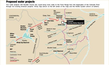
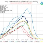
Colorado’s biggest water provider says the project will guard against future shortages on the northern branch of its system and provide more operating flexi bility, make the overall system more resilient to climate change and extreme weather events like floods and fires. And part of the mitigation includes water earmarked for environmental purposes on both sides of the Continental Divide, water that could benefit a sometimes stressed trout population in the South Fork of Boulder Creek.

After scouring thousands of public comments and compiling the voluminous scientific and engineering studies for the Moffat Collection System Project, the federal agency says the new diversion and storage would help avert a potential major Denver Water system failure. The feds singled out Arvada, Westminster and the North Table Mountain Water and Sanitation District as especially vulnerable to raw water shortages without the project.

Release of the final EIS is one of the final steps in the intricate and regulatory ritual required by the National Environmental Policy Act, commonly known as NEPA. Especially for big projects involving public resources, the law is intended as an environmental bulwark. Ten years is a long time, but irrevocable allocation of public resources requires a hard — not a fast — look, the law says…

A few hours after the study was posted, the environmental community targeted media and the public with statements and blog posts from conservation groups, including a stern warning shot from Earthjustice, the legal arm of the green machine. In response to the Corps’ dire warnings of water shortages, some conservation advocates seemed to be saying they’re ready for an all-out battle over the Moffat project.

Hardened battle lines are nothing new in western water wars, but if Winston Churchill were to comment on this one, he might say, “Never have so many battled so hard over so little.”

The Moffat project would reliably deliver 18,000 acre feet of water. That’s enough to comfortably supply a small community for a year, but to keep that number in perspective consider this: All of Denver Water’s reservoirs combined lose more than 25,000 acre feet of water annually to evaporation…

Conflict over the Moffat project may be avoided, since all the parties worked on this collaboratively, says Conservation Colorado advocacy director Becky Long.

“People really rolled up their sleeves and went to work on that plan. … My sense is Denver has been pretty willing to mitigate and negotiate,” says Long, who has deep roots in rural agricultural water use after growing up in the ranch and grazing lands of the Lower Blue Valley, north of Silverthorne.

Even before fully studying the final environmental impact statement, Long says it’s clear that this proposal is different from many past projects because of the huge effort put into mitigating the effects of new diversions and storage, especially on the Western Slope…

“At some point, Denver Water will need a permit from the county,” says Chris Garre, who lives on the south shore and has become leader of a grassroots effort to draw attention to the concerns of area residents.

Standing at one of the stunning overlooks, Garre explained graphically how the landscape would permanently change with construction, including a de-forested rock face at the site of the potential quarry, along with a total inundation of the existing shoreline and the elimination of tens of thousands of trees…

The formal comment period ends in June, but could be extended by another 45 days, with many entities already saying they will request more time. Denver Water execs said they expect a final Corps of Engineers decision on the $360 million project within a year. The decision will be made at the regional Corps of Engineers headquarters in Omaha.

Beyond that, Denver Water still needs several other major permits, including an amendment to a federal hydropower license and a water quality certification under the state-run Clean Water Act standards.

Denver Water spokesman Steve Snyder said the cost of the project, based on a per acre-foot yield, is in line with other water projects along the Front Range.

The first phases of construction including offsite road improvements could start as early as 2017, with dam construction expected to start in 2018 and finish in 2021, with the heaviest construction occurring between 2019 and 2020, Snyder says. All schedules are based upon the permitting schedule and may be delayed or accelerated pending approvals.

More Moffat Collection System Project coverage here.

“…we have a lot of communities on a diminishing aquifer” — Eric Hecox

rueter-hessplans

From The Denver Post (Steve Raabe):

The shimmering surface of Rueter-Hess reservoir seems out of place in arid Douglas County, where almost all of the water resources are in aquifers a quarter-mile under ground.

Yet the $195 million body of water, southwest of Parker, is poised to play a crucial role in providing water to one of the fastest-growing metropolitan areas in the U.S.

As recently as a few years ago, developers were content to tap the seemingly abundant Denver Basin aquifer to serve the thousands of new homes built each year along the southern edge of metro Denver.

But a problem arose. As homebuilding in Douglas County exploded, the groundwater that once seemed abundant turned out to be finite. Land developers and utilities found that the more wells they drilled into the aquifer, the more grudgingly it surrendered water.

“Now we have a lot of communities on a diminishing aquifer,” said Eric Hecox, executive director of the South Metro Water Supply Authority, a consortium of 14 water suppliers that serve 300,000 residents.

As water pressure in the Denver Basin steadily declines, developers and water utilities that rely on the aquifer are being forced to drill more wells and pump harder from existing wells.

Enter Rueter-Hess. The massive storage facility — 50 percent larger in surface area than Cherry Creek reservoir — aims to help developers wean themselves from groundwater by shifting to other sources.

The reservoir anchors a multifaceted water plan for the south metro area that includes the purchase of costly but replenishable surface water, reuse of wastewater and a greater emphasis on conservation.

Douglas County, long a magnet for builders enticed by easy access to Denver Basin aquifers, is taking the water issue seriously.

A new proposal floated by the county government would give developers density bonuses — up to 20 percent more buildout — for communities that reduce typical water consumption and commit to using renewable sources for at least half of their water.

“In the past, the county had not taken an active role in water supplies because groundwater was sufficient,” said Douglas County Commissioner Jill Repella. “But we understand that we cannot continue to be solely reliant on our aquifers. What we’re doing today will help us plan for the next 25 years.”

Parker Water and Sanitation District launched construction of Rueter-Hess in 2006 and began gradually filling the reservoir in 2011, fed by excess surface and alluvial well flows in Cherry Creek.

Partners in the project include Castle Rock, Stonegate and the Castle Pines North metropolitan district. Parker Water and Sanitation district manager Ron Redd said he expects more water utilities to sign on for storage as they begin acquiring rights to surface water.

The chief source of new supplies will be the Water Infrastructure and Supply Efficiency partnership, or WISE, in which Denver Water and Aurora Water will sell an average of 7,250 acre-feet a year to 10 south-metro water suppliers beginning in 2016. Most of them are expected to purchase storage for the new water in Rueter-Hess. An acre-foot is generally believed to be enough to serve the needs of two families of four for a year

Parker Water and Sanitation also is exploring ways to develop recreational uses at the dam — including hiking, camping, fishing and nonmotorized boating — through an intergovernmental agreement with other Douglas County entities.

Even three years after opening, the reservoir’s stored water has reached just 13 percent of its 75,000-acre-foot capacity. Yet Rueter-Hess is the most visible icon in Douglas County’s search for water solutions.

At stake is the ability to provide water for a county that in the 1990s and early 2000s perennially ranked among the fastest-growing in the nation. The number of homes in Douglas County has soared from 7,789 in 1980 to more than 110,000 today, an astounding increase of more than 1,300 percent.

The building boom slowed after the 18-month recession that ended in June 2009. Growth rates that had reached as high as 10 percent to 15 percent a year during the 1990s ratcheted down to about 1 percent to 2 percent.

But as the economy has begun recovering, Douglas County is once again “seeing high levels of demand” for new residential development, said assistant director of planning services Steve Koster.

One of the biggest Douglas County projects in decades is Sterling Ranch, a proposed community of 12,000 homes south of Chatfield State Park.

The 3,400-acre ranch sits on the outer fringes of the Denver Basin aquifer, making it a poor candidate for reliance on the basin’s groundwater.

As a result, the project developer will employ a mixed-bag of water resources, including an aggressive conservation and efficiency plan; surface-water purchases from the WISE program; well water from rights owned by Denver billionaire Philip Anschutz; and a precedent-setting rainwater-collection program.

Sterling Ranch managing director Harold Smethills described the Rueter-Hess concept as “brilliant,” even though his development has not yet purchased any of the reservoir’s capacity.

“You just can’t have enough storage,” he said.

More Rueter-Hess Reservoir coverage here and here. More Denver Basin Aquifer System coverage here.

Snowpack news: Airborne Snow Observatory project second season recap #ColoradoRiver

Combined lidar and aerial mapping via GeoMapsvia GeoMaps
Combined lidar and aerial mapping via GeoMaps

From The Sheet (Katie Vane):

The ASO is a repurposed de Havilland Twin Otter plane, equipped with LiDAR (a remote sensing method that uses light in the form of a pulsed laser to generate three-dimensional information on surface characteristics), spectrometer, GPS, and an inertial measurement unit that tracks the pitch and yaw of the aircraft.

Together, the LiDAR and spectrometer, which measure both topography and reflected sunlight, create a three-dimensional map of the snowpack.

Incredibly, LiDAR data gathered from 20,000 feet in the air can measure snowpack topography to within 10 centimeters, Painter said.

The purpose of this data is to represent snowpack, particularly its water equivalent, “in a more meaningful way.”

Until now, snowpack data was typically measured using snow courses or snow pillows. Both snow courses and pillows offer limited information, as neither one covers a large amount of terrain. “The greater purpose of them is as an indicator of percentage [of average],” Painter said. “But water isn’t allocated in percentages; it’s allocated in acre-feet.”

“Remote sensing is key to understanding the whole of the mountain snowpack,” he concluded.

Considering about 75 percent of the freshwater supply for the Western U.S. comes from snowmelt, understanding mountain snowpack and calculating the snow water equivalent with greater precision is crucial for more refined water management.

More Colorado River Basin coverage here.

“The sky turns pink or brown as the dust clouds billow and swirl on the Southern Plains” — Betsy Blaney #COdrought


From the Associated Press (Betsy Blaney) via The Pueblo Chieftain:

The sky turns pink or brown as the dust clouds billow and swirl on the Southern Plains, leaving those caught outdoors with grit on their teeth and in their eyes, much like the days of the Dust Bowl. But due to the drought conditions that have been a constant presence since 2011, some parts of the Texas and Oklahoma panhandles, northeastern New Mexico and Southeastern Colorado are drier now than they were during the infamous dry spell of the 1930s.

While experts say the possibility of another Dust Bowl is unlikely because of modern irrigation and farming techniques enacted afterward that are aimed at holding soil in place, greater erosion in recent years has resulted in an increasing number of dust storms, including one last month that lasted three days in Lubbock.

The dust storms are an indirect result of the drought, according to Tom Gill, a geology professor at the University of Texas-El Paso who has studied the phenomenon for years.

“The drought leads to reduced land cover and making it far more difficult to keep the soil anchored to the ground,” he said. “To get a real strong dust storm you need a combination of barren land and strong winds,” Gill said.

In the 1930s, farmers plowed up 100 million acres, and billions of tons of topsoil blew away, filling the skies across five states with soil. Scientists with the federal government’s Soil Conservation Service — now the Natural Resources Conservation Service — stepped in after the man-made ecological disaster and tried to stem erosion.

Progress was slow initially, but since the 1980s, more U.S. farmers have moved to soil conservation practices, minimizing the disturbance of the soil’s surface and making it less likely to take flight in high winds. The results are telling: In 1982, more than 3 billion tons of soil nationwide were lost to wind and water erosion; that dropped to 1.72 billion tons in 2010, according to data from the conservation service

David Ford lives in a part of the Texas Panhandle that’s drier now than in the 1930s, and has used a strip-till process to conserve soil for about 10 years.

“If it hadn’t been for a lot of these changes, it would really be bad,” said Ford, who grows corn, cotton, wheat and grain sorghum on more than 4,000 acres about 50 miles north of Amarillo, Texas. “We would be in the middle of the ’30s again.”

The number of dust storms seems to rise with the length of the drought. Amarillo has had 10 this year; it had none in 2010. The city is about 10 percent drier now than the 42 months that ended April 30, 1936, and drier than the state’s record drought in the 1950s.

Lubbock already has seen 15 days with dust storms this year, the National Weather Service said.

Weather service officials in southeastern Colorado only began issuing dust storm warning this year because they were becoming more prevalent; so far, the Pueblo office has issued 15 warnings.

Film screening: DamNation (SXSW Audience Choice Award) at the Mayan Wednesday night in Denver

Official poster
Official poster

Click here to go to the website to watch the trailer and pre-order your copy.

From email from American Rivers (Sinjin Eberle):

I am excited to come on board as the new Associate Director of Communications for American Rivers – focusing primarily on the Colorado Basin.

I grew up on the Western Slope of Colorado, and have recently settled in Durango – in the heart of the basin. I thrive on being out on the water in a raft or a driftboat, ripping a trail on my mountain bike, or hiking one of the countless routes in the high country. Having spent more than 10 years as a volunteer leader with Trout Unlimited, I am thrilled to bring my professional skills and energy to work for the rivers of the west. But most importantly, I am excited to be working with you.

Members and supporters are the bedrock of any successful effort, and you are the real force behind how much American Rivers can accomplish. With your help, we can preserve and restore the places we love, work, and play, and build a more sustainable future for our rivers. I would like to invite you to a few events we have set up in the coming weeks:

  • Denver – DamNation screening at the Mayan Theater May 14, 7:30pm
  • Telluride – MountainFilm DamNation Screening, May 23 – 26
  • Aspen – Wild Rivers Night at the Wheeler, featuring Pete McBride and DamNation, Wheeler Opera House, June 5
  • If you haven’t checked out the trailer for DamNation, see it here. It’s pretty amazing!

    I so look forward to meeting you in person and talking about how we can work together for our rivers in the coming years. Come out to a film screening, or drop me an email – there is so much to do and I am excited that we can embark on this journey together!

    More restoration/reclamation coverage here.

    #CODrought news: Save water, energy (and money) in a Colorado summer: 5 easy ways — The Denver Post

    From The Denver Post (Susan Clotfelter):

    Every time it rains in Colorado, we tend to forget we live in a high desert. Every time we’re blessed with a cool spring, we tend to forget that come mid-June — or sooner — it’s going to get hot. Summer’s onset reliably brings a bumper crop of ways to save money on energy and water. Here are a few.

    1. Maintain your air-conditioning system. If it’s a whole-house unit that relies on your furnace to move cooled air, change furnace filters. Remove the winter cover; trim weeds or grass around the unit, and book a pro to check on the evaporator and condenser, which are usually sealed. Consult websites like howstuffworks.com or familyhandyman.com to clean the parts you can access. Indoors, clean air-return ducts and clear clutter from around them.

    2. That ’80s staple, the ceiling fan, can be a great way to keep a space comfortable without turning on the air conditioning. If you’ve got one, turn the reversible switch so that it rotates counterclockwise for the warm season. And hey, while you’re up there? Dust the blades. Clean machinery lives longer.

    3. Got energy audit? Sign up for one. Check your utility provider or municipality’s website; some subsidies and bargains remain to be had. A certified pro will visit your home and find your biggest energy (and money) drains and help you fix them. If you got an energy audit done, but haven’t acted on its recommendations yet, pick one of the top three.

    4. Use less water. My own energy audit included easy ways to save on this precious Colorado commodity. My auditor installed a kitchen-faucet aerator and a balloon in the tank of my one non-low-flow toilet (which I’ve since replaced).

    My top-loading, late ’90s washing machine refuses to die so that I can justify a high-efficiency machine, but I’ve learned to cut back on its use it by combining loads. I also hang most of my laundry to dry, which trims dryer use (and extends the life of my clothes).

    5. Waste no water. Sprinkler system? Get it checked, or check it yourself, to fix or adjust any broken or wasteful heads. And check Denver Water’s website (denverwater.org) for water-saving tips that still allow you to have a beautiful summer landscape. You can also use what I call the Thrifty Girl’s Drip Irrigation system: Put a plastic tub in the kitchen sink and a 3- to 5-gallon bucket in the shower to collect the water that runs while you’re waiting for the flow to heat up. Use that water in the garden on shrubs, perennials or larger vegetables by pouring it into a second bucket with three or four quarter-inch holes in the bottom. Put the pierced bucket in the garden to drip-water plants. If you’re fussy about how that looks, paint the bucket.

    More conservation coverage here.

    Sterling: “AgFest” recap

    Groundwater movement via the USGS
    Groundwater movement via the USGS

    From the Sterling Journal-Advocate (Callie Jones):

    This year’s festival included 10 stations, including the GPS mapping station, where Morgan County Extension Agent Marlin Eisenach spoke about how farmers use GPS mapping to plow, so they don’t use too much agricultural herbicide or insecticide and they can save as much fuel as possible…

    At the groundwater station, Extension Agent Molly Witzel, from Burlington, spoke about watershed, an area where smaller bodies of water flow into bigger bodies of water; an aquifer, “a big underground lake;” and other groundwater terms. She also spoke about what happened during the South Platte River flood last fall…

    A rangeland ecology station had students learning about the different plants and animals that can be found on rangeland. Logan County Extension Agent Casey Matney talked about the importance of rangeland, because it has trees, animals and water.

    At a plant science station the fifth graders learned about the difference between dicot and monocot plants, they got to see different types of seeds and they learned about how plants grow.

    Blue River “State of the River” meeting recap #ColoradoRiver

    Blue River
    Blue River

    From the Summit Daily News (Ali Langley):

    About 80 people — water managers, weather experts, government officials and interested community members — attended the event hosted by the Colorado River District at the Community Center in Frisco Tuesday, May 6. Discussion revolved around snowpack, runoff, flooding and the state water plan…

    [Joanna Hopkins, board president of Blue River Watershed Group] spoke about the group’s restoration project of Ten Mile Creek, impacted by decades of mining, railroads, highways and development, and presented before and after photos of the work. The group will now focus attention on restoration of the Upper Swan River Watershed, where dredge boats in the early 20th century mined for 2 miles and the group and its partners will work to turn the river “right side up.”[…]

    [Troy Wineland, water commissioner for the Blue River basin] pointed to a graph and asked the audience to consider this year’s snowpack levels. “What does that surplus, that bonus, that cream on the top, what does that mean to you?” he said. Better rafting, some said. Fishing. Full reservoirs…

    Bob Steger, water resources engineer with Denver Water, discussed Dillon Reservoir operations. The utility’s main priorities for the reservoir are maintaining its water supply and reducing flood risk, he said, but it also considers boating, rafting, kayaking, fishing, endangered fish and its upcoming construction project.

    The utility began lowering the reservoir level in late February, just like in other high-snowpack years, he said. Going forward, the reservoir will start filling in mid-May or June, depending on whether the spring is wet or dry.

    The Roberts Tunnel, which brings water from Dillon to Denver, won’t be turned on until mid-June or July, he said, and the utility will replace the large gates that control outflow to the Blue River likely sometime between August and October…

    Ron Thomasson, a hydrologist with the U.S. Bureau of Reclamation who oversees Green Mountain Reservoir operations, said he expects to fill that reservoir in mid-July.

    He talked about how more runoff will improve habitat for four endangered fish species in the 15-Mile Reach of the Colorado River and showed his “obligatory snowpack graph.” Then he presented spaghetti plots to explain that when experts say “most probable scenario” what they really mean is, “It’s actually no more probable than any other scenario. It just happens to be in the middle.”[…]

    explained the rare conditions that combined to cause record-breaking flooding in the Boulder area in September. Then he switched to the “crazy winter that you just lived through” in Summit and what to expect in the six- to eight-week runoff season produced by seven months of snow.

    He joked about the polar vortex, a phenomenon that’s been around forever but didn’t make the media until this winter, and he showed more spaghetti plots saying, “Those averages are beautiful. They give us something to think about. They never happen.”

    Those excited about a surplus should remember the rest of the state is experiencing drought conditions. “You fared well,” he said. “It’s not always going to work that way, so please be grateful.”

    Then he asked for volunteers to help collect real-time precipitation data with rain gauges for http://cocorahs.org.

    Jim Pokrandt, chair of the Colorado Basin Roundtable that represents Summit and five other counties, emphasized problems with low levels in Lake Powell and Lake Mead and focused on the state water plan, which the roundtable is helping to create.

    Of the 14 states in the West, Colorado is one of four without a water plan. The other three are Washington, Oregon and Arizona…

    “Transmountain diversion should be the last tool out of the box,” he said. “Conservation and reuse needs to be hit hard.”

    If a new transmountain diversion must be constructed, it should be done along the lines of the recent agreement between West Slope stakeholders and Denver Water.

    One audience member asked why reducing population growth wasn’t one of the considered solutions. Most of the projected growth “is us having children,” Pokrandt said. “It’s the elephant in the room, but it’s the one that you really can’t touch.”

    He said in some parts of the Front Range, the untouchable issue is green grass.

    More Colorado River Basin coverage here and here.

    2014 Colorado legislation: Productive and collaborative session in 2014 #COleg

    Colorado Water Plan website screen shot November 1, 2013
    Colorado Water Plan website screen shot November 1, 2013

    Joe Hanel, the very effective and prolific journalist from The Durango Herald is morphing his career. He wrapped up his run at the Herald with two articles about the 2014 session. First up, he reports that Four Corners legislators felt like the recent session accomplished much. Here’s an excerpt:

    “I feel so much better than I did a year ago,” said Sen. Ellen Roberts, R-Durango. “Last year, I went home demoralized and wondering if it made any difference to be up here.”[…]

    Fights over water rights returned to the stage this year, and Roberts was in the middle of most of them. She brought the Legislature a plan hatched by a Durango water engineer to limit the size of lawns in new suburban neighborhoods. It riled homebuilders and city governments, and eventually it was turned into a study – a common way for legislators to delay inconvenient legislation.

    Roberts also pushed for the Legislature to have veto power over the Colorado Water Plan, which Gov. John Hickenlooper wants to have crafted by December. Legislators of both parties had complained Hickenlooper was bypassing them, and that the public at large knew very little of the water plan.

    Although her bill was scaled back, it still requires hearings around the state in front of the Legislature’s water committee before the plan can be finished.

    “We weren’t invited to the party,” Roberts said. “We had to crash the party, but we are now at the table.”[…]

    Rep. Don Coram, R-Montrose, also noticed a change in tone from 2013, when pressure from party leaders led to a series of partisan votes.

    “The lock-down mode wasn’t there this year, on either side,” Coram said…

    Another bill, though, stands out as a statewide highlight of the 2014 session. It was a rural broadband bill that finally passed after four years of unsuccessful efforts. The bill converts part of the phone company’s subsidy for serving hard-to-reach customers into a grant fund to build high-speed Internet lines to unserved areas.

    Last fall, Coram began crafting the bill with Club 20 and others on the Western Slope.

    “The last couple years, that bill has failed because it was a top-down approach. This year, it was truly a grass-roots, bottom-up effort,” he said.

    Weber Fire near Mancos June 2012 via MNGInteractive.com
    Weber Fire near Mancos June 2012 via MNGInteractive.com

    Here’s the link to Joe’s other final article. Here’s an excerpt:

    Before this year, people around the Capitol knew Steve King as a rank-and-file Grand Junction Republican senator with perfect hair. This year, though, King stepped from his seat in the back row of the Senate to center stage with his single-minded advocacy of an aerial firefighting fleet. The passage of his bill to rent or buy firefighting aircraft ranks among the biggest achievements of the 2014 legislative session, which ended Wednesday…

    The Legislature’s Democratic leaders entered the session in January without any of the flashy agenda items that characterized 2013, like gun safety, civil unions, elections reform or in-state tuition for kids without U.S. citizenship.

    King stepped into that vacuum with his insistence that Colorado needed more airplanes and helicopters to fight wildfires. Gov. John Hickenlooper and legislative leaders had been lukewarm on the idea, citing the cost and questionable effectiveness of aerial firefighting.

    Democratic Senate President Morgan Carroll praised King for his passion and signed on to his bill as a fellow sponsor.

    “He has stuck with it and stuck with it and persuaded me it was the right thing to do,” Carroll said.

    But everything really changed in March, when Hickenlooper’s top fire official, Paul Cooke, issued a report that recommended contracting for light air tankers and helicopters and buying spotter planes. King had wanted heavy tankers and helicopters, but he immediately embraced the report and changed his bill to follow its recommendations.

    Hickenlooper was reluctant to cast King as the hero and said his administration started examining aerial firefighting in 2011.

    “It wasn’t like we weren’t doing something. But Senator King definitely helped create a context where this was top of mind, where people were thinking about different alternative choices. In that sense, I think he was a valuable partner to have,” Hickenlooper said.

    King, however, benefited from the same economic recovery that enabled the other big accomplishments of the 2014 session.

    The $20 million cost of the aerial fleet is just a sliver of the big investments in education. An extra $110 million for K-12 schools begins to reverse about $1 billion in cuts since 2008. And the $100 million boost to colleges is a record, but it also does not restore deep cuts made during the recession.

    Joe Hanel via The Durango Herald
    Joe Hanel via The Durango Herald

    I loved Joe’s adios on Twitter (Just the facts ma’am). I also thought that it was fitting that he used Twitter to let us all know about his new gig.

    It’s a bummer to see another Colorado water reporter move on. Good luck man!

    Click here to browse through the Coyote Gulch posts attributed to The Durango Herald and Joe Hanel. Joe shows up on the older Coyote Gulch as well.

    NRCS: The May 1, 2014 Colorado Basin Outlook Report is hot off the presses

    streamflowforecastmap05012014nrcs

    Click here to read the report. Here’s an excerpt:

    Summary

    When viewing current statewide totals for all water supply parameters, it would be difficult to find a more “normal” year. With statewide snowpack, water year-to-date precipitation and reservoir storage at 107, 102 and 93 percent normal respectively, conditions are favorable for good water supplies this season. Of course the story is more complex than just the statewide numbers. Although 2014 was not a La Nina year some of the snow accumulation patterns could be construed as such the Upper Rio Grande and the combined San Juan, Animas, Dolores and San Miguel basins in Colorado both have snowpack percentages below 70 percent of median, while significantly better snowpack’s exist in the northern tier basins. All of the northern basins boast snowpack percentages that are greater than 120 percent of median. In general the statewide snowpack trended downward over the course of April falling 8 percentage as a result of below average precipitation in the form of snowfall throughout the month. Although monthly precipitation for the state was just 80 percent of average this April, year-to-date precipitation rounded out at 102 percent of average on May 1. With nearly all reservoirs currently at better standing than last year at this time, it is hard to frown upon the below average storage in the Upper Rio Grande and Arkansas River basins. In addition the vast majority of water supply forecasts for Colorado look to be better than last year based on current data.

    Snowpack

    Despite a slight decline in the snowpack percent of median during April, statewide snowpack was still 128 percent of last year according to SNOTEL and snow course observations on May 1. The Upper Rio Grande saw the greatest decline in snowpack with a 29 percent drop this month. All major basins saw a decrease this month, yet many remain near to above normal while some are well above normal. With nearly one third of all sub basin snowpack’s at 125 percent of median or better and 19 of 34 sub basins above 100 percent of median, this season is just what was needed to replenish last year’s ailing water supplies in the state’s northern watersheds. In the other regions of the state, the Arkansas and Gunnison basins are fortunate to have snowpack’s at 99 and 97 percent of median respectively, while the “have not” basins include the Upper Rio Grande and the combined San Juan watersheds at 50 and 68 percent of median respectively. The moral of this snow season is: snowpack varies greatly across the state, from 41 percent of median in the combined Conejos & Rio San Antonio watersheds to 169 percent of median in the Muddy Creek drainage in the Colorado River basin. Be sure to look at basins of interest and the sites within for the most concise data to prepare for the year to come.

    Precipitation

    For the first time since January, monthly precipitation was below average, not just statewide, but in every major basin. Quite similarly to January when monthly precipitation was at 81 percent of average, precipitation this month was 80 percent of average. Thanks to strong accumulations in October, January, February and March, year-to-date precipitation remains slightly above normal at this point. Thankfully the differences in year-to-date precipitation across the state are not as extreme as in the case of snowpack. The Upper Rio Grande basin has the lowest year-to-date total at 80 percent of average, with the only above average month this water year being November. Conversely, the South Platte basin is currently showing year-to-date precipitation at 119 percent of average. In general the precipitation map looks much the same as the snowpack map with better totals in the northern basins, and below average numbers in the south.

    Reservoir Storage

    With over one half of the states reservoirs currently at 100 percent of average storage or better, and nearly three quarters of the state’s reservoirs at or above 80 percent of average at the end of April, statewide reservoir storage is in fairly good standing. The Arkansas River basin currently has the lowest storage as a percent of average at 59 percent but on a positive note Pueblo Reservoir is right at the 30 year average storage with volumes at 54 percent of capacity. The South Platte River basin has the best storage at 110 percent of average and 90 percent of capacity. With the snowpack in the basin this year it is likely the South Platte reservoirs will reach 100 percent capacity this spring. The vast majority of all reservoirs in the state currently have higher storage levels than at this time last year. For areas with well above normal snowpack’s and projected streamflows, it is often necessary to draft reservoirs to make room for the above normal expected inflows. If reservoir storage is below average in a drainage basin with above to well above normal snowpack the project may be anticipating above average inflows.

    Streamflow

    Projected streamflows in Colorado are typically a reflection of current snowpack totals and monthly precipitation totals throughout the year, and this month is no exception. Similar to the snowpack reports current forecasts vary widely across the state from 148 percent of the May to July average for the Inflow to Wolford Mountain Reservoir to 16 percent of the May to September average at San Antonio River at Ortiz in the Upper Rio Grande. For the three major watersheds in the north, nearly all streamflow forecasts are calling for above normal runoff this season. Within that same region only three forecast points have forecasts below average; all other points look to have strong water supplies going into the beginning of summer. On the flip side of the state, in the four major southern basins, just over one quarter of the forecasted streamflows are projected to be 100 percent of normal or better. Brightening the scenario further in the south, 24 of the 55 forecast points are projected to be better than 80 percent of average. But with highly variable snowpack across the state forecasts differ greatly as well, be sure to consult the actual forecast information for the most accurate information.

    Snowpack/runoff news

    From The Durango Herald (Dale Rodebaugh):

    The snowpack as of May 1 in the watersheds drained by the Animas, San Juan, Dolores and San Miguel rivers leaves the southwest corner of Colorado hurting.

    At 68 percent of its 30-year median, the amount of snow in the highcountry foretells a sparse runoff.

    Only the Rio Grande basin is worse off at 50 percent.

    On the flip side, the Colorado, South Platte, North Platte and Yampa/White basins are wallowing in snow. The Yampa/White and Colorado basins have snowpacks that stand at 121 and 122 percent, respectively. The South Platte has 133 percent and the North Platte, 135 percent…

    “In general, moisture-laden storms have favored the northern-tier basins throughout 2014,” Domonkos said. “Last month, the Gunnison, Upper Rio Grande and San Miguel, Dolores, Animas and San Juan basins were impacted by warmer temperatures and lack of snowfall.”

    Overall, however, the state is not doing too badly in regards to reservoir storage, Domonkos said.

    Slightly more than 50 percent of state reservoirs stand at 100 percent of average or better and nearly three-quarters of them at 80 percent of average or better, Domonkos said.

    Reservoirs catching runoff from the Animas, San Juan, Dolores and San Miguel basins were at 85 percent of average on May 1. Last year on the same date, the reservoirs stood at 64 percent of average.

    Statewide, reservoirs hold 93 percent of their average, up from 71 percent on the same 2013 date. Three basins, the Yampa/White, Gunnison and South Platte, hold more than 100 percent of their average – 106, 107 and 110 percent respectively.

    River flows in general will be good to excellent, the report says. More than one-half of stream-flow forecast points should have more than 100 percent of their average and nearly two-thirds should have flows of more than 80 percent of average.

    But again, Southwest Colorado is the exception, the report says.

    “Runoff volumes for May through July are expected to range from average to below average,” the report says.

    Say hello to the EPA’s ‘Waters of the United States” website

    Screen shot from the EPA's Waters of the US website May 9, 2014
    Screen shot from the EPA’s Waters of the US website May 9, 2014

    Click here to go to the website and get all the inside skinny on the proposed rule. Here’s an excerpt:

    For the past three years, EPA and the Army Corps have listened to important input from the agriculture community. Using the input from those discussions, the agencies then worked with the U.S. Department of Agriculture to ensure that concerns raised by farmers and the agricultural industry were addressed.

    Download a fact sheet about benefits for agriculture.

    Read an op-ed on agriculture by EPA Administrator McCarthy.

    More Environmental Protection Agency coverage here.

    HB14-1333: Legislature to fund Long Hollow project — The Durango Herald #COleg

    Long Hollow Reservoir location map via The Durango Herald
    Long Hollow Reservoir location map via The Durango Herald

    From The Durango Herald (Joe Hanel):

    A Southwest Colorado water district can expect $1,575,000 from the Legislature to help build a dam just off the La Plata River. It’s one of the few water projects statewide the Legislature is funding this year.

    Long Hollow Reservoir, about five miles north of the New Mexico border, is being built to help farmers and ranchers in southwestern La Plata County keep water through the dry months, while at the same time letting the state meet its legal obligation to deliver water to New Mexico.

    “Part of the reservoir would be for interstate compact compliance when Colorado has a difficult time making deliveries to New Mexico,” said Bruce Whitehead, executive director of the Southwest Water Conservation District…

    With the money from the state’s water projects fund, Long Hollow reservoir should be finished by fall, he said. Most of the money to build the reservoir was set aside when the Animas-La Plata Project was scaled down.

    The Legislature’s annual water projects bill, House Bill 1333, often has something for water users all across the state. But this year, Long Hollow is the only construction project to get direct funding. The bill also makes up to $131 million in loans to two projects on Denver’s south side – an expansion of Chatfield Reservoir and a water-efficiency and reuse project in the southern suburbs.

    The bill has passed the House on a 61-1 vote, and it is on track to pass the Senate early this week.

    NRCS: Water Supply Outlook for Colorado Much Better Than This Time Last Year #COdrought

    nrcsmay2014outlooksnowpackreservoirstorage

    Here’s the release from the Natural Resources Conservation Service (Mage Hultstrand):

    The latest snowpack measurements, conducted by the USDA – Natural Resources Conservation Service (NRCS), show above normal levels of snow at many measuring sites throughout the Yampa, Colorado, North and South Platte River basins in Colorado. Conversely, observations in the Upper Rio Grande, Arkansas, Gunnison and combined San Miguel, Dolores, Animas and San Juan River basins indicate near to below normal snowpack’s.

    “The month of April yielded below average precipitation in all watersheds but affected year-to- date precipitation and snowpack totals little, rounding out the snowpack on May 1 at 107 percent of median,” according to Brian Domonkos, Colorado Snow Survey Supervisor with the NRCS.

    In general, moisture laden storms favored the northern tier basins in the state of Colorado throughout 2014. Last month the Gunnison, Upper Rio Grande and San Miguel, Dolores, Animas and San Juan basins were impacted by warmer temperatures and lack of snowfall. These basins have fallen further below normal since last month’s report, with the most severe deficit in the Upper Rio Grande basin, which fell from 79 percent of median last month to 50 percent of median this month. The latest surveys indicate the lowest snowpack percentage in the state was measured in the Upper Rio Grande basin at 50 percent of median. The San Miguel, Dolores, Animas and San Juan basins declined to 68 percent of median and the Gunnison declined to 97 percent of median.

    With slightly better than one half of the states reservoirs at 100 percent of average or better, and nearly three quarters of the state’s reservoirs at or better than 80 percent of average at the end of April, statewide reservoir storage is in fairly good standing. The Arkansas River basin currently has the lowest storage as a percent of average at 59 percent but on a positive note Pueblo Reservoir is right at the 30 year average and 54 percent of capacity. The South Platte basin has the best storage at 110 percent of average and 90 percent of capacity. The vast majority of all reservoirs in the state have higher storage levels than at this time last year. For areas with well above normal snowpack or projected streamflows, it is often necessary to draft reservoirs to allow for the above average inflows. If reservoir storage is below average in a drainage basin with above to well above normal snowpack the project may be anticipating above average streamflow.

    For most of the state, this spring’s runoff and summer water supplies are predicted to be good to excellent. More than half of the 89 streamflow forecast points in Colorado are predicted to have better than 100 percent of average streamflows. Nearly two thirds of the state is projected to have better than 80 percent of average streamflows. Two excellent statistics compared to this time last year. The basins that can expect some of the largest volumes include the Colorado, Yampa, North Platte and along the Cache La Poudre River in the South Platte basin. The exceptions are the Upper Rio Grande, and those basins in southwestern Colorado where runoff volumes for the May through July period are expected to range from average to below average volumes.

    The latest ENSO discussion is hot off the presses #COdrought

    midapril2014plumeofmodelensopredictionsvianoaa

    Click here to read the latest discussion from the Climate Prediction Center. Here’s an excerpt:

    Synopsis: Chance of El Niño increases during the remainder of the year, exceeding 65% during
    summer.

    ENSO-neutral continued during April 2014, but with above-average sea surface temperatures (SST) developing over much of the eastern tropical Pacific as well as persisting near the International Date Line. The weekly SST indices were near to slightly above average and increasing in the Niño1+2, Niño3 and Niño3.4 regions, and above average in the Niño4 region. The down-welling phase of a strong oceanic Kelvin wave that began in January greatly increased the oceanic heat content during March and April, and produced large positive subsurface temperature anomalies across the central and eastern Pacific. The upper portion of these subsurface anomalies reached the sea surface, warming the waters east of 125ºW longitude. Also during April, weak low-level westerly wind anomalies were observed over the far western Pacific, while upper-level easterly anomalies occurred over much of the Pacific. Convection was enhanced over the west-central equatorial Pacific. These atmospheric and oceanic conditions collectively indicate a continued evolution toward El Niño.

    From New Scientist (Michael Slezak):

    The weather is preparing to go wild, and will wreak havoc and death around the globe later this year. An El Niño, a splurge of warm water in the Pacific Ocean, is coming. It will unleash floods in the Americas, while South-East Asia and Australia face drought. Yet little is being done to address these consequences.

    “The tropical climate system is primed for a big El Niño,” says Axel Timmermann of the University of Hawaii in Honolulu…

    The effects can be deadly. A big El Niño in 1997-98 killed 20,000 people and caused almost $97 billion of damage.

    Meteorologists contacted by New Scientist all expect an El Niño at the end of this year. And it looks like a big one, says Wenju Cai of CSIRO, Australia’s national research agency, in Melbourne. The more heat in the Pacific, the bigger the El Niño, and right now, 150 metres below the surface, a ball of warm water is crossing that ocean. “It’s huge,” says Cai.

    Yet official forecasts remain cautious. As recently as 5 May, the US National Oceanic and Atmospheric Administration only said the odds of an El Niño would exceed 50 per cent this year.

    Most El Niño researchers say forecasters are being too conservative. “One thing I hear over and over again is ‘we do not want to create a panic’,” says Timmermann. There is a reason: forecasting a big El Niño would cause a spike in food prices. “But it may be better to have this reaction at an early stage, when farmers can still adapt, rather than later.”

    The good news is that El Niño is a known quantity. “We already know what happens when a big El Niño hits,” says Zafar Adeel of the United Nations University in Hamilton, Canada. That means vulnerable populations can be identified and emergency plans put in place. But not everywhere has a plan.

    “I had work to do today, but then a river happened” — John Fleck #RioGrande #NMdrought

    Breckenridge: “We can’t just sit up here and say we have all the water, now we’ll use it” — Tim Gagen #ColoradoRiver

    Breckenridge circa 1913 via Breckenridge Resort
    Breckenridge circa 1913 via Breckenridge Resort

    From The Mountain Town News (Allen Best):

    The town council is considering legislation that would cap outdoor use at three days a week. It’s part of an effort to put a new emphasis on water conservation and efficiency, says Tim Gagen, the town manager.

    “We have to walk the talk,” says Gagen. “We can’t just sit up here and say we have all the water, now we’ll use it.”

    Breckenridge is not alone. Other mountains towns in Colorado are devoting more attention to water conservation and efficiency. A coalition in the Roaring Fork Valley is assembling plans for public outreach to elevate water efficiency. The Vail-based Eagle River Water and Sanitation District began crimping water use in 2003. Aspen’s water-efficiency measures go back even further, to the 1990s…

    Colorado’s Front Range cities, where 85 percent of state residents live, have become more efficient with existing supplies. But they have also expanded supplies in recent decades by buying farms in the South Platte and Arkansas River valleys for their water rights, and allowing the farms to then dry up. They have also purchased mountain ranches in such buy-and-dry transactions.

    Front Range water providers also want to retain the option of going to the Colorado River and its tributaries for one final, big diversion. Western Slope water leaders urge caution. But to have credibility, leaders in the mountain valleys realize they first must put their own houses in order.

    “The Western Slope needs to be goosed,” says Chris Treese, director of external affairs for the Colorado River Water Conservation District. “Frankly, the Front Range has led most of the water-conservation efforts in Colorado to date.”[…]

    Gagen says that Breckenridge has been nibbling at water conservation efforts for several years. Leaking segments of existing pipes, which can cause loss of 8 to 15 percent of all the municipal water supply, are being replaced. Sprinklers in parks are being changed out in favor of more efficient devices. And the town is now looking at narrowing irrigation at its golf course to avoid watering of the roughs.

    Breckenridge, in its municipal operation, has also adopted more xeriscaping, using plants that don’t require irrigation, reducing irrigation of remaining turf, and, in some cases, installing artificial turf.

    Still on the agenda is elevating rates for high-consumption users. The average water bill in Breckenridge is just $35 every two months, not much more than dinner at one of the town’s higher-end restaurants. As such, most people probably pay little, if any attention, to the idea of conserving water in order to reduce their costs. They just write the check, says Gagen.

    While Breckenridge has broad goals of improved sustainability, Gagen says the plan to reduce outdoor lawn irrigation to three days a week was pushed by two council members who have been persuaded by books they’ve read: “Blue Revolution,” by Cynthia Barnett (2011), “Cadillac Desert,” by Marc Reisner (1986), and “Getting Green Done,” by Auden Schendler (2011)…

    Eagle River Water and Sanitation District has achieved a 20 percent per capita reduction in use, according to Diane Johnson, communications director. That’s in line with the reduction in water use since 2000 by Denver Water’s 1.3 million direct and indirect customers.

    However, Eagle River has not pushed indoor water savings. Because 95 percent of indoor water is treated and released into the Eagle River, explains Johnson, the impact is small on the valley’s creeks and rivers. This compares with just 15 to 40 percent of water returned to streams after outdoor irrigation. Given limited resources for messaging, the better return is to hammer home the message of reduced outdoor use.

    “What we really try to work with local people to understand is that their outdoor use affects how much water is in the rivers,” says Johnson. “If you are using water indoors, save yourself some money and be efficient, but most of that water comes back to the treatment plant and returns to the river.”[…]

    In adopting its regulations on outdoor lawn watering, Eagle River Water was motivated by the searing drought of 2002. But laws also provide incentives. When seeking permits for new or expanded reservoirs, county regulations ask about “efficient use” of existing resources. State and federal regulations approach it with different wording, but essentially the same intent. “Efficient use of resource is going to be a consideration in any of those permitting processes,” says Johnson.

    Eagle River Water has also adopted tiered rates, charging higher rates per 1,000 gallons as consumers step up consumption. But what do you do about those pockets of consumers for whom money is no deterrent?

    That’s an issue in the Vail Valley that water officials are starting to wrestle with. Aspen recognized years ago that price was no object to some homeowners—and charges nosebleed rates.

    Aspen’s municipal utility, which delivers both electricity and water, uses the income from high-use water customers to pay for front-end renewable energy programs and demand-side energy efficiency, says Phil Overeynder, the former utilities director and now the utilities engineer for special projects.

    Aspen in the early 1990s approached the forked paths of water use. But instead of continuing to build capacity for existing water demands, the city instead reined in use. Last year, Aspen used the same amount of water as it did in 1966, despite having three times as many residents. (See more detailed story).

    Now, an effort has been launched to frame a broad water efficiency strategy for the Roaring Fork Valley. The seed was planted in 2010 by the Community Office for Resource Efficiency, or CORE, a non-profit founded in the mid-1990s. The effort has several motives—including energy.

    Formation of the group was at least partly influenced by the writings of Amory Lovins, a resident of the area, who for decades talked about “negawatts”—the idea that efficiency in energy was as good as new supply. The group he co-founded, Rocky Mountain Institute, further applied this idea of a soft path to water efficiency.

    CORE’s Jason Haber explains that saving water also saves energy in several ways. Developing water resources requires energy, but it also takes energy to pump water. Energy is also embedded in treatment of sewage, he points out. Typically, water and sewage are the largest components of any municipality’s energy budget…

    Whether Colorado truly has any water to develop on the Western Slope is debatable—and has been debated frequently in state-wide water forums. The Colorado River Water Conservation District has suggested that major new diversions would be risky, simply because of the lack of certainty of legally entitled water in future years. Colorado’s use of the river that bears its name is tightly capped by two inter-state water compacts and one international treaty.

    More conservation coverage here.

    Drought news #COdrought


    Click on a thumbnail graphic for a gallery of drought data from the US Drought Monitor.

    Click here to go to the US Drought Monitor website. Here’s an excerpt:

    The Plains

    After good rains last week across parts of the northern Plains, dryness followed this week across most of eastern South Dakota, Nebraska and Kansas. Unseasonably cool weather continues to delay impacts thus far as 30-90 day deficits (25-75% of normal across the region) are starting to mount considerably for many parts of these states heading into summer. This has led to some changes this week in the form of expanding D1-D2 in eastern Nebraska as well as in the southern Panhandle out west. D1 also expanded in southeastern South Dakota, although some trimming of D0 on the northernmost flank of D0 in eastern South Dakota is also noted this week as they have been wetter than those counties in the southeast. Kansas continues to set the southern edge of the intense drought that seems to be waking up and pushing rapidly north along with warmer temperatures. A large expansion of D3 now covers nearly the entire southern half of Kansas and D4 is slowly pushing north out of Oklahoma. Soil moisture and groundwater levels are hurting well in front of the peak demand season as the cumulative impacts of such an intense multi-year drought are already glaringly evident, and it’s only early May. Precipitation totals on the year are running just 25-50% of normal, or worse, for many locales across southern Kansas.

    The story is even bleaker in the southern Plains, where the heat and drought described above for Kansas are even more pronounced and entrenched across western Oklahoma and much of Texas as well. Expansion has begun to happen in earnest now that Mother Nature has turned up the furnace, which will do the landscape no favors with summer not here yet. Expansion of D2-D4 is noted across western Oklahoma and all changes in Texas are for the worse this week as well, with expansion of D0-D4 found statewide and D3 and D4 covering large portions of southern, central, north-central and the Panhandle of Texas. Streamflow and groundwater levels are hurting given the long duration and sustained intensity of this drought, which is now going on close to four years. Winter wheat has also been hard hit by hard freezes and the more recent triple-digit heat. Lack of range and pasture land, as well as fire, are the other main impacts already being reported early this year.

    The West

    Most of the West remains in status quo after a relatively dry but warmer than normal week. For the drought-affected regions, the general lack of snow pack and water equivalent totals (as reported by USDA-NRCS) leaves a lot to be desired, with many locations falling at, or below, 50% of normal, and many areas have already melted out that shouldn’t have at this time of year. As the dry season settles in and demand peaks, water supplies will quickly follow suit as many in the region have already turned their attention to what the monsoon or potential El Niño may bring, knowing that the tap is about to go dry.

    Some minor changes were made this week, with some slight expansion of D1 in extreme northeastern Colorado, where the drought in the Plains continues to slowly push westward toward the Front Range of the Rockies. Farther west and north, a late-season push of moisture brought some recovery to year-to-date totals in western Idaho, leading to some minor improvement of D0-D2 there.

    Looking Ahead

    Over the next 5 days (May 8-13), the National Weather Service is calling for a system to potentially bring some relief to the Pacific Northwest along with parts of the central Rockies and Front Range. Heavy precipitation is possible in northeastern Colorado and in the Nebraska Panhandle along with heavier, but spottier, totals expected in a band running north to south from Minnesota, western Iowa, western Missouri, eastern Kansas, eastern Oklahoma, western Arkansas and parts of north-central and southern Texas along with southern Louisiana as well. In addition, above-normal rains appear to be likely for Mississippi and northern Alabama along with the western reaches of the Tennessee Valley, northern Georgia and the extreme western counties in the Carolinas. As for temperatures, below-normal readings (5 to 10 degrees) are expected over roughly this same time period for the northern Plains, central/northern Rocky Mountain states, Idaho and parts of the Intermountain Basin region. The opposite is forecast for parts of all states east of the Mississippi River, except for Florida, with readings expected to run 3 to 9 degrees above normal.

    The 6-10 day (May 13-17) and 8-14 (May 15-21) day outlooks are both consistent in showing a greater likelihood of above-normal temperatures across the West and below-normal temperatures east of the Mississippi River valley as well as the Great Lakes and Gulf Coast region, including coastal Texas. As for precipitation, below-normal rainfall is more likely across western Alaska, much of the West (not as likely in the Pacific NW), the central and southern Great Plains and the Mississippi Valley and over into the Southeast as well. Above-normal precipitation is likely only in the Northeast and New England regions, with lower chances stretching south into the northern Mid-Atlantic region.

    Snowpack/runoff news #COdrought

    2014 Colorado legislation: SB14-023 — West Slope instream use, irrigation efficiency #COleg

    Colorado instream flow program map via the Colorado Water Conservation Board
    Colorado instream flow program map via the Colorado Water Conservation Board

    Here’s the first of a two-part series about the bill from Michael Schrantz writing for Steamboat Today. Here’s an excerpt:

    Senate Bill 23 is on its way to Gov. John Hickenlooper’s desk thanks to some legislative maneuvering, but the bill dealing with changes to water law on the Western Slope has divided interested organizations and prompted warnings that its consequences could be much broader than intended.

    The bill aims to provide incentives for Western Slope agricultural water users and irrigators to make their operations more efficient while also increasing instream flows.

    Organizations opposed to Senate Bill 23 warn that while its intent is laudable, the bill also has the potential to harm existing water rights.

    Under current water law, not using a water right in its full, decreed amount for the intended beneficial use can put the right in jeopardy. The Division Engineer’s office tracks historic consumptive use, and whatever water has not been used in a 10-year period (either the full right or a partial amount) gets put on the decennial abandonment list. Water that’s considered abandoned flows through the stream or creek like it had been during the previous 10 years or longer that it wasn’t being used or it’s put to use by other rights holders.

    Senate Bill 23 would allow those who have rights for agricultural, irrigation or stock watering uses in water divisions 4, 5, 6 (that’s us) or 7 to implement efficiency measures, such as a sprinkler system, and transfer that savings as an instream right to the Colorado Water Conservation Board.

    The water rights holders could structure the agreement so that they could get the transferred amount back from the CWCB in the future, allowing them to implement more efficient irrigation measures without risking the loss of part of their decreed water.

    The CWCB would get an instream flow between the point the rights holder diverts water and the point of the historical return flows.

    Critics of Senate Bill 23 generally have two major issues with the legislation: that a transfer for instream use has the potential to harm intervening water rights and that it also could injure upstream junior rights holders…

    “The intent of bill is providing incentives for ag water to use efficiencies without harm to others,” Colorado River Water Conservation District spokesman Chris Treese said.

    That’s a goal the district supports and has funded itself in the past, Treese said, but there are a number of concerns with Senate Bill 23.

    The Colorado River Water Conservation District, which represents Western Slope counties including Routt, opposes Senate Bill 23.

    The principal concern, Treese said, is that the process could represent a cost to surrounding water users who take it upon themselves to investigate whether the change would harm their rights.

    “There’s definitely a potential for injury for those rights in between,” Colorado Farm Bureau President Don Shawcroft said about the intervening rights between the point of diversion and point of historical return flows.

    The Colorado Farm Bureau also opposed Senate Bill 23.

    “It’s an interesting dilemma,” Shawcroft said. “Colorado water law says the state and anyone changing a water right has to prove they’re not injuring anyone else.

    “Anyone who believes they’re injured has to lawyer up and engineer up and has to prove their point.”[…]

    The Colorado Water Congress worked on the bill with legislators and other interested parties for eight to 10 months, Executive Director Doug Kemper said, and it is satisfied that the processes included in the bill will protect surrounding water rights holders.

    “We finally got to the point where we felt like major concerns were addressed,” Kemper said. “We ultimately ended up taking the position to support” the bill.

    Requiring a water court process to ensure that other water rights are not injured was a big part of that, he said.

    “It’s not creating water right out of thin air or, of more concern, creating water right out of someone else’s water,” Kemper said…

    More 2014 Colorado legislation coverage here.

    The latest Middle Colorado Watershed Council newsletter is hot off the presses #ColoradoRiver

    coloradorivereaglecounty

    Click here to read the newsletter. Here’s an excerpt:

    Annual State of the Rivers Meeting

    “Our Water – This Year and Beyond” is the theme for this year’s report on the state of the Middle Colorado and Roaring Fork Rivers. Co-hosted by the Colorado River District and the Middle Colorado Watershed Council, the event will be held on Wednesday, May 14th, at the Garfield County Public Library in Glenwood Springs, from 6:00 to 7:45 pm. Water managers will present information on current and expected reservoir operations and in-stream flows in our basin with an eye towards short- and long-term water supply forecasts. Click here to view a press release and the evening’s agenda.

    Federal report links Colorado fires to climate change — Fort Collins Coloradoan

    hewlettfire5162012

    From the Fort Collins Coloradoan (Ryan Maye Handy):

    Colorado residents have seen the affects of climate change scar their mountains in the form of wildfires and massive bark beetle outbreaks, according to the U.S. Climate Assessment released Tuesday by the White House.

    Considered to be a part of the Southwest Region, which encompasses drought-stricken states such as New Mexico and California, Colorado is likely to see the impacts of climate change in things ranging from annual snowpack, to water, to agriculture and to weather…

    Colorado is heavily dependent on its winter snowpack — it provides water to farmers and cities, is often a good indicator for drought, and also fuels the ski-tourism industry. Colorado’s mountains are also the headwaters for rivers and streams that feed 18 other states, making the state an epicenter for water availability issues in the Midwest and West.

    The climate change assessment predicts that the Southwest Region’s population of 56 million will increase to 94 million by 2050.

    The report relied on local scientists for input on their regions. Dennis Ojima, a Colorado State University professor of Ecosystem Science, wrote a chapter on the Great Plains, and Reagan Waskom, director of the Colorado Water Center, helped author the Southwest Region chapter. There were also several other CSU political scientists, epidemiologists and fire experts who contributed to the report.

    Aurora Water embarks on expansion of Prairie Waters

    prairiewaterstreatment

    From The Denver Post (Megan Mitchell):

    Aurora Water has begun construction to expand the city’s Prairie Waters Project for the first time since the natural water filtration and collection system opened in 2010. Projects nixed from the original construction plan kept the $659 million project about $100 million below its initial budget. Now, those projects are being called back up to make sure Prairie Waters stays on track for exponential growth over the next 40 years.

    “The expansion part of the project has been planned from the very beginning,” said Marshall Brown, executive director for Aurora Water. “This year, we’re at a place where we can prioritize the growth and look toward the future of system capacity.”
    Crews have begun digging six new collection wells in between the existing 17 wells that collect water from a basin near the South Platte River in Weld County, downstream from the Denver Metro Wastewater Reclamation District’s plant. From there, the water is piped through wells 44 miles south to treatment and storage facilities in Aurora for residential use.

    Along the way, the water is pulled through 100 feet of gravel and sand. This 30-day, natural process helps pull large contaminants out of the water.

    Two new filter beds will also be installed at the Peter D. Binney Water Purification Facility near the Aurora Reservoir this year. At the Binney facility, water is treated with chemicals and ultraviolet lights to make it potable.

    The cost of the expansion projects is $2.9 million, said Greg Baker, spokesperson for Aurora Water. He said water tap fees will not be affected by the new wells and filters this year.

    “We plan our capital projects (which are predominantly paid for by development or tap fees) well in advance,” Baker said. “We plan for these expenses so that our rates don’t roller coaster based on immediate projects.”

    Right now, Prairie Waters is spread over 250 acres in Weld County and is only built out to about 20 percent of its total potential capacity. Baker said the system currently provides 10 million gallons of water per day. At full build-out, Prairie Waters will able to provide 50 million gallons of water per day.

    The project itself was conceived in response to extreme drought conditions in 2003.

    “Ideally, we would like to have two years’ worth of supply stored in the system at all times,” Brown said. “Aurora’s system varies between one and two years’ worth of storage now.”

    The long-term vision for the project involves well development all the way down the South Platte River to Fort Lupton, as well as adding more physical storage components. Aurora Water has already started to acquire additional property for capacity expansion in the future.

    Baker added: “As Aurora’s population grows, we will expand into the system to support that growth.”

    More Prairie Waters coverage here and here.

    CU-Boulder researchers confirm leaks from Front Range oil and gas operations

    DJ Basin Exploration via the Oil and Gas Journal
    DJ Basin Exploration via the Oil and Gas Journal

    Here’s the release from the University of Colorado (Gabrielle Petron/Katy Human):

    During two days of intensive airborne measurements, oil and gas operations in Colorado’s Front Range leaked nearly three times as much methane, a greenhouse gas, as predicted based on inventory estimates, and seven times as much benzene, a regulated air toxic. Emissions of other chemicals that contribute to summertime ozone pollution were about twice as high as estimates, according to the new paper, accepted for publication in the American Geophysical Union’s Journal of Geophysical Research: Atmospheres.

    “These discrepancies are substantial,” said lead author Gabrielle Petron, an atmospheric scientist with the Cooperative Institute for Research in Environmental Sciences, a joint institute of the University of Colorado Boulder and the National Oceanic and Atmospheric Administration. “Emission estimates or ‘inventories’ are the primary tool that policy makers and regulators use to evaluate air quality and climate impacts of various sources, including oil and gas sources. If they’re off, it’s important to know.”

    The new paper provides independent confirmation of findings from research performed from 2008-2010, also by Petron and her colleagues, on the magnitude of air pollutant emissions from oil and gas activities in northeastern Colorado. In the earlier study, the team used a mobile laboratory—sophisticated chemical detection instruments packed into a car—and an instrumented NOAA tall tower near Erie, Colorado, to measure atmospheric concentrations of several chemicals downwind of various sources, including oil and gas equipment, landfills and animal feedlots.

    Back then, the scientists determined that methane emissions from oil and gas activities in the region were likely about twice as high as estimates from state and federal agencies, and benzene emissions were several times higher. In 2008, northeastern Colorado’s Weld County had about 14,000 operating oil and gas wells, all located in a geological formation called the Denver-Julesburg Basin.

    In May 2012, when measurements for the new analysis were collected, there were about 24,000 active oil and gas wells in Weld County. The new work relied on a different technique, too, called mass-balance. In 2012, Petron and her colleagues contracted with a small aircraft to measure the concentrations of methane and other chemicals in the air downwind and upwind of the Denver-Julesburg Basin. On the ground, NOAA wind profilers near Platteville and Greeley tracked around-the-clock wind speed and wind direction.

    On two days in May 2012, conditions were ideal for mass-balance work. Petron and her team calculated that 26 metric tons of methane were emitted hourly in a region centered on Weld County. To estimate the fraction from oil and gas activities, the authors subtracted inventory estimates of methane emissions from other sources, including animal feedlots, landfills and wastewater treatment plants. Petron and her team found that during those two days, oil and gas operations in the Denver-Julesburg Basin emitted about 19 metric tons of methane per hour, 75 percent of the total methane emissions. That’s about three times as large as an hourly average estimate for oil and gas operations based on Environmental Protection Agency’s (EPA’s) Greenhouse Gas Reporting Program (itself based on industry-reported emissions).

    Petron and her colleagues combined information from the mass-balance technique and detailed chemical analysis of air samples in the laboratory to come up with emissions estimates for volatile organic compounds, a class of chemicals that contributes to ozone pollution; and benzene, an air toxic.

    Benzene emissions from oil and gas activities reported in the paper are significantly higher than state estimates: about 380 pounds (173 kilograms) per hour, compared with a state estimate of about 50 pounds (25 kilograms) per hour. Car and truck tailpipes are a known source of the toxic chemical; the new results suggest that oil and gas operations may also be a significant source.

    Oil-and-gas-related emissions for a subset of volatile organic compounds (VOCs), which can contribute to ground-level ozone pollution, were about 25 metric tons per hour, compared to the state inventory, which amounts to 13.1 tons. Ozone at high levels can harm people’s lungs and damage crops and other plants; the northern Front Range of Colorado has been out of compliance with federal health-based 8-hour ozone standards since 2007, according to the EPA. Another CIRES- and NOAA-led paper published last year showed that oil and natural gas activities were responsible for about half of the contributions of VOCs to ozone formation in northeastern Colorado.

    This summer, dozens of atmospheric scientists from NASA, the National Center for Atmospheric Research, NOAA, CIRES and other will gather in the Front Range, to participate in an intensive study of the region’s atmosphere, said NCAR scientist Gabriele Pfister. With research aircraft, balloon-borne measurements, mobile laboratories and other ground-based equipment, the scientists plan to further characterize the emissions of many possible sources, including motor vehicles, power plants, industrial activities, agriculture, wildfires and transported pollution.

    “This summer’s field experiment will provide us the information we need to understand all the key processes that contribute to air pollution in the Front Range,” Pfister said.

    More oil and gas coverage here.

    2014 Colorado Legislation: SB14-192 is on its way to Governor Hickenlooper’s desk

    Lincoln/Cotter Mill Park superfund site
    Lincoln/Cotter Mill Park superfund site

    From the Cañon City Daily Record (Christy Steadman):

    “The passage of the Uranium Groundwater Protection bill today will help restore our use and rights to our wells,” Sharyn Cunningham, Lincoln Park resident, said.

    John Hamrick, facility manager at Cotter Corp., said SB 192 ceases “a year-and-a-half of progress in the negotiation process” with the Environmental Protection Agency and the Colorado Department of Public Health and Environment to abide by the federal rules regarding “what is the best way” concerning clean-up. He said the negotiations were a measure to clean up what would eventually “go away” naturally.

    Pete Maysmith, executive director of Conservation Colorado, said the area’s community members and activists “deserve a hearty congratulations for turning their passion into a legislative victory.”

    “No community should have to endure the long-term exposure to uranium and other contamination as the community of Cañon City has at the hands of the Cotter Corp.,” he said.

    Hamrick said he wanted to remind people that “to the best of Cotter’s knowledge, nobody is drinking ground water (contaminated) above any health limits or ground water protection standards.”[…]

    Another issue with SB 192, said Hamrick, is the requirement to use the most expedited and best available technology for the clean-up. He said there will be only one technology that could reach both those requirements, and as of yet, nobody knows what it is nor an idea of its cost.

    “Water quality is improving in Lincoln Park naturally,” Hamrick said. “(SB 192) adds a lot of unknown costs without a lot of public benefits.”

    More nuclear coverage here.

    ‘Discover Water in Pueblo’ children’s water festival recap

    Colorado State University at Pueblo
    Colorado State University at Pueblo

    From The Pueblo Chieftain (Chris Woodka):

    The sky overhead was slightly overcast, but weather on the campus of Colorado State University-Pueblo was truly tenacious Tuesday at the 17th annual Discover Water in Pueblo children’s water festival. Nearly 1,900 fourth-graders from Pueblo City Schools (D60), District 70 and four private schools attended the daylong event.

    Thunderstorms deposited 0.29 and 0.17 inches in rain gauges just inches apart. A young girl gasped as a piece of fence washed downstream in a flood. A pile of snow slowly melted.

    Board of Water Works employees repaired broken water mains as crowds looked on.

    Inside it wasn’t much calmer, as fourth-graders were grilled about things like how many gallons of water are in an acre-foot (325,851). Meanwhile, Detective Di, a mad scientist, concocted chemical creations.

    The Thunderstorms were a pair of Nerf Super Soakers, of course. The flood occurred on a trailer-top model of a watershed. The snow was actually made from shavings from the Pueblo Ice Arena hauled in by the U.S. Forest Service.

    The water mains were life-size demonstration models trucked in by the water board.

    The grilling of students was part of Water Wizards, sponsored by the Bureau of Reclamation.

    And, Di works for Mad Science of Colorado.

    “I would say learning is more fun,” one boy said, defying his classmates when asked whether it was more rewarding to learn how to read a rain gauge or to fire the Thunderstorm.

    The flood-simulation trailer was sponsored by the Natural Resources Conservation Service, and included a demonstration of how much more dangerous paved surfaces make a downpour.

    “Colorado Springs is one giant parking lot. When it floods, it all goes into Fountain Creek,” explained Carl Beeman, who was manning the booth.

    Even with all the learning activities, one activity was clearly the favorite: Getting wet. Between fire hoses, irrigation siphons and leaky taps into a water line, there were plenty of opportunities to make a splash.

    Primary sponsors of the event are the Pueblo water board, Southeastern Colorado Water Conservancy District, St. Charles Mesa Water District, Reclamation, Pueblo West and CSU-Pueblo.

    More education coverage here.

    The Eagle River Watershed Council “The Current” newsletter is hot off the presses

    Eagle River Basin
    Eagle River Basin

    Click here to read the newsletter. Here’s an excerpt:

    May 14th, 5:30 p.m.
    The Dusty Boot in Eagle
    *grab your drinks & food and bring them into the presentation!*

    Come learn first-hand from Colorado Parks & Wildlife Aquatic Biologist Kendall Bakich about a variety of topics regarding the status and management of the Eagle and Upper Colorado River fisheries.

    “This is an important meeting and we hope to see a good turnout,” said Bakich. “We want to give the public an opportunity to hear how their local fisheries are doing directly from the people who manage them.”

    Bakich will present her most recent survey data regarding the variety of fishes and populations currently found in the Eagle and Upper Colorado Rivers.

    “Whether you are an avid angler, a guide, local restaurateur, hotel owner or you just want to hear about fish, this is a great opportunity to discuss our local fish communities,” added Bakich. “The fish in Eagle County are not only an incredibly important resource for the area, they are one of the most outstanding resources in Colorado.”

    More Eagle River watershed coverage here.

    Weekly Climate, Water and Drought Assessment of the Upper #ColoradoRiver Basin #COdrought

    wyutcoprecipitationaspercentofaverageapril2014

    Click here to read the current assessment. Click here to go to the NIDIS website hosted by the Colorado Climate Center.

    More Colorado River Basin coverage here and here.

    Snowpack/runoff news: Water Year 2014 snowpack is melting out #COdrought

    Click on a thumbnail to view a gallery of snowpack data from the Natural Resources Conservation Service. The melt out has started in earnest in the southern and western basins. The South Platte Basin is hanging on a bit. Unlike last season and 2011 we haven’t gotten the big Spring storms boosting the snowpack. There may be something on the horizon today and tomorrow and next week. Keep dancing for snow.

    Former NRCS snow guru Mike Gillespie told me a while back that this is the time of year to start paying attention to “current as a percent of peak” numbers instead of “percent of average.”

    From The Greeley Tribune (Eric Brown):

    A large snowpack has river flows in the mountains and foothills well above average for this time of year, but that hasn’t yet translated into historically full rivers closer to Greeley. There’s plenty of water coming down, experts say, but local farmers — having endured two dry and windy months — have been taking it out of the river about as fast as it’s been coming down during the past week.

    “It’s been bone dry lately … so anyone who’s in priority to take water is taking whatever they can,” said Mike Hungenberg, a farmer near Greeley and Eaton, and president of the New Cache La Poudre Ditch and Irrigation Co. in Lucerne. He noted that, in addition to it being dry recently, some farmers could be taking more water than normal now because they’ve planted more acres this year than in recent years because of the positive water outlook.

    The biggest contrast in river flows has been in the Poudre River. At its mouth above Fort Collins, the Poudre River was seeing flows of about 950 cubic feet per second on Tuesday — more than double the historic average of about 450 cubic feet per second for May 6 at that location, according to Colorado Division of Water Resources numbers. But by the time the river reached Greeley, flows on Tuesday were 35 cubic feet per second — far below the historic average of about 170 cfs for May 6 at that location.

    It was a different story on the Poudre River near Greeley last week. Flows in the river near Greeley reached about 380 cfs on April 28 — well above the historic average of about 150 cfs for that date. Hungenberg noted that his ditch started delivering water to its local farmers a couple days later because they were in need, helping contribute to the sharp drop in stream flows in the river.

    “A lot of factors play into it,” said Dave Nettles, the Colorado Division of Water Resources Division 1 engineer, based in Greeley. “We’ve had some cooler temperatures that have helped slow some of the flows. But no doubt we’re seeing farmers irrigating more than normal for this time of year because of how dry it’s been lately.”

    With river levels historically low near Greeley and in Weld County, it could be a cushion the area needs to endure too much water coming this way later on.

    “It could play a part in that,” Nettles said.

    A well above-average snowpack in the mountains, combined with rivers and streams that are still littered with debris and compromised banks, has caused concern for potential flooding in northeast Colorado during the spring run-off period this spring.

    Local farmers said they don’t like using this much irrigation water just to get their crops started, but they don’t have much choice.

    Last September’s historic flooding gave local farmers good soil moisture heading into 2014 and, during the first two months of the year, precipitation in the Greeley area was double what it is historically. Since March 1, however, Greeley has only received about 2 inches of precipitation — about 40 percent less than normal. The recent exclamation point to the dry-spell was a series of windy days that parched the soil even more so. Local farmers say they’re glad to have the abundant run-off to help them get their crops off to a good start, but added that they’re eager for rain to come to the rescue, helping them reserve some of their run-off supplies for irrigating later in the year.

    Meanwhile Clear Creek at Golden is up ~40 cfs this morning. From email from the USGS Water Watch system:

    Streamflow of 285 cfs exceeds subscriber threshold of 200 at 2014-05-07 04:45:00 MDT
    06719505 00060 CLEAR CREEK AT GOLDEN, CO

    From email from Reclamation (Kara Lamb):

    This morning we made some additional changes to the outflow at Olympus Dam. Inflows to Lake Estes were up again last night, as is typical for this time of year. As a result, in a series of two changes at 7:15 a.m. and again at 9:15 a.m., we bumped up the outflow from the dam to correspond with the forecasted inflows to the small reservoir. Today, the Big Thompson River is flowing at about 236 cubic feet per second at the top of the Big Thompson Canyon by the gage below Olympus Dam.

    Now that runoff has begun, we will likely be making changes every day to adjust outflow with inflows. We are also going to move back to our regular operations schedule where we adjust the gates at Olympus Dam shortly after midnight each night to match the predicted inflows for the reservoir in the early morning hours.

    From CDOT via the Glenwood Springs Post Independent:

    High water from the start of the seasonal mountain runoff prompted Colorado Department of Transportation officials to close a section of the Glenwood Canyon bike path on Tuesday afternoon. The path between the Shoshone put-in and the Hanging Lake trailhead will remain closed until further notice, CDOT spokeswoman Tracy Trulove said.

    “We will monitor the situation daily, but for now that section is closed,” Trulove said.

    It’s possible that other sections of the path could also be closed at times during the spring runoff season, she said.

    Tilting the table of Colorado’s water geography — Mountain Town News

    Diagram depicting average streamflow leaving Colorado -- graphic/State Engineer
    Diagram depicting average streamflow leaving Colorado — graphic/State Engineer

    From The Mountain Town News (Allen Best):

    Transmountain diversions from Colorado’s Western Slope to cities and farms east of the Continental Divide range from 450,000 to 600,000 acre-feet a year

    How much water is that? It represents just 4.8 percent to 6.9 percent of all waters from the Western Slope, including not just the Colorado River but tributaries whose waters flow into the river outside Colorado: the Yampa, the Dolores and San Miguel, the Animas, and the San Juan.

    But on the main stream of the Colorado River, upstream from Grand Junction (and excluding the Gunnison), the dent is much more severe. Half of all water available for consumption is taken from the basin in diversions ranging from Grand Lake to Aspen.

    More transmountain/transbasin diversions coverage here.

    2014 Colorado legislation: HB14-1002 passes House (again) now on to Governor Hickenlooper’s desk #COleg

    Cortez: Rate hikes cost sanitation district board incumbents their elected jobs

    sleepingutemountainapril2005

    From the Cortez Journal (Toby Baker):

    All three challengers to the Cortez Sanitation District were elected Tuesday, forcing both incumbents out of office.

    Unofficial results for Tuesday’s mail-in ballot election reveal that board president Dave Waters and board member David Kimble were removed from office. They received 394 and 367 votes, respectively.

    Challengers Ryan Griglak, Tim Robinson and Ray Fox received 590, 695 and 704 votes, respectively. They will serve four-year terms.

    Reached via telephone Tuesday evening, The Cortez Journal broke the news to Fox.

    “I’m pleased,” he said immediately. “Obviously, I wanted to get on the board.”

    Fox said he was also happy to hear that Griglak and Robinson would be joining him on the board, adding that they all face a learning curve.

    “I’m looking forward to the challenge,” Fox said. “Hopefully we can move things in the right direction.”

    Attempts to reach Griglak and Robinson for comment were unsuccessful Tuesday evening.

    The total number of ballots mailed versus cast was also immediately unavailable.

    More San Juan River Basin coverage here.

    State of the river: Winter snows dispel most Colorado drought woes

    Arkansas Valley augmentation plans will enable 3x the pumping this year over last

    Typical water well
    Typical water well

    From The Pueblo Chieftain (Chris Woodka):

    Farmers who use wells will pump more than three times as much water than in 2013 under augmentation plans approved last week by the state.

    “I think one of the things that helped out was that there was so little pumping last year that there are no return flows to be replaced this year,” said Steve Witte, Water Division 2 engineer.

    The plans from the three major groundwater associations, including 1,780 wells, total nearly 102,000 acre-feet (33.2 billion gallons), compared with 32,384 acre-feet in 2013. That’s also about 115 percent of the 12-year average from the three major well pumping plans.

    The largest group is the Lower Arkansas Water Management Association, which plans to pump 60,756 acre-feet this year, up from 13,534 acre-feet in July.

    “In District 67, below John Martin Reservoir, they are influenced by Purgatoire River flows, so that’s had an effect,” Witte said.

    The Colorado Water Protective and Development Association plans to pump 33,000 acre-feet, while the Arkansas Groundwater Users Association has plans for 8,231 acre-feet in farm wells.

    Another factor in the ample well allotments is a reduction in the state presumption of depletions, which dropped to 36.5 percent this year, from 39 percent in the past.

    Surface water replacement plans, primarily driven by large farm sprinkler systems also have been approved.

    There are three major plans under the Rule 10 plans adopted in the 2010 consumptive use rules which prevent injury to downstream users, including Kansas.

    On the Fort Lyon Canal, 161 improvements on 57 farms will require 1,000 acre-feet of replacement water. Non-Fort Lyon plans for 74 improvements on 35 farms will require 891 acre-feet. Both of the plans are administered by the Lower Arkansas Valley Water Conservancy District.

    A third plan, filed by LAWMA for four farms owned by GP Resources call for 836 acre-feet of replacement water.

    More Arkansas River Basin coverage here.

    BREAKING: NOAA, fed scientists stand w/ #POTUS in release of #USClimateReport at http://globalchange.gov #NOAAclimate

    Denver Water: A must read on “drought tolerant” (or is it “native”?) plants #COdrought

    NOAA Data Snapshots: Drought Outlook for May 2014 #COdrought

    seasonaldroughtoutlook04172014

    From NOAA:

    Drought conditions across a large swath of the Western United States are unlikely to improve during May, according to the Monthly Drought Outlook from NOAA’s Climate Prediction Center. From the state of Washington south to the Mexican border, then east into Texas and north into the High Plains, increased chances for warmer-than-average temperatures and a normal decline in the amount of precipitation expected across the West and Southwest in late spring mean that existing drought conditions will likely remain in place or become worse.

    The map…shows the monthly drought outlook for May 2014. Yellow areas show where drought is likely to develop. Areas where drought is already present and likely to persist or worsen are shown in brown—not a hopeful outlook for California or southeastern Colorado. Tan areas show where drought conditions are likely to improve, and green areas show where drought is likely to end. Drought is likely to expand in southern Texas, but the eastern portion of the southern Great Plains is likely to see drought improve or end.

    Gov. Hickenlooper proclaims May 5-10 Drinking Water Week

    waterfromtap

    Here’s the release from Governor Hickenlooper’s office via the Chaffee County Times:

    The historic flooding last September and the lingering drought affecting many Colorado communities demonstrate the need for safe drinking water. In the absence of disasters that threaten water supplies, few people think about safe drinking water and what it takes to make it available at the turn of the faucet.

    Water is an essential but limited resource that can become contaminated by natural forces and human activity. Water system managers and operators, laboratory workers, and state and local agencies make water safe to drink.

    From the state’s varied source waters including rivers, reservoirs, wells and springs to the facilities that filter and disinfect the water, to the tanks that store it and the pipes that deliver it to our homes, cooperation and coordination by local utilities and state workers is required to ensure safe drinking water flows from the tap on demand.

    Gov. John Hickenlooper’s proclamation of Colorado Drinking Water Week, May 5-10, calls on Coloradans to be aware of our role as stewards of nature’s water and the infrastructure upon which future generations depend. The proclamation serves as a reminder to be diligent about protecting our water from pollution and conserving water, and to recognize the professionals who keep our drinking water safe.

    Many communities – even those unaffected by the flooding – need to upgrade their aging systems to continue providing safe drinking water. The Water Quality Control Division at the Colorado Department of Public Health and Environment oversees approximately 2,000 public drinking water systems in Colorado. The systems are operated and maintained by local authorities. During the past year, nearly half the incidents involving poor water quality investigated by the Water Quality Control Division were associated with infrastructure deficiencies, such as broken or excessively leaking pipes or problems with storage tanks.
    Rebuilding aging drinking water infrastructure is almost always a financial challenge, even with the grants and loans available though federal and state agencies. It requires citizen support and careful planning by water system managers. Since 1997, the department, in cooperation with the Colorado Water Resources and Power Development Authority and the Department of Local Affairs, has approved about 180 loans, worth $449 million, to water systems through the Drinking Water State Revolving Fund. The fund provides below-market financing to help water systems treat and deliver safe drinking water.

    The responsibility to ensure safe drinking water does not reside solely with water systems and government agencies. Individuals play a significant role as well. In addition to conserving water, individuals must protect water quality in rivers, lakes, streams and wells by being careful with herbicides and pesticides; disposing of oil, antifreeze, unused prescriptions and personal care products properly; and becoming involved in water quantity and quality issues within the watersheds and water systems that supply their drinking water.

    Consumers served by a community public water system can get an in-depth understanding of their water system by reading its annual Consumer Confidence Report. This year’s reports will be distributed to consumers this summer. Past copies generally are posted on each water system’s website. Citizens who have difficulty obtaining their system’s Consumer Confidence Report may contact the Water Quality Control Division at 303-692-3556.

    More water treatment coverage here.

    Reclamation will release 7.48 million acre-feet (lowest since first fill) from Lake Powell this season #ColoradoRiver

    Lake Powell
    Lake Powell

    Here’s the release from Reclamation via the Lake Powell Chronicle:

    As part of its ongoing management of Colorado River reservoirs, the Bureau of Reclamation has determined that, based on the best available data projections of Lake Powell and Lake Mead reservoir elevations, under the 2007 Colorado River Interim Guidelines for Lower Basin Shortages and Coordinated Operations for Lake Powell and Lake Mead (2007 Interim Guidelines) a release of 7.48 million acre-feet (maf) from Lake Powell is required in water year 2014 (Oct. 1, 2013 – Sept. 30, 2014).

    An annual release of 7.48 maf is the lowest release since the filling of Lake Powell in the 1960s. Lake Mead is projected to decline an additional eight feet during 2014 as a result of the lower Lake Powell annual release; however, Lake Mead will operate under normal conditions in calendar year 2014, with water users in the Lower Colorado River Basin and Mexico receiving their full water orders in accordance with the 2007 Interim Guidelines and the 1944 Treaty with Mexico.

    The 2007 Interim Guidelines Record of Decision was signed by the Secretary of the Interior after extensive consultation with the seven Colorado River Basin states, Native American tribes, federal agencies, environmental organizations, and other stakeholders and interested parties. The guidelines were adopted to coordinate reservoir management strategies and address annual operations of Lake Powell and Lake Mead, particularly under low reservoir conditions.

    “This is the worst 14-year drought period in the last hundred years,” said Upper Colorado Regional Director Larry Walkoviak. “Reclamation’s collaboration with the seven Colorado River Basin states on the 2007 Interim Guidelines is proving to be invaluable in coordinating the operations of the reservoirs and helping protect future availability of Colorado River water supplies.”

    Reclamation’s Lower Colorado Regional Director Terry Fulp also pointed to the variability in the system.

    “With a good winter snowpack next year, the outlook could change significantly as it did in 2011, but we also need to be prepared for continuing drought,” he said. “Currently the longer-term projections from Reclamation’s hydrologic models show a very small chance of lower basin delivery shortages in 2015, with the first significant chance of reduced water deliveries in the lower basin in 2016. These projections will be updated monthly and will reflect changes in weather and the resulting hydrology.”

    Updated monthly, Reclamation’s 24-Month Study is an operational report that provides projected reservoir operations for all major system reservoirs in the Colorado River Basin for the next two years. The August 24-Month Study is available on the Reclamation websites for the Upper and Lower Colorado regions:

    Upper Colorado Region: http://www.usbr.gov/uc/water/crsp/studies/index.html

    Lower Colorado Region: http://www.usbr.gov/lc/region/g4000/24mo/index.html

    By planning ahead for varying reservoir levels, the 2007 Interim Guidelines provide Colorado River users, especially those in the lower basin states of Arizona, Nevada and California, with a greater degree of certainty about annual water deliveries. The 2007 Interim Guidelines also define the reservoir levels that would trigger delivery shortages and specify those reduced delivery amounts in the lower Colorado River Basin once Lake Mead reaches certain elevations. Information about the 2007 Interim Guidelines is available at http://www.usbr.gov/lc/region/programs/strategies.html.

    More Colorado River Basin coverage here and here.

    Runoff news: Timing of Rio Grande River Compact deliveries questioned downriver #RioGrande #ColoradoRiver

    Rio Grande River near Del Norte May 6, 2014
    Rio Grande River near Del Norte May 6, 2014

    From the Taos News (J.R. Logan):

    Streamflow data from the Colorado Division of Water Resources showed the Río Grande was flowing at 1,330 cubic-feet per second (cfs) when it came out of the mountains near Del Norte, Colo Wednesday (April 30).
    But by the time it was just about to cross the New Mexico border, it was at just 209 cfs.
    The 84 percent drop is due almost entirely to irrigation in the San Luís Valley, which begins in earnest around this time of year.

    Rio Grande River near Cerro May 6, 2014
    Rio Grande River near Cerro May 6, 2014

    A hydrograph of the Río Grande near Cerro showed the river was hovering at nearly 700 cfs between the end of February and the end of March. But starting at April 1, the streamflow at Cerro begin to plummet. At one point in mid-April, the river in New Mexico was at just 100 cfs.

    The amount of water in the river as it crosses state lines is dictated by the Río Grande Compact — a deal hashed out between New Mexico, Colorado and Texas in the 1930s…

    Water officials in New Mexico and Colorado say Colorado has met its legal obligation in recent years. The total water delivery from Colorado is calculated on an annual basis, meaning water that runs unimpeded in the fall and winter makes up for big diversions in the spring and early summer.

    Taos County residents — especially some rafting guides — have been vocal critics of the arrangement, which they say does harm to their business and affects the ecology of the river.

    Farmers and water managers in the San Luís Valley, meanwhile, point out that they too are suffering from the effects of drought and are operating within the limits of the compact.

    From Reclamation via the Loveland Reporter-Herald:

    With runoff starting to increase in the Big Thompson Basin, the Bureau of Reclamation bumped up outflow from Olympus Dam, at the east side of Estes Park, into the river Monday morning.

    Kara Lamb, public information officer for the agency, said the flow was gradually increased through the day from 40 cubic feet per second to about 140 cfs.

    “The heat over the next few days will likely increase nightly runoff inflows to Lake Estes, which will pass on through Olympus Dam to the canyon,” she said in a press release, adding, “So far, runoff inflows have been typical for this time of year.”

    Warm weather has started melting mountain snowpack, leading to the increase in river flow.

    On Friday Lamb had reported runoff inflow reaching up to 200 cfs at night. Runoff typically reaches its peak at night as water from snow that melted during the day heads downstream.

    Lamb said it’s possible there could be more increases in outflow into the Big Thompson on Tuesday.

    Last week, the bureau diverted some of the runoff inflow to the Colorado-Big Thompson Projects reservoirs, including Carter Lake and Horsetooth Reservoir.

    By Friday, Carter Lake was at 98 percent of capacity, and more water was being diverted to Horsetooth. By Sunday it was reported at 88 percent full.

    From email from Reclamation (Kara Lamb):

    We’re still making space for the upcoming runoff on the Blue River. As a result, about an hour ago, we bumped up releases from Green Mountain Dam to the lower Blue by 50 cfs. We are now sending about 950 cfs on downstream.

    Residents in the Arkansas River basin are encouraged to participate in developing #COWaterPlan

    Basin roundtable boundaries
    Basin roundtable boundaries

    From the Lamar Ledger:

    Residents in the Arkansas River basin are encouraged to participate in developing Colorado’s Water Plan.

    Governor Hickenlooper issued an executive order in 2013 calling for the development of a statewide water plan, the first draft of which will be complete in Dec. of this year.

    Each river basin in the state, including the Arkansas Basin, is developing a Basin Implementation Plan (BIP) that will forecast future water needs in the basin and identify way to meet those growing needs in a state where water is scarce.

    The BIP information from all basins will be folded into the final state plan.

    The Arkansas Basin Roundtable has been working on this issue for many years, and wants to be sure every voice is heard as many interests compete for a limited supply of water.

    several ways of providing input are being offered to basin residents.

    Attend a meeting of the Arkansas Basin Roundtable

    Upcoming meetings include:

    May 14 from 11:30 a.m. to 3 p.m. at CSU in Pueblo.

    June 11 from 11:30 a.m. to 3 p.m. with a location to be determined.

    Attend a meeting hosted by a member of the Roundtable

    Attend one of these meetings in or near your community to hear more about the planning process and offer your opinion on water issues that affect you and suggest potential projects or policies that will help meet future needs. Meetings planned so far can be found at arkansasbasin.com.

    Long on to the basin Web site

    You will find a wealth of information about what has been done so far in the planning process and complete a survey that will ask for your opinion on water matters at http://arkansasbasin.com.

    Contact the Arkansas Basin Roundtable member to share your thoughts or find out more about this statewide effort to secure Colorado’s water future.

    When finalized, Colorado’s Water Plan will be an important tool in protecting water for all uses in our state – agriculture, the environment, recreation, municipalities and industries. The members of the Arkansas Basin Roundtable urge all citizens to consider the importance of water to our future.

    More Colorado Water Plan coverage here.

    Rio Grande Basin: Water Managers Cooperate to Create Beneficial River Flows, Albuequerque to Elephant Butte #RioGrande

    Rio Grande Silvery Minnow via Wikipedia
    Rio Grande Silvery Minnow via Wikipedia

    Silvery minnows were seen doing backflips over the news that their reach of the Rio Grande is going to get an extra drink.

    Here’s the release from Reclamation (Mary Carlson):

    Flows on the Rio Grande from Albuquerque to Elephant Butte Reservoir will increase this week in a coordinated effort aimed at triggering a spawn of the endangered Rio Grande silvery minnow. This pioneering effort by federal and non-federal water managers will create conditions that haven’t naturally occurred over the last four years due to drought.
    The April forecast data released by the Natural Resources Conservation Service shows snowpack volumes well below average throughout southern Colorado and northern New Mexico. The inflow at El Vado Reservoir is expected to be about 64,000 acre-feet of water or about 28 percent of average. This type of coordinated effort is needed to attempt to cue a spawn, as minnow numbers in the critical habitat from Cochiti Dam to just above Elephant Butte Reservoir are at their lowest since populations have been monitored.

    The release out of Abiquiu Reservoir increased to about 1,500 cubic-feet-per-second today to begin moving water toward the Middle Rio Grande. The flow out of Cochiti Reservoir will increase to as high as 2,000 cfs, doubling the current release. It will continue for a week, and then be stepped down to the current release. The goal of this flow is to mimic a natural spring runoff peak to encourage the Rio Grande silvery minnow to spawn while still meeting the irrigation needs of the middle valley. The water for this action is being released from reservoirs and will not diminish the available water supply for Middle Rio Grande Conservancy District irrigators.

    “This release is the result of focused planning and coordination among water management agencies and the Fish and Wildlife Service,” said Albuquerque Area Manager Mike Hamman. “It was a tremendous effort by all involved to use what limited water that is available to help create an artificial pulse flow that we hope will trigger a substantial spawn, which hasn’t happened naturally in the last few years due to the severe drought conditions in New Mexico.”

    This multi-agency effort was between Reclamation, the Albuquerque Bernalillo County Water Utility Authority, who agreed to an exchange that provided the largest portion of the water, the New Mexico Interstate Stream Commission, the city of Albuquerque, the Middle Rio Grande Conservancy District, the Fish and Wildlife Service and the Army Corps of Engineers. The Middle Rio Grande Pueblos Coalition is also working closely with Reclamation to assist in this effort.

    “Creating a successful spawn of silvery minnow while still meeting the needs of our farmers and cities is a remarkable accomplishment,” said Estevan Lopez, Director of the New Mexico Interstate Stream Commission. “We are proud of this innovative effort and the hard work of all the people involved. This success was only possible through collaboration in the middle Rio Grande valley and demonstrates New Mexico’s ability to work through another summer of drought.”

    The approximately 18,000 acre-feet of water to be used for the peak flow came from two sources. About 12,000 acre-feet came from an exchange whereby water held in storage last year on behalf of the six Middle Rio Grande Pueblos that went unused and would have been released last fall was exchanged at Elephant Butte with the Water Authority for San Juan-Chama water. Updated sediment studies at Abiquiu Reservoir led to the discovery of an additional 6,000 acre feet of water which must now move down to Elephant Butte.

    Water managers and biologists have been preparing for this since the beginning of the year. A similar effort was underway in 2013, but could not be attempted due to extremely low river flows. Conditions are now more favorable and recent meetings have focused on the logistics of the release for the best possible timing. It is important that river temperatures are warm enough to allow for minnow spawning and that there is enough natural flow in the river to allow the majority of this water to reach Elephant Butte. Crews will be in the river to gather some of the minnow eggs as part of the FWS’s Southwestern Native Aquatic Resources & Recovery Center propagation program and for the city of Albuquerque BioPark. Other eggs will hopefully hatch in the river to help maintain the wild population. MRGCD is coordinating with egg collection crews and adjusting its intake structures as necessary to avoid accidental entrainment of eggs it in its system.

    A similar high flow was released from El Vado on April 25-28 for overall ecosystem improvement on the Rio Chama. In that case, the Middle Rio Grande Conservancy District agreed to allow its water to be moved down and held at Abiquiu Reservoir for use in the Middle Rio Grande in the coming months. ABCWUA allowed MRGCD to use some of its storage space in Abiquiu. The flow reached 2,000 cfs for about 24 hours before being gradually reduced.

    More Rio Grande River Basin coverage here.

    2014 #COLeg: SB14-195, South Platte River Post #COflood Phreatophyte Study, Ag to Appropriations unamended 12-0

    Click here to read the bill.

    More 2014 Colorado Legislation coverage here.