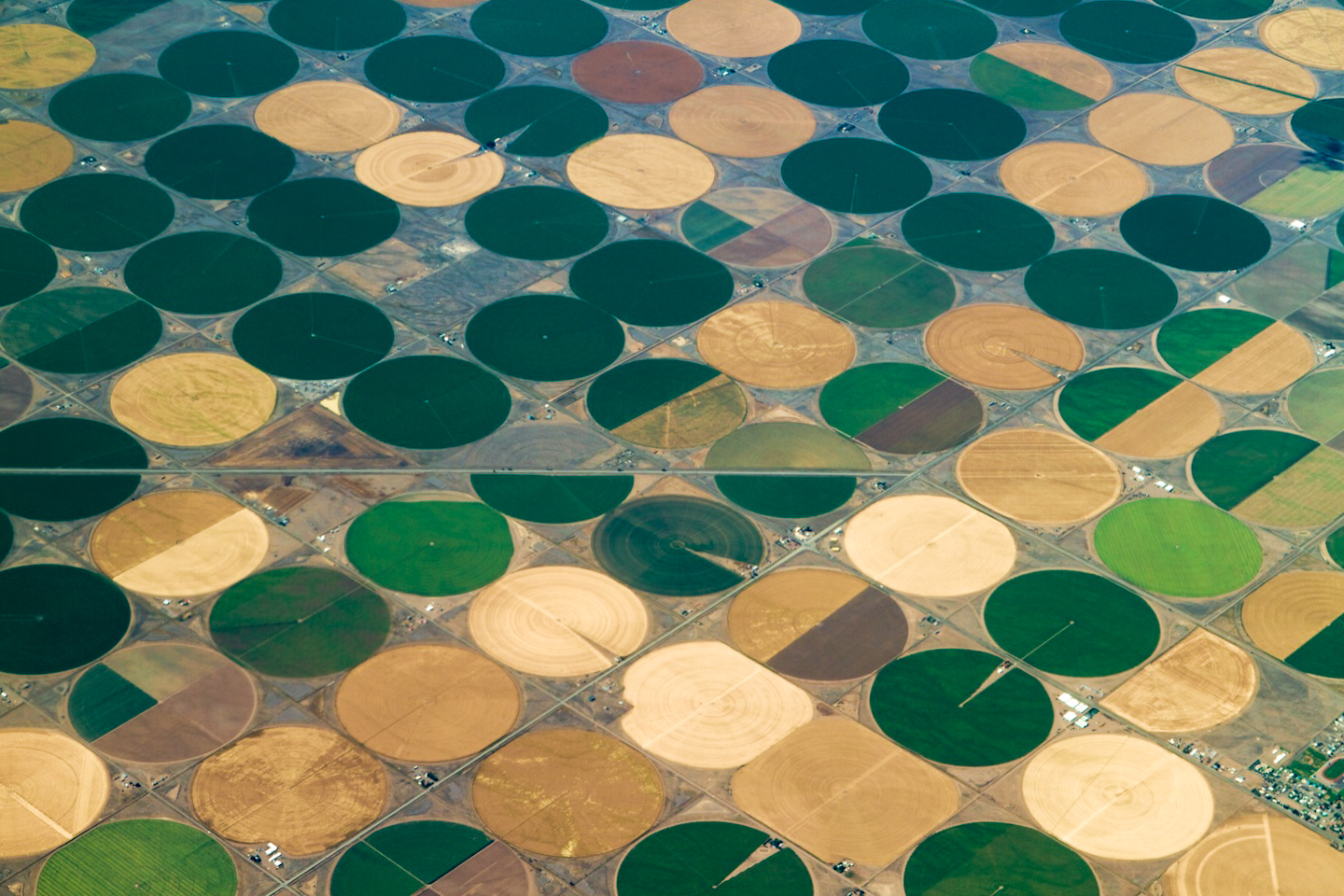
Crop circles — irrigated agriculture Click here to read the report. Here’s an excerpt:
The 2012 Census of Agriculture is the 28th Federal census of agriculture and the fourth conducted by the U.S. Department of Agriculture (USDA), National Agricultural Statistics Service (NASS). The U.S. Department of Commerce, Bureau of the Census conducted the census of agriculture for 156 years (1840-1996). The 1997 Appropriations Act contained a provision that transferred the responsibility for the census of agriculture to NASS.
The history of collecting data on U.S. agriculture dates back as far as President George Washington, who kept meticulous statistical records describing his own and other farms. In 1791, President Washington wrote to farmers requesting information on land values, crop acreages, crop yields, livestock prices, and taxes. Washington compiled the results on an area extending roughly 250 miles from north to south and 100 miles from east to west which today lies in Maryland, Pennsylvania, Virginia, West Virginia, and the District of Columbia, where most of the young country’s population lived. In effect, Washington’s inquiry was an attempt to fulfill the need for sound agricultural data for a nation that was heavily reliant on the success of agriculture. Such informal inquiries worked while the Nation was young, but were insufficient as the country expanded.
The U.S. Department of Agriculture brought a bounty of farm data to the public market on Friday when it released the 2012 agriculture census.
Published every five years, the census is a trove of information down to the county level on production practices, farm economics, and rural demographics. Being a water news site, Circle of Blue is interested in the irrigation trends.
On the whole, irrigation is declining in the dry West and making inroads in the humid East.
Since 1997, irrigated acreage is down 11 percent in California, 20 percent in New Mexico, and 25 percent in Colorado. Over the same period, irrigated acreage shot up 49 percent in Mississippi, 71 percent in Indiana, and 212 percent in Tennessee – albeit each from a much lower starting base.
Irrigation also adds value. Only 14 percent of farms are irrigated, but they account for 39 percent of the market value of farm sales.
Click here for the Wikipedia entry. Here’s an excerpt:
John Laing Leal (1858–1914) was a physician and water treatment expert who, in 1908, was responsible for conceiving and implementing the first disinfection of a U.S. drinking water supply using chlorine. He was one of the principal expert witnesses at two trials which examined the quality of the water supply in Jersey City, New Jersey, and which evaluated the safety and utility of chlorine for production of “pure and wholesome” drinking water. The second trial verdict approved the use of chlorine to disinfect drinking water which led to an explosion of its use in water supplies of the U.S.
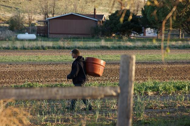
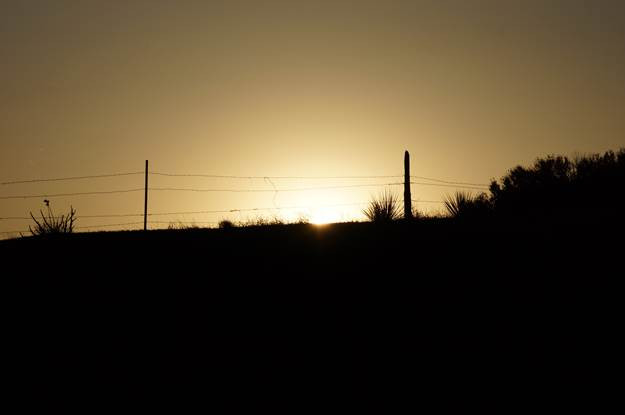
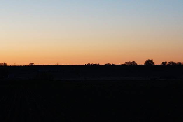
What a good way to start the month. Ditches are running, farmers are getting their crops into the ground and watering them up. Optimism is high for the most part due to a decent snowpack in most areas.
Longtime readers will know that I’m a fan of Justice Hobbs’ poetry and writing. Here’s a picture poem that he sent via email on Saturday:
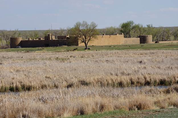
May The Arkansas
Bent’s Fort on the way to Old Mexico
The ever-working river
scallops a field of furrow rows
There’s no closer work to the elemental
– the keepers, the feeders, the binders –
Sunset comes before dinner
And the glow of an early May morning beams
Let’s get-back-to-it!
(for Dan, Jamie, Avery, and all Colorado farm families)
From the Ouray County Plaindealer (Sheridan Block):
In an attempt to protect Colorado’s natural resources, the Public Trust Initiative is again trying to make waves and earn its spot on ballots this year. While the initiative aims to secure protection for the state’s precious resources — particularly water — many local ranchers and water users are vehemently against the proposed measure.
Initiative 103, also known as the public trust doctrine, is an effort to protect the state’s natural resources from pollution and irresponsible use. The initiative asserts that it is the state’s responsibility “to secure the rights of the people to protect natural resources” such as “clean air, clean water, including ground and surface water, and the preservation of the environment” which the public is entitled to.
More Public Trust Doctrine coverage here. Here’s the link for the Colorado Water Congress Stewardship Project website for more information about the Public Trust Doctrine.
Storm pattern over Colorado September 2013 — Graphic/NWS via USA Today
Here’s the release from Boulder County (Stacey Proctor) via the Lyons Recorder:
As part of long-term flood recovery, Boulder County has hired consultant Michael Baker Jr., Inc. to complete a master plan for the St. Vrain Creek watershed, which includes South St. Vrain Creek, North St. Vrain Creek, and the main stem of St. Vrain Creek to the confluence with Boulder Creek.
The master plan will be used to guide the county, municipalities, and individual landowners in identification and prioritization of stream rehabilitation and restoration projects. The goal of the master planning effort and subsequent project implementation is increased resiliency in communities, economies, and river systems.
“Using an open and collaborative process among public agencies, property owners, ditch companies, stakeholders, and the public, the St. Vrain master plan will help facilitate the transition to the next phase of creek recovery,” said Dave Jula, St. Vrain Creek Watershed Master Plan Project Manager, for Michael Baker Jr., Inc.
The master planning effort is funded by a grant from the Colorado Water Conservation Board, Boulder County, and other local agencies. The project will begin immediately with public meetings, field assessments, and data analysis. The final master plan is expected to be completed by early fall.
The consultant was selected through a competitive process by the St. Vrain Creek Coalition. The St. Vrain Creek Coalition consists of representatives from Boulder County, Natural Resource Conservation Service, Town of Lyons, City of Longmont, St. Vrain and Left Hand Water Conservancy District, USDA Forest Service, Arapaho Roosevelt National Forest, Colorado Department of Transportation, and the Colorado Water Conservation Board.
“After thorough review of the bids we received, the St. Vrain Creek Coalition selected Michael Baker Jr., Inc. for the project because of their strong technical expertise and their commitment to citizen participation in the process,” said Julie McKay, St. Vrain Creek Coalition lead for Boulder County.
Similar master planning efforts are underway for many other watersheds in Boulder County, including Left Hand Creek, Little Thompson River, and Fourmile Creek. For more information on any of the master plans, please contact Stacey Proctor, Communications Specialist at 303-441-1107 or sproctor@bouldercounty.org.
Click here to read the newsletter. Here’s an excerpt:
… there is nothing quite like the sense of accomplishment we experience at the closing of a conservation easement.
Conserving land and water is really our core function. And it gives us the chance to work with some of the most committed and generous people here in the Valley who deeply care about the future of their ranches. This is so evident in the heartwarming story in this newsletter from Eveyln Buss about conserving the ranch that she and her brother Doug Davie inherited from their parents. We are grateful to them for protecting that beautiful ranch on the Rio Grande, and its exceptional water rights forever.
Likewise, we were able to complete the conservation easement on the lovely Garcia Ranch on the Conejos River in December of 2013. Along with his daughters, Lana and Tania, Reyes Garcia was committed to protecting the legacy of his family on that land. His article expressing the deep meaning of this was featured in our Spring 2013 newsletter (you can find that issue on our website).
Both of these ranches were featured properties in RiGHT’s 2012 and 2013 “Save the Ranch” campaigns. In so many ways, these projects were community projects, and we could not have made our way through the many challenges that easements inherently present, without the generous support of our many friends and neighbors who contribute to RiGHT’s work, with donations of time, funds, and so much more. I hope you will share in our deep sense of accomplishment, that together, we are leaving a lasting legacy of conserved land and water for future generations.
Colorado-Big Thompson Project east slope facilities
From email from Reclamation (Kara Lamb):
On Monday, May 5, we will stop pumping water to Carter Lake. Carter is about 98% full and ready for the season.
Colorado-Big Thompson Project water that was going up to Carter will now go to Horsetooth. Horsetooth Reservoir is about 88% full and its water level is still rising.
Boat ramps are open.
From email from Reclamation (Kara Lamb):
apologize for a late evening notice. I’m on business travel and communicating across time zones.
This e-mail is to let you all know there are some changes coming to the river flow down the Big Thompson Canyon. Run-off is increasing and so will flows down the canyon, beginning Monday.
Currently, we are seeing run-off inflows up to 200 cfs at night. But, as you have read in previous e-mails, under Free River conditions, we have been able to divert some of that at Olympus Dam to Colorado-Big Thompson Project reservoirs like Carter Lake and Horsetooth Reservoir. This weekend, Free River conditions are ending.
As a result, we will no longer be able to pull some of the spring run-off flows native to the Big T coming into Lake Estes out of the river. Instead, the Big Thompson will resume its native outflow through Olympus Dam to the Canyon.
Currently, we are releasing about 35 cfs. Beginning Monday, May 5, we will start incrementally increasing the releases in several steps. The resulting flows down the Canyon by Monday afternoon could go up to about 140 cfs. It is possible there could be additional increases on Tuesday.
I will send an update on Monday. Meanwhile, please let me know if you have any related questions.
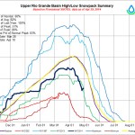
Stuck out here in the Rio Grande Basin, I’ve long suffered Colorado River Basin Envy Syndrome. The Colorado is the sexy river, which means it gets all the cool science. I dream of an analysis this rich of uncertainties in my river’s streamflow.
Turns out that even within the Colorado River Basin there’s a little Envy Syndrome going on.
More Rio Grande River Basin coverage here. More Colorado River Basin coverage here.
The town council amended a law during a meeting Tuesday, April 22, to extend water conservation efforts during drought that limited outdoor use to three times a week.
The restrictions were last put in place in 2003 and 2012, and the new rules will take effect June 1.
“We’re a headwaters community, and we want to take a leadership role,” said Peter Grosshuesch, the town’s community development director.
Properties east of Main Street or Highway 9 may water only on Sundays, Wednesdays and Fridays, while properties west of those roads may water only on Tuesdays, Thursdays and Saturdays. On those days, watering is restricted to between 5 p.m. and 9 a.m. the next day.
People can still keep their landscaping alive under those restrictions, Grosshuesch said, calling unlimited water use unwise, especially in a semiarid climate.
According to the Western Regional Climate Center, Breckenridge received an average of 163 inches of snow a year between 1948 and 2005. But that number translates to just 19 inches of water per year.
“Water is a valuable commodity,” Grosshuesch said. “It’s expensive to produce and deliver.”
When the town asked for public comment on how the change would affect pressure-cleaning driveways and parking lots, officials received hearty support.
“The vast majority of people said, ‘No, you shouldn’t be using water to do that. You should just sweep them,’” Grosshuesch said.
But the town exempted using water for cleaning those surfaces anyway, as long as people use hoses with shut-off nozzles.
Some businesses in the food industry expressed concern about the permanent restrictions. Due to health codes, they must clean pollen off their outdoor tables, and they like to do that with water. Grossheusch said that specific case also will be exempt.
First-time violators will be warned, but a second-time offender will be fined $250. A third-time offense warrants a $500 fine, and any offenses after that will cost $750. Out-of-town violators will be charged 1.5 times the fine for residents.
“Navigable waters.” According to the Internet, the accepted definition is: “deep and wide enough for boats and ships to travel on or through: capable of being navigated.”
Apparently that’s true for everyone… but the Environmental Protection Agency.
The new proposed ruling for the expanded Clean Water Act from the EPA is meant to clarify what is determined as “Waters of the U.S.” In essence, almost any place that water could collect could be subject to regulation and the permitting process.
The CWA was started in 1972 as a way to curb pollution into what was determined navigable water from a single source — without a federal permit.
Most people would probably be amazed at what all requires permission from someone else in order to simply do something… even on your own property. There are permits to build stuff, permits to take down stuff, permits to use water, permits to take away water — I’m sure there are probably even agencies that have permits in order for another agency to allow permits. The process is essentially the same. You apply, based on whatever rules and regulations have been drawn up. You explain why you should be allowed a permit to complete whatever action or build whatever structure you have planned. You present your application with the proper fee, determined by the regulatory board or by law, and you wait to hear back.
Here’s the catch: There is no legal right to be allowed a permit. That’s right, even if you dot your I’s and cross your T’s and pay the fees and fill out each form in triplicate and you state sound reasons as to why your permit should be granted and have science on your side, you may be turned down. Because we all know that decisions don’t always make sense.
More Environmental Protection Agency coverage here.
FromThe Grand Junction Daily Sentinel (Gary Harmon):
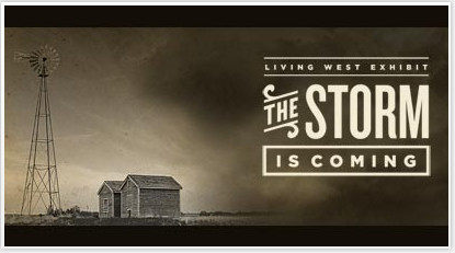
Water, according to Western lore, flows uphill to money. According to a display at the History Colorado Center in Denver, it runs uphill with something else: a grudge.
That’s according to what History Colorado describes as “a groundbreaking new 7,000-square-foot exhibit that explores the living dynamics between the people of Colorado and their state’s extraordinary environment.”
Called “Living West,” the exhibit includes a diorama of Colorado depicting the natural flow of water west from the Continental Divide and the population differential showing the vast majority of people, 80 percent, on the east side of the Rocky Mountains.
“The Western Slope has water, but a small population,” reads the display. “To eastern Colorado, this is a waste; shouldn’t water go where the people are?”
“But piping water east means less for western towns, ranches, and orchards. Western Slope residents believe their future is being sacrificed to benefit the rest of Colorado.”
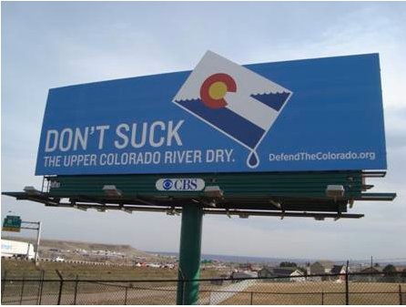
The text accompanies a photo of a rally in which protesters waved signs emblazoned with slogans such as “Let Our Rivers Run!” and “Don’t Suck the Upper Colorado River Dry.”
Headlining the text is, “Water comes from the Western Slope (with a grudge.)”
Western Slope residents and water managers said they weren’t consulted on the exhibit, and some suggested that it might be a harbinger of bad feelings to come.
Indeed, the exhibit, which illustrates the way Coloradans from ancient Puebloans to Dust Bowl-era farmers have dealt with drought, is subtitled “The Storm is Coming!”
“Wouldn’t anybody begrudge the fact that their future is being limited?” Mesa County Commissioner Steve Acquafresca said when told of the exhibit. “I wouldn’t dispute the fact — but I think there are good reasons for it.”
“It sounds like somebody is trivializing the issue,” Acquafresca said.
Kids open pumps
There is more to the Colorado River story than the exhibit suggests, said Bonnie Petersen, executive director of Club 20, a Western Slope advocacy organization.
Colorado River Basin including out of basin demands — Graphic/USBR
“There’s certainly no recognition that seven states rely on the water over here,” Petersen said, referring to Arizona, Colorado, California, Nevada, New Mexico, Utah and Wyoming.
The diorama is interactive and geared to younger visitors, who can open and close pumps to move water about the state.
“Your job:” the exhibit says, “Send water from Big River in the west to Small River in the east, all the way down to Thirsty Town.”
Another instruction urges visitors to “Crank that pump and keep cranking, Watch the pump move water from Big River into Western Reservoir. This takes water away from Busy City and Dry Throat Ranch.”
That could present an opportunity, Acquafresca said.
“I’d like to go there and direct it back from the east to the west,” Acquafresca said.
“Living West,” according to the History Colorado website, was presented by Denver Water with “generous support” from the Gates Family Foundation.
“Denver Water, yeah, there’s a surprise,” Petersen said.
Denver Water’s collection system via the USACE EIS
“Denver Water,” Larry Clever, general manager of the Ute Water Conservancy District in Grand Junction, guessed when told of the exhibit. “I didn’t know. I just figured it was Denver Water.”
“And people wonder why we don’t trust them,” said Diane Schwenke, president of the Grand Junction Area Chamber of Commerce.
Denver Water, however, had little to do with the display that prominently bears its name, said spokesman Travis Thompson.
“We had no influence or design on the content of the exhibit,” Thompson said. “It wasn’t for us to tell the story. It was for them to tell the story.”
“Them” is History Colorado, a nonprofit organization previously referred to as the Colorado Historical Society. It’s also a state agency that receives funding under the Division of Higher Education.
A spokesperson for the museum didn’t respond to several requests for comment.
East-west relations
Colorado transmountain diversions via the State Engineer’s office
The transmountain diversion display “seems a little biased” toward a Front Range perspective, said David Bailey, curator of history at the Museum of Western Colorado in Grand Junction, who has viewed the exhibit.
“Usually you try to give all a voice,” Bailey said. “Our job is to make you think about the topic, in this case the historic and present-day crisis of water.”
Denver Water is a major transmountain diverter and water provider to 1.3 million customers that just last year reached an agreement with water providers and local governments down the Colorado River Basin that was hailed as marking a new era in east-west water relations.
Lurking beneath the good feelings, however, has been the possibility of a new transmountain diversion. Although Gov. John Hickenlooper’s state water plan is being drafted without identifying one, it is to set out a way by which such a project could be pursued.
And James Lochhead, who heads Denver Water, last month signed a letter on behalf of the Front Range Water Council saying that a new transmountain diversion is a necessity.
Talks about a state water plan “should begin with an assurance, and not simply a hope” for a new project diverting water from the Colorado River to the Front Range.
Broader picture
Western Slope water is now sent east via 24 transmountain diversions that suck up, in a wet year, about 600,000 acre feet of water. An acre foot of water, or 325,851 gallons, is enough to supply about two and a half Front Range households for a year, according to DenverWater.org.
It’s also about 8 percent of the water that the upper Colorado River Basin states are required to deliver to the lower basin under a 1922 compact governing management of the river.
The amount of water diverted east could be crucial in a succession of dry years as the upper and lower basins deal with keeping enough water in Lake Powell to ensure the efficient operation of the electricity-generating turbines and putting enough water into Lake Mead downstream, Clever said.
The issue involves more than diverting water, Clever said.
Front Range water interests “want everybody to pay for a diversion,” Clever said. “They want the West Slope to help pay for taking our water.”
The fact is, said Grand County Manager Lurline Underbrink Curran, the Colorado River Basin “might not have as much water to give as everybody thinks we do.”
To be certain, Denver Water has lived up to its agreement with the Colorado River Basin, Curran said, but the tone of the exhibit bearing its name and citing the grudging nature of the Western Slope is “somewhat disturbing,” Curran said.
“Does the West Slope grudgingly withhold water?” Curran said. “No, in my opinion. The West Slope wants to have recognition of the needs and uses (of water) on the West Slope.” Those uses aren’t limited to ranches and orchards, Curran said, noting that the West Slope has growing cities and industries of its own, just as on the East Slope.
It’s possible that the message children absorb isn’t one favoring transmountain diversions, Acquafresca said.
“If Denver Water is trying to indoctrinate kids to view water resources as the Front Range does, I think that’s the wrong approach,” Acquafresca said. “Children could easily ask themselves, ‘Shouldn’t water flow where God meant for it to flow?’”
Colorado-Big Thompson Project Map via Northern Water
From the Fort Collins Coloradoan (Ryan Maye Handy):
Without changes to its water rates, Northern Water’s expenses are on track to exceed its revenue in 2015. At its monthly meeting on Thursday, the board reviewed a study it commissioned to outline options for future water-rate hikes.
Northern Water released the rate study on Tuesday, and several water district managers and lawyers asked the board on Thursday to postpone its decision until they had more time to review the massive document.
The board also postponed a decision to set the water rates for 2015, which will likely increase by 9 percent for all stakeholders…
Northern Water plans to raise the cost of Colorado-Big Thompson or CB-T shares, which many districts rely on for most of their water. Regardless of the board’s ultimate decision, water rates will increase for Fort Collins Utilities, which gets about half of its water from the Big Thompson. Utilities costs for Fort Collins customers will not be affected, a city official previously said.
The rate study, done by CH2MHill in Denver, came up with three options for rate changes, all of which would double or triple the costs of water for farmers and cities alike.
At its Thursday meeting, the board eliminated one option, which would keep the existing rate system.
In June, the board will decide between the two remaining options, which could turn out to be drastically different after 10 years, according to CH2MHill’s research:
• One option could mean a sharp increase in water rates. For municipalities and industrial clients, at most, one unit of CB-T water would jump from $28 per acre foot to $51.90 per acre foot by 2016. For irrigators, this increase would bump the cost from $10 to $18.70 per acre-foot.
• The other model would likely mean a more gradual increase. By 2016, this option would bump municipal and industrial rates to $49.10 and irrigation rates to $20.90 per acre foot.
Only those who own fixed-rate contracts would escape the proposed changes. Fixed-rate allotments were created in 1957 and set at $1.50 per acre-foot. The city of Fort Collins owns 6,052 fixed-rate units among its 18,885 total units of CB-T water.
Several water district managers asked the board to reconsider the fixed-rate contracts and allow them to absorb some of the costs of modern water operations.
Dennis Jackson, who worked on the rate study for CH2MHill, cautioned that a volatile economy could drastically change some of the study’s findings. While a strong economy would make rate hike unnecessary, a weaker economy would likely mean more increases in the future, he told the board.
“If for some reason the economy were to stall, and if we had conditions that were sluggish and not as forecasted, assessments would need to be higher, 15 to 20 percent higher,” Jackson said.
More Northern Colorado Water Conservancy District coverage here.
… the Colorado Division of Reclamation Mining and Safety is beginning the process of trying to stabilize the mine near Ophir and improve the water quality of streams in the area. The DRMS project aims to see if there is a way to stop water from flowing through the mine, which will also help improve the water quality of Howard Fork, which flows into the San Miguel River. The project is being overseen by the Environmental Protection Agency, which has been investigating the water quality and taking samples from the Iron Springs Mining District for a couple of years, according to EPA Site Assessment Manager Jean Wyatt.
“It’s in part to understand the baseline conditions for water quality and understand if something can be done to stop the mine water from passing through the workings of the mine,” Wyatt said. “There are elevated levels of zinc and iron coming out of that mine … We want to understand what the conditions are and who could contribute resources or expertise to increase the quality of the watershed in general.”
DRMS is seeking bids from contractors to reopen the portal and stabilize and rehabilitate portions of the underground workings of the Carbonero Mine. The project will also include the construction of a platform at the portal, construction of water management structures near Ophir Pass Road below the site and re-grading and reclamation of certain areas.
“That’s the goal: to stabilize the mine and enter and see what, if anything, can be done,” said Bruce Stover, director of the DRMS Inactive Mine Reclamation Progam. “This isn’t a final remediation by any means. This is just part of an ongoing investigation.”
Glenn Pauls is the landowner of the site. In the 1980s, Pauls acquired many of the mining claims in the area — he estimates about 1,100 acres in roughly 100 claims at one point — with the intention of making a trade with the Forest Service at some point. His goal, he said is to preserve the Ophir Pass Road and keep it open for Jeep traffic. Pauls said he would like to create a hydroelectricity project at the Carbonero Mine site, once the water quality studies are complete.
“The idea is that we open it up and find out if the water coming in the back end is clean,” he said. “I can’t touch the water until someone gives me the OK.”
A mandatory pre-bid meeting for interested contractors is planned for the site on Ophir Pass Road about a half-mile east of Ophir at 10:30 a.m. June 11. The submission deadline for bids is June 24. For more information about the project, contact Kristin Miranda at the Department of Natural Resources/Division of Reclamation, Mining and Safety at 303-866-3567 ext. 8133 or kristin.miranda@state.co.us.
Sean Cronin and John McClow at the 2014 CFWE President’s Award Reception
Sean Cronin received the 2014 Emerging Leader Award yesterday at the Colorado Foundation for Water Education’s President’s Award Reception. Alan Hamel received this year’s President’s Award.
The shindig at the Colorado History Museum is an annual event to recognize leaders in the water community.
Mr. Cronin [St. Vrain and Left Hand Water Conservancy District] related a life event that helped point him towards a career in water. As a young Eagle Scout eager to serve his community he organized a clean up of a local pond. He remembers now that the clean up of “weeds” included cattails and other wetland flora. Most of those present knew immediately that Sean and his cohorts were rooting around in a wetlands. He admitted that he should have sought a “404 permit.”
He asserted that he didn’t get any callouses on his hands performing his role in the aftermath of the September flooding. He said his blisters showed up in another area from sitting in meeting after meeting. He credits the first responders and the personnel rebuilding the infrastructure along with folk’s lives for doing the real work.
Mr. Hamel continued that theme acknowledging that he knows that successful individuals depend on their network for inspiration, mentoring, and support. He emphasized the importance of communication, honesty, and transparency as values for leaders.
Mr. Hamel retired from the Pueblo Board of Water Works last year after 54 years of service to the community. Retired is a relative term however as he is the currently serving as Vice-Chair for the Colorado Water Conservation Board.
Click here to read the bios for both awardees from the CFWE website.
More Colorado Foundation for Water Education coverage here.
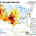
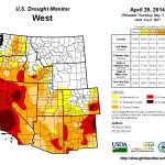
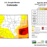
Click on a thumbnail graphic to view a gallery of drought data from the US Drought Monitor website.
Click here to go to the website. Here’s an excerpt:
Summary
A weather system moving in the upper-level westerly flow brought swaths of precipitation to the Pacific Northwest, Great Plains, and Midwest early in this U.S. Drought Monitor (USDM) week. Another upper-level weather system stalled out later in the week as it moved across the contiguous United States (CONUS), generating violent weather and locally heavy precipitation, especially along and east of the Mississippi River. Precipitation was below normal across much of the Southwest, southern Plains, and coastal Southeast. Weekly temperatures averaged below-normal in the northern states and in the West, but above normal from the Plains to the Southeast…
The Plains
Bands of 2-4 inches of rain fell across parts of the Dakotas, Nebraska, and Kansas this week, but the western portions of Nebraska and Kansas largely missed out on the precipitation. The precipitation from this week’s slow-moving upper low replenished topsoil moisture, but subsoil moisture was slow to respond, limiting any improvement. USDA observations improved only slightly, with 53% of Nebraska and 67% of Kansas topsoil still rated short or very short of moisture as of April 27. D0 was pulled back in South Dakota, a D0 hole was added to south central Nebraska, D1 was contracted in eastern Nebraska, and D2 was pulled back in south central Nebraska and north central Kansas. But deterioration occurred in the Nebraska panhandle, where D0 expanded, and in western and southern Kansas, where D2-D3 expanded…
The West
Widespread 2+ inches of precipitation fell along coastal Washington and Oregon, with locally 5+ inches of precipitation. Along the Sierra in California, in the northern Rockies, and in parts of northern Nevada and Utah, 1-3 inches of precipitation was reported. Half an inch to 2 inches of precipitation occurred over the Colorado Rockies, and 0.5-1.0 inch was reported in other parts of the West. But the precipitation was largely hit or miss, with other areas receiving only a few tenths of an inch, and much of southern California, Arizona, and New Mexico getting no precipitation. Improvement in the drought depiction occurred in the Northwest, where D0-D2 was pulled back in northeast Washington and parts of Oregon, but D3 expanded in parts of southwest and southeast Oregon. D2-D4 expanded across parts of New Mexico to reflect both short-term precipitation deficits as well as lingering long-term deficits, some stretching over the course of 4 years. D0-D3 expanded in northeast Colorado to reflect dryness at the 30 day to 6 month timescales. D2 was added to Duchesne Co. in northeast Utah and D1-D2 expanded in southeast Utah and southwest Colorado to reflect dryness at 120 days. In the Four Corners area, the town of Monticello, Utah has major water supply problems. With their reservoir at a critically low level, groundwater wells were drilled for supplemental supply. Even with conservation, they have at most one season of water supply. If snowpack is low again next year, they will have very little water available for municipal supply.
Looking Ahead
As a slow-moving upper-level weather system gradually exits the CONUS, it will leave behind an inch or more of precipitation along the East Coast, with 2-4 inches possible in parts of the Northeast and eastern Gulf of Mexico Coast. In addition, the NWS HPC 7-Day Quantitative Precipitation Forecast (QPF) calls for 1-2 inches of precipitation along the northern tier states, but no precipitation across the Southwest and southern Plains to Lower Mississippi Valley. Temperatures for May 1-6 should be below normal in the central CONUS as the upper low and surface cold front migrate eastward, and above normal in the West. Colder-than-normal air slides into the northern states during May 3-8.
The 6-10 day and 8-14 day outlooks indicate that a change in the upper-level circulation pattern, consisting of a trough over western North America and a ridge over the east, is predicted for May 6-14, bringing warmer-than-normal temperatures for Alaska and the southern Plains to Northeast, and below-normal temperatures for the West to northern Great Lakes. Precipitation is expected to be above normal for much of Alaska and the CONUS, except for the immediate West Coast of the CONUS, Southeast, and extreme Southwest.
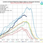
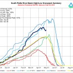
Colorado’s snowpack level is 102-percent of normal, offering an encouraging sign for farmers who depend on the water from spring runoff which is expected to start earlier this year.
In Crowley County residents are hopeful the expected boost in moisture as temperatures climb will put an end to a problem they’ve been dealing with for days now, high winds have created massive dust storms and dirt has accumulated on almost every solid surface in the path of the winds.
“All a person can really think about is the Dust Bowl in a situation like this where sometimes you can’t even see your hands in front of your face,” said Gary Pfalzbot, who lives on County Road D near Ordway. “There’s no beast or critter alive that can get out of this.”
The news of the above average snowpack this year is encouraging, but water experts are remaining cautiously optimistic. Though the Arkansas River snowpack is listed as 92-percent of normal, much of Southern Colorado is still considered to be facing severe drought conditions. A good snowpack year is great, but one helpful year can only go so far to reduce the drought that’s plagued the region for several years.
“Say a prayer for the rain or snow,” Larry Pfalzbot said. “I’d even take hail at this point, small hail.”
From the Associated Press (Bobby Magill) via the Kitsap Sun:
Though the overall spread of dry conditions across the U.S. has diminished slightly over recent weeks, and about 15 percent over the past year, the drought hotspots in the West remain desiccated.
The driest places today are the places that have been dry for 2 or 3 years or longer: California, northwest Nevada and the southern Great Plains of the Texas and Oklahoma panhandles, northeast New Mexico and along the Colorado-Kansas border.
In other words, drought is bringing the dust back to the Dust Bowl territory of the 1930s.
For those places, dealing with the threat of water scarcity, the specter of severe wildfires, and farmlands that are struggling to produce crops has become a way of life.
About 75 percent of Texas is so drought stricken that the U.S. Dept. of Agriculture declared 240 of the state’s 252 counties a drought disaster area last month. The worst of it is in the northern third of the state, where Dallas is experiencing its third driest year on record so far and dust storms have been sweeping across the Panhandle.
Farther north in eastern Colorado’s Arkansas River Valley, storms of tumbleweeds have been blocking roadways, irrigation canals and access to homes and schools, forcing local county officials to spend hundreds of thousands of dollars clearing the mountains of tumbleweeds from highways and overpasses…
California — 100 percent of it — remains under drought conditions, according to the U.S. Drought Monitor released Thursday. Lasting relief isn’t expected to come until the fall — if it comes at all — and for now, reservoir levels remain low and wildland fire potential remains high throughout coastal California and the Sierra Nevada range.
Wildfire potential is also high in other drought-stricken areas of the West Coast through the summer, especially Northern California, central Oregon and northern Nevada.
The May 1 national wildland fire outlook for the summer season shows drought-ravaged southern New Mexico and Arizona to have a high scorch potential through the end of June when the summer monsoon rains are expected to kick in and improve wildfire conditions there.
A University of Utah study published in April shows that while the number of large wildfires is increasing across the West, there isn’t always a direct connection between drought and wildfires because forest management and other factors play a role in how and when wildfires burn.
For now, the only drought relief in sight anywhere in the West is in the Four Corners states, where the summer monsoons are expected to bring above-normal precipitation for Colorado, New Mexico, Arizona and Utah, according to the National Climate Prediction Center’s three-month outlook issued in late April…
So, the drought on the West Coast is here to stay, and relief is likely to depend on the possible development of an El Niño in the Pacific. If that happens, relief could come when the snow season begins late this year.
And even if next winter is a wet one, that doesn’t necessarily mean the West’s drought disappears.
As Climate Prediction Center senior meteorologist David Miskus told Climate Central last month, it’s going to take several years of above-normal precipitation just to get California back to normal.
A release of water down the Colorado River may not reach the sea, as hoped. But it is visible from space.
A new satellite image from Landsat 8 captured a view of the Colorado on April 16. The river is typically dry by the time it gets to this spot in northern Mexico, its flow diverted to feed thirsty farms both in that country and in the United States. The Colorado River has only rarely reached the sea since 1960.
This spring, however, both countries agreed to release more water than usual from the Colorado’s dams in an effort to restore parched ecosystems, especially the Colorado Delta.
Residents here are thankful for bipartisan legislation passed [by the Senate] Wednesday that will help clean up groundwater contamination by Cotter Corp.’s uranium mill. The legislation will ensure that uranium mills clean up ongoing contamination of residents’ groundwater as expeditiously as possible, with the best available technology. The legislation will help give direction to the state health department as it oversees the cleanup, according to Chris Arend of Conservation Colorado.
Residents of the Lincoln Park neighborhood just north of the Cotter Uranium Mill site have been hooked up to city water so they can avoid using wells that have been contaminated by uranium and molybdenum which seeped from the mill site.
The neighborhood and Cotter mill have been part of a Superfund cleanup site since 1984.
“For my Lincoln Park neighbors, forsaking our historic use of our water wells was never an option. We knew we needed to keep fighting for full and active cleanup of our wells, not only to restore our current rights but for future residents,” said Sharyn Cunningham, a Lincoln Park resident who is co-chair of Colorado Citizens Against Toxic Waste.
“After 30 years of contamination and indifference, the residents of Lincoln Park saw significant movement in their campaign for the Cotter Corp. to finally clean up its mess,” said Pete Maysmith of Conservation Colorado. “No community should have to endure the long-term exposure to uranium and other contamination as the community of Canon City has.”
Cotter officials, along with state and federal health officials, are overseeing decommissioning and full cleanup now that the mill is closed.
More 2014 Colorado legislation coverage here. More nuclear coverage here.
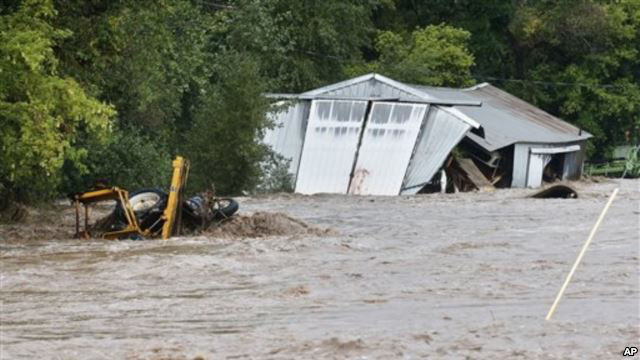
Flooding St. Vrain River September, 2013 via Voice of America
Here’s the release from the US Department of Housing and Urban Development and Governor Hickenlooper’s office (Val Beck, Charlene Guzman):
The U.S. Department of Housing and Urban Development (HUD) today announced it approved Colorado’s Community Development Block Grant – Disaster Recovery (CDBG-DR) Action Plan. The Plan outlines how Colorado will distribute $62.8 million in grant dollars received from HUD for flood recovery programs.
During a visit in December, HUD Secretary Shaun Donovan announced the funding award and that it would go toward needs not addressed through other sources of public and private assistance such as the Federal Emergency Management Agency and Small Business Administration.With acceptance of this disaster action plan the long-term and sustainable disaster recovery can continue.
This grant will support recovery efforts in 18 Presidentially declared flood-impacted counties, with a majority of the funds going to the most impacted counties: Boulder, Larimer and Weld. Programs will focus on housing, public infrastructure, long-term planning and economic development and, as stipulated by the grant, 50 percent of the funds will be distributed to low- and moderate-income households.
“We are very pleased with this approval of our action plan for the $62.8 million in CDBG-DR funding. We greatly appreciate the efforts of HUD in working with our team to get to this as quickly as possible,” Hickenlooper said. “This grant will support long-term and sustainable disaster recovery efforts in the most impacted communities devastated by last year’s floods. The plan was developed with feedback from those impacted communities and will give Coloradans another resource to rebuild better and stronger.”
“From the moment the Presidential disaster declaration was made, HUD has been on the job, working with Congress to speed these much-needed funds to the State of Colorado,” HUD Rocky Mountain Regional Administrator, Rick M. Garcia said. “This funding is vital to helping Coloradoans rebuild their communities and HUD has been proud to partner with the State of Colorado and FEMA in this process.”
Applications for the funds will be available Friday, May 2, online at http://dola.colorado.gov/cdbg-dr/. The State will work with all applicants to release the money as soon as possible.
From the Longmont Times-Call (John Fryar) via the Loveland Reporter-Herald:
Programs funded by the Community Development Block Grant-Disaster Recovery grant are to focus on housing, public infrastructure, long-term planning and economic development, with 50 percent of the funds distributed to programs benefiting low- and moderate-income households affected by last September’s floods.
“We are very pleased with this approval of our action plan for the $62.8 million,” Gov. John Hickenlooper said in a Wednesday morning statement.
“This grant will support long-term and sustainable disaster recovery efforts in the most impacted communities devastated by last year’s floods,” Hickenlooper said. “The plan was developed with feedback from those impacted communities and will give Coloradans another resource to rebuild better and stronger.”
The state now will formally accept applications from communities for such programs as: household assistance, new housing construction, business grants and loans, agriculture grants, infrastructure repair grants, and strategic planning.
Colorado also is in line for getting another $199 million in federal CDBG-DR funds, and the state is preparing a separate action plan for spending that second round of flood recovery money.
Boulder County government and the county’s cities and towns have been working collaboratively on applications for the money they’re seeking from the first $62.8 million round of funding — an approach county officials said was intended to avoid local competitions for those dollars.
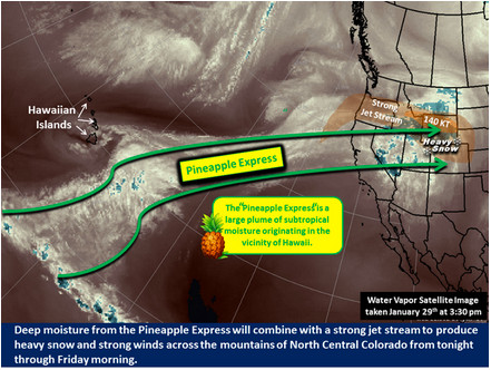
Pineapple Express conditions January 29, 2014 via NWS Boulder
Here’s the release from the US Bureau of Reclamation (Peter Soeth):
The Bureau of Reclamation is releasing a series of videos summarizing collaborative research addressing climate change and variability impacts, estimating flood and drought hazards, and improving streamflow prediction. This information was presented in January at the Second Annual Progress Meeting on Reclamation Climate and Hydrology Research.
“For more than 100 years, Reclamation and its partners have developed the tools to guide a sustainable water and power future for the West,” said Acting Commissioner Lowell Pimley. “This video series summarizes collaborative research that is another tool for Reclamation and its water users to manage water into the future.”
To kick off the video series, Reclamation is releasing four videos. They are:
Reclamation’s Research and Development Office is developing the science and tools that are critical to incorporate information on long-term climate change into water resource planning and infrastructure management. Sustainable water resource management will rely upon management strategies that effectively deliver water under a changing climate as well as including hydrologic hazard possibilities on infrastructure. Improved ability to forecast and use climate variability information may greatly enhance the flexibility of water managers and water users to plan their short-term operations and water delivery.
Research collaborators include Federal and non-Federal organizations, including members of the Climate Change and Water Working Group (http://www.ccawwg.us), NASA Jet Propulsion Laboratory, National Center for Atmospheric Research, University of Colorado CIRES and others.
Additional videos will be released over the next few weeks in the same playlist. When posted, the video link will be shared on Reclamation’s Twitter and Facebook accounts. You can also follow by using the hashtag #climateseries. To see the videos once posted or learn more about the presentations, please visit http://www.usbr.gov/climate.
A snowy winter in the Upper Colorado Basin is the city’s water savior. It’s the snowpack that fills Utilities’ reservoirs, which in recent years had dipped to below normal levels and had officials nervous about having enough water in storage for emergencies.
Once this year’s snow melts, Utilities expects it will have 2.3 years of water in storage – or about 73 percent of capacity. That’s a pretty good place to be, said Abby Ortega, Utilities water planner.
“We are expecting to fully recover storage levels to normal,” Ortega said.
Still, Utilities will roll out a $600,000 conservation campaign encouraging residents to water their lawns three days a week or less.
From the Cañon City Daily Record (Christy Steadman):
The Colorado Senate passed Senate Bill 192 on Tuesday, which concerns uranium licensing and groundwater protection, but causes conflict between Cotter Corp. Uranium Mill and Lincoln Park residents.
In a press release issued by Conservation Colorado representative Chris Arend, residents of Lincoln Park “expressed support for (the) bipartisan legislation … that will help rectify 30 years of groundwater contamination by Cotter Corp.”
“The passage of SB 192 today will help restore our use and rights to our wells and begin to rectify the damage the Cotter Corporation has caused in our community,” Sharyn Cunningham, Lincoln Park resident said in the release.
John Hamrick, facility manager at Cotter Corp., said they have been in negotiations with the Environmental Protection Agency and the Colorado Department of Public Health and Environment to abide by the federal rules regarding “what is the best way” concerning clean-up. He said that is “now in jeopardy” because of SB 192, and a year-and-a-half of progress in the negotiation process will have to be discarded, and they will now have “to go back to zero.”
“(Additionally), the State of Colorado is federally preempted from passing a law that requires the EPA to select a specific clean-up remedy,” Hamrick said.
In the release, Lincoln Park resident Pete Maysmith said SB 192 “will help clean-up residents’ groundwater and restore the historic use of their water wells.”
“No community should have to endure the long-term exposure to uranium and other contamination as the community of Cañon City has at the hands of the Cotter Corp.,” Maysmith said.
Impacted residents and members of the Colorado conservation community expressed support for bipartisan legislation passed today that will help rectify 30 years of groundwater contamination by Cotter Corporation in Canon City, Colorado. Residents of the Lincoln Park neighborhood in Canon City had been told that the best way to deal with Cotter’s pollution was for the community to abandon use of their wells.
“For my Lincoln Park neighbors forsaking our historic use of our water wells was never an option. We knew we needed to keep fighting for full and active clean up of our wells not only to restore our current rights but for future residents,” said Sharyn Cunningham, Lincoln Park resident. “The passage of SB 192 today will help restore our use and rights to our wells and begin to rectify the damage the Cotter Corporation has caused in our community.”
“Today after 30 years of contamination and indifference, the residents of Lincoln Park saw significant movement in their campaign for the Cotter Corporation to finally clean up its mess in Cañon City,” said Pete Maysmith. “No community should have to endure the long term exposure to uranium and other contamination as the community of Cañon City has at the hands of the Cotter Corporation. The legislation passed today will help clean up residents’ groundwater and restore the historic use of their water wells.”
Although pleased that contaminated water would be cleaned-up, supporters expressed concern that the Colorado Senate stripped out licensing requirements that would protect against future contamination.
“We are disappointed in Colorado Senate amendments to remove important protections for experimental uranium milling proposed for our community,” said Cathe Meyrick, resident of the Tallahassee Area in Fremont County. “The legislation would have clarified that licensing is required before the industry deploys experimental uranium recovery techniques with potentially grave impacts on our groundwater. Regardless of this setback, we will rely on a committed community and look for other mechanisms to protect our groundwater.”
The proposed new technologies involve extraction through the creation of an underground uranium slurry (i.e., underground borehole mining) and concentration through physical, rather than chemical means (i.e., ablation). These new uranium recovery methods are being proposed for uranium deposits in Fremont County (Tallahassee Area/Arkansas River) and in Weld County (Centennial Project and Keota).
Both Conservation Colorado and impacted landowners in Fremont and Weld County will work to reinstate the provisions as the bill moves forward.
At a celebration lunch on April 24 at Devil’s Thumb Ranch in Tabernash, representatives from Denver Water, the Colorado Governor’s Office, Grand County and Trout Unlimited spoke in favor of the Colorado River Cooperative Agreement. Nearing its one-year anniversary this September, the agreement coordinates efforts between 18 interest groups to both protect West Slope watersheds while providing future water supplies to Denver customers. The celebration came in the wake of the latest development in the proposed Moffat Collection System, Denver Water’s latest trans-mountain water project.
“(Our) overall goal is to protect the watershed and economies in the Colorado River Basin and help provide additional water security for those who live, work and play on the West Slope and (for) the customers of Denver Water,” said Jim Lochhead, CEO and Manager of Denver Water, at the lunch celebration…
Denver Water will pay out $1.95 million in Grand County for watershed, water treatment and river habitat improvements. It will send another $2 million to Summit County. The agreement is being called “historic” for its unprecedented work in bringing together a wide range of interests throughout the state and for its “learning by doing” program of adaptive water management.
“Working together, we were able to resolve historic conflicts through a holistic approach to resolving Colorado water disputes,” Lochhead said.
According to John Stulp with Gov. John Hickenlooper’s office, the unprecedented water cooperation will also be used as a model for the statewide Colorado Water Plan, set to be ready by December 2014.
“Part of the concerns we have, and why we need a water plan, is based on many of the same principles you had in this cooperative agreement,” Stulp said at the lunch. “Important … building blocks that went into this cooperative agreement (are) having good people with a broad vision of the future beyond their own community.”[…]
Still, the agreement hasn’t eliminated all controversy. Part of the Colorado River Cooperative Agreement negotiations is that West Slope parties must agree not to oppose any permits for the Moffat Project, the latest trans-mountain diversion plan to move water from the Fraser watershed to the Denver-metro area…
The U.S. Army Corps of Engineers released its final Environmental Impact Statement for the Moffat Project last week. It’s a massive document — the table of contents alone is over 60 pages and Wockner said it has around 11,000 pages total. So far, however, he said he hasn’t seen anything in the study to address the negative impacts to river systems in Grand County. Other environmental interests have also said even with the environmental impact statement, the Moffat Project is “far from a done deal.”
“This project should not be approved unless the long-term health of the river is assured and our nation’s environmental standards are met,” said McCrystie Adams, a Denver-based attorney with Earthjustice, in a press release. “We and our partners are committed to keeping the Colorado River flowing.”
Geoff Elliott, an earth scientist with the local firm Grand Environmental Services, said Denver Water presented bad data to begin with, stacking the numbers in its favor.
“Their data is skewed to show more water in the Fraser Headwaters than now exists,” he said. “My problem is no one is doing math. Denver gets out with everything it wants.”
Elliot said according to his analysis so far, the Moffat Project’s proposals compared with U.S. Geological Survey data on actual water flows means it could take 90 percent or more water out of the Fraser.
“Now, we get hit by a 12,000-page Final EIS that requires an army to review,” he said. “This is Big Brother Denver Water hitting Grand County hard, and we are told we should be happy with vague platitudes, scraps of water and lawyerly agreements for more closed-door meetings.”
More Colorado River Cooperative Agreement coverage here.
Mummy Lake is a sandstone-lined circular pit that was originally 90 feet (27.5 meters) across and 22 feet (6.65 m) deep. In 1917, American naturalist Jesse Walter Fewkes pegged the structure as a prehistoric water reservoir. Several subsequent studies of Mummy Lake have also supported this view, leading the National Parks Service to officially name the structure “Far View Reservoir” in 2006. (Far View refers to the group of archaeological structures located on the northern part of the park’s Chapin Mesa ridge, where Mummy Lake is also situated.)
In the new study, researchers analyzed the hydrologic, topographic, climatic and sedimentary features of Mummy Lake and the surrounding cliff area. They concluded that, contrary to what previous research had determined, the pit wouldn’t have effectively collected or distributed water…
“The fundamental problem with Mummy Lake is that it’s on a ridge,” said study lead author Larry Benson, an emeritus research scientist for the U.S. Geological Survey and adjunct curator of anthropology at the University of Colorado Museum of Natural History. “It’s hard to believe that Native Americans who understood the landscape and were in need of water would have decided to build a reservoir on that ridge.”[…]
To test this reservoir theory, Benson and his colleagues first analyzed the topography and hydrology of the ridge using GPS surveys, high-resolution imagery and digital elevation models.
They found that the ditches leading from Mummy Lake to the southern structures couldn’t have functioned as water canals or irrigation distribution systems. The ditches would have easily spilled water over the canyon edge at various points if it didn’t have walls controlling the water flow (which don’t appear to have existed).
Next, the team used climate models to investigate Mummy Lake’s potential to store water. They found that even in the wettest year on record, 1941, the pit would have gotten less than a foot of water from winter and spring precipitation by the end of April. This water would have completely evaporated by the end of July, when it’s most needed for crops.
The researchers then tested if a hypothetical feeder ditch could actually provide Mummy Lake with water. “The engineering and sediment transport work showed that any water in the ditch would start moving so much dirt that it would block the path,” Benson said. That is, soil would have quickly clogged the ditch after regular rainfall, preventing the water from reaching Mummy Lake…
Benson and his colleagues propose Mummy Lake is an unroofed ceremonial structure, not unlike the ancient kivas and plazas elsewhere in the Southwest. They noted that the structure is similar in size to a great kiva found at a Pueblohistorical site near Zuni, N.M. It also resembles a ball court and amphitheater at the Puebloan village of Wupatki in Arizona — interestingly, Fewkes also thought these two structures were reservoirs.
Furthermore, the ditches connecting Mummy Lake to Far View Village, Spruce Tree House and Cliff Palace aren’t canals to transport water, but rather Chacoan ceremony roads with similar dimensions to Chacoan roads that exist at other sites in the San Juan Basin, the researchers argue.
Two decades ago, researchers studying the Manuelito Canyon Community of New Mexico discovered the Ancestral Puebloan population had an evolving ritual landscape. Over the centuries, the Manuelito people relocated the ritual focus of their community several times. Each time they moved, they built ceremonial roads to connect their retired great houses and great kivas to the new complexes.
Benson and his colleagues suspect the same thing happened at Mesa Verde. Mummy Lake was built as early as A.D. 900, around the same time as the rest of the Far View group of structures; Cliff Palace and Spruce Tree House, on the other hand, date to the early 1200s. The researchers think the community relocated to the latter structures between A.D. 1225 and 1250, and connected their past with their present using the ceremonial roads…