CSU Extension Pueblo County: Agriculture Sustainability and Climate Change

Statewide annual average temperature 1900-2012 via Western Water Assessment

Here’s the release via the Prowers Journal (Wilma Trujillo):

Early last year, the US government released the National Climate Assessment Report. The report concluded that climate change is unequivocal and that agriculture will be on the front lines with those most impacted by its effect.

Climate disruptions to agricultural production have increased in the past 40 years and are projected to continue increasing over the next 25 years. Producers and land managers will face increases in the frequency of extreme weather events which will cause significant erosion, runoff and nutrient losses, prolonged droughts; increased pressure from weeds, pests and diseases, and higher temperatures which will affect crop pollination and lower yields.

As bad as those challenges sound, farmers and ranchers currently have a number of strategies to adapt to the changing climate conditions. These adaptation strategies include changing selection of crops, timing of field operations, and increasing use of pesticides to control increased pressure from pests and diseases. Diversifying crop rotations, integrating livestock with crop production systems, improving soil health and quality, minimizing off-farm flows of nutrients and pesticides and other practices typically associated with sustainable agriculture also increase the resiliency of the agricultural systems to climate change. Thus, an adaptation plan consisting of integrated changes in crop rotations, irrigation methods, and fertilization and tillage practices, may be an effective approach to managing climate risk.

However, other potential constraints to adaptation must be recognized and addressed. In addition to the availability of critical basic resources such as land and water, there are potential constraints related to farm financing and credit availability. Farm resilience to climate change is also a function of financial capacity to withstand increasing variability in production and economic returns. As climate change intensifies, “climate risk” from more frequent and intense weather events will add to the existing risks commonly managed by producers, such as those related to production, marketing, regulation, and personal health and safety factors.

Although agriculture has a long history of successful adaptation to climate variability, the accelerating pace of climate change and the intensity of projected climate change represent new and unprecedented challenges to agriculture sustainability.

Mechanisms for adapting to and miti­gating climate change are important for continued agricultural production and stewardship of natural resources. New research, education, and extension activi­ties are necessary to increase the resilience of agronomic systems to climate change and to benefit from new opportunities that may arise.

@NWSBoulder: Heavy snow will continue tonight. Up to 2 inches of snow per hour will be possible with the heavier snow bands

Future Lower Dolores management topic of meeting

David Robbins photo via Hill and Robbins P.C.

From the Cortez Journal (Jim Mimiaga):

Forty agriculture and political leaders and Robbins met Tuesday about issues on the Lower Dolores River that have made for rough water lately.

Forest Service and mostly BLM land below the dam are being considered for additional federal protection, including designating separate areas as the Dolores Canyon Wilderness Area and Dolores River National Conservation Area. The proposal in the form of a draft bill was released last month.

Feds control river

Other preservation measures are also on the horizon.

Struggling native fish in the shallows of the Lower Dolores could be listed under the Endangered Species list, which would trigger federal action. Sections of the river are poised to become a National Wild and Scenic River if Congress so desires. Or the area could be named a National Monument by President Barack Obama.

Local ag officials and water managers want to know how each of these scenarios could impact rights to water stored in McPhee Reservoir.

“A legal review can tell us what we are doing wrong, what we’re doing right, or if we should even do anything,” said Dolores County Commissioner Ernie Williams. “I believe some kind of action is needed to protect Dolores and Montezuma County water.”

Agriculture and water interests in Dolores and Montezuma County are negotiating with Robbins to conduct a legal analysis.

One key message is that agencies including the BLM, Forest Service, U.S. Fish and Wildlife, and the Bureau of Reclamation are mandated by Congress on how to manage lands.

Agencies have discretionary power on how to carry out Congressional direction. But limiting that power is possible through the carefully crafted laws drafted at the local level.

“We get mad at local fed officials for implementing laws we don’t agree with, but after all it is Congress who told them what the standards are they need to follow,” Robbins said. “I encourage all of you to find ways to pass a law that constrains the otherwise open discretion of federal officials to manage the federal lands and water running through them.”

Implied water rights

There has been much speculation on which special federal designation — a monument, an NCA, a Wilderness Area, a Wild and Scenic River, or an ESA listing for native fish, could force more water out of McPhee Reservoir.

According to Robbins, they all could, unless federal legislation passes that prohibits it for an area.

“Whenever the government reserves land for a purpose, there is potential for reserving sufficient water to fulfill that purpose whether or not water is mentioned in the withdrawal,” he said.

A Wild and Scenic River designation typically comes with a federally reserved water right.

A 108-mile section of the Dolores from McPhee Dam to Bedrock is considered “suitable” for Wild and Scenic. A draft NCA bill proposes to drop the suitability status as a compromise for prohibiting new dams or mining.

If one of the struggling native fish on the Dolores River is listed under the Endangered Species list, it triggers a recovery plan that could force more water downstream.

Another perplexing issue: Sections of the Dolores below a proposed NCA from the Bradfield Bridge to Bedrock are also eligible for Wild and Scenic. If they became designated, would McPhee Reservoir continue to a target for additional water?

Robbins has been successful drafting legislation on Sand Dunes National Park and the Rio Grande River that protects agricultural water rights along with native fish.

He said he’s willing to research the issues regarding the Lower Dolores River, and is expected to submit a bid for a review. A public meeting is planned once it is completed.

More Dolores River watershed coverage here and here.

Dolores River Restoration Partnership annual report


From Telluride Daily Planet (Stephen Elliott):

In a presentation to the San Miguel County Board of Commissioners at their meeting Wednesday, Nature Conservancy Southwest Colorado Project Director Peter Mueller updated the board on the work of the Dolores River Restoration Partnership, a private-public partnership that works to preserve the wildlife and ecology of the river that starts in the San Juan Mountains and runs to its confluence with the Colorado River near Moab…

In 2014, according to Mueller, the DRRP developed and approved a transition plan for long-term monitoring and maintenance of the river, which sets forth strategies for fundraising, communications, governance and physical conservation work needed to support the diversity and health of the Dolores River’s riparian corridor for the next five years.

The DRRP works to preserve the habitat surrounding the Dolores River, and it has done well at that in the six years since it started implementing its ecological goals. But that’s not all DRRP wants to accomplish, Mueller said…

A significant part of DRRP’s workforce comes from Conservation Corps crews, which are made up of young adults typically aged 18 to 24, “consistent with out commitment to the next generation of stewards,” according to the DRRP’s 2014 annual report.

In 2014, 49 members of those teams contributed a combined 13,400 hours of work restoring the Dolores River, including an average of 130 hours per person of training…

In addition to ecological and social goals, the DRRP 2014 annual report outlines the economic impact the partnership had on the local community. According to the report, the total amount of money that went into the local economy because of the group’s expenditures, job creation and partnerships was $1,182,800.

The Colorado Nonprofit Association awarded the DRRP the 2014 Colorado Collaboration Award at a ceremony in October, a state-wide award that goes to an organization that exemplifies collaboration between many different entities, and it comes with a $50,000 prize, which the DRRP says will be used to “support long-term stewardship of the Dolores River.”

At the time, Colorado Nonprofit Association President and CEO Renny Fagan applauded the DRRP for its success at bringing different groups together to work toward a common goal.

“The Dolores River Restoration Partnership is an outstanding example of how nonprofits, businesses and government agencies are working together,” Fagan said. “Collaborating isn’t always easy. It takes a lot of work and commitment, but when we get together and identify our common goals, we can accomplish remarkable things.”

More Dolores River watershed coverage here.

Vail Whitewater Series Kicks Off May 12 — Vail Recreation District

gorecreekkayakvailviavailrecreation
Here’s the release from the Vail Recreation District:

The Vail Recreation District will kick off the Vail Whitewater Series Tuesday, May 12 at the Vail Whitewater Park in Vail Village. This is the first race in the five race series, which is presented by the Town of Vail and Howard Head Sports Medicine, with course design by Alpine Quest Sports.

Races will begin at 5:30 p.m. and offer competition featuring kayaking (under 9’6″), two-person raft and stand up paddleboard (SUP). Races will start at the Covered Bridge and finish at the International Bridge. The course for each week will be determined the day prior based on river flows. Each week, the two round format will consist of an individual time trial with results determining the seeding for the second round, head-to-head race. Check vailrec.com or Vail Whitewater Race Series Facebook page at facebook.com/vailrace for updates. Lakota Guides will be onsite with rafts available for R2 Teams to use. Spectators will enjoy viewing from the banks of Gore Creek.

Participants can register for all five races for $40, preregister for $10 for individual races or register on race-day for $15. Preregistration ends at 5 p.m. Monday, May 11. Onsite day-of registration will begin at 4:30 p.m. at the Vail Whitewater Park.

The Covered Bridge will be under construction during Tuesday’s race and competitors will need to access the start on the south side of Gore Creek by crossing the river on Vail Valley Drive or the International Bridge. Participants and spectators are asked to park in the Vail Village parking structure during the event. Short-term gear drop off/pick up will be available at Checkpoint Charlie before and after the race.

An after party will be hosted at Vendetta’s in Vail Village where cash and product prizes will be awarded to the top three winners of all three categories. All participants and spectators over age 21 will receive a free beer courtesy of New Belgium Brewing Company, the race series’ new beverage partner.

Four additional races are scheduled throughout the spring and will take place at 5:30 p.m. Tuesday, May 19, May 26, June 2 and June 9 at the Vail Whitewater Park.

Also new for 2015, the Vail Recreation District and Alpine Quest Sports will raffle off a Hala Atacha SUP board (retail value $1,350). The board will be raffled off on June 9 at the Pazzo’s Vail after party for the final race of series. Everyone who competes in a Vail Whitewater Series event will be automatically entered, once for each race they participate in (up to five entries). Spectators can enter to win by taking a photo with the board at any of the five races, then posting it on Facebook and tagging Vail Whitewater Series and Alpine Quest Sports. Additionally, between May 12 – June 8, anyone can go into Alpine Quest in Edwards to take a photo with the board and posting and tagging will get them an entry. Must be present at Pazzo’s Vail on June 9 to win.

The Whitewater Series is brought to you by the Town of Vail, Alpine Quest, Howard Head Sports Medicine, New Belgium, Vail Recreation District, Altitude Billards & Club, Stolquist, Hala SUP, Red Lion, Vendetta’s, Pazzo’s, Optic Nerve, Astral and Kokatat.

To register or for more information, call the VRD Sports Department at 970-479-2280 or visit http://www.vailrec.com/sports/whitewater-race-series.

More whitewater coverage here.

@NWSGJT: Low pressure continues marching east today bringing snow and some storms #cowx

Snowpack news: The NRCS May 1 news release is hot off the presses

Click on a thumbnail graphic to view a gallery of early May statewide snowpack maps from the Natural Resources Conservation Servise. Remember the good old days in 2011? The four years of drought in southwest Colorado really stand out.

Here’s the release from the NRCS:

April Precipitation Disappoints Statewide But Satiates South Platte

Typically, by May 1 nearly all mountain snowpack measuring locations in Colorado are dominated by snowmelt opposed to snow accumulation, with the turning point or peak accumulation occurring slightly after April 1. However, this year all basins experienced the turning point in early March with the exception of the South Platte which, due to mid-April storms, was able to achieve a snowpack peak this year close to normal.

When viewed from the Front Range, it may seem that recent precipitation has substantially increased the statewide year-to-date total (currently at 80 percent of normal), but the fact is that statewide April 2015 precipitation was only 71 percent of normal, while the South Platte April precipitation was 110 percent of normal. Mountain snowpack follows the same storyline; the South Platte snowpack is at 96 percent of normal on May 1, while statewide snowpack is just 61 percent of normal. The Rio Grande snowpack is the lowest in the state at 25 percent of normal on May 1.

“Statewide snowpack peaked during mid to early March at about 75% of the normal peak snowpack. This means that mountain snowpack this year will only provide about three quarters of the typical snowmelt to contribute to streamflow” said Brian Domonkos, Hydrologist with the USDA NRCS Colorado Snow Survey Program…

Statewide Basin High/Low graph May 6, 2015

During the snowmelt season, when attempting to get a better understanding of water supply for the remainder of the water year, it is important to remember that snowpack is not the only factor involved in spring and summer runoff. Other factors to consider include snowpack peak timing and spring rain. Snowpack peak timing, which occurred early this year, often results in poor runoff efficiency. Monthly precipitation has been well below normal in nearly every basin for the last two months, which carries more weight since March (63 percent of normal) and April are the two months of the year in which Colorado typically receives the most precipitation. Additionally, April often provides rain at the lower elevations which does not add to the snowpack, but often augments streamflow. Largely that rain has not come to Colorado.

These factors and many others, Domonkos goes on to say, “paint a poor streamflow forecast picture for much of the state heading into spring and summer of 2015.” Future near or above normal precipitation would improve streamflow prospects in most watersheds that are currently below average. However, without abundant rain, streamflow outlooks will likely not improve enough to make a substantial difference in the entire water budget.

statewidesnowpackreservoirstoragemay12015vianrcs

For more information about Colorado’s snowpack or supporting water supply related information, please go to the Colorado Snow Survey website at:

http://www.nrcs.usda.gov/wps/portal/nrcs/main/co/snow/

Or contact Brian Domonkos, Colorado Snow Survey Supervisor at Brian.Domonkos@mt.usda.gov or 720-544-2852.

The May 1, 2015 Colorado Water Supply Outlook is hot off the presses from the NRCS

May 1, 2015 Colorado streamflow forecast map via the NRCS

Click here to read the report.

Drought news: Southeastern Colorado dryness improves

Click here to go to the US Drought Monitor website. Here’s an excerpt:

The Plains

The best of this week’s rains fell outside most of the primary drought areas in the, but some beneficial rains helped to continue the recovery process across parts of Kansas, western Oklahoma and western Texas. The lack of rainfall in South Dakota means D2 has advanced westward toward the Black Hills. While this has provided favorable planting conditions, it has also led to an early stress on range and pasture conditions across much of the northern Plains.

Other changes worth noting this week are shown in western Oklahoma and north and northwestern Texas, including the Panhandle. This has led to a reduction of D1-D3 this week based on the favorable short-term pattern and prospects for future rains looking quite promising over the next week as well. These recent rains and the resultant short-term benefits (soil moisture, streamflows, rangeland conditions) means that the short-long term impact line (SL) has been pushed northward into the Texas and Oklahoma Panhandles and a bit eastward into western Oklahoma as well. Long-term drought hangover impacts are still noted in those areas falling under the long-term (L) impact line designation, reflecting longer-term lack of deep soil moisture, tree stress, and below-normal groundwater and reservoir levels, which will need to continue to see recovery before this 5-year drought is truly broken…

The West

On the heels of last week’s favorable rains in eastern New Mexico, more modest rains, but rain nonetheless, fell again across eastern New Mexico, helping to continue pushing back the D0-D2 conditions found in the northeastern corner of the state. This relief hasn’t stopped at the border, as southeastern Colorado shares in the improvement this week, with a chipping away of D0-D2. Streamflow levels continue to respond favorably, but surface water storage has a ways to go, with Elephant Butte remaining at only 19.9 percent full (based on conservation storage and conservation capacity) as compared to 18.5 percent this time last year. However, it is up from just six months ago when the reservoir was below 10 percent full.

To the west of New Mexico, Arizona’s relatively favorable short-term precipitation led to the removal of the small D3 area found in the southeastern corner of the state. Long-term impacts and overall recovery are still lacking, heading into an important monsoon season, as D1-D2 conditions still cover over 80 percent of the state.

The situation continues to deteriorate across northern California and Oregon as well. This is reflected by a slight expansion of D1-D2 to the west in extreme northwest California and extreme southwest Oregon. The northwest corner of Oregon also sees a bump downward this week with an expansion of D2 there.

Idaho has also taken a turn for the worse as the wet season winds down, with expansions of D0 across the Panhandle and central regions and of D1 in the west-central region of the state. Water supply forecasts continue to decline along with the early melt-out of an already below-normal snow pack. The D0 also expanded to the east into Montana along the Bitterroot Range. Speaking of Montana, this week’s map reflects an expansion of D1 in the southwest corner along with a push eastward of the D0 into the southeastern corner of the state…

Looking Ahead

For the upcoming 5-day period, May 7-May 11, a large, slow moving system will churn out into the country’s mid-section, bringing with it potentially heavy rains on the order of 2 to 4 inches. These widespread rains are forecasted along the Rocky Mountains Front Ranges of Colorado and Wyoming along with most of the Great Plains and into the Midwest. Temperatures are expected to be well above-normal in the Pacific Northwest (3 to 9 degrees F) and east of the Mississippi (3 to 9 degrees F). Well below-normal temperatures are likely (6 to 15 degrees F) in southern California, the Great Basin, the Rocky Mountain range and Front Range, the northern Plains and up into Minnesota and western Wisconsin.

For the 6-10 day period, May 12-16, above-normal temperatures are expected across all of Alaska, the Pacific Northwest (including Montana) and the Atlantic Seaboard. Below-normal readings are expected for most of California, the Four-Corner region, the central and southern Plains and the Midwest. As for precipitation, below-normal rainfall is more likely in the northern and central Plains, the Midwest and Ohio Valley. The prospects for above-normal precipitation are located across the Great Basin, Desert Southwest, Texas and the Gulf Coast region.

Aspinall Unit operations update: Releases increasing to meet Black Canyon Water Right peak flow target of 2,054 cfs

Aspinall Unit
Aspinall Unit

From email from Reclamation (Erik Knight):

Significant rainfall in the North Fork of the Gunnison basin has changed things considerably over the last 24 hours. What was predicted to be a 1,500 cfs peak at the Somerset gage turned into a 2,600 cfs peak last night, with over 4,000 cfs in the North Fork at the confluence gage. This resulted in flows reaching 5,800 cfs on the Gunnison River at the Whitewater gage, above the peak flow target of 4,991 cfs.

Currently flows in the Gunnison River through the Black Canyon are 1,050 cfs so release at Crystal Dam will continue to be increased in order to reach the Black Canyon Water Right peak flow target of 2,054 cfs. The peak release for the Black Canyon Water Right will be maintained for 24 hours before releases are ramped down, starting late Saturday night, May 9th. The updated release schedule is shown below:

aspinallunitreleaseschedule0507thru05132015

“Australia has used water markets to minimise economic costs during droughts” — Brad Udall

Colorado River Basin including out of basin demands -- Graphic/USBR
Colorado River Basin including out of basin demands — Graphic/USBR

From ABC Rural (Clint Jasper):

For Colorado State University senior water and climate research scientist Brad Udall, many of the problems with the management of water in the CRB come from the “antiquated” First in Time, First in Right system, under which owners of water rights that have held them longest are the last to have allocations cut off, regardless of how they are using the water.

Mr Udall has visited Australia a number of times, at one time being the South Australian water department’s visiting scholar.

“Australia has used water markets to minimise economic costs during droughts and we need to move toward water markets here,” he said.

“It has been very painful to get that in place and historically the powers that be don’t like it, and they feel like it does too much damage to existing interests.”

Australia’s water reforms were born out of crisis, which Mr Udall believes is not too far away for the CRB.

But he says a pre-existing framework of “shared risk” in the Murray-Darling Basin meant the introduction of water markets in Australia was easier than it will be in the USA.

“Australia continued to allocate water rights until the government imposed a cap on overall use in the late 1990s,” Mr Udall said.

“Effectively what you did was dilute shareholders and at some point in time existing shareholders said ‘hold on: we’re all going to be damaged if you don’t limit future water rights’.

“Our prior appropriation system lets people continue to get water rights today, even though there is no water.

“And so there is no collective sense that ‘we’re all being harmed here – we need to do something about it’.”[…]

“I know within Australia there are lots of complaints and criticisms of what you have done, but relative to what the United States’ water management looks like, you are on another planet, you are operating in a different century. It is amazing what you have done,” he said.

More Colorado River Basin coverage here.

Bottled water costs 1,000 to 10,000 times more than tap water — Greeley Water #DrinkingWaterWeek15

@smaxwell_water ‘s “The Future of Water” — David McGimpsey

EPA: May is American Wetlands Month

Weekly Climate, Water and Drought Assessment for Colorado and the Upper #ColoradoRiver Region

Upper Colorado River Basin April 2015 precipitation as a percent of normal

Click here to read the current assessment. Click here to go to the NIDIS website hosted by the Colorado Climate Center.

More Colorado River Basin coverage here.

Cry me a barrel: Senate drowns rainwater-collection bill — the Colorado Independent #coleg

Photo via the Colorado Independent
A rain barrel in far-wetter Louisiana. Image by bluecinderella via the Colorado Independent

From the Colorado Independent (Tessa Cheek):

Collecting rainwater runoff from roofs, to water plants, is illegal, and the Senate just voted to keep it that way.

Talk about some good old fashioned political wrangling.

Word is that Sen. Ellen Roberts, R-Durango, had to go over the head of agriculture committee Chair Sen. Jerry Sonnenberg, R-Sterling, just to get the bill to the floor.

The measure would have allowed Coloradans to collect two barrels of rainwater a year to water gardens.

“It gives urban dwellers a chance to see what it means to have to be cautious with the amount of water they use, to be careful, to save,” said Sen. Michael Merrifield, D-Colorado Springs. “People need to realize we really are a desert state.”

Two barrels of water is two too many, argued the water buffaloes – lawmakers, farmers and just about anyone with a vested interested in the current way water is distributed in Colorado. That included reps for big water companies eager to sell every drop they can grab in this drought-prone state, who argued that the barrel phenomenon could explode in urban areas and impact downstream users.

Advocates from Conservation Colorado said the rain-barrel fight is far from over and that Coloradans should prepare for even more scalding water wars in the future.

“Going forward, Colorado will face tough choices in our water use as our population grows, and we face diminishing available supplies,” said director Peter Maysmith in a release. “Innovative steps like rain barrels can be part of solutions to help Coloradans conserve and use scarce water supplies wisely. For Colorado to continue to thrive, all Coloradans will need to work together on water solutions that provide for our communities, agriculture and our environment.”

Update: For those who are curious, HB 1259 was killed via a procedural movement approved by an unrecorded vote. Senate leadership laid over the bill until after the session ends, when it can’t be passed.

From the Associated Press via the The Pueblo Chieftain:

Colorado’s only-in-the-nation ban on backyard rain barrels is sticking around for another year.

The state Senate moved Tuesday to reject a bill to allow homeowners to use up to two 55-gallon rain barrels. The maneuver was a late-evening vote to delay the bill, meaning it won’t make it to the governor’s desk before lawmakers conclude work for the year.

The state House previously passed the bill, and it had bipartisan support in the Senate, too. But other Republicans opposed the measure as a dangerous precedent.

Colorado’s rain-barrel ban is little known and widely flouted. But the barrels violate Colorado water law, which says that people can use but not keep water that runs on or through their property.

Meanwhile Conservation Colorado is not going to give up:

Conservation Colorado Executive Director Peter Maysmith released the following statement on the Colorado Senate failing to take action to pass legislation to legalize rain barrels in Colorado.

“Over the past few months this bill has captured the attention of Coloradans. Like many in the legislature, citizens do not understand why they are illegal or how Colorado could be the last state in the United States to allow citizens to use them.

For supporters from Western Slope water districts to Denver urban farmers, legalizing rain barrels is common sense. It is a way to connect Coloradans with the reality of water supply and use in Colorado. While it is disappointing this bill was not considered earlier in the session, the effort to legalize rain barrels and reach out to Coloradans on our water challenges will not end.

Going forward, Colorado will face tough choices in our water use as our population grows and we face diminishing available supplies. Innovative steps like rain barrels can be part of solutions to help Coloradans conserve and use scarce water supplies wisely. For Colorado to continue to thrive, all Coloradans will need to work together on water solutions that provide for our communities, agriculture and our environment.”

More 2015 Colorado legislation coverage here.

2015 Colorado legislation: Last minute effort to save HB15-1259 (#RainBarrel) fails in Senate 18-17

Rain barrel schematic

The latest Eagle River Watershed Council newsletter “The Current” is hot off the presses

eagleriver

Click here to read the newsletter. Here’s an excerpt:

Watershed Wednesday:
State of the Fisheries

Wednesday, May 13th
5:30 pm @ Minturn Anglers shop
102 Main St, Minturn

Come learn first-hand from Colorado Parks & Wildlife (CPW) Aquatic Biologist Kendall Bakich about a variety of topics regarding the status and management of the Eagle and Upper Colorado River fisheries.

“This is an important meeting and we hope to see a good turnout,” said Bakich. “We want to give the public an opportunity to hear how their local fisheries are doing directly from the people who manage them.”

Bakich will present her most recent survey data regarding the variety of fishes and populations currently found in the Eagle and Upper Colorado Rivers.

“Whether you are an avid angler, guide, local restaurateur, hotel owner or you just want to hear about fish, this is a great opportunity to discuss our local fish communities,” added Bakich. “The fish in Eagle County are not only an incredibly important resource for the area, they are one of the most outstanding resources in Colorado.”

More Eagle River watershed coverage here.

Larimer County is looking at alternatives to ban on development in floodplains

Cache la Poudre River

From the Loveland Reporter-Herald (Pamela Johnson):

Larimer County is going ahead with a pilot study of potentially tying rebuilding rules in the floodway to the level of hazard instead of a blanket ban.

County Engineer Mark Peterson updated the commissioners at a public meeting Tuesday that the pilot portion of the study will focus on two stretches of the Poudre River and look at ranking the hazard based on depth and velocity.

Based on a recommendation of the flood review board, the county will look at three different levels of measurement, all which are higher than the measurement used by the city of Boulder, which has a similar ranking system.

That portion of the pilot study should be complete by July, then the county will look at erosion hazards in the same two areas of the Poudre River.

The data is expected to reveal to the county how such a system would work and allow the commissioners to decide whether it is an option they would like to pursue.

The floodway is the area closest to the river within a flood plain, and currently, county rules prohibit rebuilding of any structures that are destroyed or more than 50 percent damaged within that area. The ban applies to flood damage as well as destruction from fire, earthquakes, tornadoes and other disasters.

Residents have complained that the rule affects their property values and ability to sell their homes and asked the county to repeal the ban altogether and allow them to rebuild as long as they elevate the structure to state and federal standards.

More Cache la Poudre River coverage here.

Lower Ark nets 800 acre-feet this season from a recalculation of pond seepage

Orr Manufacturing Vertical Impact Sprinkler circa 1928 via the Irrigation Museum

From The Pueblo Chieftain (Chris Woodka):

A recalculation of the seepage rate of ponds used to feed irrigation sprinklers means farmers will have to repay less water than originally calculated this year under 2010 surface irrigation rules.

The savings amounts to about 800 acre-feet (260 million gallons) for Rule 10 plans operated by the Lower Arkansas Valley Water Conservancy District, a 40 percent savings.

The Lower Ark’s 2-year study still is not complete because of technical glitches. The Colorado Division of Water Resources accepted results for only some of the more than 20 ponds studied, and the state has asked for additional study in some areas.

But the results altered the basic formula for the Irrigation System Analysis Model. An interim seepage calculation method has been adopted as a result.

“(The division) does believe that the limited amount of pond study data from ponds where inlet and outlet meters were verified to be accurate are more comprehensive than what was used to derive the original seepage method in ISAM,” the state’s report noted.

Under the previous ISAM formula, the state estimated losses from the more than 145 farms covered by Lower Ark’s Rule 10 plans would create about 1,947 acre-feet of deficits. Under the interim method, the deficits total 1,137 acre-feet.

The 2010 rules were written to cover farms that have installed sprinklers or drip irrigation systems fed by ponds as well as other improvements in order to prevent increased consumptive use and potential litigation with Kansas over the Arkansas River Compact. Similar rules, written in 1996, already cover wells in the Arkansas Valley.

More Lower Arkansas Valley Water Conservancy District coverage here.

San Luis Valley: Dick Wolfe okays groundwater Subdistrict No. 1 augmentation and pumping plan for this season

Artesian well Dutton Ranch, Alamosa 1909 via the Crestone Eagle

From The Pueblo Chieftain (Matt Hildner):

State Engineer Dick Wolfe gave his approval Friday to a plan to mitigate the impacts of groundwater pumping this year in the north-central San Luis Valley.

Wolfe’s approval, issued at the close of business Friday, confirms Subdistrict No. 1 has sufficient water to cover the depletions caused by the 3,412 wells inside its boundary.

The subdistrict, which must get annual state approval for its plan, must replace an estimated 3,655 acre-feet in depletions that well pumping is expected to cause to the Rio Grande this year.

Those wells are projected to pump 238,000 acre-feet of groundwater this year, which impacts surface water given that the two are hydraulically connected to varying degrees around the valley. The subdistrict has a pool of 20,115 acre-feet it can use to replace depletions, drawing off transbasin diversions coming into the basin, reservoir storage and a federal reclamation project that pumps groundwater on the east side of the valley.

The subdistrict also has nine forbearance agreements with ditch companies that will allow it to pay for damages in lieu of putting water in the river.

While mitigating the harm to surface water users is a court-ordered priority, the subdistrict’s other aim is to reduce groundwater pumping through the fallowing of farm ground.

This year, through a federal conservation program, just under 4,000 acres will be taken out of production, a savings to the aquifer of roughly 7,800 acre feet.

Unlike previous years, the subdistrict will no longer have a financial guarantee by its parent organization — the Rio Grande Water Conservation District, which draws property tax revenue from five of the valley’s six counties.

Instead, the subdistrict has placed $3.85 million in escrow to ensure well depletions are replaced in the event the subdistrict dissolved.

More San Luis Valley groundwater coverage here and here.

Snowpack news

2015 Colorado legislation: SB15-212 (Storm Water Facilities Not Injure Water Rights) passes out of House Local Government Committee #coleg

Detention pond
Detention pond

From The Pueblo Chieftain (Chris Woodka):

A bill that changes water rights for flood water storage passed the House Friday after it was diverted to the House Local Government Committee rather than the Agriculture Committee so it would not be killed.

The bill, SB212, allows water from five-year floods to be stored 72 hours and for water from larger floods to be released as “quickly as practicable.” It also allows storage of runoff water from areas burned by wildfire.

“We believe this bill changes the prior appropriation doctrine,” said Jay Winner, general manager of the Lower Arkansas Valley Water Conservancy District. “It’s very disappointing.”

Winner and Peter Nichols, the Lower Ark’s water attorney, worked to amend the bill to satisfy waterrights issues, but failed to prevail. Farmers from the Arkansas Valley testified against the bill in the Senate Agriculture Committee, saying it would deprive junior water rights holders.

The bill does exempt Fountain Creek, but it allows entities with a state discharge permit to operate under the new guidelines. That means Colorado Springs will be able to operate runoff detention ponds in connection with the burn scars from the Waldo Canyon and Black Forest fires, as well as stormwater detention facilities.

The Fountain Creek Watershed Flood Control and Greenway district does not intend to use the provisions of the bill, opting instead to continue a water rights study that is looking at how to ensure any water stored in its future detention ponds will be shepherded to the owners of water rights that would have been in priority without storage.

State Sen. Leroy Garcia, D-Pueblo, added the amendment exempting Fountain Creek. State Rep. Ed Vigil, D-Fort Garland, chairs the House agriculture committee, and was expected to kill the bill had it been assigned to that committee.

More 2015 Colorado legislation coverage here.

Leaking Las Vegas: Forced Rationing Looms As Lake Mead Faces Federal “Water Emergency” #ColoradoRiver

0.34% of Colorado’s residents commented on the 1st draft of the #COWaterPlan

More Colorado Water Plan coverage here.

Federal Regional Conservation Partnership Program grant goal is hydroelectric/crop watering efficiency

Crop circles -- irrigated agriculture
Crop circles — irrigated agriculture

From The Denver Post (Bruce Finley):

The Colorado experiment aims to pressurize flows of agricultural water, producing hydro-power, and then deliver water more precisely to crops using sprinklers. If successful, this is envisioned as a way to help reduce the 85 percent share of water required to sustain agriculture in semi-arid Colorado and other western states.

“This is not only possible. It is going to happen,” Vilsack said in an interview. “It is going to provide for more efficient irrigation, which is important as we deal with increased scarcity. It also is going to deliver hydropower, a renewable energy resource.”

The federal Regional Conservation Partnership Program grants, building on $394 million awarded in January, are designed to encourage local agriculture leaders to work with innovators at private companies, universities, non-profit groups and government agencies to solve environmental challenges. Congress created the program last year and funds it under the Farm Bill.

In Colorado, state agriculture officials are coordinating the Pressurized Small Hydropower project, which will receive $1.8 million in federal funds and assistance through the Natural Resources Conservation Service, in addition to $1.6 million from American Rivers, the governor’s energy office, the Colorado Rural Electric Association and others…

Vilsack said more than 600 groups have applied for conservation grants with 115 funded so far. Teaming with the private sector amplifies what the government could do, he said. “We need to figure out ways to use water more creatively and more efficiently.”

From The Durango Herald (Ann Butler):

The U.S. Department of Agriculture announced Monday that up to $235 million has been allocated for conservation projects.

“Conservation programs not only allow us to preserve valuable lands for future generations and wildlife habitat,” said Sen. Michael Bennet, D-Colo., who sits on the Agriculture Committee and helped craft the 2014 Farm Bill, which includes the RCPP, “they also pay a large part in sustaining our agriculture, recreation and tourism industries. The announcement of this funding is exciting news, and we encourage people to apply for funding to facilitate conservation programs across the state.”

The program encourages groups to work with multiple partners, which may include private companies, local and tribal governments, universities and nonprofits along with farmers, ranchers and forest landowners, to design projects that work best for their region. Local partners and the federal government invest funding and manpower to the projects.

People in Archuleta and La Plata counties may have a leg up on obtaining a grant, as the two counties are in the Colorado River Basin, which has been identified as 1 of 8 Critical Conservation Areas in the country. The Colorado River District received $8 million in January, the first round of disbursements in the RCPP, for the Lower Gunnison River Basin. That funding is being used to better manage agricultural and water resources for farming by expanding improvements in conveyance, delivery and on-farm irrigation, Bennet’s office said.

More hydropower/hydroelectric coverage here.

AWWA: We’re kicking off #DrinkingWaterWeek15…a great time to ask- “What do you know about H2O?”

David McGimpsey: Moody’s assigns Aaa rating to Colorado WRPDA’s 2015 A Clean Water Revenue Bonds

@AlixFVE: “I hate pointless single use plastic”

USGS: This Public Service Recognition Week, thank you to all public servants for their dedicated service

A huge shout out to all of you government types that have a part if providing clean water to the masses!

The latest NIDIS newsletter, “The Dry Times,” is hot off the presses #drought

US Drought Monitor April 28, 2015

Click here to read the latest newsletter. Here’s an excerpt:

Target: Understanding, predicting, monitoring drought

Drought is among the costliest of climate hazards and has impacted the U.S. on many occasions.

With accurate and timely information, actions can be taken to prepare for, mitigate, and adapt to the impacts of drought. Research to better understand how droughts evolve is critical to providing improved information, products, and services. In particular, improved monitoring and prediction capabilities are needed for timely water and emergency management decisions.

NOAA’s Modeling, Analysis, Predictions, and Projections (MAPP) program awarded $6.6 million in 2014 to support 15 new multi-year projects in which university partners and federal researchers will work to improve our understanding of drought and advance NOAA’s prediction and monitoring capabilities to better anticipate and respond to drought. MAPP is a part of the Climate Program Office (CPO), situated within NOAA’s Office of Oceanic and Atmospheric Research (OAR). Extensive research is required to evolve our nation’s drought monitoring system. Scientists and decision makers need a system that can effectively integrate an array of data and information about drought conditions from multiple sources and at spatial scales ranging from local to global to provide a clear picture of its origins and impacts. Predicting drought is a great challenge given the significant roles that multiple systems (atmosphere, ocean, and land surface) play in creating drought conditions.

MAPP funding will support research that deepens our understanding of past North American droughts to unlock the role that various factors played in their onset and recovery. Research projects will focus on whether models and prediction systems can accurately simulate these known droughts. These projects will help researchers improve models and prediction systems which in turn will enhance the nation’s preparedness and ability to cope with and mitigate drought impacts.

NIDIS Director Dr. Roger Pulwarty noted, “scientifically robust drought early warnings are essential for effective early actions. These research projects will further our understanding of drought and move our information capability toward more accurate, longer-lead predictions and improved monitoring of drought conditions that impact the nation’s economy, the environment, and our livelihoods.”

MAPP Program funding strategically complements internal investments at NOAA’s Geophysical Fluid Dynamics Laboratory (GFDL), the Earth System Research Laboratory (ESRL), and the National Centers for Environmental Prediction (NCEP) by investing in centers of research excellence across the U.S., engaging the community external to NOAA to help achieve NOAA’s climate mission. Support for these projects comes from NIDIS, which partners with MAPP to advance drought research. These researchers will constitute a new NOAA Drought Task Force, organized by the MAPP program.

Colorado: Annual State of the River sessions include vital information on snowpack, stream flows and reservoirs

Snowpack/runoff news: Colorado is melting-out pretty much everywhere, Yampa River on the rise

From Steamboat Today (Tom Ross):

After three days in a row with high temperatures in the 60s, the Yampa River in Steamboat Springs climbed past the median flow for the date Friday, settling in at 1,150 cubic feet per second as of mid-morning. That’s 207 cfs above the median.

And the river is expected to rise significantly higher by the middle of the coming work week, but it’s unlikely to peak for the season, according to a hydrologist with the National Oceanic Atmospheric Administration.

Hydrologist Ashley Nielson at the Colorado Basin River Forecast Center confirmed her agency is projecting that the Yampa will continue to climb over the weekend, and if the temperature forecast holds up, it is expected to rise close to 1,600 cfs after midnight Tuesday, before dropping to almost half that level by May 10…

Judson tracked 13 days in April with measurable precipitation, though several were measured in 100ths of an inch. He tallied seven snow events last month, the most significant being the 2.6 inches that fell April 19. It was followed by 1.4 inches that fell the next day.

Steamboat-based meteorologist Mike Weissbluth forecasted Friday that Steamboat would continue to see a chance of afternoon showers this weekend thanks to low pressure to the north, but it’s a storm expected to cross Baja early next week that could send stronger storm energy into Northwest Colorado even though it may track south and ultimately favor the Front Range.

Beyond that, a much stronger storm is expected to reach landfall in the Pacific Northwest on Tuesday, which could lead to unsettled weather here all week followed by a wet weekend May 9 and 10.

Drought conditions return

Though Northwest Colorado went into the winter with above average water stored in reservoirs and strong soil moisture after unusually wet months of July through September, the U.S. Drought Monitor shows the region in moderate to severe drought.

Most of Colorado east of the Divide has avoided drought except for the southeast corner of the state.

From the Fort Collins Coloradoan (Jason Pohl):

Fort Collins saw less than half of its usual April snowfall this year. But that’s okay since Mother Nature split the difference when it came to rain.

Snowfall was down in the Choice City — 2.6 inches compared to the usual amount of 6.2 inches — but repeated rounds of warmer April showers brought the total amount of water that fell to 3.3 inches, data from the Colorado Climate Center show. That’s 161 percent of normal and ranks as the 18th wettest in the 127 years of record keeping.

High temperatures also continued an upward trend. April’s average high was 63.3 degrees, about 1.1 degrees above normal. Lows climbed slightly in a month that saw the mercury dip to 25 degrees and climb to 80 degrees.

Since the snowy season began, about 41 inches fell in Fort Collins. That’s 14 inches below normal.

But snow-lovers last month didn’t have to go far to get their fix.

Northern Colorado’s high country, still blanketed in white, saw major gains in April that reversed what was shaping up to be a dire water year akin to 2012.

Snowpack in the South Platte River Basin skyrocketed in mid-April from about 81 percent to 93 percent of normal in just a few days, according to Natural Resources Conservation Service measurements. That shot of moisture dumped four feet of heavy and wet snow in some areas northwest of Fort Collins, putting the year on par with 2013. That year was the antithesis of a parched and wildfire-prone 2012.

As of Saturday, South Platte River Basin snowpack was at 91 percent of normal and was beginning its melt-off. Continued dry conditions in in Southern Colorado continued to hold statewide snowpack levels down, hovering about 57 percent of normal.

Poudre River flows at the mouth of the canyon remain high ahead of rafting season. Values on Saturday showed a continued upward climb to about 1200 cubic feet per second, about three time times that historic average. Those figures will be on the rise in the coming days and weeks.

From The Telluride Daily Planet (Stephen Elliott):

The United States Department of Agriculture’s SNOTEL snowpack report shows the San Miguel, Dolores, Animas and San Juan river basins at 44 percent of their median snowpack levels, raising enough concern with the Mountain Village Town Council that it decided Thursday to enact water conservation regulations for the summer, effective May 1.

The water conservation program differs from similar conservation programs in 2012 and 2013 in that it allows for longer irrigation hours during the month of May, when freezing temperatures are still possible. Full details of the conservation program, which can be found at http://townofmountainvillage.com/waterconservation, include designated days and times when residents of Mountain Village, Ski Ranches, Elk Run and Skyfield can irrigate.

The town enlisted local water consultant Eric Bikis of Bikis Water Consultants to review the current status of local draught conditions and recommend a course of action for the town. In his letter to town staff, Bikis recommended several measures to reduce the expected strain on town water supplies.

“If dry conditions prevail throughout the summer,” Bikis wrote, “it likely will provide hardship to many water users and a water rights call will be placed on the San Miguel River. There is good cause to develop drought planning measures now and to inform your constituency as soon as possible so that their awareness is elevated.”

From The Denver Post (Bruce Willoughby):

Snowpack across Colorado currently measures at about 59 percent, but the story in the western portion of the state holds considerably less promise. According to U.S. Natural Resources Conservation Service data, the upper Rio Grande basin is pulling down the statewide average with a mere 28 percent of its average annual snowpack as of Friday. Where snowpack traditionally peaks in the Rio Grande basin April 10, it hit its high mark March 11 this year, that at just 75 percent of the normal peak. Likewise, the adjacent San Miguel/Dolores/Animas/San Juan basin in the state’s southwest corner is limping along at just 39 percent of its normal snowpack for the date, reaching its peak March 14…

Speculation is rampant that the Gunnison River basin, at 55 percent of average, has already seen its peak native flow for the year. Any additional bump in flows will probably occur as a result of releases from Blue Mesa Reservoir and Crystal Dam upstream.

The upside of Colorado’s water equation can be found on the east side of the Continental Divide, where the South Platte River basin leads the state with 93 percent of its average snowpack. The easterly draining Arkansas River is at 77 percent of average, its snowpack peaking just about two weeks ahead of schedule. Dams lining both river basins are sure to manipulate flow regimens throughout the summer, including the Arkansas’ decades-old Voluntary Flow Management Plan that traditionally keeps upper portions of the river rolling at raft-friendly levels of about 700 cubic feet per second from July 1-Aug. 15. As mountain snow begins to melt, a higher spike in flow remains possible.

While the South Platte lacks such a cooperative arrangement for recreational use, reservoirs throughout the basin are brimming at the moment, and river flows are likely to increase with downstream demand.

Back to the west, the Colorado River and tributaries such as the Eagle began the steady march up the hydrograph this week as a snowpack currently measuring just 66 percent of normal has begun to wane in earnest.

Arkansas River Basin Water Forum recap

Colorado Drought Monitor April 28, 2015

From the La Junta Tribune-Democrat (Candace Krebs):

Nolan Doesken, the state climatologist for Colorado, offered an optimistic weather update to a largely upbeat crowd during the Arkansas River Basin Water Forum recently held in Pueblo.

“Everyone seems to have a fairly good attitude at this point,” he said later from his office in Fort Collins.

“Right now the prospects tend to look favorable for southeast Colorado.”

Following a promising fall and winter, early spring conditions deteriorated over a wide area this year, as warm, dry conditions settled in, testing the wheat crop as it came out of dormancy and diminishing the crucial supply of mountain snow needed for runoff going into the growing season.

“The mountain snowpack was near normal all winter for the Arkansas basin and then in March and the first half of April it started to really dissipate and melt early,” Doesken recounted. “But the Arkansas was still better off than other parts of the Rockies and the West at 87 percent of average, which is near the normal range. The bump we got last week put it back in that 80 to 90 percent of average range, and we’ll likely get another bump before the spring snow is over.”

“Out on the plains, the prospect for irrigation is looking good, and the Pueblo Reservoir has a lot of water in it,” he added.

The South Platte is in even better shape than the Arkansas, but the Rio Grande and Colorado tributaries are much worse, suffering from snow shortages in the high country and the extreme drought plaguing the entire Southwest, he said.

As for the Eastern Plains, he described them as “distinctly better than they were a year or two ago, but there still has not been enough rain in most places to build deeper soil moisture.”

Southeastern Colorado is recuperating from its driest 42-month stretch ever recorded since recordkeeping began in the late 1800s, he pointed out. “The grasses have started to come back and not as much bare ground is showing, but it’s still a slow process,” he said.

More Arkansas River Basin coverage here.

2015 Colorado legislation: HB15-1178 (Emergency Well Pumping Damaging High Groundwater) sails through Senate Ag committee #coleg

Map of the South Platte River alluvial aquifer subregions -- Colorado Water Conservation Board via the Colorado Water Institute
Map of the South Platte River alluvial aquifer subregions — Colorado Water Conservation Board via the Colorado Water Institute

From The Fort Morgan Times (Marianne Goodland):

State House Bill 15-1178 won unanimous approval from the state Senate Agriculture, Natural Resources and Energy Committee on Thursday.

As introduced, HB 1178 would put $500,000 in general funds (income and sales tax revenue) into an emergency dewatering account that would pay for emergency pumping of wells in Gilcrest and LaSalle. The Ag Committee amended the bill to allow emergency pumping in Sterling, as well, and to put $165,000 immediately into the dewatering account. Another $290,000 would be available beginning July 1 to continue pumping. The bill’s House sponsor, Rep. Lori Saine, R-Firestone, told this reporter that Gilcrest will get priority in the pumping because the situation there is more critical.

The bill’s Senate co-sponsor, Sen. Vicki Marble, R-Fort Collins, told the committee Weld County is already clearing ditches from Gilcrest to the South Platte River, and pumping started earlier this week. Co-sponsor Sen. Jerry Sonnenberg, R-Sterling, said that water levels are rising to the point that the water is coming up through water treatment facilities and damaging liners, which becomes a water contamination issue…

There’s another bill in play to help with the flooding problem, but it was changed substantially this week by its Senate co-sponsor, Sen. Mary Hodge, D-Brighton. That led to a little bit of sniping by Sonnenberg, the bill’s other co-sponsor, during Thursday’s hearing.

As introduced, House Bill 15-1013 requires the Colorado Water Conservation Board to conduct a study that would test alternative methods for lowering the water table along the South Platte near the Gilcrest/LaSalle and Sterling areas. The bill sets up application and approval criteria for the pilot projects, which would last four years. A second section of the bill authorizes the state engineer to review an augmentation plan submitted to water court if that plan includes construction of a recharge structure (ponds or ditches).

However, at Hodge’s request, the Senate on Thursday removed that second section, which did not go over well with Sonnenberg. The bill got final approval from the Senate Friday, and now goes back to the House. Should the House reject the Senate amendment, the bill would go to a conference committee. Sonnenberg said that if that happens, he will work to restore the bill to its original version.

More 2015 Colorado legislation coverage here.

The Town of Vail is embarking on a stormwater study to improve stream health in Gore Creek

Gore Creek
Gore Creek

From the Vail Daily (Scott N. Miller):

When tackling a big job, success often depends on good information. Cleaning up Gore Creek is one of those big jobs, and people in charge of that task are still working to find out exactly what they’re facing.

To that end, the town of Vail this year has hired SGM, a Glenwood Springs-based engineering, surveying and consulting company, to do some of the most basic research — locating all of the town’s storm sewers and finding out exactly where they go.

That’s a more complicated job than it sounds. At the moment, town officials know the location of no more than 70 percent of the existing storm drainage system.

Kristen Bertuglia, the town’s environmental sustainability manager, said knowing where all of the town’s storm drains are, and where they go, is an important part of the bigger cleanup effort.

VAIL’S VAULTS

Most of the town’s storm drains flow into vaults, essentially big tanks where sand, oil and other pollutants are separated out before water ends up in the creek.

Bertuglia said knowing where those vaults are, and which parts of the drainage system flow into them — along with good mapping of the system — will help town officials develop a schedule for cleaning the vaults, thus keeping them working as they should.

“As soon as the inventory’s done, we can do a better schedule,” Bertuglia said.

More stormwater coverage here.

2015 Colorado legislation: #RainBarrel bill dead for year

A draft of Colorado’s proposed water plan may not be trickling down to the people — The Colorado Independent #COWaterPlan #ColoradoRiver

earlyseasonstremflowicebobberwyn
From The Colorado Independent (Bob Berwyn):

Water fights run deep in this state, and officials long avoided drafting a plan for what to do about it.

But Gov. John Hickenlooper knows avoidance is no longer an option; water is running out.

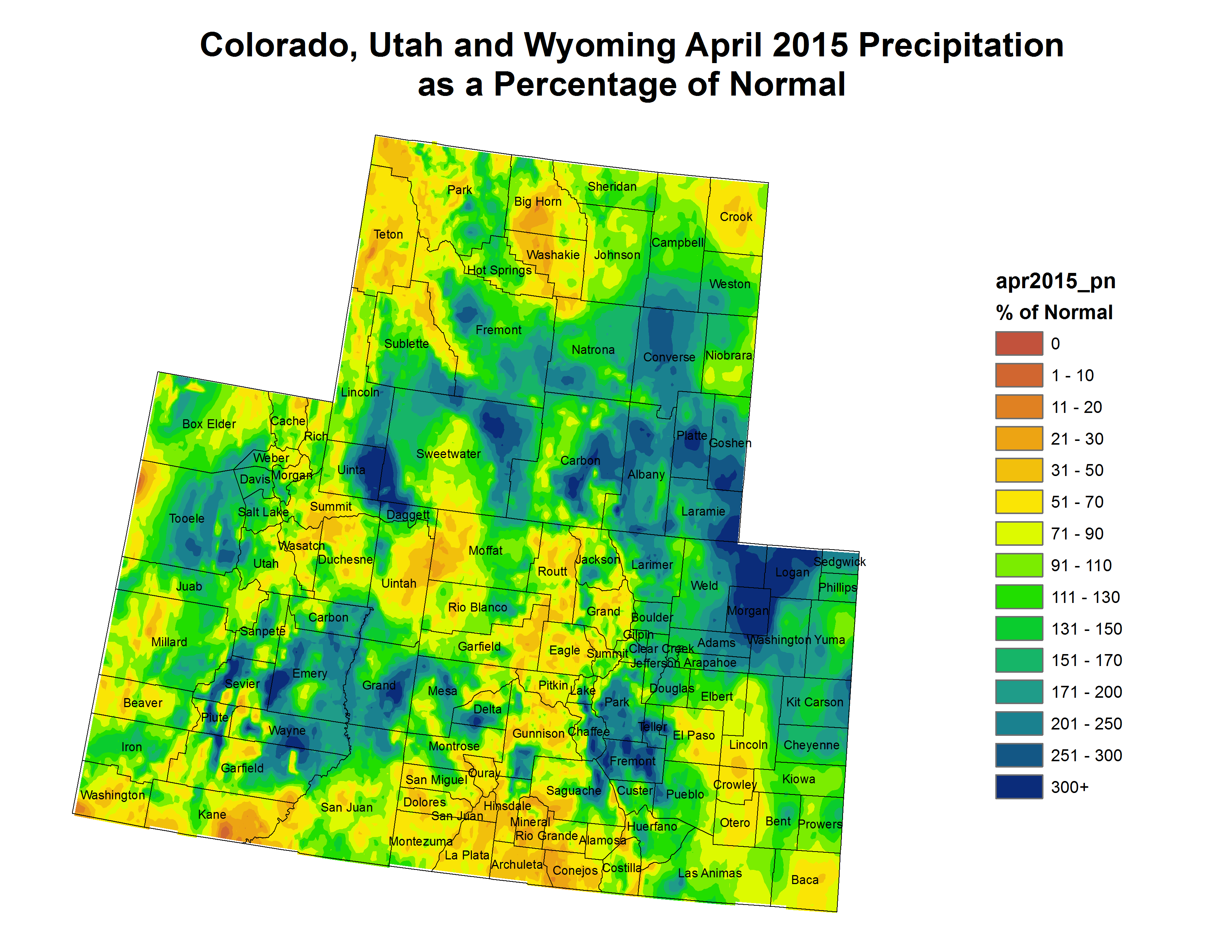
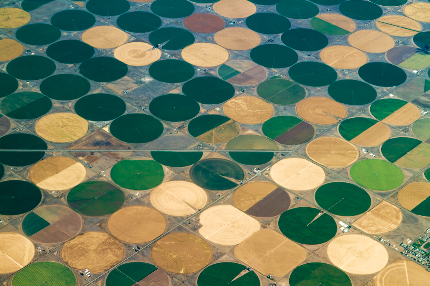
As Colorado’s population rises, the gap between supply and demand is expected to grow to millions of gallons of water per day by 2050. Already, nearly every drop of groundwater, river-water and rainwater has been claimed in our state.

Just like energy and the Internet, water needs to be regulated.

But farmers and ranchers have one set of interests, city dwellers have another and environmentalists have staked a claim in the fight, too. The current laws, based in frontier feuds, favor farmers and ranchers – particularly the ones whose families have owned their land decades before others.

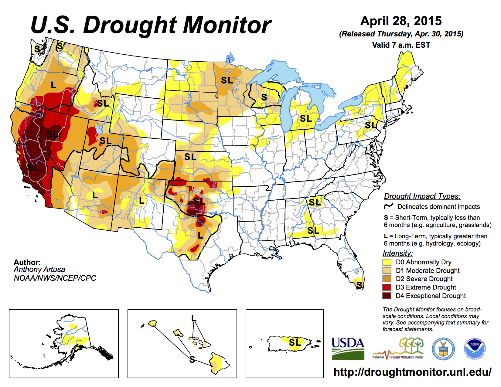
Some fear states like California, that are already dealing with drought, will grab water from Colorado, either with money or force. After all, water wars are the future, stated a 2012 report from the Office of the Director of National Intelligence, which oversees the FBI and the CIA.

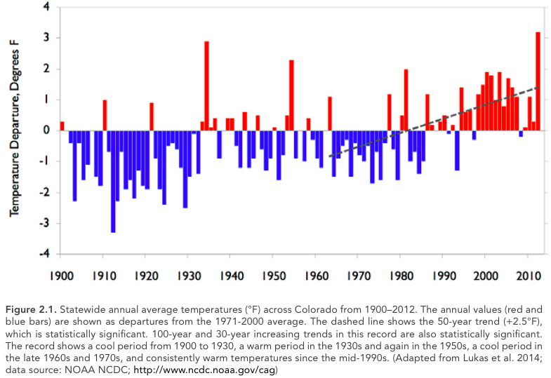
In 2012, Colorado was ravaged by wildfires and drought. In response, in 2013, Hickenloooper ordered various state departments to craft a long-term water plan. The Colorado Water Conservation Board is heading the effort.

“Throughout our state’s history, other water plans have been created by federal agencies or for the purpose of obtaining federal dollars,” the order says. “We embark on Colorado’s first water plan written by Coloradans, for Coloradans.”

But what Coloradans? City folks? Farmers? Ranchers? Outdoor enthusiasts?

To figure this out, the state needs to hear from people. But do Coloradans even know this planning process is taking place? And, with water wars looming, how can a plan solve the thousands of conflicting water needs Colorado must balance as the planet heats up, our rivers dry up and our population swells.

Don’t touch the water

Theresa Ellsworth didn’t know about the state’s efforts, but she knows in her gut that something is wrong with how water laws work here.

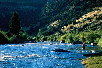
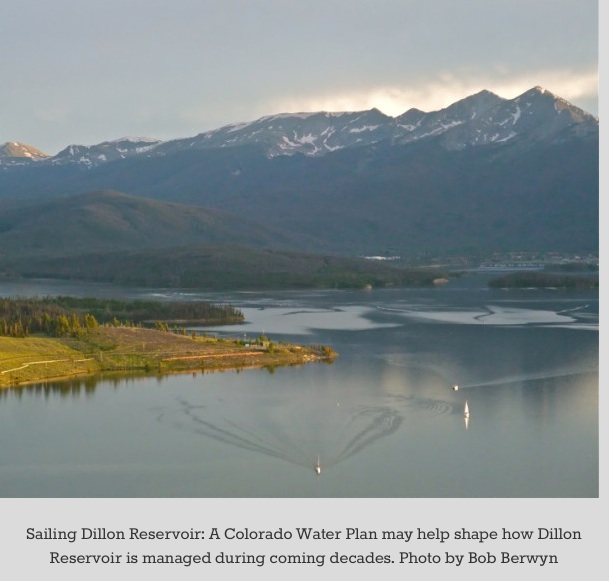
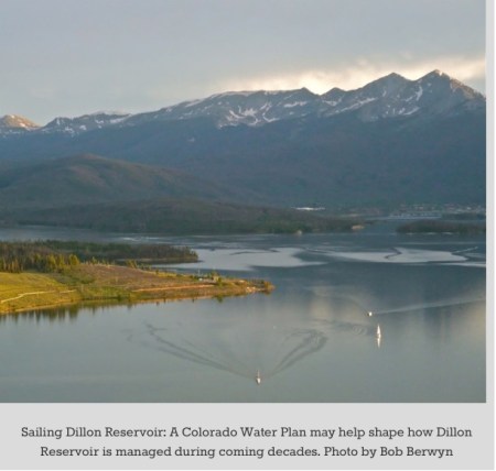
Ellsworth lives halfway between Frisco and Breckenridge, at the foot of the Tenmile Range. In the spring, water rages around her subdivision. Runoff from the mountains surges down the Blue River, feeding millions of gallons of water into Dillon Reservoir each day.

But Ellsworth can’t use any of it, not even a few drops for a petunia patch. She gets her household water from a well, and if she uses well water to wash her car or water her lawn, she’s breaking the law – unless she were to buy into an expensive state-run water trading program that she can’t afford.

“How can I tell somebody this isn’t fair?” she says, with no idea that Hickenlooper’s water-planning process is going on.

Ellsworth isn’t the only one who hasn’t heard of the state water plan or efforts by officials to seek public input before the comment period on the first draft ends [May 1].

sailingdillonreservoirbobberwyn

Water cop

John Minor, Summit County’s elected sheriff, didn’t know about the planning effort, either. And he’s a public official who, like it or not, deals with water in his job.

His deputies get called in a few times a year by water inspectors who enforce the state’s peculiar groundwater laws. See, these inspectors risk their necks threatening people with water shut-offs and fines. Colorado water law – a tangled mess – isn’t exactly user friendly. Few have the time or energy to untangle it. And many Coloradans don’t like that the government is on their land and trying to take what they see as their water.

So, they make threats, and Sheriff Minor and his deputies have to help keep the inspectors safe.

Minor, a British-born libertarian, rubs his chin incredulously as he ponders the irony of his job as a water cop. Shouldn’t he know about the state plan?

Disconnect

From the start, Hickenlooper and his water planners have sought widespread public input into Colorado’s first-ever statewide water blueprint, even launching a social media campaign on Facebook and Twitter. There’s a one-stop website for commenting, and it’s easy to sign up for email alerts and snail-mail updates.

But like Minor and Ellsworth, many people who should know and care about the water plan just haven’t been reached — or maybe they have, and just haven’t tuned in.

State officials are trying, “but they’re not very good at it,” Eagle County resident Ken Neubecker said. General skepticism about unwieldy government planning efforts probably cause some people to shy away, added Neubecker, a longtime river runner, fly fisherman and head of the Colorado River Basin Project for American Rivers.

“You can never get too much grassroots involvement,” he said. “This plan is really important for the future of the state. It won’t trump water law, but provides a road map for the future instead of looking back at the past. People need to get their comments in, talk about it and tell their friends,” Neubecker said. “This is a chance for people to actually speak.”

So, what’s the plan?

The first draft Coloradans are being asked to read and comment on is 300 pages long. It’s clouded with fuzzy statements about conservation and cooperation among water users. It’s vague. [ed. emphasis mine]

Hidden behind the fuzziness is a blueprint that does not solve historic tensions between water-producing areas west of the Continental Divide and water-hungry areas to the east, commenters suggest. Front Range cities and farms need the water to continue to thrive, but Western Slope farmers, environmentalists and outdoors enthusiasts are close to saying, “Not one more drop.”

Federal agencies have sent in comments, wrangling for control. This is one more chapter in the century-long drama over water rights between Colorado and the feds.

State agencies insist they share goals with the feds: more water conservation, reuse and recycling – all nebulous concepts.

The plan calls for more options to avoid permanently drying up farmland, but it doesn’t say what farmland or where. It needs to be specific to make it more than just a memo or feel-good document, water watchdogs say.
Today is the last chance to comment about what people like and don’t like about the first draft. Once the second draft gets released, the public will have another chance to comment between July 15 and Sept. 17.

Whether or not everybody who wants a say knows he or she can have one has yet to be seen.

With our series “Colorado water: What’s the plan?” The Colorado Independent will in the coming months cover the formation of the water blueprint and detail the political, economic social and environmental tugs-of-war that will be stretching it as it takes shape.

Please follow our multimedia coverage and weigh in with your comments and questions as we try to make sense out of one of the driest yet most pressing issues we face.

More Colorado Water Plan coverage here.

The End of California? — The New York Times #ColoradoRiver


Here’s guest column written by Timothy Egan for The New York Times asking how the current drought will permanently alter California? Here’s an excerpt:

But California, from this drought onward, will be a state transformed. The Dust Bowl of the 1930s was human-caused, after the grasslands of the Great Plains were ripped up, and the land thrown to the wind. It never fully recovered. The California drought of today is mostly nature’s hand, diminishing an Eden created by man. The Golden State may recover, but it won’t be the same place.

Looking to the future, there is also the grim prospect that this dry spell is only the start of a “megadrought,” made worse by climate change. California has only about one year of water supply left in its reservoirs. What if the endless days without rain become endless years?

In the cities of a changed California, brown is the new green. A residential lawn anywhere south of, say, Sacramento, is already considered an indulgence. “If the only person walking on your lawn is the person mowing it,” said Felicia Marcus, chairwoman of the State Water Resources Control Board, then maybe it should be taken out. The state wants people to convert lawns to drought-tolerant landscaping, or fake grass.

Artificial lakes filled with Sierra snowmelt will become baked-mud valleys, surrounded by ugly bathtub rings. Some rivers will dry completely — at least until a normal rain year. A few days ago, there was a bare trickle from the Napa, near the town of St. Helena, flowing through some of the most valuable vineyards on the planet. The state’s massive plumbing system, one of the biggest in the world, needs adequate snow in order to serve farmers in the Central Valley and techies in Silicon Valley. This year, California set a record low Sierra snowpack in April — 5 percent of normal — following the driest winter since records have been kept.

To Californians stunned by their bare mountains, there was no more absurd moment in public life recently than when James Inhofe, the Republican senator from Oklahoma who is chairman of the environment and public works committee, held up a snowball in February as evidence of America’s hydraulic bounty in the age of climate change…

But now, just about everyone in California knows that it requires a gallon of water to grow a single almond, or that agriculture accounts for 80 percent of the water used by humans here. Meanwhile, the cities have become leaders in conservation. It takes 106 gallons of water to produce an ounce of beef — which is more than the average San Francisco Bay Area resident uses in a day. Mayor Eric Garcetti of Los Angeles wants to reduce the amount of water the city purchases by 50 percent in the next decade, cutting back through aggressive use of wastewater and conservation.

It’s outlandish, urban critics note, for big farm units to be growing alfalfa — which consumes about 20 percent of the state’s irrigation water — or raising cattle, in a place with a third of the rainfall of other states. And by exporting that alfalfa and other thirsty crops overseas, the state is essentially shipping its precious water to China…

What will come, then, from this disrupting drought is likely to be a shift of power. The urban “almond shaming” chorus is quick to note that the crop uses enough water to support 75 percent of the state’s population. In other words, there would be no water shortage in San Diego or Los Angeles if nut growers shut off the pumps.

“Imagine if somebody ever said, ‘Let’s have a vote on how to use California’s water,’ ” said Daniel Beard, a former Bureau of Recreation commissioner and a critic of federal dam building. “That’s the last thing big agricultural interests would want.”

The food industry is ripe for disruption. The land that has been left fallow now in the Central Valley is still less than 5 percent of all the irrigation acreage in California. Another 5 percent would leave most of the industry standing, and leaner. Low-value, high-water crops would disappear, as is already happening.

Absent a vote of the people, the free market could end up as the decider. The big city water districts have more than enough money to buy farm water in a freewheeling exchange. Indeed, they’ve been making numerous purchases for years — though limited by complex water contracts and infrastructure that makes it difficult to pipe large amounts from one place to the other.

In addition, one fear of making water an open-market commodity is that rich and politically powerful communities would get all the clean water they needed, while poor public districts would be left out. A class system around breathable air has already developed in China. Is abundant water the next must-have possession of the 1 percent?