Click here to download the report. Here’s the forward:
Life in the Arctic has always been de ned by change and uncertainty. The seasons transform the landscape, the weather is unpredictable, and conditions can shift abruptly, sometimes dangerously. Yet the Arctic is now changing at an unprecedented pace, on multiple levels, in ways that fundamentally a affect both people and ecosystems.
This report is the culmination of a ve-year e ort to better understand the nature of Arctic change, including critical tipping points, as well as the factors that support resilience, and the kinds of choices that strengthen adaptive capacity. Because local changes are nested in larger-scale processes, it is especially important that interactions across scales are better understood.
Resilience features prominently in three major international agreements reached in 2015: the Sustainable Development Goals, the Paris Agreement on climate change, and the Sendai Framework for Disaster Risk Reduction. The Paris Agreement alone mentions resilience six times, recognizing that climate change impacts already in the pipeline will require both humans and nature to adapt.
The changes happening in the Arctic today are driven primarily by external factors. Climate change is the most pervasive and powerful driver of change, but many other environmental changes are taking place as well, alongside rapid social and economic developments. In some contexts, factors such as resource demand, transportation needs, migration, geopolitical changes and globalization are making the greatest impact on the Arctic. Indeed, many Arctic social-ecological systems face multiple stressors at once.
Slowing Arctic change and building resilience are thus crucial for the people and ecosystems of the Arctic – but the report also highlights the stakes for the world as a whole. Arctic social and biophysical systems are deeply intertwined with our planet’s social and biophysical systems, so rapid, dramatic and unexpected changes in this sensitive region are likely to be felt elsewhere. As we are often reminded, what happens in the Arctic doesn’t stay in the Arctic.
The Arctic Resilience Report is the final output of a process set in motion at the start of the Swedish Chairmanship of the Arctic Council (2011–2013). The project has been led by the Stockholm Environment Institute and the Stockholm Resilience Centre, in collaboration with the Resilience Alliance. It has been pursued in consultation with Arctic countries and Indigenous Peoples, and has included collaboration with several Arctic scientific organizations.
An integral part of the assessment is to identify policy and management options that may be needed for strengthening resilience, for adaptation, and for transformational change when this is necessary. We hope this work will inform, inspire and lay the groundwork for collaborative action.
The long awaited Windy Gap Bypass Project may begin moving forward in the not-so-distant future.
Officials from Grand County as well as multiple local partnering agencies and groups are patiently awaiting news on a $10 million Regional Conservation Partnership Program (RCPP) grant. The announcement regarding which applicants will receive the grant is expected sometime in Dec. this year. If the grant award is approved full funding for the Windy Gap Bypass Project will be secured.
WORKIN ON THE RIVER
The RCPP grant is administered by the National Resources Conservation Service (NRCS) and is given to producers and landowners to provide conservation assistance. The grant application was submitted under a partnership of multiple local organizations and entities including: Grand County government, the Irrigators in the Lands in the Vicinity of Kremmling (ILVK), the Upper Colorado River Alliance (UCRA), Middle Park, the Colorado River District, Trout Unlimited, Colorado Parks and Wildlife (CPW) and Northern Water.
If awarded the $10 million grant monies will go directly to two specific projects: the Windy Gap Bypass Project and a streambed habitat improvement project in the Colorado River for the ILVK. Additionally CPW is working to secure funding from the States Wildlife Mitigation and Enhancement Plan to conduct a stream enhancement project on the Colorado River between the Windy Gap and the ILVK lands. If local organizers are able to secure funding for all three projects roughly 33-miles of the Colorado River will see stream improvements.
Lurline Underbrink-Curran is a contract employee for Grand County overseeing much of the County’s efforts on water issues. She worked closely with others to develop the RCPP grant application. “This will be a big deal if we are successful,” Underbrink-Curran said. “We think we have a strong application and we have a very strong partnership collaboration.”
She cautioned against expecting results too quickly though, even if full funding is approved. “The things that happened to the River didn’t happen over night and we won’t fix them overnight. But if we have methods and plans in place we will get them fixed.”
WINDY GAP BYPASS
The total cost of the Windy Gap Bypass Project is estimated at roughly $9.6 million. A total of $4.5 million has already been secured for the project and the $10 million RCPP grant would cover the remainder, with excess funds going to the ILVK Project.
Map of the Colorado-Big Thompson Project via Northern Water
The Windy Gap Bypass Project is intended to create a free flowing channel for water from the Colorado River to [bypass] the Windy Gap Reservoir. The Windy Gap Reservoir is located just a short distance west of Granby on US Highway 40 and is one of several water storage reservoir[s] that make up the Colorado Big-Thompson Project’s water diversion system.
Water from the Windy Gap is pumped through the Northern Water diversion and pump network eventually reaching Grand Lake before moving across the Continental Divide through the Alva B. Adams Tunnel. When the Windy Gap Reservoir was initially constructed no free flowing channel was created. As such the Windy Gap Reservoir divides the river habitat above and below the reservoir, preventing fish and other creatures from migrating freely.
Additionally the Windy Gap causes the Colorado River to lose nearly all of its velocity, allowing for a substantial amount of sediment to develop in both the reservoir and in the river downstream. The sediment buildup negatively impacts bug habitat, which has a domino effect on all other species living in the river.
The work that will be done for the Windy Gap Bypass is fairly simple in concept. Excavators will dig out a channel within the existing Windy Gap Reservoir. The dirt from the excavations will be used to construct a berm inside the Reservoir. The berm will establish a smaller reservoir while also creating a separate channel for the free flow of water down the Colorado.
ILVK PROJECT
The ILVK streambed habitat improvement project seeks to address two concerns: issues with irrigation infrastructure and improvements of streambed habitat for bug and aquatic life.
As Paul Bruchez, one of the ILVK landowners helping to spearhead the project explained, the project hopes to accomplish both goals through the same work; by rebuilding the pools and riffles that create healthy river habitat and focusing most of those efforts on areas where the irrigation pumping infrastructure already exists.
The ILVK is a landowners organization made up primarily of irrigating ranchers near the town of Kremmling. The ILVK holds some of the most senior water rights on the upper Colorado River; their senior water rights are recognized in Senate Document 80 and their rights precede the famous Colorado-Big Thompson Project (CBTP).
Prior to the establishment of the CBTP there were virtually no water storage reservoirs in the high country and no ditches bringing water to the landowners of the ILVK. At that time they were considered as having, “meadows act water rights” meaning they did not irrigate their fields using irrigation ditches, rather their fields naturally flooded each spring/summer as snow runoff from higher elevations made its way to the Colorado River.
When the CBTP was established irrigation pumps were constructed to provide water from the Colorado River to the landowners of the ILVK. As time has passed and additional water diversions and storage projects were undertaken above the ILVK region the flows that provided the ILVK members with irrigation water have diminished, along with the overall water table.
“We have a fixed station (irrigation) pump system with a river that is dynamic and changing,” Bruchez explained. “My neighbors and family struggle with irrigation issues. But I am also watching the regress of the Colorado River from a fishery standpoint. The concept of the ILVK project is to fix and repair our irrigation systems to be sustainable while using construction techniques that will improve the health of the river overall.”
In that way the ILVK project proverbially kills two birds with one stone. But for Bruchez and other landowners along the Colorado the effort isn’t just about improving their ability to access the water that is theirs by right, it is about the broader health of the River as well.
“If we can cut down water temps by even a fraction we are making headway,” Bruchez said. “It almost becomes a water quality issue. We are not just improving segments but improving the whole river system. We can’t look at one part or another as the priority. It is a system that needs a system wide repair.”
In the year since Gov. John Hickenlooper and the Colorado Water Conservation Board released a much-ballyhooed plan to grapple with a looming water shortage, a critical question remains: How to come up with the estimated $20 billion to pay for it?
“Money is a key part of making this work,” said Bart Miller, Healthy Rivers Program Director for the conservation group Western Resource Advocates.
The state’s share is expected to be about $3 billion, or about $100 million per year, beginning in 2020. The rest will come from local and regional water providers, who will pass on the costs to you through higher rates.
The water plan, adopted last November, seeks to head off the looming water shortage created by Colorado’s population boom. In 2050, the state’s population is expected to hit roughly 11 million, double what it is now. The water conservation board projects that demand will outstrip supply by about one million acre-feet of water per year, or enough water to satisfy four million families in Denver.
When Hickenlooper ordered the plan in 2013, he said “every conversation about water needs to start with conservation.” That’s among the two biggest goals of the plan: to ask Coloradans to conserve about 400,000 acre-feet of water per year. The second lofty goal is about storage – either above-ground reservoirs or refilling aquifers, especially in the Front Range – and that goal is also 400,000 acre-feet of water per year. An acre-foot is the amount of water it would take to cover Mile High Stadium from endzone to endzone with one foot of water.
The plan also aims to align water conservation with land-use planning, and calls for sharing of agricultural water and greater protection of watersheds.
The $20-billion cost of the plan is its biggest hurdle. In the plan’s first year, the state was able to invest about one-tenth of one percent of that, about $18 million, in various projects. The state also loaned $90 million to help a water storage project get off the ground near Loveland.
But, it’s not at all clear whether the state will be able to continue to raise even that much money in the short-term future. The General Assembly is tapping severance taxes to cover costs of projects related to the water plan, and that money stream, too, has gone from a stream to a trickle due to the slump in oil and gas, coal and mineral industries.
With the oil and gas industry struggling, it’s difficult for the water conservation board to figure out how to keep the water plan going “at high gear,” former Speaker of the House Russ George of Rifle and water conservation board chair told The Colorado Independent. What’s needed most is a predictable forecast of revenues in order to plan the projects that will solve the problems, he said. That’s just not something that’s possible right now with severance tax revenues and that makes paying for the water plan “risky these days,” he said.
The magnitude of the shortage predicted for Colorado has repercussions across the state, from cities to farms and ranches. The Colorado River, the state’s signature waterway, is already over-tapped. More water is needed from it than it produces annually.
In the year since the plan was adopted, the General Assembly passed an $8 million grant program that will, among other things, pay for a water supply study of the Bear Creek Reservoir, dredge state reservoirs to provide more water storage; and improve watersheds, the swaths of lands that drain all streams and rainfall to a common outlet. One million of the $8 million was earmarked for an update to a water conservation board study that projected the gap between supply and demand would hit one million acre-feet shortage a year by 2050. Water experts now say the shortage is likely to be greater.
The state Legislature also kicked in another $5 million as part of an annual water projects bill. The projects include watershed-level flood and drought planning; funding for water forecasting and measuring, money to update re-use regulations and a training program on water loss.
Basin roundtable boundaries
And nine statewide groups, known as roundtables, spent another $7.1 million in state funds for dozens of projects including a study of storage along the South Platte River, repairs to ditch infrastructure in the Arkansas Basin, community forums and education plans in several communities, creek restoration. The state water plan, which took two years to draw up, relied on the work of the roundtables, which are tied to eight of the state’s major rivers, plus another group for the Denver metro area. The nine groups include representatives of municipal water providers, environmental groups, recreational water users, industry and agriculture.
One of the major collaborations in the first year has been among the four western roundtables (Yampa/White River, Colorado, North Platte and the Southwest) and the Colorado Water Conservation Board on the first phase of a $52,000 study to examine the possibility of a “call” on the Colorado River. Seven states downstream of Colorado would exercise their rights under contracts made with the state to draw more water out of the river that originates here. Such a “call,” has become increasingly probable because both Lake Powell on the Utah-Arizona border and Lake Mead on the Nevada-Arizona border are reaching levels so low the lack of supply could jeopardize the generation of hydroelectricity that supplies the Western power grid.
The chance that the states will issue a call, a situation that could create havoc among them — as well as in Mexico, which also relies on Colorado River water — is on the horizon, but not imminent, said Chris Treese of the Colorado River District.
Colorado agriculture also faces a supply-and-demand gap, and the conservation board teamed up with the Department of Agriculture to devise ways to save water and preserve rural Colorado’s farming and ranching communities and their cultures. The hope is to avoid “buy and dry,” the practice employed by municipal water providers to buy farm and ranch land for its water rights, leaving the land unsuitable for farming. Alternative transfer methods, or ATMs for short, allow farmers and ranchers to lease water rights, rather than sell off their land and the water rights that go with it. ATMs also encourage farmers and ranchers to plant crops with shorter growing seasons.
Colorado transmountain diversions via the State Engineer’s office
Farming and ranching use 89 percent of the state’s “consumed” water –meaning water that is used and doesn’t return to a waterway or ditch. Most of that agricultural water comes from the Western Slope and is funneled to the ag-rich eastern part of the state through tunnels built through the mountains during the 20th century.
The water plan’s goal is to use ATMs to conserve 50,000 acre-feet of water a year. The two ATMs currently in place are saving only a fraction of that – 2,500 acre-feet annually, said water conservation board Director James Eklund. “We’ve got a long way to go,” he told the board last week.
In addition to state funding, the success of the water plan relies upon local water providers and municipalities to continue to pay for much of the infrastructure needed to stave off a water shortage.
The Northern Colorado Water Conservancy District, based in Berthoud, is into the 12th year of a project to add 40,000 acre-feet of water (enough water to supply 160,000 families in 15 northern Front Range communities) to two reservoirs near Fort Collins and Greeley. A third project, to build the Chimney Hollow reservoir west of Carter Lake in Loveland, will add another 30,000 acre-feet of water. Total cost for the three projects: around $1.2 billion. Chimney Hollow is expected to break ground in about two to three years. The U.S. Army Corps of Engineers must give final approval for the Glade and Galeton reservoirs. That is not expected until 2018.
Denver Water also is working on a storage solution: the expansion of Gross Reservoir, west of Boulder. That expansion will add 77,000 acre-feet of water, almost all of it for Denver Water customers along the Front Range at a cost of $380 million. That, too, counts toward the $20 billion cost of the water plan.
As implementation of the water plan began last year, some conservationists complained of a slow start. But, a year in, groups including Conservation Colorado, Western Resource Advocates and American Rivers collectively deemed this year’s efforts to be “a good first lap,” according to a statement issued by the groups last week.
As the 2017 legislative session approaches, Hickenlooper’s administration is preparing to ask lawmakers to approve a three-to-five-year $55 million funding plan that would provide grants and loans for water projects. The money would come from a reserve fund controlled by the Department of Natural Resources. Of that $55 million, $10 million would go directly to fund projects tied to the water plan. Those projects are currently in the application process and have not yet been identified.
The $55 million also includes a $30 million loan guarantee fund for water providers that they can then use to obtain large loans in the financial markets. The CWCB estimates project participants could obtain up to $300 to $400 million in the finance market through this loan fund.
Board director Eklund echoed water conservation board chair George’s concern that severance tax and federal mineral lease revenues aren’t consistent and reliable forms of funding. So, too, did Miller of Western Resource Advocates, who also said it’s critical that the $55 million plan be adopted and the projects launched. The water conservation board is looking for other revenue sources that would provide more stable funding, although George and Eklund declined to identify what those sources might be.
However, The Nature Conservancy recently commissioned a study on various ways the state could generate the money needed to cover that $3 billion state obligation on the water plan. The study came up with nine ideas that could bring in between $10 million and $86 million per year. Those ideas included peak water use fees, a tourism fee; and fees on marijuana grow operations, paid for by consumers or the industry. Summit Economics, which conducted the study, said they would not make a specific recommendation, citing the need for more analysis based on water plan criteria. As a next step, the economists suggested the state gauge public opinion on the top two or three options.
Aaron Citron of the Nature Conservancy said the organization is primarily interested in the environmental goals of the plan, but acknowledged that the funds will support other goals as well.
The water plan wasn’t a high priority in the 2016 session; lawmakers were much more concerned about finding a way to fund transportation infrastructure and K-12 education.
Whether the $55 million ask in the coming session gets approved may depend on the selling job by the water conservation board and supporters of the water plan, including the governor. In the past several sessions, rural lawmakers have been loathe to touch severance tax revenue for anything other than its major intended purpose: to mitigate impacts of oil and gas or other mining activities in local communities. Many of those communities have have been hard hit by declines in oil and gas production and mining, but still have to deal with the impacts of those activities.
Republican Sen. Jerry Sonnenberg of Sterling says he doesn’t have much confidence in the way the water conservation board is proceeding with the water plan. Sonnenberg is most interested in seeing progress on building or expanding water storage, particularly along the South Platte River.
Sonnenberg, who chairs the Senate Agriculture, Natural Resources and Energy Committee, also is not wild about the water conservation board tapping a reserve to cover the $55 million request in 2017. The state, he said, should pay back the severance tax money it has been “stealing” for the last several years, which has often used to balance the budget or pay for other priorities. The water conservation board also ought to do a better job of prioritizing its projects, he said. It may result in a slower pace for the water plan, but the state has to figure out how to allocate the severance tax dollars it has, Sonnenberg said.
Democratic Sen. Pat Steadman of Denver, who sits on the Joint Budget Committee, said the administration’s $55 million request is reasonable and believes that severance tax revenues should cover it. But he also said this might not be the best time to make that request, given a recent court case involving oil giant BP.
Last spring, the Colorado Supreme Court ruled in favor of BP and against the Colorado Department of Revenue in a lawsuit over tax refunds. Energy companies are allowed to deduct transportation, manufacturing and processing costs from revenue when they value oil and gas for severance tax purposes. The Court ruled the energy companies could also include the cost of capital for transportation, manufacturing and processing, and the Court made the ruling retroactive to 2012.
The legislature, concerned that lots of other companies and individuals would seek similar refunds, put the state’s main revenue source, the general fund, on the hook to cover those refunds, estimated in August at about $51.4 million.
Hickenlooper has proposed clearing out several severance tax accounts to reimburse the general fund for those refunds, Steadman noted. And that’s going to cut back on what’s available to the water conservation board for its projects.
The public needs to be weighing in on this, George said, because the infrastructure that people want government to provide has to be paid for somehow. “Growth and demand are outpacing revenue available to modernize our infrastructure,” he said, adding,“that’s a political conversation that persists without solution. The state water plan will be held back if we can’t get over that hump of political decision-making.”
How much water reaches the Westwater stretch of the Colorado River, and then Lake Powell, is taking on increasing importance to Colorado water officials. A new study is underway to look at much more water is available to develop on the Western Slope, and it’s caught the attention of east slope water officials. Photo: Brent Gardner-Smith/Aspen Journalism
At the Colorado Water Conservation Board meeting the board pledged to secure $55 million in funds for implementation, a big win for year two!
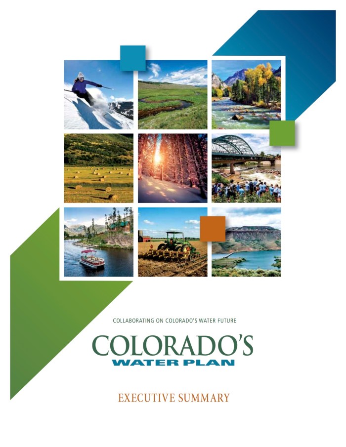
Water is deeply intertwined in Colorado’s way of life. The water we drink, the businesses supporting our economy and the recreation we enjoy depends on clean water and flowing rivers. Until last year, Colorado was one of the few states in the west without a plan for managing our water.
In 2013, Governor Hickenlooper recognized the state needed a long-term water plan and through executive order directed the Colorado Water Conservation Board (CWCB) to work with stakeholders across the state to develop a comprehensive water management plan. Last year, important conversations between farmers and ranchers, environmental groups, water suppliers, recreation advocates and concerned citizens at public meetings, at the grocery store, and on the river paid off. In November 2015, Governor Hickenlooper signed the Colorado Water Plan committing our state to coordinated and sustainable water management for the next 35 years.
Photo via Brent Gardner-Smith/Aspen journalism
Colorado is a headwaters state for the Colorado River basin. The Colorado River not only matters to the state and its economy, but it also downstream to the six other states and Mexico that also depend on snowpack that originates here. How and why we manage our water not only affects us, but also our neighbors downstream.
Healthy, flowing rivers support our thriving economies like agriculture and recreation, and our growing cities. Clean water, and enough of it, are essential to support our growing region. Colorado’s heritage and culture is built upon our natural resources and rivers are at the heart of it all. With an abnormally dry fall, it is clear how critical it is to protect and restore our rivers and solidify our commitment to water conservation. Drought volatility varies from year to year across the southwest, and the continuation of this 15-year drought across the basin in the coming years is not out of the realm of possibilities.
November 16, 2016 marked the first anniversary of signing of the Colorado Water Plan. To celebrate the work that has been done across the state, Governor Hickenlooper proclaimed this date as Colorado Water Plan Implementation Day. This proclamation applauds efforts over the past year, and further supports the important work that must continue to move forward goals and objectives contained within the Colorado Water Plan. While this milestone is something to celebrate, implementation thus far has been slower than anticipated. However, at a recent CWCB meeting, new energy was breathed into the plan’s implantation when the CWCB pledged to secure funds for implementation. The CWCB voted to:
Direct the first $30 million of this request towards the creation of a loan guarantee fund
Focus the other $25 million towards funding other important objectives of the Plan, including: $10 million in supplemental funding for the Water Supply Reserve Fund to fund water supply projects; $5 million directed to the Watershed Restoration Program; $10 million towards Water Plan Implementation Funding that will fund non reimbursable investments
How does this funding help support healthy rivers and streams here in Colorado?
American Rivers, along with environmental partners and other stakeholders are gearing up to begin work on stream management plans on rivers statewide. These plans are a part of the Watershed Restoration Program, which focuses on developing methods to help manage important rivers and streams in Colorado to keep them healthy for both nature and people. As a part of the budget allocation, the CWCB pledged $5 million to help with the planning and development of Stream Management Plans.
The Colorado Water Plan can only be as successful as its implementation. We congratulate the CWCB and the Hickenlooper Administration for restating their dedication in this first year of the Plan. The Colorado State Legislature has an opportunity to continue the progress of the state’s first water plan by supporting the funding for water conservation measures and stream management plans as they approve the state budget. We must keep the pressure on to ensure future funding and support needed to protect our rivers for communities, agriculture, business, and wildlife. Our state’s future, and the health of an entire region, depends on it.
On this day in 1922, Federal and State representatives met for the Colorado River Compact Commission in Santa Fe, New Mexico. Among the attendees were Arthur P. Davis, Director of Reclamation Service, and Herbert Hoover, who at the time, was the Secretary of Commerce. Photo taken November 24, 1922. USBR photo.
The compact was the fruit of several years of negotiations among the states. The seven states had previously formed the League of the Southwest in 1917 to promote development along the river. In 1921, Congress authorized the states to enter into a compact for allocation of the river resources. The agreement was approved by Congress in 1922, the same year it was signed. Colorado River Compact was signed by the delegates from the seven Colorado River Basin states: Wyoming, Colorado, Utah and New Mexico were designated Upper Basin states and California, Arizona and Nevada as the Lower Basin states. This compact determined that the water would be shared equally among the upper and lower basin states. Prior to the compact, the name of the river was standardized along its length. Previously the portion of the river upstream from its confluence with the Green River had been known locally as the “Grand River”. The change was opposed by many local residents in Utah and Colorado, and the new name was enforced locally by acts of the state legislatures in both states in the early 1920s. One of the major concerns both today and back in the 1920’s was the expanding population, and this increased the demand for water, particularly in California. In more recent years, mainly because of Las Vegas, Nevada has been looking for more use of the Colorado River.
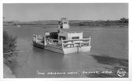
Arizona Navy photo via California State University
In 1934, Arizona, unhappy with California’s decision to dam and divert the river, called out the National Guard and even commissioned a two boat “navy.” The matter was eventually settled in court.
The agreement was controversial even at the time, however. Arizona, for example, was dissatisfied with the lower basin allotment and refused to ratify the agreement until 1944.[7] The specific allotments were disputed by Arizona until the United States Supreme Court upheld the amount in the 1963 decision in Arizona v. California. The agreement ended many years of dispute, clearing the way for the Central Arizona Project, authorized by Congress in 1968.
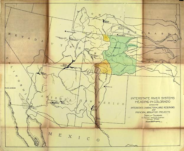
Delph Carpenter’s 1922 Colorado River Basin map with Lake Mead and Lake Powell
From the Union of Concerned Scientists (Erika Spanger-Siegfried):
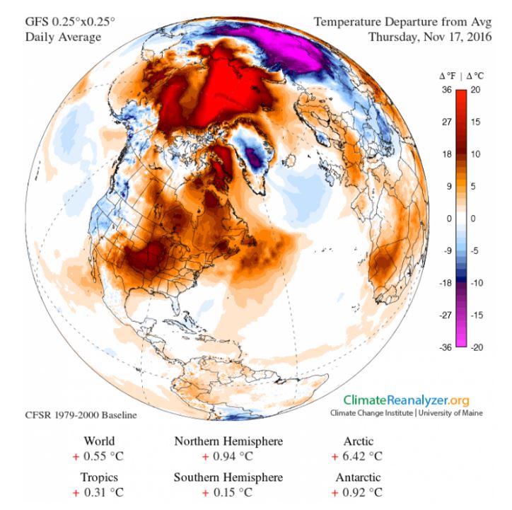
It is polar night in the Arctic—a darkness that lasts from early October to early March. Temperatures rarely escape freezing in that darkness, averaging -30° F until the light begins to return in spring. Right now, however, temperatures across much of the Arctic are 36 degrees F above normal. Large areas are well above freezing. And instead of rapidly expanding, sea ice extent is in decline.
Taken together, this is not unusual. It’s unheard of.
The degree to which current Arctic conditions are straying from the norm may prove to be the greatest change yet measured there—the latest signal from the Arctic that all is not well.
And while the frozen top of the world may seem remote and unimportant at the moment, what happens there matters greatly to both our immediate and long-term future.
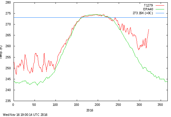
2016 temperatures (Kelvin) above Latitude 80. The green line shows daily mean historic average temperatures from 1958-2002. The red line shows the daily mean average from 2010 to present. The blue line is 32 degrees F, or freezing. Recent days have seen departures from the long-term average of up to 36 degrees F. At and above this latitude, roughly days 1-45 and days 300-365 are spent in darkness. Source: Danish Meteorological Institute
Breaking down the Arctic breakdown
The Arctic plays an important role in moderating global climate. When heat from the tropics is delivered north to the Arctic by winds and ocean currents, the region exerts a cooling effect on both. Without this distribution of energy, the lower latitudes would overheat. Sea ice and snow- and ice-covered land (known as the “cryosphere”) help the Arctic to stay cool by reflecting most of the incoming solar energy back to space.
But the Arctic, like the rest of the planet, is warming, and unlike the rest of the planet, warming in the Arctic can feed rapidly on itself.
To describe one of the feedbacks: Warmer temperatures drive greater melt of sea ice, which exposes open ocean, and exposed water absorbs heat from sun that was previously reflected. Ocean temperatures rise as a result, and when winter comes, the sea ice has a harder time rebounding amidst warmer air and water temperatures. The following year, the melt season begins with sea ice cover that is thinner and smaller in extent.
There are other feedbacks, and all are complex. For a closer look at these reinforcing cycles, see my colleague’s blog on Why the Arctic Matters. As the National Snow and Ice Data Center puts it:
A small temperature increase at the poles leads to still greater warming over time, making the poles the most sensitive regions to climate change on Earth. According to scientific measurements, both the thickness and extent of summer sea ice in the Arctic have shown a dramatic decline over the past thirty years. […] The loss of sea ice also has the potential to accelerate global warming trends and to change climate patterns.
Okay. With this in mind, let’s look at the state of the Arctic at this time.
Sea ice extent
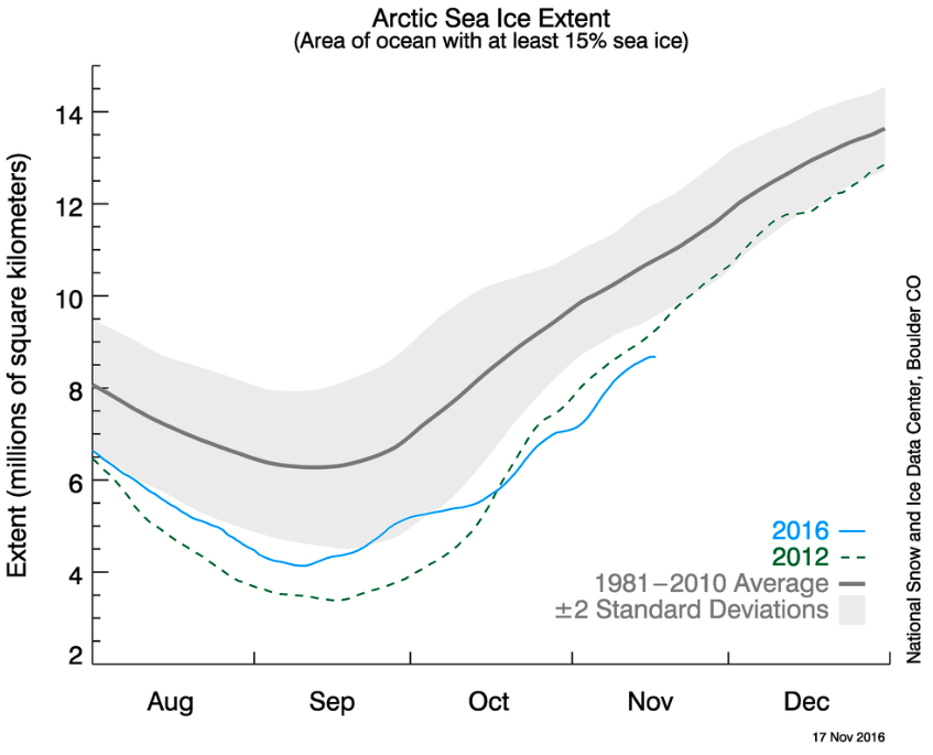
In the polar night, Arctic sea ice historically rebounds from summer melt as both the water and air cool. In recent decades, the ice has been declining in both extent and volume.
This year, with warm ocean temperatures and continued delivery of warm air from the lower latitudes, the ice is struggling to rebound. October saw new record lows for Arctic sea ice extent.
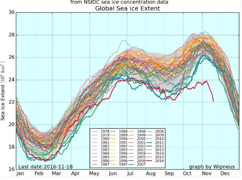
Global sea ice extent began 2016 (thick red line) at low levels. Just in recent days , the Arctic has lost more than a million square kilometers of sea ice, reaching a new record low and contributing to a steep decline in November’s total global sea ice extent. Antarctic sea ice extent is also at record low levels. Source: Arctic News
In November, Arctic sea ice extent remains well below average for this time of year. In each of the last three days, a time of year when sea ice is normally growing, it has shrunk instead (see figure below). Arctic sea ice is melting up there in the polar darkness.
According to experts following this closely, as of Sunday, November 20, Arctic sea ice is now ~1.1 million square kilometers below the previous record low.
Sea surface temperatures
With larger areas of the Arctic ice-free each year, and for longer periods of time, the Arctic Ocean is absorbing more heat.
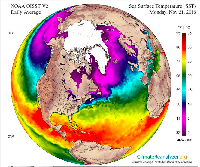
This fall, sea surface temperatures are well above average, with anomalous warmth persisting into November as seen in the figure below. Scientists have reported ocean temperatures 25° F above average in some locations.
Sea surface temperatures are unusually high and well above freezing in some areas of the Arctic, contributing to ice melt. Credit: Climate Change Institute
Air temperatures
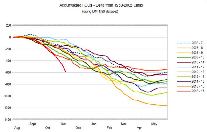
The chart below looks at this warmth by a different measure: “freezing degree days.” By many available measures, the oncoming Arctic winter is in a nose dive unprecedented in recent record keeping.
A weakened polar vortex and wobbly jet stream have been identified as factors in recent anomalous winters, both colder and warmer, and indeed, meandering winds are currently delivering warm air far northward to the Arctic, and a deep, snowy freeze in Eurasia.
The combination of factors driving Arctic air temperatures today has resulted in a stunning temperature anomaly—persistent, vast areas of 36° F above normal, shown in the map below.
Wild cards, like the unusual cyclone that struck the Arctic last winter, driving temperatures 50 degrees above normal, may compound and accelerate ice loss, according to a recent NASA study.
It’s as if the Arctic is trying to be heard. It’s hard to imagine stronger signals to send.
[Stormwater enforcement actions represent] a 10-fold increase over 2015 and a dramatic uptick from a time when the city largely ignored violations of its own stormwater regulations. And this could just be a start — the city is also looking at a new program that would give it even more muscle against violators.
The ramp-up is due in part to Mayor John Suthers’ response to pressure from the Environmental Protection Agency and the Colorado Department of Public Health and Environment. Those agencies issued two highly critical reports of the city’s stormwater maintenance and regulation enforcement in recent years, and on Nov. 9 the EPA filed a lawsuit alleging the city’s lax approach violates its MS4 permit and the Clean Water Act. The lawsuit could bring multi-million-dollar civil penalties and federal monitoring.
In early 2007, City Council imposed stormwater fees on property owners, raising about $16 million a year for drainage projects and maintenance.
But in 2009, the Council defunded the program after voters approved a measure aimed at killing the fees. After that, the EPA lawsuit states, the city’s stormwater program limped along on an average of $1.6 million a year from 2011 to 2014.
Despite a scathing EPA report in 2013, then-Mayor Steve Bach did little, and even opposed a citizen-driven ballot measure for drainage that failed in 2014. Without more money, city officials have said, they couldn’t effectively track down violators.
That neglect had ramifications: In addition to possible EPA fines, uncontrolled drainage enraged officials in downstream Pueblo County, who in turn threatened agreements on Colorado Springs Utilities’ Southern Delivery System pipeline. So, earlier this year, Suthers and Council adopted a $460-million, 20-year stormwater program to fend off fines and cope with the city’s extensive drainage problems. One part of that program: oversight to verify compliance by contractors. Last year, the city’s stormwater staff numbered about 20. Today, it stands at 56, and another 10 will be added next year. Many of those are inspectors who troll for violators…
Though stormwater program manager Rich Mulledy says inspectors fan out over the city, most offenses were spotted on the city’s northeast side where development is brisk, records show…
Mulledy stresses the city would rather gain compliance than punish builders. He doesn’t like the word “crackdown” to describe the city’s approach in enforcing its MS4 permit, which requires erosion control for all projects larger than one acre.
“Just because of the number of houses being built, we’ve really stepped up,” he says, quickly adding that the industry has proven a willing partner. The city, he notes, has the authority to issue summonses that carry fines of $500 per day, but no fines have been levied so far.
“We’ve had compliance,” he says, “We’re committed from the city’s standpoint to make sure we’re doing the right thing to meet our permit going forward, and I feel the industry is supportive going forward. We have to meet the federal permit for sure, but we want to do the right thing and still have developers make progress and be able to do business.”
Builders and developers are all in, says Tim Seibert, president of the Housing and Building Association of Colorado Springs.
“Obviously, just like the mayor stated, we’re not pleased to hear the EPA has filed a lawsuit,” Seibert says. “We think there is a better solution. But at the end of the day, we want to be at the table and be sure we’re in compliance.”
Seibert says the HBA hosts monthly “Wet Wednesday” meetings at which its members are instructed in stormwater regulations, such as erosion control and best management practices.
“With the recent enforcement, we’ve stepped that up,” he adds. “We’ve made it more thorough. We’ve gotten a lot of cooperation from the city telling us, ‘These are the practices we need to see.’ I think that’s been very helpful for them to get in contact with guys in the field doing the implementation.”
The HBA also added a monthly meeting with Mulledy at which design standards are discussed. “We want to make sure we’re not getting ourselves in trouble, and we don’t want the city to get in trouble,” Seibert says.
He also says that as the city shapes its program to satisfy federal authorities, HBA members realize more enforcement is coming.
Mulledy won’t discuss details of the new program — still being worked out — but says it will clarify enforcement steps, and allow officials to “jump steps” if a violation poses an immediate threat to the city’s stormwater system or downstream. Currently being reviewed by stakeholders, the program will be introduced within a few months.
“In general,” Mulledy says, “it’s going to be more specific and give us more tools.”
Click here to go to the US Drought Monitor website. Here’s an excerpt:
Summary
This USDM week began with an upper-level trough exiting the Northeast. Another trough moved across the country during the week, dragging a low pressure system and cold front across the country and giving the Central Rockies, Central Plains, Upper Midwest, and Northeast a blanket of snow. A third trough moved across the West and into the Plains as the week ended. Precipitation for the week was above normal across parts of California, the Southwest, southern Texas, Central to Northern Rockies, Central Plains to Upper Mississippi Valley, and Northeast. Rains fell along the front from Texas to the Great Lakes, but amounts were mostly below normal. The troughs moved through a dominant upper-level ridge which kept weekly temperatures above normal for most of the contiguous U.S. (CONUS), with only Florida and the coastal Southeast averaging cooler than normal…
The Great Plains
A large blanket of snow fell across the Plains of Colorado to the Upper Mississippi Valley, with half an inch to an inch of precipitation across parts of Nebraska and the Dakotas. Coastal and northeastern Texas also received half an inch or more of rain, but the rest of the Plains was mostly dry this week. D0-D3 were adjusted in Texas, D0-D3 expanded in parts of Oklahoma, D0 expanded in North Dakota, and an oval of D1 was added to south central North Dakota. As summarized by the National Weather Service, from an agricultural perspective, farmers and ranchers across extreme northeast Texas have already had to supplement winter hay as the pastures were dormant even before the first frost/freeze this past weekend, stock ponds are very low/dried up, and right now, one rancher in western Bowie County has stated that winter wheat probably will not come up if planted now. As noted by the Oklahoma State Climatologist, reservoirs in central Oklahoma have seen significant decreases in storage, producing significant water impacts. Lake Hefner and Overholser were 6 and 5 feet down, respectively, for this time of year, and Draper was down 12 feet, which is a bit drastic…
The Rockies and Far West
The upper-level troughs brought welcomed precipitation to parts of the West, with 2 inches or more of precipitation falling along the coast from central California to Washington, and 2-4 inches in favored upslope regions further inland. The troughs left half an inch to an inch of moisture across parts of the Southwest and Central to Northern Rockies, which was above normal in these regions and in parts of California. Precipitation amounts were less than half an inch in other parts of the West, and these translated to below normal for the week. Mountain snow water content increased from 4 to 12 inches at many of the SNOTEL stations. But this is early in the snow season, so no change to the drought depiction was made in the West. The ecosystem continued to show the impacts of the multi-year drought. According to an analysis released November 18 by the U.S. Forest Service, the Forest Service estimates, based on aerial detection surveys conducted throughout 2016, the number of dead trees on California’s forested lands grew to a cumulative total of 102 million on 7.7 million acres since 2010. In 2016, 62 million trees died, representing more than a 100 percent increase in dead trees across the state from 2015, when 29 million trees died. This scale of die-off is unprecedented in California’s modern history. Millions more drought-stressed trees that are not yet dead are expected to die in the coming months and years. Five consecutive years of severe drought in California, a dramatic rise in bark beetle infestation and warmer temperatures are leading to these historic levels of tree die-off. The majority of the 102 million dead trees are located in ten counties in the southern and central Sierra Nevada region. The Forest Service also identified increasing mortality in the northern part of the state, including Siskiyou, Modoc, Plumas and Lassen counties. Dead and dying trees can pose a significant risk to communities if a wildfire breaks out in these high hazard areas…
Looking Ahead
An inch or more of precipitation is forecast to fall November 23-28 from eastern Texas to the Great Lakes as the latest front and low pressure system move across the CONUS. Three or more inches are expected from northeast Texas to eastern Arkansas, and an inch or more is progged for the Northeast. Meanwhile, another Pacific system will drench the West Coast with up to 10 inches or more of precipitation from northern California to Washington, and an inch or more as far inland as the Northern Rockies. No precipitation is forecast for southern California to southwest New Mexico, but the rest of the country may see a tenth of an inch or more. Temperatures should be warmer than normal for most of the CONUS, except for parts of the extreme Southwest. For November 28-December 6, odds favor cooler-than-normal temperatures for the West and warmer-than-normal temperatures for the East and Alaska. Much of the CONUS from the Plains to the East Coast, the Southwest, and Alaska are expected to be wetter than normal, while odds favor drier-than-normal weather across the Far West and the Rio Grande Valley.
Going into Thanksgiving , Vail has had almost no snow. That’s not remarkable, but the recent warm weather is.
In 1962, the ski area’s inaugural year, it was dry, too. Ski area marketing boss Bob Parker got the bright idea of recruiting Ute Indians to conduct a snow dance. It did start snowing almost immediately. That was in December.
Since then, Vail has had more slow starts to winter, particularly in droughts in 1976-77 and 1980-81. Instead of recruited Utes, though, Vail—like most ski areas—invested heavily in snowmaking.
Just one problem with this autumn. It’s been too warm to make snow at many places. Vail delayed opening until the day after Thanksgiving. And at Beaver Creek, a few miles from Vail, World Cup races had to be punted. Mike Imhoff, the chief executive of the Vail Valley Foundation, the organization that puts on the races, said the venue has a “remarkably sophisticated snowmaking system. However, the cold weather did not come in time this year.”
Warm weather was the problem at Telluride, too. Chief executive Bill Jensen announced a delayed opening until the Monday after Thanksgiving. “There aren‘t enough snowmaking hours over the next week to 10 days to make the quantity of snow necessary to achieve our planning opening day,” he said.
Indeed, temperatures in Denver last week hit 80 degrees, a record for the date and tying the record high for November, which was set in 2006.
In Salt Lake City, it was warm, too. Even though it snowed, the temperature didn’t fall below freezing. The Salt Lake Tribune noted that the city had been frost-free for 242 days, breaking a record set in 1915.
Expect more temperature records to tumble, say scientists at the National Center for Atmospheric Research in Boulder, Colo. New research announced this week in the Proceedings of the National Academy of Sciences” says Americans will see, on average, about 15 daily maximum temperature records for every time that the mercury notches a record low.
This compares, during the last decade, with two record high temperatures for every record low temperature.
The United States has experienced unusual warmth lately, as indicated by this July 22, 2016, weather map showing much of the country facing highs in the 90s and 100s and lows in the 70s. New research indicates that more record high temperatures may be in store. (Weather map by the National Oceanic and Atmospheric Administration’s Weather Prediction Center.) via The Mountain Town News.
If temperatures were not warming, explained Gerald Meehl, a senior scientist at NCAR and lead author of the paper, the ratio of record highest to record lows would average out to about one to one.
“An increase in average temperatures of a few degrees may not seem like much, but it correlates with a noticeable increase in days that are hotter than any in the records, and nights that will remain warmer than we’ve ever experienced in the past,” he said.
“Even with much warmer temperatures on average, we will still have winter and we will still get record cold temperatures,” he went on to explain. “But the numbers of those will be really small compared to record high temperatures.
The 15-to-1 ratio of record highs to lows assumes temperatures across the continental United States increase by slightly more than 5.4 degrees Fahrenheit (3 degrees Celsius) above recent years. That’s the amount of warming expected to occur by 2065 with the current pace of greenhouse gas emissions.
Last week, the World Meteorological Organization reported that it is very likely that 2016 will be the hottest year on record globally.
“Long-term climate change indicators are also record breaking,” the organization said in a press release. “Concentrations of major greenhouse gases in the atmosphere continue to increase to new records. Arctic sea ice remained at very low levels, especially during early 2016 and the October re-freezing period, and there was significant and very early melting of the Greenland ice sheet.”
Can we adapt to higher temperatures? To an extent, yes. Snowmaking was conducted at California’s Boreal Mountain Resort in July even as temperatures rose above 80 degrees. It took a lot of energy to make the snow, but it can be done.
But as was noted in Telluride and Beaver Creek this past week, cold temperatures are needed to make snow with any great volume.
In Park City, National Weather Service hydrologist Brian McInerney, looked through the crystal ball of increasing greenhouse gas emissions to predict even more rapid climate change.
“We’re going to see areas that are (now) 100 percent snow-covered in December, January (and February) and are only going to be 50 percent snow-covered starting in 2035,” he said at an event covered by The Park Record.
“The young people in the audience that are skiers, they’re going to have a hard time getting to the base areas of Park City, Powder Mountain Beaver Mountain, some of these lower-elevation areas,” he added.
That’s in the future. This winter might still be a good one. Ryan Boudreau, a forecaster with aspen-weather.net, predicted plenty of snow in the Northern and Southern Rockies in December and January.
“It’s going to hammer in December. It’s just a little delayed,” he told the Telluride Daily Planet.
But if we continue to dump carbon dioxide, methane and other greenhouse gases into the troposphere the way we have, ski season will get a lot shorter.
Negative Indian Ocean Dipole ends, while central tropical Pacific Ocean warms
The Indian Ocean Dipole has returned to neutral levels, after being in a negative phase since May. The tropical Pacific Ocean remains El Niño–Southern Oscillation (ENSO) neutral.
In the tropical Pacific, most indicators of ENSO are well within neutral bounds. In the past fortnight, sea surface temperatures in the central tropical Pacific Ocean have warmed once again, further dampening chances of La Niña. The Southern Oscillation Index (SOI) has been negative since late October (La Niña values are typically positive) but remains neutral. Trade winds are currently close to average. Only cloudiness near the Date Line continues to show some La Niña-like characteristics.
Climate models predict the tropical Pacific Ocean will remain cooler than average, but in the ENSO-neutral range, through until the end of the 2016–17 summer. Only one of the eight models surveyed indicates La Niña for the summer months. A La Niña developing this late in the calendar year has only occurred once since 1980.
The Indian Ocean Dipole (IOD) has returned to neutral levels as the monsoon trough transitions to the southern hemisphere. This shift changes the wind patterns over the tropical Indian Ocean, breaking down the typical IOD circulation. The strong negative IOD event helped drive Australia’s wettest May–September period in 117 years of record. The July IOD value was equal-strongest for at least 50 years.
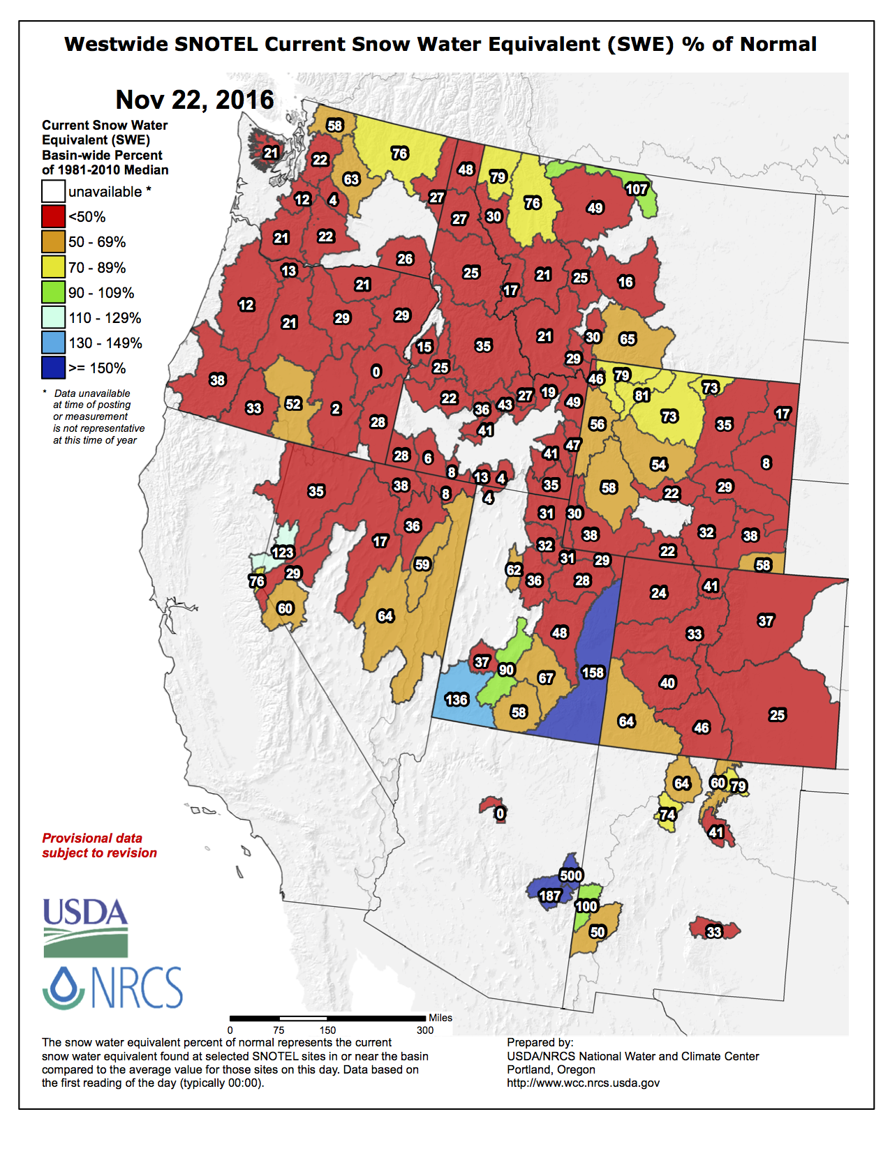
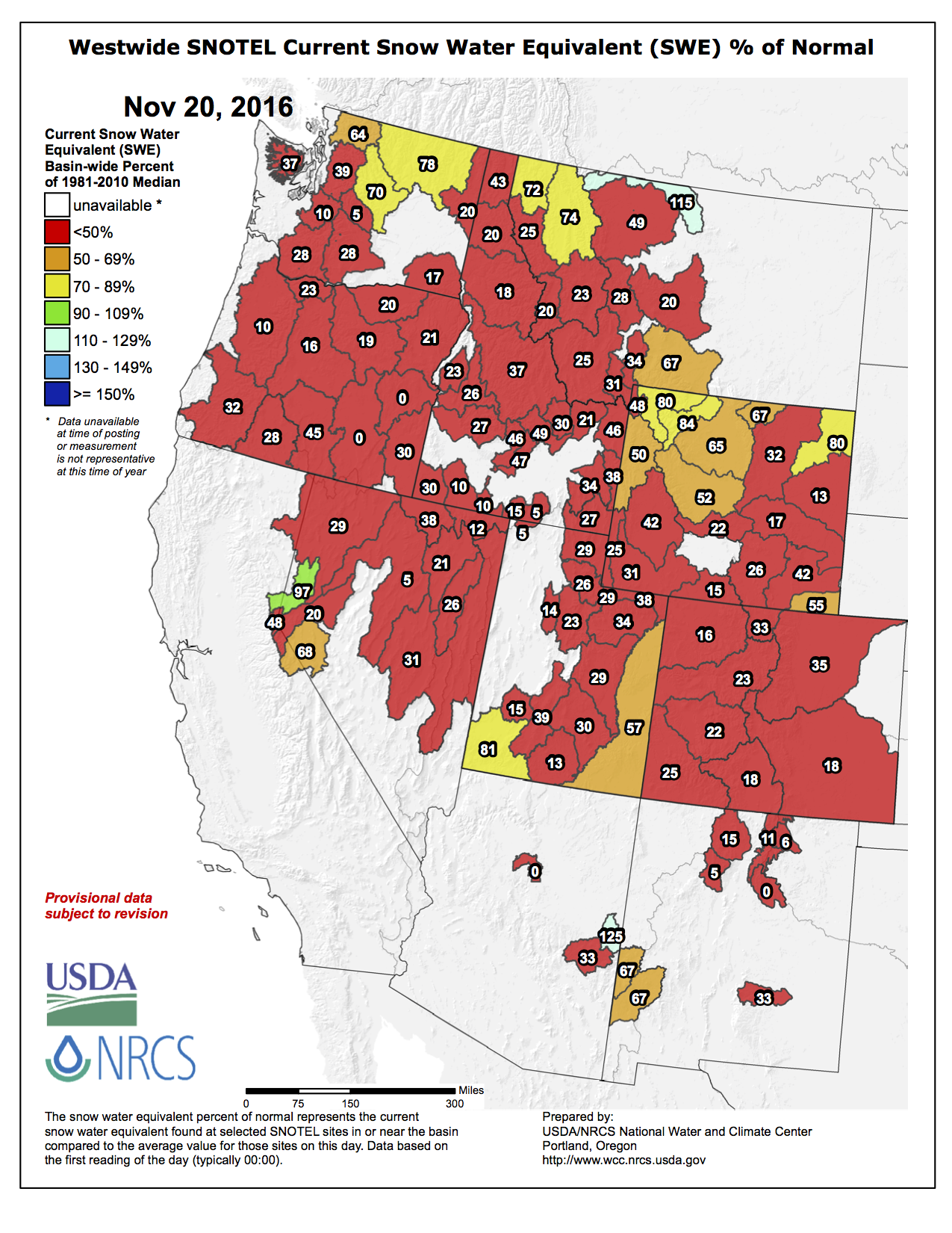
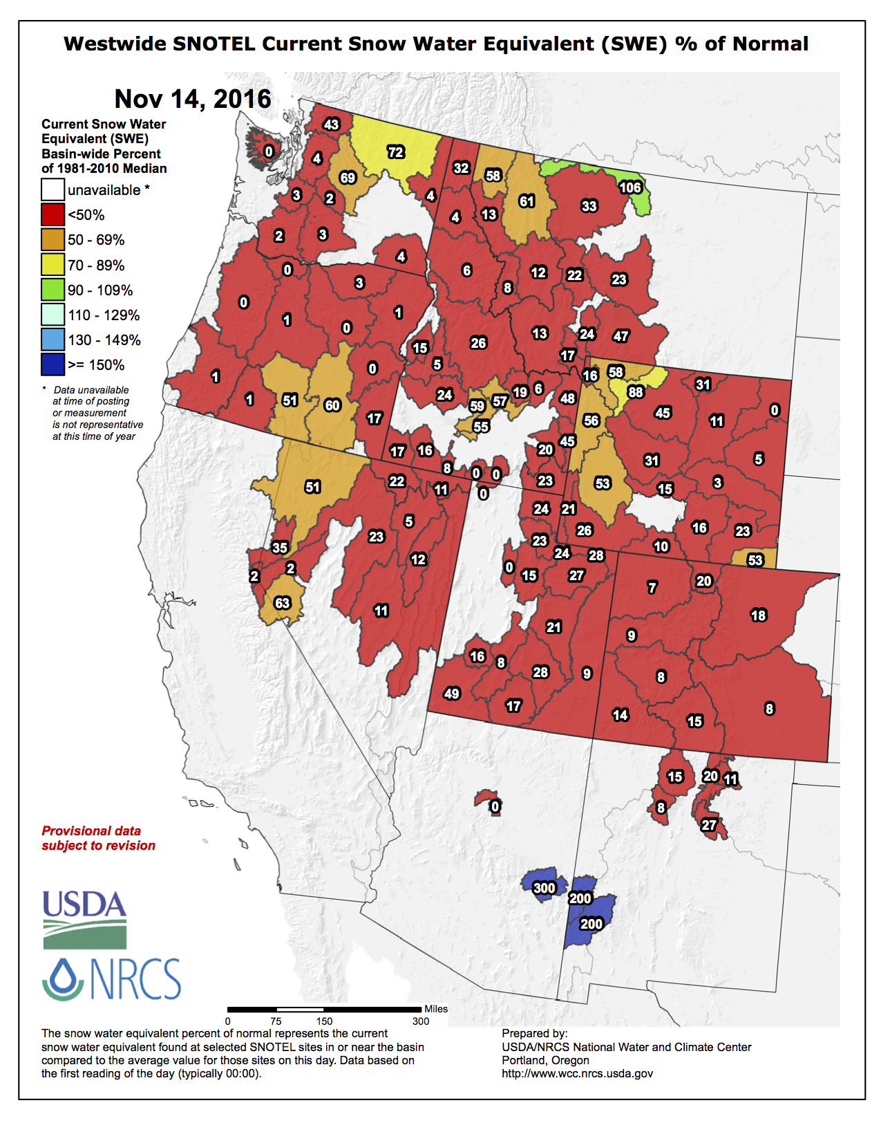
Colorado experienced above average temperatures in October and the first half of November combined with well below normal precipitation as weak La Niña conditions have developed. October was the third warmest on record and temperatures across the state through November 14 ranged from 4-10 degrees above normal. While the 2016 Water Year ended with nearly average precipitation, the 2017 water year is off to a dry start with all basins in the state recording well below normal precipitation as of November 14 at the mountain SNOTEL sites.
Statewide snowpack as of November 14 is at 6% of average. This is the worst start to the mountain snowpack season since at least 1986, although daily snowpack records only date back to that year. At this point in the water year, Colorado typically receives 2.1 inches of snow water equivalent however the state is currently at 0.1 inches.
Statewide water year to date mountain precipitation is 34% of average. The South Platte & Yampa/White basins have the highest percentage of average at 42% and 47% respectively. The lack of precipitation has negatively affected the winter wheat crop.
Reservoir storage statewide remains strong at 104% of normal. The Southwest and Yampa/White River basins have the highest storage levels in the state at 112 and 114% of average, respectively. The Upper Rio Grande has the lowest storage levels at 87% percent.
Water providers in attendance all reported storage levels ranging from 70 to 123 percent of average. Demand is above average & providers hope colder temperatures will help decrease the demands.
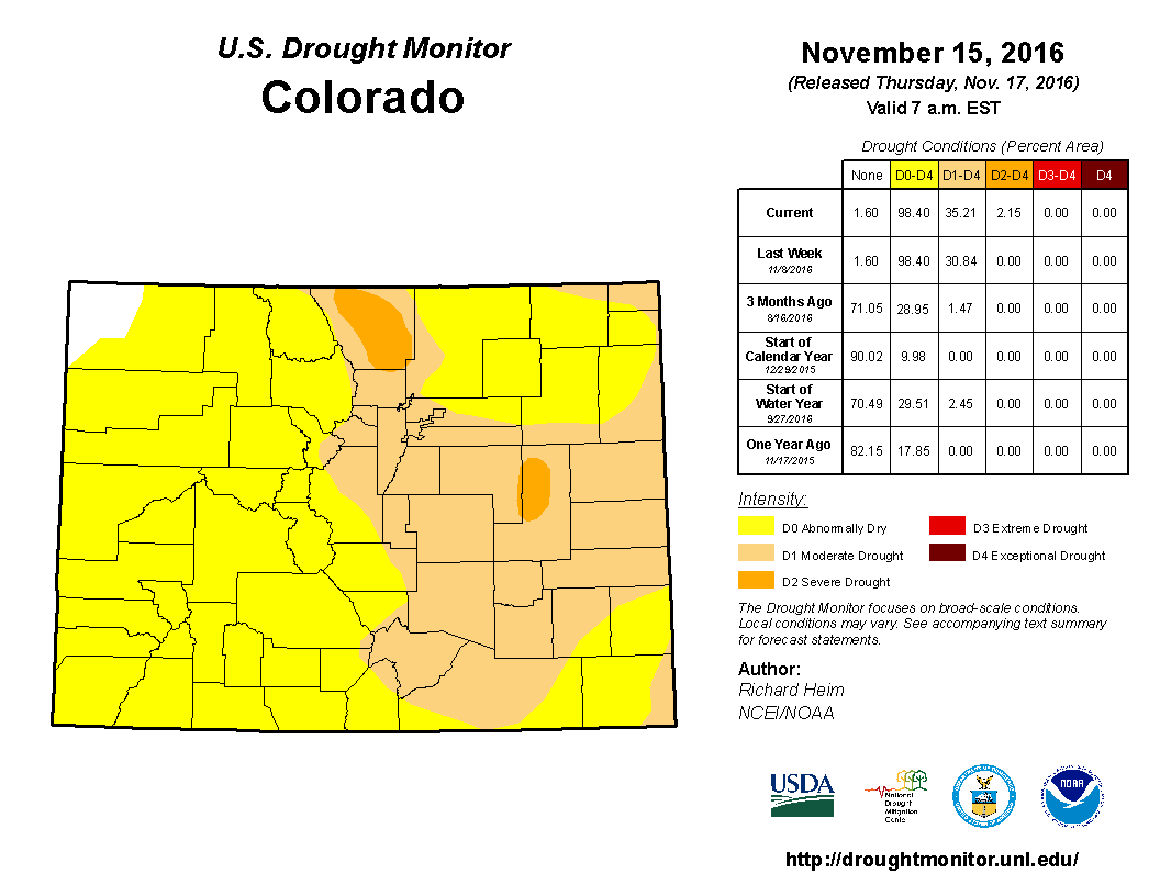
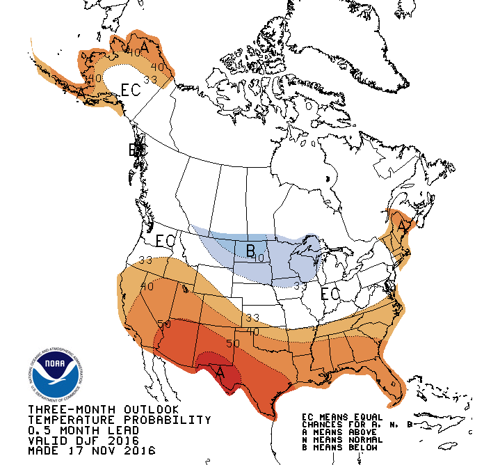
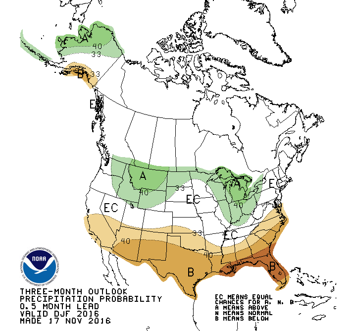
A weak La Niña has developed contributing to the lower than average precipitation in the state this fall. The long term forecast predicts the weak La Niña may be gone by early 2017. CPC forecasts give Colorado equal chances for moisture through late winter with a chance for extra moisture in December. Weak La Niña conditions should favor the northern and central mountains through mid winter, after which it would revert to being a negative factor. The next two weeks promise to bring near normal moisture to the state in a welcome change from dry fall conditions.
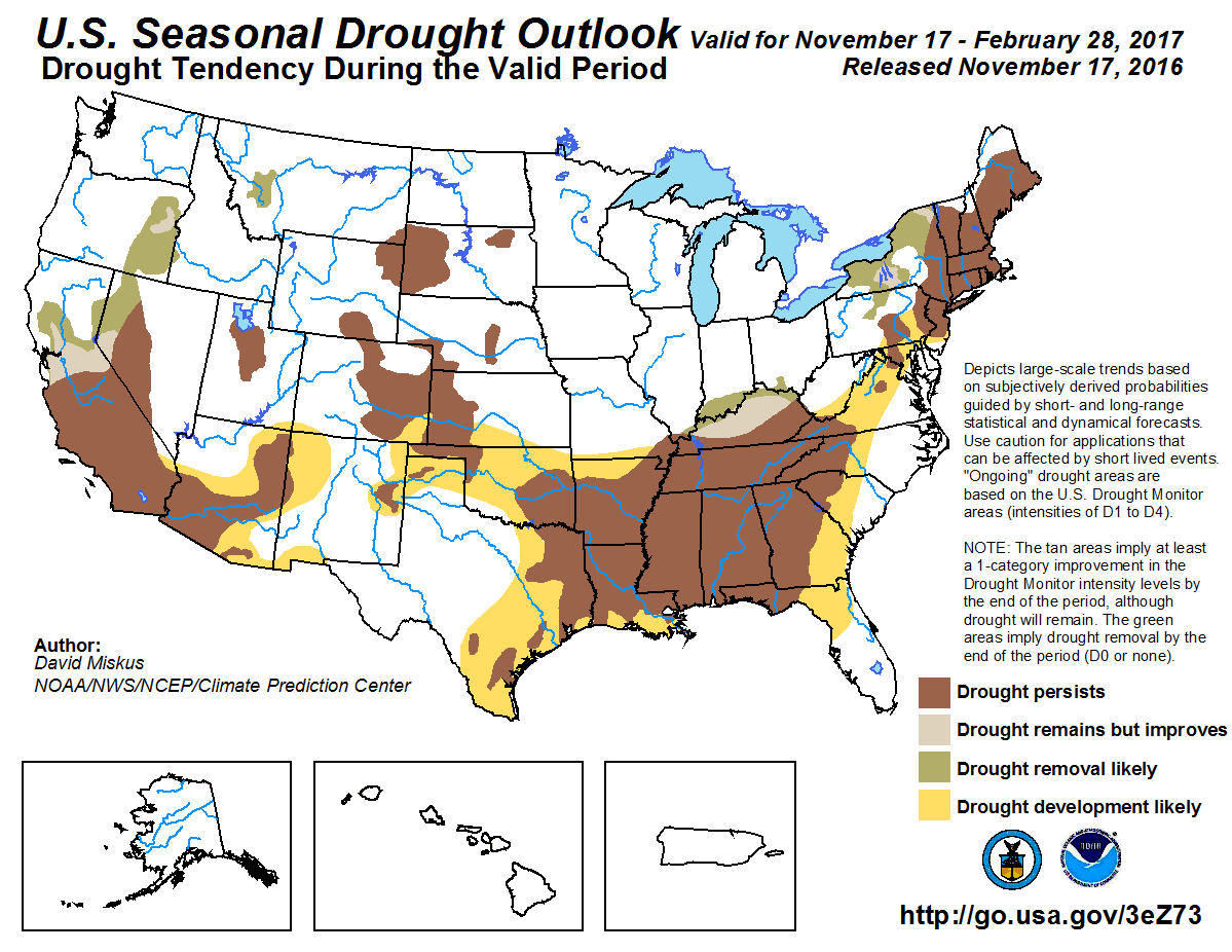
The US Drought Monitor shows D2, severe drought, has been introduced into Larimer and Lincoln counties. D1, moderate drought, has been expanded further towards the southeastern part of the state. Only 1.6% of Colorado in the northwest part of the state is currently drought free.
In a paper published earlier this year, a team of ecologists sought to outline the essential role of gravel-bed rivers in Western mountain ecosystems — the first time an interdisciplinary team has looked at river systems on such a large scale.
“A river doesn’t just flow down the channel,” said F. Richard Hauer, a professor of stream ecology at the University of Montana and the lead author of the paper. “It flows over and through the entire flood plain system, from valley wall to valley wall, and supports an extraordinary diversity of life.”
Perhaps most surprising of all: “Most of the water in these systems is not in the river — it’s in the gravel.”
These river systems are among the most ecologically important habitats on the continent, Dr. Hauer and his colleagues concluded, supporting a hidden wealth of biodiversity. And not just in the West; the life-sustaining dynamics are at play in the mountains of Europe, the Andes, the Himalayas and New Zealand.
In the West, a dynamic river is not important just to fish or to amphibians, but to grizzly bears and mountain lions descending from mountaintops to the flood plain for important foods. Indeed, two-thirds of the species in a large river valley spend at least part of their lives in its flood plain.
The new study also demonstrates that altering this complex biological machinery with dams and diversions has far-reaching effects, leading to long-term decline of the ecosystem.
“A river is a huge, huge biodiversity engine with multiple parts,” Dr. Hauer said. “If you keep taking out parts, pretty soon the engine stops.”
Until now, scientists had never put together such a comprehensive ecological blueprint of river dynamics.
Melting snow and groundwater flow down the channel; this is what we think of as a “river.” But underground, far more water is moving slowly through a labyrinthine network of cobbles, gravel and sand that make up the entire valley bottom.
This deeply buried habitat is far more important and far more productive than thought. The matrix of gravel and sand cleans the water, filtering organic material and freeing up nitrogen and phosphorous embedded in the gravel.
These natural fertilizers spread across the valley bottom, a shot of adrenaline that nourishes plants in the flood plain such as willows and aspen, which in turn draw birds and beavers, elk and caribou. The plant-eaters attract predators like wolves and grizzly bears.
In the summer, warm water is stored underground. It takes so long for the water to move that it surfaces in winter, moderating water temperatures and creating a refuge for some aquatic species, shielding them from winter’s freeze. In the winter, the opposite happens.
The river also continually rearranges and renews the ecosystem.
During high water, topsoil, gravel and woody debris are washed into new sites downriver and below ground, fostering new habitats and new plant communities. The new habitats blend with existing ones, from mature cottonwood forests to grasslands, to create a patchy mosaic.
On a recent flight over the Bitterroot River, a gravel-bed river near Missoula, Dr. Hauer pointed out the flood plain.
While the river below flowed down a main channel, it was easy to see from the air that over centuries, the Bitterroot had frequently jumped its bounds to create a network of new channels.
The old channels were covered with gravel — an important habitat for the stoneflies and other insects that feed the fish. Everywhere in the valley, water flowing underground through the gravel surfaced to create a diverse assortment of ponds, seeps and springs.
Dr. Hauer also pointed out a number of places where people have sought to tame the river’s unruly habits in order to plow farm fields or build subdivisions.
“There’s no renewal — the river doesn’t move gravel around and doesn’t create new mosaics of habitat,” he said. “Nutrients are not dispersed. Everything gets locked in place and starts getting old and declines.”
The environmental damage is hidden — at first. Channels feeding the underground habitats are sealed off as the river is confined. The species that depend on the hidden flows begin to falter.
These gravel flood plains, Dr. Hauer said, are among the most endangered ecosystems worldwide.
Keeping them intact will help dependent species adapt to the greatest environmental threat of all: climate change. “The implication for conservation is enormous,” Dr. Hauer said.
Click here to read the report. Here’s the abstract:
This study investigated the effect of increasing population and changing climatic conditions on the water resources of a semi-arid region, the Las Vegas Valley (LVV) in southern Nevada. A system dynamics model was developed for the LVV from 1989 to 2035. The impact of climate change on water demand and the water supply from the Colorado River was modeled, using projections from 16 global climate models for 3 emission scenarios. Variability in water demand and supply under different scenarios of population growth and demand management, including water conservation and water pricing, was evaluated. With the population growth that was projected, if no further demand management policies were implemented, the LVV would not be able to meet the water demand in the near future. However, by combining water conservation and pricing policies, the available supply could last well into the future. The reduction in water demand in 2035 was predicted to be 327 million cubic meters (MCM) for ‘status quo’ population growth, or 30.6%; 408 MCM for 50% of the projected growth, or 38%; and 511 MCM for no population growth, or 47.8%. Water supply reliability decreased significantly with changing climatic conditions. Therefore, major challenges to water sustainability in the LVV would be due to rapid population growth as well as to climate variability. However, with the combination of reduced population growth rate and water conservation policies, the Colorado River supply could meet the future demand of the LVV most of the time.
From Colorado Corn Growers Association (Eric Brown):
National Corn Growers Association (NCGA) incoming president Wesley Spurlock will make Colorado one of his early stops in his new role, when he attends Colorado Corn’s Annual Banquet on Dec. 7 in Yuma. While there, he also plans to address the crowd gathered at the Yuma Community Center (421 E. 2nd Avenue).
In addition to his role with NCGA, Spurlock farms 9,600 acres of irrigated corn, cotton, wheat and grain sorghum in the upper Texas panhandle, where he also runs a harvesting and spray company.
Among the many others in attendance on Dec. 7 will be Colorado Agriculture Commissioner Don Brown, and John Stulp – a former Colorado ag commissioner, and the current special adviser on water to Colorado Gov. John Hickenlooper. Both are also planning to step up to the podium during the event.
The day will begin with the Colorado Corn Growers Association (CCGA) hosting its annual business meeting at 4:30 p.m. (all CCGA members are invited), then a social hour at 5:30 p.m., with the dinner and awards starting at 6:30 p.m.
We ask those wanting to attend to please RSVP no later than Monday, Nov. 28, by contacting Ann Cross at across@coloradocorn.com, or by calling her at the Colorado Corn office at (970) 351-8201.
Invitations and RSVP cards have also been mailed out, to provide another method of RSVP-ing.
Look for more details in the “Kernels” e-news and on our website as the event gets closer.
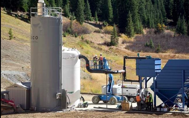
The Environmental Protection Agency’s temporary water-treatment facility at Gold King Mine, October 2015, via Steve Lewis/The Durango Herald.
From the Associated Press (Dan Elliott) via The Farmington Daily Times:
A final decision will be made next month, the EPA said. The agency announced its intentions last week.
The plant began operating in October 2015, and the agency said at the time it would run at least through the end of this month and possibly longer…
The EPA is looking at long-term solutions for the Gold King and 47 other nearby mining sites, which send millions of gallons of acidic wastewater to creeks and rivers every year. The area was designated a Superfund site in September, clearing the way for a multimillion-dollar federal cleanup expected to take years.
The temporary treatment plant cost $2.9 million. The original plant cost $1.8 million, and the EPA later expanded it for $1.1 million more.
It is being run for slightly less than expected. The EPA initially said it would cost $20,000 a week to run, but the agency said Tuesday the cost is about $16,000 a week.
Cleanup so far has cost about $29 million, the EPA said. That money has gone toward work and reimbursements and aid to state and local governments affected by the Gold King spill.
The temporary treatment plant could be in operation for at least two years while the EPA investigates the area and evaluates long-term options, the agency said.
On April 7, 2016, the Environmental Protection Agency proposed adding the “Bonita Peak Mining District” to the National Priorities List, making it eligible for Superfund. Forty-eight mine portals and tailings piles are “under consideration” to be included. The Gold King Mine will almost certainly be on the final list, as will the nearby American Tunnel. The Mayflower Mill #4 tailings repository, just outside Silverton, is another likely candidate, given that it appears to be leaching large quantities of metals into the Animas River. What Superfund will entail for the area beyond that, and when the actual cleanup will begin, remains unclear. Eric Baker
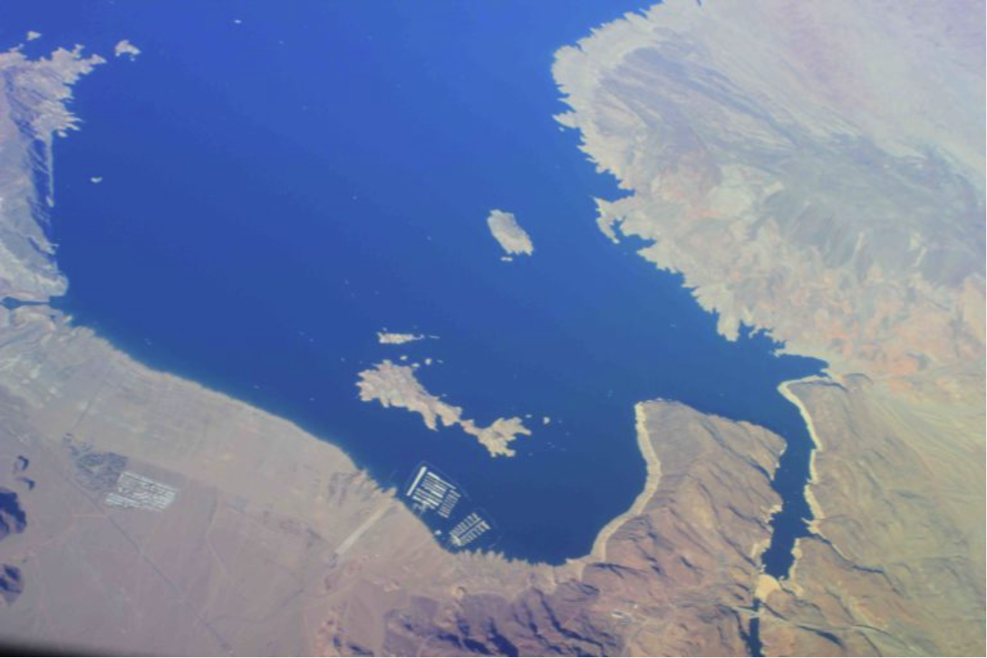
From 38,000 feet in a jet, Hoover Dam looks to be a remarkable achievement. The giant plug in the Colorado River about 30 miles outside Las Vegas, the cause of the swathes of blue in the tan desert landscape, stands as a testament to 20th century American ingenuity, stubbornness, and political will.
From the crest of the dam, the achievement looks more flawed. Lake Mead has dropped 130 feet since 2000, when it was full. It’s now at 37 percent of capacity and declining rapidly enough to capture the full attention of water managers from Los Angeles to Denver.
In Phoenix, water managers foresee potential reductions so severe they could “dramatically impact Arizona’s entire economy, society, and the environment,” said Suzanne Ticknor, director of water policy for the Central Arizona Project, or CAP, at a recent forum. She described the risk of what she called “this existential threat” as a low probability that could nonetheless develop quickly and in the relatively near future.
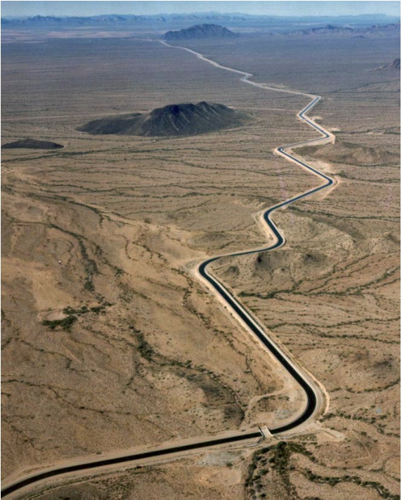
The CAP delivers 1.6 million acre-feet of water annually from the Colorado River through a 336-mile concrete-lined aqueduct to four million people, including 10 irrigation districts and 11 tribes. Built in the 1970s and 1980s, it was financed by the federal government.
Terms of that financing included an import provision: Arizona, along with Nevada, would have to bear the brunt of reduced flows, if there are any. Only later, according to a protocol agreed to in 2007 among the states and the federal government, must California start cutting back. That would be when Meat drops to an elevation of 1,045 feet. As of mid-November, it was at 1,112 feet.
The Central Arizona Aqueduct delivers water from the Colorado River to underground aquifers in southern Arizona. UT researcher Bridget Scanlon recommends more water storage projects like the aqueduct to help protect against variability in the river’s water supply. U.S. Bureau of Reclamation.
Arizona has also been taking steps. Farms, where half of Arizona’s water from the Colorado River goes, have fallowed 10 percent of their acreage. Reductions have been a “hard sell,” said Ticknor. “People are having a hard time grappling with the size of the reductions and the nature of the impacts.”
Asked at the forum sponsored by the Colorado River Water Conservation District in Grand Junction, Colo., about the willingness to reduce water use for parks, golf courses and other urban greenery, she answered: “Those conversations are ongoing.”
Drought has usually been blamed for the declining reservoir levels. But upper basin states have released 8.23 million acre-feet in all but one year in this century from Lake Powell, located higher in the drainage.
Far more than drought is at work. There’s also something called the “structural deficit.” This water-wonkish phrase is used by Colorado River experts to describe the fact that more is expected of the river than it can possibly deliver. When delegates from the seven basin states assembled in Santa Fe in 1922 to apportion the river’s waters, they assumed 18 million acre-feet. It has rarely delivered that much since then. This century, there’s been much less. Flows in the river since 2005 have averaged 12.7 million acre-feet.
Variability is a given. That’s essentially what the river’s two giant reservoirs, Mead and Powell, were created to moderate. There will be dry years. Framers of the Colorado River compact understand that.
Drought isn’t the real problem here. The real problem, said Ticknor, is “the simple fact that the lower basin (Arizona, California and Nevada) uses 1.2 million acre-feet more water than is delivered.”
Change disguised as drought
Warming temperatures can create the impression of drought. Since 2000, precipitation in the basin has been more or less average. However, all years have been warmer than average, said Jeff Lukas, of the Western Water Assessment in Boulder, Colo.
In Western Colorado, which provides half the water of the river, temperatures have increased about 2 degrees Fahrenheit in the last 30 years. Summer temperatures have spiked even more, nearly 3 degrees F.
Jeff Lukas via the Western Water Assessment.
Models suggested a degree warming in the basin could produce a 5 to 10 percent reduction in Colorado River flows. Particularly hot years, including 2012, have reduced flows 20 percent. A growing body of evidence compiled by researchers points very strongly if still circumstantially toward rising temperatures as the primary cause for reduced flows.
In a later interview, Lukas explained that this is not new to researchers, who for at least a decade have been linking increased temperatures with reduced flows. But he also pointed to a multitude of factors that influence runoff in any given years.
“We have giant beetle infestations in the headwaters of the Colorado. We have dust on snow events. We have wildfires. We have just crazy variability in our weather, with a ton of snow during one May and another May really dry,” he says. There is great complexity, he adds, between how much snowfalls and the runoff in the Colorado River.
Despite this great variability, which scientists call noise, researchers believe they see a clear effect of climate change as predicted by models.
“It’s a really noisy system with a lot of different factors, but I think we are starting to see the warming signal emerge – now and not just 30, 50 or 70 years out,” says Lukas.
Lukas points out that much of the infrastructure and many of the water management policies are predicated on the climate of the 20th century, when we made dams and other decisions about how to manage our natural resources.
“And the climate was roughly 2 degrees cooler than it is in the Western Colorado than it has been in the 21st century,” he says.
More blunt yet in his assessment was Abrahm Lustgarten, a writer for ProPublica, a non-profit journalism foundation, who spent two years researching the Colorado River issues. Western water use amounts to “wishful thinking that there is more water than there actually exists,” he said in a noon-hour speech at the forum. “This is a fundamental untruth.”
Cotton-picking subsidies
Lustgarten zeroed in on cotton farming in Arizona. He told of one cotton farmer in central Arizona who has 8,000 acres. Each acre of cotton requires six times as much water as an acre of lettuce, and 60 times as much as wheat. Why grow cotton? The price is low, because of a world-wide surplus.
The farmer grows cotton, he said, partly out of habit, partly from pride—but also because of federal incentives. In Arizona and California, $4 billion has been doled out by the federal government to cotton farmers.
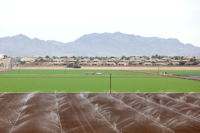
Spray irrigation on a field in the Imperial Valley in southern California. This type of irrigation is a lot better than the extremely water inefficient type of flood irrigation that is popular in this region. Still, in the high temperatures of this desert region a lot of the water evaporates, leaving the salts, that are dissolved in the colorado River water that is used, on the soil.
In a pinch, can water be diverted from farms to cities? Cities from Denver to Los Angeles have been participating in a basin-wide study that is seeking to study how savings can be wrung from farms and industrial uses, if necessary.
One such project is near Hotchkiss, along the North Fork of the Gunnison River in Colorado. There, Tom Kay, of North Fork Organics has voluntarily participated in a program begin underwritten by Denver Water, the Central Arizona project and other water agencies, but also The Nature Conservancy and Trout Unlimited.
Those organizations are providing money for Kay and other farmers to plant crops crops that need less water. We’re using one acre-foot per acre instead of three acre-feet, and they’re compensating the farmer for the two-acre-feet not used,” explained Kay at the forum in Grand Junction. A side benefit for Kay is that he has been able to transform production to certified organic, with a significant increase in pay.
The program is half-way through a four-year trial, but results have been dramatic. “When you go from furrow flooding to field sprinklers, you can get by with a half or a quarter of the water,” said Dave Kanzer, chief deputy engineer for the Colorado River Water Conservation District.
As general manger of the Colorado River Water Conservation District, Eric Kuhn has been warning of the influence of global warming in the basin for a decade. He is also a proponent of practical politics.
After the searing drought of the early century, the U.S. Department of Interior guided creation of a protocol for sharing shortages not anticipated by the 1927 compact. Adopted in 2007, the interim shortage criteria set the course for the reductions now being instituted in Arizona and those ahead for California.
“Sixteen years of drought had continued overdraft of supplies have taken their toll on its major reservoirs and have stressed operational protocols, and climate change threatens further reduction to runoff,” he says. “Lake levels are hovering around the elevation at which the first-ever shortage declaration on the river must be announced by the secretary of Interior. The declaration could come as soon as August 2017.”
Reservoir levels in Lake Mead continue to decline and were down to 37 percent of capacity recently. December 2015 photo/Allen Best
Kuhn, who was one of 65 “thought leaders” interviewed for the report, says the states need to come up with solutions, which inevitably entail compromises. “We have to make some decisions, and we are not gong to get what we want, but we are not going to push ourselves over the cliff, either,” he said. Letting the courts sort out how to respond to shortages is “too risky,” he said.
While much has been made of the lower-basin living beyond its means with over-drafts of the Colorado River, Kuhn said that Colorado itself is not immune. The 1948 upper-basin compact apportions 51.75 percent of Colorado River flows upstream of Lee’s Ferry to Colorado, But in this century, he said, Colorado has been taking 58 percent.
Kuhn also stressed political realities. Cities tend to have junior water rights, but turning off their spigots isn’t going to happen.
“No governor of any state, of any political part, or either gender is going to turn off water to people, especially big cities,” he said. “If you have a town of 100, you can send them bottled water. But you aren’t going to meet the needs of Colorado Springs with bottled water.”
A crisis in the Colorado River? That’s the easy story, and without action it’d be the accurate story. The more nuanced story is one of changes underway and more yet to come—because, after all, the climate does seem to be shifting.
A screenshot from the website for Colorado’s Water Plan.
FromThe Grand Junction Daily Sentinel (Dennis Webb):
Colorado’s water plan hit its first birthday this month, prompting state water officials and some water activists to offer an assessment of how implementation has been going in addressing the state’s future water needs.
“I’d say that there have been quite a few activities done this past year,” said Bart Miller, Healthy Rivers Program director for the conservation group Western Resource Advocates.
But he and some others would like to see the state pick up the pace when it comes to work on the plan, which was an initiative of Gov. John Hickenlooper.
“We don’t want to see the plan sit on a shelf and gather dust,” said Craig Mackey, co-director of Protect the Flows, which represents more than 1,100 businesses that support protecting the Colorado River system.
James Eklund, director of the Colorado Water Conservation Board, a state agency, responded to such concerns during the board’s meeting last week, saying that “we are moving forward aggressively and I don’t think slowly at all.”
The plan sets out to eliminate, through a mix of conservation, new water projects and other means, what otherwise could be a 560,000-acre-foot gap between municipal and industrial water demand and supply in the state by 2050.
Miller credits the state for a number of recent actions it has taken to start carrying out the water plan. In September, the Board adopted new criteria for evaluating applications for loans and grants from its water supply reserve fund, which pays for projects that must be approved by the applicable local river basin roundtable. The new criteria are intended to match up with water plan goals, helping address identified water gaps, ensuring collaboration and local involvement, and avoiding or mitigating environmental and other impacts.
Miller also points to the $55 million in funding the Board approved last week related to the water plan. That includes $10 million in supplemental money for the reserve fund, the same amount for water plan implementation, $5 million for stream and watershed conservation, and $30 million in loan guarantee money.
The spending will require approval by the legislature in order to go forward.
Miller said while there’s still a long ways to go in carrying out the water plan, the approval of the spending is a good-faith show of progress.
“They’ve, I think, run a good first lap in this race and there’s quite a few laps to go,” he said.
But Mackey pointed to the billions of dollars the plan is expected to require to implement, and said educating the public about the plan and water in general is crucial.
“Our view is we’ve got a lot of work to do,” he said, as he called on everyone from Hickenlooper, to lawmakers, the business community and others to come together and show leadership in selling key components of the plan.
Part of Board’s meeting last week was devoted to reviewing educational efforts the agency is undertaking to show what work it has been doing on various elements of the plan. Among the achievements it cites are initiatives in areas such as integrating water considerations into land-use planning, working with other state agencies to address water-related concerns related to climate change, and exploring ways to divert agricultural water for other uses without altogether buying out, and drying out, farmland.
Hayfield message to President Obama 2011 via Protect the Flows
Map from Northern Water via the Fort Collins Coloradan.
FromAspen Journalism (Brent Gardner-Smith) via The Aspen Daily News:
The board of directors of the Colorado Water Conservation Board gave conceptual approval Wednesday to a $90 million loan to help finance the $400 million Windy Gap Firming Project, which will divert more water from the Colorado River.
The CWCB, charged with facilitating water supply projects in Colorado, has both a loan program and a grant program. And while its grant program is being challenged by a sharp drop in severance tax revenue from the oil and gas sector, the agency’s loan program remains robust, especially as Aurora just repaid a $70 million loan ahead of schedule.
The $90 million loan to Northern Water, which is developing Windy Gap, is the largest in the agency’s history. It will help facilitate a project that is more popular on the Eastern Slope than the Western Slope, given it will increase the level of water sent under the Continental Divide.
The loan, which still needs final approval from the CWCB board, will be part of a financing package for a new reservoir near Loveland called Chimney Hollow Reservoir, which will cost $400 million to construct.
Eric Wilkinson, the general manager of Northern Water, said he expects the project to be approved in 2017, that test drilling has begun at the dam site — next to Carter Lake Reservoir in Larimer County — and design work is well underway. Gov. Hickenlooper has also endorsed the Windy Gap project, even though final federal approval is still outstanding.
Wilkinson also said that the prospect of a CWCB loan has galvanized financing discussions among the 12 different entities – including 10 cities from Broomfield north to Greeley — who are involved in the project as members of the Northern Water Municipal Subdistrict.
“The difference that this has made cannot be overstated,” Wilkinson told the CWCB board about the loan.
Savings needed to backfill drop in severance tax funding
The $90 million loan makes up a big chunk of this year’s “projects bill,” which is submitted annually by the CWCB to the state Legislature for approval. This year’s projects bill is $165 million in all, which makes it the largest annual spending request in the history of the CWCB, which dates back to 1937.
Another big part of the projects bill is $55 million for an array of grants and loans spurred by the Colorado Water Plan, which was approved a year ago by the CWCB board and presented to the governor.
Of the $55 million, $10 million is for projects to be funded at the discretion of the CWCB directors, and $5 million is specifically for watershed restoration efforts and stream management plans, which is a nod to environmental interests in the state.
Another $10 million is used to fund the agency’s Water Supply Reserve Fund, which helps fund local water supply projects identified and approved by the nine basin roundtables around the state, including the Colorado River Basin Roundtable, which meets in Glenwood Springs.
Site of Chimney Hollow Reservoir via Northern Water.
Funding for roundtable projects is supposed to come from severance taxes paid by oil and gas producers in the state to the tune of $10 million a year. But the combination of the slowdown in the gas patch and property tax rebates given to the industry means that the CWCB is only going to see about a quarter of the severance tax revenue this year that it normally receives.
As such, the CWCB is asking the Legislature to let it spend severance tax revenue it has tucked away from the good years. That approach, however, is fraught with danger, as the Legislature is busy trying to figure out how to fill a $500 million to $800 million hole in the state’s budget, which must be balanced each year by law.
James Eklund, director of the CWCB, said the Legislature will be looking in all nooks and crannies for funds, but he’s hopeful that the approval of the state water plan last year will help convince lawmakers that the CWCB has a legitimate need for the money it has set aside for future projects.
Also in the $55 million bucket in the projects bill is a $30 million “loan guarantee fund” to help water suppliers with varying credit ratings to gain better interest rates when funding new projects together.
Eklund is sensitive to criticism that not enough has been achieved after the publication of the Colorado Water Plan a year ago, which itself was the product of an intense two-year collaborative effort among water interests in the state.
On Wednesday, he told the CWCB directors that while the Water Plan was now a year old, it was “only five days old in water years.”
“We are moving forward aggressively,” Eklund said. “And I don’t think slowly at all, especially if you look at it in water time.”
Board renews Ruedi fish-water lease
Also at last week’s CWCB meeting, Eklund said that the Ute Water Conservancy District in Grand Junction has offered to once again lease 12,000 acre-feet of water it owns in Ruedi Reservoir to the CWCB, so the agency can help maintain flows in the Colorado River, as it has done the last two years.
While the water from Ruedi benefits endangered fish in a critical 15-mile reach of the Colorado, it has also kicked up river levels in the lower Fryingpan River below Ruedi Reservoir in the late summer and fall to the consternation of some anglers.
The CWCB board also approved a $1.7 million loan for improvements to the Grand Valley Power Plant, which controls one of the senior water rights that make up the “Cameo Call” on the Colorado River above Grand Junction.
The loan to the Grand Valley Water Users Association and the Orchard Mesa Irrigation District will help cover the costs of a $5.2 million project to modernize the hydropower plant, which was built in the 1930s.
Contracts were also finalized this week with a bevy of water consultants to prepare the next edition of the Statewide Water Supply Initiative, or SWSI, which is a more technical version of the state water plan.
The SWSI plan is slated to be finished by December 2017 and is designed to inform regional water plans created by the basin roundtables, known as “basin implementation plans,” as well as provide a base of data for the next version of the more policy-driven Colorado Water Plan.
Also, State Engineer Dick Wolfe informed the CWCB board he’ll be retiring in June 2017 at age 55, after nine years in his role as the state’s top water cop.
Editor’s note: Aspen Journalism and the Aspen Daily News are collaborating on coverage of rivers and water in Colorado. More at http://www.aspenjournalism.org.
Conceptual vision of potential transmountain diversions from the South Platte Roundtable Basin Implementation Plan
FromAspen Journalism (Allen Best) via The Aspen Daily News:
After several years of warm-and-fuzzy talk, water leaders in Colorado are on the verge of a squabble. At issue is just how much water in the Colorado River remains to be developed and under what terms.
The Continental Divide again divides the protagonists as well as the waters. Two water districts representing the water-rich but more sparsely populated Western Slope in January launched the Joint West Slope Roundtable Risk Study.
The idea, first hatched at a joint meeting in Grand Junction of the four water roundtables on the Western Slope, is that even now, after the drafting of a state water plan, much remains unknown about the Colorado River, the state’s go-to source for both farms and cities.
Front Range water agencies that serve approximately 80 percent of Colorado’s population challenge assumptions that were used in the study. A Nov. 9 letter from James Lochhead, chief executive of Denver Water and also president of the Front Range Water Council, expresses “concern” that the assumptions “may be creating biased impressions regarding the amount of the remaining developable water under the compacts.”
Not so, responded Eric Kuhn, general manager of the Glenwood Springs-based Colorado River Water Conservation district, one of two Western Slope districts to sponsor the study. The other is Durango-based Southwest Colorado Water Conservation District. The initial phase of the study, completed this fall, looked at the risk of water levels in Lake Powell dropping below manageable levels. The river district and other West Slope entities now want to complete additional analysis of numerous supply and demand scenarios.
“The study was never intended to be a water supply availability study and shouldn’t be used in that matter,” Kuhn said. “It’s really no more than a ‘how much might we have to cut back in order to prevent Lake Powell from dropping below dangerously low levels under a number of different demand and hydrology assumptions.’”
Demand reduction would have to be “big” if drought comparable to that of 2002 or that of the mid-1950s revisits the region, he said.
In a Nov. 15 memo, Kuhn took issue with the review of the study by Glenwood Springs-based hydrologist Kerry Sundeen conducted for the Front Range Water Council.
Funding for the study, Sundeen noted in his report, “was not adequate to prepare detailed documentation of the modeling assumptions used in the study, nor the study results.” He described the hydrology and demand assumptions in the study as being in a “narrow range.”
Sundeen’s challenge to the findings came as Western Slope water groups were preparing to seek state funding for the second phase of the study. The application to the Colorado Water Conservation Board, the state’s lead water policy agency, has been delayed until January or March, according to Jim Pokrandt, community affairs director for the River District and chair of the Colorado River Roundtable.
Sundeen’s report to the Front Range Water Council also warned of what that next study seeks to do. His memo says the “proposed administrative operations to assure compact compliance could place a disproportionate burden on Colorado River water supply systems essential for meeting demands on the East Slope.”
In his memo, Sundeen also warned that a Western Slope-led study might lead to “confusion as to the state’s position on Colorado River” in negotiations with other states.
Sundeen’s warnings and Lochhead’s protest reveal traditional tensions in Colorado, where 90 percent of the state’s 5.4 million residents live east of the Continental Divide, mostly at the foot of the Rocky Mountains. Close to 90 percent of Colorado’s agriculture production also occurs east of the Divide. But 80 percent of the state’s water originates west of the Continental Divide, mostly in the form of snow.
Just how much of Colorado’s water remains available for development is the giant question still dangling in Colorado. The state water plan didn’t seek to answer the question. The official estimate is somewhere between none and 800,000 acre-feet. Independently, Kuhn has estimated 150,000 acre-feet.
What may be more important yet is how much water will be available if drought prevails and if the climate becomes warmer. The 1922 Colorado River Compact requires Colorado and the three other upper-basin states to allow 75 million acre-feet to flow downstream to Lee’s Ferry, at the mouth of the Grand Canyon, in rolling 10-year cycles. Lake Powell has become the bank vault for ascertaining those obligations can be met.
But how much more water can be developed out of the Colorado River without violating compact requirements? In September, at the River District’s annual conference in Grand Junction, Kuhn pointed out that the compact governing water use among the upper-basin states apportions 51 percent of their water (roughly half in the total river) to Colorado. But, in the last 10 years, Colorado has been using 58 percent.
At least two ideas for major water diversions to the Front Range have been introduced in the last decade, one from the Yampa River and the other from Flaming Gorge Reservoir.
The Front Range Water Council was first to register opposition to the Western Slope’s plan to get state funding for a new study.
“We believe these investigations are best conducted in a statewide or upper basin manner with all interested water users represented, rather than by particular sub-regions or individual roundtables,” said Lochhead’s letter.
The letter went on to hint at the depth of concerns. The Western Slope’s proposed second study “proposes to assess various involuntary compact curtailment alternatives that could be imposed on existing uses … ,” Lochhead’s letter stated. “Some of the proposed involuntary curtailment alternatives” in the next study “potentially favor limited special interests.”
Other water providers on the Eastern Slope have also talked about the Western Slope study.
Meeting in Longmont, along the St. Vrain River, the South Platte Basin Roundtable took no formal position because the Colorado River Roundtable’s formal request for state funding had been withdrawn. But speakers, including Sean Cronin, executive director of the St. Vrain and Left Hand Water Conservancy District, said that if the study is to be applicable to all of Colorado, then it needs to be a state-supervised study.
In an interview the next day, Joe Frank, chair of the South Platte Roundtable, reiterated the belief that “we need one voice” about Colorado River water.
“I think the metro and the Eastern Slope hopes that state takes the lead in looking at this issue of risk analysis and curtailment and everything,” he said.
He also suggested concerns among existing diverters of Colorado River water about the impact of future diversions.
“They have as much issue with a new transbasin diversion as the Western Slope would,” Frank said.
Editor’s note: Aspen Journalism and the Aspen Daily News are collaborating on coverage of rivers and water. More at http://www.aspenjournalism.org.
Colorado Water Plan website screen shot November 1, 2013
FromThe Glenwood Springs Post Independent (Kevin Fixler):
Even proponents for the first-of-its kind strategy — a non-binding set of goals and guidelines that prepares for the year 2050, when Colorado’s population is anticipated to more than double to 10.5 million — acknowledge it’s gotten off to a slow start. But after all of the excitement, and with it some friction, surrounding the water plan’s unveiling last November, the biggest steps to come revolve around its actual execution…
The water plan calls for some lofty objectives on that 35-year timeline. They include achieving an additional 400,000 acre-feet of urban conservation, attaining that same amount in new storage, and using alternative methods to share 50,000 more acre-feet of water designated for agricultural needs. Such techniques entail approaches like long-term rotational fallowing and short-term leasing and supply agreements to keep the water with farmers and ranchers as needed to continue raising the crops we all eat, but through procedures that also provide for the Front Range’s growing populations as available…
“The ability to lessen the pressure on rivers, and also give agricultural and recreational economies certainty, is some of the biggest value that the water plan provides,” said Sinjin Eberle, communications director of the Intermountain West chapter of water advocacy group American Rivers. “The river connects all of us all across the Southwest. All that water comes from up here, and how we manage it up here sets the tone all the way down the basin.”
ONGOING STRUGGLES
Colorado’s water year in 2016 was about average, which experts see as a strong season. Year to year, there can be serious volatility, with the Upper Colorado River Basin — made up of Colorado, Wyoming and parts of Arizona, New Mexico and Utah — seeing record lows over the past 15 years in 2002 and both 2012 and 2013 for water available to the Lower Basin of California and Nevada, as well as the other portions of Arizona, New Mexico and Utah. The inflow into northern Arizona’s Lake Powell, where the Colorado River runs before terminating at Mexico’s Gulf of California, is the ultimate determining factor.
Those totals for the past year mean almost nothing for the one upcoming, however, with drought always a possibility in the Southwest. It’s another reason why settling on a comprehensive state plan that satisfies all of its needs, including the recreation and wildlife economies of places like Summit County and throughout the Western Slope, is so pivotal.
“All the reasons we created the water plan a year ago are still prevalent in Colorado,” said Beckwith. “The underlying issue is if we don’t act and we don’t change, we end up drying up our rivers, we don’t provide a sustainable water supply to our cities and we leave agriculture in the dust.”
At present, the biggest strides for the plan have been made with the Colorado Water Conservation Board (CWCB) producing proposals for the allocation of grant money from its annual Water Supply Reserve Fund. The account, created from legislation passed by the state’s General Assembly in 2006, is spread across various water projects that theoretically align with those goals of the water plan. To date, the fund has provided more than $27.5 million for projects spanning the nine water basins.
The focus of late for how to spend those dollars consists of funding stream management plans and forthcoming water efficiency programs. At its bimonthly meeting in September, the CWCB also updated its eligibility criteria for what qualifies recipients to receive those funds based on a checklist. The focus of this month’s meeting, scheduled for Nov. 16 and 17, will now be on how to carry on financially supporting projects at levels of the past given momentous shortfall in revenues that fund the account.
The Water Supply Reserve is supported by severance taxes produced from energy purchases. With a weighty drop off in production of gas, oil and coal, on top of unremarkable sales, the CWCB will need to come up with a way to backfill millions of dollars in losses in the interim, while also finding a solution for the future, if it hopes to hit some of those targets in the state water plan along the named time frame.
“The funding has just been hammered by low energy prices and cutbacks in productions,” explained the Colorado River District’s Jim Pokrandt. “That’s in the short term. And in the long term, the CWCB will need to come up with a funding stream dedicated to these water projects. Because even with full funding, the fund wouldn’t begin to scratch the surface of some of the work that needs to be done.”
FINDING SOLUTIONS
A proposal to help allevaite investment strains includes a loan guarantee fund that would back regional project requests with state dollars to ensure cash advances are obtainable to complete water ventures moving forward. Sales and container taxes, mill levies and water tap fees are other mechanisms the CWCB will explore — all of which would either need to come through possible legislation with the General Assembly or from future voter approval — to come up with the assets needed to resume with the implementation phase of the overall plan. But with both education and infrastructure accounts also impacted by the severance tax downturn and competing for the same funding, no easy answers currently exist.
It’s only after new dollars are discovered that further implementation of the water plan can occur. According to the state water roadmap, that means bolstering those stream management plans and applying additional scrutiny to potential large-scale water developments down the road, if deemed necessary. More emphasis on conservation and increased water efficiency will also be a large part of purported success.
The one thing that is certain, though, is that those who contributed to helping shape the framework of the water plan will keep at it given the promise the state spawned with its release. Holding decision-makers accountable and ensuring the plan does eventually have real impact across Colorado persists as their focus.
“The water plan really does create this full-on recognition that the environment and healthy, flowing rivers are important to Colorado’s brand, to our economy, to us as a state,” said Beckwith. “So many people spent a lot of time working on this plan that no one wants it to just sit on the shelf.”
The Colorado Water Conservation Board voted last week to seek the funding in next year’s budget to get going on the $20 billion statewide water plan unveiled a year ago…
At the heart of the plan is the idea of urging state water consumers to wean themselves from about 1 percent of their usage per year.
If all goes well, it’s still a tall order…
Of the $55 million requested for next year, $30 million would go into a loan fund to help cities finance repairs and other projects to help save water, and $25 million would kick-start other parts of the plan.
The budget legislators will consider next session, however, is projected at $28.5 billion, which envisions $500 million in cuts and delayed spending for such programs as transportation, health care and education.
The governor’s budget proposal also calls for the state to hang on to an estimated $32 million in severance taxes from mineral extraction that usually would go to local governments to pay for such projects as water conservation.
Severance taxes have been eyed as a way to pay for a part of the components of the water plan, including replacing leaky pipes, raising the height of dams to expand reservoirs, restoring watersheds and allowing water deals between rural and urban areas to still help preserve agriculture.
The 1 percent statewide water-saving target would represent 130 billion gallons a year, according to the plan. The savings target could eventually accommodate more than 1.1 million additional households, the plan envisions.
The $20 billion price tag includes water projects and river restoration programs across the state by 2050, with most of the money coming from local governments that benefit from individual projects, federal sources, private enterprise and environmental foundations. Statewide, taxpayers are expected to pony up about $3 billion over the next 34 years.
“In my view it’s a really important conclusion that after the first year we have a lot of objectives; we have a good first year of figuring out what we need to do, and now we have a commitment, at least by the board, to start spending resources to implement the plan,” said Bart Miller, Healthy Rivers program director for Boulder-based Western Resource Advocates…
“In the world of water, much of the issue is and should be bipartisan,” he said. “If you’re talking about water in the West it feels to me that that’s an issue that transcends individual people or individual parties. It’s kind of a basic thing we all need to work together on.”
Miller and other conservation leaders used the one-year anniversary of the plan’s unveiling to urge leaders to continue to progress, despite short-term budget hurdles.
In addition to the fast expanding state population, climate projections show hotter and drier conditions in the American Southwest, including Colorado, which could lead to more drought.
Abby Burk, Western Rivers Program lead for Audubon Rockies, said that while implementing the plan would not be easy, the issues are pressing.
“Now more than ever, Coloradans must continue to work together for implementation of the plan and reach for smart bold actions now in order to secure our water future for people and the environment,” she said.
Matt Rice, Colorado Basin director with American Rivers, called the sweeping conservation effort “an example of people across Colorado, and across a wide array of interests, coming together to forge this important plan for our state’s water future.
“But any good plan is only as good as its implementation, and now we must urge our leaders to continue working toward fully implementing the principles developed in the final plan.”
Human beings are now largely an urban species: for the first time in history, more than half of the world’s population lives in towns, cities and megacities.
Worldwide, it is estimated that almost one-fifth of all urbanites – over 700 million people – live without a decent toilet. To put that into context, the queue for people waiting for toilets in our cities and towns would stretch around the world 29 times.
In WaterAid’s new report, Overflowing cities: The State of the World’s Toilets 2016, they look at some of the world’s worst countries for urban sanitation, and some of the jobs that are created when the challenge is addressed head-on.
I am so psyched to see Elephant Revival with the Colorado Symphony next Saturday. Here’s an interview with Bonnie Paine from LiveForLiveMusic.com. Here’s an excerpt:
L4LM: Another thing that seems to connect a majority of the songs you write is the element water. Is that on purpose as well?
BP: Yeah, absolutely. I look for water places everywhere we go if I have time. Those are the easiest places, when I am writing, to let it flow, so to speak. I listen for melodies in the water. Whether it’s the way streams bubble, or the river rushes or the ocean ebbs and falls or rain falls…there are patterns that you can hear that can repeat themselves.
It can become a melody that is ingrained in your surroundings, and it is something a lot of people can relate to. I want to draw from those places when I am writing because it is something everyone can relate to. And water is life.
Water is the main ingredient for any type of creativity, the creation of life.
Global average temperature from the 20th Century average via NASA.
FromThe Washington Post (Chris Mooney and Jason Samenow):
…some people in the science community are watching the chaos somewhere else — the Arctic.
It’s polar night there now — the sun isn’t rising in much of the Arctic. That’s when the Arctic is supposed to get super-cold, when the sea ice that covers the vast Arctic Ocean is supposed to grow and thicken.
But in fall of 2016 — which has been a zany year for the region, with multiple records set for low levels of monthly sea ice — something is totally off. The Arctic is super-hot, even as a vast area of cold polar air has been displaced over Siberia.
At the same time, one of the key indicators of the state of the Arctic — the extent of sea ice covering the polar ocean — is at a record low. The ice is freezing up again, as it always does this time of year after reaching its September low, but it isn’t doing so as rapidly as usual.
In fact, the ice’s area is even lower than it was during the record-low 2012:
Twitter’s expert Arctic watchers also are stunned. Zack Labe, a PhD student at the University of California at Irvine who studies the Arctic, tweeted out an image on Wednesday from the Danish Meteorological Institute showing Arctic temperatures about 20 degrees Celsius higher than normal above 80 degrees North Latitude.
“Today’s latest #Arctic mean temperature continues to move the wrong direction . . . up. Quite an anomalous spike!,” Labe wrote. Here’s the figure:
Daily mean temperatures for the Arctic area north of the 80th northern parallel. (Danish Meteorological Institute)
“Despite onset of #PolarNight, temperatures near #NorthPole increasing. Extraordinary situation right now in #Arctic, w/record low #seaice,” added Daniel Swain, a climate scientist at UCLA.
This is the second year in a row that temperatures near the North Pole have risen to freakishly warm levels. During 2015’s final days, the temperature near the Pole spiked to the melting point thanks to a massive storm that pumped warm air into the region.
So what’s going on here?
“It’s about 20C [36 degrees Fahrenheit] warmer than normal over most of the Arctic Ocean, along with cold anomalies of about the same magnitude over north-central Asia,” Jennifer Francis, an Arctic specialist at Rutgers University, said by email Wednesday.
“The Arctic warmth is the result of a combination of record-low sea-ice extent for this time of year, probably very thin ice, and plenty of warm/moist air from lower latitudes being driven northward by a very wavy jet stream.”
Here’s the release from the US Bureau of Reclamation (Peter Soeth):
Today, the Bureau of Reclamation released two WaterSMART Grants funding opportunities including the water and energy efficiency grants funding opportunity and the new small-scale water efficiency projects funding opportunity. These two funding opportunities will help move the West towards resilience in the face of drought and ongoing imbalances between water supply and demand.
The new small-scale water efficiency projects funding opportunity is for small improvements that have been identified through previous planning efforts. Projects eligible for funding include installation of flow measurement or automation in a specific part of a water delivery system, lining of a section of a canal to address seepage, small rebate programs that result in reduced residential water use, or other similar projects that are limited in scope. These projects are eligible to receive up to $75,000 in federal funding. For this funding opportunity, Reclamation has developed a streamlined selection and review process to reflect the small-scale nature of these projects.
Previously, small-scale water efficiency projects were funded through Reclamation’s Water Conservation Field Services Program, which beginning this year will focus on planning and design activities to help lay the groundwork for future improvements. Proposals for this new category of WaterSMART Grants will be accepted, evaluated and selected on a rolling basis with the final application submission deadline on April 27, 2017, at 4:00 p.m. MDT. This funding opportunity is available at http://www.grants.gov by searching for funding opportunity BOR-DO-17-F011.
Water and energy efficiency grants focus on larger scale projects that result in quantifiable and sustained water savings and that may have several components intended to address a significant water management concern. Projects include canal lining and piping, more comprehensive installation of irrigation flow measurement or canal automation improvements, installation of water meters and other similar projects. Projects may also include components that increase renewable energy use and improve energy efficiency, and projects that result in instream flows for endangered species and other fish and wildlife or support water sustainability in other ways.
Applications may be submitted to one of two funding groups:
Funding Group I: Up to $300,000 will be available for smaller projects that may take up to two years to complete.
Funding Group II: Up to $1,000,000 will be available for larger, phased projects that will take up to three years to complete. No more than $500,000 in federal funds will be provided within a given year to complete each phase.
Proposals must be submitted by January 18, 2017, at 4:00 p.m. MST. The funding opportunity is available at http://www.grants.gov by searching for funding opportunity number BOR-DO-17-F012.
Those eligible to apply for both grants are states, tribes, irrigation districts, water districts or other organizations with water or power delivery authority located in the western United States or United States territories as identified in the Reclamation Act of June 17, 1902. Another WaterSMART Grants funding opportunity, for water marketing activities, is expected to be released this winter.
WaterSMART aims to improve water conservation and sustainability, helping water resource managers make sound decisions about water use. The program identifies strategies to ensure this generation and future ones will have sufficient amounts of clean water for drinking, economic activities, recreation and ecosystem health. The program also identifies adaptive measures to address climate change and its impact on future water demands. To learn more, please visit http://www.usbr.gov/watersmart.
In the twilight of the Obama administration, Interior Secretary Sally Jewell came to Denver yesterday to announce the adoption of long-range plans to protect the Roan Plateau and the Thompson Divide — two spectacularly scenic and environmentally fragile areas on the Western Slope — from oil and gas drilling. The deals have been years in the works, and despite the uncertainty surrounding President-elect Donald Trump’s energy policies, won’t be easily undone by a simple regime change.
The compromise announced by Jewell, which involves canceling 25 drilling leases in the Thompson Divide and resolving litigation over energy development on the Roan Plateau, ends efforts to exploit oil and gas resources in areas teeming with wildlife and rare plant species. As we reported in “Raiding the Roan” way back in 2004, energy companies have been salivating over the prospect of tapping into the Roan’s rich gas reserves since the early days of the George W. Bush administration.
In 2008, shortly before Bush left office, the Bureau of Land Management, over strong protests from much of Colorado’s congressional delegation, opened up areas on top of the plateau to gas leases. The BLM’s plan projected up to 1,500 wells over the next twenty years, but other sources estimated that as many as 4,000 wells could be drilled. Hunters, outfitters, tourism interests and environmental activists feared that the impacts of so much industrial activity, including new roads and clearing vast areas for well pads, would be devastating to wildlife habitat.
Legal and administrative challenges to the BLM’s plan — notably, litigation brought by Trout Unlimited, the National Wildlife Federation and others, represented by Earthjustice and Western Resource Advocates — kept the leases tied up in court for years. A settlement agreement, first announced in 2014, canceled numerous leases and designated key areas of the plateau as off-limits to development. The Thompson Divide battle has also raged for years, as locals challenged leases in precious watersheds and roadless areas.
“This resolution strikes the right balance by protecting one of Colorado’s most spectacular places and important watersheds, and ensuring that any future development is done responsibly and held to high standards,” said Secretary Jewell yesterday, as a beaming Governor John Hickenlooper looked on.
Given the slow pace of environmental review and other bureaucratic processes within the BLM, it’s doubtful the deal that was finally hammered out can be undone by another shift toward the drill-baby-drill mantra in the White House. Economic forces have also lessened the push to drill on remote public lands in recent years; a glut of natural gas from widespread fracking, tapping into reserves previously considered inaccessible, has kept prices low and eased the demand for new drill rigs. These days only 35 percent of leased public lands are actually producing at any given time; with so many leases sitting idle, who needs more?
Click here to read the update from the Colorado Water Conservation Board:
Colorado experienced above average temperatures in October and the first half of November combined with well below normal precipitation as weak La Niña conditions have developed. October was the third warmest on record and temperatures across the state through November 14 ranged from 4-10 degrees above normal. While the 2016 Water Year ended with nearly average precipitation, the 2017 water year is off to a dry start with all basins in the state recording well below normal precipitation as of November 14 at the mountain SNOTEL sites.
Statewide snowpack as of November 14 is at 6% of average. This is the worst start to the mountain snowpack season since at least 1986, although daily snowpack records only date back to that year. At this point in the water year, Colorado typically receives 2.1 inches of snow water equivalent however the state is currently at 0.1 inches.
Statewide water year to date mountain precipitation is 34% of average. The South Platte & Yampa/White basins have the highest percentage of average at 42% and 47% respectively. The lack of precipitation has negatively affected the winter wheat crop.
Reservoir storage statewide remains strong at 104% of normal. The Southwest and Yampa/White River basins have the highest storage levels in the state at 112 and 114% of average, respectively. The Upper Rio Grande has the lowest storage levels at 87% percent.
Water providers in attendance all reported storage levels ranging from 70 to 123 percent of average. Demand is above average & providers hope colder temperatures will help decrease the demands.
A weak La Niña has developed contributing to the lower than average precipitation in the state this fall. The long term forecast predicts the weak La Niña may be gone by early 2017. CPC forecasts give Colorado equal chances for moisture through late winter with a chance for extra moisture in December. Weak La Niña conditions should favor the northern and central mountains through mid winter, after which it would revert to being a negative factor. The next two weeks promise to bring near normal moisture to the state in a welcome change from dry fall conditions.
Colorado Drought Monitor November 15, 2016.
The US Drought Monitor shows D2, severe drought, has been introduced into Larimer [Boulder, Elbert] and Lincoln counties. D1, moderate drought, has been expanded further towards the southeastern part of the state. Only 1.6% of Colorado in the northwest part of the state is currently drought free.
The county held a late afternoon public workshop on Nov. 14 for proposed changes to the county’s water zoning plan.
Conversation was diligent and thorough, despite a sparsely attended meeting of six people in addition to county staff.
The exact portion of the plan under review is Section 18A, which helps determine if a proposed development has an adequate water supply, particularly in terms of quality, quantity and dependability. Douglas County’s Board of Commissioners first adopted 18A in 1998, but it has been revised in 2002, 2005, 2007 and 2013.
County experts said the regulations are primarily for new housing developments or properties seeking to rezone for reasons like expansion. Additionally, they mostly pertain to unincorporated Douglas County, as most municipalities or other water districts have their own regulations.
The main changes in Section 18A were to remove about 15 pages of repetitive sections and more clearly explain if a developer would qualify.
But staff also has proposed Section 18B, an entirely new set of regulations that will act as an alternative to Section 18A.
As the resolution stands, developers must meet a water demand standard of .75 acre-feet per residence per year.
A demand standard is an estimate of how much water a household or development will need, said Kati Rider, a planning resource supervisor with Douglas County.
An acre-foot is how water is measured. One way to think of it, Rider said, is to imagine it as the equivalent to the amount of water that woud spread across an acre of land at one foot deep.
However, county staff said, the average household uses closer to .40 or .45 acre-feet. The .75 standard is costly for developers and may require them to source more water than necessary.
“This revision may matter to residents as it may be a way to encourage new development to utilize renewable water resources, rather than groundwater, in all areas of the county,” Rider said.
Under 18B, developers could propose higher-density developments if they also promise to use less groundwater, rely on more renewable water sources and prove they can accomplish that goal.
Not more than 50 percent of the water supply could come from non-renewable sources. Although the overall amount of water use might be greater, the hope is to encourage a more environmental approach.
If the amendments continue to gain traction, they would pass before the Planning Commission and the Board of Commissioners for final approval.
Public comment is accepted at http://www.douglas.co.us through Nov. 23. Information aboutthe amendments may be found through the county’s Project Records Online (PRO) online tool.
Commissioners will schedule a work session to review the input after public comment closes.
Jason Salzman, author of Making the News: A Guide for Activists and Nonprofits, is chairman of the board of Rocky Mountain Media Watch and a former media critic for the shuttered newspaper Rocky Mountain News.
Rolly Fischer, who died recently, is the subject of this blog post from Jason Salzman and The Huffington Post. Jason, characteristically humble, doesn’t mention his role in uncovering the plagiarism scandal. I know he was involved because he emailed me early on asking about the work that Scott McIinnis so blatantly stole from Greg Hobbs and others.
Hobbs said at the time that he would have expected some credit from McIinnis.
Take a trip back through time in the Coyote Gulch archives here.
Here’s Jason’s blog post:
Rolly Fischer, who bravely fought off 2010 GOP gubernatorial candidate Scott McInnis’ attempts to blame him for McInnis’ plagiarized water articles, died last week in Glenwood Springs.
Fischer went from “irascible“ water nerd to cult hero in Colorado political circles after some of McInnis’ articles, commissioned by the Hasan Family Foundation, on Colorado water issues turned out to be substantially lifted from the writings of then Colorado Supreme Court Judge Gregory Hobbs.
After the plagiarism came to light, McInnis blamed Fischer, who was 82 years old at the time.
“I had staff assistance, I had research, and as you know, the research – that’s where the problem is here,” McInnis told Denver 7 at the time. McInnis added on the radio that his assistant felt “very remorseful” and “sick about it.”
Rolly Fischer via TheDenverChannel.com.
But, oops, Fischer soon told the [reporter] “Scott’s responsible for it.”
The piano fell through the floor when Fischer spoke with then Denver 7 reporter John Ferrugia in one of Colorado’s greatest political TV-news moments.
Ferrugia asked, “Rolly, is Scott McInnis lying to us?”
After some thought Fischer said, “Yes.”
The 82-year-old said, “I never knew about the foundation or any foundation Scott was associated with.”
“Did you know how he was using these?” Ferrugia asked, referring to the articles.
“No. I had this sophomoric assumption that he wanted them for his own inventory,” said Fischer.
Turned out, McInnis even tried to get Fischer to sign a letter saying the plagiarism was Fischer’s fault.
After the Ferrugia interview, McInnis sort of took responsibility for the plagiarism, telling The Denver Post, “I made a mistake. . . . I immediately owned up to it. It’s my responsibility. I’ve got to fix it. I’ve told my side of the story. So that’s where we are on that. I’d love to talk to you on jobs and some of these other things.”
He gave his two-year stipend of $300,000 back to the foundation. (He’d paid Fischer a few hundred dollars per water article.)
But in 2014, McInnis appeared to throw Fischer under the bus again, telling the Grand Junction Sentinel that he “didn’t plagiarize, period” and that he’d “used ghost writers my whole career” and “didn’t make the mistake.”
Scott McInnis, a former U.S. representative and current Mesa County commissioner, called Fischer “a water giant in his time,” who prepared the district for the issues it faces today…
Fischer figured in the collapse of McInnis’ campaign for governor in 2010, but McInnis said he never held the incident against Fischer.
“That’s water under the bridge now. I always thought Rollie was one of the brightest water people on the Western Slope,” McInnis said.
Did McInnis really say water under the bridge? A new water musing?
In any case, Fischer’s uninvited but starring role in the story of the downfall of McInnis deserves more than an asterisk in Colorado history. It was game changing.
If you were around at the time, you know that McInnis’ treatment of Fischer was far more damaging politically to McInnis than the plagiarism itself. It lead directly to McInnis’ loss in the GOP gubernatorial primary to Dan Maes, whose many flaws (and despite the best efforts of former U.S. Rep. Tom Tancredo) paved the way for Hickenlooper to be governor.
Unlike now, Hickenlooper, you may recall, was weak and flailing during the 2010 election, and Hick would might have lost to McInnis in a general election. And McInnis might have won the GOP primary had Fischer lied and taken fake responsibility for the plagiarism, as McInnis asked him to do. I mean, Tancredo and Maes, who both ran for governor in 2010, together had nearly as many votes as Hick.
It clearly wasn’t easy for Fischer, who served as a Colorado Water District Chief, to stand up to his long-time friend McInnis, but apparently in keeping with his personality, he did, and it brightened the spotlight not only on the plagiarism but on a nasty side of McInnis that GOP voters didn’t like. Can you blame them?
We owe Fischer our collective gratitude for his honesty.
Storm drain and open channel improvements between the East Rail Line (38th & Blake Station) and the South Platte River (Globeville Landing Outfall), Stormwater detention/conveyance between the East Rail Line (38th & Blake Station) and Colorado Blvd, (Montclair Basin) Stormwater detention/ conveyance immediately east of Colorado Blvd. (Park Hill Basin).
The city of Denver’s $300 million stormwater diversion project has already generated significant community resistance, from complaints over the sharp hike in stormwater fees needed to finance the plan to protests over the impacts the construction will have on north Denver neighborhoods and the City Park Golf Course to heated debates over who truly benefits from the project.
But as more details of the plan become public, opponents of the Platte to Park Hill Stormwater Systems are increasingly focusing on a little-discussed aspect of the project: the decision to direct storm runoff to the South Platte River through a heavily polluted Superfund site, a process that some fear could expose the river and nearby neighborhoods to a toxic brew of contaminants from arsenic-laced groundwater and a long-buried landfill.
“This is authentically nuts,” says civil engineer Adrian Brown, who’s raised questions with city engineers about the viability of the storm runoff outfall design. “If this thing fails, it’s just going to deposit the whole landfill into the river.”
Public works officials say the project is safe and will actually improve river quality. They have touted Platte to Park Hill (or “P2PH”) as a necessary fix for long-festering drainage problems in the northeast part of the city — water that flows north and west from Fairmount Cemetery through the Montclair, Park Hill, Cole and Whittier neighborhoods to Elyria, Swansea, Globeville and ultimately the South Platte River. Officials have stressed that some of the city’s poorest neighborhoods will benefit from the improvements, which include a fifteen-block channel along East 39th Avenue, an expanded outfall area at Globeville Landing Park, and a thirty-acre detention “pond” at the golf course, which won’t fill up except in the worst storms.
The number of Jeffco schools affected by unsafe levels of lead in drinking water from at least one sink or water fountain has risen to 109.
According to documents posted to the district’s website, approximately 7,500 samples have been taken from 144 schools since June 3, and more than 500 of those samples showed lead levels above the Environmental Protection Agency’s maximum allowable level, which is 15 parts per billion.
As of Wednesday morning, test results are back for 137 schools, and approximately 80 percent have lead levels above the EPA threshold.
The test results show that a significant number of classroom and laboratory sinks are affected, as well as numerous food service sinks and sprayers, and drinking fountains in girls’ locker rooms at several schools. The lead levels at the affected schools range from 15.1 to 3,704.8 parts per billion.
Commenting on the latest numbers, district spokeswoman Diana Wilson said some of the results were expected due to the age of many of the buildings.
“Considering the age of many of our schools, we knew there was a risk that some of the plumbing fixtures could result in lead content in the drinking water being above the EPA recommended level. That is exactly what led us to test,” she said.
Six months ago, the district began testing its drinking water after high lead levels were found at the Head Start building the district previously owned in Arvada. Since then pipes and plumbing at several schools have been replaced, and a remediation plan has been developed.
Still, district officials said at a special meeting of the Jeffco school board in late July that the district hadn’t tested for lead since 1990 — partially because it wasn’t legally required to do so.
Test results for a handful of schools are still forthcoming, but do not include charter schools. Wilson said that of the school district’s 155 schools, 10 percent are charters, and “their facilities are not maintained by the district.”
Westwide SNOTEL map November 14, 2016 via the NRCS.
FromThe Associated Press (Dan Elliott) via KOAT.com:
Autumn snow has been scarce in the Rocky Mountains, forcing some ski areas to push back opening day and causing some nervousness about how much water will be available next spring for the Colorado River, the lifeblood of the Southwest.
But the first significant storm of the season is expected to blow into Colorado and Utah Thursday, bringing up to 10 inches of snow at higher elevations, forecasters said. Water managers and climate experts say it’s too early in the season to predict a dry winter.
“This doesn’t mean at all that the winter is going to be dry,” said Klaus Wolter, a climate scientist with the Cooperative Institute for Research in Environmental Sciences in Boulder, Colorado.
“It’s kind of a nervousness-inducing late onset,” he said.
A lot can happen between the fall and spring, said Marlon Duke, a spokesman for the U.S. Bureau of Reclamation, which manages multiple reservoirs on the Colorado River.
“We’re hoping to see some good precipitation through the winter months,” he said.
The Colorado snowpack is off to its worst start in more than 30 years, said Brian Domonkos, who supervises the U.S. Department of Agriculture snow survey in the state.
At least five Colorado ski resorts have postponed their opening day. Unusually warm temperatures have limited how much artificial snow the resorts can make, compounding the lack of natural snow.
Still, two Colorado resorts have opened with limited skiing and two more are scheduled to start this weekend. Others plan to open before or during the Thanksgiving holiday, said Chris Linsmayer, a spokesman for Colorado Ski Country USA.
No matter how much or how little snow this week’s storm brings, the colder weather should help with snow-making, Linsmayer said.
“We’re hearing is that Thursday is going to be kind of a shift in the weather pattern to cooler weather,” he said.
At least three ski resorts in New Mexico have delayed their opening. In Utah, five resorts that hope to open this weekend are waiting to see what Thursday’s storm brings before deciding, said Paul Marshall, a spokesman for Ski Utah.
Water managers pay close attention to the snowfall in the Rocky Mountains because of its direct impact on the Colorado River, which supplies water to about 40 million people and 6,300 square miles of farmland. Seven states and 20 Indian reservations rely on the river.
After a yearslong Western drought, Lake Mead — a vital Colorado River reservoir in Arizona and Nevada — is barely able to supply all the users who depend on it. By 2018, some users might not get all they need, the U.S. Bureau of Reclamation said last summer. The agency manages multiple reservoirs on the river.
About 90 percent of the river’s water comes from the region known as the Upper Colorado River Basin, a large swath of Colorado, Utah and Wyoming and smaller sections of Arizona and New Mexico.
With their normally deep winter snows, the Colorado mountains are the heart of the Upper Basin.
The Colorado snowfall could catch up to normal, Domonkos said, but that’s unlikely.
“I wouldn’t call it likely, no. But it’s not out of the realm of possibility,” he said.
Click here to go the US Drought Monitor website. Here’s a excerpt:
Summary
A large upper-level ridge of high pressure dominated the Lower 48 States (CONUS) this USDM week, keeping much of the country warmer and drier than normal. Low pressure troughs moving in the jet stream flow brought precipitation to the Pacific Northwest, northwest California, and the Northern Rockies; parts of Texas and the Gulf of Mexico coast; and the coastal Southeast to Mid-Atlantic States and eastern Great Lakes. But, except for Texas and a few areas in the coastal Carolinas, even with the precipitation the week was drier than normal. The continued and prolonged dryness in many areas resulted in expanding and intensifying drought, especially in the Central to Southern Plains, Lower Mississippi Valley to Ohio Valley, and Southeast to Northeast…
The Great Plains
One to 2 inches of rain fell in parts of Texas, and North Dakota had a tenth of an inch or less, but most of the Great Plains had no precipitation this week. There was some contraction of D0 in Texas where the rains fell, but more expansion of D0-D2 occurred with the addition of a new oval of D3 over northeast Texas and adjacent southeast Oklahoma. D0-D2 also expanded in parts of Oklahoma, D0 expanded in Iowa and Missouri and adjacent parts of Illinois, and D0-D1 expanded in western Kansas and Nebraska and adjacent parts of Colorado. The Oklahoma State Climatologist’s office has received widespread reports of low or dry farm ponds, dry soils and ruined crops. In LeFlore County, cattle producers are already feeding hay due to the lack of forage caused by drought conditions, and water supplies in the northern half of the county are becoming very depleted. Reports of drought impacts in the Arklatex, received by National Weather Service personnel, include much lower than usual stock ponds and significant risk for wildfires…
The Rockies and Far West
Precipitation fell from northwestern California, across the Pacific Northwest, and much of Montana this week. But this is well into the wet season for the Northwest, so the precipitation that fell was still below normal in most locations. No precipitation fell outside these areas. Temperatures were well above normal across the West. Additional changes in Colorado include the insertion of a couple D2 spots, and D0-D1 was expanded in south central Wyoming. Otherwise, no changes were made to the drought depiction in the West. The Colorado Climate Center noted that the warm, dry weather of the last month or two has led to an abysmal start to the snowpack season with all major river basins in Colorado reporting less than 25% of average snowfall by this point in the cold season. The lack of snowpack is evident across most of the West…
Looking Ahead
In the 24 hours after the valid time of the November 15 USDM, a low pressure system dropped 1-2 inches of rain across parts of the Northeast and another system brought additional precipitation to the Pacific Northwest. During November 22-26, above-normal precipitation is expected across the Far West, the Midwest, and Northeast, while below-normal precipitation is forecasted for Texas, the Southeast, Montana, North Dakota, and Alaska. A similar pattern is evident in the outlook for November 24-30. Odds favor drier than normal weather in the Southern Plains to Southeast, Montana, and eastern Alaska, and wetter than normal weather across the Far West to Central Plains, Northeast, and western Alaska Temperatures are expected to be below normal along the East Coast but above normal for the rest of the CONUS and parts of Alaska for the entire period, November 22-30.
Westwide SNOTEL map November 14, 2016 via the NRCS.
New West Texas Mesonet station…Old Fort Lewis…looking north…station is 10 miles west of Durango and 20 miles east of Mesa Verde National Park in southwest Colorado.
Completed in September, the weather station is part of Texas Tech University’s “West Texas Mesonet” network of nearly 100 stations – mostly concentrated on Texas’ Panhandle Plains – that began in 2000.
Yet a connection between Fort Lewis College physics professor Charlie Hakes and a staff member at Texas Tech ultimately led to discussions about installing a weather station on the college’s sprawling 6,200-acre property, about 16 miles southwest of Durango.
“Their study is to make better weather models of remote places where a lot of people are still just guessing,” said Hakes, who is also director of the Fort Lewis Observatory. “And Durango is now their most remote location.”
Crews spent about a month erecting the new weather station, which stands about 33 feet tall on the plateau above the offices of the Southwest Conservation Corp. The $23,000 station was financed in large part by Texas Tech, but also received state and federal funding, as well as endowments from wind energy companies.
The station now streams 28 different parameters – including temperature, wind speed and direction, relative humidity and precipitation – to the West Texas Mesonet website every five minutes.
“It’s tough to know what’s going on (with the weather) in your area,” said Wes Burgett, operations manager for the West Texas Mesonet. “So we’re really anxious to see some of the data come back.”
The Four Corners region has long been known as a sort of “blind spot” when it comes to weather and radar modeling, as major hubs in Albuquerque, Flagstaff and Grand Junction take in data at elevations too high to accurately hone in on places like Durango.
“The radar coming out of Grand Junction is pretty high above our head here, so it doesn’t see a lot of the lower level weather going on,” McNamara said.
“Especially, anything below mountain tops. There’s a lot that’s missed from the radar, which is typically the primary source for current conditions. As a result, we have to rely more on secondary weather systems out there.”
Indeed, by piece-mealing stations in remote, isolated places like Hesperus, forecasters can rely on that data to create a more complete picture of the region’s weather, said Dennis Phillips, a meteorologist for the National Weather Service in Grand Junction.
“The more data we have, the better we can make our forecasts,” Phillips said. “Observations are really what drive everything, so accurate wind, temperature, precipitation forecasts in one spot is awesome. It’s almost invaluable.”
The only official NOAA weather station is located by the Durango-La Plata County Airport, yet McNamara said other agency stations around the region help filter in more on-the-ground information, which is used to help predict wildfires, avalanches, as well as other extreme natural events.
Yet the station at the Old Fort Lewis campus also has some more specialized purposes, Texas Tech’s Burgett said.
Researchers will look at the data, at the behest of stakeholders, to help farmers and ranchers in the area better time the growing season, namely hay production, by using data to find trends with temperature, humidity and wind.
The real-time data will also assist Mesa Verde Helitak pilots, who operate out of the Old Fort Lewis campus, know the wind speed and direction when they come in to land.
And, Burgett said, Texas Tech University, a leading institute on wind energy research, will be paying close attention to the possibilities of production in southwestern La Plata County.
So how long will the new weather station – the project’s 99th – stick around?
The Widefield Water and Sanitation District became the last major water system to stop using well water from the tainted aquifer, according to the district’s water manager, Brandon Bernard.
As of Nov. 10, all of the district’s customers receive cleaner surface water from the Pueblo Reservoir.
“We’re looking forward to moving forward without having to worry about PFCs,” said Bernard, using an acronym for the toxic chemicals.
The announcement ends one chapter of a water crisis that sent thousands of residents scrambling for bottled water…
The contamination has spawned two class-action lawsuits against companies that manufactured the foam. The Air Force, which found the chemical harmful to laboratory animals as early as the 1970s, also is studying its role in the contamination by drilling several test wells around Peterson Air Force Base…
For months, local water officials raced to limit residents’ exposure to the chemicals, which remain unregulated by the EPA.
Fountain officials shut off their wells in fall 2015 – relying instead on cleaner water from the Pueblo Reservoir. But other water districts couldn’t meet customers’ demands this past summer without using contaminated well water.
Security Water and Sanitation Districts weaned itself from the aquifer in September.
Officials for all three water districts are optimistic that customers will no longer receive contaminated water from the aquifer, unless its cleansed of the toxic chemicals.
Officials in Security and Fountain have previously voiced plans to build treatment plants to filter the fouled water. Water rates there could rise to help finance those projects.
Widefield officials, however, are conducting two test projects to determine whether ion exchange or granular activated carbon filters best remove the chemicals, Bernard said.
Widefield’s test projects, which began in October, are expected to last six months, he said.
The district also is planning a $1 million project to install a pipe under Interstate 25 capable of bringing in more water from the Pueblo Reservoir. Widefield has several thousand acre feet of water stored at the Pueblo Reservoir, and officials there are no longer concerned about running out of water rights this year.
District leaders also plan to meet with Air Force officials on Thursday to coordinate how the military can help filter water. In July, the Air Force vowed to spend $4.3 million to supply bottled water and well water filters for the affected communities.
Unlike other water districts, Widefield is not planning to raise rates in 2017 to pay for the water projects, Bernard said. Rather, they will be paid for using reserve funding.
Customers are only likely to pay for operations costs once a treatment plant is built, he said.
“It’s nice just to not have to worry about our customers being concerned,” Bernard said. “And now we can just move forward with fixing the problem.”
During their monthly meeting…Lower Arkansas board members voted unanimously to join a lawsuit filed last week against Colorado Springs for discharging pollutants into Fountain Creek and the Arkansas River.
Members also said they have asked Pueblo City Council and the Pueblo County commissioners to join the lawsuit, as well.
“I can’t see where Pueblo County and the city cannot step up and do the same thing,” said Anthony Nunez, a former Pueblo County commissioner who sits on the Lower Ark board…
Peter Nichols, an attorney and a Lower Ark director, told board members that intervening in the lawsuit would give them a seat at the table in any sort of trial or negotiated settlement that might occur…
Nunez said Colorado Springs needs to be held accountable and, in the nearly six years he has been on the board, he’s heard the same thing from Colorado Springs over and over again.
“We’ve met with the (Colorado Springs) City Council. I guess to put it in better terms, we meet with half of the City Council because they are always waiting for the next city council,” Nunez said.
“We have talked and talked, and I think it is time that actions be taken.”
[…]
“As long as they can keep giving us the stiff arm — put us off, put us off, put us off — they don’t feel like they have any obligation because, quite frankly, if they have a violation, they pay a small fine and that fine is far less than rectifying the entire problem,” [Melissa Esquibel] said.
One of the worst recorded droughts in human history has stretched water supplies thin across the far-reaching river basin, which serves 40 million people.
Nowhere is this more obvious than Lake Mead, which straddles the border of Arizona and Nevada. The water level in the country’s largest manmade reservoir has been plummeting; it’s now only 37 percent full.
With an official water shortage imminent, Arizona, Nevada and California are taking matters into their own hands. The states are hammering out a voluntary agreement to cut their water use — an approach some consider revolutionary after so many decades of fighting and lawsuits.
The cooperation springs from self-preservation. If Lake Mead drops too low, the federal government could step in and reallocate the water.
At the same time, upper basin states like Colorado and Wyoming want to use more Colorado River water — something they’re legally entitled to.
In Colorado, Denver Water is in the final stages of seeking approval on a water storage project that would take more water out of the Colorado River. Wyoming is researching whether to store more water from the Green River, a Colorado tributary. Utah is discussing whether to build a pipeline to transport water from Lake Powell, the reservoir found up river from Lake Mead along the Utah – Arizona border.
Add in the likely impacts of climate change and how it’s affecting the Colorado River basin and you have an increasingly complex and challenging picture developing for the 21st century.
Pat Mulroy, a senior fellow at the William S. Boyd School of Law at the University of Nevada Las Vegas and a leading Western water expert, says the time for a new toolbox and ideas to approach water management has arrived.
“There won’t be any winners and losers,” Mulroy says, unless Colorado River states move beyond the fighting and lawsuits of the last century as they try to adapt to the next century. “There will only be losers.”
Silverton, Colo., lies an at elevation of 9,300 feet in San Juan County, and the Gold King Mine is more than 1,000 feet higher in the valley at the left side of the photo. Photo/Allen Best
This time last year, the Environmental Protection Agency, having breached the portal of the Gold King Mine on Aug. 5, 2015, was still the target of public lashing for the release of 3 million gallons of mine wastewater into the Animas River.
Yet nearly a year ago to the day, officials from Durango, La Plata County, Silverton and San Juan County were on a tour of Superfund sites around Colorado – an event many note as the turning point in the conversations surrounding listing the mines around Silverton as a Superfund site.
And on Monday, at an EPA-hosted public hearing to update the community of Silverton on the workings of the Superfund site, local officials noted the complete 180-degree turn on the tone of conversations.
“After working with this group, it’s been beneficial,” said San Juan County Commissioner Ernie Kuhlman, who historically opposed to a Superfund listing. “We’ve learned a lot from it. They are working with us, and we appreciate having a seat at the table.”
San Juan County Administrator Willy Tookey, too, heaped praise on the EPA for reimbursing the more than $349,000 the county spent in response to the spill, as well as contributing to the local economy.
Tookey said the EPA has populated local hotels and restaurants, as well as hired local firms whenever possible. He estimated EPA crews, as well as other federal agencies, spent a total of 775 nights in Silverton hotels.
“So far, it’s been a pleasant experience,” Tookey said. “Its been a real pleasure to work with the folks from the EPA.”
For most of the two hour-plus meeting, EPA officials listed numerous actions taken over the summer in the Animas watershed, as it addresses 48 mining sites contributing to degraded water quality.
EPA officials, in partnership with multiple agencies, said they completed an extensive evaluation of the Animas River Basin, information they will take into the winter months to draft a more complete plan for cleanup.
Other tasks taken over the summer included minor work at the Brooklyn Mine and installation of two meteorological stations, a precipitation gauge and a full weather station around the Superfund site.
The EPA and Bureau of Land Management also installed four groundwater wells at the Kittimack tailings between Howardsville and Eureka to establish the depth of the water table and define groundwater flows.
And the EPA’s Rebecca Thomas said the agency will consider future expansion of the temporary water-treatment plant to treat mine waste from adjacent mines of the Gold King, namely the Red & Bonita, Mogul and American Tunnel.
“(It being so close) we owe it to ourselves to evaluate treating that water,” Thomas said.
In addition, lesser-known actions were discussed: testing to see if dust kicked up from ATVs could potentially be harmful to human health, or if plants in the basin, used by Native American tribes for medicinal purposes, could have adverse health impacts.
Thomas said an estimated 4 million gallons of mine waste discharge into the Animas watershed every day, and the agency will prioritize the major contributors, as well as look for lower hanging fruit for cleanup actions.
“It is going to be a long-term project,” Thomas said. “We are going to be here for years and years.”