Here’s the release from the US Bureau of Reclamation:
Two funding opportunities are now available from the Bureau of Reclamation for entities to develop drought contingency plans and build long-term solutions to drought. These two funding opportunities are part of Reclamation’s Drought Response Program.
The drought contingency planning funding opportunity is for applicants to request up to $200,000 to develop a new drought plan or to update an existing drought plan. Applicants may also request technical assistance from Reclamation for the development of elements of the Drought Contingency Plan. States, Indian tribes, irrigation districts, water districts, and other organizations with water or power delivery authority located in the 17 Western United States and Hawaii are eligible for this funding opportunity. It is available at http://www.grants.gov by searching for funding opportunity number BOR-DO-17-F009.
The drought resiliency projects funding opportunity is for projects that will increase the reliability of water supply; improve water management; implement systems to facilitate the voluntary sale, transfer, or exchange of water; and provide benefits for fish, wildlife, and the environment to mitigate impacts caused by drought.
Applications may be submitted under one of two funding groups for resiliency projects:
Funding Group I: up to $300,000 for projects that can be completed within two years
Funding Group II: up to $750,000 for larger projects that can be completed within three years.
For drought resiliency projects, states, tribes, irrigation districts, water districts, and other organizations with water or power delivery authority in the 17 Western United States or United States Territories as identified in the Reclamation Act of June 17, 1902, are invited to leverage their resources by cost sharing with Reclamation. Applicants must also provide a 50 percent non-Federal cost-share. It is available at http://www.grants.gov by searching for funding opportunity number BOR-DO-17-F010.
The fiscal year 2017 budget request includes $4 million for the Drought Response Program. Applications are due on February 14, 2017, by 4 p.m. MST as indicated in the funding opportunities.
For more than 100 years, Reclamation and its partners have worked to develop a sustainable water and power future for the West. This program is part of the Department of the Interior’s WaterSMART Program, which focuses on improving water conservation and sustainability, while helping water resource managers make sound decisions about water use.
The ongoing animosity surrounding a sewer line extension within the Three Lakes Water and Sanitation District (TLWSD) continued Monday night when the TLWSD Board of Directors responded to 17 questions posed by local citizen Michael Eha…
The meeting covered a broad range of topics but the capacity crowd of attendees was primarily focused on issues surrounding a highly contentious sewer line extension project the District is undertaking in the Pine Beach area. Among the citizens most adamantly opposed to the Bine Beach sewer extension is Michael Eha.
Eha and other citizens impacted by the Pine Beach sewer extension have requested the Board engage with citizens in a question and answer session. The Board did not engage in a Q&A session.
Instead the Board requested Eha submit a list of questions in writing so the Board could prepare answers. The Board’s response to Eha’s written questions was scheduled as an agenda item for the evening. The Board refused to entertain additional questions from the crowd and instead responded only to those questions previously submitted by Eha. Responses were prepared ahead of time and were read aloud to the crowd by various members of the Board, TLWSD staff members and the District’s Attorney.
As the Board took up the issue Board Chairman Bill Heffron pointed out the proceedings were an, “unusual” agenda item for the Board.
“This Board has a history of asking that questions be submitted in writing,” Heffron said. “It gives us an opportunity to research and give a fully developed and through answer. That is what we are doing here tonight.”
Heffron continued by asking that additional Board responses to citizen questions no longer be scheduled as agenda items, preferring instead that such interactions occur through correspondence only and outside regularly scheduled meetings.
Heffron asked if that was the consensus of the Board to which the other Board members stated yes.
As the segment began Michael Eha raised an objection to the Board. Eha said it was his understanding that the agenda item would be a question and answer session with additional dialog between constituents and the Board and not merely an agenda item wherein constituents were not allowed to ask follow up questions.
Chairman Heffron said, “We are not accepting questions. We are responding to questions that have been posed.”
When those in attendance raised additional questions later in the meeting Chairman Heffron used his gavel liberally to bring order to the crowd.
“Are we going to entertain taking questions from the floor?” Heffron asked the other Board members.
All other Board members said they wished to press on with the Board responses and not field additional questions.
In the lead up to the meeting Monday night Michael Eha submitted a list of 17 questions for the Board. Eha submitted his questions at the request of the District, which does not typically hold any formal Q&A sessions. Additionally the Board does not respond to questions posed to the Board during the Public Comment portion of their meeting.
The responses prepared by Three Lakes for the meeting ostensibly answered the questions posed by Eha though several questions were answered through legalese that appeared to avoid the deeper substantive issues posed by the questions.
For example, one of the questions posed by Eha was, “We find the Board to be cavalier in their decision making, and would like to give them the opportunity of explaining. Exactly what are the qualifications of each board member that allows them to impose such financial hardships on residents?”
The response provided by the Board quoted the Colorado State statutes that outline the requirements for election to any special district board in the state. The Board offered no additional response to the question beyond the relevant state statutes outlining Board membership requirements.
The full list of all questions submitted by Eha, as well as the District’s responses, can be obtained through a request to the Three Lakes Water and Sanitation District.
The cause of the contention in the TLWSD stems from plans the District has to install a new sewer main line in the Pine Beach area. District resident Gayle Langley, one of a handful of individuals impacted by the Pine Beach sewer extension project, outlined her concerns to the Board during the Public Comment period.
“As a constituent, and as someone who is not financially able to pay the fees you are asking me for in the time frame you are asking, I am asking you once again to find a way to make a longer term loan program,” Langley said.
“I’m still looking at 40 to 50 thousand dollars. I cannot pay that off in a four or five-year period of time. I’m asking you to find a way to make it a win win for everybody.”
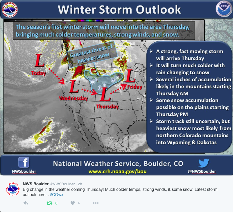
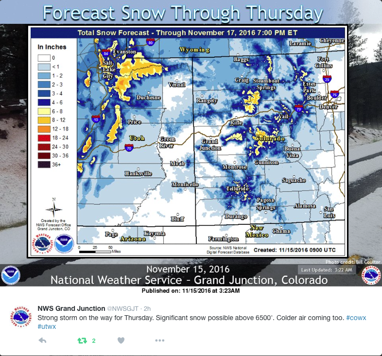
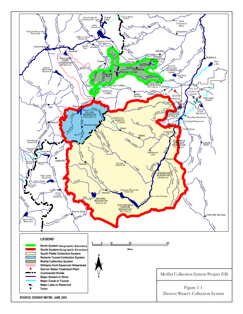
Although snow in the high country is the primary source of Denver’s drinking water, snow at lower elevations is also important.
“To replenish the soil in our yards, for our plants and our gardens and our trees,” Travis Thompson said, Senior Media Coordinator with Denver Water. “And it also just helps, having that healthy landscape, means that’s less water that we’re actually using, taking from those reservoirs that the mountain snowpack fills during the spring.”
In addition to improving the health of vegetation and reducing fire danger, snow in Denver also helps replenish water supplies further down the South Platte River in Northern Colorado and Nebraska…
Snow at the end of the week likely won’t make up for the many recent weeks of unusually warm, dry weather in Denver.
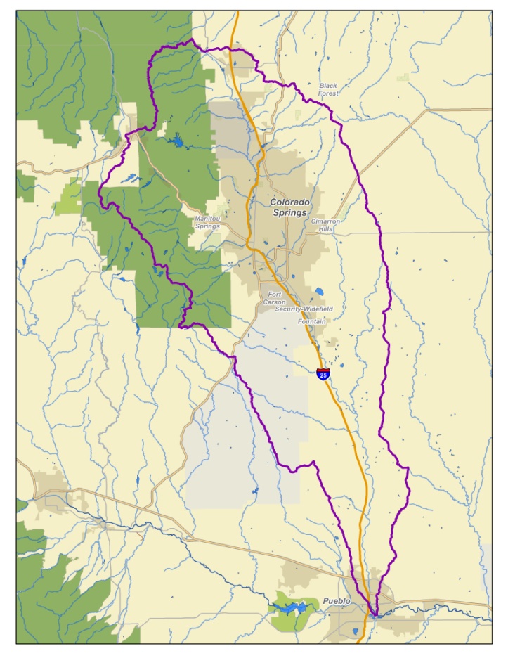
The Fountain Creek Watershed is located along the central front range of Colorado. It is a 927-square mile watershed that drains south into the Arkansas River at Pueblo. The watershed is bordered by the Palmer Divide to the north, Pikes Peak to the west, and a minor divide 20 miles east of Colorado Springs. Map via the Fountain Creek Watershed Flood Control and Greenway District.
Not surprisingly, the federal government sued the city of Colorado Springs on Nov. 9 over the city’s repeated violations of the Clean Water Act and the Colorado Water Quality Control Act. The allegations arise from the city’s failure to deal with drainage and failure to comply with its permit to discharge stormwater into the municipal storm sewer system, which ultimately flows into the Arkansas River.
The suit comes despite Mayor John Suthers orchestrating a deal with Pueblo County earlier this year to fix the city’s storm drainage system, costing taxpayers and Colorado Springs Utilities ratepayers $460 million in the next 20 years.
Suthers took office in June 2015, following years of violations in controlling stormwater. Suthers lamented to other media the City Council’s move to abolish the city’s Stormwater Enterprise in 2009. But Council did so after voters approved Issue 300 that fall, which aimed to dismantle the enterprise. (At the time, the city attorney’s office felt the language in Issue 300 failed to force the shutdown of the enterprise, but City Council defunded it anyway, citing voter intent.)
The EPA, however, cites the city’s soft treatment of developers — along with its lack of a stormwater program — for the violations. In early 2013, the EPA issued a scathing report outlining violations and followed up in August 2015 with an equally critical report.
Specifically, the lawsuit notes the city backed off of requiring detention ponds and other flood-control measures in Cottonwood Creek that would have cost $11.4 million, and instead reduced developers’ fees. But that violates the city’s discharge permit, the lawsuit states. It also notes drainage violations at First & Main adjacent to Powers Boulevard and Flying Horse Pond Filing 26 on the city’s far north side. In addition, the city allowed seven residential developments to be built without requiring stormwater controls, in violation of its discharge permit and its own requirements, the lawsuit says. Moreover, the city didn’t enforce its rules when developers violated the city’s stormwater requirements, according to the suit.
“Unless enjoined, the city’s violations will continue,” the lawsuit states, noting it is seeking unspecified civil penalties.
“On Wednesday, the city was served with a broad and unspecific filing from the EPA, citing Colorado Springs for deficiencies in its stormwater system since the dissolution of the stormwater enterprise in 2009,” Suthers said in a statement. “While we recognize that stormwater was underfunded during that time, this was extremely frustrating, considering the commitment the mayor and city council have already made to massive stormwater improvements over the next 20 years.”
Suthers also noted it makes more sense to use city money to fix the problem than pay to litigate the lawsuit or remit fines. “We will ask the federal judge to look at our efforts and our commitments toward real progress and hope that a more constructive resolution can be reached,” he said.
The Environmental Protection Agency announced Monday it would prefer to continue operations at the temporary water-treatment plant that handles discharges out of the Gold King Mine while the agency continues to evaluate long-term options.
Before the EPA makes that decision final, a public comment period that began Monday will run to Dec. 14.
“As EPA understands more about the hydrology of the area, and how various sources of contamination are affecting water quality, the Agency will consider any number of options, including potential expansion of the IWTP, to address the contamination,” Chris Wardell, of U.S. EPA Region 8, said in a news release.
The second option considered in the report released Monday was to mothball the $1.5 million water-treatment plant, which was built two months after an EPA contracted crew on Aug. 5, 2015, breached the portal of the Gold King Mine, releasing 3 million gallons of mine waste down the Animas River.
The treatment plant’s high cost of operation, as well as the need to deal with the lime-heavy metal sludge by-product, led officials tasked with improving water quality in the Animas River watershed to find other options.
As of last week, the average flow rate into the treatment plant was 712 gallons per minute, and it costs about $16,000 per week to operate.
If EPA, after reviewing public comments, formally decides to continue operations, the agency will move the plant from “emergency removal action” funding to “Non-Time Critical Removal Action,” which falls under the proper Superfund process.
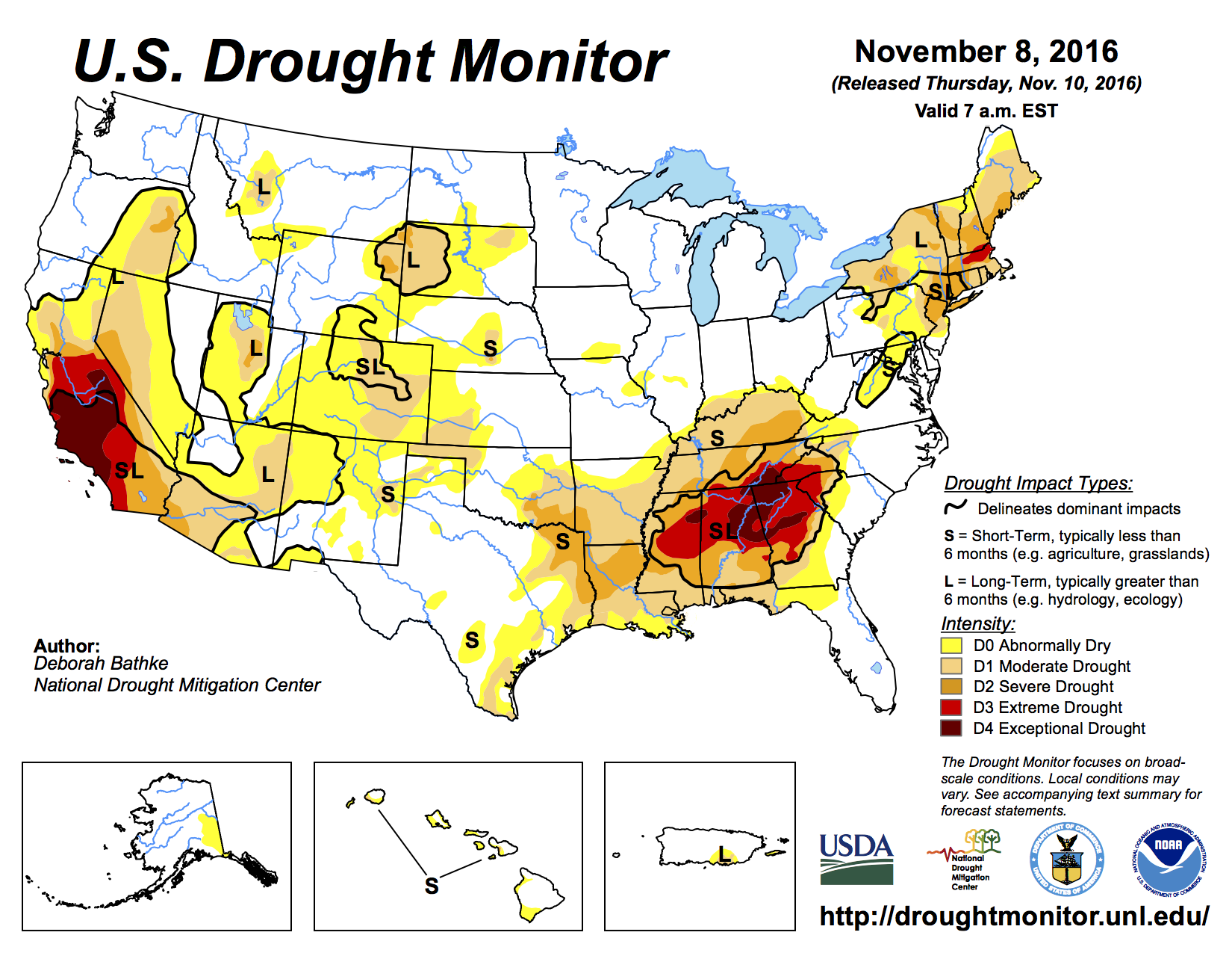
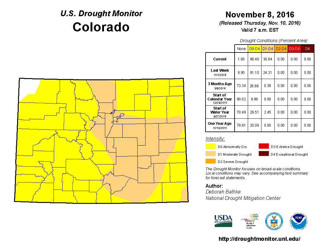
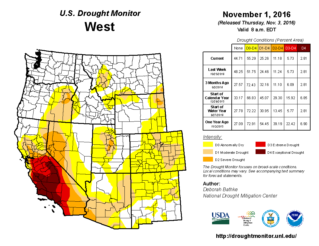
Most of Colorado is experiencing some level of drought, but it’s the worst in a swath of the state along the Front Range extending to the state’s northern, southern and eastern borders, including Fort Collins, Denver, Colorado Springs and Pueblo. That’s the area where there’s “moderate drought,” according to a U.S. Drought Monitor update on Nov. 8. The levels of drought intensity range from abnormally dry to moderate drought, severe drought, extreme drought and exceptional drought.
The last time El Paso County was this dry was in 2014, when the area was coming out of a drought that peaked in 2013.
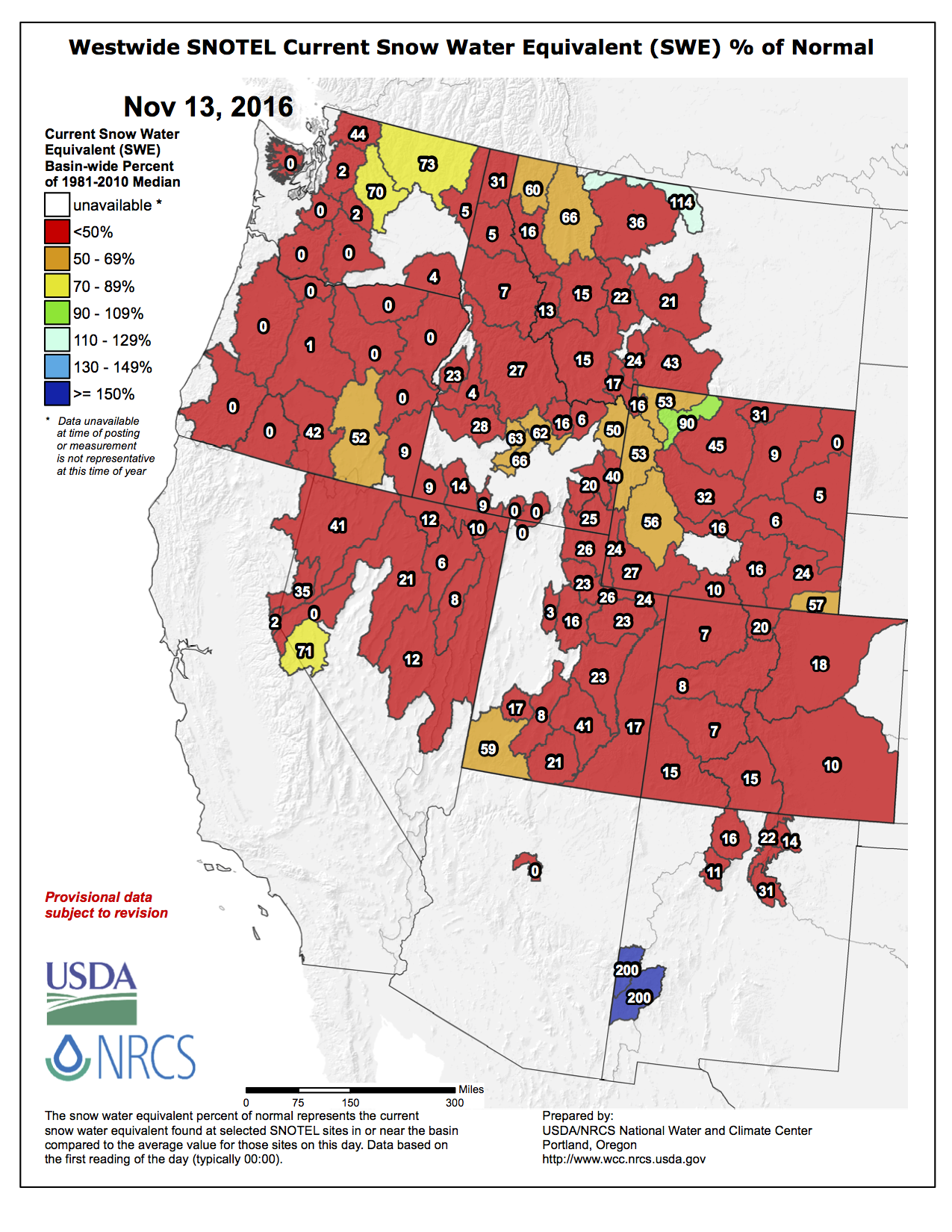
Right now, the snowpack is suffering, but “we don’t have cause for concern yet because it’s still early in the season,” said Becky Bolinger, a Colorado Climate Center drought specialist.
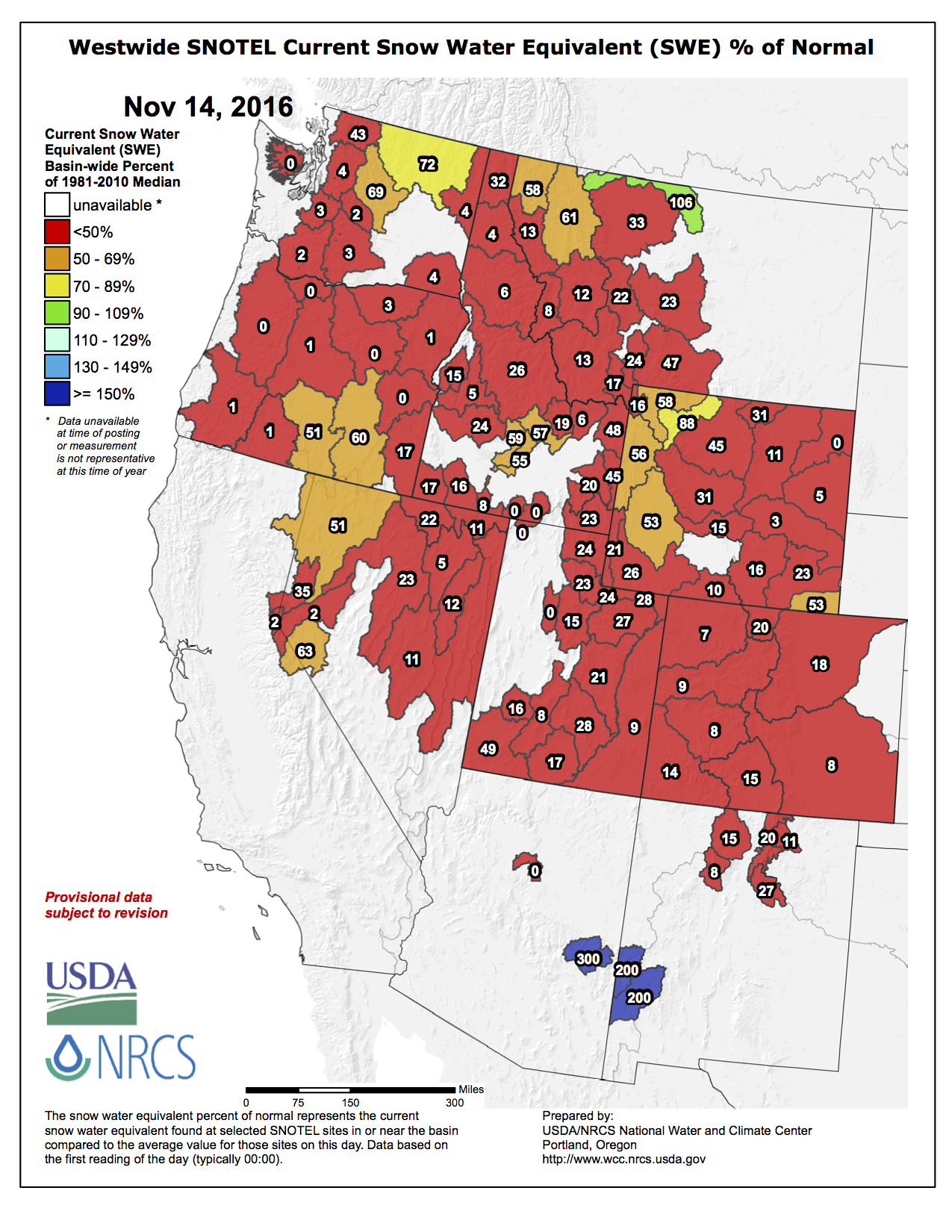
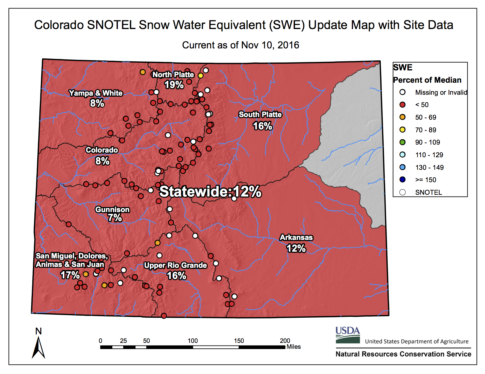
Western Colorado has only 6 to 20 percent of its normal snowpack, and the Upper Colorado River Basin “has seen very little snowfall,” with sub-basins that have less than 40 percent of normal snowpack, according to the Colorado Climate Center.
Snowpack can impact future water supply: “It really gives us an indication of what’s coming down the line,” Bolinger said.
“If you have a low snowpack year, you’re not replenishing the reservoirs as much.”
But cities shouldn’t be worried yet, she said. The agricultural sector is experiencing most concern right now – dry soils and a lack of precipitation are impacting the winter wheat.
“Here at the Colorado Climate Center, we’re definitely keeping a very close watch on conditions,” Bolinger said.
In Colorado Springs, September was the seventh-warmest and tied as the 16th-driest, and October was the second-warmest and tied as the driest, according to Mark Wankowski, a meteorologist with the National Weather Service in Pueblo.
“The last two months have really dried us out,” Wankowski said.
So far in November, each day has seen above-average temperatures, and there has been almost no precipitation, according to the weather service. And there’s a fire-weather watch in place Wednesday from 10 a.m.-7 p.m. for parts of Colorado including El Paso County. The watch warns of gusty winds, low relative humidity and dry fuels: “Extreme fire behavior with rapid rates of fire growth and spread will be possible with any fire starts.”
Here’s the release from the Central Colorado Water Conservancy District (Randy Ray or Kathy Parker):
““CCWCD is pleased to announce the acquisition Geisert Reservoir. Every opportunity CCWCD can, we partner with good people such as Weld County – it’s proven to be a win-win for the two agencies. The support of the Weld County Commissioners regarding irrigated agriculture is so impressive, the residents of Weld County have to be proud.” –Randy W. Ray – CCWCD Executive Director
“CCWCD staff and Board of Directors constantly evaluate projects which provide the best benefit for our constituents as economical as possible. The CCWCD Board was successful in siting a diversion point on the South Platte River for the Bijou Hill Recharge Project – will provide a supply of water to the South Platte River when operational that will last for years.” — Randy W. Ray – CCWCD Executive Director
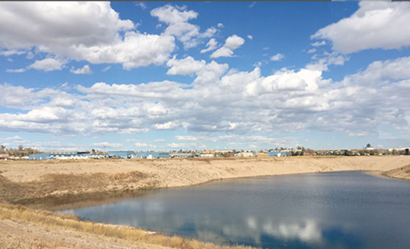
Central Colorado Water Conservancy District and Weld County Commissioners formally executed a closing on Geisert Reservoir November 8th. This water storage project takes advantage of a mined-out gravel pit on the north bank of the Cache La Poudre River, near 11th avenue, in north Greeley. Geisert Reservoir has a perimeter slurry wall that limits interaction of groundwater, the slurry wall liner was tested and approved by the Colorado Division of Water Resources. The reservoir capacity is 1,257 acre-feet and should be full by the end of November. The water being used to fill Geisert Reservoir during the months of November and December originates from a lease with the City of Thornton and other water supplies owned by CCWCD upstream of Greeley. The water will be held in storage for a short time period and released in approximately January of 2017 for augmentation of Central’s 1,000-member agricultural irrigation wells. The CCWCD agricultural members are located in parts of Adams, Morgan and Weld Counties.
A second closing was held on November 10th for CCWCD’s Bijou Hill Recharge Project in western Morgan County near the town of Orchard, Colorado. This land near the South Platte River will become a new point of water diversion in which water will be pumped south of the river several miles to recharge projects. These recharge projects include ponds which will be constructed as shallow infiltration basins with the intent of rapid seepage into the underlying groundwater aquifer. The water after delivered to the groundwater aquifer becomes as water supply to be used for augmentation of agricultural wells in CCWCD’s plans of augmentation which include roughly 1,000 wells in parts of Adams, Morgan and Weld Counties. The groundwater recharge project will be a tremendous benefit to the CCWCD augmentation plans operated by the CCWCD Sub-Districts – the Groundwater Management Subdistrict and the Well Augmentation Subdistrict.
Augmentation plans are Water Court decreed legal agreements which allow irrigation wells to pump out of priority while preventing injury to more senior water rights using projects such as Geisert Reservoir and Bijou Hill Recharge.
Bijou Hill Recharge and Geisert Reservoir will not only help farmers and livestock producers with their needed water supplies, but also offer an added benefit of creating new wildlife habitat and water quality improvements.
CCWCD – Where the Future Flows
If you would like more information about this topic, please contact Randy Ray or Kathy Parker at 970-330-4540 or email at rray@ccwcd.org
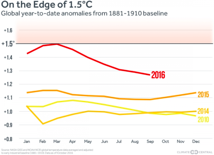
2016 is set to be the hottest year on record by a significant margin, with temperatures that are 2.2˚F (1.2˚C) above pre-industrial times, the World Meteorological Organization told diplomats gathered in Marrakech, Morocco, to discuss international action to limit global warming to less than 2˚C by the end of the century.
The year-to-date temperature anomaly using the 1891-1910 baseline. Graphic via Climate Central.
“Another year. Another record. The high temperatures we saw in 2015 are set to be beaten in 2016,” WMO Secretary-General Petteri Taalas said in a statement.
This banner year follows what was the hottest five-year period on record, 2011-2015, as noted in a separate WMO report submitted to the U.N. conference last week. When 2016 takes over the title of hottest year, it will also mean that 16 of the 17 hottest years in the books will have occurred in this century, the only exception being the intense El Niño year of 1998.
Global temperatures in both 2015 and 2016 were also given a small boost from an exceptionally strong El Niño, but the bulk of the heat has built up in the atmosphere over decades, trapped by ever-rising levels of greenhouse gases.
“The extra heat from the powerful El Niño event has disappeared. The heat from global warming will continue,” Taalas said.
While there is still a month and a half left in the year, preliminary temperature data through October suggests that 2016 will easily best 2015’s record temperature. Final temperature data for the month will be released this week by NASA and the National Oceanic and Atmospheric Administration.
Both reports also underscore other major climate milestones, including record-high carbon dioxide levels in the atmosphere and record-low Arctic sea ice levels during many months of this year.
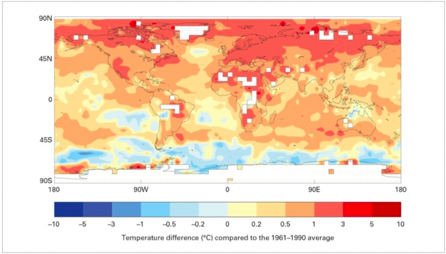
Warmth in the Arctic has been particularly notable, with parts of Arctic Russia running nearly 11˚F to 13˚F (6°C to 7°C) above the 1961-1990 average.
How temperatures in the five-year period from 2011-2015 compared to the long-term average. Credit: WMO via Climate Central.
“We are used to measuring temperature records in fractions of a degree, and so this is different,” Taalas said.
The five-year report, intended to give negotiators a longer-term perspective on recent climate trends, also noted that researchers are increasingly able to tease out the influence of climate change on extreme weather events. Rising temperatures have made some events, like extreme heat waves and rainfalls, more likely and more intense, research has shown.
Negotiators in Morocco are concerned about the election of Donald Trump derailing the international climate action that has been taken thus far, as he has promised to pull the U.S. out of the landmark Paris agreement and to dismantle the Clean Power Plan, which is aimed at reducing domestic greenhouse gas emissions.
Starting Oct. 27, officials from the Bureau of Reclamation turned off the water diversion tunnel from the West Slope to the Colorado-Big Thompson Project that feeds many of the lakes and reservoirs in Larimer County. The reservoir levels have also been lowered through the release of water to storage downstream.
According to a news release from the agency, the shutdown has allowed for the inspection of dams at Marys Lake and Lake Estes near Estes Park, and Flatiron Reservoir west of Loveland.
While the reservoirs are at low levels, crews are also looking at the power generation facilities at the Marys and Pole Hill power plants and the Charles Hansen Feeder Canal.
According to agency officials, the work will continue on the reservoirs and facilities throughout November, with water diversions through the Adams Tunnel from the Western Slope slated to resume in mid-December.
Even proponents for the first-of-its kind strategy — a non-binding set of goals and guidelines that prepares for the year 2050, when Colorado’s population is anticipated to more than double to 10.5 million — acknowledge it’s gotten off to a slow start. But after all of the excitement, and with it some friction, surrounding the water plan’s unveiling last November, the biggest steps to come revolve around its actual execution.
“The plan is only as good as its on-the-ground implementation,” said Drew Beckwith, water policy manager with Boulder-based conservation nonprofit Western Resource Advocates. “If we really do want to secure our water future for communities and agriculture and business and wildlife and rivers, we’ve got to put some of these things into action.”
The water plan calls for some lofty objectives on that 35-year timeline. They include achieving an additional 400,000 acre-feet of urban conservation, attaining that same amount in new storage, and using alternative methods to share 50,000 more acre-feet of water designated for agricultural needs. Such techniques entail approaches like long-term rotational fallowing and short-term leasing and supply agreements to keep the water with farmers and ranchers as needed to continue raising the crops we all eat, but through procedures that also provide for the Front Range’s growing populations as available.
[…]
“The ability to lessen the pressure on rivers, and also give agricultural and recreational economies certainty, is some of the biggest value that the water plan provides,” said Sinjin Eberle, communications director of the Intermountain West chapter of water advocacy group American Rivers. “The river connects all of us all across the Southwest. All that water comes from up here, and how we manage it up here sets the tone all the way down the basin.”
ONGOING STRUGGLES
Colorado’s water year in 2016 was about average, which experts see as a strong season. Year to year, there can be serious volatility, with the Upper Colorado River Basin — made up of Colorado, Wyoming and parts of Arizona, New Mexico and Utah — seeing record lows over the past 15 years in 2002 and both 2012 and 2013 for water available to the Lower Basin of California and Nevada, as well as the other portions of Arizona, New Mexico and Utah. The inflow into northern Arizona’s Lake Powell, where the Colorado River runs before terminating at Mexico’s Gulf of California, is the ultimate determining factor.
Those totals for the past year mean almost nothing for the one upcoming, however, with drought always a possibility in the Southwest. It’s another reason why settling on a comprehensive state plan that satisfies all of its needs, including the recreation and wildlife economies of places like Summit County and throughout the Western Slope, is so pivotal.
“All the reasons we created the water plan a year ago are still prevalent in Colorado,” said Beckwith. “The underlying issue is if we don’t act and we don’t change, we end up drying up our rivers, we don’t provide a sustainable water supply to our cities and we leave agriculture in the dust.”
At present, the biggest strides for the plan have been made with the Colorado Water Conservation Board (CWCB) producing proposals for the allocation of grant money from its annual Water Supply Reserve Fund. The account, created from legislation passed by the state’s General Assembly in 2006, is spread across various water projects that theoretically align with those goals of the water plan. To date, the fund has provided more than $27.5 million for projects spanning the nine water basins.
The focus of late for how to spend those dollars consists of funding stream management plans and forthcoming water efficiency programs. At its bimonthly meeting in September, the CWCB also updated its eligibility criteria for what qualifies recipients to receive those funds based on a checklist. The focus of this month’s meeting, scheduled for Nov. 16 and 17, will now be on how to carry on financially supporting projects at levels of the past given momentous shortfall in revenues that fund the account.
The Water Supply Reserve is supported by severance taxes produced from energy purchases. With a weighty drop off in production of gas, oil and coal, on top of unremarkable sales, the CWCB will need to come up with a way to backfill millions of dollars in losses in the interim, while also finding a solution for the future, if it hopes to hit some of those targets in the state water plan along the named time frame. [ed. emphasis mine]
“The funding has just been hammered by low energy prices and cutbacks in productions,” explained the Colorado River District’s Jim Pokrandt. “That’s in the short term. And in the long term, the CWCB will need to come up with a funding stream dedicated to these water projects. Because even with full funding, the fund wouldn’t begin to scratch the surface of some of the work that needs to be done.”
FINDING SOLUTIONS
A proposal to help allevaite investment strains includes a loan guarantee fund that would back regional project requests with state dollars to ensure cash advances are obtainable to complete water ventures moving forward. Sales and container taxes, mill levies and water tap fees are other mechanisms the CWCB will explore — all of which would either need to come through possible legislation with the General Assembly or from future voter approval — to come up with the assets needed to resume with the implementation phase of the overall plan. But with both education and infrastructure accounts also impacted by the severance tax downturn and competing for the same funding, no easy answers currently exist.
It’s only after new dollars are discovered that further implementation of the water plan can occur. According to the state water roadmap, that means bolstering those stream management plans and applying additional scrutiny to potential large-scale water developments down the road, if deemed necessary. More emphasis on conservation and increased water efficiency will also be a large part of purported success.
The one thing that is certain, though, is that those who contributed to helping shape the framework of the water plan will keep at it given the promise the state spawned with its release. Holding decision-makers accountable and ensuring the plan does eventually have real impact across Colorado persists as their focus.
“The water plan really does create this full-on recognition that the environment and healthy, flowing rivers are important to Colorado’s brand, to our economy, to us as a state,” said Beckwith. “So many people spent a lot of time working on this plan that no one wants it to just sit on the shelf.”
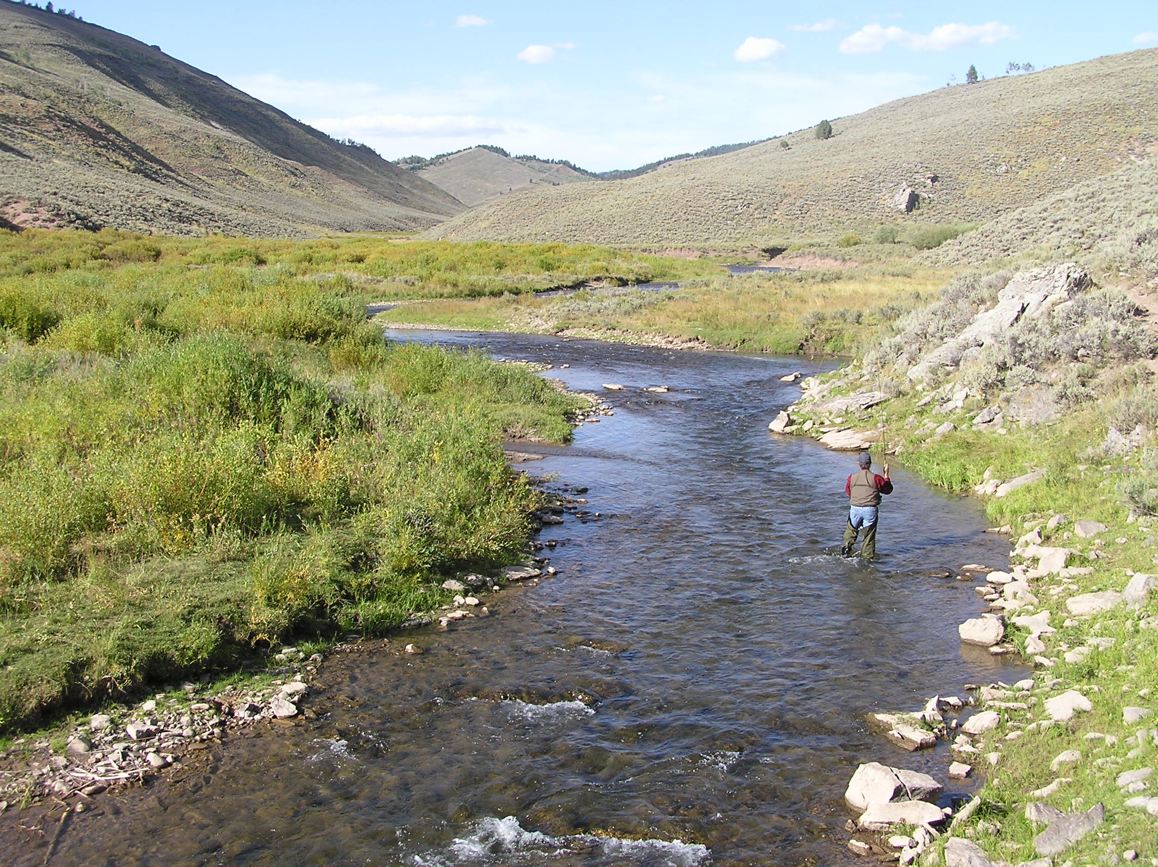
Colorado Parks and Wildlife has lifted the voluntary fishing closure at a popular area on the Fryingpan River below the Ruedi Reservoir Dam, effective immediately.
Known locally as the ‘toilet bowl,’ fish here became stressed and vulnerable to anglers after water normally released from the dam into this area was rerouted to accommodate for annual maintenance and inspections.
“We asked anglers for their cooperation to protect the resource while this situation was ongoing,” said Senior Aquatic Biologist Lori Martin. “In fact, it was anglers voicing their concerns to us that led to CPW instituting the voluntary closure in the first place. We are grateful to them for their regard for ethics, and their cooperation.”
The ‘toilet bowl’ is a heavily fished area of the Gold Medal trout waters of the Fryingpan River.
An email from Leon Russell Records to The Associated Press says Russell died in Nashville on Saturday night. The email cites Russell’s wife as the source of the information. Russell had heart bypass surgery in July and was recovering from that at the time of his death. He had been planning on resuming touring in January, the email said.
Besides his music, Russell was known for his striking appearance: wispy white hair halfway down his back and that covered much of his face.
He wrote Joe Cocker’s “Delta Lady” and in 1969 put together Cocker’s “Mad Dogs and Englishmen” tour, which spawned a documentary film and a hit double album.
As a musician, primarily a pianist, he played on The Beach Boys’ “California Girls” and Jan and Dean’s “Surf City.” He also played guitar and bass.
Russell produced and played on recording sessions for Bob Dylan, Frank Sinatra, Ike and Tina Turner, the Rolling Stones and many others.
He recorded hit songs himself like “Tight Rope” and “Lady Blue” and participated in “The Concert for Bangla Desh.” John Lennon, Ringo Starr and George Harrison played on his first album, “Leon Russell.”
His concerts often ended with a rousing version of “Jumpin’ Jack Flash.” In 1973, Billboard Magazine listed Russell as the top concert attraction in the world. About this time, he was the headline act on billings that included Elton John and at other times Willie Nelson.
In a 1992 interview with The Associated Press, Russell said music doesn’t really change much.
“It’s cyclical, like fashion. You keep your old clothes and they’ll be in style again sooner or later.
“There are new things, like rap. But that’s a rebirth of poetry. It’s brought poetry to the public consciousness.”
In 2011, Russell was chosen for induction into the Songwriters Hall of Fame. He also was honored with an Award for Music Excellence from the Rock and Roll Hall of Fame.
He and Elton John released “The Union,” a critically received duo album in 2010.
Russell, born in Lawton, Oklahoma, began as a night club piano player in Oklahoma at the age of 14, also backing touring artists when they came to town. Jerry Lee Lewis was so impressed with Russell that he hired Russell and his band for two years of tours.
He relocated to Los Angeles in 1959, where he became known as a top musician, and later to Nashville.
In the early 2000s he began his own record label, Leon Russell Records.
If things are feeling weirdly warm for November, you’re not alone—places throughout North America are experiencing record high temperatures after an unseasonably warm October. But don’t ditch those unused winter coats and mittens just yet: As Eric Berger reports for Ars Technica, a weather phenomenon that all but guarantees a chilly winter.
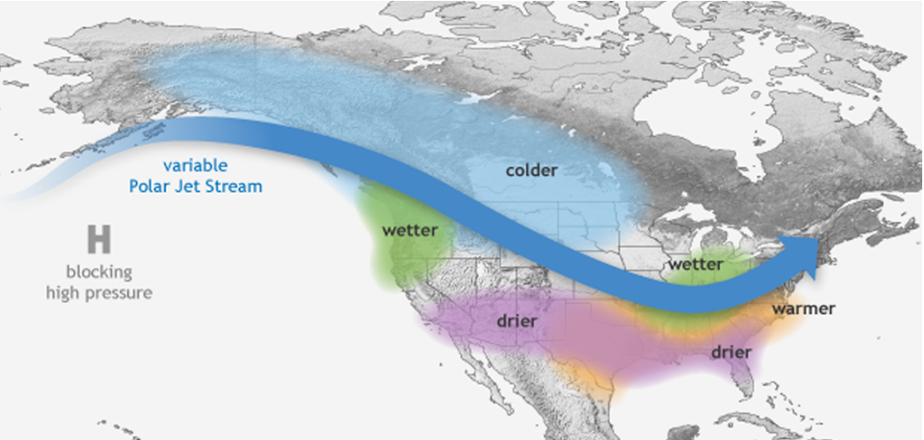
It’s called La Niña, and it happens when the temperatures in the equatorial Pacific Ocean cool down. Though the phenomenon is associated with with a warmer than normal winter in the Southeast, the effect is the opposite for the Northwest, which tends to be cooler than normal during a La Niña year. And as Berger writes, the phenomenon was just confirmed by climate officials.
Right now, National Weather Service predictions show a weak La Niña sticking around through the winter, affecting both temperatures and precipitation. For northern parts of the United States, that means more precipitation and cooler temperatures than usual and the opposite in the southern half of the country.
Though wetter than normal conditions will soak places like the northern Rockies, drought conditions will likely persist in California, which is still parched despite a damp El Niño event earlier this year. The dry conditions will also worsen in places like the Deep South, which has been exceptionally dry this year. For the middle of the country, however, it could go either way.
Of course, La Niña patterns aren’t the only ones that dictate climate. In a media release about the U.S. winter outlook, NOAA notes that though the phenomenon is linked to heavier snowfall around the Great Lakes, snow forecasts aren’t possible without more data on developing storms. And other oscillations in atmospheric pressure and temperature in places like the Arctic and the tropics can influence how much precipitation is generated and how cold the weather gets.
Intense La Niña years can lead to severe droughts, as in 1988 when the phenomenon combined with other atmospheric anomalies to create the worst Great Plains drought since the Dust Bowl. But this year may be a lucky break. This latest La Niña appears to be relatively weak, which means that the ocean and parts of the atmosphere will get a much-needed cooldown before the next warmup.
We all know a slow start for snowfall doesn’t mean the ski season will turn out to be bad. It can, however, make it difficult for snowpack to catch up later in the season, which is what concerns those who watch water levels.
“From a skiing perspective, one good series of storms could have people forgetting this dry weather,” said self-proclaimed Colorado River nerd, Eric Kuhn. “From a water supply perspective, the longer we go without any snow, the more unlikely it is we will catch up to average.”
Kuhn is the general manager of the Colorado River District; 2016-’17 will be his 36th winter working with the district.
“I’ve seen some really wet ones, I’ve seen some dry ones and I know it’s not time to panic,” he said. Besides, “it looks like there’s three days between now and Thanksgiving where they’re suggesting there’s a chance of rain and snow.”
STUCK ON ZERO
Currently, the snow-water equivalent at the Snotel site on Vail Mountain is 0 inches; the 30-year median for Friday is 2.7 inches. Copper Mountain’s site is also reading 0 inches with a 1.5-inch 30-year median. At the headwaters of the Eagle River on Fremont Pass, there’s currently a 0.3 inch snowpack reading, with a 30-year median for Friday of 2.4 inches.
Arapahoe Basin and Loveland ski resorts, which are always the first resorts to open on the Interstate 70 corridor, have both opened. Those resorts do not announce an opening date ahead of time, but their Summit County neighbors who do, including Copper Mountain and Keystone, have seen delays to their originally scheduled dates.
Here in Eagle County, Ski and Snowboard Club Vail was hoping to have its professional training grounds at Golden Peak open to national teams from around the world by today, but will be forced to wait until cooler temperatures allow for more snowmaking.
Eagle River Water & Sanitation District communications manager Diane Johnson has worked in the area for decades, and has seen delays to the local resort openings. She cautions skiers against basing season predictions on early season conditions.
“In the 1978-’79 season, we started with .4 inches snow water equivalent, and that turned out to be a great year with peak (snow water equivalent) at 34 inches in May,” Johnson said. “And in 2011-’12, we had about normal for right now, but that turned into the lowest overall.”
[…]
“We’re dependent on stream flows. We don’t have lots of reservoir storage, so talking to Denver Water or someone like that it’s a different story,” Johnson said. “We go ‘Hey, we’ll see what’s coming down in the spring.’ Obviously, we always like being ahead but I don’t think it automatically sets us up for gloom.”
FromAspen Journalism (Allen Best) via The Aspen Daily News:
Nobody disputes that the Colorado-Big Thompson project has changed Grand Lake, the state’s largest, deepest natural lake. How could it not?
In the 1940s, Grand Lake was integrated into the giant C-BT, what the late historian David Lavender called a “massive violation of geography.” It’s Colorado’s largest transmountain diversion project. By one tally in the 1990s, it delivers an average 231,060 acre-feet annually from the headwaters of the Colorado River to cities and farms east of the Continental Divide. This compares to the 105,024 acre-feet from three tunnels through the Sawatch Range east of Aspen.
Almost immediately after the C-BT was completed in 1953, locals began to complain that the project shoehorned into the lake had sullied the lake’s clarity by introducing algae and sediments. This is, they insist, a violation of federal law.
The controversy pivots on Senate Document 80, a part of the Congressional authorization for project funding in 1937. The document describes the needs of irrigation, industrial and power production but also warns against impacts to nearby Rocky Mountain National Park.
The lake, if outside the park, has one of Colorado’s most memorable backdrops. The document specifies the need “to preserve the fishing and recreational facilities and the scenic attractions of Grand Lake…”
On that, say many locals, the C-BT has failed, and they say that until recently they got little response from the U.S. Bureau of Reclamation, the agency that built the C-BT.
But now, in a reversal, the bureau is working with 18 other stakeholders in an effort to solve the problem. Parties include Northern Colorado Water, the agency that manages the diversions for cities and farmers of northeastern Colorado, Grand County and other state and local organizations.
Grand Lake’s story fits into a broad theme of changed sensibilities in Colorado about 20th century river alterations. Restoration and remediation projects are starting or underway on the San Miguel River in Telluride, on the Eagle River at Camp Hale and on the Fraser River near Winter Park.
“It’s possible that at one time, the impacts of the CBT Project on Grand Lake clarity were thought to be just part of the price we pay for valuable water projects,” said Anne Castle, a fellow at the Getches-Wilkinson Center for Natural Resources, Energy and the Environment at the University of Colorado-Boulder. “Now, we are more inclined to believe that the environmental values have significance, including economic significance, and that operations can and should be adjusted to better accommodate these values.”
The work at Grand Lake also illustrates the power of persistence and spunk by advocates of environmental protection. And it involves a collaborative process called adaptive management that emphasizes consensus-based decision-making in solving stubborn issues involving water diversions.
Nobody thinks solving this problem will be easy, though. In April, after several years of working together, the Grand Lake stakeholders submitted a plan to the Colorado Water Quality Control Commission. The plan approved by the commission sets an interim clarity goal for summer pumping during the next five years.
During that time, the Bureau of Reclamation is to develop a plan for long-term solutions. Alternatives include expensive new tunnels, possibly bypassing Grand Lake altogether. A preview of the alternatives may emerge at a meeting of stakeholders in late November.
Not everybody in Grand Lake thinks that reduced clarity is a problem. “There are people who think there’s a problem, but there is no problem,” says Jim Gasner, a member of the Grand Lake Board of Trustees, the town’s elected body, and a fishing “teacher” at Rocky Mountain Outfitters.
But Elwin Crabtree, a real estate agent and former Grand County commissioner, sees something different. “It’s adverse to its natural being,” he said in early August in an interview at his office along the town’s main street of knotty-pined stores and lodges. “I think we look at it as a moral issue,” he added. “I think we believe in having responsibility to be good stewards of our environment.”
The C-BT is an effort to address what one historian in the 1950s called “nature’s error.” Even as Aspen was putting on its silver-lined britches in the 1880s, farmers along the South Platte River and its tributaries were struggling with inadequate water in late summer to finish their corn and other crops.
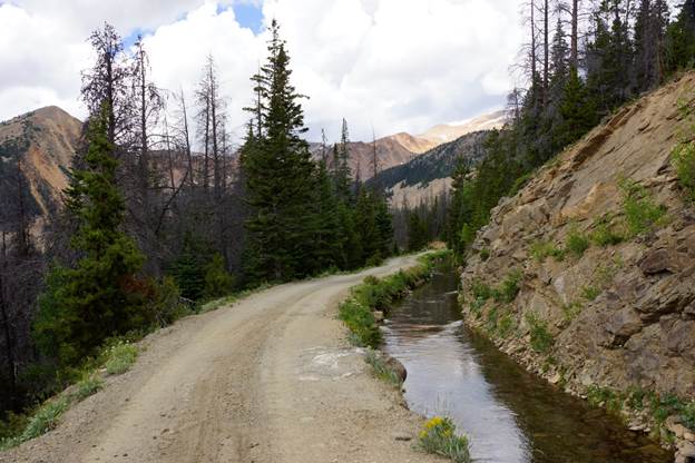
Grand River Ditch July 2016. Photo credit Greg Hobbs.
Irrigators set out to remedy this. The first large-scale transmountain diversion from the headwaters of the Colorado River began in 1890. Called the Grand River Ditch, it’s beveled into the side of the Never Summer Range in what is now Rocky Mountain National Park, collecting water like a rain gutter from a roof.
Then came the 1930s, the decade of the Dust Bowl, the Great Depression and the New Deal. Farmers in northeastern Colorado had long been agitating for added infusions of water from the Colorado River headwaters. But they couldn’t get it done themselves. They needed federal funding.
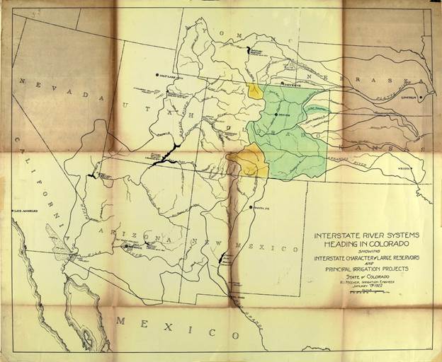
Map of the Colorado-Big Thompson Project via Northern Water
The flawed design
But the work along the Continental Divide from 1939 to 1953 created a wound at Grand Lake. In retrospect, the design was flawed.
The C-BT at the Colorado River headwaters consists of three main bodies of interconnected water. Only one, Grand Lake, is natural.
Farthest downstream is Granby Reservoir, which is Colorado’s third largest, capable of holding 539,758 acre-feet of water during runoff of spring and early summer. This compares to Ruedi Reservoir’s 102,373 acre-feet and Dillon’s 257,304 acre-feet.
From Granby, water is pumped upstream as needed by Eastern Slope diverters to Shadow Mountain Reservoir. Shallow, no more than nine feet deep, Shadow Mountain is directly connected through a short canal to Grand Lake.
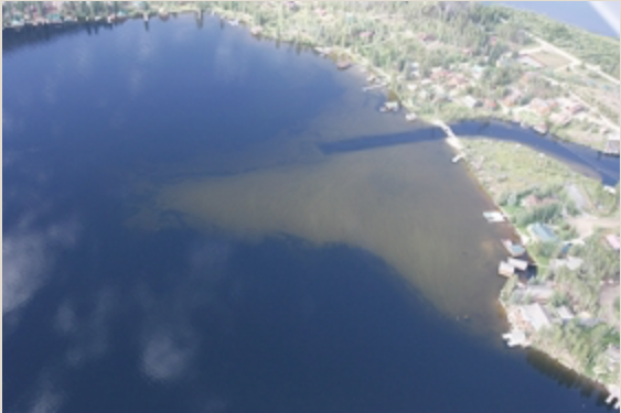
In 2011, reservoirs east of the divide were full, so water was allowed to continue down the Colorado River without diversion. This photo shows what the lake looked like on Aug. 30, without pumping. Photo courtesy of Byron Metzler and pilot Steve Paul
The canal occupies the original path of the Colorado River emerging from Grand Lake. From the interconnected Grand Lake and Shadow Mountain Reservoir, water is then pumped through the 13.1-mile Alva Adams Tunnel underneath the national park to the Estes Park area for storage in reservoirs there and along the northern Front Range.
Shadow Mountain is a problem, though. Its shallowness allows water to be easily warmed in summer, producing algae that can float into Grand Lake. The shallowness also allows lake-bottom sediments to be disturbed more easily and dispersed into Grand Lake.
Evidence for the historic, pre-construction clarity of Grand Lake is scant: Just one measurement, taken in 1941, of 9.2 meters (30 feet).
Detailed observations during the last decade show clarity down to 6 meters (19.6 feet), but no more.
The standard adopted in April by the state agency specifies a minimum of 2.5 meters and an average of 3.8 meters (8.2 feet to 12.4 feet) during summer diversion season.
“I think the clarity standard has really elevated the discussion,” says Lane Wyatt, co-director of the water quality/quantity committee in the Northwest Council of Governments. “This is the only clarity standard in Colorado. It’s the first one we’ve ever done.”
Clarity is not the only issue, though. Water must be delivered to farms and cities. As it is flows downhill toward the Great Plains, it generates electricity distributed by the Western Area Power Authority. Purchasers of this low-cost power include Aspen Electric and Holy Cross Energy.
Canton “Scally” O’Donnell, president of the Three Lakes Watershed Association, remembers a more pristine past.
As a boy, his family summered at Grand Lake. That was in the 1930s and 1940s. “We drank the water right out of the lake, and many families did that,” O’Donnell said.
The first complaint about the sullied water was filed in 1954, the year after the project’s formal completion. In 1956, Grand Lake trustees adopted a resolution that informed Colorado’s congressional delegation of problems. The resolution was aimed at the Bureau of Reclamation.
“I think it’s fair to say that up until seven or eight years ago, the bureau pretty much stonewalled,” O’Donnell said. “They just did not want to recognize the problem, and Northern Colorado Water, the same.”
Movement has occurred during the last decade. One avenue for local protest was a proposed expansion of an existing diversion of the Colorado River at Windy Gap, about 15 miles downstream. Completed in 1985, the Windy Gap dam uses the C-BT infrastructure to deliver additional water to the Rawhide power plant north of Fort Collins, Greeley, Boulder and other cities.
The Windy Gap Firming, or expansion, plan was formally introduced after the drought of 2002. It proposes diversion of remaining water rights owned by a string of northern Front Range cities.
The effect of persistence
O’Donnell, of the Three Lakes Watershed Association, thinks the changed attitudes is explained by the persistence of individual public officials.
He singles out Lurline Underbrink Curran, then the Grand County manager. “She’s smart and she’s tough,” he said. “She just kept on beating on everybody to make it happen.”
He also points to the influence of Anne Castle, a long-time Denver water lawyer who served from 2009 to 20014 as assistant secretary for water and science in the Interior Department. Her responsibilities included oversight of the Bureau of Reclamation.
“I think part of the reason it has attention now is the fact that the Windy Gap Firming Project required the federal government to pay attention to Senate Document 80 and both C-BT and Windy Gap Firming Project do have an impact on Grand Lake’s recreation and scenic attraction. Calling attention to that issue, as both Lurline and I did, with prodding from Scally, had an impact,” Castle said.
But again, agreeing there is a problem is not the same thing as finding a solution.
“There is a lot of uncertainty about how our operations affect clarity,” said Victor Lee, an engineer for the Bureau of Reclamation.
The precise circumstances that cause algae and sediments to degrade clarity are poorly understood. Northern has been altering its diversion regimes, to see if that will improve clarity.
This year, from July until late August, pumping was conducted about 15 hours a day at 250 cubic feet per second. Clarity degraded, though. Algae growth was suspected. So the pumping was accelerated to about 20 hours a day with two pumps. Results were mixed.
It was a success, said Lee, in that they learned something. Clarity readings exceeded the minimum but did not meet the average standard. “I would say the experiment was successful, but we did not meet our objective,” he said.
Esther Vincent, water quality manager for Northern Water, said the effort to address Grand Lake’s muddled clarity is attracting attention across Colorado by water professionals. Spurring their interest, she said, is the possibility of other bodies of water being assigned clarity standards.
There’s also interest in the adaptive management process created for Grand Lake. It’s similar to but separate from Learning By Doing, which was created in response to expanded water diversions from both Windy Gap and by Denver Water’s Moffat Tunnel collection system.
Vincent also points out a deeply philosophical question. In 1937, when adopting S.D. 80, did Congress have the same notion about what constitutes “scenic attraction” as we do today?
“I am an engineer,” she said. “Asking an engineer to define what beauty is, is an interesting dilemma. It’s not a concept that lends itself very well to science.”
Editor’s note: Aspen Journalism and the Aspen Daily News are collaborating on coverage of Colorado’s rivers and water. More at http://www.aspenjournalism.org.
On April 7, 2016, the Environmental Protection Agency proposed adding the “Bonita Peak Mining District” to the National Priorities List, making it eligible for Superfund. Forty-eight mine portals and tailings piles are “under consideration” to be included. The Gold King Mine will almost certainly be on the final list, as will the nearby American Tunnel. The Mayflower Mill #4 tailings repository, just outside Silverton, is another likely candidate, given that it appears to be leaching large quantities of metals into the Animas River. What Superfund will entail for the area beyond that, and when the actual cleanup will begin, remains unclear. Eric Baker
In a lawsuit filed earlier this year in U.S. District Court of New Mexico, the tribe named Sunnyside Gold Corp. as a responsible party for the spill on Aug. 5, 2015.
The lawsuit also names the U.S. Environmental Protection Agency, Environmental Restoration LLC, Harrison Western Corp., Gold King Mines Corp., Kinross Gold Corp., Kinross Gold USA Inc. and John Does 1-10.
Sunnyside filed a motion on Oct. 17 to dismiss its involvement in the lawsuit, and the tribe filed its response on Monday.
In the tribe’s response to Sunnyside’s motion, it called the company a “key contributor” to the toxic water buildup at the Gold King Mine near Silverton, Colo.
The buildup led to a blowout, triggering the release of more than 3 million gallons of toxic wastewater into the Animas and San Juan rivers.
“It knew that its actions in bulk heading its mine would shift the flow of contaminated water to other mines in the Upper Animas Watershed and pose a substantial threat of a future blowout into downstream communities,” the response states…
Sunnyside argued the state of Colorado should be named in the lawsuit since the mine and associated activities at the mine site are within the state.
In the tribe’s response, it stated the federal court can provide “complete relief” for damages incurred as a result of the spill among the defendants already named in the lawsuit. It adds that Colorado’s role as a mine regulator is of “no consequence” because the tribe is not challenging how the state regulates mining nor is it asking for an injunction only the state could provide.
Sunnyside also argued for a dismissal using a section of the Comprehensive Environmental Response, Compensation and Liability Act, which is commonly known as the Superfund Act.
The section Sunnyside cited states that no federal court has jurisdiction to review any challenges when remedial action is taking place at a Superfund site.
In response, the tribe argues Sunnyside cannot use that section of the Superfund Act because the Bonita Peak Mining District, which includes the Gold King Mine, was designated a Superfund site only after the mine spill.
The EPA declared the area a Superfund site in September.
The orange plume flows through the Animas across the Colorado/New Mexico state line the afternoon of Aug. 7, 2015. (Photo by Melissa May, San Juan Soil and Conservation District)
The Wyoming Water Development Commission voted against the Sublette Creek Reservoir, citing concerns by the Wyoming Game and Fish Department that too much water would be diverted, harming the Smiths Fork fishery.
“Their concern was that the water levels are being diminished in Smiths Fork, and that it would cause the temperatures to rise in late summer, and if those temperatures exceed a certain threshold, then you have the potential for a fish kill,” said commission director Harry LaBonde.
After the vote in a joint meeting of the commission and the Legislature’s Select Water Committee, Demont Grandy of the Cokeville Development Company said they were not planning to further pursue the project.
“As far as I’m concerned, it’s over,” Grandy said, noting area irrigators had been looking at it for nearly 35 years.
Siting problems have long plagued the undertaking. About $1 million in studies have been conducted and three potential locations rejected.
Another issue that raised concern was the project’s financial viability. In reports to the commission, the development company said its members could pay for operations and maintenance but not the dam itself.
Water storage rates would be between $17 and $178 per acre-foot, depending on the district’s financing costs and varying reservoir volumes. The small irrigation district said its members could afford to pay around $4 per acre-foot for water.
Commissioner Floyd Canfield has been a strong proponent of the project. The 4,100-acre-foot reservoir would help provide protection during times of drought should Wyoming ever need to supplement water flowing downstream under the Colorado River Compact, he said.
“What we’re trying to do is we’re trying to find a way to use a pre-compact water right. That’s the objective,” Canfield said. “It’s a very hard place to do that.”
State water officials suggested that enough data had been collected on the project’s drainage area that, should another potential site be located, the sponsors could start with a ‘Level II, Stage II’ study, rather than beginning from scratch.
The commission supported that recommendation in the motion to deny project funding.
“So, to me, I think that I would go for the motion, and hope that between the state engineer’s office and the agency, we could continue to work with the sponsor on a couple of spots,” said commissioner David Evans.
Even if another site is located, the timing of the rejection could affect its prospects. The state is facing significant revenue declines stemming from the energy downturn, and the commission is already set to approve projects that would commit about two-thirds of the $158 million in the Level III construction account.
“I think we have to start prioritizing things, and limiting how much money we use in studying sites,” Canfield said. “It’s the state of Wyoming’s money, citizens’ money, and maybe spend it a little more judiciously. That’s my feeling.”
Sublette Creek Reservoir Project photo via RJH Consultants.
About 68 percent of Colorado is “abnormally dry,” while 31 percent is in moderate drought, according to the U.S. Drought Monitor. The Front Range and plains are getting the worst of it, with a drought spreading across the greater metro area for about the last month.
Moderate drought can damage crops and pastures and may begin to affect water supplies, according to the federal agency. However, Denver may not need to panic about water restrictions just yet.
“Right now, Denver Water’s water supply is in good shape,”wrote Travis Thompson, spokesperson for Denver Water, in an email.
“Systemwide, our reservoirs are at higher-than-normal levels for this time of year at 88 percent. Typically, they are around 85 percent right now. But, we are definitely keeping a close eye on the current conditions and hoping for some much needed moisture to help begin building that snowpack for 2017.”
Forecasting models had shown a change in the weather next week to both lower temperatures and bring some snow to the Front Range, but that is looking less likely.
That incoming weather may still drop some amount of snow on the mountains, but it’s still too early to tell much, according to Noah Brauer, a meteorologist who contributes to Weather5280.
The U.S. Drought Monitor report, released Thursday, says 98.4 percent of Colorado is abnormally dry. Additionally, 30.84 percent of the state — including extreme western portions of Weld and much of the Front Range — is experiencing moderate drought, a more severe condition than abnormal dryness.
These numbers come in the wake of several weeks of unseasonably high temperatures and a lack of precipitation. In fact, a week ago, 91.1 percent of the state was abnormally dry and 24.31 percent was experiencing moderate drought. Last year at this time, only 20.09 percent of the state was abnormally dry and none of the state was experiencing drought.
Weld saw .72 inches of precipitation in October. The average for October is .89 inches. Temperatures were well above normal much of the month and have remained above normal in November.
Arapahoe Basin remains the only resort open in the state, and Loveland Ski Area will open Thursday after a multi-week delay. Both can thank manmade snow because Mother Nature hasn’t been of much help.
Snow-making wizardry aside, it has to be cold enough outside for the flakes to stick, and overnight temperatures remained stubbornly warm through most of October, Loveland Ski Area spokesman John Sellers said.
“Our patience has really been tested this year,” he said.
Staff started making snow Oct. 3, and it usually takes just a couple of weeks to open after snow-making begins. Overnight temperatures only recently have dropped enough to schedule Opening Day for Thursday.
Copper Mountain Resort cited unseasonable warmth when it pushed its Opening Day back a week, from Friday to Nov. 18.
“The decision to delay Opening Day is always difficult and is not one we make lightly,” said Gary Rodgers, Copper Mountain’s president and general manager, in a press release. “Our teams have been working around the clock to prepare the mountain for the upcoming season, but we do need a little more cooperation from Mother Nature.”
Keystone Resort also pushed back its opening from Nov. 4 to a tentative Friday because of warm weather.
The economic impact of a delayed opening is not good but “not huge,” Sellers said. Bad weather or roads later in the season would be a bigger economic threat, he said.
Last year, Colorado slopes saw 13 million skier visits.
The National Weather Service’s Climate Prediction Center predicts warmer-than-normal temperatures through the rest of fall, but a lack of early fall snow doesn’t necessarily correlate with a lack of winter snow.
The district says the lawsuit, filed by the federal and state governments, followed on the heels of a letter of concern the district sent Oct. 28 to the U.S. Environmental Protection Agency.
The lawsuit was filed Wednesday in U.S. District Court in Denver by the EPA and the Colorado Department of Public Health and Environment against the city of Colorado Springs.
The lawsuit alleges that discharges into the creek from the city’s stormwater sewage system violate the federal Clean Water Act and the state Water Quality Control Act.
“It’s time Colorado Springs be held accountable for its continued violations of discharge limits into Fountain Creek,” said Jay Winner, general manager of the Lower Arkansas district. Its mission is to protect water resources of the Lower Arkansas River Valley.
“We’ve been trying to get the Springs to recognize their responsibility to Pueblo and the Lower Arkansas Valley for the past 12 years, but there has been close to zero progress when it comes to cleaning up the mess on Fountain Creek,” Winner said.
He said the Oct. 28 letter expressed concerns with Colorado Springs’ 2016 Stormwater Program Implementation Plan. The letter was part of the district’s long-standing complaints about the city’s discharges into the creek.
The lawsuit seeks:
A court order requiring Colorado Springs “to take all steps necessary to redress or mitigate the impact of its violations.”
A court order requiring the city “to develop, implement and enforce” its stormwater management program, as required by permits the government has issued. The federal and state laws invoked by the lawsuit regulate the discharges.
Imposition of monetary penalties on Colorado Springs for the violations.
“This is an historic day for Pueblo, which has been waiting decades for Colorado Springs to clean up Fountain Creek,” Anthony Nunez, a former Pueblo County commissioner who sits on the Lower Ark board, said in a statement issued by the district.
Melissa Esquibel, another Pueblo County member of the district’s board, said the board intends to discuss the lawsuit at its Wednesday meeting in Rocky Ford. The district encompasses Bent, Crowley, Otero, Prowers and Pueblo counties.
The Gazette newspaper in Colorado Springs reported Thursday that the city’s mayor, John Suthers, expressed frustration that the EPA and state environmental agency filed the lawsuit rather than recognize recent strides the city has made to deal with its storm sewer discharges.
“They know they have a mayor and City Council that recognize the problem, understand the problem and are intent on fixing the problem,” the mayor said. “Rather than working with us to get this done, they file a lawsuit.
“Every single dime going to litigate this thing and pay fines should be going into fixing the problem,” Suthers said.
The district sees it differently.
“They’ve dumped on Pueblo in the past, and it looks like they’ll keep on dumping,” Winner said. “We’ve seen nothing to convince us they have changed their attitude that Fountain Creek can be used as an open sewer.”
The lawsuit seeks a court order requiring Colorado Springs “to take all steps necessary to redress or mitigate the impact of its violations.”
Colorado Springs’ discharge from its storm sewer system of toxic pollutants into Fountain Creek has long been a cause of distrust and bad relations between Pueblo and its upstream neighbor.
The lawsuit was filed Wednesday in U.S. District Court in Denver.
The U.S. Department of Justice filed the lawsuit at the request of the Environmental Protection Agency. The Colorado Attorney General’s office filed the lawsuit at the request of the Colorado Department of Public Health and Environment.
The lawsuit claims that polluted discharges from Colorado Springs’ stormwater system violate the federal Clean Water Act and the state Water Quality Control Act.
The 51-page lawsuit states that the discharges flow into Monument Creek, Camp Creek, Cheyenne Creek and Shooks Run, as well as into Fountain Creek.
The lawsuit also seeks a court order to require Colorado Springs “to develop, implement and enforce” its stormwater management program, as required by permits the government has issued. The federal and state laws invoked by the lawsuit regulate the discharges.
The lawsuit also asks a judge to impose monetary penalties on Colorado Springs for the violations.
Water runoff from streets, parking lots and other surfaces picks up pollutants that drain into the stormwater sewage system, which discharges it into the creeks.
Pollutants include accumulated debris, chemicals and sediment. They “can adversely affect water quality, erode stream banks, destroy needed habitat for fish and other aquatic life, and make it more difficult and expensive for downstream users to effectively use the water,” the lawsuit states.
Under federal courts rules, the city is required to respond to the lawsuit after it is served on a city official. In their responses filed at the court, defendants typically state their position on the allegations and claims against them.
Report: Remediation Scenarios for Attenuating Peak Flows and Reducing Sediment Transport in Fountain Creek, Colorado, 2013
The Lower South Platte Water Conservancy District’s executive committee approved the district’s nearly $1 million budget for 2017 Tuesday morning.
At its October meeting the full board authorized the executive committee to move ahead with formal adoption in November after a public hearing. Board Chairman Ken Fritzler briefly adjourned the executive committee meeting Tuesday to hold a public hearing, but there were no public comments. After re-convening, the attending members adopted the budget.
The bottom line of $995,257 includes a beginning fund balance of $250,885, total tax revenue of $244,104, and two grants from the Colorado Water Conservation Board totaling $363,168, which the district will administer. One grant is to help manage the Northeast Colorado Water Cooperative and the other is for the year-long South Platte Storage Study.
The other big chunk of revenue, $146,600, comes from the myriad services LSPWCD provides to water users in the area.
On the expenditure side, the largest portions are personnel costs of $254,450 and a contingency reserve of $215,387. The funds shown on the revenue side for the two CWCB grants also show on the expenditure side, since they are merely pass-through funds.
In other business Tuesday, Manager Joe Frank formally notified the committee that the district has selected MWH Global, formerly Montgomery Watson Harza, headquartered in Broomfield, and Leonard Rice Engineers of Denver as contractors on South Platte river storage survey. The survey is a study of water storage potential in the South Platte River basin. It is the first project in eastern Colorado to result from the Colorado Water Plan that was presented to Gov. John Hickenlooper in November 2015.The study is mandated by HB 16-1266, which is the first legislation to emanate from that water plan.
Frank also told the committee that terms for five seats on the district’s governing board will expire at the end of this year. They include two seats in Logan County, two in Morgan County, and one in Sedgwick County. Board members who want to re-apply for their positions must do so in writing by the end of November.
The latest figures in the U.S. Drought Monitor show 98.4 percent is experiencing “abnormally dry” conditions and 30.8 percent is in a period of moderate drought.
The worst drought conditions are along the Front Range and eastern plains of Colorado.
Thursday marked the 29th day in a row that Denver has gone without measurable precipitation, according to the National Weather Service.
Though that doesn’t come close to cracking the top-10 precipitation-free streaks, Denver could come close if it doesn’t get any rain or snow in the next week…
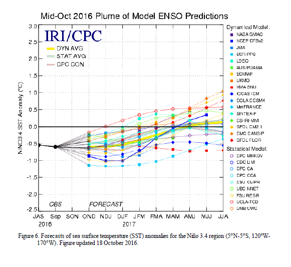
drought conditions are expected to worsen as La Niña arrives this week in the U.S. The weather pattern occurs when water in the Pacific Ocean cools, and usually brings higher precipitation to the Northwest and northern Rockies, but that comes with drought conditions across the American South.
Forecasters with the National Oceanic and Atmospheric Administration (NOAA) have said in recent days this La Niña will likely be weak and short-lived, adding there is a 55 percent chance it will persist through the winter.
The current trajectory for La Niña means Colorado could be a bit drier than usual this winter, though it should be exempted from the driest conditions.
But the current conditions moved in quickly. On Aug. 9, only 26.7 percent of the state was under “abnormally dry” conditions, and just 0.4 percent was under moderate drought conditions.
A year ago today, 80 percent of the state was experiencing no drought conditions whatsoever.
The lack of precipitation and warmer, drier air has already postponed ski season at several of Colorado’s resorts, which have struggled to make artificial snow at times and haven’t seen much help from Mother Nature.
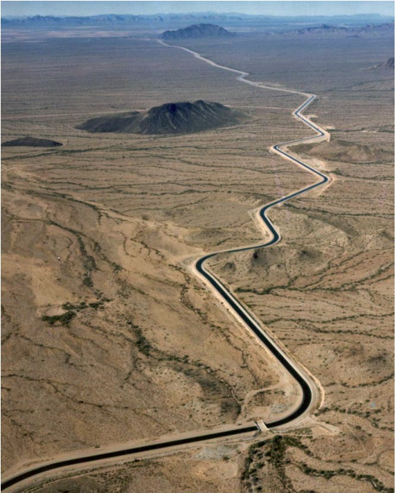
The Central Arizona Aqueduct delivers water from the Colorado River to underground aquifers in southern Arizona. UT researcher Bridget Scanlon recommends more water storage projects like the aqueduct to help protect against variability in the river’s water supply. U.S. Bureau of Reclamation.
Tucson will leave nearly 20 percent of its Central Arizona Project water supply in Mead next year, in hopes of propping up the declining lake and pushing back the date of shortages that would cut deliveries, particularly to cities.
Tucson and Phoenix also have agreed to have Phoenix store much more of its CAP supply in a Tucson-area underground aquifer next year than planned. The upshot of the deal is that even though Tucson will leave a lot of water in Lake Mead, it will still put even more CAP into its Avra Valley recharge basins next year than it normally does.
But when a future Colorado River shortage occurs, Phoenix would get to make use of the same amount of Tucson’s share of CAP water as it’s now getting ready to store in Tucson. It’s a trade-off that pleases water leaders in both cities, as well as Arizona’s top water official.
“The actions like that which are taken by water users to conserve water in Lake Mead is a very positive thing,” said Arizona Department of Water Resources Director Tom Buschatzke. “I haven’t heard from anyone else interested in doing what Tucson is doing, but maybe when they hear Tucson is doing that, other folks will step forward.”
Tucson’s mayor and City Council strongly support Tucson Water’s action, but several members are frustrated that the utility acted unilaterally. Tucson Water Director Timothy Thomure said that was because City Manager Michael Ortega had to place a CAP order for next year by Oct. 3, and the negotiations with water project officials and others involved in this deal weren’t wrapped up until Sept. 29. For various reasons, the issue wasn’t brought to the council until this week.
Mayor Jonathan Rothschid and council members Steve Kozachik, Paul Cunningham and Karin Uhlich said this isn’t acceptable and that they want to be involved earlier in such negotiations in the future.
“This is about our future,” Cunningham said. “Without water there is no Tucson left.”
While it’s constructive for Tucson to collaborate with cities such as Phoenix, “that does not mean the decisions should start getting made by a handful of staff members,” Uhlich said. “Water is worth more than gold here. It’s life.”
Specifically, the Tucson-Phoenix arrangement works like this:
Next year, Tucson will leave 26,000 feet of its 144,000 acre-foot CAP supply in Lake Mead. Typically, Tucson Water takes all the water, but stores nearly one-third in Avra Valley recharge basins for when it’s needed in times of shortage. It usually puts the rest of that water into the same basins and pumps it out over the course of a year.
Phoenix will store 36,500 acre-feet in the Avra Valley basins next year, and put an additional 3,500 acre-feet in another recharge basin for Metro Water’s future use. Typically, Phoenix uses about two-thirds of its total CAP supply, and the rest goes to other, Arizona-based CAP users such as farmers and the Arizona Water Bank. The bank stores it in its recharge basins for future use.
When a Colorado River shortage occurs that’s severe enough to affect cities, Tucson could pump the Phoenix-stored water for its use. Phoenix, in turn, could pull a similar amount of Tucson’s CAP supply in the same year as the water heads down the project’s concrete canal to one of two Phoenix-area CAP treatment plants.
This arrangement saves Tucson $5.3 million next year. That’s $1.8 million in payments from Phoenix for storing its water down here, and the $3.5 million it saves in payments to CAP for unordered water.
While this arrangement is now only for next year, Phoenix Water Director Katherine Sorensen said she hopes it will become a long-term arrangement. Thomure said it’s possible that Tucson Water will come to the council about extending this setup for three to five years.
This is the second time the two cities have agreed to increase the scope of their water-sharing agreement since they first signed it in 2014.
This agreement comes as water officials around the Southwest are negotiating a three-state agreement to reduce their use of Colorado River water in hopes of reducing if not arresting Lake Mead’s continued decline. The lake is expected to end 2017 barely 3 feet above 1,075 feet. Below that level, an initial shortage would be declared, slashing water deliveries to Arizona farmers and the water bank.
The bigger concern is that if additional steps aren’t taken to keep more water in Mead, in 10 percent of all possible future scenarios Mead would drop to 1,025 feet by 2019, according to computer models. At that level, Arizona cities would face CAP shortages, Thomure said. But with the water use cuts now being considered by the three states, plus Tucson’s reduction, the odds of the lake hitting 1,025 feet would be reduced to less than 10 percent in most years through 2026, he said.
Now, with five years worth of CAP water stored underground in the utility’s basins and others run by the water bank, “we are rich with water,” Thomure said.
“We can build a fence around Tucson and say that we’re resilient and we don’t need to participate in discussions with other cities, but we’re at risk if we do so,” he said. “We’re better off if we work collectively, in a much better position for the long term.”
It’s in Phoenix’s best interest to store as much CAP in Tucson-area aquifers as it can, water director Sorensen added. Currently, Phoenix’s ability to store its CAP water in underground aquifers in its area is limited because it abandoned most wellfields back in the 1980s when it switched to CAP, Sorensen said.
Phoenix can meet only 5 percent of its total demand with groundwater, “which is very concerning to us,” she said.
Under an agreement between water officials in Phoenix and Tucson, a significant amount of Colorado River water allocated to Phoenix will be stored in Tucson-area reservoirs and the underground aquifer next year, while Tucson will draw about 20 percent less water from Lake Mead than normal.
The deal is intended to keep the water level in Lake Mead high enough to prevent the federal Bureau of Reclamation from declaring a water shortage that would require states to reduce their withdrawal of water from the lake, which supplies approximately 90 percent of the Las Vegas Valley’s drinking water.
Bronson Mack, a Southern Nevada Water Authority spokesman, said the deal between Tucson and Phoenix typifies the behind-the-scenes work going on to avoid a shortage declaration.
“That’s been a lot of the focus on states near the Colorado River working to develop agreements and understandings that allow better coordination and more flexibility between us,” he said…
“The agreement is a positive thing because it allows leveraging of existing infrastructure to create flexibility to manage water supplies,” said Tom Buschatzke, Arizona Department of Water Resources director. “Tucson gets to keep some water in Lake Mead, which creates benefits for larger audiences beyond Phoenix and Tucson.”
Lake Mead sank to a low record of 1,071.61 feet above sea level on July 1, but has since gained nearly 5 feet.
If the lake’s surface is below 1,075 feet at the beginning of a year, Nevada would be forced to cut its river use by 4 percent while Arizona would take an 11 percent cut.
The Bureau of Reclamation currently forecasts that the lake will be at 1,078 feet above sea level— 3 feet above the first water shortage trigger — at the end of December.
Lake Mead behind Hoover Dam December 2015 via Greg Hobbs.
Click here to the Denver for Colorado River Studies at Utah State University for all the inside skinny on the report. Here’s the executive summary:
The Fill Mead First (FMF) plan would establish Lake Mead reservoir as the primary water storage facility of the main-stem Colorado River and would relegate Lake Powell reservoir to a secondary water storage facility to be used only when Lake Mead is full. The objectives of the FMF plan are to re-expose some of Glen Canyon’s sandstone walls that are now inundated, begin the process of re-creating a riverine ecosystem in Glen Canyon, restore a more natural streamflow, temperature, and sediment-supply regime of the Colorado River in the Grand Canyon ecosystem, and reduce system-wide water losses caused by evaporation and movement of reservoir water into ground-water storage. The FMF plan would be implemented in three phases. Phase I would involve lowering Lake Powell to the minimum elevation at which hydroelectricity can still be produced (called minimum power pool elevation): 3490 ft asl (feet above sea level). At this elevation, the water surface area of Lake Powell is approximately 77 mi2, which is 31% of the surface area when the reservoir is full. Phase II of the FMF plan would involve lowering Lake Powell to dead pool elevation (3370 ft asl), abandoning hydroelectricity generation, and releasing water only through the river outlets. The water surface area of Lake Powell at dead pool is approximately 32 mi2 and is 13% of the reservoir surface area when it is full. Implementation of Phase III would necessitate drilling new diversion tunnels around Glen Canyon Dam in order to eliminate all water storage at Lake Powell. In this paper, we summarize the FMF plan and identify critical details about the plan’s implementation that are presently unknown. We estimate changes in evaporation losses and groundwater storage that would occur if the FMF plan was implemented, based on review of existing data and published reports. We also discuss significant river-ecosystem issues that would arise if the plan was implemented.
FromThe Grand Junction Daily Sentinel (Gary Harmon):
Making Lake Mead the primary water storage facility on the Colorado River isn’t as simple as it might seem and would require more study than it’s been given so far, says a study released Thursday.
Backers of the Fill Mead First idea said the study underscores the need to move ahead with studies and a spokesman for the Colorado River Water Conservation District said the discussion ignores a significant element: the need for Colorado and other states to save water in Powell.
The Center for Colorado River Studies at Utah State University said more study of evaporation from Lake Powell is needed, as well as a study of groundwater into the reservoir and of the fine sediment that would be released should Lake Powell be drained.
That would be a good start, said Eric Balken, executive director of the Glen Canyon Institute, which drafted the idea of filling Lake Mead instead of storing water in Powell so as to reduce water lost to evaporation.
The Interior Department has so far “written off” the idea, Balken said.
“Now is the time to initiate new measurement programs of (evaporation) losses at Lake Powell and Lake Mead so that future policy discussions have access to less uncertain data regarding evaporation and groundwater storage,” Balken said in an email.
The idea ignores Lake Powell’s “primary purpose,” which is to serve as a savings account for the upper Colorado River Basin states to deliver an average 7.5 million acre-feet of water per year to the lower basin, said Chris Treese of the River District.
The amount is set in the 1922 compact that governs the use of the river, which provides water to millions of people in the arid Southwest.
Advocates of draining Lake Powell tend to write off the upper basin concerns by saying it’s “with a wave of the hand that you’d have to ‘make a few changes’,” to the compact, Treese said, “As if it’s simple and desirable to open up the Colorado River Compact.”
The Fill Mead First idea proposes draining Lake Powell in a three-stage process and storing the water in Lake Mead, 300 miles downstream.
“It is surprising how much uncertainty there is in estimating losses associated with reservoir storage,” said Jack Schmidt of the Center for Colorado River Studies, who served as chief of the U.S. Geological Survey’s Grand Canyon Research and Monitoring Center from 2011 to 2014.
Evaporation losses at Lake Mead are measured by the U.S. Geological Survey in a state-of-the-science program, but there have been no efforts to measure evaporation at Lake Powell since the mid-1970s, Schmidt said.
Using the most recent data, researchers showed the Fill Mead First plan might reduce evaporation losses slightly, but noted that such a prediction is uncertain.
The Interior Department should conduct a thorough scientific investigation of evaporation and seepage losses at lakes Powell and Mead, as the Utah State study suggests, Balken said.
Delph Carpenter’s 1922 Colorado River Basin map with Lake Mead and Lake Powell
Contaminated drinking water isn’t just a problem for Flint, Michigan. Many towns and cities across the Midwest and Great Plains face pollution seeping into their water supplies.
Farmers spread nitrogen- and phosphorous-based fertilizers on their fields to help their crops grow. Excess nutrients, though, can leach into groundwater or seep into rivers, creeks, canals or ditches that eventually feed into the Mississippi River. In high concentrations, these chemical compounds damage aquatic life and burden small towns that have to remove them from their water supply.
Headlines on news stories from Burlington, Colorado, Erie, Illinois, and Creighton, Nebraska, warn citizens not to drink the water due to high levels of nitrate. Boiling the water won’t work. It further concentrates the contaminants. Dilution and filtering seem to be the best ways to limit exposure.
So, nutrients meant for plants are ending up concentrated in our water. But how?
View of runoff, also called nonpoint source pollution, from a farm field in Iowa during a rain storm. Topsoil as well as farm fertilizers and other potential pollutants run off unprotected farm fields when heavy rains occur. (Credit: Lynn Betts/U.S. Department of Agriculture, Natural Resources Conservation Service/Wikimedia Commons)
Weather this winter to be influenced by climate phenomena
La Nina has arrived and is favored to stick around through winter. Forecasters say the climate phenomena will likely contribute to drier and warmer weather in the southern U.S. and wetter, cooler conditions in the Pacific Northwest and across to the northern tier of the nation this winter.
Typical La Nina weather patterns over North America via NOAA.
NOAA scientists declared the arrival of La Nina on Nov. 10, calling it present, but weak. It is predicted to be short-lived, possibly only lasting a few months. La Nina is associated with cooler-than-average sea surface temperatures in the Equatorial Pacific, which trigger changes in the atmosphere. This ocean-atmosphere coupling impacts the position of the Pacific jet stream influencing weather and climate patterns around the globe.
“A weak La Nina is in place and is likely to remain for the winter,” said Mike Halpert, deputy director, NOAA’s Climate Prediction Center. “The weak La Nina is likely to contribute to persisting or developing drought across much of the southern U.S. this winter.”
This La Nina follows one of the strongest El Ninos on record, which ended in June. Recent La Nina years include 2011-2012; 2010-2011; 2007-2008; and 2000-2001. Find out more about La Nina on the ENSO Blog.
What to expect this winter: NOAA’s Winter Outlook.
Click here to go to the US Drought Monitor website. Here’s an excerpt:
Summary
Mild weather once again dominated the majority of the U.S. this past week. Temperatures of at least 10 degrees warmer than normal dominated much of the Plains, Midwest, and Mid-South. Near to slightly below-normal temperatures were confined to New England and south Florida. The drought-stricken areas of the Southeast, southern California, the Intermountain West, and the northwestern Plains received little, if any, precipitation resulting in the persistence or deterioration of drought conditions in these areas. Meanwhile, the coastal Northwest, the south-central U.S., parts of the Midwest, and New England saw rainfall with the passage of a cold front through those areas…
The Plains
Most of last week’s rain stayed to the east of the regions’ drought-inflicted areas. Temperatures ranging from 8 to 16 degrees above normal caused continued drying in these regions and resulted in an expansion of moderate drought (D1) over southwest Kansas and abnormally dry (D0) conditions across north central South Dakota and south-central North Dakota…
The West
Changes in the West this week were mixed. Abnormal dryness (D0) expanded westward in the Upper Colorado River Basin over western Colorado, eastern Utah, and south-central Wyoming in response to warmer-than-normal temperatures and short-term precipitation deficits. Colorado also saw a south and southwestward expansion of moderate drought (D1) due to the continued dryness in the region and impacts on soil moisture and vegetation. A re-examination of data due to rains over the last 30 days resulted in a trimming of moderate (D1) and severe (D2) drought over northeast California and northwest Nevada. These rains have been enough to improve long-term rainfall deficits, streamflow, and soil moisture. Likewise, a one category improvement was made in drought conditions over western Wyoming.
Looking Ahead
The National Weather Service medium range forecast calls for continued warmth and dryness over much of the interior U.S. The highest temperature anomalies are expected over the western and central states while East Coast temperatures are forecast to return to more seasonable values. The highest probabilities for precipitation once again is in the Northwest. Forecast models also indicate a possibility for rain along parts of the Gulf and East Coast.
John O. is a Water Resources Administrator for the City of Thornton. In May of 2016, leading up to Bike to Work Day, Smart Commute interviewed John about his bike commute to work. Read John’s responses below!
Smart Commute: Can you describe your normal commute?
John O: I have a very long commute – 25 miles round trip each day. I actually commute entirely by bike, and it takes about an hour each way. My office is in Thornton, and I live in northwest Denver.
SC: When did you start commuting by bike?
JO: I started bike commuting around April 2008. I wanted to lower my carbon footprint.
SC: What is the best thing about your commute to work?
JO: The best thing about my commute is the time along Clear Creek and Farmers Highline Canal — no vehicle traffic, watching the seasons change over the months, and having a great view of the changing Colorado weather over the Front Range.
Update: For safety reasons (road rage, driver error) I have stopped riding Pecos St during the evening rush hour. I now throw my bike on an RTD express bus, ride downtown to Union Station, and bike home from there through the Northside neiborhoods. Cuts my mileage about 5 miles.
Mine waste piles at the Freda Mine pose a risk to water quality and erosion, prompting the Colorado Division of Mining, Reclamation and Safety to come in to clean up the site. Courtesy of Colorado Division of Mining, Reclamation and Safety.
Taxpayers again must foot the bill for cleaning up a Colorado mine site previously operated by embroiled company Red Arrow Gold Corp.
“We wrote a violation, and recalculated his (Red Arrow owner Craig Liukko) bond,” said Tony Waldron of Colorado’s Division of Mining, Reclamation and Safety. “He didn’t respond. Sometimes people just disappear.”
Trouble began in 2013 when state inspectors visited a relatively minor but active mine site on which Red Arrow held a permit about seven miles northwest of Silverton, called the Freda Mine.
Finding a litany of violations that posed a risk of water pollution and erosion, DMRS determined Liukko’s bond of $8,685 would not cover the cost of cleanup, estimating instead it would take $19,000.
But when Liukko did not post the additional bond and failed to attend several state meetings about his company, Colorado’s Mined Land Reclamation Board in 2014 revoked his license and seized the $8,685 bond.
The $10,315 difference will now be covered by a fund set up for these types of situations, Waldron said. Part will be come from federal money, and another portion will be covered by a severance tax on Colorado’s gross income taken from oil and gas and carbon dioxide production, which contributes about $130,000 a year to the state’s mine cleanup efforts.
Kirstin Brown, a reclamation specialist with DMRS, said work at the Freda Mine is likely to begin in summer 2017.
She said crews, among other tasks, will need to haul off trash from a recently erected mill building, close two mine portals, and take on a large project to re-grade mine waste piles that are eroding into Ruby Creek, a tributary of Mineral Creek.
Brown also found during a 2015 inspection a mine waste pile outside the permit boundary on adjacent Forest Service land.
“And oddly, it’s uphill of the site, which is very strange, and not the way (miners) normally work,” she said.
Brown estimated the project would take a couple weeks to complete once crews can gain access to the hard-to-get-to site near Ophir Pass, at an elevation of 11,200 feet.
The approximately 1-acre site is relatively small when compared with other polluters in the heavily mined Animas River watershed, and is not included in the Environmental Protection Agency’s recently declared Superfund listing, which will address 48 mining sites around Silverton.
Yet Brown said the small mine waste piles and trash that is a potential hazard to waterways is just enough to be “irritating,” warranting a cleanup.
Aside from the Freda Mine, DMRS’s Waldron said the state is paying for a cleanup project at Liukko’s other former mining operation in Mancos, where investigators in 2013 say they found dangerous levels of mercury and arsenic contamination.
Waldron said DMRS completed one season of work over the summer, yet there are lingering tasks to do in summer 2017 before the site is fully remediated.
So far, the state has spent $113,034 on cleaning the site in Mancos, with only $8,875 of Red Arrow’s initial bond covering the cost, according to DMRS spokesman Todd Hartman.
Liukko, who lives in Arizona, also has not paid any of the $339,667 in violations issued by the state, Hartman said, adding that the amounts due have been sent to the state’s collection office.
When contacted last week, Liukko said he was unable to comment because of pending litigation.
His company is involved in a bankruptcy case in Colorado, wherein Liukko claims Red Arrow’s parent company American Patriot Gold and investors Maximilion Investors seized Red Arrow’s assets with the intent of taking over the mine in Mancos.
Liukko argued the $25 million loan the investors promised was not delivered, and the continual breach of funding obligations led to the mine’s closure and Red Arrow’s inability to pay for the cost of cleanup.
The Fountain Creek Watershed is located along the central front range of Colorado. It is a 927-square mile watershed that drains south into the Arkansas River at Pueblo. The watershed is bordered by the Palmer Divide to the north, Pikes Peak to the west, and a minor divide 20 miles east of Colorado Springs. Map via the Fountain Creek Watershed Flood Control and Greenway District.
The U.S. Environmental Protection Agency and the state health department filed a lawsuit Wednesday against the City of Colorado Springs over water quality violations and stormwater program shortfalls dating to 2009.
Mayor John Suthers, who began building a new stormwater program immediately after taking office in June 2015, expressed frustration over the decision by the EPA and the Colorado Department of Public Health and Environment to file legal action rather than recognize recent strides the city has made.
The federal and state agencies are seeking civil penalties that Suthers said could amount to “millions and millions of dollars.”
“What’s frustrating is: They know they have a mayor and City Council that recognize the problem, understand the problem and are intent on fixing the problem,” the mayor said. “Rather than working with us to get this done, they file a lawsuit.
“This is the kind of lawsuit that gives the EPA a reputation for being over-reaching. Every single dime going to litigate this thing and pay fines should be going into fixing the problem.”
Over the past 18 months, the city has:
◘ Negotiated and signed a $460 million, 20-year intergovernmental agreement with Pueblo County to build 71 major stormwater projects. The work is designed to eliminate sedimentation, detain excessive flows and improve water quality in Fountain Creek for local and downstream communities. That pact is backed by Colorado Springs Utilities, which will appropriate needed funds should the city experience a shortfall.
◘ Recruited professional engineer Richard Mulledy to manage the stormwater division and beef up the staff of stormwater inspectors and engineers from 28 to 49 full-time employees, with a total of 66 to be on board within the next several months.
◘ Increased spending on stormwater from $5 million in 2015 to $19 million a year, including $9.2 million for capital projects, $3 million from Utilities and $7.1 million to $7.8 million, when fully staffed, for the city’s Municipal Separate Storm Sewer System, known as an MS4 federal permit, which allows Fountain Creek to flow into the Arkansas River, to the Mississippi River and into the Gulf of Mexico.
◘ Started building a $3 million detention pond on Sand Creek; spending $2 million to rehabilitate wash-out areas, remedy sediment-transport issues and improve water quality since 2013 flooding, and retrofitting a King Street detention pond so it not only controls flood waters but also manages flow to mimic natural discharge.
When Suthers took office, he lamented a former City Council’s decision in 2009 to eliminate the city’s Stormwater Enterprise Fund, which had collected $15 million to $16 million a year in fees from property owners to spend on stormwater projects.
“Fountain Creek is one of the most unstable, flashy creeks in all the nation. It’s a unique animal,” engineer Mulledy told The Gazette in March.
The base flow of 120 cubic feet per second can reach 20,000 cfs during a 25-year event, swelling the creek to 100 feet wide and 10 feet deep, he said. “On top of that, the material along that creek is an alluvial field. It’s sand. So it’s kind of the perfect storm,” Mulledy said.
The mayor recognized that city voters repeatedly voted down stormwater measures, so he and the council agreed to address the need directly from the general fund. In order to do so, he froze employee salaries and vacancies, squeezed the police and fire departments, and shelved several planned capital projects this year.
But the EPA and state point to average annual stormwater expenditures of $1.6 million from 2011 through 2014, when only nine full-time employees worked in stormwater. So surface runoff, streambed degradation, widening and erosion led to sedimentation and unacceptable water quality.
The suit cites a 2000 planning study for the Cottonwood Creek Drainage Basin that eliminated six detention basins and structural measures originally planned, reducing costs by $11.4 million, but notes that the plan now is being updated and revised.
A 2013 EPA audit identified water-quality control structures at two developments that didn’t treat stormwater before discharging it into state waters; seven residential developments without stormwater controls or waivers for such; failure to submit development, inspection and maintenance plans to Engineering Development Review before grading permits were issued, and other failures since 2013 to ensure that policies protecting water quality were followed.
Larry Small, executive director of the Fountain Creek Watershed, Flood Control and Greenway District, has long despaired of the city’s years of neglect toward Fountain Creek and stormwater issues.
But that’s in the past, Small said.
“John (Suthers) put in that $460 million plan, he’s increased the stormwater department significantly in staffing, he’s put processes in place, and he’s started at least three significant projects in the last year to deal with it,” Small said. “He’s got an agreement with Pueblo County that we haven’t had in years on managing and monitoring stormwater and to review progress annually and adjust the priorities. As far as John’s performance, he’s done a great job in the last year and a half.
“From the time the city discontinued its stormwater enterprise until John put planning in place, we had a large number of years with a huge deficiency. But I don’t see how a lawsuit is going to correct the problem,” he said. “The only thing a lawsuit is going to do is bring in money for the federal government in fines, and what good does that do for the city or the problem?
“A better solution would have been to sit down with monitoring and performance guidelines and allow the city to use that money to make improvements instead of pay fines with it. This is just another example of the federal government using a local issue to raise money.”
Total Water Use (Freshwater and Saline Water), by Sector (1900–2010) Notes: Municipal and Industrial (M&I) includes public supply, self-supplied residential, self-supplied industrial, mining, and self-supplied commercial (self-supplied commercial was not calculated in 2000–2010). Agriculture includes aquaculture (1985–2010 only), livestock, and irrigation. Between 1900 and 1945, the M&I category includes water for livestock and dairy. Sources: Data for 1900–1945 from the Council on Environmental Quality (CEQ) (1991). Data for 1950–2010 from USGS (2014a). Population data from Williamson (2015).
Water use has not gone up as population increased in the last few years, contrary to popular opinion and expectations. How does this impact how urban water managers are planning?
UNTIL 1980, WATER use went up steadily as population increased, necessitating investments in infrastructure and boosts to capacity. But since then, there has been a dramatic decoupling across the United States, with water use declining even as the population and the economy continued to grow.
The U.S. Geological Survey found that water consumption peaked at 440 billion gallons (1,665 billion liters) per day before dropping in 1980 and then remained steady through the 1980s and 1990s. It rose slightly in 2000, but significantly declined between 2005 and 2010, when it fell to 350 billion gallons (1,325 billion liters) per day. The USGS attributes this decline to better cooling methods that cut water use for thermoelectric power, and water use efficiencies in irrigation for farming, improved standards for many appliances and fixtures and laws requiring low-flow fixtures.
“Back in 1980 toilets used 6 gallons [23 liters] per flush, but now it’s 1.2 gallons [4.5 liters] in California. These standards have allowed our economies to grow while our communities grew too,” says Heather Cooley, director of the Water Program at the Pacific Institute. “Another reason is the passage of the Clean Water Act, which tried to reduce impacts of waste discharge, that drove efficiency improvements in industry.”
But despite the public and industry adopting efficiency practices, most of us continue to think water use will keep increasing as population grows, so water agencies have planned for it.
“Emphasis has been on building more supply to meet increasing demand. But if water use remains stagnant, that might mean we invest in facilities we ultimately don’t need, or pay for supplies we don’t need,” Cooley points out.
Improve Demand Forecasting
These developments, and the USGS data that showed declines across the board, prompted Cooley and her colleagues to study these trends and put together a community guide for evaluating future urban water demand.
After examining water use data and water agencies’ urban water plans, Cooley and her colleagues found that while water use stayed stagnant or declined in some areas, many utilities were projecting increased water use in the future, which shows they’re not allowing for efficiency improvements and so they could be overestimating demand, which could increase costs for rate payers for water they may not use.
“So we need to improve demand forecasting approaches,” Cooley says. “None of us has a crystal ball, but we can look at trends for the last 20 to 30 years, and use that to calculate water needs, which will help us to develop a much more sustainable water future for California.”
Part of that forecasting is planning for climate change and its impact on demand, something that she says many water agencies have yet to incorporate successfully.
For each area, water forecasting can look very different depending on local variables.
Unusually warm weather is forcing Opening Day delays for Colorado ski resorts, which produce a $4.8 billion annual boon to the state economy.
Arapahoe Basin remains the only resort open in the state, and Loveland Ski Area will open Thursday after a multi-week delay. Both can thank manmade snow because Mother Nature hasn’t been of much help.
Snow-making wizardry aside, it has to be cold enough outside for the flakes to stick, and overnight temperatures remained stubbornly warm through most of October, Loveland Ski Area spokesman John Sellers said.
“Our patience has really been tested this year,” he said.
Staff started making snow Oct. 3, and it usually takes just a couple of weeks to open after snow-making begins. Overnight temperatures only recently have dropped enough to schedule Opening Day for Thursday.
Copper Mountain Resort cited unseasonable warmth when it pushed its Opening Day back a week, from Friday to Nov. 18.
“The decision to delay Opening Day is always difficult and is not one we make lightly,” said Gary Rodgers, Copper Mountain’s president and general manager, in a press release. “Our teams have been working around the clock to prepare the mountain for the upcoming season, but we do need a little more cooperation from Mother Nature.”
Keystone Resort also pushed back its opening from Nov. 4 to a tentative Friday because of warm weather.
The economic impact of a delayed opening is not good but “not huge,” Sellers said. Bad weather or roads later in the season would be a bigger economic threat, he said.
Last year, Colorado slopes saw 13 million skier visits.
The National Weather Service’s Climate Prediction Center predicts warmer-than-normal temperatures through the rest of fall, but a lack of early fall snow doesn’t necessarily correlate with a lack of winter snow.
Photo by Havey Productions via TheDenverChannel.com
Here’s the release from Colorado State University (Jessica Bennett):
Learning more about the complexities and inner-workings of western water law is the purpose behind the 2016 Interdisciplinary Water Resources Seminar series. The series will discuss topics including the history and evolution of western water law; state compacts and federal water law; hybrid water law systems; water quality law; groundwater law; and environmental law. The seminar series will provide attendees the opportunity for in-depth discussion about water-related court cases and interaction with prominent water resource professionals.
Each seminar is held Monday at 4 p.m. in the Behavioral Sciences Building, Room 103. All faculty, students, off-campus water professionals, and members of the Fort Collins community who are interested in water and western water law are invited to attend.
For individuals unable to attend, the seminars will be recorded and uploaded online. The full semester schedule is accessible here. Or there’s more information regarding all of the Interdisciplinary Water Resources Seminars.
Amy Beatie, Nov. 14
Amy Beatie began her tenure at the Colorado Water Trust in 2007, after nearly six years practicing water litigation at two different Front Range water law firms. Beatie will be speaking at the Nov. 14 seminar on “Water Transactions in Colorado.” She will discuss how the reallocation of water rights through voluntary transfers has become a significant part of the water law for Colorado and other Western states. In this seminar, Beatie will provide the basic tools and concepts necessary to understand water transactions under Colorado water law.
Prior to practicing water litigation, Beatie clerked for the Honorable Gregory J. Hobbs of the Colorado Supreme Court. While in law school, she helped create the University of Denver Water Law Review, served as its editor-in-chief, and now sits on the advisory board. She is also a member of the advisory board of Metro State University’s One World One Water Center and the board of directors of the Colorado Water Congress. In May 2013, Beatie received the Colorado Foundation for Water Education’s Emerging Leader award.
Next year, the U.S. Army Corps of Engineers is expected to decide whether to issue a permit to triple the capacity of Gross Reservoir in the Rocky Mountain foothills, with additional shipments of about 18,000 acre feet of water a year from the Colorado River watershed. An acre foot is enough water to meet the annual needs of an average family of five.
That is one of the last regulatory barriers for utility Denver Water’s $380 million project, for which district officials say they hope to break ground in 2019 to help ensure local water supplies.
“We have an obligation to supply water,” said Jeff Martin, Denver Water’s manager of the project, as he stood recently atop a 340-foot concrete dam that is to be raised by 131 feet under the plan. “It’s not an option to not have water.”
[…]
The Corps of Engineers is expected to decide next year on a proposed new “Windy Gap” project in Colorado, which would divert up to another 30,000 acre feet a year to the Front Range, the heavily populated area where the Rocky Mountains rise up from the plains.
In addition, more than 200,000 acre feet would be diverted for proposed projects in Utah and Wyoming…
Water officials in California and other lower basin states say they aren’t overly concerned about more diversions upstream, because a 1922 compact requires the upper basin states to deliver them about 7.5 million acre feet a year, or one half the river flow set aside for human use north of the U.S.-Mexico border. Much of that water is stockpiled in Lake Powell on the Arizona-Utah border.
With the Colorado running much lower than when the compact was signed, water experts say there is less water to divert.
“So long as their development doesn’t impinge on their release to us, that is their business,” said Chuck Cullom, a program manager at the Central Arizona Project in Phoenix, which pulls from the river and stands to lose a fifth of its deliveries if a shortage is declared on the Colorado. “If it falls below that, then they would have to figure out how to manage their demand.”
Don Ostler, executive director of the Upper Colorado River Commission, which oversees use of the river in the upper basin states of Colorado, Utah, Wyoming and New Mexico, agreed that new diversions increase the risk of shortages.
“The more you develop, the more a severe drought can affect you,” said Mr. Ostler. “But we are able to live with a certain amount of shortage.”
In Denver, water officials don’t feel they have much choice but to seek more Colorado water.
In 2002, tons of sediment from a forest fire clogged one of Denver Water’s reservoirs during a drought. “We came close to running out of water in the northern end of our system,” said Jim Lochhead, chief executive officer of Denver Water, a utility that serves 1.4 million people.
That crisis helped prompt the district in 2003 to undertake the Gross Reservoir expansion, which would store more water from an existing tunnel that transfers Colorado River water from the west side of the Continental Divide.
Denver officials pledged to only take the water in wet years and release more into streams when it is dry—measures that drew praise from some conservationists…
Gov. John Hickenlooper in July gave the state’s approval, calling the dam’s expansion vital. “The state’s responsibility is to ensure we do the right thing for Colorado’s future,” the Democratic governor said at the time, “and this project is vital infrastructure for our economy and the environment.”
The dam that forms Gross Reservoir, located in the mountains west of Boulder. Photo: Brent Gardner-Smith/Aspen Journalism
Releases from dam help restore ecological health without affecting water commitments
The U.S. Department of the Interior today initiated another high-flow release of water from Glen Canyon Dam in Arizona under an innovative science-based experimental plan. The fourth such release, the goal is to enhance the environment in Grand Canyon National Park and Glen Canyon National Recreation Area while continuing to meet water and power delivery needs and allowing continued scientific experimentation and monitoring on the Colorado River.
“Healthy watersheds are critical to the economy and environment, and our science-based approach demonstrates that protecting water supplies alongside other resources tied to the river are not only compatible but instrinsically linked,” said Secretary of the Interior Sally Jewell. “This latest release will provide critical fish and wildlife habitat, reduce erosion of archaeological sites and enhance recreational opportunities while meeting our obligations to water users in the region.”
The 96-hour-release will pick up enough sand from tributary channels to fill a building as big as a football field and as tall as the Washington Monument, all the way to the brim. These hundreds of thousands of tons of sediment will be re-deposited along downstream reaches as sandbars and beaches along the Colorado River, mimicking natural river flow.
The high-volume experimental releases are designed to restore sand features and associated backwater habitats to provide key fish and wildlife habitat, potentially reduce erosion of archaeological sites, restore and enhance riparian vegetation, increase beaches and enhance wilderness values along the Colorado River in Glen Canyon National Recreation Area and Grand Canyon National Park. The annual volume of water to be sent toward Lake Mead this year will not change as a result of the experiment – water releases in other months will be adjusted accordingly.
The decision to conduct this experiment followed substantial consultation with Colorado River Basin states, American Indian Tribes and involved federal agencies, including five Interior agencies – Bureau of Reclamation, National Park Service, U.S. Fish and Wildlife Service, U.S. Geological Survey and Bureau of Indian Affairs.
In planning the release, officials considered the amount of sediment available in the river; the condition of cultural and archaeological resources near the river; biological resources such as endangered species, the Lees Ferry recreational fishery and riparian vegetation; and seasonal demands for water and hydroelectric power deliveries. During and after the release, the USGS Grand Canyon Monitoring and Research Center will gather a variety of scientific data, including how beaches and sandbars change, differences in sediment concentration and composition, and water quality.
Recognizing the importance of annual water deliveries and dependable hydroelectric power generation, the Grand Canyon Protection Act of 1992 (Public Law 102-575) directed the Secretary of the Interior to manage Glen Canyon Dam in such a way as to “protect, mitigate adverse impacts to, and improve the values for which Grand Canyon National Park and Glen Canyon National Recreation Area were established.”
Former Secretary of the Interior Ken Salazar triggered the first release under the experimental long-term protocol in November 2012. The protocol calls for conducting more frequent high-flow experimental releases and timing them to occur following sediment inputs to the Colorado River downstream from Glen Canyon Dam.
Department of the Interior officials remind recreational users to use extreme caution during the high flows when on or along the Colorado River through Glen, Marble and Grand Canyons. Flow-level information will be posted at multiple locations in both Glen Canyon National Recreation Area and Grand Canyon National Park.
Additional information about this high flow experiment—including flow information, campsite maps and shoreline modeling—is available at the following websites:
Roaring Fork River, Grottos, on Monday morning June 13, 2016, looking downstream, with diversions into the Twin Lakes Tunnel at over 600 cfs. While impressive at this level, the whitewater frenzy that resulted after the tunnels were closed was far more intense. Photo Brent Gardner-Smith Aspen Journalism.
FromAspen Public Radio (Elizabeth Stewart-Severy):
Healthy Rivers and Streams board members recently took a field trip to the construction zone on the Roaring Fork River, where backhoes are digging up the riverbed. By February, this should be a man-made whitewater park with two waves for boaters to surf.
Board chair Lisa Tasker said the ultimate goal of this project is to keep water in the river during low flow years, using a water right designated for recreation.
“When you get a recreational in-channel diversion water right, you have to put structures in, and then you have to prove that people are recreating in there,” Tasker said.
With a price-tag of nearly $800,000, the whitewater park is the biggest project the Healthy Rivers and Streams fund has tackled…
Now it is turning its attention to the City of Aspen, which wants to reserve the right to build reservoirs on Castle and Maroon creeks. The municipality filed last month with the state to keep its conditional water storage right.
“We’re a healthy rivers board, and we’re going to respond in favor of a healthy river and a healthy ecosystem,” Tasker said. “So, we’re going to come out probably fairly strongly, because that is our mission.”
At a meeting in late October, the river board agreed to urge Pitkin County Commissioners to formally file in opposition to the City of Aspen in water court. Commissioner Rachel Richards is not warm to the idea.
“Just forcing the city to relinquish those water rights actually does nothing to protect the long-term health of the Castle Creek or the Maroon Creek,” Richards said.
Richards said she’d like to see the city maintain the rights while researching alternatives, like digging into a deeper aquifer or working to change Colorado water law entirely.
If nothing else, Richards and Tasker agree, the issue has opened a new conversation and interest in local water issues.
“I think it’s going to cause people to become a lot more creative and a lot more imaginative as to how they’re going to handle a shortage of water in the future,” Tasker said.
The county has until Dec. 31 to file in opposition to the city.
90-percent of our plants and trees are not indigenous to Colorado, and they’re going to need more water to stay growing. About 20 to 30 inches of moisture a year.
Myth buster: trees and shrubs do not go dormant in the winter. They grow all year long, with spring and fall the most important times of the year. Giving your landscape a good, thirst quenching drink of water right now will give it a fighting chance this winter, and for years to come.
Evaporation and transpiration graphic via the USGS
Here’s an interview with Douglas Kenney from Matt Weiser writing for Water Deeply. Click through and read the whole thing. Here’s an excerpt:
A team of scientists declares in a new report explaining the effects of climate change on the Colorado River that there won’t be any “breakthroughs” to save us from water scarcity.
How low can the Colorado go? When will we get back to “normal” winters? Can we blame it all on climate change?
To address some of these questions, the Colorado River Research Group recently released a concise four-page paper explaining how climate change is affecting the river. It is a remarkably accessible summation of lots of complicated science. The conclusion is that we simply need to adapt to a future in which water scarcity is the norm.
To help illuminate this conclusion, Water Deeply recently spoke with Douglas Kenney, director of the Western Water Program at the University of Colorado. Kenney is also chairman of the Colorado River Research Group, an independent team of scholars from six public universities that explain the river’s challenges in an ongoing series of plain-language policy reports.
Water Deeply: One of the really important statements you make in this paper is that “climate change is water change.” Tell me more about that.
Kenney: We’re certainly not the first people to make that observation or even use that phrasing. Every element of the hydrologic cycle, to some degree, is temperature dependent: when it snows versus when it rains; when it melts, how much evaporates; how much water the plants use; the length of the growing seasons. It’s all temperature-dependent.
Water Deeply: You also write that the effect of temperature “overwhelms precipitation changes.” What do you mean by that?
Kenney: It gets to this point that virtually every element of the hydrologic cycle is very much influenced by temperature. You can get conditions that are maybe a little wetter or drier. But you start running those scenarios through the climate models and what you realize very quickly when you look at the output is that those modest changes in precipitation really pale in significance compared to the impact of temperature. It’s in part because temperature so much drives the natural uses of water, the natural movement of water.
There’s a great observation that two of our members – Brad Udall and Jonathan Overpeck – have made in recent research: Just a very slight reduction in precipitation, largely because it’s so warm, can lead to a significant 15 percent or more reduction in actual streamflow.
Local apples were once again pressed into juice for market during a successful pilot project held in a Lebanon orchard last month.
The event, sponsored by the Montezuma Orchard Restoration Project, processed 800 bushels of apples gathered from local orchards.
“It went really well, we generated 2,200 gallons of raw juice that was sold to hard cider makers,” said MORP manager Nina Williams.
The group is studying the feasibility of using a mobile pressing unit to process apples from the many forgotten local orchards that otherwise let the fruit go to waste.
They were awarded a $42,400 planning grant from the U.S. Department of Agriculture to test the idea.
For two days in October, Northwest Mobile Juicing, out of Montana, set up in the Russell apple orchard in Lebanon. The unit can press, pasteurize, and package the juice for market.
For the pilot, the raw juice could only be sold to hard cider companies for fermentation. Additional permits are needed to sell pasteurized apple juice.
“We proved we can get if off the trees for sale to the hard cider market,” Williams said. “If the demand is there we can work through the regulations to sell local juice as well.”
Several orchard owners realized some profits from the project, and were paid 10 cents per pound for apples still on the tree.
A dedicated crew of twenty MORP volunteers spend 300 hours picking the apples in the weeks prior to the pressing. In all, nine apple orchard owners were paid $3,500 for their apples.
One local cider maker and four from Boulder and Denver bought the raw juice. A semi-truck was loaded with the juice for a night run to Front Range cideries.
“They were impressed with the quality,” Williams said. “The juice was a blend of local heritage apple varieties.”
Apple mash produced was hauled off by local livestock owners for feed.
MORP said they broke even on the trial run, and are studying how best to set up a local pressing facility.
“We learned that there is a lot of labor and infrastructure involved besides just the pressing equipment,” Williams said.
Commercial apple operations require warehouses, shipping docks, refrigerated cold storage to store apples, and heavy equipment such as trucks and forklifts.
MORP has been documenting once popular heritage apple varieties from the days when the area was a thriving fruit market more than 100 years ago.
They have brought many of them back to life through careful grafting and propagation techniques, and are encouraging local farmers to plant heritage apple orchards.
“Our big goals is to bring back this genetic diversity to keep heritage apples from going extinct, and to get it so people can have these trees again,” said MORP orchardist Jude Schuenemeyer. “Trees that worked here for over 100 years are really well adapted to this place.”
A recent victory for MORP was the rediscovery of the rare Colorado orange apple in a Cañon City orchard in 2012. For the last several years, local orchardists have been grafting and cultivating this near-extinct apple known for its fine flavor, hardiness, storage qualities, and cider-making potential.
There are dozens of abandoned apple orchards in the county that still produce a good crop, but have a limited market. The juice market is seen as ideal because the apples do not have to be perfect and the ones that fall on the ground can be used as well.
“One of our goals is to get local orchards back in shape by hosting workshops this winter on pruning and orchard management,” Williams said.