Manhattan: Upper Republican River Basin informational meeting, January 4, 2017

ksucampusmanhattan
Kansas State University, Manhattan, Kansas via Wikimedia.

From the Hays Post:

State and local water officials will host an informational meeting and discussion forum for water users and others interested in the water supply of the South Fork Republican River. The meeting will take place at 1:00 p.m. CST on Wednesday, Jan. 4, 2017, at the Cheyenne County 4-H building at the fairgrounds on N. College Street, St. Francis.

The Kansas Department of Agriculture and the Kansas Water Office will share information about the resolutions reached between Kansas, Colorado and Nebraska this year. Stakeholders are encouraged to attend and provide input to state water officials charged with administering the Republican River Compact. The Vision for the Future of Water Supply in Kansas includes a focus to represent Kansas in interstate water issues in order to best serve Kansas and its citizens.

“We want to hear from water users in the area as we continue to represent their needs in these interstate issues,” said Secretary of Agriculture Jackie McClaskey. “This long-term agreement reached by the three states will provide flexibility and greater certainty to all water users in this region.”

For more information on the meeting, please contact Chris Beightel at the KDA Division of Water Resources, at (785) 564-6659 or Chris.Beightel@ks.gov. To read more about the Republican River Compact, go to http://agriculture.ks.gov/RepublicanRiver.

Saint Francis, Kansas credit Wichita Eagle.

Meanwhile, there is a meeting about the South Fork of the Republican River on January 4, 2017 in Saint Francis:

A meeting and discussion about the South Fork of the Republican River will begin at 1 p.m. Jan. 4 at the Cheyenne County 4-H Building in St. Francis.

Kansas Department of Agriculture and Kansas Water Office officials will share information on resolutions reached between Kansas, Colorado and Nebraska.

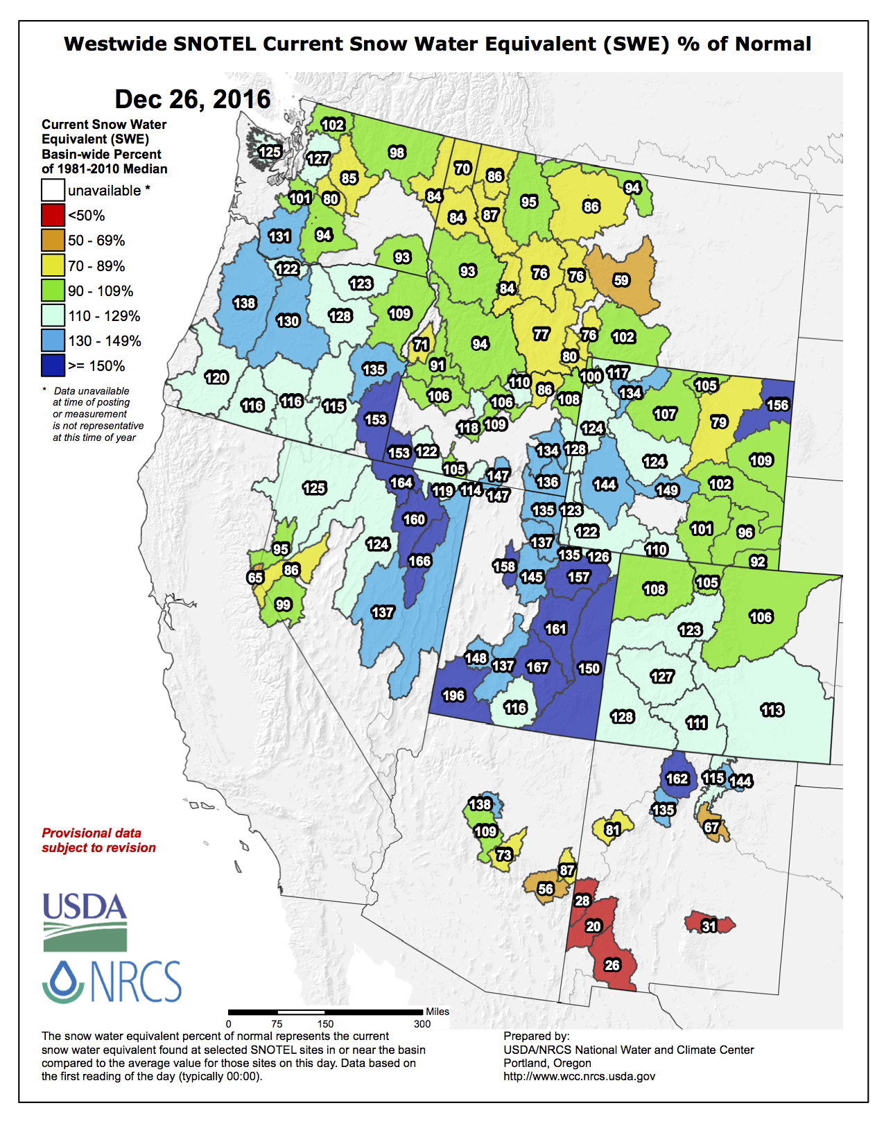
The Colorado agreement provides a path aimed at improving streamflow in the South Fork of the Republican, which flows through Cheyenne County in northwest Kansas. Included is a Colorado commitment to retire 25,000 more groundwater-irrigated acres to improve flows into Kansas, according to the Kansas Agriculture Department’s website.

The Nebraska agreement is billed to provide Kansas water users “much more certainty that there will be a viable irrigation supply during dry periods,” by delivering and storing “Compliance Water” to Harlan County Reservoir in southern Nebraska for Kansas irrigation use, the website reads.

Republican River Basin by District

#AnimasRiver: Public comments favor continued Cement Creek water treatment operations

The EPA's wastewater treatment plant near Silverton, Colorado, on Thursday, Oct. 16, 2015 -- photo via Grace Hood Colorado Public Radio
The EPA’s wastewater treatment plant near Silverton, Colorado, on Thursday, Oct. 16, 2015 — photo via Grace Hood Colorado Public Radio

From The Durango Herald (Jonathan Romeo):

Continued operations of the temporary water treatment plant north of Silverton received near unanimous support during a 30-day public comment period.

From Nov. 14 to Dec. 14, the Environmental Protection Agency accepted public comments on whether to continue operations at the plant that handles acidic discharges from the Gold King Mine.

The EPA previously announced it preferred that option while it continues to evaluate long-term options for the recently declared Bonita Peak Mining District Superfund site, which would address issues at 48 mining-related sites around Silverton.

The public comment period was part of a formal process to move the plant from “emergency removal action” funding to a “non-time critical removal action” funding, which is part of the Superfund process.

The agency received 12 submissions, mostly from government entities affected by the Aug. 5, 2015, Gold King Mine blowout, with only one resident weighing in.

The government entities in favor of continued operations included the Colorado Department of Public Health and Environment; the Colorado Attorney General’s Office; La Plata County; San Juan County; the town of Silverton; the Utah Department of Environmental Quality, and Congressman Scott Tipton.

Trout Unlimited, an environmental group, and Duranglers Flies and Supplies also voiced support for keeping the plant running.

While all the above-mentioned entities voiced support for continued operations, some suggested the EPA start treating discharges from adjacent mines, namely the Red & Bonita and Mogul mines, as well as the American Tunnel.

Others wrote that the EPA should secure a place to store the lime-heavy metal sludge byproduct of the treatment plant before committing to continued operation. The EPA has said it is searching for a long-term dump site…

A representative from Silverton Mountain Ski Area, which is about a mile and a half downstream from the water treatment plant, raised concerns about the treatment plant’s impact on ski operations.

The ski mountain’s chief operating officer, Tim Petrick, asked the EPA to consider installing better equipment for improved communications in the remote area, as well as perform dust suppression on County Road 110.

And a Castle Rock-based company called Jalema Technologies Ltd. that deals with mine wastewater treatment said the EPA could cut costs of operations “if a more studied plant design was implemented at the site.” The company then argued it had the technology to “produce higher quality discharge water for a cost similar to that shown for” the temporary plant, and offered its services.

One resident voiced support for the continuance of the plant, though the name was redacted.

Rebecca Thomas, EPA’s project manager for the Superfund site, said the agency will consider the comments and then make a decision through an “action memo.”

She expected the final decision to be issued in January.

Photo via the @USGS Twitter feed

http://www.reporterherald.com/news/ci_30684388/big-t-river-rehab-begin

Flood damage Big Thompson Canyon September 2013 -- photo via Northern Water
Flood damage Big Thompson Canyon September 2013 — photo via Northern Water

From The Loveland Reporter-Herald (Pamela Johnson):

This year, actual work will begin to repair habitat along and inside several stretches of the Big Thompson River through a grassroots group, The Big Thompson Watershed Coalition, that formed after the 2013 flood.

“2017 is going to be a big year for projects happening on the ground,” said Shayna Jones, watershed coordinator with the coalition. “We’re talking millions of dollars in river restoration.”

A couple of projects through the coalition have already begun, but several others are going to kick off in 2017. Early in the year, the coalition will put out bids for a contractor to work on a stretch about a mile long from Jasper Lake through Narrows Park, which is in the lower section of the canyon.

Estimated to cost $900,000, the project will include stabilizing sections of the banks, planting vegetation and creating what are called flood plain benches to allow the water space to spread out in the event of a future flood, explained Jones and Tracy Wendt, assistant watershed coordinator.

The work also includes improving fish habitat in several ways, such as building pools within the river and planting vegetation in strategic places to provide shade and cover.

“There will be habitat improvements for all different life stages of trout,” Wendt said. “It’s all the phases of their life to help them.”

Because of the fish habitat component, the coalition, in partnership with Rocky Mountain Flycasters, recently received a $4,500 grant from the Trout and Salmon Foundation. And the Flycasters, a local chapter of Trout Unlimited, also contributed $2,000 to the project.

The bulk of the funding, about $500,000, will come from the Natural Resources Conservation Service with the rest of the money from the Colorado Water Conservation Board, Jones explained.

This piece of the river winds through both private and public properties and ends just before the Narrows near the Colorado Cherry Company.

Other projects also are planned further west along the river with more money coming from the NRCS and the Colorado Water Conservation Board. The exact amounts of money and grants are still being finalized, though Jones did confirm the total work would be in the millions.

Other projects to rehabilitate the river and river corridor are occurring simultaneously including one that will begin in 2017 as a partnership with the coalition and Sylvan Dale Guest Ranch.

Work began in October and will continue this spring on West Creek, and other improvements began two weeks ago on Fox Creek. Both, located along the North Fork near Glen Haven, are being built in partnership with Larimer County, NRCS and the Colorado Water Conservation Board.

Also, Larimer County, private property owners, Colorado Parks and Wildlife and Colorado Department of Transportation officials are working on separate stretches of the river, with everyone working together for overall river benefit.

“We’re making sure our projects are complementing each other to make for an overall healthy watershed,” Jones said.

She expects the work to continue over the next three years as the Colorado Department of Transportation completes the permanent repairs of U.S. 34, which also include massive river restoration work.

#Snowpack news: Thanks, Ullr, all basins above 100% of normal

Click a thumbnail graphic below to view a gallery of snowpack data from the NRCS.

Here’s the Westwide Basin-Filled SNOTEL map from the NRCS.

Westwide SNOTEL basin-filled map December 26, 2016 via the NRCS.

Finally, here’s a look at the preliminary snowfall map from the Christmas widespread snowfall in Colorado from the NWS Pueblo office.

screen-shot-2016-12-26-at-8-20-36-am