The 2017 budget, as proposed by the finance department, is $31.06 million, a 2.5 percent decrease from last year’s budget, and a roughly 6 percent increase from the revised 2016 budget. That includes the general fund, enterprise funds and intergovernmental funds.
According to city manager Shane Hale, the 2017 budget includes funds that are being carried over from 2016 projects the city didn’t finish by year’s end. The new fiscal year begins Jan. 1.
The approved budget did not include new taxes or tax raises, and the city’s mill levy stayed at 1.21 mills per $1,000 of assessed value property…
The biggest fee increase came from the public works department, which proposed to increase water rates in 2017 by 15 percent. The base rate for a residential ¾-inch water meter will be bumped from $17.20 to $19.80 per month, and tap fees will go up from $4,190 to $4,819 for ¾-inch water taps. Johnson said the increase will help his department pay for several projects in 2017, including repairs on a major water line that pumps in water from outside the town.
“It’s an investment for our customers in their own infrastructure,” Johnson said…
Water: About $3.48 million has been budgeted for 2017, up from $3.28 million, an increase of 6.2 percent.
Lake Powell, shown here in 2008, serves multiple purposes. Photo/Andrew Pernick, U.S. Bureau of Reclamation — via The Mountain Town News
FromThe Grand Junction Daily Sentinel (Dave Buchanan):
Lake Powell, which helps moderate water levels in Lake Mead, acts as a “savings account” for the states in the Upper Basin of the Colorado River.
In the years when the Upper Basin can’t meet its water-sharing obligations as required in the 1922 Colorado River Compact, water is released from the Lake Powell “account” for Lower Basin use.
But what happens when that Lake Powell account is over-drawn?
One is the potential impacts of a declining Lake Powell is the potential impact on power generation.
If Lake Powell drops below 3,490 feet above sea level (on Oct. 28 the level was 3,611 feet or 58 percent full), there no longer is enough water in the reservoir to push through the eight giant turbines.
This potential shortage of power in the western grid would have to be covered by changes in power generation at Blue Mesa, Flaming Gorge and Navajo dams.
“The likely first trigger we run into, the first cataclysm, is Lake Powell reaching a level where” power is not being produced, said Chris Treece of the Colorado River District. “That has impacts to all the power customers and not getting that revenue from the power impacts us in Colorado and in Grand Junction in particular.”
According to the Bureau of Reclamation, Lake Powell each year averages $150 million in power revenue and makes enough electricity to power more than 320,000 homes. The federal endangered fish recovery program is funded by power revenues, as is the salinity control program in the Paradox Valley and the adaptive management program for the Grand Canyon.
According to the Department of the Interior, the Grand Canyon plan provides even monthly volume releases and allows experimental releases to restore sand features and key fish and wildlife habitat, increase beaches and enhance wilderness values along the Colorado River.
Plus, low levels mean not enough push to get the water through the tubes and into the lower river.
“And if we are not sending water through the turbines, just the bypass tubes, we are on a mathematical certainty that we will not be able to provide 8.23 (million acre feet) over the long haul, and won’t have enough pressure and size to push that quantity of water through the dam,” Treece said.
During her presentation earlier this month, Secretary of the Interior Sally Jewell said there is a “50/50 chance” the upper basin will see water shortage.
“Ten years ago most people were dismissing any chance of the Upper Basin having a water shortage or being out of compliance with the compact obligations,” Treece said. “Now, it’s pretty much widely accepted that it’s a probability greater than zero. And that’s a real significant change in the dialogue.”
DARCA’s 15th Annual Convention is just around the corner – February 15-17, 2017 – at the Sky Ute Casino Resort on the Southern Ute Indian Reservation in Ignacio.
A wide variety of speakers have been invited, and presentations include:
Transmountain Diversions – Compensating for the Impact
Climate Change Update
Colorado River Update
Oil and Gas Development – Water Quality and Ditches
Legal Update
Legislative Update
DARCA will be hosting a pre-convention tour on Wednesday, Feb. 15. A bus will be provided to take participants on the study tour to:
Animas La Plata Project
Ute Mountain Ute Tribe – Farm and Ranch Enterprise
Southern Ute Agriculture – Land Rehabilitation Projects
On the final day of the conference participants may choose among three concurrent workshops:
Workshop A: Planning Issues and Problems – Alternative Transfer Mechanisms (ATMs)
Workshop B: Working with Your New Neighbors
Workshop C: Ditch Companies and Drones
For information regarding convention registration as well as sponsorship or exhibitor registration opportunities please visit http://www.darca.org or contact me at (970) 412-1960 or john.mckenzie@darca.org.
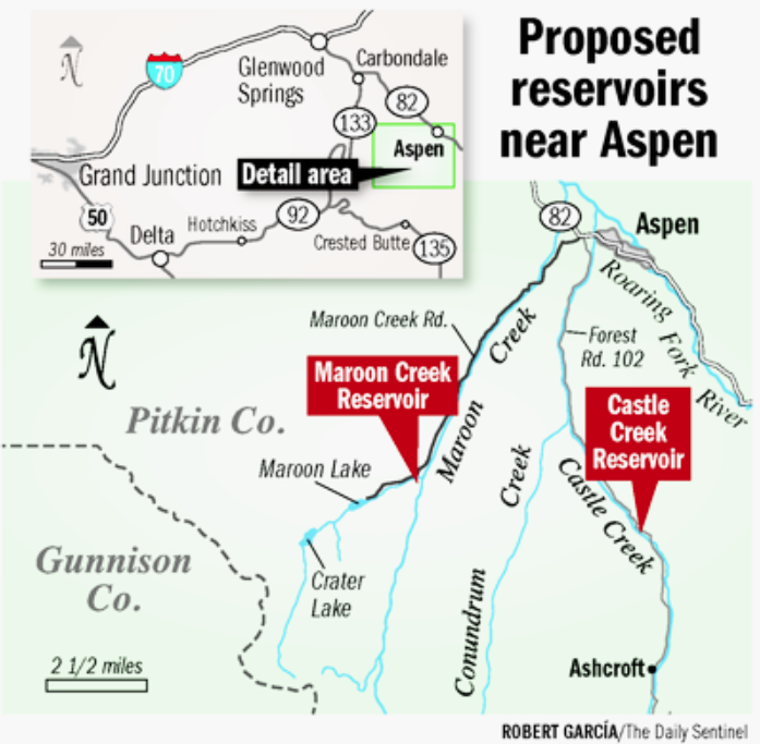
Harald Pabst, pictured in October 1965, who was elected mayor of Aspen in November 1964. Two months after this photo was taken, Pabst would sign the maps that created the conditional water rights for the Castle and Maroon creek reservoirs.
Editor’s note: The following is the first part in a series exploring the city of Aspen’s historic intent in filing for and maintaining conditional water rights for storage reservoirs on Castle and Maroon creeks.
ASPEN – Thursday will mark the date 51 years ago when two maps were filed with the state of Colorado by the city of Aspen, signaling the city’s intent to someday build two large dams and reservoirs on upper Maroon and Castle creeks.
It was on Dec. 29, 1965, that the maps pinpointing the location of the two potential dams, their height, and the size of the resulting reservoirs were filed with the state water engineer’s office. Aspen’s mayor at the time, Harald Pabst, signed both maps.
One map, in its notes section, described a 155-foot-tall dam within view of the Maroon Bells that would create a reservoir holding 4,567 acre-feet of water. The other map described a 170-foot-tall dam two miles below Ashcroft that would hold 9,062 acre-feet.
On Oct. 31 of this year, the city filed applications with the state to extend the conditional water rights for the two potential dams and reservoirs for another six years.
It was the ninth time the city has filed for diligence on the reservoirs since 1972. This was the first time the reservoirs were separated out into two applications, one for Maroon Creek Reservoir and one for Castle Creek Reservoir.
Pitkin County, American Rivers, and the U.S. Forest Service have all stated publicly they intend to file statements of opposition in the cases, which are being processed in Division 5 water court in Glenwood Springs, before the Dec. 31 deadline. Wilderness Workshop, Western Resource Advocates, and a property owner on whose land the Castle Creek dam would be built filed statements of opposition last week.
During deliberations this fall by Aspen City Council about the conditional water rights tied to the two dams, it sometimes sounded as if the current council members viewed the old water rights as orphans once left on the doorstep of city hall by distant strangers.
“As far as where the 150-foot-dam picture comes from, was that us, or someone else?” said Aspen City Councilman Adam Frisch during a Sept. 20 work session on the water rights. “All I know is 150 feet keeps on getting talked about in print from some very smart and well-meaning organizations, so I’m assuming it came from somewhere.”
David Hornbacher, the city’s director of utilities and environmental initiatives, confirmed for Frisch that the heights of the two dams — 155 feet tall at Maroon Creek Reservoir and 170 feet tall at Castle Creek Reservoir — came from the two maps signed by Aspen’s mayor in 1965 and filed with the Colorado state engineer’s office by the city’s consulting engineer.
“In 1965, maps were prepared,” Hornbacher said. “And those maps showed physically where these conditional water rights would be. It would show the depth. Based on the depth, what the volume of water is. So the height is directly off of that information that was filed back in 1965.”
And the rights have been nurtured ever since, although with a parenting philosophy that could be described as “benign neglect.” The city has never done a feasibility study for either dam and reservoir project. And yet, it has consistently told the state it intends to build both dams when needed.
Now at 51 years of age, it’s still not clear if the water rights will ever mature to fruition. But the city announced on Halloween it is still willing to care for them. And in so doing, the city once again told the state the dams are vital components of its integrated water system and that it will build the dams if it needs to, especially in light of climate change.
This detail from the 1965 map for Maroon Creek Reservoir shows the location of the reservoir, the height of the dam (155 feet), and the signature of the then-mayor of Aspen, Harald Pabst.
Council approved
The date of Dec. 29, 1965, is relevant because that’s the day the city filed official maps with the state engineer’s office in Glenwood Springs for the dams on Castle and Maroon creeks. The maps are clear and compelling, and include both the mayor of Aspen’s signature and that of Dale Rea, the city’s consulting engineer.
While the maps were filed in December 1965, the water right itself carries an earlier appropriation date of July 19, 1965. That’s the day on which the Aspen City Council confirmed staff’s initiative to have Rea locate the two dam sites and prepare maps to file with the state. That direction from the council is viewed as the first step taken under Colorado water law to create the water rights for the two dams.
John Kerrigan was the city manager, or administrator, in 1965 and he obtained the council’s consent for Rea to proceed, according to minutes from a regular city council meeting held on July 19.
Under a heading in the minutes of “Reservoir,” there is only a cryptic, and singular, note on the water storage projects. It says “Mr. Kerrigan said Dale Rea is preparing land filings on the reservoir.”
A district court judge would eventually make the rights official on Nov. 5, 1971, giving the conditional water rights their adjudication date. The process to adjudicate water rights often took years because the water court slowly reviewed large bundles of applications.
The Castle Creek Reservor, decreed in Civil Action 5884, was given Structure No. 589 and Priority No. 805. The Maroon Creek Reservoir, also decreed in CA 5884, was given Structure No. 590 and Priority No. 806.
Civil Action 5884 is a 242-page decree that earmarked priority numbers for a long list of other potential local reservoirs, including Ashcroft Reservoir, Pabst Reservoir, Snowmass Reservoir, and the Paepcke Forebay Reservoir on the main stem of the Roaring Fork River.
The rights to the Castle and Maroon reservoirs are the only significant conditional storage water rights decreed in CA 5884, in what could be considered “the class of 1971,” that are still being maintained today.
Rea, the consulting engineer for the city of Aspen, was from Littleton and he had spent 12 years with U.S. Bureau of Reclamation, mostly in Denver, before going out on his own to design and develop water systems for a number of growing Colorado cities.
In 1956 he was contacted by the city, which had just purchased a large portfolio of senior water rights on Castle and Maroon creeks from the Holy Cross Electric Association.
The rights were originally used to produce hydropower in the 1890s, with the water diverted from the two creeks and sent down wooden flumes to a knob of land on the hillside between the two creeks.
The lower end of the Castle Creek flume, about 1900. A water right to use 60 cfs of water in the flume dates to Nov. 16, 1885. The original claimant was the Castle Creek Water Co. Today, the water right is the city of Aspen’s most senior diversion right in its portfolio of water rights.
The 1956 water plan
By the mid-1950s, the city was also in the process of acquiring the assets of the Aspen Water Co., a private water company that had been struggling for years to provide the citizens of Aspen with a reliably clean supply of water.
Rea submitted a water plan on Aug. 17, 1956, that was designed to provide for the city’s water needs from 1957 to 1977.
“The report included requirements, supply, treatment, distribution, operation, maintenance, finance and revenue of a complete system,” the Aspen Times reported about Rea’s 1956 water plan. “It incorporates an estimated 1,700 to 3,500 permanent residents with provisions for transient populations of 5,000.”
Rea recommended that the city build a new water system using its senior water rights on Castle and Maroon creeks.
Rea’s 1956 report made no mention, though, of dams being necessary on either upper Castle and Maroon creeks, even up to 1977, to supply the city with adequate water.
Instead, Rea said there was “sufficient water” available from Castle Creek “without storage.”
“The city’s best water right is out of Castle Creek with priority No. 136a in the water district for 60 cubic feet per second (for) irrigation and domestic supply,” Rea wrote. “Therefore the city would have no problem on Castle Creek with respect to water rights or adequately [sic] of supply, as low flow records on Castle Creek indicate that the supply is more than double the future requirements of the city.”
Under the heading of “surface supply,” Rea declared, “Surface water supply in Aspen should be no problem, as Pitkin County probably has a greater run-off per acre than any county in Colorado.”
And under the heading of “reliability,” he noted that “in some communities severe drought conditions and underground pumping of individual development will gradually diminish the surface flow to a point where it is dangerous for a city to rely strictly on surface water flow. Fortunately this is not the case in Aspen, as the large drainage basin of each of the streams under study are sufficient to yield a continuous flow at all times.”
City Hall in Aspen in 1956 on an unpaved Galena Street. When engineer Dale Rea drafted a water plan for Aspen in 1956, the town was still a fairly quiet place.
Urgent water need
On March 5, 1959, Rea attended a special joint meeting of the Aspen City Council and the city’s new “utility advisory board,” which was to oversee the city’s new water and electric utility departments.
According to the Aspen Times the main agenda item was “how to get a safe water system in the quickest possible time in the most efficient way.”
Rea, the Times wrote, “told the assembled officials that the only logical source of water at the present time was Castle Creek. This is the only source on which the city owns adequate water rights.
“Following Rea’s report and a general discussion it was decided to take his recommendations drawing up the plans necessary to develop a state-approved system using Castle Creek as a source of water,” the Times reported.
Today, Castle Creek remains the city’s primary source of water.
On Oct. 12, 1959, Rea attended another meeting in Aspen, as city officials were wavering on their earlier decision to build their new system based on a supply of water from Castle Creek, and instead were thinking of using water from Hunter Creek.
“At Monday’s meeting, and at several previous meetings, engineer Dale Rea informed officials that additional water rights would be needed before Hunter Creek could be considered,” the Times reported. “The city already owns more than enough rights on Castle Creek to enable it to use that stream as the primary source for its system.”
The city owned, and still does own, two large water rights on Castle Creek, one dating from 1885 for 60 cfs and an 1889 right to 100 cfs. And it owns a right from 1892 for 65 cfs from Maroon Creek. On Colorado’s Western Slope, these are large, and senior, water rights and make the city the dominant rights holder on the creeks, and especially so on Castle Creek.
There was lot of construction underway in Aspen in September 1960, including trenching on Main Street in front of the Hotel Jerome to replace water pipes. Securing a reliable supply of treated water was on ongoing project in Aspen until at least late 1967.
The water council
In 1963 Harald Pabst ran for mayor of Aspen on top of a “clean sweep” ticket, and Aspen’s water rights and water delivery system was a campaign issue.
Pabst was the grandson of the founder of Pabst Brewery. He came to the Aspen area in the 1950s and bought a large swath of ranch land in the lower Snowmass and Capitol Creek valleys.
According to the Times, Pabst was “well known to Aspenites for his duties as administrative vice president of the Aspen Institute and director of the Aspen Skiing Corp.,” which was then a public company.
Each of the council candidates in 1963 laid out their campaign platforms in a front-page feature in the Times in October, and each of them addressed water.
In his candidate statement, Pabst said, “although the subject of Aspen’s water supply has probably received more attention than any other problem, there is still much dissatisfaction and uncertainty expressed by Aspenites.
“We feel that a thorough, factual re-evaluation of the water problem should be made, based on an inventory and analysis (volume, purity, etc.) of existing adjudicated water rights and related existing structures, cost of required improvements and new facilities, as well as operating costs.”
The balance of the 1963 “clean sweep” ticket in Aspen included Werner Kuster, the owner of the Red Onion bar and restaurant, Dr. Robert Barnard, who would go on to serve as Aspen mayor, Bill McEachern, and Dave Stapleton.
Aspen Mayor Robert (Bugsy) Barnard, right, at the Paragon bar in Aspen on Jan. 8, 1968, four years after he was elected to the Aspen City Council with Harald Pabst.
Risk of losing rights
Robert “Bugsy” Barnard, in his statement printed in the Times, said it was “difficult to understand how a city such as Aspen can be surrounded by four rivers and still be plagued with an insufficient water supply that requires rationing during the summer months and is frequently found to be contaminated by disease-producing micro-organisms. And all this in the face of extremely high water costs to the consumer.
“A further difficulty in the water situation lies in the fact that by ceasing to use any of the city’s surface water rights in the Roaring Fork River, Castle Creek or Maroon Creek, Aspen faces the serious risk of losing these water rights through non-use,” Barnard wrote, citing a concern that still exists in City Hall today.
The clean-sweep ticket did just that on Nov. 5, 1963, when 411 votes were cast, a record turnout for Aspen at the time. And so a new Aspen City Council was soon seated, and it had water on its agenda.
A crowd of people waiting next to a bus in Aspen in 1965. The bus says “Glenwood-Aspen Stage.” By the mid-1960s, Aspen was gaining in popularity among visiting skiers.
Updated water plan
In March 1964 the water-focused city council directed Rea “to investigate and draw up plans and specifications for a long range water plan,” according to the Times, and the next month Rea signed a new contract with the city to develop the plan.
In December 1964, nearly six years after his first water plan for the city, Rea submitted a “water supply and development feasibility study,” and this time he declared that water storage would be necessary to meet future needs.
“The ultimate density of the entire Aspen valley from the lower end of the airport to the originally proposed Aspen Dam on the Roaring Fork is 65,980 people,” Rea wrote. “The water use for this population is estimated at 28 million gallons per day; to supply this water it will be necessary to construct dams on both Castle Creek and Maroon Creek and possibly Hunter Creek.”
Today, the peak-population day of about 35,000 people in the city’s water service area typically comes on July 4, and the city’s water treatment plant has a current capacity of 20 million gallons per day.
“It is estimated that this population could be reached in about 40 to 50 years which is not too long to plan a water system,” Rea added. “At that time, the total estimated flows of Castle Creek and Maroon Creek will be needed to supply Aspen’s need of about 28 million gallons per day.”
Rea then recommended to the council “that dam and reservoir sites be selected on Castle Creek and Maroon Creek and filings for their use be made with the state engineer.”
“In order to expand the supply in these two creeks, large storage reservoirs can be constructed, one on each creek,” Rea also wrote.
These are apparently the first calls in a city plan for reservoirs on Castle and Maroon Creek, and they appear to be based on an overly large population forecast.
Even Rea acknowledged in his 1964 report that his population projection was “on the optimistic side and ‘good times’ will have to remain if the projection is to be realized.”
Rea also wrote that one of the purposes of the report was to “project the growth of the community to require the full development of the city’s water rights.”
And he recommended, “any surplus water rights from the proposed development of these sites be sold to prospective downstream users,” suggesting there would, in fact, be “surplus water” from the reservoirs.
Rae’s 1964 report, and its recommendations to build reservoirs, resonated with the city council led by Mayor Pabst.
Rea would later testify that his report to the council “resulted in the making of claims of the city to the state engineer for reservoirs … to supply the city of Aspen in the foreseeable future.”
John Kerrigan, the Aspen city manager, or administrator, in 1965. He appears to be standing outside of the Wheeler Opera House and holding a button that says, for some reason, “There is no Aspen.”
Council takes the plunge
On July 22, 1965, Rea sent a letter to city administrator Kerrigan laying out a scope of work to begin investigating aspects of Aspen’s long-range water supply system, including the two reservoirs.
The letter laid out plans for locating a “large storage reservoir” on both Castle and Maroon creeks.
“Field work for preliminary filing could be done before snow falls if authorized at once,” Rea wrote, and noted, “This project has been discussed with the state engineer and it meets with his approval.”
And Rea wrote two of the more intriguing sentences in the available historical record about the value of filing for the storage rights.
“We believe these filings will greatly enhance your water rights,” Rea told Aspen’s Kerrigan. “Further, in the case of Castle Creek, the need may not be too far in the future.”
The city council of 1965 would affirmatively vote on their intent to file for water rights on the dam sites at a council meeting on Aug. 2, 1965.
On Sept. 1 Rea began working in the field to survey the locations for the two reservoirs. And it appears from the historic public record that it was Rea, and Rea alone, who determined where the two potential dams should be built and how big they should be.
On Dec. 6, with Rea’s work in the field complete, the city council was informed that the required maps for the upcoming water rights filing would be signed by Mayor Pabst.
The minutes of the meeting state: “Filings on Maroon and Castle Creek: Mr. Kerrigan referred to filings on Maroon and Castle Creek – maps to be signed by mayor and city clerk and sent to Dale Rea to be filed with state engineer.”
And sometime before Dec. 29, when the maps for the two reservoirs were were duly filed with the state engineer’s office, both Rea and Mayor Pabst signed the maps.
The 1965 map for the Maroon Creek Reservoir shows a dam across Maroon Creek, just below the confluence of East and West Maroon creeks. The note on the map says the height of the planned dam is 155 feet, the resulting reservoir’s capacity is 4,567 acre feet and the estimated cost of the project was $770,000.
The map for the Castle Creek Reservoir shows a dam across Castle Creek, between Fall and Sandy creeks. The notes on the map say the height of the dam is 170 feet, the capacity 9,062 acre-feet and the cost is $790,000.
A detail of a map showing the potential Paepcke Forebay, formed by a 150-foot-tall dam across the main stem of the Roaring Fork River. Note airport runway to left of map, indicating dam would be just above Shale Bluffs in a deep narrow canyon.
Dam the Fork?
Before Aspen filed for the maps describing the scope and scale of the dams and reservoirs on Castle and Maroon, it also investigated the idea of building a large dam across the main stem of the Roaring Fork River.
In March 1963, the city council directed staff to continue investigating the feasibility of building a dam on the main stem of the Roaring Fork River, at a deep and narrow part of the river between the airport and Shale Bluffs. The location, notably, was below the confluences of both Castle and Maroon creeks.
The council discussion was labeled in the minutes from March 18, 1963, as “feasibility – water rights use.”
“Discussed – water rights – and council directed that the city administrator continue the investigation of the feasibility of using the water rights owned by the city of Aspen from Hunter Creek, Maroon Creek, Castle Creek, the Roaring Fork River and other tributary sources, at a point on the Roaring Fork River … ,” the minutes state.
And in September 1963, the council took another step toward a potential dam on the Roaring Fork.
The minutes of a regular council meeting, under the heading, “Water – utilization program,” state, “[City] Attorney Stewart and council discussed plans for definite utilization of water and water rights. Point of diversion this side of Shale Bluffs. Dam for power, irrigation, flood control and recreation. A feasibility report is to be considered this fall, and the engineer should establish 2 to 3 damsites, and prepare plans.”
The council then voted unanimously on a motion to “conduct investigation to determine the places of potential damsites on the mainstem of the Roaring Fork River below Aspen” and to file a map and claim statement with the state engineer.
Three years later, in April 1966, the Colorado River District, not the city of Aspen, filed a map with the state that included a 150-foot-tall dam across the Fork.
The potential dam was now part of the Snowmass Project, and the resulting reservoir, which could hold 4,760 acre-feet of water, was called the Paepcke Forebay.
A pipeline, called the Gerbaz Conduit, was to run from the Paepcke Forebay to Watson Divide and Snowmass Creek. Water was to then to be sent down the creek and collected again in the Pabst Reservoir, which was to hold 73,645 acre-feet of water behind a 290-foot dam on lower Snowmass Creek. By comparison, Ruedi Reservoir holds about 102,000 acre-feet of water.
Water from the Pabst Reservoir was then to run down the last part of the creek to a hydropower plant at the confluence with the Roaring Fork, in what is now Old Snowmass.
The conditional water rights for the Snowmass Project would go on to be cancelled by a water court judge for lack of diligence in 1979, mainly because the Paepcke Forebay on the Roaring Fork would have flooded the site of the wastewater treatment plant operated by the Aspen Consolidated Sanitation District, and the project stalled.
So as it turned out, the city of Aspen’s efforts to build a dam across the main stem of the Roaring Fork would not result in concrete ever being poured. And perhaps the councils of the early 1960s sensed such a plan might never come to fruition.
Next up in the series: The city of Aspen defends the conditional water rights in court as its consulting engineer calls for more study of the dams and reservoirs.
Editor’s note: Aspen Journalism, the Aspen Daily News, and Coyote Gulch are collaborating on coverage of rivers and water. The Daily News published this story on Monday, Dec. 26, 2016.
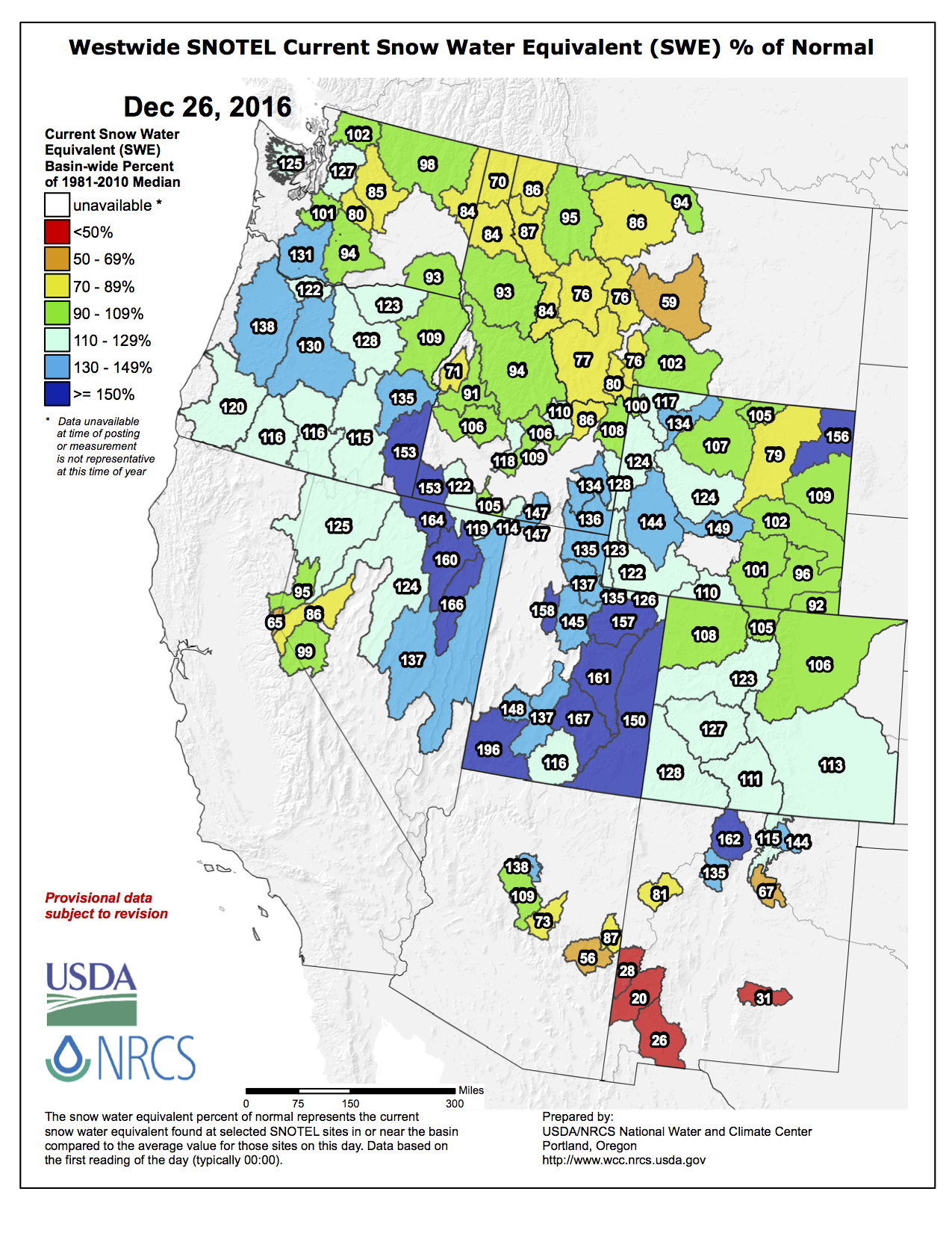
Fall 2016 was a great lesson in patience for snow lovers across Colorado.
For weeks it seemed like the snow would never fly as unseasonably warm and dry weather gripped the region. Adding to the somber mood was the forecast for a La Niña winter, which is a weather pattern that can sometimes steer the main storm track away.
But as soon as the calendar flipped to December the weather pattern changed and nature’s snow machine came to life…
[Statewide snowpack] rose to over 6 inches in just three weeks. Every major river basin went from well below average to well above.
Colorado has roughly four months left in the snow accumulation season with March and April being very important as spring storm systems cross the Central Rockies.
Lake Havasu is a large reservoir behind Parker Dam on the Colorado River, on the border between California and Arizona. Lake Havasu City sits on the lake’s eastern shore. Photo credit MyGola.com
Lake Mead’s water levels this year fell to a near all-time low in the midst of a 16-year drought throughout the Southwestern U.S., prompting discussion at a national conference last week.
The Colorado River Water Users Association met [December 14-16, 2017] in Las Vegas for an annual conference, where guests — including Arizona Gov. Doug Ducey and Colorado Gov. John Hickenlooper — discussed the need for conservation efforts and governance of the Colorado River’s water supply. Ducey and Hickenlooper hosted a question-and-answer session with the U.S. Chamber of Commerce last Monday, in which both agreed that water is an issue that “transcends partisan politics.”
According to the Arizona Department of Water Resources, Arizona and California are negotiating the terms of a contingency plan to protect Lake Mead, a final agreement is still pending.
“This plan is a way to delay and maybe thwart shortage declarations with the most important aspect of California agreeing to take shortages after Lake Mead reaches particular elevations,” said Lake Havasu City’s Water Resources Coordinator Doyle Wilson. “Since the plan has not yet been approved by all parties, details are uncertain.”
Havasu receives an allocation of about 28,000 acre-feet of water per year from the Colorado River. Havasu uses about half that amount. If a water shortage were declared, the city would be required to use 20 percent less than its currently-allocated amount. According to Lake Havasu City officials, the city would be in no immediate danger in the event of a shortage. Havasu’s pending effluent water project is will provide reused water to city parks, further progressing the city’s conservation efforts.
“A combination of projects and programs have helped to educate the community on conserving water and have resulted in real water use efficiency at both the personal and citywide levels,” Wilson said. Havasu residents have used low water-use faucet and shower heads, geyser stop devices for irrigation systems, and have received rebates for water conservation.
“Over the years, the combined activities, along with the acknowledgment that the winter water averaging strategy for setting monthly sewer rates has lowered the city’s overall water consumption,” Wilson said.
In Havasu, total water consumption has more than halved in the past thirty years. In 1985, water consumption peaked at more than 450 gallons daily per capita. As of 2015, Havasu’s total water consumption was recorded at about 175 gallons per capita, daily, and trending even lower. Residential water consumption in Havasu was recorded at about 130 gallons per capita, daily.
Conservation efforts continue statewide, according to Arizona Department of Water Resources spokeswoman Michelle Moreno.
“As a state, we’re more efficient in water conservation,” Moreno said. “We use less than we did in the 1950s, despite a 600-percent population increase, in part because of our conservation efforts.”
Arizona regulates water use on an industrial level, maintaining mandatory conservation while allowing providers to educate customers in conservation efforts. Some water providers offer rebates to customers for efforts to conserve water at home.
The Central Arizona Project is continuing to lead conservation programs to prevent a shortage in 2018, according to the Department of Water Resources, but the risks of another shortage are expected to increase from 2019-21.
Stakeholders in the Lower-Basin Colorado River expected this year’s conference to focus on agreements associated with the Drought Contingency Plan, which would revise water conservation efforts and restrictions in the event of a water shortage. Stakeholders also expected announcements involving an agreement on water rights and restrictions between the U.S. and Mexico. No such announcements came, which could hold consequences for Lake Havasu City, as well as the American Southwest.
The situation in Lake Mead is only projected to become worse, according to the U.S. Bureau of Reclamation. Lake Mead’s surface now rests at about 1,077 feet above sea level, and Bureau of Reclamation officials say there is a 54 percent chance that the lake will fall below 1,075 feet in 2017.
Lake Mead’s water levels are measured every August, and the results of that month’s measurement will determine if cuts will need to be made, according to the Arizona Department of Water Resources. If Mead’s water level falls below 1,075 feet above sea level in August 2017, Arizona water providers will be forced to reduce their water usage by 192,000 acre-feet until August 2018, according to new proposed guidelines. Nevada would similarly have to reduce water usage by 8,000 acre-feet per year, while California would not be required to make reductions at all.
Arizona, California and Nevada each have an interest in maintaining Lake Mead’s water levels. Mead represents one of the two largest reservoirs in the Colorado River system, and directly affects the supply of river water to all three states. Federal agencies measure Lake Mead’s water levels to determine whether a shortage should be declared on the Colorado River. If such a shortage were declared, California would be asked to make significant cuts to its water usage.
Arizona, California and Nevada are negotiating the terms for their proposed “Lower Colorado River Basin Drought Contingency Plan,” which would revise 2007 water restriction guidelines among the three states. According to the 2007 guidelines, Arizona would make the bulk of reductions in the event of a shortage, despite consuming less than either of its neighboring states. California, however, would never face water restrictions, no matter how low the water levels become at Lake Mead.
The Colorado River provides water to 13 percent of America’s population. More than 40 million people rely on the river, but water shortages have exposed a need for changes in water use and policy. According to this month’s Arizona Department of Water Resources Drought Index, Southwestern Arizona continues to undergo severe drought conditions and the Havasu region is beginning to experience an “abnormally dry” season.
As negotiations continue between Arizona, Nevada and California, the Department of Water Resources says the next steps for its “Lower Colorado River Basin Drought Contingency Plan” discussions will include continuing to assess potential impacts on the southwest.
Site map for the proposed reservoirs on Castle and Maroon creeks via Robert Garcia and The Grand Junction Daily Sentinel.
FromAspen Public Radio (Elizabeth Stewart-Severy):
The deadline to file a formal objection is the end of the month, and Matt Rice, the Colorado River basin director for American Rivers, thinks the public needs to better understand what these conditional rights actually mean.
“Conditional water rights can only be used for one thing, one thing alone right now, and that is to fill a 170-foot dam on Castle Creek and a 155-foot dam on Maroon Creek,” Rice said.
He said conditional rights do not protect the creeks from another entity filing for claims on that water, and such claims from government officials are misleading.
“Those water rights … can not be swept up by some other entity,” Rice said. “At one point there were hundreds of conditional water rights throughout the state and many have been abandoned in recent years by entities like the Colorado River District and Denver Water with absolutely no consequences.”
This is the first time that the city will face opposition as it files to keep the conditional water rights, which the municipal government has owned since 1971.
FromThe Grand Junction Daily Sentinel (Katie Langford):
Even before he designed lightweight, biodegradable water pouches, local inventor and entrepreneur Tim Huff had his eyes on a much bigger project.
As the founder of Palisade-based company Colorado Clear, Huff has always dreamed of a way to provide clean water in large quantities to those who need it the most, whether they’re people living in an impoverished country or a disaster-stricken community.
“The logistics of shipping water is horrible,” Huff said. “Water weighs an exorbitant amount.”
It takes semitrailer after semitrailer to bring enough clean water to communities in need, and the waste that’s left behind stays in landfills for hundreds of years.
And even with a water filtration plant built in a community, people might not have sterile containers to haul and store the water safely.
What people really need, Huff said, is an all-in-one water purification and bottling system — a system that will purify water on site, then put it into sterile containers that won’t overwhelm landfills. The system needs components that are small enough to be hauled in a standard pickup or airplane, yet hefty enough to purify and bottle thousands of bottles of water in a day.
Huff didn’t see anything like that on the market, so he created it.
Huff and the Colorado Clear team finished their first model in November and have since received calls from across the country and the world. From Flint, Michigan, to Ghana, governments and organizations are asking for one of Huff’s systems.
Some can pay for it out of pocket, but many others can’t.
People desperately need clean water, Huff said, and he’s looking for public and private investors to bring it to them.
“We want to get the word out to the right people in government or the (non-governmental organizations) who are willing to back this and get this technology out to the people,” Huff said. “It’s something that the world needs.”
It’s also something Mesa County needs, because Huff said he is committed to manufacturing his product in the Grand Valley.
The first mobile purification and bottling system was almost entirely sourced from nine local companies.
“Our goal is to have a global solution for this problem but at the same time put our community back to work with something that is a year-round need, globally,” he said.
While he’s happy that his biodegradable water “amphoras” will mean less trash in the world, Huff said he’s more focused on the people who die every day because they don’t have access to clean water.
“It’s more important to us, getting safe water to people,” Huff said. “I think that’s a bigger issue.”
More than 70 percent of Latino voters are deeply concerned about the environment and how it affects their families. That’s according to a new Latino Decisions poll, which found over 90 percent of Latino Coloradans want the President-elect and new Congress to fight climate change.
Dominick Moreno, incoming Colorado Senator for Adams County, said he isn’t surprised by the poll results.
“The Latino community, I think, in Colorado really cares about the environment, cares about climate change and doing something about that, and is generally, I think, more environmentally sensitive to these issues,” he said.
He added that the survey confirms Latinos are an increasingly important voting bloc and are willing to take their convictions into the voting booth. In Colorado, 96 percent of Latinos surveyed said they support candidates who work to protect public health by limiting air pollution.
Nationally, Latino Republicans were less enthusiastic than Democrats about the need for action on climate change, but more than 60 percent agreed it’s an important issue. Over 90 percent want more clean-energy development.
Senior analyst of Latino Decisions, Edward Vargas, said these voters care about the environment because Latino communities are disproportionately affected.
“We tend to reside and live near environmental dump sites, factories; Latinos are also more likely to be working in the fields,” he explained. “So, I think this is just a reflection of where we live and where we work is impacted by the environment.”
Moreno said he’s confident the Latino community will keep a watchful eye on the Trump administration and Congress in case they try to reverse progress on climate change or let energy producers off the hook.
“You’re going to see them really, I think, rise up and say that we’re not going to accept the status quo, that we’re not going to accept halting the work that we’ve already done to make sure that, no matter where you live, that you have access to clean air and clean water, and outdoor recreation,” Moreno added.