During recent testing mandated by the Colorado Department of Public Health and Environment at 20 different sites earlier this year, the town discovered that seven had lead levels in excess of the state’s maximum allowable limit of 15 parts per billion. The finding comes just months after Frisco discovered a similar issue in their sampling pool.
Dillon officials stress that the town has good, clean surface water.
“We don’t have lead in our source water,” said Scott O’Brien, Dillon’s public works director. “We’ve monitored for that, and it’s not the issue. … The issue is the materials that were used prior to 1987 for constructing homes, copper pipe with leaded solder. In addition to that, a lot of fixtures like faucets were constructed with either brass or bronze — metal alloys that contain lead.”
O’Brien said that because the source water is so “aggressive,” it’s leeching the lead out of older pipes and fixtures at testing sites, resulting in the elevated rates. In determining aggressiveness, the town looks at four main factors: pH levels, alkalinity, temperature and hardness.
The pH level in the water measures how acidic or basic the water is on a scale of 0 to 14 — anything below 7 is considered acidic, and anything higher is considered basic. In general, high acidity means the water is more corrosive, and more likely to leech metal ions like lead and copper. Dillon’s source water is naturally about 7.3, or slightly leaning towards the basic side.
Alkalinity is a measure of the buffering ability of the water, essentially the ratio of hydrogen ions versus hydroxide ions that determines the water’s ability to neutralize acid. O’Brien noted that Dillon’s water has low alkalinity. Temperature is self-explanatory, literally describing how hot or cold the water is — wherein hotter water is more reactive and aggressive than cold water. Hardness measures the mineral concentration in the water, or what it’s naturally picking up as it flows along. Because Dillon uses its source water so quickly, it is relatively soft.
“We’re the first in line to pick it up, and it doesn’t have the chance to pick up these other minerals and other things that help reduce the aggressiveness of the water,” said O’Brien.
This is a problem that Dillon has dealt with in the past. The town’s testing also returned high lead levels in both 2012 and 2014, and officials have been working with the state since to address the issue. In 2014, the town attempted to adjust the pH levels up to about 8.5 on the scale, which appeared to have worked over the last five years. Though, due to recent changes in regulations from the state level — which essentially requires towns to zero in on high-risk testing sites to determine the worst-case scenarios for water quality issues — new issues are being discovered.
“To get a representative sample pool they don’t want us to go over the distribution system geographically, and sample it spread out,” said Mark Helman, chief water plant operator. “They want us to sample these particular sites built from 1983 to 1987 (before the Lead Contamination Control Act in 1988) they know are going to give us the worst results. … This is a process of us learning where the worst sites are that we have, testing those sites, seeing how our water is doing at those sites, and if we have a problem we want to address the worst case scenario.”
Both O’Brien and Helman noted that they already have a plan to try and address the issue of overly aggressive water. The plan is to add soda ash — sodium carbonate or baking soda — during the water treatment process to increase pH levels, alkalinity and hardness to the water to reduce aggressiveness. However, because it includes changes to the plant, the new process must first be signed off on by the state.
O’Brien said that once the state approves the town’s new water treatment methods they’ll be able to implement the new process quickly, though the review process could take between 30 and 60 days.
From the Water Education Foundation (Gary Pitzer):
Western water in-depth: talks are about to begin on a potentially sweeping agreement that could reimagine how the Colorado River is managed
Lake Mead, behind Hoover Dam, shows the effects of nearly two decades of drought. (Image: Bureau of Reclamation)
Even as stakeholders in the Colorado River Basin celebrate the recent completion of an unprecedented drought plan intended to stave off a crashing Lake Mead, there is little time to rest. An even larger hurdle lies ahead as they prepare to hammer out the next set of rules that could vastly reshape the river’s future.
Set to expire in 2026, the current guidelines for water deliveries and shortage sharing, launched in 2007 amid a multiyear drought, were designed to prevent disputes that could provoke conflict.
Those guidelines have been successful so far and the drought plan — signed March 19 — is expected to help. But as the time for crafting a new set of rules draws near, some river veterans suggest the result will be nothing less than a dramatic re-imagining of how the overworked Colorado River is managed to ensure its very survival as a source of water for 40 million people from Wyoming to Mexico.
Negotiators will face some daunting challenges: Under the 1922 Colorado River Compact that divided its waters among the states, more water has been promised to users than the river carries in an average year. A two-decade drought has amplified the shortfall, particularly in the main reservoirs serving the three Lower Basin states of Arizona, Nevada and California and the country of Mexico. Scientists believe climate change is likely to make things worse.
There are other issues. The Upper Basin states of Wyoming, Utah, Colorado and New Mexico, which have never used their full apportionment of the river’s waters, have their own ambitions for growth. The Lower Basin states are drawing on Lake Mead faster than it can be replenished — creating a so-called structural deficit. Native American tribes throughout the Basin, many of whom have priority rights to the river’s flow, are increasingly expected to assert those rights. And in southeastern California, there’s general agreement the ailing Salton Sea will need to be addressed.
Addressing the Structural Deficit
Resetting how the river is managed is critical because of the fear surrounding the once-unthinkable scenario of Lake Mead, the nation’s largest reservoir that sits near Las Vegas, falling too low to function as a water supply reservoir and hydropower producer.
Pat Mulroy, a senior fellow at the University of Nevada, Las Vegas’ Boyd School of Law and the former longtime general manager of the Southern Nevada Water Authority, is an advocate for extensively rethinking how the Colorado River is managed. (Image: University of Nevada, Las Vegas’ Boyd School of Law)
“There are some real serious issues that the next seven years have to address or there won’t be a continuation of the next chapter of the 2007 agreement,” Pat Mulroy, the former longtime general manager of the Southern Nevada Water Authority, said in late March at the Lincoln Institute of Land Policy’s Future of Water conference in Phoenix. “The structural deficit has to be addressed. Period. End of conversation.”
Solving the structural deficit could require some unconventional and controversial aspects, such as allocating water evaporation in Lake Mead (about 600,000 acre-feet annually) among the Lower Basin states.
“Those are the things that we need to look at now because we have the opportunity and space to do that creative thinking,” Anne Castle, former assistant secretary for water and science at the Department of the Interior, said at the Phoenix conference.
The evaporation allocation could be justified because the Upper Basin bears its own evaporation from Lake Powell (about 386,000 acre-feet annually), meaning that in order to deliver the requisite 8.23 million acre-feet annually to the Lower Basin, more than that has to be stored in Lake Powell to account for evaporation.
Mulroy, now a senior fellow at the University of Nevada, Las Vegas’ Boyd School of Law, said all options must be on the table during upcoming talks. The 2007 guidelines and Drought Contingency Plan, she said, are “Band-Aid” approaches that do not provide a foundational structure for resilience.
“We can’t go on the way we are,” she said. “Are we willing to sit here and say we are going to work from the premise that our Upper Basin neighbors are never going to develop their supply? It’s not a safe assumption, it’s not logical and we can’t continue to work from that.”
She stopped short, however, of advocating a reopening of the 1922 Colorado River Compact that divided its waters, calling such an effort a “a fool’s mission.”
Indeed, water supply development in the Upper Basin is happening through efforts such as Utah’s proposed pipeline from Lake Powell to St. George in the southwest corner of the state. The 139-mile pipeline would pump about 86,000 acre-feet of water annually from Lake Powell to Washington and Kane counties. The Upper Colorado River Commission estimates that Upper Basin use, currently about 4.5 million acre-feet, will reach about 5.4 million acre-feet by 2060.
“The Upper Basin has the prerogative to develop its allocation and we are starting to see that, and when that occurs it’s going to make that whole issue of the structural deficit even more complicated,” Amy Haas, executive director of the Upper Colorado River Commission, said in an interview. She is especially concerned because while the Upper Basin has been providing more than its share of water to the Lower Basin, the elevation at Lake Mead continues to fall.
Jim Lochhead, longtime chief of Denver Water, said in an interview that demand for water in the Upper Basin has actually been relatively flat the past 30 years. But the combination of the structural deficit and warming conditions means the system “isn’t adequate to meet today’s demands.”
Meanwhile, there is an increasing body of scientific evidence pointing to a warmer and drier basin on a scale previously unseen. In 2018, a report authored by climate scientists Brad Udall, Mu Xiao and Dennis Lettenmaier reported that between 1916 and 2014, streamflow in the Upper Colorado River Basin declined by 16 percent and that “pervasive warming” has reduced snowpack and contributed to the long‐term decline of runoff.
The structural deficit refers to the consumption by Lower Basin states of more water than enters Lake Mead each year. The deficit, which includes losses from evaporation, is estimated at 1.2 million acre-feet a year. (Image: Central Arizona Project)
The gravity of the situation – drought and an overallocated, drying basin – pushes people to confront the reality of what’s before them.
“I think folks need to have a real unvarnished conversation about what the shared vision of the basin looks like,” Chuck Cullom, Colorado River Program Manager with the Central Arizona Project, said in an interview. “That conversation … has to include the aspirations of all the water users as well as a recognition that it’s a shared system that benefits all the water users from Mexico to the headwaters in Wyoming and Colorado.”
‘Focus on Risk and Vulnerability’
Analysis of tree ring data shows that drought has frequently occurred in the Colorado River Basin. A 60-year period during the mid-1100s was marked by a 25-year stretch when river flow averaged 15 percent below normal, according to the University of Arizona.
More recently, the system has been shaken by a chronic two-decade drought that saw Lake Mead drop to its lowest level ever in July of 2016. According to Reclamation, the combined storage of Lake Powell and Lake Mead is at its lowest point, 39 percent of capacity, since Powell began filling in the 1960s. A wet winter this year has helped, but there is no guarantee that the reservoirs will ever be full again.
Cullom said that Lake Mead’s precipitous decline will provide those working on the 2026 guidelines with the “visceral experience” and “emotional clarity” of knowing the possible extremes that are lurking.
“The drought has caused everyone to focus on risk and vulnerability in a way that we didn’t in the 2007 guidelines,” he said.
While water managers and policymakers crave certainty, precision and specificity don’t exist when the climate change variable is added to an already volatile Colorado River Basin. That doesn’t mean, however, that plans can’t be made.
“We cannot tell water managers what the future will look like, but we do understand the trends,” Kathy Jacobs, director of the University of Arizona’s Center for Climate Adaptation Science and Solutions, said in Phoenix. “If water managers understand the trends, they can make decisions.”
‘Tethered to the Salton Sea’
An unavoidable part of the conversation is the fate of the Salton Sea, California’s largest lake and a haven for waterfowl on the Pacific Flyway that is receding, exposing a playa that generates swirling dust storms that pose a public health risk. Created more than a century ago by flooding from the Colorado River, the sea in southeastern California is in crisis as it slowly dries up, due in part to water transfers to San Diego. Officials for years have sought a Salton Sea solution that preserves it as a habitat for birds and fish while minimizing its negative impact to air quality.
The Imperial Irrigation District’s insistence that the Drought Contingency Plan include $200 million for the Salton Sea (which was not authorized) ultimately resulted in the district’s exclusion from the drought plan as other stakeholders pushed to get it signed.
“The challenge we see on the river is, we’ve got everybody hooked into a smaller but sustainable Salton Sea. But evidently everybody outside of California is focused on a smaller sea, not the sustainable part,” Tina Shields, Imperial’s water manager, said in an interview.
Imperial in April filed suit to halt the Drought Contingency Plan, asking for a thorough analysis under the California Environmental Quality Act of the plan’s impact on the Salton Sea. The episode reflected Mulroy’s view that deciding what to do about the Salton Sea has to be a part of the future discussions.
“Nothing can happen on the river, whether it’s exchanges, whether it’s conservation, that doesn’t inevitably affect the Salton Sea,” she said. “We are all tethered to the Salton Sea.”
Seeking Lasting Solutions
Complicated, multi-stakeholder agreements regarding Colorado River water use are tough enough in the best of circumstances. Add in more extreme drought, tribal access to long-held water rights and the uncertainty of the river’s sustainability and it’s clear finding a long-lasting solution will not be easy.
Terry Fulp, director of the Bureau of Reclamation’s Lower Colorado Region, reminded the audience in Phoenix that measures such as voluntary reduction agreements and new operating guidelines are intense and complicated processes that require deliberation and patience.
“It took us 2,090 days to set up the [drought plan],” he said. “These are really hard things.”
Lochhead, the Denver Water CEO, echoed that view, noting how difficult it was to reach agreement on the Drought Contingency Plan. Renegotiating the 2007 guidelines by 2026, he added, is going to be far more challenging — “maybe a circus isn’t quite the right word, but not far from it.”
Despite this winter’s snowpack, experienced people know that hard times can be right around the corner. Near-crashing conditions in the early 2000s served as the catalyst for interstate discussions that resulted in the 2007 Interim Guidelines.
That agreement was a significant achievement because it encouraged users to leave water in Lake Mead to shore up its surface level.
“Despite 12 years of dry conditions since the guidelines were put in place, there have been no shortages on the Colorado River because of the incentives to store water in Lake Mead,” said Bill Hasencamp, manager of Colorado River resources with the Metropolitan Water District of Southern California, which provides water for more than 19 million people. “Additionally, those guidelines have provided Metropolitan flexibility to fill its Colorado River Aqueduct during California’s record drought, which has been critically important to our region.”
There is general agreement that what happened in 2007 was but a step in the continuing evolution of river management.
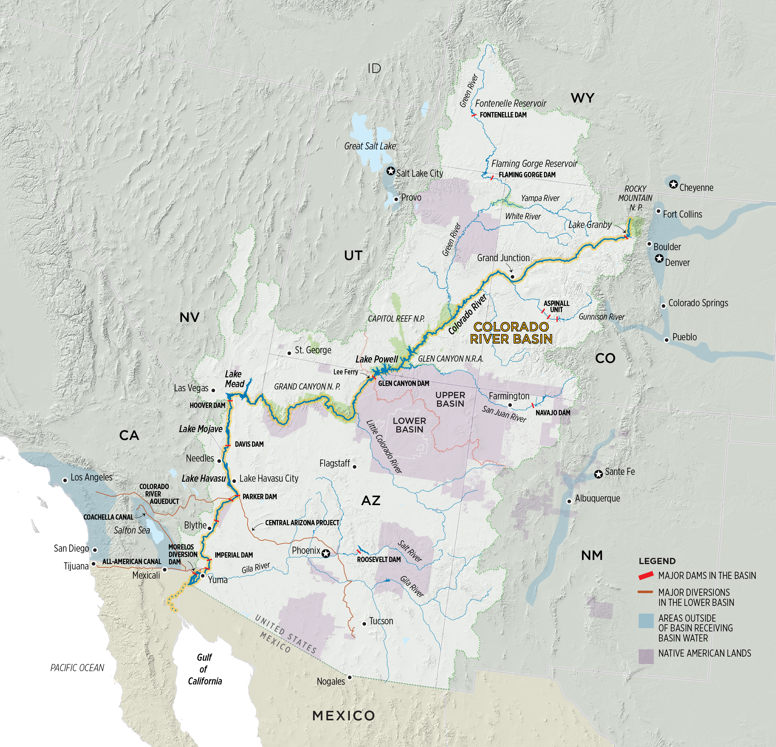
Colorado River Basin. Graphic credit: Water Education Colorado
“The 2007 guidelines were put in place for a certain amount of time and that’s because we had to learn about the system,” Reclamation Commissioner Brenda Burman said in Phoenix March 19 at the signing of the Drought Contingency Plan. “What we learned was that it wasn’t enough. The risk we expected in 2007 increased four times between then and now.”
While the 2007 agreement provided a framework for getting water users through tough conditions, more action is needed beyond conservation, Mulroy said.
“Conservation is foundational. That’s a given,” she said. “But at what point is conservation no longer able to answer the entire question? Simply solving the structural deficit does not in any way, shape or form address the hydrologic impacts [from climate change] that we are going to see on top of the structural deficit.”
What’s Ahead For Negotiators
Under the 2007 Interim Guidelines, talks on a new agreement must begin by 2020, although most expect them to begin this fall. There is a small army of people dedicated to the task, including representatives of the federal government and each of the seven basin states, water users, Native American tribes, nongovernmental organizations and Mexico. Furthermore, the U.S. continues to work with Mexico to implement Minute 323 of the 1944 U.S.-Mexico Water Treaty. Signed in 2017, Minute 323 specified reductions in water deliveries to Mexico during a shortage and allows Mexico to store water in Lake Mead. It expires in 2026.
The negotiations must forego the idea of winners and losers and must ensure that Mexico and Native American tribes are part of the conversation, Mulroy said, adding that a discussion about augmentation has to be on the table.
“We can’t get through this next seven years simply by taking away,” she said. “Trades, exchanges, reuse and stormwater capture and all of those smaller, urban regional discussions absolutely are part of the equation. The idea is to use every flexibility the Compact offers while respecting its four corners.”
Stephen Lewis, governor of the Gila River Indian Community near Phoenix, said that the Drought Contingency Plan could not have been done without the support of tribes. Those same tribes, he said at the Phoenix conference, “need to be at the table” discussing the parameters of the next agreement.
The Imperial Irrigation District, the single largest rights-holder of Colorado River water at 3.1 million-acre feet, will keep fighting to protect the Salton Sea and the viability of the district’s water supply.
“Anytime you talk about less supplies and potential impacts … IID always feels like everybody’s looking at us with that target on our backs since we are the largest user. But they tend to forget we are already conserving and transferring more than 15 percent of that entitlement to benefit other urban water agencies,” Shields, the district’s water manager, said.
There is also the question of the extent of outreach and transparency. Castle, the former Interior official, said it’s essential to leave room in the process for small, closed-door meetings among the state representatives and Interior because “there are things that need to get done that elected and appointed officials can’t get done in public and that’s just the fact.”
Promoting grandiose, “silver bullet” solutions distracts people from the results that can be achieved through multiple “nickel-sized” projects, said Jennifer Pitt, National Audubon Society’s Colorado River Program Director.
“We are going to use less water one way or another, so the question is how do we do it?” she said. “The thought that we are going to get there one way or another because that’s what the water supply is, is a reality that may help drive some of the policy discussions going forward.”
Cullom said the upcoming talks will demonstrate that neither an extension of the 2007 guidelines nor the recently negotiated drought plan will be enough to carry the shared vision of the river’s future. “The drought plan gives us space to develop the next set of operating rules without doing that in a crisis mode,” he said, “so we can take our time and have a rational, thoughtful discussion instead of doing it before a collapse of the system.”
Fulp, the Bureau of Reclamation official who has been through four presidential administrations, said the Colorado River is “essentially apolitical and it’s extremely important that we keep it that way.” He also pointed to the track record of success of the 2007 Interim Guidelines and the Drought Contingency Plan as proof that people can work together.
“We know how to do this,” he said. And he remains optimistic that as new people come to the negotiating table, they will continue that legacy. “We have to make sure we are bringing up the right people behind us because we need the same momentum to get there.”
Reach Gary Pitzer: gpitzer@watereducation.org, Twitter: @gary_wef
Know someone else who wants to stay connected with water in the West? Encourage them to sign up for Western Water, and follow us on Facebook and Twitter.
Let’s take a minute to daydream. Close your eyes and envision beautiful mountain scenery and cold, clean water drifting through the valley floor, bugs flitting through the clear, blue sky, and the possibility of sighting wildlife around every bend. Listen to the birds chirping and the sound of water running over the backs of logs and rocks. Now picture over 100 miles of this river stacked with browns and rainbows. This is not a dream. This is the Arkansas River in central Colorado.
At one point in history, not too long ago, this was not the Arkansas we now know. It was severely contaminated from hardrock mining to the degree of needing a Superfund designation to clean it up. But clean it up they did. After years of remediation work, the Arkansas has rebounded better than imagined, becoming the Gold Medal river we know today.
Chaffee County Commissioner Greg Felt said, “When I first began fishing the Arkansas in 1985, one could catch a lot of fish, but they were small and in poor condition due to water quality issues. With the successful effort to improve that, we began to see fish live much longer and healthier lives, and the diversity of our aquatic entomology really flourished. While a Superfund project is not a quick nor easy process, the payoff for the fishery, and for anglers, local businesses, residents, and visitors has been phenomenal.”
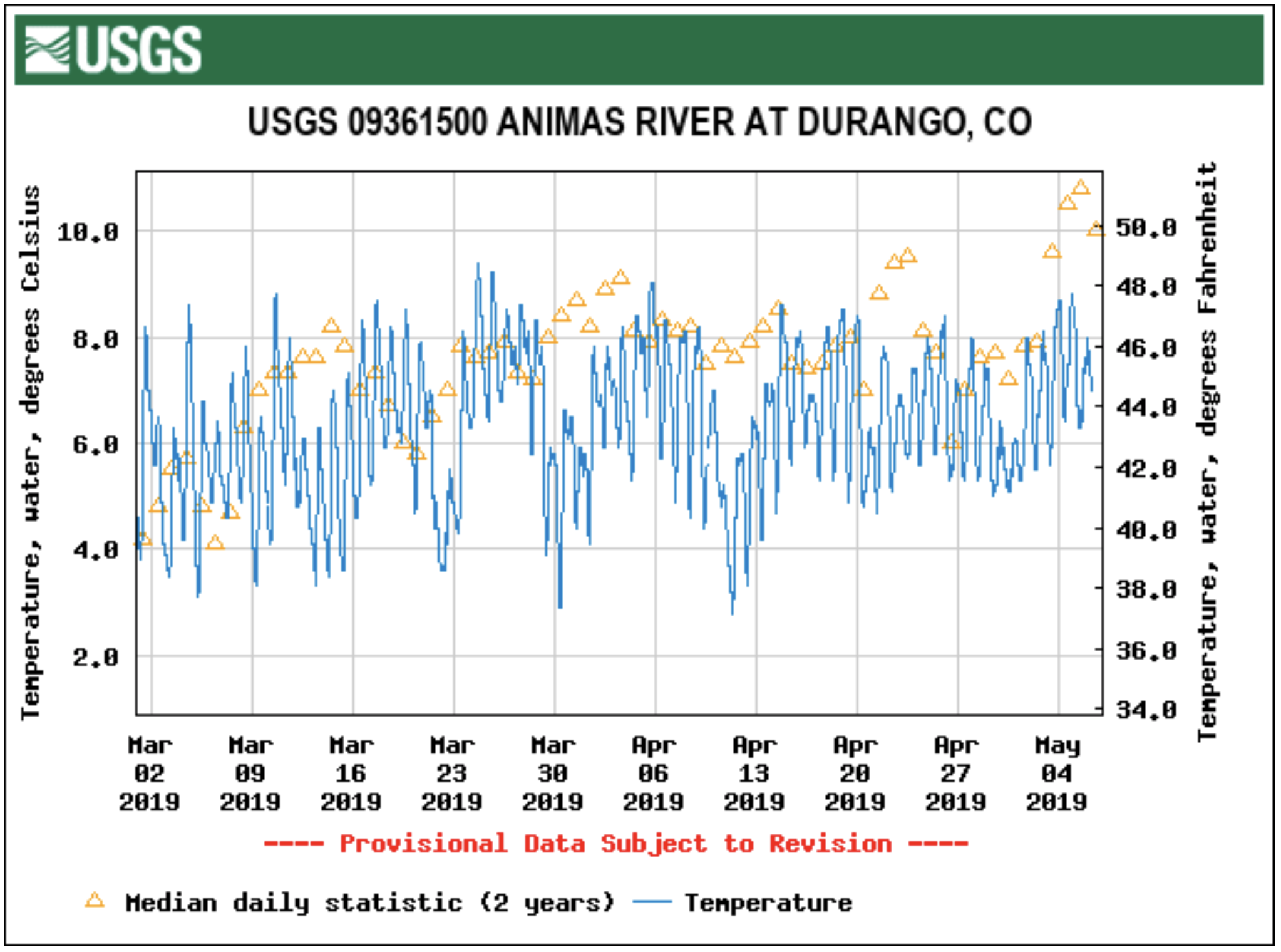
This is also the hope for the Animas River just a few hundred miles to the southwest. Named a Superfund cleanup site in 2016, the Animas headwaters have a similar storied past of hardrock mining. Since the mining boom of the 1880s, the Upper Animas has seen massive heavy metal loads flowing through a wilderness section and into the town of Durango. Luckily, the metals dissolve significantly to leave the lower reaches valuable for anglers with its four miles of Gold Medal designation through Durango. But just imagine what could happen with the remainder of the river after the Superfund cleanup is complete.
We’ve already seen glimpses of rehabilitation on the Animas River. During a brief period when a wastewater treatment plant was in place at the headwaters, trout numbers in the upper reaches were about 400 fish per mile. Once that treatment plant was removed in 2004, numbers dropped to 100 fish per mile in 2010 and a dismal 73 fish per mile last year. The same is true for macroinvertebrates. The celebrated pale morning dun was once a character of the river landscape, but since the closure of the plant, they have been nonexistent. Clearly, remediation of any level is beneficial to trout and trout food.
If the Animas River Valley, its citizens and businesses, anglers and recreationists can learn anything from the Arkansas River success story, it’s this: hope is not lost. It will take time, but the Animas River will return to a healthy habitat for our beloved trout.
On April 7, 2016, the Environmental Protection Agency proposed adding the “Bonita Peak Mining District” to the National Priorities List, making it eligible for Superfund. Forty-eight mine portals and tailings piles are “under consideration” to be included. The Gold King Mine will almost certainly be on the final list, as will the nearby American Tunnel. The Mayflower Mill #4 tailings repository, just outside Silverton, is another likely candidate, given that it appears to be leaching large quantities of metals into the Animas River. What Superfund will entail for the area beyond that, and when the actual cleanup will begin, remains unclear. Eric Baker
From the Environmental Working Group (Monica Amarelo):
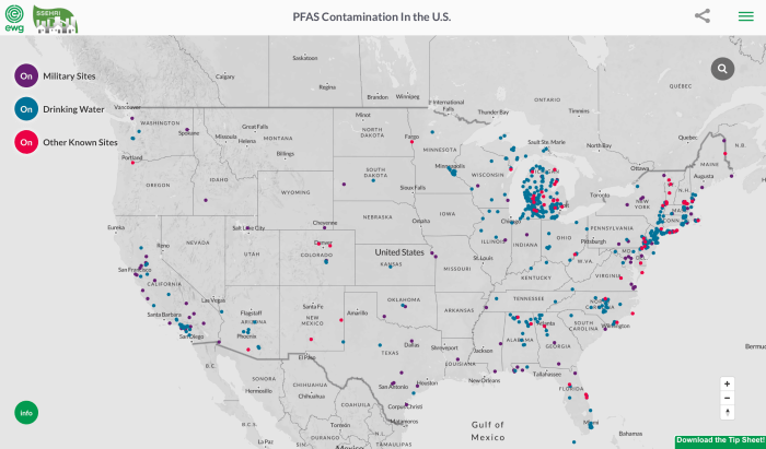
The known extent of contamination of American communities with the toxic fluorinated compounds known as PFAS continues to grow at an alarming rate, with no end in sight. As of March 2019, at least 610 locations in 43 states are known to be contaminated, including drinking water systems serving an estimated 19 million people.
The latest update of an interactive map by EWG and the Social Science Environmental Health Research Institute, at Northeastern University, documents publicly known pollution from PFAS chemicals nationwide, including public water systems, military bases, military and civilian airports, industrial plants, dumps and firefighter training sites. The map is the most comprehensive resource available to track PFAS pollution in the U.S.
The last time the map was updated, in July 2018, there were 172 contaminated sites in 40 states. This update draws from new data sources, so it is not directly comparable with the previous edition. But clearly, the crisis is spreading, and the new data may represent just the tip of a toxic iceberg.
PFAS chemicals, used in hundreds of consumer products, have been linked to weakened childhood immunity, thyroid disease, cancer and other health problems. PFOA, formerly used to make DuPont’s Teflon, and PFOS, formerly in 3M’s Scotchgard, have been phased out in the U.S., but manufacturers have replaced them with chemically similar, largely untested compounds that may be no safer. According to the Centers for Disease Control and Prevention, PFAS chemicals contaminate the blood of virtually all Americans.
“The Environmental Protection Agency has utterly failed to address PFAS with the seriousness this crisis demands, leaving local communities and states to grapple with a complex problem rooted in the failure of the federal chemical regulatory system,” said Ken Cook, president of EWG, which has studied these compounds for almost two decades. “EPA must move swiftly to set a truly health-protective legal limit for all PFAS chemicals, requiring utilities to clean up contaminated water supplies.”
“The updated map shows that PFAS contamination is truly a nationwide problem, impacting millions of Americans in hundreds of communities,” said Phil Brown, a professor of sociology and health sciences at Northeastern University and director of the Social Science Environmental Health Research Institute. “Leaders in many communities and states are doing great work to raise awareness about PFAS and push for cleanup, but this is a national crisis demanding national action. The EPA should act more quickly to evaluate all PFAS chemicals and restrict their use, and polluting industries should be held responsible.”
Michigan has 192 sites on the map, reflecting a testing program more comprehensive than anywhere else. It reinforces the fact that PFAS chemicals are everywhere – when you look for them, you find them. California has 47 known contamination sites and New Jersey has 43.
The map also shows contamination of 117 military sites, including 77 military airports, a legacy of the Pentagon’s 50-year history of using PFAS-based firefighting foam.
There are no legally enforceable limits for PFAS chemicals under the federal Safe Drinking Water Act. The EPA’s non-binding health advisory level for drinking water is 70 parts per trillion, or ppt, for PFOA and PFOS, separately or in combination.
Last year the federal Agency for Toxic Substances Disease Registry proposed safe levels that roughly translate to 7 ppt for PFOS and 11 ppt for PFOA. Based on the best available science and emerging evidence of harm from the entire class of these chemicals, EWG is today proposing drinking water and cleanup standards for all PFAS chemicals as a group at 1 ppt. This is a health-based level that will fully protect public health for the most vulnerable populations, and does not depend on economic or political considerations.
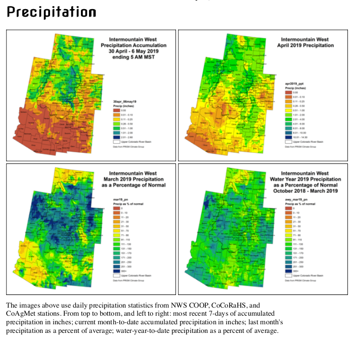
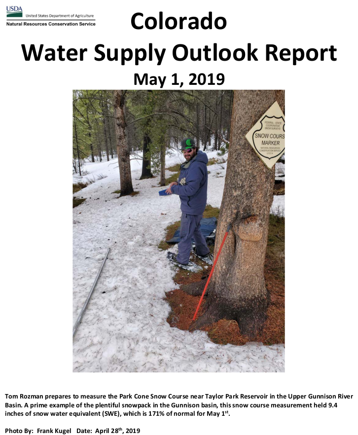
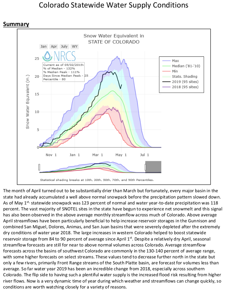
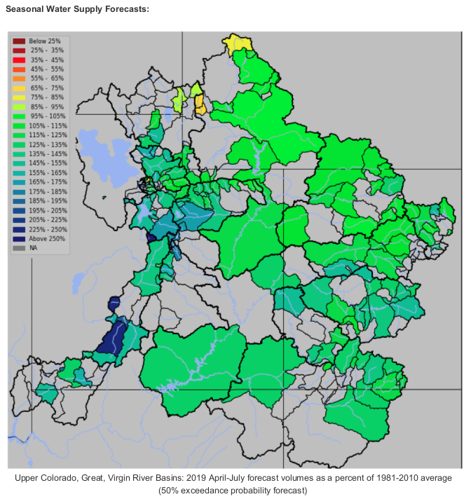
The May 1st forecast for the April – July unregulated inflow volume to Blue Mesa Reservoir is 970,000 acre-feet. This is 144% of the 30 year average. Snowpack in the Upper Gunnison Basin peaked at 143% of average. Blue Mesa Reservoir current content is 384,000 acre-feet which is 46% of full. Current elevation is 7462 ft. Maximum content at Blue Mesa Reservoir is 829,500 acre-feet at an elevation of 7519.4 ft.
Based on the May 1st forecast, the Black Canyon Water Right and Aspinall Unit ROD peak flow targets are listed below:
Black Canyon Water Right
The peak flow target is equal to 7,158 cfs for a duration of 24 hours.
The shoulder flow target is 966 cfs, for the period between May 1 and July 25.
Aspinall Unit Operations ROD
The year type is currently classified as Moderately Wet.
The peak flow target will be 14,350 cfs and the duration target at this flow will be 10 days.
The half bankfull target will be 8,070 cfs and the duration target at this flow will be 20 days.
(The criteria have been met for the drought rule that allows half-bankfull flows to be reduced from 40 days to 20 days.)
Projected Spring Operations
During spring operations, releases from the Aspinall Unit will be made in an attempt to match the peak flow of the North Fork of the Gunnison River to maximize the potential of meeting the desired peak at the Whitewater gage, while simultaneously meeting the Black Canyon Water Right peak flow amount. The magnitude of release necessary to meet the desired peak at the Whitewater gage will be dependent on the flow contribution from the North Fork of the Gunnison River and other tributaries downstream from the Aspinall Unit. Current projections for spring peak operations show that flows in the Gunnison River through the Black Canyon could be over 8,000 cfs for 10 days in order to achieve the desired peak flow and duration at Whitewater. With this runoff forecast and corresponding downstream targets, Blue Mesa Reservoir is currently projected to fill to an elevation of around 7515.5 feet with an approximate peak content of 795,000 acre-feet.
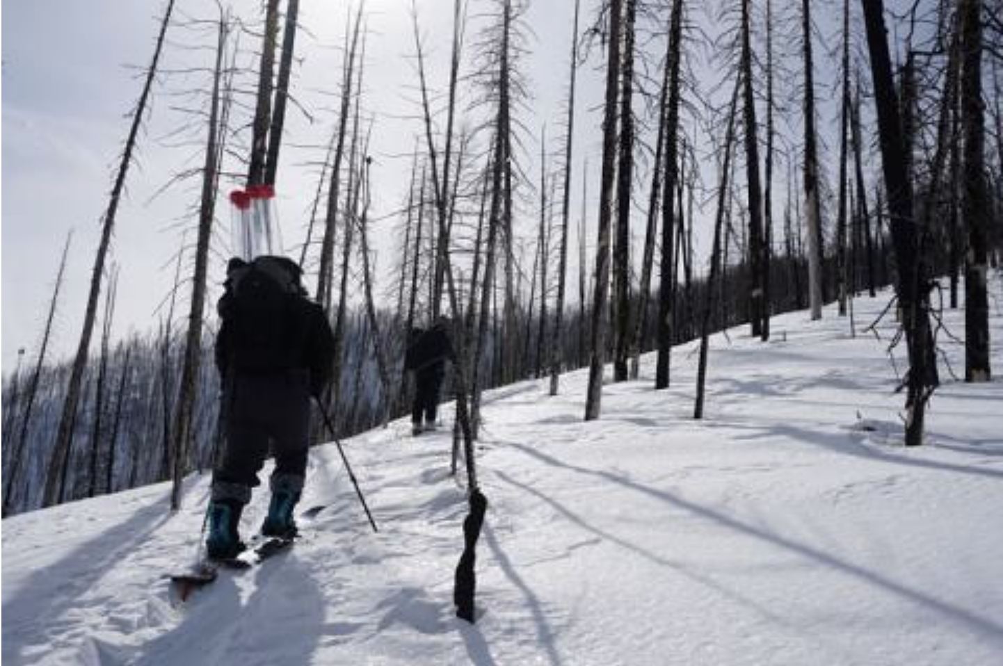
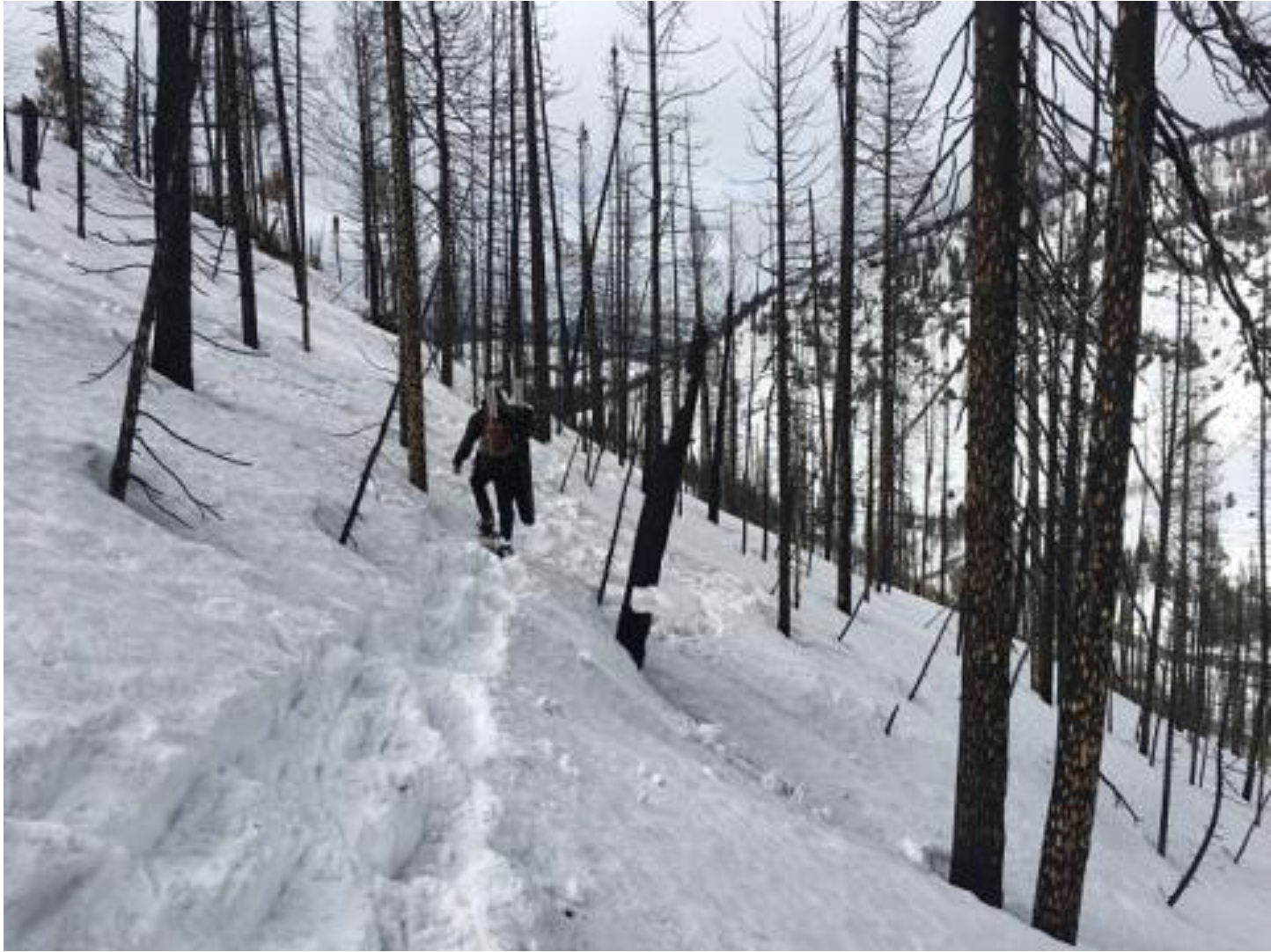
Here’s the article from the Center for Snow and Avalanche Studies. Click through and read the whole article and check out the photo galleries from each site. Here’s a excerpt:
Our CODOS tour around Colorado began Monday and finished Friday afternoon. To see a map of our sample sites throughout the state http://www.codos.org/#maps. Dust from the April 9/10 storm event (D3) was observed at all CODOS sites across the entire state. From Monday thru Thursday (April 30 – May 2) most of the Colorado Mountains received a productive storm and general unsettled weather meant 7 days of precipitation at SASP resulting in 3” of precipitation in the form of wet snow. After this productive storm(s) a number of higher elevation SNOTEL stations (see SNOTEL plots below) appear to now be near peak SWE (Berthoud, Grizzly, Hoosier, Red Mountain, Willow, Fremont), although the peak may still be a week away depending on what melt occurs now until Wednesday when a storm system is expected to arrive, and how much precipitation this storm brings and where.
For CODOS sites that were visited before snow accumulation began the dust was observed at the surface. For sites that we visited during or after snow accumulation the dust was under the new snow. So essentially, the dust was on the surface prior to the storm and will be back on the surface once this new snow consolidates and melts. Dust severity is enough that it has and will effect albedo. Below are pictures and observations for each CODOS site detailing location of dust layers, new snow accumulation on the dust, and general sense of severity of dust.
After the overcast and stormy conditions we experienced Monday thru Thursday slowing snowmelt and resulting in reduced streamflows statewide, the heat will be on thru Monday picking things up a bit. The next tap on the snowmelt brakes starts Tuesday with increased chances of precipitation Wednesday-Friday. The snow level will start high, above 9,000’, but lower towards the end of the week. Models are coming into agreement with this system expecting to produce over 1” of water in some areas.
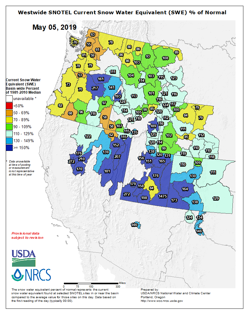
This is a low frequency dust season (only two notable dust events to date) but may be a high consequence snowmelt season. The two dust events we have received are at the top of the snowpack…..a very big snowpack. How it all plays out depends on spring weather going forth. The snowpack at all CODOS sites are isothermal, wet and at certain depths very wet. As storm systems exit the state and warm/sunny conditions return the snowpack will not waste anytime going back into melt mode. Much more so once the dust layer(s) are exposed at the snow surface. So far this spring we have received well timed storm systems slowing down snowmelt, adding even more precipitation to the snowpack, and covering exposed dust. This keeps streamflow peaks from occurring early and all at once. Ideally inclement weather will allow the snow to melt gradually well into the summer, but if we get a stretch of warm and sunny weather we will see rapid melt in basins that are 110%-172% of median snowpack and very high streamflows as a result.
Another item to consider, we mentioned in previous CODOS reports our SBSP site at elevation 12,200’ is currently in the top three years, being up there with WY2005 and WY2011 for the most SWE in our period of record (going back to WY2004). SBSP is the only source of high elevation operational snowpack data in Colorado. The highest SNOTEL station in Colorado is at 11,600’. So not only are we seeing a lot of snow at higher elevations at SBB and visually elsewhere, but our longtime CSAS field assistant has noted that this is the most snow he has seen on all aspects for this time of year, notably southerly aspects. This winter we did not see any winter “droughts” where a long period, usually in January or February, of sustained warm and dry weather render southerly aspects partially or completely devoid of snow. Unlike typical years where the snow would be melted out by now, the southerly aspects most notably still have ample snow.
Snowpack in every part of Colorado’s high country is sporting layers of dust, according to a new statewide survey of the state’s winter accumulation.
“This is a low frequency dust season,” wrote Jeff Derry, head of the Colorado Dust on Snow Program, in a post about the survey results. “But may be a high consequence snowmelt season.”
Dust is darker than snow. Just like a black T-shirt on a sunny day, it absorbs more sunlight, causing what’s underneath it to heat up more rapidly.
“It’s like holding a magnifying glass up to the snowpack,” Derry said.
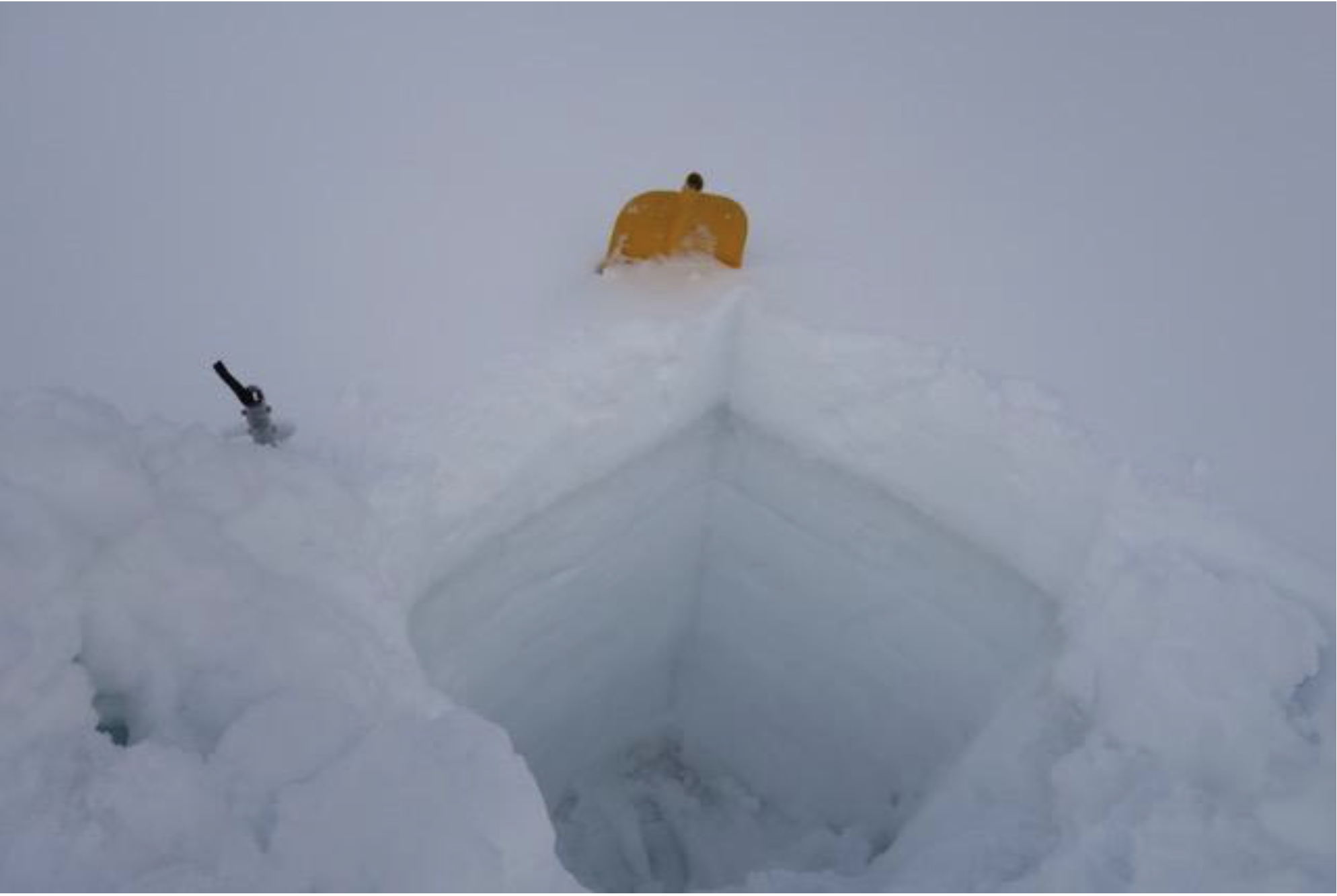
A snow pit on Loveland Pass shows a narrow stripe of dust near the surface. When it’s exposed, the dust can speed up melt off by a couple weeks. Photo credit: Center for Snow and Avalanche Studies via KUNC
Each year Derry and his colleagues from Silverton’s Center for Snow and Avalanche Studies dig snow pits throughout the state to check on the layers of dust. This winter he found two distinct stripes, close to the surface. A dust storm in early March left one of those layers. Another storm in the first week of April blanketed dust on snowpack throughout the state’s high country.
At each of the 11 sites Derry visited, dust was present somewhere in the snowpack.
Snow melts from the top down. The layers closest to the surface melt through the snowpack, exposing those underneath.
Once dust layers are exposed, they have the potential to speed up snow melt. Depending on the severity of the dust deposition and where the layers lie within the snowpack, dust can shorten the runoff season by a couple weeks to a month. In a heavy snow year, like the winter of 2019, that could mean rapid melt in watersheds across the state, making water management much more difficult.
Here’s a report from Barbara McLachlan that’s running in the The Durango Herald. Click through and read the whole article. Here’s an excerpt:
HB19-1113 – Protect Water Quality Adverse Mining Impacts
We all remember the 2015 Gold King Mine spill, so I led a bill to help prevent water pollution from future hardrock mining operations in Colorado. This is good for our environment and precious water, while keeping a thriving mining industry moving forward. Taxpayers will no longer have to pay when a mine files for bankruptcy.
HB19-1006 – Wildfire Mitigation Wildland-Urban Interface Areas
Wildfire season is fast approaching. This bill won bipartisan approval in the Legislature and adds funding to the already existing Wildfire Risk Mitigation Grant Program to address the needs of mitigation in the Wildland-Urban Interface Areas. The funding will help homeowners prepare their property for fire suppression. The Colorado Forest Service says these areas are the most likely to burn during the next fire season; helping them now will help all of Colorado later.
Created by Imgur user Fejetlenfej , a geographer and GIS analyst with a ‘lifelong passion for beautiful maps,’ it highlights the massive expanse of river basins across the country – in particular, those which feed the Mississippi River, in pink.
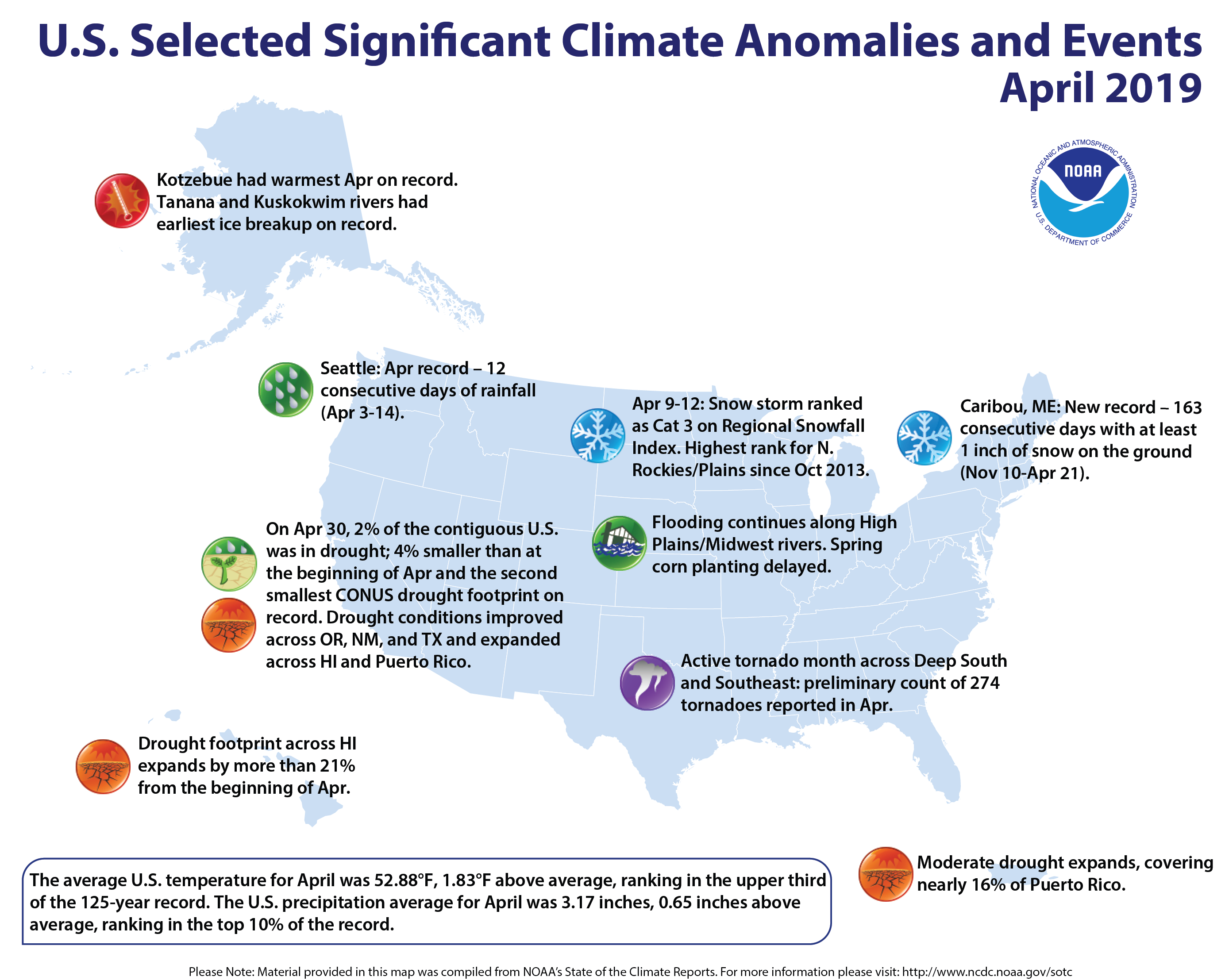
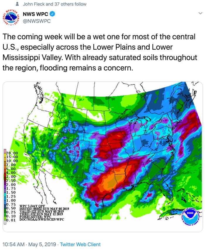
More rain has fallen in the lower 48 states over the last 12 months than during any similar period in over 120 years of record-keeping. More than 36 inches has fallen on average. According to the Washington Post the record precipitation is an increasing trend, which is expected as climate warming intensifies rainfall.
While most of the country is drought-free, much of the Midwest and south central areas of the country are full of water. The upper Midwest has been inundated by rapid snowmelt and continuing rains. The Mississippi River has risen to one of its highest levels since 1993. The Coast Guard shut down a five-mile stretch in St. Louis to barge traffic which is hard on farmers who are being hit not only with rains and flooding, but also tariffs.
Farther south in Louisiana, Governor John Bel Edwards declared a state of emergency due to severe weather. The U.S. Army Corps of Engineers opened the Bonnet Carre spillway for the second time this year to protect New Orleans by diverting water into Lake Pontchartrain. The same storm system affected Houston, where thousands and businesses lost power and heavy flooding forced evacuations. Parts of the city received five inches of rain in 90 minutes on Thursday.
In the north, water levels on the Great Lakes are expected to reach record highs this year. Lake Superior rose two inches more than normal in April. About six years ago Lakes Huron and Michigan fell to their lowest points during a 15-year slump that dried up wetlands and forced cargo vessels to lighten loads. Now a spokesperson for the Army Corps told the Detroit Free Press they are at the other extreme, and experts say the prolonged drop-off followed by the recent rise in levels is a result, at least in part, of a warming climate.
Rivers of meltwater and a mantle of soot, dust, and microbes darken the surface and speed melting. Surface melting has now surpassed the discharge of icebergs into the ocean as a major cause of ice loss. Photo credit Marco Tedesco/Lamont-Doherty Earth Observatory.
Poignant call to arms to restore nature from Emily Johnston, “Loving a vanishing world.” Here’s an excerpt:
The truth is that the ocean that looks so beautiful and unchanging is well on its way to becoming a vast garbage dump full of plastic and of heavy metals, where little survives but jellyfish. It will not smell the same. Its colors will change. And most sea-birds, of course, will die with it.
So I want to ask you the same question I ask myself every time I’m entranced by the beauty of this world: what does it mean to love this place? What does it mean to love anyone or anything, in a world whose vanishing is accelerating, perhaps beyond our capacity to save the things that we love most?
Knowledge is responsibility, isn’t it? If we let this world die — if we let it be slaughtered by the shockingly small number of villains who have lied to us for decades — then we become complicit, because we are the only ones with the leverage to help it live again; those who come after us will have far less ability to do so, as we have far less ability than our parents would have (had they known the truth to the degree that we do). For better and for worse, we are the ones at the intersection of knowledge and agency. So how do we best use that leverage, and how do we find the heart to keep going when the realities of loss overwhelm us?
The stakes are unnervingly clear if we look at the Earth’s five previous extinctions, particularly the end-Permian, in which as much as 90% of life on Earth was wiped out. In all of them, greenhouse gases from volcanic activity, and the ensuing temperature rise, were triggers of destabilization. All of them happened extremely suddenly in geologic terms — but with temperatures and greenhouse gas concentrations that were rising hundreds or thousands of times more slowly than we’re causing them to now.
So it’s not just our grandkids; it’s not just low-lying or hot/dry places; it’s not just humans; it’s not just orcas or the Great Barrier Reef or monarch butterflies; it’s not even “just” the oceans (upon which so many species, and people, depend). What’s at risk now, as best we can tell, is life on Earth. Possibly all of it: scientists now know that runaway greenhouse gas scenarios can turn a pleasant, habitable, water-filled planet….into Venus.
The potential loss of all life is clarifying, because there is only one medicine for any of it — for any of us — and that is the restoration of a thriving natural world, beginning with the near-term end of fossil fuel use. If we’re making real progress towards those goals, we can almost certainly tip the balance for some individuals and species — at least for awhile. And that’s surely a good thing: to help some people live longer lives with some stability is much better than not to do so, even if it doesn’t last for millennia, and to save some species is far better than to save none. What could be a more meaningful way to spend our lives?
t’s been about 35 years since the mill at Uravan closed and about 33 since the former West End town was designated a Superfund site, eventually to be bulldozed, burned and buried. But roughly 2 miles away is the Ballpark at Historic Uravan, Colorado, which was never contaminated by uranium and vanadium mining — and the one place people who grew up there still have to gather and remember.
The ballpark, with its primitive camping, has also attracted its share of hobbyist gold miners who access the San Miguel River from there. But when some began showing up with machinery, locals sounded the alarm and on Thursday, Montrose County passed an ordinance prohibiting unauthorized, mechanized mining along the river acreage it owns there. The ordinance can go into effect May 28…
A problem reared its head, though, when she discovered a video on the Facebook page of a hobbyist prospecting group. Thompson said the video showed compressors and a hose that was pumping the river — plus the site was promoting the location to other hobbyists, as was a prospecting book, which has since delisted the location.
“There was a big group that was going to come. They were all going to bring their machinery and have a big weekend there. We decided we probably better let the county know what was happening,” Thompson said.
Although it’s one thing to pan for gold in the river, or put up a small sluice box — that’s still allowed under the new ordinance — mechanized mining imperils the river and the habitat it provides.
“We contacted the group and told them … it belongs to the county. We lease it to the historical society. They have spent many countless hours down there and have turned that into a beautiful little park we encourage people to use. We don’t want it destroyed,” said Montrose County Commissioner Roger Rash, a former Uravan resident.
The county also put up a sign barring machinery in the river.
“But we needed to have some teeth,” Rash said. “We don’t want mechanized mining going on in our park.”
The new ordinance allows panning within the river channel, as long as it occurs at least 2 feet from the bank. Among other provisions, the ordinance prohibits motorized mining activities, including motorized suction dredging.
It also bars activity that undercuts or excavates banks and the ordinance further restricts access to the channel to existing roads and trails.
People cannot disturb more than 1 cubic yard of soil per day and anything that cannot be removed by hand must remain undisturbed.
All digging has to be filled in and the work area must be cleaned up before departure.
Violations are treated as a petty offense, which carry fines between $100 on first occurrence and up to $1,000 for repeat offenses.
If the county property, river or surrounding area sustains damages in excess of $100, violators can be charged with a class-2 misdemeanor punishable by stiffer fines and up to a year in county jail.
Thompson said she and other Rimrockers didn’t understand why anyone would be mining the river with machinery to begin with. The park is open to the public — although it relies upon donations to sustain the picnic structures and fire pits former residents paid for — and has had only minor vandalism issues prior to the mechanized mining.
A wetland that would have been flooded under the potential Castle Creek Reservoir. The reservoir would have stood across the main channel of Castle Creek, about two miles below Ashcroft. Photo credit: Brent Gardner-Smith/Aspen Journalism
The water court judge reviewing two applications from the city of Aspen to retain, but move, its conditional water-storage rights tied to two potential reservoirs on Castle and Maroon creeks has issued a new decree for the Castle Creek right.
And the judge said Wednesday he is ready to issue a new decree for the Maroon Creek right, once the city works out final language with one of the opposing parties in that case.
“Although perhaps a close call, I’m satisfied and am prepared to approve the conditional rights that have been requested,” District Court Judge James Boyd, who oversees Division 5 water court in Glenwood Springs, said during a case-management conference.
Boyd in November asked Aspen to submit additional information concerning its claims that it has been diligent in developing the dams and reservoirs and that it had a need for the water. The city filed updated information and a slightly revised proposed decree in April, which the judge said he has reviewed.
Under its negotiated settlements with the 10 opposing parties in the Castle and Maroon diligence cases, the city has agreed to store no more than 8,500 acre-feet of water from the two streams in five potential new locations, away from the high-mountain valleys and closer to the Roaring Fork River.
The ten settlements, or stipulations, in both cases are essentially the same for each opposing party, but there are some slight differences. The settlement with Pitkin County in the Maroon Creek Reservoir case is representative.
Under all of the agreements, the city could store either up to 8,500 acre-feet from Castle Creek or up to 8,500 acre-feet from both streams, with a maximum of 4,567 acre-feet coming from Maroon Creek.
The city has at least now obtained a conditional water right to store 8,500 acre-feet from Castle Creek, albeit no longer in the originally proposed location, 2 miles below Ashcroft, and for which it still needs further water court approvals to move the water right to a new location, or locations.
Regarding the remaining issue in the Maroon Creek case, which revolves around the precise wording of a no-precedent clause, Boyd said, “It strikes me there is probably a reasonably decent possibility this issue will go away with a little further negotiation.”
The judge’s announcement during the case-management conference Wednesday regarding his readiness to approve the city’s two diligence applications was made to elicit any further concerns that the water attorneys in the cases may still have.
Hearing no concerns — apart from the no-precedent language issue between Larsen Family LP and the city in the Maroon Creek case — Boyd gave Larsen and the city a month to work things out. In the meantime, he said he would proceed to issue a new decree in the Castle Creek case.
“It’s nice to get at least one of them done,” said the city’s water attorney, Cynthia Covell.
Once the Maroon Creek decree is issued, which Covell does expect to occur, the city plans to prepare an application to water court to move its conditional storage rights to the new potential locations: the city golf course; the Maroon Creek Club golf course, which is partially on city-owned open space; the city’s Cozy Point open space, near the bottom of Brush Creek Road; the Woody Creek gravel pit, operated by Elam Construction; and an undeveloped, 63-acre parcel of land next to the gravel pit, which the city bought for $2.68 million in February 2018 for water-storage purposes.
“I’m sure the city will be undertaking further investigations about the suitability of those sites and what they finally are going to land on,” Covell said. “I’m not really expecting they are going to try to build a reservoir at every single one of those sites, but they will be doing the necessary fieldwork and other kinds of things to determine what makes the most sense for them.”
Covell said there will be “many, many opportunities for the community to be involved in this planning process.”
Under the decrees, the city will have until May 2025 to file a change-of-location application.
But Covell said she would advise that the city do so “sooner rather than later.”
The city in 1965 first filed for water-storage rights tied to potential dams and reservoirs on upper Castle and Maroon creeks. Since then, the city has periodically applied for, and received, findings of diligence from the water court.
The city filed its most recent diligent applications in October 2016. Ten parties filed statements of opposition, and the city reached agreements, or stipulations, with all parties in October 2018. A key provision was that the city had to try to move the water rights out of the high valleys, and if it failed in that effort, it could not return to the two valleys.
Pitkin County, the U.S. Forest Service, American Rivers, Western Resource Advocates, Colorado Trout Unlimited and Wilderness Workshop were opposers in both cases, and each case also included two private-property owners.
Aspen Journalism covers rivers and water in collaboration with The Aspen Times. The Times published a version of this story on Friday, May 10. This updated version reflects the issuance of the signed Castle Creek decree at 11:30 a.m. on May 10.
Aquatic biologist Jim White, of Colorado Parks and Wildlife, spoke at a community meeting in Dolores about planned fish surveys, population data and survey techniques.
Parks and Wildlife works with McPhee Reservoir managers to manage downstream flows for three native species that reside in the Lower Dolores – the roundtail chub, bluehead sucker and flannelmouth sucker. The first several miles below the dam to Bradfield Bridge is managed as a cold-water fishery for brown and rainbow trout.
“Roundtail populations have been good,” White said, “and bluehead and flannelmouth are not as abundant.”
The reservoir holds a 33,500 acre-foot reserve for the native fish needs. The “fish pool” is released gradually throughout the year base on biologists’ input. In the winter, flows below the dam are 20-30 cubic feet per second. During summer, they reach 60-80 cfs if there is no whitewater release.
During low water years, the fish pool and farmers share in shortages. When there is a recreation dam release like this year, it is not counted against the fish pool, and the higher flows are managed for ecological benefits such as channel scouring, timing to benefit the fish spawn, and flood plain sedimentation that replenishes nutrient rich sediment on the banks for new seedlings…
Fish counts and surveys are done each year at Slick Rock Canyon, Dove Creek Pump Station, Pyramid Mountain and below the San Miguel confluence.
White explained how a “pit-tag array” installed in 2013 to monitor native fish on the Lower Dolores River works. It is just upstream from the Disappointment Creek confluence.
Native fish captured throughout the Lower Dolores are inserted with a electronic tag, and when they move past the “array” wire above the river, the movement and fish identification is recorded.
So far, 1,421 fish have been tagged. Of those, 38 percent were flannelmouth suckers, 35 were roundtail chubs, and 23 percent were bluehead suckers. Four percent were smallmouth bass, a non-native species biologists are trying to get rid of because they prey on young native fish.
Since installed, 157 tagged fish have been recorded passing under the pit-tag array. In 2018, 14 fish were detected, including eight flannelmouth that arrived after April 8. Five of the flannelmouth were tagged in Slick Rock Canyon, two in the Pyramid Mountain Reach and one tagged in 2014 in the San Miguel River.
The first native fish of 2019 passed under the array on April 5. It was last detected on Oct. 18. On April 16, two flannelmouth were recorded.
Fish kills in the North Fork of the South Platte River are occurring during low water flow periods that fail to dilute the toxicity of heavy metals such as iron, copper and aluminum. Contaminants in the form of heavy metals move downstream, originating primarily from Hall Valley and Geneva Creek mining operations.
When water flow is adequate, there is enough oxygen to negate the impact of the toxins. When water levels are inadequate, fish develop coatings on their gills as a natural self-defense mechanism to the toxins. That protective coating ultimately renders their gills inoperable.
When and why do water levels get too low?
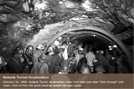
Water flow in the river is dependent upon how much water is released from Dillon Reservoir through Roberts Tunnel, and those decisions are made almost exclusively by Denver Water.
When more water is needed within Denver Water service areas, the rate of the water passing through Roberts Tunnel is set to flow more freely. When water is not needed to serve the Denver Water service area, the flow from Roberts Tunnel is restricted, much to the detriment of the people, and the fish, in Park County.
Water flows can be naturally low in the river during certain seasons. This year, in mid-March, for example, snowmelt had not yet occurred and the river was in its customary state of low flow prior to the fast-approaching late-spring thaw.
An abundance of area-wide spring moisture, however, created a situation where Denver Water service areas enjoyed a surplus of water. Therefore, the flow from Roberts Tunnel and Dillon Reservoir was ceased on March 11 and remained so at least until this writing.
The predictable result was the most recent fish kill, which occurred March 11-15, because flows were simply not sufficient to combat ever-present toxic heavy metals related to mining. No information has been provided by Denver Water as to when the tunnel will be reopened.
Denver Water states its position
When The Flume recently requested a statement from Denver Water regarding flows in the river and operations of Roberts Tunnel, a response was received in timely fashion.
In direct response to whether or not Denver Water felt a moral obligation to residents in Park County related to ecological systems they have long controlled, and whether Denver Water should accept responsibility for maintaining minimal flow in the South Platte River for the environmental and economical benefit of the entire North Fork region, the following statement was submitted:
“We (Denver Water) understand the potential for impacts to the fishery when flows from the Roberts Tunnel are shut down, and certainly recognize and appreciate the effect on the angling community and local businesses and outfitters. Unfortunately, operation of the Roberts Tunnel is directed by legal obligations and decrees tied to Colorado water law and binding agreements with West Slope communities where the water from the tunnel originates.
“As you know, the flows from the Roberts Tunnel originate in water diverted from West Slope rivers and streams into Dillon Reservoir. Denver Water depends on this supply when snow pack within the Upper South Platte watershed is insufficient. However, since early March, portions of the Upper South Platte watershed have received more than four feet of snow and spring precipitation continues to be strong.
“Legally, water supplied through the Roberts Tunnel can only be accessed when water is needed in Denver Water’s service area. Further, any other uses for the water, including augmenting stream flows for aquatic life or recreation uses, are not allowed as a primary purpose for operating the tunnel.
“While we provide projections about how long Denver Water will deliver water through the tunnel, those are only estimates based on snow pack, reservoir storage and other system elements. Those projections can change as conditions change; as they did in late winter and early spring this year.”
Colorado transmountain diversions via the State Engineer’s office
Colorado lawmakers wrapped up the 2019 session last week, approving five water bills this year which address the Colorado River drought, funding for the state’s water plan, Republican River compact issues, severance taxes and hard-rock mining.
It put off for now another bill that would have expanded the state’s nationally recognized instream flow program, which allows water for fish and aquatic habitat to be left in streams.
Colorado River Drought and Water Plan Funding
Faced with a 19-year drought that has seen storage in the Colorado River’s two largest reservoirs—Powell and Mead—drop below half full, the legislature took a first step in reducing water use to ensure compliance with the Colorado River Compact. Although it did not adopt new policy, it appropriated $1.7 million as part of Senate Bill 212 for the Colorado Water Conservation Board (CWCB) to explore a demand management program that would incentivize voluntary cutbacks of Colorado River use, where saved water could be stored in Lake Powell as a hedge against future shortfalls. It also set aside $8.3 million to fund the Colorado Water Plan. The combined $10 million lawmakers approved is far less than the $30 million Governor Jared Polis had requested, but the Joint Budget Committee (JBC) pared that figure due to competing demands from other big ticket items. Senator Bob Rankin (R-Carbondale), the bill’s chief sponsor and a JBC member, noted that the remaining $20 million in Polis’ original request “was really meant to be a contingency plan against demand management in the future and so it could probably wait until next year to be appropriated.” That is if revenue forecasts allow.
Still Rankin said the funding is an important step forward for the water plan. “This is the first time we’ve started to put general fund money against the water plan.”
Republican River Compact
The General Assembly also opted to approve a measure that redraws the boundary of the Republican River Water Conservation District to include more wells that reduce the flow of the Republican River in violation of a compact with Kansas and Nebraska. The legislature created the district in 2004. Its original boundary was drawn at the topographic boundary of the Republican River and did not accurately reflect the impact of groundwater pumping outside the district on the river’s flows.
House Bill 1029 incorporates the groundwater boundary agreed to by Kansas, Nebraska and Colorado in a Supreme Court settlement and allows the district to assess the same fee on those well owners that it does on all irrigators in the district. Those fees help to pay for a pipeline that transports conserved groundwater to the river to ensure compact compliance.
The district borrowed $62 million to buy water rights and build the pipeline, and has assessed farmers $14.50 per acre annually to repay the loan. Absent the legislation, wells that do not have water augmentation, or replacement, plans to mitigate their surface water depletions could face curtailment under new rules issued by the state engineer; now they are automatically part of the district’s approved augmentation plan.
Severance Taxes
The General Assembly passed another bill that changes the timing of severance tax allocations that support several water programs to allow for better planning and budgeting. Currently the tax revenue is transferred three times a year to the CWCB based on revenue forecasts; if the actual tax collections are less than forecasted (which has often been the case), funds have to be taken back. Senate Bill 16 bases allocations on the amount collected in the previous fiscal year and consolidates three payments into one for distribution the following year. Because tax collections in 2018 exceeded forecasts, there’s enough revenue available to avoid any funding gap moving forward.
Water Quality Impacts of Hard-Rock Mining
The General Assembly passed a bill to protect water quality from the impacts of hard-rock mining. House Bill 1113 requires reclamation plans for new or amended hard-rock mining permits to demonstrate a “reasonably foreseeable end date” for water quality treatment to ensure compliance with water quality standards. It also eliminates the option of “self-bonding”—an audited financial statement demonstrating that the mine operator has sufficient assets to meet reclamation responsibilities—and requires a bond or other financial assurance to guarantee adequate funds to protect water quality, including treatment and monitoring costs.
Representative Dylan Roberts, (D-Eagle), the bill’s prime sponsor, emphasized that it applies only to hard-rock mining—not to coal or gravel mining—and “aligns statute with what’s already happening in current practice by the Division of Reclamation, Mining and Safety…so that we can avoid creating more chronically polluting mines.” The bill was similar to one that passed the House but failed in the Senate last year.
Instream Flows
The Senate Agriculture & Natural Resources Committee set aside a bill that would have expanded an existing program to protect streamflows for environmental purposes, but with a commitment to study the issue further this summer. Under current law, a water right holder can loan water to the CWCB to boost instream flows in stream reaches where the CWCB holds an instream flow water right. The loan may be exercised for no more than three years in a single 10-year period. House Bill 1218, which had passed the House earlier in the session, would have increased the number of years the loan could be exercised from three to five, and permitted a loan applicant to reapply to the state engineer for two additional 10-year periods.
Opposition to the bill centered on concerns that expanding the number of years would reduce irrigation return flows to other farmland dependent on them for crop production and risk damaging soils. Senator Kerry Donovan (D-Vail), the bill’s sponsor and a rancher, asked the committee to postpone it with an understanding that the Interim Water Resources Review Committee would study it further this summer. She noted that with “some of the concerns that have been raised, as well as the level of attention that this issue deserves, we need to get this right, and I’m not sure we have consensus on a way forward today.”
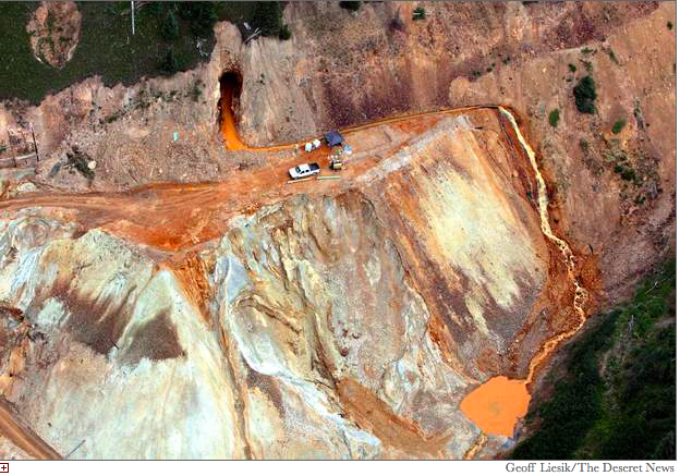
Wastewater continued to stream out of the Gold King Mine on Tuesday [August 11, 2015] near Silverton, several days after a rush of 3 million gallons of it flooded Cement Creek and the Animas River. At the top of the photo is the mine’s opening, where an Environmental Protection Agency cleanup team was working with heavy machinery Aug. 5 and hit an earthen wall that had millions of gallons of water built up behind it
Here’s the release from Colorado Parks and Wildlife (Joe Lewandowski):
CPW, National Park Service cooperating on native trout restoration in Great Sand Dunes; meetings schedule to explain project
DRUANGO, Colo. – In the continuing effort to restore native cutthroat trout to state waters, Colorado Parks and Wildlife and the National Park Service are cooperating on a major project set for late summer in Great Sand Dunes National Park and Preserve.
Two public meetings to explain the project are scheduled: 6 p.m., May 20 at the Rio Grande Water Conservation District office, 8805 Independence Way in Alamosa; and 6 p.m., May 21 at the library in Westcliffe, 209 Main Street.
The ambitious project will help re-establish Rio Grande cutthroat trout in Upper Sand Creek Lake, Lower Sand Creek Lake and in Sand Creek. The area is located high on the west flank of the Sangre de Cristo Mountain Range.
“This is a challenging project, but it will provide ideal and protected habitat for these fish,” said John Alves, senior aquatic biologist for CPW’s Southwest Region. “We appreciate that the National Park Service shares CPW’s goals to re-establish native cutthroats in the waters of the San Luis Valley. Trout Unlimited is also working as a partner on this project.”
The project is tentatively scheduled to start the last week of August. To re-establish the native cutthroats, the lakes and creek will be treated with Rotenone, an EPA-approved organic chemical that has been used for decades in Colorado and elsewhere for aquatic management projects. The chemical will kill all the non-native trout. If the treatment is successful, the earliest the area could be restocked with Rio Grande cutthroat would be the fall of 2020.
The Sand Creek area will be closed to public access during the treatment project.
CPW, the National Park Service, the state of New Mexico and Native American tribes have been working to re-establish Rio Grande cutthroats for more than 20 years. Currently, the cutthroat can only be found in about 11 percent of its historic habitat. Mining, water development, intensive land-use and over-fishing have caused the trout’s populations to decline significantly during the last 100 years. Conservation groups have asked the federal U.S. Fish and Wildlife Service to place the fish on its threatened and endangered species list.
“All the agencies involved in the restoration are working diligently to make sure this trout is not listed. This restoration project is just one of many that will be done in the next decade,” Alves said.
The Rio Grande cutthroat is one of three native trout indigenous to Colorado. The Colorado River cutthroat is found on Colorado’s Western Slope, and the Greenback cutthroat is found in drainages of the Front Range. CPW is also working on a variety of projects to restore those populations.
San Luis People’s Ditch March 17, 2018. Photo credit: Greg Hobbs
Here’s the release from the Bureau of Reclamation (Peter Soeth):
The 2019 Water Marketing Strategy Grants funding opportunity is now available from the Bureau of Reclamation. This funding opportunity is available to water entities to establish or expand water markets or water marketing activities. Reclamation will make available up to $200,000 for simple projects that can be completed within two years and up to $400,000 for more complex projects that can be completed in three years. Up to $3 million is available for this funding opportunity.
“The water marketing strategy grants provide entities an opportunity to leverage their money and resources with Reclamation to develop a water marketing strategy to increase water supply reliability,” program coordinator Avra Morgan said.
The funding opportunity is available at http://www.grants.gov by searching for BOR-DO-19-F006. Applications will be due on July 31, 2019, at 4:00 p.m. MDT.
Those eligible to apply for these grants are states, Indian tribes, irrigation districts, water districts or other organizations with water or power delivery authority located in the western United States or United States territories. This includes Alaska, Arizona, California, Colorado, Hawaii, Idaho, Kansas, Montana, Nebraska, Nevada, New Mexico, North Dakota, Oklahoma, Oregon, South Dakota, Texas, Utah, Washington, Wyoming, American Samoa, Guam, the Northern Mariana Islands, and the Virgin Islands.
Water markets support the President’s memorandum on Promoting the Reliable Supply and Delivery of Water in the West. They are between willing buyers and sellers and can be used to help water managers meet demands efficiently in times of shortage, helping prevent water conflicts. These planning efforts proactively address water supply reliability and increase water management flexibility. Learn more about water marketing at https://www.usbr.gov/watersmart/watermarketing.
The funding is part of WaterSMART. WaterSMART is a Department of the Interior initiative that uses the best available science to improve water conservation and help water resource managers identify strategies to narrow the gap between supply and demand. For more information on the WaterSMART program, visit https://www.usbr.gov/WaterSMART.
This bill came about due to the Colorado Department of Revenue’s decision to impose sales taxes on the wholesale sale of fertilizer to greenhouses and nurseries. Since fertilizer is used to grow plants that would later be sold themselves, McKean thought to exempt wholesale sales.
“It didn’t make sense to tax an input that is part of a product on which sales taxes would be collected at point of sale,” McKean wrote. “…The margins for many, if not most, of our farmers are too tight to push this kind of additional cost on them.”
HB 19-1329 passed the House May 1 and the Senate May 3. As of Thursday, it had not yet been sent to the governor’s desk.
Last Friday, the gavels fell in the Colorado House and Senate to close the 120th and final day of the 2019 legislative session. It will take a few months for the dust to settle but I believe that when we look back on this past session, it will be seen as one of the most productive and transformative sessions for Colorado in recent memory.
I am very proud of the work that my colleagues and I were able to accomplish and am confident that the counties that I represent, Eagle and Routt, will be better off in the coming years because of that work.
Over the last four months, I made sure to prioritize the most pressing issues for Eagle and Routt counties: health care, transportation, housing, education and environmental protection. I was the lead sponsor of 35 bills; 30 of them passed and have been signed into law or are sitting on the Gov. Jered Polis’ desk awaiting his signature and every single one of those bills had bipartisan sponsorship or received bipartisan votes…
Acting to protect our state’s natural beauty and the outdoor economy and agriculture on which our community relies was also an urgent task. We passed historic climate change legislation that will make Colorado a leader in reducing greenhouse gas emissions along with several other bills to protect our environment. I also was excited to see the Governor sign my bill to protect Colorado’s water from mining spills and a bill to increase funding for Colorado’s water plan
Here’s an interview with Nathan Fey from Jason Blevins that’s running in The Colorado Sun. Click through and read the whole article. Here’s an excerpt:
Nathan Fey is the new director of the Colorado Office of Outdoor Recreation Industry.
Fey, who has served as acting director for the past month, is a sixth-generation Coloradan who spent 12 years as Colorado’s regional director for American Whitewater. He grew the national organization’s network of regional paddling groups to more than 20 from four and fostered the development of recreational water rights so communities could build whitewater parks.
Fey, an accomplished kayaker, replaces Luis Benitez, the climber who founded the state’s outdoor recreation office — the second in the nation — four years ago and helped build a growing coalition of state outdoor recreation offices across the country.
Nathan Fey, seen here paddling the Lower Dolores River in an Alpacka raft, is a veteran kayaker who served 12 years as Colorado’s stewardship director for American Whitewater. He is the new director of the Colorado Outdoor Recreation Industry Office. (Photo courtesy Nathan Fey)
On the opportunities for growing the outdoor recreation economy in Colorado …
“Here along the Front Range, in Larimer, Summit, Boulder, Gilpin, I see an opportunity to learn from how impacted those landscapes have been, particularly on the Arapahoe and Roosevelt National Forests. We are in discussions with a big range of stakeholders to figure out how we can disperse that use, manage it better so that we are not having such a huge footprint on the land. So the opportunity is, one, correcting the mistake, and two, learning from that and being able to implement new strategies, and perhaps new tools, in other parts of the state that don’t have those issues yet, but are interested in growing their rec economy and will potentially have to address overuse or mismanagement in the future. So now we can stay in front of that one.
“On the development side, I look at communities like Nucla, Naturita and places like Craig; their identity and their economy has been one thing and they are on the cusp of transitioning into something new. They’ve got this incredible wealth of public lands and the Yampa River and the San Miguel River, BLM and Forest Service right out their backdoor. There’s an opportunity there to improve public access and safety and use of those places and create an amenity that draws visitors and more money and more investment.
“It’s about recognizing the diversity of landscapes and attributes we have in the state. Everybody thinks of Colorado as being mountains and ski resorts and what’s accessible from the Front Range. We have incredible opportunities in the San Luis Valley with the Great Sand Dunes, but beyond that, it’s climbing in Penitente Canyon and the trail system surrounding Del Norte and the investment that valley is making into improving river recreation. That just hasn’t been on people’s radar. It’s an example of what we are seeing around the state, where we’ve got really high-quality outdoor opportunities but I guess we just haven’t been marketing them or managing them appropriately.”
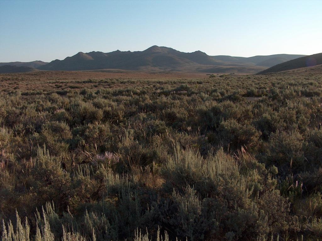
Sagebrush landscapes are important habitat for maintaining biodiversity in much of the United States. Image credit: Steve Knick, USGS.
FromThe New York Times (Brad Plumer and Somini Sengupta):
On Monday, I wrote about a sweeping new United Nations report warning that humans were destroying Earth’s natural ecosystems at an “unprecedented” pace.
The findings were sobering: As many as one million plant and animal species are now threatened with extinction because of farming, hunting, pollution and, increasingly, climate change. Almost everywhere you look, nature is vanishing before our eyes.
But the report, which was written for world leaders and policymakers, also wrestled with another big question: Why should anyone care about the loss of nature? Why should countries take drastic steps, as the report urges, to halt the decline in biodiversity?
The scientists and experts who wrote the report spent a lot of effort trying to frame biodiversity loss as an urgent issue for human well-being. Natural ecosystems, they explained, provide invaluable material services to people, from mangrove forests that protect millions from coastal flooding to wild insects that pollinate our crops. When we destroy nature, they concluded, we undermine our own quality of life.
That’s a compelling argument, and it’s one that many conservationists and ecologists have emphasized in recent years. There’s now an entire field of research around “ecosystem services;” scientists try to quantify in dollar terms all the benefits that nature provides to humanity, in order to make an economic case for conservation.
It’s worth noting that some ecologists have long been skeptical of this line of thinking, and have countered that it’s simply wrong to drive other species to extinction even if they’re not crucial for economic growth or humanity’s survival. And the new report does acknowledge that nature also has a spiritual or inspirational value that can often be “difficult to quantify.”
But it’s been 27 years since the first global treaty to protect biodiversity, and the world’s nations are still faltering in their efforts to halt the decline of natural ecosystems around the globe. That helps explains why the authors of this latest report felt they had to appeal more forcefully to humanity’s own naked self-interest.
“Life on Earth is an intricate fabric, and it’s not like we’re looking at it from the outside,” Sandra M. Díaz, a lead author of the report and an ecologist at the National University of Córdoba in Argentina, told me. “We are threads in that fabric. If the fabric is getting holes and fraying, that affects us all.”
In July 2017, lobbyists from Energy Fuels Resources, a Canadian uranium mining company with operations in the United States, urged the [Administration] to shrink the boundaries of Bears Ears National Monument in order to free up uranium deposits for future mining.
Some observers found it odd. After all, foreign competition and low prices had beaten the domestic uranium industry down to just about nothing, and lobbyists — including Andrew Wheeler, who has since been appointed head of the Environmental Protection Agency— had already convinced the Obama administration to leave Energy Fuels’ Daneros Mine out of the new national monument. Why would they want to go after more deposits?
Energy Fuels’ White Mesa Mill from inside Bears Ears National Monument. Photo credit: Jonathan Thompson
Now we know: Those same lobbyists are pushing the [Administration] to order utilities to purchase at least 25% of their uranium domestically. Such a quota would throw a lifeline to the handful of uranium mining companies still operating in the U.S. and likely spur more uranium mining in the West — including, perhaps, within Bears Ears’ former boundaries as well as near the Grand Canyon. And it would continue the federal government’s long history of propping up the uranium industry at the expense of the people and places of uranium country —and maybe, even, of the nuclear power industry.
When prospectors with Geiger counters started scouring the Colorado Plateau in the 1940s, the government supported them, building roads to potential deposits, giving federal land to anyone interested in staking a claim, and paying $10,000 bonuses to those who found uranium. When corporations arrived to develop the prospects, the government again stepped in, becoming the sole buyer of the yellowcake they produced, virtually eliminating any economic risk.
Hundreds of mines and mills popped in Wyoming and across the Colorado Plateau, many of them within or near the borders of the Wind River Reservation, the Navajo Nation and New Mexico’s Laguna and Acoma pueblos. Many, if not most, of the miners and millers — and the people who eventually suffered from radiation — belonged to those tribes.
Decades before the U.S. boom got going, researchers had firmly established that European uranium miners (before the bomb, uranium was used to make dye) got lung cancer at much higher rates than the general populace. And in 1952, U.S. scientists uncovered the mechanism by which radon — a radioactive “daughter” of uranium found in at dangerously high levels in mines and mills — caused lung cancer. And yet the miners were never informed of the risks, nor were protective measures taken. In fact, the federal Atomic Energy Commission actively withheld this information from the public in a cover-up that benefited the corporations.
The government ended its uranium-buying program in the 1970s, but by then nuclear power was catching on worldwide, and demand for reactor fuel kept U.S. mines afloat and spurred new mining in Canada, Australia and elsewhere. After the Three Mile Island disaster in 1979, though, U.S. utilities stopped building new reactors. A global glut resulted in a uranium price crash, and with cheaper yellowcake flooding in from overseas, the industry withered. As of 2017, U.S. utilities were buying only 5% of their nuclear fuel from domestic producers, and mines and mills employed just 424 people, compared to 16,000 in 1979. While the industry’s future remains in question, its past legacy endures in the form of hundreds of sick miners and millers; abandoned, contaminated mines; and the ongoing, taxpayer-funded effort to clean up giant tailings piles near communities.
Now, the industry — led by Energy Fuels and Ur-Energy — is hoping the government will once again step up, meddle in the markets, and throw it a lifeline. The 25% quota would immediately and substantially up demand — and prices — for domestic uranium, potentially raising production to levels that haven’t been seen in decades. It could breathe new life into Energy Fuels’ Canyon Mine, which is near the Grand Canyon, along with its Daneros Mine and White Mesa Mill — the only conventional mill in the U.S — both located near Bears Ears National Monument. Ur-Energy, meanwhile, would see more demand for its products from the spill-prone Lost Creek in-situ facility in Wyoming near Jeffrey City, a community that bet everything on the uranium boom in the 1970s, only to see it all crash a few years later, leaving the town a husk.
If these existing, active mines can’t keep up with demand, uranium companies could revive long-dormant ones or seek new deposits. Both can be found in the White Canyon uranium district, which was part of the original Bears Ears National Monument but was cut out by the [Administration’s] shrinkage at Energy Fuels’ request.
Late last year, U.S. Department of Commerce officials visited the White Mesa Mill, the Energy Fuels mines near the La Sal Mountains outside Moab, Utah, and other uranium facilities. This spring, they submitted their report on the quota proposal to the [Administration], which has 90 days to act. Indigenous and environmental activists, including citizens from the Ute Mountain Ute Tribe near White Mesa, Utah, are protesting the proposal. And this time, they have an unexpected ally: The nuclear power industry. That’s because the proposed quotas will drive up fuel prices for nuclear reactor operators, which are already having a hard time competing against cheap natural gas-generated power.
That puts the President…who hasn’t hesitated to interfere in the free market in order to boost the coal and nuclear power industry — between a rock and reactors.
Jonathan Thompson is a contributing editor at High Country News. He is the author of River of Lost Souls: The Science, Politics and Greed Behind the Gold King Mine Disaster.
In May 2019, Water Education Colorado recognized Jennifer Pitt with the Diane Hoppe Leadership Award.
Jennifer Pitt joined Audubon in December 2015 to advise the organization’s strategies to protect and restore rivers throughout the Colorado River Basin. At Audubon she leads the United States–Mexico collaboration to restore the Colorado River Delta. She serves as the U.S. co-chair of the bi-national work group whose partners will, through 2026, implement existing treaty commitments providing environmental flows and habitat creation.
Prior to joining Audubon, Jennifer spent 17 years working to protect and restore freshwater ecosystems in the Colorado River Basin at the Environmental Defense Fund. With partners, she led efforts to prioritize and implement restoration of the Colorado River Delta, including work coordinating the Pulse Flow of 2014 that brought water into dried-up stretches of Colorado River Delta across the border. She also worked with Colorado River stakeholders to produce the unprecedented Colorado River Basin Supply and Demand Study, the first federal assessment of climate change impacts in the basin and the first basin-wide evaluation of the impacts on water supply reliability and river health.
Celene Hawkins:
In May 2019, Water Education Colorado recognized Celene Hawkins with its Emerging Leader Award.
Celene Hawkins serves as the Western Colorado Water Project Director for the Colorado Chapter of The Nature Conservancy. She coordinates and implements projects with agricultural partners, federal, state, tribal, and local governments, and local conservation organizations to help optimize the use of water in western and southwestern Colorado, and she fosters project work that supports water transactions that benefit environmental values while also supporting agriculture and other traditional water uses. In 2017, Celene was appointed to serve on the Colorado Water Conservation Board for the San Miguel, Dolores, Animas, and San Juan Rivers and she is currently vice-chairman of that board.
Click on a thumbnail graphic to view a gallery of drought data from the US Drought Monitor website.
US Drought Monitor May 7, 2019.
West Drought Monitor May 7, 2019.
Colorado Drought Monitor May 7, 2019.
Click here to go to the US Drought Monitor website. Here’s an excerpt:
This Week’s Drought Summary
A large portion of the lower 48 states remains free of drought or abnormal dryness this week, including the entire Northeast and Midwest regions. Moderate drought coverage shifted in Georgia in response to precipitation patterns over the past week. Areas of short-term moderate drought were removed in Texas, where widespread moderate to heavy precipitation fell. Severe drought in northwest New Mexico was reduced in coverage because of improved short-term conditions, though some long-term precipitation deficits remain in the area. Moderate drought was added in western Washington because of worsening short- and long-term precipitation deficits and low streamflow. Widespread improvements to the drought depiction were made in Hawaii. The northern part of the drought area in southeast Alaska improved some, while severe drought expanded slightly to the south of its position last week in southeast Alaska. No changes were made this week in Puerto Rico…
A small area of abnormal dryness developed in southwest Nebraska, far northwest Kansas, and a small part of northeast Colorado because of short-term precipitation deficits and low streamflow in the area. Abnormal dryness also has developed as a result of short-term precipitation deficits in the Laramie Range in Wyoming. In North Dakota, abnormal dryness was extended slightly eastward in response to short-term precipitation deficits. Meanwhile, abnormal dryness in western North Dakota was removed in areas where long-term drought conditions had improved. Very wet conditions have continued in Kansas, and flooding is taking place in south-central Kansas…
Long-range drought conditions continued to improve in northwest New Mexico where vegetation is beginning to recover. Thus, severe drought coverage was reduced here, and it remains the only area of severe drought in the lower 48 states. Moderate drought developed in western Washington, and abnormal dryness also expanded here, in response to worsening short- and long-term precipitation deficits, low streamflow, and low soil moisture in some areas. Abnormal dryness developed in the Wind River Range in Wyoming and in the Jackson area in Wyoming. Abnormal dryness was removed in northeast Montana, where long-term precipitation deficits had improved…
Widespread improvements were made in Texas this week in areas that received moderate to heavy precipitation, such that no areas of moderate drought remain. With the heavy precipitation, the Brazos River is running high in north-central Texas, and minor to moderate flooding is a concern in parts of Texas. A small area of abnormal dryness expanded from northeast New Mexico into the Texas and Oklahoma panhandles, where soil moisture has lessened in response to lower short-term precipitation and frequent hot and windy conditions…
Looking Ahead
Widespread moderate to heavy rain is forecast to continue over the next several days over parts of the south-central United States. The highest rainfall amounts are forecast to occur in southeast Texas, Arkansas, and Louisiana. Precipitation is also forecast in parts of New Mexico that are still experiencing drought. Moderate precipitation amounts are predicted to fall across much of the Northeast and the Upper Midwest. Dry weather is forecast in the Pacific Northwest. Primarily warm weather is forecast in the Northwest, while much of the Plains is expected to be cooler than normal, with moderating temperatures expected early next week.
And, just for grins, take a walk back in drought history with this slideshow of early May US Drought Monitor maps from 2019 back to 2011.
The New River, a contaminated waterway that flows north from Mexico, spills into the Salton Sea in southwestern California’s Imperial Valley. Transborder pollution is among Jayne Harkins’ priorities as U.S. IBWC Commissioner. (Image: U.S. Bureau of Reclamation)
The Imperial Irrigation District board of directors voted Tuesday to allow access across its lands for critically needed state wetlands projects at the Salton Sea, designed to tamp down dangerous dust storms and give threatened wildlife a boost. In exchange, California will shoulder the maintenance and operations of the projects, and the state’s taxpayers will cover the costs of any lawsuits or regulatory penalties if the work goes awry.
Tuesday’s vote clears a key hurdle to constructing 3,700 acres around the heavily polluted New River at the south end of the lake, implementing what’s known as the Species Conservation Habitat plan. It’s one of the larger pieces of a stalled ten year pilot Salton Sea Management Plan to address increasing public health concerns and massive wildlife losses at California’s largest inland water body.
“I feel a lot more optimistic now that we finally got this step done, which has been bedeviling us for some time,” said Bruce Wilcox, Assistant Secretary of Natural Resources overseeing Salton Sea efforts. “It feels good. Now we just need to move on to the next step.”
[…]
Tuesday’s agreement clears a particularly thorny issue that stopped the larger wetlands projects in their tracks: Who’s responsible if something goes wrong? Neither IID nor previous state officials were willing to budge, but new California water board chairman E. Joaquin Esquivel in March gave state natural resources staff and IID until May 1 to strike an agreement, and told them to report back to him by June…
The threat of lawsuits is not an idle one. Farmers along the edge of the 350 square mile sea — twice as large as Lake Tahoe — have sued before and say they could sue again if state work harms their crops, or, conversely, if nothing is done to stop increasing air quality problems.
“If the government doesn’t do anything about it and all the dust comes into our crops and kills them, well then, we have a pretty good case,” said Juan DeLara, risk manager for Federated Mutual Insurance, which leases 1,000 acres of farmland on the north end of the sea to a grower. DeLara is also head of the Salton Sea Action Committee and would-be developer of a 4,900 acre housing, commercial and recreational project at the sea’s north end.
It’s unclear on what specific legal grounds farmers could sue. Past runoff from their fields included pesticides, herbicides and fertilizer discharge into the shimmering blue water body, which began life as an agricultural sump. But it’s also agricultural runoff, mixed with naturally salty Colorado River irrigation water, that is keeping the sea afloat, so to speak. Without the runoff, it would dry even faster…
Martinez, IID’s general manager, said he was not familiar with case law on the issue, but said, “any time someone’s business suffers as a result of some action, they’re going to look for the biggest pockets out there to help meet their costs.”
He said that concern is part of what motivated IID to dig in its heels and formally nail down that the state would bear responsibility for Salton Sea restoration before allowing access. Another big factor, he said, was that California officials agreed to be responsible for restoring the sea in a 2003 multi-party agreement between them, federal officials, IID and other water districts…
The next steps for the plan include finalizing the easement documents and seeking bids.
From the Republican River Water Conservation District via The Julesberg Advoacate:
In an effort to increase the surface water flows in the Republican River system, the Republican River Water Conservation District has recently purchased and leased multiple surface water rights on both the North Fork and South Fork Republican Rivers. By keeping the surface water in the river, the RRWCD is greatly enhancing the ability of the State of Colorado to stay in compliance with the Republican River Compact. Due to the extensive efforts of the RRWCD and the Colorado State Engineer’s office, Colorado will be in compliance with the Compact in 2019.
This will be the first year since the Final Settlement Stipulation was signed in 2002, that Colorado will be in compact compliance.
In the Annual Compact accounting 60% of all surface diversions are treated as depletions to the flows of the rivers and those depletions must be replaced through the Compact Compliance Pipeline. This requires considerably more water than off-setting comparable groundwater pumping. Last week, the RRWCD purchased the Hayes Creek Ditch and the Hayes Creek Ditch #3 surfacewater rights on a tributary of the North Fork Republican River. Some of these water rights were diverted each year, and the RRWCD was required to off-set those diversions with additional pumping from the compact compliance pipeline.
The RRWCD also purchased and leased a total of 27.5 cubic feet per second of surface water rights formerly owned by the Hutton Foundation Trust. Significant diversions on the South Fork have impacted Colorado’s efforts to come in to compliance with the Compact. As part of the Compact accounting there are tests for State Wide compliance and tests for each sub-basin. When calculating the sub-basin non-impairment test, additional diversions on the South Fork can contribute to a failure to meet the Compact non-compliance. By purchasing the surface water rights, the RRWCD can insure that the water will stay in the stream and will be measured at the state-line gage and again at the compact gage near Benkelman, NE.
After years of legal conflict, all entities can stop litigation because by purchasing these surface water rights, all legal actions by the Hutton Foundation Trust or by CPW, Inc. will be terminated. By purchasing the South Fork surface water rights, the RRWCD will not have to operate the Compact Compliance pipeline an additional 17 days that would be required to off-set the amount of water these rights would otherwise be entitled to divert.
The Republican River Compact Administration (RRCA) has approved the operation and accounting for the Compact Compliance Pipeline. As part of getting this approval, Colorado agreed to voluntarily retire up to 25,000 acres in the South Fork Focus Zone (SFFZ) by 2029. Colorado is pursuing 10,000 retired irrigated acres in the SFFZ by 2024 and an additional 15,000 retired irrigated acres by 2029.
Drying up the acres formerly irrigated by these surface water rights will contribute to the total of retired irrigated acres in the SFFZ, but Colorado is still far from the 10,000 acres to be retired by 2024.
The RRWCD continues to offer supplemental contracts for CREP and for EQIP conservation programs. The District offers increased annual payments for acres retired in the South Fork Focus Zone.
Currently the FSA, NRCS, the State of Colorado and the RRWCD are waiting for the USDA to publish the Rules and Regulations for the 2018 Farm Bill. As soon as the rules and regulations are published, producers can start applying for these conservation programs.
The consensus of the RRWCD Board is that by completing these purchases, it improves the ability to secure compact compliance now and into the future.
The RRWCD also approved a Water Use Fee Policy during the quarterly Board meeting on April 25th in Yuma. The Water Use Fee Policy includes a fee for junior surface water right diversions, and it modifies the annual fee for municipal and commercial wells. A copy of the fee policy is available on the RRWCD website at http://www.republicanriver.com.
If you have any questions please contact Rod Lenz, RRWCD President, 970-630-3265, Deb Daniel, RRWCD General Manager, 970-332-3552 or contact any RRWCD Board member.
From the Associated Press (Felicia Fonseca) via The Salt Lake Tribune:
The bug flows are part of a larger plan approved in late 2016 to manage operations at Glen Canyon Dam, which holds back Lake Powell. The plan allows for high flows to push sand built up in Colorado River tributaries through the Grand Canyon as well as other experiments that could help native fish such as the endangered humpback chub and non-native trout.
Researchers are recommending three consecutive years of bug flows. Scott VanderKooi, who oversees the Geological Survey’s Grand Canyon Monitoring and Research Center in Flagstaff, said something about the weekend steady flows is encouraging bugs to emerge as adults from the water, which might lead to more eggs, more larvae and more adults. But, more study is needed.
Researchers also are hopeful rare insects such as stoneflies and mayflies will be more frequent around Lees Ferry, a prized rainbow trout fishery below Glen Canyon Dam.
The bug flows don’t change the amount of water the U.S. Bureau of Reclamation must deliver downstream through Lake Mead to Arizona, Nevada, California and Mexico. The lower levels on the weekend are offset by higher peak flows for hydropower during the week, the agency said.
Hydropower took a hit of about $165,000 — about half of what was expected — in the 2018 experiment, the Geological Survey said.
The agency recorded a sharp increase in the number of caddisflies through the Grand Canyon. Citizen scientists along the river set out plastic containers with a battery-powered black light for an hour each night and deliver the bugs they capture to Geological Survey scientists, about 1,000 samples per year.
In 2017, the light traps collected 91 caddisflies per hour on average, a figure that rose to 358 last year, outpacing the number of midges for the first time since the agency began tracking them in 2012, VanderKooi said.
The number of adult midges throughout the Grand Canyon rose by 34% on weekends versus weekdays during last year’s experiment. Intensive sampling one weekend in August showed an 865% increase in midges between Glen Canyon Dam and Lees Ferry, the agency said.
“For a scientist, this is really great,” VanderKooi said. “This is the culmination of a career’s worth of work to see this happen, to see from your hypothesis an indication that you’re correct.”
The Arizona Game and Fish Department also surveyed people who fished from a boat at Lees Ferry during the experiment to see if the bug flows made a difference. Fisheries biologist David Rogowski said anglers reported catching about 18% more fish.
He attributed that to the low, steady flows that allow lures to better reach gravel bars, rather than the increase in bugs.
During April, the average contiguous U.S. temperature was 52.9°F, 1.8°F above the 20th century average, ranking in the upper third of the 125-year record. The year-to-date (January–April) average contiguous U.S. temperature was 39.4°F, 0.3°F above average, ranking in the middle third of the 125-year period of record. This was the coldest start to a year since 2014 for the nation.
The April precipitation total for the contiguous U.S. was 3.17 inches, 0.65 inch above average, and ranked in the top 10 percent of the 125-year period of record. The year-to-date precipitation total was 11.24 inches, 1.76 inch above average, ranking seventh wettest.
This monthly summary from NOAA National Centers for Environmental Information is part of the suite of climate services NOAA provides to government, business, academia and the public to support informed decision-making.
April Temperature
Much-above-average temperatures were observed across the Mid-Atlantic as well as coastal California. Delaware had its second warmest April on record while Maryland and New Jersey were third and fourth warmest on record, respectively.
Parts of the Deep South and northern Plains were cooler than average.
The Alaska average April temperature was 28.4°F, 5.1°F above the long-term mean. This was the 10th warmest April on record for the state. Kotzebue had its warmest April on record. Along the state’s west coast, the Bering Sea ice extent ranked second lowest behind 2018.
April Precipitation
During April, much-below-normal dryness was observed across parts of the central Plains.
Above-average wetness occurred across much of the Northwest, the South, parts of the upper Mississippi Valley and Great Lakes as well as portions of the Southeast and New England.
Oregon ranked third wettest for April while Idaho and Vermont both ranked sixth wettest.
A significant snow event, which occurred from the 9th to the 12th, brought blizzard conditions to parts of the northern Plains and ranked as Category 3 on the Regional Snowfall Index scale. This is the highest rank for a snow event in the Northern Rockies and Plains region since October 2013. Watertown, S.D., reported 25 inches of snow, which is the city’s largest 3-day snow total on record.
According to NOAA data, analyzed by the Rutgers Global Snow Lab, the contiguous U.S. snow cover extent during April was 302,700 square miles, 21,000 square miles above the 1981–2010 average. This was the 22nd largest April snow cover extent on record for the Lower 48 since satellite records began 53 years ago. Above-average snow cover was observed across the northern Plains, Great Lakes and into New England, with below-average snow cover across the central High Plains and parts of the West.
According to the April 30 U.S. Drought Monitor report, approximately two percent of the contiguous U.S. was in drought, down from six percent at the beginning of April. This is the second smallest drought footprint on record. Drought conditions improved across Oregon, New Mexico and Texas and expanded across Hawaii and Puerto Rico
Year-to-date (January–April) Temperature
Much-above- to above-average temperatures were observed across much of the Southeast, Ohio Valley, and Mid-Atlantic states. Florida had its sixth warmest year-to-date period while Georgia experienced its ninth warmest such period.
Much-below- to below-average temperatures were present across the northern Plains and Great Lakes with South Dakota ranking 11th coldest January–April on record.
The Alaska January–April temperature was 19.4°F, 9.1°F above the long-term average, ranking second warmest on record for the state. Only 2016 was warmer. Much of the North Slope, northern West Coast, northern Northeast Interior, and eastern Aleutian regions were record warm, while near-average conditions were observed across the Panhandle. Utqiaġvik (Barrow) had its warmest January–April on record, surpassing the previous record set in 2018 by 0.9°F.
Year-to-date (January–April) Precipitation
Below-average precipitation for the year-to-date period was observed across parts of Washington state, Georgia and South Carolina.
Much-above- to above-average precipitation dominated much of the West, the Mississippi and Ohio Valleys, Great Lakes and parts of New England. Tennessee was second wettest while Nevada and Utah ranked fourth wettest for this year-to-date period.
Humanity must save insects, if not for their sake, then for ourselves, a leading entomologist has warned.
“Insects are the glue in nature and there is no doubt that both the [numbers] and diversity of insects are declining,” said Prof Anne Sverdrup-Thygeson, at the Norwegian University of Life Sciences. “At some stage the whole fabric unravels and then we will really see the consequences.”
On Monday, the largest ever assessment of the health of nature was published and warned starkly that the annihilation of wildlife is eroding the foundations of human civilisation. The IPBES report said: “Insect abundance has declined very rapidly in some places … but the global extent of such declines is not known.” It said the available evidence supports a “tentative” estimate that 10% of the 5.5m species of insect thought to exist are threatened with extinction.
The food and water humanity relies upon are underpinned by insects but Sverdrup-Thygeson’s new book, Extraordinary Insects, spends many of its pages on how wonderful and weird insects are. “The first stage is to get people to appreciate these little creatures,” said Sverdrup-Thygeson.
Many appear to defy the normal rules of life. Some fruit flies can be beheaded and live normally for several days more, thanks to mini-brains in each joint. Then there are the carpet beetles that can effectively reverse time, by reverting to younger stages of development when food is scarce.
Others are bizarrely constructed. Some butterflies have ears in their mouths, one has an eye on its penis, while houseflies taste with their feet. Insect reproduction is also exotic. The southern green shield bug can maintain sex for 10 days, while another type of fruit fly produces sperm that are 20 times longer than its own body.
Some aphids, which can reproduce without sex, produce babies that already themselves contain babies, effectively giving birth to their children and grandchildren simultaneously. There are also a lot of insects – more than a billion, billion individuals alive today. “If you shared them out, there would be 200m insects for each human,” said Sverdrup-Thygeson.
But for all their abundance, insects are in trouble. “Global data suggests that while we humans have doubled our population in the past 40 years, the number of insects has been reduced by almost half – these are dramatic figures,” she said.
Some researchers warned in February that falling insect populations threaten a “catastrophic collapse of nature’s ecosystems”, while recent studies from Germany and Puerto Rico have revealed plunging numbers over the last 25 to 35 years.
“There are lots of details to fill in, but I have read pretty much every study in English and I haven’t seen a single one where entomologists don’t believe the main message that a lot of insect species are definitely declining,” said Sverdrup-Thygeson. The destruction of natural environments to create farmland is the key cause, she said. “When you throw all the pesticides and climate change on top of that, it is not very cool to be an insect today.
The Center has awarded funding to three research teams, two faculty fellows, and two education and engagement projects for 2019-20. These projects catalyze water research, education, and engagement through interdisciplinary collaboration and creative scholarship among CSU faculty and students. Congratulations to the awardees!
Water Research Teams
Harnessing the power of the crowd to monitor urban street flooding
This research team will use community monitoring of urban street flooding in order to generate greater temporal and spatial coverage of flood-related data than would be possible with installed sensors. This data will allow for analyses of the factors that lead to street flooding. This pilot project will also provide a foundation for integrating social media with Flood Tracker.
Team Investigators:
Aditi Bhaskar, Department of Civil and Environmental Engineering
Greg Newman, Natural Resource Ecology Laboratory
Stephanie Kampf, Department of Ecosystem Science and Sustainability
Sam Zipper, University of Victoria, Kansas Geological Survey
Hydrologic drivers of peatland development and carbon accumulation in western Washington
This research team will investigate how peatlands respond to changes in precipitation and temperature over time. Despite peatlands’ significant role in global carbon storage, uncertainties remain in how these systems respond to hydrologic alterations from changing climate and land use. This research will inform regional wetland management and has far reaching implications for more northern peatlands.
Team Investigators:
John Hribljan, Department of Forest and Rangeland Stewardship
Jeremy Shaw, Department of Forest and Rangeland Stewardship
David Cooper, Department of Forest and Rangeland Stewardship
Jason Sibold, Department of Anthropology
Joe Rocchio, Washington Department of Natural Resources, Natural Heritage Program
Julie Loisel, Texas A&M University, Department of Geography
The current and future state of water resources for the Colorado Rocky Mountains
This research team will use high-resolution modeling to investigate how predicted changes in climate will modify the snowpack and hydrology of the Colorado Rocky Mountains. This work will produce a better understanding of future snow dynamics given its complex interactions with the atmosphere, land cover, and terrain, and will inform management of the ecological resources of Rocky Mountain National Park and surrounding areas.
Team Investigators:
Kristen Rasmussen, Department of Atmospheric Science
Steven Fassnacht, Department of Ecosystem Science and Sustainability
Daniel McGrath, Department of Geosciences
Graham Sexstone, U.S. Geological Survey, Colorado Water Science Center
Water Faculty Fellows
Yoichiro Kanno, Department of Fish, Wildlife, and Conservation Biology
Assessing gene flow of invasive brook trout to restore a meta-population of threatened greenback cutthroat trout in the upper Poudre River basin
Dr. Kanno will provide scientific support for a significant greenback cutthroat trout restoration in the upper Cache la Poudre basin. Spatial population structure and movement of this species in the upper basin are poorly understood, and this research will quantify trout movement, identify habitat features that impact gene flow, and determine whether altered flows in the river’s mainstem may hamper fish movement or isolate tributary populations.
Michael Ronayne, Department of Geosciences
Numerical modeling of evolving recharge-discharge sources in a multi-aquifer system
Dr. Ronayne will study the hydrogeologic processes that control time-varying recharge within complex multi-aquifer systems. This research will examine how geologic heterogeneity impacts the alluvial-bedrock groundwater exchange, the conditions that give rise to unsaturated zones between the alluvium and bedrock, and the causes of aquifer “disconnect.”
Water Education & Engagement Projects
Steven Fassnacht, Department of Ecosystem Science and Sustainability
Kids Poetry on Water – Creating K-12 curriculum integrating water science and poetry
This project aims to help high school students and K-12 educators better understand the coupling of humanities and the environment—specifically ecology, climate, and hydrology. By creating an interdisciplinary curriculum that encourages students to think about water, write poetry, and broaden their perspectives, Drs. Fassnacht and Carlyon hope to inspire students to study water and environmental sciences at the college level.
Amy Kremen, Department of Soil and Crop Sciences
Development and launch of a “Master Irrigator” education and training program in Northeastern Colorado
This project will develop curriculum to encourage water-use efficiency and water conservation in the Northern High Plains. It will provide an engaging, intensive professional development/educational opportunity for producers and crop consultants and help push the region towards fulfilling its water conservation goals. These efforts will complement state and local policy efforts around declining water quantity and quality.
Trains at 14th St and South Platte River June 19, 1965. Photo via Westword.com
Join us for a fun and interactive day learning about the history of the South Platte River Urban Corridor Waterway and efforts to reclaim it. Explore this waterway by bicycle along with citizen leaders, scientists, planners and water managers.
Urban Water Cycle Tour Route: This roughly 10-mile route begins at Johnson Habitat Park, travels downstream along the Platte to Shoemaker Plaza at Confluence park, then on to the Globeville/National Western Complex area, ending at Metro Wastewater with lunch included. See the map and full itinerary on the reverse side of the page.
Registration is open! Registration will be capped at 30 participants per flight. Helmet required to ride. Sunscreen, water, and a small backpack are recommended.
The meetup point for the Water Education Colorado urban water tour in 2014 at the confluence of Clear Creek and the South Platte River.
Here’s the release from Portland State University (Cristina Rojas):
Forest fires are causing snow to melt earlier in the season, a trend occurring across the western U.S. that may affect water supplies and trigger even more fires, according to a new study by a team of researchers at Portland State University (PSU) , the Desert Research Institute (DRI), and the University of Nevada, Reno.
Kelly Gleason and crew head out in a recently burned forest to collect snow samples. (Photo credit: Christina Aragon/PSU
It’s a cycle that will only be exacerbated as the frequency, duration, and severity of forest fires increase with a warmer and drier climate.
Researchers found that more than 11 percent of all forests in the West are currently experiencing earlier snowmelt and snow disappearance as a result of fires.
The team used state-of-the-art laboratory measurements of snow samples, taken in DRI’s Ultra-Trace Ice Core Analytical Laboratory in Reno, Nevada, as well as radiative transfer and geospatial modeling to evaluate the impacts of forest fires on snow for more than a decade following a fire. They found that not only did snow melt an average five days earlier after a fire than before all across the West, but the accelerated timing of the snowmelt continued for as many as 15 years.
“This fire effect on earlier snowmelt is widespread across the West and is persistent for at least a decade following fire,” said Kelly Gleason, the lead author and an assistant professor of environmental science and management in PSU’s College of Liberal Arts and Sciences.
Gleason, who conducted the research as a postdoctoral fellow at the Desert Research Institute, and her team cite two reasons for the earlier snowmelt.
First, the shade provided by the tree canopy gets removed by a fire, allowing more sunlight to hit the snow. Secondly and more importantly, the soot — also known as black carbon — and the charred wood, bark and debris left behind from a fire darkens the snow and lowers its reflectivity. The result is like the difference between wearing a black t-shirt on a sunny day instead of a white one.
In the last 20 years, there’s been a four-fold increase in the amount of energy absorbed by snowpack because of fires across the West.
“Snow is typically very reflective, which is why it appears white, but just a small change in the albedo or reflectivity of the snow surface can have a profound impact on the amount of solar energy absorbed by the snowpack,” said co-author Joe McConnell, a research professor of hydrology and head of the Ultra-Trace Ice Core Analytical Laboratory at DRI. “This solar energy is a key factor driving snowmelt.”
Burned forests shed soot and burned debris that darken the snow surface and accerlerate snowmelt for years following fire. Photo credit: Nathan Chellman/DRI
For Western states that rely on snowpack and its runoff into local streams and reservoirs for water, early snowmelt can be a major concern.
“The volume of snowpack and the timing of snowmelt are the dominant drivers of how much water there is and when that water is available downstream,” Gleason said. “The timing is important for forests, fish, and how we allocate reservoir operations; in the winter, we tend to control for flooding, whereas in the summer, we try and hold it back.”
Early snowmelt is also likely to fuel larger and more severe fires across the West, Gleason said.
“Snow is already melting earlier because of climate change,” she said. “When it melts earlier, it’s causing larger and longer-lasting fires on the landscape. Those fires then have a feedback into the snow itself, driving an even earlier snowmelt, which then causes more fires. It’s a vicious cycle.”
Gleason will continue to build on this research in her lab at PSU. She’s in the first year of a grant from NASA that’ll look at the forest fire effects on snow albedo, or how much sunlight energy its surface reflects back into the atmosphere.
Funding for the study was provided by the Sulo and Aileen Maki Endowment at the Desert Research Institute. Co-authors also included Monica Arienzo and Nathan Chellman from DRI and Wendy Calvin from the University of Nevada, Reno.
A raft, poised for action, on the Colorado River. Photo: Brent Gardner-Smith/Aspen Journalism
From the Hutchins Water Center at Colorado Mesa University:
The Mesa County State of the Rivers meeting will provide you with an update on this year’s snowpack, expected river flows and reservoir operations, as well as drought planning and information on an innovative project to help endangered fish in the Grand Valley.
A free chili dinner will be served at 6:00; the program will begin at 6:30.
Date And Time
Tue, May 14, 2019
6:00 PM – 8:00 PM MDT
Add to Calendar
Location
CMU University Center Ballroom
1451 North 12th Street
Grand Junction, CO 81501
Audubon’s Colorado River Program Director Jennifer Pitt will receive an award for her leadership on the Colorado River this weekend. Water Education Colorado named her the 2019 recipient of the Diane Hoppe Leadership award (see here).
This is an annual award bestowed on a Coloradan who has a body of work in the field of water resources benefiting the Colorado public; strong reputation among peers; commitment to balanced and accurate information; among other qualities.
In particular, Dan Luecke, one of the organization’s board members commented on Pitt’s leadership on the United States–Mexico collaboration to restore the long-desiccated Colorado River Delta.
“Jennifer is imaginative, committed, quick, and fearless,” Luecke said. “What she and her bi-national colleagues have accomplished is awe inspiring. It was clear, almost from the beginning, that she was going to make a difference. There are few like her.”
Pitt is the first recipient who works for a conservation NGO. Other recent notable recipients include former Colorado Governor John Hickenlooper, who is now running for President, and Eric Kuhn, recently retired from the role of general manager of the Colorado River Water Conservation District.
70 Randh Reservoir: Partnering with the Platte River Water Development Authority, this facility will be used to store water for the support of 70 Ranch’s cattle and farming operations as well as provide storage for local agricultural and municipal water providers. Photo credit: 70 Ranch
Update: The event has been rescheduled due to the expected inclement weather tomorrow.
Here’s the release from the 70 Ranch folks (Lynn Bartels):
When Gov. Jared Polis recently unveiled a new state logo, he noted that the rich blue base of the design represented water, “which is absolutely critical to our state.”
Bob Lembke, president of the Weld Adams Water Development Authority, agrees. On property adjacent to his 70 Ranch in Weld County, Lembke has constructed one of the state’s largest synthetically lined, raw water reservoirs.
The grand opening for the 70 Ranch Reservoir, located near the South Platte River and Kersey, is now scheduled for May 15. The event was pushed back a week because of weather.
“We don’t have a water shortage problem in Colorado,” Lembke is fond of saying. “There is plenty of water in Colorado. We just have to capture and store it for those times and seasons when we need it.”
More than 3 million cubic yards of dirt were removed during the three-year construction process. The lined reservoir will hold somewhere around 5,500 acre feet of water.
Drew Damiano, vice president of operations for the Weld Adams Water Development Authority, or WAWDA, is the project manager for the reservoir.
“This is a big deal,” he said. “The reservoir is a critically important component of our system. It will allow us to utilize our decreed water rights to the fullest extent for agricultural, municipal and industrial purposes.”
Lembke purchased the 70 Ranch in 2003. Some historians say got its name because it was 70 miles from Denver, Cheyenne and Sterling, the three primary cattle shipping hubs in northern Colorado during the 19th century. Others note that settlers who grazed cattle on the land in 1870 branded them with the number “70.” A portion of James Michener’s novel “Centennial” was filmed on location at the ranch.
Today the 70 Ranch is actively involved in the Kersey community. Ranch operators manage farming, grazing and activities of the oil and gas operators across its more than 14,000 acres. A few years ago, Lembke donated a 165-acre parcel of land to the Platte River Water Development Authority where Colorado State University helps conduct experiments on subsurface irrigation to help farmers and municipalities conserve water and withstand droughts.
Click here to go to the website to learn more about the project from United Water:
70 Ranch Reservoir – The 70 Ranch Reservoir, located on the 70 Ranch and sponsored by the Weld Adams Water District Authority, is scheduled to open in 2019. The reservoir will hold 5,500 acre feet of water storage.
70 Ranch Pond Pipeline – The 70 Ranch has a 250 acre foot lined reservoir centrally located within its boundaries. To take advantage of the ranch’s prime location on the South Platte River, 70 Ranch is in the planning process of building a pipeline connecting the Platte River to the pond for augmentation purposes.
Click here to read the discussion. Here’s an excerpt:
Water Supply Forecast Summary:
The majority of the Upper Colorado River and Great Basin April-July water supply forecasts increased between April and May. The forecasts at locations that did not increase had minimal changes from early April.
Widespread significant precipitation occurred over the Green River Basin in Wyoming, the Great Basin and the Sevier and San Rafael River basins during the first half of April. The remainder of the Upper Colorado River Basin was mostly dry and received minimal precipitation the first half of the month. However, river basins in Colorado benefited from a significant precipitation event the last four days of the month. Specifically, the Gunnison River basin and Upper Colorado River basin headwaters received up to or more than the average monthly total precipitation during this time period.
The largest increases in water supply forecasts between April 1st and May 1st occurred in the Green River basin in Wyoming, and the San Juan, Gunnison, and Dolores River Basins. Significant increases also occurred throughout the Great Basin, Duchesne, San Rafael and Sevier River Basins in Utah. Forecasts in the Upper Colorado River headwaters and Yampa River basins had slight increases or remained similar to the April 1st forecasts. April-July runoff volume forecasts now range from near 115 to 200 percent of average. Currently only a few northern headwater basins of the Green River Basin in Wyoming and the Great Basin (Bear River Basin) have forecasts below average for the 2019 season.
Very dry soil moisture conditions were widespread entering the winter season. These may have some impact on the overall yield of runoff that ends up in the streams depending on how the snow melt plays out. In areas with significant snowpack or where snowmelt is delayed the impacts of dry soils may be lessened.
April-July unregulated inflow forecasts for some of the major reservoirs in the Upper Colorado River Basin include Fontenelle Reservoir 740 KAF (102% average), Flaming Gorge 1050 KAF (108% of average), Blue Mesa Reservoir 970 KAF (144% of average), McPhee Reservoir 420 KAF (142% of average), and Navajo Reservoir 930 KAF (127% of average). The Lake Powell inflow forecast is 9.20 MAF (128% of average).
April Weather Synopsis-Precipitation-Temperature:
Storm systems favored central/northern Utah and southwest Wyoming for the first half of April. Areas including the Great Basin, Sevier River Basin and the Green River Basin received above average precipitation for the first two weeks of April. River basins in Colorado did not benefit from the storm track early in the month. However, areas in Colorado benefited from a significant precipitation event the last four days of the month which continued into the first few days of May. Specifically, the Gunnison River basin and Upper Colorado River basin headwaters received up to or more than the average monthly total precipitation during this time period.
By the end of the month, the highest wet anomalies (in percent of normal terms) were across the Green River basin in Wyoming, the Duchesne River Basin, parts of central Utah and the Great Basin including the Bear, Weber, Six Creeks, Provo, and Sevier River basins where precipitation was 120-140% of average. Other basins including the Upper Colorado Headwaters, Gunnison River Basin and the Yampa River Basin ended the month with precipitation near 100-105% of average. These areas would have ended the month with below average precipitation and a resulting decrease in water supply forecasts had it not been for the storm at the end of the month. The San Juan River Basin, Dolores River Basin and the Lower Colorado River Basin in Arizona all received below average precipitation for April…
Soil Moisture:
Soil moisture conditions in the higher elevation headwater areas are important entering the winter, prior to snowfall, as it can influence the efficiency of the snowmelt runoff the following spring. The effects are most pronounced when soil moisture conditions and snowpack conditions are both much above or much below average. In areas where the soil moisture was below average entering the winter and the current snowpack is also much below median, spring runoff may be further reduced.
Modeled soil moisture conditions as of November 15th were below average over most of the Upper Colorado River Basin and Great Basin. In the Upper Colorado River Mainstem River Basin, soil moisture conditions were below average in headwater basins along the Continental Divide, and closer to average downstream. Soil moisture conditions in the Gunnison, Dolores, and San Juan basins were much below average.
Statewide temperature 1895 through 2018 via the Colorado Climate Center.
FromThe Pueblo Chieftain (Peter Roper) via The La Junta Tribune-Democrat:
The message came in three different voices: Climate change and global warming are here, and they will shrink Colorado’s rivers and water supply.
“We are causing this and we can fix it,” said Brad Udall, a senior research scientist at the Colorado Water Institute and Colorado State University.
He was speaking to several hundred officials from regional water districts who were in Pueblo Wednesday for the 25th Arkansas River Basin Water Forum.
Udall’s message was also underlined by Nolan Doesken, former state climatologist, and Taryn Finnessey, of the Colorado Water Conservation Board.
“We thought we’d outgrown dust storms,” Doesken said, showing a slide of a dust-filled sky over Southern Colorado a few summers ago. “But, lo and behold, we find that if you string together multiple years of drought. …”
Finnessey, who oversees the state’s drought response plan for the Department of Natural Resources, said the long-term forecast shows a future where the Arkansas River wouldn’t be able to meet the demand to use it.
The three water experts were looking at the impact of climate change on Colorado’s rivers. They gave different perspectives of a trend showing that temperatures are warming — and that would affect how much water is available in the future.
Udall showed temperature models that indicate the average daytime temperature could be 6 degrees hotter by the next century. That trend is already displaying itself in hot, dry summers and longer fire seasons, he said.
“Look at the Paradise Fire in California,” he said. “It burned 20,000 structures. California now has a fire season that is year-round.”
Doesken showed temperature records for Southern Colorado that evidence a slow, creeping trend line upward since the 1890s. And there were many wild swings from wet years to dry years, hot years to colder years. But stretched over time, the average crept upward.
“We are warming — but Southern Colorado seems to be warming a little more slowly,” he said.
Udall said warmer temperatures are likely to reduce flow in the state’s rivers as much as 20 percent by 2050.
“Water conservation has to be part of every discussion as we go forward,” he said.
Doesken said the state couldn’t begin to cope with its drought struggle without the large man-made lakes, dams and other storage projects. More are probably needed, he said.
“The question to me is: Do we have the courage to go forward?” he said.
Nearly six years after the Big Thompson River flood wrecked U.S. Highway 34, stranded Estes Park and wiped out bridges and homes, the U.S. government has yet to fund $20 million of repairs in Larimer County.
The county hasn’t started construction on County Road 47 (Big Elk Meadows) and County Road 44H (Buckhorn) because of the lack of funding. The county finished work on Big Thompson River bridges destroyed and rebuilt after the flood but hasn’t been reimbursed by the Federal Emergency Management Agency for the project.
The delay in FEMA funding for Larimer County’s last three flood recovery projects has county officials in a bind: As another construction season looms without federal money, so does a crucial state deadline.
Colorado’s general fund has paid for about 13% of Larimer County’s flood restoration work since 2013. Come September 2020, state funding for the projects will dry up.
“We will not be able to meet that deadline with the delays we’ve had because of this issue,” said Lori Hodges, Larimer County emergency management director. “Our biggest projects are at risk because we haven’t gotten the guidance we need.”
The holdup is essentially a bureaucratic issue. Congress passed a law in October 2018 changing the way FEMA awards money for disaster recovery work.
FEMA used to deny funding for all projects that didn’t meet a strict set of code compliance guidelines. The guidelines had little wiggle room for projects on roads and bridges in complex terrain — like the ones destroyed by the flood in the Big Thompson canyon. For example, a road repair in a narrow, rocky canyon probably couldn’t meet FEMA’s requirement for shoulder width.
The Disaster Recovery Reform Act of 2018 instructed FEMA to award money for projects that don’t meet the strict guidelines as long as a local engineer signs off on the work and agrees a waiver is necessary. Congress gave FEMA 60 days to give its regional offices guidance on how to award funding under the new law.
But FEMA hasn’t done that yet, so regional officials won’t fund the implicated Larimer County projects, Hodges said. FEMA Region 8 spokesperson Lynn Kimbrough told the Coloradoan the office paused a Larimer County funding appeal as it waits for policy guidance from headquarters…
CR 47, partially destroyed by the flood, branches off U.S. Highway 36 between Lyons and Estes Park. The road is accessible but unpaved. An 11-mile stretch of CR 44H, located in Buckhorn Canyon and the Roosevelt National Forest, was heavily damaged in the flood and the High Park Fire in 2012.
Snow levels have presumably peaked in the San Juan Mountains and, as expected, they look pretty darned healthy. That said, it’s not quite the biggest snow year on the books. How 2019 ranks depends on which SNOTEL station you’re looking at.
…as of May 1, this year’s snow levels were the second highest at Red Mountain Pass and Columbus Basin, fourth highest at the lower elevation Cascade station, and fifth at Molas Lake (which seems off to me).
But whether it was a record year or not, it’s clear that it has been — and continues to be — a good year for water supplies and river flows in the whole region. At every station the snowpack remains far above average, and three to four times what it was at this time last year. Also, one only needs to look at all the snow slide debris in the high country to determine that it was a historic avalanche cycle…
But that was past. What about the near future? How high will the Animas River get this year?
It’s already hit 3,000 cubic feet per second in Durango, which is plenty of flow for some good kayaking and rafting (albeit a bit chilly). And it’s fair to bet that it will top 5,000 cfs before the runoff is over. But whether it will shoot up past 8,000 cfs as it did in 2005 (which saw a smaller snowpack at most stations in the watershed) or not is anyone’s guess.
Just because the snowpack is bigger than 2005 doesn’t mean the runoff will hit a bigger peak. A cool spring will result in a slower melt, and that will mean a higher average flow and a longer rafting season, but not necessarily a bigger peak.
Either way, the reservoirs are likely to get a bit of a boost, and the smaller ones will likely get topped off. As for Lake Powell rising back up to its former glory? Don’t get your hopes up.
Animas River at Durango March 1 through May 6. 2019 via USGS