@ASU awarded NASA grant for study on Colorado River water management

Dust streaming across Four Corners April 29, 2009 via MODIS

Here’s the release from Arizona State University (Karin Valentine):

An interdisciplinary team of researchers at Arizona State University has received a $1 million grant from NASA’s Earth Science Division to provide long-range scenarios for water management for the Colorado River Basin.

“Water management is a pressing issue for Arizona,” said Enrique Vivoni, principal investigator of the project and professor in the School of Earth and Space Exploration and the School of Sustainable Engineering and the Built Environment. “This grant will assist in helping local, state and federal entities with their drought contingency planning.”

Arizona depends heavily on the Colorado River Basin, the drainage area of the Colorado River that includes parts of seven states in the U.S. and the country of Mexico and supplies the majority of the state’s current renewable water.

With this grant, the team will provide a comprehensive evaluation of climate and land-use changes and how these impact the Colorado River Basin. Data collection for the study will involve Earth-observing satellites as well as ground data from the U.S. Geological Survey, the National Oceanic and Atmospheric Administration and other entities.

The Colorado River is one of the most engineered watersheds in the world with three major tributaries and 10 major regulating reservoirs. In the U.S. and Mexico, the river supplies more than 40 million people with renewable water in nine states, 22 Native American nations and 22 national parks and refuges. It is also used to irrigate 5.5 million acres of agricultural land and to produce 4,180 MWh of hydroelectric power.

This crucial water resource is currently under threat from rising demands linked to population growth and economic activities, as well as declining amounts of available streamflow and reservoir storage.

“The focus on a major freshwater source in the Colorado River Basin and how it impacts stakeholders highlights how and where we want to target NASA Earth observations and science to meet our freshwater management challenges,” said Bradley Doorn of NASA’s Science Mission Directorate Earth Science Division. “We are focusing on advancing the use of satellite observations and hydrologic modeling to monitor and assess local and regional water quality and quantity for improving water resource decisions.”

For this grant, ASU has partnered with Central Arizona Project (CAP), Arizona’s largest resource for renewable water supplies. CAP brings water from the Colorado River to central and southern Arizona via aqueducts, tunnels, pumping plants and pipelines.

Mohammed Mahmoud, a senior policy analyst at CAP and co-investigator on the grant team, will provide expertise on the Colorado River management system.

“The work produced by this project will be beneficial not only to CAP, but to many of our partners in the Colorado River Basin,” said Mahmoud. “We are fortunate to have been a selected recipient of this grant. This is a testament to the quality and importance of the work in the submitted proposal, which was made possible by our continued partnership with professor Vivoni and his team at ASU.”

In addition to Vivoni and Mahmoud, the interdisciplinary team includes ASU co-investigators Theodore Bohn of the School of Earth and Space Exploration, Dave White of the School of Community Resources and Development and director of the Decision Center for a Desert City, Giuseppe Mascaro of the School of Sustainable Engineering and the Built Environment, and graduate students Kristen Whitney of the School of Earth and Space Exploration and Zhaocheng Wang of the School of Sustainable Engineering and the Built Environment.

“If you don’t own a water right or rely on water for your paycheck, [water management] is usually an afterthought…Until it isn’t” — Nicole Seltzer

From the Steamboat Pilot & Today (Nicole Seltzer):

Boring. Arcane. Those are words I hear when I ask people their opinions on water management. If you don’t own a water right or rely on water for your paycheck, it’s usually an afterthought in the grand scheme of things.

Until it isn’t.

Until there isn’t enough water in the river to bring in tourism dollars. Until low river levels mean ranchers without senior water rights must stop irrigating hay fields. Until water levels in Nevada’s Lake Powell go low enough to require all Colorado water users to send more water downstream. These realities are at the forefront for only a small percentage of people, but the rest of us will notice the ripple effects eventually.

One of the reasons I moved to Routt County a few years ago was the slow pace of change. Having witnessed 15 years of Front Range growth, I was ready to celebrate the value of maintaining the status quo. The Yampa River is healthy and hard working, and most water users don’t face imminent threats. But we can’t let the lack of an emergency blind us to a slow accumulation of changes that require good planning.

That’s why I am involved in helping the Yampa-White-Green Basin Roundtable develop the first Integrated Water Management Plan for the Yampa River basin. The planning effort takes advantage of state grant dollars available for water planning. A coalition of Basin Roundtable members, local water agencies and NGO partners has raised over $500,000 to make progress on roundtable goals and build relationships with water users.

This plan will combine top-down and bottom-up tactics. The roundtable is currently hiring segment coordinators to meet with water users and other stakeholders to understand the opportunities they see and the challenges they face. They will also hire science and engineering experts to characterize existing conditions and identify future trends.

The outcome of the plan will be a prioritized list of actions that users can take to protect existing and future water uses and support healthy river ecosystems in the face of growing populations, changing land uses and climate uncertainty. The roundtable has its own grants to help fund implementation of those actions and will identify federal, state and local partners that can contribute as well.

The plan is just starting to take shape, and there will be ample opportunity for involvement. You can learn more at yampawhitegreen.com.

Nicole Seltzer is the science and policy manager for River Network, a national nonprofit that empowers and unites people and communities to protect and restore rivers. She lives in Oak Creek and now owns more irrigation boots than high heels.

Lower Dolores River will come alive with rapids for at least 10 days — The Cortez Journal

Ponderosa Gorge, Dolores River. Photo credit RiverSearch.com.

From The Cortez Journal (Jim Mimiaga) via The Durango Herald:

A 10-day whitewater boating release is planned for the Dolores River below McPhee dam and reservoir, managers said this week.

The recreational water flows will be let out from Tuesday to May 30 and are scheduled to accommodate boaters over Memorial Day weekend.

“Timing the release early for the three-day holiday was a big interest for the boating community,” said Mike Preston, general manager for the Dolores Water Conservancy District.

Beginning Tuesday, the managed “spill” will increase at a rate of 400 cubic feet per second per day to achieve a 1,200 cfs flow by the morning of May 24. The high flow will be maintained through May 27, then ramp down to 800 cfs through noon May 30. A gradual ramp down over a few days will follow.

However, the managed release is expected to continue after May 30, but to what extent has not yet been determined, water officials said.

Winter snowpack that reached 140% of normal is enough to fill McPhee Reservoir and provide the boating release below the dam. Recent cooler and rainy weather in Southwest Colorado has slowed the snowpack runoff, creating uncertainty about the final timing…

The inflow rate will depend on hard-to-predict temperatures and potential rain in the coming weeks. McPhee is expected to reach full capacity by mid-June, said district engineer Ken Curtis, and all irrigators will get a full supply for the season…

The 97-mile stretch of the Dolores River below the dam from Bradfield Bridge to Bedrock is revered by boaters for its challenging rapids and remote, red-rock canyon wilderness.

The three- to five-day Slick Rock-to-Bedrock section through winding Slick Rock Canyon offers a pristine river running experience. The 18-mile, one-day Ponderosa Gorge has convenient access and fills with locals and tourists when the river runs. No permit is required to boat the Dolores River.

Dolores River near Bedrock

The expert Snaggletooth Rapid is especially notorious for drenching boaters and occasionally flipping boats. A road along the river accessed from Dove Creek is a popular spot to spend the day watching boaters negotiate the wild hydraulics created by the rapid’s “fangs.”

[…]

Also this week, temperature suppression flows of 100 cfs were released from the dam to benefit the downstream native fishery. The strategy is to delay the spawning of the bluehead and flannelmouth suckers and roundtail chub until after the whitewater release.

Southeastern #Colorado farmers loving wet spring — The Pueblo Chieftain

Dan Hobbs farm planting sour cherry trees Avondale via Greg Hobbs.

From The Pueblo Chieftain (Peter Roper):

Winter snow and spring rain have chased drought conditions out of nearly all of Colorado and farmers are reveling in it by planting “every available acre,” as one Avondale farmer put it.

“It’s terrific. I’m putting in 14-hour days just trying to make use of all the water we’re getting right now,” said Dan Hobbs of Hobbs & Meyer Farms.

The federal US Drought Monitor shows the state virtually clear of any signs of drought except for a small strip in Southeastern Colorado, which is marked as [Abnormally Dry D0].

“This year, we’re chasing water instead,” Hobbs said. “My neighbors are planting every available acre they can find.”

Hobbs said one change he’s made is shifting to some historically durable varieties of wheat and barley, which are more resistant to grasshoppers.

The region has had three summers of bad grasshopper infestations, although Hobbs is expecting that to back off this year.

“Old-timers will tell you hoppers come in three-year cycles and that seems about right,” he said.

More snow and rain have had some drawbacks.

According to Aginfo.net, corn has been slower to emerge because of the cool and damp, and pasture land has been wet enough to keep farmers out of the fields on some days.

San Luis Valley potato growers reported a halt in planting earlier this spring because of wet conditions.

Statewide, the winter wheat is thriving, with 77 of the crop rated as excellent.

@USBR: Interior and states sign historic drought agreements to protect #ColoradoRiver #DCP #COriver #aridification

Here’s the release from the Bureau of Reclamation (Marlon Duke/Patti Aaron):

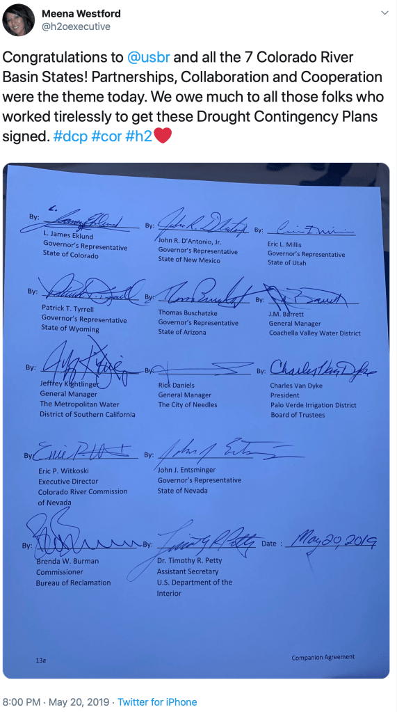
The Department of the Interior, Bureau of Reclamation and representatives from all seven Colorado River Basin states gathered today and signed completed drought contingency plans for the Upper and Lower Colorado River basins. These completed plans are designed to reduce risks from ongoing drought and protect the single most important water resource in the western United States.

“This is an historic accomplishment for the Colorado River Basin. Adopting consensus-based drought contingency plans represents the best path toward safeguarding the single most important water resource in the western United States,” said Reclamation Commissioner Brenda Burman. “These agreements represent tremendous collaboration, coordination and compromise from each basin state, American Indian tribes, and even the nation of Mexico.”

In addition to the voluntary reductions and other measures to which the basin states agreed, Mexico has also agreed to participate in additional measures to protect the Colorado River Basin. Under a 2017 agreement, Minute 323 to the 1944 U.S. – Mexico Water Treaty, Mexico agreed to implement a Binational Water Scarcity Contingency Plan but only after the United States adopted the DCP.

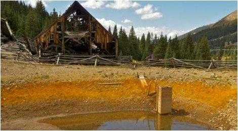
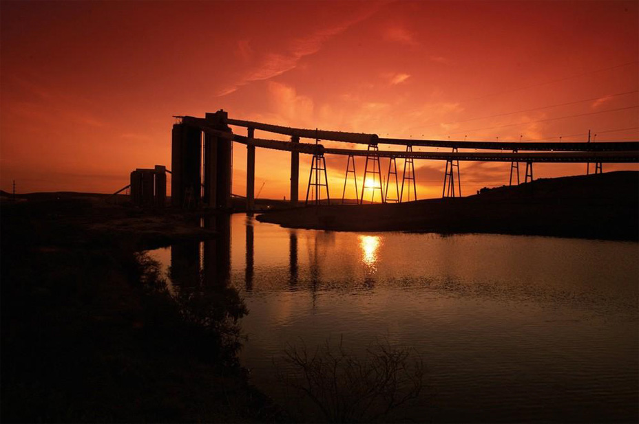
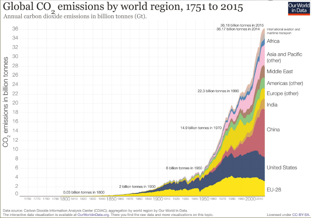
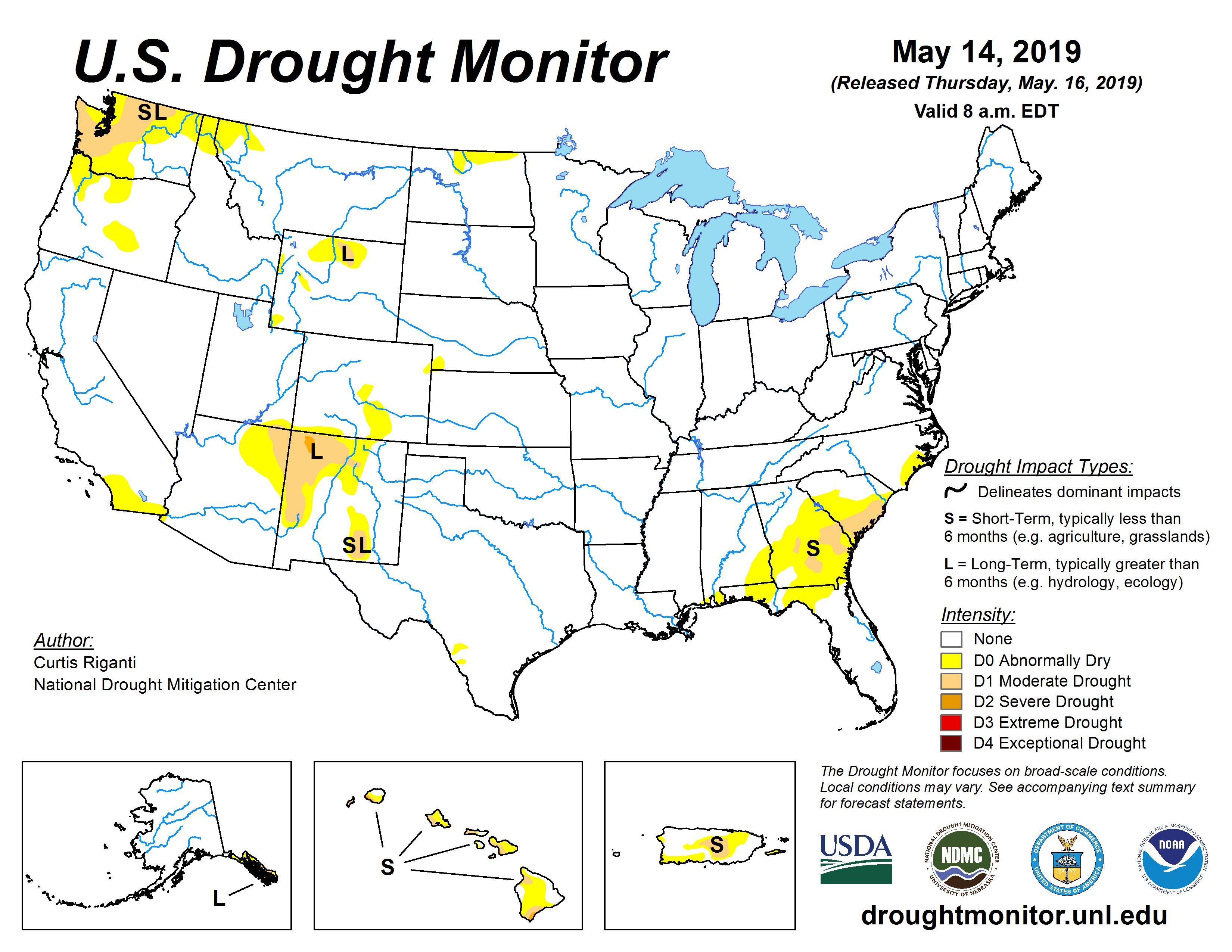
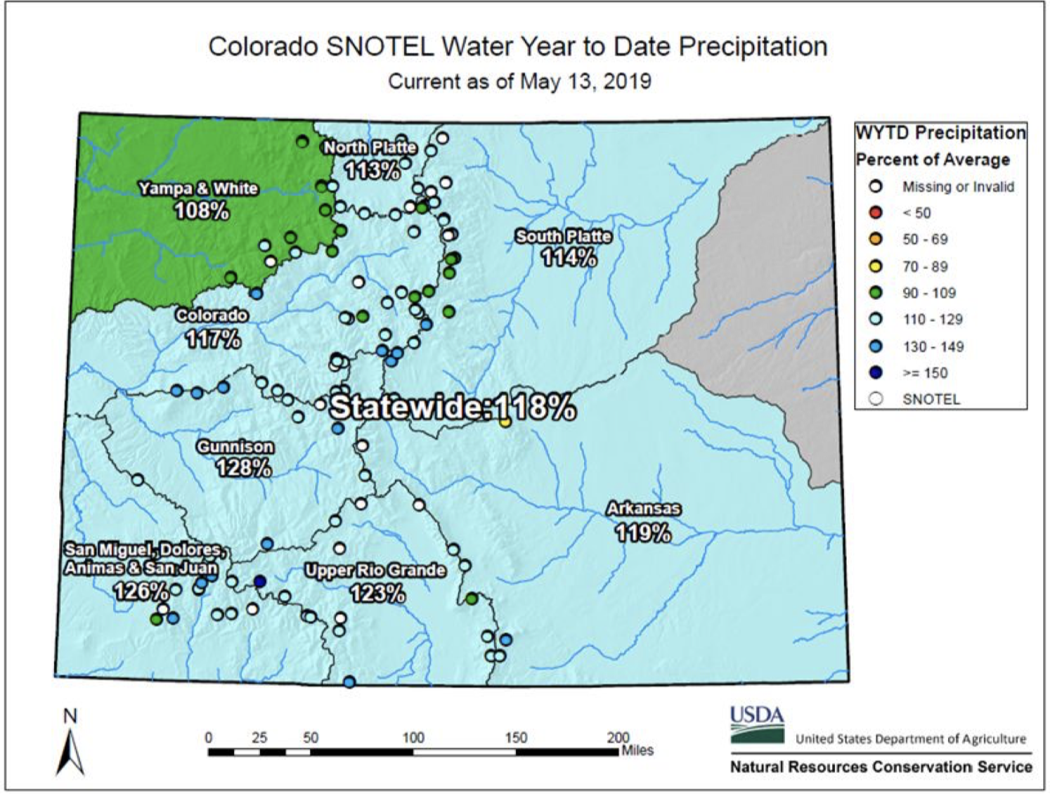
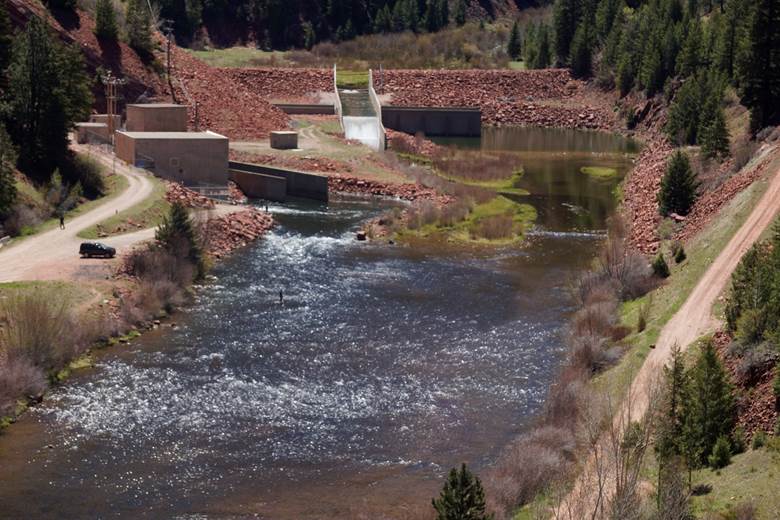
The Colorado River, with its system of reservoirs and water conveyance infrastructure, supplies water for more than 40 million people and nearly 5.5 million acres of farmland across the western United States and Mexico. The reservoirs along the river have performed well—ensuring reliable and consistent water deliveries through even the driest years. But, after 20 years of drought, those reservoirs are showing increasing strain; Lake Powell and Lake Mead, the two largest reservoirs on the system and in the United States, are only 39% and 41% full respectively. And, while the basin experienced above-average snowpack in 2019, the total system storage across the basin began the water year at just 47% full.

“The urgency for action in the basin is real, and I applaud all of the parties across the seven states and Mexico for coming together and reaching agreement to protect the Colorado River,” said Burman. “I’m glad to finally say that ‘done’ is done.”

From The Arizona Republic (Ian James):

The Colorado River just got a boost that’s likely to prevent its depleted reservoirs from bottoming out, at least for the next several years.

Representatives of seven Western states and the federal government signed a landmark deal on Monday laying out potential cuts in water deliveries through 2026 to reduce the risks of the river’s reservoirs hitting critically low levels.

Yet even as they celebrated the deal’s completion on a terrace overlooking Hoover Dam and drought-stricken Lake Mead, state and federal water officials acknowledged that tougher negotiations lie ahead. Their task starting next year will be to work out new rules to re-balance the chronically overused river for years to come.

Figuring out how to do that will be complicated because the Colorado River, which supplies water for vast farmlands and more than 40 million people, is managed under a nearly century-old system of allocations that draws out more than what flows in from rain and snow in an average year.

The river’s reservoirs have fallen since 2000 during one of the driest periods in centuries, and global warming is cranking up the pressures by contributing to the declines in the river’s flow.

“Look at all we have accomplished by working together,” said federal Reclamation Commissioner Brenda Burman, who signed the agreements alongside the states’ representatives. “All the states should be commended for finding a path forward.”

She called the deal historic and said it adds an important new chapter to the rules that govern the river.

“But our work is not done,” Burman said. “We know we have even greater challenges ahead.”

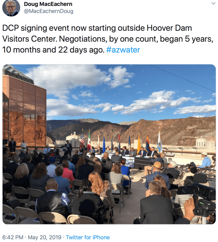
Federal and state officials began talking about the need for a drought deal in 2013, and the negotiations got underway in 2015.

The set of agreements includes two separate but interrelated drought contingency plans: one for states in the river’s Upper Basin — Colorado, Wyoming, Utah and New Mexico — and the other for the Lower Basin states — Arizona, Nevada and California.

The drought plans are designed to prop up the levels of Lake Mead and Lake Powell, the nation’s largest reservoirs, between 2020 and 2026. Lake Powell is now 40% full, and Lake Mead sits 41% full.

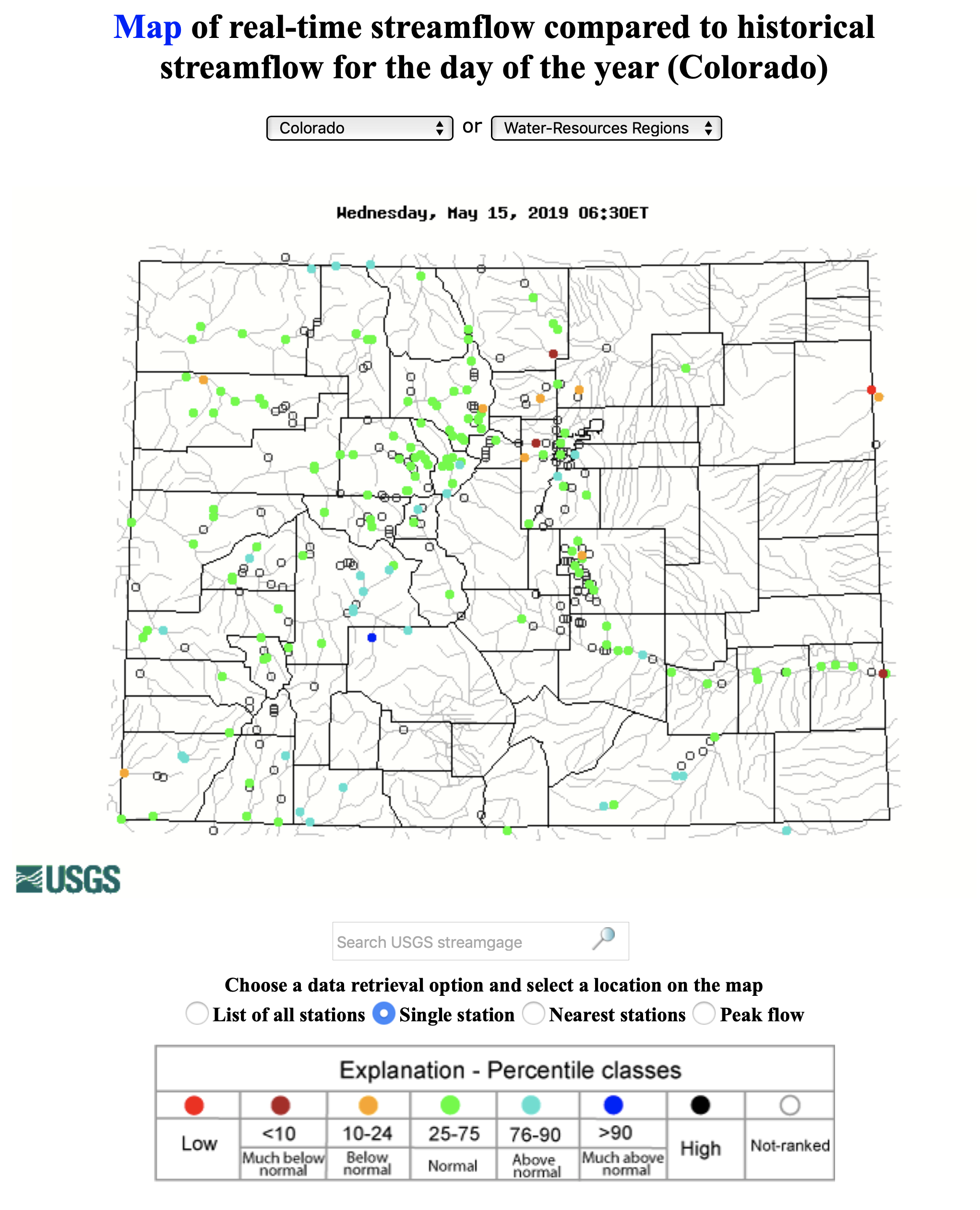
During the talks on the agreement last year, Lake Mead had appeared headed for a first-ever declaration of a shortage by the federal government. But this winter left the Rocky Mountains blanketed with heavy snow, unleashing a bounty of runoff that’s expected to avert a shortage for another year.

“One good year is helpful,” Burman said. “But it doesn’t fix a 19-year drought and it doesn’t do anything to predict for us what’s going to happen next.”

The audience of water managers and government officials broke into applause after the signing and posed for photos with the Hoover Dam, its low water levels starkly outlined, in the background.

Missing from the celebration was the largest single user of the Colorado River, California’ Imperial Irrigation District, which is suing to challenge the deal.

A new reality driven by global warming

Water managers and supporters of the deal have praised the Lower Basin’s Drought Contingency Plan, or DCP, as “bridge solution” to get the region through the next several years until 2026 while reducing the risks of a crash. But they also stress that it’s merely a stopgap measure — a temporary fix on top of the existing 2007 guidelines for managing shortages — and that it will provide a short window of time to start to plan bigger steps.

“We’re in a moment where we’re going to take a pause and recognize the progress we’ve made. But I think it needs to be a short pause so that we get working on the renegotiation of the guidelines,” said Kevin Moran, who leads the Environmental Defense Fund’s Colorado River program. “I think it’s in everyone’s interest that we move those conversations as quickly as possible forward.”

[…]

When water officials finished negotiating the last set of rules for dealing with a potential shortage in 2007, they had expected those rules to work through 2026. But only halfway through that period, they realized the measures weren’t nearly strong enough. And that forced them to negotiate the new set of drought agreements to finish off the period…

Adapting that system to a hotter planet, Moran said, will require posing tougher questions and looking at ways of boosting conservation and managing demand for water across the Colorado River Basin.

“The modeling looking forward would say we probably ought to be planning for somewhere between 15 and 35% additional reduction in flows driven by climate change,” Moran said. He said climate models present an outlook that is “very dire” and demands action…

A shortage is unlikely next year

Cynthia Campbell, a water adviser for Phoenix, said the challenges that lie ahead for negotiators are sobering.

“They know that they have a daunting task ahead of them, beginning in 2020, to try to come up with new operating rules that are going to keep us sustainable further into the 21st century,” Campbell said. “When they come back, Arizona is certainly going to be on the business end of cuts.”

There’s no way around that, she said, because the state holds the junior-most position in the water priority system. Under the framework that emerges from the next round of negotiations, she said, the state will probably face bigger reductions during a shortage than under the newly signed drought plan.

The latest projections by the U.S. Bureau of Reclamation show that in 2020 it’s unlikely a shortage will be declared at Lake Mead. The reservoir’s level now stands at 1,088 feet above sea level, about 13 feet higher than the threshold that would trigger a shortage declaration…

Critics: Arizona plan is not sustainable

Arizona water officials have called the state’s internal plan a landmark consensus agreement that effectively “shares the pain” and will address the water shortfall for the next several years.

But Arizona’s plan has also drawn criticism.

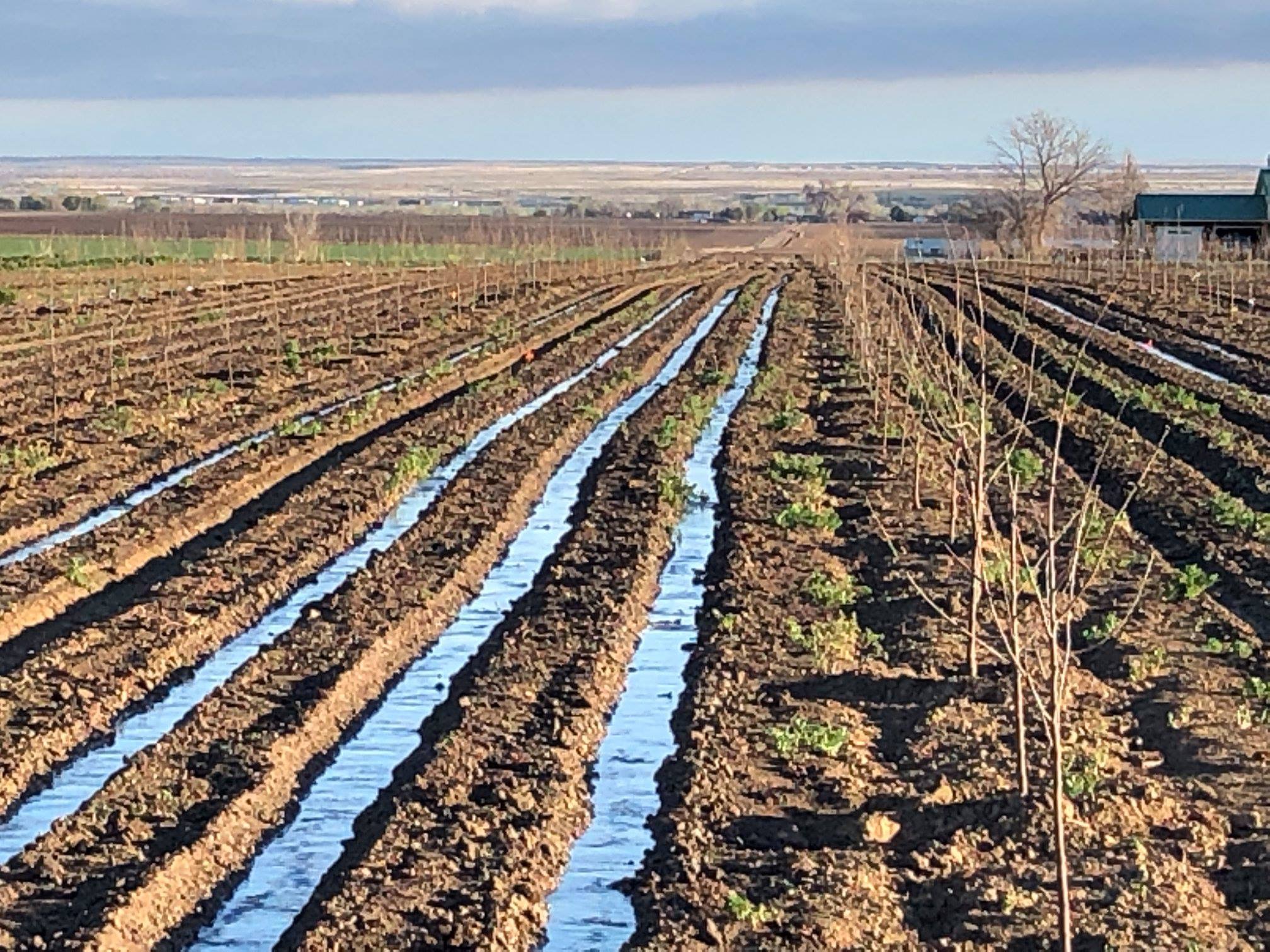
Some experts and environmentalists are concerned about the plan’s promotion of more groundwater pumping in parts of the state. They say using state money to drill more wells in Pinal County will only lead to declining aquifers. They also argue the state missed an opportunity to do more to encourage conservation.

“It is positive that the Colorado River basin states are looking at cutting back on river water use, but it is unfortunate that our state has chosen to augment the river water with more groundwater pumping,” said Sandy Bahr, director of the Sierra Club’s Grand Canyon Chapter. “Sadly, the Arizona plan is not sustainable and is designed to keep Arizona doing more of the same — unsustainable and thirsty agriculture and more and more sprawl development.”

She said looking past 2026, all the states should consider the river’s long-term water deficit, the effects of climate change, and how to do more for conservation while considering the health of the river.

“It is way past time for a Colorado River sustainability plan that centers on a healthy river that flows all the way to the sea and that provides for people, plants, and animals along the way,” Bahr said. “There is not time for patting ourselves on the back. We need to do more, now.”

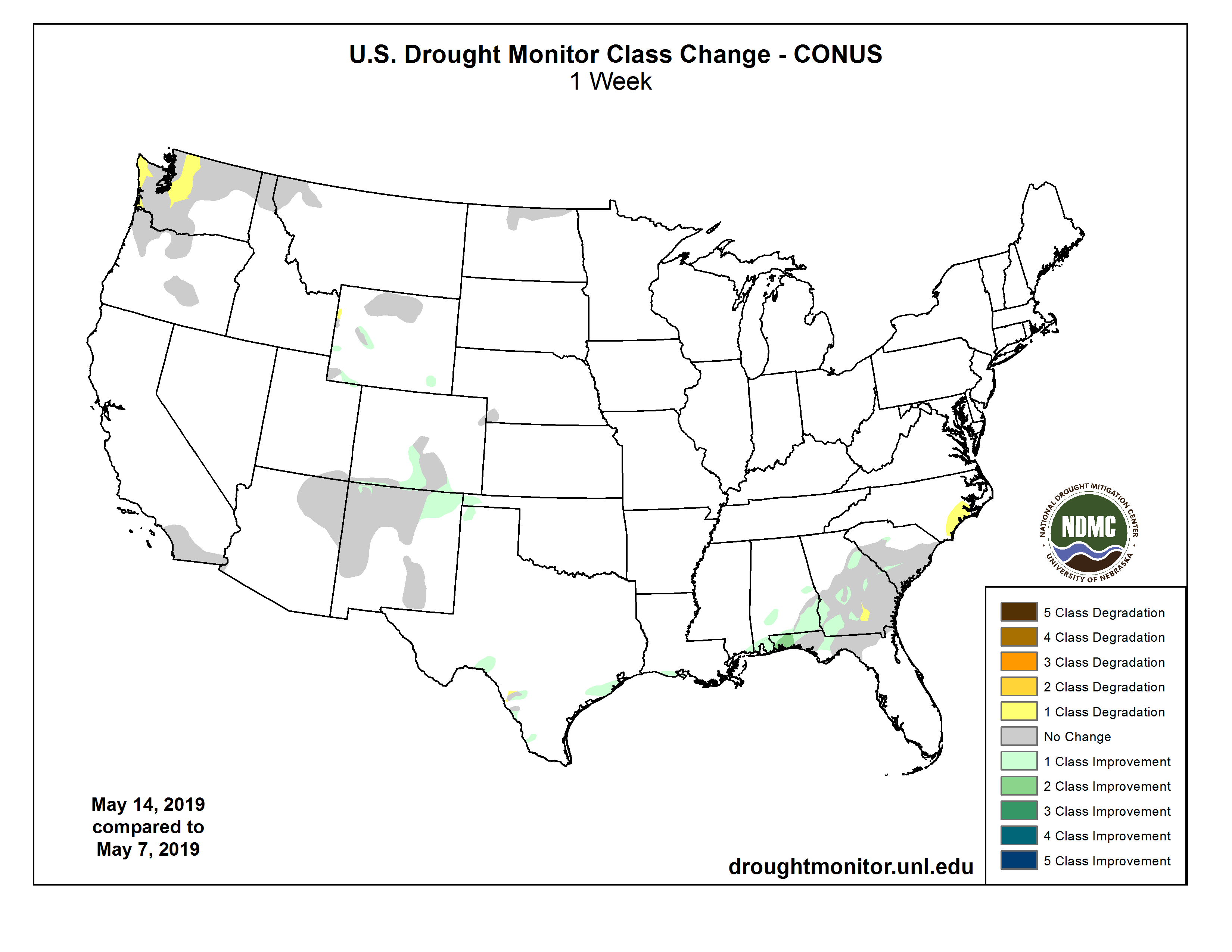
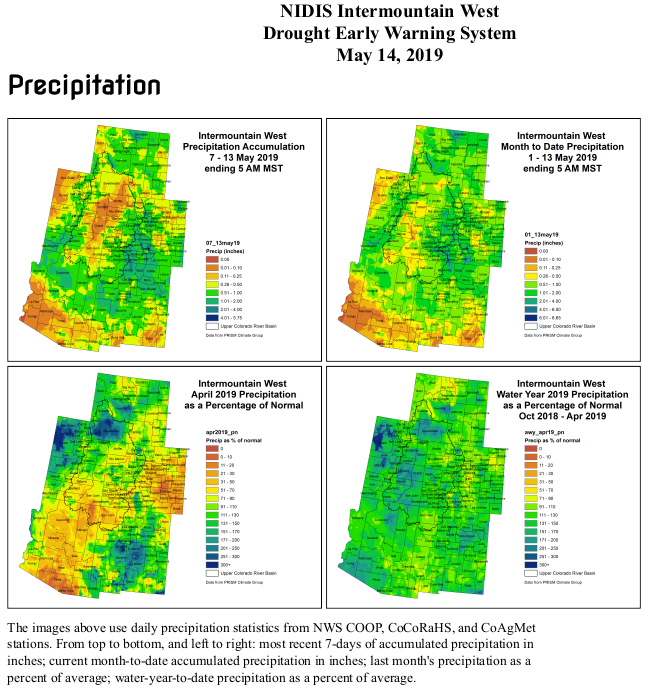
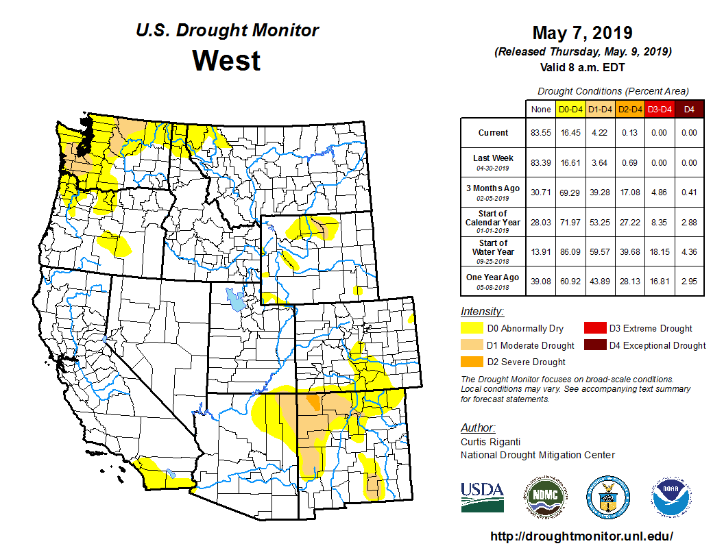
In the meantime, even as the drought has eased across the West with the wet winter, concerns remain that the 19-year run of mostly dry years could continue. Earlier this month, a group of experts in a state advisory group recommended to Gov. Doug Ducey that a declaration of drought in Arizona should remain in effect.

Tom Buschatzke, director of the Arizona Department of Water Resources, called the Drought Contingency Plan “a huge incremental step forward.”

“It sets us up to have good conversations about what we need to do to deal with the projections of our drier future, climate change forcing reductions in flow, etcetera,” Buschatzke said. Discussions on the next round of plans should start soon in Arizona, he said, because “keeping the momentum going is really important.”

Update: May 21, 2019

From Inkstain (John Fleck):

Now that we have a DCP, what does this mean in practice?

According to the most recent Bureau of Reclamation 24-month study, Lake Mead is projected to end 2019 at elevation ~1,085 feet above sea level. Prior to the DCP, Lower Basin water users (Mexico, Arizona, Nevada, California) got a full allocation of water as long as Lake Mead’s elevation was above 1,075. Under the DCP, a new shortage tier has been added between elevations 1,090 and 1,075. The result is that, for the first time in the history of Colorado River management, there will now be mandatory water use reductions on the Colorado River.

What does this mean in practice? I ran down a quick summary this morning of the relevant data, comparing recent use with the cuts mandated under the DCP. It shows that, at this first tier of shortage, permitted use is less than the voluntary cuts water users have been making since 2015:

In other words, all of the states are already using less water than contemplated in this first tier of DCP reductions.

CU asks city to consider different CU Boulder South flood mitigation plan — CU Boulder News

Boulder. By Gtj82 at English Wikipedia – Transferred from en.wikipedia to Commons by Patriot8790., Public Domain, https://commons.wikimedia.org/w/index.php?curid=11297782

From CU Boulder Today:

CU Boulder today asked the Boulder City Council to consider a flood mitigation option that would support both the community’s life safety needs and the university’s need to use a reasonable amount of its CU Boulder South property in the future to meet its mission to serve Colorado.

In a letter to council members (PDF), the university recommended that Boulder refrain from further investing in Variant I – 500, a flood mitigation option that would curtail the university’s future ability to develop its CU Boulder South property. Located at U.S. 36 and Table Mesa Drive, the 308-acre parcel of university-owned land is under consideration for annexation into the Boulder city limits.

CU Boulder has recommended that the city seriously consider another plan—Variant II – 500—which was previously recommended by the city’s Water Resource Advisory Board and experts hired by the city.

If the university and city reach agreement on annexation terms, CU Boulder would use the property in the future to develop limited academic buildings and housing for faculty, staff, upper-level undergraduate students and graduate students. Other planned uses include recreation fields, expanded hiking and biking trails and other value-added features for the Boulder and university communities.

In all, CU Boulder is seeking to develop just 129 acres of the site designated as public use in the most recent Boulder Valley Comprehensive Plan update, while 30 acres would be used for recreation fields. The university would donate 80 acres to the city for flood mitigation, with the balance remaining undeveloped.

Arriving at a mutually acceptable flood mitigation plan for the land is key to the agreement between the university and the city after years of ongoing discussions. In order to make progress in the negotiation process, city officials in November asked CU to submit an annexation application ahead of schedule. CU complied by filing an annexation application on Feb. 4.

The next day, city officials decided to move forward with a flood mitigation plan known as Variant I – 500, the only proposed flood mitigation plan among several considered by the city that the university repeatedly has said it cannot accept.

If the city moves forward with Variant 1 – 500, the university would not be able to develop the entire 129 acres allocated for public use on its own property, said Frances Draper, CU Boulder’s vice chancellor for strategic relations and communications.

“The university is dedicated to working with the city, and local residents whose homes are in the floodplain to achieve safety,” Draper said. “At the same time, we must be good stewards of the university’s resources for the benefit of the state of Colorado, to educate students and engage in research. The university has offered significant community benefits while striking a good balance to achieve effective use of this site to serve the needs of students in the coming decades.”

Despite its objection to the city’s intent to pursue Variant I – 500, CU worked to create a path forward in its annexation application by offering three options that would make it possible for CU to work with the city’s chosen flood mitigation plan.

However, in a March 28 response, the city made it clear none of CU Boulder’s alternatives would be feasible, precipitating the university’s response for a study session and further discussions.

May 2019 #Drought Update — Colorado Department of Natural Resources

Click here to read the update (Tracy Kosloff/Taryn Finnessey):

As a result of consistent fall and winter precipitation, near record breaking snowpack, and near normal reservoir storage levels, the Drought Task Force has made a recommendation to Governor Polis to deactivate the Colorado Drought Mitigation and Response Plan statewide.

While April ended with slightly below average precipitation across the state, May has started off cool and wet and, following a brief warmup, is forecast to end in a similar fashion. ​May through August is an important period for precipitation accumulation east of the continental divide as much of the annual precipitation falls during this time. ​Water year to date precipitation remains above average statewide, with some areas still seeing spring snow accumulation. Stream flows have increased reflecting the start of runoff season and reservoir levels are responding.

US Drought Monitor May 16, 2019.
  • As of May14th, only 11 percent of the State is classified as abnormally dry. This spring has seen the record lowest amount of drought coverage over the contenital United States, according to the US Drought Monitor, which has been tracking conditions since 2000.
  • El Niño conditions remain, and are likely to continue through summer (70 percent chance) of this year. Historically summer during an El Niño are more likely to be wet than dry, and the NOAA Climate Prediction Center outlooks for the June-July-August period show increased chances of wetter-than-average conditions.
  • Current SNOTEL Water Year to-date precipitation in 118 percent of average, with all basins above average.
  • SNOTEL snow water equivalent statewide is 155 percent of median with all basins above normal. These figures can fluctuate greatly during the spring season when snowmelt has begun, but storms can still result in accumulation.
  • Statewide reservoir storage as of May 1, is 90 percent of average and increasing as the runoff season begins with widespread above average streamflow forecasts. Blue Mesa Reservoir, heavily impacted by the 2018 drought, has increased more than 26 feet in elevation since April 1 and has seen an increase of more than 55,000 acre-feet since May 1.
  • Flooding in post wildfire burn scars remains a concern and is being monitored closely. The daily flood threat bulletin can be accessed May 1 through September 30 ​HERE​.
  • South Routt County Water Users Meeting, May 29, 2019 — Colorado Division of Water Resources #YampaRiver

    Here’s the notice from the the Colorado Division of Water Resources (Scott Hummer):

    South Routt County Water Users Meeting

    Bear River at CR7 near Yampa / 3:30 PM, May 16, 2019 / Flow Rate = 0.52 CFS. Photo credit: Scott Hummer

    Wednesday, May 29, 2019
    Soroco High School / Oak Creek, CO
    6:30 PM – 8:00 PM

    Representatives from the Colorado Division of Water Resources (DWR), Upper Yampa Water Conservancy District (UYWCD), United States Forest Service (USFS), and Natural Resources Conservation Service (NRCS)

    The agenda will address the agencies specific roles regarding:

    Authority and Responsibilities associated with Administration, Management, and Oversight of water matters in the Morrison Creek, Oak Creek, and all Tributary drainages above Stagecoach Reservoir

    All waters users are encouraged to Attend

    Special recognition to the Soroco High School, FFA Chapter for helping organize the event!

    #Drought news: Moderate drought exits #Colorado, pockets of abnormal dryness (D0) remain — The Kiowa County Press

    From The Kiowa County Press (Chris Sorensen):

    The final remnants of drought that spanned late 2017 through early 2019 have been removed from Colorado according to the latest update from the National Drought Mitigation Center…

    Colorado Drought Monitor May 16, 2019.

    Just three months ago, as frequent heavy snow storms began to impact western and central Colorado, the area was in extreme drought. A portion of southwest Archuleta County was still in exceptional drought – the worst category.

    With this week’s update, abnormally dry conditions were also removed from the south central part of the state as rain and snow continued in the area.

    Abnormally dry expanses continue for the east central mountains, portions of four southwest counties, and east central Yuma County.

    Colorado Drought Monitor February 12, 2019.

    Overall, 89 percent of Colorado is drought-free, with the remaining 11 percent in abnormally dry conditions.

    One year ago, just 20 percent of the state was drought-free. Abnormally dry and moderate drought each covered 14 percent of the state, while another 20 percent was experiencing severe drought. Twenty-three percent of Colorado was in extreme drought, with the remaining eight percent in exceptional conditions. (Total does not equal 100 percent due to rounding.)

    Colorado Drought Monitor February 13, 2018.

    We were warned 150 years ago about our water shortage. We have to do better. — The Washington Post #aridification #ColoradoRiver #COriver

    John Wesley Powell’s recommendation for political boundaries in the west by watershed

    From The Washington Post (Heather Hansman):

    Heather Hansman is the author of “Downriver: Into the Future of Water in the West.”

    Coming into the crush of the first real rapid, Red Creek, I white-knuckle my paddle, try to keep breathing and think about what John Wesley Powell must have felt when he teed up to the trough of the first wave.

    It’s May, the same time of year that, 150 years ago, Powell and a nine-man crew put onto the Green River just upstream from here and paddled on down the Colorado through the Grand Canyon — the first non-Native Americans on record to do so.

    When Powell made his trip, the Homestead Act was less than a decade old, and the chalk-dust canyons of the Colorado Plateau were a big blank space on the map. America’s manifest destiny was just manifesting itself, but he could see that as the West filled up, human demand for its resources would outstrip supply.

    His predictions about water shortages have proved eerily true. The Colorado River — of which the Green is the biggest tributary — is the main water source for 40 million people. It’s already overallocated, and climate change is predicted to shrink flows by up to 50 percent by the end of the century. We’re finally coming to grips with those forecasts and beginning to heed Powell’s century-and-a-half-old warnings. But it’s taken drought and desperation to get us there, and we have to do better.

    This spring, the seven states in the Colorado River Basin signed a drought contingency plan. For the first time, each of the states has agreed to take less than its individual allocated share of water, to try to shore up the supply for a drier future. It’s a small but significant step in dialing back demand to meet supply — the heart of Powell’s prediction — but no one, not even the state leaders who agreed to it after almost 100 years of battling over water rights, thinks it goes far enough.

    Climate change and overuse are still advancing. I followed Powell’s path because I wanted to understand how water conflicts were going to play out, and my first move was the same as his: get on the river to see what’s going on. Today, Red Creek is in the tailwater of Flaming Gorge Dam, and I can see the impacts of a highly regulated waterway: the non-native trout, the unnaturally clear water, because the dam stops sediment that would normally make the current milky and thick. We’ve constructed a vast network of pipes, reservoirs and dams and built up a society around that man-made river, and that’s not going to change. No one wants to cut off water to Salt Lake City or to stop growing food in Yuma, Ariz.

    This winter brought above-average snowfall, but it barely dents two decades of extended drought that experts are now calling aridity, because drought sounds temporary and fixable. It was another anomalous winter in the swinging yo-yo of climate change: unpredictable and hard to manage, in a river system that’s managed down to every drop.

    We’ve been okay so far, in part because reservoirs give us a buffer in the dry years, but we’re sucking down our storage, and in the fragile interlocking mesh of current water use, our squeezed supply won’t last for long.

    As I paddled, I saw the intractability of an overstretched water system firsthand: ranchers with decades of family history who told me they were unable to pass down their land, cities building new reservoirs to shore up their reserves, desiccated tribal reservations where opportunity has been thwarted by withheld water rights. It was obvious, as Powell anticipated, that the math didn’t line up.

    In his “Report on the Lands of the Arid Region of the United States,” he predicted that there wouldn’t be enough water for unchecked westward growth in the drylands beyond the Great Plains; he warned that groundwater wouldn’t be enough to sustain agriculture and that the most sustainable way to use water in the West would be lightly, and within a river’s own watershed.

    The prevailing climate theory at the time, pushed by land speculator Charles Dana Wilber, was that “rain follows the plow” — that is, agriculture itself could change the climate of arid regions — so Powell’s message of moderation was inconvenient to the culture of optimism and American exceptionalism. It still is. We know better than that now, I think, but it’s hard to shake the outdated dreams that we can keep growing and not suffer consequences. The drought contingency plan is an important step in addressing that, but there will need to be more compromises and creative ways to incentivize using less.

    Spring, if you’re a boater, always comes with the fragile dream of following the hydrograph, watching for the spike of runoff, trying to predict your risk and your rush as you hope that snowmelt and spring rains have provided the depth to make your way downstream. But at some point, that risk has to line up with reality. You can’t float if you don’t have any water.

    “This year the snow is melting out a little later higher up…I do expect water to be fairly high for the [Ruedi] reservoir” — John Currier

    Ruedi Dam. Photo credit Greg Hobbs.

    From The Aspen Times (Chad Abraham):

    Ruedi Reservoir on Friday was just under 63 percent full as it continues to recover from the recent drought, but the wet, cool spring — more snow and rain is possible today — means there is plenty of snow remaining in the upper Fryingpan River Valley.

    Gauges at and near the reservoir show winter is loosening its grip, albeit slowly. The Ivanhoe Snotel site, which sits at 10,400 feet, had a snowpack Friday that is 185 percent of normal for the day, while the Kiln site (9,600 feet) stood at 161 percent of average.

    That simply means more snow is locked in at high elevations than normal for this time of the year, said John Currier, chief engineer with the Colorado River District.

    “This year the snow is melting out a little later higher up,” he said. “I do expect water to be fairly high for the reservoir.”

    Currier predicted Bureau of Reclamation officials, who control releases from Ruedi, to keep flows in the Fryingpan at around 300 cubic feet per second (CFS) for most of the summer. That level, which will increase drastically as snowmelt increases and fills the tub, is preferable for “fisherman wade-ability reasons,” he said. “They are typically going to have to bypass [that CFS rate] because there’s much, much more water during runoff.”

    Ruedi being roughly three-quarters full in mid-May is somewhat below normal, said Mark Fuller, who recently retired after nearly four decades as director of the Ruedi Water and Power Authority. That’s a sign of both a stubborn snowpack and the reclamation bureau “trying to leave plenty of room for late runoff in anticipation of a flood out of the upper Fryingpan when it gets warm,” he said…

    Releases from Ruedi may make fishing the gold-medal waters below the reservoir a bit more difficult when they occur, but greatly aid the river environment in the long term, said Scott Montrose, a guide with Frying Pan Anglers.

    2019 #COleg: Colorado lawmakers approve a bevy of energy bills — The Denver Post #ActOnClimate #KeepItInTheGround

    Coyote Gulch’s Leaf charging at campsite near Steamboat Springs August 21, 2017.

    From The Denver Post (Judith Kohler):

    “If I had to sum it up in a word, I think I’d say ‘transformative.’ It’s a real shift in our policy, and I think it really shows the direction that Colorado is headed,” said Erin Overturf, chief energy counsel for the conservation group Western Resource Advocates. “I think it shows that we’re starting to take climate change seriously and recognize the task that’s truly ahead of us if we’re going to do our part to help solve this problem.”

    The bills include efforts to make houses and appliances — from refrigerators, to light bulbs to air conditioners and furnaces — more energy-efficient…

    Lawmakers extended state tax credits for buying electric vehicles and allowed regulated electric utilities to own and operate vehicle charging stations to try to encourage people to buy and drive zero-emission vehicles.

    One of the things that sets Colorado apart from other states working to boost the use of renewable energy and reduce greenhouse gas emissions is its efforts to look out for affected workers and communities, said Anna McDevitt, an organizer with the Sierra Club’s Beyond Coal Campaign.

    The bill reauthorizing the PUC has a provision requiring utilities to include a workforce transition plan when they propose shutting down a power plant. Another section on low-cost bonds to retire power plants for cleaner, cheaper alternatives also provides that a portion of the proceeds helps workers and communities affected by the closures…

    Referring to the PUC bill and its carbon-reduction targets, Xcel Energy said in a statement Friday that the legislation was “heavily negotiated with a broad set of stakeholders” and protects safety reliability and customer costs…

    One bill expands the size of community solar gardens, which are centralized arrays of solar panels that users “subscribe” to. They are intended for people who want to use solar power but whose roofs aren’t suitable, who live in an apartment or can’t afford to install a system.

    Other legislation directs the PUC to study regional transmission organizations that would make it easier for utilities or municipalities to buy wholesale power. Another section requires regulators to take on planning to help facilitate rooftop solar and other distributed-energy installations.

    The PUC also will have to look into so-called “performance-based ratemaking.” That would allow utilities to earn a certain rate of return on things such as increasing energy efficiency or installing a certain amount of rooftop solar rather than just on construction of plants or other infrastructure.

    ‘Now I Am Speaking to the Whole World.’ How Teen Climate Activist @GretaThunberg Got Everyone to Listen #ActOnClimate #ClimateCrisis

    Greta Thunberg in Stockholm screen shot from the Time Magazine website May 19, 2019.

    Here’s an in-depth report from Suyin Haynes that’s running in Time Magazine. Click through and read the whole thing (and then do one thing to mitigate Global Heating today). Here’s an excerpt:

    Thunberg attributes her determination to her diagnosis of Asperger’s, a mild form of autism spectrum disorder. “It makes me see the world differently. I see through lies more easily,” she says. “I don’t like compromising. For me, it’s either you are sustainable or not — you can’t be a little bit sustainable.” Her openness about her diagnosis, and willingness to share about her experiences of depression, anxiety and eating disorders, are another reason why many see Thunberg as a role model. “To be different is not a weakness. It’s a strength in many ways, because you stand out from the crowd.”

    Not that all of the attention has made her terribly impressed. She indulges a brief smile at a mention of President Barack Obama’s tweet in praise of her, but she returns quickly to her larger message. “I believe that once we start behaving as if we were in an existential crisis, then we can avoid a climate and ecological breakdown,” she says. “But the opportunity to do so will not last for long. We have to start today.”

    […]

    “People are taking their cues from Greta,” says Naomi Klein, activist and author of This Changes Everything: Capitalism vs. the Climate. “There’s something very hard to categorize about her, and I think because she’s not looking for approval and is not easily impressed, people don’t know what to do with that.”

    Thunberg has been greatly influenced by Klein’s work and has welcomed her support. But Klein thinks the teenager doesn’t really need anyone’s advice. “I don’t think I would deign to tell Greta what she should do in the future. She is following her own path with such clarity, and she has tremendously good instincts.”

    […]

    Thunberg’s main goal is for governments to reduce emissions in line with the Paris Agreement, limiting global temperature rise to 1.5°C over pre-industrial levels. In October 2018, the U.N.’s Intergovernmental Panel on Climate Change (IPCC) released a landmark report warning that carbon emissions would need to be cut by 45% by 2030 to reach this target. “The report made it very clear that we have to act now,” says Myles Allen, a co-author of the report. Since the price of failing to heed these warnings will be paid by young people, Thunberg believes the school strike follows an inevitable logic. “We are children, saying why should we care about our future when no one else is doing that?” she says. “When children say something like that, I think adults feel very bad.”

    Hooked into river stewardship — News on TAP

    Two dozen Girl Scouts came to the South Platte River to learn about watersheds — and how to tie a good fly. The post Hooked into river stewardship appeared first on News on TAP.

    via Hooked into river stewardship — News on TAP

    “Brotherhood of Skiing” tracks rich history of black ski club — Katie Klingsporn

    In 1973, being a black skier was a lonely pursuit. Ski slopes were white-dominated landscapes of intimidation or hostility, and it wasn’t uncommon to encounter overt racism in the lift line. That year, a handful of small ski clubs from around the country decided to band together and hit the slopes as a group. They […]

    via “Brotherhood of Skiing” tracks rich history of black ski club — Katie Klingsporn

    A big spring boost for one of Denver Water’s most important bank accounts — News on TAP

    Lake Powell is expected to get a big water deposit this year — but the decades-long basin drought remains. The post A big spring boost for one of Denver Water’s most important bank accounts appeared first on News on TAP.

    via A big spring boost for one of Denver Water’s most important bank accounts — News on TAP

    Spring thaw — Katie Klingsporn

    Originally published in the Telluride Daily Planet on March 29, 2019. I can tell immediately that the trail conditions will be poor today. As soon as I step out of the car, my boots sink into the ground. It’s saturated from snowmelt. This is going to be muddy. But here I am. I’ve packed the […]

    via Spring thaw — Katie Klingsporn

    Denver: Watershed Summit 2019, June 27, 2019

    Click here to go to the Resource Central website for all the inside skinny:

    The Watershed Summit is rapidly becoming the region’s top event for water industry leaders. Join 250+ water utility executives, business leaders, conservation experts, and other professionals to gain the new insights you need to help position your organization for success.

    Watershed Summit 2019 is produced through a collaborative partnership between the Colorado Water Conservation Board, Denver Water, the City of Boulder, Aurora Water, the One World One Water Center, Resource Central, and the Denver Botanic Gardens. Building on the success of the last 4 years, this one-day summit helps you get connected to industry leaders and what works best across the Mountain West.

    Standard Registration: $65

    We are thrilled to feature a dynamic line-up of experts in the water field who are excited to share their knowledge and join in on the conversation.

    Special Guest: Phil Weiser, Attorney General for the State of Colorado

    • J. J. Ament, CEO, Metro Denver Economic Development Corporation
    • Ze’ev Barylka, Marketing Director US, Netafim
    • Cynthia S. Campbell, Water Resources Management Advisor, City of Phoenix
    • Beorn Courtney, President, Element Water
    • Lisa Darling, Executive Director, South Metro Water Supply Authority
    • Carol Ekarius, Executive Director, Coalition for the Upper South Platte
    • Jorge Figueroa, Chief Innovation Officer, Americas for Conservation
    • Brent Gardner Smith, Journalist, Aspen Times
    • Dan Gibbs, Executive Director, Colorado Department of Natural Resources
    • Kate Greenberg, Colorado Commissioner of Agriculture, State of Colorado
    • Jim Havey, Filmmaker, HaveyPro Cinema
    • Jim Lochhead, CEO/Manager, Denver Water
    • Peter Marcus, Communications Director, Terrapin Care Station
    • Fernando Nardi, Professor, Università per Stranieri di Perugia, Italy
    • Cristina Rulli, Professor, Milan Polytechnic, Italy
    • Luke Runyon, Reporter, KUNC
    • Harold Smethills, Founder, Sterling Ranch
    • Jamie Sudler, Executive Producer, H2O Radio
    • Weston Toll, Watershed Program Specialist, CO State Forest Service
    • Chris Treese, External Affairs Manager, Colorado River District
    • Larry Vickerman, Director, Denver Botanic Gardens Chatfield Farms
    • Scott Winter, Water Conservation Specialist, Colorado Springs Utility

    Panel Topics Include:

    • The Colorado River
    • Water and Business
    • Agriculture
    • Watershed Health
    • Conservation and Storage

    ​”The economic and health consequences of #climatechange” May 15, 2019 — Written testimony of Dr. Katherine Drew Marvel (US House of Representatives Ways and Means Committee) #ActOnClimate

    Click here to read Dr. Marvel’s written testimony from the other day:

    How recreation boosts the economy — @HighCountryNews

    From the High Country News (Luna Anna Archey):

    Across the country, the outdoor recreation industry puts millions of people to work and boosts the economy by hundreds of billions of dollars. To cash in on some of that spending, many communities trumpet the recreation opportunities available to visitors, in the hopes that travelers will stay in local hotels, book local tours and dine at local restaurants.

    Sources: Headwaters Economics; U.S. Department of Commerce

    But do recreation amenities lure new residents — who might bring even more economic benefits — as well as tourists? To find out, Headwaters Economics, a nonprofit research group, looked at where populations have grown or dwindled since 2010. They compared counties where the economy is closely tied to entertainment and seasonal visitors’ spending, or “recreation counties,” to counties with economies driven by other factors.

    The number of people who moved to each type of county, and how much money they brought with them, was different at distinct levels of urbanization. Here are some of Headwaters’ results:

    Statewide benefits in Montana

    The vast majority of Montana’s 1 million residents — 87% — label themselves outdoor enthusiasts. They’re responsible for more than half of the $7.1 billion spent on outdoor activities in the state every year, including rafting or fishing the state’s nearly 170,000 miles of river. Residents and visitors alike are drawn by the natural assets of Big Sky Country: Montana’s booming recreation economy is built around the cornerstone of the 33.8 million acres of public land within its borders.

    Even seemingly small recreation areas can have a big impact. The 42-mile Whitefish Trail, sections of which snake around ponds and lakes near the town of Whitefish, contributes $6.4 million to the economy every year. The trail system supports more than one job for every mile of its length, putting residents to work at local businesses like the Whitefish Bike Retreat, where visitors can rent bicycles, spend the night or arrange for a trail shuttle.

    Local benefits in North Idaho

    Rural Bonner County, in North Idaho, hosts about 660 miles of trails for biking, hiking, riding ATVs and other activities. The area has a robust recreation culture, which in turn supports gear shops, lodging, restaurants and guide services.

    Luna Anna Archey is the associate photo editor at High Country News. Email her at lunaarchey@hcn.org

    Farms get boost in water from Fryingpan-Arkansas Project #ColoradoRiver #COriver

    Here’s the release from the Southeastern Colorado Water Conservancy District (Chris Woodka):

    Agriculture received the lion’s share of water from the Fryingpan-Arkansas Project this year, when an abundant water supply is expected to boost Arkansas River flows as well as imported water.

    Allocations totaling 63,000 acre-feet were made by the Southeastern Colorado Water Conservancy District board on Thursday (May 16), with 48,668 acre-feet going to agriculture, and 14,332 going to cities. The district is the agency responsible for management of the Fry-Ark Project, which is operated by the U.S. Bureau of Reclamation.

    “This is a remarkable outcome for the Arkansas River basin, given the dry conditions we faced last year,” said Garrett Markus, water resources engineer for the district. “The conditions look favorable during the next three months, when rainfall should add to the abundant snowpack already in the mountains.”

    Water users in nine counties benefit from the supplemental water provided by the Fry-Ark Project, ranging from large cities in Pueblo and El Paso counties to irrigation companies in the Lower Arkansas Valley. Fry-Ark Project water accounts for about 10 percent of flows in the Arkansas River annually.

    While cities are entitled to more than 54 percent of project water, their accounts in Pueblo Reservoir are relatively full, freeing up additional water for agriculture. Municipal allocations include:

    Fountain Valley Authority, 7,353 acre-feet;
    Pueblo Water, 2,000 acre-feet;
    Cities west of Pueblo, 2,312 acre-feet;
    Cities east of Pueblo, 2,667 acre-feet.

    In the event of changing conditions – a reduction of precipitation or rapid melt-off of snow – the District initially will release only 28,256 acre-feet of water to irrigation companies until final imports are certain, with the remainder delivered as soon as the expected total is reached. Municipal allocations would not be affected by a shortfall, because they are all below allocation limits.

    Another 17,338 acre-feet of irrigation return flows were allocation, and 10,016 acre-feet will be initially released.

    Reclamation estimates the project will yield 84,000 acre-feet this year, but deductions from that total are made for evaporation, transit loss and obligations to other water users reduce the amount of water available to allocate.

    The Fry-Ark Project imports an average of about 56,000 acre-feet through its collection system in the Fryingpan River and Hunter Creek watersheds above Basalt. Water comes through the Boustead Tunnel into Turquoise Lake, through the Mount Elbert Power Plant at Twin Lakes and into terminal storage at Pueblo Reservoir.

    Three-month projections from the National Oceanic and Atmospheric Administration predict cooler and wetter than average conditions for eastern Colorado.

    #Drought news: #Colorado has seen a big improvement over mid-February conditions

    From The Colorado Sun (Jesse Paul):

    As the snowpack runoff season begins, Colorado’s drought situation has dramatically improved again. In the past three months, the areas on the drought map marked abnormally dry or worse have shrunk by 88%.

    On Feb. 12, 92% of the state was under some kind of drought status, including the most severe “exceptional drought” rating. On Thursday, the U.S. Drought Monitor reported that just 11% of Colorado is abnormally dry, but that no area is under a “drought” listing…

    But [Cari Bowen] cautioned that things could change if there are a few weeks of dry weather.

    “It’s all kind of pattern based,” she said. “Drought is not always something that’s fixed in the short term. It’s a long-term thing.”

    That being said, early signs are pointing to some big improvements.

    Reservoir storage levels in much of the state, which were giving farmers heartburn last summer, are looking solid. Only reservoirs in the southwest corner of Colorado remain far below their average levels, holding just a sliver of their capacity.

    Statewide, reservoirs are at 90% of their average fill level and holding 53% of their capacity. Compared to last year’s average, reservoirs at are 111%…

    Bowen said the late storms and relatively cool temperatures in the high country have helped keep the runoff season from ramping up too quickly to be captured.

    “That definitely does push back that melting a little bit,” she said.

    Moab looks at water assessment, future planning — The Moab Sun News #ColoradoRiver #COriver #aridification

    Colorado River near Moab, Utah.

    From The Moab Sun News (Ashley Bunton):

    Can the City of Moab take water out of the Colorado River if its springs and wells become depleted? Is climate change data being factored into water use planning in Moab and in the State of Utah?

    These were two questions raised on Tuesday, May 14, at the Moab City Council workshop discussing an assessment and recent report detailing surface and groundwater resources in and around Moab.

    Moab City Engineer Chuck Williams delivered the hour-long workshop presentation along with the authors of the report, Kenneth Kolm and Paul K.M. van der Heijde. Kolm works at Hydrologic Systems Analysis LLC in Golden, Colorado, while van der Heijde works at Heath Hydrology Inc. based in Boulder, Colorado.

    The report contains a three-phase plan for Moab’s springs and wells. The first phase, to use mapping and data to perform a Hydrologic and Environmental System Analysis (HESA) of Moab’s springs and wells to develop a comprehensive and updated understanding of the groundwater system, has been completed. The second phase, collecting hyrodological and hydrogeological data currently available to use in a water budget, has also been completed.

    The third phase, which has not yet been completed, aims to update the Water Protections Plans for the city’s springs and wells.

    The city’s plans are not the same as the Groundwater Management Plan currently under development, and spearheaded by, the Utah Department of Natural Resources Division of Water Rights for Moab and Spanish Valley. The report presented at the workshop explained surface water and groundwater flows and how the geologic rock formations influence the flow, storage, distribution of water, and did not talk about water rights.

    However, the city’s data from the assessment and its plans will be considered in the development of the Groundwater Management Plan, said Marc Stilson, the southeastern regional engineer for the Division of Water Rights, along with data from his agency’s work on water rights adjudication in the valley and a recent U.S. Geological Survey (USGS) study.

    Moab City Council member Rani Derasary asked during the workshop if climate change data is reflected in the assessment and planning.

    “In terms of climate change, is there a standard, either percentage or formula, that, if you wanted a community to plan out 40 years, does the state allow you to calculate that in?” Derasary asked. “Is that all based on the engineer calculating anyway, then it would be based on consultation from a hydrologist on how you should help calculate that? Just cause it seems like that’s something we’re facing. I don’t know how it’s going to affect these numbers.”

    Van der Heijde responded by saying that climate change data has not been included and explained that a change would mean either more snow and precipitation or less, which would create a “major change” in the use of water by plants and the in-flow of water from Mill Creek from the La Sal Mountains.

    “I would say in this right now, we don’t have it,” he said. we didn’t locate it right now, because there was not this question,” he said. “If you are concerned for a 40-year plan, I think that there are already studies that give some indication for this area … not certain what those predictions are, we (have not) looked into that… I’m not certain where to find it, but it is possible.”

    Lawsuit challenges @POTUS administration approval of #Utah #oilshale development — Southern Utah Wilderness Alliance #ActOnClimate #KeepItInTheGround

    White River Basin. By Shannon1 – Own work, CC BY-SA 4.0, https://commons.wikimedia.org/w/index.php?curid=69281367

    Ed Quillen used to say that oil shale had been the, “Next big thing for 100 years.”

    Here’s the release from the Southern Utah Wilderness Alliance (Ray Bloxham) via Earth Justice:

    Conservation groups today sued the Trump administration to challenge what would be the nation’s first commercial-scale oil shale mine and processing facility. The lawsuit says officials failed to protect several endangered species when they approved rights-of-way across public lands to provide utilities to the proposed oil shale development.

    The massive Enefit project in northeast Utah’s Uintah Basin would also drain billions of gallons of water from the Green River, generate enormous amounts of greenhouse gas pollution and exacerbate the Uintah Basin’s often-dismal air quality.

    Today’s lawsuit, filed in U.S. District Court in Utah, argues that the U.S. Fish and Wildlife Service violated the law by ignoring the potential harm to endangered fish. In its biological opinion, the agency considered only the harm from water depletions necessary to build the pipeline, not the billions of gallons of Green River water that will be sent through the pipeline to Enefit’s oil shale development.

    “The responsible federal agencies have worn blinders in approving this project, leaving themselves and the public in the dark about the immense ecological harm it would cause,” said Alex Hardee, attorney at Earthjustice. “We’re going to court to uphold the nation’s environmental laws and save the Upper Colorado River Basin from the devastating effects of oil shale.”

    The Bureau of Land Management also violated the law by failing to adequately analyze the significant environmental impacts of the proposed oil shale development, which likely would not occur but for the agency’s approval of the rights-of-way.

    “This is a prescription for disaster for our climate, wildlife, and the Colorado River Basin,” said Ted Zukoski, a senior attorney at the Center for Biological Diversity. “Draining the Green River to mine one of the most carbon-intensive fuels on the planet sends us in exactly the wrong direction. It’s putting us on a collision course with climate catastrophe so a foreign fossil-fuel company can make big bucks.”

    The Trump administration paved the way for the project last year by approving rights-of-way for electricity, oil, gas, and water lines across public lands. At full buildout, the Estonian-owned Enefit American Oil facility would produce 50,000 barrels of oil every day for the next 30 years or more from the Green River Formation.

    Map of oil shale and tar sands in Colorado, Utah and Wyoming — via the BLM

    “The environmental destruction, air pollution and water pollution inherent in this proposed oil shale mining project is something that every citizen of Utah should be alarmed about,” said Dr. Brian Moench, president and founder of Utah Physicians for a Healthy Environment. “That it would become a long-term public health disaster is being callously dismissed by a BLM that is being run as a subsidiary of the dirty energy industry.”

    Huge amounts of water are required in the oil shale production process. The water pipeline will allow Enefit to drain more than 10,000 acre feet annually from the Green River, harming critical habitat for endangered fish, including the Colorado pikeminnow and the razorback sucker. The project comes as Western states struggle with record droughts and climate-driven declines in river flows in the Colorado River Basin.

    “Our region is already feeling the effects of pollution and climate change. To destroy our public lands in order to drill for more polluting fossil fuels would be a disaster for our communities and our planet,” said Dan Mayhew, conservation chair of the Utah Chapter of the Sierra Club. “We should be accelerating the transition to clean energy, not sacrificing our water, air quality, and climate for an investment in one of the dirtiest fossil fuels in the world. Today we continue the fight to ensure that federal agencies can’t continue to approve dangerous, dirty energy projects without fully considering the totality of environmental damage that would result.”

    Enefit intends to strip-mine about 28 million tons of rock a year over thousands of acres of high-desert habitat, generating hundreds of millions of tons of waste rock. It will also construct a half-square-mile processing plant, about 45 miles south of Dinosaur National Monument, to bake the rock at extremely high temperatures to turn pre-petroleum oil shale rock into refinery-ready synthetic crude oil. That will require vast amounts of energy and emit huge amounts of ozone precursors in an area recently listed by the U.S. Environmental Protection Agency as not in attainment with healthy ozone standards.

    Oil shale is one of world’s most carbon-polluting fuels, with lifecycle carbon emissions up to 75 percent higher than those of conventional fuels.

    “BLM’s approach here is to ignore the elephant in the room, which never ends well,” said Ann Alexander, senior attorney with Natural Resources Defense Council. “They’ve focused exclusively on the relatively small impact of building some power lines and pipes, hoping no one will notice that this infrastructure will facilitate large-scale environmental destruction. Well, we noticed.”

    The project would produce 547 million barrels of oil over three decades, spewing more than 200 million tons of greenhouse gas — as much as 50 coal-fired power plants produce in a year. Those emissions would contribute to global warming and regional drought already afflicting the rivers and their endangered fish.

    “Enefit’s proposed oil shale operation could deplete more than 100 billion gallons over three decades,” said Sarah Stock, program director at Living Rivers. “That’s water taken away from other current water users and the downstream river ecosystem. The BLM needs to stop side-stepping their responsibilities by ignoring the devastating impacts that oil shale development will have on the climate and downstream water availability in the Colorado River Basin.”

    “As a result of mismanagement, drought, and accelerating climate change, the Colorado River system is on the verge of collapse,” said Daniel E. Estrin, advocacy director at Waterkeeper Alliance. “Yet despite this crisis, BLM and FWS have approved rights-of-way across public lands for a project that could remove 100 billion gallons of water from the basin, push several endangered species closer to extinction, and rapidly degrade the water supply of almost 40 million people. These approvals, that will allow an Estonian hard rock oil shale company to exploit US public lands and resources, must be reversed.”

    “The BLM approved the rights-of-way to service Enefit’s proposed oil shale mine and processing facility based on an utterly inadequate analysis of potentially devastating air, water, climate and species impacts,” said Michael Toll, a staff attorney at Grand Canyon Trust. “Considering the rights-of-way are a public subsidy of an otherwise economically unfeasible oil shale development, the public has a right to know exactly how Enefit’s project will impact their health and environment.”

    The groups filing today’s lawsuit are Living Rivers/Colorado RiverKeeper, Center for Biological Diversity, Grand Canyon Trust, Natural Resources Defense Council, Sierra Club, Utah Physicians for a Healthy Environment and Waterkeeper. The groups are represented by attorneys from Earthjustice, Grand Canyon Trust and the Center for Biological Diversity.

    2019 #COleg: Colorado oil and gas director issues final objective criteria for [SB19-181] — #Colorado Department of Natural Resources

    Drilling rig and production pad near Erie school via WaterDefense.org

    From the Colorado Department of Natural Resources (Chris Arend):

    Colorado Oil and Gas Conservation Commission (COGCC) Director Jeff Robbins released Final Objective Criteria today to ensure pending oil and gas permits and applications are in compliance with Colorado’s new oil and gas law, SB 19-181.

    “The finalization of the criteria is an important first step in implementing the new law and incorporating it’s public health, safety, welfare, environmental, and wildlife considerations,” said Director Jeff Robbins. “We appreciate the 340 public comments we received and believe the objective criteria satisfies the Colorado Legislature’s intent.”

    The Final Objective Criteria (Criteria) released include provisions that the Director of the COGCC may conduct additional analysis and review on proposed oil and gas locations, which are within 1,500 feet of a residence, are within a municipality, 1,500 feet of a municipality or platted subdivision, areas identified as “sensitive wildlife habitat” by the Colorado Department of Wildlife, or in a floodplain or water supply areas, among others.

    Guidance was also issued today to outline the process an applicant can expect from the COGCC to ensure a permit complies with the new law’s requirements.

    The criteria was informed by a wide variety of comments received by the Commission from the public, local governments, the industry and other interested parties.

    While the Director and staff determined that the draft criteria captured most public and stakeholder comments and upheld the intent of SB 19-181, the Director added Objective Criteria No. 16, which involves additional Director Review on specific wells when an operator is subject to individual or blanket financial assurance requirements in addition to a few other small edits.

    The criteria will remain in place for the COGCC until final rules outlined in SB 19-181 are adopted.

    Final Objective Criteria: here
    Final Objective Criteria Guidance: here
    Objective Criteria Public Comments: here

    Wattenberg Oil and Gas Field via Free Range Longmont

    From The Associated Press via Colorado Public Radio:

    Environmentalists and community activists asked Colorado regulators on Wednesday to stop issuing new oil and gas drilling permits until they rewrite the rules under a new law that makes public safety and the environment the state’s top priorities.

    Just a month after the law took effect, some activists told the Colorado Oil and Gas Conservation Commission it should be further along in revising the regulations…

    The session was one of the oil and gas commission’s early steps toward implementing the new law, which mandated a major change in the agency’s focus from encouraging production to protecting the public, the environment and wildlife.

    The law reflects increasing fears about public safety as the booming Wattenberg oil and gas field overlaps with fast-growing communities north and east of Denver. In addition to the emphasis on safety, it gives local governments new powers over the location of drilling and changes the makeup of the commission to add expertise on safety and the environment.

    Commission Director Jeff Robbins called Wednesday’s meeting to hear public comment on the first set of changes, which deal mostly with administrative procedures, not drilling. The commission is expected to take up more substantive rules later this year.

    Activists called for faster and more sweeping action, saying that oil and gas drilling pollutes the air and water, worsens climate change and puts residents at risk from fires and explosions…

    The commission’s first formal hearing since the law was passed is Monday, but it was not yet clear whether members would start the rulemaking process.

    Frisco’s ‘Big Dig’ lays the foundation for improved marina at Dillon Reservoir – News on TAP

    How Denver Water helped pay for long-planned changes to improve boating, paddling at the reservoir.

    Source: Frisco’s ‘Big Dig’ lays the foundation for improved marina at Dillon Reservoir – News on TAP

    Managing all our resources, both natural and man-made – News on TAP

    Denver Water’s Operations Complex Redevelopment is making us more efficient and saving customers money.

    Source: Managing all our resources, both natural and man-made – News on TAP

    #Drought news: #Colorado is now drought free, areas of abnormally dry (D0) remain

    Click on a thumbnail graphic to view a gallery of drought data from the U.S. Drought Monitor.

    Click here to go to the U.S. Drought Monitor website. Here’s an excerpt:

    This Week’s Drought Summary

    Widespread precipitation this week led mostly to improvements in moderate drought and abnormally dry regions across the Southeast and South, and in the Rocky Mountains in southern Colorado and northern New Mexico. In parts of central and western Washington where high evaporative demand and paltry precipitation amounts continued, conditions degraded to moderate drought. Moderate and severe drought continued in southeast Alaska and in parts of Hawaii, while moderate drought and abnormal dryness coverage was adjusted in Puerto Rico…

    High Plains

    Recent precipitation led to the removal of abnormal dryness in southeast Wyoming. Abnormally dry conditions continued from southwest Nebraska into northeast Colorado. Recent precipitation in the Wind River Range in Wyoming and improving surface moisture conditions led to a reduction of abnormal dryness in this area…

    West

    Precipitation over the past week in Colorado and New Mexico led to reduction of long-term precipitation deficits and improvement in conditions in southern Colorado and northern New Mexico. Moderate drought was completely removed from southern Colorado, and severe and moderate drought coverage was reduced in northwest New Mexico, where vegetation is prospering. A large area of long-term abnormal dryness also improved to normal conditions in south-central Colorado because of the continued precipitation. Abnormal dryness coverage in southwest Wyoming and northeast Utah was also reduced because of the effects of recent precipitation. Meanwhile, short- and long-term dry conditions, low streamflow, and high evaporative demand continue in western Washington, where moderate drought expanded to cover more of central and western Washington, including the coastal areas of the Olympic Peninsula…

    South

    Rainfall over the region was widespread and heavy in many areas, particularly Louisiana and southeast Texas, and this caused short-term precipitation deficits to improve in Texas and far southern Louisiana. Abnormal dryness in the Texas and Oklahoma panhandles was removed after rainfall this week. Abnormal dryness was also reduced and adjusted in southern Texas in response to recent rainfall. Abnormal dryness also ceased in southern Louisiana where heavy rainfall amounts of 3 to 5 inches were common this week…

    Looking Ahead

    This week, a strong jet stream with several embedded storm systems will move into the continental U.S. and will interact with copious amounts of moisture. Though the evolution of each of the storm systems remains in question, moderate to heavy rain is possible in parts of the Great Plains and Midwest from this weekend into next week, including in areas that have received heavy rain recently, in addition to a risk for severe storms. Moderate to heavy precipitation amounts are also forecast in the Sierra Nevada and in some other parts of the West as the storm systems move from west to east. Warmer temperatures are forecast to occur in parts of the Southeast from this weekend into early next week.

    Here’s the one week change map through May 16, 2019.

    ]

    One of Colorado’s largest synthetically lined, raw water reservoirs celebrates its grand opening May 15, 2019

    From 9News.com (Erin Roney):

    The Ranch Reservoir is located near the South Platte River and Kersey, on property adjacent to Weld Adams Water Development Authority President Bob Lembke’s 70 Ranch in Weld County.

    “We don’t have a water shortage problem in Colorado,” Lembke said. “There is plenty of water in Colorado. We just have to capture and store it for those times and seasons when we need it.”

    […]

    “This is a big deal,” said Drew Damiano, vice president of operations for the Weld Adams Water Development Authority. “The reservoir is a critically important component of our system. It will allow us to utilize our decreed water rights to the fullest extent for agricultural, municipal and industrial purposes.”

    70 Randh Reservoir: Partnering with the Platte River Water Development Authority, this facility will be used to store water for the support of 70 Ranch’s cattle and farming operations as well as provide storage for local agricultural and municipal water providers. Photo credit: 70 Ranch

    2019 #COleg: SB19-181 rule-making #ActOnClimate #KeepItInTheGround

    From The Denver Post (Judith Kohler):

    Environmental and community organizations want the state to halt approval of oil and gas drilling permits until all new rules are written in the wake of more stringent regulations passed by the legislature in this year’s session.

    Approving all the rules is expected to take at least a year, given the complexity of the new law. A new Colorado Oil and Gas Conservation Commission will need to be seated; new regulations to protect public health, safety and the environment will be developed; and new bond and fee rates to ensure cleanup of well sites will be set.

    When the bill was moving through the legislature, the sponsors repeatedly disputed opponents’ arguments that Senate Bill 19-181 would lead to a moratorium on new oil and gas drilling.

    But for several at a hearing Wednesday on the first set of rules being considered, the right thing to do is to halt approval of all permits until new regulations putting health and safety first are adopted…

    Environmental and community activists who think no oil and gas permits should be approved until the new regulations take effect said so in letters sent Monday to Gov. Jared Polis, the COGCC and the Colorado Department of Public Health and Environment…

    Jeff Robbins, executive director of the oil and gas commission, said Tuesday that his staff is moving forward as directed by the legislation. The staff is expected to release final criteria this week that will be used to consider permit applications while the new regulations are being developed.

    The legislation directed the staff to draft criteria to provide additional review of permit applications to make sure new development meets the law’s objective of protecting public health and safety, the environment and wildlife, Robbins said.

    The new law also clarifies that cities and counties can use their planning and land-use authority to regulate oil and gas in their borders. The guidelines, which the staff took public comments on, also address that change.

    The COGCC staff has paused approval of new permits to write those guidelines and appoint an interim commission.

    “Some permits may be approved and some may not given the heightened scrutiny and changes in progress. That course of action is consistent with SB 181,” Sen. Mike Foote, D-Lafayaette, one of the bill’s co-sponsors, said in an email.

    Senate Majority Leader Steve Fenberg, D-Boulder, a main sponsor of the bill, said the COGCC staff is following the process intended by the legislation.

    “I have full faith in the director and the commission and the individuals there to ensure that they’re moving in a way that honors the spirit of the bill,” Fenberg said. “If they don’t, we will step in if we need to, not to punish anyone but to make sure our intentions are clear.”

    […]

    The criteria the staff will use to determine if applications need more scrutiny include whether proposed wells are within certain distances from schools, homes or parks; are in a municipality; or if local governments want more input.

    There are about 6,500 permit applications waiting in the queue. From January until the bill came law, the COGCC approved permits for 88 well locations and more than 800 associated wells.

    The proposed change the COGCC took public comments on Wednesday deals with allowing administrative law judges to consider disputes and some administrative issues now handled by the commission. Robbins said the change is intended to give the commission more time to consider rules and policies.

    Colorado has led the way on regulations designed to limit emissions of methane. Photo/Allen Best

    Public scoping begins for Browns Canyon National Monument resource management plan, comments end June 13, 2019

    Browns Canyon via BrownsCanyon.org

    From Bureau of Land Management:

    On May 14, 2019, the BLM and the U.S. Forest Service (USFS) published in the Federal Register a notice of intent (NOI) to prepare a Resource Management Plan/Environmental Impact Statement (RMP/EIS) for Browns Canyon National Monument (BCNM).

    The BLM and USFS are soliciting comments from the public about issues to be addressed in the BCNM RMP/EIS, such as wild and scenic river values (see Issues in the navigation list on the left) and those described in the Planning Criteria Report (see Documents & Reports in the navigation list).

    Comments can be submitted online through the interactive mapping tool here: http://arcg.is/1yuDDD, through the Documents & Reports page, or by U.S. Mail to BCNM RMP/EIS, 5575 Cleora Road, Salida, CO 81201. Please do not email comments.

    Written comments must be received by June 13, 2019, in order to receive a formal response in a scoping comment report, which will be released at a later date.

    For a schedule of public scoping meetings, see “Meetings” under the How to get Involved link at left.

    HOW TO COMMENT:

    The most useful comments are specific comments about BCNM management issues, goals, and objectives. The BLM and USFS are especially interested in comments on the preliminary alternatives and basis for analysis found in the Planning Criteria Report (see Documents & Reports page) and comments on wild and scenic river values (see the Issues page).

    Effective comments provide constructive solutions, specific examples, and supporting documentation; are clear, concise, and relevant; and avoid simply stating an opinion.

    The BLM and USFS will review comments submitted during the scoping period and respond to them in a scoping comment report to be published at a later date. Comments submitted outside of this period will be considered but won’t be in the scoping report.

    Before including your address, phone number, email address, or other personal identifying information in your comment, be advised that your entire comment, including your personal identifying information, may be made publicly available at any time. While you can ask us in your comment to withhold your personal identifying information from public review, we cannot guarantee that we will be able to do so.

    What Does the #ColoradoRiver #Drought Plan Mean for #California? — Public Policy Institute of California #DCP #COriver #aridification

    From the Public Policy Institute of California (Gokce Sencan):

    A much-anticipated plan to address chronic water shortages in the Colorado River Basin was recently signed into law by President Trump. This drought contingency plan (DCP) aims to slow the long-term decline in Lake Mead’s water levels caused by over-allocation of Colorado River water and 19 years of drought, as well as address future water shortages in the basin.

    The DCP is the fruit of a decade of negotiations among the seven basin states to resolve the over-allocation problem through cuts and water storage. (Mexico receives water from the river but is not part of this plan.) California has the largest share of the Colorado, with senior rights to more than a quarter of the river’s average annual flow.

    Graphic credit: The Public Policy Institute of California

    Lake Mead is a water source for 600,000 acres of farmland and 19 million people in Southern California. California agencies can also store up to 250,000 acre-feet of water in Lake Mead.

    Without the DCP, Lake Mead’s water level could drop too low to allow releases from Hoover Dam. As the lake nears this threshold, senior water right-holders in California might be tempted to withdraw their water before it becomes inaccessible. While such a move would be permissible, it would accelerate the drop in the lake level and affect future deliveries for junior water right-holders in the other lower-basin states.

    The DCP eliminates this concern and delivers an orderly and mutually agreed upon method to manage shortages until 2026. It provides assurance against curtailments for water stored behind the dam. This is especially important for the Southern California water agencies, whose ability to store water in Lake Mead is crucial for managing seasonal demands.

    Some significant challenges must still be addressed, however. The Imperial Irrigation District, the largest Colorado River water user, opted out of the plan due to a dispute over funding to restore the shrinking Salton Sea. The district also filed a lawsuit that calls for the DCP to be suspended until an environmental review of the plan is completed.

    The lawsuit alleges that the Metropolitan Water District (MWD), which would contribute most of the water required to fulfill California’s obligations under the DCP in times of system-wide shortage, unlawfully approved the DCP. IID claims that MWD did not consider the “sources of water that would be necessary for [it] to fulfill its commitment and the environmental effects associated with obtaining water for those sources.” The outcome of this lawsuit is uncertain.

    Currently, the Colorado supplies about a third of all water used in Southern California’s urban areas. The region’s water agencies are taking steps to develop more local supplies and increase water efficiency to help them meet water demand if DCP cuts are triggered during a future water shortage.

    The plan won’t cause immediate water cuts. This year’s wet winter means that Lake Mead’s elevation, currently 1,090 feet above sea level, may remain above the 1,045-foot threshold at which the mandate is triggered for California. But the basin states now have a plan in place to address the next dry spell.

    Graphic credit: Public Policy Institute of California

    #Snowpack news: Snowmelt Processes Infographic via @NOAA

    With the monster snowpack across Colorado it’s time to review snowmelt processes. Here’s an infographic from NOAA.

    The Metro Wastewater Reclamation District honored 19 metro area organizations for perfect compliance with their industrial wastewater discharge permits on May 8, 2019

    Here’s the release from the Metro Wastewater Reclamation District (Kelly Merritt):

    The Metro Wastewater Reclamation District (Metro District) honored 19 metro area organizations for perfect compliance with their industrial wastewater discharge permits on May 8, 2019. Water Remediation Technology, LLC, received a Platinum Award for perfect compliance for five consecutive years (2014 through 2018).

    The following were recognized with Gold Awards for perfect compliance from January through December 2018:

     Acme Manufacturing Company, Inc.
     Advanced Circuits, Inc.
     Ball Metal Beverage Container Corp.
     CoorsTek, Inc.
     CW Elaborations, Inc.
     Denver Metal Finishing
     G & K Services, A Division of Cintas
     Industrialex Manufacturing Corp.
     Majestic Metals, LLC
     Packaging Corporation of America
     Pepsi Beverages Company
     RMO, Inc.
     Rocky Mountain Bottle Company, LLC
     Safeway, Inc., Denver Beverage Plant
     Swire Coca-Cola, USA
     United States Mint
     Upsher-Smith Laboratories, LLC
     Wanco, Inc.

    The federal Pretreatment Regulations under the Clean Water Act require the Metro District to have an Industrial Pretreatment Program to control the discharge of industrial wastes to the sanitary sewer system. One of the ways that the Metro District controls these discharges is through issuance of industrial wastewater discharge permits.

    Metropolitan Wastewater Reclamation District Hite plant outfall via South Platte Coalition for Urban River Evaluation

    @USGS explainer, “Base Flow in Rivers”

    Click here to go to the USGS website. Here’s an excerpt:

    When a drought hits and little or no rain has fallen in a long time, you might expect small streams and even larger rivers to just dry up, right? In many cases, they don’t. Streamflow might lessen to a trickle or so, but water continues to flow. How is that possible? Read on to find out how “base flow”, which is water seeping into the stream from groundwater, helps keep water in streams during droughts.

    Groundwater movement via the USGS

    @ColoradoClimate: Weekly Climate, Water and #Drought Assessment of the Intermountain West

    Click here to read the current assessment. Click here to go to the NIDIS website hosted by the Colorado Climate Center.

    2019 #COleg: Kerry Donovan recaps the session

    From The Ark Valley Voice (Kerry Donovan):

    Climate Data Bill (SB19-096)

    With the growing concerns about the impact of climate on our economy, I passed a bill to collect long term climate data for the state so that we can work to create solutions that are informed by Colorado-specific data.

    Water Bills: (SB19-186, SB19-221, HB19-1113)

    Water is a critical part of Colorado’s businesses and way of life, which is is why I carried SB19-186, SB19-221 and HB19-1113 to protect water from adverse mining impacts, to take a step towards funding the critical water projects the Western Slope has prioritized, and to broaden the scope of agriculture’s role in water quality.

    Acid mine drainage Pennsylvania Mine via the Summit County Citizens Voice

    #Snowpack news: The beautiful snowpack pretty much ended the 2018 #drought in #Colorado @ColoradoClimate @CWCB_DNR

    From The Colorado Springs Gazette (Liz Forster):

    …reservoirs are filling, and the generous snowfall has nearly eliminated a drought that hydrologists said in January would take years for recovery.

    “I don’t see how you could order something better than what we got after a year like last,” said Greg Smith, a senior hydrologist with the National Oceanic and Atmospheric Administration. “This is exactly what we needed.”

    […]

    …this March was the third wettest in the Upper San Juan River Basin, with about 14.1 inches of snow water equivalent, Smith said. The record was set in 1979 with 17.3 inches, and the average is 6.1 inches…

    Colorado’s snow water equivalent dropped below its median peak of 16.8 inches for the first time April 28, 18 days later than usual. (The median is the midpoint between the highest and lowest.) But a storm at the end of April boosted the snowpack above peak — and the snow hasn’t stopped. Flakes fell again last week across the state, though not enough to surpass the median apex again.

    The contrast in Colorado snow levels year to year are remarkable at 15.4 inches versus 4.

    Encouraging conditions are widespread in the Upper Colorado River Basin and across the Southwest, Smith said…

    “Even in areas like the Yampa and Green rivers, which were running a bit below average to start, they caught up in the second half of spring,” he said.

    The drought that ushered in severe wildfires and dismally low reservoir levels is almost history, with about 84% of the state sated, according to the U.S. Drought Monitor, compared with 82% in need of a soak one year ago.

    Since the U.S. Drought Monitor was established in 1999, the state always had some abnormally dry areas. Now, only 15.28% of the state is abnormally dry, and less than 1% is in a moderate drought…

    Becky Bolinger, a climatologist with the Colorado Climate Center, said the state needed enough snow to fill three “buckets”: soil, rivers and streams, and reservoirs.

    “When the snowpack first started to accumulate, we thought, ‘This is good, but will it be good enough to really recover the entire hydrological system?’ But once the snow and cold came in February and March, it became more likely that we could see recovery in all of those buckets,” Bolinger said.

    Besides cooler, wetter conditions throughout the Southwest, the wind has blown in less dust, which can accelerate melting because of its darker color, a measurement known as albedo.

    So far this year, three events have blown dust onto the 11 mountain passes tracked by the Colorado Center for Snow and Avalanche. By May 14, 2018, the research institute had reported eight.

    “Our melt rate is going steady, and there’s nothing too much to be concerned about,” said Russ Schumacher, state climatologist and director of the Colorado Climate Center.

    The wet, cool cycle appears to be continuing into late spring and summer, forecasts show. NOAA predicted a 50% chance of above average precipitation for most of Colorado through July, average temperatures for central Colorado, below average for the eastern plains and slightly above average on the Western Slope.

    From The Denver Post (Chris Bianchi):

    The key as far as possible stream and river flooding, though, is just how quickly that snow will melt. If temperatures quickly spike, for example, rivers and streams could be quickly overwhelmed by a sudden influx of high water.

    “The mountains have been getting snow and they’re going to get more (this week),” said Jim Kalina, a meteorologist with the National Weather Service office in Boulder. “The first concern for flooding would be from the melting snowpack. If the pattern changes and we suddenly get warm, that’s probably the biggest concern for the rivers. There’s a potential since we have such a high snowpack.”

    Of course, the melting snow will provide a huge positive boost to Colorado in the form of valuable water for state reservoirs. At the end of April, statewide reservoirs were running at 90 percent of average. That said, the lowest reservoir capacity levels were mainly in the southwestern part of the state, and that’s where the most snow remains to melt. The melting snow will likely help fill reservoirs that were largely depleted by last year’s drought…

    …long-range outlooks produced by the Climate Prediction Center (CPC), which cites a familiar culprit for the wetter than average long-range outlook: El Nino. There are a number of factors in play, but the key is the continued presence of a weak El Nino pattern in the tropical Pacific Ocean. The meteorological domino effect of warmer-than-average central Pacific waters influences global weather, including an influx of energy into the United States’ subtropical jet stream. While it’s not always the case, that El Nino-driven boost of jet stream energy can often translate to extra moisture along the Front Range.

    “Typically, El Nino leads to a bit of wetter years over our area here in eastern Colorado,” Kalina said. “There seems to be a bit more moisture available. There seems to be more fuel for added precipitation.”

    While the effect of soil moisture on summer showers and storms isn’t entirely clear, there is also a possible natural link between added snow levels and increased rainfall. In short, melting snow increases the amount of water in the ground, and that water has to evaporate. That evaporated water can add moisture to the air, therefore increasing chances for afternoon showers and storms…

    Summer and fall rain, however, typically comes from a different source: the annual monsoon. The monsoon is a seasonal reversal of typical wind patterns, leading to extra showers and thunderstorms for the southwestern United States. This usually starts to flare up in July, with August and early September the typical prime time for monsoonal moisture. While Denver and most of the Front Range is typically tends to feel only fringe impacts from the monsoon, showers and storms generated by the monsoon can lead to extra rain and storms.

    Predicting the monsoon’s strength and precise impacts, however, is a bit of a shot in the dark.

    “The main thing is the monsoon sets up. It’s really difficult to predict that,” Kalina said. “Some years you have a weak monsoon, sometimes you have a strong one. It all depends on where it sets up and how strong it is.”

    At least in the near term, chances are overall trending toward a wet late spring, summer and early fall. And in case you’ve been stuck in a windowless basement the last few weeks, it’s been a wet start to May, with more moisture likely en route this week and next.

    From The Mohave Daily News (Saul A. Flores):

    According to the BOR, the snowpack in the Upper Basin is nearly 140% above average as of April 15 and it forecasts that seasonal inflow to Lake Powell will be at 128% of average.

    “We are pleased to see the above average snowpack conditions in the Upper Basin and the improvement in the inflow forecast for Lake Powell,” said Brent Rhees, BOR’s Upper Colorado regional director. “Significant risks and uncertainty persist and storage at Lake Powell remains essential to the overall well being of the basin.”

    The BOR, based on April’s 24-month study, projected Lake Powell to release up to 9 million acre-feet in water year 2019. Lake Powell’s elevation at the end of the calendar year is projected to be 3,607.49 feet above sea level.

    “These developments may lessen the chance of shortage in 2020,” Terry Fulp, BOR’s Lower Colorado regional director, said in a prepared statement. “However, one near or even above average year will not end the ongoing extended drought experienced in the Colorado River Basin and does not substantially reduce the risks facing the basin.”

    In the same 24-month study, the BOR stated that Lake Mead’s elevation at the end of the 2019 calendar year is projected to be at 1,084.72 feet above sea level, nearly 10 feet above the shortage determination trigger of 1,075 feet.

    The BOR said that operating tiers for Lake Powell in the water year 2020 and operating condition for Lake Mead in the calendar year 2020 will be determined based on the projected conditions on Jan. 1, 2020, as reported in this coming August’s 24-month study.

    #ColoradoRiver: 2019 State of the River meeting recap: “The long-term trend is that it’s drier” — Hannah Holm #COriver #aridification

    Changing nature of Colorado River droughts, Udall/Overpeck 2017.

    From The Grand Junction Daily Sentinel (Katie Langford):

    Despite plentiful snowfall this winter and a rainy spring on the Western Slope, local water experts took a cautious tone at the 2019 State of the River meeting Tuesday night.

    Snowpacks and inflow at reservoirs across the state are well above average, but that isn’t necessarily an indicator for the future, said Erik Knight, a hydrologist with the U.S. Bureau of Reclamation.

    There have been multiple examples of precipitation swinging from very dry to very wet and back again the next year, Knight said…

    Hannah Holm, coordinator for the Hutchins Water Center at Colorado Mesa University, said while a wet year can give water users a break, it doesn’t change trends.

    “The long-term trend is that it’s drier,” Holm said. “The overall precipitation trend is flat, but because of increased temperatures over that same time frame, the amount of water in the river is going down.”

    Water users like towns and cities, farmers and the recreation industry are still collaborating on a solution for the problem of less water to go around, Holm said.

    #Drought news: #Utah water managers celebrate the 2018-2019 snow accumulation season

    From The Deseret News (Katie McKellar):

    Utah water managers had a big reason to celebrate Friday [May 10, 2019].

    Thanks to this year’s snowpack and runoff, Utah’s drought is officially over — at least for now…

    It would have been a tough wager to predict Utah would obliterate its drought designation from October of last year after a dismal 2018 gave Utah one of the country’s worst drought designations, yet “we did it in six months’ time,” McInerney said…

    Water managers, hydrologists and storm forecasters have been keeping a close eye on Utah’s mountain ranges over the past month, wary of the possibility warm temperatures could rapidly melt this year’s high snowpack and cause damaging flooding.

    But Utah’s bipolar weather patterns over the last several weeks have created the perfect conditions to avoid flooding while also filling just about all of the state’s reservoirs…

    thanks to several warm-then-cold spells over the last month, Utah still has thick snowpack in high elevations — even creating statistical anomalies in southeastern Utah, where snowpack sits about a mammoth, nearly record-breaking 8,500 percent of average.

    “Southeast did fantastic,” said Troy Brosten, Utah Snow Survey supervisor with the U.S. Department of Agriculture’s Natural Resources Conservation Service.

    And in high elevations across state, “there’s still quite a bit of snow up there,” Brosten said. “It’s holding pretty good.”

    As a result, some reservoirs are already releasing water in anticipation of more runoff. Nearly all of Utah’s reservoirs are expected to fill, with some exceptions including Strawberry (due to its size) and Steinaker Reservoir, which was drained for repair, according to Gary Henrie, a civil engineer with the U.S. Bureau of Reclamation.

    Lake Powell, which has struggled due to the nearly 20-year drought on the Colorado River, obviously won’t fill — but it’s expected to see an about 11 percent peak increase. That could mean an almost 50-foot rise in waters for the boating destination, Henrie said.

    Along the Wasatch Front, it’s likely rivers will be flowing their highest around the end of May — particularly rivers fed from high elevations such as Big and Little Cottonwood canyons, McInerney said.

    West Drought Monitor May 7, 2019.

    Paper: Effects of management areas, #drought, and commodity prices on groundwater decline patterns across the #HighPlainsAquifer — Erin Haacker, et. al

    The High Plains Aquifer provides 30 percent of the water used in the nation’s irrigated agriculture. The aquifer runs under South Dakota, Wyoming, Nebraska, Colorado, Kansas, Oklahoma, New Mexico and Texas.

    Click here to snag a copy to read (Erin M.K. Haacker, Kayla A. Cotterman, Samuel J. Smidt, Anthony D. Kendall, David W. Hyndman). Here’s the abstract:

    We use an 82-year record of water table data from the High Plains Aquifer to introduce a new application of segmented regression to hydrogeology, and evaluate the effects of droughts, crop prices, and local groundwater management on groundwater level trajectories. Across the High Plains, we find discernable regional cycles of faster and slower water table declines. A parsimonious Classification And Regression Tree (CART) analysis details correlations between select explanatory variables and changes in water table trajectories, quantified as changes in slope of well hydrographs. Drying relative to prior-year conditions is associated with negative changes in slope; in the absence of drying conditions, steep declines in commodity price are associated with positive changes in hydrograph slopes. Establishment of a groundwater management area is not a strong predictor for change in water table trajectories, but more wells tend to have negative changes in around the time of management areas are formation, suggesting that drought conditions are associated with both negative deflections in water table trajectory and enactment of management areas. Segmented regression is a promising tool for groundwater managers to evaluate change thresholds and the effectiveness of management strategies on groundwater storage and decline, using readily available water table data.

    Why #Colorado has set out to join #California with electric vehicle regs — The Mountain Town News #ActOnClimate

    Coyote Gulch’s Leaf charging in the Town of Kremling Town Park August 21, 2017.

    From The Mountain Town News (Allen Best):

    This report was part of the May 3 issue of Mountain Town News.

    Peter Butler, of Durango, and Auden Schendler, a town councilman in Basalt, are members of the Colorado Air Quality Control Commission, whose monthly meeting I attended this morning. At hand was whether to go forward with rule-making that would put Colorado in the company of 9 other states in adopting California’s zero-emission vehicle standards. It’s called Regulation 20.

    The intent is to accelerate the adoption of electric vehicles. Gov. Jared Polis, in an executive order in January, the first of his administration, directed the air agency to consider the California program.

    There are at least two good reasons to do so. One is ozone pollution, ozone being the primary constituent of what we more loosely call smog. Colorado’s Front Range has violated federal ozone standards since 2008, and vehicle emissions are a major reason why. Second, if Colorado has any hope of meeting its greenhouse gas reductions goal, it must reduce emissions from the transportation sector. Transportation became the No. 1 source of greenhouse gas emissions in the United States in 2017.

    A staff member of the Colorado Department of Public Health and Environment (an agency now headed by former Eagle County Commissioner Jill Ryan), described electric vehicles as being evolutionary rather than revolutionary. Left to its own devices, the staff member suggested, the free market will eventually embrace electric vehicles for the simple matter of cost. The cost of gasoline to get 100 miles in an internal-combustion engine is 2.5 times that of a battery-powered vehicle.

    Of course, electric cars remain more costly. The staff member said the state assumes that battery-powered vehicles will reach up-front cost parity with internal-combustion engines somewhere between 2025-2028. In adopting California’s standards, Colorado will seek to accelerate the rate of adoption, by requiring manufactures to offer more electric vehicles in Colorado.

    I sat in the second row, amid a bunch of suits. When it came time for testimony, nearly all of them identified themselves as auto dealers. They objected without exception. They want a voluntary market. They don’t want “cumbersome regulations.” Legislators need to tackle this, not a state agency directed by the governor. If it worked so well for California, why does California have such crummy air quality?

    (As for California’s air quality, it has improved as the state now nears 10 percent market penetration of EVs. In Colorado, EV sales in late 2018 neared 3 percent).

    The most interesting objection was that hydrogen will be the better solution than electrification, and time should be allowed for the hydrogen-powered cars to come a long. There were objections to subsidization of electric vehicles. We can, said several, do better than this.

    The car dealers never did explain why the regulations would be burdensome, nor did they offer evidence of how fast the market, without guidance by government, would respond to the need to abate the pollution, both ozone and greenhouse gases.

    But there was pushback. “A lot of people here have said we can do better,” said an individual who identified himself as Josh, a mechanic in a car dealership that specializes in EVs and hybrids. “If we could have done better, we wouldn’t be here (today). I am here because air quality in Denver is just awful and because of climate change, which we all know is a real thing.”

    A woman pointed out that car dealers make little money on sale of cars. Their money comes from fixing cars and unlike internal-combustion engines, electric vehicles need comparatively few repairs.

    Then came the final testimony of the morning. The speaker, Jim Burness, manages a company called National Car Charging. Revisiting automotive changes of the last 50 years, he pointed out that safety belts came as a result of a government mandate. Ditto for airbags. Ditto for improved fuel efficiency. His take-away conclusion: “Industry today is fighting for their right to pollute, and I find that very disturbing.”

    A few minutes later, the commission voted with only a shrug of dissent from a member from Craig to pursue the rule-making. Colorado is hurrying to accelerate the energy transition. As one speaker said, there’s no time to spare.

    @EPA Announces Availability of $2.6 Billion in New Funding to Improve Water Infrastructure Across the United States

    Water infrastructure as sidewalk art

    Here’s the release from the Environmental Protection Agency:

    The U.S. Environmental Protection Agency (EPA) announced the availability of $2.6 billion in new funds to assist states, tribes and territories with improving drinking water and wastewater infrastructure across the country. This funding advances President Trump’s efforts to rebuild the country’s aging water infrastructure, create local jobs, and ensure all Americans have safe and clean water.

    “EPA is delivering on President Trump’s commitment to modernize our nation’s water infrastructure and improve public health and environmental protections,” said EPA Administrator Andrew Wheeler. “EPA’s $2.6 billion contribution to the State Revolving Funds will enable more communities to make the investments needed to ensure Americans have safe water for drinking and recreation. These funds can also be combined with EPA’s WIFIA loans to create a powerful, innovative financing solution for major infrastructure projects nationwide.”

    The State Revolving Funds (SRFs) require state match, loan repayments, and interest that flows back to the funds. With more than 30 years of federal capitalization grants and state contributions, approximately $80 billion has been invested into these programs. According to the agency’s estimate of national drinking water and wastewater needs, over $743 billion is needed for water infrastructure improvements. Through loan repayments and investment earnings, the SRFs have leveraged these contributions to provide more than $170 billion in financial assistance to over 39,900 water quality infrastructure projects and 14,500 drinking water projects across the country.

    This year, EPA is making available more than $1 billion in new federal grant funding for the Drinking Water State Revolving Fund (DWSRF). This funding can be used for loans that help drinking water systems install controls to treat contaminants such as PFAS and improve distribution systems by removing lead service lines. In addition, more than $50 million in DWSRF grant funding is available to tribes, U.S. territories, and the District of Columbia to use for drinking water system upgrades.

    EPA is also providing approximately $1.6 billion in new federal grant funding for the Clean Water State Revolving Fund (CWSRF). This funding is available for a wide range of water infrastructure projects, including modernizing aging wastewater infrastructure, implementing water reuse and recycling, and addressing stormwater. More than $64 million in CWSRF grant funding is available to tribes, certain U.S. territories, and the District of Columbia for infrastructure projects.

    Background:

    Under the Clean Water and Drinking Water State Revolving Fund programs, EPA provides funding to all 50 states and Puerto Rico to capitalize SRF loan programs. The states and Puerto Rico contribute an additional 20% to match the federal grants. The 51 SRF programs function like infrastructure banks by providing low-interest loans to eligible recipients for drinking water and clean water infrastructure projects. As the loan principal and interest are repaid over time, it allows the state’s DWSRF or CWSRF to be recycled or “revolve.” As money is returned to the state’s revolving loan fund, the state makes new loans to other eligible recipients.

    In 2018, the SRFs committed $9.6 billion in drinking water and clean water infrastructure loans and refinancing and disbursed $8.8 billion for drinking water and clean water infrastructure.

    For more information, visit https://www.epa.gov/drinkingwatersrf and https://www.epa.gov/cwsrf.

    Water Conservation and Innovation Through a “Pro” Partnership — @USDA

    Here’s the release from the U.S. Department of Agriculture (Chris Groskreutz):

    Some have called water “the new gold.” When you consider the fact that about one percent of the Earth’s water supply is available for human use, coupled with a growing global population, the comparison makes sense. Irrigator Pro is one irrigation scheduling tool available to farmers. Now, you can access the tool right from your mobile device.

    Across the United States and beyond, farmers are looking for innovative ways to conserve water while maintaining or boosting crop yields. With this goal in mind, leading farmers like Marty McLendon are helping others manage water more efficiently. McLendon and his fellow Flint River Soil and Water Conservation District members in Southwest Georgia have used a Conservation Innovation Grant from USDA’s Natural Resources Conservation Service to partner with other like-minded groups to advance technology available for water conservation.

    The result? Irrigator Pro now comes with a new tool – an app that allows farmers to access irrigation water management practices right from their mobile device.

    A Georgia peanut farmer using his smartphone to monitor his crop’s water needs. Photo credits: Flint River Soil and Water Conservation District, Matt Hanner

    “Our goal through this project, and many others, is to significantly advance conservation through partnership and innovation,” said McLendon. “Irrigator Pro will aid farmers throughout our region in making decisions that enhance both water conservation and on-farm efficiency.”

    What is Irrigator Pro?

    Irrigator Pro is an irrigation scheduling tool for peanuts, cotton, and corn that was first developed by the Agricultural Research Service’s National Peanut Research Laboratory in Dawson, Georgia. It’s a system designed to provide recommendations based on scientific data resulting in conservation-minded irrigation management.

    A team of agriculture and conservation partners in Georgia recently unveiled an updated version of the system to now include a smartphone app and web-based platform to increase accessibility. Irrigator Pro is available for free in the Apple and Google Play Stores, or online at IrrigatorPro.org.

    How was the new Irrigator Pro developed?

    The Flint River Soil and Water Conservation District partnered with the ARS National Peanut Research Laboratory and the University of Georgia to develop a smartphone app and cloud-based web platform for Irrigator Pro. Over the last two years, the team has worked to further develop, refine, and test the new version of Irrigator Pro to ensure it is consistent and user-friendly.

    What makes Irrigator Pro better than before?

    Irrigator Pro is a trusted tool by many farmers and crop consultants in the Southeast. However, a major barrier to increased accessibility and adoption was the time-consuming nature of the original version of the tool, which required hand-reading soil moisture sensors in the field and manual entry of data into a desktop software platform to generate an irrigation recommendation.

    The new version, supported through a CIG, takes the science and models from the old version and integrates them with modern technology to automate the process. Data is retrieved remotely from sensors in the field and automatically sent to the Irrigator Pro server, generating a real-time irrigation recommendation on the app. The website, IrrigatorPro.org, syncs with the app and has additional capabilities that can be configured by users to help document meeting USDA conservation program requirements.

    Examples of Irrigator Pro’s smartphone app display. Photo Credit: Austn

    How does Irrigator Pro help farmers enhance both efficiency and production?

    Irrigator Pro is designed to optimize water use while maintaining or improving yields. The tool utilizes real-time field conditions – including soil moisture, soil temperature, and crop growth stage – to generate an irrigation recommendation.

    In a 2018 study at the University of Georgia’s Stripling Irrigation Research Park, researchers evaluated several irrigation scheduling methods for peanuts. The new version of Irrigator Pro out-performed all other treatments in both yield and irrigation water use efficiency.

    What’s next for Irrigator Pro?

    This season, with funding from the National Fish and Wildlife Foundation and the Southeast Aquatics Resources Partnership, the partner team will be launching a hands-on project with over 40 farmers in Georgia, Florida, and Alabama to use Irrigator Pro and soil moisture sensors on irrigated peanut farms. In the future, project partners would like to expand both the crops and geographic capacity of this tool to help farmers across the country optimize their irrigation decisions.

    How can farmers access Irrigator Pro?

    Visit http://flintriverswcd.org/irrigator-pro to learn more about Irrigator Pro and access a link to download the app – it’s free!

    Visit http://farmers.gov/conserve to learn about additional tools and programs that are available to help you meet conservation goals across your working land.

    May 2019 El Niño Update: Feliz Cumpleaños (The #ENSO blog turns 5) — @NOAA

    From Climate.gov (Emily Becker):

    Forecasters estimate a 70% chance that our current El Niño will continue through the summer, and a 55-60% chance it will extend into the fall.

    Just a number

    El Niño conditions were still evident across the tropical Pacific Ocean during April, as the sea surface temperature in the Niño3.4 region averaged about 0.7°C warmer than the long-term average (via the ERSSTv5 database). Most computer models predict that the ocean surface will stay warmer than average in the Niño3.4 region, with the majority of predictions remaining above the El Niño threshold of 0.5°C through next fall.

    Climate model forecasts for the Niño3.4 Index. Dynamical model data (purple line) from the North American Multi-Model Ensemble (NMME): darker purple envelope shows the range of 68% of all model forecasts; lighter purple shows the range of 95% of all model forecasts. Statistical model data (dashed line) from CPC’s Consolidated SST Forecasts. NOAA Climate.gov image from CPC data.

    However, there is a broad range of potential outcomes shown here, and we’re still within the spring predictability barrier, when forecast models have a tougher time making successful predictions, partly due to the tendency of ENSO to be in transition during the spring. We’re starting to pass that barrier, but we still bear it in mind when looking at forecasts made in early May.

    Blow out your candles
    The atmosphere also continued to reflect El Niño in April, with more clouds and rain forming over the warmer-than-average waters of the central tropical Pacific, and drier conditions over the far western Pacific and Indonesia, although this pattern was somewhat weaker than during February or March.

    The near-surface winds in the tropical Pacific, the trade winds, were near average in April. The trade winds usually blow from the east to the west, keeping warm water piled up in the far western Pacific. Changes in these winds are a critical component of the El Niño system. When they weaken in the central Pacific, surface waters can warm, and sometimes allow a downwelling Kelvin wave to form: a large blob of warmer-than-average water that moves from the west to the east under the surface of the Pacific.

    After a couple of months of weaker-than-average trade winds (what we expect during El Niño conditions), they were near average overall during April. This slight weakening of the typical El Niño signal is in part due to a reawakening Madden-Julian Oscillation (MJO) in the second half of April.

    The MJO is an area of active storms and convection (rising air) that travels from west to east along the equator. It can circle the globe in about 30-60 days. We’ve talked about the MJO quite a bit on the ENSO Blog and climate.gov, since this pattern can affect US weather, and interact with El Niño and La Niña.

    The surface and upper-atmosphere structure of the MJO for a period when the enhanced convective phase (thunderstorm cloud) is centered across the Indian Ocean and the suppressed convective phase is centered over the west-central Pacific Ocean. Horizontal arrows pointing left represent wind departures from average that are easterly, and arrows pointing right represent wind departures from average that are westerly. The entire system shifts eastward over time, eventually circling the globe and returning to its point of origin. Climate.gov drawing by Fiona Martin.

    Near-surface air is drawn toward the MJO-related area of convection. So when the MJO is over the Indian Ocean, the trade winds in the west-central Pacific are stronger than average, because the inflow to the MJO reinforces them. But when the MJO moves into the central Pacific, the trade winds tend to be weaker, because the inflow to the MJO opposes them.

    After going mostly quiet in mid-March, by mid-April the MJO was showing signs of re-development. The trade winds in the western Pacific during mid-late April were stronger than average (more east-to-west), consistent with what we’d expect when the center of MJO convection is in the Indian Ocean. However, during the first week of May, as the MJO moved into the Pacific, the trade winds weakened substantially in the west-central Pacific.

    Over the hill

    Area-averaged upper-ocean heat content anomaly (°C) in the equatorial Pacific (5°N-5°S, 180º-100ºW). The heat content anomaly is computed as the departure from the 1981-2010 base period pentad (5-day) means. Heat content has been elevated for the last 12 months, but recently decrease. Climate.gov figure from CPC data.

    Over the past year, subsurface waters (from the surface down to about 1,000 feet) have remained warmer-than-average overall, but with some substantial increases and decreases, resembling a particularly brutal stage of the Tour de France. If the recent weakening in the trade winds does lead to a downwelling Kelvin wave and increases the subsurface anomalies, it could provide fuel to help this El Niño event to persist. Bikers beware, another uphill climb may be ahead of you.

    Bon anniversaire

    Lastly, happy 5th birthday to the ENSO Blog! We’ve learned a lot over the past 60 months, and we hope you have, too. We’ve reported on a slow-to-develop, but strong El Niño; consecutive weak La Niñas; and the current, weak El Niño. We’ve built an extensive catalog of posts on ENSO (the whole El Niño/La Niña system), other climate patterns, and many other climate-related topics. Check out our editor’s handy index page for a stroll down memory lane. And, never forget Tom’s three-post series on forecast verification.

    The best part is that we have a long list of topics we’re looking forward to covering in future posts, and we’re happy to solicit suggestions in the comments section below on topics you would like us to cover. Thank you for reading us—we’ve had well over 2 million unique page views so far—otherwise, we’d just be yelling into the (trade) winds.

    #CarbonDioxide Soars to Record-Breaking Levels Not Seen in 800,000 Years — Live Science #ActOnClimate

    Sen. John Barrasso, R-Wyo., argued in a recent op-ed that fossil fuels, like the coal processed at this Wyoming plant, will continue to power the world for decades, and that the solution to climate change is “investment, invention and innovation,” not regulation. Photo credit: BLM Wyoming

    From Live Science (Yasemin Saplakoglu):

    On Saturday (May 11), the levels of the greenhouse gas reached 415 parts per million (ppm), as measured by the National Oceanic and Atmospheric Administration’s Mauna Loa Observatory in Hawaii. Scientists at the observatory have been measuring atmospheric carbon dioxide levels since 1958. But because of other kinds of analysis, such as those done on ancient air bubbles trapped in ice cores, they have data on levels reaching back 800,000 years…

    During the ice ages, carbon dioxide levels in the atmosphere were around 200 ppm. And during the interglacial periods — the planet is currently in an interglacial period — levels were around 280 ppm, according to NASA.

    But every story has its villains: Humans are burning fossil fuels, causing the release of carbon dioxide and other greenhouse gases, which are adding an extra blanket on an already feverish planet. So far, global temperatures have risen by about 1.8 degrees Fahrenheit (1 degree Celsius) since the 19th century or pre-industrial times, according to a special report released last year by the United Nation’s Intergovernmental Panel on Climate Change.

    Every year, the Earth sees about 3 ppm more carbon dioxide in the air, said Michael Mann, a distinguished professor of meteorology at Penn State University. “If you do the math, well, it’s pretty sobering,” he said. “We’ll cross 450 ppm in just over a decade.”

    […]

    “CO2 levels will continue to increase for at least the next decade and likely much longer, because not enough is being done worldwide,” said Donald Wuebbles, a professor of atmospheric sciences at the University of Illinois at Urbana-Champaign. “The long-term increase is due to human-related emissions, especially the emissions of our burning of fossil fuels.”

    However, he noted that the annual peak in carbon dioxide, which fluctuates throughout the year as plants change their breathing rhythms, occurs right now. The annual average value will be more like 410 to 412 ppm, he said. Which … is still very high.

    “We keep breaking records, but what makes the current levels of CO2 in the atmosphere most troubling is that we are now well into the ‘danger zone’ where large tipping points in the Earth’s climate could be crossed,” said Jonathan Overpeck, the dean of the School for Environment and Sustainability at the University of Michigan. “This is particularly true when you factor in the additional warming potential of the other greenhouse gases, including methane, that are now in the atmosphere.”

    The last time atmospheric carbon dioxide levels were this high, way before Homo sapiens walked the planet, the Antarctic Ice Sheet was much smaller and sea levels were up to 65 feet (20 meters) higher than they are today, Overpeck told Live Science.

    “Thus, we could soon be at the point where comparable reductions in ice sheet size, and corresponding increases in sea level, are both inevitable and irreversible over the next few centuries,” he said. Smaller ice sheets, in turn, might reduce the reflectivity of the planet and potentially accelerate the warming even more, he added.

    “It’s like we’re playing with a loaded gun and don’t know how it works.”

    Global CO2 emissions by world region 1751 through 2015.

    Hualapai Tribe Hopes Water Settlement Finally Happens This Congress — KJZZ #ColoradoRiver #COriver #aridification

    Panorama of the Hualapai Mountains taken from Kingman in December 2009. Photo credit Wikimedia.

    From KJZZ (Bret Jaspers):

    “The Colorado River runs right right behind our backyard on the (border) of our reservation if you look at the map,” said [Damon] Clarke in an interview. “And we don’t get a drop from it. You guys, down there in the Valley, you get tons and tons of water from the river.”

    To get access to river water, the tribe is hoping its federal water settlement will finally become law. Earlier this month, Arizona’s congressional delegation sponsored another settlement bill after similar efforts in 2017 and 2016.

    If a water rights settlement became law, the Hualapai Tribe would get 4,000 acre-feet of Colorado River water each year…

    The current bills, introduced in both the U.S. House and Senate, include:

  • $134.5 million to construct a pipeline bringing most of that water to the reservation, which includes the community of Peach Springs and Grand Canyon West, the tribe’s tourist hotspot;
  • $32 million for operations, maintenance and repairs once the tribe assumes title over the pipeline;
  • $5 million for the Department of Interior to operate it before that time;
  • $2 million for DOI to provide technical assistance to the Hualapai Tribe.
  • But Interior is still against the specific terms of the settlement.

    During testimony in late 2017, Alan Mikkelsen, who was then the deputy commissioner of the Bureau of Reclamation, told the Senate Indian Affairs Committee that while the Department of Interior generally supports settlements for Indian water rights, “we believe the cost to construct a 70-mile pipeline from the Colorado River lifting water over 4,000 feet in elevation will greatly exceed the costs currently contemplated.” In his testimony, Mikkelsen also worried about litigation.

    Mikkelsen is now senior adviser to DOI Secretary David Bernhardt. Interior declined an interview, but a spokeswoman said via email that the department’s position on the Hualapai water settlement remains the same.

    Rep. Tom O’Halleran (D-AZ01), the lead sponsor of the settlement legislation in the House, said the only sticking point is the dollar amount.

    Many Indian reservations are located in or near contentious river basins where demand for water outstrips supply. Map courtesy of the Bureau of Reclamation.

    2019 #COleg: #Colorado Is Entering A New Environmental Era…Maybe — Colorado Public Radio #ActOnClimate

    From Colorado Public Radio (Grace Hood):

    More than a dozen new energy and environment bills are headed to Gov. Jared Polis for a signature. They cover an array of issues from the oversight of electrical generating companies to how companies have to factor climate change into their decision making to the nitty gritty of how oil and gas drilling is governed in the state.

    “Given the priority we saw voters make of energy and the environment this past fall they were a really an important part of this past legislative session,” said Kelly Nordini, executive director of Conservation Colorado, an environmental nonprofit.

    While momentous, the actual impacts of some policies are yet to be determined. At least two — the oil rule and greenhouse gas reduction goals — will see many details decided in rulemaking by state agencies.

    Agencies will release basic ideas on their plans for new regulations. Then they’ll release a draft rule for the public to weigh in on. Some environmental groups plan to put pressure on the state to hold evening sessions, so the public has a better chance to share their concerns.

    The oil and gas law, for example, will require at least a half-dozen rules to be written or rewritten. That means it could take years — not months — to completely spell out details of measures that could have the biggest impact on curbing climate change…

    Here’s a list of the key energy and environment bills:

    Just Transition From Coal-based Electrical Energy Economy. Creates first-of-its-kind Just Transition office, and makes grants available to coal transition workers.

    Electric Motor Vehicles Public Utility Services. Allows electric utilities to apply to the Public Utilities Commission to build electric vehicle charging stations.

    Protect Public Welfare Oil and Gas Operations. 29-page bill makes health and safety a priority for regulators and launches more than a half dozen rulemakings on things like flowlines, adopting additional methane controls.

    Collect Long-Term Climate Change Data. Directs state health officials to collect greenhouse gas emission data annually, and make data available to local governments.

    Community Solar Gardens Modernization Act. Allows community solar gardens to expand from 2 to 5 megawatts.

    Modify Innovative Motor Vehicle Income Tax Credits. Current law phases out EV tax credits at the end of 2021, new law extends tax credits through 2025.

    Electric Vehicle Grant Fund. Allows for more flexibility in how EV Grant Fund administered by the Colorado Energy Office is used.

    New Appliance Energy and Water Efficiency Standards. Appliances and plumbing fixtures sold in Colorado will have to meet new energy efficiency and water efficiency standards.

    Building Energy Codes. Local governments required to adopt one of three international energy conservation codes when they update building codes.

    Climate Action Plan To Reduce Pollution. Directs Colorado’s Air Quality Control Commission to reduce greenhouse gas emissions 26 percent by 2025, 50 percent by 2030 and 90 percent by 2050.

    Housing Authority Properties. Allows public housing authorities to participate in state PACE program, a way to finance clean energy projects.

    Front Range Waste Diversion Program. Creates Front Range landfill fee that goes to help communities meet waste diversion goals.

    Sunset Public Utilities Commission. 81-page bill gives new charter for state electric utility regulators, including a move in 2020 to calculate the social cost of carbon dioxide emissions in certain utility proceedings.

    Coyote Gulch’s Leaf connected in the parking garage in Winter Park, August 21, 2017.

    #ColoradoRiver: Popular State Bridge and Two Bridges sites now under BLM management — The Vail Daily #COriver

    The upper Colorado River, above State Bridge. Photo: Brent Gardner-Smith/Aspen Journalism

    From The Vail Daily (Pam Boyd):

    The 17-acre Two Bridges property and 10-acre State Bridge property were acquired by Eagle County in 2011 to improve public access to the river. Additionally, the Eagle County Open Space Program financed improvements at both sites, including boat launches, bathroom facilities, and developed parking areas. During the county’s ownership, the sites were managed collaboratively with the BLM, together with nine existing BLM recreational sites within the Upper Colorado Special Recreation Management Area.

    Sticking to the plan

    While county officials decided eight years ago that it was important to purchase the formerly private parcels for public use, it was never the county’s intention to keep the sites as part of its open space inventory.

    “They always intended to be an interim owner,” said Christine Quinlan of The Conservation Fund. “Everything has now come full circle. The parcels are in the BLM’s hands.”

    “It’s also a win for the county because they have recouped $1.8 million through the sale,” Quinlan added.

    “This sale fulfills our plan to enhance these two recreational properties for the public, while returning funds to Eagle County Open Space for future uses,” said Eagle County Commissioner Kathy Chandler-Henry. “We are proud of our partnerships to protect land and water while supporting excellent recreation management on the Colorado River.”

    Bipartisan support

    U.S. Senators Michael Bennet and Cory Gardner and U.S. Representative Scott Tipton (CO-3) supported Colorado’s request for federal Land and Water Conservation Fund dollars and helped secure the Congressional appropriations for permanent protection of the State Bridge and Two Bridges properties. Permanently reauthorized by U.S. Congress this winter, LWCF is a 50-year-old bipartisan, federal program that uses a percentage of proceeds from offshore oil and gas royalties — not taxpayer dollars — to acquire critical lands and protect natural resources.

    The State Bridge and Two Bridges properties are heavily used for boating and recreation. The Two Bridges property provides a popular put-in and take-out site on the 10-mile stretch between State Bridge and the Catamount Bridge Recreation Site.

    The conservation of the Two Bridges and State Bridge parcels complemented the previous addition of the 9-acre Dotsero Landing site to the Upper Colorado River Special Recreation Management Area. In 2016, in cooperation with Eagle County and The Conservation Fund, the BLM used similar federal funding to acquire Dotsero Landing, providing continued river access where the Eagle and Colorado Rivers join. Quinlan noted that together, the three river access sites are helping to secure the significant scenic, recreational, cultural, and wildlife resources along the upper basin of the Colorado.