The health of our waters is the principal measure of how we live on the land — Luna Leopold
#Drought news: Much of E. #Colorado, S. #NE, #KS and N.W. #SD into S.W. #ND received well over 150% of normal precipitation for the week
Click on a thumbnail graphic to view a gallery of drought data from the US Drought Monitor website>
US Drought Monitor map June 1, 2021.
High Plains Drought Monitor map June 1, 2021.
West Drought Monitor map June 1, 2021.
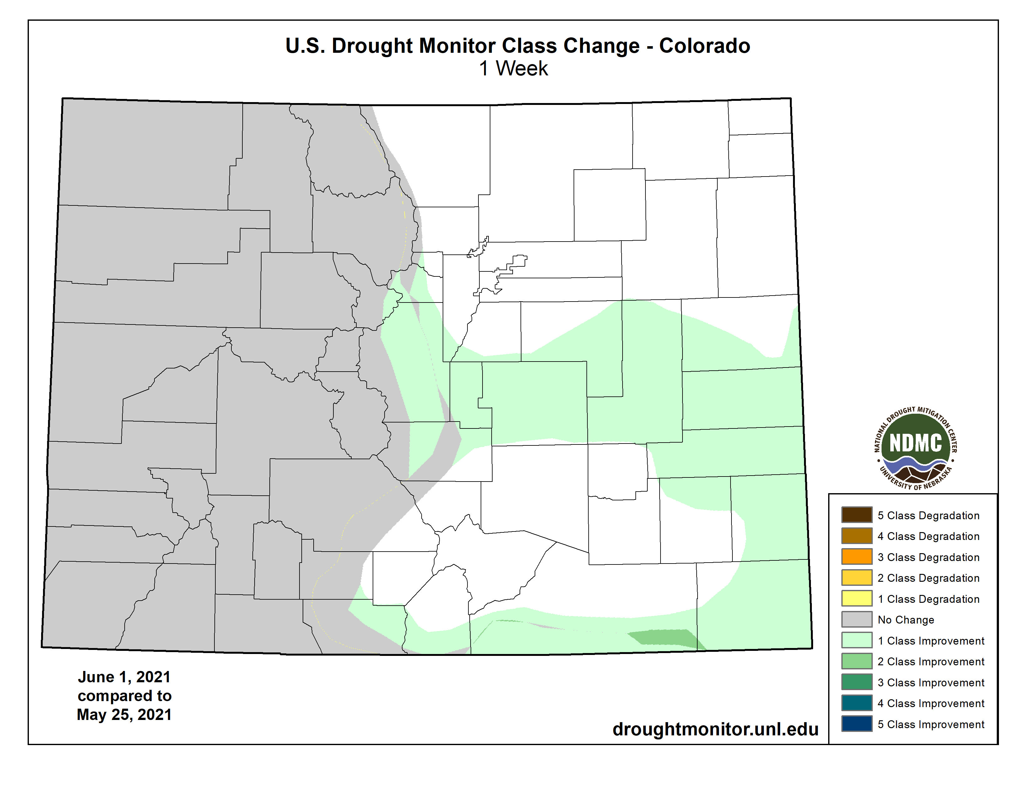
Colorado Drought Monitor map June 1, 2021.
Click here to go to the US Drought Monitor website. Here’s an excerpt:
This Week’s Drought Summary
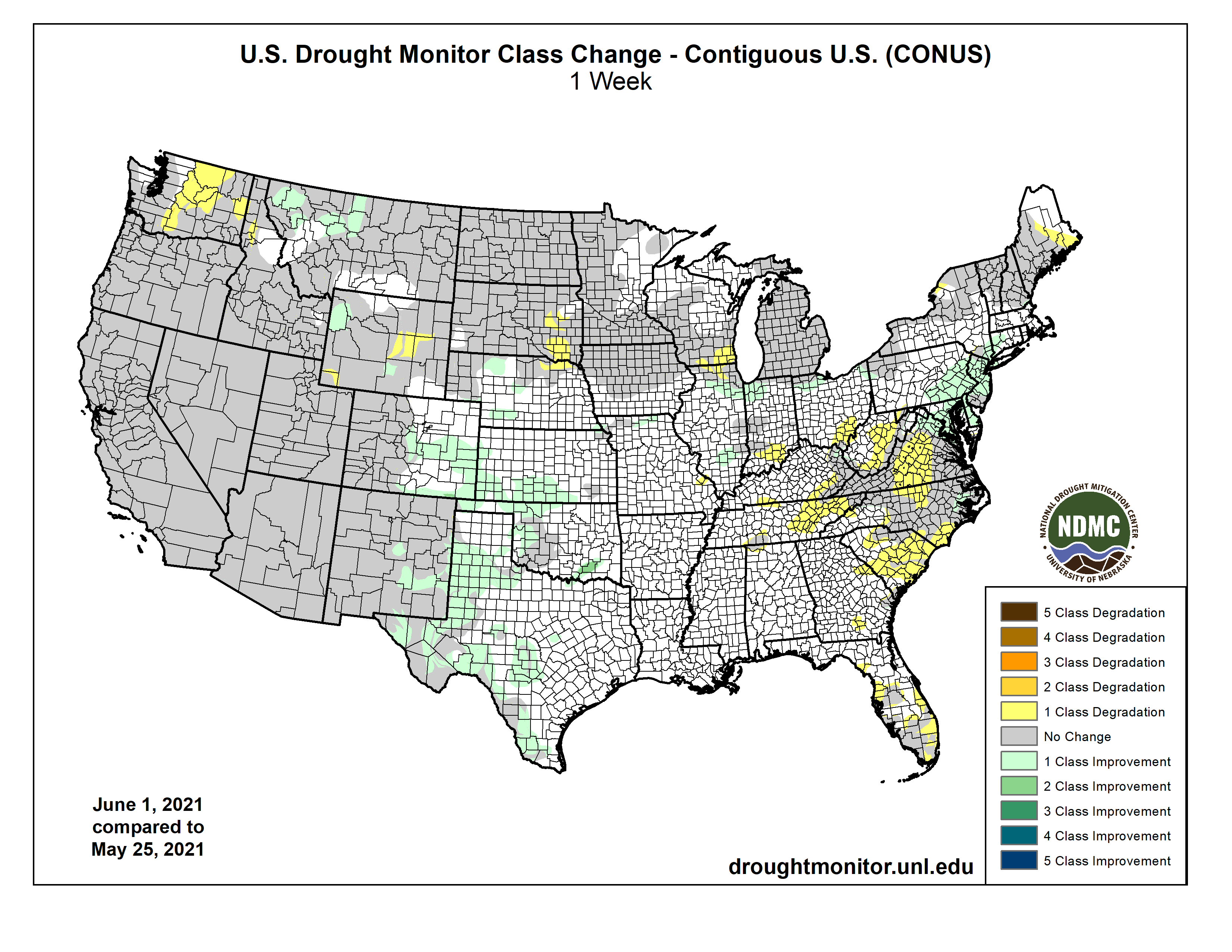
Precipitation this past week was most active in the southern Plains and the Mid-Atlantic into the Northeast, helping to ease and improve drought in those regions. Some precipitation also occurred in the South and portions of the Midwest, but the Southeast and Southwest remained dry through the week. For the time of year, temperatures were well below normal over most of the country, with departures of 9-12 degrees below normal in the Dakotas. Portions of the Southeast and Southwest did have pockets of above-normal temperatures, but even those areas were close to normal…
Colorado Drought Monitor one week change map ending June 1, 2021.
Temperatures were 4-6 degrees below normal, with even greater departures in the Dakotas where some areas were 8-10 degrees below normal for the week. Much of eastern Colorado, southern Nebraska, Kansas and northwest South Dakota into southwest North Dakota received well over 150% of normal precipitation for the week. In Nebraska, abnormally dry conditions were improved over the north central, southwest and extreme southeast portions of the state while moderate drought expanded over northeast Nebraska. Severe drought was introduced over southeast South Dakota, with an expansion of moderate drought and abnormally dry conditions too. Southern Kansas and eastern Colorado had improvements to abnormally dry and moderate drought conditions while Wyoming had a mix of improvements and degradations to moderate and severe drought in the state…
The warmest temperatures in the region were over California and Nevada, where departures for the week were 3-6 degrees above normal. Most of the rest of the region was near normal for temperatures. Most of the West was dry for the week but eastern New Mexico and western Montana received enough precipitation to allow for some improvements to their drought status. Impacts are building in the region with water cutback anticipated on Lake Mead as it is currently 37% full and fell below the critical 1,075-foot level triggering cutbacks to Arizona, Nevada, and Mexico. Abnormally dry and moderate drought conditions were improved over western Montana while New Mexico had a large area of exceptional drought improve due to recent rains. In Washington, conditions continue to dry out, and abnormally dry and both moderate and severe drought conditions continued to expand…
Much of the region had abundant precipitation during the week with many areas recording over 200 percent of normal rain. Along with the precipitation, cooler than normal temperatures were widespread with most areas 3-6 degrees below normal for the week. The ongoing wet pattern allowed for continued improvements over most of Texas during the week, with most areas having a full reduction of the previous drought intensity level. Southeast Oklahoma had moderate drought and abnormally dry conditions removed while portions of western Oklahoma also had abnormally dry conditions improve…
Looking Ahead
Over the next 5-7 days, it is anticipated that much of the West as well as the central Plains will remain dry. The southern Plains and portions of the Carolinas are expected to see the most rain. Warmer than normal conditions are supposed to dominate the West and into the northern Plains, with departures of 12-15 degrees above normal in portions of California and Nevada. Cooler than normal temperatures are expected over the southern Plains and South in response to the anticipated rain.
The 6-10 day outlooks show the majority of the country has above normal chances of recording temperatures above normal during the period with the northern Plains, upper Midwest, and into the Northeast having the greatest likelihood. Cooler than normal temperatures are expected over Alaska, the West Coast, and into the southern Plains. It is anticipated that dry conditions will continue to dominate the Plains and West with the highest likelihood over the Great Basin. The greatest odds of above normal precipitation will be along the Mississippi Valley and into the southern Plains.
Here’s the one week US Drought Monitor change map.
US Drought Monitor one week change map ending June 1, 2021.
Just for grins here are the early June US drought monitor maps for the past few years.