The health of our waters is the principal measure of how we live on the land — Luna Leopold
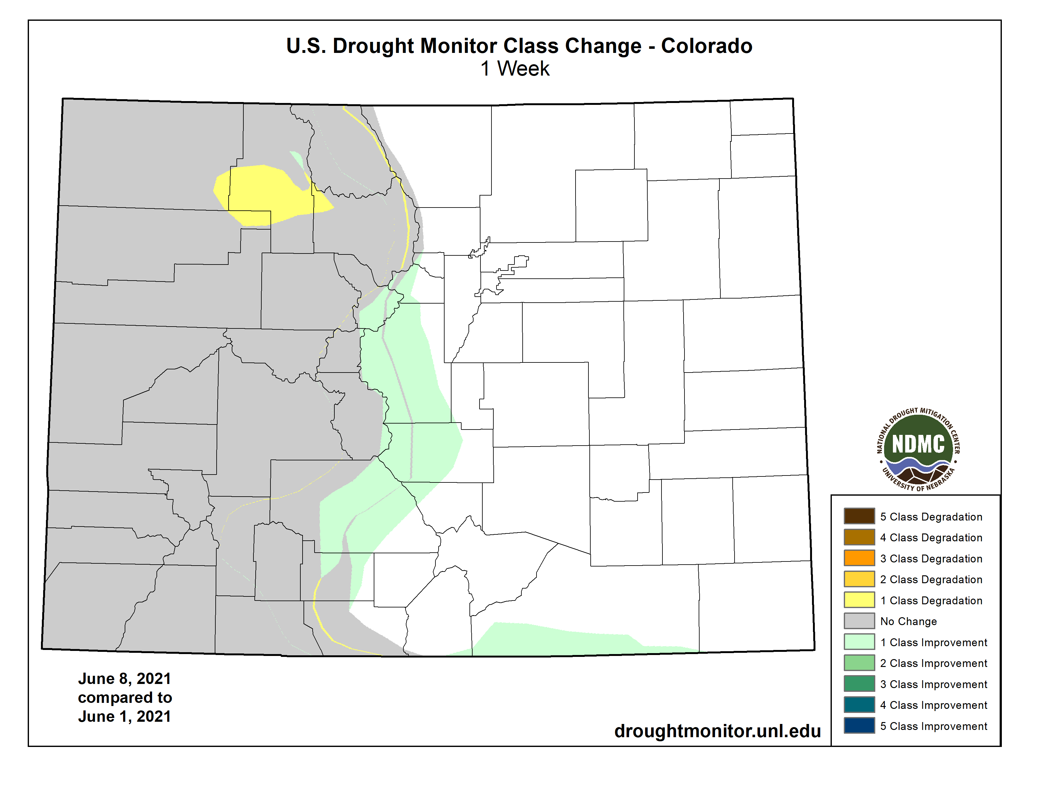
#Drought news: Improvements were made to the D0 (abnormally dry) and D1 (moderate drought) conditions in the central portion of #Colorado
Click on a thumbnail graphic to view a gallery of drought data from the US Drought Monitor website.
US Drought Monitor map June 8, 2021.
High Plains Drought Monitor map June 8, 2021.
West Drought Monitor map June 8, 2021.
Colorado Drought Monitor map June 8, 2021.
Click here to go to the US Drought Monitor website. Here’s an excerpt:
This Week’s Drought Summary
Warm and dry conditions dominated the West while the southern Plains and South recorded the most precipitation for the week as well as cooler than normal temperatures. Temperatures were 3-6 degrees below normal over much of the southern Plains, and into the lower Mississippi Valley. Warmer than normal temperatures dominated from California to the Dakotas with departures of 9-12 degrees above normal and even higher in the northern Plains. With the active pattern continuing over the southern Plains, conditions have flipped over the last several weeks from one of drought to ample precipitation. A reassessment of conditions in several places in the West and northern Plains led to improvements, in light of some of the wetter conditions recently…
Colorado Drought Monitor one week change map ending June 8, 2021.
A mostly dry week for the region, with some late precipitation in the period over North Dakota that will be addressed next week when the full extent of the rains can be taken into account. Some areas of Colorado had above-normal precipitation for the week. Temperatures were well above normal in the Dakotas where widespread areas of 12-15 degrees above normal were observed, with several places over 100 degrees F. Farther south in the region, the temperatures across Kansas were below normal. Portions of southwest North Dakota and northwest South Dakota were reassessed this week to take into account the wetter pattern lately. Improvements to the severe and extreme drought conditions were made based upon this reanalysis of data. In Nebraska, moderate drought and abnormally dry conditions spread over the northeast to central portions of the state, with some severe drought being introduced in the far northern counties. Southeast South Dakota had drought expand and intensify, with more moderate and severe drought being introduced. The plains of Colorado remained wet and further improvements were made to the abnormally dry and moderate drought conditions in the central portion of the state. Degradation took place in Wyoming where extreme drought was introduced in the northeast and moderate and severe drought expanded in the central and southwest portions of the state, with just a small pocket improved in the southwest…
A very dry week for the region, with only areas of New Mexico, northeast Arizona, western Colorado and northwest Washington having above-normal precipitation. Temperatures were well above normal with most areas 3-9 degrees above normal for the week. A reassessment of conditions in eastern New Mexico took place after the most recent rains, and this led to improvements in the region, with some being multi-category for the week. Eastern Washington saw conditions continuing to decline, and an expansion of moderate, severe, and extreme drought took place this week. Oregon was similar with widespread areas of degradation in the state and expansion of exceptional, extreme, severe, and moderate drought. Idaho also had widespread degradations with expansion of extreme, severe, and moderate drought and also a new introduction of exceptional drought. California continued to see the impacts of drought increase, and there was expansion of extreme and exceptional drought in the northern and central areas as well as along the coast of central California. A small area of exceptional drought was expanded in central Utah. As with the conditions in the northern Plains, some areas of eastern Montana were reassessed this week and a large area of extreme drought was removed while other areas of the state had an expansion of severe and moderate drought. Some of these same areas improved in Montana received rain after the cut-off for this week and could see further improvements next week…
With a continued wet pattern, temperatures were well below normal, with departures of 6-8 degrees below normal in portions of Texas and Oklahoma. The greatest rains fell from east Texas into the lower Mississippi Valley, but there were pockets of heavier rain from south Texas into the central portions of the state. As in past weeks, the wet pattern of the current week as well as a reassessment of conditions over the last 6-8 weeks allowed for continued and multi-category improvements over portions of Texas. The only extreme and exceptional drought left in the state is in the Trans-Pecos region…
Looking Ahead
Over the next 5-7 days, it is anticipated that the best rains will be over the South, Southeast and into the Mid-Atlantic with some relief continuing in the northern Plains. Most all of the West remains dry, especially in the southwest, with some rain possible in the northwest. Above-normal temperatures will dominate the country with most areas from the West into the Midwest anticipating above-normal temperatures. Near-normal temperatures in the Southeast as well along the West Coast are expected.
The 6-10 day outlooks show the high probability of above-normal temperatures over most of the country from the Midwest and southern Plains to the West. Cooler than normal temperatures are anticipated in the East and to the Gulf Coast as well as into the lower Mississippi Valley and Texas. Below-normal precipitation is anticipated over most of the country, with the highest probabilities in the Midwest, northern Plains, northern Rocky Mountains and into the Great Basin. The highest probabilities of above-normal precipitation are along the Gulf Coast, northern Alaska and in Arizona.
US Drought Monitor one week change map ending June 8, 2021.